West Wales SAC assessment - Natural Resources … · West Wales Marine Selection Assessment...
18
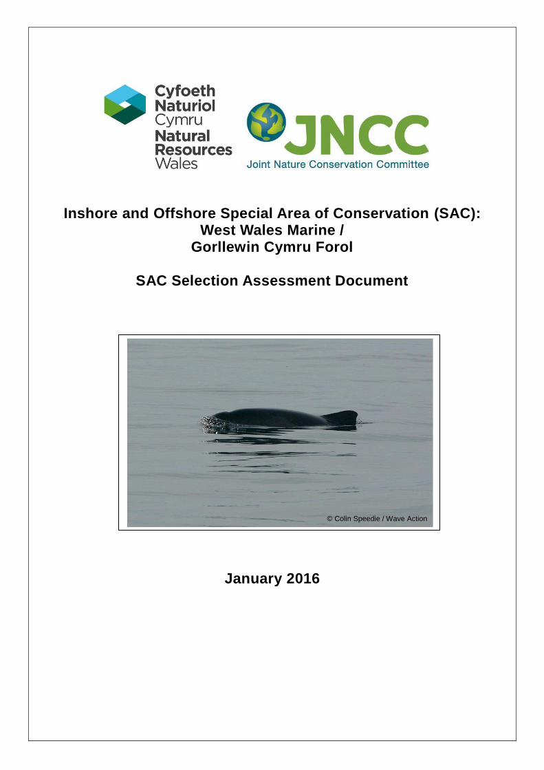
Inshore and Offshore Special Area of Conservation (SAC): West Wales Marine / Gorllewin Cymru Forol SAC Selection Assessment Document January 2016 © Colin Speedie / Wave Action
Transcript of West Wales SAC assessment - Natural Resources … · West Wales Marine Selection Assessment...
Inshore and Offshore Special Area of Conservation (SAC): West Wales Marine /
Gorllewin Cymru Forol
SAC Selection Assessment Document
January 2016
© Colin Speedie / Wave Action
West Wales Marine Selection Assessment Document, January 2016 Page 2 of 18
Further information This document is available as a pdf file on NRW’s website for download if required
Please return comments or queries to:
Marine Advice Team Natural Resources Wales Maes y Ffynnon Bangor LL57 2DW
Email: [email protected] Tel: 0300 065 3000
Recommended citation: NRW and JNCC (2015) SAC Selection Assessment Document: West Wales Marine / Gorllewin Cymru Forol. January, 2016. Natural Resources Wales and Joint Nature Conservation Committee, UK.
West Wales Marine Selection Assessment Document, January 2016 Page 3 of 18
1. Introduction This document provides detailed information about the West Wales Marine / Gorllewin Cymru Forol site proposed for designation for the Annex II species harbour porpoise (Phocoena phocoena) and evaluates this interest feature according to the Habitats Directive1 selection criteria and guiding principles. This is a single feature site, proposed for designation solely for the purpose of aiding the management of harbour porpoise populations throughout UK waters, in accordance with EU legislation. The site includes parts of both Welsh territorial waters (out to 12 nautical miles from the baseline) and offshore waters (from 12 nautical miles from the coast out to 200 nautical miles or to the UK Continental Shelf limit), and is therefore a joint responsibility of Natural Resources Wales (NRW) and the Joint Nature Conservation Committee (JNCC). The Conservation of Habitats and Species Regulations 20102 (as amended) transpose the Habitats Directive into law on land and in territorial waters of England and Wales. The Offshore Marine Conservation (Natural Habitats &c.) Regulations 20073 (as amended in 2010) transpose the Habitats Directive into law for UK offshore waters. The advice contained in the present document is produced to enable the Secretary of State and the Welsh Ministers to decide whether they propose to submit the West Wales Marine / Gorllewin Cymru Forol site to the European Commission as a site eligible for designation as a Special Area of Conservation (SAC), in accordance with Regulation 10 of the Conservation of Habitats and Species Regulations 2010 (as amended), and Regulation 7 of the Offshore Marine Conservation (Natural Habitats &c) Regulation 2007 (as amended). JNCC and NRW have been asked by Defra and the Welsh Government to provide this advice. The Habitats Directive aims to conserve biodiversity by maintaining or restoring Annex I habitats and Annex II species to a favourable conservation status. Member States are required to contribute to a coherent European ecological network of protected sites through designation of SACs for natural habitats and wild species listed on the Annexes of the Directive. Sites eligible for designation as marine SACs are selected on the basis of the criteria set out in Annex III (Stage 1) of the Habitats Directive and relevant scientific information. Sites are considered only if they host a Habitats Directive Annex I habitat or Annex II species. For Annex II aquatic species that range over wide areas, sites must clearly identify areas that represent the physical and biological factors essential to these species’ life and reproduction. Socio-economic factors are not taken into account in the identification of sites to be proposed to the European Commission. While some wide-ranging highly mobile aquatic species have clearly-defined breeding/nurturing/feeding areas (i.e. areas ‘essential to their life and reproduction’), the harbour porpoise is a naturally widely-distributed cetacean in European North Atlantic waters, and relatively little is known about its breeding behaviour. In addition, there are few obvious natural site boundaries for mobile species in the open sea. In practice, therefore, Article 4 of the Habitats Directive, which requires Member States to propose sites for Annex II species, and Annex III (site selection criteria) have proved difficult to apply to this species. To address this problem, the European Commission (EC) held a workshop involving experts in December 2000 and published guidance on the designation of SACs for harbour porpoise in 2007 (EC, 2007). The guidance states that ‘it is possible to identify areas representing crucial factors for the life cycle of this species. These areas would be identifiable on the basis of:
• the continuous or regular presence of the species (although subject to seasonal variations);
1 http://www.central2013.eu/fileadmin/user_upload/Downloads/Document_Centre/OP_Resources/HABITAT_DIRECTIVE_92-43-EEC.pdf
2 http://www.legislation.gov.uk/uksi/2010/490/pdfs/uksi_20100490_en.pdf
3 http://www.legislation.gov.uk/uksi/2007/1842/pdfs/uksi_20071842_en.pdf
West Wales Marine Selection Assessment Document, January 2016 Page 4 of 18
• good population density (in relation to neighbouring areas);
• high ratio of young to adults during certain periods of the year and
• other biological elements are characteristic of these areas, such as very developed social and sexual life.’
The guidance also states that ‘defining boundaries for ‘sites’ in offshore waters which support a given percentage of the national population of some mobile species may be difficult due to the lack of obvious natural boundaries (such as coast, topographical boundaries, etc.) in the open sea. This criterion is also challenging to use in the offshore marine environment where populations may often be distributed across several national boundaries.’ Therefore, the application of these additional criteria has also proven difficult. In addition to information on the Annex II species hosted within the site, this document contains;
i) a map of the site; ii) its name, location and extent; iii) the data resulting from application of the criteria specified in Annex III (Stage 1) to the
Habitats Directive. In preparing this document, NRW and JNCC have taken into consideration the format established by the European Commission, under which the Member States are required to provide site information to the Commission when proposing candidate SACs. This format is set out in the ‘Natura 2000 Standard data form’4 (prepared by the European Topic Centre for Biodiversity and Nature Conservation on behalf of the European Commission to collect standardised information on SACs throughout Europe).
4 The Standard Data Form template is available here: http://eur-lex.europa.eu/legal-
content/EN/TXT/PDF/?uri=CELEX:32011D0484&from=EN
West Wales Marine Selection Assessment Document, January 2016 Page 5 of 18
Cyflwyniad Mae'r ddogfen hon yn rhoi gwybodaeth fanwl am y safle West Wales Marine / Gorllewin Cymru Forol y cynigiwyd ei ddynodi ar gyfer rhywogaeth Atodiad II, sef y llamhidydd (Phocoena phocoena), ac mae'n gwerthuso'r nodwedd o ddiddordeb hon yn unol â meini prawf dethol ac egwyddorion arweiniol y Gyfarwyddeb Cynefinoedd5. Mae hwn yn safle un nodwedd, a gynigir ei ddynodi yn gyfan gwbl i helpu i reoli poblogaethau o lamhidyddion yn nyfroedd y DU, yn unol â deddfwriaeth yr UE. Mae'r safle'n cynnwys rhannau o ddyfroedd tiriogaethol Cymru (gan ymestyn allan 12 o filltiroedd morol o'r man cychwyn) a dyfroedd alltraeth (o 12 o filltiroedd morol o'r arfordir allan i 200 o filltiroedd morol neu i derfyn Sgafell Gyfandirol y DU), ac felly mae Cyfoeth Naturiol Cymru, a'r Cyd-bwyllgor Cadwraeth Natur yn gyfrifol amdano ar y cyd. Mae Rheoliadau Gwarchod Cynefinoedd a Rhywogaethau 20106 (fel y'u diwygiwyd) yn trosi'r Gyfarwyddeb Cynefinoedd yn gyfraith ar dir a dyfroedd tiriogaethol Cymru a Lloegr. Mae Rheoliadau Cadwraeth Forol Alltraeth (Cynefinoedd Naturiol, &c.) 20077 (fel y'u diwygiwyd yn 2010) yn trosi'r Gyfarwyddeb Cynefinoedd yn gyfraith ar ddyfroedd alltraeth y DU. Lluniwyd y cyngor yn y ddogfen hon i alluogi'r Ysgrifennydd Gwladol a Gweinidogion Cymru benderfynu a ddylid cyflwyno safle West Wales Marine / Gorllewin Cymru Forol i'r Comisiwn Ewropeaidd fel safle sy'n gymwys i gael ei ddynodi'n Ardal Cadwraeth Arbennig, yn unol â Rheoliad 10 o Reoliadau Gwarchod Cynefinoedd a Rhywogaethau 2010 (fel y'u diwygiwyd), a Rheoliad 7 o Reoliadau Cadwraeth Forol Alltraeth (Cynefinoedd Naturiol, &c.) 2007 (fel y'u diwygiwyd). Mae Defra a Llywodraeth Cymru wedi gofyn i Cyfoeth Naturiol Cymru a'r Cyd-bwyllgor Cadwraeth Natur roi'r cyngor hwn. Nod y Gyfarwyddeb Cynefinoedd yw gwarchod bioamrywiaeth trwy gynnal neu adfer statws cadwraethol ffafriol cynefinoedd a restrir yn Atodiad I a rhywogaethau a restrir yn Atodiad II. Mae'n ofynnol i Aelod-wladwriaethau gyfrannu at rwydwaith ecolegol Ewropeaidd cydlynol trwy ddynodi Ardaloedd Cadwraeth Arbennig ar gyfer cynefinoedd naturiol a rhywogaethau gwyllt a restrir yn Atodiadau'r Gyfarwyddeb. Caiff safleoedd sy'n gymwys i gael eu dynodi'n Ardaloedd Cadwraeth Arbennig morol eu dewis ar sail y meini prawf a nodir yn Atodiad III (Cam 1) i'r Gyfarwyddeb Cynefinoedd a gwybodaeth wyddonol berthnasol. Dim ond os ydynt yn cynnal cynefin a restrir yn Atodiad I neu rywogaeth a restrir yn Atodiad II y Gyfarwyddeb Cynefinoedd y caiff safleoedd eu hystyried. Ar gyfer rhywogaethau dyfrol Atodiad II sy'n rhychwantu ardaloedd eang, rhaid i safleoedd nodi'n glir ardaloedd sy'n cynrychioli'r ffactorau ffisegol a biolegol sy'n hanfodol i fywyd ac atgenhedliad y rhywogaethau hyn. Nid ystyrir ffactorau economaidd-gymdeithasol wrth nodi safleoedd i'w cynnig i'r Comisiwn Ewropeaidd. Er bod gan rai rhywogaethau dyfrol symudol iawn â dosbarthiad eang ardaloedd bridio/magu/bwydo clir (h.y. ardaloedd sy'n hanfodol i'w bywyd a'u hatgenhedliad), mae llamhidyddion yn forfilod a welir yn naturiol mewn sawl rhan o ddyfroedd Ewropeaidd y Gogledd Iwerydd, ac ychydig iawn a wyddys am eu hymddygiad bridio. At hynny, prin yw'r ffiniau safle naturiol amlwg ar gyfer rhywogaethau symudol yn y môr agored. Yn ymarferol, felly, ar gyfer y rhywogaeth hon, bu'n anodd cymhwyso Erthygl 4 o'r Gyfarwyddeb Cynefinoedd, sy'n ei gwneud yn ofynnol i aelod-wladwriaethau gynnig safleoedd ar gyfer rhywogaethau Atodiad II, ac Atodiad III (meini prawf ar gyfer dethol safleoedd). Er mwyn mynd i'r afael â'r broblem hon, cynhaliodd y Comisiwn Ewropeaidd weithdy ym mis Rhagfyr 2000 a chyhoeddodd ganllawiau ar ddynodi Ardaloedd Cadwraeth Arbennig ar gyfer llamhidyddion yn 2007 (CE, 2007). Mae'r canllawiau'n nodi 'it is possible to identify areas representing crucial factors for the life cycle of this species. These areas would be identifiable on the basis of: • the continuous or regular presence of the species (although subject to seasonal variations);
5 http://www.central2013.eu/fileadmin/user_upload/Downloads/Document_Centre/OP_Resources/HABITAT_DIRECTIVE_92-
43-EEC.pdf 6 http://www.legislation.gov.uk/uksi/2010/490/pdfs/uksi_20100490_en.pdf
7 http://www.legislation.gov.uk/uksi/2007/1842/pdfs/uksi_20071842_en.pdf
West Wales Marine Selection Assessment Document, January 2016 Page 6 of 18
• good population density (in relation to neighbouring areas); • high ratio of young to adults during certain periods of the year and • other biological elements are characteristic of these areas, such as very developed social and sexual life.’ Mae'r canllawiau hefyd yn nodi bod ‘defining boundaries for ‘sites’ in offshore waters which support a given percentage of the national population of some mobile species may be difficult due to the lack of obvious natural boundaries (such as coast, topographical boundaries, etc.) in the open sea. This criterion is also challenging to use in the offshore marine environment where populations may often be distributed across several national boundaries’. Felly, bu'n anodd hefyd gymhwyso'r meini prawf ychwanegol hyn. Yn ogystal â'r wybodaeth am y rhywogaeth Atodiad II sy'n byw yn y safle hwn, mae'r ddogfen hon yn cynnwys; i) map o'r safle;
ii) ei enw, ei leoliad a'i faint;
iii) y data sy'n deillio o gymhwyso'r meini prawf a nodir yn Atodiad III (Cam 1) i'r Gyfarwyddeb Cynefinoedd. Wrth baratoi'r ddogfen hon, mae Cyfoeth Naturiol Cymru, a'r Cyd-bwyllgor Cadwraeth Natur wedi ystyried y fformat a sefydlwyd gan y Comisiwn Ewropeaidd, sy'n ei gwneud yn ofynnol i'r aelod-wladwriaethau ddarparu gwybodaeth am safleoedd i'r Comisiwn wrth gynnig darpar Ardaloedd Cadwraeth Arbennig. Nodir y fformat hwn yn ‘ffurflen data safonol Natura 2000'8 (a baratowyd gan y Ganolfan Testun Ewropeaidd ar Fioamrywiaeth a Chadwraeth Natur ar ran y Comisiwn Ewropeaidd i gasglu gwybodaeth safonol am Ardaloedd Cadwraeth Arbennig ledled Ewrop).
8 Mae templed o'r Ffurflen Data Safonol ar gael yma: http://eur-lex.europa.eu/legal-content/EN/TXT/PDF/?uri=CELEX:32011D0484&from=EN
West Wales Marine Selection Assessment Document, January 2016 Page 7 of 18
2. Background to identification of harbour porpoise Special Areas of Conservation in UK waters
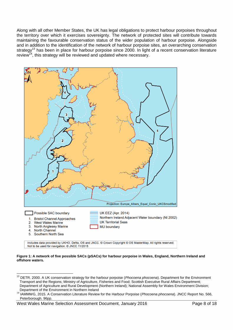
The Joint Cetacean Protocol (JCP) was created in 2004 and is amongst the largest collation of standardised survey data on harbour porpoise in the world, comprising 39 data sources with data from at least 545 distinct survey platforms (ships and aircraft) representing over 1.05 million km of survey effort (coverage) over an 18 year period from 1994-2011. DHI Water Environments (UK) Ltd (DHI) were contracted by JNCC to undertake an analysis of these data in order to determine if persistent areas of high harbour porpoise density were present in the wider UK seas (Heinänen and Skov, 2015). This study will hereafter be referred to as the DHI analysis/model. Partly to ensure geographic representation, UK waters were divided into three Management Units (MUs)9 identified by the Interagency Marine Mammal Working Group (IAMMWG): the North Sea (NS), the Celtic and Irish Seas (CIS) and West Scotland (WS). These MUs align with the UK parts of the Assessment Units10 proposed for the harbour porpoise by the International Council for the Exploration of the Sea (ICES) in their advice to OSPAR. The Management Units were selected to combine what we understand of the ecology of harbour porpoise with the practicality of managing human activities. The DHI analysis modelled the relationship between environmental variables and the observed harbour porpoise distribution to develop distribution models in each MU. These models described discrete areas of predicted high porpoise density and captured the year-to-year variation within the different locations. Areas within the MUs that were identified to persistently have the top 10% of predicted high densities of harbour porpoise were considered in detail in the analysis. Areas of Search (AoS), within which the final SAC boundaries would be identified, were selected based on these top 10% of predicted high density areas. The top 10% areas were filtered by model confidence and areas of less than 500km2 were removed on the grounds that such small areas are ineffective for harbour porpoise conservation in relation to the much larger AoS identified in the Management Units. Sites within the AoS were restricted to high confidence areas only. Sufficiency, seasonality and geographic spread of sites were considered in order to identify a network of recommended draft SACs (rdSACs). Sufficiency thresholds of 20% of the nominal UK harbour porpoise abundance and 10-14% of the UK habitat for the species11 within the rdSACs of each MU were met. A UK network of sites for harbour porpoise was submitted to Government as draft SACs (dSACs) in June 2015. Once the sites gain approval from Governments to go to consultation, the classification changes from dSACs to possible SACs (pSACs). The Governments of Wales and North Ireland, and Defra on behalf of England and offshore decided to proceed to consultation with five of the sites (Figure 1), subject to an adjustment to the North Channel SAC boundary. This adjustment was to account for the fact that the Scottish Government is not proceeding at this time and the SAC boundaries needed to reflect this. Together with the existing Skerries & Causeway SAC (grade C for harbour porpoise), these five sites cover 10.3% of the UK habitat and 18.7% of the UK population12 of harbour porpoises, and are distributed in territorial and offshore waters throughout the North Sea MU and the Celtic and Irish Sea MU. In addition, there are 34 UK SACs which already list harbour porpoise as a non-qualifying feature (grade D) in UK waters.
9 IAMMWG, 2015. Management Units for cetaceans in UK waters (January 2015). JNCC Report No. 547, JNCC Peterborough. 37pp.
10 ICES. 2014 available from http://www.ices.dk/sites/pub/Publication%20Reports/Expert%20Group%20Report/acom/2014/WGMME/wgmme_2014.pdf
11 IAMMWG, 2015. The use of harbour porpoise sightings data to inform the development of draft Special Areas of Conservation in UK waters. JNCC Report No. 565, JNCC Peterborough. 29pp.
12 UK habitat for harbour porpoise is considered the UK continental shelf which is approximated by waters of 200m depth or less.
West Wales Marine Selection Assessment Document, January 2016 Page 8 of 18
Along with all other Member States, the UK has legal obligations to protect harbour porpoises throughout the territory over which it exercises sovereignty. The network of protected sites will contribute towards maintaining the favourable conservation status of the wider population of harbour porpoise. Alongside and in addition to the identification of the network of harbour porpoise sites, an overarching conservation strategy13 has been in place for harbour porpoise since 2000. In light of a recent conservation literature review14, this strategy will be reviewed and updated where necessary.
Figure 1: A network of five possible SACs (pSACs) for harbour porpoise in Wales, England, Northern Ireland and offshore waters.
13
DETR. 2000. A UK conservation strategy for the harbour porpoise (Phocoena phocoena). Department for the Environment Transport and the Regions; Ministry of Agriculture, Fisheries and Food; Scottish Executive Rural Affairs Department; Department of Agriculture and Rural Development (Northern Ireland); National Assembly for Wales Environment Division; Department of the Environment in Northern Ireland
14 IAMMWG, 2015. A Conservation Literature Review for the Harbour Porpoise (Phocoena phocoena). JNCC Report No. 566,
Peterborough. 96pp.
West Wales Marine Selection Assessment Document, January 2016 Page 9 of 18
3. West Wales Marine / Gorllewin Cymru Forol SAC: Site Information
Site name West Wales Marine / Gorllewin Cymru Forol
Site centre location 52°16'16.4'' N, 04°53'20.2'' W (Datum: WGS 1984)
Site surface area 737,717 ha / 7,377 km
2
(Datum: Europe Albers Equal Area modified to UK, calculated in ArcGIS)
Biogeographic region Atlantic
Administrative Region Welsh inshore waters (NRW) UK offshore waters (JNCC)
Percentage cover within region Welsh inshore waters: 76.7% Offshore waters: 23.3%
4. Interest feature(s) under the EU Habitats Directive 1351: Harbour porpoise (Phocoena phocoena)
West Wales Marine Selection Assessment Document, January 2016 Page 10 of 18
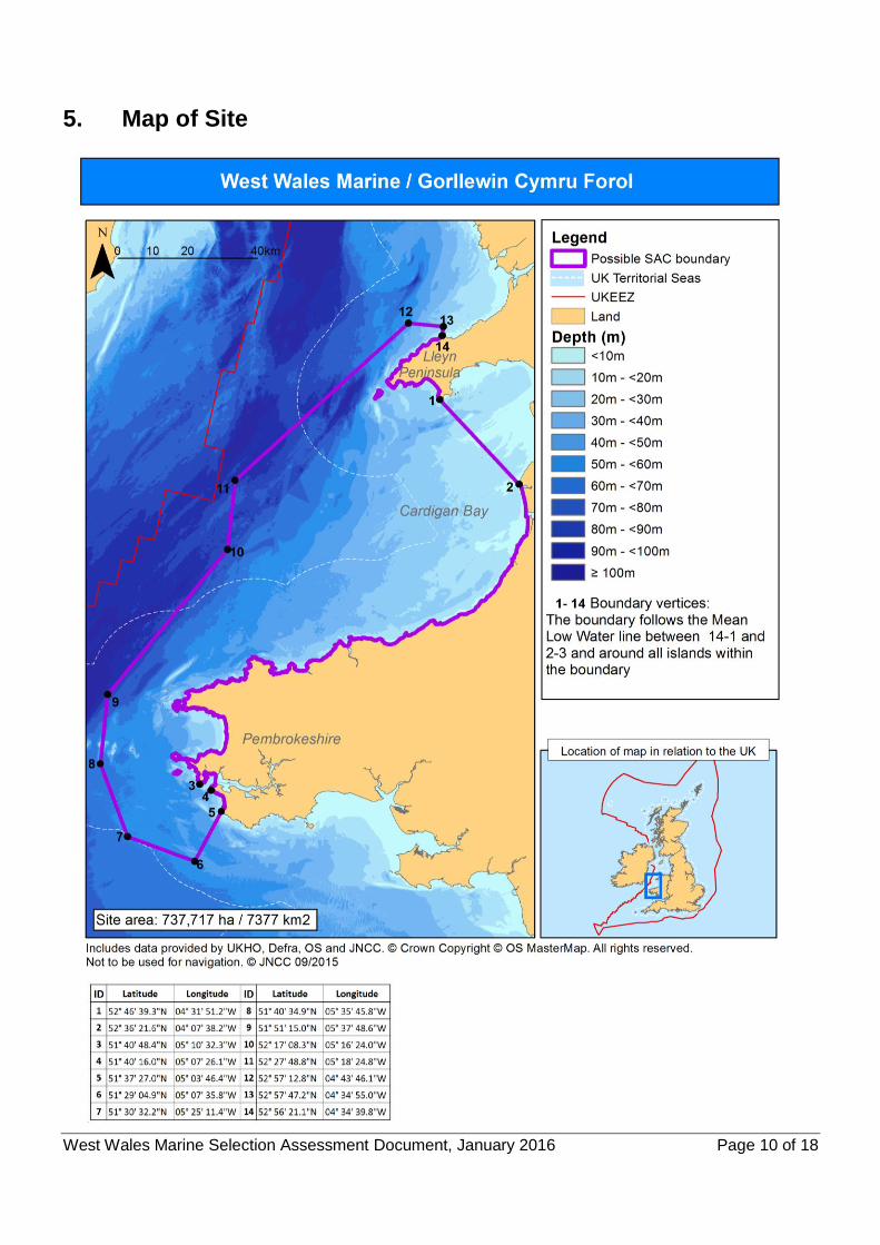
5. Map of Site
West Wales Marine Selection Assessment Document, January 2016 Page 11 of 18
6. Site summary The West Wales Marine / Gorllewin Cymru Forol site has been recognised as an area with the top 10% predicted persistent high densities of harbour porpoise. The area included within the site covers important summer habitat for porpoises, while a part of this site in Cardigan Bay was also identified as important during winter. The site covers an area of 7,377km2, extending into the Irish Sea from the Llŷn peninsula in North Wales to Pembrokeshire in West Wales. It extends almost to the mid-line (UK EEZ) between the Republic of Ireland and Wales. The water depths within the site range between the Mean Low Water Tide (MLWT) level and 100m. Away from coastal areas, the depths largely fall within the range of 40-50m. The site contains a mixture of hard substrate and sediments, including rock, coarse sediment, sand and mud (EUSeaMap). The boundary encompasses part of the Pen Llŷn a’r Sarnau SAC, the whole of the Cardigan Bay / Bae Ceredigion SAC and part of the Pembrokeshire Marine / Sir Benfro Morol SAC. Defining habitats of cetaceans is problematic; this is primarily due to their highly mobile nature and their distribution being driven mainly by the distribution and availability of their prey. In the absence of prey data, relationships between habitat variables (such as depth, water temperature, seabed sediment etc) are often used as proxies of prey distribution (e.g. Marubini et al, 2009; Skov & Thomsen, 2008; Embling et al, 2010). Regional variation in these relationships between habitat variables occurs and was evident between the Management Units in the analyses undertaken by DHI. The analyses undertaken by DHI used several different environmental variables and modelled them against observed density of harbour porpoise for each MU. In all MUs, the coarseness of the seabed sediment was important with porpoises showing a preference for coarser sediments (such as sand/gravel) rather than fine sediments (e.g. mud). Similar habitat associations have been made in the eastern part of the North Sea (Skov et al, 2014). Sandeels (Ammodytidae), which are known prey for harbour porpoises, exhibit a strong association with particular surface sediments (Benke & Siebert, 1996; Santos, 1998). Fine particle fractions have been demonstrated to limit the distribution of the lesser sandeel (Ammodytes marinus) around the Shetland Isles (Wright et al, 2000). Harbour porpoise feed on a wide variety of fish and generally focus on the most abundant local species. The predominant prey type appears to be bottom-dwelling fish, although shoaling fish such as mackerel (Scomber scombrus) and herring (Clupea harengus) are also taken (Santos & Pierce, 2003; Pierce et al, 2007). For the Celtic and Irish Seas MU, the DHI model results for both the summer and winter seasons show water depth and variables within the water column (particularly current speed in the winter) are the most important physical factors that increase the probability of presence and density of harbour porpoise. The predicted densities of harbour porpoise show considerable variation during the periods they spend in offshore waters and more persistent pattern in coastal areas. There is an indication that the harbour porpoises within the Celtic and Irish Seas MU have a preference for water depths shallower than 40m. Areas of higher eddy activity (turbulence) were preferred along with tidal current speeds of 0.4-0.6m/s, although faster currents (0.8-1.0m/s) were also used in the summer. Lower densities of harbour porpoise were found in areas with high levels of shipping traffic (based on a threshold of approximately 50 ships per day) in the summer. The physical characteristics of the West Wales Marine / Gorllewin Cymru Forol site are well aligned to the environmental variables determining the probability of presence and the density of harbour porpoise. Much of the site incorporates shallow depths of around 40m, with some deeper areas beyond the 12nm boundary (see section 8). The seabed energy layer of EU SeaMap15 indicates that the energy levels, including current and wave energy, are low to medium across most of the site but with high energy around Pembrokeshire islands and the tip of the Llŷn Peninsula.
15
Phase 1 energy layers are available for download from EUSeaMap: http://www.emodnet-seabedhabitats.eu/default.aspx?page=1953
West Wales Marine Selection Assessment Document, January 2016 Page 12 of 18
The West Wales Marine site Gorllewin Cymru Forol is located in the Celtic and Irish Sea harbour porpoise MU16 and contains the Annex II species harbour porpoise as a qualifying species. Additionally, three other sites - North Channel, North Anglesey Marine / Gogledd Môn Forol and Bristol Channel Approaches / Dynesfeydd Môr Hafren - make up a series of sites proposed for harbour porpoise within this MU.
7. Site boundary To date, the guidance developed by JNCC for defining SAC boundaries for marine sites away from the coast has focused on habitat features, largely from modelled data. The harbour porpoise sites are also, in part, based on modelled data and the outputs predict areas with expected high densities of harbour porpoise. The outputs from this approach and that for habitat features are consequently similar. Therefore, the guidelines have largely been transferred to consideration of boundaries for harbour porpoise sites: 1. As a general principle, site boundaries should be drawn closely around the qualifying feature for
which the sites have been selected, taking into account the need to ensure that the site operates as a functional whole for the conservation of the feature;
2. Where possible, the seaward boundaries of the sites should be drawn using straight lines to ensure ease of identification on charts and at sea (and thereby minimising the number of nodes in the boundary where feasible);
3. However, a balance is needed between more complex site shapes drawn more tightly around the feature and simple square/rectangular boundaries so that the area of ‘non-interest-feature’ included within the site boundary is minimised, but this should not be to the detriment of the structural and functional integrity of the interest feature;
4. Site boundary coordinates be provided in degrees, minutes, seconds. The nature of the boundaries for the recommended draft SAC were ‘blocky’ due to their emergence from the 25km2 gridded model output of the DHI analyses (5km x 5km grid squares). Additional principles for creating boundaries for the harbour porpoise sites were also needed: 5. Diagonal runs of pixels (the DHI grid squares) should be straightened by a line that approximates
the centre of the diagonal; 6. Vertical and horizontal lengths of more than two pixels of the sites were maintained whenever
possible to preserve overall shape; 7. Modifications of the boundary of each recommended draft SACs should not alter the total area of
the site by more than approximately 5%; 8. Possible SACs will not extend into rivers; 9. Estuaries are excluded where the width of the entrance is ≤2km and the model did not indicate
the area was included; 10. The ‘coastal’ edge of sites is defined by the Mean Low Water (MLW) tide line; 11. Site boundaries were aligned with the EEZ boundary where they were closely aligned.
16
IAMMWG, 2015. Management Units for cetaceans in UK waters (January 2015). JNCC Report No. 547, JNCC Peterborough.
West Wales Marine Selection Assessment Document, January 2016 Page 13 of 18
8. Assessment of interest feature against selection criteria
8.1. Harbour porpoise (Phocoena phocoena)
Annex III selection criteria for Annex II Species: Stage 1B
Stage 1 of Annex III of the Habitats Directive refers to the assessment at national level of the relative importance of sites based on: (a) Size and density of the population of the species present on the site in relation to the populations
present within national territory. (b) Degree of conservation of the features of the habitat which are important for the species
concerned and restoration possibilities. (c) Degree of isolation of the population present on the site in relation to the natural range of the
species. (d) Global assessment of the value of the site for conservation of the species concerned. As UK waters are divided into Management Units to ensure geographic coverage and to facilitate management for harbour porpoise, each site has been assessed in relation to the MU rather than at the national level.
a) Proportion of UK part of the Celtic and Irish Sea Management Unit population17
Abundance estimates calculated for each site were used directly to grade criterion iii a) Size and density of the population of the species present on the site in relation to the populations present within national territory. The identification of SACs for harbour porpoise has been driven by assessments at the scale of national territory within Management Units to ensure sites constitute a geographically representative network; the criterion has been applied at this scale. The explanatory notes to the Natura 2000 standard data form suggest the following ranking to grade the sites based on the size of the population in the site relative to the population in the national territory (criterion III (a)) and for the purpose of harbour porpoise possible SACs, relative to the relevant UK management unit: Grade A: >15% to 100% of the relevant UK management unit population Grade B: >2% to 15% of the relevant UK management unit population Grade C: >0% to 2% of the relevant UK management unit population The possible SACs are ‘clearly identifiable’ based on the modelling and persistence analyses undertaken by DHI. The analytical approach taken by DHI incorporated some of the sub-criteria of the European Commission guidance for identifying sites for marine mobile species (EC, 2007), such as sub-criteria ‘Continuous or regular presence of the species (although subject to seasonal variations’, ‘Good population density (in relation to neighbouring areas)’ and some elements of sub-criteria ‘Other biological elements that are characteristics, such as very developed social and sexual life’. All of the sites have regular presence of harbour porpoise, whilst some show seasonal variation. It was not possible to assess the ratio of young to adults because data have not been collected consistently at an appropriate scale. The abundance within the possible SACs can be estimated from existing survey data (Hammond et al., 2013) and thereby Criterion III (a) can be applied directly for the purposes of grading the site. The West Wales Marine / Gorllewin Cymru Forol site was identified as being within the top 10% of persistent high density areas for harbour porpoise in UK waters during the summer season, and part of
17
UK MU population is defined throughout this document as ‘the UK portion of the MU where water depths are 200m or less’.
West Wales Marine Selection Assessment Document, January 2016 Page 14 of 18
this site (in Cardigan Bay) also identified as important during winter (Heinänen and Skov, 2015). It is estimated (based on the SCANS-II survey which took place in July 2005) that the site supports approximately 2506 individuals (95% Confidence Interval: 1410 - 4455) for at least part of the year, as seasonal differences are likely to occur. This represents approximately 9% of the population within the UK part of the Celtic and Irish Sea MU. It should be noted that because this estimate is derived from the July 2005 SCANS-II survey it is unlikely to be reflective of abundances in other months, especially during winter, which may be higher or lower than that observed in summer. Thus, the estimate is merely indicative of a relative amount and cannot be considered as a specific population number for the site. It is not appropriate to assign a site population because of the daily and seasonal movements of the animals. Although survey effort was not constant for all months of the year, the DHI analysis showed high confidence in the modelling across the site, especially during the summer season. Therefore the West Wales Marine / Gorllewin Cymru Forol site has been identified as an important area for harbour porpoise, especially during the summer, and based on the figure of 9% of the Celtic and Irish Sea MU population the site would be graded B on the EC standard data form (B = >2% to 15% of the UK part of the MU population).
b) Degree of conservation of the features of the habitat which are important for the species concerned and restoration possibilities
The five sites (Figure 1) cover approximately 10.3% of available porpoise habitat (continental shelf) and porpoise densities within this network are amongst the highest modelled for the population as indicated by the DHI analysis. This supports the notion that these areas, relative to the rest of the continental shelf, include the best habitat for harbour porpoises and have been used persistently over the last two decades. It is assumed that the preference for these habitats is associated with good feeding opportunities and prey aggregations. The available evidence indicates that the conservation status of the UK harbour porpoise population is currently Favourable18. Therefore, it is considered that the conservation of the feature in all the sites is graded as II (elements are well conserved), and ‘restoration possibilities’ do not have to be considered. Therefore, the overall grade for this criterion is at least grade B. We do not know which features of the habitat are the most important drivers of the association with prey; nor do we know what the main prey species of porpoise within the sites are. Until these are known, the quality of the habitat cannot be accurately determined. However, the quality of habitat is assumed to be good or excellent given the persistent high densities of porpoise in these areas, so a grade of A/B has been awarded. Therefore, with respect to the degree of conservation of the features of the habitat important for harbour porpoises, the West Wales Marine / Gorllewin Cymru Forol site would be graded A/B (‘Excellent’/‘Good conservation’) overall, without the necessity for consideration of restoration possibilities.
c) Degree of isolation of the population present on the site in relation to the natural range of the species
As a wide-ranging species, the animals within the site cannot be considered isolated in relation to the rest of the population. Animals within the site are part of the wider MU population. Therefore, with respect to isolation, the West Wales Marine / Gorllewin Cymru Forol site would be graded C: population not isolated within extended distribution range.
18
http://jncc.defra.gov.uk/pdf/Article17Consult_20131010/S1351_UK.pdf
West Wales Marine Selection Assessment Document, January 2016 Page 15 of 18
d) Global assessment
The global assessment is weighted towards the grade awarded to the site for its size and density, given that the conservation of features is not clearly understood and the sites are all equal in quality with regard their ‘degree of isolation’. Therefore, the West Wales Marine / Gorllewin Cymru Forol site is considered to have a global grade B, i.e. within the context of the UK Celtic and Irish Seas management unit. It contains a significant proportion of the UK MU population (9%) of harbour porpoises and it covers important and persistent high density areas for the summer season.
Summary of grades for Stage 1B criteria
Proportion of UK MU Population (a)
Conservation of features (b)
Isolation of population (c)
Global assessment (d)
West Wales Marine / Gorllewin Cymru Forol
B A/B C B
9. Supporting scientific documentation The process leading to the selection of the West Wales Marine / Gorllewin Cymru Forol site was based on a combination of observed data and predictive modelling (Heinänen and Skov, 2015). The study investigated whether persistent high density areas of harbour porpoise could be identified in UK waters, using 18 years (1994 to 2011) of sea-based Joint Cetacean Protocol (JCP) data covering the entire UK EEZ. The JCP assembled disparate effort-related cetacean sightings datasets from European / north-east Atlantic waters and included those from all major UK sources e.g. ‘Small Cetacean Abundance in the North Sea and adjacent waters’ SCANS & SCANS-II from 1994 and 2005 respectively (Hammond et al, 2002; Hammond et al, 2013); ‘Cetacean Offshore Distribution and Abundance in European Atlantic’ CODA surveys from 2007 (CODA, 2009); European Seabirds At Sea (ESAS), which collected and collated seabird and cetacean data from the majority of countries with a north-west European coastline between 1979 and 1999, with ad hoc surveys beyond 1999; Sea Watch Foundation (SWF; i.e. NGO led surveys); Atlantic Research Coalition (ARC); and from other non-governmental and marine renewable industry sources. The DHI report addressed challenges, such as variable survey coverage in different parts of the UK EEZ within the study period, by developing statistical distribution models capable of predicting seasonal and yearly means. Where there were sufficient data, models were run for two seasons: summer and winter for each MU. Data on concentrations of prey of harbour porpoises were not available for the entire EEZ at a fine spatial scale (5km). Therefore, physical oceanographic properties of currents, water masses and the seafloor were used as variables in the model. It is assumed that these variables affect the probability of harbour porpoises encountering prey. Mean shipping intensity was also included in the model to account for some anthropogenic disturbance. The DHI model results indicate that densities of harbour porpoises are influenced by both oceanographic and pressure variables. The degree of influence of these factors varies in different parts of UK waters and with the different seasons. Analyses of the persistency of high density areas integrated evaluations of the number of years that high densities were predicted for an area, with evaluations of the degree of recent high densities as predicted by the distribution models. Due to the uneven survey effort over the
West Wales Marine Selection Assessment Document, January 2016 Page 16 of 18
period, the uncertainty in modelled distributions varied greatly. Robust model predictions (based on relative standard errors) were found in most parts of the Irish Sea and Welsh coastal waters. However, model uncertainties are particularly high during winter as well as offshore in the Celtic Sea.
West Wales Marine Selection Assessment Document, January 2016 Page 17 of 18
References BENKE, H., AND SIEBERT, U. 1996. The current status of harbour porpoises (Phocoena phocoena) in German waters. Reports of the International Whaling Commission, SC/47/SM49. CODA. 2009. Cetacean Offshore Distribution and Abundance in the European Atlantic. Final Report. 43pp. [Available from http://biology.st-andrews.ac.uk/coda/documents/CODA_Final_Report_11-2-09.pdf] EC. 2007. Guidelines for the establishment of the Natura 2000 network in the marine environment. Application of the habitats and Birds Directives. [Available from: http://ec.europa.eu/environment/nature/natura2000/marine/docs/marine_guidelines.pdf] EMBLING, C. B., GILLIBRAND, P. A., GORDON, J., SHRIMPTON, J., STEVICK, P. T., and HAMMOND, P. S. 2010. Using habitat models to identify suitable sites for marine protected areas for harbour porpoises Phocoena phocoena. Biological Conservation, 143, 267–279. EVANS, P.G.H., PIERCE, G.J., VENERUSO, G., WEIR, C.R., GIBAS, D., ANDERWALD, P. and BEGOÑA SANTOS, M. 2015. Analysis of long-term effort-related land-based observations to identify whether coastal areas of harbour porpoise and bottlenose dolphin have persistent high occurrence & abundance. JNCC report No. 543, JNCC, Peterborough. HAMMOND, P. S., BERGGREN, P., BENKE, H., BORCHERS, D. L., COLLET, A., HEIDE-JORGENSEN, M. P., HEIMLICH, S., HIBY, A. R., LEOPOLD, M. F. and ØIEN, N. 2002 Abundance of harbour porpoise and other cetaceans in the North Sea and adjacent waters. Journal of Applied Ecology, 39, 361–376. HAMMOND, P.S., MACLEOD, K., BERGGREN, P., BORCHERS, D.L., BURT, L., CAÑADAS, A., DESPORTES, G., DONOVAN, G.P., GILLES, A., GILLESPIE, D., GORDON, J., HIBY, L., KUKLIK, I., LEAPER, R., LEHNERT, K., LEOPOLD, M., LOVELL, P., ØIEN, N., PAXTON, C.G.M., RIDOUX, V., ROGAN, E., SAMARRA, F., SCHEIDAT, M., SEQUEIRA, M., SIEBERT, U., SKOV, H., SWIFT, R., TASKER, M.L., TEILMANN, J., van CANNEYT, O. and VÁZQUEZ, J.A. 2013. Cetacean abundance and distribution in European Atlantic shelf waters to inform conservation and management. Biological Conservation, 164, 107–122 HEINÄNEN, S and SKOV, H. 2015. The identification of discrete and persistent areas of relatively high harbour porpoise density in the wider UK marine area, JNCC Report No. 544, JNCC, Peterborough. MARUBINI, F., GIMONA, A., EVANS, P. G., WRIGHT, P. J., and PIERCE, G. J. 2009. Habitat preferences and interannual variability in occurrence of the harbour porpoise Phocoena phocoena off northwest Scotland. Marine Ecology Progress Series, 381, 297–310. PIERCE, G. J., SANTOS, M. B. and CERVINO, S., 2007. Assessing sources of variation underlying estimates of cetacean diet composition: a simulation study on analysis of harbour porpoise diet in Scottish (UK) waters. Journal of the Marine Biological Association, 87, 213–221. SANTOS, M. B. 1998. Feeding ecology of harbour porpoises, common and bottlenosed dolphins and sperm whales in the northeast and Atlantic. PhD thesis, School of Biology, University of Aberdeen, Scotland. SANTOS, M. B. and PIERCE, G. J. 2003. The diet of harbour porpoise (Phocoena phocoena) in the northeast Atlantic. Oceanography and Marine Biology: an Annual Review 2003, 41, 355–390. SKOV, H. and THOMSEN, F. 2008. Resolving fine-scale spatio-temporal dynamics in the harbour porpoise Phocoena phocoena. Marine Ecology Progress Series, 373, 173-186.

West Wales Marine Selection Assessment Document, January 2016 Page 18 of 18
SKOV, H., HEINÄNEN, S., HANSEN, D.A., LADAGE, F., SCHLENZ, B., ZYDELIS, R. and THOMSEN, F. 2014 Habitat Modelling. Pp 102–112 in: BSH & BMU (2014). Ecological Research at the Offshore Windfarm alpha ventus - Challenges, Results and Perspectives. Federal Maritime and Hydrographic Agency (BSH), Ministry for the Environment, Nature Conservation and Nuclear Safety (BMU). Springer Spektrum. 180 pp. WRIGHT, P.J., JENSEN, H. and TUCK, I. 2000. The influence of sediment type on the distribution of the lesser sandeel, Ammodytes marinus. Journal of Sea Research, 44, 243-256.