West Mount Lindesay Highway Development Corridor
21
West Mount Lindesay Highway Development Corridor – Major Road Network Study Update October 2018
Transcript of West Mount Lindesay Highway Development Corridor

West Mount Lindesay Highway Development Corridor – Major Road Network Study Update October 2018

West Mount Lindesay Highway Development Corridor – – Major Road Network Study Update - 1 -
Creative Commons information © State of Queensland (Department of Transport and Main Roads) 2015
http://creativecommons.org.licences/by/4.0/ This work is licensed under a Creative Commons Attribution 4.0 Licence. You are free to copy, communicate and adapt the work, as long as you attribute the authors. The Queensland Government supports and encourages the dissemination and exchange of information. However, copyright protects this publication. The State of Queensland has no objection to this material being reproduced, made available online or electronically but only if its recognised as the owner of the copyright and this material remains unaltered.
The Queensland Government is committed to providing accessible services to Queenslanders of all cultural and linguistic backgrounds. If you have difficulty understanding this publication and need a translator, please call the Translating and Interpreting Service (TIS National) on 13 14 50 and ask them to telephone the Queensland Department of Transport and Main Roads on 13 74 68.
Disclaimer: While every care has been taken in preparing this publication, the State of Queensland accepts no responsibility for decisions or actions taken as a result of any data, information, statement or advice, expressed or implied, contained within. To the best of our knowledge, the content was correct at the time of publishing.

West Mount Lindesay Highway Development Corridor – – Major Road Network Study Update - 2 -
Introduction The West Mount Lindesay Highway Development Corridor Major Road Network Study (WMLH) was completed in 2010. Its purpose was to develop a road network plan for major roads in the western area of Logan City south to Beaudesert and the Bromelton State Development Area that caters for full development of the area beyond 2031.
Challenges for the study area include:
• Transformation of a currently predominately rural area into future urban centres.
• Provision of travel choices such as public transport, walking and cycling to reduce dependence on private motor vehicles.
• Long distance travel.
• Connecting the planned communities to major activity centres and the rest of the SEQ region.
The studies recommendations for an ultimate (beyond 2031) Mount Lindesay Highway were:
• More than six lanes required north of Browns Plains Road.
• Six lanes required between Browns Plains Road and Park Ridge Road.
• Six lanes required Park Ridge to Jimboomba if no alternative north-south motorway standard capacity is provided.
• Four lanes required Jimboomba to Woodhill then Bromelton.
• Retain two lanes Woodhill to Beaudesert if Bromelton North-South arterial is constructed, otherwise four lanes is required.
Figure 1 describes the proposed major road network plan for the study area at full development beyond 2031.
This update of the WMLH recommendations considers the outcomes of the following land use and transport planning studies and major project announcements since 2010.
• Mount Lindesay Highway Road Corridor Development Report (2013)
• Park Ridge Connector Corridor Preservation Study (2013)
• Mount Lindesay Highway Safety Review (2016)
• Logan Enhancement Project (2016)
• SEQ Regional Plan (2017 – 2041)
• Draft Logan West Area Transport Study (2018).

West Mount Lindesay Highway Development Corridor – Major Road Network Study Update - 3 -
Figure 1. West Mount Lindesay Development Corridor – Major Road Network Study (at full development)
West Mount Lindesay Highway Development Corridor – Major Road Network Study Update - 4 -
Overview of Transport Planning Studies, Major Projects, SEQ Regional Plan
Mount Lindesay Highway Road Corridor Development Report (2013) This study extended previous highway planning to develop an ultimate six lane motorway standard with grade separated interchanges from Chambers Flat Road through Jimboomba to Woodhill (19km). It would support the ultimate road freight demand to and from the Bromelton State Development Area.
The planning identified significant land impacts adjacent to the Mount Lindesay Highway corridor that are not currently protected. A 2011 risk adjusted estimate to construct this 19 kilometre four lane motorway between Chambers Flat Road and Woodhill was $1.57 billion.
The report identified the Mount Lindesay Highway should be upgraded to a four lane standard from Chambers Flat Road south to Jimboomba (South Street) by 2031 with the balance to Woodhill when the Bromelton State Development Area was substantially completed and the Bromelton North-South Arterial Road was delivered.
Mount Lindesay Highway Safety Review (2016) This safety review was a ‘pilot project’ that included extensive community and stakeholder engagement to develop a wide range of short to medium term safety initiatives across traditional engineering behavioural and enforcement discrepancies – a holistic approach.
Relevant study recommendations included:
• Upgrade of at-grade intersections
• Improve grade-separated interchange configuration, linkage to service roads and length of ramps
• Investigate the opportunity to provide additional safe overtaking opportunities
Since this report the following safety improvements have, or are funded to be upgraded:
− Signalised upgrades at Camp Cable Road, Greenbank Road, Stockleigh Road.
− Service road extensions to manage direct accesses.
− Four lane highway extension between Rosia Road and Stoney Camp Road interchange.
− Extension of four lanes between Camp Cable Road and Johanna Street.
− Channelised turn treatments at Worendo Street, Veresdale Scrub Road, Undullah Road, Gleneagle State School access.
− Widening and wide centre line treatment south of Beaudesert.
− Upgrade pedestrian facilities at Beaudesert State High School.
− Upgrade bus stops at Camp Cable Road intersection.
− Construct Beaudesert Town Centre Bypass.
West Mount Lindesay Highway Development Corridor – Major Road Network Study Update - 5 -
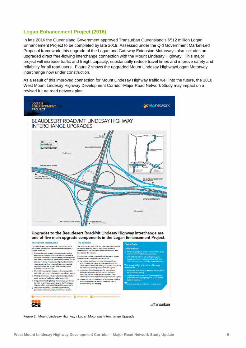
Logan Enhancement Project (2016) In late 2016 the Queensland Government approved Transurban Queensland’s $512 million Logan Enhancement Project to be completed by late 2019. Assessed under the Qld Government Market-Led Proposal framework, this upgrade of the Logan and Gateway Extension Motorways also includes an upgraded direct free-flowing interchange connection with the Mount Lindesay Highway. This major project will increase traffic and freight capacity, substantially reduce travel times and improve safety and reliability for all road users. Figure 2 shows the upgraded Mount Lindesay Highway/Logan Motorway interchange now under construction.
As a result of this improved connection for Mount Lindesay Highway traffic well into the future, the 2010 West Mount Lindesay Highway Development Corridor-Major Road Network Study may impact on a revised future road network plan.
Figure 2. Mount Lindesay Highway / Logan Motorway Interchange Upgrade

West Mount Lindesay Highway Development Corridor – Major Road Network Study Update - 6 -
South East Queensland Regional Plan 2017-2041 In August 2017 the Queensland Government released the new regional plan for South East Queensland. It also sets the transport planning direction to focus on maximising the use of existing infrastructure and planning for smarter solutions for new infrastructure.
The SEQ Regional Plan 2017-2041 (Regional Plan) identifies the need to change our transport priorities to achieve a more sustainable, healthier and fairer transport system and prioritises public and active transport. This includes making the most of our existing systems and targeting strategic investment in new region-shaping infrastructure.
For the West Mount Lindesay Highway Development corridor, the Regional Plan has identified the following priority region-shaping transport infrastructure to be delivered by 2041:
• Enhance the high frequency public transport connection between Browns Plains and the South East Busway.
• Provide frequent public transport services to planned major expansion growth areas - Yarrabilba and Flagstone.
• The Melbourne to Brisbane Inland Rail.
• Salisbury to Flagstone Passenger Rail.
• Bromelton North-South Arterial Road, as part of the Mount Lindesay Highway upgrade.
In addition to delivery of the above services and infrastructure the Regional Plan identifies delivery of the following key regional infrastructure:
• Delivering the southern extension of the Gateway Motorway
• Delivering the road corridor connecting the Greater Flagstone and Yarrabilba expansion areas to the regional road network.

West Mount Lindesay Highway Development Corridor – Major Road Network Study Update - 7 -
Logan West Area Transport Study
Completion of the 2013 Mount Lindesay Highway motorway concept plan for a strategic cost of approximately $1.5 billion identified the need to further investigate the timing for a motorway and development of a staging strategy that addresses both congestion and safety issues in a more timely and cost effective approach.
With release of the Regional Plan and announcement of the Logan Enhancement Project, planning for the Mount Lindesay Highway and surrounding road network also required updating as part of an integrated, affordable transport plan that links to the ongoing development of Flagstone, Yarrabilba and Bromelton State Development Area.
To consider the medium and long term strategic effects of these recent outcomes and decisions, an area wide integrated transport study for the western area of Logan City was completed in 2018. The Logan West Area Transport Study was initiated by TMR with Economic Development Queensland (EDQ) and Logan City Council as key stakeholders. EDQ are managers of both the Greater Flagstone and Yarrabilba Priority Development Areas.
The study’s objective is to develop a multi-modal transport strategy and implementation plan to guide future planning and identify investment priorities for the Logan West area. Given the physical distance separating urban growth areas in the Logan West Area, the road upgrades required to manage future road-based demands will be costly. Any public transport solution (either rail or bus) that offsets the costs of constructing new or upgrading existing roads across the Logan West Area will certainly assist in better optimising future investments. The study will also provide empirical support for TMR’s response to the infrastructure demands of ‘Logan City of Choice’ policy document. The study’s time horizon is 2041 in line with the Regional Plan.
The following key outputs from the draft Logan West Area Transport Study report have been considered in developing a forward 10 year plan for the Mount Lindesay Highway.
Population and employment growth
ShapingSEQ2017 - South East Queensland Regional Plan 2017 (ShapingSEQ 2017) is the State planning instrument responsible for the development of the South Western Corridor, which includes Logan City Council and Scenic Rim Regional Council. ShapingSEQ 2017 expects the Logan City Council area to deliver 98,700 new dwellings by 2041 (see Table 1), 75% of the additional dwellings are planned for the greenfield growth areas in Greater Flagstone, Yarrabilba, Park Ridge and Flinders.
Table 1: Dwelling Supply Benchmarks 2011-2041 (Source: ShapingSEQ 2017)
LGA 2011 2011-16 2011-41 2011-31*
Existing
dwellings
Estimated total
additional dwellings**
Total additional dwellings
Additional infill
dwellings***
Total % of additional
dwellings as infill
Additional greenfield dwellings
Total additional dwellings
Additional infill
dwellings***
Additional greenfield dwellings
Logan 99,900 9,500 98,700 25,000 25% 73,700 53,600 16,700 37,000
Scenic Rim
15,500 1,600 10,800 0 0% 10,800 7,200 0 7,200
*Provided only for guidance about growth assumptions over time, the 2011–31 growth provides an indication of the additional dwelling supply which needs to be accommodated by 2031 if the 2041 benchmarks are to be accommodated.
** Estimates subject to revision based on better information about recent dwelling construction activity.
*** Infill dwellings are calculated using the existing urban area boundary.

West Mount Lindesay Highway Development Corridor – Major Road Network Study Update - 8 -
The Scenic Rim area is expected to deliver 10,800 new dwellings in the same period. While residential growth is modest compared to Logan, the Bromelton State Development Area will see Scenic Rim employment numbers grow significantly.
Table 2: Priority Development Areas and State Development Area
PDA/SDA Date declared
Total Area
Location/ Impacts Target # of Dwellings
Target Population
Attractors
Greater Flagstone PDA
8 October 2010
7,188 hectares
West of Jimboomba and Mount Lindesay Highway, along the Brisbane to Sydney Rail Line. Lies immediately north of Bromelton SDA
50,000 120,000 • major regional activity
centre • neighbourhood centres • local centres • public and private
schools • several employment
clusters (incl. North Maclean)
Yarrabilba PDA
8 October 2010
2,222 hectares
Former commercial pine plantation bounded by Plunkett Conservation Park to the east, Waterford-Tamborine to the west and Plunkett Rd to the south
20,000 50,000 • A sub-regional town
centre • Two neighbourhood
centres • Local centres • Public and private
schools • High level of local
employment
Bromelton SDA
2008 15,610 hectares (of which 1,800 will be developed for industrial uses)
Located within the Scenic Rim Regional Council, approximately six km west of the Beaudesert township and 75 km south of Brisbane
Substantial increase in volume of heavy freight vehicles accessing Bromelton
Access will be restricted to Mount Lindesay Highway with a new road link ( Bromelton North-South Arterial) proposed to link Bromelton to MLH at Woodhill
N/A N/A • Divided into six land use
precincts • One sub precinct will
house high impact, difficult-to-locate and rail dependent industries and will be appropriately buffered by other industrial and rural land uses.
• Given the proximity to Brisbane-Sydney Rail Line, the SDA will include Multi-modal Freight Terminals
West Mount Lindesay Highway Development Corridor – Major Road Network Study Update - 9 -
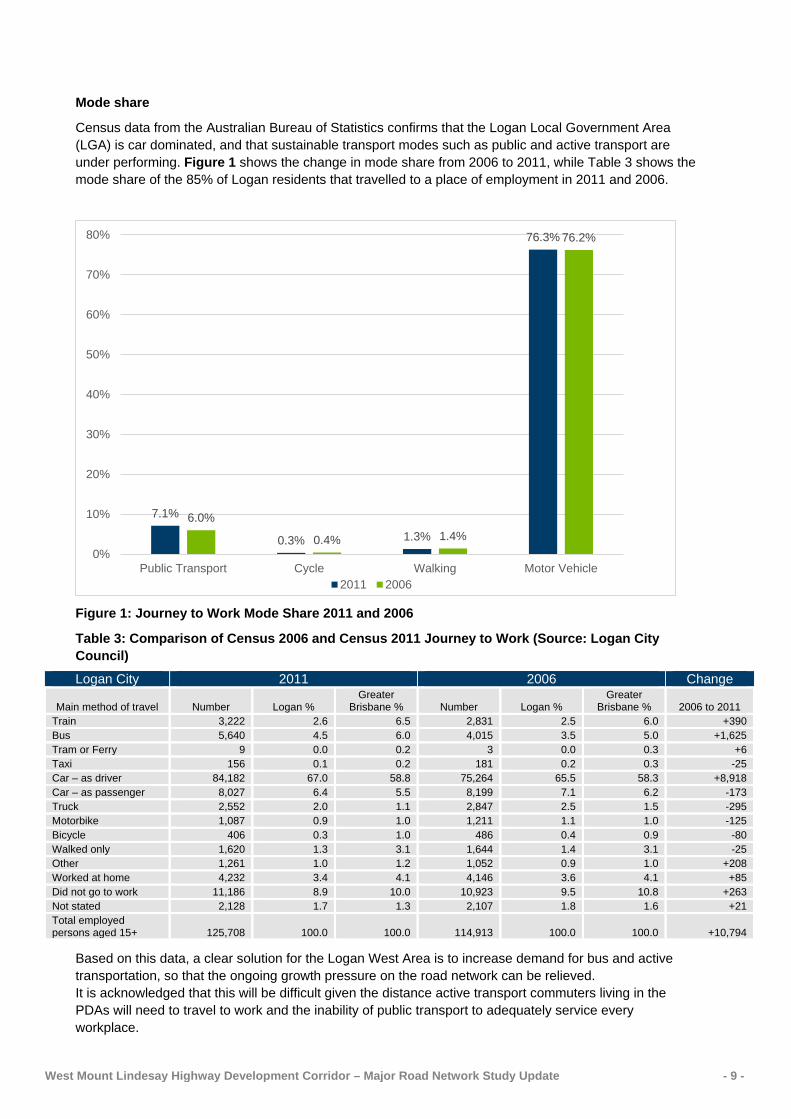
Mode share
Census data from the Australian Bureau of Statistics confirms that the Logan Local Government Area (LGA) is car dominated, and that sustainable transport modes such as public and active transport are under performing. Figure 1 shows the change in mode share from 2006 to 2011, while Table 3 shows the mode share of the 85% of Logan residents that travelled to a place of employment in 2011 and 2006.
Figure 1: Journey to Work Mode Share 2011 and 2006
Table 3: Comparison of Census 2006 and Census 2011 Journey to Work (Source: Logan City Council)
Logan City 2011 2006 Change
Main method of travel Number Logan % Greater
Brisbane % Number Logan % Greater
Brisbane % 2006 to 2011 Train 3,222 2.6 6.5 2,831 2.5 6.0 +390 Bus 5,640 4.5 6.0 4,015 3.5 5.0 +1,625 Tram or Ferry 9 0.0 0.2 3 0.0 0.3 +6 Taxi 156 0.1 0.2 181 0.2 0.3 -25 Car – as driver 84,182 67.0 58.8 75,264 65.5 58.3 +8,918 Car – as passenger 8,027 6.4 5.5 8,199 7.1 6.2 -173 Truck 2,552 2.0 1.1 2,847 2.5 1.5 -295 Motorbike 1,087 0.9 1.0 1,211 1.1 1.0 -125 Bicycle 406 0.3 1.0 486 0.4 0.9 -80 Walked only 1,620 1.3 3.1 1,644 1.4 3.1 -25 Other 1,261 1.0 1.2 1,052 0.9 1.0 +208 Worked at home 4,232 3.4 4.1 4,146 3.6 4.1 +85 Did not go to work 11,186 8.9 10.0 10,923 9.5 10.8 +263 Not stated 2,128 1.7 1.3 2,107 1.8 1.6 +21 Total employed persons aged 15+ 125,708 100.0 100.0 114,913 100.0 100.0 +10,794
Based on this data, a clear solution for the Logan West Area is to increase demand for bus and active transportation, so that the ongoing growth pressure on the road network can be relieved. It is acknowledged that this will be difficult given the distance active transport commuters living in the PDAs will need to travel to work and the inability of public transport to adequately service every workplace.
7.1%
0.3% 1.3%
76.3%
6.0%
0.4% 1.4%
76.2%
0%
10%
20%
30%
40%
50%
60%
70%
80%
Public Transport Cycle Walking Motor Vehicle2011 2006

West Mount Lindesay Highway Development Corridor – Major Road Network Study Update - 10 -
Challenges for the Logan West transport networks
The Logan West Area is facing significant transportation challenges as major development occurs in growth areas including Yarrabilba, Greater Flagstone, Logan Reserve, Park Ridge and North Maclean. This extensive residential and industrial growth will see a largely rural road network being depended on to accommodate significant increases in car, bus, freight and cycle trips in the coming years. This will place increasing pressure on all levels of government and developers to invest in public transport, active transport and road infrastructure across the area.
Key challenges facing all governments and developers include:
• The current low self-containment of employment within the new growth areas, forcing residents to travel long distances to employment;
• The significant travel distances between the growth areas and major retail and employment areas in Logan, Ipswich, Brisbane and Gold Coast LGAs, making active transport difficult;
• The historically low modal share for sustainable modes of transport across the LGA;
• The sparse distribution of employment destinations across Logan and surrounding LGAs making it difficult for public transport to service all these areas, particularly at a time that suits many of those that employ blue collar workers;
• The affordability of new transport infrastructure given the extensive distance between the growth areas and existing transport networks to the north;
• Sourcing funding to deliver new transport infrastructure early in the development process;
• The prioritisation of high priority transport projects given the limitations of funding;
• Maintaining operational efficiency of the existing transport networks until capacity upgrades are able to be delivered;
• Maximising the capacity of the existing transport infrastructure in order to delay capital investment on new or upgraded transport infrastructure;
• The need to establish public and active transport networks for new residents before they develop a reliance on private transport;
• The need, in the short to medium term, for all forms of transport to share the same road space
• The impact of heavy freight vehicles, servicing new freight terminals at Bromelton, on roads in the Logan West Area.
West Mount Lindesay Highway Development Corridor – Major Road Network Study Update - 11 -
Future transport initiatives
Transport initiatives in ShapingSEQ 2017 – South East Queensland Regional Plan 2017
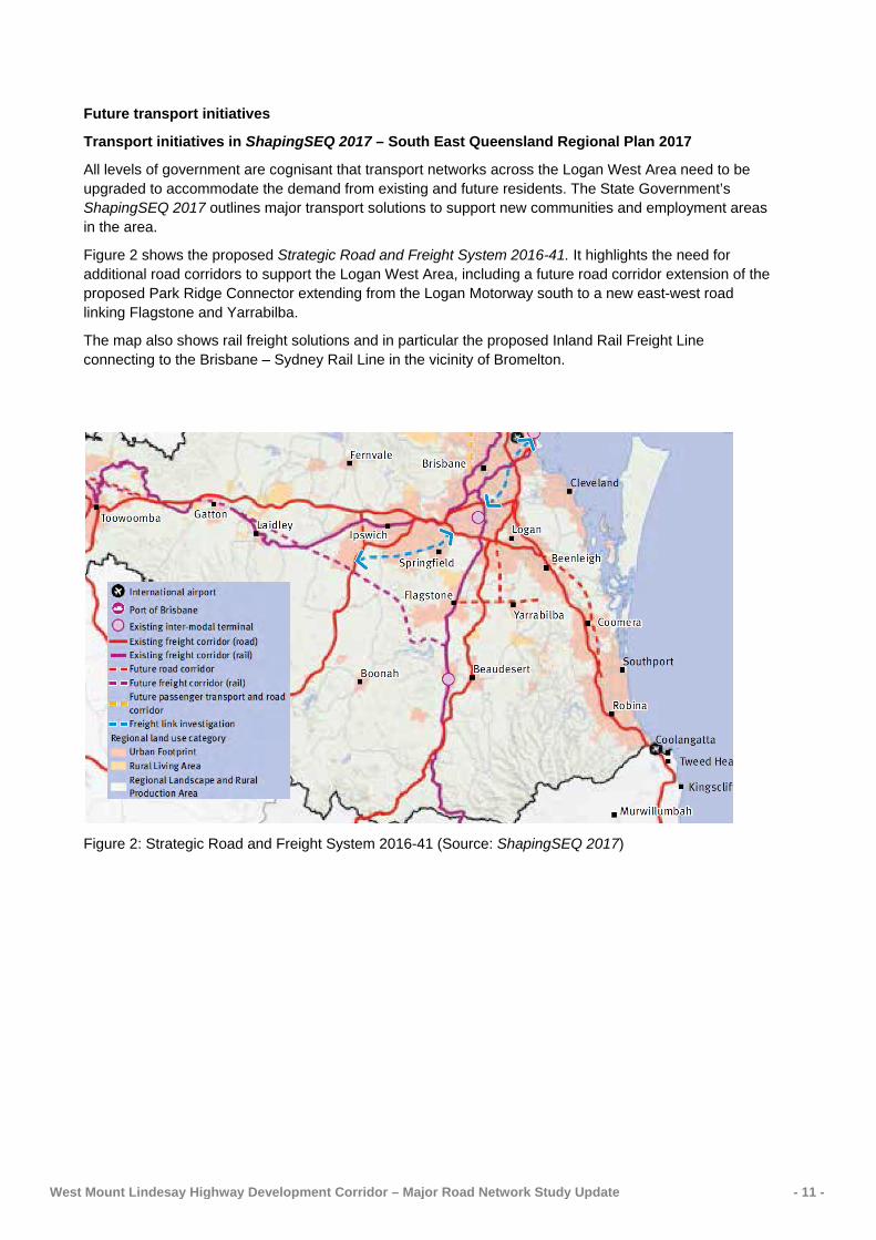
All levels of government are cognisant that transport networks across the Logan West Area need to be upgraded to accommodate the demand from existing and future residents. The State Government’s ShapingSEQ 2017 outlines major transport solutions to support new communities and employment areas in the area.
Figure 2 shows the proposed Strategic Road and Freight System 2016-41. It highlights the need for additional road corridors to support the Logan West Area, including a future road corridor extension of the proposed Park Ridge Connector extending from the Logan Motorway south to a new east-west road linking Flagstone and Yarrabilba.
The map also shows rail freight solutions and in particular the proposed Inland Rail Freight Line connecting to the Brisbane – Sydney Rail Line in the vicinity of Bromelton.
Figure 2: Strategic Road and Freight System 2016-41 (Source: ShapingSEQ 2017)

West Mount Lindesay Highway Development Corridor – Major Road Network Study Update - 12 -
Figure 3 shows the proposed Strategic Passenger Transport (PT) System 2016-41. For the study area, it shows trunk public transport corridors supporting Greater Flagstone and Browns Plains and trunk public transport services to Yarrabilba and Beaudesert.
While new public transport using the Greater Flagstone Corridor will initially be bus focused, in the long term the Salisbury to Beaudesert Rail Line will service future development areas in the South Western Corridor.
Figure 3: Strategic Passenger Transport (PT) System 2016-41 (Source: ShapingSEQ 2017)
Other major transport initiatives
Major road upgrades
TMR is actively planning the duplication and progressively delivering safety improvements along the Mount Lindesay Highway from Park Ridge south to Jimboomba.
Similarly TMR is delivering localised intersection improvements along Waterford–Tamborine Road between Logan Village and Yarrabilba.
Transurban, as the toll operators of the Logan and Gateway Motorways, are presently delivering the Logan Enhancement Project which will see a major upgrade of the Logan and Gateway Extension Motorways between the Mount Lindesay Highway, Wembley Road and Compton Road interchanges.
Local road upgrades
Economic Development Queensland (EDQ), as the authority responsible for the PDAs, is working with Logan City Council to deliver upgrades to local roads across the Logan West Area as demand increases. This will see a number of local roads, servicing PDAs, duplicated over coming years.

West Mount Lindesay Highway Development Corridor – Major Road Network Study Update - 13 -
New freight road servicing Bromelton
TMR has identified the alignment of a new link road, the Bromelton North-South Arterial Road, connecting Bromelton SDA and Mount Lindesay Highway at Woodhill. When constructed, the new road will reduce heavy freight and commuter traffic accessing Bromelton from the Mount Lindesay Highway south of Woodhill.
New bus services
Currently, there are nine TransLink scheduled bus services, one private bus service and 104 school bus services servicing the Logan West area. One of these services, the 540 Browns Plains to Beaudesert, uses the Mount Lindesay Highway providing 13 hourly weekday services.
Of the nine scheduled TransLink services in the Logan West area, six are services to Brisbane CBD with two being high frequency all day services and three pre-paid peak only express services. There are three local bus routes which services Browns Plains Grand Plaza.
TransLink is actively planning how best to service the area, working with developers in Greater Flagstone and Yarrabilba, to implement services as part of the development conditions imposed by EDQ. To date, the developers of Yarrabilba have contracted Logan Coaches to provide ten daily services each way, with four in the AM peak and four return services in the PM peak.
Public transport services to Greater Flagstone will be delivered as development matures. As demand increases a new network of extended existing bus routes, new bus routes and more frequent bus services will be implemented. This could include a Demand Responsive Transport (DRT) solution connecting areas with lower population density and dispersed employment attractors, based on the outcome of a trial that is presently underway.
New park ‘n’ ride facilities
There are only two formal park ‘n’ ride facilities in the study area. They are Park Ridge and the Greenbank RSL. However, existing residents are also using private vehicles to commute to major public transport hubs including: Browns Plains Grand Plaza; Mains Road, Nathan; Springfield Central Rail Station; Loganlea Rail Station and Beenleigh Rail Station.
With many existing facilities at capacity, expansion or new park ‘n’ ride facilities at major transport hubs through the Logan West Area will be necessary to ensure every opportunity is provided for private vehicle owners to drive short distances to access trunk public transport services.
New cycleways
A network of new internal cycleways are being progressively rolled out by the developers of the PDAs.
The Principal Cycle Network indicatively shows routes connecting these local networks to the existing cycle network across Logan to the north. This includes a new cycleway within the proposed Salisbury to Beaudesert Rail Line corridor to connect key centres including Undullah, Flagstone, New Beith, and Greenbank to the existing cycle network to the north. The Network also includes a trail utilising the old Bethania to Beaudesert Rail Line corridor.
West Mount Lindesay Highway Development Corridor – Major Road Network Study Update - 14 -
Development growth
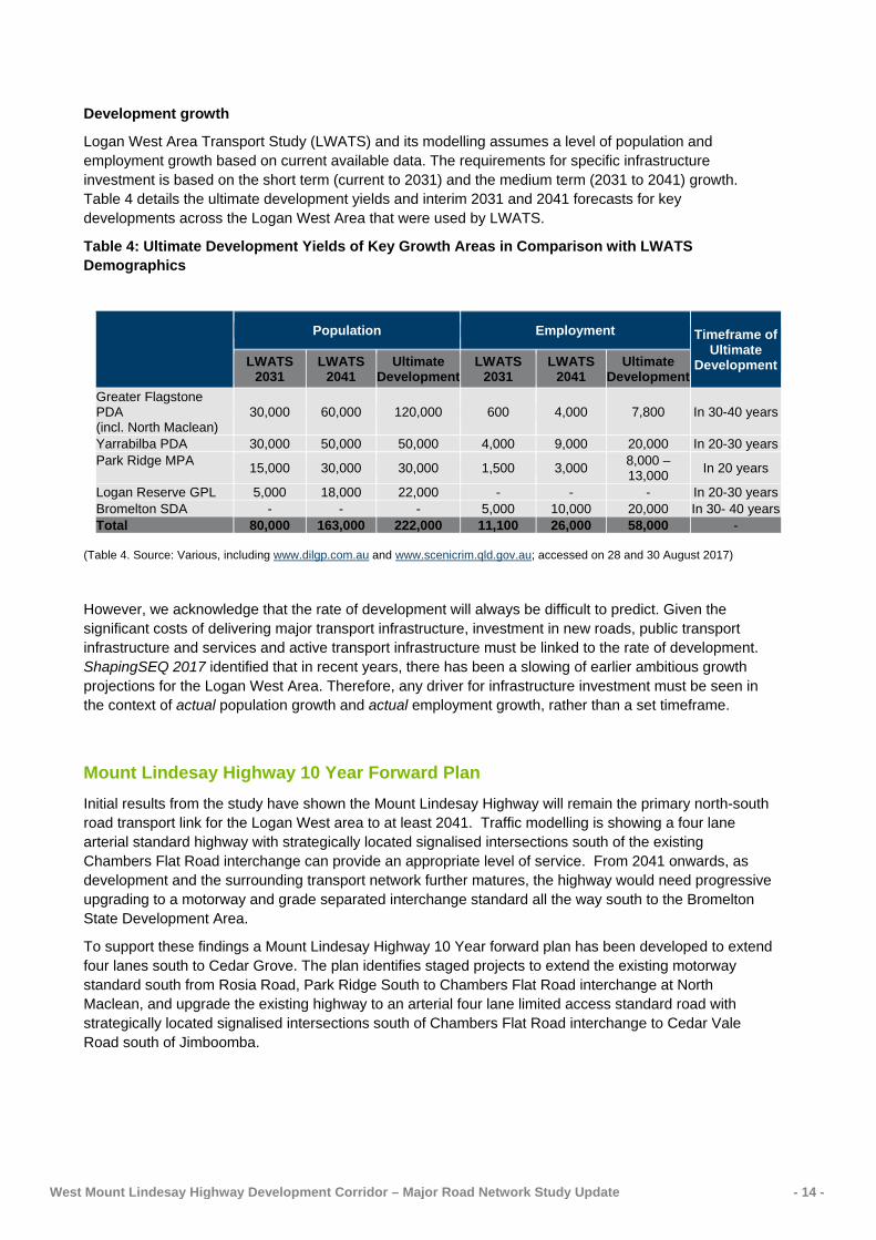
Logan West Area Transport Study (LWATS) and its modelling assumes a level of population and employment growth based on current available data. The requirements for specific infrastructure investment is based on the short term (current to 2031) and the medium term (2031 to 2041) growth. Table 4 details the ultimate development yields and interim 2031 and 2041 forecasts for key developments across the Logan West Area that were used by LWATS.
Table 4: Ultimate Development Yields of Key Growth Areas in Comparison with LWATS Demographics
Population Employment Timeframe of
Ultimate Development LWATS
2031 LWATS
2041 Ultimate
Development LWATS
2031 LWATS
2041 Ultimate
Development Greater Flagstone PDA (incl. North Maclean)
30,000 60,000 120,000 600 4,000 7,800 In 30-40 years
Yarrabilba PDA 30,000 50,000 50,000 4,000 9,000 20,000 In 20-30 years Park Ridge MPA 15,000 30,000 30,000 1,500 3,000 8,000 –
13,000 In 20 years
Logan Reserve GPL 5,000 18,000 22,000 - - - In 20-30 years Bromelton SDA - - - 5,000 10,000 20,000 In 30- 40 years Total 80,000 163,000 222,000 11,100 26,000 58,000 -
(Table 4. Source: Various, including www.dilgp.com.au and www.scenicrim.qld.gov.au; accessed on 28 and 30 August 2017)
However, we acknowledge that the rate of development will always be difficult to predict. Given the significant costs of delivering major transport infrastructure, investment in new roads, public transport infrastructure and services and active transport infrastructure must be linked to the rate of development. ShapingSEQ 2017 identified that in recent years, there has been a slowing of earlier ambitious growth projections for the Logan West Area. Therefore, any driver for infrastructure investment must be seen in the context of actual population growth and actual employment growth, rather than a set timeframe.
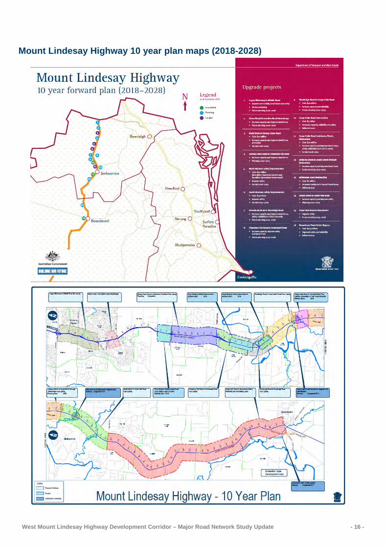
Mount Lindesay Highway 10 Year Forward Plan Initial results from the study have shown the Mount Lindesay Highway will remain the primary north-south road transport link for the Logan West area to at least 2041. Traffic modelling is showing a four lane arterial standard highway with strategically located signalised intersections south of the existing Chambers Flat Road interchange can provide an appropriate level of service. From 2041 onwards, as development and the surrounding transport network further matures, the highway would need progressive upgrading to a motorway and grade separated interchange standard all the way south to the Bromelton State Development Area.
To support these findings a Mount Lindesay Highway 10 Year forward plan has been developed to extend four lanes south to Cedar Grove. The plan identifies staged projects to extend the existing motorway standard south from Rosia Road, Park Ridge South to Chambers Flat Road interchange at North Maclean, and upgrade the existing highway to an arterial four lane limited access standard road with strategically located signalised intersections south of Chambers Flat Road interchange to Cedar Vale Road south of Jimboomba.
West Mount Lindesay Highway Development Corridor – Major Road Network Study Update - 15 -
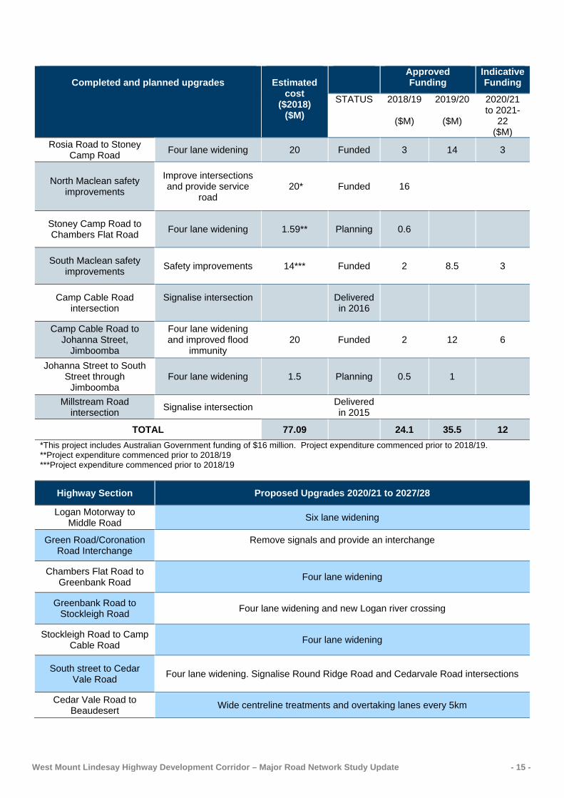
Completed and planned upgrades
Estimated
cost ($2018)
($M)
Approved Funding
Indicative Funding
STATUS 2018/19
($M)
2019/20
($M)
2020/21 to 2021-
22 ($M)
Rosia Road to Stoney Camp Road Four lane widening 20 Funded 3 14 3
North Maclean safety improvements
Improve intersections and provide service
road 20* Funded 16
Stoney Camp Road to Chambers Flat Road Four lane widening 1.59** Planning 0.6
South Maclean safety improvements Safety improvements 14*** Funded 2 8.5 3
Camp Cable Road intersection
Signalise intersection Delivered
in 2016
Camp Cable Road to Johanna Street,
Jimboomba
Four lane widening and improved flood
immunity 20 Funded 2 12 6
Johanna Street to South Street through
Jimboomba Four lane widening 1.5 Planning 0.5 1
Millstream Road intersection Signalise intersection Delivered
in 2015
TOTAL 77.09 24.1 35.5 12 *This project includes Australian Government funding of $16 million. Project expenditure commenced prior to 2018/19. **Project expenditure commenced prior to 2018/19 ***Project expenditure commenced prior to 2018/19
Highway Section Proposed Upgrades 2020/21 to 2027/28
Logan Motorway to Middle Road Six lane widening
Green Road/Coronation Road Interchange
Remove signals and provide an interchange
Chambers Flat Road to Greenbank Road Four lane widening
Greenbank Road to Stockleigh Road Four lane widening and new Logan river crossing
Stockleigh Road to Camp Cable Road Four lane widening
South street to Cedar Vale Road Four lane widening. Signalise Round Ridge Road and Cedarvale Road intersections
Cedar Vale Road to Beaudesert Wide centreline treatments and overtaking lanes every 5km
West Mount Lindesay Highway Development Corridor – Major Road Network Study Update - 16 -
Mount Lindesay Highway 10 year plan maps (2018-2028)
West Mount Lindesay Highway Development Corridor – Major Road Network Study Update - 17 -
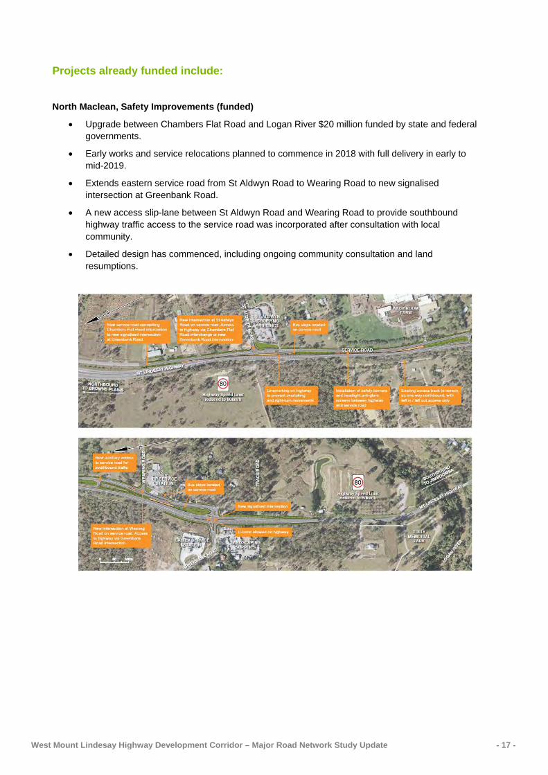
Projects already funded include:
North Maclean, Safety Improvements (funded)
• Upgrade between Chambers Flat Road and Logan River $20 million funded by state and federal governments.
• Early works and service relocations planned to commence in 2018 with full delivery in early to mid-2019.
• Extends eastern service road from St Aldwyn Road to Wearing Road to new signalised intersection at Greenbank Road.
• A new access slip-lane between St Aldwyn Road and Wearing Road to provide southbound highway traffic access to the service road was incorporated after consultation with local community.
• Detailed design has commenced, including ongoing community consultation and land resumptions.

West Mount Lindesay Highway Development Corridor – Major Road Network Study Update - 18 -
South Maclean, Safety Improvements (funded)
• Upgrade between South Maclean and Camp Cable Road $14 million funded by state government.
• Design well underway, survey complete. Some land requirements and consultation required 2018.
• Extends the eastern service road south to a new signalised intersection at Stockleigh Road and Crest Road.
• Extends Casuarina Road to connect to Crest Road, disconnecting the existing intersection with the Mount Lindesay Highway.

West Mount Lindesay Highway Development Corridor – Major Road Network Study Update - 19 -
Rosia Road to Stoney Camp Road Interchange (funded)
• $20 million of state funding included in 2017/18 to 2020/21 QTRIP.
• Indicative delivery timing is 2019-20.
• Four lane widening, 1.1km south from Rosia Road to interchange overpass.
• Increased water runoff capacity.
Camp Cable Road to Johanna Street, Jimboomba (funded)
• $20 million of state funding 2018/2019 - 2020/2021.
• Four lane widening and improved flood immunity increasing reliability.
• Detailed design is underway.

West Mount Lindesay Highway Development Corridor – Major Road Network Study Update - 20 -
Camp Cable Road intersection (delivered)
• A $7 million upgrade to signalise the Camp Cable Road intersection increasing capacity, reliability and safety was delivered in 2016.