Wellington Conservation Management Strategy, Volume 2 · Islands over 1 ha administered by the...
128
1 Wellington Conservation Management Strategy 2019-2029 Wellington 2019, Volume II Appendices CMS CONSERVATION MANAGEMENT STRATEGY
Transcript of Wellington Conservation Management Strategy, Volume 2 · Islands over 1 ha administered by the...

1Wellington Conservation Management Strategy 2019-2029
Wellington 2019, Volume II Appendices
CMSCONSERVATION MANAGEMENT STRATEGY

Cover: McKinnon Hut, 2012. This is a standard six-bunk hut in Ruahine Forest Park. Photographer: Jonathan Astin© Jonathan Astin © January 2019, New Zealand Department of Conservation
ISBN Online - 978-1-98-851483-3ISBN Print - 978-1-98-851484-0
Crown copyright © 2019
This work is licensed under the Creative Commons Attribution 4.0 International licence. In essence, you are free to copy, distribute and adapt the work, as long as you attribute the work to the Crown and abide by the other licence terms. To view a copy of this licence, visit https://creativecommons.org/licenses/by/4.0/
Please note that no departmental or governmental emblem, logo or Coat of Arms may be used in any way which infringes any provision of the Flags, Emblems, and Names Protection Act 1981. Attribution to the Crown should be in written form and not by reproduction of any such emblem, logo or Coat of Arms. Use the wording ‘Department of Conservation’ in your attribution, not the Department of Conservation logo.
This publication is printed on paper pulp sourced from sustainably grown and managed forests, using Elemental Chlorine Free (ECF) bleaching and printed with 100 percent vegetable-based inks.
This conservation management strategy is made up of three volumes: Volume I, Volume II Appendices and Volume III Maps. All volumes are online at www.doc.govt.nz/wellingtoncms.
3Wellington Conservation Management Strategy 2019-2029
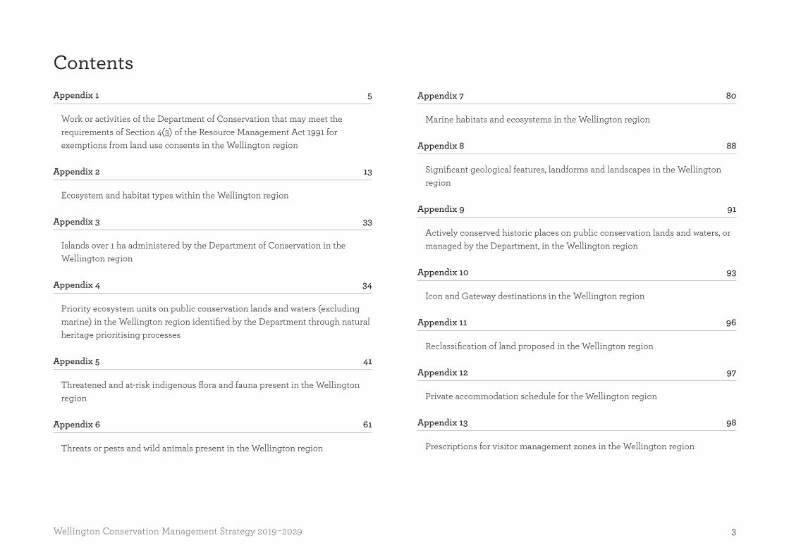
ContentsAppendix 1 5
Work or activities of the Department of Conservation that may meet the requirements of Section 4(3) of the Resource Management Act 1991 for exemptions from land use consents in the Wellington region
Appendix 2 13
Ecosystem and habitat types within the Wellington region
Appendix 3 33
Islands over 1 ha administered by the Department of Conservation in the Wellington region
Appendix 4 34
Priority ecosystem units on public conservation lands and waters (excluding marine) in the Wellington region identified by the Department through natural heritage prioritising processes
Appendix 5 41
Threatened and at-risk indigenous flora and fauna present in the Wellington region
Appendix 6 61
Threats or pests and wild animals present in the Wellington region
Appendix 7 80
Marine habitats and ecosystems in the Wellington region
Appendix 8 88
Significant geological features, landforms and landscapes in the Wellington region
Appendix 9 91
Actively conserved historic places on public conservation lands and waters, or managed by the Department, in the Wellington region
Appendix 10 93
Icon and Gateway destinations in the Wellington region
Appendix 11 96
Reclassification of land proposed in the Wellington region
Appendix 12 97
Private accommodation schedule for the Wellington region
Appendix 13 98
Prescriptions for visitor management zones in the Wellington region
4 Wellington Conservation Management Strategy 2019-2029
Appendix 14 101
Aircraft use zones for the Wellington region
Appendix 15 103
Criteria for which the Manawatū Estuary Wetland of International Importance was nominated
Appendix 16 104
Treaty of Waitangi relationships for the Wellington region
Appendix 17 106
Designated landing zones in the Ruahine Forest Park
Appendix 18 107
Statutory agencies
Appendix 19 110
Submitters on the Wellington CMS review
Appendix 20 112
Milestones

5Wellington Conservation Management Strategy 2019-2029 Appendix 1
Appendix 1Work or activities of the Department of Conservation that may meet the requirements of Section 4(3) of the Resource Management Act 1991 for exemptions from land use consents in the Wellington regionThis table is presented to meet the requirements for enabling exemptions under Section 4(3) of the Resource Management Act 1991 (RMA). It does not exclude the need to meet all Departmental requirements for the assessment of effects or responsibilities under other legislation (e.g. Building Act 2004, Heritage New Zealand Pouhere Taonga Act 2014). This table does not imply that the facilities included within it will be managed in perpetuity.
Activity scope Management actions Environmental impacts Location
Tracks, roads and car parking areas for visitor purposes
1. Upgrade existing tracks and roads to meet current Departmental service standards using current alignment.
2. Service standard upgrades of existing tracks and roads through partial or complete realignment to take advantage of better grades and terrain features, or to incorporate elements of natural or historic landscape.
3. Construct new tracks as agreed in consultation with the community.
4. Improvements to any existing track as considered necessary to mitigate any environmental impact, health and safety concern or visitor risk, or to provide improved access for any management purpose.
1. Construct tracks and roads using cut to fill excavation, cut to waste excavation and levelling using hand tools, motorised equipment and machinery.
2. Excavate batter slopes to a maximum height of 1.5 m.
3. Vegetation removal from the full width of the track corridor, and discretionary removal of any vegetation beyond the track and road corridor that is considered hazardous or that may adversely affect track components such as batter slopes, drainage or track surface materials.
1. Soil disturbance, including disturbance of the duff layer and subsoil. Disturbance and soil compaction in fill areas.
2. Surface water run-off, including modification of existing natural watercourses, and control and redirection of surface water using various means such as culvert pipes, drainage sumps, cut-outs and cross boards.
3. Alterations to land contours and slopes during track construction and upgrade.
4. Removal of vegetation from the track corridor and from immediately adjacent to the asset corridor.
Existing tracks, roads and car parks
Manawatū District • Bruce Park Scenic Reserve track • Papaitonga Scenic Reserve track and car park • Makino Scenic Reserve track • Manawatū Gorge Scenic Reserve tracks and car
park • Mangaweka Scenic Reserve track • Pukepuke Lagoon Conservation Area track and road • Ruahine Forest Park tracks, roads and car parks
- Rangiwahia Track - Sunshine Track
• Ruahine Forest (West) Conservation Area track and car park
• Simpson Scenic Reserve road and car park
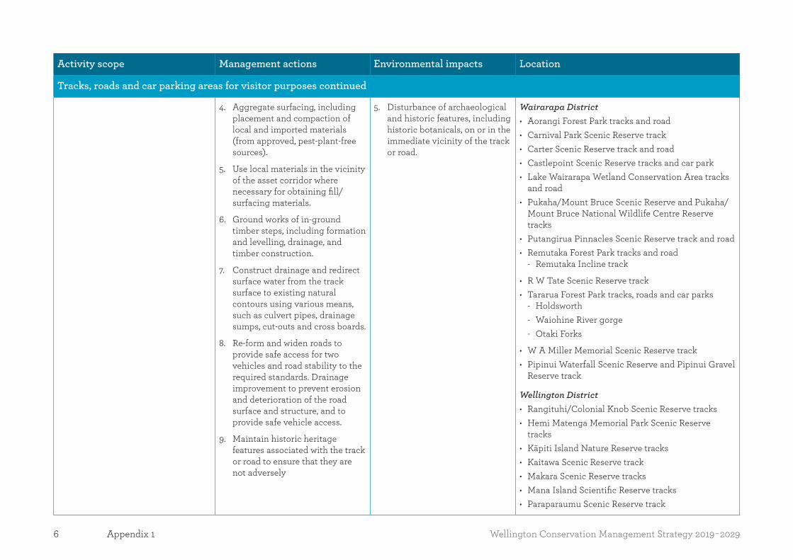
6 Wellington Conservation Management Strategy 2019-2029Appendix 1
Activity scope Management actions Environmental impacts Location
Tracks, roads and car parking areas for visitor purposes continued
4. Aggregate surfacing, including placement and compaction of local and imported materials (from approved, pest-plant-free sources).
5. Use local materials in the vicinity of the asset corridor where necessary for obtaining fill/surfacing materials.
6. Ground works of in-ground timber steps, including formation and levelling, drainage, and timber construction.
7. Construct drainage and redirect surface water from the track surface to existing natural contours using various means, such as culvert pipes, drainage sumps, cut-outs and cross boards.
8. Re-form and widen roads to provide safe access for two vehicles and road stability to the required standards. Drainage improvement to prevent erosion and deterioration of the road surface and structure, and to provide safe vehicle access.
9. Maintain historic heritage features associated with the track or road to ensure that they are not adversely
5. Disturbance of archaeological and historic features, including historic botanicals, on or in the immediate vicinity of the track or road.
Wairarapa District • Aorangi Forest Park tracks and road • Carnival Park Scenic Reserve track • Carter Scenic Reserve track and road • Castlepoint Scenic Reserve tracks and car park • Lake Wairarapa Wetland Conservation Area tracks
and road • Pukaha/Mount Bruce Scenic Reserve and Pukaha/
Mount Bruce National Wildlife Centre Reserve tracks
• Putangirua Pinnacles Scenic Reserve track and road • Remutaka Forest Park tracks and road
- Remutaka Incline track
• R W Tate Scenic Reserve track • Tararua Forest Park tracks, roads and car parks
- Holdsworth - Waiohine River gorge - Otaki Forks
• W A Miller Memorial Scenic Reserve track • Pipinui Waterfall Scenic Reserve and Pipinui Gravel
Reserve track
Wellington District • Rangituhi/Colonial Knob Scenic Reserve tracks • Hemi Matenga Memorial Park Scenic Reserve
tracks • Kāpiti Island Nature Reserve tracks • Kaitawa Scenic Reserve track • Makara Scenic Reserve tracks • Mana Island Scientific Reserve tracks • Paraparaumu Scenic Reserve track

7Wellington Conservation Management Strategy 2019-2029 Appendix 1
Activity scope Management actions Environmental impacts Location
Tracks, roads and car parking areas for visitor purposes continued
• Pauatahanui Wildlife Reserve tracks • Remutaka Forest Park tracks, car park and roads
- Catchpool - Orongorongo River valley
• Turakirae Head Scientific Reserve track and car park
• Waikanae Estuary Scientific Reserve tracks • Whareroa Recreation Reserve tracks, car park and
road
Proposed future developments Manawatū District • Manawatū Gorge Scenic Reserve walking and cycle
trails • Omarupapako/Round Bush Scenic Reserve walkway • Car park at Sunrise Hut entrance, Ruahine Forest
Park
Structures* and buildings for visitor purposes
1. Upgrade existing structures and buildings to meet Departmental service standards so that visitor group requirements are met, such as minimum access widths and safety barrier heights.
2. Scheduled ‘like for like’ (substantially similar structures and buildings built on the same footprint or within the immediate vicinity) replacement of existing structures and buildings as they reach the end of their projected/economic life.
1. Preparatory site works such as vegetation removal, formation and levelling of structure and building footprints, and excavation of piles and footings.
2. Works associated with water reticulation and sewage containment/treatment.
3. Construct drainage and redirect surface water from structure and building footprint to existing natural contours using various means, such as culvert pipes, drainage sumps and cut-outs.
1. Soil disturbance, including disturbance of the duff layer and subsoil. Disturbance and soil compaction in fill areas.
2. Surface water run-off, including modification of existing natural watercourses, and control and redirection of surface water using various means such as culvert pipes, drainage sumps, cut-outs and cross boards.
Existing structures and buildings
Manawatū District • Makino Scenic Reserve track and building • Manawatū Gorge Scenic Reserve tracks and
buildings • Ruahine Forest (West) Conservation Area track and
building • Pukepuke Lagoon Conservation Area track, road
and building • Ruahine Forest Park tracks, huts and shelters • Ruahine Forest (West) Conservation Area track • Simpson Scenic Reserve road and building
* Recreational structures for visitor purposes include viewing platforms, steps/stairs, boardwalks, bridges, handrails, safety fences, stiles, signage, etc.
8 Wellington Conservation Management Strategy 2019-2029Appendix 1
Activity scope Management actions Environmental impacts Location
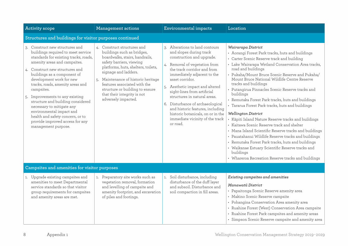
Structures and buildings for visitor purposes continued
3. Construct new structures and buildings required to meet service standards for existing tracks, roads, amenity areas and campsites.
4. Construct new structures and buildings as a component of development work for new tracks, roads, amenity areas and campsites.
5. Improvements to any existing structure and building considered necessary to mitigate any environmental impact and health and safety concern, or to provide improved access for any management purpose.
4. Construct structures and buildings such as bridges, boardwalks, stairs, handrails, safety barriers, viewing platforms, huts, shelters, toilets, signage and ladders.
5. Maintenance of historic heritage features associated with the structure or building to ensure that their integrity is not adversely impacted.
3. Alterations to land contours and slopes during track construction and upgrade.
4. Removal of vegetation from the track corridor and from immediately adjacent to the asset corridor.
5. Aesthetic impact and altered sight-lines from artificial structures in natural areas.
6. Disturbance of archaeological and historic features, including historic botanicals, on or in the immediate vicinity of the track or road.
Wairarapa District • Aorangi Forest Park tracks, huts and buildings • Carter Scenic Reserve track and building • Lake Wairarapa Wetland Conservation Area tracks,
road and buildings • Pukaha/Mount Bruce Scenic Reserve and Pukaha/
Mount Bruce National Wildlife Centre Reserve tracks and buildings
• Putangirua Pinnacles Scenic Reserve tracks and buildings
• Remutaka Forest Park tracks, huts and buildings • Tararua Forest Park tracks, huts and buildings
Wellington District • Kāpiti Island Nature Reserve tracks and buildings • Kaitawa Scenic Reserve track and shelter • Mana Island Scientific Reserve tracks and buildings • Pauatahanui Wildlife Reserve tracks and buildings • Remutaka Forest Park tracks, huts and buildings • Waikanae Estuary Scientific Reserve tracks and
buildings • Whareroa Recreation Reserve tracks and buildings
Campsites and amenities for visitor purposes
1. Upgrade existing campsites and amenities to meet Departmental service standards so that visitor group requirements for campsites and amenity areas are met.
1. Preparatory site works such as vegetation removal, formation and levelling of campsite and amenity footprint, and excavation of piles and footings.
1. Soil disturbance, including disturbance of the duff layer and subsoil. Disturbance and soil compaction in fill areas.
Existing campsites and amenities
Manawatū District • Papaitonga Scenic Reserve amenity area • Makino Scenic Reserve campsite • Pohangina Conservation Area amenity area • Ruahine Forest (West) Conservation Area campsite • Ruahine Forest Park campsites and amenity areas • Simpson Scenic Reserve campsite and amenity area

9Wellington Conservation Management Strategy 2019-2029 Appendix 1
Activity scope Management actions Environmental impacts Location
Campsites and amenities for visitor purposes continued
2. Scheduled ‘like for like’ (substantially similar campsites and amenities built on the same footprint or within the immediate vicinity) replacement of existing campsites and amenity assets as these reach the end of their projected/economic life.
3. Construct new campsites and amenities required to meet service standards for existing campsites and amenity areas.
4. Construct new assets such as structures and buildings as a component of development work for new campsites and amenity areas.
5. Improvements to any existing asset or establishment of new assets considered necessary to manage, meet regulatory requirements and mitigate any environmental impact or health and safety concern, or to provide improved access for any management purpose.
2. Works associated with water reticulation and sewage containment/treatment, including effluent dispersal fields and in-ground waste tanks.
3. Construct drainage and redirect surface water from building and structural campsite and amenity footprint to existing natural contours using various means such as culvert pipes, drainage sumps and cut-outs.
4. Construct campsites and amenities such as bridges, boardwalks, stairs, handrails, safety barriers, shelters, toilets, showers, signage and ladders.
5. Maintenance of historic heritage features, including historic botanicals, associated with the campsite or amenity to ensure that they are not adversely impacted.
2. Surface water run-off, including modification of existing natural watercourses, and control and redirection of surface water using various means such as culvert pipes, drainage sumps, cut-outs and cross boards.
3. Alterations to land contours and slopes during track construction and upgrade.
4. Removal of vegetation from the track corridor and from immediately adjacent to the asset corridor.
5. Aesthetic impact and altered sight-lines from artificial structures in natural areas.
6. Noise from increased usage of campsite and amenities.
7. Increased water take for operation of campsite and amenities.
8. Disturbance of archaeological and historic features, including historic botanicals, on or in the immediate vicinity of the track or road.
Wairarapa District • Lake Wairarapa Wetland Conservation Area picnic
area • Pukaha Mount Bruce Scenic Reserve and Pukaha
Mount Bruce National Wildlife Centre Reserve amenity area
• Putangirua Pinnacles Scenic Reserve campsite • Remutaka Forest Park campsite • Tararua Forest Park campsites and amenity areas
- Holdsworth - Waiohine River gorge - Otaki Forks
Wellington District • Kāpiti Island Nature Reserve amenity area • Mana Island Scientific Reserve amenity area • Pauatahanui Wildlife Reserve amenity area • Remutaka Forest Park campsite and amenity area
- Catchpool
• Waikanae Estuary Scientific Reserve amenity area • Whareroa Recreation Reserve amenity area

10 Wellington Conservation Management Strategy 2019-2029Appendix 1
Activity scope Management actions Environmental impacts Location
Historic assets – remedial work and maintenance
1. Maintenance of historic places to departmental service standards, and ICOMOS and Heritage NZ standards and guidelines.
2. Stabilisation of condition of historic assets by conservation treatments and land stabilising, e.g. construction of retaining walls.
1. Vegetation management around historic places, maintenance of drainage channels and management of safety issues including barrier construction and installation of interpretative panels.
2. Repairs and conservation treatments as scheduled to concrete, masonry, metal, timber and earthwork structures.
3. Maintenance of historic heritage features, including historic botanicals, associated with the historic asset to ensure that they are not adversely impacted.
1. Minor soil disturbance of the duff layer and subsoil. Disturbance and soil compaction in fill areas.
2. Surface water run-off, including modification of existing natural watercourses and control and redirection of surface water using various means, such as culvert pipes and drainage sumps.
3. Removal of vegetation from assets and immediate vicinity.
Manawatū District • Bruce Memorial Scenic Reserve memorial • Bruce Park Scenic Reserve memorials • Ruahine Forest Park huts • Ruahine Forest East Conservation Area hut
Wairarapa District • Aorangi Forest Park hut • Kupe’s Sail Rock Recreation Reserve • Remutaka Forest Park rail incline • Tararua Forest Park huts • Shields Flat Historic Reserve stone walls • Tararua Forest Park haulers
Wellington District • Kāpiti Island Nature Reserve building and whaling
station • Makara Scenic Reserve gun emplacements • Mana Island Scientific Reserve woolshed, habitation
and lighthouse
Signs
1. Erection of signage on public conservation lands and waters for the purpose of providing information and interpretation to the public.
2. Erection of signage on public conservation lands and waters for the purpose of informing people about fire lighting restrictions.
1. Works associated with the erection of signage.
1. Aesthetic impact from man-made structures in natural areas.
2. Removal of vegetation from sign footprint and immediate vicinity.
• All public conservation lands and waters in the Wellington region.

11Wellington Conservation Management Strategy 2019-2029 Appendix 1
Activity scope Management actions Environmental impacts Location
Tracks, roads and facilities used for management purposes (including staff accommodation and wardens’ quarters)
1. See Activity scope for ‘Tracks, roads and car parking areas for visitor purposes’, ‘Structures and buildings for visitor purposes’ and ‘Campsites and amenities for visitor purposes’.
1. See Management actions for ‘Tracks, roads and car parking areas for visitor purposes’, ‘Structures and buildings for visitor purposes’ and ‘Campsites and amenities for visitor purposes’.
NB: Not all visitor standards noted above will apply to biodiversity tracks, roads and structures (including staff accommodation). In some cases, a lesser standard may apply.
1. See Environmental impacts for ‘Tracks, roads and car parking areas for visitor purposes’, ‘Structures and buildings for visitor purposes’ and ‘Campsites and amenities for visitor purposes’.
• All public conservation lands and waters in the Wellington region where conservation management programmes are being undertaken.
Other management-related activities
1. Erection of fences on public conservation lands and waters and its boundaries.
2. Habitat enhancement.
3. Pest control and/or eradication.
4. Airstrips for firefighting purposes.
1. Vegetation removal to provide clear lines for fences.
2. Some pest animal operations (note: discharge permits will be required for operations utilising pesticides).
3. Earthworks and vegetation clearance associated with habitat enhancement, i.e. pond/drain creation or re-alignment and fire management.
4. General access required to undertake the activity.
1. Vegetation removal.
2. Soil disturbance, including disturbance of the duff layer and subsoil.
3. Death and likely eradication of target pest mammals; possible death of non-target species.
• All public conservation lands and waters in the Wellington region where conservation management programmes are being undertaken.
12 Wellington Conservation Management Strategy 2019-2029Appendix 1
Activity scope Management actions Environmental impacts Location
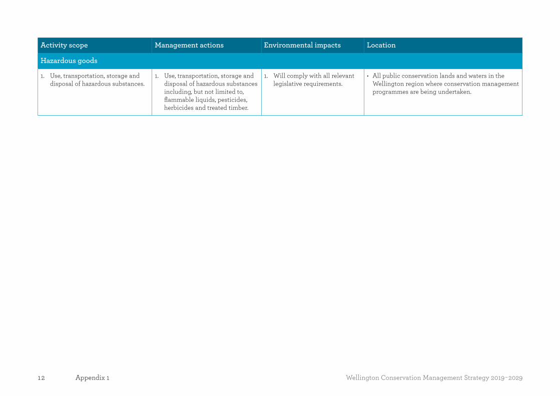
Hazardous goods
1. Use, transportation, storage and disposal of hazardous substances.
1. Use, transportation, storage and disposal of hazardous substances including, but not limited to, flammable liquids, pesticides, herbicides and treated timber.
1. Will comply with all relevant legislative requirements.
• All public conservation lands and waters in the Wellington region where conservation management programmes are being undertaken.

13Wellington Conservation Management Strategy 2019-2029 Appendix 2
Appendix 2Ecosystem and habitat types within the Wellington region1
This list has been taken from the Department’s national list of around 1000 ecosystem units2, which represents the full range of New Zealand’s terrestrial and freshwater ecosystems (including priority and non-priority units both on and off public conservation lands and waters). The list is accurate as at the date of approval of this CMS.
Management of ecosystem units on public conservation lands and waters within the Wellington region is addressed in Section 3.1 and the Natural values tables of the Places in Part Two. Section 3.1, Section 3.4 and the Outcomes and Natural values tables of the Places in Part Two address the Department’s work to advocate for the protection and restoration of ecosystems and habitats that occur outside of public conservation lands and waters and manage threats to them.
1 See Appendix 7 for marine habitats and ecosystems.2 For more information about the classification of New Zealand’s terrestrial ecosystems, see Singers, N.J.D; Rogers, G.M. 2014: A classification of New Zealand’s terrestrial ecosystems. Science for Conservation 325,
Department of Conservation, Wellington. 87 p.
The information in this Appendix is correct at the time of publishing. Its contents may be amended or reviewed during the term of this CMS, in accordance with section 17I of the Conservation Act 1987. It likely to change as the threats and priorities for action are updated. Management responses may also change as new techniques and more effective methods are developed and new threats arise. For information on what specific management responses are being used at the time of reading, please contact the relevant district office.
Note: Information in the columns applies to all of the ecosystem/habitats under that heading. For example, the information in the description, location, significant values, pressures and threats, management responses and priority sites for action under the ‘Cool forest and scrub’ heading applies to CF3, CF8, CF11, CF13, CF15, CH16, CF17 and CF18.

14 Wellington Conservation Management Strategy 2019-2029Appendix 2
Ecosystem/habitat type: Dunes
Description Location(s)3
DN2: Spinifex, pīngao grassland/sedgeland
Sedgeland, grassland of abundant spinifex and pīngao, with occasional shore bindweed, sand coprosma, tauhinu and sand daphne, grading into rear semi-stable dunes with open, scattered dune scrub of bracken, Muehlenbeckia complexa, toetoe, harakeke and cabbage trees. Locally includes matagouri, mānuka, kānuka, tutu and Olearia solandri.
DN5: Oioi, knobby clubrush sedgeland
Dune plains of several local variants with both dry and ephemerally wet communities and a range of successional stages. Dominant species include Carex pumila, species of Gunnera, Selliera, Isolepis, Epilobium, Ranunculus, Leptinella, Lobelia, Colobanthus, Geranium, Hydrocotyle and, locally, Lilaeopsis novae-zelandiae, Myriophyllum votschii along with Triglochin striata, Limosella lineata and other turf-forming species; older stages develop into oioi, knobby club rush, toetoe, harakeke and, locally, Cyperus ustulatus, Lepidosperma australe, silver tussock and Raoulia spp. plus Coprosma propinqua and mānuka (in oldest successions).
• Mt Barton (Aorangi Forest Park) • Riversdale dunes • Castlepoint Scenic Reserve dunes • Pahaoa Scientific Reserve dunes • Tangimoana Beach Conservation Area • Tangimoana Dunes Recreation Reserve • Waikanae River estuary • Manawatū Estuary • Lake Onoke (Lake Wairarapa Wetland Conservation Area) • Himatangi Beach (Himatangi Bush Scientific Reserve) • Koitiata • Pukepuke Lagoon Conservation Area
Significant values and pressures/threats
Managed: Cats, cattle, climbers, deer, ferrets, goats, groundcover, hares, hedgehogs, human impacts, mice, pioneer woody pest plants, possums, rabbits, rats, shade-tolerant woody pest plants, stoats, sheep, vehicles, weasels. Loss of habitat plants.
Not managed: Illegal harvest – land based, impeded fish passage. Climate change and habitat loss.
Management responses
• Pest plant and animal control • Threatened species management, including replanting programmes for threatened plants, such as Pimelea actea or invertebrate host plants • Investigate Foxton-Himatangi regional park with Horizons Regional Council. Maintain natural processes • Manage vehicles on dunes, as per New Zealand Coastal Policy Statement • Manage human impacts, such as disturbance
3 The ecosystem/habitat types occur within the Places and public conservation lands and waters identified in this column.

15Wellington Conservation Management Strategy 2019-2029 Appendix 2
Ecosystem/habitat type: Dunes continued
Waikanae River estuary, Manawatū Estuary, and Tangimoana • Pest plant control • Rabbit control • Planting dune species at Castlepoint Scenic Reserve and Onoke Spit • Controlling marram, horned poppy and purple ragwort at Onoke Spit • Controlling marram and lupin at Pahaoa Scientific Reserve • Mustelid and cat control at Onoke Spit led by community group
Priority sites for action
• Mixture of public conservation lands and waters and private/Māori-owned and managed land
Waikanae River estuary • Enhance general estuary habitat via weed and rabbit control to benefit the more than 70 species of birds that use this site
Manawatū Estuary • Ramsar site for sea and wading birds • The estuary contains a variety of habitats and very good inanga/galaxiid spawning sites • Pest plants are controlled to ensure the integrity of natural processes and open water areas are maintained for waders (feeding habitat)
Tangimoana • Coastal site encompassing fore-dunes back to small ephemeral wetland areas • Pest plant control is focused on reducing the impact of pest plants on threatened plant sites, particularly for the nationally critical species Pimelea actea
Secondary Location
NF2: Mānuka or kānuka scrub
NF3: Broadleaved scrub & shrubland
NF4: Short-tussock grassland Mānuka, kānuka and broadleaved scrub, shrubland and short-tussock grassland
• Awahou Conservation Area

16 Wellington Conservation Management Strategy 2019-2029Appendix 2
Ecosystem/habitat type: Dunes continued
Management responses
Awahou Conservation Area (fully implemented Ecosystem Management Unit sites): • Site-led pest plant control (various species) • Mustelid and cat trapping • Possum and rat control (pesticide) • Restoration plantings • Fence maintenance and replacement as necessary
Priority sites for action
• Habitat restoration. Awahou Conservation Area is one of the few remaining remnants of indigenous dune forest in the Manawatū
Ecosystem/habitat type: Coastal and inland cliffs
Description Location(s)
CL2: Ngaio, taupata, treeland/herbfield/rocklandNgaio, taupata treeland and harakeke and/or wharariki flaxland with scattered patches of low forest of, locally, tītoki, puka, wharangi, ngaio and akeake plus a wide range of halophytic herbs.
CL3: Coprosma, Muehlenbeckia shrubland/herbfield/rocklandMosaics of wind-shorn low-lying scrub of divaricating shrubs, including species of Coprosma, Muehlenbeckia, Melicytus and wharariki plus tauhinu, taupata, Hebe elliptica and, locally, tussocks (e.g. Chionochloa beddiei and silver tussock) along with halophytic herbs and sedges on scattered coastal cliffs.
• Aorangi Ranges (Aorangi Forest Park)
Significant values and pressures/threats
Climbers, goats, ground cover and herbaceous weeds, human impacts and pioneer woody pest plants.
Management responses
• Goat control and management of human impacts
Priority sites for action
• Aorangi Range
17Wellington Conservation Management Strategy 2019-2029 Appendix 2
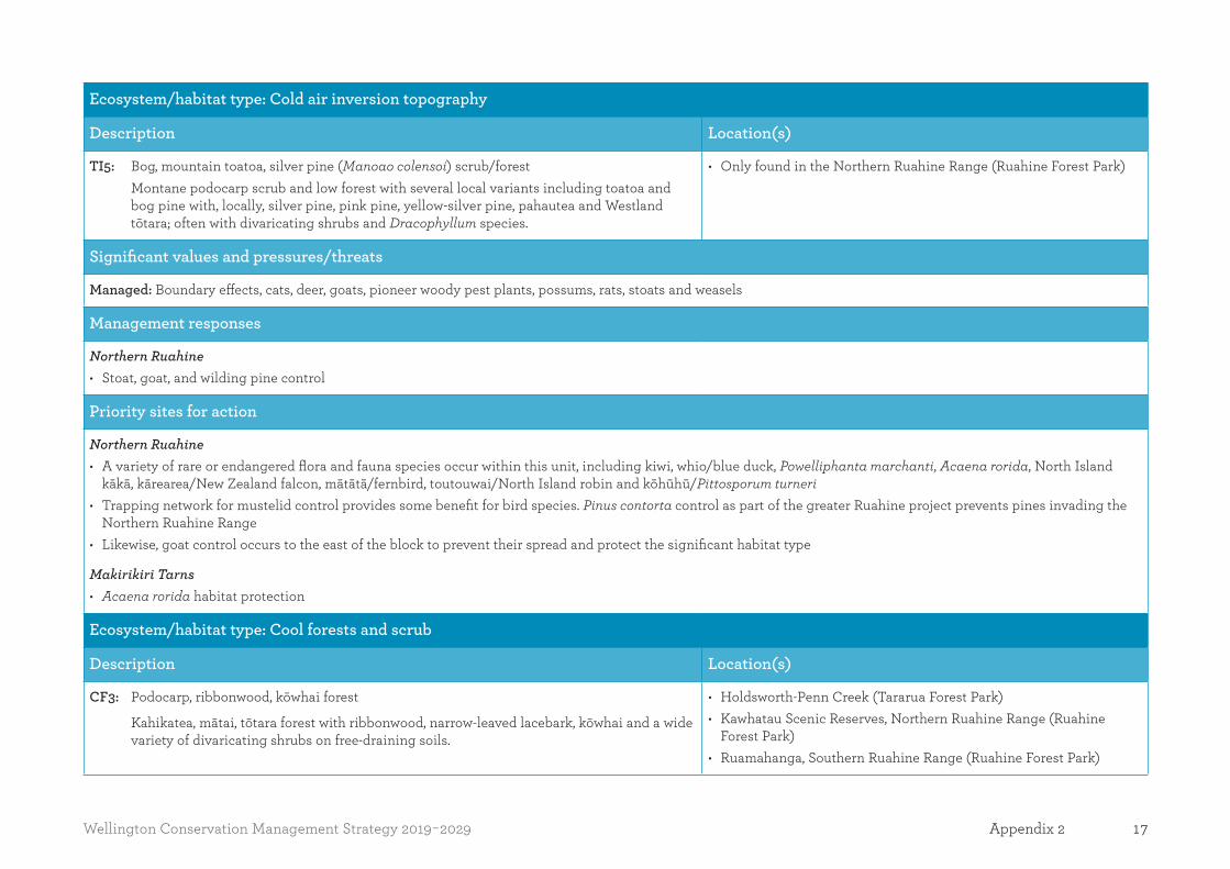
Ecosystem/habitat type: Cold air inversion topography
Description Location(s)
TI5: Bog, mountain toatoa, silver pine (Manoao colensoi) scrub/forestMontane podocarp scrub and low forest with several local variants including toatoa and bog pine with, locally, silver pine, pink pine, yellow-silver pine, pahautea and Westland tōtara; often with divaricating shrubs and Dracophyllum species.
• Only found in the Northern Ruahine Range (Ruahine Forest Park)
Significant values and pressures/threats
Managed: Boundary effects, cats, deer, goats, pioneer woody pest plants, possums, rats, stoats and weasels
Management responses
Northern Ruahine • Stoat, goat, and wilding pine control
Priority sites for action
Northern Ruahine • A variety of rare or endangered flora and fauna species occur within this unit, including kiwi, whio/blue duck, Powelliphanta marchanti, Acaena rorida, North Island
kākā, kārearea/New Zealand falcon, mātātā/fernbird, toutouwai/North Island robin and kōhūhū/Pittosporum turneri • Trapping network for mustelid control provides some benefit for bird species. Pinus contorta control as part of the greater Ruahine project prevents pines invading the
Northern Ruahine Range • Likewise, goat control occurs to the east of the block to prevent their spread and protect the significant habitat type
Makirikiri Tarns • Acaena rorida habitat protection
Ecosystem/habitat type: Cool forests and scrub
Description Location(s)
CF3: Podocarp, ribbonwood, kōwhai forest
Kahikatea, mātai, tōtara forest with ribbonwood, narrow-leaved lacebark, kōwhai and a wide variety of divaricating shrubs on free-draining soils.
• Holdsworth-Penn Creek (Tararua Forest Park) • Kawhatau Scenic Reserves, Northern Ruahine Range (Ruahine
Forest Park) • Ruamahanga, Southern Ruahine Range (Ruahine Forest Park)

18 Wellington Conservation Management Strategy 2019-2029Appendix 2
Ecosystem/habitat type: Cool forests and scrub continued
CF8: Mountain beech forest
Mountain beech forest with divaricating Coprosma spp., weeping matipo, mountain toatoa, snow tōtara, broadleaf, three-finger, putaputawētā and, locally, Hall’s tōtara.
CF11: Hall’s tōtara, pāhautea, kāmahi forest
North Island montane beech gap forests. Dominants may include Hall’s tōtara, mountain toatoa, pāhautea, silver pine, pink pine, bog pine, yellow-silver pine, quintinia, kāmahi, broadleaf and tawari.
CF13: Olearia, Pseudopanax, Dracophyllum scrub
Sub-alpine scrub with a wide range of local variants including species of Olearia, Brachyglottis, Pseudopanax, Dracophyllum, hebe, Coprosma, Hoheria, montane podocarp trees, mānuka and wharariki. Locally includes monocultures such as leatherwood (O. colensoi) scrub in Southern Ruahine – Northern Tararua Ranges.
CF15: Red beech, podocarp forest
Red beech forest of at least two types:
i) Hill slope forest of red beech and, locally, kāmahi (in wetter parts of the range), scattered rimu, Hall’s tōtara, miro and matai; plus hīnau and maire in the north.
ii) Tall red beech on alluvial stony terraces with, locally, silver beech, kāmahi, southern rātā and podocarp trees (rimu, kahikatea, mātai and tōtara).
CH16: Red, silver beech forest
Red-silver beech forest with, locally, podocarp-broadleaved species having at least three local variants:
i) Raukumara – Urewera ranges – red and silver beech with tawari and, locally, quintinia, kāmahi, Hall’s tōtara and (at lower altitudes) rimu and miro.
ii) North Island red and silver beech forest with, locally, black/mountain beech, Hall’s tōtara, pāhautea, kāmahi, hard beech and (at lower altitudes) rimu, miro and matai.
iii) with red, silver, black/mountain beech.
CF17: Mountain beech, silver beech, podocarp forest
Beech, podocarp and beech, and broadleaved forest of at least two variants:
i) stunted mountain beech and/or silver beech plus, locally, montane podocarp trees (Hall’s tōtara, pāhautea, pink, bog and silver pine).
ii) lower altitude mountain beech/silver beech with, locally, yellow-silver pine, silver pine, rimu, kahikatea, pāhautea, Hall’s tōtara and pōkākā.
• McKerrow (Remutaka Forest Park) • Mt Barton (Aorangi Forest Park) • Rangitikei River • Titirangi Scenic Reserve • Utiku Scenic Reserve, Horowhenua
19Wellington Conservation Management Strategy 2019-2029 Appendix 2
Ecosystem/habitat type: Cool forests and scrub continued
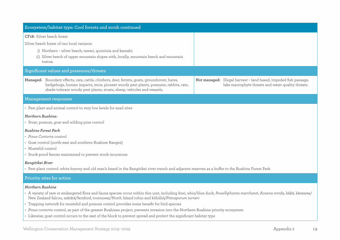
CF18: Silver beech forest
Silver beech forest of two local variants:
i) Northern – silver beech, tawari, quintinia and kamahi. ii) Silver beech of upper mountain slopes with, locally, mountain beech and mountain
toatoa.
Significant values and pressures/threats
Managed: Boundary effects, cats, cattle, climbers, deer, ferrets, goats, groundcover, hares, hedgehogs, human impacts, mice, pioneer woody pest plants, possums, rabbits, rats, shade-tolerant woody pest plants, stoats, sheep, vehicles and weasels.
Not managed: Illegal harvest – land based, impeded fish passage, lake macrophyte threats and water quality threats.
Management responses
• Pest plant and animal control to very low levels for snail sites
Northern Ruahine: • Stoat, possum, goat and wilding pine control
Ruahine Forest Park • Pinus Contorta control • Goat control (north-east and southern Ruahine Ranges) • Mustelid control • Stock-proof fences maintained to prevent stock incursions
Rangitikei River • Pest plant control: white bryony and old man’s beard in the Rangitikei river trench and adjacent reserves as a buffer to the Ruahine Forest Park
Priority sites for action
Northern Ruahine • A variety of rare or endangered flora and fauna species occur within this unit, including kiwi, whio/blue duck, Powelliphanta marchanti, Acaena rorida, kākā, kārearea/
New Zealand falcon, mātātā/fernbird, toutouwai/North Island robin and kōhūhū/Pittosporum turneri • Trapping network for mustelid and possum control provides some benefit for bird species • Pinus contorta control, as part of the greater Ruahines project, prevents invasion into the Northern Ruahine priority ecosystem • Likewise, goat control occurs to the east of the block to prevent spread and protect the significant habitat type
20 Wellington Conservation Management Strategy 2019-2029Appendix 2
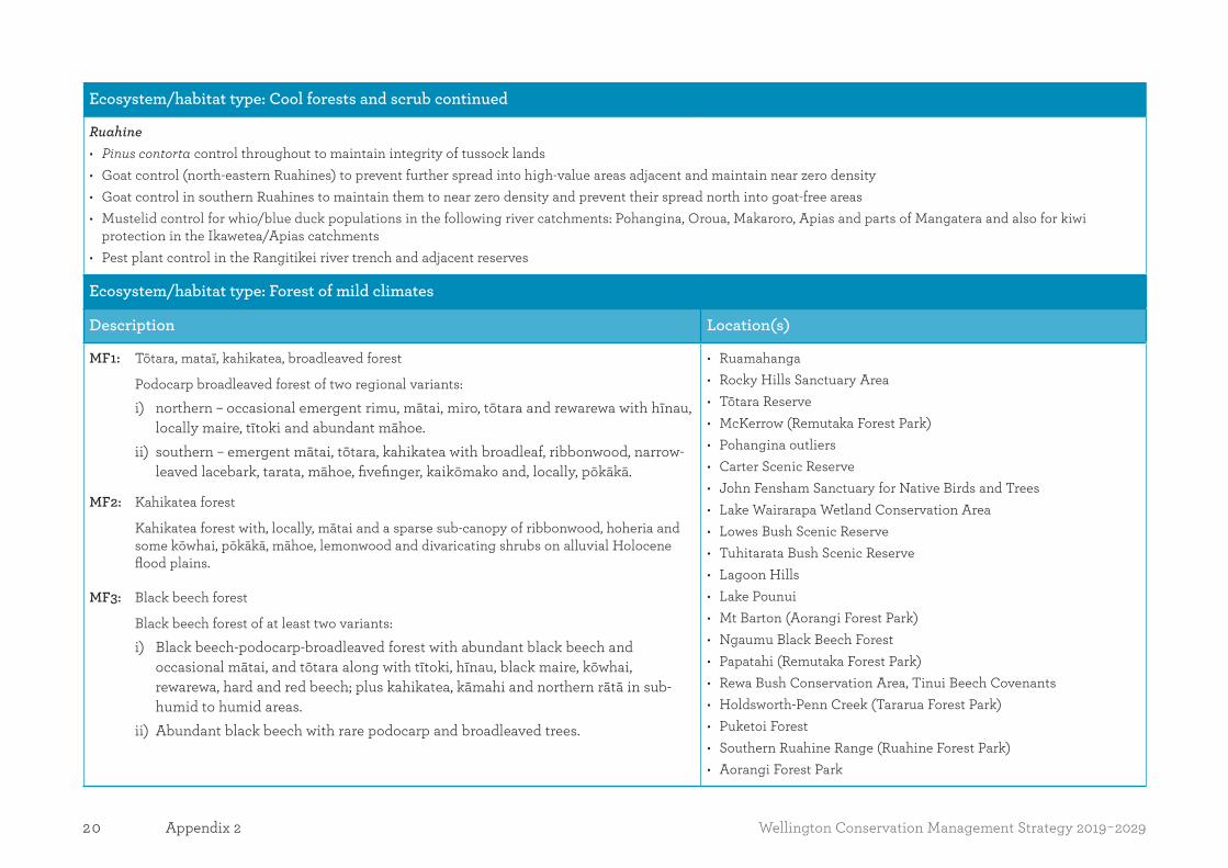
Ecosystem/habitat type: Cool forests and scrub continued
Ruahine • Pinus contorta control throughout to maintain integrity of tussock lands • Goat control (north-eastern Ruahines) to prevent further spread into high-value areas adjacent and maintain near zero density • Goat control in southern Ruahines to maintain them to near zero density and prevent their spread north into goat-free areas • Mustelid control for whio/blue duck populations in the following river catchments: Pohangina, Oroua, Makaroro, Apias and parts of Mangatera and also for kiwi
protection in the Ikawetea/Apias catchments • Pest plant control in the Rangitikei river trench and adjacent reserves
Ecosystem/habitat type: Forest of mild climates
Description Location(s)
MF1: Tōtara, mataī, kahikatea, broadleaved forest
Podocarp broadleaved forest of two regional variants:
i) northern – occasional emergent rimu, mātai, miro, tōtara and rewarewa with hīnau, locally maire, tītoki and abundant māhoe.
ii) southern – emergent mātai, tōtara, kahikatea with broadleaf, ribbonwood, narrow-leaved lacebark, tarata, māhoe, fivefinger, kaikōmako and, locally, pōkākā.
MF2: Kahikatea forest
Kahikatea forest with, locally, mātai and a sparse sub-canopy of ribbonwood, hoheria and some kōwhai, pōkākā, māhoe, lemonwood and divaricating shrubs on alluvial Holocene flood plains.
MF3: Black beech forest
Black beech forest of at least two variants:
i) Black beech-podocarp-broadleaved forest with abundant black beech and occasional mātai, and tōtara along with tītoki, hīnau, black maire, kōwhai, rewarewa, hard and red beech; plus kahikatea, kāmahi and northern rātā in sub-humid to humid areas.
ii) Abundant black beech with rare podocarp and broadleaved trees.
• Ruamahanga • Rocky Hills Sanctuary Area • Tōtara Reserve • McKerrow (Remutaka Forest Park) • Pohangina outliers • Carter Scenic Reserve • John Fensham Sanctuary for Native Birds and Trees • Lake Wairarapa Wetland Conservation Area • Lowes Bush Scenic Reserve • Tuhitarata Bush Scenic Reserve • Lagoon Hills • Lake Pounui • Mt Barton (Aorangi Forest Park) • Ngaumu Black Beech Forest • Papatahi (Remutaka Forest Park) • Rewa Bush Conservation Area, Tinui Beech Covenants • Holdsworth-Penn Creek (Tararua Forest Park) • Puketoi Forest • Southern Ruahine Range (Ruahine Forest Park) • Aorangi Forest Park
21Wellington Conservation Management Strategy 2019-2029 Appendix 2
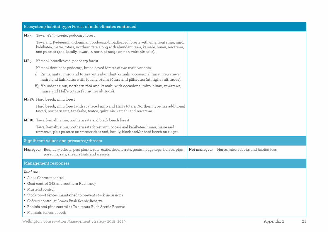
Ecosystem/habitat type: Forest of mild climates continued
MF4: Tawa, Weinmannia, podocarp forest
Tawa and Weinmannia-dominant podocarp-broadleaved forests with emergent rimu, miro, kahikatea, mātai, tōtara, northern rātā along with abundant tawa, kāmahi, hīnau, rewarewa, and pukatea (and, locally, tawari in north of range on non-volcanic soils).
MF5: Kāmahi, broadleaved, podocarp forest
Kāmahi-dominant podocarp, broadleaved forests of two main variants:
i) Rimu, mātai, miro and tōtara with abundant kāmahi, occasional hīnau, rewarewa, maire and kahikatea with, locally, Hall’s tōtara and pāhautea (at higher altitudes).
ii) Abundant rimu, northern rātā and kamahi with occasional miro, hīnau, rewarewa, maire and Hall’s tōtara (at higher altitude).
MF17: Hard beech, rimu forest
Hard beech, rimu forest with scattered miro and Hall’s tōtara. Northern type has additional tawari, northern rātā, tanekaha, toatoa, quintinia, kamahi and rewarewa.
MF18: Tawa, kāmahi, rimu, northern rātā and black beech forest
Tawa, kāmahi, rimu, northern rātā forest with occasional kahikatea, hīnau, maire and rewarewa, plus pukatea on warmer sites and, locally, black and/or hard beech on ridges.
Significant values and pressures/threats
Managed: Boundary effects, pest plants, cats, cattle, deer, ferrets, goats, hedgehogs, horses, pigs, possums, rats, sheep, stoats and weasels.
Not managed: Hares, mice, rabbits and habitat loss.
Management responses
Ruahine • Pinus Contorta control • Goat control (NE and southern Ruahines) • Mustelid control • Stock-proof fences maintained to prevent stock incursions • Cobaea control at Lowes Bush Scenic Reserve • Robinia and pine control at Tuhitarata Bush Scenic Reserve • Maintain fences at both

22 Wellington Conservation Management Strategy 2019-2029Appendix 2
Ecosystem/habitat type: Forest of mild climates continued
Priority sites for action
• Majority of public conservation lands and waters, with some private and other Crown land, a small bit of Royal Forest & Bird-controlled land and a QEII covenant
Southern Ruahine Range • Recent browser management on an altitudinal sequence from lowland through montane conifer-broadleaved forest to dense montane scrub on greywacke • Goat control takes place as part of a wider programme that encompasses some of this unit • Pinus contorta occurs on slips but presently is not controlled due to no tussocklands in this unit
Ecosystem/habitat type: Forest of warm climates
Description Location(s)
WF2: Tōtara, mataī, ribbonwood forest
Tōtara, mātai forest with occasional kahikatea, tītoki, ribbonwood and kowhai, plus a wide range of divaricating shrubs. Locally includes occasional tawa, tītoki and maire in northern and moister part of range. Early successional derivatives on younger alluvial sites include kānuka and kōwhai treeland and forest.
WF3: Tawa, tītoki, podocarp forest
Tawa podocarp-broadleaved forest with emergent kahikatea, tōtara and mātai, and abundant tawa, tītoki, rewarewa and hīnau. Locally Northern rātā, pukatea, rimu and nīkau are locally present in warmer humid microclimates and kohekohe in the north-east of the range. Occasionally black beech on dry ridges. Very little intact examples remaining – most as secondary kanuka-dominant derivatives.
WF7: Tōtara, mataī, broadleaved forest
Mosaics of kānuka, māpou, corokia and akeake on younger soils grading into ngaio, tītoki, kōwhai, tōtara, mātai, rewarewa, narrow-leaved maire, māhoe, lancewood and kaikōmako. Locally includes kohekohe on older dune soils in south part of range.
WF9: Kahikatea, pukatea forest
Kahikatea forest with pukatea and abundant kiekie and supplejack, occasionally with rimu and tawa and often with swamp maire (particularly on organic and gley soils with a high water table).
WF15: Kohekohe, tawa forest
Kohekohe, tawa forest with tītoki, māhoe, pigeonwood, nīkau and occasional emergent rimu and, locally, pukatea and northern rātā in the North Island.
• Rangituhi/Colonial Knob Scenic Reserve • Ireland Rd • Tora Farm Settlement (near Tora Bush Scenic Reserve) • Hemi Matenga Memorial Park Scenic Reserve • Kāpiti Island Nature Reserve • Paraparaumu Scenic Reserve • Ahi Paku • Kiripiti Scenic Reserve • Wainuioru River • Lake Papaitonga (Papaitonga Scenic Reserve) • Manawatū Gorge Scenic Reserve • Red River (Akitio) Scenic Reserve • Waimata River • Awahou Conservation Area • Himatangi Scenic Reserve • Waikanae River estuary • Omarupapako/Round Bush Scenic Reserve • Moana Roa Conservation Area • Tawhirihoe Scientific Reserve, Horowhenua

23Wellington Conservation Management Strategy 2019-2029 Appendix 2
Ecosystem/habitat type: Forest of warm climates continued
Significant values and pressures/threats
Managed: Discharge/pollution from land, hydrological alteration, water quality threats, pest plants, cats, cattle, deer, ferrets, goats, hedgehogs, mice, pigs, possums, rats, sheep, stoats and weasels.
Not managed: Rabbits.
Management responses
• Managed: cats, cattle, deer, discharge/pollution from land, ferrets, pest plants • Pest animals controlled to very low levels at snail sites • Access management • Threatened species management • Supplementary feeding for hihi/stitchbirds (Kāpiti Island) • Translocations of threatened species (to and from sites) • Goats, ground cover, hedgehogs, hydrological alteration, mice, pigs, pioneer woody pest plants, possums, rats, shade-tolerant woody pest plants, sheep, stoats, water
quality threats and weasels
Papaitonga Scenic Reserve • Focal work at this site is animal (mustelids, possums, rats,and cats), and plant (sycamore, climbing asparagus, old man’s beard, ivy, tutsan, purple loosestrife, banana
passionfruit, elderberry, woolly nightshade, tradescantia and other species) pest control • Restoration of pastureland to wetland with hydrological manipulation and re-vegetation plantings
Omarupapako/Round Bush Scenic Reserve, Himatangi Scientific Reserve, Awahou Conservation Area (fully implemented Ecosystem Management Unit sites) • Site-led pest plant control (various species) • Mustelid and cat trapping • Possum and rat control (pesticide) • Restoration plantings • Fence maintenance and replacement as necessary
Manawatū Gorge • Old man’s beard control • Rat and possum control • Mustelid and hedgehog control

24 Wellington Conservation Management Strategy 2019-2029Appendix 2
Ecosystem/habitat type: Forest of warm climates continued
Priority sites for action
• Predominantly public conservation lands and waters, some private iwi land on Kāpiti Island and Scenic Reserve on Rangituhi/Colonial Knob.
Papaitonga Scenic Reserve • Pest animal control • Restoration work through the construction of a weir and extensive plantings to enhance the habitat for species such as matuku-hurepo/Australasian bittern, giant
kōkopu/galaxiids, banded kōkopu/galaxiids; hauhau/ brown mudfish and Powelliphanta traversi traversi
Omarupapako/Round Bush Scenic Reserve; Himatangi Scientific Reserve; Awahou Conservation Area • Improve habitat for species, such as hauhau/brown mudfish at Omarupapako/Round Bush Scenic Reserve and for Wellington barking gecko at Himatangi Scenic
Reserve • All three reserves are important and are some of the few remaining remnants of indigenous dune forest in the Manawatū
Manawatū Gorge • Mixed tawa/podocarp forest with occasional emergent northern rātā • A biodiversity joint management project covers the public conservation lands and waters and adjacent council/railways/LINZ/Māori-owned/private land • Pest plant and pest animal control occurs to improve wildlife habitat and restore forest structure
Ecosystem/habitat type: Lakes
Description Location(s)
Lake LK4.2 Landslide B Landslide: warm, shallow, small.
Lake 6.1 Riverine A Riverine: warm, shallow, moderately large.
Lake LK7.1 Shoreline AShoreline: warm, shallow, moderately large.
Lake 11.1 Windform AWindform: warm, shallow, moderately large.
• Lakes Horowhenua, Papaitonga (Papaitonga Scenic Reserve), Waitawa, Huritini, Koputara, Onoke and Wairarapa (Lake Wairarapa Wetland Conservation Area), Namunamu, Ngaruru and Pounui
• Pukepuke Lagoon (Pukepuke Lagoon Conservation Area) • Northern Ruahine (Ruahine Forest Park) • Lake Kohangaera and Lake Kohangapiripiri Scientific Reserve
(Pencarrow Lakes) • Kāpiti Island Nature Reserve, unnamed lakes: near Tuturumuri and
Waioronu Stream.

25Wellington Conservation Management Strategy 2019-2029 Appendix 2
Ecosystem/habitat type: Lakes continued
Significant values and pressures/threats
Managed: Boundary effects, cats, cattle, climbers, ferrets, ground cover, hydrological alteration, impeded fish passage, lake macrophyte threats, lake water quality threats, mice, pioneer woody pest plants, rats, shade-tolerant woody pest plants, stoats and weasels.
Management responses
• Pest plant and animal control, including fish and to very low levels for snail sites • Riparian zone management • Threatened species management • Drainage control • Maintain links with neighbouring ecosystems, e.g. dunes at Pukepuke Lagoon Conservation Area • Threatened species management, including replanting programmes for invertebrate host plants e.g. Pimelea species • Translocations of threatened species (to and from sites)
Lake Kohangaera and Lake Kohangapiripiri Scientific Reserve • Co-managed by Greater Wellington Regional Council and Port Nicholson Block Settlement Trust as part of the East Harbour Regional Park • Department input focuses on technical advice and review
Papaitonga Scenic Reserve • Focal work at this site is animal (mustelids, possums, rats and cats) and plant (sycamore, climbing asparagus, old man’s beard, ivy, tutsan, purple loosestrife, banana
passionfruit, elderberry, woolly nightshade, tradescantia and other species) pest control • Restoration of pastureland to wetland with hydrological manipulation and re-vegetation plantings
Pukepuke Lagoon • Stoat trapping
Northern Ruahine • Stoat, goat and wilding pine control
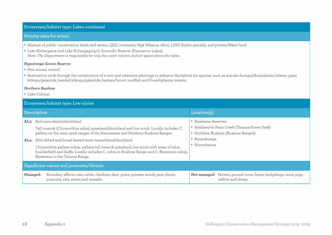
26 Wellington Conservation Management Strategy 2019-2029Appendix 2
Ecosystem/habitat type: Lakes continued
Priority sites for action
• Mixture of public conservation lands and waters, QEII covenants, Ngā Whenua rāhui, LINZ (hydro parcels), and private/Māori land • Lake Kohangaera and Lake Kohangapiripiri Scientific Reserve (Pencarrow Lakes)
Note: The Department is responsible for only the water column and air space above the lakes.
Papaitonga Scenic Reserve • Pest animal control • Restoration work through the construction of a weir and extensive plantings to enhance the habitat for species, such as matuku-hurepo/Australasian bittern, giant
kōkopu/galaxiids, banded kōkopu/galaxiids, hauhau/brown mudfish and Powelliphanta traversi
Northern Ruahine • Lake Colenso
Ecosystem/habitat type: Low alpine
Description Location(s)
AL3: Red tussockland/shrubland
Tall tussock (Chionochloa rubra) grassland/shrubland and low scrub. Locally includes C. pallens on the main axial ranges of the Kaimanawa and Northern Ruahine Ranges.
AL4: Mid-ribbed and broad-leaved snow tussockland/shrubland
Chionochloa pallens subsp. pallens tall tussock grassland, low scrub with areas of talus, boulderfield and bluffs. Locally includes C. rubra in Ruahine Range and C. flavescens subsp. flavescens in the Tararua Range.
• Kawhatau Reserves • Holdsworth-Penn Creek (Tararua Forest Park) • Northern Ruahine (Ruahine Ranges) • Ruamahanga • Horowhenua
Significant values and pressures/threats
Managed: Boundary effects, cats, cattle, climbers, deer, goats, pioneer woody pest plants, possums, rats, stoats and weasels.
Not managed: Ferrets, ground cover, hares, hedgehogs, mice, pigs, rabbits and sheep.
27Wellington Conservation Management Strategy 2019-2029 Appendix 2
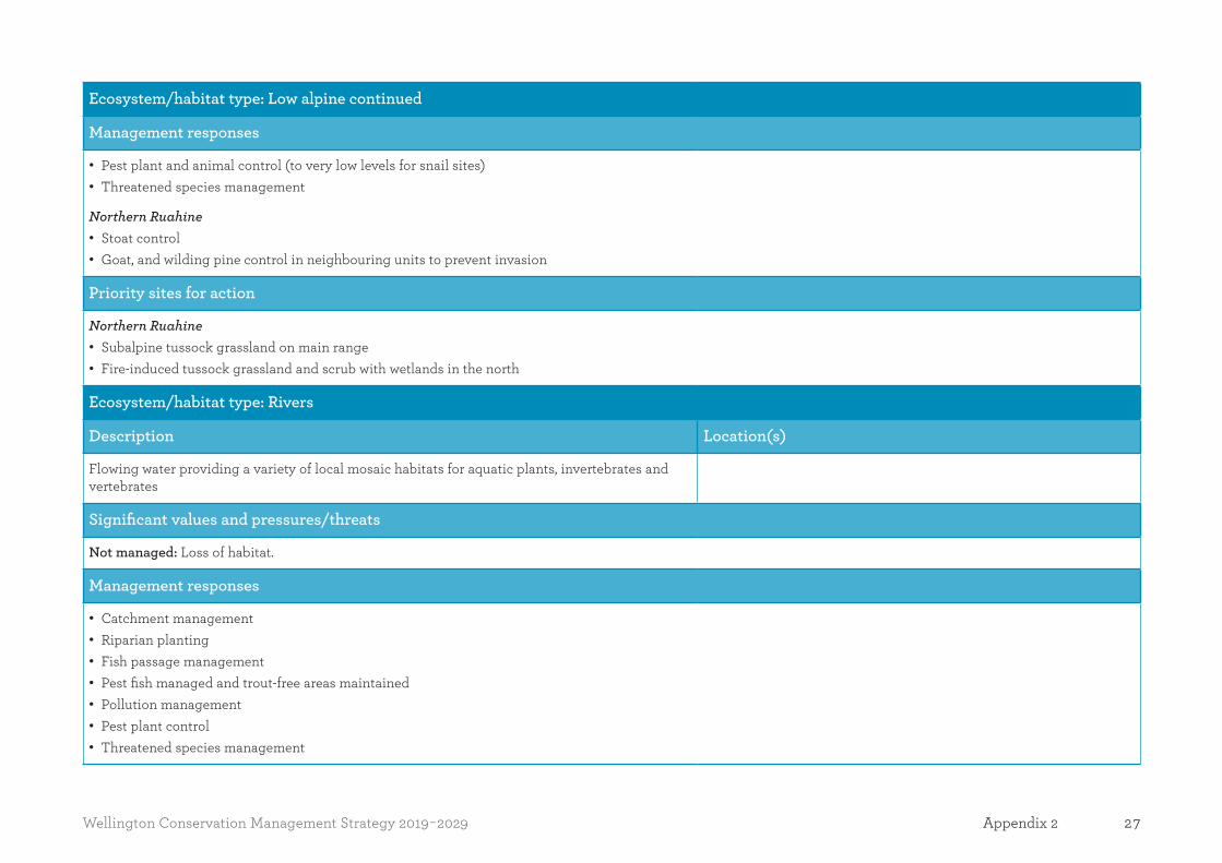
Ecosystem/habitat type: Low alpine continued
Management responses
• Pest plant and animal control (to very low levels for snail sites) • Threatened species management
Northern Ruahine • Stoat control • Goat, and wilding pine control in neighbouring units to prevent invasion
Priority sites for action
Northern Ruahine • Subalpine tussock grassland on main range • Fire-induced tussock grassland and scrub with wetlands in the north
Ecosystem/habitat type: Rivers
Description Location(s)
Flowing water providing a variety of local mosaic habitats for aquatic plants, invertebrates and vertebrates
Significant values and pressures/threats
Not managed: Loss of habitat.
Management responses
• Catchment management • Riparian planting • Fish passage management • Pest fish managed and trout-free areas maintained • Pollution management • Pest plant control • Threatened species management
28 Wellington Conservation Management Strategy 2019-2029Appendix 2
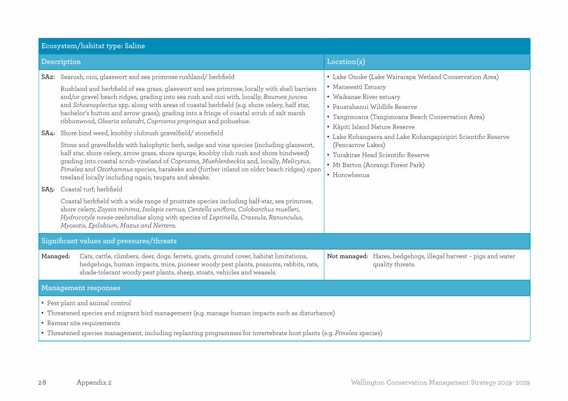
Ecosystem/habitat type: Saline
Description Location(s)
SA2: Searush, oioi, glasswort and sea primrose rushland/ herbfield
Rushland and herbfield of sea grass, glasswort and sea primrose, locally with shell barriers and/or gravel beach ridges, grading into sea rush and oioi with, locally, Baumea juncea and Schoenoplectus spp. along with areas of coastal herbfield (e.g. shore celery, half star, bachelor’s button and arrow grass); grading into a fringe of coastal scrub of salt marsh ribbonwood, Olearia solandri, Coprosma propinqua and pohuehue.
SA4: Shore bind weed, knobby clubrush gravelfield/ stonefield
Stone and gravelfields with halophytic herb, sedge and vine species (including glasswort, half star, shore celery, arrow grass, shore spurge, knobby club rush and shore bindweed) grading into coastal scrub-vineland of Coprosma, Muehlenbeckia and, locally, Melicytus, Pimelea and Ozothamnus species, harakeke and (further inland on older beach ridges) open treeland locally including ngaio, taupata and akeake.
SA5: Coastal turf; herbfield
Coastal herbfield with a wide range of prostrate species including half-star, sea primrose, shore celery, Zoysia minima, Isolepis cernua, Centella uniflora, Colobanthus muelleri, Hydrocotyle novae-zeelandiae along with species of Leptinella, Crassula, Ranunculus, Myosotis, Epilobium, Mazus and Nertera.
• Lake Onoke (Lake Wairarapa Wetland Conservation Area) • Manawatū Estuary • Waikanae River estuary • Pauatahanui Wildlife Reserve • Tangimoana (Tangimoana Beach Conservation Area) • Kāpiti Island Nature Reserve • Lake Kohangaera and Lake Kohangapiripiri Scientific Reserve
(Pencarrow Lakes) • Turakirae Head Scientific Reserve • Mt Barton (Aorangi Forest Park) • Horowhenua
Significant values and pressures/threats
Managed: Cats, cattle, climbers, deer, dogs, ferrets, goats, ground cover, habitat limitations, hedgehogs, human impacts, mice, pioneer woody pest plants, possums, rabbits, rats, shade-tolerant woody pest plants, sheep, stoats, vehicles and weasels.
Not managed: Hares, hedgehogs, illegal harvest – pigs and water quality threats.
Management responses
• Pest plant and animal control • Threatened species and migrant bird management (e.g. manage human impacts such as disturbance) • Ramsar site requirements • Threatened species management, including replanting programmes for invertebrate host plants (e.g. Pimelea species)

29Wellington Conservation Management Strategy 2019-2029 Appendix 2
Ecosystem/habitat type: Saline continued
Waikanae River estuary • Pest plant control (horsetail, gorse, broom, karo and marram) • Rabbit control
Turakirae • Gorse, Spanish heath
Manawatū Estuary • Pest plant control (Spartina anglica, sharp rush, pampas, sand acacia, boxthorn, periwinkle, Japanese honeysuckle, willow, Queensland poplar, silver poplar, gorse and
other species
Priority sites for action
Waikanae River estuary • Enhance general estuary habitat via pest plant and rabbit control to benefit the more than 70 species of birds that use this site
Manawatū Estuary • Ramsar site of significance for sea and wading birds • The estuary has a variety of habitats and contains very good kōkopu/galaxiids spawning sites • Pest plants are controlled to ensure the integrity of natural processes and open water areas are maintained for waders (feeding habitat)
Ecosystem/habitat type: Screes and boulderfields
Description Location(s)
SC1: Gravel field
Loose mobile gravelfield of (predominantly) shattered greywacke and argillite forming 35°–40° slopes that support 26 species of specialised scree plants and associates (commonly including Stellaria roughii, Epilobium pycnostachyum, Lignocarpa carnosula and hebe epacridea.
• Mt Barton (Aorangi Forest Park) • Papatahi (Remutaka Forest Park) • Ruamahanga
Significant values & pressures/threats
Managed: Boundary effects, cats, cattle, climbers, deer, goats, ground cover, pioneer woody pest plants, possums, rats, stoats and weasels.
Not managed: Ferrets, hares, hedgehogs, mice, pigs, rabbits.
Management responses
• Plant and animal pest species management, including replanting programmes for invertebrate host plants (e.g. Pimelea species)

30 Wellington Conservation Management Strategy 2019-2029Appendix 2
Ecosystem/habitat type: Wetlands [WL1–WL22]
Description Location(s)
WL15: Lakeshore turf, herbfieldShort-statured herbfields of broadly two variants:
i) coastal. ii) inland – often with species common to both variants. Coastal herbfields are often
brackish and commonly include Selliera radicans, Isolepis spp., Limosella and Lilaeopsis and grade into salt marsh with increasing salinity. The inland variant commonly includes Glossistigma elatinoides, species of Lilaeopsis, Carex, Eleocharis, Lobelia, Centrolepis, Hydrocotyle, Myriophyllum, Plantago, Ranunculus, Crassula and other herb species.
WL16: Red tussock, Schoenus tussocklandRed tussockland locally with localised cushionfield, sedgeland and shallow pools with Schoenus pauciflorus, Oreobolus spp., Carpha alpina, Carex coriacea, C. sinclairii and locally sphagnum, wirerush and scattered shrubs e.g. hebe odornt and bog pine.
WL17: Alpine seepages/flushes, Schoenus pauciflorus sedgelandLow-stature sedgeland, mossfield and herbfield with abundant mosses, liverworts, sedges and a wide range of herbs including Schoenus pauciflorus, Carpha alpina and, locally, Epilobium, Montia, Ranunculus, Schizeilema, Hydrocotyle and Gentianella spp.
WL18: FlaxlandFlaxland-dominant swamps, often with toetoe, species of Carex (e.g. pūkio) and Baumea and kiokio along with occasional wetland scrub and treeland of cabbage trees, Coprosma spp., mānuka and, locally, weeping matipo and Olearia virgata. Areas with high water tables may be dominated by pūkio. May grade into water-logged wooded terrain (carr) with emergent cabbage trees.
WL19: Raupō reedlandRaupō reedland of abundant raupō with, locally, species of Bolboschoenus and Schoenoplectus, Baumea articulata, pūkio and harakeke/flax with (where unmodified) a margin of scrub of Coprosma species and, locally, Olearia virgata with mānuka and scattered kahikatea. Often occurs on lake margins or includes small ponds with shallow water/pools containing floating/rafted aquatics, such as milfoils, buttercups, willowherbs, species of Potamogeton and Isolepis, Azolla, Lemna and spiked sedges.
WL20: Coprosma, Olearia scrubScrub of Coprosma spp. and, locally, Olearia virgata (which can be locally dominant) along with a mosaic of a wide variety of Carex spp. and, locally, kiokio. May also include scattered harakeke, raupō, toetoe and cabbage trees.
• Northern Ruahine (Ruahine Forest Park) • Lakes: Alice, Onoke and Wairarapa (Lake Wairarapa Wetland
Conservation Area • Papaitonga Scenic Reserve • Lake Pounui • Upper Waiohine River (Tararua Forest Park) • Koputaroa flaxlands (Koputaroa Scientific Reserve) • Makerua Swamp Wildlife Management Reserve • Te Hapua Rd • Omarupapako/Round Bush Scenic Reserve • Lake Kohangaera and Lake Kohangapiripiri Scientific Reserve
(Pencarrow Lakes) • Pukepuke Lagoon Conservation Area • Mangara Stream • Riversdale dunes • Waikanae River estuary • Reporoa Bog

31Wellington Conservation Management Strategy 2019-2029 Appendix 2
Ecosystem/habitat type: Wetlands [WL1–WL22] continued
Significant values and pressures/threats
Managed: Boundary effects, cats, cattle, climbers, deer, ferrets, goats, ground cover, hedgehogs, hydrological alteration, impeded fish passage, mice, pigs, pioneer woody pest plants, possums, rabbits, rats, shade-tolerant woody pest plants, stoats and weasels.
Not managed: Habitat limitations, hares, lake macrophyte threats, lake water quality threats, vehicles, water quality threats and habitat loss.
Management responses
• Pests controlled to very low levels for snail sites • Drainage control, access management • Threatened species management • Catchment management • Hydrological programmes maintained • Invertebrate host plants (e.g. Pimelea spp.) replanted • Human impacts (such as disturbance) managed
Lake Kohangaera and Lake Kohangapiripiri Scientific Reserve (Pencarrow Lakes) • Co-managed by Greater Wellington Regional and Port Nicholson Block Settlement Trust as part of the East Harbour Regional Park • Department input focuses on technical advice and review
Papaitonga Scenic Reserve • Focal work at this site is animal (mustelids, possums, rats and cats) and plant (sycamore, climbing asparagus, old man’s beard, ivy, tutsan, purple loosestrife, banana
passionfruit, elderberry, woolly nightshade, tradescantia and other species) pest control • Restoration of pastureland to wetland with hydrological manipulation and re-vegetation plantings
Pukepuke Lagoon • Stoat trapping
Northern Ruahine • Stoat, goat, and wilding pine control

32 Wellington Conservation Management Strategy 2019-2029Appendix 2
Ecosystem/habitat type: Wetlands [WL1–WL22] continued
Priority sites for action
• Effectively half each of public conservation lands and waters and QEII covenants (including Lake Wairarapa), with some ‘private’ as in not expressly public conservation lands and waters
• Lake Kohangaera and Lake Kohangapiripiri Scientific Reserve (Pencarrow Lakes) Note: Department is responsible for only the water column and air space above the lakes.
Papaitonga Scenic Reserve • Pest animal control • Restoration work through the construction of a weir and extensive plantings to enhance the habitat for species (such as matuku-hurepo/Australasian bittern, giant
kōkopu/galaxiids, banded kōkopu/galaxiids, hauhau /brown mudfish and Powelliphanta traversi traversi)
Northern Ruahine • Lake Colenso
Makirikiri Tarns • Acaena rorida habitat protection

33Wellington Conservation Management Strategy 2019-2029 Appendix 3
Appendix 3Islands over 1 ha administered by the Department of Conservation in the Wellington region
Island group/island
Administrative status
Desired island classification
(10-year goal)*
Pest species Particular issues Notes/comments
Islands Place
Kāpiti Island Nature Reserve Ecosystem recovery • Plant pests: banana passion fruit, periwinkle, wild carrot, Selaginella, gorse, bone seed and barberry.
• Nationally significant biodiversity values.
• Biosecurity operations focused on mammalian, invertebrate and plant pests, fire management and pest plant control.
• Access by permit only. • Recreation Icon site.
Mana Island Scientific Reserve Ecosystem restoration • Pest animals: black backed gulls, pūkeko.
• Pest plants.
• Nationally significant biodiversity values.
• Biosecurity operations focused on pest mammals, invertebrates and plants.
• Control of black-backed gulls and pūkeko populations, eradication of wasps and a number of pest plant species.
* The desired island classification is aligned with the 10-year term of this CMS and represents the desired future state of the island (Department of Conservation 2010: The island strategy: guidelines for managing islands administered by the Department of Conservation). The island classification is intended for guidance only, and needs to be read in conjunction with the outcome and policies for Places in Part Two.

34 Wellington Conservation Management Strategy 2019-2029Appendix 4
Appendix 4Priority ecosystem units on public conservation lands and waters (excluding marine) in the Wellington region identified by the Department through natural heritage prioritising processesThis list has been compiled from the Department’s national list of around 1000 ecosystem units, which represents the full range of New Zealand’s terrestrial and freshwater ecosystems and excludes units or parts of units on private land. Please note, the table does not necessarily list all nationally significant ecosystems present in the Wellington region.
The list is correct as at the date of publication of this CMS. Its contents may be amended or reviewed during the term of this CMS.
Name of ecosystem unit and predominant ecosystem and habitat types included within it
Threats/issues Management responses
Central Spine Place
Northern Ruahine (Ruahine Forest Park) (7384 ha)
• Red beech, podocarp forest • Hall’s tōtara, pāhautea, kamahi forest • Olearia, Pseudopanax, Dracophyllum scrub • Mid-ribbed and broadleaved snow tussock – shrubland • Red tussock, Schoenus tussockland • Bog, mountain toatoa and silver pine scrub forest • Scree, gravelfields • Landslide class B
• Pest plants: Pinus contorta and hieracium. • Pest animals: mustelids, possums, rats, cats, hares,
hedgehogs, deer and pigs.
• Ongoing wilding pine control to the north-east and east of the unit to prevent invasion.
• Ongoing goat control to the north-east and east of the unit to prevent invasion.
• Extensive network of mustelid traps for stoat, weasel, ferret and hedgehog control.
Manawatū Gorge (Manawatū Gorge Scenic Reserve) (962 ha)
• Tawa, tītoki, podocarp forest
• Weeds: old man’s beard, wilding pines, tradescantia, Japanese honeysuckle, banana passionfruit, periwinkle and other species.
• Animal pests: mustelids, possums, rats, cats, rabbits, hares, hedgehogs, goats, sheep and trespassing cattle.
• Weed control programme targeting old man’s beard and wilding pines.
• Trapping network checked by volunteers for mustelids and hedgehogs.
• Bait station network checked for possums and rats.
• Hunting for goats. • Inspecting and maintaining fences/landowner
liaison.

35Wellington Conservation Management Strategy 2019-2029 Appendix 4
Name of ecosystem unit and predominant ecosystem and habitat types included within it
Threats/issues Management responses
Upper Waiohine River (Tararua Forest Park) (10 ha)
• Alpine seepages – flushes, Schoenus pauciflorus sedgeland
• Deer. • Deer control.
Mount Barton (Aorangi Forest Park) (4365 ha)
• Silver beech forest • Mānuka or kānuka scrub • Broadleaved scrub and scrubland • Black beech forest • Screes, gravelfields • Coastal turf, herbfields • Spinifex, pīngao glassland/sedgeland
• Cats, cattle, deer, ferrets, goats, groundcover and herbaceous weeds, hares, hedgehogs, mice, pigs, pioneer woody pest plants, possums, rabbits, rats, sheep, stoats and weasels.
• Control of cattle, goats, ground cover, herbaceous weeds, possums, rats and stoats.
Manawatū-Rangitikei Place
Titirangi Scenic Reserve (385 ha)
• Podocarp, ribbonwood, kōwhai forest
• Pest plants: old man’s beard. • Pest animals: mustelids, possums, rats, cats, rabbits,
hares, hedgehogs, sheep and trespassing cattle.
• Ongoing pest plant control targeting old man’s beard.
• Inspecting and maintaining fences/landowner liaison.
Koputaroa Flaxlands (Koputaroa Scientific Reserve) (28 ha)
• Flaxland
• Pest plants: Reed canary grass, Japanese honeysuckle, willows, pampas, gorse and other species.
• Pest animals: mustelids, possums, rats, cats, rabbits, hares, hedgehogs, sheep and trespassing cattle.
• Ongoing pest plant control programme. • Trapping network checked by volunteers for
mustelids and hedgehogs. • Trapping network checked for possums and
rats. • Feral cat trapping. • Repellent and plant protection guards to
protect plantings from rabbits and hares. • Maintaining fences/landowner liaison.

36 Wellington Conservation Management Strategy 2019-2029Appendix 4
Name of ecosystem unit and predominant ecosystem and habitat types included within it
Threats/issues Management responses
Wairarapa Place
Rewa Bush (Rewa Bush Conservation Area) (1273 ha)
• Mānuka or kānuka scrub • Black beech forest
• Goats, deer and pigs. • Ongoing goat control.
Red River (Akitio) (Red River Scenic Reserve) (670 ha)
• Tawa, tītoki and podocarp forest
• Possums, goats and wilding pines. • Ongoing goat control. • Possum control planned. • Ongoing pine control.
Lake Onoke (Lake Wairarapa Wetland Conservation Area) (930 ha)
• Coprosma, Olearia scrub • Spinifex, pīngao grassland-sedgeland • Oioi, clubrush sedgeland • Shore bind weed, knobby clubrush, gravelfield – stonefield • Lake turf, herbfield
• Pest plants: marram, purple ragwort, horned poppy.
• Predator effect on bird nesting.
• Ongoing volunteer trapping programme. • Ongoing pest plant control.
Carter Scenic Reserve (31 ha)
• Kahikatea forest • Wetland and open water
• Pest plants, rats and possums. • Ongoing pest animal control. • Ongoing ivy and smilax control
programme. • Maintaining fences.
Lowes Bush Scenic Reserve (42 ha)
• Mānuka/raupō swampland • Kahikatea forest • Pukatea/swamp maire forest
• Pest plants, rats and possums. • Ongoing Cobaea, Selaginella and blackberry control.
• Possums controlled with OSPRI as part of TB programme.
• Fence maintenance.Tuhitarata (Tuhitarata Bush Scenic Reserve) (10 ha)
• Kahikatea forest
• Pest plants, rats and possums. • Ongoing pine, cherry laurel and Robinia control programme.
• Rat trapping network. • Possums controlled with OSPRI as part of
TB programme.

37Wellington Conservation Management Strategy 2019-2029 Appendix 4
Name of ecosystem unit and predominant ecosystem and habitat types included within it
Threats/issues Management responses
Coastal Dunes Place
Tangimoana (Tawhirihoe Scientific Reserve, Moanaroa Conservation Area and Tangimoana Beach Conservation Area) (418 ha)
• Spinifex, pīngao glassland/sedgeland • Oioi, knobby clubrush, sedgeland • Searush, oioi, glasswort and shore primrose rushland-
herbfield • Mānuka or kānuka scrub • Coprosma propingua shrubland
• Pest plants: Field horsetail, pampas, sand acacia, boxthorn, Japanese honeysuckle, pink ragwort, wilding pines, gorse, broom and other species.
• Pest animals: mustelids, possums, rats, cats, rabbits, hares, sambar deer and trespassing cattle.
• Erosion.
• Ongoing pest plant control. • Permitted recreational hunting of sambar
deer. • Maintaining fences/landowner liaison. • Assisting regional and district councils with
dune management issues.
Manawatū Estuary (532 ha)
• Spinifex, pīngao glassland/sedgeland • Oioi, knobby clubrush, sedgeland • Searush, oioi, glasswort and shore primrose, rushland-
herbfield • Saltmarsh ribbonwood
• Weeds: Spartina anglica, sharp rush, pampas, sand acacia, boxthorn, periwinkle, Japanese honeysuckle, willow, Queensland poplar, silver poplar, gorse, marram grass and other species.
• Pest animals: mustelids, possums, rats, rabbits, cats and hares.
• Erosion.
• Ongoing pest plant control. • Supporting local volunteers carrying out
mustelid control. • Assisting regional and district councils with
dune management issues.
Himatangi Scientific Reserve (39 ha)
• Pukatea, tawa, kahikatea
• Pest plants: periwinkle, trandescantia, old man’s beard, blackberry, gorse.
• Pest animals: mustelids, possums, rats, cats, rabbits, hares, hedgehogs and trespassing cattle.
• Ongoing pest plant control programme. • Trapping network checked by volunteers for
mustelids and hedgehogs. • Bait station network checked for possums
and rats. • Feral cat trapping. • Repellent and plant protection guards used
to protect plantings from rabbits and hares. • Maintaining fences/landowner liaison.
38 Wellington Conservation Management Strategy 2019-2029Appendix 4
Name of ecosystem unit and predominant ecosystem and habitat types included within it
Threats/issues Management responses
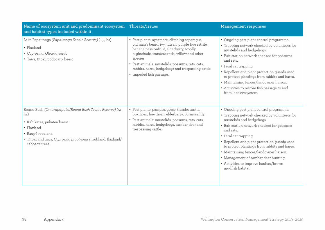
Lake Papaitonga (Papaitonga Scenic Reserve) (153 ha)
• Flaxland • Coprosma, Olearia scrub • Tawa, tītoki, podocarp forest
• Pest plants: sycamore, climbing asparagus, old man’s beard, ivy, tutsan, purple loosestrife, banana passionfruit, elderberry, woolly nightshade, trandescantia, willow and other species.
• Pest animals: mustelids, possums, rats, cats, rabbits, hares, hedgehogs and trespassing cattle.
• Impeded fish passage.
• Ongoing pest plant control programme. • Trapping network checked by volunteers for
mustelids and hedgehogs. • Bait station network checked for possums
and rats. • Feral cat trapping. • Repellent and plant protection guards used
to protect plantings from rabbits and hares. • Maintaining fences/landowner liaison. • Activities to restore fish passage to and
from lake ecosystem.
Round Bush (Omarupapako/Round Bush Scenic Reserve) (51 ha)
• Kahikatea, pukatea forest • Flaxland • Raupō reedland • Tītoki and tawa, Coprosma propinqua shrubland, flaxland/
cabbage trees
• Pest plants: pampas, gorse, trandescantia, boxthorn, hawthorn, elderberry, Formosa lily.
• Pest animals: mustelids, possums, rats, cats, rabbits, hares, hedgehogs, sambar deer and trespassing cattle.
• Ongoing pest plant control programme. • Trapping network checked by volunteers for
mustelids and hedgehogs. • Bait station network checked for possums
and rats. • Feral cat trapping. • Repellent and plant protection guards used
to protect plantings from rabbits and hares. • Maintaining fences/landowner liaison. • Management of sambar deer hunting. • Activities to improve hauhau/brown
mudfish habitat.

39Wellington Conservation Management Strategy 2019-2029 Appendix 4
Name of ecosystem unit and predominant ecosystem and habitat types included within it
Threats/issues Management responses
Awahou Conservation Area (19 ha)
• Tōtara, mātai broadleaved forest
• Pest plants: old man’s beard, boxthorn, hawthorn, gorse and other species.
• Pest animals: mustelids, possums, rats, cats, rabbits, hares, hedgehogs, sambar deer and trespassing cattle.
• Ongoing pest plant control programme. • Trapping network checked by volunteers for
mustelids and hedgehogs. • Bait station network checked for possums
and rats. • Feral cat trapping. • Repellent and plant protection guards used
to protect plantings from rabbits and hares. • Maintaining fences/landowner liaison.
Islands Place
Kāpiti Island (Kāpiti Island Nature Reserve) (1969 ha)
• Kohekohe, tawa forest • Podocarp, ribbonwood, kōwhai forest • Shore bind weed, knobby clubrush, gravelfield – stonefield • Shoreline class C
• Pest plants: periwinkle, gorse, broom, agapanthus, boneseed, karo, mallow, banana passion vine, selaginella, pampas, holly-leaved senecio.
• Pest animals: none present but biosecurity procedures in place for all pest animals.
• Ongoing pest plant programme. • Ongoing biosecurity measures.
Mana Island (Mana Island Scientific Reserve) (211 ha)
• Broadleaved scrub and shrubland • Ngaio, taupata treeland – herbfield rockland
• Pest plants: boneseed, boxthorn, karo, mallow, pink ragwort, holly-leaved senecio, Tangier pea, tree lucerne, tree mallow, blackberry, plus many others.
• Pest animals: none present but biosecurity procedures in places for all pest animals.
• Ongoing pest plant programme. • Ongoing biosecurity measures.

40 Wellington Conservation Management Strategy 2019-2029Appendix 4
Name of ecosystem unit and predominant ecosystem and habitat types included within it
Threats/issues Management responses
Wellington-Kāpiti Place
Rangituhi/Colonial Knob (Rangituhi/Colonial Knob Scenic Reserve) (130 ha)
• Broadleaved scrub and scrubland • Kohekohe, tawa forest
• Mustelids, possums, rats, goats, climbers, ground cover/herbaceous weeds and pioneer woody pest plants.
• Bait station network for possums and rats. • Secondary killing of mustelids. • Hunting for goats.
Kiripiti Scientific Reserve (2 ha)
• Tōtara, mātai, ribbonwood forest
• Mustelids, possums, rats, climbers, ground cover/herbaceous weeds, pioneer woody pest plants and shade-tolerant woody pest plants.
• Bait station and self-setting trap network for possums and rats.
• Secondary killing of mustelids.
Hemi Matenga Memorial Park Scenic Reserve (326 ha)
• Kohekohe, tawa forest
• Mustelids, possums, rats, goats, pigs, climbers, ground cover/herbaceous weeds, pioneer woody pest plants and shade-tolerant woody pest plants.
• Bait station network for possums and rats. • Secondary killing of mustelids. Hunting for
goats and pigs.
Paraparaumu (Paraparaumu Scenic Reserve) (298 ha)
• Kohekohe, tawa forest
• Mustelids, possums, rats, goats, pigs, climbers, ground cover/herbaceous weeds, pioneer woody pest plants and shade-tolerant woody pest plants.
• Bait station network for possums and rats. • Secondary killing of mustelids. Hunting for
goats and pigs.
Coastal and Marine Place
Turakirae Scientific Reserve (141 ha)
• Shore bind weed, knobby clubrush gravelfield/stonefield • Lowland lo-gradient streams and rivers • Lowland hill country gravel bed streams
• Pest plants, ferrets, goats, hares, hedgehogs, mice, pigs, possums, rabbits, rats, stoats, trespassing cattle and weasels.
• Climbers, goat, rat, stoat and possum control.

41Wellington Conservation Management Strategy 2019-2029 Appendix 5
Several thousand indigenous species are present in the Wellington region. This appendix lists the species of vascular plants, non-vascular plants, freshwater fish, marine animals, land vertebrate animals and invertebrates as ‘threatened’ or ‘at risk’ in accordance with the New Zealand Threat Classification System Manual 20184 and taxa status lists 2008 to 2016.
Management of threatened and at-risk species and of important ecosystems within the Wellington region is addressed in Section 3.1, the Natural values tables of the Places in Part Two and Appendix 4. Section 3.1 and the Natural values tables of the Places in Part Two address the Department’s work to advocate for the protection of threatened and at-risk flora and fauna that occur outside public conservation lands and waters, and manage threats to them.
The information provided within this Appendix is correct at the time of publishing. Due to the nature of conservation, this information is likely to change. Many key data sets related to the status of threatened species, and
4 www.doc.govt.nz/about-us/science-publications/conservation-publications/nz-threat-classification-system/nz-threat-classification-system-manual-2008/
the location and status of ecosystems, are continually improved and are updated within the Department’s systems on a rolling basis. It is also likely that management responses may change as new techniques and more effective methods are developed. Ongoing invasion of pests and recognition of new threats to biodiversity are also a reality. For information on what management responses are being used at the time of reading please contact the relevant departmental district office.
If there are changes to key data sets (such as the New Zealand Threat Classification status lists) the contents may also be amended or reviewed during the term of this CMS.
Appendix 5Threatened and at-risk indigenous flora and fauna present in the Wellington region
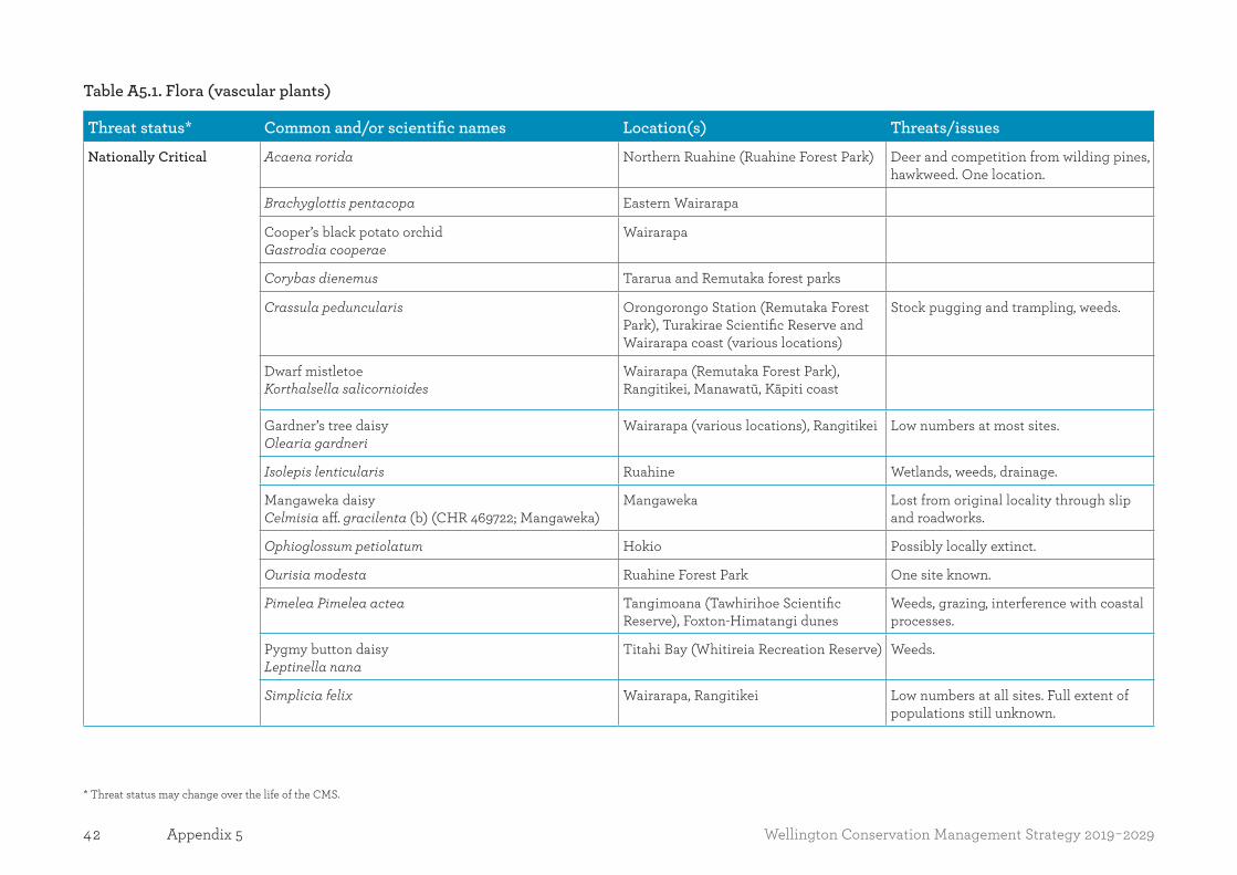
42 Wellington Conservation Management Strategy 2019-2029Appendix 5
Table A5.1. Flora (vascular plants)
Threat status* Common and/or scientific names Location(s) Threats/issues
Nationally Critical Acaena rorida Northern Ruahine (Ruahine Forest Park) Deer and competition from wilding pines, hawkweed. One location.
Brachyglottis pentacopa Eastern Wairarapa
Cooper’s black potato orchidGastrodia cooperae
Wairarapa
Corybas dienemus Tararua and Remutaka forest parks
Crassula peduncularis Orongorongo Station (Remutaka Forest Park), Turakirae Scientific Reserve and Wairarapa coast (various locations)
Stock pugging and trampling, weeds.
Dwarf mistletoeKorthalsella salicornioides
Wairarapa (Remutaka Forest Park), Rangitikei, Manawatū, Kāpiti coast
Gardner’s tree daisyOlearia gardneri
Wairarapa (various locations), Rangitikei Low numbers at most sites.
Isolepis lenticularis Ruahine Wetlands, weeds, drainage.
Mangaweka daisyCelmisia aff. gracilenta (b) (CHR 469722; Mangaweka)
Mangaweka Lost from original locality through slip and roadworks.
Ophioglossum petiolatum Hokio Possibly locally extinct.
Ourisia modesta Ruahine Forest Park One site known.
Pimelea Pimelea actea Tangimoana (Tawhirihoe Scientific Reserve), Foxton-Himatangi dunes
Weeds, grazing, interference with coastal processes.
Pygmy button daisyLeptinella nana
Titahi Bay (Whitireia Recreation Reserve) Weeds.
Simplicia felix Wairarapa, Rangitikei Low numbers at all sites. Full extent of populations still unknown.
* Threat status may change over the life of the CMS.
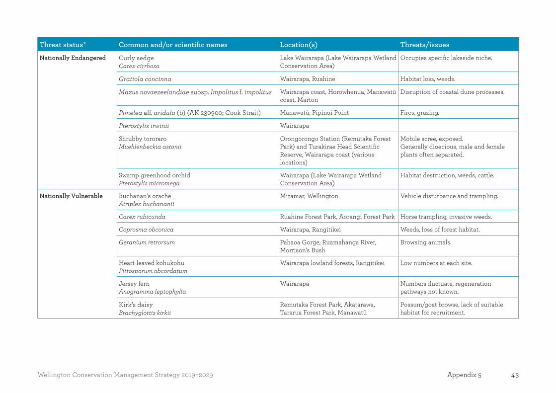
43Wellington Conservation Management Strategy 2019-2029 Appendix 5
Threat status* Common and/or scientific names Location(s) Threats/issues
Nationally Endangered Curly sedgeCarex cirrhosa
Lake Wairarapa (Lake Wairarapa Wetland Conservation Area)
Occupies specific lakeside niche.
Gratiola concinna Wairarapa, Ruahine Habitat loss, weeds.
Mazus novaezeelandiae subsp. Impolitus f. impolitus Wairarapa coast, Horowhenua, Manawatū coast, Marton
Disruption of coastal dune processes.
Pimelea aff. aridula (b) (AK 230900; Cook Strait) Manawatū, Pipinui Point Fires, grazing.
Pterostylis irwinii Wairarapa
Shrubby tororaroMuehlenbeckia astonii
Orongorongo Station (Remutaka Forest Park) and Turakirae Head Scientific Reserve, Wairarapa coast (various locations)
Mobile scree, exposed.Generally dioecious, male and female plants often separated.
Swamp greenhood orchidPterostylis micromega
Wairarapa (Lake Wairarapa Wetland Conservation Area)
Habitat destruction, weeds, cattle.
Nationally Vulnerable Buchanan’s oracheAtriplex buchananii
Miramar, Wellington Vehicle disturbance and trampling.
Carex rubicunda Ruahine Forest Park, Aorangi Forest Park Horse trampling, invasive weeds.
Coprosma obconica Wairarapa, Rangitikei Weeds, loss of forest habitat.
Geranium retrorsum Pahaoa Gorge, Ruamahanga River, Morrison’s Bush
Browsing animals.
Heart-leaved kohukohuPittosporum obcordatum
Wairarapa lowland forests, Rangitikei Low numbers at each site.
Jersey fernAnogramma leptophylla
Wairarapa Numbers fluctuate, regeneration pathways not known.
Kirk’s daisy Brachyglottis kirkii
Remutaka Forest Park, Akatarawa, Tararua Forest Park, Manawatū
Possum/goat browse, lack of suitable habitat for recruitment.

44 Wellington Conservation Management Strategy 2019-2029Appendix 5
Threat status* Common and/or scientific names Location(s) Threats/issues
Kunzea amathicola Peka Peka Beach, Kāpiti Island, Pauatahanui
Clearance, myrtle rust.
Lepilaena bilocularis Wairarapa, Wellington, Kāpiti, Horowhenua, Remutaka, Tararua
Leptinella tenella Lake Wairarapa, Fitzroy Bay, Wainuiomata River, Korohiwa Stream, Transmission Gully, Mount Kaukau
Spread of weeds, wetland drainage.
Libertia peregrinans Turakina Disruption of dune processes, weeds.
Muehlenbeckia ephedroides Pencarrow, Palliser Bay, Rangitikei Pest animals.
Myosotis brevis Palliser Bay Pest plants, trampling.
Pimelea tomentosa Wairarapa Habitat loss.
Pittosporum turneri Northern Ruahine (Ruahine Forest Park) Possum browsing.
PoroporoSolanum aviculare var. aviculare
Throughout the region Pest animals.
Pterostylis tasmanica Eastbourne, Wellington, Remutaka, Tararua
Competition from weeds.
Purple plume grassDichelachne micrantha
Waihora Habitat quality.
Sea hollyEryngium vesiculosum
Red Rocks coast, Pecarrow coast and lakes, Turakirae, Wairarapa coast
Vehicles and grazing.
Water broomAmphibromus fluitans
Wetlands around Lake Wairarapa (Matthews & Boggy Pond Wildlife Reserve, Lake Wairarapa Wetland Conservation Area)
Does not appear every year at all sites. Habitat quality.
Wood rose/DactylanthusDactylanthus taylorii
Ruahine Forest Park, Rangitikei, Wairarapa
Animal pests.

45Wellington Conservation Management Strategy 2019-2029 Appendix 5
Threat status* Common and/or scientific names Location(s) Threats/issues
Declining Climbing groundselBrachyglottis sciadophila
Wairarapa Pest animals.
Coastal woollyheadCraspedia uniflora var. maritima
Titahi Bay, Pencarrow coast and lakes Vehicles, human impact, habitat destruction.
Coprosma virescens Wairarapa , Rangitikei, Turakirae
Coprosma wallii Wairarapa, Rangitikei
Daucus glochidiatus Ruahine Forest Park, Aorangi Forest Park
Faster growing and taller weeds.
Dwarf muskMazus novaezeelandiae subsp. Novaezeelandiae
Makara, Wairarapa, Manawatū, Rangitikei
Rank grass.
Eel grassZostera muelleri subsp. Novazelandica
Pauatahanui Inlet, Porirua Harbour, Waikanae
Sedimentation.
Eleocharis neozelandica Horowhenua, Manawatū Disruption of coastal processes, vehicles.
Gunnera arenaria Foxton and Himatangi dunes Vehicles, interruption of dune processes.
Isolepis basilaris Foxton dunes Browsing, trampling and weeds.
Korthalsella clavata Wairarapa, Rangitikei, Wellington
Long-leaved pimeleaPimelea longifolia
Tararua Forest Park
Melicytus orarius Taputeranga Island, Titahi Bay
Myrsine umbricola Tararua Forest Park
New Zealand mint; hihoi Mentha cunninghamii
Aorangi Forest Park, Ruahine, Manawatū, Rangitikei, Wellington
Habitat degradation.
New Zealand sow thistleSonchus kirkii
Manawatū, Wellington coast and islands, Kāpiti Island
Weeds.

46 Wellington Conservation Management Strategy 2019-2029Appendix 5
Threat status* Common and/or scientific names Location(s) Threats/issues
Pimelea villosa Coastal dunes throughout Vehicle damage, marram grass.
PīngaoFicinia spiralis
Dunes throughout the region Vehicles, trampling, weeds, rabbits, loss of habitat.
QuillwortIsoetes kirkii
Wetlands
Red mistletoePeraxilla tetrapetala
Ruahine Forest Park; Rangitikei (various locations), Tararua Forest Park, Aorangi Forest Park
Possums.
Sand coprosmaCoprosma acerosa
Wairarapa (Castlepoint Scenic Reserve), Foxton and Himatangi dunes, Moana Roa Conservation Area, most dune areas
Disruption of coastal processes.
Sand tussockPoa billardierei
Wairarapa coast Lack of recruitment, dune disturbance, vehicles.
Scandia rosifolia Horowhenua, Rangitikei Vehicle disturbance.
Scarlet mistletoePeraxilla colensoi
Tararua Ranges (Tararua Forest Park) Possums.
Sea sedgeCarex litorosa
Manawatū Estuary Disruption of coastal processes.
Selliera rotundifolia Manawatū dunes Vehicles, disruption of ecosystem processes, pest plants.
Shore spurge Euphorbia glauca
Kāpiti Island, Baring Head, Turakirae Head
Habitat loss.
Solander’s geraniumGeranium solanderi
Wellington
Spiranthes novae-zelandiae Horowhenua, Waikanae, Hutt Valley Loss of wetland habitat.
Stout water milfoilMyriophyllum robustum
Kāpiti, Wellington, Rangitikei

47Wellington Conservation Management Strategy 2019-2029 Appendix 5
Threat status* Common and/or scientific names Location(s) Threats/issues
Swamp nettleUrtica perconfusa
Wellington, Wairarapa, Manawatū Not a long-lived species, habitat quality important.
Teucridium parvifolium Wairarapa, Manawatū, Horowhenua, Wellington, Rangitikei
Overgrowth of surrounding vegetation.
Thick-leaved māhoeMelicytus crassifolius
Wellington harbour, Wairarapa coast Roadside clearance, slips.
Trisetum antarcticum Wellington
White mistletoeTupeia antarctica
Horowhenua, Rangitikei, Manawatū, Wellington, Wairarapa, Ruahine, Tararua
Possum browse.
Yellow mistletoeAlepis flavida
Wairarapa Possums
Recovering Epilobium hirtigerum Remutaka Forest Park Competition from large, fast growing weeds.
Relict Giant maidenhairAdiantum formosum
Manawatū, Manawatū Gorge, Horowhenua
Browsing.
Gossamer grassAnemanthele lessoniana
Wairarapa (various locations), Horowhenua
Habitat quality.
Large-leaved milk treeStreblus banksii
Matiu/Somes Island (Matiu Scientific Reserve), Kāpiti Island Nature Reserve, Wellington and Wairarapa
Possums.
Pygmy sundewDrosera pygmaea
Ruahine (Makirikiri Tarns) Wetland drainage.
Senecio sterquilinus Matiu/Somes Island and Makora/Ward Island

48 Wellington Conservation Management Strategy 2019-2029Appendix 5
Threat status* Common and/or scientific names Location(s) Threats/issues
Naturally Uncommon Aciphylla dissecta Tararua Forest Park
Acaena emittens Ruahine Forest Park Pest plants.
Aciphylla squarrosa var. flaccida Tararua and Ruahine Forest Park
Agrostis oresbia Tararua and Ruahine Forest Parks
Azorella allanii Ruahine and Tararua Forest Park
Beddie’s tussock, Cook Strait tussockChionochloa beddiei
Wairarapa, Aorangi Forest Park, Wellington
Naturally uncommon.
Blanket fern Asplenium subglandulosus
Wairarapa, Tararua Forest Park, Wellington
Blechnum zeelandicum Wairarapa, Porirua Horowhenua, Kāpiti
Brachyglottis compacta Eastern Wairarapa Local endemic, restricted to limestone, often on eroding bluffs.
Brachyglottis greyi Coastal Wairarapa
Caladenia alata Horowhenua, Hutt Valley Biologically sparse.
Caladenia atradenia Wairarapa, Tararua Forest Park Naturally uncommon.
Caladenia bartlettii Wellington, Kāpiti, Tararua Forst Park Naturally uncommon orchid.
Caladenia variegata Eastbourne Hills, Aorangi Forest Park, Tararua Forest Park
Carex druceana Ruahine Forest Park
Carex obtusifolia Ruahine and Tararua Forest Park
Chenopodium allanii Wellington-Kāpiti and Wairarapa Uncommon in North Island.
Common mountain daisyCelmisia spectabilis subsp. lanceolata
Wairarapa, Aorangi, Ruahine and Tararua forest parks
Browsing animals.
Corunastylis nuda Wairarapa, Remutaka Forest Park, Wellington, Tararua Forest Park
Range reduction.
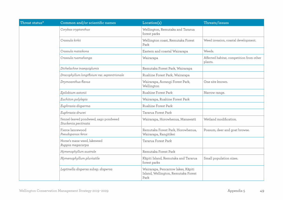
49Wellington Conservation Management Strategy 2019-2029 Appendix 5
Threat status* Common and/or scientific names Location(s) Threats/issues
Corybas cryptanthus Wellington, Remutaka and Tararua forest parks
Crassula kirkii Wellington coast, Remutaka Forest Park
Weed invasion, coastal development.
Crassula mataikona Eastern and coastal Wairarapa Weeds.
Crassula ruamahanga Wairarapa Affected habitat, competition from other plants.
Dichelachne inaequiglumis Remutaka Forest Park, Wairarapa
Dracophyllum longifloium var. septentrionale Ruahine Forest Park, Wairarapa
Drymoanthus flavus Wairarapa, Aorangi Forest Park, Wellington
One site known.
Epilobium astonii Ruahine Forest Park Narrow range.
Euchiton polylepis Wairarapa, Ruahine Forest Park
Euphrasia disperma Ruahine Forest Park
Euphrasia drucei Tararua Forest Park
Fennel-leaved pondweed, sago pondweedStuckenia pectinata
Wairarapa, Horowhenua, Manawatū Wetland modification.
Fierce lancewood Pseudopanax ferox
Remutaka Forest Park, Horowhenua, Wairarapa, Rangitikei
Possum, deer and goat browse.
Horse’s mane weed, lakeweedRuppia megacarpa
Tararua Forest Park
Hymenophyllum australe Remutaka Forest Park
Hymenophyllum pluviatile Kāpiti Island, Remutaka and Tararua forest parks
Small population sizes.
Leptinella dispersa subsp. dispersa Wairarapa, Pencarrow lakes, Kāpiti Island, Wellington, Remutaka Forest Park

50 Wellington Conservation Management Strategy 2019-2029Appendix 5
Threat status* Common and/or scientific names Location(s) Threats/issues
Lindsaea viridis Ruahine Forest Park, Manawatū
Myosotis spathulata Wairarapa, Ruahine Forest Park
Myosotis venosa Tararua and Ruahine Forest Park
New Zealand musk Thyridia repens
Wairarapa, Remutaka Forest Park, Wellington
New Zealand spinachTetragonia tetragonoides
Wairarapa coast, Wellington and islands, Manawatū
Disturbance of coastal sands.
Pterostylis auriculata Kāpiti Island
Pterostylis foliata South Wairarapa, Wellington, Ruahine and Tararua forest parks
Pterostylis porrecta Wairarapa, Porirua Scenic Reserve
Raoulia rubra Tararua Forest Park
Rytidosperma petrosum Wairarapa, Wellington, Kāpiti Island and coast
Low numbers, small area occupied.
Schoenus fluitans Ruahine Forest Park, Rangitikei, Moawhango
Schoenus caespitans Ruahine and Wairarapa
Senecio banksii Ruahine Forest Park
SneezeweedCentipeda aotearoana
Kāpiti, Wairarapa
Sophora molloyi Wairarapa, Wellington Goats.
Spotted sun orchidThelymitra ixioides
Wellington Vulnerable to roadworks and animal browse.
Streamside tree daisyOlearia cheesemanii
Tararua Forest Park, Kāpiti coast Weeds.

51Wellington Conservation Management Strategy 2019-2029 Appendix 5
Threat status* Common and/or scientific names Location(s) Threats/issues
Thelymitra formosa Aorangi, Tararua and Remutaka forest parks, Rangitikei
Townsonia deflexa Tararua Forest Park
Tutu Coriaria (a) (CHR 469745, Rimutaka)
Wairarapa
Veronica angustissima Tararua Forest Park
Veronica evenosa Tararua Forest Park, Kāpiti Island
Zannichellia palustris Wairarapa, Horowhenua, Manawatū Wetland drainage.
Table A5.2. Flora (non-vascular plants)
Threat status* Common and/or scientific names Location(s) Threats/issues
Nationally Vulnerable Fissidens berteroi Masterton Competition from weeds, changes in water levels, aeration and quality.
Declining Liverwort
Ricciocarpos natans
Lake Wairarapa Wetland Conservation Area
Table A5.3. Fauna (freshwater fish)
Threat status* Common and/or scientific names Location(s) Threats/issues
Nationally Vulnerable Piharau, lamprey Geotria australis
Wairarapa Water quality, loss of habitat, fish passage barriers.
Shortjaw kōkopu Galaxias postvectis
Wairarapa Water quality, loss of habitat, fish passage barriers.
Declining Bluegill bully Gobiomorphus hubbsi

52 Wellington Conservation Management Strategy 2019-2029Appendix 5
Threat status* Common and/or scientific names Location(s) Threats/issues
Brown mudfish Neochanna apoda
Omarupapako/Round Bush Scenic Reserve; Lake Papaitonga (Papaitonga Scenic Reserve); Koputaroa Flaxlands (Koputaroa Scientific Reserve), Lowes Bush Scenic Reserve, Tini Bush Covenant, Otaihanga
Wetland draining.
Dwarf galaxias Galaxias divergens
One recent Wairarapa site Water quality, loss of habitat, fish passage barriers.
Giant kōkopu Galaxias argenteus
Lake Papaitonga (Papaitonga Scenic Reserve), Wairarapa (Remutaka Forest Park, Aorangi Forest Park, Tararua Forest Park) Kaitawa Scenic Reserve
Hydrological alteration, impeded fish passage, lake macrophyte threats, lake water quality threats, loss of wetland habitat, modification of rivers and lakes.
Inanga Galaxias maculatus
Lake Wairarapa Wetland Conservation Area, lower part of Ruamahanga River
Wetland drainage, habitat degradation, land modification and stream barriers.
Kōaro Galaxias brevipinnis
Wairarapa (various locations), especially streams near coast.
Water quality, loss of habitat, fish passage barriers.
Longfin eel Anguilla dieffenbachii
Pukaha Mount Bruce (Mount Bruce Scenic Reserve), Lake Wairarapa Wetland Conservation Area
Wetland habitat loss, impediments to fish passage and commercial exploitation. Recreational fishing, water quality, weeds/invasive plant species.
Redfin bully Gobiomorphus huttoni
Torrentfish Cheimarrichthys fosteri

53Wellington Conservation Management Strategy 2019-2029 Appendix 5
Table A5.4. Fauna (marine)
Threat status* Common and/or scientific names Location(s) Threats/issues
Nationally Critical Bryde’s whale Balaeneoptera edeni brydei
All coastal waters Boat strike (elsewhere in range).
Killer whale Orcinus orca
All coastal waters
New Zealand sea lionPhocarctos hookeri
Not specifically known in Wellington region but may visit and haul out on beaches
Bycatch in fisheries (elsewhere in range).
Southern elephant Mirounga leoninaseal
Occasional visitor, hauls out on beaches
Spionid Boccardiella magniovata
Nationally Endangered Bottlenose dolphin Tursiops truncatus
All coastal waters Vessel traffic.
Hector’s dolphinCephalorhynchus hectori hectori
Highly coastal Bycatch in fisheries.
Nationally Vulnerable Southern right whale Eubalaena australis
All coastal waters
Table A5.5. Fauna (land vertebrates)
Threat status* Common and/or scientific names Location(s) Threats/issues
Nationally Critical Australasian bittern Botaurus poiciloptilus
Manawatū Estuary (Foxton Conservation Area), Lake Papaitonga (Papaitonga Scenic Reserve), Koputaroa Flaxlands (Koputaroa Scientific Reserve), Wairarapa wetlands (Lake Wairarapa Wetland Conservation Area, Matthews & Boggy Wildlife Reserve)
Rats, stoats, cats.

54 Wellington Conservation Management Strategy 2019-2029Appendix 5
Threat status* Common and/or scientific names Location(s) Threats/issues
Black-billed gull Larus bulleri
Ruamahanga River, Lake. Wairarapa Wetland Conservation Area
Predators, vulnerable nest colony locations. Cats. Trapping, work with Greater Wellington to minimise impacts of flood protection to maintain river habitat.
Reef heron Egretta sacra sacra
Coastal and Marine Place Advocacy to minimise disturbance and habitat loss, Island biosecurity.
Rowi/Okarito brown kiwi Apteryx rowi
Mana Island Scientific Reserve Animal pest incursions, cats.
Takahē Porphyrio hochstetteri
Mana Island Scientific Reserve, Kāpiti Island Nature Reserve
Animal pest incursion, cats.
White heron Ardea modesta
Visitor to WairarapaWellington-Kāpiti
Nationally Endangered Black-fronted tern Childonias albostriatus
Wairarapa Predators, cats.
Whitaker’s skinkOligosoma whitakeri
Pukerua Bay Rats and mice, cats.
WrybillAnarhynchus frontalis
Manawatū Estuary (Foxton Conservation Area). Visitor to Lake Wairarapa (Lake Wairarapa Wetland Conservation Area)
Weed control and animal pests, such as mustelids, possums and rats. Human disturbance. Dogs and cats.
Nationally Vulnerable Banded dotterelCharadrius bicinctus bicinctus
Breeding in Wairarapa at various locations
Predators, disturbance.
Caspian ternHydropogne caspia
Onoke Spit (Lake Wairarapa Wetland Conservation Area), Kāpiti Island Nature Reserve
Animal pest incursion, predators, disturbance, cats.
Kupe skink Oligosoma aff. infrapunctatum “Southern North Island”
Wairarapa Predators, land use changes.
Lesser knotCalidris canutus rogersi
Manawatū Estuary (Foxton Conservation Area)
Human disturbance, dogs, cats.
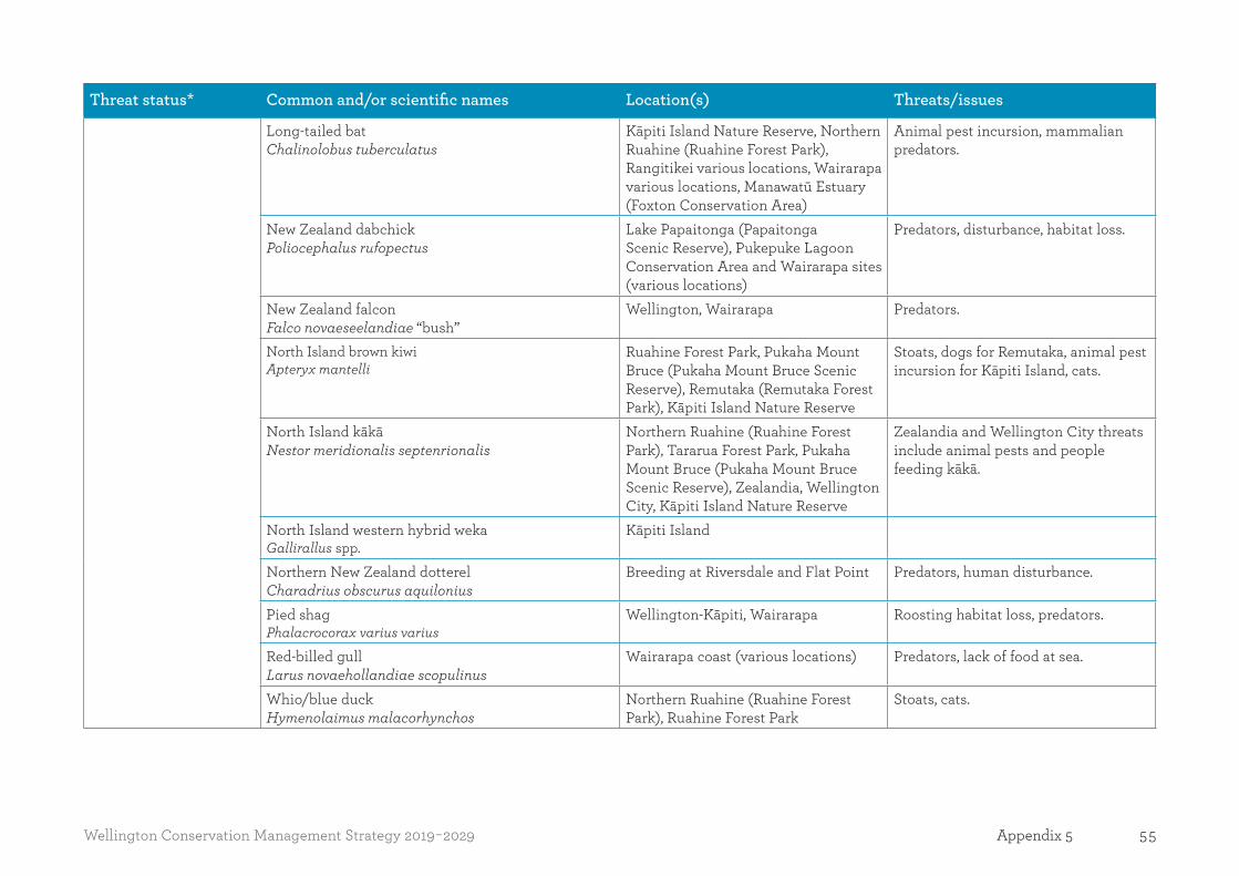
55Wellington Conservation Management Strategy 2019-2029 Appendix 5
Threat status* Common and/or scientific names Location(s) Threats/issues
Long-tailed bat Chalinolobus tuberculatus
Kāpiti Island Nature Reserve, Northern Ruahine (Ruahine Forest Park), Rangitikei various locations, Wairarapa various locations, Manawatū Estuary (Foxton Conservation Area)
Animal pest incursion, mammalian predators.
New Zealand dabchickPoliocephalus rufopectus
Lake Papaitonga (Papaitonga Scenic Reserve), Pukepuke Lagoon Conservation Area and Wairarapa sites (various locations)
Predators, disturbance, habitat loss.
New Zealand falcon Falco novaeseelandiae “bush”
Wellington, Wairarapa Predators.
North Island brown kiwiApteryx mantelli
Ruahine Forest Park, Pukaha Mount Bruce (Pukaha Mount Bruce Scenic Reserve), Remutaka (Remutaka Forest Park), Kāpiti Island Nature Reserve
Stoats, dogs for Remutaka, animal pest incursion for Kāpiti Island, cats.
North Island kākāNestor meridionalis septenrionalis
Northern Ruahine (Ruahine Forest Park), Tararua Forest Park, Pukaha Mount Bruce (Pukaha Mount Bruce Scenic Reserve), Zealandia, Wellington City, Kāpiti Island Nature Reserve
Zealandia and Wellington City threats include animal pests and people feeding kākā.
North Island western hybrid wekaGallirallus spp.
Kāpiti Island
Northern New Zealand dotterelCharadrius obscurus aquilonius
Breeding at Riversdale and Flat Point Predators, human disturbance.
Pied shagPhalacrocorax varius varius
Wellington-Kāpiti, Wairarapa Roosting habitat loss, predators.
Red-billed gullLarus novaehollandiae scopulinus
Wairarapa coast (various locations) Predators, lack of food at sea.
Whio/blue duckHymenolaimus malacorhynchos
Northern Ruahine (Ruahine Forest Park), Ruahine Forest Park
Stoats, cats.

56 Wellington Conservation Management Strategy 2019-2029Appendix 5
Threat status* Common and/or scientific names Location(s) Threats/issues
Declining Brown tealAnas chlorotis
Kāpiti Island Nature Reserve, Mana Island Scientific Reserve
Animal pest incursion.
Central lesser short-tailed batMystacina tubercualta rhyacobia
Waiohine Gorge and Tararua ranges Animal pest incursion, cats, habitat disturbance.
Glossy brown skinkOligosoma zelandicum
Wellington, Kāpiti and Mana islands. Predators.
New Zealand pipitAnthus novaeseelandiae novaeseelandiae
Throughout the region Predators, urbanisation.
North Island fernbirdBowdleria punctata vealeae
Waikanae Estuary (Waikanae Estuary Scientific Reserve)
Predators.
North Island rifleman Acanthisitta chloris granti
Pukaha Mount Bruce (Pukaha Mount Bruce Scenic Reserve), Tararua Forest Park, Aorangi Forest Park and Wairarapa sites
Predators, cats.
Northern blue penguinEudyptula minor iredalei
Wairarapa (various locations), Wellington, Kāpiti, Mana
Predators, disturbance.
Ornate skinkOligosoma ornatum
Matiu/Somes Island (Matiu Historic Reserve, Matiu Scientific Reserve), Wellington, Wairarapa
Animal pest incursion, predators, habitat loss, cats.
Pied stiltHimantopus himantopus leucocephalus
Lake Wairarapa Wetland Conservation Area, Wellington-Kāpiti Place
Animal pest incursion, predators.
Sooty shearwaterPuffinus griseus
Kāpiti Island Nature Reserve, Mana Island Scientific Reserve and Matiu/Somes Island (Matiu Historic Reserve and Matiu Scientific Reserve)
Predators.
South Island pied oystercatcherHaematopus finschi
Wairarapa Cats.
Southern North forest geckoMokopirirakau “Southern North Island”
Kāpiti Island, Mana Island, Matiu/Somes Island, Zealandia, Pukaha Mount Bruce, Wairarapa, forest parks and forested reserves
Predators and habitat loss.
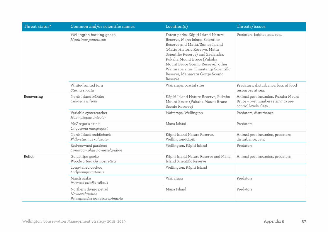
57Wellington Conservation Management Strategy 2019-2029 Appendix 5
Threat status* Common and/or scientific names Location(s) Threats/issues
Wellington barking geckoNaultinus punctatus
Forest parks, Kāpiti Island Nature Reserve, Mana Island Scientific Reserve and Matiu/Somes Island (Matiu Historic Reserve, Matiu Scientific Reserve) and Zealandia, Pukaha Mount Bruce (Pukaha Mount Bruce Scenic Reserve), other Wairarapa sites. Himatangi Scientific Reserve, Manawatū Gorge Scenic Reserve
Predators, habitat loss, cats.
White-fronted ternSterna striata
Wairarapa, coastal sites Predators, disturbance, loss of food resources at sea.
Recovering North Island kōkakoCallaeas wilsoni
Kāpiti Island Nature Reserve, Pukaha Mount Bruce (Pukaha Mount Bruce Scenic Reserve)
Animal pest incursion. Pukaha Mount Bruce – pest numbers rising to pre-control levels. Cats.
Variable oystercatcherHaematopus unicolor
Wairarapa, Wellington Predators, disturbance.
McGregor’s skinkOligosoma macgregori
Mana Island Predators
North Island saddlebackPhilersturmus rufusater
Kāpiti Island Nature Reserve, Wellington-Kāpiti
Animal pest incursion, predators, disturbance, cats.
Red-crowned parakeetCynaroamphus novaezelandiae
Wellington, Kāpiti Island Predators.
Relict Goldstripe geckoWoodworthia chrysosiretica
Kāpiti Island Nature Reserve and Mana Island Scientific Reserve
Animal pest incursion, predators.
Long-tailed cuckooEudynamys taitensis
Wellington, Kāpiti Island
Marsh crakePorzana pusilla affinus
Wairarapa Predators.
Northern diving petrelNovaezelandiaePelecanoides urinatrix urinatrix
Mana Island Predators.

58 Wellington Conservation Management Strategy 2019-2029Appendix 5
Threat status* Common and/or scientific names Location(s) Threats/issues
Spotless crakePorzana tabuensis tabuensis
Coastal Dunes Place, Wairarapa Predators.
Spotted skink Oligosomalineoocellatum
Wairarapa, Turakirae Heads, Matiu/Somes and Mokopuna islands, Mana Island, Zealandia
Predators and habitat loss.
TuataraSphenodon punctatus
Matiu/Somes Island Animal pest incursion.
Naturally Uncommon Black shagPhalcrocorax carbo novaehollandiae
Widespread Predators, disturbance.
Little black shagPhalacrocorax sulcirostris
Widespread Predators, disturbance.
Royal spoonbillPlatalea regia
Kāpiti Island Nature Reserve, Wairarapa Moana (Lake Wairarapa Wetlands Conservation Area, Matthews & Boggy Wildlife Reserve and Allsops Bay Wildlife Reserve)
Animal pest incursion.
Table A5.6. Fauna (invertebrates)
Threat status* Common and/or scientific names Location(s) Threats/issues
Nationally Endangered Land snail Powelliphanta traversi tararuensis
Lake Papaitonga (Papaitonga Scenic Reserve, Koputaroa flaxlands (Koputaroa Scientific Reserve), Manawatū plains
Animal browsing, hedgehogs, rodents.
Land snail Powelliphanta traversi traversi
Waiopehu Scenic Reserve Hedgehogs, rodents.
Land snail Powelliphanta traversi florida
Kimberley Scenic Reserve Hedgehogs, rodents.
Speargrass weevil Stephanorhynchus insolitus
Mana Island Scientific Reserve, Wellington South Coast
Rat browsing, loss of habitat.

59Wellington Conservation Management Strategy 2019-2029 Appendix 5
Threat status* Common and/or scientific names Location(s) Threats/issues
Nationally Vulnerable Kākahi, freshwater mussel Echyridella aucklandica
Wairarapa Moana (Lake Wairarapa Wetland Conservation Area)
Land snail Powelliphanta marchanti
Northern Ruahine (Ruahine Forest Park), Hillas and Huttons covenant lands
Animal browsing, hedgehogs, rodents.
Orongorongo black cicada Maoricicada myersi
Orongorongo Valley (Remutaka Forest Park)
Unknown.
Declining Brullea antarctica Wairarapa Loss of habitat.Common kākahi, freshwater mussel Echyridella menziesii
Lake Wairarapa
Katipō Latrodectus katipo
Te Humenga Point, Flat Point, Uruti Point and Lake Onoke Spit
Loss of habitat.
Relict Flax weevil Anagotus fairburni
Mana Island Scientific Reserve Predators.
Forest ringlet butterfly Dodonidia helmsii
Remutaka Forest Park, Wairarapa, Aorangi Ranges
Parasitation by introduced wasps.
* Threat status may change over time.
Sources: Bats: O’Donnell, C.F.J.; Christie, J.E.; Lloyd, B.; Parsons, S.; Hitchmough, R.A. 2013: Conservation status of New Zealand bats, 2012. New Zealand Threat Classification Series 6. Department of Conservation, Wellington. 8 p.
Birds: Robertson, H.A; Dowding, J.E.; Elliot, G.P; Hitchmough, R.A; Miskelly, C.M.; O’Donnell, C.F.J.; Powlesland, R.G.; Sagar, P.M.; Scofield, R.P.; Taylor, G.A. 2013: Conservation status of New Zealand birds, 2012. New Zealand Threat Classification Series 4. Department of Conservation, Wellington. 22 p.
Freshwater fish: Goodman, J.M.: Dunn, N.R.; Ravenscroft, P.J.; Boubee, J.A.T.; David, B.O.; Griffiths, M.; Nicholas Ling, N.; Hitchmough, R.A.; Rolfe, J.R. 2014:
Conservation status of New Zealand freshwater fish, 2013. New Zealand Threat Classification Series 7. Department of Conservation, Wellington. 12 p.
Freshwater invertebrates: Grainger, N.; Collier, K; Hitchmough, R.; Harding, J.; Smith, B.; Sutherland, D. 2014: Conservation status of New Zealand freshwater invertebrates, 2013. New Zealand Threat Classification Series 8. Department of Conservation, Wellington. 28 p.
Hornworts and liverworts: de Lange, P.J.; Glenny, P.; Braggins, J.; Renner, M.; von Konrat, M.; Engel, J.; Reeb, C.; Rolfe, J. 2015: Conservation status of New Zealand hornworts and liverworts, 2014. New Zealand Threat Classification Series 11. Department of Conservation, Wellington. 31 p.

60 Wellington Conservation Management Strategy 2019-2029Appendix 5
Marine invertebrates: Freeman, D.; Schnabel, K.; Marshall, B.; Gordon, D.; Wing, S.; Tracey, D.; Hitchmough, R. 2014: Conservation status of New Zealand marine invertebrates, 2013. New Zealand Threat Classification Series 9. Department of Conservation, Wellington. 20 p.
Marine mammals: Baker, C.S.; Chilvers, B.L.; Childerhouse, S.; Constantine, R.; Currey, R.; Mattlin, R.; van Helden, A.; Hitchmough, R.; Rolfe, J. 2016: Conservation status of New Zealand marine mammals, 2013. New Zealand Threat Classification Series 14. Department of Conservation, Wellington. 18 p.
Mosses: Rolfe, J.R.; Fife, A.J.; Beever, J.E.; Brownsey, P.J.; Hitchmough, R.A. 2016. Conservation status of New Zealand mosses, 2014: New Zealand Threat Classification Series 13. Department of Conservation, Wellington. 12 p.
Reptiles: Hitchmough, R.; Anderson, P.; Barr, B.; Monks, J.; Lettink, M.; Reardon, J.; Tocher, M.; Whitaker, T. 2013: Conservation status of New Zealand reptiles, 2012. New Zealand Threat Classification Series 2. Department of Conservation, Wellington. 16 p.
Vascular plants: de Lange, P.J.; Rolfe, J.R.; Champion, P.D.; Courtney, S.P.; Heenan, P.B; Barkla, J.W.; Cameron, E.K.; Norton, D.A; Hitchmough, R.A. 2013: Conservation status of New Zealand indigenous vascular plants, 2012. New Zealand Threat Classification Series 3. Department of Conservation, Wellington. 70 p.

61Wellington Conservation Management Strategy 2019-2029 Appendix 6
Appendix 6Threats or pests and wild animals present in the Wellington region If a herd of chamois, deer, tahr or feral pigs is designated as a herd of special interest under section 16 of the Game Animal Council Act 2013, the animals within that herd are no longer wild animals.
Management of threats or pests or wild animals in the Wellington region is addressed in Section 3.1 and the Natural values tables of the Places in Part Two. The information provided within this Appendix is correct at the time of publishing. Due to the nature of conservation, this information is likely to change. Many key data sets are continually improved and are updated within the Department’s systems on a rolling basis. It is also likely that management responses will change as new techniques and more effective methods are developed. For information on what management responses are being used at the time of reading please contact the relevant district office.
Table A6.1 Pest and wild animals
Common and scientific name Locations and distribution Pressures/threats Management response Priority sites for action
Birds
Magpie Gymnorhina tibicen tibicen, G. tibicen hypoleuca
Widespread throughout region. Predation on native species, attacks on visitors.
Generally nil. Localised response to complaints.
High visitor use sites.
Eastern rosellaPlatycersus eximius
Widespread throughout region. Competition with native species.
Generally nil.
Black-backed gull Larus dominicanus
Widespread throughout region. Flight-path hazard for aircraft, predation/competition for native species.
Intervention to reduce breeding success.
Matiu/Somes Island for airport flight-path risks. Kāpiti and Mana islands to protect re-establishing seabird breeding sites.
Rook
Corvus frugilegus
Scattered in Northern Wairarapa. Minor. Support Greater Wellington Regional Council eradication programme.
As located.

62 Wellington Conservation Management Strategy 2019-2029Appendix 5
Common and scientific name Locations and distribution Pressures/threats Management response Priority sites for action
Freshwater fish5
Brown bullhead catfish Ameiurus nebulosus
Scattered sites. Biodiversity decline, reduced water quality, loss of habitat.
Prevention, surveillance, control to low levels and eradication where management criteria are met.
All freshwater sites managed by the Department.
Gambusia Gambusia affinis
Scattered sites, including possibly at Lake Onoke (Lake Wairarapa Wetland Conservation Area) (not confirmed by netting – other Wairarapa sites eradicated).
Predation of freshwater species, competition with native fish species.
Prevention, surveillance, control to low levels and eradication where management criteria are met.
All freshwater sites managed by the Department and at other sites in partnership with Greater Wellington Regional Council.
Goldfish Carassius auratus
Widespread throughout region. Biodiversity decline, competition with native species.
Prevention, surveillance, control to low levels and eradication where management criteria are met.
All freshwater sites managed by the Department.
Koi carp Cyprinus carpio
Scattered sites (Waikanae River, Forest Lakes and some ponds).
Biodiversity decline, reduced water quality, loss of habitat.
Prevention, surveillance, control to low levels and eradication where management criteria are met.
All freshwater sites managed by the Department and at other sites in partnership with Greater Wellington Regional Council.
Rudd Scardinius erythrophthalmus
Scattered sites (present throughout Lake Wairarapa Wetland Conservation Area).
Biodiversity decline, competition with native species.
Prevention, surveillance, control to low levels and eradication where management criteria are met.
All freshwater sites managed by the Department.
Invertebrates
Argentine antLinepithema humile
Widespread on Kāpiti Coast, Petone, Seaview and around Miramar.
Argentine ants are highly competitive for resources and will displace native species.
Prevention, eradication, containment. Support Greater Wellington Regional Council control programmes.
Departmental facilities. Priority sites such as Kāpiti, Mana and Matiu/Somes islands.
Australian subterranean termites Coptotermes acinacoformis
Not known but risks associated with port.
Threat to native forest biodiversity and will displace native invertebrates.
Prevention. Support Greater Wellington Regional Council control programmes.
5 The following pest fish are consistent with the Greater Wellington regional pest management strategy.

63Wellington Conservation Management Strategy 2019-2029 Appendix 6
Common and scientific name Locations and distribution Pressures/threats Management response Priority sites for action
Darwin’s antDoleromyrma darwinia
Coastal and Marine Place (Plimmerton).
Threat to native biodiversity and will displace native invertebrates.
Prevention, eradication, containment. Support Greater Wellington Regional Council control programmes.
Departmental facilities. Priority sites such as Kāpiti, Mana and Matiu/Somes islands.
German wasps Vespula germanica
Widespread throughout region. Threat to native biodiversity and will predate native invertebrates. Public nuisance threat.
Localised control (developing tools may allow broader scale intervention in future).
High visitor use sites. Reserves and covenants where nests are reported. Specific sites where these pests are likely to have an impact on threatened species and staff managing these species (e.g. Hihi/stitchbird feeders on Kāpiti Island).
Common wasps Vespula vulgaris
Widespread throughout region. Threat to native biodiversity and will predate native invertebrates. Public nuisance threat.
Localised control (developing tools may allow broader scale intervention in future).
High visitor use sites. Reserves and covenants where nests are reported. Specific sites where these pests are likely to have an impact on threatened species and staff managing these species.
Asian paper wasp Polites chinensis
Widespread throughout region. Threat to native biodiversity and will predate native invertebrates. Public nuisance threat.
Localised control. High visitor use sites.Reserves and covenants where nests are reported.Specific sites where these pests are likely to have an impact on threatened species and staff managing these species.
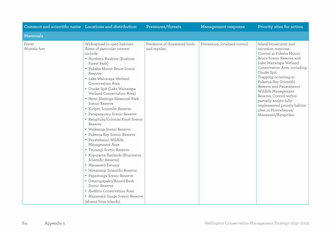
64 Wellington Conservation Management Strategy 2019-2029Appendix 5
Common and scientific name Locations and distribution Pressures/threats Management response Priority sites for action
Mammals
FerretMustela furo
Widespread in open habitats. Areas of particular interest include: • Northern Ruahine (Ruahine
Forest Park) • Pukaha Mount Bruce Scenic
Reserve • Lake Wairarapa Wetland
Conservation Area • Onoke Spit (Lake Wairarapa
Wetland Conservation Area) • Hemi Matenga Memorial Park
Scenic Reserve • Kiripiti Scientific Reserve • Paraparaumu Scenic Reserve • Rangituhi/Colonial Knob Scenic
Reserve • Waikanae Scenic Reserve • Pukerua Bay Scenic Reserve • Pauatahanui Wildlife
Management Area • Titirangi Scenic Reserve • Koputaroa flaxlands (Koputaroa
Scientific Reserve) • Manawatū Estuary • Himatangi Scientific Reserve • Papaitonga Scenic Reserve • Omarupapako/Round Bush
Scenic Reserve • Awahou Conservation Area • Manawatū Gorge Scenic Reserve
(absent from islands).
Predation of threatened birds and reptiles.
Prevention, localised control. Island biosecurity and incursion response. Control at Pukaha Mount Bruce Scenic Reserve and Lake Wairarapa Wetland Conservation Area, including Onoke Spit. Trapping occurring at Pukerua Bay Scientific Reserve and Pauatahanui Wildlife Management Reserve. Control within partially and/or fully implemented priority habitat sites in Horowhenua/Manawatū/Rangitikei.

65Wellington Conservation Management Strategy 2019-2029 Appendix 6
Common and scientific name Locations and distribution Pressures/threats Management response Priority sites for action
European hedgehogErinaceus europaeus occidentalis
Widespread throughout the region.
Threat to native biodiversity, predation of threatened birds and reptiles.
Prevention, localised control.
European hareLepus europaeus
Widespread in open habitats, present in forests, absent from islands.
Threat to native biodiversity, sustains populations of feral cats and ferrets.
Prevention, localised control.
Stoat Mustela ermineandWeasel Mustela nivalis vulgaris
Widespread in open habitats. Areas of particular interest include:
• Northern Ruahine (Ruahine Forest Park)
• Pukaha Mount Bruce Scenic Reserve
• Lake Wairarapa Wetland Conservation Area
• Onoke Spit (Lake Wairarapa Wetland Conservation Area)
• Hemi Matenga Memorial Park Scenic Reserve
• Kiripiti Scientific Reserve • Paraparaumu Scenic Reserve • Rangituhi/Colonial Knob Scenic
Reserve • Waikanae Scenic Reserve • Pukerua Bay Scenic Reserve • Pauatahanui Wildlife
Management Area • Titirangi Scenic Reserve • Koputaroa flaxlands (Koputaroa
Scientific Reserve) • Manawatū Estuary • Himatangi Scientific Reserve • Papaitonga Scenic Reserve • Omarupapako/Round Bush
Scenic Reserve • Awahou Conservation Area • Manawatū Gorge Scenic Reserve
(absent from islands).
Predation of threatened birds, invertebrates and reptiles.
Prevention, localised control, support for community projects.
Island biosecurity and incursion response. Control at Pukaha Mount Bruce and Lake Wairarapa Wetland Conservation Area, including Onoke Spit, Project Kākā site (Mitre Peak to Mount Holdsworth, Holdsworth to Otaki Forks) and Cold Stream. Community projects include Aorangi restoration and Remutaka restoration. Control at Deep Creek bat site. Partial control, though secondary poisoning, in Hemi Matenga Memorial Park Scenic Reserve, Paraparaumu Scenic Reserve, Rangituhi/Colonial Knob Scenic Reserve, Waikanae Scenic Reserve and adjoining or nearby covenants. Trapping occurring at Pukerua Bay Scientific Reserve and Pauatahanui Wildlife Management Reserve. Control within partially and/or fully implemented priority ecosystem sites in Horowhenua/Manawatū/Rangitikei.

66 Wellington Conservation Management Strategy 2019-2029Appendix 5
Common and scientific name Locations and distribution Pressures/threats Management response Priority sites for action
Rats Rattus species
Widespread (absent from islands). Predation of threatened birds, invertebrates and reptiles.
Prevention, surveillance, control to low levels and eradication where management criteria are met.
Island biosecurity and incursion response. Control at Pukaha Mount Bruce Scenic Reserve and Project Kākā site and cold stream. Trapping at Deep Creek pekapeka/bat site.Control in Hemi Matenga Memorial Park Scenic Reserve, Paraparaumu Scenic Reserve, Rangituhi/Colonial Knob Scenic Reserve, Pauatahanui Wildlife Management Reserve, Waikanae Scenic Reserve, Waikanae Estuary Scientific Reserve, Pukerua Bay Scientific Reserve and adjoining or nearby covenants.Control within partially and/or fully implemented priority ecosystem sites in Horowhenua/Manawatū/Rangitikei.
Mice Mus musculus
Widespread (absent from islands). Predation of threatened invertebrates and reptiles.
Prevention, surveillance, control to low levels and eradication where management criteria are met.
Island biosecurity and incursion response. Partial control in Hemi Matenga Memorial Park Scenic Reserve, Paraparaumu Scenic Reserve, Rangituhi/Colonial Knob Scenic Reserve, Pauatahanui Wildlife Management Reserve,
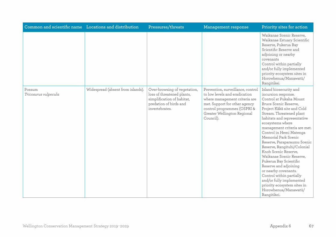
67Wellington Conservation Management Strategy 2019-2029 Appendix 6
Common and scientific name Locations and distribution Pressures/threats Management response Priority sites for action
Waikanae Scenic Reserve, Waikanae Estuary Scientific Reserve, Pukerua Bay Scientific Reserve and adjoining or nearby covenantsControl within partially and/or fully implemented priority ecosystem sites in Horowhenua/Manawatū/Rangitikei.
Possum Tricosurus vulpecula
Widespread (absent from islands). Over-browsing of vegetation, loss of threatened plants, simplification of habitat, predation of birds and invertebrates.
Prevention, surveillance, control to low levels and eradication where management criteria are met. Support for other agency control programmes (OSPRI & Greater Wellington Regional Council).
Island biosecurity and incursion response. Control at Pukaha Mount Bruce Scenic Reserve, Project Kākā site and Cold Stream. Threatened plant habitats and representative ecosystems where management criteria are met. Control in Hemi Matenga Memorial Park Scenic Reserve, Paraparaumu Scenic Reserve, Rangituhi/Colonial Knob Scenic Reserve, Waikanae Scenic Reserve, Pukerua Bay Scientific Reserve and adjoining or nearby covenants. Control within partially and/or fully implemented priority ecosystem sites in Horowhenua/Manawatū/Rangitikei.

68 Wellington Conservation Management Strategy 2019-2029Appendix 5
Common and scientific name Locations and distribution Pressures/threats Management response Priority sites for action
Feral rabbit Oryctolagus cuniculus cuniculus
Widespread in open habitat. Threat to native biodiversity, sustains populations of feral cats and ferrets, impact on local restoration programmes.
Localised control. Threatened plant habitats where management criteria are met. Control at sites that are vulnerable (Waikanae Estuary Scientific reserve, Waikanae Scenic Reserve and the adjoining QEII covenants and Tini Bush Covenant).
Feral red deer Cervus elaphus
Widespread. Threat to native biodiversity in forest and tussockland habitats.
Encouragement of recreational hunting and commercial hunting.
Priority ecosystems where management criteria are met.
Sika deer Cervus nippon
Localised in northern Tararua range (Tararua Forest Park).
Threat to native biodiversity in forest and shrubland habitats.
Encouragement of recreational hunting and commercial hunting.
Priority ecosystems where management criteria are met.
Feral fallow deer Dama dama
Widespread scattered pockets largely on private land.
Threat to native biodiversity in forest and shrubland habitats.
Encouragement of recreational hunting and commercial hunting.
Sambar deer Rusa unicolor
Widespread scattered pockets largely on private land, particularly forestry blocks. Inhabit Omarupapako/Round Bush, Awahou Conservation Area, Moutoa Conservation Area and Tangimoana Beach Conservation Area.
Threat to native biodiversity in forest and shrubland habitats.
Encouragement of recreational hunting at Tangimoana Beach Conservation Area and management hunting in Omarupapako/Round Bush Scenic Reserve.
Omarupapako/Round Bush Scenic Reserve.
Feral goat Capra hircus
Widespread in eastern and southern sections of the region with pockets in Tararua range (Tararua Forest Park). Ruahine range: distribution limited to the north east and southern areas of the range. Manawatū Gorge Scenic Reserve: occasional and localised to limited areas.
Threat to native biodiversity in forest and shrubland habitats.
Prevention, surveillance, control to low levels and eradication where management criteria are met. Encouragement of recreational hunting and commercial hunting. In the Manawatū Gorge Scenic Reserve, goats are not common but do appear occasionally
Aorangi range (eradication), Tararua range (containment), Remutaka range (control where management criteria are met). Priority ecosystems where management criteria are met. Rangituhi/Colonial Knob Scenic Reserve,

69Wellington Conservation Management Strategy 2019-2029 Appendix 6
Common and scientific name Locations and distribution Pressures/threats Management response Priority sites for action
– hunting takes place when animals are sighted. Goats are present in Ruahine but not present within the Northern Ruahine priority ecosystem boundary, but populations are present to the east and south, and controlled there to prevent spread.
Hemi Matenga Memorial Park Scenic Reserve, Paraparaumu Scenic Reserve and Pukerua Bay Scientific Reserve. Manawatū Gorge Scenic Reserve, Northern Ruahine, Ruahine, Southern Ruahine Range.
Feral pig Sus scrofa
Widespread in eastern and southern sections of the region.
Threat to native biodiversity in forest, shrubland and open habitats.
Encouragement of recreational hunting and commercial hunting. Response to reports within reserves with departmental hunters.Northern Ruahine: pigs have been recorded predating powelliphanta snails at this site – advocate low numbers in lands adjacent to snail populations; most are on private land.
Priority ecosystems where management criteria are met. Hemi Matenga Memorial Park Scenic Reserve and Paraparaumu Scenic Reserve. Northern Ruahine (Ruahine Forest Park).
Feral and unwanted catsFelis catus
Widespread Threat to native biodiversity in forest, shrubland and open habitats. Predation of birds, lizards and invertebrates.
Localised control. Prevention of establishment on islands. Priority ecosystems where management criteria are met e.g. Pukaha Mount Bruce Scenic Reserve.
Reptiles
Rainbow (plague) skinkLampropholis delicata
Not known, but risks associated with rail and port traffic.
Displacement of native lizards. Prevention. Support Greater Wellington Regional Council and Horizons Regional Council control programmes.
Island biosecurity.
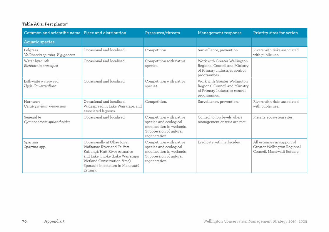
70 Wellington Conservation Management Strategy 2019-2029Appendix 5
Table A6.2. Pest plants*
Common and scientific name Place and distribution Pressures/threats Management response Priority sites for action
Aquatic species
Eelgrass Vallisneria spiralis, V. gigantea
Occasional and localised. Competition. Surveillance, prevention. Rivers with risks associated with public use.
Water hyacinthEichhornia crassipes
Occasional and localised. Competition with native species.
Work with Greater Wellington Regional Council and Ministry of Primary Industries control programmes.
Esthwaite waterweedHydrilla verticillata
Occasional and localised. Competition with native species.
Work with Greater Wellington Regional Council and Ministry of Primary Industries control programmes.
Hornwort Ceratophyllum demersum
Occasional and localised. Widespread in Lake Wairarapa and associated lagoons.
Competition. Surveillance, prevention. Rivers with risks associated with public use.
Senegal teGymnocoronis spilanthoides
Occasional and localised. Competition with native species and ecological modification in wetlands. Suppression of natural regeneration.
Control to low levels where management criteria are met.
Priority ecosystem sites.
Spartina Spartina spp.
Occasionally at Ohau River, Waikanae River and Te Awa Kairangi/Hutt River estuaries and Lake Onoke (Lake Wairarapa Wetland Conservation Area).Sporadic infestation in Manawatū Estuary.
Competition with native species and ecological modification in wetlands. Suppression of natural regeneration.
Eradicate with herbicides. All estuaries in support of Greater Wellington Regional Council. Manawatū Estuary.

71Wellington Conservation Management Strategy 2019-2029 Appendix 6
Common and scientific name Place and distribution Pressures/threats Management response Priority sites for action
Climbers
Banana passionfruitPassiflora mixta, P. mollisima, P. tripartite
Widespread in lowland forest remnants in Wellington, Kāpiti, Horowhenua districts and Lower Ruamahanga catchment. Also in Manawatū and Rangitikei.
Smothering effect. Prevention, surveillance, control to low levels and eradication where management criteria are met.
Priority ecosystem sites.
Blue morning glory Ipomoea indica
Occasional and localised. Smothering effect. Control to low levels where management criteria are met.
Priority ecosystem sites.
Blue passionflower Passiflora caerulea
Occasional and localised. Smothering effect. Control to low levels where management criteria are met.
Priority ecosystem sites.
Cathedral bells Cobaea scandens
Widespread in urban areas. Lowes Bush Scenic Reserve in Wairarapa.
Smothering of forest and shrublands.
Control to low levels where management criteria are met.
Priority ecosystem site, including Lowes Bush Scenic Reserve.
Climbing asparagus Asparagus scandens
Largely confined to western side of Remutaka and Tararua rangesManawatū Estuary and Lake Papaitonga (Papaitonga Scenic Reserve).
Smothering of forest and shrublands.
Control to low levels where management criteria are met.
Priority ecosystem sites.
Climbing spindleberry Celastrus orbiculatus
Occasional and localised. Strangling of native flora. Control to low levels where management criteria are met.
Priority ecosystem sites.
Elaegnus Elaegnus x reflexa
Common in hilly terrain around Wellington.
Suppress regeneration of native species in forest and shrubland.
Control to low levels where management criteria are met.
Priority ecosystem sites.
German ivy Senecio mikanioides
Isolated forest patches around Lake Wairarapa Wetland Conservation Area and on Kāpiti Island Nature Reserve.
Smothering of forest and shrublands.
Control to low levels where management criteria are met.
Priority ecosystem sites.
Japanese honeysuckle Lonicera japonica
Relatively widespread in modified areas and it is present in some scenic reserves in north Wairarapa. No records from eastern Wairarapa. Present in several reserves in Horowhenua, Manawatū and Rangitikei.
Smothering of forest and shrublands.
Control to low levels where management criteria are met.
Priority ecosystem sites.
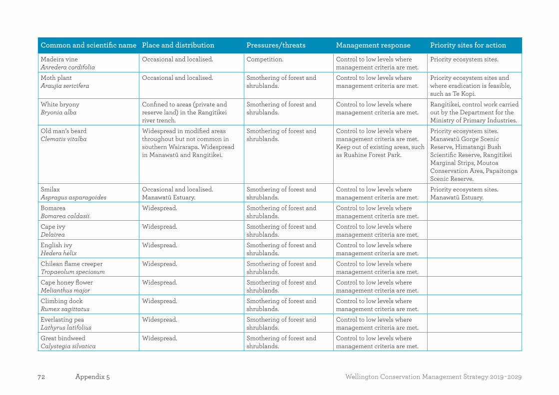
72 Wellington Conservation Management Strategy 2019-2029Appendix 5
Common and scientific name Place and distribution Pressures/threats Management response Priority sites for action
Madeira vine Anredera cordifolia
Occasional and localised. Competition. Control to low levels where management criteria are met.
Priority ecosystem sites.
Moth plant Araujia sericifera
Occasional and localised. Smothering of forest and shrublands.
Control to low levels where management criteria are met.
Priority ecosystem sites and where eradication is feasible, such as Te Kopi.
White bryony Bryonia alba
Confined to areas (private and reserve land) in the Rangitikei river trench.
Smothering of forest and shrublands.
Control to low levels where management criteria are met.
Rangitikei, control work carried out by the Department for the Ministry of Primary Industries.
Old man’s beard Clematis vitalba
Widespread in modified areas throughout but not common in southern Wairarapa. Widespread in Manawatū and Rangitikei.
Smothering of forest and shrublands.
Control to low levels where management criteria are met. Keep out of existing areas, such as Ruahine Forest Park.
Priority ecosystem sites.Manawatū Gorge Scenic Reserve, Himatangi Bush Scientific Reserve, Rangitikei Marginal Strips, Moutoa Conservation Area, Papaitonga Scenic Reserve.
Smilax Aspragus asparagoides
Occasional and localised. Manawatū Estuary.
Smothering of forest and shrublands.
Control to low levels where management criteria are met.
Priority ecosystem sites.Manawatū Estuary.
BomareaBomarea caldasii
Widespread. Smothering of forest and shrublands.
Control to low levels where management criteria are met.
Cape ivy Delairea
Widespread. Smothering of forest and shrublands.
Control to low levels where management criteria are met.
English ivyHedera helix
Widespread. Smothering of forest and shrublands.
Control to low levels where management criteria are met.
Chilean flame creeper Tropaeolum speciosum
Widespread. Smothering of forest and shrublands.
Control to low levels where management criteria are met.
Cape honey flower Melianthus major
Widespread. Smothering of forest and shrublands.
Control to low levels where management criteria are met.
Climbing dock Rumex sagittatus
Widespread. Smothering of forest and shrublands.
Control to low levels where management criteria are met.
Everlasting pea Lathyrus latifolius
Widespread. Smothering of forest and shrublands.
Control to low levels where management criteria are met.
Great bindweed Calystegia silvatica
Widespread. Smothering of forest and shrublands.
Control to low levels where management criteria are met.
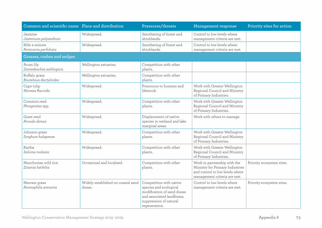
73Wellington Conservation Management Strategy 2019-2029 Appendix 6
Common and scientific name Place and distribution Pressures/threats Management response Priority sites for action
Jasmine Jasminum polyanthum
Widespread. Smothering of forest and shrublands.
Control to low levels where management criteria are met.
Mile a minute Persicaria perfoliata
Widespread. Smothering of forest and shrublands.
Control to low levels where management criteria are met.
Grasses, rushes and sedges
Arum lily Zantedeschia aethiopica
Wellington estuaries. Competition with other plants.
Buffalo grass Bouteloua dactyloides
Wellington estuaries. Competition with other plants.
Cape tulipMoraea flaccida
Widespread. Poisonous to humans and lifestock.
Work with Greater Wellington Regional Council and Ministry of Primary Industries.
Common reedPhragmites spp.
Widespread. Competition with other plants.
Work with Greater Wellington Regional Council and Ministry of Primary Industries.
Giant reed Arundo donax
Widespread. Displacement of native species in wetland and lake marginal areas.
Work with others to manage.
Johnson grassSorghum halepense
Widespread. Competition with other plants.
Work with Greater Wellington Regional Council and Ministry of Primary Industries.
Kariba Salvina molesta
Widespread. Competition with other plants.
Work with Greater Wellington Regional Council and Ministry of Primary Industries.
Manchurian wild rice Zizania latifolia
Occasional and localised. Competition with other plants.
Work in partnership with the Ministry for Primary Industries and control to low levels where management criteria are met.
Priority ecosystem sites.
Marram grass Ammophila arenaria
Widely established on coastal sand dunes.
Competition with native species and ecological modification of sand dunes and associated landforms, suppression of natural regeneration.
Control to low levels where management criteria are met.
Priority ecosystem sites.

74 Wellington Conservation Management Strategy 2019-2029Appendix 5
Common and scientific name Place and distribution Pressures/threats Management response Priority sites for action
Montbretia Crocosmia crocosmiiflora
Open shrubland, streamsides and wetlands.
Competition with other plants.
Work with others to manage.
Pampas Cortaderia selloana
Widespread in coastal and lakeside sites throughout except southern Wairarapa, Remutaka Forest Park, Waikanae River estuary.
Displacement of native species in low-stature communities and suppression of native wetland tree and shrub species.
Control to low levels where management criteria are met.
Priority ecosystem sites and Koputaroa Scientific Reserve, Omarupapako/Round Bush Scenic Reserve, Tangimoana Beach Conservation Area and Manawatū Estuary.
Pyp grassEhrharta villosa var. maxima
Widespread. Competition with other plants.
Work with Greater Wellington Regional Council and Ministry of Primary Industries.
Yellow flag iris Iris pseudacorus
Wairarapa, swampy ground, lakes, salt marsh, wet sandy areas.
Competition with other plants.
Work with Greater Wellington Regional Council and Ministry of Primary Industries.
Sea couch Agropyron pungens
Widespread. Competition with other plants.
Control to low levels where management criteria are met.
Indian doab Cynodon dactylon
Widespread. Competition with other plants.
Control to low levels where management criteria are met.
Kikuyu Pennisetum clandestinum
Widespread. Competition with other plants.
Control to low levels where management criteria are met.
Groundcover species
Blackberry Rubus spp.
Widespread and abundant. Prevents natural regeneration.
Control to low levels where management criteria are met.
Priority ecosystem sites.
Gorse Ulex europaeus
Widespread and abundant. Ecosystem modification. Control to low levels where management criteria are met.
Priority ecosystem sites.
Hawkweed Hieracium pillosella
Occasional and localised. Ecosystem modification. Surveillance, prevention of spreading.
Eradicate from single known site in Aorangi Forest Park.
Hemlock Conium maculatum
Widespread. Poisonous. Control to low levels where management criteria are met.
Priority ecosystem sites.

75Wellington Conservation Management Strategy 2019-2029 Appendix 6
Common and scientific name Place and distribution Pressures/threats Management response Priority sites for action
Horned poppy Glaucium flavum
Coastal areas with rocky and shingly coast line, coastal cliffs, and dunes.
Competition with native species.
Works with others to manage.
Ice plant Carpobrotus edulis
Foxton and Wairarapa sand dunes, coastal cliffs.
Competition with native species
Works with others to manage.
Mist flower Ageratina riparia
Occasional and localised. Competition with native species and ecosystem modification.
Biological control agents. Priority ecosystem sites.
Monkey musk Minulus guttatus
Wairarapa, swamps, lakes, streams. Competition with native species and ecosystem modification, suppression of natural regeneration.
Works with others to manage.
Periwinkle Vinca major
Widespread in lowland remnants. Competition with native species and ecosystem modification, suppression of natural regeneration.
Control to low levels where management criteria are met.
Priority ecosystem sites.
Selaginella Selaginella kraussiana
Occasional and localised. Competition with native species and ecosystem modification, suppression of natural regeneration.
Control to low levels where management criteria are met.
Priority ecosystem sites.
Sweet pea shrub Polygala myrtifolia
Occasional and localised. Spread within coastal environment.
Control to low levels where management criteria are met.
Priority ecosystem sites.
Tutsan Hypericum androsaemum
Isolated populations mostly western developed landscapes.
Competition with native species and ecological modification, suppression of natural regeneration.
Control to low levels where management criteria are met.
Priority ecosystem sites.
Wandering willy Tradescantia fluminensis
Widespread and common in modified areas including Matiu/Somes and Mana islands, Manawatū lowland remnants and Wairarapa.
Competition with native species and ecosystem modification, suppression of natural regeneration.
Control to low levels where management criteria are met.
Priority ecosystem sites.

76 Wellington Conservation Management Strategy 2019-2029Appendix 5
Common and scientific name Place and distribution Pressures/threats Management response Priority sites for action
Chilean rhubarb Gunnera tinctoria
Occasional and localised. Displacement of native species in low-stature communities, stabilising naturally dynamic habitats.
Control to low levels where management criteria are met, surveillance in wider landscape.
Priority ecosystem sites, eastern shore of Lake Wairarapa Wetland Conservation Area, and Tauherenikau River delta.
Plectranthus Widespread. Competition with native species.
Control to low levels where management criteria are met.
Sea rocket Cakile maritima
Widespread. Competition with native species.
Control to low levels where management criteria are met.
Agapanthus Widespread. Competition with native species.
Control to low levels where management criteria are met.
Aluminium plant Widespread. Competition with native species.
Control to low levels where management criteria are met.
Artemesia Widespread. Competition with native species.
Control to low levels where management criteria are met.
Japanese knotweed Fallopia japonica
Widespread. Competition with native species.
Control to low levels where management criteria are met.
Bear’s breeches Acanthus mollis
Widespread. Competition with native species.
Control to low levels where management criteria are met.
Fairy crassula Crassula multicava
Widespread. Competition with native species.
Control to low levels where management criteria are met.
Gazania Gazania spp.
Widespread. Competition with native species.
Control to low levels where management criteria are met.
Ginger Hedychium gardnerianum
Widespread. Competition with native species.
Control to low levels where management criteria are met.
Himalayan balsam Impatiens glandulifera
Widespread. Control to low levels where management criteria are met.
Pigs ear Cotyledon orbiculata
Widespread. Competition with native species.
Control to low levels where management criteria are met.

77Wellington Conservation Management Strategy 2019-2029 Appendix 6
Common and scientific name Place and distribution Pressures/threats Management response Priority sites for action
Pink ragwort (Senecio glastifolius) and purple groundsel (Scenecio elegans)
Widespread on natural coastal sites on the western side of the region. Invading western slopes of Kāpiti Island Nature Reserve.
Competition with native species and ecological modification, suppression of natural regeneration.
Control to low levels where management criteria are met.
Kāpiti, Mana and Mātiu/Somes islands, and Onoke Spit (Lake Wairarapa Wetland Conservation Area).
Purple loosestrife Lythrum salicaria
Occasional and localised presencePapaitonga Scenic Reserve. Matthews & Boggy Pond Wildlife Reserve and ephemeral wetland.
Displacement of native species in wetland and lake marginal areas.
Control to low levels where management criteria are met. Surveillance in wider landscape.
Priority ecosystem sites including Papaitonga Scenic Reserve and Matthews & Boggy Pond Wildlife Reserve.
Trees and shrubs
Barberry Berberis glaucocarpa
Common in hilly terrain around Wellington, scattered and localised in Wairarapa.
Shade-tolerant invasive, suppresses regeneration of native species in forest and shrubland.
Boneseed Chrysanthemoides monilifera
Largely confined to western coast including the Manawatū Estuary, with isolated populations on south eastern Wairarapa coast.
Replaces coastal vegetation. Control to low levels where management criteria are met. Greater Wellington Regional Council plans to eradicate it from its area, the Department will destroy it when encountered.
Priority ecosystem sites.
Boxthorn Lycium ferocissimum
Foxton sand dunes, cliffs, islands, coastal areas.
Shade tolerant invasive, suppress regeneration of native species in forest and shrubland.
Works with others to manage.
Brush wattle Paraserianthes lophantha
Forest parks, short tussockland, coastal fringes.
Suppresses regeneration of native species in forest and shrubland.
Works with others to manage.
Buddleia Buddleja davidii
Component of invasive vegetation on stony river margins.
Suppresses regeneration of native species in forest and shrubland.
Control to low levels where management criteria are met.
Priority ecosystem sites.
Cotoneaster Cotoneaster glaucophyllus
Widespread. Suppresses regeneration of native species in forest and shrubland.
Control to low levels where management criteria are met.
Priority ecosystem sites.

78 Wellington Conservation Management Strategy 2019-2029Appendix 5
Common and scientific name Place and distribution Pressures/threats Management response Priority sites for action
Darwin’s barberry Berberis darwinii
Common in hilly terrain around Wellington, scattered and localised in Wairarapa.
Shade-tolerant invasive, suppresses regeneration of native species in forest and shrubland.
Control to low levels where management criteria are met.
Priority ecosystem sites.
Evergreen buckthorn Rhamnus alaternus
Widespread. Shade-tolerant invasive, suppresses regeneration of native species in forest and shrubland.
Control to low levels where management criteria are met.
Priority ecosystem sites.
Heather Calluna vulgaris
Occasional and localised. Ecosystem modification. Surveillance, prevention. Control at single site (Oumukura Scenic Reserve).
Spanish heath Erica lusitanica
Occasional and localised. Competition with native species and ecosystem modification, suppression of natural regeneration.
Control to low levels where management criteria are met.
Tauheranikau Valley.
Sweet pea shrub Polygala myrtifolia
Shrubland, short tussockland, coastal areas.
Invasion of low-stature and regenerating vegetation.
Works with others to manage.
Sycamore Acer pseudoplatanus
Occasional and localised. Suppress regeneration of native species in forest and shrubland.
Control to low levels where management criteria are met.
Priority ecosystem sites. Papaitonga Scenic Reserve and Rangitikei Marginal strips.
Tree lupin Lupinus arboreus
Short tussockland, coastal, sandy and well-drained areas.
Competition with native species and ecosystem modification, suppression of natural regeneration.
Works with others to manage.
Wilding pines (Includes Pinus radiata)
Occasional and localised. Invasion of low-stature and regenerating vegetation.
Control to low levels where management criteria are met.
Priority ecosystem sites.
Willow Salix spp.
Widespread in wetlands and river systems.
Displacement of native species in low-stature communities and suppression of native wetland tree and shrub species.
Control to low levels where management criteria are met.
Lake Wairarapa Wetland Conservation Area and adjoining wetlands. Koputaroa flaxlands (Koputaroa Scientific Reserve) in Manawatū.
Woolly nightshade Solanum mauritianum
Occasional and localised. Suppresses regeneration of native species in shrubland and short tussock.
Control to low levels where management criteria are met.
Priority ecosystem sites.
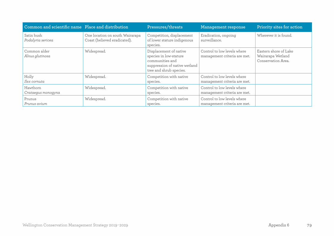
79Wellington Conservation Management Strategy 2019-2029 Appendix 6
Common and scientific name Place and distribution Pressures/threats Management response Priority sites for action
Satin bush Podalyria sericea
One location on south Wairarapa Coast (believed eradicated).
Competition, displacement of lower stature indigenous species.
Eradication, ongoing surveillance.
Wherever it is found.
Common alder Alnus glutinosa
Widespread. Displacement of native species in low-stature communities and suppression of native wetland tree and shrub species.
Control to low levels where management criteria are met.
Eastern shore of Lake Wairarapa Wetland Conservation Area.
Holly Ilex cornuta
Widespread. Competition with native species.
Control to low levels where management criteria are met.
Hawthorn Crataegus monogyna
Widespread. Competition with native species.
Control to low levels where management criteria are met.
Prunus Prunus avium
Widespread. Competition with native species.
Control to low levels where management criteria are met.
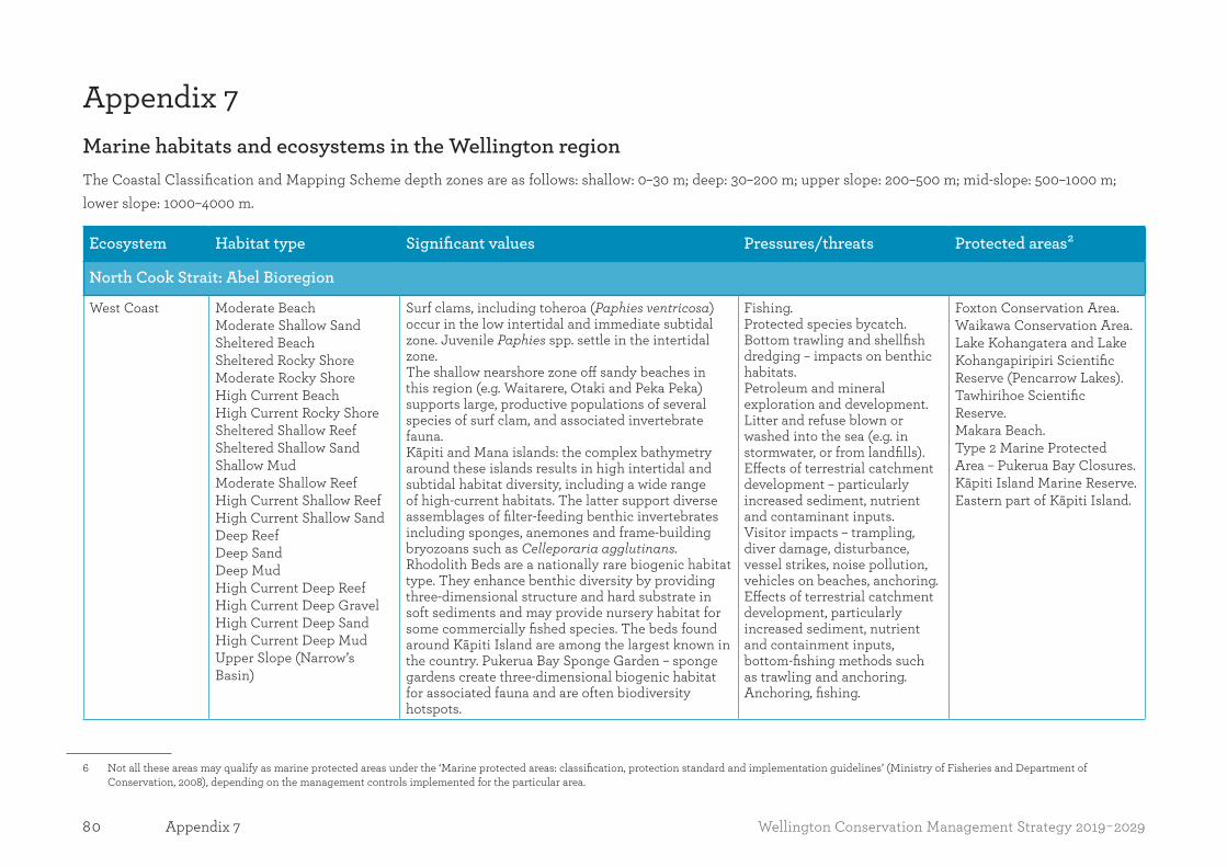
80 Wellington Conservation Management Strategy 2019-2029Appendix 7
Appendix 7Marine habitats and ecosystems in the Wellington region The Coastal Classification and Mapping Scheme depth zones are as follows: shallow: 0–30 m; deep: 30–200 m; upper slope: 200–500 m; mid-slope: 500–1000 m; lower slope: 1000–4000 m.
Ecosystem Habitat type Significant values Pressures/threats Protected areas
North Cook Strait: Abel Bioregion
West Coast Moderate BeachModerate Shallow SandSheltered BeachSheltered Rocky ShoreModerate Rocky ShoreHigh Current BeachHigh Current Rocky ShoreSheltered Shallow ReefSheltered Shallow SandShallow MudModerate Shallow ReefHigh Current Shallow ReefHigh Current Shallow SandDeep ReefDeep SandDeep MudHigh Current Deep ReefHigh Current Deep GravelHigh Current Deep SandHigh Current Deep MudUpper Slope (Narrow’s Basin)
Surf clams, including toheroa (Paphies ventricosa) occur in the low intertidal and immediate subtidal zone. Juvenile Paphies spp. settle in the intertidal zone.The shallow nearshore zone off sandy beaches in this region (e.g. Waitarere, Otaki and Peka Peka) supports large, productive populations of several species of surf clam, and associated invertebrate fauna. Kāpiti and Mana islands: the complex bathymetry around these islands results in high intertidal and subtidal habitat diversity, including a wide range of high-current habitats. The latter support diverse assemblages of filter-feeding benthic invertebrates including sponges, anemones and frame-building bryozoans such as Celleporaria agglutinans.Rhodolith Beds are a nationally rare biogenic habitat type. They enhance benthic diversity by providing three-dimensional structure and hard substrate in soft sediments and may provide nursery habitat for some commercially fished species. The beds found around Kāpiti Island are among the largest known in the country. Pukerua Bay Sponge Garden – sponge gardens create three-dimensional biogenic habitat for associated fauna and are often biodiversity hotspots.
Fishing.Protected species bycatch.Bottom trawling and shellfish dredging – impacts on benthic habitats.Petroleum and mineral exploration and development.Litter and refuse blown or washed into the sea (e.g. in stormwater, or from landfills).Effects of terrestrial catchment development – particularly increased sediment, nutrient and contaminant inputs.Visitor impacts – trampling, diver damage, disturbance, vessel strikes, noise pollution, vehicles on beaches, anchoring. Effects of terrestrial catchment development, particularly increased sediment, nutrient and containment inputs, bottom-fishing methods such as trawling and anchoring. Anchoring, fishing.
Foxton Conservation Area.Waikawa Conservation Area.Lake Kohangatera and Lake Kohangapiripiri Scientific Reserve (Pencarrow Lakes).Tawhirihoe Scientific Reserve.Makara Beach.Type 2 Marine Protected Area – Pukerua Bay Closures.Kāpiti Island Marine Reserve.Eastern part of Kāpiti Island.
6 Not all these areas may qualify as marine protected areas under the ‘Marine protected areas: classification, protection standard and implementation guidelines’ (Ministry of Fisheries and Department of Conservation, 2008), depending on the management controls implemented for the particular area.
2

81Wellington Conservation Management Strategy 2019-2029 Appendix 7
Ecosystem Habitat type Significant values Pressures/threats Protected areas
Hunter’s Bank, Fisherman’s Rock: diverse benthic invertebrate assemblages and demersal and pelagic fishes (such as hāpuku/grouper, tarakihi and haku/kingfish) aggregate on these reefs. Well represented in the northern part of Kāpiti Island and off the western and southern part of Kāpiti Island. Black coral Lillipathes lillei (Totton 1923) has been reported on deep reefs off Kāpiti Island. All corals are protected under the Wildlife Act 1953. The predator-free status of the islands means that the intertidal zone is free of predation by rats. Anemone beds on eastern side of Kāpiti Island adjacent to Tokomapuna/Aeroplane Island in depths of 1015 m. Frame-building bryozoans and brachiopods (Neothyris compressus) occur on coarse carbonate sediments, gravels and mud in D’Urville Sea Valley and Narrow’s Basin. Neothyris is endemic to New Zealand.
Increased sediment, nutrient and containment inputs. Bottom fishing methods such as trawling and anchoring.
Rangitikei River Sheltered Shallow Beach Diadromous fish passage Invasive pest plants.Flood control works.
Manawatū River Estuarine Sand Diadromous fish passage Invasive pest plants.Flood control works.
Manawatū river mouth and estuary Ramsar Site.
Waikanae Estuary Estuarine BeachEstuarine Sand
Indigenous coastal vegetation.Diadromous fish passage. Bird species breeding in the reserve include tūturiwhatu/banded dotterel, tōrea pango/variable oystercatcher, pukeko and weweia/dabchick. Other resident species include taranui/Caspian tern, poaka/pied stilt, pāpango/New Zealand scaup, pāteke/brown teal, pārera/grey duck, kuruwhengi/Australasian shoveler and mallard. Royal spoonbills regularly feed in the estuary.
Invasive pest plants.Disturbance.Introduced predators.
Waikanae Estuary Scientific Reserve.Various Wairarapa locations.

82 Wellington Conservation Management Strategy 2019-2029Appendix 7
Ecosystem Habitat type Significant values Pressures/threats Protected areas
Otaki River Estuarine Sand Inanga spawning habitat. Inanga spawn on spring tide events among tidally-inundated riparian vegetation. Diadromous fish passage.
Invasive pest plants.Trampling and grazing by stock.
Porirua Harbour Biogenic SaltmarshBiogenic SeagrassEstuarine BeachEstuarine Rocky ShoreEstuarine SandMudflatSheltered BeachSheltered Rocky ShoreSheltered Shallow ReefSheltered Shallow Sand
Shallow harbour and estuary supporting a representative range of estuarine birds, coastal fishes and invertebrates, marine algae, flowering plants, seagrass and saltmarsh (MacDiarmid et al. 2012).Extensive shellfish beds.Rig/spotted dogfish nursery. Diadromous fish passage.
Coastal development – habitat loss.Catchment development – elevated sedimentation rates, increased turbidity, increased freshwater inflow, nutrient enrichment, contaminants. Altered hydrology due to reclamations, impoundments, channelisation.Disturbance, noise pollution.Ship/vessel strikes.Invasive marine species.Invasive pest plants.Introduced predators.Fishing.
Pauatahanui Inlet Wildlife Refuge.Pauatahanui Wildlife Reserve.Horokiwi Wildlife Reserve.Duck Creek Scenic Reserve.
Makara Stream Inanga spawning habitat.Diadromous fish passage.
Invasive pest plants, human impacts, farming practices.Trampling and grazing by stock.
North Cook Strait: Cook Bioregion
Wellington Harbour
Sheltered Rocky ShoreSheltered BeachSheltered Shallow ReefSheltered Shallow SandShallow MudEstuarine MudEstuarine ReefEstuarine Rocky ShoreEstuarine Sand
Diadromous fish passage.Giant kelp (Macrocystis pyrifera) forests.Elephant fish (Callorhinchus millii) and rough skate (Zearaja nasuta) deposit their egg cases on shallow sheltered sand habitats near the harbour entrance. Adamsiella algal beds: provide habitat for diverse species, stabilise soft sediments.The threatened polychaete worm Boccardiella magniovata (Spionidae) inhabits soft intertidal areas
Invasive marine species, including toxic dinoflagellates.Pollution – heavy metals, herbicides, pesticides including PCBs, antifouling, nutrients, oil or oil products, plastic, sewage. Shipping – boat strikes, noise pollution, contaminants.Infrastructure development and coastal protection works.

83Wellington Conservation Management Strategy 2019-2029 Appendix 7
Ecosystem Habitat type Significant values Pressures/threats Protected areas
Submarine freshwater springs
in the upper reaches of the Te Awa Kairangi Hutt River estuary.Submarine freshwater springs – alter salinity and the local ecosystem, creating rare habitats and possible dependent fauna, although no reliable information exists for the Wellington seeps.
Adamsiella algal beds – anchoring, sedimentation, pollution, dredging, dumping, reclamation.Sand/gravel abstraction, dredging/dumping of dredge spoils.Catchment development – increased sedimentation and fresh water inflow.Fishing.Visitor impacts – trampling of intertidal organisms, disturbance of natural behaviours, noise, vehicles on beaches, anchoring.Fresh water springs – pollution and nutrient influxes from land aquifers, engineering activities can lower aquifer pressures and disturb the aquifer cap that prevents seawater leaking into the aquifer.
Cook Strait and Palliser Bay (Cape Terawhiti to Cape Palliser)
Moderate BeachExposed BeachModerate Rocky ShoreExposed Rocky ShoreSheltered Shallow ReefModerate Shallow ReefHigh Current Shallow ReefExposed Shallow ReefDeep ReefHigh Current Deep ReefModerate Shallow Sand
South Coast gravel beaches, specifically western Lyall Bay, provide the only known habitat of the gravel maggot (Smeagol climoi). This species inhabits the upper intertidal generally beneath drift seaweed or where gravel is wet up to 30 cm below the surface.Cook Strait is part of the migratory pathway of paikea/humpback whales migrating northwards from Antarctica. Most pass through the Strait between mid-May to mid-August.
Smeagol climoi – gravel extraction, disturbance, pollution such as stormwater discharge.Fishing.Bottom trawling – benthic impacts.Petroleum exploration.River inputs – increased sediment and nutrient loading due to catchment development.
Taputeranga Marine Reserve.Type 2 Marine Protected Area – Cook Strait Submarine Cable Closure.Ocean Beach Conservation Area.Palliser Bay Taiapure.
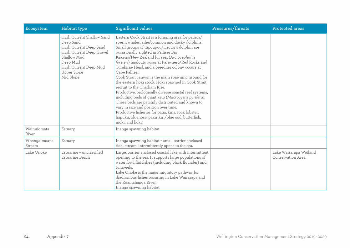
84 Wellington Conservation Management Strategy 2019-2029Appendix 7
Ecosystem Habitat type Significant values Pressures/threats Protected areas
High Current Shallow SandDeep SandHigh Current Deep SandHigh Current Deep GravelShallow MudDeep MudHigh Current Deep MudUpper SlopeMid Slope
Eastern Cook Strait is a foraging area for parāoa/sperm whales, aihe/common and dusky dolphins.Small groups of tūpoupou/Hector’s dolphin are occasionally sighted in Palliser Bay.Kekeno/New Zealand fur seal (Arctocephalus forsteri) haulouts occur at Pariwhero/Red Rocks and Turakirae Head, and a breeding colony occurs at Cape Palliser.Cook Strait canyon is the main spawning ground for the eastern hoki stock. Hoki spawned in Cook Strait recruit to the Chatham Rise.Productive, biologically diverse coastal reef systems, including beds of giant kelp (Macrocystis pyrifera). These beds are patchily distributed and known to vary in size and position over time.Productive fisheries for pāua, kina, rock lobster, hāpuku, bluenose, pākirikiri/blue cod, butterfish, moki, and hoki.
Wainuiomata River
Estuary Inanga spawning habitat.
Whangaimoana Stream
Estuary Inanga spawning habitat – small barrier enclosed tidal stream, intermittently opens to the sea.
Lake Onoke Estuarine – unclassifiedEstuarine Beach
Large, barrier enclosed coastal lake with intermittent opening to the sea. It supports large populations of water fowl, flat fishes (including black flounder) and tuna/eels. Lake Onoke is the major migratory pathway for diadromous fishes occuring in Lake Wairarapa and the Ruamahanga River.Inanga spawning habitat.
Lake Wairarapa Wetland Conservation Area.
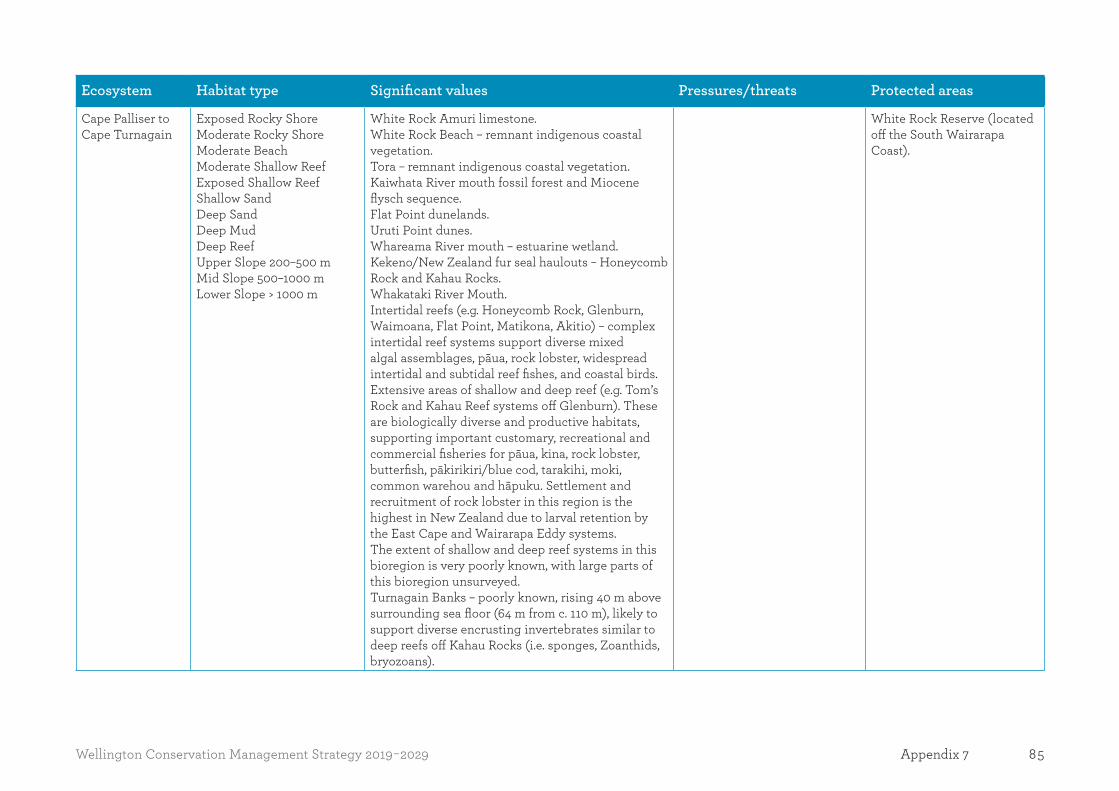
85Wellington Conservation Management Strategy 2019-2029 Appendix 7
Ecosystem Habitat type Significant values Pressures/threats Protected areas
Cape Palliser to Cape Turnagain
Exposed Rocky ShoreModerate Rocky ShoreModerate BeachModerate Shallow ReefExposed Shallow ReefShallow SandDeep SandDeep MudDeep ReefUpper Slope 200–500 mMid Slope 500–1000 mLower Slope > 1000 m
White Rock Amuri limestone.White Rock Beach – remnant indigenous coastal vegetation.Tora – remnant indigenous coastal vegetation.Kaiwhata River mouth fossil forest and Miocene flysch sequence.Flat Point dunelands.Uruti Point dunes.Whareama River mouth – estuarine wetland.Kekeno/New Zealand fur seal haulouts – Honeycomb Rock and Kahau Rocks.Whakataki River Mouth.Intertidal reefs (e.g. Honeycomb Rock, Glenburn, Waimoana, Flat Point, Matikona, Akitio) – complex intertidal reef systems support diverse mixed algal assemblages, pāua, rock lobster, widespread intertidal and subtidal reef fishes, and coastal birds.Extensive areas of shallow and deep reef (e.g. Tom’s Rock and Kahau Reef systems off Glenburn). These are biologically diverse and productive habitats, supporting important customary, recreational and commercial fisheries for pāua, kina, rock lobster, butterfish, pākirikiri/blue cod, tarakihi, moki, common warehou and hāpuku. Settlement and recruitment of rock lobster in this region is the highest in New Zealand due to larval retention by the East Cape and Wairarapa Eddy systems.The extent of shallow and deep reef systems in this bioregion is very poorly known, with large parts of this bioregion unsurveyed.Turnagain Banks – poorly known, rising 40 m above surrounding sea floor (64 m from c. 110 m), likely to support diverse encrusting invertebrates similar to deep reefs off Kahau Rocks (i.e. sponges, Zoanthids, bryozoans).
White Rock Reserve (located off the South Wairarapa Coast).
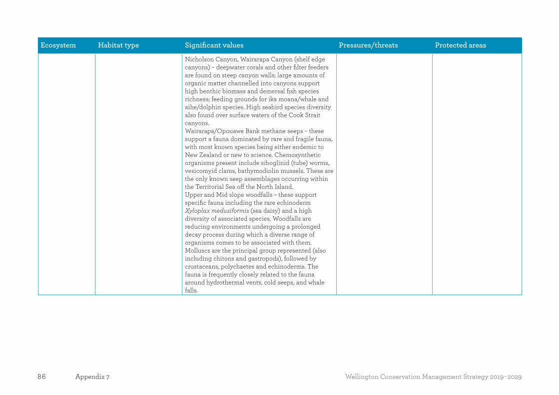
86 Wellington Conservation Management Strategy 2019-2029Appendix 7
Ecosystem Habitat type Significant values Pressures/threats Protected areas
Nicholson Canyon, Wairarapa Canyon (shelf edge canyons) – deepwater corals and other filter feeders are found on steep canyon walls; large amounts of organic matter channelled into canyons support high benthic biomass and demersal fish species richness; feeding grounds for ika moana/whale and aihe/dolphin species. High seabird species diversity also found over surface waters of the Cook Strait canyons.Wairarapa/Opouawe Bank methane seeps – these support a fauna dominated by rare and fragile fauna, with most known species being either endemic to New Zealand or new to science. Chemosynthetic organisms present include siboglinid (tube) worms, vesicomyid clams, bathymodiolin mussels. These are the only known seep assemblages occurring within the Territorial Sea off the North Island. Upper and Mid slope woodfalls – these support specific fauna including the rare echinoderm Xyloplax medusiformis (sea daisy) and a high diversity of associated species. Woodfalls are reducing environments undergoing a prolonged decay process during which a diverse range of organisms comes to be associated with them. Molluscs are the principal group represented (also including chitons and gastropods), followed by crustaceans, polychaetes and echinoderms. The fauna is frequently closely related to the fauna around hydrothermal vents, cold seeps, and whale falls.

87Wellington Conservation Management Strategy 2019-2029 Appendix 7
References:MacDiarmid, A.; Nelson, W.; Gordon, D.; Bowden, D.; Mountjoy, J.; Lamarche, G. 2012: Sites of significance for indigenous marine biodiversity in the Wellington region. Report prepared for Greater Wellington Regional Council by the National Institute of Water and Atmospheric Research (NIWA).
Shears, N.I.; Babcock, R.C. 2007: Quantitative description of mainland New Zealand’s shallow subtidal reef communities. Science for Conservation 280. Department of Conservation, Wellington. 126 p.
Duffy, C.; Geange, S.; Linwood, L. 2015: Use of qualitative scientific criteria to identify significant marine ecosystems in New Zealand waters. Draft report, 24 July 2015. Marine Ecosystems Team, Aquatic and Reporting Unit, Department of Conservation.
Walls, K. 2006: Nearshore marine classification and inventory. A planning tool to help identify marine protected areas for the nearshore of New Zealand. Department of Conservation, Wellington, New Zealand.
MacDiarmid, A.; McKenzie, A.; Sturman, J.; Beaumont, J.; Mikaloff-Fletcher, S.; Dunne, J. 2012: Assessment of anthropogenic threats to New Zealand marine habitats, New Zealand Aquatic Environment and Biodiversity Report No. 93. 255 p. Available from http://fs.fish.govt.nz.
MacDiarmid, A.B.; Law, C.S.; Pinkerton, M.; Zeldis, J. 2013: New Zealand marine ecosystem services. In Dymond, J.R. (ed.): Ecosystem services in New Zealand – conditions and trends. Manaaki Whenua Press, Lincoln, New Zealand.
Townsend, M.; Thrush, S.; Carbines, M. 2011: Simplifying the complex: an “Ecosystem Principles Approach” to goods and services management in marine coastal ecosystems. Marine Ecology Progress Series 434: 291–301.
Leathwick, J.; Rowden, A.; Nodder, S.; Gorman, R.; Bardsley, S.; Pinkerton; M., Baird, S.; Hadfield, M.; Currie, K.; Goh, A. 2012: A Benthic-optimised Marine Environment Classification (BOMEC) for New Zealand waters. New Zealand Aquatic Environment and Biodiversity Report No 88. 54 p.
Read, G.B. 1975: Systematics and biology of polydorid species (Polychaeta: Spionidae) from Wellington Harbour. Journal of the Royal Society of New Zealand 5(4): 395–419.
Beadel ,S.M.C.; Bibby, J.; Perfect, A.J.; Rebergen, A.; Sawyer J. 2005: Eastern Wairarapa Ecological District: Survey report for the Protected Natural Areas Programme. Department of Conservation, Wellington. 79 p.
Froude, V. 2004: Area-based restrictions in the New Zealand marine environment. Department of Conservation, Wellington. 169 p.
Fisheries (Central Area Commercial Fishing) Regulations (1986 (SR 1986/217)).
Cameron, F. 2008: Wetland Monitoring Review. Environmental Management Group Technical Report, Hawke’s Bay Regional Council. 35 p.
Department of Conservation 2001: New Zealand shore plover recovery plan 2001–2011. Threatened Species Recovery Plan 44. Department of Conservation, Wellington. 24 p.
Garrick J. A.F. 1974: First record of an odontaspidid shark in New Zealand waters. New Zealand Journal of Marine and Freshwater Research 8: 621630. www.gdc.govt.nz/assets/Files/Conservation/State-of-the-Environment/The-Coast.pdf

88 Wellington Conservation Management Strategy 2019-2029Appendix 8
Appendix 8Significant geological features, landforms and landscapes in the Wellington region These values are identified for the purpose of Conservation General Policy, policies 4.5(a) and (b).
Table A8.1: Significant geological features and landforms on public conservation lands and waters
Type Feature Place(s) Significance Pressures/threats
Turakirae Head Scientific Reserve
Turakirae Head uplifted beach ridges: best-preserved example of raised beach ridges on the Wellington coast.
Central Spine Place International Overstocking, over visiting.
Partly in Waiohine Faulted Terraces Scientific Reserve
West Wairarapa Fault. Waiohine River faulted terrace: example of progressive displacement of the late Quaternary alluvial terraces along the Wairarapa Fault.
Wairarapa Place International Ploughing, burning, overstocking.
Pukepuke Lagoon (only public conservation land and water as part of larger Himatangi dune environment)
Himatangi dune dammed lakes: largest Holocene dune area in the country with several dune dammed lakes.
Coastal Dunes Place National Vulnerable to afforestation.
Putangirua Pinnacles Scenic Reserve
Putangirua Pinnacles and Miocene sediments: the best area in New Zealand of badlands erosion and earth pillar formation, a spectacular tourist attraction.
Central Spine Place National Clearance of surrounding vegetation (fire).
Part Tora Recreation Reserve (only public conservation land and water as part of larger Pukemiru environment)
Pukemuri Stream uplifted marine benches: well-preserved sequence of seven uplifted Holocene marine terraces that record uplift history of Wairarapa coast.
Wairarapa Place National Farming practices.
Adjacent Lake Kohangapiripiri Scientific Reserve
Lake Kohangapiripiri raised beach: one of the two best known examples of raised beach ridges that occupy the mouth of a formerly drowned valley and now dam the valley, forming a lake behind.
Coastal and Marine Place
National Cultural, farming, recreation (stock and motorcycles ruining the surface).

89Wellington Conservation Management Strategy 2019-2029 Appendix 8
Type Feature Place(s) Significance Pressures/threats
Te Rangipai Scenic Reserve, Rangitikei River No 3 River Marginal Strip, Mokai Conservation Area, and Omatane River Marginal Strip
Rangitikei River gorge: an impressive, well-defined gorge occupying a 10–15 km stretch of the Rangitikei River. Good place to see stratification and concretions within papa rock.
Manawatū-Rangitikei Place
National
Rangitikei River No 3 River Control Reserve, Kahu Scenic Reserve, and Pouwhakarua Conservation Area
Rangitikei River Plio-Pleistocene fossiliferous sediments: one of the thickest Pleistocene sequences of mudstone, siltstone and sandstone, with diverse range of shell beds, in the world.
Manawatū-Rangitikei Place
National
Manawatū Gorge Scenic Reserve Manawatū Gorge: a large and impressive gorge bisecting the main axial ranges of the North Island.
Central Spine Place National Invasive pest plants and animals. Goats have been a problem in the past.
Foxton Conservation Area – Ramsar site
Manawatū River estuary: an estuary and associated sand and mud flats important as the habitat of many birds – some migratory.
Coastal Dunes Place International Removal of meander causing estuary to become smaller.
Remutaka Forest Park Galatea Mine gold: good example of visible gold. Central Spine Place RegionalTawhirihoe Scientific Reserve Himatangi sand drifts: Waitarere and Motuiti
sand dune building phases.Coastal Dunes Place National Afforestation, recent reactivation of
dunes following subdivision.Kāpiti Island Nature Reserve Kāpiti Island uplifted sea caves: small uplifted sea
caves, evidence of uplift during earthquake about 1460AD.
Islands Place Regional
Kupe’s Sail Rock Recreation Reserve (Ngā Ra a Kupe)
Kupe’s Sail sandstone slab: a huge resistant slab of sandstone is exposed on the coastal cliff in a sail-like shape.
Coastal and Marine Place
Regional and with great significance to iwi from the link to Kupe
Karo invasion into flax-dominant vegetation.

90 Wellington Conservation Management Strategy 2019-2029Appendix 8
Table A8.2: Significant landscapes
Landscape Place(s) Significance (international, national or regional) Pressures/threats
Kāpiti Island: Phyllonite formed as part of anticlinal fold
Islands Place Nationally significant – Kāpiti Island Nature Reserve. Plant and animal pests.
Lower North Island Axial Range Central Spine Place Nationally significant – Ruahine, Tararua, Remutaka and Aorangi forest parks.
Erosion processes, plant and animal pests.
Waikanae River estuary Coastal Dunes Place
Nationally significant – natural mosaic of freshwater lakelets, saltwater lagoons and marshes, tidal sand flats at the mouth of the Waikanae River.
Plant and animal pests, sediment inputs.
Manawatū Dune fields Coastal Dunes Place
Regionally significant – Himatangi Bush Scientific Reserve.
Destruction through earthworks and cattle trampling.
Wairarapa Moana and Lake Onoke
Wairarapa Place Regionally significant – Lake Wairarapa Wetland Conservation Area. Highly significant to iwi.
Land use pressures, drainage, plant pests.
Pariwhero/Red Rocks Scientific Reserve
Coastal and Marine Place
Regionally significant. Erosion processes.
Pauatahanui Inlet Coastal and Marine Place
Regionally significant – Pauatahanui and Horokiwi Wildlife Reserves.
Plant and animal pests, sediment inputs.
Castlepoint Coastal and Marine Place
Regionally significant – Castlepoint Scenic Reserve. Plant pests, erosion processes, fossil collectors.
Wairarapa Taipos: includes Pahaoa Gorge, Rocky Hills, Oterei, Mangapakeha and Tinui Taipos
Wairarapa Place Regionally significant. Land use, pine plantations, plant and animal pests.
Cape Palliser Wairarapa Place Regionally significant – great significance to iwi from the link with Kupe.
Onoke Spit Wairarapa Place Regionally significant – gravel barrier bar. Vehicles, weeds.Wairarapa Valley Wairarapa Place Regionally significant. Land use pressures.

91Wellington Conservation Management Strategy 2019-2029 Appendix 9
Appendix 9Actively conserved historic places on public conservation lands and waters, or managed by the Department, in the Wellington region
Historic place Location Heritage topics and significance Pressure/threats Destination management category/access
Central Spine Place
Top Maropea Hut Ruahine Forest Park Wild animal control. Slips, fire, vandalism. Backcountry. Access by foot.Waterfall Hut Ruahine Forest Park Wild animal control. Fire, vandalism. Backcountry. Access by foot.Shutes Hut Ruahine Forest Park Wild animal control. Seismic events. Backcountry. Access by foot.Sentry Box Hut Ruahine Forest Park Wild animal control. Vandalism. Backcountry. Access by footEllis Hut Ruahine Forest Park High country farming. Deterioration – rot,
fire, vandalism, tree fall.
Backcountry. Access by foot.
Smiths Stream Hut Ruahine Forest Park High country farming. Vandalism. Backcountry. Access by foot.Remutaka Rail Trail Remutaka Forest Park Rail transport. Tourism and recreation. Washouts/slips. Gateway destination. Access by foot/mountain
bike.Cone Hut Tararua Forest Park Huts. Tourism and recreation. Vandalism, fire. Backcountry. Access by foot.Pararaki Hut Aorangi Forest Park Wild animal control. Vandalism. Backcountry. Access by foot.Sheridan Creek logging sites Tararua Forest Park Timber industry machinery. Slips, vegetation re-
growth, corrosion. Gateway destination. Access by foot.
Field Hut Tararua Forest Park Tourism and recreation. Vandalism, fire. Gateway destination. Access by foot.
Manawatū-Rangitikei Place
Bruce Park memorials Bruce Park Scenic Reserve
Nature conservation. Vegetation re-growth, seismic events, vandalism.
Local Treasure. Access by foot.
R. C. Bruce Memorial Bruce Memorial Scenic Reserve
Nature conservation Vegetation re-growth, seismic events.
Local Treasure. Access by car then short walk.

92 Wellington Conservation Management Strategy 2019-2029Appendix 9
Historic place Location Heritage topics and significance Pressure/threats Destination management category/access
Wairarapa Place
Kupe’s Sail Rock Recreation Reserve Ngā Rā o Kupe
Cape Palliser Māori. Geological processes. Local Treasure. Access by car.
Wellington-Kāpiti Place
Shields Flat Historic Reserve Otaki River gorge Farming and timber mill workers’ settlement. Early settlement – Depression work tasks.
Grazing livestock (except sheep), vandalism.
Local Treasure. Accessible by car.
Makara coastal defence installations
Makara – Opau Bay Defending New Zealand. Corrosion, vandalism. Local Treasure. Accessible on foot.
Dominion Observatory Botanical Gardens, Wellington City
Government service. Maritime. Recreation. Defending New Zealand.
Vandalism, unrestricted adaptation.
Access by foot.
Islands Place
Kāpiti Island whare Kāpiti Island (Rangatira Point)
Farming. Nature Conservation. Fire, tree fall. Icon destination. Access by ferry (concession).
Te Kahu-o-terangi Whaling Station
Kāpiti island (Honeymoon Bay)
Māori. Whaling. Vegetation re-growth, erosion, tree fall.
Icon destination. Access by ferry (concession) but currently no track to the site.
Kāpiti Island trypots Kāpiti Island (Rangatira Point)
Whaling. Corrosion. Icon destination. Access by ferry (concession).
Mana Island habitation sites Mana Island Māori. Unintentional excavation, vegetation re-growth.
Local Treasure. Access by private boat.
Mana Island lighthouse site Mana Island Maritime. Government services. Vegetation re-growth, erosion.
Local Treasure. Access by private boat.
Mana Island woolshed Mana Island Farming. Animal quarantine. Corrosion, fire. Local Treasure. Access by private boat.

93Wellington Conservation Management Strategy 2019-2029 Appendix 10
Appendix 10Icon and Gateway destinations in the Wellington region Recreation opportunities on public conservation lands and waters have been categorised into four different destination types to reflect known and potential demand, and to capture people’s outdoor leisure preferences. This is part of an approach known as Destination Management. ‘Icon destinations’ are those the Department has identified as high profile, popular destinations underpinning national and international tourism, and providing memorable visitor experiences in New Zealand. ‘Gateway destinations’ are places that introduce New Zealanders to the outdoors and allow them to learn about conservation. These destinations may provide for a diverse range of activities but include many traditional camping and tramping destinations. ‘Local Treasures’ are vehicle-accessible, locally valued locations providing recreation opportunities for, and growing connections with, nearby communities. ‘Backcountry’ destinations provide for more challenging adventures, including popular walks and tramps, within the body of large-scale natural settings. Note: Management of these destinations within the Wellington region is addressed in Section 3.3 and Part Two Places.
The list is accurate as at the date of publication of this CMS. Its contents may be amended or reviewed during the term of this CMS.
Note: Local Treasure and Backcountry destinations are not included in this table. They are addressed in Parts One and Two of this CMS. Where specified, these destination types are accurate as at the time of publication and may be amended or reviewed during the term of this CMS.
Table A10.1: Icon destinations
Destination type Associated tracks and facilities
Icon destinations
Pukaha Mount Bruce (Wairarapa Place) Pukaha Lookout TrackMount Bruce National Wildlife Centre TracksMount Munroe (Braddocks Farm) – Mount Bruce TrackMount Bruce Car parkMount Bruce eel bridge and platform
Kāpiti Island Nature Reserve (Islands Place) Boulder Bank LoopBeach Landing to Shelter TrackOkupe Valley Loop TrackRangatira Low Level WalkTrig TrackWilkinson TrackRangatira Visitor ShelterKāpiti Northend Visitor Shelter
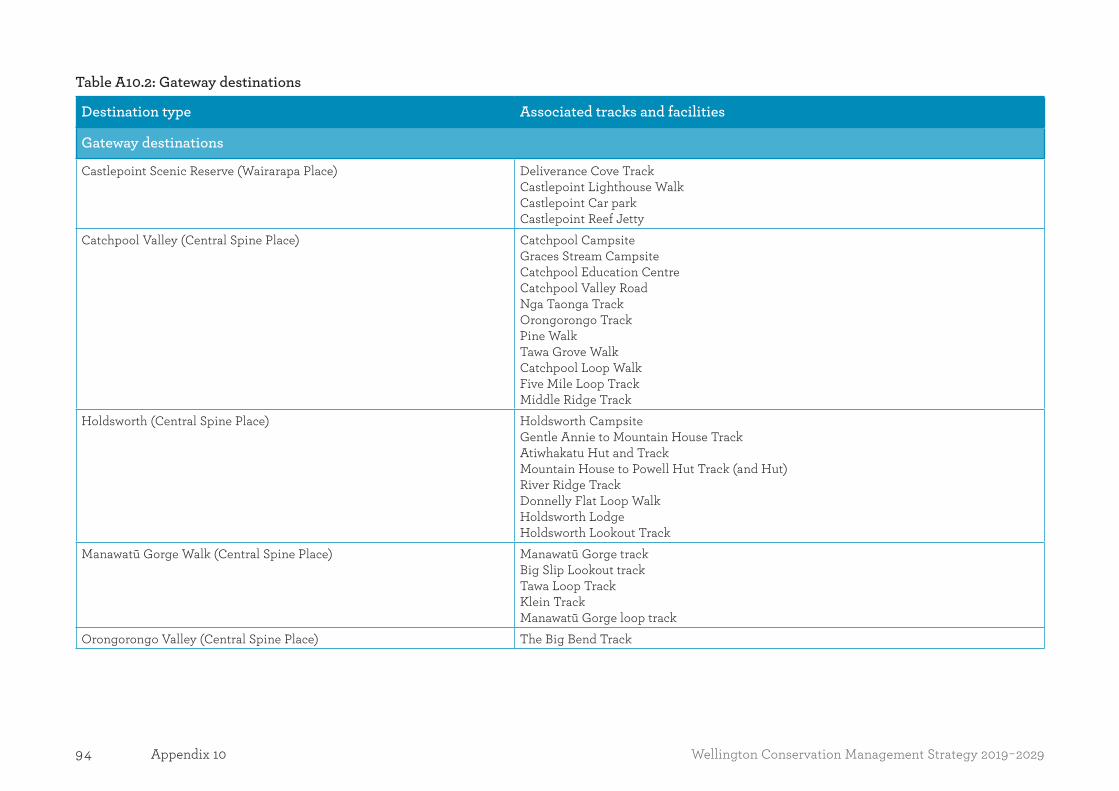
94 Wellington Conservation Management Strategy 2019-2029Appendix 10
Table A10.2: Gateway destinations
Destination type Associated tracks and facilities
Gateway destinations
Castlepoint Scenic Reserve (Wairarapa Place) Deliverance Cove TrackCastlepoint Lighthouse WalkCastlepoint Car parkCastlepoint Reef Jetty
Catchpool Valley (Central Spine Place) Catchpool CampsiteGraces Stream CampsiteCatchpool Education CentreCatchpool Valley RoadNga Taonga TrackOrongorongo TrackPine WalkTawa Grove WalkCatchpool Loop WalkFive Mile Loop TrackMiddle Ridge Track
Holdsworth (Central Spine Place) Holdsworth CampsiteGentle Annie to Mountain House TrackAtiwhakatu Hut and TrackMountain House to Powell Hut Track (and Hut)River Ridge TrackDonnelly Flat Loop WalkHoldsworth Lodge Holdsworth Lookout Track
Manawatū Gorge Walk (Central Spine Place) Manawatū Gorge trackBig Slip Lookout trackTawa Loop TrackKlein TrackManawatū Gorge loop track
Orongorongo Valley (Central Spine Place) The Big Bend Track

95Wellington Conservation Management Strategy 2019-2029 Appendix 10
Destination type Associated tracks and facilities
Gateway destinations
Otaki Forks (Central Spine Place) Fenceline WalkParawai LodgeOtaki Forks RoadOtaki Forks to Field Hut TrackSheridan HaulerArcus Loop TrackWaitatapia Track Otaki Forks Schoolhouse Campsite Sheriden Creek Rail Track (Historic)School Flat Nature Walk
Putangirua Pinnacles (Central Spine Place) Pinnacles TrackPutangirua Access RoadPutangirua Pinnacles CampsiteTe Kopi HomesteadAorangi Holiday Cottage and Aorangi Single Persons Quarters
Rangiwahia Track (Central Spine Place) Rangiwahia HutRangiwahia Hut to Mangahui TrackRangiwahia car park to Rangiwahia Hut Track
Remutaka7 Rail Trail (Central Spine Place) Remutaka Incline TrackRemutaka Incline TunnelsRemutaka Incline Station Yard
Sunrise Track (Central Spine Place) Sunrise TrackTriplex Hut
Waiohine River gorge (Central Spine Place) Waiohine Abseil SiteWaiohine CampgroundWaiohine Gorge Road
Waiohione to Holdsworth Track (Central Spine Place) Waiohine TrackTōtara Flats to Holdsworth Track
Whareroa Farm (Wellington-Kāpiti Place) Cairn View TrackCoastal View WalkForest WalkFarm Race WalkLink TrackWhareroa Entry Building
7 As a result of the Rangitāne Tū Mai Rā (Wairarapa Tamaki nui-ā-Rua) Claims Settlement Act 2017, the name of Rimutaka Forest Park has been changed to Remutaka Forest Park.

96 Wellington Conservation Management Strategy 2019-2029Appendix 11
Appendix 11Reclassification of land proposed in the Wellington regionNote: NAPLIS is the centralised database for all land administered by the Department of Conservation and Land Information New Zealand.
Name of conservation area or reserve NAPLIS ID number Proposed status change/review Other action
Otaki Conservation Area 2795257 Scenic Reserve Rare coastal dune wetland habitat.Fort Street Conservation Area 2798526 Historic Reserve Historic gun emplacement.Moanaroa Conservation Area 2792925 Scenic Reserve Estuarine/dune vegetation, limit vehicle access
to site.Awahou Conservation Area 2794361 Scientific Reserve Presence of Wellington barking gecko.Forest Flat Conservation Area 2794745 Scenic Reserve Requires increased management activity.Coast Cliffs Conservation Area 2795104 Scenic Reserve Threatened species management becoming a
priority.Rewa Bush Conservation Area 2794773 Scenic Reserve Requires mitigation of threats.

97Wellington Conservation Management Strategy 2019-2029 Appendix 12
Appendix 12Private accommodation schedule for the Wellington regionAuthorised and unauthorised private accommodation and related facilities in the Wellington region.
Location of building(s) No. of buildings Authorised Exception applies8 Right of renewal Notes
Central Spine Place
Orongorongo River valley, Remutaka Forest Park
52 Yes No No Licence to end on death of licensee or by 31 December 2050
Corner Creek, Remutaka Forest Park
8 Yes No No Licence to end on death of licensee or by 31 July 2019
Corner Creek 7 No No No
Wairarapa Place
Ocean Beach Conservation Area 20 No No No
8 Such as section 7(2) of the Conservation Amendment Act 1996 or section 11(4) of the Reserves Amendment Act 1996.

98 Wellington Conservation Management Strategy 2019-2029Appendix 13
Appendix 13Prescriptions for visitor management zones in the Wellington region
Setting Urban Rural Front country Backcountry – accessible and walk-in
Remote
General description
Areas inside or on the periphery of urban areas. Typically includes a historic or cultural site.
Remnant native forest, wetlands, marine reserves and historic or cultural sites in areas dominated by farmland and plantation forest.
Where the majority of visitation occurs; typically small areas, scattered within or on the periphery of large relatively natural areas. Includes the vicinity of main ‘scenic’ roads passing through public conservation lands and waters. Often focused on a particular attraction.
Large-scale natural settings generally accessed first through front country. Includes popular walks and tramps set within large-scale natural settings and/or that access other settings.
Catchments beyond the backcountry zone, forming the wild lands in the interior of large protected areas, with basic low-use tracks, marked routes and huts in some places.
Accessibility Enabled for people of most ages and abilities
Typically, via sealed and unsealed roads, and in some cases by boat. Enabled for people of most ages or abilities.
Readily accessible areas, usually via sealed roads, or scheduled ferry or air services. Mostly by car, but also tour buses and guided parties to some sites. Enabled for people of most ages and abilities.
People will have travelled some distance to reach these settings. ‘Backcountry accessible’ focuses on unsealed roads, four-wheel drive roads, navigable waters and aircraft landing sites. Motorised ground access generally restricted to roads and designated routes. ‘Backcountry walk-in’ is focused beyond the influence of motorised access.
Typically, 5 or more hours travel on foot from front country. Access supported by air or water craft in some areas.
Predominant visitor groups9
Short-stop travellers and day visitors.
Short-stop travellers, day visitors and over-nighters.
Predominantly short-stop travellers, day visitors and over-nighters. Other visitors in transition to backcountry and remote settings.
Predominantly ‘backcountry comfort seekers’ and ‘backcountry adventurers’.
Backcountry adventurers and ‘remoteness seekers’.
9 Visitor groups relate to the Department’s Visitor Strategy 1996.

99Wellington Conservation Management Strategy 2019-2029 Appendix 13
Setting Urban Rural Front country Backcountry – accessible and walk-in
Remote
Predominant destination categories
Icon, Gateway and Local Treasure. Predominantly Icon, Gateway and Backcountry.
Predominantly Backcountry.
Facility setting High-standard footpaths, cycleways and modified landscapes. High degree of control via information and direction signs, and barriers.
Short walks, campsites and picnic areas, for a range of ages and abilities. High degree of control via information and direction signs, and barriers.
Good-quality facilities, services and easy access. Sometimes the origin for tramping tracks and routes, with signs and information to make this transition clear. High degree of control via information and direction signs, and barriers.
A range of facility standards, including any designated vehicle routes, and popular walks and tramping tracks. Evidence of control limited to essential directional signs and barriers on Great Walks, and where there are significant hazards.
Basic huts, bridges, low-use tracks and marked routes. Evidence of control is limited to essential signs.
Desired visitor experience and interactions
Varying, from activities with large groups, time with small groups/families, some time away from other groups and, in some cases, solitude.
Generally, some time away from other groups and, in some cases, solitude. Occasional encounters with organised groups. Generally accepting of occasional intrusion of noise.
Reasonable expectation of isolation from sights, sounds and activities of other people. Interaction with few other groups. Considerable self-reliance on backcountry skills.
Preferred maximum party size
What is socially appropriate. Conforming concessions schedule – 15 people.
50 people. Conforming concessions schedule – 15 people.
15 people. 50 for periodic tour bus parties. Conforming concessions schedule – 15 people.
15 people. 8 people.

100 Wellington Conservation Management Strategy 2019-2029Appendix 13
Setting Urban Rural Front country Backcountry – accessible and walk-in
Remote
Typical visitor interaction levels
What is socially appropriate.
20 or less people seen per hour.
30 or less people seen per visit duration.
15 or less other people seen per day for ‘backcountry adventurer’ tracks or routes. 40 or less people seen per day for ‘backcountry comfort seeker’ tracks or routes.
One other party seen per day.
Concessions operations
Concessionaire activity may be permitted in all these visitor management zones, subject to conditions to avoid, remedy or mitigate adverse effects, including compliance with criteria within this table; the outcome, objectives and policies in the CMS apply.Concessionaire client activities should not be advantaged or disadvantaged compared with those for non-concessionaire visitors, unless there is a reason specified in the Plan for adopting a different management approach.
Concessions effects management
Avoid, remedy or mitigate adverse effects. Avoid or mitigate adverse effects.
Avoid adverse effects.
Aircraft management
Aircraft access for visitor use purpose should not be approved other than in accordance with Policies 4.2.1–4.2.10 (Aircraft), and the outcomes and policies in Part Two – Places.

101Wellington Conservation Management Strategy 2019-2029 Appendi4x 1
Appendix 14Aircraft use zones for the Wellington regionTo manage the effects of aircraft landings on public conservation lands and waters there are four, nationally consistent, aircraft access zones (as shown on Map 6 in Volume II of this CMS). These zones reflect the different management methodologies required, and the likelihood of granting concessions, for aircraft landings.
• Red Zone – Areas where a concession application to land an aircraft should be declined. However, concessions may be granted for aircraft landings associated with the construction, operation or maintenance of equipment (e.g. meteorological, seismic) or utilities (e.g. communication systems, transmission lines) that have been authorised by the Department, or to support research authorised by the Department. This zone may apply where:
i) legislation provides strong direction that concessions should not be granted for aircraft landings (e.g. gazetted wilderness areas); ii) an area is adjacent to (parts of) a National Park where there are no aircraft landings;iii) adverse effects on conservation, including recreational, values need to be avoided (e.g. nature and scientific reserves, threatened species habitat,
high use picnic and camping areas); iv) the area is readily accessible by other means; orv) aircraft activity may interfere with management activities.
• Yellow Zone – Areas where a concession application to land an aircraft should be granted where it meets the nationally consistent limits for this zone. This zone may apply where there is a need to restrict aircraft use; either where visitors expect a low level of encounters with aircraft or where values of natural quiet predominate, particularly in backcountry and remote areas.
• Green Zone – Areas where a concession application to land an aircraft should be granted, provided it complies with any relevant outcome and/or the criteria in the relevant policies. This zone may apply where:
i) conservation, including recreation, values are unlikely to be affected by landings; ii) there are natural limits on sites where landings can actually occur (e.g. forest cover, steep terrain); or iii) there is likely to be little demand for aircraft access over the life of this CMS.

102 Wellington Conservation Management Strategy 2019-2029Appendix 14
• Orange Zone – Areas where there are complex issues to be managed, which require the use of limits and/or other criteria to guide whether concessions for aircraft landings can be granted. This zone may apply:
i) in situations that involve limited opportunities, areas of intensive aircraft activity or where a precautionary approach is required; ii) where there are historic or legal reasons for an approach that does not fit within the other three zones; iii) to provide for a specific recreational activity (e.g. heli-skiing, heli-fishing, ground-based hunting); iv) to only allow specific types of aircraft (e.g. non-powered aircraft);v) where there are variations in seasonal use; vi) to protect visitor experiences; or
vii) where landings do not fit within the circumstances described in the other three zones.
The application of these aircraft access zones manages aircraft landings on public conservation lands and waters. As a result, there is a spectrum of aircraft landings and over-flights (aircraft encounters) that may be experienced by visitors to public conservation lands and waters, as described in Section 4.2 Aircraft.
Outcomes and/or policies may specify numeric limits for aircraft landings (e.g. daily, monthly, annually), or may use the words ‘rare’, ‘occasional’, ‘regular’ or ‘frequent’ to describe the overall level of aircraft encounters and therefore the visitor experience expected in each aircraft access zone (or part thereof).
This spectrum does not consider aircraft landings associated with the construction, operation and/or maintenance of equipment or utilities authorised by the Department, or wild animal control activities. Neither can the Department directly manage over-flights (while aircraft are in the airspace above public conservation lands and waters).
A concession to land an aircraft does not include any other activities, such as vegetation removal or earthworks, associated with maintaining an airstrip or designated landing site.
Table A14: Spectrum of aircraft encounters on public conservation lands and waters
Low High
Average percentage of time aircraft are likely to be encountered 1% or less 5% 25% 50% or more
Likely visitor management zone Remote and/or backcountry zones Backcountry and/or front country zones
Word used in outcomes/policies to describe and achieve this Rare Occasional Regular Frequent

103Wellington Conservation Management Strategy 2019-2029 Appendix 15
Appendix 15Criteria for which the Manawatū Estuary Wetland of International Importance was nominatedCriterion 1: A wetland should be considered internationally important if it contains a representative, rare, or unique example of a natural or near-natural wetland
type found within the appropriate biogeographic region. Manawatū Estuary is noted as being one of the largest remaining natural areas in the ecological district and is the most natural and diverse estuarine wetland within the Manawatū ecological region.
Criterion 2: A wetland should be considered internationally important if it supports vulnerable, endangered, or critically endangered species or threatened ecological communities. The estuary supports vulnerable, endangered, and critically endangered species, such as the tara iti/New Zealand fairy tern (Sternula nereis), matuku-hurepo/Australasian bittern (Botaurus poiciloptilus), shortjaw kōkopu (Galaxias postvectis)/galaxiids and piharau/lamprey (Geotria australis).
Criterion 3: A wetland should be considered internationally important if it supports populations of plant and/or animal species important for maintaining the biological diversity of a particular biogeographic region. The estuary is the largest saltmarsh in the Manawatū ecological region and supports populations of bird species that are important for maintaining the biological diversity of the ecological region.
Criterion 4: A wetland should be considered internationally important if it supports plant and/or animal species at a critical stage in their life cycles or provides refuge during adverse conditions. The estuary supports the ngutu pare/wrybill (Anarhynchus frontalis) population during two significant stages of their lifecycle, as a passage between breeding grounds and wintering sites and as a wintering site in itself.
Criterion 6: A wetland should be considered internationally important if it regularly supports 1% of the individuals in a population of one species or subspecies of waterbird. The estuary supports about 1% of the world’s population of ngutu pare/wrybill.
Criterion 8: A wetland should be considered internationally important if it is an important source of food for fishes, spawning ground, nursery and/or migration path on which fish stocks, either within the wetland or elsewhere, depend. The estuary has a high diversity of native fish, including a number of threatened species. A large proportion of these fish migrate from the ocean through the estuary and into the river catchments. Inanga/whitebait spawning is believed to also occur within the estuary.
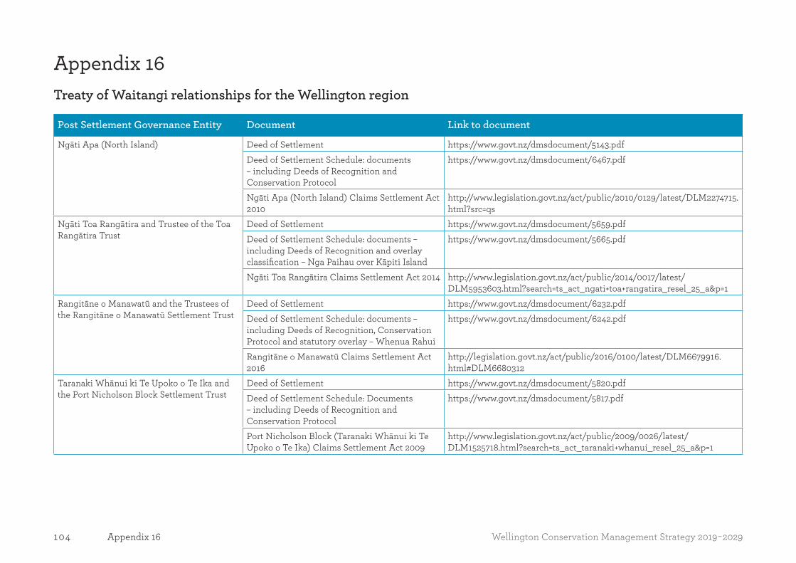
104 Wellington Conservation Management Strategy 2019-2029Appendix 16
Appendix 16Treaty of Waitangi relationships for the Wellington region
Post Settlement Governance Entity Document Link to document
Ngāti Apa (North Island) Deed of Settlement https://www.govt.nz/dmsdocument/5143.pdf Deed of Settlement Schedule: documents – including Deeds of Recognition and Conservation Protocol
https://www.govt.nz/dmsdocument/6467.pdf
Ngāti Apa (North Island) Claims Settlement Act 2010
http://www.legislation.govt.nz/act/public/2010/0129/latest/DLM2274715.html?src=qs
Ngāti Toa Rangātira and Trustee of the Toa Rangātira Trust
Deed of Settlement https://www.govt.nz/dmsdocument/5659.pdf Deed of Settlement Schedule: documents – including Deeds of Recognition and overlay classification – Nga Paihau over Kāpiti Island
https://www.govt.nz/dmsdocument/5665.pdf
Ngāti Toa Rangātira Claims Settlement Act 2014 http://www.legislation.govt.nz/act/public/2014/0017/latest/DLM5953603.html?search=ts_act_ngati+toa+rangatira_resel_25_a&p=1
Rangitāne o Manawatū and the Trustees of the Rangitāne o Manawatū Settlement Trust
Deed of Settlement https://www.govt.nz/dmsdocument/6232.pdf Deed of Settlement Schedule: documents – including Deeds of Recognition, Conservation Protocol and statutory overlay – Whenua Rahui
https://www.govt.nz/dmsdocument/6242.pdf
Rangitāne o Manawatū Claims Settlement Act 2016
http://legislation.govt.nz/act/public/2016/0100/latest/DLM6679916.html#DLM6680312
Taranaki Whānui ki Te Upoko o Te Ika and the Port Nicholson Block Settlement Trust
Deed of Settlement https://www.govt.nz/dmsdocument/5820.pdf Deed of Settlement Schedule: Documents – including Deeds of Recognition and Conservation Protocol
https://www.govt.nz/dmsdocument/5817.pdf
Port Nicholson Block (Taranaki Whānui ki Te Upoko o Te Ika) Claims Settlement Act 2009
http://www.legislation.govt.nz/act/public/2009/0026/latest/DLM1525718.html?search=ts_act_taranaki+whanui_resel_25_a&p=1
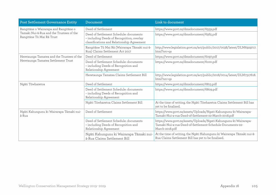
105Wellington Conservation Management Strategy 2019-2029 Appendix 16
Post Settlement Governance Entity Document Link to document
Rangitāne o Wairarapa and Rangitāne o Tamaki Nui-ā-Rua and the Trustees of the Rangitāne Tū Mai Rā Trust
Deed of Settlement https://www.govt.nz/dmsdocument/6559.pdf Deed of Settlement Schedule: documents – including Deeds of Recognition, overlay classifications and Relationship Agreement
https://www.govt.nz/dmsdocument/6565.pdf
Rangitāne Tū Mai Rā (Wairarapa Tāmaki nui-ā-Rua) Claims Settlement Act 2017
http://www.legislation.govt.nz/act/public/2017/0038/latest/DLM6929717.html?src=qs
Heretaunga Tamatea and the Trustees of the Heretaunga Tamatea Settlement Trust
Deed of Settlement https://www.govt.nz/dmsdocument/6097.pdf Deed of Settlement Schedule: documents – including Deeds of Recognition and Relationship Agreement
https://www.govt.nz/dmsdocument/6100.pdf
Heretaunga Tamatea Claims Settlement Bill http://www.legislation.govt.nz/act/public/2018/0014/latest/DLM7317618.html?src=qs
Ngāti Tūwharetoa Deed of Settlement https://www.govt.nz/dmsdocument/6815.pdf Deed of Settlement Schedule: documents – including Deeds of Recognition and Relationship Agreement
https://www.govt.nz/dmsdocument/6809.pdf
Ngāti Tūwharetoa Claims Settlement Bill At the time of writing, the Ngāti Tūwharetoa Claims Settlement Bill has yet to be finalised.
Ngāti Kahungunu ki Wairarapa Tāmaki nui-ā-Rua
Deed of Settlement https://www.govt.nz/assets/Uploads/Ngati-Kahungunu-ki-Wairarapa-Tamaki-Nui-a-rua-Deed-of-Settlement-22-March-2018.pdf
Deed of Settlement Schedule: documents – including Deeds of Recognition and Relationship Agreement
https://www.govt.nz/assets/Uploads/Ngati-Kahungunu-ki-Wairarapa-Tamaki-Nui-a-rua-Deed-of-Settlement-Schedule-Documents-22-March-2018.pdf
Ngāti Kahungunu ki Wairarapa Tāmaki nui-ā-Rua Claims Settlement Bill
At the time of writing, the Ngāti Kahungunu ki Wairarapa Tāmaki nui-ā-Rua Claims Settlement Bill has yet to be finalised.

106 Wellington Conservation Management Strategy 2019-2029Appendix 17
Appendix 17Designated landing zones in the Ruahine Forest Park
Name of site Map grid reference Name of site Map grid reference
Cattle Creek Hut E1861199, N5560513 Purity Hut E1861493, N5587627
Colenso Hut E1869392, N5603979 Rockslide Biv E1876894, N5610046
Crow Hut E1864192, N5593531 Ruahine Hut E1885598, N5616054
Daphine Hut E1868400, N5576923 Ruahine Corner Hut E1872192, N5608343
Dead Dog Hut E1883197, N5613851 Shutes Hut E1883194, N5621456
Diane’s Hut E1882194, N5617953 Smiths Stream Hut E1871199, N5584228
Gold Creek Hut E1873798, N5593735 Sparrowhawk Hut E1872496, N5596536
Hinerua Hut E1871100, N5582727 Tarn Biv E1868799, N5580525
Howletts Hut E1867699, N5578124 Taruarau Biv E1880793, N5617953
Ikawatea Forks Hut E1874592, N5612847 Toka Biv E1862298, N5569518
Iron Bark Hut E1865190, N5602937 Top Gorge Hut E1865199, N5571219
Kylie Biv E1874495, N5602840 Top Maropea Hut E1870396, N5592433
Leon Kinvig Hut E1862499, N5567217 Unknown Campsite E1867233, N5602500
Maropea Forks Hut E1868894, N5597535 Upper Makaroro Hut E1876797, N5602741
McKinnon Hut E1864993, N5591831 Waiokotore Campsite E1868190, N5606640
Mid Pohangia Hut E1859098, N5561813 Waikamaka E1868296, N5588430
Mokai Patea Campsite E1866131 N5594775 Wakelings Hut E1867997, N5594783
Ngamoko Hut E1860498, N5563814 Waterfall Hut E1866496, N5586628
Otukota Hut E1864590, N5600636 Whakarekou Campsite E1862137, N560668
Parks Peak Hut E1878798, N5602942

107Wellington Conservation Management Strategy 2019-2029 Appendix 18
Appendix 18Statutory agenciesThe table below identifies those agencies and their responsibilities that are most likely to directly affect the management of public conservation lands and waters.
Agency/ organisation Responsibilities Examples of issues and projects of common interest
Civil Aviation Authority of New Zealand (CAA)
The CAA is a transport Crown entity responsible to the Minister of Transport. Civil aviation in New Zealand operates within a system established and maintained in accordance with the Civil Aviation Act 1990. The system sets boundaries, which are the minimum safety and security standards to be met by system participants. Civil aviation activities that do not meet these minimum standards are not tolerated. The safety standards are detailed in the Civil Aviation Rules.
• Aircraft access • Drones classified as aircraft under the relevant legislation
Fire and Emergency New Zealand (FENZ)
FENZ is the national organisation responsible for promoting fire safety; providing fire prevention, response and suppression services; managing incidents involving hazardous substances; and providing urban search and rescue services.
Game Animal Council The Game Animal Council is a statutory body established under the Game Animal Council Act 2013. Key functions of the Council include advising and making recommendations to the Minister of Conservation on hunting issues, providing information and education to the sector, promoting safety initiatives, conducting game animal research, and undertaking management functions for designated herds of special interest. At the time of writing this CMS, there were no herds of special interest within the Wellington region.
• Management of game animals
Heritage New Zealand Pouhere Taonga
Heritage New Zealand Pouhere Taonga is an autonomous Crown entity with a leading national role in promoting the identification, protection, preservation and conservation of the historical and cultural heritage of New Zealand. Its principle functions include the listing of historic places/sites, advocating for the protection of sites, issuing of archaeological authorities to destroy or modify archaeological sites, advocacy for the conservation of historic resources, education, and management of historic properties.
• Management of historic places and archaeological sites

108 Wellington Conservation Management Strategy 2019-2029Appendix 18
Agency/ organisation Responsibilities Examples of issues and projects of common interest
Land Information New Zealand (LINZ)
LINZ works across land, sea, data, crown property and regulatory areas, administering various Acts and legislation in relation to New Zealand’s land and seabed. Responsibilities include managing land titles, geodetic and cadastral survey systems, topographic information, hydrographic information and managing Crown property.
Local authorities The functions of local authorities as set out in the Local Government Act 2002 are wide-ranging.
Greater Wellington Regional Council and Horizons Regional CouncilRegional councils have regulatory responsibilities under the Resource Management Act 1991 for the control of activities on public conservation lands and waters. These include discharges onto land and into water, the damming and diversion of water, activities in the beds of lakes and rivers (including gravel extraction and management of activities in the coastal marine area). Management controls are for the most part set out in regional plans.These councils are also responsible for preparing regional pest management strategies under the Biosecurity Act 1993, building control in the coastal marine area under the Building Act 1991 and catchment management. Greater Wellington Regional Council also administers a network of regional parks.
Wellington City, Porirua City, Upper Hutt City, South Wairarapa District, Carterton District, Masterton District, Palmerston North City, Kāpiti Coast District, Horowhenua District, Manawatū District, Tararua District, Rangitikei DistrictUnder the Resource Management Act 1991, local councils control the use of land within their districts. This is primarily achieved through district plans.Local councils also develop and maintain local infrastructure including parks and reserves and roading.
• Predator Free Wellington • Plant and animal pest management • Road access to public conservation land
Maritime New Zealand Maritime New Zealand is the national regulatory, compliance and response agency for the safety, security and environmental protection of coastal and inland waterways. Responsible for ensuring our seas are safe, secure and clean on behalf of all New Zealanders. Administers the Maritime Transport Amendment Act 2004.
• Leads response to significant maritime incidents and emergencies, including oil spills.
• Provision of maritime safety infrastructure
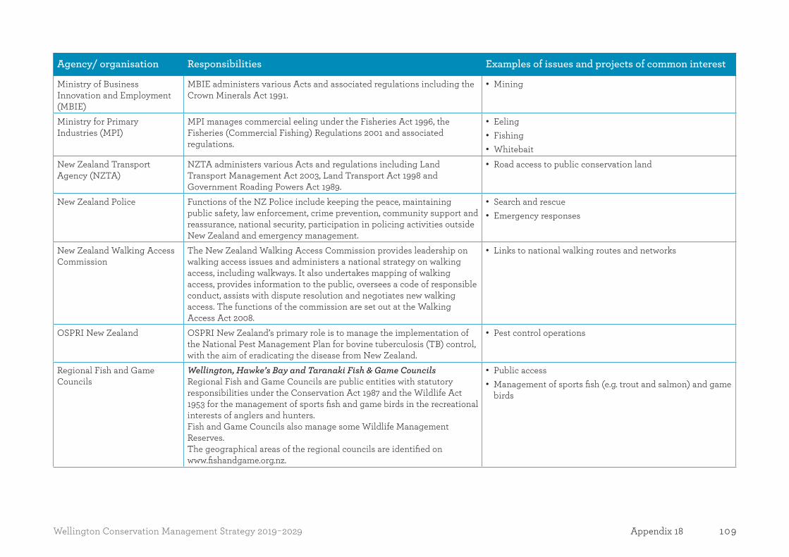
109Wellington Conservation Management Strategy 2019-2029 Appendix 18
Agency/ organisation Responsibilities Examples of issues and projects of common interest
Ministry of Business Innovation and Employment (MBIE)
MBIE administers various Acts and associated regulations including the Crown Minerals Act 1991.
• Mining
Ministry for Primary Industries (MPI)
MPI manages commercial eeling under the Fisheries Act 1996, the Fisheries (Commercial Fishing) Regulations 2001 and associated regulations.
• Eeling • Fishing • Whitebait
New Zealand Transport Agency (NZTA)
NZTA administers various Acts and regulations including Land Transport Management Act 2003, Land Transport Act 1998 and Government Roading Powers Act 1989.
• Road access to public conservation land
New Zealand Police Functions of the NZ Police include keeping the peace, maintaining public safety, law enforcement, crime prevention, community support and reassurance, national security, participation in policing activities outside New Zealand and emergency management.
• Search and rescue • Emergency responses
New Zealand Walking Access Commission
The New Zealand Walking Access Commission provides leadership on walking access issues and administers a national strategy on walking access, including walkways. It also undertakes mapping of walking access, provides information to the public, oversees a code of responsible conduct, assists with dispute resolution and negotiates new walking access. The functions of the commission are set out at the Walking Access Act 2008.
• Links to national walking routes and networks
OSPRI New Zealand OSPRI New Zealand’s primary role is to manage the implementation of the National Pest Management Plan for bovine tuberculosis (TB) control, with the aim of eradicating the disease from New Zealand.
• Pest control operations
Regional Fish and Game Councils
Wellington, Hawke’s Bay and Taranaki Fish & Game CouncilsRegional Fish and Game Councils are public entities with statutory responsibilities under the Conservation Act 1987 and the Wildlife Act 1953 for the management of sports fish and game birds in the recreational interests of anglers and hunters. Fish and Game Councils also manage some Wildlife Management Reserves.The geographical areas of the regional councils are identified on www.fishandgame.org.nz.
• Public access • Management of sports fish (e.g. trout and salmon) and game
birds
110 Wellington Conservation Management Strategy 2019-2029Appendix 19
Appendix 19Submitters on the Wellington CMS reviewThe list below identifies those people and organisations who contributed to the review of the CMS by submitting on the draft Wellington CMS. It should be noted that this table does not reflect all PSGEs, tangata whenua, local authorities, agencies and other individuals that participated in and contributed to the review of the CMS in other ways. All input and support for conservation is acknowledged and has helped to direct the future of conservation in the Wellington region over the next ten years and beyond.
1st Karori Scout Group, Adam Laker, Adam Schmidt, Albertus Viljoen, Alex Denholm, Alison Davis, Alistair McEwan, Alistair Rieger, Allan Atkinson, Allan Smith, Andrew McColl, Anthony Kemohon, Aorangi Restoration Trust, Ben Farrell, Bill Voisey, Blair Curry, Bradley MacDonald, Brenton Hidgson, Brian Churchouse, Brigitte Grabowski, Brock Beyer, Bruce Beyer, Bruce Graham, Bruce Hagar, Bush Branch NZ Deerstalkers Association, Campbell Back, Carter Task Force, Castlepoint Ratepayers and Residents Associatoin (CRRA), Cathryn Ash, Chris Cunningham, Chris Peterson, Chris Scott, Dairy New Zealand, Daniel Billett, Daniel Lovett, Daniel Somerville, Darren Parlato, Darryl Huia, David Ainsworth, David Buck, David Gilroy, David Gratton, Dean Rabbitt, Debbie and Scott Farrell, Debbie Woolcott, Derrick Field, Dr Paul Blaschke, Chris Livesey, Dr. Wrenn Green, and Clive Antsey, Environment Network Manawatū, Federated Farmers of New Zealand, Federated Mountain Clubs, Fiona Attewell, Friends of Mana Island, Friends of Taputeranga Marine Reserve Trust, Gary Fox, Gary Trow, Gavin Stoddart, Gordon George, Gordon Kuggeleijn, Graeme Blanchard, Graeme Corin, Graeme Sawyer, Grant Cassar, Greater Wellington Regional Council, Gregg Pickens, Guardians of Kāpiti Marine Reserve, Harvey Paterson, Henry Melville, Heretaunga Tramping Club, Heritage New Zealand, Horizons Regional Council, Horowhenua District Council, Howard Egan, Hutt City Council, Hutt Valley Deer Stalkers, Ian and Jill Goodwin, Ian Baine, Ian MacDonald, Ian Patterson, Ian Rasmussen, Isaac Murphy, Jacob Brown, Jaime Peryer-Fursdon, James Blyth, James Fine, James Smith, James Young, Jason Bedford, Jason Christensen, Jenny Cossey, Jinesse Taylor, John Horne, John Leith, Jon Astwood, Jon Kearins, Jon Waghorn, Kahungunu ki Tamaki nui-a-rua Trust, Kahungunu Ki Wairarapa, Kāpiti Heliworx Limited, Kara Collins, Karen Singleton-Ryan, Karla and Trevor Beamsley, Kathryn Bayliss, Katie Vermeer, Keegan Toft, Kevin Daly, Kevin Fewtrell, Kevin Ormond, Kevin Wilson, KiwiRail Holdings Limited (KiwiRail),Liam Cockayne-Goodin, Logan Whitford, Lower North Island Red Deer Foundation Incorporated, Mana Cycle Group, Manawatū District Council, Margaret Jeune, Marina and Nigel Fraser, Mark Heaphy-Postles, Mark Jeffares, Martin Cayford, Masterton & South Wairarapa Tramping Clubs, Matt Aldiss, Matthew Diederich, Matthew Evetts, Maxine Robb Veneberg, Michael Walsh, Michele Domaneschi, Michelle Caldwell, Mike Craig, Mike Pratt, Mitchell Kinghorn, MT Mangaweka Helipark, Murray Gray, New Zealand Alpine Club, New Zealand Canyoning Association, New Zealand Deerstalkers’ Association, New Zealand Deerstalkers’ Association Hutt Valley Branch Inc., New Zealand Deerstalkers’ Association Manawatū Branch, New Zealand Deerstalkers Association’ Wairarapa Branch, New Zealand Game Animal Council, New Zealand Motor Caravan Association Inc., New Zealand Recreation Association, New Zealand Transport Agency, New Zealand Walking Access Commission, Ngā Uruora – Kāpiti Project Inc., Ngati Hauiti, Nickolas Efstratiou, Nigel Smith, Nigel Thompson, NZ Horse Network, Ocean Beach Residents Association, Orongorongo Club, Otari Wilton’s Bush Trust, Palmerston North Tramping and
111Wellington Conservation Management Strategy 2019-2029 Appendix 19
Mountaineering Club, Patrick Enright, Patrick Krippner, Paul Dekker, Paul Kendall, Paul Shivnan, Peter East, Peter Zhou, Philip & Penelope Porritt, Porirua City Council, Port Nicholson Block Settlement Trust, Rangitāne o Tamaki nui a Rua Incorporated, Rangitane o Wairarapa Incorporated, Rangitikei District Council, Rangitikei Helicopters Ltd, Rangiwahia Community Committee, Rebecca Jamieson (on behalf of others), Rhonda Fitzpatrick, Richard Morton, Rob Hard, Robert Cox, Robert Warrington, Roger Gregory, Rohan Harrigan, Ross Blackwell, Royal Forest & Bird Protection Society of New Zealand Inc, Ruahine Whio Protection Trust, Sam Forward, Sam Pilcher, Sam Wilkie, Samuel Foss, Sarah Simmons, Scott Michael Rodgers, Serge Ritossa, Shane Blatchford, Shane Simpson, Shea Peterson, Simon Crowther, Simon Reynolds, South Wairarapa Biodiversity Group, Steffen Zinkham, Stephen Mawdesley, Steve Anderton, Steve Cary, Sustainable Wairarapa, Tainui Salzmann, Tanenuiarangi Manawatū Incorporated (on behalf of Rangitāne o Manawatū), Tararua Aorangi Rimutaka Huts Committee, Tararua Tramping Club, Te Āpiti Manawatū Gorge Governance Group, Te Araroa Wellington Trust, Te Rūnanga o Raukawa and Te Taiao o Raukawa, Te Runanga o Toa Rangatira, Te Taiao Hawkes Bay, Terence Galuszka, Terry Weaver, Tim Gale – New Zealand Deerstalkers’ Association, Tim Goode, Tim Watson, Timothy Barnes, Tom Nation, Tom Scott, Tony Le Bas, Tourism Industry Aotearoa, Trail Fund NZ, Ursula Edgington, Vic Ormond, Vic Pratt, Waa Rata Estate, Waikanae Estuary Care Group Inc, Wainuiomata Rural Community Association, Wallace Potts, Wanganui Tramping Club, Warwick Gibbs, Wellington Botanical Society, Wellington City Council, Wellington Electricity Lines Limited (WELL), Wellington Harbour Islands Kaitiaki Board, Wellington Trails Trust, Wellington Tramping and Mountaineering Club Inc, Wellington, Hawke’s Bay, and Taranaki Fish & Game Councils, Whitewater NZ, William Brandt and Zachary Prestidge.

112 Wellington Conservation Management Strategy 2019-2029Appendix 20
Appendix 20MilestonesThe list below includes all the regional and Place-based milestones in the CMS. Conservation General Policy 2005 requires the CMS to include ‘major milestones towards planned outcomes’. The Department and Wellington Conservation Board may over time, in conjunction with post settlement governance entities (PSGEs), tangata whenua and other conservation partners, expand this monitoring and reporting framework during the life of the CMS (see Part Three – Implementation, monitoring and reporting).
Note: The number in brackets relates to the provision number for that milestone in Volume I.
Regional milestonesThe milestones below apply to one or more Places within this document and give effect to the objectives set out in Part One. They are grouped using the priority headings set out in the Statement of Intent 2016–2020, where possible. They should be read in conjunction with the more specific milestones for Places.
Treaty of Waitangi relationships
Year 1 Year 4 Year 7 Year 10
Strategic projectsDeveloped mutually agreed processes for identifying projects of significance to PSGEs and tangata whenua. (3.5.1)
Enhancing te reo MāoriIdentified sites suitable for interpretation in te reo Māori, supported by PSGEs and tangata whenua. (3.5.4)
Installed and updated interpretive, instructional and identifying signs in te reo Māori at sites identified in Year 1. (3.5.5)
Strategic projectsPrioritised projects of significance to PSGEs and tangata whenua identified in Year 1. (3.5.2)
Enhancing te reo MāoriInstalled and updated interpretative, instructional and identifying signs in te reo Māori at sites identified in Year 1. (3.5.5)
Strategic projectsProgress made on priority projects of significance. (3.5.3)
Enhancing te reo MāoriInstalled and updated interpretative, instructional and identifying signs in te reo Māori at sites identified in Year 1. (3.5.5)
Strategic projectsProgress made on priority projects of significance. (3.5.3)
Enhancing te reo MāoriInstalled and updated interpretative, instructional and identifying signs in te reo Māori at sites identified in Year 1. (3.5.5)

113Wellington Conservation Management Strategy 2019-2029 Appendix 20
Sites of cultural significanceIdentified sites supported by PSGEs and tangata whenua, suitable for having their stories told. (3.5.6)
Enhancing understanding of cultural valuesSupported development of plans for cultural materials. (3.5.8)
Sites of cultural significanceIdentified sites supported by PSGEs and tangata whenua, suitable for having their stories told. (3.5.6)
Supported PSGEs and tangata whenua to tell their stories and associations with sites of cultural significance. (3.5.7)
Enhancing understanding of cultural valuesSupported development of plans for cultural materials. (3.5.8)
EducationIn collaboration with PSGEs and tangata whenua, applied cultural monitoring approaches based on mātauranga Māori (Māori traditional knowledge and cultural values). (3.59)
Collaboratively educated the public on these methods, increasing understanding of mātauranga Māori and respect for species and the environment. (3.5.10)
Sites of cultural significanceIdentified sites supported by PSGEs and tangata whenua, suitable for having their stories told. (3.5.6)
Supported PSGEs and tangata whenua to tell their stories and associations with sites of cultural significance. (3.5.7)
Enhancing understanding of cultural valuesSupported development of plans for cultural materials. (3.5.8)
EducationCollaboratively educated the public on these methods, increasing understanding of mātauranga Māori and respect for species and the environment. (3.5.10)
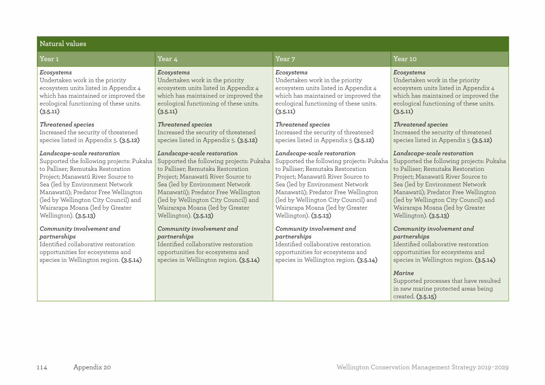
114 Wellington Conservation Management Strategy 2019-2029Appendix 20
Natural values
Year 1 Year 4 Year 7 Year 10
EcosystemsUndertaken work in the priority ecosystem units listed in Appendix 4 which has maintained or improved the ecological functioning of these units. (3.5.11)
Threatened speciesIncreased the security of threatened species listed in Appendix 5. (3.5.12)
Landscape-scale restorationSupported the following projects: Pukaha to Palliser; Remutaka Restoration Project; Manawatū River Source to Sea (led by Environment Network Manawatū); Predator Free Wellington (led by Wellington City Council) and Wairarapa Moana (led by Greater Wellington). (3.5.13)
Community involvement and partnershipsIdentified collaborative restoration opportunities for ecosystems and species in Wellington region. (3.5.14)
EcosystemsUndertaken work in the priority ecosystem units listed in Appendix 4 which has maintained or improved the ecological functioning of these units. (3.5.11)
Threatened speciesIncreased the security of threatened species listed in Appendix 5 (3.5.12)
Landscape-scale restorationSupported the following projects: Pukaha to Palliser; Remutaka Restoration Project; Manawatū River Source to Sea (led by Environment Network Manawatū); Predator Free Wellington (led by Wellington City Council) and Wairarapa Moana (led by Greater Wellington). (3.5.13)
Community involvement and partnershipsIdentified collaborative restoration opportunities for ecosystems and species in Wellington region. (3.5.14)
MarineSupported processes that have resulted in new marine protected areas being created. (3.5.15)

115Wellington Conservation Management Strategy 2019-2029 Appendix 20
Historic values
Year 1 Year 4 Year 7 Year 10
Actively managed placesPrepared a baseline report on the condition of all actively conserved historic places listed in Appendix 9. (3.5.18)
Bringing history to lifeEvaluated existing storytelling for all the actively conserved sites and developed a prioritised programme for enhancing storytelling at these sites. (3.5.16)
Actively managed placesEnhanced storytelling and marketing of the ‘Historic Landmarks’ sites, identified as part of the interagency Landmarks Whenua Tohunga programme, which are on public conservation lands and waters in the Wellington CMS region. (3.5.17)
Actively managed placesMinimised deterioration of 13 of the actively conserved historic places listed in Appendix 9 under the guidance of approved conservation plans. (3.5.19)
Engaging othersPartnerships with others who manage 5 of the 22 actively conserved historic places listed in Appendix 9. (3.5.21)
Actively managed placesMinimised deterioration of all of the 22 actively conserved historic places listed in Appendix 9 under the guidance of approved conservation plans. (3.5.20)
Engaging othersPartnerships with others who manage 11 of the 22 actively conserved historic places listed in Appendix 9. (3.5.22)

116 Wellington Conservation Management Strategy 2019-2029Appendix 20
Recreation values
Year 1 Year 4 Year 7 Year 10
Gateway destinationsEstablished visitor satisfaction monitoring for priority sites in Appendix 10. (3.5.23)Analysed visitor satisfaction for 15 (90%) of the destinations in Appendix 10 and established an improvement programme. (3.5.24)Established mechanisms for gathering and analysing baseline visitor count data at all destinations in Appendix 10. (3.5.26)
Engaging others in locally treasured destinationsDeveloped an improvement plan for the most popular destinations where facilities are below standard for the target visitor group. (3.5.28)
Backcountry destinationsDeveloped an improvement plan for the most popular destinations where facilities are below standard for the target visitor group. (3.5.30)Obtained partner/community support to maintain 60% of all Departmental huts, excluding serviced huts. (3.5.31)
Te Araroa TrailInvestigated the provision of facilities to meet user demand. (3.5.33)
Public accessIdentified priority destinations for improving public access to and from public conservation lands and waters. (3.5.35)
Public accessAchieved improved public access to and from priority sites. (3.5.36)
Gateway destinationsEvidence that visitor satisfaction has increased for destinations in Appendix 10. (3.5.25)
Evidence that more people are recreating at all destinations in Appendix 10. (3.5.27)10
Engaging others in locally treasured destinationsDemonstrated that the number of community partnerships to support the management of Local Treasures has increased. (3.5.29)
Backcountry destinationsObtained partner/community support to maintain 80% of all Departmental huts excluding serviced huts. (3.5.32)
Te Araroa TrailProvided facilities identified in Milestone 3.5.33 (3.5.34)
10 See Part Two 9 Islands Place for how visitor numbers are to be managed for Kāpiti Island Nature Reserve.
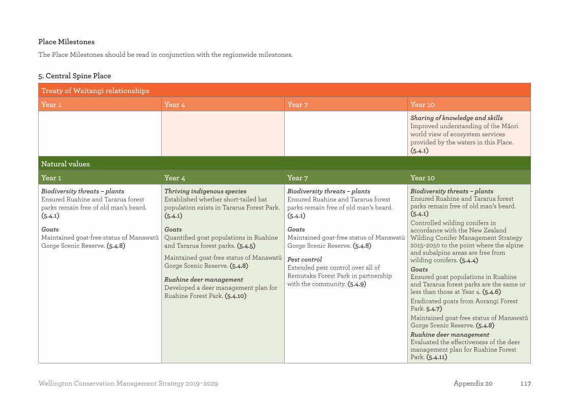
117Wellington Conservation Management Strategy 2019-2029 Appendix 20
Place MilestonesThe Place Milestones should be read in conjunction with the regionwide milestones.
5. Central Spine Place
Treaty of Waitangi relationships
Year 1 Year 4 Year 7 Year 10
Sharing of knowledge and skills Improved understanding of the Māori world view of ecosystem services provided by the waters in this Place. (5.4.1)
Natural values
Year 1 Year 4 Year 7 Year 10
Biodiversity threats – plantsEnsured Ruahine and Tararua forest parks remain free of old man’s beard. (5.4.1)
GoatsMaintained goat-free status of Manawatū Gorge Scenic Reserve. (5.4.8)
Thriving indigenous speciesEstablished whether short-tailed bat population exists in Tararua Forest Park. (5.4.1)
GoatsQuantified goat populations in Ruahine and Tararua forest parks. (5.4.5)
Maintained goat-free status of Manawatū Gorge Scenic Reserve. (5.4.8)
Ruahine deer managementDeveloped a deer management plan for Ruahine Forest Park. (5.4.10)
Biodiversity threats – plantsEnsured Ruahine and Tararua forest parks remain free of old man’s beard. (5.4.1)
GoatsMaintained goat-free status of Manawatū Gorge Scenic Reserve. (5.4.8)
Pest controlExtended pest control over all of Remutaka Forest Park in partnership with the community. (5.4.9)
Biodiversity threats – plantsEnsured Ruahine and Tararua forest parks remain free of old man’s beard. (5.4.1)Controlled wilding conifers in accordance with the New Zealand Wilding Conifer Management Strategy 2015–2050 to the point where the alpine and subalpine areas are free from wilding conifers. (5.4.4)GoatsEnsured goat populations in Ruahine and Tararua forest parks are the same or less than those at Year 4. (5.4.6)Eradicated goats from Aorangi Forest Park. 5.4.7)Maintained goat-free status of Manawatū Gorge Scenic Reserve. (5.4.8)Ruahine deer management Evaluated the effectiveness of the deer management plan for Ruahine Forest Park. (5.4.11)

118 Wellington Conservation Management Strategy 2019-2029Appendix 20
Historic values
Year 1 Year 4 Year 7 Year 10
Stories of historic places toldImproved storytelling along the Remutaka Rail Trail. (5.4.12)
Historic sites protected Completed heritage assessments and conservation plans for Cone and Pararaki Huts. (5.4.14)
Stories of historic places toldImproved storytelling at timber industry actively conserved historic places at Otaki. (5.4.13)
Recreation values
Year 1 Year 4 Year 7 Year 10
Public accessDeveloped a strategy to secure access into areas of Ruahine and Aorangi forest parks without permanent legal access. (5.4.15)
Recreation opportunities for all ages and abilities Installed a new Siberia Bridge and upgraded Remutaka Incline Track to meet New Zealand Cycle Trails Grade 2 standard. (5.4.16)
Orongorongo huts Completed an inventory, including ownership, of all huts and accommodation. (5.4.18)
Year 2Aircraft monitoringDeveloped a monitoring system for the effects of aircraft use in this Place. (5.4.21)
Orongorongo huts Made decisions on the future use and management of huts and accommodation with expired licences. (5.4.19)
Aircraft monitoringEstablished an evidenced-based threshold for aircraft use and managed aircraft consistently within this Place. (5.4.22)
Recreation opportunities for all ages and abilities Investigated the feasibility of developing an easy, family-friendly tramping experience in Ruahine and/or Tararua forest parks. (5.4.17)
Aircraft monitoringEstablished an evidenced-based threshold for aircraft use and manage aircraft consistently within this Place. (5.4.22)
Orongorongo huts Removed or re-purposed any huts not subject to licence or management agreement. (5.14.20)
Aircraft monitoringEstablished an evidenced-based threshold for aircraft use and manage aircraft consistently within this Place. (5.4.22)
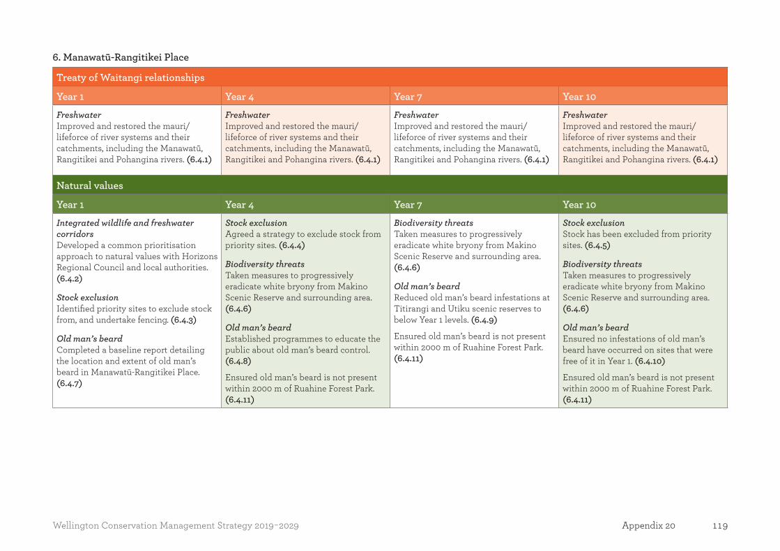
119Wellington Conservation Management Strategy 2019-2029 Appendix 20
6. Manawatū-Rangitikei Place
Treaty of Waitangi relationships
Year 1 Year 4 Year 7 Year 10
Freshwater Improved and restored the mauri/lifeforce of river systems and their catchments, including the Manawatū, Rangitikei and Pohangina rivers. (6.4.1)
Freshwater Improved and restored the mauri/lifeforce of river systems and their catchments, including the Manawatū, Rangitikei and Pohangina rivers. (6.4.1)
Freshwater Improved and restored the mauri/lifeforce of river systems and their catchments, including the Manawatū, Rangitikei and Pohangina rivers. (6.4.1)
Freshwater Improved and restored the mauri/lifeforce of river systems and their catchments, including the Manawatū, Rangitikei and Pohangina rivers. (6.4.1)
Natural values
Year 1 Year 4 Year 7 Year 10
Integrated wildlife and freshwater corridorsDeveloped a common prioritisation approach to natural values with Horizons Regional Council and local authorities. (6.4.2)
Stock exclusionIdentified priority sites to exclude stock from, and undertake fencing. (6.4.3)
Old man’s beardCompleted a baseline report detailing the location and extent of old man’s beard in Manawatū-Rangitikei Place. (6.4.7)
Stock exclusionAgreed a strategy to exclude stock from priority sites. (6.4.4)
Biodiversity threatsTaken measures to progressively eradicate white bryony from Makino Scenic Reserve and surrounding area. (6.4.6)
Old man’s beardEstablished programmes to educate the public about old man’s beard control. (6.4.8)
Ensured old man’s beard is not present within 2000 m of Ruahine Forest Park. (6.4.11)
Biodiversity threatsTaken measures to progressively eradicate white bryony from Makino Scenic Reserve and surrounding area. (6.4.6)
Old man’s beardReduced old man’s beard infestations at Titirangi and Utiku scenic reserves to below Year 1 levels. (6.4.9)
Ensured old man’s beard is not present within 2000 m of Ruahine Forest Park. (6.4.11)
Stock exclusionStock has been excluded from priority sites. (6.4.5)
Biodiversity threatsTaken measures to progressively eradicate white bryony from Makino Scenic Reserve and surrounding area. (6.4.6)
Old man’s beardEnsured no infestations of old man’s beard have occurred on sites that were free of it in Year 1. (6.4.10)
Ensured old man’s beard is not present within 2000 m of Ruahine Forest Park. (6.4.11)
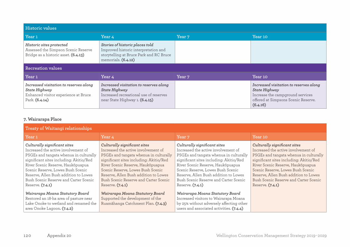
120 Wellington Conservation Management Strategy 2019-2029Appendix 20
Historic values
Year 1 Year 4 Year 7 Year 10
Historic sites protectedAssessed the Simpson Scenic Reserve Bridge as a historic asset. (6.4.13)
Stories of historic places toldImproved historic interpretation and storytelling at Bruce Park and RC Bruce memorials. (6.4.12)
Recreation values
Year 1 Year 4 Year 7 Year 10
Increased visitation to reserves along State Highway Enhanced visitor experience at Bruce Park. (6.4.14)
Increased visitation to reserves along State Highway Increased recreational use of reserves near State Highway 1. (6.4.15)
Increased visitation to reserves along State Highway Increase the campground services offered at Simpsons Scenic Reserve. (6.4.16)
7. Wairarapa Place
Treaty of Waitangi relationships
Year 1 Year 4 Year 7 Year 10
Culturally significant sites Increased the active involvement of PSGEs and tangata whenua in culturally significant sites including: Akitio/Red River Scenic Reserve, Haukōpuapua Scenic Reserve, Lowes Bush Scenic Reserve, Allen Bush addition to Lowes Bush Scenic Reserve and Carter Scenic Reserve. (7.4.1)
Wairarapa Moana Statutory BoardRestored an 18-ha area of pasture near Lake Onoke to wetland and renamed the area Onoke Lagoon. (7.4.2)
Culturally significant sites Increased the active involvement of PSGEs and tangata whenua in culturally significant sites including: Akitio/Red River Scenic Reserve, Haukōpuapua Scenic Reserve, Lowes Bush Scenic Reserve, Allen Bush addition to Lowes Bush Scenic Reserve and Carter Scenic Reserve. (7.4.1)
Wairarapa Moana Statutory BoardSupported the development of the Ruamāhanga Catchment Plan. (7.4.3)
Culturally significant sites Increased the active involvement of PSGEs and tangata whenua in culturally significant sites including: Akitio/Red River Scenic Reserve, Haukōpuapua Scenic Reserve, Lowes Bush Scenic Reserve, Allen Bush addition to Lowes Bush Scenic Reserve and Carter Scenic Reserve. (7.4.1)
Wairarapa Moana Statutory BoardIncreased visitors to Wairarapa Moana by 25% without adversely affecting other users and associated activities. (7.4.4)
Culturally significant sites Increased the active involvement of PSGEs and tangata whenua in culturally significant sites including: Akitio/Red River Scenic Reserve, Haukōpuapua Scenic Reserve, Lowes Bush Scenic Reserve, Allen Bush addition to Lowes Bush Scenic Reserve and Carter Scenic Reserve. (7.4.1)

121Wellington Conservation Management Strategy 2019-2029 Appendix 20
Natural values
Year 1 Year 4 Year 7 Year 10
Mountains to sea network expandedDeveloped a strategy to link remnant sites between Wairarapa Moana and Remutaka Forest Park. (7.4.5)
Landscape-scale predator control and restorationCommenced landscape-scale pest and wild animal control. (7.4.7)
Landscape-scale predator control and restorationUndertaken landscape-scale pest and wild animal control over 20% of Place. (7.4.8)
Mountains to sea network expandedCreated additional connections between Wairarapa Moana and Remutaka Forest Park. (7.4.6)
Landscape-scale predator control and restorationUndertaken landscape-scale pest and wild animal control over 40% of Place. (7.4.9)
Historic values
Year 1 Year 4 Year 7 Year 10
See the regional milestones in Section 3.5.
Recreation values
Year 1 Year 4 Year 7 Year 10
See the regional milestones in Section 3.5.
8. Coastal Dunes Place
Treaty of Waitangi relationships
Year 1 Year 4 Year 7 Year 10
Enhancing understanding of cultural valuesSupported development of a cultural materials plan for pīngao. (8.4.1)
Enhancing understanding of cultural valuesSupported development of a cultural materials plan for pīngao. (8.4.1)
Enhancing understanding of cultural valuesSupported development of a cultural materials plan for pīngao. (8.4.1)
Enhancing understanding of cultural valuesSupported development of a cultural materials plan for pīngao. (8.4.1)

122 Wellington Conservation Management Strategy 2019-2029Appendix 20
Natural values
Year 1 Year 4 Year 7 Year 10
Manawatū EstuaryMaintain and/or support pest management initiatives at Manawatū Estuary Ramsar site to protect resident and migratory bird populations. (8.4.4)
Manawatū EstuaryMaintain and/or support pest management initiatives at Manawatū Estuary Ramsar site to protect resident and migratory bird populations. (8.4.4)
Manawatū EstuaryMaintain and/or support pest management initiatives at Manawatū Estuary Ramsar site to protect resident and migratory bird populations. (8.4.4)
Healthier forest remnantsReduced populations of possums, stoats, rats and sambar deer within Omarupapako/Round Bush Scenic and Himatangi Bush Scenic Reserves. (8.4.2)
Enhanced wetland habitatsEnsured Lake Waiwiri is sufficiently healthy to support mahinga kai harvest. (8.4.3)
Manawatū EstuaryMaintain and/or support pest management initiatives at Manawatū Estuary Ramsar site to protect resident and migratory bird populations. (8.4.4)
Historic values
Year 1 Year 4 Year 7 Year 10
Historic sites protectedRe-evaluated the 1997 assessment11 of the value, significance and threats to historic places in the Coastal Dunes Place. (8.4.5)
Recreation values
Year 1 Year 4 Year 7 Year 10
Expand recreational opportunitiesImproved visitor facilities at Papaitonga to increase visitor numbers by 20%. (8.4.6)
11 McFadgen B. 1997: Archaeology of the Wellington Conservancy: Kāpiti-Horowhenua: a prehistoric and palaeoenvironmental study. Department of Conservation, Wellington. 43 p.

123Wellington Conservation Management Strategy 2019-2029 Appendix 20
9. Islands Place
Treaty of Waitangi relationships
Year 1 Year 4 Year 7 Year 10
KaitiakitangaJoint conservation management plan for Kāpiti Island approved. (9.4.1)
Tangata whenua values recognised and appreciatedErected pou whenua/cultural markers on Mana Island. (9.4.3)
KaitiakitangaSupported Ngāti Toa Rangātira in the vesting and gifting back of Kāpiti Island Nature Reserve and Mana Island Scientific Reserve. (9.4.2)
Natural values
Year 1 Year 4 Year 7 Year 10
Pest-free status sustainedKāpiti and Mana islands remain free of mammalian pests. (9.4.6)
Species abundance and diversitySupported introduction of white-faced petrels to Mana Island. (9.4.4)Increased genetic diversity of kōkako population on Kāpiti Island. (9.4.5)
Pest-free status sustainedKāpiti and Mana islands remain free of mammalian pests. (9.4.6)
Species abundance and diversityIncreased genetic diversity of kōkako population on Kāpiti Island. (9.4.5)
Pest-free status sustainedKāpiti and Mana islands remain free of mammalian pests. (9.4.6)
Species abundance and diversityIncreased genetic diversity of kōkako population on Kāpiti Island. (9.4.5)
Pest-free status sustainedKāpiti and Mana islands remain free of mammalian pests. (9.4.6)
Historic values
Year 1 Year 4 Year 7 Year 10
Sites protection and enhancementDeveloped conservation plan for Te Kahu-o-terangi Whaling Station. (9.4.7)
Sites protection and enhancementDeveloped heritage assessment and conservation plans for Mana Island lighthouse, woolshed and habitation sites. (9.4.8)
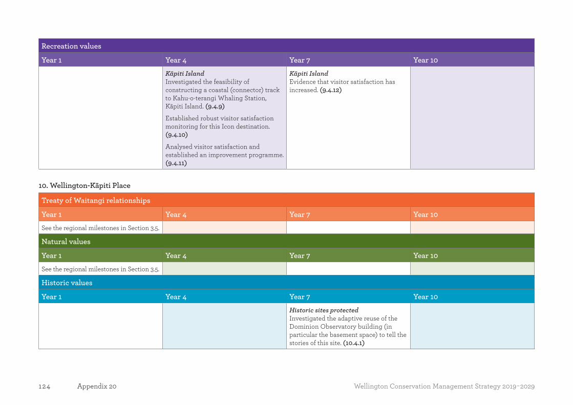
124 Wellington Conservation Management Strategy 2019-2029Appendix 20
Recreation values
Year 1 Year 4 Year 7 Year 10
Kāpiti IslandInvestigated the feasibility of constructing a coastal (connector) track to Kahu-o-terangi Whaling Station, Kāpiti Island. (9.4.9)
Established robust visitor satisfaction monitoring for this Icon destination. (9.4.10)
Analysed visitor satisfaction and established an improvement programme. (9.4.11)
Kāpiti IslandEvidence that visitor satisfaction has increased. (9.4.12)
10. Wellington-Kāpiti Place
Treaty of Waitangi relationships
Year 1 Year 4 Year 7 Year 10
See the regional milestones in Section 3.5.
Natural values
Year 1 Year 4 Year 7 Year 10
See the regional milestones in Section 3.5.
Historic values
Year 1 Year 4 Year 7 Year 10
Historic sites protectedInvestigated the adaptive reuse of the Dominion Observatory building (in particular the basement space) to tell the stories of this site. (10.4.1)
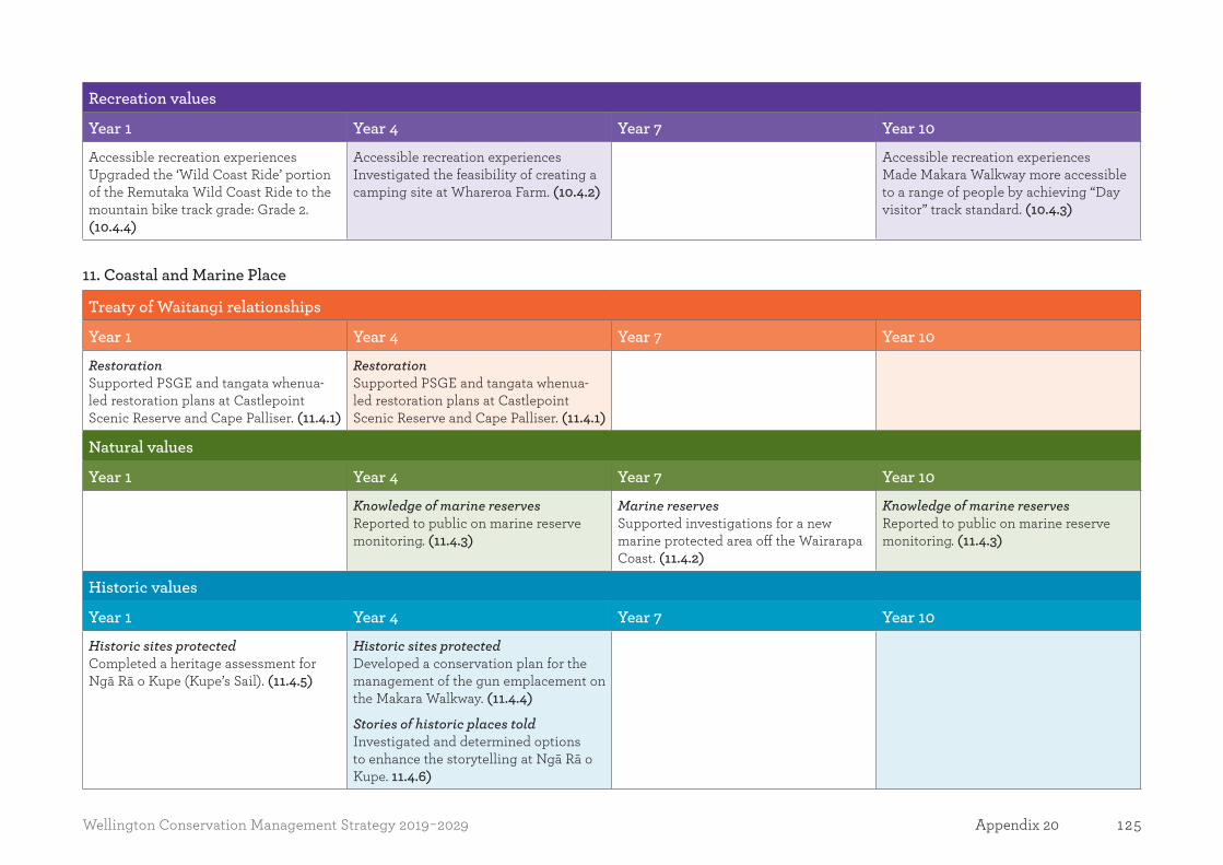
125Wellington Conservation Management Strategy 2019-2029 Appendix 20
Recreation values
Year 1 Year 4 Year 7 Year 10
Accessible recreation experiencesUpgraded the ‘Wild Coast Ride’ portion of the Remutaka Wild Coast Ride to the mountain bike track grade: Grade 2. (10.4.4)
Accessible recreation experiencesInvestigated the feasibility of creating a camping site at Whareroa Farm. (10.4.2)
Accessible recreation experiencesMade Makara Walkway more accessible to a range of people by achieving “Day visitor” track standard. (10.4.3)
11. Coastal and Marine Place
Treaty of Waitangi relationships
Year 1 Year 4 Year 7 Year 10
RestorationSupported PSGE and tangata whenua-led restoration plans at Castlepoint Scenic Reserve and Cape Palliser. (11.4.1)
RestorationSupported PSGE and tangata whenua-led restoration plans at Castlepoint Scenic Reserve and Cape Palliser. (11.4.1)
Natural values
Year 1 Year 4 Year 7 Year 10
Knowledge of marine reserves Reported to public on marine reserve monitoring. (11.4.3)
Marine reserves Supported investigations for a new marine protected area off the Wairarapa Coast. (11.4.2)
Knowledge of marine reserves Reported to public on marine reserve monitoring. (11.4.3)
Historic values
Year 1 Year 4 Year 7 Year 10
Historic sites protectedCompleted a heritage assessment for Ngā Rā o Kupe (Kupe’s Sail). (11.4.5)
Historic sites protectedDeveloped a conservation plan for the management of the gun emplacement on the Makara Walkway. (11.4.4)
Stories of historic places toldInvestigated and determined options to enhance the storytelling at Ngā Rā o Kupe. 11.4.6)
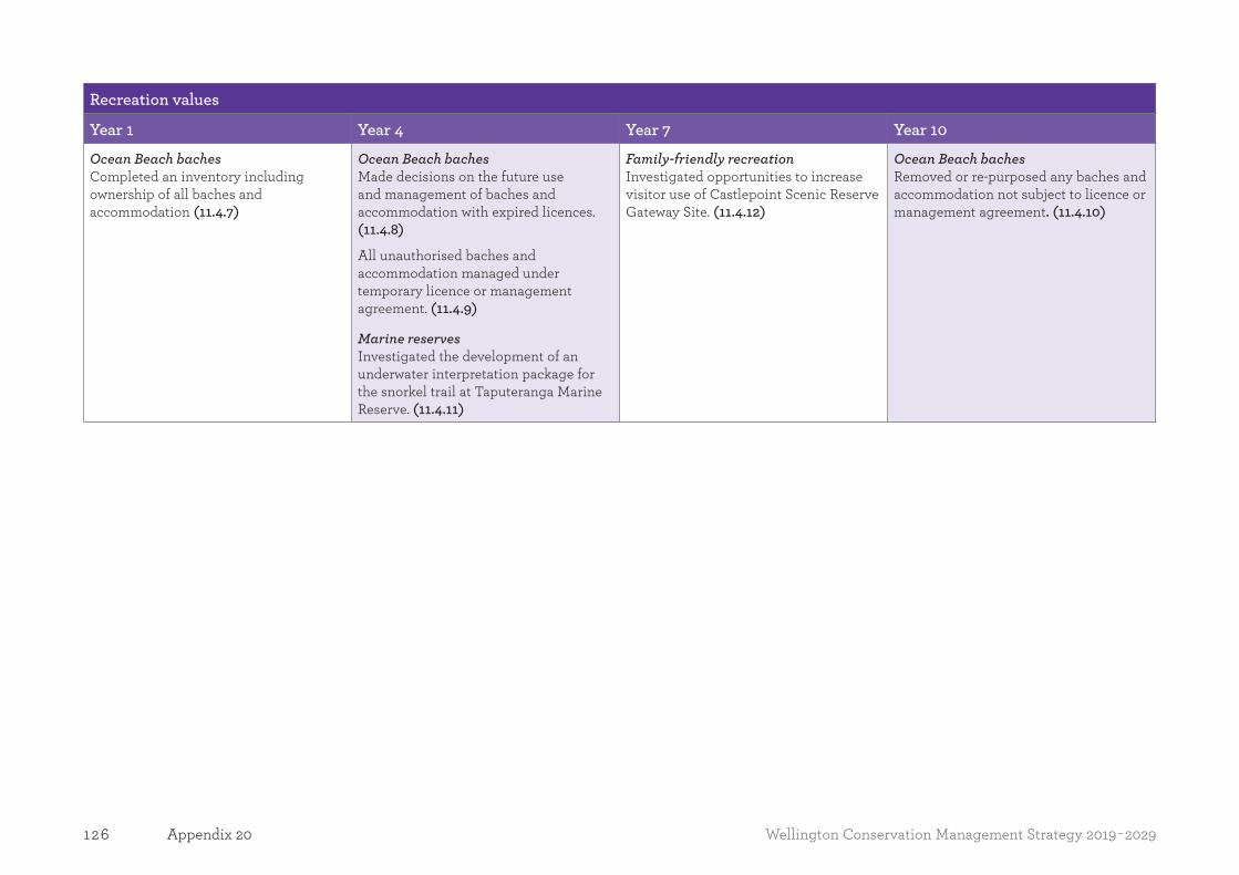
126 Wellington Conservation Management Strategy 2019-2029Appendix 20
Recreation values
Year 1 Year 4 Year 7 Year 10
Ocean Beach bachesCompleted an inventory including ownership of all baches and accommodation (11.4.7)
Ocean Beach bachesMade decisions on the future use and management of baches and accommodation with expired licences. (11.4.8)
All unauthorised baches and accommodation managed under temporary licence or management agreement. (11.4.9)
Marine reservesInvestigated the development of an underwater interpretation package for the snorkel trail at Taputeranga Marine Reserve. (11.4.11)
Family-friendly recreationInvestigated opportunities to increase visitor use of Castlepoint Scenic Reserve Gateway Site. (11.4.12)
Ocean Beach bachesRemoved or re-purposed any baches and accommodation not subject to licence or management agreement. (11.4.10)