Wellhead Protection areas What is a Wellhead Protection Area
Upload
vuongxuyenCategory
view
215download
2
Wellhead Protection
Plan
Public Water Supply District #3
May 2010

Table of Contents
Guidelines for Developing a Source Water Protection Plan ……………………………...3
Introduction ……………………………………………………………………………….6
Plan Objective …………………………………………………………………………….6
System Overview …………………………………………………………………………6
Implementation Strategy ………………………………………………………………….7
Wellhead Protection Committee Members ……………………………………………….7
Delineation Area ………………………………………………………………………….7
Delineation Area Maps ……………………………………………………………………8
Inventory …………………………………………………………………………………12
Susceptibility Determination …………………………………………………………….14
Management Strategies …………………………………………………………………..19
Emergency Plan ………………………………………………………………………….20
Recommendations ………………………………………………………………………..23
2008 Consumer Confidence Report ……………………………………………………...24
Table 1 – Sources of Ground Water Contamination ……………………………………..27
Table 2 – Potentially Harmful Components of Common (Household) Products ……………….28

Department of Natural Resources
Public Drinking Water Branch
Guidelines for Developing a Source Water Protection Plan
General Information
Small Water System or Name: Public Water Supply District No. 3
System or Mailing Address: 106 SE 421 Road
Warrensburg, MO 64093
PWSID #: 1024311
Phone: (660)-429-2494
Primary Contact: David Streeter, General Manager
Phone Numbers: 441-7428 (cell) 816-835-7220 (home) (Person responsible for water quality) Directions to your location: Approximately 4 miles east of the town of Warrensburg,
MO on DD Hwy. Turn right on SE 421 Road and immediately turn right at the
next driveway.
Source/ Plan/ Funding Information
Source New or Existing? Existing
Source Type: Ground
Plan Original or Update: Update
Funding Sources for Plan Development: Internal
Background Information
What was the land used for before the establishment of the system? Residential
and Farmland
How is the water used? Residential
Number of wells or springs: 3 Wells
Approximate year drilled: #1 well 1970 #2 well 1973 #3 well 2003
Driller’s names: Wells number 1 and 2 were drilled by John Beckett Drilling, and
Well number 3 was drilled by Harper Drilling Company
Depth of each well: #1 well – 600 feet, #2 well – 710 feet, #3 well – 1300 feet
List of Parameters that may be pertinent to understanding raw water quality:
Roubidoux Aquifer
Assess elements of the raw water source’s quantity and quality: Roubidoux Aquifer
Treatment: Chlorine is added when water is pumped from the wells.
Determination if current treatment is sufficient to handle characteristics of raw water:
Acceptable

Is the overall treatment applied to the raw water sufficient to maintain finished water
drinking water quality standards? Acceptable
Watershed or Wellhead Area Delineation and Inventory
Description of the geology of the identified protection area: Limestone
What method was used to delineate the area: Tape
Are maps of the delineated area included with the submitted document? Yes, maps
included
Total Lake Surface and protection area in acres: See delineation map.
Number of Ponds, Lakes, Rivers, Streams and Wells: 1 Pond, 1 Wet Weather
Creek, 2 Lagoon Systems, 3 Wells that are still in use
Was the geological survey and resource assessment division contacted to share global
positioning information? Used website for information.
Types of agricultural practices within protection area: Livestock and Row Crop
Security Issues: Currently we have no external lighting around the critical components of
the water system. We plan to put up external lights. Hickory Hills has a
neighborhood watch but currently PWSD #3 is not involved.
We should talk to the director of the neighborhood watch program to get involved.
Total number of acres of each: Cropland, Grassland, and Woodland etc. within the source
water protection area: See delineation map for buffer zone.
Description and location of wastewater treatment facility discharge if it is within the
protection area: 2 Wastewater Lagoon Systems in Hickory Hills located ½
to 1 mile from #1 and #2 Wells. The South Lagoon is located in Zone 2 and the
North Lagoon is located in Zone 3 of the Wellhead Protection Area.
Any concentrated animal feed operations? None
List of potential or actual contaminant sites in the protection area: See Contaminant
Inventory List on Pages 12 and 13
Description of the associated risk and potential impact of listed contaminants in the
protection area: See Contaminant Inventory List on Pages 12 and 13
How will the plan be updated with information pertaining to the resolution of risks from
listed contaminant sources? The Wellhead Protection Plan will be updated on
an annual basis.
Source Water Protection Management Plan Information
Description of implementation practices planned to contain, eliminate or reduce the risks
of contamination: Educational material such as Brochures and Newsletters
dedicated to Wellhead Protection will be distributed to property owners
throughout the Wellhead Protection Area to educate the public on how to properly
dispose hazardous chemicals. We have also posted signs in the Wellhead
Protection Area to remind people not to dump harmful contaminants.
For more information see Management Strategies on Page 20

Very specific information including plan of action for managing contamination:
See Emergency Plan on Pages 21 - 23
A chronological listing or mention of when implementation of management practices will
be utilized: See Management Strategies on Page 20
Description of measures taken to meet finished water standards: Chlorine added and
detention time in Clearwell
Is protection plan mentioned in the annual Consumer Confidence Report published by the
supply? Yes
How will the information that you gained in the writing of the plan be used to manage
these sites in the future? This plan is intended to educate the customers of
PWSD #3 on ways they could help protect our public drinking water facility via
discussion with Wellhead Protection Committee members, newsletters, and
brochures. The more we educate the public about harmful products the more aware
they become of what they are putting in the environment.
What method of surveillance will be used to document changes in the source water
protection area, and how frequently will these be completed? We intend on
contacting the Hickory Hills Neighborhood Watch to get involved. The facility
will also be surveyed on a daily basis by PWSD #3 maintenance technicians.
Indicate how often and by what method the plan will be reviewed and updated:
Each year the Wellhead Protection Committee will look over the plan and make
necessary updates.
List how the public will be involved in the project’s future: Education material pertaining
to Wellhead Protection will continue to be mailed to PWSD #3 customers and
companies that have been identified as potential contaminants. We have also
encourage local business owners and property owners within the Wellhead
Protection Area to get involved in creating the Wellhead Protection Plan.
Wellhead Protection Plan Missouri
Missouri Rural Water Association
Introduction
The purpose of the Wellhead Protection Plan is to protect the drinking water source for Public
Water Supply District No. 3. Our Wellhead Protection Area consists of mostly residential home
owners and a few local businesses. The key to a successful Wellhead Protection Plan is
communication. Educating our customers on ways they could help protect our public drinking
water facility is the only way to help keep the public drinking water from being contaminated.
Our Wellhead Protection Committee is a team of individuals committed to doing everything we
can to protect our public drinking water. The committee is made up of PWSD #3 staff, local
business owners, PWSD #3 customers and concerned citizens. Brochures and Newsletters
pertaining to Wellhead Protection will be distributed throughout the District to educate and
inform the customers of Public Water Supply District No. 3. These brochures and newsletters
will also be available at our office.
Plan Objective
The objective of the Wellhead Protection Plan is to protect the health and well being of all Public
Water Supply District No. 3 customers. Information and education on ways to keep our public
drinking water from being contaminated is a great way to protect both public health and the
environment. Discussing this plan and distributing newsletters and brochures will inform the
public of the situation and the negative effect dumping toxic chemicals has on our water supply.
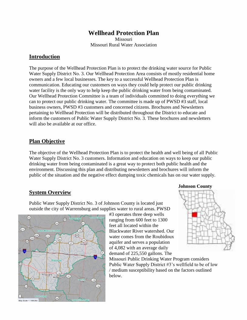
Johnson County
System Overview
Public Water Supply District No. 3 of Johnson County is located just
outside the city of Warrensburg and supplies water to rural areas. PWSD
#3 operates three deep wells
ranging from 600 feet to 1300
feet all located within the
Blackwater River watershed. Our
water comes from the Roubidoux
aquifer and serves a population
of 4,082 with an average daily
demand of 225,550 gallons. The
Missouri Public Drinking Water Program considers
Public Water Supply District #3’s wellfield to be of low
/ medium susceptibility based on the factors outlined
below.

Public Water Supply District #3’s source type is strictly ground water which is considered low
susceptibility to contamination. We are also located in a low susceptible aquifer because it is
more than 100 feet deep. All three of our wells are more than 100 feet deep so chemicals that
could potentially seep into the ground are still highly unlikely to contaminate the public drinking
water. Within the wellhead protection area, the land use is characterized by mainly rural areas.
There have been no known positive tests for Volatile Organic Chemicals (VOC), Synthetic
Organic Chemicals (SOC), Inorganic Chemicals (IOC), or ―nitrate‖ that was at or above ½ the
MCL. Major highways that are located within the PWSD #3 wellhead protection area would be
DD Hwy. 13 Hwy, Y Hwy, and PP Hwy are just outside of our wellhead protection area but
could still be of concern. Public Water Supply District No. 3 is in compliance with all state and
federal drinking water regulations.
Implementation Strategy
Public Water Supply District No. 3’s Wellhead Protection Committee will meet with local
landowners, local business owners, City / County officials, and customer of PWSD #3 to discuss
actions that could be taken to protect our public drinking water supply. Brochures and
Newsletters with information on ways people can help protect the Wellhead Protection Area will
be distributed to homes and businesses located within the Wellhead Protection Area.
Wellhead Protection Committee
Below is a list of people who participated and helped PWSD #3 create and execute a Wellhead
Protection Plan. This committee will meet on an annual basis to review and make necessary
updates to the Wellhead Protection Plan. Team members include:
Angie Sanders – Project Clerk – PWSD #3
Trudy Tate – Project Clerk – PWSD #3
David Streeter – General Manager – PWSD #3
Reggie Nelson – District Clerk – PWSD #3
For more information on PWSD #3’s Wellhead Protection Committee please contact:
Public Water Supply District No. 3
Angie Sanders
106 SE 421 Rd
Warrensburg, MO 64093
660-429-2494
Delineation
Public Water Supply District No. 3 has chosen a one mile fixed radius as the wellhead protection
zone. We have also included businesses or home owners that are outside of the zone but may be
of concern such as Allied Waste and many more.


Inventory
An inventory was conducted by the Wellhead Protection Committee via the University of
Missouri CARES system, on-site verification and discussion. Taking an inventory of potential
risks within our Wellhead Protection Area will help to identify and monitor these sites for
potential contaminations. This inventory will consist of substances that could potentially
contaminate the source water such as synthetic organic chemicals, volatile organic chemicals,
fuel, oils, pesticides, nutrients, animal or human waste, etc.
The most likely threats to Public Water Supply District No. 3’s source water supply would be
chemicals such as fertilizers and pesticides that are applied to the agriculture surrounding our
wells. Below is a list of other potential contaminant threats.
CONTAMINANT INVENTORY NAME (cont. i.d.) LOCATION TYPE CONTACT THREAT
Show-Me Sanitary
Landfill
230 South 421 Rd.
Warrensburg, MO 64093
Zones 3 & 4
Solid Waste Landfill Allied Waste Industries.
Inc.
660-7474-7697
Groundwater
contamination
Union Pacific Railroad Runs east – west through
Wells 1 & 2
Zone 4
Railroad 1-888-877-7267 Surface spills of
petroleum and
hazardous substances
St. Louis Southwestern
Railroad – Missouri
Central Railroad
Company
Runs east – west though
southern part of PWSD #3
Zone 4
Railroad Jordan Buck, Missouri
Central Railroad Comp.
618-667-9803 or
AmerenUE
800-552-7583
Surface spills of
petroleum and
hazardous substances
LaFarge Cement 247 NE Division
Warrensburg, MO 64093
Zone 4
Cement (ready-mix)
plant
1-816-257-4040 Surface spills of
petroleum and
hazardous substances
Whiteman Air Force
Base
Knob Noster, MO
Zone 4
Store and Gas Station,
Private wells, etc.
Public Affairs office at
660-687-6126
Petroleum spills,
above ground storage
tanks and potential
conduit for
contaminants
Public Water Supply
District No. 3
SE 421 Rd. & Sycamore Rd.
Zone 2
Lagoon System PWSD #3 Biological
contaminants
Public Water Supply
District No. 3
106 SE 421 Rd.
Zone 3
Lagoon System PWSD #3 Biological
contaminants
State Park Village Sewer 101 SE 591 Rd.
Zone 4
Sewage Treatment Plant Lisa Simpson
660-747-9900
Biological
contaminants
DD Express 101 SE 421 Rd.
Zone 3
Store and Gas Station 660-429-6684 Petroleum spills,
above ground storage
tanks
Landshire Foods, Inc. 97 SE 341 Rd.
Zone 4
Food Processor
Food & Beverage
Manufacturer
660-747-2999
800-468-3354
State Highway 13 Project To run north – south on west
side of wells 1 & 2
Zone 4
State Highway MoDOT
1-888-275-6636
Surface spills of
petroleum and
hazardous substances
due to close
proximity to wells

Agriculture Near well #’s 1, 2, & 3
Zone
Row crop farming and
pasture land
Private land
owners/farmers
Herbicides,
pesticides, fertilizers,
nutrients impacting
shallow groundwater.
Private wells Near well #’s 1, 2, & 3 Private wells Private landowners Potential conduit for
contaminants
Miscellaneous above
ground storage tanks
Above ground storage
tanks containing
petroleum
Surface spills of
petroleum
Adams Memorial
Cemetery
SE 521 Rd.
Zone 4
Sutton Cemetery SE 301 Rd.
Zone 4
Greer Cemetery SE PP Hwy & SE 371 Rd.
Zone 4
Mt. Zion Cemetery 13 Hwy & SW 600 Rd.
Zone 4
Mineral Creek Cemetery 2 Hwy
Zone 4
Other contaminant risks not specifically identified in the above table, but believed to be present
near, or within the WPA include the following:
Septic systems: potential for leakage of biological contaminants to the groundwater.
Active or abandoned private wells and cisterns: potential conduit for contaminants to
impact groundwater.

Public Water Supply District #3 Production Date: April 2010
PWSS No. 1024311
Susceptibility Determination
3 Wells
Missouri Department of
Natural Resources
Although all data in this data set have been used by the Missouri Department of Natural Resources
(MoDNR), no warranty, expressed or implied, is made by the MoDNR as to the accuracy of the data
and related materials. The act of distribution shall not constitute any such warranty, and no
responsibility is assumed by the MoDNR in the use of these data or related materials. This report is
subject to change as additional information is acquired.
The Missouri Department of Natural Resources (MoDNR)
has assembled this information on the accompanying pages
in order to assess the susceptibility of the drinking water
source to contamination. MoDNR makes no claim that this
information is 100% accurate. There are many unforeseen
and unpredictable factors that may cause a source to be
contaminated. The overall susceptibility of the water system
is equal to the highest susceptibility achieved in any category
of the table below. A susceptible water source is still capable
of providing safe drinking water. MoDNR routinely
monitors all public supplies to ensure public health is
protected. Public water systems and local communities are
encouraged to take all measures possible to reduce the
susceptibility of their drinking water source. For more
information call 1-800-334-6946.
Not
Susceptible
Moderately
Susceptible
Highly
Susceptible
No
Data
A system is highly susceptible because of construction
deficiencies if:
A well was not constructed according to plans approved by
PDWP
X
A well was not cased to a depth approved by DNR X
A well casing is not of sufficient weight X
A well is not sufficiently sealed (grouted) around the casing,
or A well has developed holes in the casing or other flaws
that compromise its integrity.
X
A system is highly susceptible due to direct influence of
surface water if:
A well has tested positive for surface water indicators such
as algae or high turbidity
X
A system is highly susceptible to surface contaminants if:
A well casing does not extend 12 inches above the wellhouse
floor, or 18 inches above the ground surface
X
A well casing does not extend four feet above the 100-year
flood level, or four feet above the highest known flood
elevation
X
A well is not provided with a property screened vent X
All openings in a well casing are not properly sealed X
A system is highly susceptible based on detection

histories if:
Volatile Organic Chemicals (VOCs) have been detected in a
well
X
Synthetic Organic Chemicals (SOCs) have been detected in a
well
X
Inorganic Chemicals (IOCs) have been detected in a well
above naturally occurring level
X
Nitrates have been detected at or above one-half the MCL X
Bacteria has been consistently detected in a well X
Viruses or microbiological contaminants are detected in a
well
X
A system is highly susceptible to weather vandalism, and
sabotage if:
A well is not in a locked well house of adequate construction X
A system is moderately susceptible due to local geology if:
A producing aquifer is less than 100 feet below the surface X
A producing aquifer has conduit flow conditions due to
surficial karst topography
X
A producing aquifer is not overlain by an impermeable
confining layer
X
A producing aquifer is overlain by a conductive (>5X 10e-4)
formation (including soil)
X
A producing aquifer is confined, but there are open wells
nearby penetrating that layer
X
A system is moderately susceptible to contaminants if:
Any contaminants listed in Appendix F-a are found in the
source water area
Septic systems are present in the source water area X
A well is indirectly connected to a surface water body X
A submersible well pump cannot be ruled out from
containing PCBs or PAHs
X
There is a high density of transportation corridors in the
source water area
X
A system is highly susceptible to contamination if :
Any contaminant sites identified in the source water area are
known to have contaminated groundwater that may migrate
toward a well.
X
For more information contact the Missouri Department of Natural Resources at
www.dnr.mo.gov. The Source Water Assessment Plan may be found by visiting the Department
of Natural Resources Web site at http://drinkingwater.missouri.edu/swap/index.html.


Management Strategies
Once the risks and threats have been identified the next step would be to establish an effective
Wellhead Protect Plan to prevent or reduce/eliminate potential contaminations. To achieve this
objective we must perform the following tasks.
1) Public Water Supply District No. 3’s Wellhead Committee will submit the Wellhead
Protection Plan to the Missouri Department of Natural Resources for their review. This
plan will be submitted in 2010.
2) The Committee will routinely observe activities within the Wellhead Protection Area and
report all pertinent information to the Missouri Department of Natural Resources, Public
Drinking Water Branch. This will be done on a daily basis.
3) The Wellhead Committee will contact representatives of Show-Me Landfill, Union
Pacific Railroad, Missouri Central Railroad Company, LaFarge Cement, Whiteman Air
Force Base, State Park Village Sewer, DD Express, Landshire Foods, Missouri Dept of
Transportation, Adams Memorial Cemetery, Sutton Cemetery, Greer Cemetery, Mt. Zion
Cemetery, and Mineral Creek Cemetery to present and discuss our approved Wellhead
Protection Plan and strategies to prevent contaminants from entering the groundwater
source. To be completed once our Wellhead Protection Plan has been approved by
Missouri Department of Natural Resources.
4) The Committee will review and update the potential contaminant source inventory with
any significant changes within the Wellhead Protection Area. To be completed in 2010
once our Wellhead Protection Plan has been approved and continued annually.
5) In addition to updating the inventory list, the Committee will also make necessary
changes to the Wellhead Protection Plan. To be completed in 2010 once our Wellhead
Protection Plan has been approved and continued annually.
6) The District will create newsletters and brochures to educate the customers of PWSD #3
about Wellhead Protection. This task is to be completed in 2010.
7) The Committee will help land owners that have abandoned wells apply for funding to
plug their abandoned wells. This funding opportunity is mentioned in our Wellhead
Protection brochures and newsletters. This task is to be completed as necessary.
8) The District will not store chemicals (other than water treatment chemicals) or allow
chemicals to be stored on property owned by the District within 300 ft. of the Wellhead
Protection Area. This task will be done on a daily basis.
9) The District will not apply chemicals on property owned by the District within 100 ft. of
their sources. The property has signs posted that read: ―Wellhead Protection Area – No
Chemicals To Be Applied‖. This task will be done on a daily basis.
10) PWSD #3 has contingency arrangements as follows: The District has an emergency
interconnect agreement with the Town of Leeton. If an emergency were to occur near our
water sources we would still be able to supply water to the customers of PWSD #3. This
will be done on an as needed basis.
11) PWSD #3 staff will continuously monitor for any potential problems or contaminants.
This will be done on a daily basis.

Emergency Plan
In the event of a spill or contamination Public Water Supply District No. 3 will contact the
appropriate authorities listed in the Emergency Plan. Listed below are Emergency Contacts that
should be called to assist in the event of a major disaster and PWSD #3’s guidelines to follow
during an emergency.
Johnson County Ambulance Service: 911
Warrensburg Fire Department: 660-747-9136
Knob Noster Fire Department: 660-747-2233
Johnson County Fire District: 660-747-5220
Warrensburg Police Department: 660-747-9133
Police Department Dispatch Office: 660-747-2211
Johnson County Sheriff Department: 660-747-5511
Missouri Highway Patrol:
Local: 660-584-5577
Central Office: 573-751-3313
Missouri Department of Transportation:
Local: 816-622-6500
Central Office: 1-888-275-6636
Missouri Department of Natural Resources:
Jefferson City: 573-751-3443
Kansas City Regional Office: 816-622-7000
Emergencies: 573-634-2436
CHEMTREC: 1-800-424-9300
State of Missouri State Emergency Management
Agency (SEMA): 573-526-9100 during business hours
573-751-2748 all other times
Missouri Emergency Response Commission:
(MERC): 573-526-9239
Johnson County Local Emergency:
Planning Committee (LEPC): 660-747-2666.
Emergencies: 660-441-0297
U.S. Food and Drug Administration (FDA):
Poison Control Center: 1-800-222-1222

Neighboring Water Systems:
PWSD #1 (Warrensburg): 429-2231
PWSD #2 (Holden): 816-732-6658
MO-AWC (Warrensburg): 747-3191
Knob Noster Water (Knob Noster): 563-2595
Leeton Water (Leeton): 653-4622
Lafayette #2 (Higginsville): 660-584-2344
Missouri Rural Water Association:
Mike Hollis: 573-996-8814
Joe Anstine: 660-653-2360
Tom Hyatt: 573-783-1745
Billy Everett: 417-455-6275
Emergency Response Plans – For Contamination of Source
1. Notify the Following:
a. Media
b. Customers
c. SEMA: 573-526-9100
573-751-2748
d. Johnson County Local Emergency Planning Committee: 660-747-2666.
2. Shut down the wells.
3. Valve off storage tank.
4. Arrange for water testing.
5. Determine extent of contamination.
6. Provide safe water to customers.
7. Stay in contact with regulatory agency until contamination has been stopped.
8. When contamination of source is abated:
a. Restore plant to service
b. Flush system, if necessary, and restore it to service.
9. Notify the media, customers, SEMA, and Missouri DNR to let them know service has
been restored.

Emergency Response Plans – For Contamination of System
1. Notify the Following:
a. Media
b. Customers
c. SEMA: 573-526-9100
573-751-2748
d. Johnson County Local Emergency Planning Committee: 660-747-2666.
2. Shut down the treatment plant, if necessary to prevent spread of contamination.
3. Provide safe water to customers.
4. Valve off uncontaminated tanks.
5. Flush out affected portion of system.
6. Arrange for water analyses.
7. Stay in contact with regulatory agency until contamination is eliminated.
8. Restore system to full service.
9. Notify the media, customers, SEMA, and Missouri DNR to let them know service has
been restored.
Emergency Response Plans – For Chlorine Release – Minor Leak
In case of minor chlorine leak, immediately contact the local fire department hazardous
chemical unit.
Emergency Response Plans – For Chlorine Release – Major Leak
In case of a major leak, immediately contact the local fire department hazardous chemical
unit. The Sheriff’s department will evacuate the public downwind of the leak.
Notify the following:
SEMA: 573-526-9100
573-751-2748
Missouri Department of Natural Resources
Environmental Emergency Responses: 573-634-2436
Emergency Response Plans – For a Hazardous Materials Spill
If a hazardous material spill contaminates the raw water source, the water treatment plant
will be shut down. The above ground storage will be utilized until the water is safe to treat. If
this requires more time than the above ground storage tank can provide, the emergency
response plan for contamination of source will be put into effect.
If a hazardous material spill contaminates the distribution system, the possibly
contaminated part of the system will be valved off and tested. If contaminated, the
emergency response plan for contamination of system will be put into effect.

Recommendations
Public Water Supply District No. 3’s Wellhead Protection Committee would like to
encourage everyone to become involved in protecting our public drinking water. The best
way to help protect your water supply is to do it yourself through local community
involvement. Becoming a member of your local Public Water Supply Wellhead Protection
team enables you to protect the ground water you, your family, and your neighbors drink.
Protecting our source water today is the most effective way to guarantee safe drinking water
for future generations. By performing the actions that have been identified in this plan we
should be able to achieve our objectives.
Wellhead Protection Committee Signatures
Angie Sanders
PWSD #3 Project Clerk
Trudy Tate
PWSD #3 Project Clerk
David Streeter
PWSD #3 General Manager
Reggie Nelson
PWSD #3 District Clerk
2009
Annual Water Quality Report (Consumer Confidence Report)
Public Water Supply District No. 3
of Johnson County
106 SE 421 Rd Warrensburg, MO
64093
MO1024311
What is an Annual Water Quality Report?
The State of Missouri and the U.S. Environmental Protection Agency requires all Public Water
Supplies to send out a Consumer Confidence Report (CCR) to describe the quality of the water
people are consuming. The guiding principle behind CCRs is that all people have the right to
know what is in their drinking water and where it comes from. The CCR provides an opportunity
for water suppliers to educate consumers about the sources and quality of their drinking water. In
compliance with the Safe Drinking Water Act, Public Water Supply District No. 3 is delivering
this CCR to all its customers. We ask that landlords, employers, and anyone else who
receives the water bill for other water users to share this report with them. Additional
copies of this report are available by contacting our office at 660-429-2494. This report is
intended to provide you with important information about your drinking water and the efforts
made to provide safe drinking water. It includes basic information on the source(s) of water, the
levels of any contaminants detected in the water, and compliance with other drinking water rules,
as well as some brief educational material.

What is the Source of my Water?
The sources of drinking water (both tap water and bottled water) include rivers, lakes, streams,
ponds, reservoirs, springs, and groundwater wells. As water travels over the surface of the land
or through the ground, it dissolves naturally-occurring minerals and, in some cases, radioactive
material, and can pickup substances resulting from the presence of animals or from human
activity.
Public Water Supply District No. 3 draws groundwater from an aquifer though 3 deep wells.
Source Water Assessment
The Department of Natural Resources conducted a source water assessment to determine the
susceptibility of our water source to potential contaminants. This process involved the
establishment of source water area delineations for each well or surface water intake and then a
contaminant inventory was performed within those delineated areas to assess potential threats to
each source. Assessment maps and summary information sheets are available on the internet at
http://maproom.missouri.edu/swipmaps/pwssid.htm. To access the maps for your water system
you will need the State-assigned identification code, which is printed at the beginning of this
report. The Source Water Inventory Project maps and information sheets provide a foundation
upon which a more comprehensive source water protection plan can be developed.
Is our Water System Meeting other Rules that Govern our
Operations?
The Missouri Department of Natural Resources regulates our water system and requires us to test
our water on a regular basis to ensure it’s safety. Our system has been assigned the identification
number MO1024311 for the purposes of tracking our test results. Last year, we tested for a
variety of contaminants. The detectable results of these tests are on the following pages of this
report. Any violations of state requirements or standards will be further explained later in this
report.
SOURCE NAME TYPE
Well #1 North Ground Water
Well # 2 South Ground Water
Well # 3 Ground Water

Why are there Contaminants in my Water?
Drinking water, including bottled water, may reasonably be expected to contain at least small
amounts of some contaminants. The presence of contaminants does not necessarily indicate that
water poses a health risk. More information about contaminants and potential health effects can
be obtained by calling the Environmental Protection Agency’s Safe Drinking Water Hotline
(800-426-4791).
Contaminants that may be present in source water include:
A. Microbial contaminants, such as viruses and bacteria, which may come from sewage
treatment plants, septic systems, agricultural livestock operations, and wildlife.
B. Inorganic contaminants, such as salts and metals, which can be naturally-occurring or result
from urban stormwater runoff, industrial, or domestic wastewater discharges, oil and gas
production, mining, or farming.
C. Pesticides and herbicides, which may come from a variety of sources such as agriculture,
urban stormwater runoff, and residential uses.
D. Organic chemical contaminants, including synthetic and volatile organic chemicals, which
are by-products of industrial processes and petroleum production, and can also come from gas
stations, urban stormwater runoff, and septic systems.
E. Radioactive contaminants, which can be naturally-occurring or be the result of oil and gas
production and mining activities.
In order to ensure that tap water is safe to drink, the Department of Natural Resources
prescribes regulations which limit the amount of certain contaminants in water provided by
public water systems. Department of Health regulations establish limits for contaminants in
bottled water which must provide the same protection for public health.
How Might I Become Actively Involved?
If you would like to observe the decision-making process that affect drinking water quality,
please attend our regularly scheduled meetings. They are held on the 3rd Tuesday of each
month, at our office in Hickory Hills subdivision at 5:30 P.M. If you have any further questions,
please call David Streeter at 660-429-2494.
Do I Need to Take Any Special Precautions?
Some people may be more vulnerable to contaminants in drinking water than the general
population. Immuno-compromised persons such as persons with cancer undergoing
chemotherapy, persons who have undergone organ trans-plants, people with HIV/AIDS or other
immune system disorders, some elderly, and infants can be particularly at risk from infections.
These people should seek advice about drinking water from their health care providers.
EPA/CDC guidelines on appropriate means to lessen the risk of infection by Cryptosporidium
and other microbial contaminants are available from the Safe Drinking Water Hotline (800-426-
4791).

Contaminants Report
Public Water Supply District No. 3 is pleased to report that all state and federal drinking water
requirements have been followed. Below is a list of substances that were detected in our drinking
water. All of the substances found in our water are under the Maximum Contaminant Level
(MCL) set by the Environmental Protection Agency.
Lead and Copper Date 90
TH Percentile Range Unit AL Sites
Over AL
Typical Source
Copper 2008—2010 0.205 0.0226—0.231 ppm 1.3 0 Corrosion of household plumbing
systems
Lead 2008—2010 2.63 1.05—5.91 ppb 15 0 Corrosion of household plumbing
systems
Disinfection By
Products
Monitoring
Period
RAA Range Unit MCL MCLG Typical Source
TTHM 2005—2007 3.76 3.76 ppb 80 0 By-product of drinking water
chlorination
Regulated
Contaminants
Collection
Date
Highest Value Range Unit MCL MCLG Typical Source
Barium 5/20/2008 0.106 0.0693—0.106 ppm 2 2 Discharge of drilling wastes;
Discharge from metal refineries;
Erosion of natural deposits
Fluoride 5/20/2008 0.68 0.63—0.68 ppm 4 4 Natural deposits; Water additive
which promotes strong teeth.
Regulated Contaminants
Radionuclides Collection Date Highest Value Range Unit MCL MCLG Typical Source
Combined Radium (-226 & -228) 3/7/2007 1.6 1.1—1.6 pCi/l 5 Erosion of natural deposits
Gross Alpha Particle Activity 3/7/2007 6 5.3—6 pCi/l Erosion of natural deposits
Radium—226 3/7/2007 1.6 1.1—1.6 pCi/l 5 0

Optional Monitoring (not required by EPA) Optional Contaminants
Secondary Contaminants Collection Date Highest Value Range Unit MCL MCLG Typical Source
Alkalinity, CACO3 Stability 5/20/2008 262 235—262 MG/L
Alkalinity, Total 5/25/2005 214 208—214 MG/L
Calcium 5/19/2008 47.6 44.6—47.6 MG/L
Chloride 5/20/2008 44.5 38.3—44.5 MG/L 250
Hardness, Carbonate 5/19/2008 210 199—210 MG/L
Iron 5/20/2008 0.17 0.05—0.17 MG/L 0.3
Magnesium 5/19/2008 22.1 21.3—22.1 MG/L
Manganese 5/20/2008 0.00342 0.00163—0.00342 MG/L 0.05
PH 5/19/2008 7.58 7.32—7.58 PH 8.5
Potassium 5/20/2008 5.01 4.12—5.01 MG/L
Sodium 5/20/2008 37.2 34.2—37.2 MG/L 20
Sulfate 5/19/2008 30.5 22.5—30.5 MG/L 250
TDS 5/19/2008 319 313—319 MG/L 500
Zinc 5/19/2008 0.0231 0.0231 MG/L 5
Abbreviations
PPB: parts per billion or micrograms per liter.
PPM: parts per million or milligrams per liter.
N/A: not applicable
NTU: Nephelometric Turbidity Unit, used to measure cloudiness in drinking water.
MFL: million fibers per liter, used to measure asbestos concentration.
ND: not detectable at testing limits.
The state has reduced monitoring requirements for certain contaminants to less often than once
per year because the concentrations of these contaminants are not expected to vary significantly
from year to year. Records with a sample year more than one year old are still considered
representative.

Definitions
MCLG: Maximum Contaminant Level Goal, or the level of a contaminant in drinking water
below which there is no known or expected risk to health. MCLGs allow for a margin of safety.
MCL: Maximum Contaminant Level, or the highest level of a contaminant that is allowed in
drinking water. MCLs are set as close to the MCLGs as feasible using the best available
treatment technology.
AL: Action Level, or the concentration of a contaminant which, when exceeded, triggers
treatment or other requirements which a water system must follow.
TT: Treatment Technique, or a required process intended to reduce the level of a contaminant in
drinking water.
90th Percentile: For Lead and Copper testing. 10% of test results are above this level and 90%
are below this level.
Level Found: is the average of all test results for a particular contaminant.
Range of Detections: Shows the lowest and highest levels found during a testing period, if only
one sample was taken, then this number equals the Level Found.
MRLDG: Maximum Residual Disinfectant Level Goal, or the level of a drinking water
disinfectant below which there is no known or expected risk to health.
MRDL: Maximum Residual Disinfectant Level, or the highest level of a disinfectant allowed in
drinking water.
RAA: Running Annual Average, or the average of sample analytical results for samples taken
during the previous four calendar quarters.
The Importance of Water
Next to air, water is the most essential element to our survival. Water makes up more than two thirds
of the weight of the human body, and without it, we would die in a few days. The human brain is made
up of 95% water, blood is 82% and lungs 90%. Just a 2% drop in our body's water supply can trigger
signs of dehydration. Mild dehydration is one of the most common causes of daytime fatigue.
Dehydration in excess of 3% may lead to heat stroke, a condition to which children are much more
prone than adults. An estimated seventy-five percent of Americans have mild, chronic dehydration.
Water also plays a key role in the prevention of disease. Drinking eight glasses of water daily could
decrease the risk of colon cancer by 45%, bladder cancer by 50% and it can potentially even reduce the
risk of breast cancer.
Since water is such an important component to our physiology, the quality of the water should be just
as important as the quantity.

Table 1 – Sources of Ground Water Contamination
Designed to Discharge
Septic tanks
Injection wells
Dry wells
Non-hazardous waste
Cooling waters
Stormwater runoff
Hazardous waste
Agricultural drainage
Automobile service station disposal
Industrial process water
Land application
Wastewater (spray irrigation) & wastewater
(sludge) hazardous waste & non-hazardous
waste petroleum refining waste.
Designed to Store Treat and/or Dispose
(Discharge through unplanned release)
Landfills – Industrial hazardous and
non-hazardous; municipal sanitary
Open dumps
Surface Impoundments – hazardous,
non-hazardous; animal waste lagoons
Waste tailings and piles, hazardous and
non-hazardous.
Materials stockpiles; hazardous and
non-hazardous waste, non-waste
Under and Above-ground storage tanks
– hazardous, non-hazardous & non-
waste
Containers (drums) – hazardous, non-
hazardous, & non-waste
Open burning sites, detonation sites
Radioactive disposal sites
Designed to Retain Substances during Transport or
Transmission
Pipelines hazardous, non-hazardous, & non-
waste; sewers
Materials transport and transfer operations
hazardous and non-hazardous
Discharging as Consequences of Other
Activities
Irrigation practice
Application – Pesticide, Fertilizer &
De-icing salts
Animal feedlot operations
Urban runoff
Mining and mine drainage
Cemeteries
Spills and leaks from manufacturing
operations
Providing Conduit or Inducing Discharge through
Altered Flow Patterns
Modified sinkholes
Production wells
Oil and gas
Geothermal/heat pump
Recovery
Water Supply – drinking, commercial or
industrial

Table 2 – Potentially Harmful Components of Common (Household) Products
Product Toxic or Hazardous Components
Antifreeze (gasoline or coolant systems) Methanol, ethylene glycol
Automatic transmission fluid Petroleum distillates, xylene
Battery acid (electrolyte) Sulfuric acid
Degreasers for driveways and garages Petroleum solvents alcohols, glycol ether
Degreasers for engines and metal Chlorinated hydrocarbons, toluene, phenols,
dichloroperchloroethylene
Engine and radiator flushes Petroleum solvents, ketones, butanol, glycol ether
Hydraulic fluid (brake fluid) Hydrocarbons, fluorocarbons
Motor oils and waste oils Hydrocarbons
Gasoline and jet fuels Hydrocarbons
Diesel fuel, kerosene, #2 heating oil Hydrocarbons
Grease, lubes Hydrocarbons
Rustproofers Phenols, heavy metals
Car wash detergents Alkyl benzene sulfonates
Car waxes and polishes Petroleum distillates, hydrocarbons
Asphalt and roofing tar Hydrocarbons
Paints, varnishes, stains and dyes Heavy metals, toluene
Paint and lacquer thinner Acetone, benzene, toluene, butyl acetate, methyl
ketones
Paint and varnish remover, deglossers Methylene chloride, toluene, acetone, xylene,
ethanol, benzene, methanol
Paint brush cleaners Hydrocarbons, toluene, acetone, methanol, glycol
ethers, methyl ethyl ketones
Floor and furniture strippers Xylene
Metal polishes Petroleum distillates, isopropanol, petroleum
naptha
Laundry soil and stain removers Hydrocarbons, benzene, trichloroethylene, 1,1,1-
trichloroethane
Other solvents Acetone, benzene
Rock salt Sodium concentration
Refrigerants 1,1,2-trichloro-1,2,2-trifluoroethane
Bug and tar removers Xylene, petroleum distillates
House cleaners, oven cleaners Xylenols, glycol ethers, isopropanol
Drain cleaners 1,1,1-trichloroethane
Toilet cleaners Xylene, sulfonates, chlorinated phenols
Cesspool cleaners Tetrachloroethylene, dichlorobenzene, methylene
chloride
Disinfectants Cresol, xylenols
Pesticides (all types) Naphthalene, phosphorous, xylene, chloroform,
heavy metals, chlorinated hydrocarbons
Photochemicals Phenols, sodium sulfite, cyanide, halide, potassium
bromide
Printing ink Heavy metals, phenol-form aldehyde
Wood preservatives (creosote) Pentachlorophenols
Swimming pool chlorine Sodium hypochlorite
Lye or caustic soda Sodium hydroxide
Jewelry cleaners Sodium cyanide