Welcome to Cairn Curran Reservoir Cairn Curran Reservoir · Cairn Curran Reservoir Welcome to About...
2
Water levels The water in Cairn Curran Reservoir is owned by GMW customers, who produce food and fibre, supply towns and businesses downstream of the storage, and protect and improve environmental waterway health. Visitors need to be conscious of potential hazards and consider their own safety and the safety of other users at all times. Water levels (high or low) can prompt increased safety measures, and changes to access for recreational areas and boating. Safety information and alerts will be signposted at public areas and boat ramps. Boating rules at Cairn Curran may change depending on water level. Level 1 (normal water levels) is above 28% capacity and normal boat zoning rules apply; Level 2 (low water levels) is between 28% capacity and 13% capacity, and means those travelling above five knots are restricted to the waters at Tower Bay and south of a line of buoys running parallel to the main embankment; Level 3 (very low water levels) is below 13% capacity. This means the reservoir is closed to vessels operating at a speed above five knots. Refer to the Guide to Vessel Operating and Zoning Rules for Victorian waters at transportsafety.vic.gov.au. Water level information available at gmwater.com.au/storage-levels Blue-Green Algae At times, the level of blue-green algae in storages can exceed safe limits. When this happens you should avoid direct contact with the water as the algae can cause skin rashes; itchiness; sore eyes, ears and nose; and nausea. If unsafe levels occur, warning signs will be positioned at major recreational areas. Blue-green algae warnings can be found online at gmwater.com.au/bluegreenalgae-alert or by phoning the 24 hour GMW blue-green algae hotline on (03) 5826 3785. Things to do Fishing Late spring and early summer is best to find Golden Perch, Brown Trout, Murray Cod and Redfin at Cairn Curran. Local anglers advise that using yabbies as bait on a running sinker can increase your chances of catching Redfin. For the latest information on fishing in Victoria, contact Fisheries Victoria on 136 186, and don’t forget your Recreational Fishing Licence! Camping Camping at Cairn Curran Reservoir is only allowed in commercial caravan and holiday parks located around the water storage (see map). You can find out more about the parks by visiting gmwater.com.au/recreation-tourism/caravan-parks In addition to the parks there are plenty of B&Bs and holidays houses available year round. For more information visit www.maldoncastlemaine.com.au Boating Cairn Curran is a popular spot for power boating, personal water craft, sailing, rowing and canoeing. The Cairn Curran Sailing Club holds regular events between October and April. Vessels can be launched from public boat ramps around the reservoir (see map). A 5-knot speed limit applies at any level within 50 metres of the water’s edge. In addition a 5-knot speed limit applies when your vessel is within 50 metres of other vessels, navigation aids, persons in the water and fixed or floating structures. A 5-knot speed limit applies within 100 metres of vessels displaying a dive flag. Keep a lookout at all times for hazards and other vessels. Refer to the Victorian Recreational Boating Safety Handbook at transportsafety.vic.gov.au For more information on GMW and its operations visit gmwater.com.au @GMWater_Lakes_Dams #GMWater_Lakes_Dams /goulburnmurraywater Cairn Curran Reservoir Welcome to Recreation Guide Facilities Woolshed Bay, Spillway Reserve and Picnic Point Reserve are popular recreation spots, perfect for spending a day near the water. Woolshed Bay and Spillway Reserve offer toilet facilities and free-to-use barbecues. Public boat ramps can be found at Woolshed Bay and Picnic Point. Welshman’s Reef Caravan Park also has public toilet facilities and a boat ramp available to the public for a small launch fee. Events GMW’s lakes, dams and reservoirs are ideal places for events. If you would like to host an event at one of our storages, visit gmwater.com.au/events About Cairn Curran Reservior Cairn Curran Reservoir is a key regional asset, located on the Loddon River directly south of Baringhup. It is surrounded by the historic goldmining towns of Maldon, Castlemaine and Maryborough. Completed in 1956, the reservoir has a capacity of 147,130 megalitres. Today the reservoir supplies irrigation, stock and domestic, and environmental water to entitlement holders from surrounding towns and flows downstream into Laanecoorie Reservoir. Cairn Curran Reservoir Code of Conduct Cairn Curran Reservoir is a beautiful and valued resource, both locally and regionally. Please care for the reservoir and be considerate of local communities so it can be enjoyed now and into the future. • camping and campfires are prohibited in GMW reserves and on foreshore and lakebed areas • refer to your local council for landfill services and consider the environment when disposing of your litter. Penalties apply for illegal dumping of rubbish • don’t take plants from the foreshore, or bring any in • don’t feed the animals or wildlife, or interfere with their habitats • boat wash can cause erosion, keep to 5 knots within 50 metres of the water’s edge • vehicles and trail bikes are only allowed on public roads within the reserve • all vehicles and trail bikes must be registered and users must be licenced • keep the waterway healthy by not using soap, toothpaste or detergent in the lake • dogs must be on a lead and/or under control at all times and aren’t allowed in the lake. Please clean up after your pets. A copy of GMW’s recreational by-law can be found online at: gmwater.com.au/recreation-tourism Cairn Curran also has a Land and On-Water Management Plan, developed in 2013. This provides an opportunity for community, stakeholder and agency representatives to work through priority issues and actions. This is available at gmwater.com.au/recreation-tourism/lowmp Victoria Melbourne Bendigo Cairn Curran Reservoir Eildon Located just two hours from Melbourne, Cairn Curran Reservoir offers plenty to see and do for the whole family. Enjoy a barbecue at one of the recreational reserves, launch a boat or throw in a line. Cairn Curran is one of 24 lakes, dams and reservoirs managed by GMW to capture, store and deliver 70% of Victoria’s stored water across the region.
Transcript of Welcome to Cairn Curran Reservoir Cairn Curran Reservoir · Cairn Curran Reservoir Welcome to About...
Facilities
Woolshed Bay, Spillway Reserve and Picnic Point Reserve are popular recreation spots, perfect for spending a day near the water. Woolshed Bay and Spillway Reserve offer toilet facilities and free-to-use barbecues. Public boat ramps can be found at Woolshed Bay and Picnic Point. Welshman’s Reef Caravan Park also has public toilet facilities and a boat ramp available to the public for a small launch fee.
Events
GMW’s lakes, dams and reservoirs are ideal places for events. If you would like to host an event at one of our storages, visit gmwater.com.au/events
@GMWater_Lakes_Dams #GMWater_Lakes_Dams
/goulburnmurraywater
Cairn Curran Reservoir
Welcome to
About Cairn Curran Reservior
Cairn Curran Reservoir is a key regional asset, located on the Loddon River directly south of Baringhup. It is surrounded by the historic goldmining towns of Maldon, Castlemaine and Maryborough. Completed in 1956, the reservoir has a capacity of 147,130 megalitres.
Today the reservoir supplies irrigation, stock and domestic, and environmental water to entitlement holders from surrounding towns and flows downstream into Laanecoorie Reservoir.
Water levels
The water in Cairn Curran Reservoir is owned by GMW customers, who produce food and fibre, supply towns and businesses downstream of the storage, and protect and improve environmental waterway health.
Visitors need to be conscious of potential hazards and consider their own safety and the safety of other users at all times. Water levels (high or low) can prompt increased safety measures, and changes to access for recreational areas and boating. Safety information and alerts will be signposted at public areas and boat ramps.
Boating rules at Cairn Curran may change depending on water level. Level 1 (normal water levels) is above 28% capacity and normal boat zoning rules apply; Level 2 (low water levels) is between 28% capacity and 13% capacity, and means those travelling above five knots are restricted to the waters at Tower Bay and south of a line of buoys running parallel to the main embankment; Level 3 (very low water levels) is below 13% capacity. This means the reservoir is closed to vessels operating at a speed above five knots.
Refer to the Guide to Vessel Operating and Zoning Rules for Victorian waters at transportsafety.vic.gov.au. Water level information available at gmwater.com.au/storage-levels
Blue-Green AlgaeAt times, the level of blue-green algae in storages can exceed safe limits. When this happens you should avoid direct contact with the water as the algae can cause skin rashes; itchiness; sore eyes, ears and nose; and nausea.
If unsafe levels occur, warning signs will be positioned at major recreational areas.
Blue-green algae warnings can be found online at gmwater.com.au/bluegreenalgae-alert or by phoning the 24 hour GMW blue-green algae hotline on (03) 5826 3785.
Things to do
FishingLate spring and early summer is best to find Golden Perch, Brown Trout, Murray Cod and Redfin at Cairn Curran.
Local anglers advise that using yabbies as bait on a running sinker can increase your chances of catching Redfin.
For the latest information on fishing in Victoria, contact Fisheries Victoria on 136 186, and don’t forget your Recreational Fishing Licence!
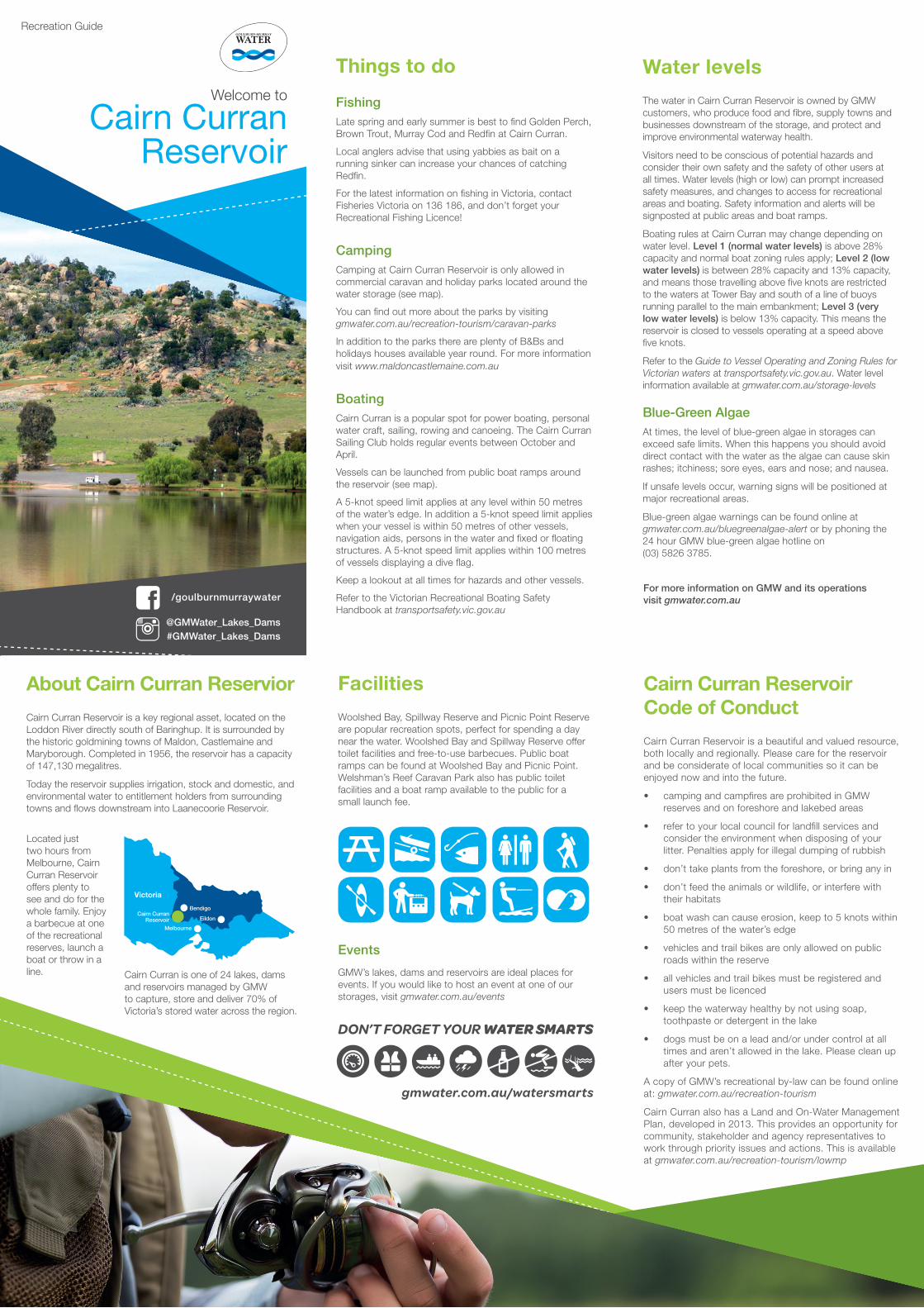
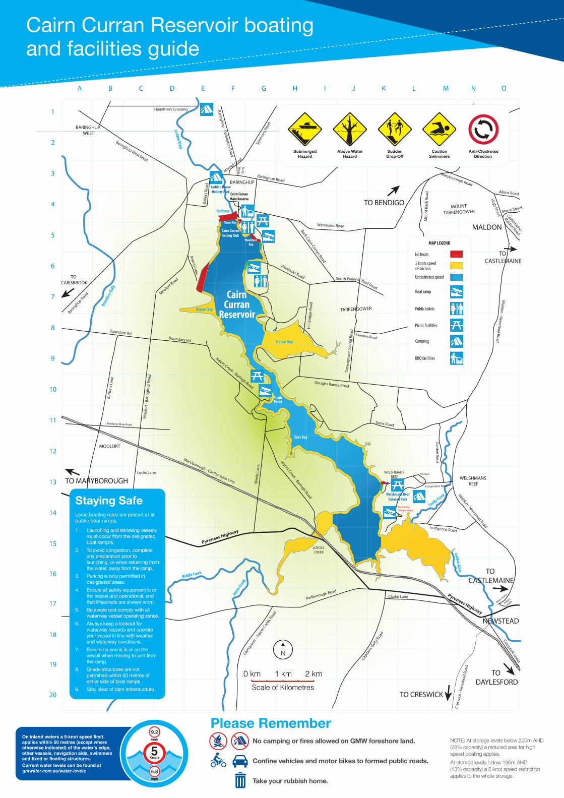
CampingCamping at Cairn Curran Reservoir is only allowed in commercial caravan and holiday parks located around the water storage (see map).
You can find out more about the parks by visiting gmwater.com.au/recreation-tourism/caravan-parks
In addition to the parks there are plenty of B&Bs and holidays houses available year round. For more information visit www.maldoncastlemaine.com.au
BoatingCairn Curran is a popular spot for power boating, personal water craft, sailing, rowing and canoeing. The Cairn Curran Sailing Club holds regular events between October and April.
Vessels can be launched from public boat ramps around the reservoir (see map).
A 5-knot speed limit applies at any level within 50 metres of the water’s edge. In addition a 5-knot speed limit applies when your vessel is within 50 metres of other vessels, navigation aids, persons in the water and fixed or floating structures. A 5-knot speed limit applies within 100 metres of vessels displaying a dive flag.
Keep a lookout at all times for hazards and other vessels.
Refer to the Victorian Recreational Boating Safety Handbook at transportsafety.vic.gov.au
Cairn Curran Reservoir Code of Conduct
Cairn Curran Reservoir is a beautiful and valued resource, both locally and regionally. Please care for the reservoir and be considerate of local communities so it can be enjoyed now and into the future.
• camping and campfires are prohibited in GMW reserves and on foreshore and lakebed areas
• refer to your local council for landfill services and consider the environment when disposing of your litter. Penalties apply for illegal dumping of rubbish
• don’t take plants from the foreshore, or bring any in
• don’t feed the animals or wildlife, or interfere with their habitats
• boat wash can cause erosion, keep to 5 knots within 50 metres of the water’s edge
• vehicles and trail bikes are only allowed on public roads within the reserve
• all vehicles and trail bikes must be registered and users must be licenced
• keep the waterway healthy by not using soap, toothpaste or detergent in the lake
• dogs must be on a lead and/or under control at all times and aren’t allowed in the lake. Please clean up after your pets.
A copy of GMW’s recreational by-law can be found online at: gmwater.com.au/recreation-tourism
Cairn Curran also has a Land and On-Water Management Plan, developed in 2013. This provides an opportunity for community, stakeholder and agency representatives to work through priority issues and actions. This is available at gmwater.com.au/recreation-tourism/lowmp
For more information on GMW and its operations visit gmwater.com.au
Recreation Guide
Victoria
Melbourne
BendigoCairn Curran
ReservoirEildon
Located just two hours from Melbourne, Cairn Curran Reservoir offers plenty to see and do for the whole family. Enjoy a barbecue at one of the recreational reserves, launch a boat or throw in a line. Cairn Curran is one of 24 lakes, dams
and reservoirs managed by GMW to capture, store and deliver 70% of Victoria’s stored water across the region.
Facilities
Woolshed Bay, Spillway Reserve and Picnic Point Reserve are popular recreation spots, perfect for spending a day near the water. Woolshed Bay and Spillway Reserve offer toilet facilities and free-to-use barbecues. Public boat ramps can be found at Woolshed Bay and Picnic Point. Welshman’s Reef Caravan Park also has public toilet facilities and a boat ramp available to the public for a small launch fee.
Events
GMW’s lakes, dams and reservoirs are ideal places for events. If you would like to host an event at one of our storages, visit gmwater.com.au/events
@GMWater_Lakes_Dams #GMWater_Lakes_Dams
/goulburnmurraywater
Cairn Curran Reservoir
Welcome to
About Cairn Curran Reservior
Cairn Curran Reservoir is a key regional asset, located on the Loddon River directly south of Baringhup. It is surrounded by the historic goldmining towns of Maldon, Castlemaine and Maryborough. Completed in 1956, the reservoir has a capacity of 147,130 megalitres.
Today the reservoir supplies irrigation, stock and domestic, and environmental water to entitlement holders from surrounding towns and flows downstream into Laanecoorie Reservoir.
Water levels
The water in Cairn Curran Reservoir is owned by GMW customers, who produce food and fibre, supply towns and businesses downstream of the storage, and protect and improve environmental waterway health.
Visitors need to be conscious of potential hazards and consider their own safety and the safety of other users at all times. Water levels (high or low) can prompt increased safety measures, and changes to access for recreational areas and boating. Safety information and alerts will be signposted at public areas and boat ramps.
Boating rules at Cairn Curran may change depending on water level. Level 1 (normal water levels) is above 28% capacity and normal boat zoning rules apply; Level 2 (low water levels) is between 28% capacity and 13% capacity, and means those travelling above five knots are restricted to the waters at Tower Bay and south of a line of buoys running parallel to the main embankment; Level 3 (very low water levels) is below 13% capacity. This means the reservoir is closed to vessels operating at a speed above five knots.
Refer to the Guide to Vessel Operating and Zoning Rules for Victorian waters at transportsafety.vic.gov.au. Water level information available at gmwater.com.au/storage-levels
Blue-Green AlgaeAt times, the level of blue-green algae in storages can exceed safe limits. When this happens you should avoid direct contact with the water as the algae can cause skin rashes; itchiness; sore eyes, ears and nose; and nausea.
If unsafe levels occur, warning signs will be positioned at major recreational areas.
Blue-green algae warnings can be found online at gmwater.com.au/bluegreenalgae-alert or by phoning the 24 hour GMW blue-green algae hotline on (03) 5826 3785.
Things to do
FishingLate spring and early summer is best to find Golden Perch, Brown Trout, Murray Cod and Redfin at Cairn Curran.
Local anglers advise that using yabbies as bait on a running sinker can increase your chances of catching Redfin.
For the latest information on fishing in Victoria, contact Fisheries Victoria on 136 186, and don’t forget your Recreational Fishing Licence!
CampingCamping at Cairn Curran Reservoir is only allowed in commercial caravan and holiday parks located around the water storage (see map).
You can find out more about the parks by visiting gmwater.com.au/recreation-tourism/caravan-parks
In addition to the parks there are plenty of B&Bs and holidays houses available year round. For more information visit www.maldoncastlemaine.com.au
BoatingCairn Curran is a popular spot for power boating, personal water craft, sailing, rowing and canoeing. The Cairn Curran Sailing Club holds regular events between October and April.
Vessels can be launched from public boat ramps around the reservoir (see map).
A 5-knot speed limit applies at any level within 50 metres of the water’s edge. In addition a 5-knot speed limit applies when your vessel is within 50 metres of other vessels, navigation aids, persons in the water and fixed or floating structures. A 5-knot speed limit applies within 100 metres of vessels displaying a dive flag.
Keep a lookout at all times for hazards and other vessels.
Refer to the Victorian Recreational Boating Safety Handbook at transportsafety.vic.gov.au
Cairn Curran Reservoir Code of Conduct
Cairn Curran Reservoir is a beautiful and valued resource, both locally and regionally. Please care for the reservoir and be considerate of local communities so it can be enjoyed now and into the future.
• camping and campfires are prohibited in GMW reserves and on foreshore and lakebed areas
• refer to your local council for landfill services and consider the environment when disposing of your litter. Penalties apply for illegal dumping of rubbish
• don’t take plants from the foreshore, or bring any in
• don’t feed the animals or wildlife, or interfere with their habitats
• boat wash can cause erosion, keep to 5 knots within 50 metres of the water’s edge
• vehicles and trail bikes are only allowed on public roads within the reserve
• all vehicles and trail bikes must be registered and users must be licenced
• keep the waterway healthy by not using soap, toothpaste or detergent in the lake
• dogs must be on a lead and/or under control at all times and aren’t allowed in the lake. Please clean up after your pets.
A copy of GMW’s recreational by-law can be found online at: gmwater.com.au/recreation-tourism
Cairn Curran also has a Land and On-Water Management Plan, developed in 2013. This provides an opportunity for community, stakeholder and agency representatives to work through priority issues and actions. This is available at gmwater.com.au/recreation-tourism/lowmp
For more information on GMW and its operations visit gmwater.com.au
Recreation Guide
Victoria
Melbourne
BendigoCairn Curran
Reservoir Eildon
Located just two hours from Melbourne, Cairn Curran Reservoir offers plenty to see and do for the whole family. Enjoy a barbecue at one of the recreational reserves, launch a boat or throw in a line. Cairn Curran is one of 24 lakes, dams
and reservoirs managed by GMW to capture, store and deliver 70% of Victoria’s stored water across the region.
Cairn Curran Reservoir boating and facilities guide
55.8
9.2
Knots
mph
kmhOn inland waters a 5-knot speed limit applies within 50 metres (except where otherwise indicated) of the water’s edge, other vessels, navigation aids, swimmers and fixed or floating structures. Current water levels can be found atgmwater.com.au/water-levels
No camping or fires allowed on GMW foreshore land.
Confine vehicles and motor bikes to formed public roads.
Take your rubbish home.
Please Rememberr
Goughs Range Road
Reef Road
1
2
3
4
5
6
7
8
9
10
11
12
13
14
15
16
17
18
19
20
A B C D E F G H I J K L M N O
Gordon Road
NEWSTEAD
MALDON
TO BENDIGO
TO CASTLEMAINE
TO MARYBOROUGH
TO CRESWICK
TO DAYLESFORD
WELSHMANS REEF
BARINGHUP
BARINGHUP WEST
TO CARISBROOK
MOOLORT
JOYCES CREEK
TARRENGOWER
MOUNTTARRENGOWER
TO CASTLEMAINE
Seers Road
Trudgeons Road
Rodborough Road
Cres
wic
k - N
ewst
ead
Road
Shie
lls L
ane
Pyrenees Highway
Pyrenees Highway
Maryborough - Castlemaine Line
Joyces Creek - Baringh Road
Moolort Road
Moo
lort
- Ba
ringh
up R
oad
Boundary Rd
Baringhup Road
Baringhup Road
Sim
mon
s Roa
d
Baringhup - Eddington Road
Bake
rs R
oad
Watersons Road
Maryborough Road
Whitlocks Road
Tarr
engo
wer
Sch
ool R
oad
Back Cairn Curran Road
Hill
Brid
ge R
oad
Baringhup West Road
Maldon - Newstead Road
Loddon River
Du�y
StreetMitchell S
treet
Bryants Lane
Boun
dary
Gully
Buft
ons L
ane
Boundary Rd
Keystone Mine Road
Glengower
- Joyc
es C
reek
Road
Capita
ns Gully
Road
Campbell Street
Joyces Creek - Baringh Road
High Street
Maldon - N
ewstead Road
South Parkins
Allens Road
Morris Street
Castlemaine -
Maldon Road
Mou
nt B
ack
Road
Hamilton’s Crossing
CairnCurran
ReservoirBryant Bay
Spillway
Treloar Bay
PicnicPoint
WELSHMANS REEF
Seer Bay
Middle Creek
Sandy Creek
Loddon River
Cairn CurranSailing Club
Tower Bay
Woolshed Bay
Cairn CurranMain Reserve
Fishermens Road
Joyces C
reek
Clarke Lane
Loddon House Holiday Park
Locks Lane
Adair Stre
et
Hillers
Street
Pitt Lane
Skinners Road
Nuggetty
Road
Welshmans Reef Caravan Park
Boat Ramp Charges Apply
SubmergedHazard
Above WaterHazard
SuddenDrop-Off
CautionSwimmers
Anti-ClockwiseDirection
0 km 1 kmScale of Kilometres
2 km
N
Staying SafeLocal boating rules are posted at all public boat ramps.
1. Launching and retrieving vessels must occur from the designated boat ramp/s.
2. To avoid congestion, complete any preparation prior to launching, or when returning from the water, away from the ramp.
3. Parking is only permitted in designated areas.
4. Ensure all safety equipment is on the vessel and operational, and that lifejackets are always worn.
5. Be aware and comply with all waterway vessel operating zones.
6. Always keep a lookout for waterway hazards and operate your vessel in line with weather and waterway conditions.
7. Ensure no one is in or on the vessel when moving to and from the ramp.
8. Shade structures are not permitted within 50 metres of either side of boat ramps.
9. Stay clear of dam infrastructure.
NOTE: At storage levels below 200m AHD (28% capacity) a reduced area for high speed boating applies.
At storage levels below 196m AHD (13% capacity) a 5 knot speed restriction applies to the whole storage.