Weatherman Walking - Logo of the BBC
18
Porthkerry to Llantwit Major Weatherman Walking
Transcript of Weatherman Walking - Logo of the BBC

Porthkerry to Llantwit Major
WeathermanWalking

The Weatherman Walking maps are intended as a guide to help you walk the route. We recommend using an OS map of the area in conjunction with this guide. Routes and conditions may have changed since this guide was written.
Reproduced by permission of Ordnance Survey on behalf of HMSO. © Crown copyright and database right 2009. All rights reserved. Ordnance Survey Licence number 100019855.
CARDIFF AIRPORT RUNWAY
2
PORTHKERRY VIADUCT
1
RHOOSE POINT
3
FONTYGARY LEISURE PARK
4
THE BLUE ANCHOR
51 Points of interest
Start
Finish
Route
For this walk we’ve included OS grid references should you wish to use them.
POWER STATIONS SITE
7
FORMER LIME WORKS
6
MILITARY DEFENCES
8
APPROXIMATE DISTANCE:
10 MILESLLANTWIT MAJOR BEACH
PEBBLE BEACH
9
The BBC takes no responsibility for any accident or injury that may occur while following the route. Always wear appropriate clothing and footwear and check weather conditions before heading out.
FORMER SEAWATCH CENTRE
10
LLANTWIT MAJOR BEACH
11
P O RT H K E R RY PA R K TO L L A N T W I T M A J O R B E AC H
W E AT H E R M A N WA L K I N G PA G E 2

P O RT H K E R RY PA R K TO L L A N T W I T M A J O R B E AC H
W E AT H E R M A N WA L K I N G PA G E 3
Waymark in the pebbles
Start: Porthkerry Park
Starting Ref: ST 08582 66908
Grade: Easy
Distance: Approx. 10 miles
Walk time: 3-4 hours
Parking: There is public parking at Porthkerry Park
(free except Sundays) and Llantwit Major
Beach (free).
Travel information: The 303 runs between Llantwit Major
(approx. one mile from the beach)
and Rhoose or Barry Station. See
local timetables.
This walk goes from the viaduct in Porthkerry Park, heading west along the Wales coast path to the beach in the historic town of Llantwit Major, one of Britain’s most important religious towns.
Further information: Visit Wales Coast Path website for more
information and path diversions
www.walescoastpath.gov.uk/plan-your-visit

P O RT H K E R RY PA R K TO L L A N T W I T M A J O R B E AC H
W E AT H E R M A N WA L K I N G PA G E 4
Porthkerry Viaduct
DirectionsPorthkerry Park is accessed
via Park Road, Barry. There is a
drive through the park, about a
mile long to get to the car park
and café. From the car park,
the viaduct is about 100 yards
away and can’t be missed.
Porthkerry Viaduct (ST 08455 66909)
The viaduct was built in the 1890s to transport coal to Barry docks. It has 15 piers and 16 arches and is over 100 ft high, but the build wasn’t straight forward. The viaduct opened in December 1897, but just two weeks later, the embankment on the eastern end began to slip.It looked like it was going to be an engineering disaster.
The viaduct was closed, and major repair works were needed. It finally reopened, and stayed open, a couple of years later and is still regularly used by trains today.
Porthkerry Viaduct
PORTHKERRY VIADUCT
1

P O RT H K E R RY PA R K TO L L A N T W I T M A J O R B E AC H
W E AT H E R M A N WA L K I N G PA G E 5
Porthkerry Boardwalk
Extremity of Cardiff Airport Runway (ST 07669 66714)
Cardiff Airport opened in the 1940s as a training base for Spitfire pilots, it then became a commercial airport in the 1950s and is Wales’ busiest airport. The airport is owned by the Welsh Government and carries about 1.6 million passengers a year.
Porthkerry Boardwalk
Pebble beach waymark
DirectionsFrom the viaduct, follow the
path to the seafront, which
includes a new section of
boardwalk. Porthkerry was
once a bustling harbour until it
was destroyed in a storm in the
16th century. Now the country
park is a reclaimed wildlife
haven and popular family
leisure location. Just before
the shoreline, the coast path
turns right and runs parallel
to the pebble beach. To the
north, just out of sight, is the
perimeter of Cardiff Airport.
CARDIFF AIRPORT RUNWAY
2

P O RT H K E R RY PA R K TO L L A N T W I T M A J O R B E AC H
W E AT H E R M A N WA L K I N G PA G E 6
Airplane landing
Cardiff AirportDerek says, “I did a stint working for the Met Office at the airport when I was much younger. I was in the control tower and had to do 12 hour shifts, giving weather reports every 30 minutes to advise the pilots of the conditions. I enjoyed my time there and think about it each time I fly from Cardiff.”

P O RT H K E R RY PA R K TO L L A N T W I T M A J O R B E AC H
W E AT H E R M A N WA L K I N G PA G E 7
Rhoose Point (ST 06684 65540)
Rhoose Point is the most southerly point of mainland Wales. The currents here are dangerous, so definitely not a place to try and dip your feet in the sea.
The Severn Estuary has the second highest tidal range in the world, with typically a 30-foot difference between high and low tide.
Rhoose Point
Rhoose
Rhoose Nature Reserve
DirectionsOn the coast path, the walk
continues past Porthkerry
Leisure Park and on the
southern side of Rhoose, one
of the fastest growing villages
in the Vale of Glamorgan.
The limestone rocks have
been extensively quarried over
the years, and where there
were once cliffs, today there
are housing estates and a
nature reserve.
RHOOSE POINT
3
P O RT H K E R RY PA R K TO L L A N T W I T M A J O R B E AC H
W E AT H E R M A N WA L K I N G PA G E 8
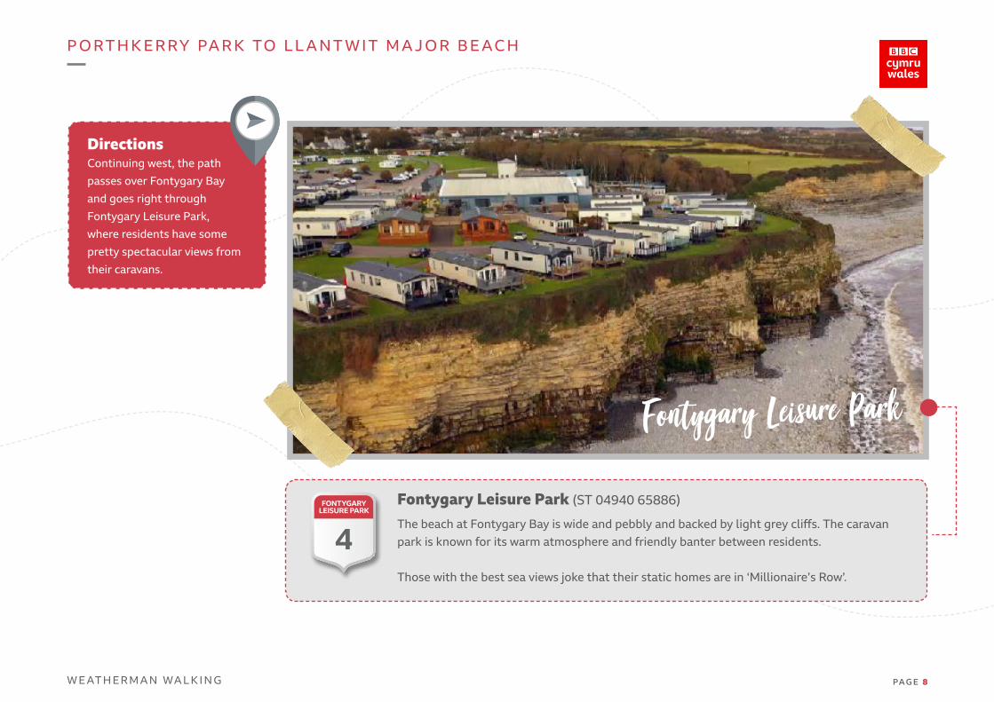
Fontygary Leisure Park (ST 04940 65886)
The beach at Fontygary Bay is wide and pebbly and backed by light grey cliffs. The caravan park is known for its warm atmosphere and friendly banter between residents.
Those with the best sea views joke that their static homes are in ‘Millionaire’s Row’.
Fontygary Leisure Park
DirectionsContinuing west, the path
passes over Fontygary Bay
and goes right through
Fontygary Leisure Park,
where residents have some
pretty spectacular views from
their caravans.
FONTYGARY LEISURE PARK
4
P O RT H K E R RY PA R K TO L L A N T W I T M A J O R B E AC H
W E AT H E R M A N WA L K I N G PA G E 9
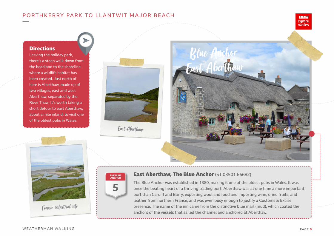
East Aberthaw, The Blue Anchor (ST 03501 66682)
The Blue Anchor was established in 1380, making it one of the oldest pubs in Wales. It was once the beating heart of a thriving trading port. Aberthaw was at one time a more important port than Cardiff and Barry, exporting wool and food and importing wine, dried fruits, and leather from northern France, and was even busy enough to justify a Customs & Excise presence. The name of the inn came from the distinctive blue marl (mud), which coated the anchors of the vessels that sailed the channel and anchored at Aberthaw.
Former industrial site
Blue AnchorEast Aberthaw
East Aberthaw
DirectionsLeaving the holiday park,
there’s a steep walk down from
the headland to the shoreline,
where a wildlife habitat has
been created. Just north of
here is Aberthaw, made up of
two villages, east and west
Aberthaw, separated by the
River Thaw. It’s worth taking a
short detour to east Aberthaw,
about a mile inland, to visit one
of the oldest pubs in Wales.
THE BLUE ANCHOR
5

P O RT H K E R RY PA R K TO L L A N T W I T M A J O R B E AC H
W E AT H E R M A N WA L K I N G PA G E 1 0
Derek and Andrew Coleman at the Blue Anchor
The Blue AnchorDerek says, “Being a Barry boy, I used to visit the Blue Anchor with friends in my youth, and it hasn’t really changed at all. I met up with one of theowners, Andrew Coleman, who told me there were lots of rumours linking the pub to smuggling in times gone by.
There waseven a tale of a secret tunnel linking Aberthaw Bay with the Blue Anchor, down which all manner of contraband might have been transported. Unfortunately, no such tunnel has ever been found.”
P O RT H K E R RY PA R K TO L L A N T W I T M A J O R B E AC H
W E AT H E R M A N WA L K I N G PA G E 1 1
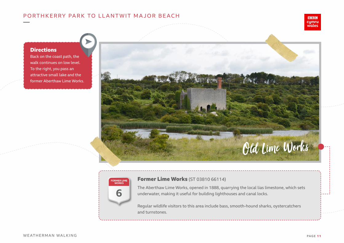
DirectionsBack on the coast path, the
walk continues on low level.
To the right, you pass an
attractive small lake and the
former Aberthaw Lime Works.
Former Lime Works (ST 03810 66114)
The Aberthaw Lime Works, opened in 1888, quarrying the local lias limestone, which sets underwater, making it useful for building lighthouses and canal locks.
Regular wildlife visitors to this area include bass, smooth-hound sharks, oystercatchers and turnstones.
Old Lime Works
FORMER LIME WORKS
6

P O RT H K E R RY PA R K TO L L A N T W I T M A J O R B E AC H
W E AT H E R M A N WA L K I N G PA G E 1 2
Former power station
Power Stations site (ST 02423 65845)
There were two power stations on the site. Aberthaw A, which started operating in 1960 was the most advanced coal-powered power station in the world at the time and it operated until the 1990s when it was demolished. Aberthaw B opened in 1971 and was finally closed in March
2020. The future of the site has still to be decided, but for now, it’s fenced off and secured.
DirectionsAt this point, the landscape
is dominated by the former
power station. The coast path
follows its external boundary
around the front of the site.
POWER STATIONS SITE
7
P O RT H K E R RY PA R K TO L L A N T W I T M A J O R B E AC H
W E AT H E R M A N WA L K I N G PA G E 1 3
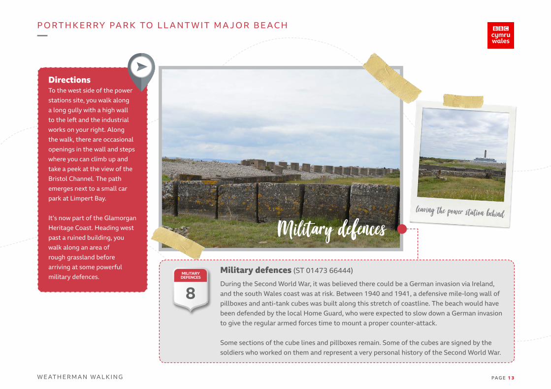
Military defences (ST 01473 66444)
During the Second World War, it was believed there could be a German invasion via Ireland, and the south Wales coast was at risk. Between 1940 and 1941, a defensive mile-long wall of pillboxes and anti-tank cubes was built along this stretch of coastline. The beach would have been defended by the local Home Guard, who were expected to slow down a German invasion to give the regular armed forces time to mount a proper counter-attack.
Some sections of the cube lines and pillboxes remain. Some of the cubes are signed by the soldiers who worked on them and represent a very personal history of the Second World War.
Military defencesleaving the power station behind
DirectionsTo the west side of the power
stations site, you walk along
a long gully with a high wall
to the left and the industrial
works on your right. Along
the walk, there are occasional
openings in the wall and steps
where you can climb up and
take a peek at the view of the
Bristol Channel. The path
emerges next to a small car
park at Limpert Bay.
It’s now part of the Glamorgan
Heritage Coast. Heading west
past a ruined building, you
walk along an area of
rough grassland before
arriving at some powerful
military defences.MILITARY
DEFENCES
8

P O RT H K E R RY PA R K TO L L A N T W I T M A J O R B E AC H
W E AT H E R M A N WA L K I N G PA G E 1 4
Summerhouse Bay pebble beach
Pebble Beach (SS 99575 66423)
It’s unusual for the coast path to cross a pebble beach, and you have to pick your way across the fairly large stones to avoid breaking your ankle. It’s a short section of the walk, just a few hundred yards, but does slow down your progress unless you are pretty sure-footed.The positive side is that it does give you uninterrupted views of the coast at ground level.
Summerhouse Bay pebble beach
DirectionsWalking on from Limpet Bay,
there’s a section of the coast
path which has been brought
closer to the sea recently.
At one time, it went around
a farmer’s land but now joins
up with the existing footpath
to follow the shoreline. After
passing along the bottom of
two fields, it veers left onto the
beach at Summerhouse Bay.
PEBBLE BEACH
9
P O RT H K E R RY PA R K TO L L A N T W I T M A J O R B E AC H
W E AT H E R M A N WA L K I N G PA G E 1 5
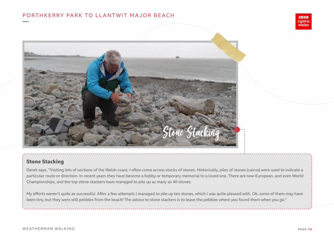
Stone Stacking
Stone StackingDerek says, “Visiting lots of sections of the Welsh coast, I often come across stacks of stones. Historically, piles of stones (cairns) were used to indicate a particular route or direction. In recent years they have become a hobby or temporary memorial to a loved one. There are now European, and even WorldChampionships, and the top stone stackers have managed to pile up as many as 40 stones.
My efforts weren’t quite as successful. After a few attempts I managed to pile up ten stones, which I was quite pleased with. Ok, some of them may have been tiny, but they were still pebbles from the beach! The advice to stone stackers is to leave the pebbles where you found them when you go.”

P O RT H K E R RY PA R K TO L L A N T W I T M A J O R B E AC H
W E AT H E R M A N WA L K I N G PA G E 1 6
DirectionsLeaving the pebble beach
behind you, the waymark
leads you to the right and
up some fairly steep steps at
Summerhouse Point.
Headland approach to Llantwit
Former SeaWatch Centre (SS 99325 66461)
The Seawatch Centre, Summerhouse Point, Boverton, near Llantwit Major, was once a HM Coastguard lookout station for the busy shipping lanes of the Bristol Channel.
It was decommissioned and then used as a Maritime Interpretation Centre, set out as a ship’s bridge and equipped with radio receivers, navigational and meteorological instrumentation.It is currently closed. Next to the Seawatch Centre is the site of an ancient fort. It is thought to be Iron Age but may have been built on the site of an earlier fort.
Former Seawatch CentreFORMER
SEAWATCH CENTRE
10
P O RT H K E R RY PA R K TO L L A N T W I T M A J O R B E AC H
W E AT H E R M A N WA L K I N G PA G E 1 7
Arriving at Llantwit Major Beach
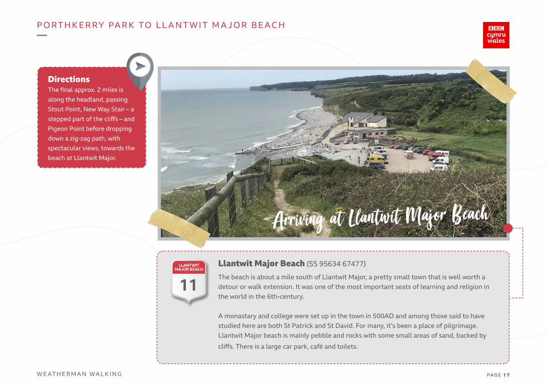
Llantwit Major Beach (SS 95634 67477)
The beach is about a mile south of Llantwit Major, a pretty small town that is well worth a detour or walk extension. It was one of the most important seats of learning and religion inthe world in the 6th-century.
A monastary and college were set up in the town in 500AD and among those said to have studied here are both St Patrick and St David. For many, it’s been a place of pilgrimage. Llantwit Major beach is mainly pebble and rocks with some small areas of sand, backed by
cliffs. There is a large car park, café and toilets.
DirectionsThe final approx. 2 miles is
along the headland, passing
Stout Point, New Way Stair – a
stepped part of the cliffs – and
Pigeon Point before dropping
down a zig-zag path, with
spectacular views, towards the
beach at Llantwit Major.
LLANTWIT MAJOR BEACH
11

P O RT H K E R RY PA R K TO L L A N T W I T M A J O R B E AC H
W E AT H E R M A N WA L K I N G PA G E 1 8
Enjoying the walk
End of the WalkDerek says, “This was a nice local walk for me and, although I had done sections of it before, I’d never actually walked the length of it and seen how the landscape was changing. It’s great to see some of the former industrial sites being brought back to nature.”