Weather Dynamics Science 10 G.Burgess 2007. Our weather is dependant on the movements of air and...
28
Weather Dynamics Science 10 G.Burgess 2007
-
date post
21-Dec-2015 -
Category
Documents
-
view
223 -
download
0
Transcript of Weather Dynamics Science 10 G.Burgess 2007. Our weather is dependant on the movements of air and...
Weather DynamicsScience 10
G.Burgess
2007
• Our weather is dependant on the movements of air and water.
• Light from the sun heats the Earth and oceans which in turn heat the surrounding air making weather patterns.
We will be discussing the effects of the sunlight and water on our weather.
Source of energy
• Light from the sun is the driving force for our weather
• Solar radiation (radiation from the sun) is absorbed by the waters and soils of the Earth.
• Absorbed light energy is converted into heat. The more direct the light, the warmer it feels.
• Excess energy absorbed by the Earth is re-radiated out into space as infra-red radiation
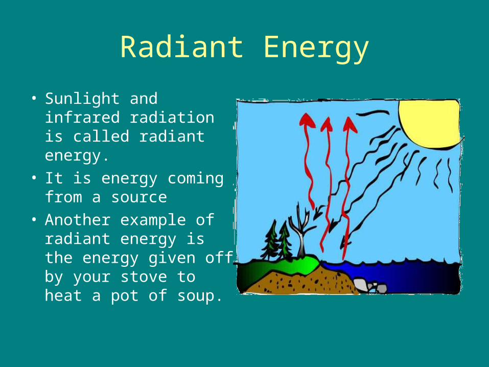
Radiant Energy
• Sunlight and infrared radiation is called radiant energy.
• It is energy coming from a source
• Another example of radiant energy is the energy given off by your stove to heat a pot of soup.
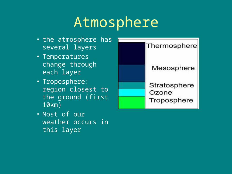
Atmosphere• the atmosphere has
several layers• Temperatures
change through each layer
• Troposphere: region closest to the ground (first 10km)
• Most of our weather occurs in this layer
Other layers of the Atmosphere
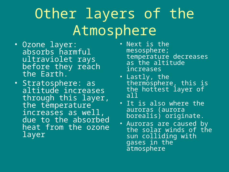
• Ozone layer: absorbs harmful ultraviolet rays before they reach the Earth.
• Stratosphere: as altitude increases through this layer, the temperature increases as well, due to the absorbed heat from the ozone layer
• Next is the mesosphere; temperature decreases as the altitude increases
• Lastly, the thermosphere, this is the hottest layer of all
• It is also where the auroras (aurora borealis) originate.
• Auroras are caused by the solar winds of the sun colliding with gases in the atmosphere
What happens when sunlight reaches the Oceans?
• Converted to heat energy• Different objects are able to absorb different amounts of
heat - specific heat capacity• Water has different specific heat capacities depending
on its state (solid, liquid, or gas)• Ice has a specific heat capacity of about 2.10J/gºC,
water about 4.18J/gºC and steam 2.08J/gºC.• Snow and ice can reflect as much as 90% of the
incoming radiation• Water is the only substance known that can be in all
three stages at temperatures found on Earth.
Properties of Water
• Absorbs more heat than other substances (Sp Heat Capacity: 4.18J/gºC)
• Thus absorbing a lot of the heat generated by sunlight.
• Latent heat of fusion: the amount of heat needed to change ice into water (333J/g°C)
• Latent heat of vaporization: the amount of heat needed to change water from a liquid to a gas (2260J/g°C)
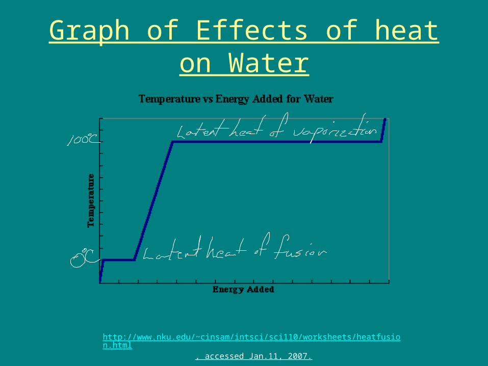
Graph of Effects of heat on Water
http://www.nku.edu/~cinsam/intsci/sci110/worksheets/heatfusion.html, accessed Jan.11, 2007.
Water in the Air
• As stated earlier, the higher up the troposphere you go, the cooler the air gets.
• Warm water vapor will rise with warm air• As the air rises, the moisture in it condenses on dust
particle to form condensation nuclei and then clouds• The amount of water vapor in the air is called humidity.
The actual amount of water in the air expressed in gram of water to kilograms of air is called the Absolute Humidity.
• Weather forecasters use the term Relative humidity referring to the percent of water in the air relative to the amount of water the air can hold.
• When the clouds are saturated with water (100% relative humidity), they release it as precipitation
What happens when sunlight reaches land?
• Land does not absorb as much heat energy as water
• This is the reason why pavement and beach sand feel hot on your feet, while lake water feels cool.
• YES, their temperatures are different, but they are being bombarded with the same amount of heat energy.
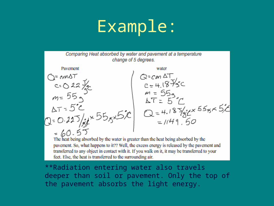
Example:
**Radiation entering water also travels deeper than soil or pavement. Only the top of the pavement absorbs the light energy.
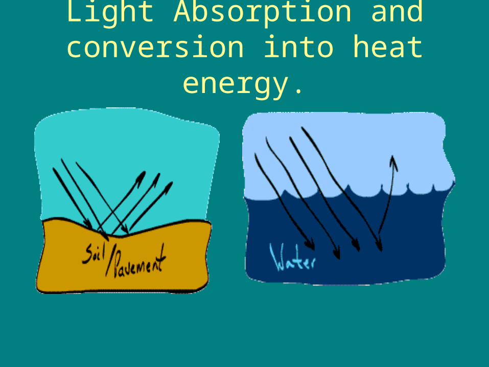
Light Absorption and conversion into heat energy.
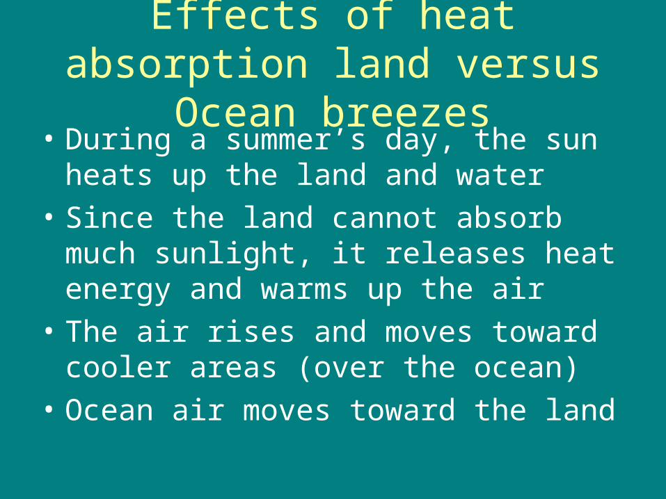
Effects of heat absorption land versus Ocean breezes
• During a summer’s day, the sun heats up the land and water
• Since the land cannot absorb much sunlight, it releases heat energy and warms up the air
• The air rises and moves toward cooler areas (over the ocean)
• Ocean air moves toward the land
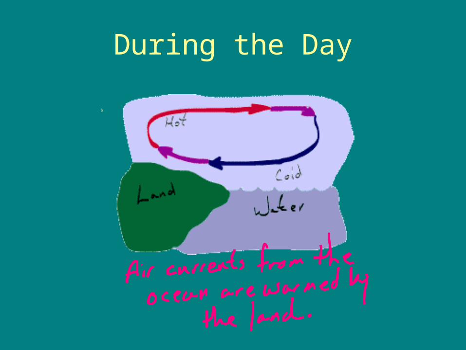
During the Day
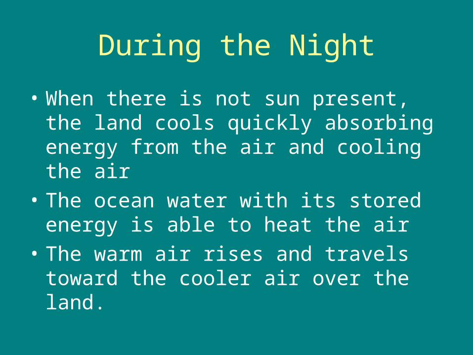
During the Night
• When there is not sun present, the land cools quickly absorbing energy from the air and cooling the air
• The ocean water with its stored energy is able to heat the air
• The warm air rises and travels toward the cooler air over the land.
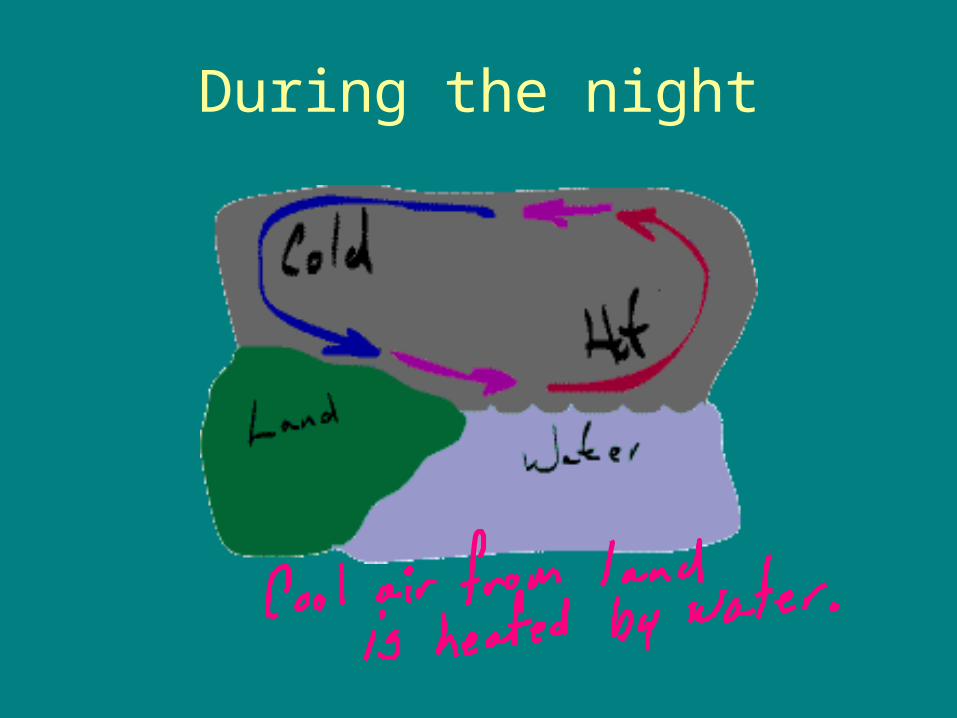
During the night
Air Masses
• Large portions of air often remain at the same place long enough to take on the temperature and moisture characteristics of the land or ocean below.
• Air mass: a large portion of air that is nearly uniform in temperature and humidity
Types of air masses
1. Continental (drier)2. Maritime (moist)3. Polar (cool)4. Tropical (warm)• These types air masses are combined to
explain the conditions.– ie. Continental polar, continental tropical,
maritime polar, maritime tropical
Air masses (con’t)
• Once these air masses start to move (due to wind) and collide, they form Fronts.
• Read pp 466 and 467– Do qstns 1-4 468, 1-3 480, and 1-3 501.
Cloud formation
• Conditions needed; water vapour, saturated air and condensation nuclei
• As air condenses it loses its ability to hold moisture. The temperature at which air forms water droplets is called its dew point.– Air is cooled with increased altitude and also
expands as it rises– Air is also cooled by cold land.
How do they grow?
• First, the air must condense• Water droplets collide and blend together
forming larger water droplets (this method is most common in warm air regions)
• Once the water droplets are large enough, they fall as precipitate
• Snow; water vapour condenses as ice crystals and the ice crystals grow as more water is added.
• Read pp 494-495 do qst 1-5.
Types of clouds
• Cumulus– puffy with flat bases– “cauliflower clouds”– Formed by air masses meeting
• Stratus– Form in layers– Flat, without shape– Formed by meeting air masses or masses rising over
mountain– Similar to ground level fog.
• Cirrus– Formed by ice crystals when very little water in the air– Air needs to rise very high to reach dew point
• Nimbus– Rain or snow cloud
• Clouds may be formed as combinations of these types;– ie. Nimbostratus, cumulonimbus
Altitude and clouds
• Low clouds: <2000m– Almost all stratus clouds
• Middle clouds: 2000-6000m– “alto”
• High clouds: >6000m– Cirro or cirrus clouds– Most are formed from ice crystals

Rain or no rain
• Dependant on the size of the water droplets– Most clouds have water droplets ~0.2mm– Rain requires water droplets ~0.5mm (fine
mist)– The average rain drop is ~0.2mm
Frontal systems• The region between two air masses is called
a FRONT.• Cold fronts: occur when cold air mass
pushes a warm air mass.– The cold air pushes the warm air upward– This causes the air to condense and form
cumulus clouds, rain usually comes from the formation of cold fronts
• Warm Fronts: occur when warm air overtakes a cold air mass.– The warm air rises gradually forming stratus and
cirrus clouds– May cause precipitation, however the rain may
last longer than if formed by a cold front.
• Stationary Front: when cold air mass and warm air mass are in contact but are not moving.
• Warm air drifts up and over cold air mass.
• Causes overcast weather