Watershed Assessment Report for Drinking Water Source ......intake and the confluence of Greata...
117
May 19, 2010 PEACHLAND CREEK AND TREPANIER CREEK Watershed Assessment Report for Drinking Water Source Protection REPORT Report Number: 09-1493-5018 Distribution: 7 Copies District of Peachland 1 Copy Golder Associates Ltd. Submitted to: District of Peachland Public Works Office c/o 5806 Beach Avenue Peachland, BC V0H 1X7 Study area and hydrology pic. Intake Peachland Creek Trepanier Creek District of Peachland Intake
Transcript of Watershed Assessment Report for Drinking Water Source ......intake and the confluence of Greata...

May 19, 2010
PEACHLAND CREEK AND TREPANIER CREEK
Watershed Assessment Report for Drinking Water Source Protection
REPO
RT
Report Number: 09-1493-5018
Distribution:
7 Copies District of Peachland 1 Copy Golder Associates Ltd.
Submitted to: District of Peachland
Public Works Office c/o 5806 Beach Avenue Peachland, BC V0H 1X7
Study area and hydrology pic.
Intake
Peachland
CreekTrepanier
Creek
District of Peachland
Intake
PEACHLAND AND TREPANIER CREEKS WATERSHED ASSESSMENT FOR DRINKING WATER SOURCE PROTECTION
May 19, 2010 Report No. 09-1493-5018
EXECUTIVE SUMMARY Golder Associates Ltd. (Golder) was retained by the District of Peachland (District) to develop a Watershed Assessment Report for Source Protection for the Peachland and Trepanier Creek Community Watersheds. The project objective was to complete Modules 1, 2, 7 and 8 of the Comprehensive Drinking Water Source to Tap Assessment Guideline (CS2TA), which consists of:
Module 1: Delineating and characterizing the water source and identifying intrinsic (natural) hazards to drinking water,
Module 2: Conducting a contaminant inventory to identify hazards to drinking water from human land uses,
Module 7: Completing a risk assessment to prioritize the hazards identified, and
Module 8: Developing a drinking water risk management strategy.
The study focused on hazards and risks to water quality and water quantity, but also examined aquatic and fisheries resources where appropriate.
The Interior Health Authority (IHA) initiated source protection of the District drinking water sources by placing a condition on the District Purveyor’s Permit to operate. The Okanagan Basin Water Board (OBWB) provided partial funding for this project through their Water Conservation and Quality Improvement Grant Initiative.
The District supplies residential, agricultural and business water users within the municipal boundaries of Peachland. Due to historic growth patterns in the District, the water supply infrastructure has developed as three distinct regions supplied by three different drinking water sources; Peachland Creek System, Ponderosa Wells System and Trepanier Creek System. This study examined watershed hazards to the surface water sources of drinking water from the Peachland Creek and Trepanier Creek watersheds.
The project was initiated at a Technical Committee meeting with District and government agency representatives who provided input into the project direction. A stakeholder meeting followed with individuals and representatives from groups and companies that either live, work or use resources from either of the Peachland or Trepanier Creek watersheds. The stakeholders identified concerns and specific issues with the watersheds, provided information on land use and initiated discussion on potential strategies to improve source water protection.
The study area included the catchment areas of each watershed upstream of the District intakes and included an area of 100 m radius around each intake. The catchment area for a given intake is termed the Watershed Assessment Area (WAA). The WAA for the Peachland Creek intake is approximately 145 km2 and the WAA for the Trepanier Creek intake is approximately 255 km2. The study included an office-based review of available data, a detailed aerial photograph review and a field reconnaissance visit to characterize the WAAs, examine land use and assess potential impacts to drinking water resources. A risk analysis was completed on the intrinsic and human land use activities identified based on the procedure outlined in the CS2TA. Site-specific hazards identified were analyzed separately to provide a relative ranking to assist in prioritizing action plans.
In addition to the qualitative measures for consequence and probability from the CS2TA, the risk assessment of intrinsic and land use activities also took into account the total area of the hazard (i.e., entire WAAs or local impact), density (i.e., intensive cattle grazing verses limited wildli fe populations), the proximity to the intakes and

PEACHLAND AND TREPANIER CREEKS WATERSHED ASSESSMENT FOR DRINKING WATER SOURCE PROTECTION
May 19, 2010 Report No. 09-1493-5018
magnitude of potential impacts. There were seven intrinsic hazards and sixteen land use activities identified in the WAAs. The following table provides a summary of the hazards identified in the Peachland and Trepanier Creek watersheds and their risk rating.
Very High Risk High Risk
• Mountain Pine Beetle • Forestry Activities: Salvage Logging and
Retention plans for MPB impacted trees (future)
• Range Use • Roads on Steep Slopes (Class III, IV and V) • Stream Crossings at Roads • Recreation: Camping • Recreation: ATVs and Dirt Bikes
• Wild Fires • Sediment Sources • Aggregate Extraction • Recreation: Boating and Fishing
Moderate Risk Low Risk • Climate Change • Wildlife and Birds • Highway 97C • Leased Land Around Reservoirs
• Tussock Moth outbreak in Trepanier Creek • Channel Stability • Forestry Activities: Licensee operations • Roads on Gentle slopes (Class I and II) • Mining: Placer, Petroleum and Coal • Mining: Mineral • Private Land • BC Hydro ROW - Maintenance Operations
The results of the risk assessment of specific sites in the Peachland Creek WAA identified that all of the Very High Risk sites, except two, were located close to the mainstem of Peachland Creek between the drinking water intake and the confluence of Greata Creek. The two other Very High Risks were at road crossing with tributaries where there were potential cattle and wildli fe access concerns.
Very High Risk sites in Trepanier Creek were identified at the bridge crossing on the transmission ROW, three sites that were potentially logged to the stream, and impromptu camping sites next to the creek.
The next step of the project was to develop Risk Management Action Plans to prevent, reduce and/or mitigate the hazards and risks in the WAAs (Module 8). The development of Risk Management Action Plans was a collaborative process that included input from the Technical Advisory Committee (TAC).
The following provides a summary of the recommended Risk Management Action Plans that were developed and are listed as follows with the highest priority actions listed first.
1) Complete vulnerability mapping - to identify and map the vulnerable areas within the Peachland Creek and Trepanier Creek watersheds. Vulnerability mapping would assist other planning and development initiatives within the watershed in the protection of water resources and sensitive habitat.

PEACHLAND AND TREPANIER CREEKS WATERSHED ASSESSMENT FOR DRINKING WATER SOURCE PROTECTION
May 19, 2010 Report No. 09-1493-5018
2) Complete a habitat and sediment source assessment on Peachland Creek – the assessment area would include Peachland Creek between the District intake and the confluence with Greata Creek. The assessment would GPS and document habitat features and sediment sources and complete a risk assessment for sediment sources to assist in prioritization of risk reduction efforts.
3) Initiate a flow monitoring program in Peachland Creek – the Water Master Plan has recommended that Peachland Creek be used as the sole water source for Peachland with Okanagan Lake designated as a backup source. Due to anticipated changes in stream flows related to climate change and mountain pine beetle impacts, the collection of flow monitoring data is recommended to assist Peachland with efficient management of their water source.
4) Develop and initiate a raw water quality monitoring program – the program objectives should be to gather baseline water quality data and assist in identifying areas of impact.
5) Use adaptive management principles to update salvage logging and retention plans – specific recommendations include updating salvage logging and retention plans to reflect new studies and information on harvesting as they emerge, retaining or enhancing natural barriers to watercourses, monitoring, and maintaining communication with stakeholders.
6) Develop Range Use Plans (RUP) using Best Management Practices – the plans should guide grazing tenure holders in best practices for grazing cattle in the watershed while also minimizing risks to drinking water.
7) Develop strategies for the improvement or deactivation of roads that are impacting the District intake – this would include assembling a working group to determine access requirements and to assist in funding or identifying funding sources for road deactivation.
8) Review of motorized recreation trail application in Peachland Creek watershed – includes development of a Steering Committee to guide the process and development of planning documents approved by the Steering Committee before trail construction. The recommendations also outline the Districts concerns to be addressed in the development process.
9) Review of the commercial ATV trail permit within the Peachland Creek watersheds – includes review of trail location and operating and monitoring plans by stakeholders and consultation to address any concerns that arise. Other recommendations specific to the Integrated Land Management Bureau (ILMB) include gathering more input from stakeholders for future permit applications, initiating a review of the Okanagan – Shuswap Land and Resource Management Plan (OS-LRMP) and extending the referral review process to 60 days.
10) Develop strategies to control unmanaged camping in high risk areas – this recommendation includes assembling a working group to determine strategies such as signage, barriers or regrading of high risk sites, and public education.
11) Recommendations pertaining to lease land around reservoirs – includes reassessing the conservation buffer around Glen Lake once the dam on Glen Lake is rebuilt, incorporating the buffer zones around reservoir lakes into the OS-LRMP, developing an education program for lease holders and supporting the position of not selling Crown land or expanding leases on drinking water reservoirs.

PEACHLAND AND TREPANIER CREEKS WATERSHED ASSESSMENT FOR DRINKING WATER SOURCE PROTECTION
May 19, 2010 Report No. 09-1493-5018
12) Requesting “electric motor only” status on Peachland Lake and Glen Lake.
13) Updating Water Emergency Response Plans to include potential impacts from wildfires – Includes developing a wildfire protection plan and guidance for forestry companies to include strategies for the protection of water quality within their fuel management programs.
14) Develop Watershed Stakeholder Groups or Committees – to assist in data gathering, watershed protection incentives and other objectives developed by the committee.
15) Continue to work of the Central Okanagan Aggregate Task Force.
16) Request a mineral, petroleum and coal reserve within the Trepanier Creek or Peachland Creek WAA. The recommendation also includes continuing to monitor the water quality monitoring results of Brenda Mines.
17) Continue with control plan for the tussock moth outbreak in Trepanier Creek Watershed.
18) Riparian Areas on Private Land – RDNO should include the vulnerability mapping (Recommendation 1) in planning documents to guide land development upgradient of the Peachland Creek and Trepanier Creek intakes.
19) Long-term monitoring of terrain and channel stability – to be completed in vulnerable areas when new aerial photographs are produced.

PEACHLAND AND TREPANIER CREEKS WATERSHED ASSESSMENT FOR DRINKING WATER SOURCE PROTECTION
May 19, 2010 Report No. 09-1493-5018 i
Table of Contents
1.0 INTRODUCTION.................................................................................................................................................................................. 1
1.1 Project Scope ........................................................................................................................................................................ 1
2.0 BACKGROUND ................................................................................................................................................................................... 2
2.1 Overview of District of Peachland’s Water System ......................................................................................................... 2
2.1.1 Current Water System Configuration .......................................................................................................................... 2
2.1.2 Future Direction of Peachland's Water Supply.......................................................................................................... 3
2.2 Overview of Drinking Water Hazards ................................................................................................................................ 4
2.3 Water Quality......................................................................................................................................................................... 4
2.4 Water Quantity ...................................................................................................................................................................... 6
3.0 PROJECT METHODS ........................................................................................................................................................................ 7
4.0 TECHNICAL COMMITTEE AND STAKEHOLDER MEETINGS................................................................................................. 7
5.0 MODULE 1 – WATERSHED CHARATERIZATION ...................................................................................................................... 8
5.1 Watershed Assessment Area ............................................................................................................................................. 8
5.2 Climate and Biogeoclimatic Zones .................................................................................................................................... 9
5.3 Bedrock and Surficial Geology ......................................................................................................................................... 10
5.4 Terrain and Channel Stability ........................................................................................................................................... 10
5.5 Fish Status ........................................................................................................................................................................... 13
5.6 Source Water Quality ......................................................................................................................................................... 15
5.7 Hydrology and Source Water Use ................................................................................................................................... 18
5.8 Integrity Evaluation of Intakes and Reservoirs .............................................................................................................. 21
5.8.1 Peachland Creek Water Facilities.............................................................................................................................. 22
5.8.2 Trepanier Creek Water Facilities ............................................................................................................................... 24
5.9 Intrinsic Hazards to Water Quality and Quantity............................................................................................................ 26
5.9.1 Mountain Pine Beetle................................................................................................................................................... 26
5.9.2 Tussock Moth................................................................................................................................................................ 28
5.9.3 Climate Change ............................................................................................................................................................ 29
5.9.4 Wildfire ........................................................................................................................................................................... 31
5.9.5 Wildlife............................................................................................................................................................................ 32
PEACHLAND AND TREPANIER CREEKS WATERSHED ASSESSMENT FOR DRINKING WATER SOURCE PROTECTION
May 19, 2010 Report No. 09-1493-5018 ii
5.9.6 Sediment Sources ........................................................................................................................................................ 32
5.9.7 Channel Condition........................................................................................................................................................ 34
5.9.8 Summary of Intrinsic Impacts ..................................................................................................................................... 34
6.0 MODULE 2 – CONTAMINANT SOURCE INVENTORY............................................................................................................. 35
6.1 Forestry Activities ............................................................................................................................................................... 35
6.1.1 Interior Watershed Assessment Procedure ............................................................................................................. 37
6.2 Range Use ........................................................................................................................................................................... 42
6.3 Exploration and Mining Activities ..................................................................................................................................... 45
6.4 Aggregate Extraction.......................................................................................................................................................... 47
6.5 Private and Leased Land Holdings.................................................................................................................................. 48
6.6 Roads and Highways ......................................................................................................................................................... 49
6.7 BC Hydro Right-of-Way ..................................................................................................................................................... 51
6.8 Recreational Activities........................................................................................................................................................ 52
6.8.1 Camping......................................................................................................................................................................... 52
6.8.2 Boating and Fishing ..................................................................................................................................................... 54
6.8.3 ATVs and Dirt Bikes ..................................................................................................................................................... 54
6.9 Contaminant Source Inventory Summary....................................................................................................................... 57
7.0 MODULE 7 – CHARACTERIZING RISKS .................................................................................................................................... 57
7.1 Evaluating Source Protection Barriers and Vulnerabilities .......................................................................................... 57
7.2 Risk Assessment Procedure............................................................................................................................................. 59
7.3 Risk Analysis in Watershed Assessment Areas ............................................................................................................ 61
8.0 MODULE 8 – RECOMMENDED ACTIONS TO IMPROVE DRINKING WATER PROTECTION........................................ 62
9.0 LIMITATION OF LIABILITY............................................................................................................................................................. 74
10.0 REFERENCES ................................................................................................................................................................................... 75
11.0 PERSONAL COMMUNICATION REFERENCED ....................................................................................................................... 80

PEACHLAND AND TREPANIER CREEKS WATERSHED ASSESSMENT FOR DRINKING WATER SOURCE PROTECTION
May 19, 2010 Report No. 09-1493-5018 iii
TABLES
Table 1: Watershed and WAA Areas and Key Elevations. Table 2: Canadian Climate Normals (1971 – 2000) for Peachland Creek and Brenda Mines. Table 3: Biogeoclimatic Zones of Peachland Creek and Trepanier Creek Watersheds. Table 4: Site-specific hazards within Peachland Creek and Trepanier Creek WAA. (end of text) Table 5: Fisheries Inventory for Peachland Creek and Tributaries (FISS database). Table 6: Fisheries Inventory for Trepanier Creek and Tributaries (FISS database). Table 7: Provisional Water Quality Objectives for Peachland Creek (Swain, 1990). Table 8: Provisional Water Quality Objectives for Trepanier Creek (Swain, 1990). Table 9: Inactive and Active Hydrometric Stations within Peachland Creek. Table 10: Inactive and Active Hydrometric Stations within Trepanier Creek. Table 11: Int rinsic Hazard Identification Table. (end of text) Table 12: 1999 Watershed Inventory Information in Peachland Watershed. Table 13: ECAs for Loss of Mature Lodgepole Pine Compared to the Proposed Salvage logging and Retention
Plan in Peachland Creek Watershed. Table 14: 1998 and Current Watershed Inventory Information in Trepanier Watershed. Table 15: ECAs for Loss of Mature Lodgepole Pine Compared to the proposed Salvage logging and Retention
Plan in Trepanier Creek Watershed. Table 16: Overview of main grazing tenures in Peachland Creek and Trepanier Creek WAA. Table 17: Hazard Identification Table from Land Use in the Watershed Assessment Areas. (end of text) Table 18: Source Protection Barrier Evaluation. Table 19: Qualitative Measure of Probability. Table 20: Qualitative Measure of Consequence. Table 21: Qualitative Risk Analysis Matrix. Table 22: Detailed Risk Assessment for Non-Point Source Hazards to Drinking Water. (end of text) Table 23: Summary of Risk Assessment for Intrinsic and Land Use Activity Hazards to Drinking Water. Table 24: Detailed Risk Assessment for Site Specific Hazards to Drinking Water. (end of text) Table 25: Risk Management Actions for Non-Point Source Hazards to Drinking Water. (end of text) Table 26: Risk Management Action Plans for Site Specific Hazards. (end of text)
FIGURES Figure 1: Watershed Assessment Areas of Peachland and Trepanier Creeks Figure 2: Site-Specific Hazards to Drinking Water and Assigned Risk Figure 3: Daily statistics hydrograph, Peachland Creek at the mouth (#08NM159) (Within Text). Figure 4: Daily statistics hydrograph, Trepanier Creek at the mouth (#08NM155) (Within Text). Figure 5: Water Facility Locations. Figure 6: Grazing Tenure Boundaries within the Peachland and Trepanier Creeks WAAs. Figure 7: Stand Development as Dead Pine Trees Deteriorate and Natural Regeneration Becomes Established
(Within Text). Figure 8: Lodgepole Pine and Spruce Regeneration in a Pine Stand that had been Attacked by MPB in the
1980’s (Within Text). Figure 9: Locations of Private and Leased Land Parcels, Recreation Sites and BC Hydro Right -Of-Way
PEACHLAND AND TREPANIER CREEKS WATERSHED ASSESSMENT FOR DRINKING WATER SOURCE PROTECTION
May 19, 2010 Report No. 09-1493-5018 iv
APPENDICES APPENDIX A Project Meeting Summaries
APPENDIX B Biogeoclimatic Zone Information
APPENDIX C Bedrock Geology and Longitudinal Creek Profiles
APPENDIX D Photographs
APPENDIX E 2009 Tussock Moth Outbreak Map within the Central Okanagan Regional District
APPENDIX F Wildlife Information for the Central Okanagan Regional District
APPENDIX G Forestry Boundaries and Forestry In formation
APPENDIX H Water Quality and Livestock Grazing on Crown Rangeland in BC, Rangeland Health Brochure 12
APPENDIX I Mineral, Placer, Petroleum and Coal Resources
APPENDIX J Projected Growth Areas and Aggregate Potential Map (EBA, 2000)
APPENDIX K Camping Information
APPENDIX L Dirt Bike and ATV Information

PEACHLAND AND TREPANIER CREEKS WATERSHED ASSESSMENT FOR DRINKING WATER SOURCE PROTECTION
May 19, 2010 Report No. 09-1493-5018 v
LIST OF ABBREVIATIONS AND ACRONYMS
AF acre-ft BCTS BC Timber Sales BMP Best Management Practises CS2TA Comprehensive Drinking Water Source to Tap Assessment Guideline CHIA Cumulative Hydrologic Impact Assessment CORD Central Okanagan Regional District CWS Community Watersheds DFO Department of Fisheries and Oceans District District of Peachland ECA Equivalent Clear-cut Area EMS Environmental Management System database FISS Fisheries Information Summary System FL Forest License FRPA Forest and Range Practices Act FSP Forest Stewardship Plans FSR Forest Service Road GPS global positioning system IHA Interior Health Authority IWAP Interior Watershed Assessment Procedures IWRP Integrated Watershed Restoration Plan KWES Kamloops Woodlot Education Society masl metres above sea level MCM million cubic metres MEMPR Ministry of Energy, Mines and Petroleum Resources MOE British Columbia Ministry of Environment MOFR British Columbia Ministry of Forest and Range MOTCA Ministry of Tourism, Culture & Arts MOTI Ministry of Transportation and Infrastructure MPB Mountain Pine Beetle MTBE methyl tert-butyl ether NPV nuclear polyhedrosis virus NTU nephelometric turbidity units OBWB Okanagan Basin Water Board ORW Okanagan Regional Woodlands OS-LRMP Okanagan Shuswap Land and Resource Management Plan POI Point of Interest ROW Right-Of-Way RUP Range Use Plan SEE Species and Ecosystems Explorer database SFMP Sustainable Forest Management Plan SSZ Snow sensitive zones SSS Sediment Source Survey SOC Species of concern TAC Technical Advisory Committee TDS Total dissolved solids WAA Watershed Assessment Area WFN Westbank First Nation WSG Watershed Stakeholder Group WTP Water Treatment Plant

PEACHLAND AND TREPANIER CREEKS WATERSHED ASSESSMENT FOR DRINKING WATER SOURCE PROTECTION
May 19, 2010 Report No. 09-1493-5018 1
1.0 INTRODUCTION Golder Associates Ltd. (Golder) was retained by the District of Peachland (District) to develop a Watershed Assessment Report for Peachland and Trepanier Creek Community Watersheds. The objectives of the Watershed Assessment Report are to characterize important biophysical and social components within each watershed, identify potential vulnerabilities and hazards to drinking water quality, quantity, and, aquatic habitats (where appropriate), and prioritize potential risks in planning drinking water source protection.
Peachland Creek (also called Deep Creek) and Trepanier Creek are the primary drinking water sources of the District and water is distributed from these sources throughout the community. Water quantity and quality from these sources is fundamental to the health and economic well-being of the District’s residents, businesses and agricultural users. The protection of the District drinking water sources was initiated by the Interior Health Authority’s (IHA) and added as a condition on the District Purveyor’s Permit to operate and distribute drinking water. The Okanagan Basin Water Board (OBWB) provided partial funding for this project through their Water Conservation and Quality Improvement Grant Initiative.
The Watershed Assessment for Source Protection for Peachland and Trepanier Creek watersheds is based on the Comprehensive Drinking Water Source to Tap Assessment Guideline (CS2TA) developed by the BC Water & Waste Association (MHS & MWLAP, 2005). The CS2TA is comprised of the following 8 modules:
Module 1. Delineate and characterize drinking water source(s).
Module 2. Conduct contaminant source inventory.
Module 3. Assess water system components.
Module 4. Evaluate water system management, operation, and maintenance practices.
Module 5. Audit finished water quality and quantity.
Module 6. Review financial capacity and governance of the water service agency.
Module 7. Characterize drinking water risks from source to tap.
Module 8. Propose a drinking water risk management strategy.
This project included the completion of Modules 1, 2, 7 and 8.
1.1 Project Scope The scope of the Watershed Assessment for Source Protection for the Peachland Creek and Trepanier Creek Watersheds included:
A source assessment for Peachland and Trepanier Creeks for the Watershed Assessment Report to address the requirements for Modules 1, 2, 7 and 8 of the CS2TA;
Module 1 – confirm the delineation of the Peachland Creek and Trepanier Creek watershed areas, characterize the drinking water sources and outline intrinsic or natural processes that could impact the District water supply, including short term to medium term impacts from Mountain Pine Beetle (MPB) and climate change;

PEACHLAND AND TREPANIER CREEKS WATERSHED ASSESSMENT FOR DRINKING WATER SOURCE PROTECTION
May 19, 2010 Report No. 09-1493-5018 2
Module 2 – contaminant source inventory of human influenced land use including retention and salvage logging and other potential human sources of contamination. As part of Module 2, the IWAP reports completed for both Trepanier Creek (Dobson, 1998) and Peachland Creek (Dobson, 1999) would be reviewed, and sections important to water quality and quantity and potential hydrologic impacts from MPB and climate change would be updated. This would include a review of the IWAP recommendations and confirmation of the completion status of these recommendations and updating of the total Equivalent Clear-cut Areas (ECAs) and the ECAs for the upper and lower watershed areas;
Module 7 – risk assessment for identified hazards to drinking water. The risk assessment would be based on the consequence of each hazard and the likelihood or probability of each hazard occurring;
Module 8 – (final document version) recommended actions to improve drinking water source protection;
Mapping for the project would be completed in digital map layers compatible with Districts’ GIS standards and requirements;
The focus of the report would be on drinking water quality and water quantity, and where applicable, impacts to aquatic and fisheries resources would be included; and
The results of the Source Assessment would be used by the District to prepare drinking water source Assessment Response Plans that would focus on mitigating identified potential risks and hazards.
2.0 BACKGROUND 2.1 Overview of District of Peachland’s Water System 2.1.1 Current Water System Configuration Due to historic growth patterns in the District, the water supply infrastructure has developed as three distinct regions supplied by three different drinking water sources. Two regions are supplied by surface water from two different watersheds; Peachland Creek and Trepanier Creek. The watershed areas are provided in Figure 1.
The following provides a summary of each area as provided on the District of Peachland website (District, 2009) and outlined in the Water Master Plan (Urban Systems, 2007):
Peachland Creek System supplies all of Peachland that lies west and south of downtown. The Peachland Creek water system supplies water to approximately 50% of water connections in Peachland. Licenced storage within the Peachland Creek watershed includes Peachland Lake and Glen Lake, although Glen Lake currently does not provide significant water storage. Peachland Lake is a reservoir formed by an earthen dam that collects and stores spring snowmelt water, and releases it in a regulated manner through an outlet control house in the summer and fall months. This water source is diverted into the distribution system and chlorinated at the Peachland Creek intake facility, located approximately 100 m outside the District boundaries. An additional input of water to the District water system is from a diversion from Brenda Lake, which is located in the adjacent watershed to the west (Pennask Creek watershed). There is a diversion valve on the Brenda Lake outlet stream that diverts flow into a pipe that traverses through the Brenda Mine site and into the Peachland Lake reservoir. This diversion from Brenda Lake supplies up to a third of the water volume into Peachland Lake (Allin, pers. comm., 2009).

PEACHLAND AND TREPANIER CREEKS WATERSHED ASSESSMENT FOR DRINKING WATER SOURCE PROTECTION
May 19, 2010 Report No. 09-1493-5018 3
Ponderosa Wells System
supplies approximately 10% of connections within Peachland in the Ponderosa area. The Ponderosa area lies between the Peachland Creek and Trepanier Creek water systems. The Ponderosa system uses two pit style wells, which are considered vulnerable to contamination due to the well construction (Golder, 2007). This system is not currently chlorinated.
Trepanier Creek System
Peachland initiated installation of water meters on all water distribution connections in 2009 in order to assist the District in achieving a goal of 25% water use reduction. As of November 2009, meters had been installed at 2,047 properties (Urban Systems, 2009).
supplies the remaining area of Peachland that lies north of downtown. The Trepanier Creek system supplies approximately 40% of water connections with the intake located approximately 5 km west of the District municipal boundaries on the Trepanier Bench. Due to the topography of Trepanier Creek watershed, there is only limited storage within the watershed in Lacoma Lake, Silver Lake and MacDonald Lake which results in Trepanier Creek often experiencing low flows in the early fall. The Trepanier Creek system is often supplemented with water from an intake on Okanagan Lake. Water at this source is chlorinated at the water intake.
2.1.2 Future Direction of Peachland's Water Supply The Water Master Plan completed for the District of Peachland (Urban Systems, 2007) highlighted system deficiencies based on legislative requirements, storage, water availability, water quality, infrastructure and growth management requirements. Based on this assessment, the future strategy recommended for Peachland consisted of using Peachland Creek as the primary water source with Okanagan Lake as a back-up source and no longer using the Trepanier Creek intake or the Ponderosa wells.
The main drivers for this recommendation involve:
the District’s legislative requirement to filter their surface water supply (i.e., construct a filtration plant),
the relative reliability of water quantity from Peachland Creek compared to Trepanier Creek,
the relatively poor water quality in Trepanier Creek when compared to Peachland Creek, and
the District’s ability to supply all users via gravity from the Peachland Creek intake location.
To facilitate this plan, it was also recommended that the District apply to relocate their water licence point-of-diversion from the Trepanier Creek intake to the Okanagan Lake intake.
The Water Treatment Plant (WTP) is in the design and site locating phase. The current favoured location for the WTP is at the Peachland Creek intake as it would be able to facilitate a gravity-fed system to all water users (Urban Systems, 2007). The estimated completion time of construction of the WTP is 2016 - 2017 and the date of supplying the entire community with water solely from Peachland Creek is 2023 - 2024 (Urban Systems, 2007). Water delivery is beyond the scope of this project and the Water Master Plan for the District of Peachland (Urban Systems, 2007) should be referred to for further details on the future infrastructure configurations of the District water supply system.
PEACHLAND AND TREPANIER CREEKS WATERSHED ASSESSMENT FOR DRINKING WATER SOURCE PROTECTION
May 19, 2010 Report No. 09-1493-5018 4
2.2 Overview of Drinking Water Hazards About 90% of Peachland’s drinking water comes from surface water sourced from streams and lakes/reservoirs within two watersheds that are managed for multi-use. Natural processes and/or anthropogenic (human-related) land-use can present a hazard to surface water, which can ultimately impact water quality and/or water quantity.
Both water quality and water quantity are important characteristics for drinking water purveyors to consider when managing their water supply and striving to provide a safe and secure drinking water supply to their customers. The purpose of completing Modules 1 and 2 in the CS2TA is to identify specific hazards in the source watersheds that could impact water quality and water quantity so that management strategies can be developed to minimize the risks to water quality and water quantity. By identifying the potential hazards, mitigation strategies can then be developed to eliminate or minimize the hazard. The following sections provide a brief outline of impacts that can affect drinking water, while specific natural and anthropogenic hazards to the Peachland Creek and Trepanier Creek watersheds are explored in detail in Section 5 and Section 6.
2.3 Water Quality Water quality is related to the physical, chemical and biological aspects of water. These characteristics are important to the aesthetic quality of water, the health of the water user, the implications for industrial processes (i.e., scale production in boilers) and the requirements and costs of water disinfection and treatment processes. The water quality characteristics of a stream in a pristine watershed will generally have few contaminants and will usually have very good water quality for domestic purposes. Once the land base of a watershed is used for multi-uses (e.g., residential, industrial, recreation), in a manner similar to the present use of Peachland Creek and Trepanier Creek watersheds, water quality can be negatively impact from these activities.
The following provides a brief summary of the water quality issues and specific parameters that are discussed within the context of this report1. The provincial standards referenced are from the BC Approved Water Quality Guidelines for Drinking Water 2
Turbidity – Turbidity is made up of fine particles suspended in water, such as clay, silt, organic or inorganic matter and microbiological organisms (HC, 2003). Turbidity is a measure of the amount of light that is scattered through water and is reported in nephelometric turbidity units (NTU). Generally, turbidity is related to the cloudiness of water, with turbidity under 5 NTU not usually detectable to the human eye. The federal standard for turbidity levels in drinking water is multi-tiered based on filtration technology and is not generally applicable to raw water sources. IHA 43210 objectives
developed by the BC MOE, unless otherwise noted.
3
1 This list is of water quality issues and parameters is not an exhausti ve of all water quality related hazards that may exist in the Peachland and Trepanier Creek watersheds or in all watersheds, but provi des a summar y of the mai n water quality issues identified in the Peachland and Trepanier Creek watersheds.
require raw surface water used for drinking water to have turbidity <1 NTU based on research that found that the efficiency of disinfection is reduced when turbidity is above 1 NTU (HC, 2003). Turbid water may also transport microorganisms, other pathogenic substances and chemical contaminants (Dissmeyer, 2000) and can cause major operational problems for filtration plants and increase treatment costs (Meixner and Wohlgemuth, 2004). Turbidity is a relatively easy and inexpensive parameter to measure and is used as an indicator of the relative safety of water for human consumption. Increases in turbidity levels can be caused by natural processes or human activities and can often fluctuate in surface waters with the
2Available at: http: //www.env.gov.bc.ca/wat/wq/BCguidelines /approv_wq_guide/approved.html 3 IH Drinking Water Quality Improvement Program 43210 objecti ves are: Log removals of 4 for viruses and 3 for parasites; 2 treatment processes for all surface water or unprotected water sources; < 1 NTU for turbidity; and, 0 of either E.Coli or faecal colifor ms (generall y E.Coli is measured)

PEACHLAND AND TREPANIER CREEKS WATERSHED ASSESSMENT FOR DRINKING WATER SOURCE PROTECTION
May 19, 2010 Report No. 09-1493-5018 5
season. Examples of potential causes of turbidity found in the Peachland Creek and Trepanier Creek watersheds include cattle access to riparian zones, land disturbance (e.g., clear-cuts) close to stream courses, aggregate extraction and sediment (soil erosion) sources such as landslides, roads and motorbike trails.
Sediment – Sediment transport is a natural process that occurs in all watersheds. However, anthropogenic land uses and some natural processes can accelerate erosion rates and increase the volume of sediment transported in a watershed (Dissmeyer, 2000). Sediment transport is the movement of soil or sediments by either flowing water, wind or gravity. In the case of streams, sediment can be transported as dissolved matter in flowing water (dissolved load), as particulate matter in flowing water (suspended load) and as a result of interaction between individual sediment particles (bed load). Sediment inputs can be large and rapid (e.g., landslides, erosion following wildfires) or persistent and chronic sources (e.g., roads, old untreated bank failures, motorbike trails on steep slopes). Other sediment sources include soil disturbances from forest harvesting and road building, aggregate extraction, cattle disturbances in the riparian zones, changes in drainage patterns and increases in peak flows causing channel erosion and mobilization of sediments stored along or within the channel. Sediment transport can also release into the water components on, or within, the soil matrix including nutrients, microorganisms, pesticides and fertilizers, and other constituents present in the soil. The main concerns of sediment transport in relation to drinking water quality in the Peachland and Trepanier Creek watersheds are increased turbidity and microbial organisms degrading the water quality, increasing health risks and increasing treatment and operational costs. Identification and mitigation of sediment sources, cattle access to stream courses and other sediment or erosion sources is a key aspect of source protection planning.
Microorganisms – There are large number of naturally occurring microorganisms in the environment that are benign to human health. Pathogenic organisms (causing disease in humans) usually originate from human or animal fecal contamination of a water source (Dissmeyer, 2000). Source protection planning focuses on the identification and elimination of these sources. Pathogenic microorganisms can include bacteria, virus and parasites. Giardia spp. and Cryptosporidium spp. are parasitic protozoans that can be transferred between animals and humans and can be especially problematic as they are resistant to disinfectants and may not be removed with filtration (Dissmeyer, 2000). Since testing for all potential pathogenic microorganisms present can be time consuming and costly, indicator microbial testing is completed by analysing samples for Total Coliforms and E.coli. E.coli is a bacterium that is always present in animal and human intestines and its presence in water indicates fecal contamination (HC, 2006). While Total Coliforms are not limited to animal and human intestines, their presence could indicate fecal contamination or bacterial growth elsewhere in the system. Both Total Coliforms and E.coli have a provincial standard of 0 organisms/100 mL.
Metals: molybdenum and copper – The native bedrock in the upper Peachland Creek and Trepanier Creek watersheds can leach molybdenum and copper into surface water runoff when exposed to the atmosphere resulting in dissolved metal loading. The provincial standard for molybdenum is set at a maximum of 0.25 mg/L. Dissolved copper affects the palatability of drinking water and the provincial standard is set at ≤ 1 mg/L. The main source of molybdenum and copper in the Peachland Creek and Trepanier Creek watersheds is from a large scale mining operation.
Nutrients – Nutrients refer to compounds that have nit rogen, phosphorus and potassium available as a macronutrient to plants. Most nutrient components do not impact human health with the exception of nitrate and nitrite, which can be toxic to humans, especially young children causing methaemoglobinaemia (blue baby syndrome). Nitrate has a provincial standard of 10 mg/L and nitrite’s standard is 1 mg/L. Nutrient loading into reservoirs may increase the potential for algae growth or change the natural stratification of reservoirs, causing
PEACHLAND AND TREPANIER CREEKS WATERSHED ASSESSMENT FOR DRINKING WATER SOURCE PROTECTION
May 19, 2010 Report No. 09-1493-5018 6
deoxygenated bottom waters and oxygenated surface waters to mix and/or exchange places (e.g., roll-over). These chemical changes may reduce drinking water quality and cause fish kills (Dissmeyer, 2000). Sources of nutrients include wildfires, releases from soil during erosion, fertilizers, sewage, cattle (urine) and decomposition of vegetation.
Other Chemical Contaminants - Other potential chemical contaminants are generally anthropogenic and related to land use. For the Peachland Creek and Trepanier Creek watersheds, two other contaminants that present a significant water quality risk are hydrocarbons from vehicle and boating spills and salt from winter road application.
2.4 Water Quantity Having a sustainable and reliable amount of water is critical to water managers. For systems that rely on water intakes on streams, managers must consider the water balance of a watershed, seasonal fluctuations in stream flows and the storage capacity within a watershed. The water balance of a watershed and stream flow patterns are dependent upon watershed characteristics, snow accumulation, weather patterns, water diversions, storage capacity (i.e., reservoirs and lakes), groundwater recharge, vegetative and forest cover and impervious surfaces. Both natural processes and anthropogenic activities can impact water quantities.
Peak flows in the Okanagan typically occur in the spring and can present stream flooding hazards and degrade water quality by increased sediment transport, bed scour and channel erosion. Often, turbidity is increased during peak flows due to additional erosion resulting from the increase in overland runoff with snowmelt. This is the period that reservoirs, if present, are typically designed to be filled for use during drier summer months. Increases in the magnitude and frequency of peak flows can occur as the surface coverage by mature trees is reduced. This may result from forest harvesting, wildfire, tree mortality by insect infestation, road building, land clearing for residential or agricultural uses and industrial land use. Climate change patterns are also predicted to increase the magnitude and frequency of peak flows.
Changes to peak flow patterns will affect the overall water balance of the watershed. When more water is released to stream flow during the spring, reductions in low stream flows can result from reduced groundwater available for low flows. Low flows occur in the late summer and fall and correspond with peak demand for outdoor watering. Storage, if available, is important to augment low flows. However, if the low flow season is unseasonably dry, storage may not be sufficient to meet demand and drought conditions can occur.
Sediment loading can also impact water quantity by infilling reservoirs and reducing storage capacity and by infilling sedimentation ponds reducing the volume and efficiency of these facilities. Sediment carried in faster running water will settle when water velocity slows, which may impact stream bed characteristics and can result in sediment being deposited in sensitive areas such as fish spawning beds. Infilling of stream channels will reduce the capacity of a channel, thereby increasing flooding risks and potentially causing channel migration, which can impact intake facilities if stream courses are significantly altered.

PEACHLAND AND TREPANIER CREEKS WATERSHED ASSESSMENT FOR DRINKING WATER SOURCE PROTECTION
May 19, 2010 Report No. 09-1493-5018 7
3.0 PROJECT METHODS The Watershed Assessment Report for Source Protection for Peachland and Trepanier Creeks followed the general methods outlined in: (a) the Modules 1, 2, 7 and 8 of the CS2TA, and (b) the requirements of the Request for Proposals issued by the District of Peachland. The following scope of work was used by Golder to complete this Watershed Assessment Report:
Facilitate Technical Committee meetings and a Stakeholder meeting.
Conduct an office-based review of available data to characterize the watershed and identify potential risks to the District’s water supply. The office-based portion of the study also included a detailed review of 2007 aerial photographs to identify sites within the WAAs that may present a hazard to drinking water resources.
Complete a field reconnaissance visit to ground t ruth the office-based work. A detailed work plan was developed prior to undertaking the field work. The work plan was based on compiled information gained from the aerial photo review, the office-based review, the identification of potential land-use risks, summaries of high-priority areas identified in previous forestry studies, specific risk areas noted in other reports and input provided by stakeholders and the Technical Committee. The field work consisted of reconnaissance t raverses where reasonable access was available that focused on identifying or verifying hazards to the District’s water source.
Complete a risk assessment on the results of the contaminant source inventory.
Summarize the results of the study in a Watershed Assessment Report that included maps identifying the important watershed features and summarizing the results of the contaminant inventory.
4.0 PROJECT INITIATION MEETINGS The project was initiated in the fall of 2009 with a Technical Advisory Committee (TAC) meeting, followed by a stakeholder meeting. A summary of the meetings are provided below with meeting summaries provided in Appendix A.
Project Initiation Meeting with the Technical Advisory Committee The Watershed Assessment project for Peachland and Trepanier Creeks was initiated by a TAC meeting, held on September 9, 2009 at the District Public Works Office. The TAC consisted of representatives from the District, Central Okanagan Regional District (CORD), Interior Health Authority (IHA), Ministry of Environment (MOE), Ministry of Forest and Range (MOFR) and Golder. The purpose of the meeting was to provide the committee with an overview of the project and the CS2TA, identify concerns and issues within the Peachland and Trepanier Creek watersheds, identify changes in land uses in recent years and collect organization names and contacts for stakeholders that use either of the watersheds.
Stakeholder Meeting A Stakeholder Meeting was held on October 15, 2009 at the District Council Chambers. The Stakeholder Meeting consisted of individuals and representatives from a number of groups and companies that either live, work or use resources from either of the Peachland or Trepanier Creek watersheds. The purpose of the meeting was to provide the stakeholders with an overview of the project identify concerns and specific issues within the

PEACHLAND AND TREPANIER CREEKS WATERSHED ASSESSMENT FOR DRINKING WATER SOURCE PROTECTION
May 19, 2010 Report No. 09-1493-5018 8
Peachland and Trepanier Creek watersheds and initiate discussion on potential strategies to improve source water protection. The information collected was used to help guide the field reconnaissance visits.
5.0 MODULE 1 – WATERSHED CHARATERIZATION The objectives of Module 1, as outlined in the CS2TA, included delineating and characterizing the drinking water sources, evaluating the integrity of the intake area and identifying the intrinsic (natural) hazards to the District’s water source.
5.1 Watershed Assessment Area The watershed area of a stream can be defined as the land base where all water flowing overland will eventually drain into a designated stream. The watershed boundary is typically mapped (or delineated) using a topographic map and connecting the high points and ridge lines that separate the drainage of one stream from an adjacent stream.
Watersheds are typically considered synonymous with drainage basins or catchment areas and can be delineated for any type of surface water source such as streams, rivers or lakes, depending on where the “point of interest” (POI) is located. The POI is an arbitrary point on the water course chosen as the end point in which to delineate a drainage or watershed. The POI is the lowest point on the water course where all water within the delineated watershed will eventually flow through.
The POI of a watershed is usually identified as the confluence with a larger stream, river, or the point at which the stream flows into a lake. In the context of source protection studies, such as the Peachland and Trepanier Creek Watershed Assessment, the POI is identified as the point -of-diversion for drinking water source since only the land base above (upstream of) the point-of-diversion would have a direct impact on the drinking water supply.
For the purposes of this study, the term “watershed” will be used to refer to the land base that drains into either Peachland or Trepanier Creeks with the POI defined as the stream mouth (where they drain into Okanagan Lake). Watershed boundary will be used to describe the perimeter of this land base. The term “drainage basin” will be used to refer to the land base that drains into tributaries to the mainstem streams. Watershed Assessment Area (WAA) will be used to refer to the land base that drains into the District intakes plus a 100 m radius protection zone around each intake, as defined in the CS2TA.
Figure 1 provides the WAA and watershed boundaries for Peachland Creek and Trepanier Creek and identifies main tributaries and lakes within each WAA. Table 1 provides a summary of area and elevation information for the watershed areas and WAA for each stream. For the purposes of this study, groundwater flow to the streams will be considered to follow the watershed drainage areas as regional groundwater flow patterns are beyond the scope of this project.

PEACHLAND AND TREPANIER CREEKS WATERSHED ASSESSMENT FOR DRINKING WATER SOURCE PROTECTION
May 19, 2010 Report No. 09-1493-5018 9
Table 1: Watershed and WAA Areas and Key Elevations. Peachland Creek Trepanier Creek Total Watershed Area (to mouth on Okanagan Lake) 145 km2 255 km2
Watershed Assessment Area (WAA) – above District intakes 125 km2 185 km2
Elevation at Okanagan Lake 342 masl 342 masl Elevation of Intake 587 masl 590 masl
Highest Elevation in Watershed 1,820 masl
1,900 masl (Peak of Mount Gottfriedsen)
Note: masl – metres above sea level All the area within the Peachland and Trepanier Creeks WAA is located within the boundaries of Central Okanagan Regional District (CORD). The District municipal boundary and the CORD boundary are also provided in Figure 1.
5.2 Climate and Biogeoclimatic Zones The climate within the Okanagan Valley is characterized as semi-arid and consists of hot, dry summers and cool, moderately moist winters. Peachland and Trepanier Creeks are both snow-dominated hydrologic systems, which experience peak flows (freshet) due to snow melt typically in May to June. There are two weather stations within or close to the WAAs; Brenda Mines (Station ID: 1126077) and Peachland (Station ID: 1126070). Table 2 provides summary statistics from the Canadian Climate Normals, 1971 – 2000 for BC (Environment Canada, 2003) regarding climate conditions within the WAA. These stations show a wide variation in recorded temperatures and precipitation level due to site and elevation differences between station locations. The Brenda Mine station is at a higher elevation and has a greater amount of precipitation falling as snow compared to the Peachland station. Significant moisture deficits occur in the area due to high evaporation and low precipitation during the summer months.
Table 2: Canadian Climate Normals (1971 – 2000) for Peachland Creek and Brenda Mines.
Brenda Mines Peachland Station ID. 1126077 1126070 Status (years operated) Inactive (1971 to 1993) Active (1971 to 2000) Elevation (masl) 1,520 345 Annual average daily temperature (°C) 2.9 9.7 Daily average temperatures range (°C) -7.3 (Dec.) to 14.1 (Aug.) -1.2 (Dec.) to 21.1 (July) Total annual precipitation (mm per year) 653.0 401.3 Total annual rainfall (mm per year) 264.3 310.7 Total annual snowfall (cm per year) 388.8 90.3

PEACHLAND AND TREPANIER CREEKS WATERSHED ASSESSMENT FOR DRINKING WATER SOURCE PROTECTION
May 19, 2010 Report No. 09-1493-5018 10
The Peachland Creek WAA encompasses four biogeoclimatic zones, while the Trepanier Creek WAA contains three zones. Table 3 below summarizes the biogeoclimatic zones within the WAAs. Appendix B provides a map of the corresponding biogeoclimatic zones with detailed descriptions of each classification found in the WAA (Marcoux, 2009).
Table 3: Biogeoclimatic Zones of Peachland Creek and Trepanier Creek Watersheds. Watershed Species Classification Approximate Elevation Range Peachland Creek only (at intake level) Ponderosa Pine PP xh 1 300 to 900 masl
Peachland Creek and Trepanier Creek Interior Douglas Fir IDF dk 2 550 to 1450 masl
Peachland Creek and Trepanier Creek Montane Spruce MS dm 2 1250 to 1700 masl
Peachland Creek and Trepanier Creek
Engelmann Spruce - Subalpine Fire ESSF dc 2 1600 to 2300 masl
5.3 Bedrock and Surficial Geology The upper watersheds of both Peachland Creek and Trepanier Creek occur within the Thompson Plateau (Interior Plateau) physiographic unit, while the lower elevation areas occur within the Okanagan Valley physiographic unit. According to the BC Geological Survey website 4
The Thompson Plateau in the project area is generally underlain by surficial material consisting of a blanket of till (Holland, 1976). Small areas of weathered bedrock and organic (bog) material are also present locally. The surficial materials exposed within the stream channels consist primarily of recent glaciofluvial deposits of sand and gravel (Summit, 2004). At lower elevations within the Peachland municipal boundaries, the surficial geology is relatively complex and is comprised locally of kame, outwash terrace and glacial lake deposits that were formed at the time of the most recent glacial retreat, and of alluvial fan, deltaic and stream channel deposits that represent present-day erosional and depositional features (Nasmith, 1962).
, both the Peachland and Trepanier Creek watersheds are primarily underlain by granodioritic intrusive rocks of Late Triassic to Early Jurassic age. The lower reaches of Trepanier Creek, including Jack Creek, are underlain by younger undifferentiated volcanic rocks of the Tertiary age (Eocene) Penticton Group. Older calc-alkaline volcanic rocks of the Late Triassic Nicola Group underlie a small area within the Peachland Creek watershed near the border with the Trepanier Creek watershed. The bedrock geology map and geologic descriptions are provided in Appendix C.
5.4 Terrain and Channel Stability The majority of the land base within both the Peachland and Trepanier Creek WAAs is located at the higher elevations of the Thompson Plateau. The plateau can be characterized as having a gentle gradient with a rolling upland surface (Holland, 1976). The movement of ice during the last glaciation created local drumlin-like landforms on the plateau surface. These features are generally orientated in a north to south direction. At the end of the last glaciation, wasting of the ice led to the formation of meltwater channels that incised into the underlying till and bedrock. Many of these meltwater channels have been abandoned over the course of the
4 http://webmap.em.gov.bc.ca/mapplace/minpot/general.cfm

PEACHLAND AND TREPANIER CREEKS WATERSHED ASSESSMENT FOR DRINKING WATER SOURCE PROTECTION
May 19, 2010 Report No. 09-1493-5018 11
Holocence (last 10,000 years) and now carry only ephemeral stream flow. Golder (1998) considered the terrain on the plateau to be relatively stable and, for the most part, assigned a Class I or Class II Terrain Stability rating indicating a generally low potential for landslides.
As noted, the headwaters of both streams are located at the higher elevations of the plateau. Adjacent to the lower edge of the plateau, the streams become deeply-incised with very steep sidewall slopes, especially within the upper reaches of Trepanier Creek, its tributary Lacoma Creek, and along the majority of Peachland Creek. The sidewall slopes were, for the most part, a Terrain Stability rating of Class IV to Class V (Golder, 1998). These terrain classes typically indicate a generally high potential for landslides.
All specific sites referred to in this section, and throughout the report, correspond to the inventory of site-specific hazards completed for this project, with details provided in Table 4 (at end of report) with the corresponding locations provided in Figure 2. Sites were inventoried sequentially within each WAA, with the starting point at the intakes. Site markers that start with a “P” refer to sites in the Peachland Creek WAA and sites that start with a “T” refer to sites in the Trepanier Creek WAA.
The following sections provide more terrain and channel details for each WAA.
Peachland Creek The highest elevation in the Peachland WAA is at 1,820 masl (Table 1). Peachland Creek drops in height a total of 1,063 m from approximately 1,650 masl at its headwaters on the plateau to 587 masl at the Peachland intake. Based on existing terrain stability mapping (Golder, 1997), the majority of land area on the Thompson Plateau in the Peachland WAA comprises gentle terrain with slope gradients ranging from 6% to 27%. These slope areas would typically be classified as Class II to Class III with respect to terrain stability. Areas immediately around Peachland Lake, Glen Lake and Wilson Lake have flat terrain with slope gradients ranging from 0% to 5%. These areas would typically be classified as Class I with respect to terrain stability. The majority of Peachland Creek is deeply-incised and flows within a V-shaped valley with moderately steep to steep sidewall slopes varying from 28% to greater than 70%. These slope areas would typically be classified as Class II to Class V with respect to terrain stability.
Peachland Creek, from Peachland Lake to the District intake, has channel gradients that vary from 3.3% to 6.0% with an average channel gradient of 3.7% (Dobson, 1999). The longitudinal profile of Peachland Creek, as provided in Dobson (1999), is provided in Appendix C.
Upper Peachland Creek to an elevation of about 1,400 masl is characterized by a stream channel that is incised into bedrock with significant rockfall present along the channel sidewall slopes (see P-30; Table 4 and Map 2). Downstream from here, to below Peachland Lake, stream channel incision diminishes and rockfall is less common. Further downstream from Peachland Lake, stream channel incision is prominent once again. Several gullies in this area occur along the steep sidewall slopes which are inferred to be underlain by thicker till. Based on aerial photograph interpretation, small slope failures may be present upstream of the Mile Creek confluence (P-22). The middle to lower reaches of Peachland Creek remain incised with intermittent rockfall areas and numerous small slope failures present. These slope failures appear to have run out to the stream (P-12, P-14, and P-16) based on the aerial photograph review.

PEACHLAND AND TREPANIER CREEKS WATERSHED ASSESSMENT FOR DRINKING WATER SOURCE PROTECTION
May 19, 2010 Report No. 09-1493-5018 12
The main tributary to Peachland Creek is Greata Creek. Greta Creek flows out of Glen Lake in a northeast to east direction following the trend in topography to its confluence with Peachland Creek. Greata Creek generally flows within a broader valley than Peachland Creek. A slope failure was observed in the aerial photograph review on the north side of Greata Creek (P-33) downstream of its confluence with Bolivar Creek. According to Dobson 2009a, this bank failure occurred previous to 1999 and was triggered from an old forestry road. No remedial works have occurred on the bank failure and the site could still present a sediment source.
Greata Creek has a more shallow stream gradient than Peachland Creek, with gradients ranging from 1.6% to 3.2% for the majority of the stream length. The exception to this is the reach immediately upstream of its confluence with Peachland Creek, where the stream gradient is 8.7% (Dobson, 1999). The longitudinal profile of Greata Creek is provided in Appendix C.
Bolingbrooke Creek is a tributary to Greata Creek and flows into Greata Creek downstream of Glen Lake. It is deeply incised with small gullies and slope failures apparently present on the southern sidewall slope of the stream (P-31).
Additional small lakes within the Peachland Creek watershed include Wilson Lake and Spring Lake. The stream that drains Spring Lake has its confluence with Peachland Creek downstream of the district intake and is not part of the present WAA.
Trepanier Creek The headwaters of Trepanier Creek are located on the Thompson Plateau, with the highest elevation occurring at the peak of Mount Gottfriedsen at 1,900 masl (see Table 1). Terrain within the majority of the Trepanier Creek watershed is gently to moderately sloping (6% to 27% slope gradients). These slope areas would typically be classified as Class II to Class III with respect to terrain stability.
The headwater reaches of Trepanier Creek have steep channel gradients, up to a maximum of 20% (Dobson, 1998), and are deeply-incised into bedrock. The longitudinal profile of Trepanier Creek is provided in Appendix C. Rockfall predominates along the steep sidewall slopes (see T-19; Table 4 and Figure 2). Channel gradients decrease to 3.7% below about 1,200 masl. Intermittent areas of rockfall continue downstream in the lower gradient areas until approximately 900 masl. Downstream of 900 masl, the Trepanier Creek valley widens significantly. Trepanier Creek continues within this wide valley at an average channel gradient of about 2% to the District intake.
Several unnamed tributary streams flow into Trepanier Creek and generally occur within steep-gradient, incised gullies with intermittent areas of rockfall along their sidewall slopes. The largest tributary stream is Lacoma Creek which flows south to join Trepanier Creek at approximately 850 masl elevation. The longitudinal profile of Lacoma Creek is provided in Appendix C. The upper to middle reaches of Lacoma Creek may be located within a relict meltwater channel. These reaches are deeply-incised with significant areas of rockfall along Lacoma Creek and tributaries to Lacoma Creek (T-17). From the stream reaches immediately upstream of Lacoma Lake to the confluence of Lacoma Creek with Trepanier Creek, the valley widens. An area of recent rockfall or landslide was observed on aerial photographs downstream of Lacoma Lake on the west side of the valley (T-15).

PEACHLAND AND TREPANIER CREEKS WATERSHED ASSESSMENT FOR DRINKING WATER SOURCE PROTECTION
May 19, 2010 Report No. 09-1493-5018 13
The MacDonald Creek channel, near Brenda Mines, ranges in gradient from 4.7% to 12.6% (Dobson, 1998). The longitudinal profile of MacDonald Creek is provided in Appendix C. A landslide (T-25) is noted to have occurred with run out into the stream and is reported to have been caused from increased flows released from Brenda Mines in the late 1990s.
Several lakes are present within the Trepanier Creek watershed including Lacoma Lake and Silver Lake. George Lake and Long Lake are small lakes in the headwater area that drain into the Brenda Mine site which includes a large man-made lake dammed by mine tailings.
5.5 Fish Status Fisheries resources may be impacted by natural and human watershed activities. Channel stability, stream flow and other channel changes may influence the characteristics of fish habitat and fish habitat use by changing water quantity and/or quality and the morphological and physical characteristics of the channel and the materials, substrate and cover in the channel. Anthropogenic activities within the watersheds that often influence channel stability and fisheries habitat include: land/road development, logging, water storage or lack thereof and/or surface water withdrawals (i.e., Summit, 2004). Natural factors such as rainfall and stream flow intensity and variability, forest fires, climate change and variability, and natural slope/channel instability may also strongly influence channel stability and fish habitat.
Information on aquatic and fisheries resources in the Peachland Creek and Trepanier Creek watersheds was obtained from the MOE and DFO Fisheries Information Summary System (FISS) using the Fish Inventory Data Queries Website5
. The database and inventory information provides current listings of fish species observed in watersheds and specific waterbodies. Fish status for each WAA is outlined in the sections below.
Peachland Creek Peachland Creek is classified as a 3rd order stream 6 and watershed. Stream order is the numerical measuring of the amount of branching of a stream and provides a simple measure of the complexity of a stream within a watershed. Fish status for the Peachland Creek Watershed (watershed code 310-725700), as inventoried within FISS, is summarized in Table 5. None of the fish species documented within the Peachland Creek watershed (brook trout, rainbow trout, kokanee, sucker) are currently listed as threatened/endangered or as species of concern (SOC) on the BC Species and Ecosystems Explorer (SEE) database 7
The lower 1.2 km of Peachland Creek (downstream of Hardy Falls) is accessible to fish from Okanagan Lake, and resident fish populations have been observed at higher elevations (Summit, 2004). Measures to preserve/maintain fish habitat, such as gravel retention structures, fish enhancement (hatchery stocking), and flow regulation, have been initiated on Peachland Creek (Summit, 2004). Peachland Lake within the Peachland Creek WAA is enhanced (stocked) annually every year with 3,000 yearling rainbow trout. Peachland Creek has an established population of resident Longnose suckers.
maintained by MOE.
5 http://a100.gov.bc.ca/pub/fidq/fissSpeciesSelect.do 6 BC Water Resources Atlas , web-hosted i nfor mati onal database http:/ /srmapps .gov.bc.ca/apps /wr bc/ 7Website at http://a100.gov.bc.ca/pub/eswp/

PEACHLAND AND TREPANIER CREEKS WATERSHED ASSESSMENT FOR DRINKING WATER SOURCE PROTECTION
May 19, 2010 Report No. 09-1493-5018 14
Table 5: Fisheries Inventory for Peachland Creek and Tributaries (FISS database). Water Body Watershed Code Observed Fish Species (Scientific species names)
Peachland Creek (alias Deep Creek) 310-725700
Brook Trout ( Salvelinus fontinalis), Kokanee (Oncorhynchus nerka), Rainbow Trout (Oncorhynchus mykiss),
Peachland Lake 310-725700 Rainbow Trout (Oncorhynchus mykiss), Sucker (general - Catostomidae), Stocked - 3000 yearling rainbow trout/year (Rescan 1993).
Greata Creek 310-725700-31700 Brook Trout ( Salvelinus fontinalis), Rainbow Trout (Oncorhynchus mykiss),
Wilson Lake 310-725700-40600 Brook Trout ( Salvelinus fontinalis), Glen Lake (alias Peachland Reservoir No.1)
310-725700-31700 Brook Trout ( Salvelinus fontinalis), Rainbow Trout (Oncorhynchus mykiss),
Spring Lake 310-725700 -12200-67900 Brook Trout ( Salvelinus fontinalis), Rainbow Trout (Oncorhynchus mykiss),
Trepanier Creek Trepanier Creek is classified as a 4th order stream and watershed. It contains approximately 32 km of fish-bearing habitat with use by kokanee, rainbow trout, prickly sculpin, burbot and largescale sucker (Dobson, 1998). Fish status for Trepanier Creek watershed (watershed code 310-742200) is summarized in Table 6. None of the fish species documented within the Trepanier Creek watershed (burbot, prickly sculpin, rainbow trout, kokanee, sucker) are currently listed as threatened/endangered or a SOC in the SEE database.
Table 6: Fisheries Inventory for Trepanier Creek and Tributaries (FISS database).
Water Body Watershed Code Observed Fish Species (Scientific species names)
Trepanier Creek 310-742200 Burbot (Lota lota), Prickly Sculpin (Cottus asper), Kokanee (Oncorhynchus nerka), Rainbow Trout (Salvelinus fontinalis), Sucker (General - Catostomidae)
MacDonald Creek 310-742200-62600 Rainbow Trout (Salvelinus fontinalis) Silver Creek 310-742200-35000 Rainbow Trout (Salvelinus fontinalis) Jack Creek 310-742200-18400 Rainbow Trout (Salvelinus fontinalis) Lacoma Lake 310-742200-64800 Rainbow Trout (Salvelinus fontinalis)
MacDonald Lake 310-742200-62600 Rainbow Trout (Salvelinus fontinalis), historically stocked (Rescan 1993)
Silver Lake 310-742200-35000 Rainbow Trout (Salvelinus fontinalis), Kokanee (Oncorhynchus nerka)
The lowermost 800 m of Trepanier Creek are accessible to kokanee from Okanagan Lake. Rainbow t rout from Okanagan Lake can access the stream to 1.3 km upstream from the mouth. Resident trout are present at higher elevations (Summit, 2004). Fish habitat within Trepanier Creek has been influenced by channelization, limited pools, poor or limited spawning habitat, and by seasonal low flows (Rescan 1993).
PEACHLAND AND TREPANIER CREEKS WATERSHED ASSESSMENT FOR DRINKING WATER SOURCE PROTECTION
May 19, 2010 Report No. 09-1493-5018 15
MOE requested the District switch their water use from Trepanier Creek to their Okanagan Lake intake during the late summer and early fall of 2009 to provide base flows for fish habitat and to augment low summer stream flows.
It should be noted that the Water Master Plan indicated that the District is not legally obligated to comply with the MOE request; however, Section 9 of the Fish Protection Act (MOE, 2007) was brought into force in August 2009. Section 9 allows a ministerial order to temporarily require a water user to regulate or reduce their water licence allotment for the purpose of protecting fish populations regardless of the terms of Water Licences provided under the Water Act. The Federal Fisheries Act also has legislative authority to protect fish habitat if at risk.
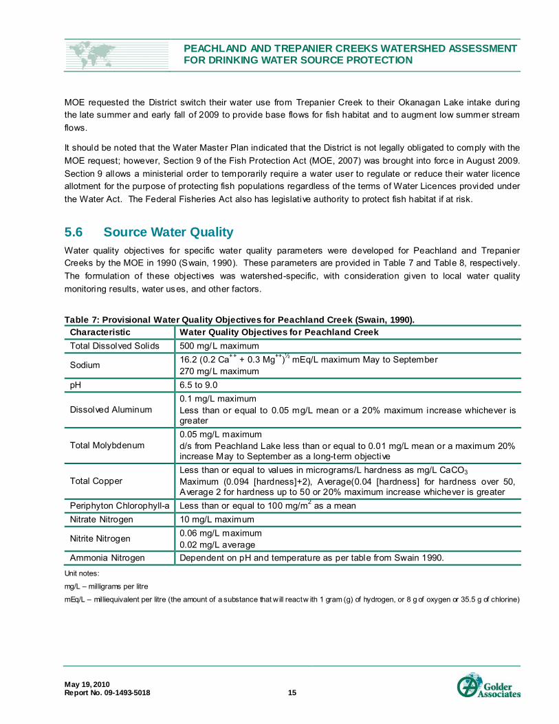
5.6 Source Water Quality Water quality objectives for specific water quality parameters were developed for Peachland and Trepanier Creeks by the MOE in 1990 (Swain, 1990). These parameters are provided in Table 7 and Table 8, respectively. The formulation of these objectives was watershed-specific, with consideration given to local water quality monitoring results, water uses, and other factors.
Table 7: Provisional Water Quality Objectives for Peachland Creek (Swain, 1990).
Characteristic Water Quality Objectives for Peachland Creek Total Dissolved Solids 500 mg/L maximum
Sodium 16.2 (0.2 Ca++ + 0.3 Mg++)½ mEq/L maximum May to September 270 mg/L maximum
pH 6.5 to 9.0
Dissolved Aluminum 0.1 mg/L maximum Less than or equal to 0.05 mg/L mean or a 20% maximum increase whichever is greater
Total Molybdenum 0.05 mg/L maximum d/s from Peachland Lake less than or equal to 0.01 mg/L mean or a maximum 20% increase May to September as a long-term objective
Total Copper Less than or equal to values in micrograms/L hardness as mg/L CaCO3 Maximum (0.094 [hardness]+2), Average(0.04 [hardness] for hardness over 50, Average 2 for hardness up to 50 or 20% maximum increase whichever is greater
Periphyton Chlorophyll-a Less than or equal to 100 mg/m2 as a mean Nitrate Nitrogen 10 mg/L maximum
Nitrite Nitrogen 0.06 mg/L maximum 0.02 mg/L average
Ammonia Nitrogen Dependent on pH and temperature as per table from Swain 1990.
Unit notes:
mg/L – milligrams per litre
mEq/L – milliequivalent per litre (the amount of a substance that will react w ith 1 gram (g) of hydrogen, or 8 g of oxygen or 35.5 g of chlorine)

PEACHLAND AND TREPANIER CREEKS WATERSHED ASSESSMENT FOR DRINKING WATER SOURCE PROTECTION
May 19, 2010 Report No. 09-1493-5018 16
Table 8: Provisional Water Quality Objectives for Trepanier Creek (Swain, 1990). Characteristic Water Quality Objectives for Trepanier Creek Total Dissolved Solids 500 mg/L maximum
Sodium 16.2 (0.2 Ca++ + 0.3 Mg++)1/2 m/L maximum May to September 270 mg/L maximum
pH 6.5 to 8.5
Dissolved Aluminum 0.1 mg/L maximum Less than or equal to 0.05 mg/L mean
Total Molybdenum 0.25 mg/L maximum For 2.5 km u/s from Okanagan Lake, 0.05 mg/L maximum, less than or equal to 0.01 mg/L mean May to September as a long-term objective.
Unit notes:
mg/L – milligrams per litre
mEq/L – milliequivalent per litre (the amount of a substance that will react w ith 1 gram (g) of hydrogen, or 8 g of oxygen or 35.5 g of chlorine)
In addition to the watershed-specific water quality objectives, drinking water guidelines are also specified by IHA (i.e., 4.3.2.1.0. drinking water objectives8
Summit (2004) provided an overview of water quality data for the Peachland and Trepanier watershed areas based on available data from the BC MOE Environmental Management System (EMS) database (sampling period variable from pre-1990’s to 2000’s). Dobson (2006) also characterized water quality in Peachland and Trepanier Creeks based on water samples collected over the period from 1996 to 1999. Additional water quality information specific to discharge of treated effluent from the Brenda Mine site (i.e., to Trepanier Creek) is outlined in Patterson (2003). Parameters that have been analyzed include: total dissolved solids (TDS), sodium, pH, dissolved aluminum, total molybdenum, total copper, total zinc, total lead, Periphyton Chlorophyll-a, nit rogen compounds, turbidity, true colour, temperature, phosphorus, and fecal coli form bacteria. A summary of the general observations noted in previous reports for each watershed are summarized in the sections below (Summit, 2004; Dobson, 2006; and Patterson, 2003).
), and by the BC Approved Water Quality Guidelines for drinking water, aquatic habitat and recreational uses (MOE, 2006). The water quality objectives, criteria, and guidelines are designed to provide guidelines for the protection of aquatic life and water resources.
Peachland Creek Peachland Creek water quality, based on analyses completed at the District intake and at upstream locations, has been generally characterized as follows (Summit, 2004, Dobson, 2006):
Alkaline pH,
Moderate TDS, but within water quality guidelines for most samples,
Elevated turbidity during spring runoff,
True colour in excess of guidelines on some occasions,
8 Refers to 4 log inacti vation of viruses, 3 log removal of parasites, 2 tr eatment process , 1 or less NTU of tur bidity and 0 Fecal Coliform or E.coli. bac teria

PEACHLAND AND TREPANIER CREEKS WATERSHED ASSESSMENT FOR DRINKING WATER SOURCE PROTECTION
May 19, 2010 Report No. 09-1493-5018 17
Mean molybdenum concentrations from EMS data slightly in excess of the long-term objective for mean total molybdenum concentration of 0.01 mg/L (May to September) as specified in the Provisional Water Quality Objectives for Peachland Creek (Summit, 2004),
Historical (pre-1992) molybdenum and copper concentration exceedances in excess of aquatic life and irrigation guidelines/objectives,
Low fecal coli form concentrations,
Nitrate and nitrite concentrations below guidelines, and
Total phosphorus concentrations in expected range for natural waters.
Spatial and temporal variability in water quality sampling results that occurs within Peachland Creek is thought to be related to seasonal variations of precipitation and stream flow, which affects watershed and channel processes and surface run-off characteristics. There are also engineered diversions in the headwaters of Peachland Creek that divert run-off water to the Brenda Mine site. Diverted water to the mine site is stored, treated to reduce molybdenum and copper concentrations in mine tailings and discharged downstream into Trepanier Creek.
Trepanier Creek Trepanier Creek water quality, based on analyses completed at the District intake and at upstream locations, has been generally characterized as follows (Summit, 2004, Dobson, 2006).
Slightly alkaline pH,
Moderate TDS,
Elevated turbidity, coliform bacteria (highest in summer months), and true colour results that do not meet BC water quality guidelines for raw water and/or IHA guidelines. Dobson (2006) noted that significantly elevated mean turbidity values occur during spring freshet within the District intake samples,
Historical (pre-1992) exceedences of guidelines/objectives for molybdenum, copper, and zinc concentrations (Swain, 1992), while post 2000 sampling results consistently meet water quality guidelines following the installation of a water treatment system at the Brenda Mine site (BMW, 2009),
Exceedences of dissolved aluminum or sodium,
Nitrate and nitrite values below guidelines, and
Elevated phosphorous concentrations on occasion, which may be associated with increased turbidity and TDS.
Historically, surface water flowing over exposed rock at the Brenda Mine operation created elevated levels of molybdenum, copper, and zinc released to MacDonald Creek, a tributary of Trepanier Creek (Summit, 2004).
MOE issued an effluent discharge permit (Permit PE-00263) in the late 1990s that required Brenda Mine to treat effluent from the site (Patterson, 2003) to limit molybdenum concentrations and potential health impact on local livestock. The discharge permit specifies concentration limits for molybdenum, copper, iron, manganese, zinc, sodium, sulphates, dissolved nit rogen, total phosphate, total suspended solids, total dissolved solids, pH, and

PEACHLAND AND TREPANIER CREEKS WATERSHED ASSESSMENT FOR DRINKING WATER SOURCE PROTECTION
May 19, 2010 Report No. 09-1493-5018 18
toxicity to rainbow trout (96-hr LC50) (Summit, 2004). The permit requirements for molybdenum are a maximum monthly concentration of 0.25 mg/L and samples at the District intake not to exceed a concentration of 0.03 mg/L between June 1 and September 30, and 0.06 mg/L for the remainder of the year (Patterson, 2003). Based on sampling completed by Brenda Mines since 2000, molybdenum concentrations have been below 0.03 mg/L at the District intake (Xstrata, 2009, 2005 and 2002).
Spatial and temporal variability in sampling results also occurs within Trepanier Creek and is related to seasonal variability of precipitation and stream flow affecting watershed and channel processes, and surface run-off characteristics. Relatively higher seasonal turbidity results at the Trepanier Creek intake may be related to smaller intake settling ponds than those at the Peachland Creek intake.
5.7 Hydrology and Source Water Use Stream flow in major streams within the Okanagan Valley are classified as snow dominated systems and are characterized by peak flows in the spring (referred to as freshet) and low flows in the late summer and fall. Freshet generally occurs from May to June when the snow melts at the upper elevations in the watershed, referred to as the snow sensitive zone (SSZ). The amount of stream flow and the timing of freshet are related to amount of snow accumulation, temperature and precipitation during the spring melt period, storage capacity in the watershed, vegetation and forest cover, impervious surfaces and soil moisture levels.
The characteristics and variation of stream flows are used to assess potential water availability in a watershed and in streams. Water availability is often assessed by monitoring stream water levels to infer flow and discharge. Stream water levels are measured at hydrometric stations maintained by the Water Survey of Canada and the MOE 9. Stream discharge is then calculated from water levels using the stream bed characteristics at the hydrometric station location. The discharge data provided is then used to assist water managers, engineers, biologists and others to estimate water availability, design infrastructure (such as dams, road drainage and dikes), estimate low flow requirements to protect aquatic life and resources and monitor climate change impacts. Currently, there are about 500 active hydrometric stations in BC and the Yukon, with historical data provided for another 2,000 10
Water availability in a stream (water supply) is influenced by annual weather patterns, water withdrawal (demand), watershed storage and the seasonal variability of stream flow and can vary from year to year. A detailed accounting of the water budget (water supply and demand) for Peachland and Trepanier Creeks was estimated by Summit (2004), and Dobson (2006), and again in the Draft Trepanier Creek Revised Operating Strategy (2007). A review of these analyses and results are present in each section below.
.
Peachland Creek There are a number of hydrometric stations that have recorded stream flow information within the Peachland Creek watershed and are presented in Table 9. All of the stations are presently inactive, with the exception of one on Greata Creek near the confluence with Peachland Creek (#08MN0173).
9Real-time s tream fl ow data available at: http://scitech.pyr.ec .gc.ca/waterweb/formnav.asp 10 http://scitech.pyr.ec.gc.ca/ClimH ydro/hydro_explanation_e.asp

PEACHLAND AND TREPANIER CREEKS WATERSHED ASSESSMENT FOR DRINKING WATER SOURCE PROTECTION
May 19, 2010 Report No. 09-1493-5018 19
Table 9: Inactive and active hydrometric stations within Peachland Creek.
Number Status Period of Record
Name
08NM218 inactive 1973-1979 McDonald Creek Diversion To Peachland Creek 08NM140 inactive 1966-1982 Peachland Creek Above Diversions 08NM159 inactive 1969-1982 Peachland Creek At The Mouth 08NM201 inactive 1973 Peachland Creek Below Diversion To Peachland Lake Reservoir 08NM219 inactive 1973-1979 Peachland Creek Diversion To Peachland Lake 08NM030 inactive 1919-1926 Peachland Creek Municipal Irrigation Diversion 08NM029 inactive 1919-1922 Peachland Creek Near Peachland 08NM220 inactive 1973-1984 Peachland Lake Near Peachland 08NM202 inactive 1973-1982 Peachland Lake Reservoir Outflow 08NM173 active 1970-present Greata Creek Near The Mouth
The mean, maximum and minimum monthly water discharge from hydrometric station #08NM159 (currently inactive) on Peachland Creek at the mouth is presented in Figure 1. The increased stream flow over the snowmelt period (from March to June) and lower flow conditions observed from approximately July through to February demonstrates the characteristics of a snow dominated system.
Figure 3: Daily statistics hydrograph, Peachland Creek at the mouth (#08NM159) 11
.
11 From Environment C anada website at: http://scitech.pyr.ec.gc.ca/climhydro/welcome_e.asp
maximum
mean
minimum
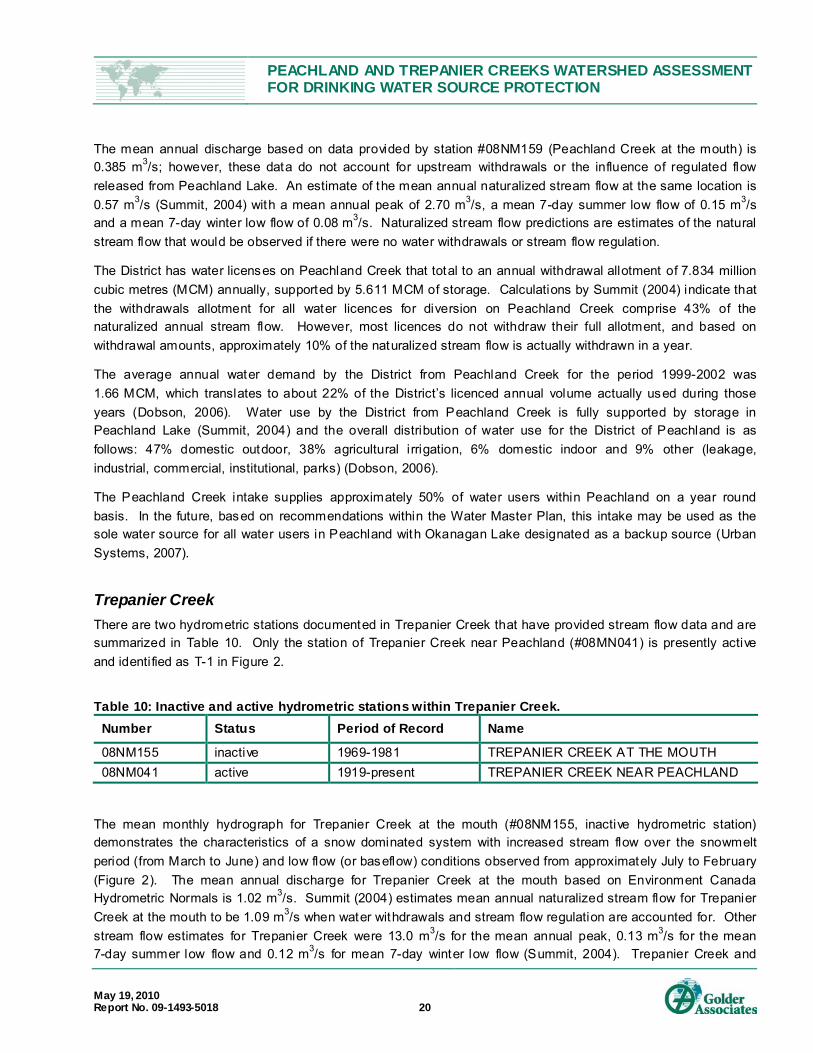
PEACHLAND AND TREPANIER CREEKS WATERSHED ASSESSMENT FOR DRINKING WATER SOURCE PROTECTION
May 19, 2010 Report No. 09-1493-5018 20
The mean annual discharge based on data provided by station #08NM159 (Peachland Creek at the mouth) is 0.385 m3/s; however, these data do not account for upstream withdrawals or the influence of regulated flow released from Peachland Lake. An estimate of the mean annual naturalized stream flow at the same location is 0.57 m3/s (Summit, 2004) with a mean annual peak of 2.70 m3/s, a mean 7-day summer low flow of 0.15 m3/s and a mean 7-day winter low flow of 0.08 m3/s. Naturalized stream flow predictions are estimates of the natural stream flow that would be observed if there were no water withdrawals or stream flow regulation.
The District has water licenses on Peachland Creek that total to an annual withdrawal allotment of 7.834 million cubic metres (MCM) annually, supported by 5.611 MCM of storage. Calculations by Summit (2004) indicate that the withdrawals allotment for all water licences for diversion on Peachland Creek comprise 43% of the naturalized annual stream flow. However, most licences do not withdraw their full allotment, and based on withdrawal amounts, approximately 10% of the naturalized stream flow is actually withdrawn in a year.
The average annual water demand by the District from Peachland Creek for the period 1999-2002 was 1.66 MCM, which translates to about 22% of the District’s licenced annual volume actually used during those years (Dobson, 2006). Water use by the District from Peachland Creek is fully supported by storage in Peachland Lake (Summit, 2004) and the overall distribution of water use for the District of Peachland is as follows: 47% domestic outdoor, 38% agricultural irrigation, 6% domestic indoor and 9% other (leakage, industrial, commercial, institutional, parks) (Dobson, 2006).
The Peachland Creek intake supplies approximately 50% of water users within Peachland on a year round basis. In the future, based on recommendations within the Water Master Plan, this intake may be used as the sole water source for all water users in Peachland with Okanagan Lake designated as a backup source (Urban Systems, 2007).
Trepanier Creek There are two hydrometric stations documented in Trepanier Creek that have provided stream flow data and are summarized in Table 10. Only the station of Trepanier Creek near Peachland (#08MN041) is presently active and identified as T-1 in Figure 2.
Table 10: Inactive and active hydrometric stations within Trepanier Creek.
Number Status Period of Record Name
08NM155 inactive 1969-1981 TREPANIER CREEK AT THE MOUTH 08NM041 active 1919-present TREPANIER CREEK NEAR PEACHLAND
The mean monthly hydrograph for Trepanier Creek at the mouth (#08NM155, inactive hydrometric station) demonstrates the characteristics of a snow dominated system with increased stream flow over the snowmelt period (from March to June) and low flow (or baseflow) conditions observed from approximately July to February (Figure 2). The mean annual discharge for Trepanier Creek at the mouth based on Environment Canada Hydrometric Normals is 1.02 m3/s. Summit (2004) estimates mean annual naturalized stream flow for Trepanier Creek at the mouth to be 1.09 m3/s when water withdrawals and stream flow regulation are accounted for. Other stream flow estimates for Trepanier Creek were 13.0 m3/s for the mean annual peak, 0.13 m3/s for the mean 7-day summer low flow and 0.12 m3/s for mean 7-day winter low flow (Summit, 2004). Trepanier Creek and

PEACHLAND AND TREPANIER CREEKS WATERSHED ASSESSMENT FOR DRINKING WATER SOURCE PROTECTION
May 19, 2010 Report No. 09-1493-5018 21
Peachland Creek have similar flow rates for the naturalized 7-day low summer flows, but Trepanier Creek has a much larger mean annual peak, which is probably attributed to the larger watershed area and significantly smaller available storage capacity.
Figure 4: Daily statistics hydrograph, Trepanier Creek at the mouth (#08NM155).
As indicated in Section 1.2, the Trepanier Creek intake supplies approximately 40% of water system connections on a year round basis; with Okanagan Lake used as a back-up intake. It was estimated that all water licence allocations accounted for 13% of naturalized annual stream flow, with 5% of estimated naturalized stream flow actually being withdrawn. On average, 27% of the licenced annual volume is actually used by licenced water users (Summit 2004).
The District holds water licences for a total annual allotment of 3.034 MCM annually on Trepanier Creek that is supported by 1.031 MCM of storage (Dobson, 2006). Based on 1999 -2002 water use data, the District’s annual water withdrawals from Trepanier Creek were approximately 1.2 MCM (Dobson, 2006), which is approximately 35% of its water licence allocation.
Trepanier Creek intake is the preferred water source for the Trepanier Creek system and is used for most of the year as it can provide water via gravity to the water users. The intake in Okanagan Lake can also feed this system and is typically used during spring freshet when water quality within the stream is excessively turbid or during dry periods to provide base flows in Trepanier Creek.
5.8 Integrity Evaluation of Intakes and Reservoirs The following summarizes the integrity evaluation of the intakes and reservoirs used by the District for the purpose of domestic drinking water supply. The assessment did not include the Okanagan Lake intake as part of the scope of work of this study. Figure 5 identifies the locations and the geographic coordinates for the District’s water facilities in the Peachland Creek and Trepanier Creek watersheds.
maximum
mean minimum

PEACHLAND AND TREPANIER CREEKS WATERSHED ASSESSMENT FOR DRINKING WATER SOURCE PROTECTION
May 19, 2010 Report No. 09-1493-5018 22
5.8.1 Peachland Creek Water Facilities Storage is provided within the Peachland Creek WAA in Peachland Lake, with secondary storage within Glen Lake and Wilson Lake. Peachland Lake is dammed and provides the majority of storage in the Peachland Creek WAA. The locations of the lakes and streams within the Peachland Creek WAA are provided in Figure 1.
The outflow at Peachland Lake releases water into Peachland Creek. The point-of-diversion where water is withdrawn into the District distribution system is downstream at the Peachland Creek intake. Peachland Creek from Peachland Lake to the intake and Greata Creek from the outlet of Glen Lake to the confluence with Peachland Creek has little to no buffering capacity due to the stream bed gradients and local topography. Buffering capacity in a stream is related to the residency time of water within the channel that allows microorganisms to degrade and turbidy/suspended sediment to settle.
The following provides a brief description of each facility and the corresponding integrity evaluation.
Peachland Lake Peachland Lake is a reservoir created by an earth-filled dam constructed in 1969 by Brenda Mines to provide water to their mining operations (Golder, 2008). The District took over the dam and water licences in 1990 when Brenda Mines stopped mining operations at the site.
Peachland Lake is at an elevation of 1645 masl and covers an area of approximately 110 hectares with a storage capacity of 12.7 MCM (10,300 acre-ft (AF)). Peachland Lake provides the main water storage facility for the District in the Peachland Creek WAA with an annual water licence storage amount of 5.303 MCM. Typically, the reservoir is filled during freshet (i.e., April to June) and water is spilled via the spillway into Peachland Creek to avoid overtopping the dam. However, discussions with District staff indicated that the reservoir only filled to 90% in 2009 and no excess water was released from the reservoir (Glass, pers. comm., 2009). Lower reservoir water levels in 2009 were attributed to a combination of increased snow loss due to higher winds through decreased forest cover and from the ground not freezing before it snowed increasing infiltration during snow melt (Allin, pers. comm., 2009). The prediction for the 2010 freshet is that there will be more overland flow as the ground frosted before snow cover, which should reduce water losses from infiltration.
The management of the Peachland Lake levels and water releases are based on seasonal assessments of the snow pack, winter ground conditions, historical data of water release, weather predictions and current weather patterns. The 2009 season was unusual as there was above average snow pack, but the reservoir only filled to 90% capacity. No water over the consumption rate was released from the reservoir during the 2009 year (Allin, pers. comm., 2009).
Peachland Lake is easily accessible by two wheeled drive vehicles. A small Recreation Camp Site is located at the northeast shore of the reservoir (see Section 5.2.6.1 for more information on this Recreation Camp Sites). There are no leased lots on Peachland Lake, but the lake is a popular fishing lake with enhanced Rainbow Trout. Motorized boats have access to Peachland Lake.
Golder completed a Dam Safety Review of Peachland Lake in June of 2008 (Golder, 2008). The report summarizes the review and inspection results with respect to the safety of the engineered facilities of the dam, reservoir, spillway and spillway channel and outlet. The following summarizes the significant results in the context of the contaminant source survey and potential impacts on water quality:

PEACHLAND AND TREPANIER CREEKS WATERSHED ASSESSMENT FOR DRINKING WATER SOURCE PROTECTION
May 19, 2010 Report No. 09-1493-5018 23
No sediment sources resulting from failures of the dam structure or slope failures were noted.
A beaver lodge was noted at the west end of the reservoir.
Active rockfall and/or sloughing of material into the concrete lined section of the spillway channel was evident in the 2008 inspection and also noted in previous dam inspection reports.
Active down-cutting, localized slope failures and erosion of the spillway channel where it discharges to Peachland Creek was noted.
Past bank sloughing was noted at the outlet, however, the area was covered with rip rap and no further sloughing was noted during the inspection.
Mr. Allin, the Director of Operations for the District, indicated that recommendations from the report to improve the spillway were completed in the summer of 2009, however, due to the snow conditions during the field reconnaissance visit and the lack of flow in the spillway, the effectiveness of the works to reduce sediment loads could not be confirmed.
Glen Lake A water licence was issued to the District in 1913 to create 0.3 MCM (250 AF) of storage and a dam was constructed on Glen Lake to support the water licence requirement, although the exact date of dam construction is unknown. The dam was breached in 1996 by the District as they were facing increasing maintenance costs to improve dam safety and the stored water was not being utilized (S. Rowe, pers. comm., 2009). The original dam was about 2 m to 3 m in height and remnants of the original dam structure are still in place. Currently, there is a log crib at the breach site that supports about 0.3 to 0.6 m of storage (S. Rowe, pers. comm., 2009).
In 2007, the District contracted Associated Engineering to complete some preliminary design work to construct a new dam on Glen Lake that would potentially double the storage amount available from 0.3 MCM (250 AF) to 0.6 MCM (500 AF) (Associated, 2008). Preliminary investigations and design work has been completed and construction is to proceed in 2010 (D. Allin, pers. comm., 2010).
Wilson Lake Mr. Allin, the Director of Operations for the District reported that there was a small dam on Wilson Lake, although no information was found to provide specifics about the dam. The District breached the dam in 1996 as the dam site needed improvements for safety reasons and the storage was not being used. Wilson Lake currently does not have any flow control and is at the natural lake level. Reconstruction of this dam is unlikely in the future as the there is not a significant amount of storage available at this site (S. Rowe, pers. comm., 2009).
Peachland Creek Intake The Peachland Creek intake facility is located approximately 3.7 km upstream from the mouth with Okanagan Lake. It is within CORD and located on Pearce Pl. near the District Public Works Yards on a 129.5 hectare parcel of land with the legal description District Lot 1275 Osoyoos Division of Yale (ODYD). Access to the intake facility and associated structures is through Pierce St., a residential road off of Princeton Ave. The road to the intake does not have a gate to limit public access, but the intake facility and associated structures are fenced.

PEACHLAND AND TREPANIER CREEKS WATERSHED ASSESSMENT FOR DRINKING WATER SOURCE PROTECTION
May 19, 2010 Report No. 09-1493-5018 24
A photo overview of the intake facility is provided in Photo 1 within Appendix D and shows the intake facility consisting of an intake diversion weir on Peachland Creek at the upstream side (Photo 2), two settling ponds in series (Photo 3), a flow control weir (Photo 4) at the downstream end of the facility and a chlorination facility for the drinking water distribution system. The intake facility is classified as off-stream as the water is diverted at the intake diversion weir and flows into the first settling pond via two diversion pipes (Photo 5). The first settling pond has a surface area of approximately 1,250 m2 with a rock berm at the outlet of the diversion pipes for energy dissipation. The second settling pond has a surface area of approximately 4,850 m2. The water is taken from the second pond and chlorinated before release into the water distribution system.
Peachland Creek is channelized between the intake weir and the flow control weir (Photo 6). This section of Peachland Creek is characterized by a low channel gradient which was observed to enhance sedimentation locally within the channel bed (Photo 7). There is a steep, exposed slope on the south side of the stream channel at the flow control weir. Material sloughing from this slope is entering the stream (Photos 8 and 9). Although this sediment source is downstream of the intake weir and, therefore, not considered a direct sediment source to the District water supply, it will impact downstream water quality and may create stream infilling and a potential maintenance issue to the District as it is infilling the stream channel at this location.
There is evidence of sedimentation occurring near the intake diversion weir as shown in Photo 10. Animal tracks were also noted at this location indicating wildli fe access. Wildlife may impact water quality by input of microbial contaminants and disturbance of the riparian zone and stream channel causing increased turbidity.
5.8.2 Trepanier Creek Water Facilities Storage is provided within the Trepanier Creek WAA within Silver Lake, Lacoma Lake, McDonald Lake, George Lake and Long Lake. Silver Lake has a flow control dam and Lacoma Lake is reported to have a partial dam at the outlet (Dobson, 1998). Water from Trepanier Creek is diverted to the District water distribution system at the Trepanier Creek intake facility. Due to stream bed gradients and the topography in the Trepanier Creek WAA, there is little to no buffering capacity in the mainstream stream channel and within the tributaries downstream of the watershed lakes. Also, the lakes in this watershed are relatively small and the residency time may not be sufficient to provide adequate buffering capacity to address the microbial and/or sediment risks in the watershed.
The locations of the lakes and streams within the Trepanier Creek WAA are provided in Figure 1. The locations and global position system (GPS) coordinates of the District water facilities are provided in Figure 5. The following sections provide a brief description of each facility and the corresponding integrity evaluation.
Silver Lake Silver Lake is located approximately 9 km west of Peachland within the Trepanier Creek WAA. Silver Lake is easily accessible by two-wheeled drive vehicles and has a number of land leases and camping facilities on the shores, including a Recreation Camp Site at the east shore (see Section 5.0 for more information on leased land and Recreation Camp Sites).
The lake level is controlled by an earth-filled dam at the south east side of the lake. The dam was originally constructed in the mid 1920’s and rehabilitated in 1980 (District website, 2009). After dam re-construction was completed in November 1980, the District was granted the diversion licences on Trepanier Creek and Silver Lake is currently used as emergency storage for the Trepanier Creek water supply. Silver Lake covers

PEACHLAND AND TREPANIER CREEKS WATERSHED ASSESSMENT FOR DRINKING WATER SOURCE PROTECTION
May 19, 2010 Report No. 09-1493-5018 25
approximately 10 hectares with a storage capacity of 0.456 MCM (456 acre-ft ). The Dam Safety Section of the Water Stewardship Division classifies the Silver Lake Reservoir Dam as a High Consequence Dam (Golder, 2009). The Silver Lake dam is about 6 m high and 30 m wide at the base. Water from Silver Lake is released to Silver Creek through a 300 mm diameter reinforced concrete pipe that has a sluice inlet and outlet structure at either end of the pipe that controls outlet (Golder, 2009).
The spillway structure is located about 200 m north of the dam and consists of an earth-filled berm comprised of native silty till. The upstream and downstream faces as well as the crest of the spillway berm are protected by a riprap cover. A 600 mm concrete culvert located under the access road provides an outlet for water that spills over the spillway. The spillway channel discharges to Silver Creek, a tributary of Trepanier Creek.
A Dam Safety Review of the Silver Lake Dam was completed by Golder in 2009 who inspected the dam, reservoir (Silver Lake) and associated spillway, spillway channel and outlet. The report indicated that the Silver Lake Dam and associated appurtenances appeared to be in satisfactory condition, except for a few noted deficiencies. The deficiencies noted were related to a wet area above the outlet, vegetative growth above the outlet, on the dam and in the spillway, and the presence of debris. No slumps, slides or slope failures were observed.
Lacoma Lake Mr. Rowe of MOE reported that the partial dam on Lacoma Lake is constructed of a log crib that is backfilled with rock. The structure is not water tight and substantial leakage occurs. The partial dam was constructed to support water licences that were issued to a number of properties outside the Peachland municipal boundary and close to Trepanier Creek. A recent application to MOE for apportionment of water licences to support subdivision of property resulted in the MOE issuing a letter stating that Conditional Licences C103311 and C104243 must construct a dam on Lacoma Lake to support their storage requirement (MOE, 2009b). The water licences and dam structure are not a District responsibility.
Trepanier Creek Intake The Trepanier Creek intake facility is located at the end of Trepanier Creek off of Trepanier Road. The intake facility is located within CORD boundaries on a 64.75 hectare parcel of land with the legal description of District Lot 3703 ODYD. Access is through private property and there is a sign that prohibits access to the public and another sign that indicates no trespassing. The intake facility and associated structures are fenced.
A plan overview of the intake facility is provided in Photo 11 of Appendix D. The facility consists of intake pipes in Trepanier Creek at the upstream end (Photo 12), two settling ponds in series (Photo 13), a flow control weir (Photo 14) at the downstream end of the facility and a chlorinating building. The intake is classified as off-stream as the water is diverted into the settling ponds from the stream and flows through the two ponds before flowing into the distribution system. The first settling pond has a surface area of approximately 640 m2, while the surface area of the second pond is approximately 565 m2.
The flow control weir on Trepanier Creek reduces the stream channel gradient to allow water to back up to form a long shallow pool on the stream approximately 200 m in length and 10 m to 15 m in width. The depth will vary seasonally with flow, but was approximately 0.6 m in depth at the time of the field visit on November 12, 2009. The pooled area allows water to cover the intake pipes and supply water to the settling ponds and intake. The

PEACHLAND AND TREPANIER CREEKS WATERSHED ASSESSMENT FOR DRINKING WATER SOURCE PROTECTION
May 19, 2010 Report No. 09-1493-5018 26
pooled area on the stream is highly channelized (Photos 15 and 16) and the low channel gradient enhances sedimentation within the channel bed. Fine material was observed covering the channel bed during the field visit and the channel bed was filled to the bottom of the intake pipes. Further sedimentation could cause obstruction of the intake pipes and impede flow into the settling ponds.
The north side of the stream where the intake facilities are located is relatively flat as is the land surrounding the facility and no sediment sources were noted. There is a moderately steep slope adjacent to the pooled area on the south bank of the stream, but the slope is well vegetated and no obvious sediment sources were noted. Both sides of the stream bank have been protected with riprap in the pooled area, with the exception of a section of the south bank upstream of the intake pipes, which had exposed soil (Photo 15). There is a potential that this bank could eroded and deliver sediment into the stream during high flows.
5.9 Intrinsic Hazards to Water Quality and Quantity Intrinsic hazards, as opposed to human related activities or hazards, to a watershed are related to natural processes and the response based on watershed characteristics which may impact water quantity and quality. Intrinsic hazards to the Peachland Creek and Trepanier Creek WAAs are summarized in Table 11 (end of text), with additional narrative provided below.
Intrinsic natural risks identified for the Peachland and Trepanier Creek WAAs include:
Recent infestations by Mountain Pine beetles,
Recent infestations by Tussock moth in the Trepanier Creek watershed,
Impacts from climate change,
Impacts from wildfires,
Impacts from wildlife,
Sediment sources, and
Channel conditions.
All specific sites referred to in this report correspond to the inventory of site-specific hazards, with details provided in Table 4 (end of text) and corresponding locations provided in Figure 2.
5.9.1 Mountain Pine Beetle The presence of Mountain Pine Beetle (MPB) in British Columbia forests has always existed, however, before 1993, significant areas of MPB impacted pine forest was always restricted to relatively small localized areas (Chatwin and Alila, 2007). Since then, MPB attack of mature pine stands has spread rapidly in the province, generally starting in Central BC and spreading south to the Interior.
The cause of the wide spread MPB epidemic in Central and Interior BC forests are thought to be from a combination of (Chatwin and Alila, 2007):
PEACHLAND AND TREPANIER CREEKS WATERSHED ASSESSMENT FOR DRINKING WATER SOURCE PROTECTION
May 19, 2010 Report No. 09-1493-5018 27
Wildfire History – widespread fires that occurred between 100 to 160 years ago killed off large areas of forest that regenerated naturally. This has resulted in large portions of similarly aged mature pine within the Central and Interior forests that are vulnerable to MPB attack,
Forest Management Practices – have prevented natural forest fires leaving large areas of mature pine, and
Climate Change – has increased winter temperatures that formally controlled beetle populations.
The water balance of an area with living trees behaves differently than stands dominated by dead trees or that is clearcut. Snow accumulation, stream flows, freshet (peak flows after snow melt) and freshet timing change with the amount of trees present, which in turn may impact wildlife, soils, fish habitat, water quality and quantity. The following is a summary of the impacts on the water balance of living tree stands compared with dead tree stands or clearcuts:
There is less snow accumulation in live stands than in clearcuts or MPB killed stands due to sublimation12 of intercepted snowfall on the tree canopy and increased transpiration 13
The timing of snowmelt is extended in live stands compared to clearcuts or MPB killed stands and will experience reduced peak flows due to shading of the snow on the forest floor slowing snow melt. Snowmelt will be faster in clearcut areas than in a dead MPB stands as some shading still occurs with dead standing trees.
of living trees. Clearcuts will have more snow accumulation than a dead tree stand as some snow is still intercepted on the dead trees and some snow will be lost by transpiration of trees that survive a MPB attack or understory.
The expected watershed changes from large losses to forest cover from the MPB epidemic include (Winkler et al., 2008);
increases in rain and snow reaching the ground,
increases in soil moisture,
increases in surface water flow,
increases in total stream flows, with the majority of flow occurring at freshet thereby increasing peak flows,
increases in the magnitude and frequency of peak flows, and
earlier onset of snow melt.
The level of hydrologic changes to a watershed is dependent on the overall percentage of watershed area impacted, percentage of trees within a stand that are impacted, regeneration (i.e., natural or salvage logging), logging practices, watershed characteristics, understory and weather (Winkler et al., 2008). The hydrologic response of a stand allowed to regenerate naturally will be more gradual while stands that are clearcut have a large immediate change (Winkler et al., 2008). Also, stands with sufficient understory will recover faster and not have as large a hydrologic response as the understory will reduce snow accumulation by intercepting precipitation, decrease the amount of groundwater by transpiring, and provide shading to ground snow thereby extending snow melt timing and reducing peak flows (Winkler et al., 2008). 12 Solid turning direc tly into a gas. 13 Water taken up by plants and released as water vapour.

PEACHLAND AND TREPANIER CREEKS WATERSHED ASSESSMENT FOR DRINKING WATER SOURCE PROTECTION
May 19, 2010 Report No. 09-1493-5018 28
The majority of forested area in the upper plateau area of both Trepanier and Peachland Creek are composed of tree stands with greater than 70% mature pine (Tolko, 2008; Dobson, 2009). In 2006, the Provincial Emergency Program produced an overview map of areas with greater than 40% lodgepole pine to assess risk to watersheds and found 44% of land base in the Trepanier Creek watershed and 47% of land base in the Peachland Creek watershed has greater than 40% lodgepole pine (Redding et. al., 2008).
Beetle killed trees must be logged in the first few years or they lose their commercial value. As a result, the province has increase the allowable annual cut for MPB infested timber and the forest companies working within the Peachland and Trepanier Creek watersheds are salvage logging large areas of mature pine in both watersheds. Hydrologic response of harvesting will vary depending on harvesting practises, the amount of ground disturbance, site drainage changes, damage to understory and planting practises. MPB salvage logging in both watersheds is explored further in Section 5.1.
The main concern to drinking water from the current MPB epidemic are the resulting changes to the water balance in a watershed and the resulting increase to peak flows. The Okanagan UBC Watershed Model predicted increases of 30% to 100% in peak flows for the 1-year and 2-year return periods and increases of 35% to 75% for the 10-year and 20-year return periods in extensively logged watersheds for modelled watersheds in the Interior (Winkler et al., 2008). The variation in peak flow responses was due to different weather conditions in different watersheds.
Increases in surface water flow and peak stream flows increases erosion rates from impacted areas, roads and infrastructure and by destabilizing stream beds and channels. Increased erosion decreases water quality by increasing turbidity and increasing sedimentation rates. Sediment loading will also increase the rate of infilling of reservoirs and other drinking water facilities, such as the pooled areas of the stream channels beside Peachland and Trepanier Creek intakes and in the settling ponds.
From a biological perspective, increases in sediment may overload aquatic organisms, disturb habitat, cover gravel spawning beds and in extreme cases, completely infill stream beds exacerbating flooding risks. Impacts to stream recovery in the long term is from lack of large woody debris recruitment, changes to stream channels and changes to the local vegetative species (Scott and Pike, 2003).
Other impacts from the MPB epidemic are the increased risk of severe wildfires from large fuel loads within the watershed, increased magnitude and frequency of peak flows potentially causing infrastructure damage if undersized and increases in groundwater and stream flows destabilizing slopes causing an increase in slope failures and landslides (Winkler et al., 2008).
5.9.2 Tussock Moth The tussock moth is a native species of BC and outbreaks typically occur every ten to twelve years 14. An outbreak was recently identified as a new concern within in the Trepanier Creek watershed 15
14Douglas-Fir Tussock Moth Program (DFTM) available at http://www.for.gov.bc.ca/rsi/foresthealth/Tussock_Moth.htm
. Tussock moth is a defoliator of Douglas-fir trees and can quickly kill Douglas-fir trees. Outbreaks often develop very quickly and then typically subside abruptly after a few years as natural controls and predators cause populations to collapse
15 Information provided on CORD website at http:/ /www.cord.bc .ca/whatsnew.aspx

PEACHLAND AND TREPANIER CREEKS WATERSHED ASSESSMENT FOR DRINKING WATER SOURCE PROTECTION
May 19, 2010 Report No. 09-1493-5018 29
(Wickman et.al., 1998). Survival rates of mature trees vary, but often younger trees have a high mortality rate while larger trees have enough reserves to recover (Manz, 2009).
Tussock moth outbreaks are of a particular concern due to public health implications. Many people and some domestic animals, such as dogs and horses, may have allergic reactions to hairs on the eggs, larvae and caterpillars, causing a condition known as tussockosis. Tussockosis causes a range of symptoms from skin rashes and itchiness to anaphylaxis. The tussock moth caterpillar should not be handled unless protective gear is worn (MOFR, 2009a).
Impacts to drinking water resources from Tussock moth outbreaks are dependent on the location of the outbreak, the level of tree mortality and the treatment method of control. According to the Douglas-fir Tussock Moth 2009 Outbreak Areas map produced by MOFR (provided in Appendix E), the outbreak in Trepanier Creek appeared to be in the lower reaches of Trepanier Creek within the stream riparian area and was rated as severe in 2009 (MOFR, 2009b). The map indicates the majority of the impacted area is downstream of the Trepanier Creek intake; however, the outbreak may spread if it cannot be controlled.
The MOFR is responsible for pest management on Crown lands and conducts an annual aerial survey to assess impacted areas and outbreak severity (CORD, 2009). Tussock moth reduction strategies include monitoring and staged control strategies depending on stage of outbreak and severity (MOF, 1995). Once an outbreak is identified, strategies for population control include application of nuclear polyhedrosis virus (NPV) virus, mating disruption, chemical insecticide and/or biological insecticide. The NPV virus is a naturally occurring virus that is specific to the tussock moth, but needs to be sprayed when the larvae has just hatched to be an effective control (MOFR, 2009c). MOFR is planning a land spraying program in coordination with CORD for the spring of 2010 to control the outbreak (CORD, 2009).
5.9.3 Climate Change Climatic conditions and events will vary to an unknown extent in the future in the Okanagan Valley. Climate models predict warming in BC to occur at a rate of 1ºC to 4ºC per century, with the Interior of the province warming faster than other regions, and experiencing higher rates of warming than observed from historic climate observation (MWLAP 2002, Wang et al. 2006). In south Central and southwestern regions of the Okanagan, the frequency of warm years is expected to increase, with an increase in minimum and maximum annual temperatures (Wang et al. 2006, MOE 2007). Analysis of temperature in BC in the last 100 years has demonstrated an overall increase, with the greatest temperature increase observed in the winter months (Pike et. al., 2008).
Precipitation responses in BC have been variable depending on location within the province. For locations with lower precipitation, such as the Okanagan Valley, higher annual average precipitation is observed, with an overall trend of increasing precipitation during wet periods, extended dry conditions and a decrease in snow pack. Climate change models predict that there will be a 10% increase summer precipitation and 15 to 25% reduced winter precipitation (MoE 2007, Mote et al. 2006, Rodenhuis et al. 2007). In mountainous regions of the Okanagan, particularly at mid-elevations, higher temperatures can potentially lead to a long-term reduction in peak snow-water equivalent, with the snowpack building later in the winter season and melting earlier in the year (Chapman 2007). Price and Rind (1994) suggest that lightning-caused wildfires could potentially increase.

PEACHLAND AND TREPANIER CREEKS WATERSHED ASSESSMENT FOR DRINKING WATER SOURCE PROTECTION
May 19, 2010 Report No. 09-1493-5018 30
The following summarizes the hydrologic responses to climate change in the Okanagan Valley (Pike et. al., 2008):
Increase in atmospheric vapour demand, increasing evaporation from lakes and reservoirs,
Increase in evapotranspiration due to higher temperatures, resulting in a longer growing season and less soil moisture. This will increase irrigation demand and may increase wildfire risk from reduced water availability to non-irrigated vegetation,
Increase in water temperatures resulting in increases in algae events in lakes and negative impacts to coldwater fish species,
Increase in frequency and magnitude of storms and extreme wind events. Changes to return period storms and predicted magnitudes may stress and compromise engineered structures and require changes to design criteria,
Alteration in vegetation to adapt to changing site conditions, impacting habitat,
Accelerated melting of snow with increasing peak flows. This will increase the risk of flooding, landslides and channel destabilization causing an increase in erosion rates,
Earlier melting of snow and lake ice, by as much as four to six weeks (Summit, 2004), resulting in reduced low flows in the late summer and early fall,
Shorter snow accumulation time from higher winter temperatures with a corresponding decrease in snow pack. This will result in less peak volume (Summit, 2004), less water available for storage and/or an increase in groundwater infiltration, depending on local surficial and bedrock geology. Increased groundwater infiltration and reduced snow pack could offset the predicted increase in peak spring flows, especially in watersheds with storage where peak flows would be intercepted, and
Snowlines will migrate to higher elevations and snow dominated systems may start to exhibit features of a mixed/hybrid hydrologic system, such that winter snow events may turn to rain events with peak flows exhibited in the winter time. This will further reduce snow accumulation and reduce late summer/early fall low flows increasing pressures on fisheries resources.
There are contradictory predictions of the peak responses to climate change. These predictions suggest that the reduced snow pack would result in decreased peak flow volumes, while faster snow melt times may shorten the melt duration and thereby result in increased peak flows.
The predicted responses of the annual flows to climate change in Peachland Creek and Trepanier Creek based on the UBC Watershed Models are as follows (Summit, 2004):
Peachland Creek - a reduction of 18% by 2020 and 34% by 2050, and
Trepanier Creek - a reduction of 20% by 2020 and 39% by 2050.
These predicted reductions in flow will affect the water availability to users and in-stream resources. In particular, the reductions are predicted to have the most dramatic impact on low flows within the streams.

PEACHLAND AND TREPANIER CREEKS WATERSHED ASSESSMENT FOR DRINKING WATER SOURCE PROTECTION
May 19, 2010 Report No. 09-1493-5018 31
5.9.4 Wildfire Wildfires can impact many aspects within a watershed such as watershed hydrology, erosion rates, wildli fe and fish habitat, forestry and other industries, vegetation and water quality. Increase in wildfire risk generally results from increases in tree mortality from insect attack and disease, overstocking vegetation and historic fire suppression techniques (Murphy et al., 2006), which is aggravated during dry weather conditions such as that experienced in the Interior of BC during 2003 and 2009.
The southern Interior wildfires of 2003 and 2009 were considered severe due to high fuel loads and extremely dry conditions, promoting intense burning conditions. High intensity fires during dry conditions may generate high temperatures fires that consume all fuel, including stump and root systems, and “ash” the soil where all soil organics and litter are combusted (Scott and Pike, 2003). This in turn exposes the mineral soils and may make them hydrophobic (repel water), increasing the velocity and the volume of runoff during rain events, both of which may result in increased soil erosion. Increased flows within the watershed are also attributed to reduced evapotranspiration through loss of living trees, increased snow pack and faster spring melting from increased radiation. Increased stream flows may also cause slope and channel instability (Scott and Pike, 2003).
The most significant reported impact of wildfires to drinking water sources is an increase in soil erosion causing increases is sedimentation and turbidity (Dissmeyer, 2000). Sediment loads following a fire are variable and dependant on (Dissmeyer, 2000: Scott and Pike, 2003):
fire characteristics and fire intensity,
total burn area and proportion of watershed burned,
proximity to stream channels,
slopes of burned area,
soil type and local geology,
vegetation, and
weather and climate.
Risks to drinking water resources from erosion typically increase when fire occurs on steep slopes, closer to stream corridors and/or in areas where there are with no reservoirs, lakes or wetlands to allow sediment to settle out.
Nutrient loads and dissolved organic matter in stream waters have been found to increase in post-fire environments (Meixner and Wohlgemuth, 2004). Phosphorus is found to be carried primarily in the sediment load and, to a lesser extent, in ash. Increases in nitrogen are primarily in the form of nit rate, will often exceed the BC Drinking Water Standards of 10 mg/L and have been found to be persistent up to 10 years after a fire (Meixner and Wohlgemuth, 2004). Nutrient loading can negatively impact reservoirs and cause algae growth and/or fish kills (Dissmeyer, 2000).
Post-fire treatment of burned areas may help reduce sediment loading to the streams (Meixner and Wohlgemuth, 2004). The National Park Service in the USA has developed protocols for emergency fire treatment and post fire treatment called Burn Area Emergency Rehabilitation (BAER) treatments that are used in the USA (Neary et.al., 2005). However, the effectiveness of these treatments is being studied and suggest that

PEACHLAND AND TREPANIER CREEKS WATERSHED ASSESSMENT FOR DRINKING WATER SOURCE PROTECTION
May 19, 2010 Report No. 09-1493-5018 32
some types of treatment are more effective than others. For instance, seeding was found not to be as effective a post-fire treatment as mulching a burn area (Wagenbreener, 2003). Hence, fire response in community watersheds should include post-fire watershed treatment, with consultation of the latest research to ensure the most effective treatment options.
5.9.5 Wildlife and Birds Wildlife information for CORD was obtained from the BC Species and Ecosystem Explorer Search Site16
Larger mammals, such as deer, black bears, coyotes, wolf, large cat species (cougar, lynxes, etc.) and birds are a risk to drinking water quality as they may impact water quality with microbial constituents, most notably pathogenic bacteria, virus and protozoa. Larger wildli fe, that have the most impact on water quality, will have access to the water courses in similar areas as cattle, as described in Section 5.2, with the exception of the lower reach of Trepanier Creek. There are no range tenures in lower Trepanier Creek; however, there was evidence of wildlife in this area (Appendix D - Photo 75). Due to the low channel gradient, wide floodplain and relatively open forest, most areas of the lower reaches of Trepanier Creek are accessible to wildlife.
. This database provides listings of Red List (extirpated, endangered, or threatened), Blue List (special concern), or Legally Designated Species on the Yellow List (not at risk). Search results for all animal species listed in the Central Okanagan Regional District are included in Appendix F. The search results identified 72 list-species on record. Seventeen of these species are mammals, 8 are reptiles and turtles, 3 are amphibians, 20 are birds, 2 are fish, 14 are insects, and 8 are non-marine molluscs. Note that the BC Government search provides legally designated species only and thus does not include common species which are known to be present within the area such as deer, black bear, cougar, and others.
A dear carcass was found in Trepanier Creek in the Spring of 2009. Dead animals will contaminate water with microbial constituents i f not removed immediately. The carcass was below the District intake and was removed by CORD.
5.9.6 Sediment Sources Sediment input into water courses has a large impact on water quality by increasing the turbidity and releasing microbial contaminants, in or adsorbed to soil, into the water. Increased turbidity in water reduces the aesthetic value of water by causing cloudiness, reduces the effectiveness of disinfection and may impact filtration plants (HC, 2003). Increased sediment loads may also reduce water quantity by increasing the infill rate of reservoirs.
Sediment sources may arise due to natural processes or as a result of human land use. Sediment sources and changes to sediment loading in a watershed generally develop when vegetation is disturbed or removed, when soils are moved and left exposed and/or when unstable terrain fails (i.e., landslides). Sediment sources may also be indirectly related to human influences in a watershed, where land use in one area may impact a natural process. For example, the loss of tree cover from timber harvesting may increase peak flows, potentially causing changes to downstream channel morphology and/or causing landslides from destabilization of terrain adjacent to stream channels.
16 Availabl e at: http://a100.gov.bc.ca/pub/eswp/search.do

PEACHLAND AND TREPANIER CREEKS WATERSHED ASSESSMENT FOR DRINKING WATER SOURCE PROTECTION
May 19, 2010 Report No. 09-1493-5018 33
Sediment sources above lakes and reservoirs (i.e., Peachland Lake) will have a lesser impact to water quality at the District intakes than sediment sources that are not buffered by a lake or reservoir. Lakes and reservoirs encourage the settling out of sediment due to reduced velocities and prolonged storage (residency time) of water which enables sediment to fall out of suspension. Peachland Creek has larger lakes to assist in sediment settling than Trepanier Creek. Sediment sources that occur above Peachland Lake, and to a lesser degree Glen Lake, may have minimal impact to water quality at the District intake. However, the lakes in both watersheds occur in the upper elevation areas of their respective watersheds so will only provide a buffer to sediment load for the upper regions of the WAAs. Sediment that enters the stream channels between the lakes and the District intakes will have a relatively faster travel time to the intakes due to predominantly high flow velocities in the streams. The turbulent characteristics of the flow will likely result in limited settling of fine particles before reaching the District intakes.
Several historic and potentially ongoing sediment sources were identified during the aerial photo review17
Landslides involve the movement of soil, rock, and water and vegetation downslope. If a landslide runs out to a stream channel, it typically results in the introduction of relatively large amounts of fine soil and vegetation into the stream. Based on the aerial photograph review, inferred landslides potentially running out to a stream channel were identified in Lacoma Creek (T-15), MacDonald Creek (T-25) in the middle reaches of Trepanier Creek, the middle to lower reaches of Peachland Creek (P-9, P-12, P-14, P-16, P-20 and P-22), Greata Creek (P-33), and Bolingbrooke Creek (P-31). Many of these inferred landslides are located adjacent to the stream channels where the sidewall slopes are generally steep (i.e., deeply-incised channel), indicating the stream channels in both the Peachland Creek and Trepanier Creek WAAs are sensitive to sediment introduction from unstable sidewall slopes.
and were groundtruthed, where accessible, during the field reconnaissance. These sources included rockfall areas associated with meltwater channels, present day stream channels and landslides along the sidewall slopes of steep-gradient streams. Significant rockfall areas exist within the upper reaches of Peachland Creek (P-30), Trepanier Creek (T-19) and the tributary Lacoma Creek (T-15 and T-17) in the Trepanier Creek watershed. Rockfall areas of lesser size were identified along the middle to lower reaches of these streams as well as in several unnamed tributary streams to Peachland Creek and Trepanier Creek. Rockfall events generally supply coarse rock fragments to the stream with relatively small amounts of fine-grained soil constituents. Coarse rock falling into a stream would typically require additional weathering in order to result in increased fine sediment input. The impact of a rockfall event could potentially disturb existing sediment present within the channel and lead to increased turbidity in the short term. Alternatively, a rockfall event could result in partial obstruction of the channel and lead to increased and/or longer term erosion and/or sediment disturbance. A less likely possibility is the temporary damming of a stream. In the event of damming, build-up of fine material in the impounded water behind the dam would likely occur and the accumulated sediment could be released rapidly i f the dam were eventually breached.
17 Using 2007 aerial photos

PEACHLAND AND TREPANIER CREEKS WATERSHED ASSESSMENT FOR DRINKING WATER SOURCE PROTECTION
May 19, 2010 Report No. 09-1493-5018 34
5.9.7 Channel Condition Disturbance of riparian zones and/or removal of vegetation buffers along streams may have detrimental effects on channel conditions by allowing increased access to livestock, wildli fe and recreational vehicles (ATVs, motorcycles, etc.). Removal of riparian vegetation typically reduces the soil stability of the riparian area, and may initiate or exacerbate bank erosion, resulting in increased sediment, vegetation and debris input into the water. Removal of riparian vegetation also typically results in increased water temperatures due to removal of shade and increased solar radiation reaching the water surface. Impacted riparian zones commonly occur in association with poor logging practises, urban development, agricultural practices, and forest fires. Road and trail crossing sites impact riparian areas and often allow access to the stream for vehicles, cattle and wildlife.
Based on the aerial photo review, logging within riparian areas has occurred in a few tributaries of upper Trepanier Creek (T-16 and T-18). Many of the road crossings in the lower stream areas of Trepanier Creek and Peachland Creeks had evidence of impromptu camping with fire rings (T-2, P-2, T-5 and T-10). Urban development and agricultural practices generally occur downstream of the Trepanier Creek and Peachland Creek water intakes and, therefore, effects from these activities would not likely impact the District’s water supply. Evidence of recent forest fires within the Trepanier Creek and Peachland Creek WAAs was not noted in the aerial photograph review.
5.9.8 Summary of Intrinsic Impacts Table 11 at the end of the report text provides the intrinsic hazards identified in the WAAs and a summary of predicted outcomes and potential impacts on drinking, and outlines the existing preventative measures and associated barriers that may reduce the impacts.
There is a delicate balance between the natural processes that occur and the physical, biological and chemical characteristics that make up a watershed. Changes in one process, or changes in the area of a watershed, will produce a response based on the watershed characteristics and may have a large influence on other processes or areas within that watershed. The watersheds of Central and Interior BC are currently in a dynamic flux to attain a new equilibrium due to a multitude of intrinsic changes that include large scale tree mortality and climate change. Water managers are attempting to anticipate the outcomes of these changes and adapt in order to continue to provide safe drinking water to their customers, as well as protect aquatic habitat.
The intrinsic processes described within this section are all interconnected, as well as the human responses to the changes. Some of the processes outlined have conflicting predicted outcomes, making the overall prediction of outcomes even more difficult. An example of this is the predicted increase of water in a watershed from MPB and salvage logging (see Section 5.1) and the predicted decrease of water from decreased snow pack due to climate change. Although there are some conflicting outcomes predicted, studies generally indicate that both MPB and climate change will cause an earlier on-set of snowmelt with faster melting times, resulting in higher freshet peak flows. Climate change is predicted to decrease snow pack and increase winter moisture falling as rain. These effects are predicted to have a greater influence on low flows with increasing occurrences of drought and drought severity. The loss of mature pine from MPB will influence the water balance within watersheds and affect stream flows and channel health, and will potentially increase the risk of wildfire, terrain instability and erosion.
PEACHLAND AND TREPANIER CREEKS WATERSHED ASSESSMENT FOR DRINKING WATER SOURCE PROTECTION
May 19, 2010 Report No. 09-1493-5018 35
These intrinsic impacts will likely significantly influence water quantity. Impacts from both higher peak flows and low flows could be offset with storage in watersheds by capturing winter rains and snowmelt to reduce peak flows and by regulating water release to augment periods of low flows. Hence, Peachland Creek would be less impacted as it has more storage capacity depending on water management of reservoirs. Trepanier Creek would be less resilient as there is minimal existing storage capacity or opportunity to increase storage in this watershed (Urban Systems, 2007).
Changes in watershed water balance will also influence other processes that could impact water quality, especially with respect to increased sedimentation and turbidity. These include increased rates of erosion and increased terrain and channel instability, especially where the streams are associated with deeply-incised steep sided channels. With increasing temperatures, the risk of wildfires increases. This would likely be exacerbated by increased fuel loads related to rise in tree mortality from MPB. These impacts may also increase the risk that wildfire characteristics will be more intense and severe with a much greater negative impact on water quality (e.g., increased likelihood of “ashing” the soil).
Intrinsic impacts will influence how humans manage water and other watershed resources, such as forestry and fisheries resources. Design of infrastructure may also be impacted as historical data collected may not be valid or may require adjustment to protect against flooding. The outcomes and severity may also be influenced by the response of humans from the different threats. Hazards from human activities are outlined in Module 2 in the following section.
6.0 MODULE 2 – CONTAMINANT SOURCE INVENTORY Module 2 examines the impacts from land use by humans within the WAAs and identifies potential hazards from these land uses to the drinking water supply.
All specific sites referred to in this section correspond to the inventory of site-specific hazards detailed in Table 4 (at end of report) and the corresponding locations provided in Figure 2. Specific sites that start with a “P” refer to the Peachland Creek WAA and sites that start with a “T” refer to the Trepanier Creek WAA.
All field reconnaissance observations were made from public roads, guided in part by the aerial photograph review. As such, the reconnaissance may not have observed all potential hazards to the drinking water supply as observations were limited to these vantage points. Conditions in the watersheds may change with time and as more information is gathered, the contaminant inventory should be updated periodically to reflect new conditions and information.
6.1 Forestry Activities
Forestry operations may have significant impacts on the water quantity, water quality and fish habitat depending on the harvesting activities and operational and road building/maintenance procedures.
Impacts of Forestry Activities on Water Resources
Water quantity may be impacted by forest development as a result of changes to the local water balance through the loss of forest cover and mature trees (MOF, 2008). Impacts to the local hydrology in clear-cut forest stands may occur due to a decrease in canopy interception of precipitation and a decrease in evapotranspiration associated with the loss of mature trees. These, in turn, may result in increased precipitation reaching the

PEACHLAND AND TREPANIER CREEKS WATERSHED ASSESSMENT FOR DRINKING WATER SOURCE PROTECTION
May 19, 2010 Report No. 09-1493-5018 36
ground with a corresponding increase in soil moisture and overland runoff. An increase in radiation (or sunlight) reaching the snow cover may also occur.
Interior BC streams are typically snow-dominated systems that are controlled by freshet flows (peak flows in the spring caused by the melting of the snowpack). Clear-cut harvesting may result in larger peak flows during freshet due to increases in snow pack (more stored water available to the streams) and faster and earlier melting of the snow pack due to increased radiation. The extent of changes to the steam hydrology is typically dependent on local watershed conditions and the intensity of forestry activities.
Water quality may be impacted in a number of ways as a result of forest development and harvesting. Increases to sediment input and turbidity in water courses are the most apparent water quality impacts related to forestry. Direct sediment input may result during road construction, road maintenance, and from forestry-related landslides. Surface erosion from road surfaces, ditchlines, culvert sites, stream crossings and cutblock areas may also increase the magnitude of sediment input. Increases in stream peak flows, described above, or changes in drainage patterns, may also result in increased levels of erosion and sediment production along stream beds and stream banks.
Other impacts to water quality may include increases in chemical parameters such as organic carbon, metals, and nutrients and changes in water colour due to due to these changes in chemistry. Nutrient enrichment may be related to fertilizers and pesticides if used in forestry operations. The abundance of pathogens may also increase due to changes in water quality. The temperature and pH of water may also be affected.
Forest harvesting may also result in the removal of natural buffers/barriers to riparian areas. Impacts to riparian vegetation may allow increased access to the stream by livestock, wildli fe and recreational vehicles (ATVs, motorcycles, etc.). These impacts are further outlined in Section 5.2 and 5.7.
Forestry activities in BC are governed by the Forest and Range Practices Act (FRPA) (MOFR, 2004), which took effect on January 31, 2004 and replaced the 1995 Forest Practices Code. Under FRPA, licencees are required to prepare Forest Stewardship Plans (FSP) that specify results and strategies to meet pre-defined government objectives with respect to; soil, timber, wildli fe, fish, water, biodiversity, cultural heritage resources, recreation resources, and visual quality.
Regulation of Forestry Activities
Licencees have additional responsibilities in watersheds designated as Community Watersheds (CWS). The definition of a CWS is a watershed that has a water licence under the Water Act held by a community, greater than 50% of the watershed is within Crown land, and the drainage area is less than 5,000 km2. The objective of the CWS designation is to allow multiple uses within a watershed area, while protecting water that is intended for human consumption. Both the Trepanier Creek and Peachland Creek watersheds are classified as CWS, with the CWS Code for the Trepanier Creek watershed being #310.065 and the CWS Code for the Peachland Creek watershed being #310.047.
PEACHLAND AND TREPANIER CREEKS WATERSHED ASSESSMENT FOR DRINKING WATER SOURCE PROTECTION
May 19, 2010 Report No. 09-1493-5018 37
Forestry Activities in the Watersheds Peachland Creek Watershed Forest harvesting has occurred in both the Peachland Creek and Trepanier Creek watersheds since the 1950’s. The majority of the Peachland Creek watershed is a designated Forest License (FL) operating area of Tolko Industries Ltd. (Tolko). BC Timber Sales (BCTS) and the Kamloops Woodlot Education Society (KWES) also have operational areas within the Peachland Creek WAA. The FSP map developed for the Peachland Creek Watershed is provided in Appendix G. The FSP for the period 2007 to 2011 is available for review on the Tolko website18
Tolko and BCTS are participants in the regional initiative of the Okanagan Regional Woodlands (ORW)
and outlines the results and strategies of the government objectives of FRPA.
19
Due to the MPB infestation, Tolko, BCTS and the KWES have initiated large scale salvage logging of lodgepole pine to realize market value on the wood before the stands deteriorate. In conjunction with the salvage logging plans, retention plans to retain trees in sensitive areas have also been developed. Retention around streams is important to reduce the overall hydrologic response, maintain ecosystem functioning and assist in watershed and stream recovery. Retention around streams is also important to provide a natural barrier to cattle and wildli fe. This is detailed further in Section 6.2.
. The ORW has a registered ISO Environmental Management System, is certified to a CAN/CSA Z809 Standards and has developed a Sustainable Forest Management Plan (SFMP) to guide operations (Tolko, 2009). The SFMP sets values, objectives, indicators and targets to address environmental, economic and social aspects for road construction and maintenance, harvesting, hauling, administration and silviculture activities (Weyer et. al., 2009). As part of the SFMP, the ORW established performance measures that are continually monitored and may be viewed on the Tolko website (Weyer et. al., 2009).
Trepanier Creek Watershed Historically, the Trepanier Creek watershed was a designated FL operating area of Gorman Brothers Lumber Ltd. In August 31, 2004, the Trepanier Creek watershed was included in a Community Forest Licence issued to the Westbank First Nations (WFN) (Mr. Thompson, pers. comm., 2010). The WFN conducts their harvesting operations through Heartland Economics LLP (Heartland), a company wholly owned by the WFN (Dobson, 2009). A SFMP for the Heartland operations was not available for review, although Mr. Thompson of Heartland indicated that Heartland utilizes sustainable harvesting practices (Thompson, pers. comm., 2009). The KWES also has some operational area around Silver Lake. The Community Forest Licence boundaries of the WFN are provided in Appendix G.
Heartland has also developed a salvage logging and retention plan within the Trepanier Creek WAA, which is further detailed in the following section.
6.1.1 Interior Watershed Assessment Procedure Detailed watershed assessments were completed for the Trepanier Creek and Peachland Creek watersheds in the late 1990’s through the Forest Renewal Program. The assessments followed the Interior Watershed Assessment Procedure (IWAP) Guidebook that was developed “to help forestry managers to understand the
18 http://www.tol ko.com/sustai nability/di v/okanagan_fsp/current_fsp_document.pdf 19 http://www.tol ko.com/sustai nability/s fm/r egional/okanagan.php

PEACHLAND AND TREPANIER CREEKS WATERSHED ASSESSMENT FOR DRINKING WATER SOURCE PROTECTION
May 19, 2010 Report No. 09-1493-5018 38
type and extent of current water-related problems that exist in the watershed and to recognise the possible hydrological implications of proposed forestry-related development or restoration” (MOF, 1999).
Recently, Dobson Engineering Ltd. was contracted by Tolko and BCTS to complete a Hydrologic Assessment within the Peachland Creek watershed and by Heartland to complete a Cumulative Hydrologic Impact Assessment in the Trepanier Creek watershed. These assessments were completed to help determine the hydrologic impact from the current harvesting levels as well as proposed salvage logging and retention plans. The assessments provided an update of the Equivalent Clear-cut Areas (ECA’s) based on current conditions and for salvage proposed logging and retention. The assessments also compared potential impacts of the proposed salvage logging and retention plans of each company with natural degeneration and regeneration of MPB impacted areas if no salvage logging occurred. These assessments are summarized in the following sections for each watershed.
While IWAP’s and other forestry-related assessments may provide valuable information on the forestry-related watershed activities and examine the potential impacts on peak stream flows from forest harvesting activities, these assessments focus on forestry-related activities and generally do not include other watershed activities that may also impact water quality and quantity. Hence, for the purpose of this report, the IWAP and recent hydrologic assessments were used as a guide to examine changes due to forestry in the watershed in the last ten years and assess potential impacts of forestry activities and MPB affected areas on the hydrologic cycle.
Peachland Creek Watershed Integrated Watershed Restoration Plan (IWRP) and IWAP reports were completed for the Peachland Creek watershed in 1998 and 1999, respectively (Dobson, 1998a and 1999). More recently, a Hydrology Assessment report was completed in the Peachland Creek watershed on behalf of Tolko and BCTS to evaluate the potential hydrologic impacts from current harvesting conditions, proposed salvage logging of MPB-impacted mature lodgepole pine stands, and retention planning (Dobson, 2009a). Table 12 provides an overview of logging activities in the watershed from inventory information provided in the 1999 IWAP and the 2007 Hydrology Assessment. Table 13 provides a summary of the potential future impacts of the salvage logging and retention planning and compares these impacts to estimated natural regeneration of MPB impacted stands.

PEACHLAND AND TREPANIER CREEKS WATERSHED ASSESSMENT FOR DRINKING WATER SOURCE PROTECTION
May 19, 2010 Report No. 09-1493-5018 39
Table 12: 1999 (2007) Watershed Inventory Information in Peachland Watershed1.
Greata Creek - P3
Upper Peachland Creek - P32
Peachland WAA (to DOP Intake)
Peachland Watershed (at mouth)
Total Area (ha) 4,483 (4,496) 6,359 (6,471) 13,482 (12,551) 14,165 Total ECA (%) 10.1 (9) 19.2 (17) 13.8 (13) 14.0 ECA in SSZ (%)2 7.5 (9) 18.3 (23) 11.2 (18) 10.6 Concern of risks to peak flows from ECA level low (low) low (low) low (low) low
Total Road Density 1.6 2.7 2.4 2.4 Stream Crossings 55 102 178 198
Notes: 1. Values stated are from the 1999 IWAP report (Dobson, 1999) while values in (brackets) are from 2007 as reported in the
Hydrology Assessment (Dobson, 2009a). 2. The SSZ in the 1999 IWAP is defined as the H60 line at 1,160 masl (the elevation where 60% of the watershed lies
above) whereas the 2009 Hydrology Assessment defines the SSZ as the H40 line based on the results of snowline monitoring completed in the Okanagan Valley (Dobson, 2009). The H40 is estimated to be 1,300 masl based on mapping provided in Dobson, 2009.
As outlined in Table 12, both the 1999 IWAP for Peachland Creek watershed and the Hydrology Assessment (Dobson, 2009a) provided a low risk concern to peak flows based on the ECA levels in the SSZ based on historic and current forestry activity. Since the ECA was about 30% for the area above Peachland Lake in the 1999 IWAP, a moderate peak flow hazard was assessed for the stream mainstem upstream of the lake. The IWAP report provided a low risk rating of forestry activities on stream channel stability and the Hydrology Assessment indicated that the stream channels were in fair condition. Disturbances noted were from past activities or cattle access to riparian zones (Dobson, 2009a).
Potential sediment delivery associated with past and current forest development was rated as low in the IWRP report and low to moderate in the Hydrology Assessment. The moderate rating in the Hydrology Assessment was in response to chronic sediment hazards. The 1999 IWAP also assessed a low concern for stream flow and landslides throughout the Peachland Creek watershed (Dobson, 1999). The IWAP report identified a number of sites where bank failures from roads had introduced sediment into the streams. These sites, which were observed in the aerial photograph review completed for this project and noted in the Hydrology Assessment, include a section of Peachland Creek upstream of the Peachland Main Forest Service Road (FSR) (see P-20 in Table 4) and a bank failure on Bolivar Creek 100 m upstream of the Peachland Main FSR crossing (P-31 in Table 4). The bank failure on Bolivar Creek is upstream of a wetland and did not appear to impact water quality in Greata Creek. The Peachland Main FSR crossing with Bolivar Creek was also identified as a sediment source, but was covered with snow at the time of the field reconnaissance.
The Hydrology Assessment compared the salvage logging and retention plans of Tolko and the BCTS with the worse-case scenario where grey attack stands have a similar impact on hydrology as a clear-cut. The report assumed it would take approximately 12 years for a predominantly lodgepole pine stand attacked by MPB to deteriorate and reach 100% ECA, whereas the impact on the ECA from a salvage logging would be immediate but would recover more quickly as replanting would regenerate the forest faster. Based on these main assumptions, the conclusions of the report found that the impacts to peak flows from natural regeneration and

PEACHLAND AND TREPANIER CREEKS WATERSHED ASSESSMENT FOR DRINKING WATER SOURCE PROTECTION
May 19, 2010 Report No. 09-1493-5018 40
the salvage logging plan would be similar, but would be more gradual and last longer in the MPB impacted stands that are allowed to regenerate naturally.
Table 13: ECAs for Loss of Mature Lodgepole Pine Compared to the Proposed Salvage Logging and Retention Plan in Peachland Creek Watershed1.
Greata Creek (P3)
Upper Peachland Creek (P2)
Peachland WAA (to DOP Intake)
Area Above SSZ (ha) 2,310 3,612 12,551
Area of Mature Lodgepole Pine in SSZ (ha) - approximate 1,294 (56%) 1,987 (55%) 7,029 (56%)
Total ECA in SSZ in 2007 (%) 9 17 5
ECA in SSZ – if all mature lodgepole pine dies (%)2 50 73 64
Increase in 50-year peak flows as a result of ECA in SSZ if all mature lodgepole pine dies (%)
24 35 31
Risk to peak flows if no salvage logging occurred high high High
ECA in SSZ – proposed salvage logging (%) 30 47 41 ECA in SSZ – proposed salvage logging and retention plan (%) 56 77 69
Risk to peak flows for salvage logging and retention plan high high High
ECA in SSZ after 30-years with natural regeneration (%)3 41 55 50
ECA in SSZ after 30-years with reforestation of logged areas (%) 28 38 34
Notes: 1. Values states as provided in (Dobson, 1999a). 2. Assumes all mature lodgepole dies in next 3 to 5 years and acts as a clear-cut. Includes areas harvested to 2007 and
represents worse-case from a hydrologic perspective (Dobson, 2009b). 3. Assuming a grey attach stand has the same hydrology impact as a clear-cut. The report concluded that the current peak flow hazard from forestry is low, but will increase to high based on both the salvage logging and retention plans of the forest companies. The peak flow hazard would also be high if the MPB impacted stands were allowed to regenerate naturally, but the impacts on peak flows would likely last longer compared with the anticipated effects of the proposed salvage and retention plans.
Trepanier Creek Watershed An Integrated Watershed Restoration Plan (IWRP) for the Peachland and Trepanier Creek watersheds, which followed the 1995 IWAP Guidebook, provided a benchmark of natural and man-made sediment sources from channel erosion, surface erosion, and landslides and completed a stream channel assessment that provided an indication of stream health (Dobson, 1998a). An IWAP Report was completed in 1998 for the Trepanier Creek

PEACHLAND AND TREPANIER CREEKS WATERSHED ASSESSMENT FOR DRINKING WATER SOURCE PROTECTION
May 19, 2010 Report No. 09-1493-5018 41
watershed (Dobson, 1998b) to examine potential water quality and water quantity risks from proposed forest development.
More recently, a Cumulative Hydrologic Impact Assessment (CHIA) report was completed in Trepanier Creek watershed on behalf of Heartland to evaluate the potential hydrologic impacts from current harvesting conditions and proposed salvage logging of MPB-impacted mature lodgepole pine stands (Dobson, 2009).
Table 14 provides an overview of watershed inventory information in 1998 and the current conditions (to December 2007) in the Trepanier Creek watershed mainstream and selected sub-basins. As demonstrated in Table 14, the total ECA in the watershed and in all sub-basins showed a decline from 1998 to 2007 while the ECA in SSZ increased slightly from 1998 to 2007 for the entire Trepanier Creek watershed and the MacDonald Creek sub-basin with a decrease in the Lacoma Creek sub-basin and the catchment area delineated to the District intake.
The 1998 IWAP estimated a moderate concern for potential sediment delivery associated with past forest development as identified in the Sediment Source Survey. The IWAP also estimated a low concern for stream flow, landslide and stream channel stability throughout the Trepanier Creek watershed (Dobson, 1998b). The report also identified non-forestry related concerns related to a landslide and mining activities in the MacDonald Creek sub-basin as well as channel disturbances from urban development in the lower Trepanier Creek watershed.
Table 14: 1998 (2007) Watershed Inventory Information in Trepanier Watershed1.
Lacoma MacDonald Trepanier WAA (at DOP Intake)
Trepanier Watershed (at mouth)
Total Area (ha) 4,787 (4,859) 3,568 (3,605) 18,448 (17,322) 25,909 (25,785) Total ECA (%) 15.0 (7.7) 22.7 (20.3) 12.0 (7.7) 11.8 (9.4) ECA in SSZ (%)2 15.0 (11.8) 22.1 (22.3) 10.2 (8.5) 8.4 (13.1) Concern of risks to peak flows from ECA level low (low) low (low) low (low) low (low)
Total Road Density 0.96 1.70 1.34 Stream Crossing 13 29 94 144
Notes: 1. Values stated from 1998 IWAP report (Dobson, 1998b) while values in (brackets) are from 2007 as reported in the
Cumulative Hydrologic Impact Assessment (Dobson, 2009b). 2. The SSZ in the 1998 IWAP is defined as the H60 line at 1,160 masl (the elevation where 60% of the watershed lies
above) whereas the 2009 CHIA defines the SSZ as the H40 line based on the results of snowline monitoring completed in the Okanagan Valley from 1999 to 2003 (Dobson, 2009b). The H40 is estimated to be 1,380 masl based on mapping provided in Dobson, 2009b.
The CHIA determined that the ECAs in 2007 for the Trepanier Creek watershed mainstem and sub-basins were less than 22% and the peak flow hazard in the SSZ was considered low (Dobson, 1999).
The CHIA also examined potential impacts to peak flows from Heartland’s proposed salvage logging and retention plan. These potential salvage impacts were compared to these impacts to the long-term hydrologic recovery from salvage logging relative to natural regeneration of lodgepole pine stands if no harvesting occurred (Dobson, 1999b). The results of this assessment are summarized in Table 15.
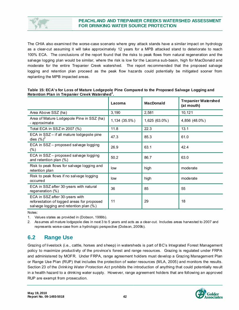
PEACHLAND AND TREPANIER CREEKS WATERSHED ASSESSMENT FOR DRINKING WATER SOURCE PROTECTION
May 19, 2010 Report No. 09-1493-5018 42
The CHIA also examined the worse-case scenario where grey attack stands have a similar impact on hydrology as a clear-cut assuming it will take approximately 12 years for a MPB attacked stand to deteriorate to reach 100% ECA. The conclusions of the report found that the risks to peak flows from natural regeneration and the salvage logging plan would be similar, where the risk is low for the Lacoma sub-basin, high for MacDonald and moderate for the entire Trepanier Creek watershed. The report recommended that the proposed salvage logging and retention plan proceed as the peak flow hazards could potentially be mitigated sooner from replanting the MPB impacted areas.
Table 15: ECA’s for Loss of Mature Lodgepole Pine Compared to the Proposed Salvage Logging and Retention Plan in Trepanier Creek Watershed1.
Lacoma MacDonald Trepanier Watershed (at mouth)
Area Above SSZ (ha) 3,190 2,581 10,121 Area of Mature Lodgepole Pine in SSZ (ha) - approximate 1,134 (35.5%) 1,625 (63.0%) 4,856 (48.0%)
Total ECA in SSZ in 2007 (%) 11.8 22.3 13.1 ECA in SSZ – if all mature lodgepole pine dies (%)2 47.3 85.3 61.0
ECA in SSZ – proposed salvage logging (%) 26.9 63.1 42.4
ECA in SSZ – proposed salvage logging and retention plan (%) 50.2 86.7 63.0
Risk to peak flows for salvage logging and retention plan low high moderate
Risk to peak flows if no salvage logging occurred low high moderate
ECA in SSZ after 30-years with natural regeneration (%) 36 85 55
ECA in SSZ after 30-years with reforestation of logged areas for proposed salvage logging and retention plan (%)
11 29 18
Notes: 1. Values states as provided in (Dobson, 1999b). 2. Assumes all mature lodgepole dies in next 3 to 5 years and acts as a clear-cut. Includes areas harvested to 2007 and
represents worse-case from a hydrologic perspective (Dobson, 2009b). 6.2 Range Use Grazing of livestock (i.e., cattle, horses and sheep) in watersheds is part of BC’s Integrated Forest Management policy to maximize productivity of the province’s forest and range resources. Grazing is regulated under FRPA and administered by MOFR. Under FRPA, range agreement holders must develop a Grazing Management Plan or Range Use Plan (RUP) that includes the protection of water resources (MLA, 2005) and monitors the results. Section 23 of the Drink ing Water Protection Act prohibits the introduction of anything that could potentially result in a health hazard to a drinking water supply. However, range agreement holders that are following an approved RUP are exempt from prosecution.

PEACHLAND AND TREPANIER CREEKS WATERSHED ASSESSMENT FOR DRINKING WATER SOURCE PROTECTION
May 19, 2010 Report No. 09-1493-5018 43
Livestock that have free access to watercourses may affect water quality and may also damage the riparian zone (MAL, 2006). Water quality may be impacted when livestock defecate in, or close to, streams (ephemeral or year-round) and lakes resulting in deposition of microbial contaminants (pathogenic bacteria, viruses and protozoa), organic solids and chemical contaminants (nitrates, ammonium and nutrients). Access to streams may result in the trampling of riparian vegetation, impacts to the stream bed which may include spawning grounds, and in increased siltation. These impacts may affect both fish habitat and water quality.
There are over 1,000 grazing tenures on Crown land in BC 20
Table 16 provides a description of the main grazing tenures, exclusion areas within the tenures and cattle-related issues identified within in each WAA area.
. Park lands and other protected areas are usually excluded. Grazing tenures may or may not follow watershed boundaries and tenures typically overlap watersheds to incorporate naturally flat areas for ease of cattle movement and grazing. Tenures may also utilize natural cattle barriers, such as streams and steep canyons, to restrict cattle movement into adjacent grazing tenures (Dinwoodie, pers.comm, 2009).
Within the study area, there are eight main grazing tenures area within the WAAs, as provided by MOFR, the boundaries of which are provided in Figure 6. Six of these are in the Peachland Creek WAA. Two of the tenures in the Peachland Creek WAA overlap into the Trepanier Creek WAA on the south side of the Trepanier Creek canyon. There are also two tenures on the north side of the Trepanier Creek canyon. There are no grazing tenures along the entire length of Trepanier Creek.
The deep canyons of Peachland Creek, Trepanier Creek and their tributaries act as natural barriers and may restrict access to most of the mainstem stream channels, except at road crossings. For example, the bridge over Peachland Creek on the Monroe FSR provides access for cattle (P-2: Photos 17-20) with pathways down to the stream on both sides of the bridge. P-2 is only about 300 m upstream of the Peachland Creek intake and the time of t ravel of water-borne particles or pathogens to the intake would likely be rapid; potentially on the order of minutes.
Other potential access points to surface water include lake shores, culvert sites at tributaries and ponds that are accessible from roads. Peachland Lake, Glen Lake and Silver Lake are excluded from the grazing tenure, although it has been reported that there is cattle access to Silver Lake through leased lots (Chudyk, pers. comm., 2009). There are two ponds on tributaries of Peachland Creek where cattle access was also noted (P-24 and P-25).
Direct, controlled cattle access limited to specific points on streams upstream of the main lakes may allow for the removal of sediment and pathogens owing to residency times in the lakes (MLA, 2006). Further information would be required to assess suitable access points and to evaluate the likely water quality benefit of restricting access to areas upstream of the lakes. Access to the streams between the lakes and the intakes would potentially incur a high risk as the time of t ravel for water-borne particles is typically short; likely on the order of hours or even minutes.
Cattle access to tributaries in the upper plateau areas of both Trepanier Creek and Peachland Creek may increase as salvage logging proceeds. Increased cattle access from roads to areas of ponding at culvert sites within flat terrain and increased surface water within clear-cut blocks was noted during the field reconnaissance
20 Forest Pr actises Board website, available at: http://www.fpb.gov.bc.ca/

PEACHLAND AND TREPANIER CREEKS WATERSHED ASSESSMENT FOR DRINKING WATER SOURCE PROTECTION
May 19, 2010 Report No. 09-1493-5018 44
(Photos 79 and 80). The MOFR has developed Best Management Practices in Community Watersheds (Fraser, 2009) that are used to develop RUP (Appendix H). The RUP should also incorporate techniques to manage these risks, such as those provided in Table 3 of the Rangeland Health Brochure 12 (Fraser, 2009) provided in Appendix H.
Table 16: Overview of Main Grazing Tenures in Peachland Creek and Trepanier Creek WAA.
Grazing Tenure (Pasture Name) Area and Description Risks to Drinking Water
Headwaters-Galena
Peachland and Trepanier (Headwaters), total 17,079 hectares Excludes Peachland lake and Brenda Mines
Salvage logging in plateau areas increases access points to cattle at many culverts and may provide access points to stream channels for cattle if inadequate riparian buffers at not left behind.
Tailings-lookout Mountain
Peachland and Trepanier, total 15,386 hectares Excludes Brenda Mines, Silver Lake, DL 3892 and DL3891
Salvage logging – see Headwaters -Galena. Reports of cattle accessing Silver Lake via leased properties (Chudyk, pers. comm.,2009). Ponds along main road with cattle access noted (P-24 and P-25) and at ponding areas by culverts in Silver Lake area (T35 and T36).
Finley Small area in lower Peachland Creek WAA on south side of stream None documented.
Woods Mountain Small area in lower Peachland Creek WAA on south side of stream
Access to Peachland Creek at Monroe FSR Creek Crossing (P-2: Photos 17-20)
Greata Creek
Peachland, total 3,316 hectares includes Glen lake area and Greata Creek Excludes Glen Lake, DL 1998 and DL4241
Salvage logging – see Headwaters -Galena. Potential access at tributary crossing (P-32: Photo 53)
Spring Lake East side of Peachland Creek, total 1,213 hectares
Potential access to Peachland Creek at switchback at Peachland FSR
Gott North side of Trepanier Creek, total 4,732 hectares Includes Trepanier Park area
Salvage logging – see Headwaters -Galena. (Photo 80)
Jackpine North side of Trepanier Creek, total 4,966 hectares
Salvage logging – see Headwaters -Galena. (Photo 79)
Removal of natural barriers to stream courses during salvage logging could also increase disturbance of riparian zones. Maintaining an adequate buffer around streams and t ributaries is important for cattle access management, as well as for channel health with respect to provision of large woody debris to help facilitate stream recovery. The natural regeneration of MPB impacted trees is provided in Figure 7. As stands deteriorate, the fallen trees may provide a natural buffer to riparian zones as shown in Figure 8.

PEACHLAND AND TREPANIER CREEKS WATERSHED ASSESSMENT FOR DRINKING WATER SOURCE PROTECTION
May 19, 2010 Report No. 09-1493-5018 45
Figure 7: Stand Development as Dead Pine Trees Deteriorate and Natural Regeneration Becomes Established
(Winkler, 2008). Used by permission of Patrick Teti, Research Hydrologist, MOFR.
Figure 8: Lodgepole Pine and Spruce Regeneration in a Pine Stand that had been attacked by MPB in the 1980’s (Winkler, 2008). Used by permission of Patrick Teti, Research Hydrologist, MOFR.
6.3 Exploration and Mining Activities A search for mineral, placer, petroleum and coal titles was completed for both Trepanier Creek and Peachland Creek WAAs on September 25, 2009 (MTO, 2009). The results of the search are provided in Appendix I. The search indicated there are no petroleum titles or coal titles in either WAA. Both WAAs are located within a placer mining reserve. There are a number of mineral titles within both the Trepanier Creek and Peachland Creek WAAs. These mineral titles are provided in Appendix I.
Mineral title provides exploration rights on the titled parcel of Crown land. The mineral title holder must obtain a permit from Ministry of Energy, Mines and Petroleum Resources (MEMPR) before conducting any exploration which results in soil disturbance (Hupman, pers. comm., 2009). As part of the permit application process,

PEACHLAND AND TREPANIER CREEKS WATERSHED ASSESSMENT FOR DRINKING WATER SOURCE PROTECTION
May 19, 2010 Report No. 09-1493-5018 46
MEMPR sends referrals for comment to recognised regulatory authorities that may have an interest in the impacted area.
Application can be made to MEMPR to have both the Trepanier Creek and Peachland Creek WAAs included within a no staking reserve for mineral title; however, this would only apply to Crown land areas without a current mineral title in good standing (Cattermole, pers. comm., 2009). If granted, mineral titles that do not remain in good standing may potentially be added to a reserve area as they lapse.
Subsurface mineral exploration and mining activities may impact both water quantity and water quality within a watershed. The potential impacts of mining activities typically depend on the local bedrock and soil conditions, the size of the operation and the nature of the exploration, mining or extraction procedures employed. Water quantity and stream flows may be impacted by changes in surface water drainage due to road construction, water diversions, dam construction, dewatering activities, mining operations, surface disturbances and removal of vegetation. These activities may also increase the sediment load to streams, as well as increase the concentration of metals organic matter and pathogens. Potential impacts may also include changes in water temperature, colour and pH.
Past mining in the area has shown that exposure of bedrock has resulted in increases in the heavy metal content of runoff water (see below and Section 4.6). Mine development has also altered the natural drainage patterns in the headwaters of Peachland Creek, Trepanier Creek and Pennask Creek watersheds as a number of stream diversions are present in these watersheds.
Brenda Mines Brenda Mines is located in the MacDonald Creek sub-basin of the Trepanier Creek watershed (see Figure 1). The mine is no longer in operation but consisted of an open pit mine that extracted mainly copper and molybdenum with a small amount of silver and gold (BMW, 2009). Peak production occurred from 1967 to 1990 when approximately 182 million tonnes of ore was processed. After the mine was officially closed, reclamation of the site consisted of re-contouring the mine waste and revegetating the site by seeding and by limited tree planting.
Brenda Mine site is regulated by Permit (PE-00263) issued by the MOE. PE-00263 requires that all precipitation falling onto and draining from exposed bedrock at the site be collected and stored in the open pit and tailings pond areas. Water retained in these areas is then treated before being released to MacDonald Creek. The runoff water before treatment is high in molybdenum and the treatment plant, commissioned in 1998 and operating annually from May to October, reduces the molybdenum concentration from approximately 2.8 mg/L to less than 0.06 mg/L (see Section 4.6 for further details on water quality).
Treated water is stored in the tailing pond and released to MacDonald Creek. Regulation of flow is an important consideration given that there was a landslide on MacDonald Creek in the late 1990’s. The landslide was remediated by the Peachland Sportsman Association with funding from Brenda Mines (Springer, pers. comm., 2009). This landslide demonstrates the sensitivity to flows of the canyonized streams in both watersheds and especially MacDonald Creek, which was also identified as a concern in the 1998 IWAP for Trepanier Creek (Dobson, 1998b).

PEACHLAND AND TREPANIER CREEKS WATERSHED ASSESSMENT FOR DRINKING WATER SOURCE PROTECTION
May 19, 2010 Report No. 09-1493-5018 47
6.4 Aggregate Extraction Aggregate in this report refers to sand and/or gravel material that is used for the construction of roads and buildings. The need for aggregate supplies has increased in the Okanagan in the last ten years due to a large population increase with a resulting construction boom. Aggregate suitable for construction uses is typically found in glacial river features (terraces and fans), and along riverbanks and deltas of modern streams and rivers (EBA, 2000).
An inventory of aggregate resources within CORD boundaries was completed in 2000 (EBA, 2000). The aggregate potential map derived from the EBA study is provided in Appendix J. In the Peachland Creek WAA, Class 121
Within the Trepanier Creek WAA, Class 1 aggregate deposits were identified along the Trepanier Creek outwash terrace from the stream mouth to an area upstream of the District intake. These areas occur on both sides of the stream. Due to the small map scale of the aggregate potential map, the amount of area upstream of the intake could not be accurately measured. Access to the deposit in the Trepanier Creek bench area is via Trepanier Bench Road and, according to the EBA study, mining the aggregate deposits in Trepanier Creek was considered to have potential local visual impacts (EBA, 2000). Environmental concerns for mining this deposit included potential impacts to the stream and recommendations were made for incorporating appropriate streamside setbacks and stream protection measures.
aggregate deposits were identified on the outwash terraces along the Peachland Creek corridor immediately upstream of the District intake and near the confluence with Greata Creek (Appendix J). Access to these deposits is via Princeton Avenue and, according to the EBA study mining the deposits was considered to have potential local visual impacts. Environmental concerns for mining this deposit included potential impacts to the stream and recommendations were made for incorporating streamside setbacks and stream protection measures (EBA, 2000).
Community and environmental concerns over gravel extraction and aggregate production operations include noise, public safety, vibration, radon, dust, traffic, appearance, hours of operation, visual impacts, impacts to wildli fe habitat, slope stability, potential site contamination and water management (MEMPR, 2002; EBA, 2000). Increases in heavy truck traffic may also result in increased road deterioration and may pose risks to public safety from gravel escaping from trucks, although loads are required to be covered (EBA, 2000).
In the context of drinking water resources, both water quantity and quality may be negatively impacted by aggregate extraction. Water quantity may be impacted due to alteration of surface drainage patterns from road and/or pit construction, stream diversions and on-site water storage. Groundwater resources may be impacted by increasing the recharge rates to groundwater, decreasing groundwater storage capacity, and reducing the filtering and buffering capacity by removal of aggregate, vegetation and topsoil (e.g., overburden). The depth to the groundwater table may also be reduced through removal of the overburden. Removal of impermeable horizons that act to confine aquifers may increase the risk of aquifer contamination.
Water quality may be impacted by increasing sediment and microbial loading and increasing the risk of chemical contaminants such as heavy metals. Increases in sediment and microbial loading may occur from road construction, removal of vegetation/exposure of soil, stormwater runoff over exposed soil, increased traffic and associated soil movement and drainage of process water. Dust from mining and processing operations may
21 Class 1 aggregates were defined originating from glaciofluvial deposits, fluvial terraces and fl uvial fans (EBA, 2000).
PEACHLAND AND TREPANIER CREEKS WATERSHED ASSESSMENT FOR DRINKING WATER SOURCE PROTECTION
May 19, 2010 Report No. 09-1493-5018 48
also increase the sediment loading to a stream. Changes to pH from metal leaching and acid drainage from exposure of rock to air and water may also occur. The risk of chemical contamination from vehicle fluids (petroleum hydrocarbons, antifreeze, oils, etc.) is increased from accidental spills and leaks from fuel storage, increased traffic and heavy equipment operation. As gravel and sand have high hydraulic conductivities, spills and leaks, if not cleaned up immediately, may quickly contaminate groundwater and eventually be conveyed to surface water, especially in operations that are close to streams. Potential risks to drinking water resources increase with proximity of aggregate operations to streams. Steep slopes in the Trepanier Creek and Peachland Creek WAAs also increase the risk of slope failures following vegetation removal and ground disturbance. The risk increases significantly on stream reaches where steep sidewall slopes occur.
CORD has developed an aggregate management strategy with the following objectives: ensure a level playing field, maximize efficient aggregate resource use, minimize land use and neighbourhood conflicts, minimize environmental impacts and streamline permitting (EBA, 2000). As part of the management strategy, it was recommended that an Aggregate Working Group of local government agencies representatives be formed to coordinate regional policy development.
Three gravel pits in the Peachland Creek WAA were identified along Princeton Avenue (Site Numbers P-10, P-11, and P-17 in Table 4 and on Figure 2). The status of these gravel extraction sites is unknown; however, they appear to be relatively small operations and are not located immediately adjacent to Peachland Creek. There is currently an application under review with MEMPR for a large gravel extraction pit upstream of the Peachland Creek intake (Hupman, pers. comm., 2009). A referral was sent to the District regarding the application and the District expressed its concern with the site’s proximity to Peachland Creek and the intake and did not want the application approved (Allin, pers. comm., 2009).
Within the Trepanier Creek WAA, there are three large aggregate operations in the bench area of Trepanier Creek and one on Highway 97C. These sites have the site IDs of T-4, T-6, T-8 and T-32 in Table 4. The locations of these sites are provided in Figure 2. Sites T-6 and T-8 are relatively new operations as they were not evident on the 2007 aerial photographs. These sites are accessed by the bridge at the stream crossing at T-5 (at the Hydro line right- of-way). Potential sediment sources were identified at this site from exposed soil on new roads (Photos 68, 69 and 70) and in the ditchline (Photo 64), as well as sediment input directly from the bridge deck (Photo 63). Another large pit was identified on Trepanier Bench Road; however, this site is downgradient of the Trepanier Creek intake and outside the study area.
6.5 Private and Leased Land Holdings Figure 9 provides the boundaries of private land holdings and leased land parcels in the Peachland Creek and Trepanier Creek WAAs. Within the Peachland Creek WAA, private land holdings are concentrated along lower Peachland Creek and adjacent to Greata Creek. There are also leased parcels around Glen Lake. The Peachland Creek intake facility is situated on leased land. Houses were noted on a few of the private land holdings. The only site of concern was at P-19 (Table 4 and Figure 2) where a lagoon was located next to a house. The intended use of the lagoon is unknown at the time of writing. The leased land parcels typically had cottages/cabins situated on them.
Within the Trepanier Creek WAA, there are private land holdings along the mainstem of Trepanier Creek from the District intake to the confluence with MacDonald Creek. The Brenda Mines facilities are situated on private land and there are leased land parcels on the shores of Silver Lake. Residential houses were not observed

PEACHLAND AND TREPANIER CREEKS WATERSHED ASSESSMENT FOR DRINKING WATER SOURCE PROTECTION
May 19, 2010 Report No. 09-1493-5018 49
during the field reconnaissance in the areas upstream of the Trepanier Creek intake. Cottages and cabins were observed on the leased land parcels around Silver Lake. Many of the cabins on Silver Lake appeared to have pit toilets or outhouses.
The primary risk associated with residential houses outside of municipal sewer services (i.e., within the WAA area), especially dwellings beside drinking water reservoirs, is septic disposal and feces from domestic animals (e.g., dogs), which increases the potential for microbial contamination of drinking water resources. As noted above, many of the cabins have pit toilets or outhouses. For the purposes of this report we assumed that the residential houses and some of the cabins may have septic systems; however direct observation and inventorying of septic systems was beyond the scope of this project. Other risks associated with residential and recreational properties are site-specific and based on the land uses on each property. For example, risks may be associated with improper storage of chemicals (fuel, oil, paints, etc.), manure piles or abandoned vehicles. These potential risks were not noted on the private or leased properties observed during the field reconnaissance as they were beyond the present scope of the project. The only sites of potential concern observed were site P-19 which had a lagoon for an unknown purpose, septic disposal on leased land sites and the presence of domestic animals around Glen Lake and Silver Lake.
Based on the close proximity to drinking water reservoirs of dwellings situated on leased land, land use on leased land is a particularly sensitive issue. The OBWB, with the support of many water utilities, health officials and local governments, are opposed to the sale or disposition of Crown land near drinking water reservoirs and encourages the lapsing of existing leases at the end of lease terms (OBWB, 2009). The OBWB's position is that the sale of leased land will increase development around reservoirs, increasing the risks of contamination of water resources and reducing the ability to increase storage. Due to the relatively small size of the reservoirs, the stored water is particularly sensitive to pollution from leaking septic systems and recreational overuse (OBWB, 2008).
Leased land may restrict the flexibility of purveyors to increase storage to adapt to climate change. There are provisions within Section 27 of the BC Water Act that allows Licensee’s to expropriate land for the purpose of construction, improvement, operation or flooding of land to increase water storage capacity.
6.6 Roads and Highways The only paved roads in the study area are Highway 97C, also referred to as the Okanagan or Coquihalla Connector, and the Brenda Mine Road, which runs between Princeton Avenue and Brenda Mines and provides access to Silver Lake. The majority of roads in the Peachland Creek and Trepanier Creek WAAs are unpaved and are associated with forestry use.
Roads may pose a significant risk to drinking water resources by direct input of sediment from road surfaces, ditchlines and exposed soils. The sloughing or failing of road cutslopes or fill slopes, particularly on steep or unstable terrain, may result in large sediment inputs to streams. Poor water management or maintenance may lead to erosion of ditchlines, fill slopes or road beds and may increase the likelihood of slope failures along road alignments. Landslides initiated by discharge of road drainage onto unstable or potentially unstable terrain may also increase sediment input. Improperly maintained or located stream crossings may result in stream avulsions and increased sediment input. Forestry roads provide recreational access to humans and their pets to lakes and other sensitive areas within watersheds and provide access for wildlife and livestock to streams at road crossings.

PEACHLAND AND TREPANIER CREEKS WATERSHED ASSESSMENT FOR DRINKING WATER SOURCE PROTECTION
May 19, 2010 Report No. 09-1493-5018 50
Generally, roads on steep slopes have the highest risk for significant erosion, while roads on gentle slopes have fewer erosion issues. Based on this premise, the field reconnaissance was focussed mainly on roads that traversed steeper slopes and on a field review of accessible erosion sites identified during the aerial photo review. A sample of road sites underlain by gentle terrain was included in the field review. Although most roads from the desktop study that were considered to pose potential risk were assessed, a few were inaccessible due to winter road conditions. These roads included P-21 and P-29 on Figure 2 in the Peachland Creek WAA, a deactivated road off of the Monroe FSR, and the lower sections of T-20 in the Trepanier Creek WAA.
Due to the topography of the study area, the majority of forestry roads are located on the plateau area. Only a few roads have been constructed along the steep canyon slopes to provide access from the lower elevations to the upper plateau. The field reconnaissance confirmed that significant erosion and/or soil movement was limited mainly to roads located on Class IV and Class V slopes, while roads on gentler slopes did not have significant erosion and/or soil movement concerns.
Peachland Creek Watershed In the Peachland Creek WAA, the main roads that transverse the steep slopes and are accessible to vehicles include Princeton Avenue and the Monroe FSR. Significant erosion problems were observed on both roads as they transverse the steep s canyon slopes. Road locations P-2, P-3, P-5 and P-7 in Table 4, the locations of which are identified on Figure 2, provide examples of erosion issues along the Monroe FSR. Road locations P-12, P-13, P-14 and P-16 along Princeton Avenue exhibit indicators of slumping and erosion. Both road segments lie adjacent to Peachland Creek and are situated upstream of the District intake. The proximity of these locations to the intake is considered to present limited opportunity for introduced sediment to settle out prior to reaching the intake.
Segments of Princeton Avenue and the Peachland FSR on steep side slopes have also experienced vandalism with cars being pushed onto the slopes. Two examples are provided in photos 55 and 56 located at P-34.
There are a number of deactivated roads that lead from the Monroe FSR that are adjacent to or c ross steep canyon slopes and are not accessible to vehicles. These deactivated roads are accessible by hikers and potentially by trail bikes that use the area (see Section 5.7.3). P-9 (Photo 34) illustrates a slump from an old road that runs parallel to Peachland Creek and is now used as a hiking path. Another area of concern documented in the field was the stream crossing of the Peachland FSR, designated as site P-32 (Photo 53). The switchback in this area lies on the steep sidewall of the stream which shows evidence of erosion and rilling.
Trepanier Creek Watershed In the Trepanier Creek WAA, Highway 97C is located on the south side of Trepanier Creek and is the main road that provides access from the lower elevations to the upper plateau. Access is also provided from other watersheds (i.e., Glenrosa watershed to the upper Clover Creek watershed area), however, these roads lie beyond the present study area.
Highway 97C was constructed in the late 1980’s using 25 mm free draining angular gravel crushed on-site to engineering design specifications; a new construction technique at the time (Keir, pers. comm., 2009). There are negligible fines in the road base to produce sediment during drainage. The ditchlines are designed to be free flowing (i.e., no ponding) and the ditchlines capturing hillslope drainage are large and capture rockfall
PEACHLAND AND TREPANIER CREEKS WATERSHED ASSESSMENT FOR DRINKING WATER SOURCE PROTECTION
May 19, 2010 Report No. 09-1493-5018 51
material from upslope road cuts and gullies. The ditchlines have not been cleared since construction as there has been insufficient build-up of material to obstruct drainage (Keir, pers. comm., 2009). Road surface and ditch water is discharged mainly onto bedrock on the downslope side of the highway. Highway 97C is maintained by Argo Road Maintenance (South Okanagan) Inc. (Argo) under contract with the Ministry of Transportation and Infrastructure (MOTI) and it is their responsibility to inform the MOTI if erosion problems occur (Keir, pers. comm., 2009).
Under Argo’s contract, they are responsible for road maintenance, first response during accidental spills and development of an annual road maintenance plan, in consultation with MOTI, to fix road and drainage problems (Martindale, pers. comm., 2009). Ploughing, salt and sand are used to control winter road conditions. Argo has a salt storage shed located at the Brenda Mine turn off (T-24). The salt storage shed is covered, the site is paved, drainage from the site is directed to a salt evaporation tank and Argo has a Salt Storage Plan to control salt storage activities. Argo also uses liquid salt in the form of calcium chloride, which is mixed at their Westbank yard, for winter road application.
Argo has an emergency spill response plan, which entails mobilization of equipment to an accident site, closure of the impacted section of highway and containment of the spill using soil and berms (Martindale, pers. comm., 2009). Argo then receives direction for further clean-up instruction from Provincial Emergency Plan coordinators. Argo also supplies spill kits to road patch trucks that carry diesel fuel for equipment cleaning.
Sand spread during winter generally collects on the side of the highway and along the concrete barriers on the highway (T-23). Argo sweeps both the highway shoulders and the highway median against the concrete barriers in the spring to remove the sand. According to Mr. Keir, the Area Manager for MOTI, Highway 97C does not have any sediment control structures (e.g., sediment ponds) and sediment monitoring of Highway 97C has not been carried out.
Road sites in the Trepanier Creek WAA where erosion issues were identified are designated as T-5 and T-7. T-5 is the bridge at BC Hydro right-of-way and direct sediment input was noted as vehicles cross over the bridge (Photos 62 and 63). Recently improved or constructed ditchlines run down a slope of exposed soil and drain directly into the stream at this site (Photos 62 and 64). T-7 is a new road with exposed soil in the ditchlines that drain directly into Trepanier Creek (Photos 68, 69 and 70). Notable erosion was also identified from a large cutbank on the road (designated as T-3), although this site is not located immediately adjacent to the stream and sediment does not have direct connectivity to the stream.
6.7 BC Hydro Right-of-Way A BC Hydro transmission line right-of-way (ROW) runs through both the Peachland Creek and Trepanier Creek WAAs (see Figure 9). The ROW crosses Trepanier Creek approximately 1.6 km upstream of the District intake and runs parallel to Highway 97C, crossing into the Pennask Creek watershed to the west around Brenda Lake. The potential impacts from the ROW on drinking water includes potential sediment sources from works, chemical contamination from spills and leaks, and microbial contamination from campers and wildli fe.
The BC Hydro maintenance program on this ROW includes removal of tall vegetation that could impact transmission lines and retention of short vegetation for groundcover (Graham, pers. comm., 2010). Any works that disturb soil are seeded immediately. The Approved Work Practices for Managing Riparian Vegetation

PEACHLAND AND TREPANIER CREEKS WATERSHED ASSESSMENT FOR DRINKING WATER SOURCE PROTECTION
May 19, 2010 Report No. 09-1493-5018 52
(BC Hydro, 2003) is followed when working in a riparian zone. No pesticides or herbicides are used on this ROW.
The bridge at the ROW crossing of Trepanier Creek is owned by BC Hydro and was replaced approximately 10 years ago (Birnie, pers. comm., 2010). In November of 2009, BC Hydro was notified that the bridge had been damaged. Investigations by BC Hydro found the bridge had been damaged by heavy equipment used by the gravel extraction operation at the location identified as T-6 and T-7 (Muir, pers. comm., 2010). BC Hydro has entered into negotiations with the property owner for repairing the bridge and has notified the owner that they must apply for access through FrontCounter BC 22
. BC Hydro has copied all communications with the property owner to FrontCounter BC.
6.8 Recreational Activities Due to the proximity of the watersheds to major population centres and the accessibility provided by primary or well-maintained secondary roads, both watersheds experience a high level of recreational activities, as well as potentially harmful human activities (e.g., illegal dumping). Recreational use is likely to increase in the future due to population growth in the Okanagan Valley and due to the promotion of recreational opportunities through tourism and other websites. The following provides an overview of the recreational activities known to occur in the Peachland Creek and Trepanier Creek watersheds.
6.8.1 Camping Camping activities include camping within designated areas, such as parks and recreation sites, backcountry camping, or “impromptu” or unmanaged camping that occurs on Crown land, typically beside roads. Hazards associated with camping depend on the activities of the campers but generally include the potential to introduce microbial contaminants, especially at sites without facilities, and chemical contaminants such as hydrocarbons. Unmanaged camping in unauthorized areas, campgrounds without washroom facilities and camping areas that allow motorized vehicles close to, or in water sources have the highest risk of impacting District water quality.
Recreation Camp Sites There is one Recreation Camp Site on Peachland Lake within the Peachland Creek WAA and one on Silver Lake within the Trepanier Creek WAA. The locations are provided on Figure 9 and Appendix K contains information available on the Recreation Sites and Trails BC website 23
. The Okanagan Mental Health Services Society is listed as the site operators for both sites. Both sites are reported to have no facilities; however, two outhouses were noted during the field reconnaissance visit at the Silver Lake Recreation Camp Site. No facilities were noted at the Peachland Lake Recreation Camp Site during the field reconnaissance visit. The Silver Lake Camp Site was observed to be clean of garbage and debris and had a well -vegetated shoreline. The Peachland Lake Recreation Camp Site was observed to have an easily accessible, flat area, however the ground condition of the site could not be observed due to snow cover.
22 FrontCounter BC is the government agency responsi ble for land use on Crown lands. 23 Availabl e at http: //www.sitesandtr ailsbc.ca/
PEACHLAND AND TREPANIER CREEKS WATERSHED ASSESSMENT FOR DRINKING WATER SOURCE PROTECTION
May 19, 2010 Report No. 09-1493-5018 53
Unmanaged Camping Sites A number of fire pits, assumed to mark unmanaged camping sites, were observed beside roads and bridges in both watersheds. As a general statement, the easily accessible sites closer to town tend to have more garbage and debris than the less accessible, sites and sites at higher elevations in the watershed areas. The camp site with the most garbage and debris observed during the field reconnaissance visit was at the site designated as T-2 in Table 4 and on Figure 2 within the Trepanier Creek WAA. Other unmanaged camping sites observed are listed in Table 4 as P-2, P-5 and P-8 the Peachland Creek WAA and as T-5, T-9 and T-10 within the Trepanier Creek WAA.
Provincial Park: Trepanier Park There is one provincial park in the study area, Trepanier Park, located in the upper reaches of Trepanier Creek as shown on Figure 9. Trepanier Park, established in April of 2001, is 2,884 hectares in size and the park boundary encompasses all of Lacoma Creek and most of the Lacoma Creek sub-basin. The park extends to Cameo Lake in the adjacent watershed and to Clover Creek which acts as the eastern park boundary. Information about Trepanier Creek is available on the BC Provincial Park website 24
The access road to the lower reach of Trepanier Park is a 4-wheel drive road approximately 6 km in length that leads from Trepanier Bench Road (T-9), although park literature reports that it is a rough 2-wheel drive access road. Vehicle access ends at Clover Creek, where a bridge has been removed (site T-12). The road runs parallel to Trepanier Creek along a relatively flat valley bottom with a forested riparian buffer between the road and stream. Although there are locations where large pools of water accumulate on the road (i.e., site T-9), the road did not show signs of erosion, except where one plugged culvert was identified (site T-11). There was, however, a flat buffer area between the road and the stream and sediment from the road surface appears to settle before reaching the stream (Photo 75). There is evidence of camping at the trailhead with fire pits, although it is within park boundaries.
and provided in Appendix K.
The upper reach of Trepanier Park is accessible by 2-wheel drive to Cameron Lake. Two deactivated roads were identified in the field leading to Lacoma Lake but were overgrown and not accessible to on-road vehicles.
There are no established camping areas identified within Trepanier Park and camping is classified as “walk-in/wilderness” camping. In reviewing camping information provided by the provincial camp site (also linked to by the recreation camping website), "LEAVE NO TRACE" ETHICS are advocated when camping (see Appendix K). The following is provided on the website:
“'IF YOU PACK IT IN.......PACK IT OUT' is a standard practice in any back country area. This also refers to biodegradable scraps such as apple cores and orange peels, which probably won't decompose before the next hiker comes along. Take along a garbage bag and carry out all trash that you generate. Do not bury anything except human waste. The ground will be disturbed by digging and animals will dig up and scatter your buried garbage.” 25
24 http://www.env.gov.bc.ca/bcparks /explore/par kpgs/trepanier/
25 http://www.env.gov.bc.ca/bcparks /explore/misc/notrace.html

PEACHLAND AND TREPANIER CREEKS WATERSHED ASSESSMENT FOR DRINKING WATER SOURCE PROTECTION
May 19, 2010 Report No. 09-1493-5018 54
This is the only mention of disposal requirements in dealing with human waste. No guidelines are provided about proper disposal in regards to distances from streams, avoidance of drainage areas, or the best methods for dealing with human waste.
6.8.2 Boating and Fishing There are a number of popular fishing lakes within both the Peachland and Trepanier Creek WAAs with boat access.
There is no restriction to motorboats on Peachland Lake or Glen Lake and motor boats are reported to be used on Peachland Lake (Glass, pers. comm., 2009). Conventional two-stroke outboard engines are inefficient releasing up to 30% of their oil and gas into the water and air as pollutants 26
Silver Lake in the Trepanier Creek WAA has a gas motor restriction, although the only indication found of the restriction was on a sign posted on the road into the Recreation Camp Site (T-34). The Recreation Sites and Trails BC website
. Although 4-stroke and new low-pollution marine 2-stroke engines are now available, there is still a risk of spillage of hydrocarbons from refuelling, accidents and improper gasoline disposal.
27
Currently, there is no maximum acceptable concentration for gasoline in drinking water as gasoline imparts an undesirable smell and taste at low levels and would generally be rejected by humans before harmful effects could occur (HC, 1988). Some additives in gasoline, such as methyl tert-butyl ether (MTBE), may also be mobilized in rain and snowmelt water if spills occur on the ground near water sources.
does not specify motor restrictions for boats and only states that “the site has a car top boat launch” at the Silver Lake Recreation Camp Site.
6.8.3 ATVs and Dirt Bikes Off-road operation of ATVs and dirt bikes (motorcycles specifically designed to drive off-road) is gaining popularity in the Interior of BC as a recreational activity. ATV and dirt bike use can cause significant damage to the environment by damaging vegetation and exposing soil to erosion. Impacts to vegetation and soil may result in increased soil erosion/sedimentation, soil compaction, damage to riparian zones and the spread of noxious weeds. Trails on slopes may also promote slope and soil destabilization, potentially resulting in landsliding and/or chronic sediment sources. To help prevent damage to grazing lands, the MOFR has produced a pamphlet to educate riders on the results of irresponsible off-road riding (Appendix L); however, this pamphlet does not mention potential impacts to drinking water and habitat resources.
The Okanagan-Shuswap Land and Resource Management Plan (LRMP)28 has designated areas of the Peachland Creek and Trepanier Creek watersheds as an Intensive Recreation Area for “Summer Motorized/Shared Use (Summer)” (Map provided in Appendix L). Currently, Okanagan ATV Tours is reported to have a trail permit registered with the Integrated Land Management Bureau (ILMB) to operate ATV tours in the Peachland WAA (Allin, pers. comm., 2009). In a promotional on-line video29
26 http://des.nh.gov/organization/commissioner/pip/factsheets /ard/documents/ard- 31.pdf
, the owner of Okanagan ATV Tours
27 http://www.sitesandtrailsbc.ca/ 28 http://archi ve.ilmb.gov.bc.ca/slrp/lrmp/kamloops/okanagan/plan/files/oslrmpfull.pdf 29 http://www.okanaganatvtours.com/video.html

PEACHLAND AND TREPANIER CREEKS WATERSHED ASSESSMENT FOR DRINKING WATER SOURCE PROTECTION
May 19, 2010 Report No. 09-1493-5018 55
indicated that their permit does not allow riding through water or crossing through streams. Promotional photographs from the Okanagan ATV Tours website (samples provided in Appendix L) shows ATVs driving through large puddles. In one picture, the creek appears to be directly adjacent to the trail and in another promotional video; there is a view of an ATV driving through what appears to be a large water feature. These activities could impact water quality depending on the local drainage patterns and the proximity of the trails to streams. If large puddles from roads drain directly into streams with no opportunity for sediment settlement, water quality can be impacted with an increase in turbidity and microorganisms. There is an additional concern for trails close to the stream between the Peachland Intake and Peachland Lake as there is no buffering capacity in this area with a greater risk of impacting water quality at the intake.
Some of the Okanagan ATV Tours promotional pictures also appear to have ATVs driving over terrain with no trails and on user-created trails, which can be viewed as http://www.okanaganatvtours.com/photo_gallery. As a sensitive habitat inventory has not been completed in this area, there is a concern that ATVs could negatively impact sensitive habitat and riding off-trail has the potential to spread noxious weed seeds. It is also apparent from watching the Okanagan ATV Tours promotional video on the company’s website that the ATVs generate a considerable amount of dust during the drier months. This could increase water turbidity through dustfall if the trails are close to the stream. The District has not received maps detailing where the trails are located or trail management plans that outline responsible trial management. Although invited, no representatives of Okanagan ATV Tours attended the stakeholder meeting to discuss water quality and habitat concerns.
The Ministry of Tourism, Culture and the Arts (MOTCA) has received an application 30
The trail map provided in the application has only a limited number of trails inventoried for use within the Peachland Creek WAA. The application indicates that the proposed trail system does not cross any water courses and the trails will be remediated to current trail stewardship best management practices. However, many user-created trails connecting Monroe FSR to the staging area or radiating from the Monroe FSR were noted during the field reconnaissance visit (See Photos 22, 23, 25, 26, 27, 28, 31 and 32). These existing trails were not inventoried and identified on the permit map. A management plan to address these unmanaged trails was not provided. MOTCA indicates that managed t rails are designed to minimize or mitigate environmental impacts (W. Anderson, pers. comm., 2010). However, the unmanaged trails cannot be viewed as independent of the managed trail system. Riders will still use unmanaged trials if they are not properly closed and some of the unmanaged trails will continue to negatively impact water quality if not remediated.. For example, the trail identified as P-4 in Photo 22 drains onto Monroe FSR less than 40 m from Peachland Creek and appears to be concentrating hillslope drainage and causing hillslope erosion and aggravating surface erosion on Monroe FSR.
from the Southern Okanagan Dirtbike Club for a permit to develop a recreational trail facility for dirt bikes including a staging area. The network of trails for the facility will be located in the lower Peachland Creek and Summerland Creek watersheds and access to the staging area will be through the Peachland Creek watershed via the Monroe FSR. The permit application included a map of the proposed trail system with GPS coordinates is provided in Appendix L.
Based on available details, the permit application also did not provide a clear statement of the proposed trail management strategy at the trail facility outlining an operating and monitoring plan, identification of sensitive environmental areas, an inventory of all trails including identifying t rails that need to be closed, remediation
30 Front Counter Referral Refer ence No. REC 98052 / File CL-09-07; Ministry of Tourism, Culture & Arts

PEACHLAND AND TREPANIER CREEKS WATERSHED ASSESSMENT FOR DRINKING WATER SOURCE PROTECTION
May 19, 2010 Report No. 09-1493-5018 56
strategies for closing high risk unmanaged trails and a sanitation strategy to accommodate riders. The Monroe FSR and the unmanaged trails originating from the Monroe FSR have been identified as a hazard to drinking water quality based on the proximity to the District intake and the locations of some of the unmanaged trail. As stated above, Peachland Creek between the Peachland intake and the reservoirs (Peachland Lake and Glen Lake) has limited buffering capacity and little opportunity for sediment to settle before reaching the intake. The stream channel within these reaches is within a deeply incised valley with steep slopes adjacent to the stream and existing landslides or slumps associated with roads have been identified adjacent to this stream reach. Unmanaged trails in this area are a concern as they could create or aggravate instability in the surrounding slopes and create chronic sediment and microorganism sources. Contaminant input to the streams in this area could reach the District intake weir very quickly, likely in a matter of minutes. The potential for sediment delivery to the streams from these unmanaged trails needs further assessment to address the risk to the intake.
During the field reconnaissance visit, sediment sources were also identified on Monroe FSR, the proposed access road to the staging area. Specific sites of concern are listed as P-2, P-3, P-5 and P-7 in Table 4 (see Photos 17, 20, 21, 24, 29 and 30 in Appendix D). The Monroe FSR traverses up a steep slope immediately adjacent to Peachland Creek about 300 m upstream of the Peachland Creek intake and the identified erosion issues could increase significantly with increasing traffic to the staging area.
During the inventory, at least eight user-created t rails were noted between the start of the Monroe FSR and the staging area. Photos 22, 23, 25, 26, 27, 28, 31 and 32 (Appendix D) provide examples of some of these user-created trails. It appeared that attempts to prohibit access to some of the trails on steep slopes have been made, however, surface remediation of these trails has not occurred and the trails continue to be chronic sediment sources due to erosion of the exposed soils. These trails may also concentrate hillslope drainage, thereby increasing soil erosion and sediment transport to the Monroe FSR. Photos 31 and 32 show significant erosion that has resulted due to alteration of surface drainage by the trails. There was no documentation provided in the application package to indicate if and how soil remediation of these trails will be completed and how the creation of more user-created trails in sensitive areas will be avoided.
Another concern regarding the proposed managed trail locations within the application is the number of non-status forestry roads in the area that lead onto steep slopes adjacent to Peachland Creek. The proposed managed trails could potentially be used by riders to gain access to these steep slopes in the future. Also, the trail labelled as Section 3 on the map provided with the permit application appears to run along the top of a steep slope that is directly adjacent to Peachland Creek. If this trail resulted in destabilization of this slope, mass wasting directly into the stream could occur. The trail map provided with the permit application also does not identify drainage, intermittent streams or sensitive areas.
Mr. Birtles, the Drinking Water Officer of IHA responded to the trail application within Peachland Creek watershed with a letter outlining IHA concerns with potential impacts to water quality and advises that the proponent complete further works to ensure drinking water sources will not be negatively impacted (letter provided in Appendix L). Further works recommended include identifying surface water sources, conducting assessments in sensitive areas, consultation with water system owners and managing threats to drinking water.
Mr. Jacobi of MOTCA indicated that a potential benefit of permitting trails for dirt bike and ATV riders is that designated groups may be held responsible for trail maintenance and trail remediation as required (Jacobi, pers. comm., 2009). While managed trail systems may afford a clear indication of responsibility for trail management, water purveyors are legally accountable for water quality. Water purveyors affected by the development of the

PEACHLAND AND TREPANIER CREEKS WATERSHED ASSESSMENT FOR DRINKING WATER SOURCE PROTECTION
May 19, 2010 Report No. 09-1493-5018 57
Bear Creek Recreation Site 31
have expressed concerns regarding their experiences with the managed trail development at this site. These concerns and recommendations to improve the decision-making process are outlined in memo from the Water Supply Association of BC (WSABC) to MOTCA (provided in Appendix L). Recommendations to assist in the trail development process in such a way to safeguard local resources include MOTCA becoming a signatory to the Memorandum of Understanding developed by IHA (MOU, 2006), assembling a Steering Committee with decision-making powers to guide trail development, deactivation of high risk trails, independent water quality monitoring of trail construction and education/enforcement.
6.9 Contaminant Source Inventory Summary The contaminant source inventory of human activities and land uses completed in Section 5.0 is summarized in Table 17 located at the end of the report text, while site specific contaminant sources identified in the aerial photograph review and the field reconnaissance is provided in Table 4 (end of text) with the corresponding locations provided in Figure 2.
In summarizing the contaminant source inventory results in Table 17, some land use issues were subdivided to reflect their relative risk to drinking water. For example, roads were separated into Highway 97C, roads on steep slopes and roads on gentle slopes. Highway 97C has a different operating regime and different agencies responsible for maintenance than the other road types. Roads on steep slopes have more erosion and mass wasting issues, whereas roads on gentle slopes tend to increase cattle and wildli fe access to water sources but tend to have fewer erosion issues than roads on steep slopes.
7.0 MODULE 7 – CHARACTERIZING RISKS In Module 7, a risk assessment is completed to examine the vulnerabilities and potential hazards in the watershed assessment areas and is applied to the hazards identified in Modules 1 and 2. Risk assessments are useful to water managers and stakeholders to qualitatively rank each potential risk identified in the contaminant source survey and help to prioritize action items.
7.1 Evaluating Source Protection Barriers and Vulnerabilities The CS2TA outlines a multiple barrier approach to supplying clean and safe drinking water that comprises the following six barriers:
1. Source Protection,
2. Treatment,
3. Water System Maintenance,
4. Water Monitoring,
5. Operator Training, and
6. Emergency Response Planning.
31 Also located on the west side of Okanagan Lake with drainage through West Kelowna.

PEACHLAND AND TREPANIER CREEKS WATERSHED ASSESSMENT FOR DRINKING WATER SOURCE PROTECTION
May 19, 2010 Report No. 09-1493-5018 58
Modules 1 and 2 of the CS2TA examine the strengths and weaknesses of the water source area and identify potential risks to drinking water quality and quantity. Protecting the water source supply area is the first line of defence in providing safe drinking water to the District intakes. By identifying risks, future works to eliminate or minimize these risks may be initiated.
Source protection can present a significant challenge to water purveyors for a variety of reasons including multiple users within watersheds, naturally variable surface water quality within Interior BC streams, unknown threats in large land areas (Summit, 2008), and, in the case of the District intakes, land within the water supply areas is outside the municipal control of the District. Nonetheless, source protection barriers do currently exist in the WAAs. To evaluate current source protection barriers, the source protection barrier assessment provided in Appendix 7C of the CS2TA was undertaken for the WAA and is outlined in Table 18.
Based on the evaluation presented in Table 18, the effectiveness of current source protection barriers is considered to be low. The impact of the local topography as a barrier, however, was not incorporated in the evaluation completed in Table 18 and some areas of the WAA will have a lower risk of affecting drinking water sources due to residence time/settling in the existing lakes. The lakes in both watersheds may be considered to act as physical barriers and sediment and contaminant sources above the lakes will likely have a lesser impact to the water quality at the District intakes than sediment and contaminant sources within the WAA between the lakes and the intakes.
Other means to help provide source protection in the WAAs may include policy controls, appropriate operational practices and water quality monitoring. Policy controls include legislative barriers such as the Water Act, the Drink ing Water Protection Act, and FRPA that legally protect drinking water sources. Other policy controls include Best Management Practices for specific industries working in the WAAs, CORD Official Community Plans and other bylaws, and environmental or other permits issued by government agencies. Operational practices are those conducted by parties working, living or recreating in the watershed area. Many companies working in the watersheds have formalized operational procedures that include environmental protection practices such as those included in the SFMP’s that Tolko and the BCTS follow.

PEACHLAND AND TREPANIER CREEKS WATERSHED ASSESSMENT FOR DRINKING WATER SOURCE PROTECTION
May 19, 2010 Report No. 09-1493-5018 59
Table 18: Source Protection Barrier Evaluation Barrier Evaluation Questions Yes/No Comment The source area is under the control of the water supplier? No Both Trepanier Creek and Peachland Creek WAAs
are within CORD boundaries. Source water protection and management plan is in place?
In- progress
This study is initial phase of source water protection plan.
Watershed uses are limited and designated? No
Both Trepanier Creek and Peachland Creek WAAs are high use areas with multiple users and easy access.
Contaminant sources are absent from the catchment area or are a low risk? No Contaminant sources are present in the both WAA
and some have a risk of impacting water resources.
Low intrinsic source vulnerability? No Both Trepanier Creek and Peachland Creek WAAs have steep slopes adjacent to the water courses with a history of slope failures in some areas.
Integrity and location of the intake ensures the best quality source water is captured?
Potentially
The best location for a water intake was not evaluated, however, both the Trepanier and Peachland intake have settling ponds before the intake.
Source water quality is consistently good with seasonal fluctuations that do not disrupt treatment systems?
No Both Trepanier Creek and Peachland Creek have seasonally fluctuating water quality with elevated turbidity levels during freshet.
Total water source capacity can supply current and projected water demand, taking into account the uncertainty associated with climate change and drought?
Yes
According to the District of Peachland Water Availability Analysis (Dobson, 2009) the District has sufficient water to supply current and future needs if water conservation goals are also achieved. However, it should be noted that the water availability analysis was completed before application for a number of development were submitted that could double Peachland’s population.
Back-up (secondary) source in position? Yes Peachland also has a water licence for Okanagan Lake.
Community and water users are aware of the impact of human activity on source water quality and quantity?
Unknown
7.2 Risk Assessment Procedure There are different procedures to evaluate risks. These are dependent on whether the data and information available has specific values or whether the information is general and descriptive in nature. A quantitative risk assessment can be completed when specific and numeric data is available, while a qualitative risk assessment is completed for general information. Based on the information available for this study, a qualitative risk assessment was completed.
The evaluation of risk is usually based on the likelihood or probability of a hazard compromising water quantity or quality occurring and the consequence if the event happened (MHS & MWLAP, 2005). Using this definition, risk is defined as:
RISK= CONSEQUENCE × PROBABILITY
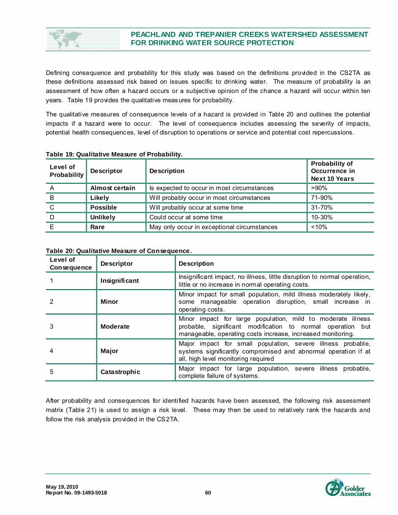
PEACHLAND AND TREPANIER CREEKS WATERSHED ASSESSMENT FOR DRINKING WATER SOURCE PROTECTION
May 19, 2010 Report No. 09-1493-5018 60
Defining consequence and probability for this study was based on the definitions provided in the CS2TA as these definitions assessed risk based on issues specific to drinking water. The measure of probability is an assessment of how often a hazard occurs or a subjective opinion of the chance a hazard will occur within ten years. Table 19 provides the qualitative measures for probability.
The qualitative measures of consequence levels of a hazard is provided in Table 20 and outlines the potential impacts if a hazard were to occur. The level of consequence includes assessing the severity of impacts, potential health consequences, level of disruption to operations or service and potential cost repercussions.
Table 19: Qualitative Measure of Probability.
Level of Probability Descriptor Description
Probability of Occurrence in Next 10 Years
A Almost certain Is expected to occur in most circumstances >90% B Likely Will probably occur in most circumstances 71-90% C Possible Will probably occur at some time 31-70% D Unlikely Could occur at some time 10-30% E Rare May only occur in exceptional circumstances <10%
Table 20: Qualitative Measure of Consequence. Level of Consequence Descriptor Description
1 Insignificant Insignificant impact, no illness, little disruption to normal operation, little or no increase in normal operating costs.
2 Minor Minor impact for small population, mild illness moderately likely, some manageable operation disruption, small increase in operating costs.
3 Moderate Minor impact for large population, mild to moderate illness probable, significant modification to normal operation but manageable, operating costs increase, increased monitoring.
4 Major Major impact for small population, severe illness probable, systems significantly compromised and abnormal operation if at all, high level monitoring required
5 Catastrophic Major impact for large population, severe illness probable, complete failure of systems.
After probability and consequences for identified hazards have been assessed, the following risk assessment matrix (Table 21) is used to assign a risk level. These may then be used to relatively rank the hazards and follow the risk analysis provided in the CS2TA.
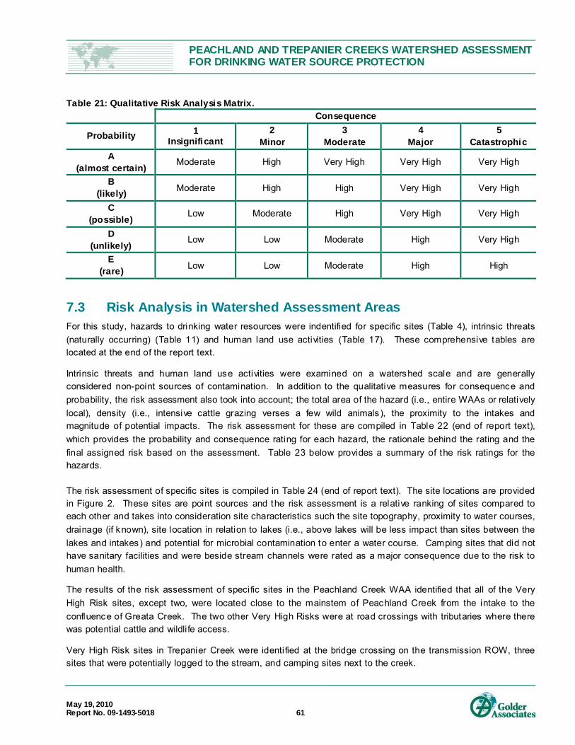
PEACHLAND AND TREPANIER CREEKS WATERSHED ASSESSMENT FOR DRINKING WATER SOURCE PROTECTION
May 19, 2010 Report No. 09-1493-5018 61
Table 21: Qualitative Risk Analysis Matrix. Consequence
Probability 1 Insignificant
2 Minor
3 Moderate
4 Major
5 Catastrophic
A (almost certain) Moderate High Very High Very High Very High
B (likely) Moderate High High Very High Very High
C (possible) Low Moderate High Very High Very High
D (unlikely) Low Low Moderate High Very High
E (rare) Low Low Moderate High High
7.3 Risk Analysis in Watershed Assessment Areas For this study, hazards to drinking water resources were indentified for specific sites (Table 4), intrinsic threats (naturally occurring) (Table 11) and human land use activities (Table 17). These comprehensive tables are located at the end of the report text.
Intrinsic threats and human land use activities were examined on a watershed scale and are generally considered non-point sources of contamination. In addition to the qualitative measures for consequence and probability, the risk assessment also took into account; the total area of the hazard (i.e., entire WAAs or relatively local), density (i.e., intensive cattle grazing verses a few wild animals), the proximity to the intakes and magnitude of potential impacts. The risk assessment for these are compiled in Table 22 (end of report text), which provides the probability and consequence rating for each hazard, the rationale behind the rating and the final assigned risk based on the assessment. Table 23 below provides a summary of the risk ratings for the hazards.
The risk assessment of specific sites is compiled in Table 24 (end of report text). The site locations are provided in Figure 2. These sites are point sources and the risk assessment is a relative ranking of sites compared to each other and takes into consideration site characteristics such the site topography, proximity to water courses, drainage (if known), site location in relation to lakes (i.e., above lakes will be less impact than sites between the lakes and intakes) and potential for microbial contamination to enter a water course. Camping sites that did not have sanitary facilities and were beside stream channels were rated as a major consequence due to the risk to human health.
The results of the risk assessment of specific sites in the Peachland Creek WAA identified that all of the Very High Risk sites, except two, were located close to the mainstem of Peachland Creek from the intake to the confluence of Greata Creek. The two other Very High Risks were at road crossings with tributaries where there was potential cattle and wildli fe access.
Very High Risk sites in Trepanier Creek were identified at the bridge crossing on the transmission ROW, three sites that were potentially logged to the stream, and camping sites next to the creek.

PEACHLAND AND TREPANIER CREEKS WATERSHED ASSESSMENT FOR DRINKING WATER SOURCE PROTECTION
May 19, 2010 Report No. 09-1493-5018 62
Table 23: Summary of Risk Assessment for Intrinsic and Land Use Activi ty Hazards to Drinking Water. Very High Risk High Risk
• Mountain Pine Beetle • Forestry Activities: Salvage Logging and
Retention plans for MPB impacted trees (future)
• Range Use • Roads on Steep Slopes (Class III, IV and V) • Stream Crossings at Roads • Recreation: Camping • Recreation: ATV and Dirt Bike Trails
• Wild Fires • Sediment Sources • Aggregate Extraction • Recreation: Boating and Fishing
Moderate Risk Low Risk • Climate Change • Wildlife and Birds • Highway 97C • Leased Land Around Reservoirs
• Tussock Moth outbreak in Trepanier Creek • Channel Stability • Forestry Activities: Licensee operations • Roads on Gentle slopes (Class I and II) • Mining: Placer, Petroleum and Coal • Mining: Mineral • Private Land • BC Hydro ROW - Maintenance Operations
8.0 MODULE 8 – RECOMMENDED ACTIONS TO IMPROVE DRINKING
WATER PROTECTION Module 8 of the CS2TA is the development of recommended actions to effectively manage the risks identified in Modules 1, 2 and 7 to prevent, reduce and/or mitigate the risks identified (MHS and MWLAP, 2005). The Risk Management Action Plans developed can then be used by the District, in consultant with IHA and the TAC members to develop an Assessment Response Plan to continue with watershed protection strategies identified for the Peachland and Trepanier Creek watersheds.
To assist with the development of Risk Management Action Plans, a TAC meeting was held on March 24, 2010 at the District Council Chambers. The meeting purpose was for the TAC to provide comments regarding the March 2010 Draft Watershed Assessment Report for Peachland and Trepanier Creek and provide input into risk minimization strategies as required to complete Module 8 of the CS2TA. The TAC included the original members invited to the project initiation meeting and was expanded to include other government agencies with interests in either the Peachland or Trepanier Creek watersheds. The TAC meeting was attended by Doug Allin, Mirjam Glass, Shawn Grundy, Wayne Marceniuk with the District of Peachland, Chris Keir of MOTI, Margaret Bakelaar of RDCO, Ralph Backer of MOFR, Robert Birtles of IHA, Solvej Patschke of MOE and Zee Marcolin of Golder. Written submissions and comments were also provided by Bob Annand, Clayton Bradley and Robert Dinwoodie of MOFR and Wade Anderson of MOTCA.
The development of the Risk Management Action Plans outlined in this section were based on the results found during the course of this study, input provided by the TAC and with consideration to the SMART principle outlined in the CS2TA. The SMART principle stands for developing recommendations that are: Specific,

PEACHLAND AND TREPANIER CREEKS WATERSHED ASSESSMENT FOR DRINKING WATER SOURCE PROTECTION
May 19, 2010 Report No. 09-1493-5018 63
Measurable, Achievable, Realistic and Time-bound. Recommended Risk Management Action Plans includes prioritization of recommendations, identifying responsibility and providing a suggested timeline.
In prioritizing the recommended actions or strategies and providing timeframes, the prioritization factors considered those provided in the CS2TA:
Cost;
Risk level of hazard addressed;
Public health implication of hazard;
Risk reduction benefit;
Ease of implementation of recommendation; and
Need to enhance weak barrier.
The suggested timeframes provided in the recommendations below are based on the guidelines provided in the CS2TA and are as follows:
Immediate – within 3 months;
Short Term – within a year;
Medium Term – 1 to 3 years;
Long Term – 3 years +; and
On-going – is in reference to programs, studies or planning processes that are currently in-progress or that should be completed on an on-going basis.
Table 25 located at the end of the report text provides a summary of the Risk Management Action Plans for non-point source hazards identified in Modules 1 and 2. Table 26 (end of report text) provides recommended Risk Management Action Plans for site specific hazards, which are listed in the general order of priority for each watershed.
The following provides a summary of Risk Management Action Plans recommended in Table 25 and identifies the drinking water hazard that is addressed in the recommendation. Some recommended actions are specific to one hazard, while other recommended actions will assist in risk reduction for more than one drinking hazard listed in Table 25.
The recommendations are listed in the general level of priority, with the highest priority actions listed first.
1. Vulnerability mapping within the watersheds
It is recommended that the District complete vulnerability mapping within the Peachland and Trepanier Creek WAA. The study purpose would be to identify and map the vulnerable areas within the watershed with a focus of protecting the District drinking water supply and sensitive habitat. The District has suggested a mapping format that corresponds to an aggregate study in-progress within RDCO that identifies red zones (highly sensitive areas that would indicate “no go” zones), yellow zones (potential development zones but may need extra precautions

PEACHLAND AND TREPANIER CREEKS WATERSHED ASSESSMENT FOR DRINKING WATER SOURCE PROTECTION
May 19, 2010 Report No. 09-1493-5018 64
above BMPs) and green zones (development to BMPs standards is acceptable). There are many activities currently occurring within the watershed within vulnerable areas as well as proposed activities in planning stages, such as a managed off-road vehicle t rail facility and aggregate studies. This would assist the District in prioritizing protection strategies, providing input into proposed development applications and would assist other government agencies by guiding development within the Peachland and Trepanier Creek watersheds. This study would assist in addressing the following hazards as provided in Table 25: 2-2 (salvage logging), 2-3 (range use), 2-12 (creek crossings), 2-14 (camping), 2-16 (off-road vehicles), 1-4 (wildfires), 2-6 (aggregate extraction), 2-8 (leased land around reservoirs) and potentially 2-7 (private land). (DOP, Immediately)
2. Habitat and Sediment Source Assessment on Peachland Creek
It is recommended that the District complete an assessment of the current habitat and sediment sources within the canyonized area of Peachland Creek between the District intake and the confluence with Greata Creek. The assessment should document the current conditions of the riparian area, including the adjacent slopes, and document erosion and deposition areas within the stream channel and sediment sources and identify disturbances that could affect water quality and identify sensitive habitat. The assessment should GPS all sediment sources and habitat features. Soil conditions, slope, connectivity to stream channel and an estimate of sediment loads should be documented for sediment sources in order to complete a risk assessment and allow prioritization for risk reduction efforts. The study results would be useful to address the following hazards as provided in Table 25: 2-3 (range use), 2-10 (roads on steep slopes), 2-12 (creek crossings), 2-14 (camping), 2-16 (off-road vehicles), 1-6 (sediment sources), 2-6 (aggregate extraction) and 1-7 (channel stability). (DOP, Immediately)
3. Flow monitoring program in Peachland Creek
It is recommended that flow monitoring equipment be installed in Peachland Creek. The Water Master Plan has recommended that Peachland Creek be used as the sole water source for Peachland with Okanagan Lake designated as a backup source (Urban Systems, 2007). The Dobson (2006) Water Availability Study that supported this strategy is based on an analysis of annual runoff estimates for metered streams on the west side of Okanagan Lake for the year 1977 (Letvak, 1980). The data from 1977 were estimated to represent a 1:20 year low flow and therefore provide a conservative estimate. Nonetheless, the District’s water supply is vulnerable from the lack of current flow information. Stream flow changes are predicted to occur from the effects of MPB, salvage logging and climate change and the District requires current stream flow information to make informed decisions and provide accurate stage triggering information for the District water conservation and drought plan. The stream flow information would assist the District in managing the water supply more efficiently and addressing the following hazards as provided in Table 25: 1-1 (MPB), 2-2 (salvage logging), 2-12 (creek crossings), 1-3 (climate change), 1-7 (channel stability). (DOP, Immediately)
4. Raw water monitoring program in Peachland Creek
It is recommended that the District develop a raw water monitoring program in Peachland Creek and potentially, Trepanier Creek, to initiate gathering of baseline monitoring information. Clear objectives for each watershed should be identified and the location of monitoring sites and water quality parameters to monitor should reflect the drinking water hazards identified in each watershed. The raw water monitoring program should be developed in consultation with IHA and MOE. Based on the results of the monitoring, source tracking could be

PEACHLAND AND TREPANIER CREEKS WATERSHED ASSESSMENT FOR DRINKING WATER SOURCE PROTECTION
May 19, 2010 Report No. 09-1493-5018 65
completed in the future if required for further identification of problem sources. The data could assist in refining risk assessment and in identification of land use impacts on drinking water. This recommendation could assist in addressing the following hazards as provided in Table 25: 1-1 (MPB), 2-2 (salvage logging), 2-3 (range use), 2-10 (roads on steep slopes), 2-12 (creek crossings), 2-14 (camping), 2-16 (off-road vehicles), 1-4 (wildfires), 1-6 (sediment sources), 2-6 (aggregate extraction), 1-3 (climate change), 1-5 (wildli fe and birds), 2-9 (Highway 97C), 2-8 (leased land around lakes), and 1-7 (channel stability). (DOP, Immediately)
5. MPB and future harvesting
The forestry companies operating within the Peachland Creek and Trepanier Creek WAA operate under FRPA, industry BMPs and company FSPs. However, due to the magnitude and rapid progress of the MPB epidemic in BC, new research and studies are being conducted and released with updated information on a continual basis. In combination with the necessity for forestry companies to harvest MPB impacted timber stands quickly, there should be an emphasis for forestry companies to include adaptive management practices in relation to their salvage logging and retention plans and be able to adjust their plans accordingly based on new information.
For example, a recent hydrological assessment was completed that examined the difference in hydrologic risk of unharvested MPB stands with proposed salvage harvesting (Grainger et. al, 2010). The report provided results that differed somewhat from the results of previous assessments completed for the development of the salvage plans in the Peachland Creek WAA (Dobson, 2009a). The premise of the hydrological response modelling completed in the Dobson (2009a) report was that unharvested MPB stands have a similar hydrologic response as a clearcut and both the salvage logged stands and unharvested MPB stands will both produce a high peak flow hazard at the District intake on Peachland Creek. In the model used in the Grainger et. al. report (2010), the salvage logging plan will have a very high peak flow hazard but the unharvested MPB stands would produce a medium peak flow hazard at the District intake on Peachland Creek. Therefore it is recommended that in light of the potential impact to the District intakes, the Grainger et. al. report be reviewed and the logging and retention plans be considered for adjustment, as appropriate. (Tolko, BCTS, KWES, Heartland, Immediately)
Other recommendations pertaining to the salvage logging and retention plans and harvesting practices are:
Use adaptive management principles to incorporate new information (i.e., vulnerability mapping when complete – Recommendation 1),
Include, retain or enhance natural barriers for cattle to watercourses within the retention plan whenever possible,
Continued monitoring of permit roads and carry out maintenance as required. Monitoring of major culverts and bridge crossings will be important to assess if they are properly sized to meet post- salvage logging conditions. Road drainage should be directed away from streams and stream crossings wherever possible and drainage infrastructure that drain directly into streams should be designed to reduce erosion (i.e., seeded or armoured),
Maintain communication with the District regarding any concerns that develop, and
Provide input to Range Officers with MOFR regarding RUP development and with MOTCA regarding trail development.
PEACHLAND AND TREPANIER CREEKS WATERSHED ASSESSMENT FOR DRINKING WATER SOURCE PROTECTION
May 19, 2010 Report No. 09-1493-5018 66
These recommendations pertain to the following hazards as provided in Table 25: 1-1 (MPB), 2-2 (salvage logging), 2-3 (range use), 2-10 (roads on steep slopes), 2-12 (c reek crossings), 2-16 (off-road vehicles), 1-6 (sediment sources) and 1-7 (channel stability).
It is also recommended that the District review the results and recommendations of the Grainger et. al. (2010) report in the context of their water management program and incorporate changes as required. Recommendations 3 and 4 will also provide baseline data to assist in management decisions regarding the potential responses to MPB. (DOP, Short Term )
6. Range (MOFR, Ranchers)
MOFR Range Officers have indicated that they are developing RUPs with grazing tenure licensees within CWS. MOFR has developed BMPs in consultation with water purveyors and IHA Drinking Water Officers to guide the development of RUPS (Appendix H). It is recommended that they continue RUP development process in the Peachland and Trepanier Creek watersheds. In developing the RUP with grazing tenure holders, MOFR should consider:
Initiating the RUP development process through meetings with the District, the IHA Drinking Water Officer, MOE, forestry representatives, range tenure holders and other identified stakeholders to discuss objectives, high risk areas, vulnerability mapping (when completed), information dissemination when the RUP is complete and possible funding sources.
Incorporating the District vulnerability mapping when completed (Recommendation 1) into the RUPs.
Continue the GPS inventory of cattle grazing infrastructure to incorporate into the RUP, possibly in partnership with other watershed users.
Identify natural barriers (include in GPS inventory when possible) and provide input to forest salvage logging and retention plans of forestry companies to discuss retention or creation of natural barriers.
Examine the timing of initial cattle access to watershed in the spring and relate it to drainage within clearcuts after snowmelt (particularly important in Trepanier Creek).
Identify works to be completed (i.e., off-site watering/nose holes, fencing, cattleguards, etc.) to safeguard water resources, prioritize works, provide a suggested timeline and identify responsible parties. This will also assist in applications for funding.
Use of adaptive management principles to accommodate changes in watershed conditions over time and incorporate new information that emerges.
Continue with education of tenure licensees (i.e., the Range Branch of MOFR provides “range school” to tenure holders).
These recommendations pertain to the hazard 2-3 (range use) in Table 25. (MOFR, Ranchers, Short Term)
Once the RUPs are completed, the information should be provided to the District, RDCO and the public (possibly through the Watershed Stakeholder Group (WSG) outlined in Recommendation 14) to assist in monitoring conditions within the RUPs. Monitoring guidelines (i.e., who to notify, when, what to report, how, etc.) should be developed to assist with this process.

PEACHLAND AND TREPANIER CREEKS WATERSHED ASSESSMENT FOR DRINKING WATER SOURCE PROTECTION
May 19, 2010 Report No. 09-1493-5018 67
In developing the RUPs, it is recommended that priority be given to the grazing tenures closest to the District Intake on Peachland Creek, namely Woods Mtn., Findley and Spring Lake.
It is also recommended that Range Officers of MOFR be involved in the assessment of concept plans and trail strategies for managed recreational trails within either watershed to identified possible cattle access issues (Recommendations 8 and 9).
7. Roads
Erosion and water quality concerns were identified on non-status forest roads and FSR roads adjacent to Peachland Creek on Class III, IV and V terrain or with stream crossings on Peachland Creek and on Trepanier Creek.
According to the MOFR website32
The MOFR policy towards Forest Service Roads (FSR) is as follows:
, “a non-status forest road is an existing road on Crown land that is not being used under any authorization by a government agency. On non-status roads, there is no formal or informal user-maintain funding arrangement to cover the costs of regular road maintenance activities. Neither government nor recipients have legal obligations to undertake environmental maintenance projects on non-status roads at their own expense.” However, it was also noted that funding may be eligible to mitigate environmental hazards on non-status forest roads from the Forest Investment Account.
33
“Other than roads used by the Ministry's Timber Sales Program, the Ministry, will no longer maintain Forest Service Roads (FSRs) with Industrial Use and, with few exceptions, will no longer maintain Forest Service roads for motor vehicle access where there is no industrial use.
The Ministry of Forests and Range will continue to maintain Community Use Forest Service Roads until further notice (where there is an industrial user, maintenance may be shared).
Although management for forest recreation is now under the jurisdiction of the Ministry of Tourism, the Ministry of Forests and Range will, subject to available funding, maintain limited access to established Recreation Sites and Trails.
Where responsibility for Forest Service road maintenance is not transferred or funded on a user-pay basis, those roads will be maintained to the "Wilderness Road" standard, or deactivated.
Roads may be temporarily closed where it would be difficult to provide for a reasonable level of user safety (due to the threat of landslides or bridge load restrictions).
Roads may be permanently deactivated where:
it becomes apparent that necessary repair work on a closed road cannot be carried out;
the road is located at the back end of a drainage (with little or no current use and no potential for expansion of access); or
32 http://www.for.gov.bc.ca/hcp/fia/landbase/acti vities/roads .htm 33 http://www.for.gov.bc.ca/dck/Engineering/dck_engineering.htm

PEACHLAND AND TREPANIER CREEKS WATERSHED ASSESSMENT FOR DRINKING WATER SOURCE PROTECTION
May 19, 2010 Report No. 09-1493-5018 68
the cost of maintenance outweighs the cost of deactivation.”
Recommendations 1 and 2 will further assess the roads identified as high risk to the District’s intake and provide priority rankings for roads and other sediment sources identified. Once this assessment is completed, it is recommended that stakeholders with activities within the Peachland WAA area:
assist in developing an access management strategy for roads identified as having a high risk to water quality or that are located within vulnerable areas (to be identified in Recommendation 1) to determine if the road should be deactivated (partially or fully) or i f access is required, by whom and to what level, and
assist in either funding works required to maintain access (dependent on road status and parties that require access) or assist in identifying and accessing funding for works required.
These recommendations pertain to the following hazards as provided in Table 25: 2-10 (roads on steep slopes), 2-12 (creek crossings), 2-16 (off-road vehicles) and 1-6 (sediment sources). (DOP, CORD, forestry companies, MOFR, MOFR Range, MOTCA, other stakeholders, Medium Term)
The roads surveyed on Class I and II terrain did not raise concerns in regards to water quality issues during the course of this study. Nonetheless, a notification system should be developed, perhaps through the WSG (Recommendation 14), to identify road related issues that may impact water quality as they occur.
8. Motorized Recreation Trail Application in Peachland Creek Watershed
MOTCA has provided the District with the Proposal Form for Trails and Recreation Facilities for a managed trail system within the Peachland Creek WAA that was submitted by the Southern Okanagan Dirtbike Club. A map with the GPS locations of the proposed trails was also provided. Concerns were identified with the proposed application with regards to the location of one of the proposed trails, the condition and locations of unmanaged trails, the condition of the access road to the proposed staging area and the lack of planning documentation such as a Concept, Operating and Monitoring Planning documents. Unmanaged camping in the area, especially adjacent to Peachland Creek, is also a concern which could increase with trail development if not addressed.
MOTCA has provide examples of planning documents developed for the Bear Creek Recreation that include a Draft Site Zone Plan map, Draft Operating Plan (RecConnect, 2009a), Monitoring Plan (RecConnect, 2009b) and other documentation to assist in trail management and development in that area.
Based on the response to the application of the IHA Drinking Water Officer, recommendations for a decision-making process for trail development by the Water Supply Association, the current conditions within the trail location area and the access road and the documentation provided by MOTCA, the following process is recommended to encourage dialogue between stakeholders for the review and development of the proposed trail system in Peachland Creek:
Consideration of the recreation trail application in the Peachland Creek watershed should be put on hold until the sensitive habitat and sediment source assessment has been completed by DOP (Recommendations 1 and 2). The assessment results and vulnerability mapping should be submitted to MOTCA when completed to allow MOTCA to incorporate these results into the trail development planning documents. (DOP, MOTCA, Immediately)

PEACHLAND AND TREPANIER CREEKS WATERSHED ASSESSMENT FOR DRINKING WATER SOURCE PROTECTION
May 19, 2010 Report No. 09-1493-5018 69
Resource Management Zone applications within Peachland Creek and Trepanier Creek watersheds, including the current trail application by Southern Okanagan Dirtbike Club, should be initiated with the formation of a Trail Steering Committee that is made up of key watershed stakeholders. The Steering Committee should have decision-making powers and be responsible to review and approve planning documents, proposed trail development, guide trail remediation and monitor performance targets set by the Committee. (MOTCA, Southern Okanagan Dirtbike Club, DOP, CORD, forestry companies, MOFR, MOFR Range, other stakeholders, Short Term )
Planning documents that include a Concept Plan and a site-specific Operating and Monitoring plan should be developed and approved by the Steering Committee before construction of trails begins. The Concept Plan should outline proposed trail development, staging areas, sanitation facilities, vulnerable and sensitive areas and a remediation strategy of high risk trails. Drainage for all proposed trails should be assessed and high risk trails, such as the trail identified as Section 3 on the map provided with the permit application, require an assessment for slope stability. The Operating plan could use the Draft Operating Plan for the Bear Creek as a template, but must address site specific concerns in Peachland Creek. In reviewing these documents, the District should be looking for strategies to address their concerns, such as an assessment of Section 3 for stability concerns, inclusion of vulnerable areas as no t rail zones, remediation strategy of high risk unmanaged trails, drainage improvements of the access road to the staging area, a proposed monitoring program, availability of sanitary facilities, managed camping opportunities to discourage streamside camping and public education.
Planning and management documents and strategies developed should use an adaptive management approach to incorporate new information as the process proceeds.
9. Commercial ATV Trail Permit through ILMB
ILMB has not provided stakeholders in the Peachland Creek watershed with information pertaining to the commercial permit issued to Okanagan ATV Tours. Of specific concern is the location of trials used and operating practices of the organized tours.
To assess risk from trail locations and company practices, the following process should be followed:
ILMB should provide specific details regarding this permit to the District, CORD, MOE and IHA, including a map of GPS trails used in the tours, Operating plan and Monitoring plan. (ILMB, Immediate)
The District, CORD, MOE and IHA should provide input pertaining to the information provided, assess risk to drinking water and sensitive habitat of trail location and outlined any concerns with the trail locations or operational procedures. (DOP, MOE, IHA, Short Term)
Discussions should then be initiated between ILMB, the permit holder, the District, CORD, MOE, IHA and other interested stakeholders pertaining to concerns identified and remedial actions should be developed to address these concerns. (ILMB, DOP, CORD, MOE, IHA, Timeframe dependant on concerns identified)
Other recommendations for ILMB are:
Commercial trail permit approval should go through a more rigorous approval process that allows greater input from stakeholders, especially water purveyors and health officials within Community Watersheds (i.e., Peachland and Trepanier Creek watersheds). (ILMB, Immediately)

PEACHLAND AND TREPANIER CREEKS WATERSHED ASSESSMENT FOR DRINKING WATER SOURCE PROTECTION
May 19, 2010 Report No. 09-1493-5018 70
The Okanagan – Shuswap Land and Resource Management Plan (LRMP) was initiated in 1995, completed in 2000 and approved by government in January 2001. Peachland Creek and Trepanier Creek watersheds are included within this plan. New legislation impacting watershed activities has been enacted since the approval of the LRMP, such as the Drink ing Water Protection Act (2001) or significantly changed, such as FRPA (2004). In addition, the population in the Okanagan Valley has increased dramatically adding additional pressures within the watershed areas and the Okanagan Valley is experiencing pressures from natural effects such as MPB and climate change. Based on these changes, it is recommended that ILMB initiate a review of LRMP to update the plan to incorporate new legislation and conditions, including implications for Community Watersheds such as Peachland Creek and Trepanier Creek. (ILMB, Initiate Short Term )
The 30 day review process for FrontcounterBC referrals provide insufficient time for municipalities and regional districts to respond. Once a referral is received by a municipality or regional district, relevant staff must be identified to review the referral, staff must develop written recommendations for review by Council or Regional Boards, these recommendations are presented at Council/Board meetings and then staff must develop a formal response based on Council/Board motions. In the summer months, often only one Council/Board meeting is held adding additional timing pressure. Therefore, it is recommended that ILMB increase the referral review process through FrontcounterBC to 60 days. (ILMB, Immediately)
10. Camping
A number of unmanaged camping sites were noted next to stream courses and relatively close to the District intakes. It would be difficult to restrict or regulate unmanaged camping within the Peachland Creek and Trepanier Creek watersheds as many of the sites are easily accessed via existing roads. The LRMP indicates that camping should be directed to designated recreation sites and tenure facilities but there is little provincial guidance for resolving concerns with unmanaged camping on Crown land. Strategies to deal with unmanaged camping on Crown land should be developed at a provincial level. (ILMB, MOE, MOTCA, Short Term)
Within the Peachland Creek and Trepanier Creek WAA, strategies to discourage camping at high risk sites directly beside the stream channels should be developed, potentially with the assistance of a WSG (Recommendation 14) and in consultation with Conservation Officers. Potential strategies could examine:
Identification of high risk sites;
Signage at these sites directing campers to designated camping sites or away from the stream;
Barriers to site or works to make site undesirable for camping (i.e., strategic placement of large rocks or regrading flat areas); and
Education on proper disposal of human waste.
Trepanier Creek Provincial Park is a designated “walk-in/wilderness” park with no sanitary facilities provided within the park boundaries. The website does not provide sufficient education regarding safe disposal of human waste in back country situations. Specific guidelines to avoid water contamination and spreading disease should be provided on the website (at minimum), such as those provided at Trailspace.com34
34 Availabl e at: http://www.trailspace.com/articles/backcountry- waste-disposal.html #number-1
and within other published

PEACHLAND AND TREPANIER CREEKS WATERSHED ASSESSMENT FOR DRINKING WATER SOURCE PROTECTION
May 19, 2010 Report No. 09-1493-5018 71
literature 35
that provide specifics such as to distances from water courses for safe disposal as well as outlining different disposal methods. (MOE, Immediately)
11. Lease land around reservoirs
The RDCO has amended their Zoning Bylaw #871-17836
The District is planning on rebuilding the dam on Glen Lake in the summer of 2010 that will increase the surface area of Glen Lake and establish a new high water line. The RDCO should redefine the 100 m buffer area around Glen Lake once the dam has been built and the final high water line established. (RDCO, Medium Term)
to include a 100 m buffer on reservoirs that also includes the lake surface area. Zoning Bylaw #871-178 includes conservation lands (CL8) and cottage lots (RU7) on leased lands and outlines permitted uses, development guidelines and setbacks. These bylaws apply to both Peachland Creek and Trepanier Creek watersheds. The leased lots on Glen Lake and Silver Lake are included in the RU7 designation and a 100 m buffer area around Glen Lake and Silver Lake is included in the CL8 designation. In regards to leased land around reservoirs and in the context of the RDCO bylaw, the following recommendations are provided:
ILMB should incorporate the riparian buffer areas established by RDCO on the Glen Lake and Silver Lake reservoirs into the LRMP. (ILMB, Medium Term)
The RDCO, in consultation with the District, IHA and MOE, should develop an education program for leased lot owners within Peachland Creek and Trepanier Creek watersheds regarding risks associated with land uses and to address source water protection issues such as septic system maintenance, pit toilet requirements, access of livestock and domestic animals, spill response, riparian zone protection and importance of riparian vegetation and guidance on the remediation of sediment sources. (RDCO, Medium Term)
The RDCO and the District should support the OBWB position in opposition of private sale and expansion of Crown lease lots on reservoirs and adjacent to watercourses within Community Watersheds, e.g., within Peachland Creek and Trepanier Creek watersheds. (RDCO, DOP, Immediately)
12. Boating on reservoirs
It is recommended that the District and RDCO submit a request to MOE to designate Peachland Lake and Glen Lake as “electric motor only” lakes and to provide additional notification opportunities to reservoir users such as posting signs at all boat launches and updating fishing guides and websites to reflect this designation. (RDCO, DOP, MOE, Immediately)
The MOTCA website does not specify the “electric motor only” requirement for Silver Lake 37
35 e.g., How to Shit in the Wood: An Environmentally Sound Approach to a Lost Art, 2nd Editi on R evised,1994. by Kathleen Meyer. Top Speed Press, C alifornia. ISBN 0-89815-627-0.
and this designation should be included in all publicity information for applicable lakes. Therefore it is recommended that MOTCA update their promotional information to reflect “electric motor only” status on applicable lakes. (MOTCA, Short Term)
36 Availabl e at: http://www.cord.bc.ca/docs/byl aws /Planning%20Bylaws/C onsolidated%20Zoning%20Bylaw%20No.%20871.pdf 37 Availabl e at: http://www.sitesandtrailsbc.ca/search/search-result.aspx?site=REC1662&districtCode=RDOS&type= Site
PEACHLAND AND TREPANIER CREEKS WATERSHED ASSESSMENT FOR DRINKING WATER SOURCE PROTECTION
May 19, 2010 Report No. 09-1493-5018 72
13. Wildfires
It is recommended that the District examine the potential risks from a wildfire within Peachland Creek and Trepanier Creek watersheds and include appropriate responses within their Water Emergency Response Plan. Issues to examine are responses to water quality concerns (i.e., turbidity, ash, nutrients, fire retardants) and back up water supplies. (DOP, Immediate)
The District, in partnership with the RDCO should consider developing a wildfire protection plan that includes a fuel reduction plan and examines appropriate post-fire treatment responses for the protection of water quality n the event of a fire. The level of effort for treatment options should reflect the level of risk to drinking water quality. (RDCO, DOP, Short Term )
Heartland is currently developing a fuel management program within their operating areas, which includes Trepanier Creek watershed. It is recommended that Heartland include strategies for the protection of water quality within their program where possible. (Heartland, Medium Term)
It is recommended that forest companies working within the Peachland Creek and Trepanier Creek WAAs include strategies for the protection of water quality within fire planning documents and fuel management programs where possible. It is acknowledged that Heartland is currently developing a fuel management program within their operating areas, which includes the Trepanier Creek watershed and has consulted with the District and other stakeholders. (Forestry companies, Medium Term)
14. Development of Watershed Stakeholder Groups or Committees
It is recommended that the District and the CRDO consider developing a Watershed Stakeholder Group (WSG) or Committee for the Peachland Creek and Trepanier Creek WAAs to assist in information gathering, watershed protection incentives and other objectives that may be developed by the WSG. There are a number of stakeholders and watershed users within each watershed with long-term vested interests in watershed activities and in protecting resources within both watersheds. Specific goals and objectives would need to be developed and information disseminated, potentially by a web-based tool, and should promote:
Public and watershed user education,
Monitoring of watershed activities and notification of restricted activities. For example, cattle access to restricted areas, illegal dumping sites, monitoring electric only boat motor use, camping in undesignated areas, etc.,
Assistance in strategy development to address high risk activities, such as high risk unmanaged camping sites, and
Monitor progress of source protection recommendations and strategies.
15. Aggregate extraction
The RDCO initiated the Central Okanagan Aggregate Task Force in the fall of 2009 with the goal of developing “a process that would help determine acceptable and safe sources of aggregate throughout the Central Okanagan for decades to come in order to minimize or reduce potential conflicts from sand and gravel

PEACHLAND AND TREPANIER CREEKS WATERSHED ASSESSMENT FOR DRINKING WATER SOURCE PROTECTION
May 19, 2010 Report No. 09-1493-5018 73
extraction” 38
. The Task Force should be presented with the vulnerability mapping for Peachland Creek and Trepanier Creek watersheds (Recommendation 1) when completed for their consideration and to assist with their aggregate development strategy. Addresses hazard 2-7 (Private Land). (RDCO, Medium Term)
16. Mineral, petroleum and coal activities
Brenda Mines is regulated by a permit that requires all water from the mine site to be treated before release to Trepanier Creek. Brenda Mines conducts regular water quality monitoring and posts the results on the internet. It is recommended that the District continue to monitor the results and provide input as required. Addresses hazard 2-5 (Mining: Mineral). (Brenda Mines, DOP, on-going)
There are currently no mining, petroleum or coal activities within either the Trepanier Creek or Peachland Creek WAAs, however, it is recommended that the District apply to MEMPR for the Trepanier Creek and Peachland Creek WAAs to be included in a no staking reserve for mineral, petroleum and coal. The request should include the inclusion of all mineral titles that do not meet the good standing requirements. Addresses hazards 2-4 and 2-5 (Mining: Mineral, Petroleum and Coal). (DOP, Medium Term)
17. Tussock moth outbreak in Trepanier Creek Watershed
RDCO and MOFR are monitoring the Tussock moth outbreak in Trepanier Creek and implementing a control plan in spring of 2010. It is recommended that CRDO provide status information on the outbreak to the DOP and the public as required. Addresses hazard 1-2 (Tussock moth outbreak). (DOP, CRDO, Ongoing)
18. Private Land
There are private surveyed parcels upstream of the Peachland Creek or Trepanier Creek District intakes and many have watercourses within their surveyed boundaries. Although there was no development noted within the riparian areas on these private lands, any future development would trigger the BC Riparian Area Regulation, which delineates a 30-metre Riparian Management Area adjacent to watercourses. Nonetheless, RDCO should consider incorporating vulnerability maps (Recommendation 1) into planning documents once completed and developing watercourse and riparian protection guidelines for future development. The District should provide vulnerability maps to RDCO once completed. Addresses hazard 2-7 (Private Land). (RDCO, Medium Term)
The surveyed lots on Glen Lake and Silver Lake are leased lots and addressed in Recommendation 11.
19. Long-term monitoring of terrain and channel stability
It is suggested that a terrain and channel monitoring program be developed within Peachland Creek and Trepanier Creek watersheds. The monitoring program could include completing an aerial overview of terrain and stream conditions within identified vulnerable areas when new aerial photos are released for the WAAs (approximately every three to five years). The aerial review would concentrate on vulnerable areas (as identified in Recommendation 1 when completed) and compare the results to previous aerial reviews to determine if an improvement in identified sediment sources has occurred and to identify new sources. The monitoring program could also identify locations along the stream channel that could be monitored annually (or bi–annually) to
38 http://www.regionaldistrict.com/departments /admin/aggregate/AggTaskForce.aspx


PEACHLAND AND TREPANIER CREEKS WATERSHED ASSESSMENT FOR DRINKING WATER SOURCE PROTECTION
May 19, 2010 Report No. 09-1493-5018 75
10.0 REFERENCES Associated Engineering (Associated). 2008. Glen Lake Reservoir Expansion, Preliminary Not for Construction Drawings. Submitted to District of Peachland.
BC Hydro. 2003. Approved Work Practices For Managing Riparian Vegetation. A Guide for Incorporating Riparian Environmental Concerns into The Protocol Agreement For Work In And Around Water. Protocol: A02-463a 10/03.
Brenda Mines Website (BMW). October 2009. http://www.brendamines.ca
Central Okanagan Regional District. August 2009. Governance & Services Committee Report of August 13, 2009 meeting.
Chapman, A., 2007. Trend in April 1st Snow Water Equivalent at Long-Term British Columbia Snow Courses, in Relation to ENSO, PDO and Climate Warming, River Forecast Centre, Ministry of Environment Victoria BC, July 2007.
Chatwin, Stephen and Younes Alila. May/June 2007. Changes in Streamflow Following Mountain Pine Beetle Attach. Innovation Magazine.
Dissmeyer, G.E., ed. 2000. Drinking Water from Forests and Grasslands: A Synthesis of the Scientific Literature. General Technical Report SRS-39. Ashville NC. U.S. Department of Agriculture, Forest Service, Southern Research Station. 246 p. District of Peachland (District) Website. September 2009. http://www.peachland.ca/
Dobson Engineering Ltd. (Dobson). December 2009a. Peachland Creek Community Watershed Hydrology Assessment and Mountain Pine Beetle Impacts. Completed for Tolko Industries Ltd. and BC Timber Sales.
Dobson Engineering Ltd. (Dobson). March 2009b. Trepanier Creek Community Watershed Cumulative Hydrologic Impact Assessment of Mountain Pine Beetle Infested Stands and Proposed Retention Plan. Completed for Heartland Economics LLP.
Dobson Engineering Ltd. (Dobson). September 1999. Watershed Assessment Report for the Peachland Creek Watershed. Completed for Riverside Forest Products Limited.
Dobson Engineering Ltd. (Dobson) (2006). District of Peachland Water Availability Analysis. A component of the Peachland Water Master Plan, November, 2006.
Dobson Engineering Ltd. (Dobson). February 1998 (1998a). Integrated Watershed Restoration Plan for the Peachland Creek and Trepanier Creek Watersheds. Completed for the District of Peachland
Dobson Engineering Ltd. (Dobson). November 1998 (1998b). Watershed Assessment Report for the Trepanier Creek Watershed. Completed for Gorman Bros. Lumber Ltd.,
EBA Engineering Ltd. (EBA) 2000. Central Okanagan Growth Management Strategy Aggregate Supply and Demand Study. Prepared for CORD, District of Lake Country, District of Peachland, and City of Kelowna.
Environment Canada, 2003. Canadian Climate Normals, 1971-2000. Atmospheric Environment Service.

PEACHLAND AND TREPANIER CREEKS WATERSHED ASSESSMENT FOR DRINKING WATER SOURCE PROTECTION
May 19, 2010 Report No. 09-1493-5018 76
Fraser, D.A. 2009. Water quality and livestock grazing on Crown rangeland in British Columbia. B.C. Min. For. Range, Range Br., Kamloops, B.C. Rangeland Health Brochure 12. URL: http://www.for.gov.bc.ca/hra
Gem Mapping & Design. (Gem) August 2009. Bear Creek Recreation Site Zone Plan, with Edits.
Golder Associates Ltd. (Golder). September 2009. Silver Lake Dam, 2009 Dam Safety Review, District of Peachland. Completed for District of Peachland.
Golder Associates Ltd. (Golder). July 2008. Peachland Lake Dam, 2008 Dam Safety Review, District of Peachland. Completed for District of Peachland.
Golder Associates Ltd. (Golder). January 2007. Initial Phases in the Development of a Groundwater Protection Plan, District of Peachland. Completed for District of Peachland.
Golder Associates Ltd. (Golder). February 1997. Terrain Stability Map for Trepanier Creek and Peachland Creek Watersheds.
Golder Associates Ltd. (Golder). July 1998. Terrain Maps 1, 2 and 3 for Peachland Community Watersheds.
Grainger and Associates Consulting Ltd. and Streamworks Unlimited. February 2010. Peachland Creek Hydrological Risk Assessment. Prepared for BC Ministry of Environment.
Health Canada (HC). February 2006a. Guidelines for Canadian Drinking Water Quality: Supporting Documentation. Total Coliforms. Ottawa, Canada.
Health Canada (HC). February 2006b. Guidelines for Canadian Drinking Water Quality: Supporting Documentation. Escherichia coli. Ottawa, Canada.
Health Canada (HC). October 2003. Guidelines for Canadian Drinking Water Quality: Supporting Documentation. Turbidity. Ottawa, Canada.
Health Canada (HC). Edited August 1998. Guidelines for Canadian Drinking Water Quality: Supporting Documentation. Gasoline and its Organic Constituents. Ottawa, Canada.
Holland, Stuart S. 1976. Landforms of British Columbia, A Physiographic Outline, Bulletin 48.
Letvak, B. January 1980. Annual Runoff Estimates for West Side of Okanagan Valley. Memo to File, Ministry of Environment. (File # 0256957)..
Manz, Ron. July 29, 2009. “Tussock Moth Infesting Trepanier.” Article in Trepanier News, Story 48533
Marcoux, Derek, Selkirk Collage – Biogeoclimatic Ecosystem Classification System in British Columbia Educational Training Site, website: http://selkirk.ca/discover/bec/index.html, printed September 21, 2009.
Meixner, Tom and Peter Wohlgemuth. 2004. Wildfire Impacts on Water Quality. September/October 2004. Southwest Hydrology.
Memorandum of Understanding (MOU). October 2006. Regarding Inter-Agency Accountability and Coordination on Drinking Water Protection. Available at: http://www.hls.gov.bc.ca/protect/pdf/drinking_water_protection.pdf

PEACHLAND AND TREPANIER CREEKS WATERSHED ASSESSMENT FOR DRINKING WATER SOURCE PROTECTION
May 19, 2010 Report No. 09-1493-5018 77
Mineral Titles Online BC (MTO). Website at https://www.mtonline.gov.bc.ca/mtov/home.do. Search performed September 25, 2009.
Ministry of Agriculture and Lands (MLA). 2006. Livestock Watering Factsheet. Watering Livestock Directly from Watercourse.
Ministry of Agriculture and Lands (MLA). 2005. Pasture and Range Health Factsheet No. 6 – Developing a Grazing Management Plan and Monitoring Results. (http://www.agf.gov.bc.ca/range/factsheets.htm)
Ministry of Energy, Mines and Petroleum Resources (MEMPR). April 2002. Aggregate Operators Handbook.
Ministry of Environment (MOE). 2009a. Bill 25 - 2007. Fish Protection Act. Section 9 brought into force in August 2009.
Ministry of Environment (MOE). March 2009b. Letter Re: Applications for apportionment of water licences on Trepanier Creek, Lacoma Creek and Lacoma Lake. Issued by Jane Bender of the MOE to Cliff Stowell.
Ministry of Environment (BC MOE). 2007. Environmental trends in British Columbia 2007.
Ministry of Environment (MOE). 2006 Edition. British Columbia Approved Water Quality Guidelines.
Ministry of Forest and Range (MOFR). 2009a. Douglas-Fir Tussock Moth Public Information Sheet #3.
Ministry of Forest and Range (MOFR). August 2009b. Regional District of Central Okanagan Douglas-Fir Tussock Moth 2009 Outbreak Area Map. 1:550,000. Southern Interior Forest Region.
Ministry of Forest and Range (MOFR). 2009c. Douglas-Fir Tussock Moth NPV Virus Information Sheet #5.
Ministry of Forest (MOF). April 1999. Forestry Practices Code of British Columbia. Coastal Watershed Assessment Procedure Guidebook (CWAP) and Watershed Assessment Procedure Guidebook (IWAP). Second Edition, Version 2.1
Ministry of Forest (MOF). October 1996. Community Watershed Guidebook. Forest Practices Code of BC.
Ministry of Forest (MOF). October 1995. Defoliator Management Guidebook. Forest Practices Code of BC.
Ministry of Health Services (MHS) and Ministry of Water, Land and Air Protection (MWLAP). March 2005. Comprehensive Drinking Water Source to Tap Assessment Guideline. Draft for Pilot Assessments.
Ministry of Water, Land and Air Protection (MWLAP). 2002. Indicators of climate change for British Columbia, 2002. British Columbia Ministry of Water, Land and Air Protection, Victoria, British Columbia. 48 pp.
Mote, P.W., E.P. Salathé, and C. Peacock. 2006. Energy-relevant Impacts of Climate Change in the Pacific Northwest. Report prepared for Portland General Electric by the Climate Impacts Group, University of Washington, Seattle. 19 pp.
Murphy, J. D., D. W. Johnson, W. W. Miller, R. F. Walker, E. F. Carroll and R. R. Blank. 2006. Wildfire Effects on Soil Nutrients and Leaching in a Tahoe Basin Watershed. Technical Reports, Landscape and Watershed Processes. J Environ Qual 35:479-489.

PEACHLAND AND TREPANIER CREEKS WATERSHED ASSESSMENT FOR DRINKING WATER SOURCE PROTECTION
May 19, 2010 Report No. 09-1493-5018 78
Nasmith, H., 1962. Late Glacial History and Surficial Deposits of the Okanagan Valley, BC. British Columbia Department of Mines and Petroleum Resources, Bulletin No. 46.
Neary, Daniel G.; Ryan, Kevin C.; DeBano, Leonard F., eds. 2005. (revised 2008). Wildland Fire in Ecosystems: Effects of Fire on Soils and Water. Gen. Tech. Rep. RMRS-GTR-42-vol.4. Ogden, UT: U.S. Department of Agriculture, Forest Service, Rocky Mountain Research Station. 250 p.
Okanagan Basin Water Board (OBWB). July 2009. OBWB Policy - Disposition of Crown Lands Surrounding Drinking Water Reservoirs In The Okanagan Watershed Okanagan Basin Water Board (OBWB). February 13, 2008. Letter to the Honourable Pat Bell, Minister of Agriculture and Lands, RE: Okanagan Reservoir Lakes Lease Lots. Signed by John Slater, Chair, OBWB. Patterson, M. (2003), Noranda Inc./Falconbridge Ltd. Water Management and Molybdenum Treatment at the Closed Noranda Inc. – Brenda Mines Site, Peachland, BC.
Pike, R.G., D.L. Spittlehouse, K.E. Bennett, V.N. Egginton, P.J. Tschaplinski, T.Q. Murdock and A.T. Werner. 2008. Summary of Climate Change Effects on Watershed Hydrology. B.C. Min. For. Range, Res. Br., Victoria, B.C. Exten. Note 87. http://www.for.gov.bc.ca/hfd/pubs/Docs/En/En87.htm
Price, C., and Rind, D. 1994. The impact of a 2 X CO2 climate on lightning-caused fires. J. Climate, 7: 1484-1494.
RecConnect. March 25, 2009a. Draft Bear Creek OHV Trail System Operating Plan. Prepared for Ministry of Tourism, Sport and the Arts.
RecConnect. Aug. 16, 2009b. Bear Creek OHV Trail System Monitoring Plan. Prepared for Ministry of Tourism, Culture and the Arts.
Redding T., R. Winkler, D. Spittlehouse, R.D. Moore, A. Wei, and P. Teti. October 2008. Mountain Pine Beetle and Watershed Hydrology: A Synthesis focused on the Okanagan Basin. One Watershed – One Water Conference Proceedings.
Rescan Environmental Services Ltd. (Rescan) (1993). Brenda Mine Decommissioning Plan, Volume II, Environmental Baseline Studies. January, 1993.
Rodenhuis D., K.E. Bennett, A.T. Werner, T.Q. Murdock, D. Bronaugh. 2007. Climate Overview 2007 Hydro-climatology and Future Climate Impacts in British Columbia, Pacific Climate Impacts Consortium, University of Victoria, British Columbia.
Scott D. and R.Pike. 2003. Wildfires and Watershed Effects in the Southern B.C. Interior. Streamline Watershed Management Bulletin. Volume 7. Number 3. Fall 2003.
Summit Environmental Consultants Ltd. (Summit). 2008. Drinking Water Source Protection Reference Materials. Prepared for Interior Health Authority.
Summit Environmental Consultants Ltd. (Summit). 2004. Trepanier Landscape Unit Water Management Plan. Prepared for Regional District of Central Okanagan and BC Ministry of Sustainable Resource Management.

PEACHLAND AND TREPANIER CREEKS WATERSHED ASSESSMENT FOR DRINKING WATER SOURCE PROTECTION
May 19, 2010 Report No. 09-1493-5018 79
Swain, L. (1990). Water Quality Assessment and Objectives, Okanagan Area, tributaries to Okanagan Lake (Peachland, Trepanier, Westbank, Faulkner, and Lambly Creeks). Technical Appendix. Water Management Branch, Ministry of Environment, Victoria.
Swain, L. (1992). Ambient Water Quality Objectives for the tributaries to Okanagan Lake near Westbank: Overview Report. Water Management Branch, Ministry of Environment, Lands and Parks, Victoria.
Tolko Industries Ltd. (Tolko). 2009. QMI Forest Certification Update.
Tolko Industries Ltd. (Tolko). February 4, 2008. Peachland/Trout Retention Plan Overview Map. 1:30,000.
Urban Systems. April 2009. Draft Water Rate Structure. Memorandum submitted to District of Peachland.
Urban Systems. April 2007. District of Peachland Water Master Plan. Submitted to District of Peachland.
Wagenbreener, Joseph William. 2003. Masters Thesis: Effectiveness of Burned Area Emergency Rehabilitation Treatments, Colorado Front Range. Department of Earth Resources, Colorado State University, Fort Collins, Colorado
Wang, T., A. Hamann, D.L. Spittlehouse, and S.N. Aitken. 2006. Development of scale-free climate data for western Canada for use in resource management. International J. Climatology 26:383–397.
Water Supply Association of BC. January 15, 2010. Motorized Trail Development Strategies for Community Watersheds. WSABC Draft Brief to Ministry of Tourism, Culture and the Arts
Weyerhaeuser/Tolko/Gorman Bros./BCTS Okanagan Operations. (Weyer et. al.) 2009. Sustainable Forest Management Plan. Annual Monitoring Report January 1, 2008 to December 31, 2008
Weyerhaeuser/Tolko/Gorman Bros./BCTS Okanagan Operations. (Weyer et. al.) 2008. Sustainable Forest Management Plan.
Wickman, B.E., R.R. Mason and G.C. Trostle. Revised 1998. Douglas-Fir Tussokc Moth. Forest Insect & Desease Leaflet 86. U.S. Department of Agriculture Forest Service. Xstrata Copper Canada (Xstrata) Brenda Mine. (2009). Newsletter #38 – October 19, 2009 Trepanier Creek Water Quality Monitoring.
Xstrata Copper Canada (Xstrata) Brenda Mine. (2005). Newsletter # 24 – July 21, 2005 Trepanier Creek Water Quality Monitoring.
Xstrata Copper Canada (Xstrata) Brenda Mine. (2002). Newsletter #16 – July 31, 2002 Trepanier Creek Water Quality Monitoring.
PEACHLAND AND TREPANIER CREEKS WATERSHED ASSESSMENT FOR DRINKING WATER SOURCE PROTECTION
May 19, 2010 Report No. 09-1493-5018 80
11.0 PERSONAL COMMUNICATION REFERENCED Allin, Doug. Director of Operations. District of Peachland, BC.
Anderson, Wade. Regional Manager, Ministry of Tourism, Culture and the Arts
Birnie, Rick. Transmission Maintenance Supervisor. BC Hydro.
Cattermole, Christy. Titles Technician. BC Ministry of Energy, Mines and Petroleum Resources.
Chudyk, Ted. Lease holder on Silver Lake, BC.
Dinwoodie, Robert. Range Officer. Ministry of Forest and Range.
Glass, Mirjam. Engineering Technician. District of Peachland, BC.
Graham, Phil. Manager of Transmission Vegetation. BC Hydro.
Hupman, Bruce. Senior Inspector of Mines. Ministry of Energy, Mines and Petroleum Resources.
Jacobi, Jeff. Ministry of Tourism, Culture and the Arts
Keir, Chris. Area Manager. Ministry of Transportation and Infrastructure.
Muir, Joan. Property Coordinator. BC Hydro.
Martindale, Jim. Quality Assurance. Argo Road Maintenance (South Okanagan) Inc.
Rowe, Steve. Dam Safety Officer, Water Stewardship Division, Ministry of Environment.
Springer, Al. Peachland Sportsman Association.
Thompson, Grant. Registered Professional Forester (RPF). Heartland Economics LLP
Waters, Harold. Planning Forester. Tolko Industries Ltd.

January 2009 Table 4 - Site-specific risks within Peachland Creek and Trepanier Creek WAA. 09-1493-5018
Golder Associates Ltd.
Site
No1
Site Description/Location Road related
Eroding slopes or unstable
terrain
Industry related
Recreation Cattle Feature
Other Potential hazard to water source or fish habitat
GPS coordinates2 Comments Report Photos # (App D)
P-1 Exposes steep slope beside flow control weir at water intake
sediment source, or diversion potential
49°45'11.44"N 119°48'6.40"W
Exposed slope downstream on bank. 9, 10
P-2 Creek Crossing with Monroe Forest Service Road
√ √ √ cattle access, sediment and microbial source
49°45'8.57"N 119°48'29.37"W
Bridge decaying and camping area. Old road beside north shore of creek - blocked from vehicle traffic but can be accessed by motorbikes. Cattle guard on north side of creek allowing access to creek - paths to creek and evidence of cattle.
17, 18, 19, 20
P-3 Road condition of Monroe Forest Road
√ sediment source 49°45'8.48"N 119°48'36.42"W
Most of the cross drains on the Monroe Forest Road are eroding. Example - Report photo 21.
21
P-4 Motorcycle Trail onto Monroe Forest Road
√ √ sediment source 49°45'10.63"N 119°48'50.29"W
An attempt was made to block off bottom of trail at road. 22, 23
P-5 Switch back on Monroe Forest Service Road
√ √ √ sediment source 49°45'8.61"N 119°48'40.29"W
Drainage at end of switchback onto steep, exposed slope - Peachland Creek at bottom. Evidence of camping.
24
P-6 Impromptu motorbike trail (one example)
√ sediment source 49°45'4.66"N 119°48'38.48"W
Many examples of impromptu motorbike trails Monroe Forest Road. Examples provided in Photos.
25, 26, 27, 28
P-7 Second switch back on Monroe Forest Service Road
√ √ sediment source 49°45'8.61"N 119°48'40.29"W
Eroding cutbank. 29, 30
P-8 Staging area of trail bike application
√ sediment sources 49°45'0.16"N 119°48'36.22"W
Mainly level area with some trails coming into area. Photos provide examples of typical motorbike trails in area and an out house.
31, 32, 33
P-9 Slump next to Peachland Creek √ √ sediment sources 49°45'10.49"N 119°48'33.44"W
Slump/exposed soil on hill slope. 34
P-10 Gravel pit on Princeton Ave. √ sediment sources 49°45'28.65"N 119°48'36.98"W
Small operation and upgradient side of road, local topography relatively flat. Drainage from site unknown.
P-11 Gravel pit on Princeton Ave. √ sediment sources 49°45'30.63"N 119°49'10.67"W
Small operation and upgradient side of road, local topography relatively flat. Drainage from site unknown.
35
P-12 Slides below very steep sections of Princeton Ave.
√ √ sediment source, impacts to stream course
49°45'32.65"N 119°49'21.77"W
Section of Princeton Ave. has very steep cutslopes that are vulnerable to erosion and slides, adjacent to Peachland Creek.
36, 37
P-13 Large exposed cutslopes on Princeton Ave.
√ √ sediment sources 49°45'43.07"N 119°49'24.02"W
Large exposed cutslopes all along steep part of Princeton Ave. Example photo 38.
38
P-14 Potential slide below Princeton Ave.
√ √ sediment source, impacts to stream course
49°46'8.74"N 119°49'31.93"W
Potential slide noted on aerial photo BCD07031 #98. 39
P-15 Gravel pit on Princeton Ave. √ sediment sources 49°47'4.11"N 119°49'55.86"W
Small operation and upgradient side of road, local topography relatively flat.
40
P-16 Slides below very steep sections of Princeton Ave.
√ √ sediment source, impacts to stream course
49°47'19.55"N 119°50'11.60"W
Section of Princeton Ave. has very steep and vulnerable to slides and erosion directly into Princeton Creek. Examples - photos 36 and 37.
36, 37
P-17 Gravel pit √ sediment sources 49°47'38.45"N 119°50'18.25"W
Small operation and upgradient side of road, local topography relatively flat. Drainage from site unknown.
35
P-18 Cattle guard √ N/A 49°47'58.10"N 119°50'21.29"W
Documenting cattle guard - no sediment sources noted.
P-19 Lagoon √ Unknown 49°48'5.49"N 119°50'20.32"W
Unknown use for lagoon - hazard would be dependant on what lagoon is for.
41
P-20 Potential slide to Peachland Creek from road
√ √ sediment source 49°48'15.66"N 119°50'37.71"W
Potential slide noted on aerial photo BCD07030 #185. 42
P-21 Old road on floodplain of Peachland Creek
√ Potential sediment source 49°49'10.90"N 119°53'18.28"W
No evidence of failure in aerial photo, but right next to stream, increased flows could impact stability
P-22 Roads/trails on steep gullied terrain, potential slide
√ √ potential sediment source, impacts to stream course, drainage diversions
Potential slide noted on aerial photo BCD07030 #189. 43

January 2009 Table 4 - Site-specific risks within Peachland Creek and Trepanier Creek WAA. 09-1493-5018
Golder Associates Ltd.
Site
No1
Site Description/Location Road related
Eroding slopes or unstable
terrain
Industry related
Recreation Cattle Feature
Other Potential hazard to water source or fish habitat
GPS coordinates2 Comments Report Photos # (App D)
P-23 Creek crossing √ sediment source 49°48'12.3"N 119°50'20.4"W
Some sediment in culvert noted. Steep, no cattle access. 44
P-24 Creek crossing and pond √ √ potential road surface runoff and microbial input from cattle and wildlife
49°49'12"N 119°50'58"W
Brenda Lake Main - potential for road surface runoff, pond on upgradient side of road with evidence of wildlife grazing and likely cattle access.
45
P-25 Creek crossings and cattle access √ √ potential road surface runoff and microbial input from cattle and wildlife
49°50'16"N 119°53'58"W
Cleared pull out next to stream and pond, evidence of wildlife grazing and easy access to cattle.
46
P-26 Creek crossings √ Culvert partially blocked 49°50'12"N 119°54'36"W
Brenda Lake Main - partially blocked culvert. 47
P-27 Brenda Mine Tailing Pond spillway
√ Road surface erosion and spillway erosion - sediment source.
49°51'13"N 119°57'39"W
Brenda Lake Main - spillway. Potential road surface erosion and spillway erosion
48
P-28 Peachland Lake, spillway and road
√ Sediment source 49°49'58.44"N 119°58'0.43"W
(1267 masl)
Exposed cuts in spillway and water spills over road. 49, 50
P-29 Forestry roads near steep and gullied slopes
√ √ potential sediment sources if active erosion/slides, impacts to stream course
49°49'48.58"N 119°56'6.22"W
Potential area of unstable slopes.
P-30 Road adjacent to steep slopes - section of Peachland Creek is deeply incised
√ √ sediment source, impacts to stream course
49°52'3.90"N 120°2'43.39"W
This section of Peachland Creek is deeply incised. Road above steep slope. Potentially unstable - rockfall areas in creek
P-31 Potential landslides below road on Bolingbroke Creek
√ √ √ sediment sources, 49°48'10.17"N 119°58'52.91"W
Potential sediment sources if active erosion/slides, impacts to stream course Location approximate. Could not see creek from Peachland Forest Service Road in the field - culvert in this area good. Cattle guard noted at site.
51, 52
P-32 Creek crossing - potential cattle access
√ √ sediment source from road surface, microbial contamination from cattle
49°47'21.04"N 119°57'7.07"W
Road surface erosion during wet weather and potential cattle access site. 53
P-33 Gully or old slide track to Greata Creek
√ potential sediment source, impacts to stream course
49°47'29.64"N 119°55'23.32"W
Gully or old slide track from road - could become unstable from excess water. Could not see from road.
P-34 Switchback on Peachland Forest Service Road -
√ √ sediment sources, impacts to stream, drainage diversion
49°47'52.75"N 119°50'39.84"W
Steep slopes, slides, crossing of Peachland creek and vandalism (cars pushed into creek). Potential cattle access to creek from old road.
54, 55, 56

January 2009 Table 4 - Site-specific risks within Peachland Creek and Trepanier Creek WAA. 09-1493-5018
Golder Associates Ltd.
Site
No1
Site Description/Location Road related
Eroding slopes or unstable
terrain
Industry related
Recreation Cattle Feature
Other Potential hazard to water source or fish habitat
GPS coordinates2 Comments Report Photos # (App D)
T-1 Env. Canada gauging station √ 49°49'32.65"N 119°47'12.42"W
Noted location of hydrometric station #08NM041. 57
T-2 Camping site and abandoned vehicles
√ Microbial, chemical risk and vandalism risk.
49°49'33.46"N 119°47'8.56"W
Obvious party site with large fire pits, garbage spread over large area and abandoned vehicles.
58, 59
T-3 Cutslope on road √ √ sediment sources 49°49'47.19"N 119°47'7.06"W
Exposed cutslope is eroding with riling. 60
T-4 Gravel Pit √ Potential sediment sources 49°49'47.19"N 119°47'7.06"W
Large amounts of truck traffic noted. 61
T-5 Creek crossing - bridge at hydro line
√ √ √ Steep slope on west side and sediment evident on bridge
49°49'49.50"N 119°47'45.84"W
Evidence of old ford through creek - large stone now blocking creek access, west side to bridge is fairly steep and sediment source. Mud on bridge deck from traffic. Camp fire beside bridge.
62, 63, 64
T-6 Recent Gravel Pit - beside creek √ Large sediment source potential. Chemical contamination
49°49'52.73"N 119°47'53.27"W
Recent large excavation area, significant erosion noted on support roads. Chemical storage on site.
65, 66, 67
T-7 Newly created road to gravel pit √ √ Sediment sources 49°49'52.84"N 119°48'7.93"W
Newly created road, significant erosion noted. 68, 69, 70
T-8 Gravel pit √ Sediment sources 49°49'57.19"N 119°48'16.25"W
Large gravel pit. Potential sediment source, drainage unknown. 71
T-9 Deactivated road to Trepanier Park
√ √ low risk of sediment source 49°49'54.42"N 119°47'43.57"W
No sediment sources noted on road, some large ponds, but area flat. Example of pond on road photo 72.
72
T-10 Old crossing of Trepanier creek - bridge removed
√ √ Potential sediment source 49°50'4.50"N 119°48'17.97"W
Some potential to erode during high flows. Camp site. 73
T-11 Eroding channel on road to Trepanier Park
√ √ Sediment source 49°50'52.84"N 119°49'24.28"W
Eroding channel crossing road. Evidence of wildlife in area. 74, 75
T-12 End of road to Trepanier Creek, bridge removed
√ √ N/A 49°52'4.48"N 119°51'20.01"W
End of road, bridge removed, camping at site - all spurs overgrown. 76, 77
T-13 Rockfall on Clover Creek √ Potential sediment source, impacts to stream course
49°52'56.27"N 119°50'58.40"W
Clover Creek is deeply incised with rockfall areas on creek as identified in aerial photo BCD07030 #041.
T-14 Logging in ephemeral stream area √ Potential sediment source, impacts to stream course
49°53'35.51"N 119°46'57.55"W
Approximate location - Logging over riparian area. 78
T-15 Lacoma Creek √ rockfall, landslide 49°54'25.99"N 119°51'58.79"W
Lacoma Creek is deeply incised with evidence of rockfalls and landslides along slopes.
T-16 Logged to creek √ Logged to creek 49°55'4.11"N 119°53'10.52"W
Cutblock logged to creek as identified in aerial photo BCD07029 #185.
T-17 Lacoma Creek tributary -rockfall along meltwater channels
√ Rockfall, potential sediment source or impact to stream course
49°56'5.78"N 119°51'35.96"W
Very steep with rockfall as identified in aerial photo BCD07029 #187.
T-18 Trepanier Creek tributary - appears logged to creek bank.
√ removal of riparian buffer - destabilize creek channel, sediment sources
49°55'2.44"N 119°55'45.60"W
Identified in aerial photo BCD07029 #182.
T-19 Rockfall along meltwater channels -Trepanier Creek
√ Rockfall, potential sediment source or impact to stream course
49°55'13.10"N 119°58'53.51"W
Very steep with rockfall as identified in aerial photo BCD07029 #178.
T-20 Upper Trepanier Creek Area (includes Clover Creek)
√ √ √ Cattle access at many culverts approximate area Area is relatively flat with large cutblocks and large quantities of water. Many culverts have some water ponding at the outlet - easy cattle and wildlife access.
79, 80
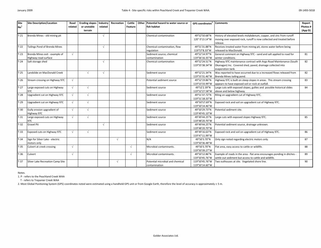
January 2009 Table 4 - Site-specific risks within Peachland Creek and Trepanier Creek WAA. 09-1493-5018
Golder Associates Ltd.
Site
No1
Site Description/Location Road related
Eroding slopes or unstable
terrain
Industry related
Recreation Cattle Feature
Other Potential hazard to water source or fish habitat
GPS coordinates2 Comments Report Photos # (App D)
T-21 Brenda Mines - old mining pit √ Chemical contamination 49°52'50.68"N 120° 0'13.14"W
History of elevated levels molybdenum, copper, and zinc from runoff moving over exposed rock, runoff is now collected and treated before release.
T-22 Tailings Pond of Brenda Mines √ Chemical contamination, flow regulation
49°51'31.88"N 119°57'8.33"W
Receives treated water from mining pit, stores water before being released to MacDonald.
T-23 Brenda Mines exit - example of Highway road surface
√ Sediment source, chemical contamination
49°52'14.97"N 119°56'16.35"W
General comment on Highway 97C - sand and salt applied to road for winter conditions.
81
T-24 Salt storage shed √ Chemical contamination 49°52'24.51"N 119°55'38.34"W
Highway 97C maintenance contract with Argo Road Maintenance (South Okanagan) Inc. Covered shed, paved, drainage collected into evaporation tank.
82
T-25 Landslide on MacDonald Creek √ √ Sediment source 49°52'21.34"N 119°55'31.46"W
Was reported to have occurred due to a increased flows released from Brenda Mines tailing pond.
82
T-26 Stream crossing on Highway 97C √ Potential sediment source 49°52'19.86"N 119°53'33.99"W
Highway 97C is built on steep slopes in areas. This stream crossing appears to have exposed soil or rock at outfall.
83
T-27 Large exposed cuts on Highway 97C
√ √ Sediment source 49°52'2.39"N 119°52'27.58"W
Large cuts with exposed slopes, gullies and possible historical slides above and below highway.
84
T-28 Upgradient cut on Highway 97C √ √ Sediment source 49°51'37.72"N 119°51'18.33"W
Riling on upgradient cut of Highway 97C.
T-29 Upgradient cut on Highway 97C √ √ Sediment source 49°50'57.69"N 119°50'14.46"W
Exposed rock and soil on upgradient cut of Highway 97C.
T-30 Gully erosion upgradient of Highway 97C
√ √ Sediment source 49°50'29.73"N 119°49'45.10"W
Potential sediment site.
T-31 Large exposed cuts on Highway 97C
√ √ Sediment source 49°49'44.25"N 119°48'20.70"W
Large cuts with exposed slopes Highway 97C. 85
T-32 Gravel Pit √ Sediment source 49°49'44.25"N 119°48'20.70"W
Potential sediment source, drainage unknown.
T-33 Exposed cuts on Highway 97C √ √ Sediment source 49°49'16.63"N 119°47'11.99"W
Exposed rock and soil on upgradient cut of Highway 97C. 86
T-34 Sign for Silver Lake - electric motors only
√ N/A 49°50'3.70"N 119°50'36.48"W
Only sign noted regarding electric motors only. 87
T-35 Culvert at creek crossing √ √ Microbial contaminants. 49°50'3.70"N 119°50'39.27"W
Flat area, easy access to cattle or wildlife. 88
T-36 Culvert √ √ Microbial contaminants. 49°50'12.86"N 119°50'45.76"W
Example of roads in the area - flat area encourages ponding in ditches - settle out sediment but access to cattle and wildlife.
89
T-37 Silver Lake Recreation Camp Site √ Potential microbial and chemical contamination
119°50'45.76"W 119°50'14.60"W
Two outhouses at site. Vegetated shore line. 90
Notes.1. P - refers to the Peachland Creek WAA T - refers to Trepanier Creek WAA 2. Most Global Positioning System (GPS) coordinates noted were estimated using a handheld GPS unit or from Google Earth, therefore the level of accuracy is approximately ± 5 m.

January 2010 Table 11 - Intrinsic Hazard Identification Table 09-1493-5018
Golder Associates Ltd.
Hazard No.1 Drinking Water Hazard Predicted Outcome Impact on Drinking Water Existing Preventative Measures Associated Barriers
1-1 Mountain Pine Beetle Decrease in forest cover through salvage logging and/or natural mortality of trees. Increase in magnitude and frequency of peak flows, soil moisture, surface water flows. Earlier on-set of snow melt.
Increased rates of erosion increasing turbidity and microbial contamination, changes to stream channel and sedimentation rates increasing maintenance costs, changes to flow regime impacting peak flows, reservoir management and drought conditions. Can increase nutrient and organic levels in water.
Some protective engineering measures around intakes: Rip rap of creek channel adjacent to intake, settling ponds before the intake and chlorination.
1-2 Tussock Moth Tree mortality - level of impact dependant on location and level of mortality. Outcomes similar to Mountain Pine Beetle if high mortality rates.
Similar to Mountain Pine Beetle if high level of tree mortality, especially around riparian zone.
CORD and MOFR planning a land spraying program in the spring of 2010.
See above.
1-3 Climate Change Increase to winter temperatures, potential peak flows, storm magnitude and evaporation rates, decrease in snow pack, earlier on-set of snow melt and freshet.
Increased water demand from irrigation, less water availability during dry season, increased flooding and erosion during winter/spring wet season.
Some protective engineering measures around intakes: Rip rap of creek channel adjacent to intake, settling ponds before the intake and chlorination.
1-4 Wildfires Loss of vegetation, exposure of mineral soils and increased in slope instabilities. Use of chemical retardants in fighting wildfires.
Increases in sedimentation and water turbidity, increases in peak flows with increase risk of channel and slope instability. Chemical retardants in water if used to fight fire.
Some protective engineering measures around intakes: Rip rap of creek channel adjacent to intake, settling ponds before the intake and chlorination.
1-5 Wildlife and Birds Input of fecal material when accessing creeks and streams. Large animals can also destabilize channel beds and increase turbidity.
Microbial contamination. Large animals can also destabilize channel beds and increase turbidity.
Natural buffers to creeks, where they exist.
Chlorination
1-6 Sediment Sources Sediment sources are the result of many activities, but mainly when vegetation is disturbed, soil exposed and/or mass wasting events.
Increases in sediment delivery to water courses with increased turbidity and microbial contaminants.
Settling ponds before intakes.
1-7 Channel Stability Is impacted by riparian buffers, peak flows and obstructions such as landslides or area of sedimentation.
Water quality generally increases in turbidity and microbial contaminants.
Some protective engineering measures around intakes. Settling ponds before intakes.

January 2010 Table 17 - Hazard Identification Table from Land Use in the Watershed Assessment Areas 09-1943-5018
Golder Associates Ltd.
Hazard No.
Activity Potential Impact to Drinking Water Existing Preventative Measures Associated Barriers
2-1 Forestry Activities: Licensee operations - harvesting practises. (Forest roads addressed as Hazard No. 2-10, 2-11 and 2-12)
Decrease in forest cover and road construction has potential to increase peak flows and contribute sediment and microbial contaminants to stream course. Chemical contamination from spills and pesticide applications (if used).
Forestry industry regulated by FRPA. Tolko and BCTS are participants of ORW and has SFMP. Heartland reported to have sustainable forestry practises. Tolko and Heartland do not use herbicides/pesticides in CWS.
Logging above reservoirs and lakes likely have less impact on water quality at District intakes.
2-2 Forestry Activities: Salvage logging and retention plans
Aggressive salvage logging with high ECAs have higher potential of increasing magnitude and frequency of peak flows, soil moisture, surface water flows, which in turn may increase rates of erosion, decreases stream channel stability and increases sedimentation rates.
Forestry industry regulated by FRPA. Tolko and BCTS are participants of ORW and has SFMP. Heartland reported to have sustainable forestry practises.
Logging above reservoirs and lakes likely have less impact on water quality at District intakes.
2-3 Range Use Typically grazing has a high density of animals - microbial contamination. Cattle can also destabilize channel beds and riparian areas thereby increasing sedimentation and turbidity.
Regulated by FRPA. Best Management Practises. MOFR staff in process of working with grazing tenure holders to develop grazing plans.
Some fencing and cattleguards in place. Steep canyons and creeks prohibit access in many areas. Some protective engineering measures around intakes: settling ponds before the intake and chlorination.
2-4 Mining: Placer, Petroleum and Coal
No current impacts as no historic or current activities. Both watersheds are within a placer reserve and there are no petroleum or coal titles.
2-5 Mining: Mineral Chemical contamination (particularily molybdenum and copper) and high flows causing landslides and creek destabilization.
Best management practises. Brenda Mines is regulated under Permit PE-00263
Treatment plant at Brenda Mines with regulated flows from storage area.
2-6 Aggregate Extraction Increases in sediment and microbial loading to stream courses, groundwater impacts and increased risk of chemical contamination.
Best management practises. Some protective engineering measures around intakes: settling ponds before the intake and chlorination.
2-7 Private Land Microbial contamination from septic systems and outhouses. Potential chemical contamination and sediment input depending on land use.
CORD Official Community Plan and applicable bylaws.
Chlorination at intakes and settling ponds.
2-8 Leased Land Around Reservoirs
Microbial contamination from septic systems and outhouses. Potential chemical contamination and sediment input depending on land use. May restrict flexibility to increase reservoir depths.
CORD Official Community Plan and applicable bylaws. Water Act allows expropriation of land for water works purpose.
Chlorination at intakes and settling ponds. Residency time in reservoirs.
2-9 Highway 97C Sediment, turbidity and microbial contamination from sand application on roads in the winter and from cutbank erosion. Salt from salt application to roads. Chemicals from accidents and spills.
Best management practises. Argo has salt storage plan.
Argo sweeps in spring and maintains road and is responcible for initial spills response for accidents of larger vehicles. Chlorination at intakes and settling ponds.

January 2010 Table 17 - Hazard Identification Table from Land Use in the Watershed Assessment Areas 09-1943-5018
Golder Associates Ltd.
Hazard No.
Activity Potential Impact to Drinking Water Existing Preventative Measures Associated Barriers
2-10 Roads on Steep slopes (Class III, IV and V)
Mass wasting, landslides, erosion of cut slopes and fills, road surface and ditch erosion causing sedimentation, turbidity and microbial contamination. Cars being pushed over steep slopes can cause hydrocarbon and chemical contamination.
Chlorination at intakes and settling ponds.
2-11 Roads on Gentle slopes (Class I and II)
Road surface and ditch erosion causing sedimentation, turbidity and microbial contamination. May provide cattle access at ponding sites in ditchlines.
Chlorination at intakes and settling ponds.
2-12 Creek crossings at roads Direct input of sediment from drainage, microbial contamination from cattle and wildlife access.
Chlorination at intakes and settling ponds.
2-13 Hydro Right-of-Way Sediment input from works and pesticides if used. BC Hydro does not use pesticides or herbicides, seeds works that expose soil immediately and have procedures for working in riparian zones.
Chlorination at intakes and settling ponds.
2-14 Recreation: Camping Microbial contamination and potential chemical contamination. Hazard rating is higher for inpromptu sites with no sanitary facilities beside creeks.
Some educational material available on provincial sites.
Chlorination at intakes.
2-15 Recreation: Boating and Fishing
Hydrocarbon contamination. Electric motors only on Silver Lake.
2-16 Recreation: ATVs and Dirt Bikes
Sediment, turbidity and microbial contamination from erosion on trails and from Monroe FSR.
Chlorination at intakes and settling ponds.
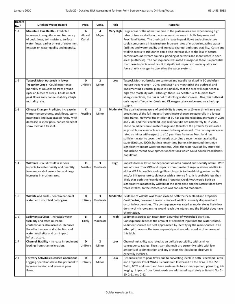
January 2010 Table 22 - Detailed Risk Assessment for Non-Point Source Hazards to Drinking Water. 09-1493-5018
Golder Associates Ltd.
Hazard No.1 Drinking Water Hazard Prob. Cons. Risk Rational
1-1 Mountain Pine Beetle - Predicted increases in magnitude and frequency of peak flows, soil moisture, surface water flows, earlier on-set of snow melt. Impacts on water quality and quantity.
A Almost Certain
4 Major
Very High Large areas of the of mature pine in the plateau area are experiencing high rates of tree mortality in the snow sensitive zone in both Trepanier and Peachland WAAs. The predicted increase in peak flows and soil moisture could compromise infrastructure, increase rates of erosion impacting water facilities and water quality and increase channel and slope stability. Cattle and wildlife access to tributaries could also increase due to the loss of natural barriers around stream courses, ponding at culverts and more water in open areas (cutblocks). The consequence was rated as major as there is a potential that these impacts could result in significant impacts to water quality and force drastic changes to operating the water system.
1-2 Tussock Moth outbreak in lower Trepanier Creek - Could experience mortality of Douglas-fir trees around riparian buffer of creek. Could impact peak flows and channel stability if high mortality rate.
D Unlikely
2 Minor
Low Tussock Moth outbreaks are common and usually localized in BC and often mature trees recover. CORD and MOFR are monitoring the outbreak and implementing a control plan so it is unlikely that the area will experience a high tree mortality rate. Although there is a health risk to humans from allergic reactions, the risk is not to drinking water sources. Also, this outbreak only impacts Trepanier Creek and Okanagan Lake can be used as a back up supply.
1-3 Climate Change - Predicted increase in winter temperatures, peak flows, storm magnitude and evaporation rates, with decrease in snow pack, earlier on-set of snow melt and freshet.
C Possible
2 Minor
Moderate The qualitative measure of probability is based on a 10-year time frame and predictions of the full impacts from climate change are generally in a longer time frame. However the Interior of BC has experienced drought years in 2003 and 2009 and the Peachland Lake reservoir did not completely fill in 2009. These could be from climate change and therefore the probability was rated as possible since impacts are currently being observed. The consequence was rated as minor with respect to a 10 year time frame as Peachland has sufficient water to cover their needs according a recent water availability study (Dobson, 2006), but in a longer time frame, climate conditions may significantly impact water operations. Also, the water availability study did not include recent development applications which could double Peachland's population.
1-4 Wildfires - Could result in serious impacts to water quality and quantity from removal of vegetation and large increases in erosion rates.
C Possible
3 Moderate
High Impacts from wildfire are dependant on area burned and severity of fire. With loss of trees from MPB and impacts from climate change, a severe wildfire in either WAA is possible and significant impacts to the drinking water quality and/or infrastructure could occur with a intense fire. It is probably less than likely that both the Peachland and Trepanier Creek WAA would both be significantly impacted by wildfire at the same time and the District does have three intakes, so the consequence was considered moderate.
1-5 Wildlife and Birds - Contamination of water with microbial pathogens.
D Unlikely
3 Moderate
Moderate Evidence of wildlife was found close to both the Peachland and Trepanier Creek WAAs, however, the occurrence of wildlife is usually dispersed and occur in low densities. The consequence was rated as moderate as likely low density of microorganisms would reach the intakes and the District does have chlorination.
1-6 Sediment Sources - Increases water turbidity and often microbial contaminants also increase. Reduces the effectiveness of disinfection and water aesthetics and can impact infrastructure.
B Likely
3 Moderate
High Sediment sources can result from a number of watershed activities. Consequence depends the amount of sediment input into the water course. Sediment sources are best approached by identifying the main sources in an attempt to resolve the issue separately and are addressed in other areas of this table.
1-7 Channel Stability - Increase in sediment loading from channel erosion.
D Unlikely
2 Minor
Low Channel instability was rated as an unlikely possibility with a minor consequence rating. The stream channels are currently stable with low amounts of sedimentation and any erosion that has been observed is generally localized.
2-1 Forestry Activities: Licensee operations - Logging operations have the potential to increase erosion and increase peak flows.
D Unlikely
2 Minor
Low Historical risks to peak flows due to harvesting levels in both Peachland Creek and Trepanier Creek WAAs is considered low based on the ECAs in the SSZ. Tolko, BCTS and Heartland have sustainable forest management plans to guide logging. Impacts from forest roads are addressed separately as Hazard No. 2-10, 2-11 and 2-12.

January 2010 Table 22 - Detailed Risk Assessment for Non-Point Source Hazards to Drinking Water. 09-1493-5018
Golder Associates Ltd.
Hazard No.1 Drinking Water Hazard Prob. Cons. Risk Rational
2-2 Forestry Activities: Salvage Logging and Retention plans for MPB impacted trees (near future) - Predicted increases in magnitude and frequency of peak flows, soil moisture, surface water flows, earlier on-set of snow melt. Impact on water quality and quantity.
A Almost Certain
4 Major
Very High High levels of salvage logging are planned in the plateau area of Trepanier Creek and Peachland Creek in the next five years with increased peak flows predicted. Increased peak flows and soil moisture may compromise infrastructure, increase rates of erosion, impact water quality, increase channel and slope stability, and increase cattle and wildlife access to streams. Tolko, BCTS and Heartland have sustainable forest management plans to guide logging which may lower potential impacts.
2-3 Range Use - Contamination of water with microbial pathogens and disturbance of riparian area causing turbidity.
B Likely
4 Major
Very High The probability assigned for range use impacts is mainly for Peachland Creek where there were cattle access points observed close to the intake. As there are no grazing tenures within the main stem of Trepanier Creek, the probability would be lowered to a possible (still Very High risk). Both watersheds may experience increased access from salvage logging and tree mortality in the plateau area. The consequence was rated as major due to the risk of health impacts and the high density of cattle that are grazed. Peachland does chlorinate their water supply which does afford some protection.
2-4 Mining: Placer, Petroleum and Coal - No activity at this time.
E Rare
I Insigni-ficant
Low There are no petroleum or coal titles in either watershed and it is not anticipated that either activity will occur in the next 10 years. Both watersheds are within a placer reserve and hence, placer mining will not occur unless the placer reserve policy changes.
2-5 Mining: Mineral - Chemical contamination (molybdenum and copper) and high flows causing landslides and creek destabilization.
E Rare
2 Minor
Low Brenda Mines is regulated by a permit, has diversions to collect runoff water over exposed rock, operates a treatment plant and conducts regular monitoring. As long as these controls stay in place, the probability of an event causing a long-term impact is considered rare and any exceedances should be observed with the monitoring program and remediated according to the permit. If future mining in the area was proposed, the assigned risk should be reassessed and would likely increase.
2-6 Aggregate Extraction - Increases in sediment and microbial loading to stream courses, groundwater impacts and increased risk of chemical contamination.
C Possible
3 Moderate
High The aggregate deposits in Trepanier Creek and Peachland Creek WAA are in the terraced slopes adjacent to the stream channels. Even if gravel extraction operations use BMPs, it is still possible that water quality would be impacted by the operations. The potential increase in turbidity and contamination risk was assessed to have a moderate consequence. (Note: The gravel extraction operation at site T- 6 and T-10 has been identified as a Very High Risk (Table 22) on a relative risk rating for specific-sites).
2-7 Private Land - Microbial contamination from septic systems. Chemical contamination and sediment input depending on land use.
D Unlikely
2 Minor
Low Development on private land directly adjacent to the stream channels in Trepanier Creek and Peachland Creek WAAs was not observed. As development is not directly adjacent to streams, probability was rated as unlikely and consequences were rated as minor. However, investigation into the observed lagoon may be warranted.
2-8 Leased Land Around Reservoirs - Microbial contamination from septic systems and outhouses. Chemical contamination and sediment input. Could restrict ability to increase storage in reservoirs.
D Unlikely
3 Moderate
Moderate Leased land is adjacent to Glen Lake and Silver Lake with outhouses and potentially septic systems. Even if they are not properly designed or are faulty, they are only used seasonally and there will be some filtration effect from travel time in the soil to the lake, also the lakes would provide residency time. The consequence was rate as moderate as if microorganisms from these systems did reached the intakes, the density would likely be low.
2-9 Highway 97C - Sediment, turbidity and microbial contamination from sand application on roads in the winter and from cutbank erosion. Salt from salt application to roads. Chemicals from vehicles, accidents and spills.
C Possible
2 Minor
Moderate Sand and salt are applied to the Highway 97C each winter and accumulate on the side of the road until spring, when it is swept. Road drainage from rain and snow melt will carry or dissolve sediment and salt in the drainage which is drained directly into the streams. There are also no studies to assess the impact on water quality from the highway. The consequence was rated as moderate as Highway 97C has been in operation since the late 1980's and the District has been able managed their water system with modification to normal operations (i.e. pumping from Okanagan Lake when turbidity high).

January 2010 Table 22 - Detailed Risk Assessment for Non-Point Source Hazards to Drinking Water. 09-1493-5018
Golder Associates Ltd.
Hazard No.1 Drinking Water Hazard Prob. Cons. Risk Rational
2-10 Roads on Steep slopes (Class III, IV and V) - Mass wasting, landslides, erosion of cut slopes and fills, road surface and ditch erosion causing sedimentation, turbidity and microbial contamination. Cars being pushed over steep slopes can cause hydrocarbon and chemical contamination.
A Almost Certain
3 Moderate
Very High The probably was listed as almost certain as a number of site specific erosion issues, cut or fill slumps and landslides were identified on roads on steep slopes in both watershed assessment areas. Two cars pushed over the road side slope were also identified. The consequence was listed as moderated as the District has been operating their system under these conditions for many years, however, increased operating costs have been associated with sediment removal from settling ponds and from the stream channels at the intakes and the requirement to install a filtration plant.
2-11 Roads on Gentle slopes (Class I and II) - Road surface and ditch erosion causing sedimentation, turbidity and microbial contamination.
D Unlikely
2 Minor
Low The probability rating was given an unlikely and the consequence was rated as minor for a significant amount of sediment and contaminants reaching the water courses from roads on gentle slopes in comparison to the roads on steep slopes. The roads on gentle slopes observed in the field had ditches that were often vegetated (unless a new road) with gentle grades and ponding at the culverts. If erosion was observed, it was minor in comparison to that of the roads on steep slopes.
2-12 Creek crossings at roads - Direct input sediment from drainage, microbial contamination from cattle and wildlife access and informal camping sites.
A Almost Certain
4 Major
Very High The probability was rated as almost certain as there were one creek crossing in the Peachland Creek close to the intake that provided access to cattle, had a camp spot and had significant sediment sources close to it and one crossing near the Trepanier intake that was noted as a significant sediment input location and had a camp spot next to the bridge . The consequence was rate as major due to the potential of severe illness from microbial contaminants from cattle and wildlife access and insufficient sanitary services at the camping sites.
2-13 BC Hydro Right-of-Way - Maintenance Operations - Sediment sources and pesticides.
D Unlikely
2 Minor
Low BC Hydro has policies about working around streams and keeping ground cover therefore possibility is unlikely. There is no pesticide use for maintenance. (Note - the bridge crossing at the BC Hydro ROW was identified as a site-specific hazard and is assessed in Table 22)
2-14 Recreation: Camping - Microbial contamination and potential chemical contamination.
C Possible
4 Major
Very High A number of informal camping sites were noted next to the stream courses in locations without proper sanitary facilities and most of the camping in the area is listed as backcountry with little guidance to proper sanitary procedures from the provincial website, therefore the probability was listed as possible. The consequence was rate as major due to the potential of severe illness from microbial contaminants from humans and domestic animals.
2-15 Recreation: Boating and Fishing - Hydrocarbon and chemical contamination.
C Possible
3 Moderate
High Gas motor boats frequently use Peachland Lake and possibly the other lakes in the watershed areas. The probability of hydrocarbon contamination reaching the District intakes was rated as possible as only low levels of hydrocarbons are required to impact drinking water taste. The consequence was rated as moderate as people will not generally drink hydrocarbons and therefore will not get sick from it and the District has a number of intakes if an alternative source is required for a short period of time. The risk is lower in the Trepanier Creek watershed as Silver Lake is electric motors only, Lacoma Lake is inaccessible and the other lakes are small and not as desirable to motor boats.
2-16 Recreation: ATVs and Dirt Bikes - Sediment, turbidity and microbial contamination from erosion on trails and from Monroe FSR and campsites potentially associated with trail users.
A Almost Certain
4 Major
Very High Peachland Creek WAA only - Significant erosion issues were observed from trails and the Monroe FSR on the way to the staging area for a proposed managed trail system in the Peachland Creek WAA and at least two informal camp sites, potentially associated with the trail users, were identified next to the stream channel, therefore the probability was listed as almost certain. The consequence was rated as major due to the potential of microbial contamination and the close proximity to the Peachland Intake. An additional risk is that there is minimal information available about the trail system already permitted to Okanagan ATV Tours and potential impacts are unknown.
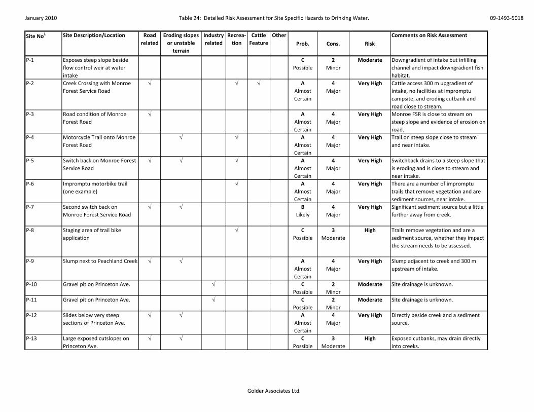
January 2010 Table 24: Detailed Risk Assessment for Site Specific Hazards to Drinking Water. 09-1493-5018
Golder Associates Ltd.
Site No1 Site Description/Location Road related
Eroding slopes or unstable
terrain
Industry related
Recrea-tion
Cattle Feature
Other
Prob. Cons. Risk
Comments on Risk Assessment
P-1 Exposes steep slope beside flow control weir at water intake
C Possible
2 Minor
Moderate Downgradient of intake but infilling channel and impact downgradient fish habitat.
P-2 Creek Crossing with Monroe Forest Service Road
√ √ √ A Almost Certain
4 Major
Very High Cattle access 300 m upgradient of intake, no facilities at impromptu campsite, and eroding cutbank and road close to stream.
P-3 Road condition of Monroe Forest Road
√ A Almost Certain
4 Major
Very High Monroe FSR is close to stream on steep slope and evidence of erosion on road.
P-4 Motorcycle Trail onto Monroe Forest Road
√ √ A Almost Certain
4 Major
Very High Trail on steep slope close to stream and near intake.
P-5 Switch back on Monroe Forest Service Road
√ √ √ A Almost Certain
4 Major
Very High Switchback drains to a steep slope that is eroding and is close to stream and near intake.
P-6 Impromptu motorbike trail (one example)
√ A Almost Certain
4 Major
Very High There are a number of impromptu trails that remove vegetation and are sediment sources, near intake.
P-7 Second switch back on Monroe Forest Service Road
√ √ B Likely
4 Major
Very High Significant sediment source but a little further away from creek.
P-8 Staging area of trail bike application
√ C Possible
3 Moderate
High Trails remove vegetation and are a sediment source, whether they impact the stream needs to be assessed.
P-9 Slump next to Peachland Creek √ √ A Almost Certain
4 Major
Very High Slump adjacent to creek and 300 m upstream of intake.
P-10 Gravel pit on Princeton Ave. √ C Possible
2 Minor
Moderate Site drainage is unknown.
P-11 Gravel pit on Princeton Ave. √ C Possible
2 Minor
Moderate Site drainage is unknown.
P-12 Slides below very steep sections of Princeton Ave.
√ √ A Almost Certain
4 Major
Very High Directly beside creek and a sediment source.
P-13 Large exposed cutslopes on Princeton Ave.
√ √ C Possible
3 Moderate
High Exposed cutbanks, may drain directly into creeks.

January 2010 Table 24: Detailed Risk Assessment for Site Specific Hazards to Drinking Water. 09-1493-5018
Golder Associates Ltd.
Site No1 Site Description/Location Road related
Eroding slopes or unstable
terrain
Industry related
Recrea-tion
Cattle Feature
Other
Prob. Cons. Risk
Comments on Risk Assessment
P-14 Potential slide below Princeton Ave.
√ √ B Likely
4 Major
Very High Next to creek and potential to provide significant sediment to creek.
P-15 Gravel pit on Princeton Ave. √ C Possible
2 Minor
Moderate Site drainage is unknown.
P-16 Slides below very steep sections of Princeton Ave.
√ √ B Likely
4 Major
Very High Next to creek and potential to provide significant sediment to creek.
P-17 Gravel pit √ C Possible
2 Minor
Moderate Site drainage is unknown.
P-18 Cattle guard √ ERare
1 Insigni-ficant
Low No risk, cattle guard noted.
P-19 Lagoon √ C Possible
3 Moderate
High The lagoon use and site drainage is unknown
P-20 Potential slide to Peachland Creek from road
√ √ B Likely
3 Moderate
High Next to creek and potential to provide significant sediment to creek.
P-21 Old road on floodplain of Peachland Creek
√ C Possible
3 Moderate
High Old road on steep slope adjacent to creek.
P-22 Roads/trails on steep gullied terrain, potential slide
√ √ B Likely
3 Moderate
High Next to creek and potential to provide significant sediment to creek.
P-23 Creek crossing √ C Possible
2 Minor
Moderate May be sediment source.
P-24 Creek crossing and pond √ √ C Possible
4 Major
Very High Cattle and wildlife access point, may provide microbial contaminants to creek.
P-25 Creek crossings and cattle access
√ √ C Possible
4 Major
Very High Cattle and wildlife access point, may provide microbial contaminants to creek.
P-26 Creek crossings √ D Unlikely
3 Moderate
Moderate Partially blocked culvert, risk of failure.
P-27 Brenda Mine Tailing Pond spillway
√ E Rare
3 Moderate
Moderate Potential road surface erosion and spillway erosion.
P-28 Peachland Lake, spillway and road
√ C Possible
3 Moderate
High Some improvements made in 2009, should be checked during use.

January 2010 Table 24: Detailed Risk Assessment for Site Specific Hazards to Drinking Water. 09-1493-5018
Golder Associates Ltd.
Site No1 Site Description/Location Road related
Eroding slopes or unstable
terrain
Industry related
Recrea-tion
Cattle Feature
Other
Prob. Cons. Risk
Comments on Risk Assessment
P-29 Forestry roads near steep and gullied slopes
√ √ D Unlikely
4 Major
Moderate Road near steep slopes.
P-30 Road adjacent to steep slopes - section of Peachland Creek is deeply incised
√ √ D Unlikely
2 Minor
Low Above Peachland Lake, low risk to water quality, but could increase sedimentation in Peachland Lake.
P-31 Potential landslides below road on Bolingbroke Creek
√ √ √ C Possible
2 Minor
Moderate Upgradient of wetland which likely settles sediment out.
P-32 Creek crossing - potential cattle access
√ √ C Possible
3 Moderate
High Cattle seen on Peachland FSR, may have access at culvert, but site further from intake.
P-33 Gully or old slide track to Greata Creek
√ C Possible
2 Minor
Moderate Old landslide track, may be providing sediment.
P-34 Switchback on Peachland Forest Service Road -
√ √ C Possible
4 Major
Very High Old road to creek may provide cattle access to creek. Eroding cutbank at culverts.
T-1 Env. Canada gauging station √ E Rare
1 Insigni-ficant
Low No risk, gauging station location noted.
T-2 Camping site and abandoned vehicles
√ C Possible
4 Major
Very High Site next to creek and close to intake with no sanitary facilities.
T-3 Cutslope on road √ √ C Possible
3 Moderate
High Eroding cutslope.
T-4 Gravel Pit √ D Unlikely
3 Moderate
Moderate High amounts of truck traffic on road next to creek.
T-5 Creek crossing - bridge at hydro line
√ √ √ A Almost Certain
4 Major
Very High Sediment from vehicle traffic noted on open plank bridge. Camp site beside creek with no sanitary facilities.
T-6 Recent Gravel Pit - beside creek
√ B Likely
4 Major
Very High Stockpiles close and unsecure chemical storage close to creek
T-7 Newly created road to gravel pit
√ √ B Likely
4 Major
Very High Cut and fill slopes with notable erosion and drainage towards creek.
T-8 Gravel pit √ B Likely
4 Major
Very High Further away from creek, but drainage unknown and heavy traffic from area must cross creek.

January 2010 Table 24: Detailed Risk Assessment for Site Specific Hazards to Drinking Water. 09-1493-5018
Golder Associates Ltd.
Site No1 Site Description/Location Road related
Eroding slopes or unstable
terrain
Industry related
Recrea-tion
Cattle Feature
Other
Prob. Cons. Risk
Comments on Risk Assessment
T-9 Deactivated road to Trepanier Park
√ √ D Unlikely
2 Minor
Low Minor erosion issues, but road on flat land with vegetated buffer between road and creek.
T-10 Old crossing of Trepanier creek - bridge removed
√ √ C Possible
3 Moderate
High Potential erosion during freshet.
T-11 Eroding channel on road to Trepanier Park
√ √ C Possible
2 Minor
Moderate Vegetated buffer between road and creek. Evidence of wildlife is not isolated to this site and is reflected in intrinsic risk assessment.
T-12 End of road to Trepanier Creek, bridge removed
√ √ C Possible
4 Major
Very High Some erosion potential at removed bridge site, camping sites with no sanitary facilities.
T-13 Rockfall on Clover Creek √ D Unlikely
2 Minor
Low Appears to be tallis slopes (rock), likely low sediment production.
T-14 Logging in ephemeral stream area
√ C Possible
4 Major
Very High Could destabilize channel and cause significant sedimentation.
T-15 Lacoma Creek √ C Possible
2 Minor
Moderate Potential sediment source during freshet.
T-16 Logged to creek √ C Possible
4 Major
Very High Could destabilize channel and cause significant sedimentation.
T-17 Lacoma Creek tributary -rockfall along meltwater channels
√ C Possible
2 Minor
Moderate Above Lacoma Lake, chance of sediment to settle.
T-18 Trepanier Creek tributary - appears logged to creek bank.
√ C Possible
4 Major
Very High Could destabilize channel and cause significant sedimentation.
T-19 Rockfall along meltwater channels -Trepanier Creek
√ D Unlikely
2 Minor
Low Appears to be tallis slopes (rock), likely low sediment production.
T-20 Upper Trepanier Creek Area (includes Clover Creek)
√ √ √ C Possible
3 Moderate
High Potential increase of cattle access to watering sites.
T-21 Brenda Mines - old mining pit √ E Rare
2 Minor
Low Assumes current controls will remain in place (permit, drainage collection,
T-22 Tailings Pond of Brenda Mines √ E Rare
2 Minor
Low Assumes current controls will remain in place (permit, drainage collection,
T-23 Brenda Mines exit - example of Highway road surface
√ A Almost Certain
3 Moderate
Very High Sand and salt from winter applications in drainage, no monitoring to assess.

January 2010 Table 24: Detailed Risk Assessment for Site Specific Hazards to Drinking Water. 09-1493-5018
Golder Associates Ltd.
Site No1 Site Description/Location Road related
Eroding slopes or unstable
terrain
Industry related
Recrea-tion
Cattle Feature
Other
Prob. Cons. Risk
Comments on Risk Assessment
T-24 Salt storage shed √ E Rare
2 Minor
Low Assumes current controls will remain in place (covered shed on paved site, drainage collected into evaporation tank).
T-25 Landslide on MacDonald Creek √ √ D Unlikely
3 Moderate
Moderate Site was remediated.
T-26 Stream crossing on Highway 97C
√ C Possible
3 Moderate
High Potential sediment site.
T-27 Large exposed cuts on Highway 97C
√ √ C Possible
3 Moderate
High Potential sediment site.
T-28 Upgradient cut on Highway 97C
√ √ C Possible
3 Moderate
High Potential sediment site.
T-29 Upgradient cut on Highway 97C
√ √ C Possible
3 Moderate
High Potential sediment site.
T-30 Gully erosion upgradient of Highway 97C
√ √ C Possible
3 Moderate
High Potential sediment site.
T-31 Large exposed cuts on Highway 97C
√ √ C Possible
3 Moderate
High Potential sediment site.
T-32 Gravel Pit √ C Possible
3 Moderate
High Potential sediment site.
T-33 Exposed cuts on Highway 97C √ √ C Possible
3 Moderate
High Potential sediment site.
T-34 Sign for Silver Lake - electric motors only
√ E Rare
1 Insigni-ficant
Low No risk, signed noted.
T-35 Culvert at creek crossing √ √ C Possible
3 Moderate
High Upstream of Silver Lake.
T-36 Culvert √ √ E Rare
2 Minor
Low Vegetated ditches. Potential access to cattle and wildlife, but upstream of Silver Lake.
T-37 Silver Lake Recreation Camp Site
√ C Possible
3 Moderate
High Outhouses at recreation campsite.
Notes.1. P - refers to the Peachland Creek WAA T - refers to Trepanier Creek WAA 2. Most Global Positioning System (GPS) coordinates noted were estimated using a handheld GPS unit or from Google Earth, therefore the level of accuracy is approximately ± 5 m.

January 2010 Table 25 - Risk Management Actions for Non-Point Source Hazards to Drinking Water. 09-1493-5018
Golder Associates Ltd.
Hazard No.1 Drinking Water Hazard Risk General Comments on Current Action and Risk Rating Rational Risk Management Actions and Corresponding Recommendations
1-1 Mountain Pine Beetle - Predicted increases in magnitude and frequency of peak flows, soil moisture, surface water flows, earlier on-set of snow melt. Impacts on water quality and quantity.
Very High Large areas of the of mature pine in the plateau area are experiencing high rates of tree mortality in the snow sensitive zone in both Trepanier and Peachland WAAs. The predicted increase in peak flows and soil moisture could compromise infrastructure, increase rates of erosion impacting water facilities and water quality and increase channel and slope stability. Cattle and wildlife access to tributaries could also increase due to the loss of natural barriers around stream courses, ponding at culverts and more water in open areas (cutblocks).
• Review of new information (i.e. Grainger Report, Feb. 2010) and implications to water management program in Peachland Creek. (Recommendation 5) • Initiate a flow monitoring program in Peachland Creek and install required stream flow monitoring equipment. (Recommendation 3) • Develop and implement raw water monitoring program for Peachland Creek and Trepanier Creek. (Recommendation 4)
2-2 Forestry Activities: Salvage Logging and Retention plans for MPB impacted trees (near future) - Predicted increases in magnitude and frequency of peak flows, soil moisture, surface water flows, earlier on-set of snow melt. Impact on water quality and quantity.
Very High High levels of salvage logging are planned in the plateau area of Trepanier Creek and Peachland Creek in the next five years with increased peak flows predicted. Increased peak flows and soil moisture may compromise infrastructure, increase rates of erosion, impact water quality, increase channel and slope stability, and increase cattle and wildlife access to streams. Tolko, BCTS and Heartland have sustainable forest management plans to guide logging .
• Review of new information (i.e. Grainger Report, Feb. 2010) with adjustments to salvage logging and retention plans as required. (Forestry companies) • Monitor forestry infrastructure, such as culverts and bridges, for responses to predicted increases to peak flows from MPB and complete upgrades as required. (Forestry companies)
2-3 Range Use - Contamination of water with microbial pathogens and disturbance of riparian area causing turbidity.
Very High The probability assigned for range use impacts is mainly for Peachland Creek where there were cattle access points observed close to the intake. As there are no grazing tenures within the main stem of Trepanier Creek, the probability would be lowered to a possible (still Very High risk). Both watersheds may experience increased access from salvage logging and tree mortality in the plateau area. The consequence was rated as major due to the risk of health impacts and the high density of cattle that are grazed. Peachland does chlorinate their water supply which does afford some protection.
• Continue development of RUP with grazing tenure holders and consult with the District as required. (Recommendation 6) • Forestry companies, District staff and other watershed users should assist MOFR and report cattle access sites to riparian zones and tributaries. (Recommendation 6) • Develop and implement raw water monitoring program for Peachland Creek and complete vulnerability mapping. (Recommendations 1 and 4) • Forestry companies and MOFR should consult regarding natural barrier retention or enhancement regarding cattle access to riparian zones. (Recommendation 5 and 6)
2-10 Roads on Steep slopes (Class III, IV and V) - Mass wasting, landslides, erosion of cut slopes and fills, road surface and ditch erosion causing sedimentation, turbidity and microbial contamination. Cars being pushed over steep slopes can cause hydrocarbon and chemical contamination.
Very High Road erosion issues, eroding cuts or fills and landslides were identified on roads on steep slopes adjacent to the stream channels in both watershed assessment areas. However, due to topography and road location, the potential impact was greater in Peachland Creek. The highest risk roads identified adjacent in Peachland Creek are mostly non-status roads. Cars pushed over main access roads the Peachland Creek canyon were also identified.
• Further assessment to identify level of risk for roads on steep slopes adjacent to Peachland Creek. (Recommendation 1) • Stakeholders in Peachland Creek to develop access management strategy for roads identified as high risk to the DOP intake and assist in either funding or accessing funding to complete either deactivation strategy or road improvements. (Recommendation 7)
2-12 Creek crossings at roads - Direct input sediment from drainage, microbial contamination from cattle and wildlife access and informal camping sites.
Very High There were two main stream crossings in the Peachland Creek that concerns to water quality were identified and one main stream crossing on Trepanier Creek. Concerns identified were proximity to intakes cattle access (Peachland Creek), informal camp sites directly beside streams, sediment sources from crossing or drainage, wildlife access.
• Stakeholders in Peachland Creek to develop access management strategy for roads identified as high risk to the DOP intake and assist in either funding or accessing funding to complete either deactivation strategy or road improvements. (Recommendation 7) • Develop long-term monitoring plan of stream channels. (Recommendation 19)
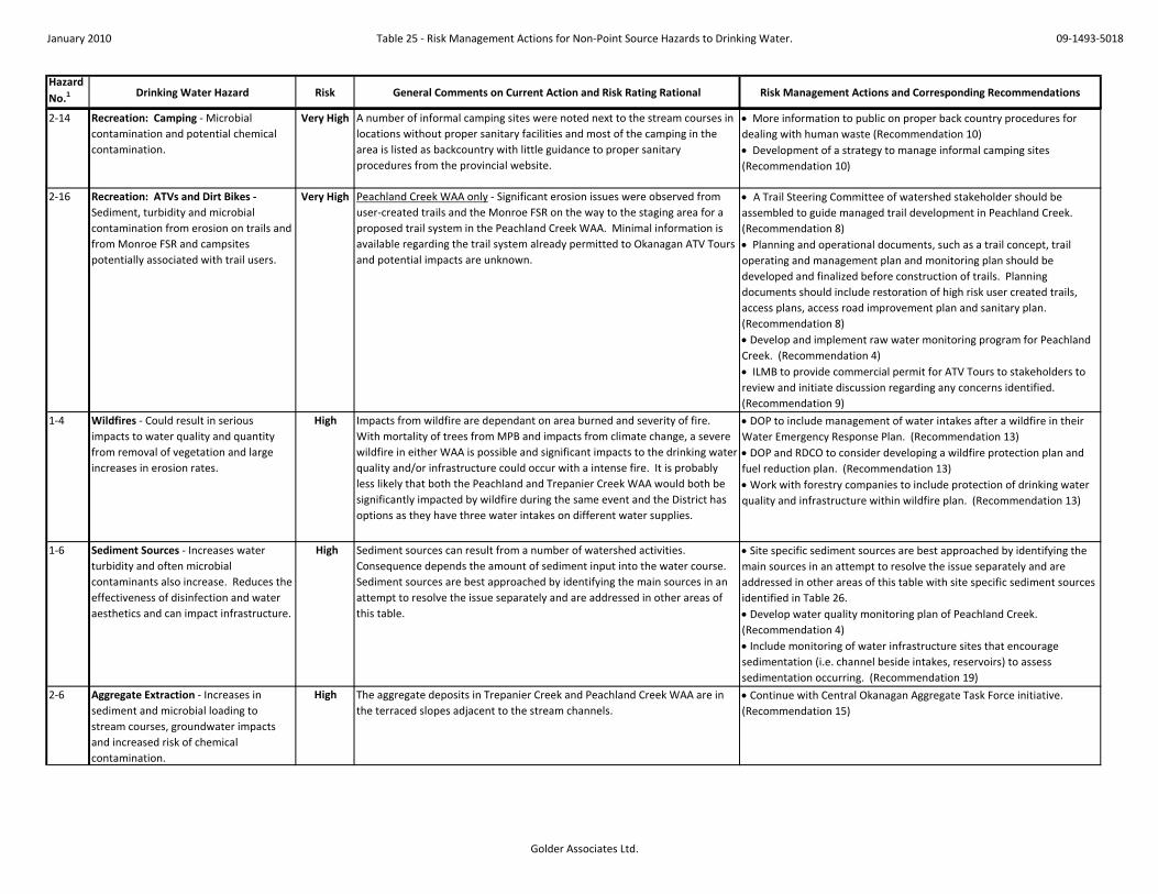
January 2010 Table 25 - Risk Management Actions for Non-Point Source Hazards to Drinking Water. 09-1493-5018
Golder Associates Ltd.
Hazard No.1 Drinking Water Hazard Risk General Comments on Current Action and Risk Rating Rational Risk Management Actions and Corresponding Recommendations
2-14 Recreation: Camping - Microbial contamination and potential chemical contamination.
Very High A number of informal camping sites were noted next to the stream courses in locations without proper sanitary facilities and most of the camping in the area is listed as backcountry with little guidance to proper sanitary procedures from the provincial website.
• More information to public on proper back country procedures for dealing with human waste (Recommendation 10) • Development of a strategy to manage informal camping sites (Recommendation 10)
2-16 Recreation: ATVs and Dirt Bikes - Sediment, turbidity and microbial contamination from erosion on trails and from Monroe FSR and campsites potentially associated with trail users.
Very High Peachland Creek WAA only - Significant erosion issues were observed from user-created trails and the Monroe FSR on the way to the staging area for a proposed trail system in the Peachland Creek WAA. Minimal information is available regarding the trail system already permitted to Okanagan ATV Tours and potential impacts are unknown.
• A Trail Steering Committee of watershed stakeholder should be assembled to guide managed trail development in Peachland Creek. (Recommendation 8) • Planning and operational documents, such as a trail concept, trail operating and management plan and monitoring plan should be developed and finalized before construction of trails. Planning documents should include restoration of high risk user created trails, access plans, access road improvement plan and sanitary plan. (Recommendation 8) • Develop and implement raw water monitoring program for Peachland Creek. (Recommendation 4) • ILMB to provide commercial permit for ATV Tours to stakeholders to review and initiate discussion regarding any concerns identified. (Recommendation 9)
1-4 Wildfires - Could result in serious impacts to water quality and quantity from removal of vegetation and large increases in erosion rates.
High Impacts from wildfire are dependant on area burned and severity of fire. With mortality of trees from MPB and impacts from climate change, a severe wildfire in either WAA is possible and significant impacts to the drinking water quality and/or infrastructure could occur with a intense fire. It is probably less likely that both the Peachland and Trepanier Creek WAA would both be significantly impacted by wildfire during the same event and the District has options as they have three water intakes on different water supplies.
• DOP to include management of water intakes after a wildfire in their Water Emergency Response Plan. (Recommendation 13) • DOP and RDCO to consider developing a wildfire protection plan and fuel reduction plan. (Recommendation 13) • Work with forestry companies to include protection of drinking water quality and infrastructure within wildfire plan. (Recommendation 13)
1-6 Sediment Sources - Increases water turbidity and often microbial contaminants also increase. Reduces the effectiveness of disinfection and water aesthetics and can impact infrastructure.
High Sediment sources can result from a number of watershed activities. Consequence depends the amount of sediment input into the water course. Sediment sources are best approached by identifying the main sources in an attempt to resolve the issue separately and are addressed in other areas of this table.
• Site specific sediment sources are best approached by identifying the main sources in an attempt to resolve the issue separately and are addressed in other areas of this table with site specific sediment sources identified in Table 26. • Develop water quality monitoring plan of Peachland Creek. (Recommendation 4) • Include monitoring of water infrastructure sites that encourage sedimentation (i.e. channel beside intakes, reservoirs) to assess sedimentation occurring. (Recommendation 19)
2-6 Aggregate Extraction - Increases in sediment and microbial loading to stream courses, groundwater impacts and increased risk of chemical contamination.
High The aggregate deposits in Trepanier Creek and Peachland Creek WAA are in the terraced slopes adjacent to the stream channels.
• Continue with Central Okanagan Aggregate Task Force initiative. (Recommendation 15)

January 2010 Table 25 - Risk Management Actions for Non-Point Source Hazards to Drinking Water. 09-1493-5018
Golder Associates Ltd.
Hazard No.1 Drinking Water Hazard Risk General Comments on Current Action and Risk Rating Rational Risk Management Actions and Corresponding Recommendations
2-15 Recreation: Boating and Fishing - Hydrocarbon and chemical contamination.
High Gas motor boats frequently use Peachland Lake and possibly the other lakes in the watershed areas. Low levels of hydrocarbon contamination can impact drinking water taste.
• DOP and RDCO submit request to MOE that Peachland Lake and Glen Lake be designated as "electric motor only". (Recommendation 12) • MOTCA include "electric motor only" designation in promotional information. (Recommendation 12) • Signs of "electric motor only" designation are posted at applicable boat launches. (Recommendation 12)
1-3 Climate Change - Predicted increase in winter temperatures, peak flows, storm magnitude and evaporation rates, with decrease in snow pack, earlier on-set of snow melt and freshet.
Moderate Climate Change predictions are generally based on time frames of 35 to 50 years. However the Interior of BC has experienced drought years in 2003 and 2009 and the Peachland Lake reservoir did not completely fill in 2009. Although rated as moderate risk, planning initiatives should be implemented to be prepared for predicted changes.
• Develop a flow monitoring program for Peachland Creek, install required stream flow monitoring equipment to initiate data collection for water use in planning documents. (Recommendation 3)
1-5 Wildlife and Birds - Contamination of water with microbial pathogens.
Moderate Evidence of wildlife was found close to both the Peachland and Trepanier Creek WAAs, however, the occurrence of wildlife is usually dispersed and occur in low densities.
• Develop and implement raw water monitoring program for Peachland Creek and Trepanier Creek. May choose to complete bacterial source tracking dependant on results. (Recommendation 4)
2-9 Highway 97C - Sediment, turbidity and microbial contamination from sand application on roads in the winter and from cutbank erosion. Salt from salt application to roads. Chemicals from vehicles, accidents and spills.
Moderate Sand and salt are applied to the Highway 97C each winter and accumulate on the side of the road until spring, when it is swept. Road drainage from rain and snow melt may increase microbial contaminants, turbidity, dissolved solids, sodium, calcium and chloride in highway road drainage which is drained directly into the streams.
• In developing raw water monitoring program for Trepanier Creek, review Brenda Mines sampling results for sodium and consider appropriate sampling locations and parameters to assess impacts from highway 97. (Recommendation 4)
2-8 Leased Land Around Reservoirs - Microbial contamination from septic systems and outhouses. Chemical contamination and sediment input. Could restrict ability to increase storage in reservoirs.
Moderate Leased land is adjacent to Glen Lake and Silver Lake with outhouses and potentially septic systems. Even if they are not properly designed or are faulty, they are only used seasonally and there will be some filtration effect from travel time in the soil to the lake, also the lakes would provide residency time. The consequence was rate as moderate as if microorganisms from these systems did reached the intakes, the density would likely be low.
• RDCO to readjust buffer area around Glen Lake after the dam has been constructed by DOP. (Recommendation 11) • ILMB should incorporate conservation buffer areas and cottage lot designations and zoning into the ILMP. (Recommendation 11) • DOP and RDCO to develop education program for lease holders and support the position that leased land around drinking water reservoirs should not be sold or expanded. (Recommendation 11) • Include the inlet and outlet of reservoirs within raw water monitoring program. (Recommendation 4)
1-2 Tussock Moth outbreak in lower Trepanier Creek - Could experience mortality of Douglas-fir trees around riparian buffer of creek. Could impact peak flows and channel stability if high mortality rate.
Low RDCO and MOFR are monitoring the outbreak and implementing a control plan so it is unlikely that the area will experience a high tree mortality rate.
• RDCO and MOFR are monitoring the outbreak and implementing a control plan in spring of 2010. (Recommendation 17) • DOP to keep informed of progress and provide information to the public as required. (Recommendation 17)

January 2010 Table 25 - Risk Management Actions for Non-Point Source Hazards to Drinking Water. 09-1493-5018
Golder Associates Ltd.
Hazard No.1 Drinking Water Hazard Risk General Comments on Current Action and Risk Rating Rational Risk Management Actions and Corresponding Recommendations
1-7 Channel Stability - Increase in sediment loading from channel erosion.
Low Channel instability was rated as an unlikely possibility with a minor consequence rating. The stream channels are currently stable with low amounts of sedimentation and any erosion that has been observed is generally localized.
• Complete complete vulnerability mapping and complete sediment survey on reach of Peachland Creek close to intake. (Recommendations 1 and 2) • Develop long-term monitoring of channel stability (Recommendation 19).
2-1 Forestry Activities: Licensee operations - Logging operations have the potential to increase erosion and increase peak flows.
Low Historical risks to peak flows due to harvesting levels in both Peachland Creek and Trepanier Creek WAAs is considered low based on the ECAs in the SSZ. FRPA and Best Management Practises guide forest practices and Tolko, BCTS and Heartland have sustainable forest management plans to guide logging. Impacts from forest roads are addressed separately roads on steep slopes and roads on gentle slopes.
• Forest companies to continue to implement Best Management Practices. (Recommendation 5)
2-11 Roads on Gentle slopes (Class I and II) - Road surface and ditch erosion causing sedimentation, turbidity and microbial contamination.
Low The probability rating was given an unlikely and the consequence was rated as minor for a significant amount of sediment and contaminants reaching the water courses from roads on gentle slopes in comparison to the roads on steep slopes. The roads on gentle slopes observed in the field had ditches that were often vegetated (unless a new road) with gentle grades and ponding at the culverts. If erosion was observed, it was minor in comparison to that of the roads on steep slopes.
• Proper planning, construction, monitoring and maintenance of active forest roads to be completed by forest companies and deactivation of non-active roads. (Recommendation 5)
2-4 Mining: Placer, Petroleum and Coal - No activity at this time.
Low There are no petroleum or coal titles in either watershed and it is not anticipated that either activity will occur in the next 10 years. Both watersheds are within a placer reserve and hence, placer mining will not occur unless the placer reserve policy changes.
• Apply for a petroleum and coal reserve within the Trepanier Creek and Peachland Creek watershed areas. (Recommendation 16)
2-5 Mining: Mineral - Chemical contamination (molybdenum and copper) and high flows causing landslides and creek destabilization.
Low Brenda Mines is regulated by a permit, has diversions to collect runoff water over exposed rock, operates a treatment plant and conducts regular monitoring. If future mining in the area was proposed, the assigned risk should be reassessed and would likely increase.
• Continue to monitor the treatment plant and water quality monitoring reports published by Brenda Mines. (Recommendation 16) • Apply for a mineral reserve within the Trepanier Creek and Peachland Creek watershed areas. (Recommendation 16)
2-7 Private Land - Microbial contamination from septic systems. Chemical contamination and sediment input depending on land use.
Low Development on private land directly adjacent to the stream channels in Trepanier Creek and Peachland Creek WAAs was not observed.
• RDCO to consider developing guidelines for development for source protection for future development. (Recommendation 18)
2-13 BC Hydro Right-of-Way - Maintenance Operations.
Low BC Hydro has policies in place about working around streams and maintaining ground cover within the Right-of Way and does not use pesticides within Community Watersheds.
• No action necessary at this time.

January 2010 Table 26: Risk Management Action Plans for Site Specific Hazards. 09-1493-5018
Golder Associates Ltd.
Site(s) No1
Site Description/Location Risk Comments Risk Management Actions (Responsible Party, Timeframe )2
P-2, 3, 5, 7, Creek crossing and specific locations on Monroe Forest Service Road
Very High Cattle access at bridge site, unmanaged campsite, and eroding cutbanks and road surface close to stream.
• Range Officer indicated gate was burnt by vandals, cattle access to be addressed in RUP and gate fixed (MOFR, Immediately ) • Improvements to Monroe FSR to be considered in Recommendations 7 and 8. • Unmanaged campsite should be addressed in Recommendation 10.
P-3, 4, 6 User-created motorcycle trails on steep slopes adjacent to Peachland Creek
Very High There are a number of user-created trails on steep slopes adjacent to stream.
• Inventory of sediment sources, assessing risk and prioritizing remedial requirements of user-created motorcycle trails addressed in Recommendation 2. • Trail access and remedial actions is considered in Recommendations 8.
P-9 Slump next to Peachland Creek Very High Slump adjacent to creek and 300 m upstream of intake.
• Inventory of sediment sources adjacent to Peachland Creek, assessing risk and prioritizing remedial requirements addressed in Recommendation 2. • Developing strategies for non-status forest roads is considered in Recommendations 7.
P-12, 14, 16, Slumps and slides below very steep sections of Princeton Ave.
Very High Directly beside creek and a sediment source.
• Inventory of sediment sources, assessing risk and prioritizing remedial requirements addressed in Recommendation 2. • Developing strategies for non-status forest roads is considered in Recommendations 7.
P-24, 25 Tributary crossings and an old road adjacent to Peachland Creek
Very High Cattle and wildlife access sites may provide microbial contaminants to creek.
• Vulnerability mapping should assess vulnerability of this site as outlined in Recommendation 1 and addressed in appropriate RUP for area (Recommendation 6).
P-34 Old road at switchback on Peachland Forest Service Road
Very High Old road to creek may provide cattle access to creek. Eroding cutbank at culverts.
• Vulnerability mapping should assess vulnerability of this site as outlined in Recommendation 1 and addressed in appropriate RUP for area (Recommendation 6).
P-8 Staging area of trail bike application High Trails remove vegetation and are a sediment source, whether they impact the stream needs to be assessed.
• Risks associated with proposed staging area should be considered in Recommendations 8.
P-13 Large exposed cutslopes on Princeton Ave.
High Exposed cutbanks, may drain directly into creeks.
• Improvements to Princeton Ave. should be addressed in Recommendation 7 as required.
P-19 Lagoon High The lagoon use and site drainage is unknown
• Use and drainage of lagoon should be identified to identify risk to water quality and determine appropriate actions required. (RDCO, Immediately )
P-20, 21, 22 Potential slide to Peachland Creek from road
High Next to creek and potential to provide significant sediment to creek.
• Vulnerability mapping should assess vulnerability of this road location as outlined in Recommendation 1 and addressed Recommendation 7 as required.
P-28 Peachland Lake, spillway and road High Some improvements made in 2009, should be checked during use.
• Improvements should be assessed when spillway is in use. (DOP, when spillway in use )
P-32 Creek crossing - potential cattle access
High Cattle seen on Peachland FSR, may have access at culvert, but site further from intake.
• Vulnerability mapping should assess vulnerability of this site as outlined in Recommendation 1 and addressed in appropriate RUP for area (Recommendation 6).

January 2010 Table 26: Risk Management Action Plans for Site Specific Hazards. 09-1493-5018
Golder Associates Ltd.
Site(s) No1
Site Description/Location Risk Comments Risk Management Actions (Responsible Party, Timeframe )2
P-1 Exposes steep slope beside flow control weir at water intake
Moderate Downgradient of intake but infilling channel and impact downgradient fish habitat.
• Consideration for improvement when other work is completed at intake (DOP, Long Term ).
P-10, 11, 15, 17
Gravel pits on Princeton Ave. Moderate Site drainage is unknown for all sites. • Site location and BMP requirements to be considered in Recommendation 15.
P-23, 26 Culverts at tributary crossings on Brenda Mine Road
Moderate May be sediment source. • To be assessed by road permit holder (Tolko, Brenda Mines, Medium Term)
P-27 Brenda Mine Tailing Pond spillway Moderate Potential road surface erosion and spillway erosion.
• To be assessed by Brenda Mines (Brenda Mines, Medium Term )
P-29 Forestry roads near steep and gullied slopes
Moderate Road near steep slopes. • To be assessed by road permit holder (Tolko, Medium Term )
P-31 Potential landslides below road on Bolingbroke Creek
Moderate Upgradient of wetland which likely settles sediment out.
• Vulnerability mapping should assess vulnerability of this road location as outlined in Recommendation 1 and addressed Recommendation 7 as required.
P-33 Gully or old slide track to Greata Creek
Moderate Old landslide track, may be providing sediment.
• Vulnerability mapping should assess vulnerability of this road location as outlined in Recommendation 1 and addressed Recommendation 7 as required.
P-18, 30 Variety of sites noted in Peachland Creek watershed
Low See Table 24 for specific site details No action require for low risk sites.
T-5 Creek crossing - bridge at hydro line Very High Sediment from vehicle traffic noted on open plank bridge. Camp site beside creek with no sanitary facilities.
• BC Hydro and MEMPR have been contacted regarding bridge site. Follow up should be completed to determine if action has been completed. (DOP, RDCO, Short Term) • Unmanaged campsite should be addressed in Recommendation 10.
T-6, 7, 8 Recently developed Gravel Pit and associated roads - beside creek
Very High Stockpiles close and unsecure chemical storage close to creek, erosion of road and drainage, heavy vehicle traffic moving sediment.
• MEMPR have been contacted regarding gravel pit. Follow up should be completed to determine if BMPs are being implemented and if sediments sources have been addressed. (DOP, RDCO, Short Term) • Site location and BMP requirements to be considered in Recommendation 15.
T-2 Camping site and abandoned vehicles Very High Site next to creek and close to intake with no sanitary facilities.
• Unmanaged campsite should be addressed in Recommendation 10.
T-12 End of road to Trepanier Creek, bridge removed
Very High Some erosion potential at removed bridge site, camping sites with no sanitary facilities.
• Consideration should be given to providing sanitary facilities away from the stream at this location. (MOE, Short Term).
T-14, 16, 18 Potential of logging through ephemeral stream or to tributary stream bank
Very High Could destabilize channel and cause significant sedimentation.
• Requires assessment and remedial action by forest permit holder. (Heartland, Short Term)
T-23 Highway 97 C Very High Sand and salt from winter applications in drainage, no monitoring to assess.
• Chemical parameters and site locations to assess impact from Highway should be incorporated into the raw water monitoring program as outlined in Recommendation 4.
T-10 Old crossing of Trepanier creek - bridge removed and
High Potential erosion during freshet. • Inspect site during freshet to determine if a sediment source. (MOE, during freshet)

January 2010 Table 26: Risk Management Action Plans for Site Specific Hazards. 09-1493-5018
Golder Associates Ltd.
Site(s) No1
Site Description/Location Risk Comments Risk Management Actions (Responsible Party, Timeframe )2
T-20 Upper Trepanier Creek Area (includes Clover Creek)
High Potential increase of cattle access to watering sites.
• Address in appropriate RUP for area as outlined Recommendation 6.
T-26, 27, 28, 29, 30, 31, 33
Eroding cuts on Highway 97 C High Potential sediment sources • Chemical parameters and site locations to assess impact from Highway should be incorporated into the raw water monitoring program as outlined in Recommendation 4.
T-3 Cutslope on road High Eroding cutslope. • Should be addressed by road permit holder. T-32 Gravel Pit High Potential sediment site. • MEMPR have been contacted regarding gravel pit. Follow up should be completed to
determine if BMPs are being implemented and if sediments sources have been addressed. (DOP, RDCO, Short Term) • Site location and BMP requirements to be considered in Recommendation 15.
T-35 Culvert at creek crossing High Upstream of Silver Lake, cattle and wildlife access.
• Assess in vulnerability mapping outlined in Recommendation 1 and addressed Recommendation 7 as required.
T-37 Silver Lake Recreation Camp Site High Outhouses at recreation campsite. • Incorporate into the raw water monitoring program as outlined in Recommendation 4.
T-15 Lacoma Creek Moderate Potential sediment source during freshet.
• Incorporate into the raw water monitoring program as outlined in Recommendation 4.
T-11 Eroding channel on road to Trepanier Park
Moderate Vegetated buffer between road and creek. Evidence of wildlife is not isolated to this site and is reflected in intrinsic risk assessment.
• Incorporate into the raw water monitoring program as outlined in Recommendation 4.
T-17 Lacoma Creek tributary -rockfall along meltwater channels
Moderate Above Lacoma Lake, chance of sediment to settle.
• Incorporate into the raw water monitoring program as outlined in Recommendation 4.
T-25 Landslide on MacDonald Creek Moderate Site was remediated. • Site was remediated, no action required at this time. • Include in monitoring program outlined in Recommendation 19.
T-4 Gravel Pit Moderate High amounts of truck traffic on road next to creek.
• Site location and BMP requirements to be considered in Recommendation 15.
T-1, 9, 13, 19, 21, 22, 24, 34, 36
Variety of sites noted in Trepanier Creek watershed - see Table 24
Low See Table 24 for specific site details No action require for low risk sites.
Notes.1. P - refers to the Peachland Creek WAA T - refers to Trepanier Creek WAA 2. Responsible party and timeframe that refer to a Recommendation are provided within Section 8 of the report text.

#
#
OkanaganLake
District of PeachlandMunicipal Boundary
Peachland CreekIntake
Trepanier CreekIntake
Trepanier CreekWatershed Assessment Area
Peachland CreekWatershed Assessment Area
CameronLk.
Greata Ck.
Bol
i ngb
ro
ke Ck.
Peachland Ck.
PeachlandLk.
GlenLk.
Brenda MinesTalings Pond
WilsonLk.
Mile Ck
SilverLk.
Si
lver Ck.
Trepanier Ck. Venn er Ck.
JackC
k.
Clov
er Ck.
LacomaLk.
Laco
ma
Ck.
LongLk.
GeorgeLk.
Brenda MinesPit Lk.
BrendaLk.
MacDonald Ck.
MacDonaldLk.
280000
280000
285000
285000
290000
290000
295000
295000
300000
300000
305000
305000
5510
000
5510
000
5515
000
5515
000
5520
000
5520
000
5525
000
5525
000
5530
000
5530
000
5535
000
5535
000
5540
000
5540
000
5545
000
5545
000
Proj
ect:
09-
1493
-501
8 D
OP
Wat
ersh
ed A
sses
smen
t\Dra
fting
\PH
340
0\G
IS\M
XD\0
9149
3501
8_34
00_1
.mxd
LEGEND
Watershed: Integrated Land Management Bureau, LRDW.Boundaries & Lakes: Regional Distict of Central Okanagan.Roads, Lakes: DMTI Spatial Inc.Rivers: National Hydro Network, Geobase.Hillside shading: BC Imagery WMS.Projection: Transverse Mercator Datum: NAD 83 Coordinate System: UTM Zone 11n.
REFERENCE
³
5,000 0 5,000
1:120,000SCALE METRES
REV. 0
Kelowna, BC
DESIGN
WATERSHED ASSESSMENT AREASOF PEACHLAND & TREPANIER CREEKS
FIGURE 1PROJECT No. 09-1493-5018 SCALE AS SHOWN
PROJECT
TITLE
GIS
REVIEW
ZM 7JAN10
CHECK
DISTRICT OF PEACHLANDWATERSHED ASSESSMENT REPORT FOR
PEACHLAND & TREPANIER CREEKS
JG 7JAN10
# Intake locationsHighway 97cHighway 97District of Peachland Municipal BoundaryRegional District Administrative Boundary
StreamsLakesWatershed Assessment Area (WAA)Peachland Creek WatershedTrepanier Creek Watershed
ZM 7JAN12RA 8MAR10

XX
X
X
X
X
X
X
XXX
X
X
XXX
X
X
X
X
X
XXXXXXXXXX
X
X
X
X
X
XX
XX
X
X
X
X
X
XXXX
X XX
X
X
X
X
X
X
XX
X
XX X
X
X
XX
X
XX
T-9T-8 T-4
P-9
T-1
T-36
T-33
T-32
T-29
T-27
T-26T-25
T-20
T-19T-18
T-17
T-16
T-14
T-13
T-12
T-11
P-34
P-32
P-31
P-30
P-27
P-28
P-29
P-26 P-25
P-24
P-23
P-16
P-13
P-11
P-22
P-21
P-33
P-15
T-15
T-21
T-28
T-30
T-23
T-37 T-7
T-6
T-5
P-8P-6P-4
P-3P-2
P-7
P-5 P-1
T-2T-3
T-35T-31
T-24
T-10
P-14
P-10
P-20P-19 P-18
P-17
P-12
T-22
T-34
Peachland Creek WAA
Trepanier Creek WAA
285000
285000
290000
290000
295000
295000
300000
300000
5510
000
5510
000
5515
000
5515
000
5520
000
5520
000
5525
000
5525
000
5530
000
5530
000
5535
000
5535
000
5540
000
5540
000
Proj
ect:
09-
1493
-501
8 D
OP
Wat
ersh
ed A
sses
smen
t\Dra
fting
\PH
340
0\G
IS\M
XD\0
9149
3501
8_34
00_2
.mxd
FEATURE COORDINATES
Watershed: Integrated Land Management Bureau, LRDW.Boundaries, Streams, Lakes: Regional Distict of Central Okanagan.Roads, Lakes: DMTI Spatial Inc.Rivers: National Hydro Network, Geobase.Orthophoto: BC Imagery WMS, Dated 1995-2004.Projection: Transverse Mercator Datum: NAD 83 Coordinate System: UTM Zone 11n.
REFERENCE
³
4,700 0 4,700
1:112,500SCALE METRES
REV. 0
Kelowna, BC
DESIGN
SITE SPECIFIC HAZARDS TODRINKING WATER & ASSIGNED RISK
FIGURE 2PROJECT No. 09-1493-5018 SCALE AS SHOWN
PROJECT
TITLE
GIS
REVIEW
ZM 11SEPT09
CHECK
DISTRICT OF PEACHLANDWATERSHED ASSESSMENT REPORT FOR
PEACHLAND & TREPANIER CREEKS
JG 11SEPT09
Potential RisksX Very High
X High
X Moderate
X Low
StreamsLakesDistrict of Peachland Municipal BoundaryWatershed Assessment Area (WAA)
LEGEND
OKANAGANLAKE
Feature coordinates were either taken in the field with a hand held GPS unit or estimated fromGoogle Earth. The estimated accuracy is +-10m.
NOTE
ZM 12SEPT09
ID_1 NORTHING EASTINGP-1 5,514,956 298,192P-2 5,514,885 297,735P-3 5,514,886 297,579P-4 5,514,894 297,511P-5 5,514,964 297,313P-6 5,514,771 297,542P-7 5,514,751 297,635P-8 5,514,645 297,583P-9 5,514,941 297,646P-10 5,515,510 297,600P-11 5,515,597 296,928P-12 5,515,667 296,709P-13 5,515,991 296,676P-14 5,516,789 296,547P-15 5,518,517 296,134P-16 5,519,006 295,837P-17 5,519,594 295,726P-18 5,520,203 295,688P-19 5,520,431 295,716P-20 5,520,758 295,381P-21 5,522,586 292,238P-22 5,523,935 290,477P-23 5,521,224 295,593P-24 5,522,513 295,041P-25 5,524,627 291,522P-26 5,524,533 290,758P-27 5,526,560 287,178P-28 5,524,275 286,659P-29 5,523,880 288,928P-30 5,528,375 281,165P-31 5,520,973 285,478P-32 5,519,372 287,533P-33 5,519,557 289,618P-34 5,520,052 295,311T-1 5,522,981 299,572T-2 5,523,003 299,650T-3 5,523,426 299,695T-4 5,524,134 299,605T-5 5,523,526 298,923T-6 5,523,632 298,779T-7 5,523,646 298,486T-8 5,523,787 298,325T-9 5,523,677 298,974T-10 5,524,014 298,299T-11 5,525,556 297,031T-12 5,527,856 294,805T-13 5,529,438 295,297T-14 5,530,469 300,147T-15 5,532,255 294,198T-16 5,533,487 292,813T-17 5,535,318 294,771T-18 5,533,555 289,719T-19 5,534,032 285,986T-20 5,534,631 284,666T-21 5,529,698 284,222T-22 5,527,119 287,813T-23 5,528,408 288,903T-24 5,528,673 289,673T-25 5,528,570 289,807T-26 5,528,433 292,149T-27 5,527,818 293,473T-28 5,527,028 294,807T-29 5,525,744 296,035T-30 5,524,858 296,588T-31 5,523,623 298,186T-32 5,523,390 298,221T-33 5,522,486 299,562T-34 5,524,093 295,532T-35 5,524,131 295,477T-36 5,524,383 295,357
RA 8MAR10

ÔÕ
ÔÕÔÕ
ÔÕ
ÔÕ
ÔÕ
ÔÕ
ÔÕ
ÔÕ
ÔÕÔÕÔÕ
Peachland Creek
Trepanier Creek
Glen Lake
PeachlandLake
SilverLake
OKANAGANLAKE
9
2
6
7
1
3
4
5
8
10
1211
Peachland Creek WAA
Trepanier Creek WAA
280000
280000
285000
285000
290000
290000
295000
295000
300000
300000
5515
000
5515
000
5520
000
5520
000
5525
000
5525
000
5530
000
5530
000
5535
000
5535
000
5540
000
5540
000
Proj
ect:
09-
1493
-501
8 D
OP
Wat
ersh
ed A
sses
smen
t\Dra
fting
\PH
340
0\G
IS\M
XD\0
9149
3501
8_34
00_5
.mxd
Watershed: Integrated Land Management Bureau, LRDW.Boundaries, Lakes: Regional Distict of Central Okanagan.Roads, Lakes: DMTI Spatial Inc.Rivers: National Hydro Network, Geobase.Orthophoto: BC Imagery WMS, Dated 1995-2004.Projection: Transverse Mercator Datum: NAD 83 Coordinate System: UTM Zone 11n.
REFERENCE
³
4,500 0 4,500
1:105,000SCALE METRES
REV. 0
Kelowna, BC
DESIGN
WATER FACILITY FEATURES
FIGURE 5PROJECT No. 09-1493-5018 SCALE AS SHOWN
PROJECT
TITLE
GIS
REVIEW
ZM 11SEPT09
CHECK
DISTRICT OF PEACHLANDWATERSHED ASSESSMENT REPORT FOR
PEACHLAND & TREPANIER CREEKS
JG 11SEPT09
LEGEND
ÔÕ Water Facility Features
Highway 97c
Highway 97
Streams
Lakes
District of Peachland Municipal Boundary
Watershed Assessment Area (WAA)
Id Descr Easting Northing1 Glen Lake Dam 286,984 5,518,7302 Peachland Creek Diverson Weir at Intake 298,016 5,515,0283 Peachland Creek Intake Chlorination Building 298,231 5,515,0034 Peachland Lake Dam 286,803 5,524,1625 Peachland Lake Spillway connection to Peachland 287,039 5,524,4916 Peachland Lk Inlet Valves / Bypass Control 286,357 5,525,2577 Peachland Lk Outlet Control Building 286,850 5,524,2128 Pumphouse at Venner Creek Road 300,541 5,522,4319 Silver Lake Outlet Valve 296,123 5,523,348
10 Silver Lake Spillway Channel 296,050 5,523,54211 Trepanier Creek Intake Chlorination Building 300,195 5,522,49312 Trepanier Creek Intake Pipes 300,084 5,522,568
FEATURE COORDINATES
ZM 12SEPT09
Feature coordinates were either taken in the field with a hand held GPS unit or estimatedfrom Google Earth. The estimated accuracy is +-10m.
NOTE
RA 8MAR10

OkanaganLake
Tailings-lookoutMountain
Tailings-lookoutMountain
Gott
Headwaters-galena
Findlay
Greata Creek
Jackpine
Woods Mtn.
Spring Lake
280000
280000
285000
285000
290000
290000
295000
295000
300000
300000
5510
000
5510
000
5515
000
5515
000
5520
000
5520
000
5525
000
5525
000
5530
000
5530
000
5535
000
5535
000
5540
000
5540
000
Proj
ect:
09-
1493
-501
8 D
OP
Wat
ersh
ed A
sses
smen
t\Dra
fting
\PH
340
0\G
IS\M
XD\0
9149
3501
8_34
00_6
.mxd
Cattle Tenure Boundaries: Okanagan Shuswap Forest District, arngpst_2009_July_update1.shpWatershed: Integrated Land Management Bureau, LRDW.Municipal Boundaries & Lakes: Regional Distict of Central Okanagan.Roads & Lakes: DMTI Spatial Inc.Rivers: National Hydro Network, Geobase.Imagery: BC Imagery WMS; Dated 1995-2004.Projection: Transverse Mercator Datum: NAD 83 Coordinate System: UTM Zone 11n.
REFERENCE
³
4,500 0 4,500
1:107,318SCALE METRES
REV. 0
Kelowna, BC
DESIGN
GRAZING TENURE BOUNDARIES WITHINTHE PEACHLAND & TERPANIER CREEKS WAAs
FIGURE 6PROJECT No. 09-1493-5018 SCALE AS SHOWN
PROJECT
TITLE
GIS
REVIEW
ZM 06JAN10
CHECK
DISTRICT OF PEACHLANDWATERSHED ASSESSMENT REPORT FOR
PEACHLAND & TREPANIER CREEKS
JG 06JAN10
Pasture NameFindlayGottGreata CreekHeadwaters-galenaJackpineSpring LakeTailings-lookout MountainWoods Mtn.
Stream/CreekLakeWatershed Assessment Area (WAA)District of Peachland Municipal BndyPeachland Creek WatershedTrepanier Creek Watershed
LEGEND
ZM 12JAN10RA 8MAR10

!5
!5
OkanaganLake
Leased Landson Silver Lake
Leased Landsaround Glen Lake
TrepanierPark
EneasLakesPark
DarkeLakePark
PennaskCreekPark
PennaskCreekPark
Peachland LakeRecreation Site
Silver LakeRecreation Site
Brenda MineTailings Pond
Tailings-lookoutMountain
Tailings-lookoutMountain
280000
280000
285000
285000
290000
290000
295000
295000
300000
300000
5510
000
5510
000
5515
000
5515
000
5520
000
5520
000
5525
000
5525
000
5530
000
5530
000
5535
000
5535
000
5540
000
5540
000
Proj
ect:
09-
1493
-501
8 D
OP
Wat
ersh
ed A
sses
smen
t\Dra
fting
\PH
340
0\G
IS\M
XD\0
9149
3501
8_34
00_9
.mxd
Watershed, Provincial Parks: Integrated Land Management Bureau, LRDW.Municipal Boundaries & Lakes: Regional Distict of Central Okanagan.BC Hydro ROW & Forest Tenure Bndy: BC WMS.Roads & Lakes: DMTI Spatial Inc.Rivers: National Hydro Network, Geobase.Imagery: BC Imagery WMS; Dated 1995-2004.Projection: Transverse Mercator Datum: NAD 83 Coordinate System: UTM Zone 11n.
REFERENCE
³
4,400 0 4,400
1:105,000SCALE METRES
REV. 0
Kelowna, BC
DESIGN
LOCATIONS OF PRIVATE &LEASED LAND PARCELS, RECREATION SITES
& BC HYDRO RIGHT-OF-WAY
FIGURE 9PROJECT No. 09-1493-5018 SCALE AS SHOWN
PROJECT
TITLE
GIS
REVIEW
ZM 06JAN10
CHECK
DISTRICT OF PEACHLANDWATERSHED ASSESSMENT REPORT FOR
PEACHLAND & TREPANIER CREEKS
JG 06JAN10
!5 Recreation Site
BC Hydro Right-of-WaySurveyed LandProvincial Park
Stream/CreekLakeDistrict of Peachland Municipal BndyWatershed Assessment Area (WAA)Peachland Creek WatershedTrepanier Creek Watershed
LEGEND
ZM 12JAN10RA 8MAR10