Multi sensor data fusion system for enhanced analysis of deterioration in concrete structures

WatERP
Water Enhanced Resource Planning
“Where water supply meets demand”
GA number: 318603
WP 7: Pilots
7.3.1: Implementation of the Water Data Warehouse (WDW)
V1.0 28/02/2014
www.waterp-fp7.eu

Ref. 318603 - WatERP D7.3.1_Implementation_of_WDW_v1.0 page 2 of 59
Document Information
Project Number 318603 Acronym WatERP
Full title Water Enhanced Resource Planning “Where water supply meets demand”
Project URL http://www.waterp-fp7.eu
Project officer Grazyna Wojcieszko
Deliverable Number 7.3.1 Title Implementation of the Water Data Warehouse (WDW)
Work Package Number 7 Title Pilots
Date of delivery Contractual 17 Actual 17
Nature Prototype Report X Dissemination Other
Dissemination
Level Public X Consortium
Responsible Author Michael Quenzer Email [email protected]
Partner DISY Phone (+49) 721 1 6006-243
Abstract
(for dissemination)
Implementation of the Water Data Warehouse (WDW): This Task will implement the central
database of the platform in the pilot areas. The main activity in this task is to put together the
methods, reference data models and tools developed in WP3 applied to the specific elements
that integrate the pilot areas.
Key words Water Data Warehouse (WDW), Pilot Integration Manager (PIM), WaterML2.0, SOS, software
integration, pilot implementation

Ref. 318603 - WatERP D7.3.1_Implementation_of_WDW_v1.0 page 3 of 59
Glossary of acronyms
ACA Agencia Catalana del Agua (trans.
Catalan Water Agency)
CUAHSI Consortium of the Advanced of
Hydrological Sciences Inc.
DMS Demand Management System
DRL Data Retrieval Language
DSS Decision Support System
DMZ Demilitarized Zone
HIS Hydrologic Information System
Hydro DWG Hydrology Domain Working Group
OWL Web Ontology Language
MAS Multi Agent System
O&M Observations and Measurements
ODM Observation Data Model
OGC Open Geospatial Consortium
OMP Open Management Platform
OWL Web Ontology Language
PIM Pilot Integration Manager
REST Representational State Transfer
SOS Sensor Observation Service
SensorML Sensor Markup Language
SWE Sensor Web Enablement
SWKA Stadtwerke Karlsruhe
WaterML Water Markup Language
WDTF Water Data Transfer Format
WDW Water Data Warehouse
XML Extensible Markup Language

Ref. 318603 - WatERP D7.3.1_Implementation_of_WDW_v1.0 page 4 of 59
Executive Summary
This document describes the activities to implement the WDW on the pilot site. It describes what sensor
observation data is currently stored on the pilot site and how this data can be accessed. For each pilot it
describes the structure of the sensor observation data and which strategies can be applied to map the
data to the ontology.
Next it describes the steps to integrate the pilot infrastructure into the WDW and what additional tools
have to be implemented to populate both, the ontology and the observation results.
To fully understand this document, the following deliverables have to be read.
Number Title Description
D1.3 Generic Ontology for water
supply distribution chain
This deliverable summarizes the ontology including the scope, purpose and
implementation language to be used.
D1.4.1 Inference and Simulation
Engine Conceptual Design
This deliverable depicts the architecture of the Decision Support System
including a behavioural definition of the inference and simulation engine.
D2.1 External System Integration
requirement
Comprehensive review of generic water supply - distribution chain was
undertaken in order to understand general requirement for system
integration and interoperability to be performed within the WatERP project
development.
D3.1 WDW Conceptual Design
Report summarizing architectural design of the water data warehouse used
to integrate all data relevant for the WatERP project and the interfaces used
for data integration.
D3.2 WDW 1st Prototype Description of the implementation, installation and usage of the Water Data
Warehouse.

Ref. 318603 - WatERP D7.3.1_Implementation_of_WDW_v1.0 page 5 of 59
Table of contents
1. INTRODUCTION ............................................................................................................................. 10
1.1 WATERP OVERVIEW.................................................................................................................................. 10
1.2 STANDARDS FOR INFORMATION INTERCHANGE .............................................................................................. 11
1.3 SCOPE OF THE FIRST INTEGRATION PHASE .................................................................................................... 11
2. INITIAL CONCEPTS ....................................................................................................................... 12
2.1 PILOT SITE TASKS ...................................................................................................................................... 13
2.1.1 Data Access ....................................................................................................................................... 13
2.1.2 Data Mapping ..................................................................................................................................... 14
2.1.3 Import data ......................................................................................................................................... 16
2.2 BIND PILOT SOS DATA TO WDW ................................................................................................................ 16
2.3 GENERAL MODULE DESIGN CONSIDERATIONS ................................................................................................ 19
3. ACA SITE INTEGRATION .............................................................................................................. 21
3.1 WATERONEFLOW ...................................................................................................................................... 21
3.1.1 History of WaterOneFlow ................................................................................................................... 21
3.1.2 Structure of WaterOneFlow ................................................................................................................ 22
3.1.3 Web Service Interface ........................................................................................................................ 22
3.1.3.1 getSites...................................................................................................................................... 22
3.1.3.2 getSitesXML .............................................................................................................................. 26
3.1.3.3 getSiteInfo ................................................................................................................................. 27
3.1.3.4 getSiteInfoObject ....................................................................................................................... 29
3.1.3.5 getValues................................................................................................................................... 32
3.1.3.6 getValuesObject ........................................................................................................................ 35
3.1.3.7 getVariableInfo .......................................................................................................................... 40
3.1.3.8 getVariableInfoObject ................................................................................................................ 41
3.2 MAPPING TO WATERML2 ........................................................................................................................... 43
3.3 ACA PILOT INTEGRATION MANAGER ........................................................................................................... 46
3.4 NEXT STEPS .............................................................................................................................................. 48
4. SWKA SITE INTEGRATION ........................................................................................................... 49
4.1 EXISTING DATA INFRASTRUCTURE ................................................................................................................ 49
Ref. 318603 - WatERP D7.3.1_Implementation_of_WDW_v1.0 page 6 of 59
4.2 MAPPING TO WATERML2 ........................................................................................................................... 50
4.3 SWKA PILOT INTEGRATION MANAGER ........................................................................................................ 51
4.3.1 Mapping to WaterML2 ........................................................................................................................ 52
4.3.2 Load Sensor Metadata ....................................................................................................................... 53
4.3.3 Configure New Sensor ....................................................................................................................... 53
4.3.4 Trigger Import/InsertObservation ........................................................................................................ 55
4.4 NEXT STEPS ............................................................................................................................................. 56
5. CONCLUSIONS AND FUTURE WORK ......................................................................................... 57
6. APPENDIX I: OBSERVATION DATA MODEL (ODM) OF THE CUAHSI HIS .............................. 58
7. APPENDIX II: WATERONEFLOW SERVICE ................................................................................ 59

Ref. 318603 - WatERP D7.3.1_Implementation_of_WDW_v1.0 page 7 of 59
Table of figures
FIGURE 1 "WATERP ARCHITECTURE FROM THE INTEGRATION POINT OF VIEW" .................................................................. 11
FIGURE 2 "INTEGRATION OF EXISTING PILOT INFRASTRUCTURE" ....................................................................................... 12
FIGURE 3 "INTEGRATION OF AN EXISTING SOS INFRASTRUCTURE" ................................................................................... 13
FIGURE 4 "MAPPING EXISTING OBSERVATION DATA" ........................................................................................................ 14
FIGURE 5 "PILOT SITE ACCESS BY THE WDW AND FURTHER PROCESSING" ...................................................................... 17
FIGURE 6 "GENERAL MODULE DESIGN" .......................................................................................................................... 20
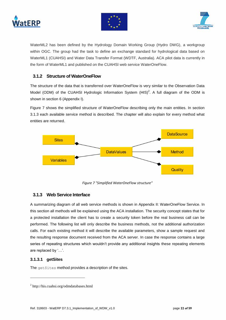
FIGURE 7 "SIMPLIFIED WATERONEFLOW STRUCTURE" ................................................................................................... 22
FIGURE 8 "QUERIED ENTITIES FOR GETSITES/GETSITESXML" ......................................................................................... 23
FIGURE 9 "QUERIED ENTITIES FOR GETSITEINFO/GETSITEINFOOBJECT" ........................................................................... 27
FIGURE 10 "QUERIED ENTITIES FOR GETVALUES/GETVALUESOBJECT" ............................................................................. 33
FIGURE 11 "QUERIED ENTITIES FOR GETVARIABLEINFO/GETVARIABLEINFOOBJECT" .......................................................... 40
FIGURE 12 "SUMMARY OF THE OGC OBSERVATIONS AND MEASUREMENTS (O&M) STANDARD" ......................................... 44
FIGURE 13 "PROCESS FLOW DURING SENSOR POLLING" .................................................................................................. 48
FIGURE 14 "POSSIBLE INSTALLATION SCENARIO FOR ACA" ............................................................................................. 49
FIGURE 15 “DATABASE TABLE FROM PILOT SITE SWKA” ................................................................................................. 50
FIGURE 16 "SWKA LOGICAL MODEL" ............................................................................................................................ 51
FIGURE 17 "FLOW CHART OF CLIENT APPLICATION" ........................................................................................................ 52
FIGURE 18 “CONFIGURATION SETTINGS FOR PIM”......................................................................................................... 53
FIGURE 19 "POSSIBLE INSTALLATION SCENARIO FOR SWKA" .......................................................................................... 56
FIGURE 20 "OBSERVATION DATA MODEL CUAHSI HIS" ................................................................................................ 58
FIGURE 21 "WATERONEFLOW SERVICE DIAGRAM" ......................................................................................................... 59

Ref. 318603 - WatERP D7.3.1_Implementation_of_WDW_v1.0 page 8 of 59
Table of tables
TABLE 1 "PARAMETERS FOR REGISTRATION OF A SENSOR IN THE WDW" .......................................................................... 18
TABLE 2 "GETSITES REQUEST PARAMETERS" ................................................................................................................. 23
TABLE 3 "GETSITESXML REQUEST PARAMETERS" .......................................................................................................... 26
TABLE 4 "GETSITEINFO REQUEST PARAMETERS" ............................................................................................................ 28
TABLE 5 "GETSITEINFOOBJECT REQUEST PARAMETERS" ................................................................................................. 29
TABLE 6 "GETVALUES REQUEST PARAMETERS" .............................................................................................................. 33
TABLE 7 "GETVALUESOBJECT REQUEST PARAMETERS" ................................................................................................... 36
TABLE 8 "GETVARIABLEINFO REQUEST PARAMETERS" ..................................................................................................... 40
TABLE 9 "GETVARIABLEINFOOBJECT REQUEST PARAMETERS" ......................................................................................... 42
TABLE 10 "MAIN ENTITIES IN CUAHSI AND OGC" ......................................................................................................... 45
TABLE 11 "COLUMNS OF SENSOR TABLE IN ACA PILOT INTEGRATION MANAGER" ............................................................... 46

Ref. 318603 - WatERP D7.3.1_Implementation_of_WDW_v1.0 page 9 of 59
Table of listings
LISTING 1 "REGISTER SENSOR IN SOS SERVER" ........................................................................................................... 15
LISTING 2 "INSERT AN OBSERVATION INTO THE SOS SERVER" .......................................................................................... 16
LISTING 3 "REGISTER PILOT SENSOR IN WDW" .............................................................................................................. 18
LISTING 4 “GETSITES REQUEST EXAMPLE” ..................................................................................................................... 23
LISTING 5 "GETSITES RESPONSE EXAMPLE" ................................................................................................................... 25
LISTING 6 "GETSITESXML REQUEST EXAMPLE" .............................................................................................................. 26
LISTING 7 "GETSITESXML RESPONSE EXAMPLE" ............................................................................................................ 27
LISTING 8 "GETSITEINFO REQUEST EXAMPLE" ................................................................................................................ 28
LISTING 9 "GETSITEINFO RESPONSE EXAMPLE" .............................................................................................................. 29
LISTING 10 "GETSITEINFOOBJECT REQUEST EXAMPLE" ................................................................................................... 30
LISTING 11 "GETSITEINFOOBJECT RESPONSE EXAMPLE" ................................................................................................. 32
LISTING 12 "GETVALUES REQUEST EXAMPLE" ................................................................................................................ 33
LISTING 13 "GETVALUES RESPONSE EXAMPLE" .............................................................................................................. 35
LISTING 14 "GETVALUESOBJECT REQUEST EXAMPLE" ..................................................................................................... 36
LISTING 15 "GETVALUESOBJECT RESPONSE EXAMPLE" ................................................................................................... 40
LISTING 16 "GETVARIABLEINFO REQUEST EXAMPLE" ....................................................................................................... 41
LISTING 17 "GETVARIABLEINFO RESPONSE EXAMPLE" ..................................................................................................... 41
LISTING 18 "GETVARIABLEINFOOBJECT REQUEST EXAMPLE" ........................................................................................... 42
LISTING 19 “GETVARIABLEINFOOBJECT RESPONSE EXAMPLE” ......................................................................................... 43
LISTING 20 "OUTPUT IN WATERML2 FORMAT" ............................................................................................................... 53
LISTING 21 "REQUEST TO REGISTER A SENSOR" ............................................................................................................. 54
LISTING 22 “RESPONSE FROM SOS FOR SENSOR REGISTRATION” .................................................................................... 54
LISTING 23 "REQUEST TO SOS FOR INSERTOBSERVATION" ............................................................................................ 55
LISTING 24 “RESPONSE FROM SOS” ............................................................................................................................. 56
Ref. 318603 - WatERP D7.3.1_Implementation_of_WDW_v1.0 page 10 of 59
1. Introduction
This document describes the activities to implement the Water Data Warehouse (WDW) on the pilots’
site. It shows what actions have been taken and which tools had to be implemented in order to integrate
the existing data structures. Some text passages can also be found in other documents but are added
to this document for the sake of self-containment. The technical descriptions of tools that were
implemented for integration of the existing data infrastructure are described in more depth in D3.3-
“WDW 2nd
Prototype” which is scheduled for delivery on month 18.
This document will first give a brief overview over the WatERP systems and will explain how pilots are
to be integrated from the architectural point of view. It will describe what general actions are required on
the pilot site and what fundamental issues have to be taken into consideration.
Next, the document gives a detailed description of each pilot’s data infrastructure and what strategy has
been implemented to tie the client to the WDW platform. The decisions are elucidated that have been
drawn so far.
Finally, the document will summarize the state that has been reached so far and explain the future
steps that still have to be taken.
1.1 WatERP overview
As also described in D3.2-“WDW 1st Prototype” the WDW is the central component of the WatERP
software and data infrastructure. Its main function is to work as a reliable and durable data basis for all
other components, providing both data needed for analyses or other functions as well as automated
routines to incorporate new data sources and datasets at any given time. The content is available for
the analysis clients via the Multi Agent System (MAS). The WDW provides both ontology information
and the observation results.
Figure 1 gives an overview over the different layers of the WatERP architecture and, especially, shows
how the layers interact. A more detailed description of the WatERP architecture can be found in D2.3-
“Open Interface Specification” chapter 3-“WatERP architecture”.

Ref. 318603 - WatERP D7.3.1_Implementation_of_WDW_v1.0 page 11 of 59
Figure 1 "WatERP architecture from the integration point of view"
The integration of the pilot data is realized via an SOS server that contains both ontology metadata and
observation results.
1.2 Standards for information interchange
As was decided in the D2.1-“External systems” chapter 5, all exchange of observation data is based on
WaterML2 time series. This standard provides an XML based combination of ontology and observation
results. For the pilot integration this means that the sensor data has to be transformed into WaterML2
and stored into an SOS server that is accessed from the WDW to import the time series.
This way the WDW has only to deal with a single data format when it accesses the pilot infrastructure.
Every transformation and mapping has to be accomplished by the Pilot Integration Manager (PIM)
which is implemented depending on the pilots’ needs.
1.3 Scope of the first integration phase
For PIM and WDW this first phase is a proof-of-concept as it is the first vertical integration. There are
several tasks that have to be accomplished. One is to identify and access the data containing the
WDW
SOS server
SOS client
On
tolo
gy
MAS
DSS
OGC WPS server
DMS
OGC WPS server
Hydrological forecast
OGC WPS server
SWKA Pilot
OGC SOS Server
ACA Pilot
OGC SOS Server
WatERP Framework
Pilot Data integration
Building Block Integration
OMP
WaterML2
WaterML2, OWL, drl WaterML2, OWL WaterML2

Ref. 318603 - WatERP D7.3.1_Implementation_of_WDW_v1.0 page 12 of 59
observation results. Next is to map the pilot data to the set of ontology metadata that is required by the
SOS/WaterML standard. These sets of metadata consist of feature of interest, sensor id,
observed property and offering (which directly relates to observed property). Other
information which has to be provided is the location of the feature of interest because it is required
by the SOS protocol and because it is mandatory to enable geospatial reasoning.
This deliverable covers an analysis of the data structures of each pilot. It describes the technical and
conceptional considerations about the way the integration can be achieved. Next, it describes the tools
that had to be implemented to access and convert the data in order to make it available within the SOS
server. Last, it shows by processing a subset of the pilots’ data that the different parts of PIM and WDW
correctly interact with each other and that the pilot data is in the end available for the MAS, and thereby
for the analysis clients.
2. Initial Concepts
One of the most important conception decisions that have been drawn in D3.1-“WDW Conceptual
Design” was that there is a strict separation between the pilot site and the WDW. It was decided that the
pilot data should be transformed into WaterML2 and stored in an SOS server. The architectural benefit
is that, thereby, there is no direct dependency from the WDW to the pilot site. As a consequence, the
WDW and all the other work packages would then be independent of the pilots’ actual data
infrastructure, but would only depend on the content provided by the SOS server. Figure 2 describes
how the pilot integration module serves as an adapter that transforms the existing sensor data into
WaterML2 which is then published via an SOS server.
Figure 2 "Integration of existing pilot infrastructure"
In case of an organization which would directly feed the SOS server from their sensor-network
infrastructure – as described in OGC Sensor Web Enablement (SWE)1 – there would not be a need for
1 Sensor Web Enablement: http://www.opengeospatial.org/ogc/markets-technologies/swe
Ref. 318603 - WatERP D7.3.1_Implementation_of_WDW_v1.0 page 13 of 59
any kind of integration tool as the WDW could directly access the SOS server that collects the
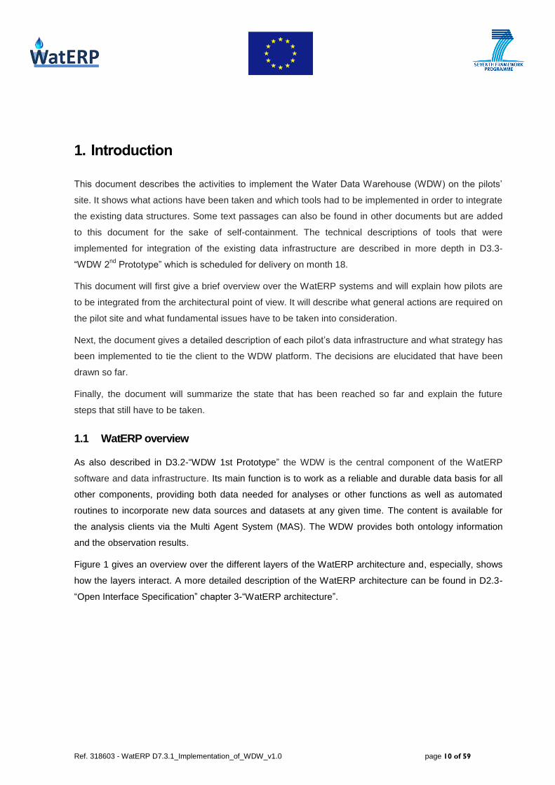
observation results. Figure 3 shows there is no need for any additional module because the sensor
network directly populates the SOS server that also serves as an interface to the WDW.
Figure 3 "Integration of an existing SOS infrastructure"
This way the WDW design would fit perfectly into an infrastructure that follows the SOS standard
published by OGC. Since neither the ACA nor the SWKA pilot meet these requirements, a separate
integration module had to be implemented. The following chapter describes the different steps that have
to be performed in order to integrate an existing observation-data infrastructure into an SOS-based
environment.
2.1 Pilot site tasks
Integration of an existing observation-data infrastructure has to be done in three different steps, namely
(1) the data access, (2) the data mapping, and (3) the data import.
2.1.1 Data Access
First, it has to be determined where and in which format the data is being kept. A procedure to access
these data has to be decided for the identified data sources. At this point, we had to take into considera-
tion three goals. Access time is one critical matter as we need to provide the observation results as
close to real-time as possible. For each pilot it will be discussed how close we can come to this goal.
Another goal is that in case there is a way to access client data over a standard interface, the
integration module should use it in order to improve the reusability of the implementation for future
pilots. Last, the integration should not compromise the stability of the existing infrastructure.This point
will also be discussed for each pilot.

Ref. 318603 - WatERP D7.3.1_Implementation_of_WDW_v1.0 page 14 of 59
2.1.2 Data Mapping
The next step after considering how to access the data is mapping the data to the ontology which is
required by the SOS and WaterML2 protocol.
Figure 4 "Mapping existing observation data"
As Figure 4 shows, the time series extracted from the pilot site have to be related to the elements that
the SOS standard requires:
Feature of interest which is the object which is being observed. Besides other attributes
it also contains the location which is essential for the geospatial operations.
Sensor which serves as an identifier
Observed property and Offering are both related to the sensor and describe what
property the sensor observes and what data the sensor offers. This also includes the
measured unit that the time series provides.
This task strongly depends on the existing information available on the pilot site. Again, in an OGC
SWE infrastructure this task is not needed since it is already done. After the mapping has been
decided, the sensor can be registered in the SOS server. Listing 1 shows the XML document with which
a new sensor is being registered.
<?xml version="1.0" encoding="UTF-8"?> <RegisterSensor service="SOS" version="1.0.0"
xmlns="http://www.opengis.net/sos/1.0" xmlns:swe="http://www.opengis.net/swe/1.0.1"
xmlns:ows="http://www.opengeospatial.net/ows" xmlns:xlink="http://www.w3.org/1999/xlink" xmlns:gml="http://www.opengis.net/gml" xmlns:ogc="http://www.opengis.net/ogc"
xmlns:om="http://www.opengis.net/om/1.0" xmlns:sml="http://www.opengis.net/sensorML/1.0.1"
xmlns:xsi="http://www.w3.org/2001/XMLSchema-instance" xsi:schemaLocation="http://www.opengis.net/sos/1.0
http://schemas.opengis.net/sos/1.0.0/sosRegisterSensor.xsd
http://www.opengis.net/om/1.0 http://schemas.opengis.net/om/1.0.0/extensions/observationSpecialization_override.xsd"> <SensorDescription>
<sml:SensorML version="1.0.1">
<sml:member> <sml:System xmlns:xsi="http://www.w3.org/2001/XMLSchema-instance">
<sml:identification>
<sml:IdentifierList> <sml:identifier>
<sml:Term definition="urn:ogc:def:identifier:OGC:uniqueID">

Ref. 318603 - WatERP D7.3.1_Implementation_of_WDW_v1.0 page 15 of 59
<sml:value>urn:ogc:object:feature:Sensor:DEMO:sensor-1
</sml:value> </sml:Term>
</sml:identifier>
</sml:IdentifierList> </sml:identification>
<sml:capabilities>
<swe:SimpleDataRecord> <swe:field name="FeatureOfInterestID">
<swe:Text definition="FeatureOfInterest identifier">
<swe:value>SAMPLE-FOI</swe:value> </swe:Text>
</swe:field>
</swe:SimpleDataRecord>
</sml:capabilities>
<sml:inputs>
<sml:InputList> <sml:input name="waterpressure">
<swe:ObservableProperty definition="urn:ogc:def:phenomenon:waterpressure" />
</sml:input> </sml:InputList>
</sml:inputs>
<sml:outputs> <sml:OutputList>
<sml:output name=" waterpressure ">
<swe:Quantity definition="urn:ogc:def:phenomenon:waterpressure"> <gml:metaDataProperty>
<offering>
<id>WATERPRESSURE</id> <name>WATERPRESSURE</name>
</offering>
</gml:metaDataProperty>
<swe:uom code="bar" />
</swe:Quantity>
</sml:output> </sml:OutputList>
</sml:outputs>
<sml:components> <sml:ComponentList>
</sml:ComponentList>
</sml:components> </sml:System>
</sml:member>
</sml:SensorML> </SensorDescription>
<ObservationTemplate>
<om:Measurement> <om:samplingTime />
<om:procedure />
<om:observedProperty /> <om:featureOfInterest>
<sa:SamplingPoint gml:id="X:SAMPLE-FOI"> <gml:name>Demo-FOI</gml:name>
<sa:sampledFeature xlink:href="urn:ogc:def:nil:OGC:unknown" />
<sa:position> <gml:Point>
<gml:pos srsName="EPSG:4258">40.66040061445847 -5.420709255985781</gml:pos>
</gml:Point> </sa:position>
</sa:SamplingPoint>
</om:featureOfInterest> <om:result uom="bar">1</om:result>
</om:Measurement>
</ObservationTemplate> </RegisterSensor>
Listing 1 "Register Sensor in SOS Server"
Ref. 318603 - WatERP D7.3.1_Implementation_of_WDW_v1.0 page 16 of 59
2.1.3 Import data
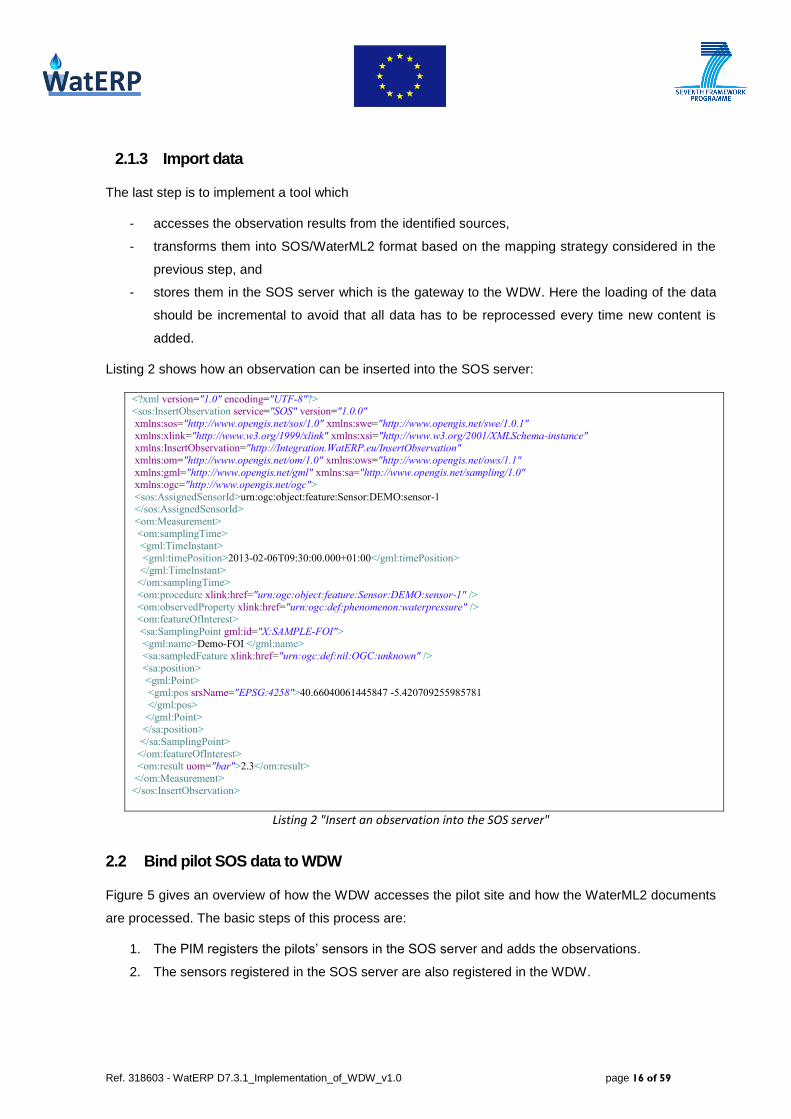
The last step is to implement a tool which
- accesses the observation results from the identified sources,
- transforms them into SOS/WaterML2 format based on the mapping strategy considered in the
previous step, and
- stores them in the SOS server which is the gateway to the WDW. Here the loading of the data
should be incremental to avoid that all data has to be reprocessed every time new content is
added.
Listing 2 shows how an observation can be inserted into the SOS server:
<?xml version="1.0" encoding="UTF-8"?> <sos:InsertObservation service="SOS" version="1.0.0"
xmlns:sos="http://www.opengis.net/sos/1.0" xmlns:swe="http://www.opengis.net/swe/1.0.1"
xmlns:xlink="http://www.w3.org/1999/xlink" xmlns:xsi="http://www.w3.org/2001/XMLSchema-instance" xmlns:InsertObservation="http://Integration.WatERP.eu/InsertObservation"
xmlns:om="http://www.opengis.net/om/1.0" xmlns:ows="http://www.opengis.net/ows/1.1"
xmlns:gml="http://www.opengis.net/gml" xmlns:sa="http://www.opengis.net/sampling/1.0" xmlns:ogc="http://www.opengis.net/ogc">
<sos:AssignedSensorId>urn:ogc:object:feature:Sensor:DEMO:sensor-1 </sos:AssignedSensorId>
<om:Measurement>
<om:samplingTime>
<gml:TimeInstant>
<gml:timePosition>2013-02-06T09:30:00.000+01:00</gml:timePosition>
</gml:TimeInstant> </om:samplingTime>
<om:procedure xlink:href="urn:ogc:object:feature:Sensor:DEMO:sensor-1" />
<om:observedProperty xlink:href="urn:ogc:def:phenomenon:waterpressure" /> <om:featureOfInterest>
<sa:SamplingPoint gml:id="X:SAMPLE-FOI">
<gml:name>Demo-FOI </gml:name> <sa:sampledFeature xlink:href="urn:ogc:def:nil:OGC:unknown" />
<sa:position>
<gml:Point> <gml:pos srsName="EPSG:4258">40.66040061445847 -5.420709255985781
</gml:pos>
</gml:Point> </sa:position>
</sa:SamplingPoint>
</om:featureOfInterest>
<om:result uom="bar">2.3</om:result>
</om:Measurement>
</sos:InsertObservation>
Listing 2 "Insert an observation into the SOS server"
2.2 Bind pilot SOS data to WDW
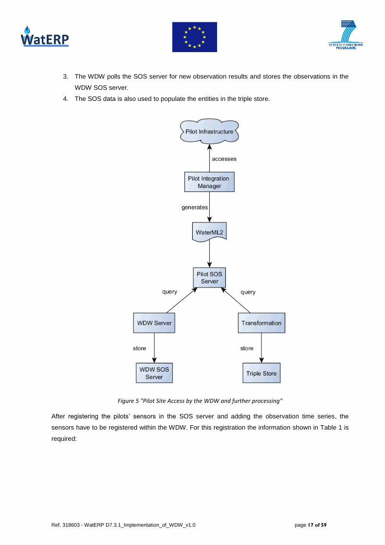
Figure 5 gives an overview of how the WDW accesses the pilot site and how the WaterML2 documents
are processed. The basic steps of this process are:
1. The PIM registers the pilots’ sensors in the SOS server and adds the observations.
2. The sensors registered in the SOS server are also registered in the WDW.
Ref. 318603 - WatERP D7.3.1_Implementation_of_WDW_v1.0 page 17 of 59
3. The WDW polls the SOS server for new observation results and stores the observations in the
WDW SOS server.
4. The SOS data is also used to populate the entities in the triple store.
Figure 5 "Pilot Site Access by the WDW and further processing"
After registering the pilots’ sensors in the SOS server and adding the observation time series, the
sensors have to be registered within the WDW. For this registration the information shown in Table 1 is
required:

Ref. 318603 - WatERP D7.3.1_Implementation_of_WDW_v1.0 page 18 of 59
Information Description
Server URL The URL of the SOS server where the sensor is registered on the pilot site.
Example: http://localhost:4711/52nSOSv3.5.0_EE/sos
Observed
property Observed property as used in the mapping
Offering Offering as used in the mapping
Sensor id Sensor id as used in the mapping
Feature of
interest Feature of interest as used in the mapping
Poll interval The interval in minutes, in which the SOS server is polled for new data
Table 1 "Parameters for registration of a sensor in the WDW"
To perform the actual registration the WDW provides a management REST service that accepts XML.
The service allows adding sensors and sensor processing to the WDW.
Listing 3 is an example for an addSensor call to the WDW server:
<?xml version="1.0" encoding="UTF-8"?> <addSensorRequest xmlns="http://waterp/wdw/ManagementService">
<observedProperty>urn:ogc:def:phenomenon:waterpressure</observedProperty>
<offering>WATERPRESSURE</offering> <sensorId>urn:ogc:object:feature:Sensor:DEMO:sensor-1</sensorId>
<pollIntervalMinutes>60</pollIntervalMinutes>
<featureOfInterest>Demo-FOI</featureOfInterest> <serverUrl>http://pilot.waterp.eu/sosserver/sos</serverUrl>
</addSensorRequest>
Listing 3 "Register pilot sensor in WDW"
After the registration of the sensor the WDW will poll the pilot SOS server for new observation results
for the sensor. Additionally, the WDW will add the sensor to the WDW SOS infrastructure in order to
offer the observation time series in the WDW interface layer. See D3.2-“WDW 1st Prototype” and D3.3-
“WDW 2nd
Prototype” for a more detailed description of the management service and the WDW internal
processing.
As described in D1.4.1-“Extension of taxonomy and ontology to the pilots” chapter 2.2-“Initial Large-
scale population strategy”, the information contained in the WaterML2 XML documents will later be
incorporated into the WaterERP ontology which will then be stored into the WDW triple store.

Ref. 318603 - WatERP D7.3.1_Implementation_of_WDW_v1.0 page 19 of 59
2.3 General module design considerations
The general module design is described in D3.3-“WDW 2nd
Prototype” (due in month 18, March 2014) in
more detail but as this document should be self-contained and D3.3 will be available after D7.3.1 the
basic design of the pilot integration modules will be briefly explained here.
Chapter 2.1 listed the different tasks that have been implemented during the pilot integration. The steps
differ regarding if they are context specific:
Data Access:
When the investigation of the pilots started it became clear that the infrastructure to be integrated into
the WDW, is highly differing. At SWKA, the PIM must deal with a rather simple database table whereas
at ACA, things were rather unclear in the beginning – but turned out later to be a WaterOneFlow service
call. For the design of the PIM it became apparent that it would have to allow a highly pilot specific
implementation of the data access. For other pilots the integration might require:
Reading the data from a single or multiple data bases as in SWKA.
File parsing.
Calling services as with ACA. Here format and protocol can highly differ.
Screen scraping or embedding legacy code into the integration module.
A mix of the access mechanisms above.
Consequently, the general integration module design must enable the data-access layer to be highly
flexible. There is a possibility that the implementation for one pilot can be used for other pilots as well in
case the pilots use the same infrastructure to make their observation results available.
Data Mapping:
As with the data access there are many possible ways how the pilots’ data can be converted into
WaterML2 documents:
The data that is required to populate the WaterML document might already be available via
database or a service call but has to be transformed.
If not all required data is available in the pilot infrastructure it has to be provided by the
integration module.
As described in chapter 3.2 for ACA the main information for the data mapping is provided by the
existing data infrastructure. In contrast for SWKA the PIM must provide most of the mapping
information. The implementation depends on the information the data access supplies. In consequence,
for the general PIM design the same level of flexibility is required for the data mapping as is for the data
access.

Ref. 318603 - WatERP D7.3.1_Implementation_of_WDW_v1.0 page 20 of 59
Import Data
Here the mapping information and the time series have to be transformed into WaterML2 and sent to
the SOS server as the external interface to the WDW for registration and storing of the observations.
For both, ACA and SWKA, the result of data access and mapping consists of the same set of
information. Therefore in both scenarios the generation of WaterML2 is identical as it is based on the
same mapped data. Also the the interactions with the SOS server are identical.
In consequence for the WatERP project context the data import is considered to not require any pilot
specific implementation. To enable the interaction of data import with data access and data mapping,
which are highly pilot dependent, classes are implemented that contain the set of information about
mapping time series that is required for the WaterML generation. The combination of data access and
data mapping has to provide this transfer objects and pass them to the data import layer.
If for a future integration activities with other pilots the set of informations to be added to WaterML2
changes or becomes client specific, this decision will have to be reconsidered.
Figure 6 "General module design"
Figure 6 shows the general module design. Data access and data mapping are abstract but have to
populate the time series and mapping information using a predefined structure. The data export which

Ref. 318603 - WatERP D7.3.1_Implementation_of_WDW_v1.0 page 21 of 59
consumes the data is independent on the actual pilot context as the pilot specifics have no influence on
the export processing.
3. ACA site integration
D1.4.1-“Extension of taxonomy and ontology to the pilots” chapter 2.1.1 explains the ACA ontology, the
logical model and required queries to the triple store. D4.1-“Inference and Simulation Engine
Conceptual Design” describes in chapter 3.1 the scenario for ACA. It deduces the logical model
(chapter 3.1.1) that describes the situation and the entities and variables that must be available as the
model input (chapter 3.1.2). Because the sensor model created inside the pilot SOS server will serve as
the base on which the ontology will be generated, the integration of ACA sensor-data infrastructure
must provide the data on which all other models can be established.
This chapter describes the considerations and activities to integrate the ACA sensor data into the
WDW. It first depicts the current infrastructure that the PIM has to integrate. Next, it analyzes how ACA
data can be mapped to WaterML2 and explains the current level of implementation. Finally, it lists the
next steps in order to integrate ACA into the WDW.
3.1 WaterOneFlow
For some time it was rather unclear how the observation data from ACA could be integrated into the
WDW. In autumn 2013, ACA installed a WaterOneFlow server as a central instance to obtain sensor-
observation results. Currently, the server provides a considerable number of sensor-observation results.
In January 2014, the server provided alone 12,883 sites. As stated in chapter 2.1.1 there are three
issues to be taken into consideration when deciding about how to access the pilots’ data: Performance,
reusability and stability. As WaterOneFlow was designed and installed by ACA as a central point to
access observation results and is long and often used in the hydrological community it meets the
requirements of reusability and stability. The prototype will show if the performance will suffice the
demand. In case critical performance problems appear alternative approaches will have to be
considered together with ACA.
This chapter will describe the history and the data structure of WaterOneFlow as well as the web
service interface by which the data from the ACA can be accessed.
3.1.1 History of WaterOneFlow
WaterOneFlow was developed by the Consortium of the Advanced of Hydrological Sciences Inc.
(CUAHSI) for use in U.S. as a standard mechanism for the transfer of hydrologic data. WaterOneFlow
web service uses WaterML1 for encoding hydrological observations. WaterML2 is significantly different
from WaterML1 as WaterML2 is based on OGC standards Sensor Observation Service (SOS),
Observations and Measurements (O&M) and Sensor Markup Language (SensorML). Moreover,
Ref. 318603 - WatERP D7.3.1_Implementation_of_WDW_v1.0 page 22 of 59
WaterML2 has been defined by the Hydrology Domain Working Group (Hydro DWG), a workgroup
within OGC. The group had the task to define an exchange standard for hydrological data based on
WaterML1 (CUAHSI) and Water Data Transfer Format (WDTF, Australia). ACA pilot data is currently in
the form of WaterML1 and published on the CUAHSI web service WaterOneFlow.
3.1.2 Structure of WaterOneFlow
The structure of the data that is transferred over WaterOneFlow is very similar to the Observation Data
Model (ODM) of the CUAHSI Hydrologic Information System (HIS)2. A full diagram of the ODM is
shown in section 6 (Appendix I).
Figure 7 shows the simplified structure of WaterOneFlow describing only the main entities. In section
3.1.3 each available service method is described. The chapter will also explain for every method what
entities are returned.
Figure 7 "Simplified WaterOneFlow structure"
3.1.3 Web Service Interface
A summarizing diagram of all web service methods is shown in Appendix II: WaterOneFlow Service. In
this section all methods will be explained using the ACA installation. The security concept states that for
a protected installation the client has to create a security token before the real business call can be
performed. The following list will only describe the business methods, not the additional authorization
calls. For each existing method it will describe the available parameters, show a sample request and
the resulting response document received from the ACA server. In case the response contains a large
series of repeating structures which wouldn’t provide any additional insights these repeating elements
are replaced by ‘…’.
3.1.3.1 getSites
The getSites method provides a description of the sites.
2 http://his.cuahsi.org/odmdatabases.html

Ref. 318603 - WatERP D7.3.1_Implementation_of_WDW_v1.0 page 23 of 59
Figure 8 "Queried entities for getSites/getSitesXML"
Table 2 contains the list of parameters that can be passed to the getSites call.
Parameter Description
site List of site identifiers in the format ‘NetworkName:SiteCode'.
authToken Previously created secutity token.
Table 2 "getSites request parameters"
Both parameters are optional. If no site is specified, all existing sites will be returned. Listing 4 contains
a getSites request example. Two sites are passed.
<soapenv:Envelope xmlns:soapenv="http://schemas.xmlsoap.org/soap/envelope/" xmlns:q0="http://ws.waterOneFlow.aca.gencat.cat" xmlns:xsd="http://www.w3.org/2001/XMLSchema" xmlns:xsi="http://www.w3.org/2001/XMLSchema-instance"> <soapenv:Body> <q0:GetSites> <q0:site>S:430141-002</q0:site> <q0:site>D:AUTOD1</q0:site> <q0:authToken /> </q0:GetSites> </soapenv:Body> </soapenv:Envelope>
Listing 4 “getSites request example”
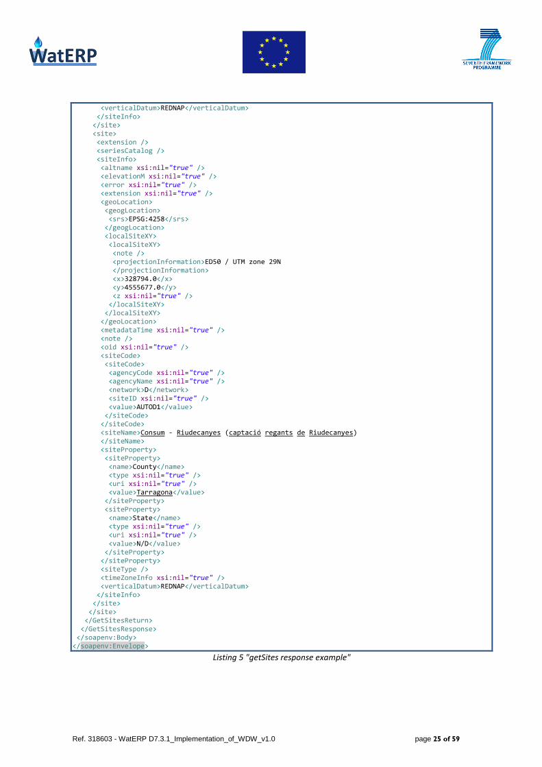
Listing 5 shows the result of the sample request. In summary getSites provides only the information
directly connected to the site such as name and location (as shown in Figure 8). For more detailed
information getSiteInfo has to be called.
<soapenv:Envelope xmlns:soapenv="http://schemas.xmlsoap.org/soap/envelope/" xmlns:xsd="http://www.w3.org/2001/XMLSchema" xmlns:xsi="http://www.w3.org/2001/XMLSchema-instance"> <soapenv:Body> <GetSitesResponse xmlns="http://ws.waterOneFlow.aca.gencat.cat"> <GetSitesReturn> <error xsi:nil="true" /> <queryInfo> <creationTime>2014-02-22T10:52:20.831Z</creationTime> <criteria> <locationParam xsi:nil="true" /> <methodCalled>GetSites</methodCalled> <parameter> <parameter>

Ref. 318603 - WatERP D7.3.1_Implementation_of_WDW_v1.0 page 24 of 59
<name>site</name> <value>S:430141-002</value> </parameter> <parameter> <name>site</name> <value>D:AUTOD1</value> </parameter> </parameter> <timeParam xsi:nil="true" /> <variableParam xsi:nil="true" /> </criteria> <extension xsi:nil="true" /> <note /> <queryURL xsi:nil="true" /> </queryInfo> <site> <site> <extension /> <seriesCatalog /> <siteInfo> <altname xsi:nil="true" /> <elevationM xsi:nil="true" /> <error xsi:nil="true" /> <extension xsi:nil="true" /> <geoLocation> <geogLocation> <srs>EPSG:4258</srs> </geogLocation> <localSiteXY> <localSiteXY> <note /> <projectionInformation>ED50 / UTM zone 29N </projectionInformation> <x>295364.0</x> <y>4503877.0</y> <z xsi:nil="true" /> </localSiteXY> </localSiteXY> </geoLocation> <metadataTime xsi:nil="true" /> <note /> <oid xsi:nil="true" /> <siteCode> <siteCode> <agencyCode xsi:nil="true" /> <agencyName xsi:nil="true" /> <network>S</network> <siteID xsi:nil="true" /> <value>430141-002</value> </siteCode> </siteCode> <siteName>QLSup(A) - E.Q.1 Amposta M.D. Riu (CHE) (RIADE) </siteName> <siteProperty> <siteProperty> <name>County</name> <type xsi:nil="true" /> <uri xsi:nil="true" /> <value>Tarragona</value> </siteProperty> <siteProperty> <name>State</name> <type xsi:nil="true" /> <uri xsi:nil="true" /> <value>N/D</value> </siteProperty> </siteProperty> <siteType /> <timeZoneInfo xsi:nil="true" />
Ref. 318603 - WatERP D7.3.1_Implementation_of_WDW_v1.0 page 25 of 59
<verticalDatum>REDNAP</verticalDatum> </siteInfo> </site> <site> <extension /> <seriesCatalog /> <siteInfo> <altname xsi:nil="true" /> <elevationM xsi:nil="true" /> <error xsi:nil="true" /> <extension xsi:nil="true" /> <geoLocation> <geogLocation> <srs>EPSG:4258</srs> </geogLocation> <localSiteXY> <localSiteXY> <note /> <projectionInformation>ED50 / UTM zone 29N </projectionInformation> <x>328794.0</x> <y>4555677.0</y> <z xsi:nil="true" /> </localSiteXY> </localSiteXY> </geoLocation> <metadataTime xsi:nil="true" /> <note /> <oid xsi:nil="true" /> <siteCode> <siteCode> <agencyCode xsi:nil="true" /> <agencyName xsi:nil="true" /> <network>D</network> <siteID xsi:nil="true" /> <value>AUTOD1</value> </siteCode> </siteCode> <siteName>Consum - Riudecanyes (captació regants de Riudecanyes) </siteName> <siteProperty> <siteProperty> <name>County</name> <type xsi:nil="true" /> <uri xsi:nil="true" /> <value>Tarragona</value> </siteProperty> <siteProperty> <name>State</name> <type xsi:nil="true" /> <uri xsi:nil="true" /> <value>N/D</value> </siteProperty> </siteProperty> <siteType /> <timeZoneInfo xsi:nil="true" /> <verticalDatum>REDNAP</verticalDatum> </siteInfo> </site> </site> </GetSitesReturn> </GetSitesResponse> </soapenv:Body> </soapenv:Envelope>
Listing 5 "getSites response example"
Ref. 318603 - WatERP D7.3.1_Implementation_of_WDW_v1.0 page 26 of 59
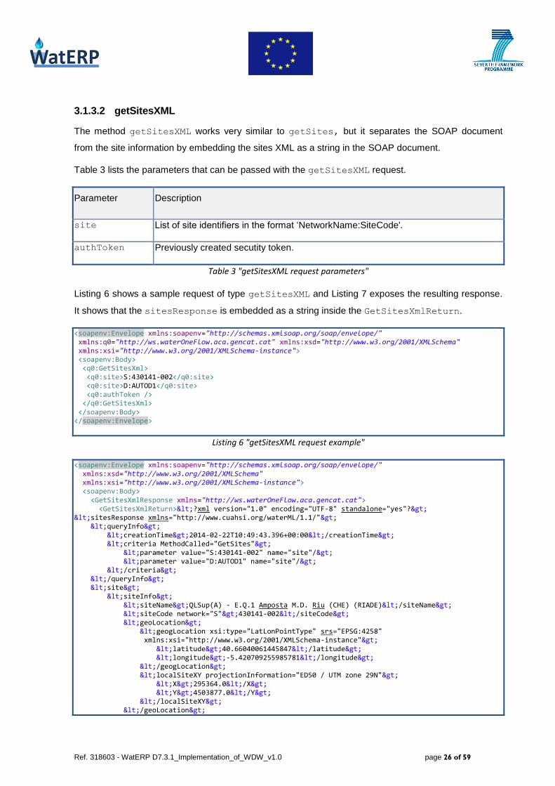
3.1.3.2 getSitesXML
The method getSitesXML works very similar to getSites, but it separates the SOAP document
from the site information by embedding the sites XML as a string in the SOAP document.
Table 3 lists the parameters that can be passed with the getSitesXML request.
Parameter Description
site List of site identifiers in the format ‘NetworkName:SiteCode'.
authToken Previously created secutity token.
Table 3 "getSitesXML request parameters"
Listing 6 shows a sample request of type getSitesXML and Listing 7 exposes the resulting response.
It shows that the sitesResponse is embedded as a string inside the GetSitesXmlReturn.
<soapenv:Envelope xmlns:soapenv="http://schemas.xmlsoap.org/soap/envelope/" xmlns:q0="http://ws.waterOneFlow.aca.gencat.cat" xmlns:xsd="http://www.w3.org/2001/XMLSchema" xmlns:xsi="http://www.w3.org/2001/XMLSchema-instance"> <soapenv:Body> <q0:GetSitesXml> <q0:site>S:430141-002</q0:site> <q0:site>D:AUTOD1</q0:site> <q0:authToken /> </q0:GetSitesXml> </soapenv:Body> </soapenv:Envelope>
Listing 6 "getSitesXML request example"
<soapenv:Envelope xmlns:soapenv="http://schemas.xmlsoap.org/soap/envelope/" xmlns:xsd="http://www.w3.org/2001/XMLSchema" xmlns:xsi="http://www.w3.org/2001/XMLSchema-instance"> <soapenv:Body> <GetSitesXmlResponse xmlns="http://ws.waterOneFlow.aca.gencat.cat"> <GetSitesXmlReturn><?xml version="1.0" encoding="UTF-8" standalone="yes"?> <sitesResponse xmlns="http://www.cuahsi.org/waterML/1.1/"> <queryInfo> <creationTime>2014-02-22T10:49:43.396+00:00</creationTime> <criteria MethodCalled="GetSites"> <parameter value="S:430141-002" name="site"/> <parameter value="D:AUTOD1" name="site"/> </criteria> </queryInfo> <site> <siteInfo> <siteName>QLSup(A) - E.Q.1 Amposta M.D. Riu (CHE) (RIADE)</siteName> <siteCode network="S">430141-002</siteCode> <geoLocation> <geogLocation xsi:type="LatLonPointType" srs="EPSG:4258" xmlns:xsi="http://www.w3.org/2001/XMLSchema-instance"> <latitude>40.66040061445847</latitude> <longitude>-5.420709255985781</longitude> </geogLocation> <localSiteXY projectionInformation="ED50 / UTM zone 29N"> <X>295364.0</X> <Y>4503877.0</Y> </localSiteXY> </geoLocation>

Ref. 318603 - WatERP D7.3.1_Implementation_of_WDW_v1.0 page 27 of 59
<verticalDatum>REDNAP</verticalDatum> <siteProperty name="County">Tarragona</siteProperty> <siteProperty name="State">N/D</siteProperty> </siteInfo> </site> <site> <siteInfo> <siteName>Consum - Riudecanyes (captació regants de Riudecanyes)</siteName> <siteCode network="D">AUTOD1</siteCode> <geoLocation> <geogLocation xsi:type="LatLonPointType" srs="EPSG:4258" xmlns:xsi="http://www.w3.org/2001/XMLSchema-instance"> <latitude>41.13435372948381</latitude> <longitude>-5.0397950513708825</longitude> </geogLocation> <localSiteXY projectionInformation="ED50 / UTM zone 29N"> <X>328794.0</X> <Y>4555677.0</Y> </localSiteXY> </geoLocation> <verticalDatum>REDNAP</verticalDatum> <siteProperty name="County">Tarragona</siteProperty> <siteProperty name="State">N/D</siteProperty> </siteInfo> </site> </sitesResponse> </GetSitesXmlReturn> </GetSitesXmlResponse> </soapenv:Body> </soapenv:Envelope>
Listing 7 "getSitesXML response example"
3.1.3.3 getSiteInfo
Given a site number, this method returns the site's metadata.
Figure 9 "Queried entities for getSiteInfo/getSiteInfoObject"
As Figure 9 describes, all entities are queried. From the data values not the single observations are
returned but the minimum and maximum timestamp for the queried sensor. Table 4 shows the possible
request parameters.
Parameter Description
site Site identifier in the format ‘NetworkName:SiteCode'.
authToken Previously created secutity token.

Ref. 318603 - WatERP D7.3.1_Implementation_of_WDW_v1.0 page 28 of 59
Table 4 "getSiteInfo request parameters"
Listing 8 shows a sample request of type GetSiteInfo passing the site identifier of the queried site.
<soapenv:Envelope xmlns:soapenv="http://schemas.xmlsoap.org/soap/envelope/" xmlns:q0="http://ws.waterOneFlow.aca.gencat.cat" xmlns:xsd="http://www.w3.org/2001/XMLSchema" xmlns:xsi="http://www.w3.org/2001/XMLSchema-instance"> <soapenv:Body> <q0:GetSiteInfo> <q0:site>S:430141-002</q0:site> <q0:authToken /> </q0:GetSiteInfo> </soapenv:Body> </soapenv:Envelope>
Listing 8 "getSiteInfo request example"
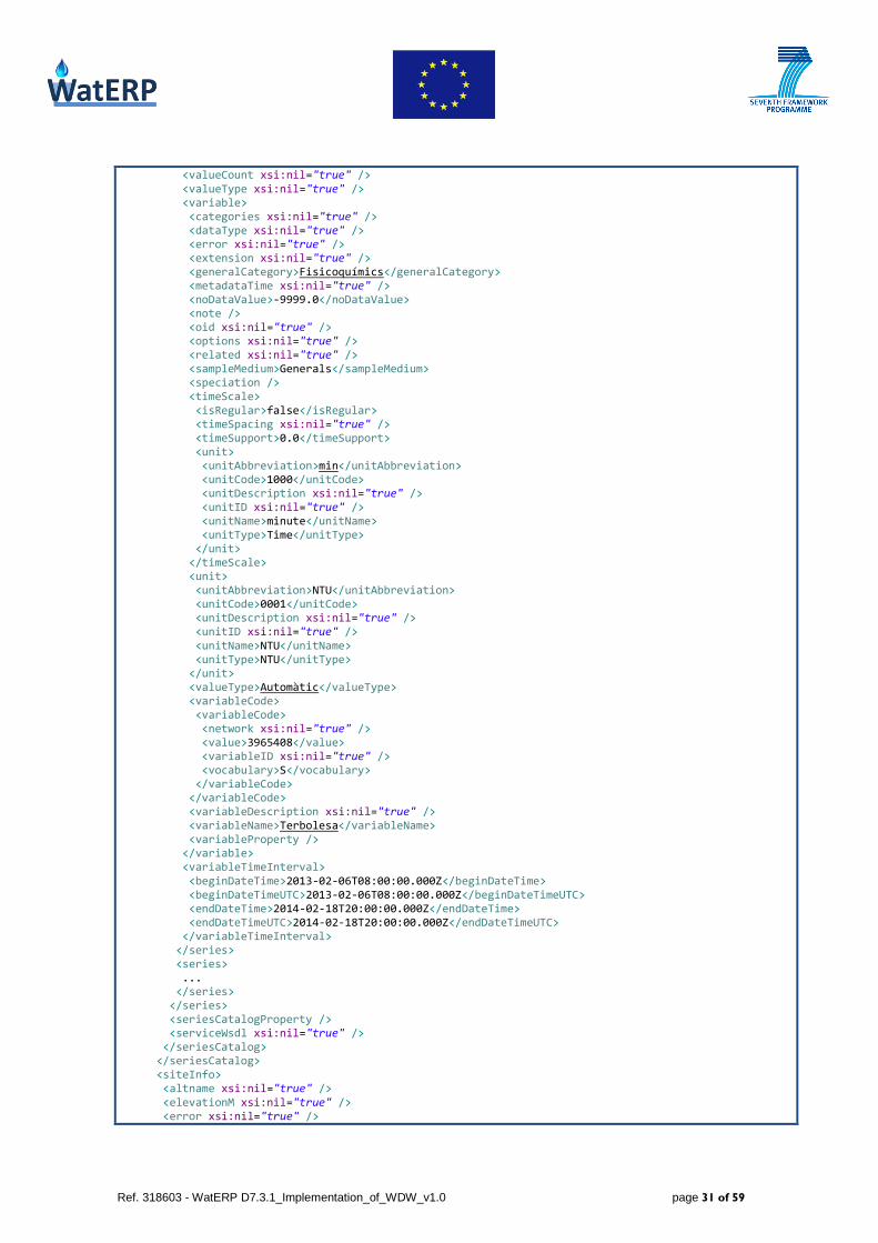
Listing 9 shows the result of the getSiteInfo request. Besides the basic site information which is also
provided by the getSites/getSitesXML requests, the response also contains the series that exist
for the site. For each series it lists the variable, the datasource, the quality and the time interval for
which data is available. Like with getSitesXML the sitesResponse is separated from the SOAP
XML structure by embedding it as a string inside the GetSiteInfoReturn tag.
<soapenv:Envelope xmlns:soapenv="http://schemas.xmlsoap.org/soap/envelope/" xmlns:xsd="http://www.w3.org/2001/XMLSchema" xmlns:xsi="http://www.w3.org/2001/XMLSchema-instance"> <soapenv:Body> <GetSiteInfoResponse xmlns="http://ws.waterOneFlow.aca.gencat.cat"> <GetSiteInfoReturn><?xml version="1.0" encoding="UTF-8" standalone="yes"?> <sitesResponse xmlns="http://www.cuahsi.org/waterML/1.1/"> <queryInfo> <creationTime>2014-02-22T09:27:12.342+00:00</creationTime> <criteria MethodCalled="GetSiteInfo"> <parameter value="S:430141-002" name="site"/> </criteria> </queryInfo> <site> <siteInfo> <siteName>QLSup(A) - E.Q.1 Amposta M.D. Riu (CHE) (RIADE)</siteName> <siteCode network="S">430141-002</siteCode> <geoLocation> <geogLocation xsi:type="LatLonPointType" srs="EPSG:4258" xmlns:xsi="http://www.w3.org/2001/XMLSchema-instance"> <latitude>40.66040061445847</latitude> <longitude>-5.420709255985781</longitude> </geogLocation> <localSiteXY projectionInformation="ED50 / UTM zone 29N"> <X>295364.0</X> <Y>4503877.0</Y> </localSiteXY> </geoLocation> <verticalDatum>REDNAP</verticalDatum> <siteProperty name="County">Tarragona</siteProperty> <siteProperty name="State">N/D</siteProperty> </siteInfo> <seriesCatalog menuGroupName="Variables fenomenològiques de SIX"> <series> <variable> <variableCode default="true" vocabulary="S">3965408</variableCode> <variableName>Terbolesa</variableName> <valueType>Automàtic</valueType> <generalCategory>Fisicoquímics</generalCategory> <sampleMedium>Generals</sampleMedium> <unit>

Ref. 318603 - WatERP D7.3.1_Implementation_of_WDW_v1.0 page 29 of 59
<unitName>NTU</unitName> <unitType>NTU</unitType> <unitAbbreviation>NTU</unitAbbreviation> <unitCode>0001</unitCode> </unit> <noDataValue>-9999.0</noDataValue> <timeScale> <unit> <unitName>minute</unitName> <unitType>Time</unitType> <unitAbbreviation>min</unitAbbreviation> <unitCode>1000</unitCode> </unit> <timeSupport>0.0</timeSupport> </timeScale> <speciation></speciation> </variable> <variableTimeInterval xsi:type="TimeIntervalType" xmlns:xsi="http://www.w3.org/2001/XMLSchema-instance"> <beginDateTime>2013-02-06T08:00:00+00:00</beginDateTime> <endDateTime>2014-02-18T20:00:00+00:00</endDateTime> <beginDateTimeUTC>2013-02-06T08:00:00+00:00</beginDateTimeUTC> <endDateTimeUTC>2014-02-18T20:00:00+00:00</endDateTimeUTC> </variableTimeInterval> <source sourceID="1"> <organization>Agència Catalana de l'Aigua</organization> <sourceDescription>Variables fenomenològiques de SIX</sourceDescription> <citation></citation> </source> <qualityControlLevel qualityControlLevelID="0"> <qualityControlLevelCode>0</qualityControlLevelCode> <definition>Raw data</definition> </qualityControlLevel> </series> <series> ... </series> </seriesCatalog> </site> </sitesResponse> </GetSiteInfoReturn> </GetSiteInfoResponse> </soapenv:Body> </soapenv:Envelope>
Listing 9 "getSiteInfo response example"
3.1.3.4 getSiteInfoObject
The getSiteInfoObject is very much like the getSiteInfo except that the response is directly
integrated in the SOAP body. Table 5 lists the parameters that can be passed in the request. Listing 10
shows an example request and Listing 11 shows the corresponding response. The information provided
is very much like in getSiteInfo and the explanation matches also here.
Parameter Description
site Single site identifier in the format ‘NetworkName:SiteCode'.
authToken Previously created secutity token.
Table 5 "getSiteInfoObject request parameters"

Ref. 318603 - WatERP D7.3.1_Implementation_of_WDW_v1.0 page 30 of 59
<soapenv:Envelope xmlns:soapenv="http://schemas.xmlsoap.org/soap/envelope/" xmlns:q0="http://ws.waterOneFlow.aca.gencat.cat" xmlns:xsd="http://www.w3.org/2001/XMLSchema" xmlns:xsi="http://www.w3.org/2001/XMLSchema-instance"> <soapenv:Body> <q0:GetSiteInfoObject> <q0:site>S:430141-002</q0:site> <q0:authToken /> </q0:GetSiteInfoObject> </soapenv:Body> </soapenv:Envelope>
Listing 10 "getSiteInfoObject request example"
<soapenv:Envelope xmlns:soapenv="http://schemas.xmlsoap.org/soap/envelope/" xmlns:xsd="http://www.w3.org/2001/XMLSchema" xmlns:xsi="http://www.w3.org/2001/XMLSchema-instance"> <soapenv:Body> <GetSiteInfoObjectResponse xmlns="http://ws.waterOneFlow.aca.gencat.cat"> <GetSiteInfoObjectReturn> <error xsi:nil="true" /> <queryInfo> <creationTime>2014-02-22T10:56:39.985Z</creationTime> <criteria> <locationParam xsi:nil="true" /> <methodCalled>GetSiteInfo</methodCalled> <parameter> <parameter> <name>site</name> <value>S:430141-002</value> </parameter> </parameter> <timeParam xsi:nil="true" /> <variableParam xsi:nil="true" /> </criteria> <extension xsi:nil="true" /> <note /> <queryURL xsi:nil="true" /> </queryInfo> <site> <site> <extension /> <seriesCatalog> <seriesCatalog> <extension xsi:nil="true" /> <menuGroupName>Variables fenomenològiques de SIX</menuGroupName> <note /> <series> <series> <dataType xsi:nil="true" /> <generalCategory xsi:nil="true" /> <method xsi:nil="true" /> <qualityControlLevel> <definition>Raw data</definition> <explanation xsi:nil="true" /> <qualityControlLevelCode>0</qualityControlLevelCode> <qualityControlLevelID>0</qualityControlLevelID> </qualityControlLevel> <sampleMedium xsi:nil="true" /> <seriesProperty /> <source> <citation /> <contactInformation /> <metadata xsi:nil="true" /> <organization>Agència Catalana de l'Aigua</organization> <sourceCode xsi:nil="true" /> <sourceDescription>Variables fenomenològiques de SIX</sourceDescription> <sourceID>1</sourceID> <sourceLink /> </source>
Ref. 318603 - WatERP D7.3.1_Implementation_of_WDW_v1.0 page 31 of 59
<valueCount xsi:nil="true" /> <valueType xsi:nil="true" /> <variable> <categories xsi:nil="true" /> <dataType xsi:nil="true" /> <error xsi:nil="true" /> <extension xsi:nil="true" /> <generalCategory>Fisicoquímics</generalCategory> <metadataTime xsi:nil="true" /> <noDataValue>-9999.0</noDataValue> <note /> <oid xsi:nil="true" /> <options xsi:nil="true" /> <related xsi:nil="true" /> <sampleMedium>Generals</sampleMedium> <speciation /> <timeScale> <isRegular>false</isRegular> <timeSpacing xsi:nil="true" /> <timeSupport>0.0</timeSupport> <unit> <unitAbbreviation>min</unitAbbreviation> <unitCode>1000</unitCode> <unitDescription xsi:nil="true" /> <unitID xsi:nil="true" /> <unitName>minute</unitName> <unitType>Time</unitType> </unit> </timeScale> <unit> <unitAbbreviation>NTU</unitAbbreviation> <unitCode>0001</unitCode> <unitDescription xsi:nil="true" /> <unitID xsi:nil="true" /> <unitName>NTU</unitName> <unitType>NTU</unitType> </unit> <valueType>Automàtic</valueType> <variableCode> <variableCode> <network xsi:nil="true" /> <value>3965408</value> <variableID xsi:nil="true" /> <vocabulary>S</vocabulary> </variableCode> </variableCode> <variableDescription xsi:nil="true" /> <variableName>Terbolesa</variableName> <variableProperty /> </variable> <variableTimeInterval> <beginDateTime>2013-02-06T08:00:00.000Z</beginDateTime> <beginDateTimeUTC>2013-02-06T08:00:00.000Z</beginDateTimeUTC> <endDateTime>2014-02-18T20:00:00.000Z</endDateTime> <endDateTimeUTC>2014-02-18T20:00:00.000Z</endDateTimeUTC> </variableTimeInterval> </series> <series> ... </series> </series> <seriesCatalogProperty /> <serviceWsdl xsi:nil="true" /> </seriesCatalog> </seriesCatalog> <siteInfo> <altname xsi:nil="true" /> <elevationM xsi:nil="true" /> <error xsi:nil="true" />
Ref. 318603 - WatERP D7.3.1_Implementation_of_WDW_v1.0 page 32 of 59
<extension xsi:nil="true" /> <geoLocation> <geogLocation> <srs>EPSG:4258</srs> </geogLocation> <localSiteXY> <localSiteXY> <note /> <projectionInformation>ED50 / UTM zone 29N </projectionInformation> <x>295364.0</x> <y>4503877.0</y> <z xsi:nil="true" /> </localSiteXY> </localSiteXY> </geoLocation> <metadataTime xsi:nil="true" /> <note /> <oid xsi:nil="true" /> <siteCode> <siteCode> <agencyCode xsi:nil="true" /> <agencyName xsi:nil="true" /> <network>S</network> <siteID xsi:nil="true" /> <value>430141-002</value> </siteCode> </siteCode> <siteName>QLSup(A) - E.Q.1 Amposta M.D. Riu (CHE) (RIADE) </siteName> <siteProperty> <siteProperty> <name>County</name> <type xsi:nil="true" /> <uri xsi:nil="true" /> <value>Tarragona</value> </siteProperty> <siteProperty> <name>State</name> <type xsi:nil="true" /> <uri xsi:nil="true" /> <value>N/D</value> </siteProperty> </siteProperty> <siteType /> <timeZoneInfo xsi:nil="true" /> <verticalDatum>REDNAP</verticalDatum> </siteInfo> </site> </site> </GetSiteInfoObjectReturn> </GetSiteInfoObjectResponse> </soapenv:Body> </soapenv:Envelope>
Listing 11 "getSiteInfoObject response example"
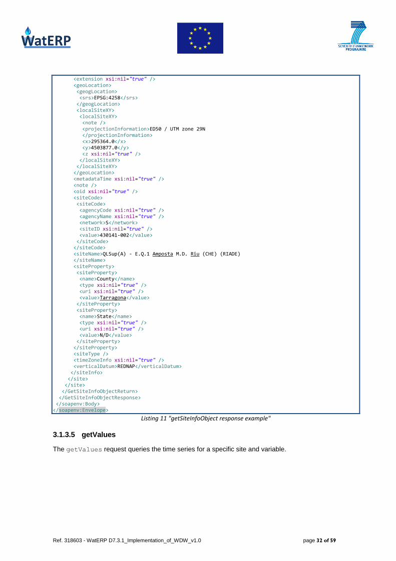
3.1.3.5 getValues
The getValues request queries the time series for a specific site and variable.

Ref. 318603 - WatERP D7.3.1_Implementation_of_WDW_v1.0 page 33 of 59
Figure 10 "Queried entities for getValues/getValuesObject"
As described in Figure 10 getValues and getValuesObject query all existing entities. Table 6
describes the parameters that can be passed with the getValues request and Listing 12 shows an
example request.
Parameter Description
location Site identifier in the format ‘NetworkName:SiteCode'.
variable Variable identifier in the format ‘NetworkName:VariableCode’
beginDate Lower limit of the requested time interval in the format ‘YYYY-MM-DD’
endDate Upper limit of the requested time interval in the format ‘YYYY-MM-DD’
authToken Previously created secutity token
Table 6 "getValues request parameters"
<soapenv:Envelope xmlns:soapenv="http://schemas.xmlsoap.org/soap/envelope/" xmlns:q0="http://ws.waterOneFlow.aca.gencat.cat" xmlns:xsd="http://www.w3.org/2001/XMLSchema" xmlns:xsi="http://www.w3.org/2001/XMLSchema-instance"> <soapenv:Body> <q0:GetValues> <q0:location>S:430141-002</q0:location> <q0:variable>S:3965408</q0:variable> <q0:startDate>2013-02-06</q0:startDate> <q0:endDate>2013-02-07</q0:endDate> <q0:authToken /> </q0:GetValues> </soapenv:Body> </soapenv:Envelope>
Listing 12 "getValues request example"
Besides the time series the getValues response contains a description of the site and the variable
which have been queried. For each value it also provides the identifier for source, quality control
and procedure. The source, quality control and feature entities referenced by the values are
also embedded inside the response but are linked with the value tags to avoid redundant information,
and thereby reduce the document size.

Ref. 318603 - WatERP D7.3.1_Implementation_of_WDW_v1.0 page 34 of 59
Like with getSitesXML and getSiteInfo the timeSeriesResponse is separated from the SOAP
body and as a string embedded in the GetValuesReturn tag.
<soapenv:Envelope xmlns:soapenv="http://schemas.xmlsoap.org/soap/envelope/" xmlns:xsd="http://www.w3.org/2001/XMLSchema" xmlns:xsi="http://www.w3.org/2001/XMLSchema-instance"> <soapenv:Body> <GetValuesResponse xmlns="http://ws.waterOneFlow.aca.gencat.cat"> <GetValuesReturn><?xml version="1.0" encoding="UTF-8" standalone="yes"?> <timeSeriesResponse xmlns="http://www.cuahsi.org/waterML/1.1/"> <queryInfo> <creationTime>2014-02-22T12:17:39.500+00:00</creationTime> <criteria MethodCalled="GetValues"> <parameter value="S:430141-002" name="site"/> <parameter value="S:3965408" name="variable"/> <parameter value="2013-02-06" name="startDate"/> <parameter value="2013-02-07" name="endDate"/> </criteria> </queryInfo> <timeSeries> <sourceInfo xsi:type="SiteInfoType" xmlns:xsi="http://www.w3.org/2001/XMLSchema-instance"> <siteName>QLSup(A) - E.Q.1 Amposta M.D. Riu (CHE) (RIADE)</siteName> <siteCode network="STR">430141-002</siteCode> <geoLocation> <geogLocation xsi:type="LatLonPointType" srs="EPSG:4258"> <latitude>40.66040061445847</latitude> <longitude>-5.420709255985781</longitude> </geogLocation> <localSiteXY projectionInformation="ED50 / UTM zone 29N"> <X>295364.0</X> <Y>4503877.0</Y> </localSiteXY> </geoLocation> <verticalDatum>REDNAP</verticalDatum> <note title="County">Tarragona</note> <note title="State">N/D</note> </sourceInfo> <variable> <variableCode default="true" vocabulary="STR">3965408</variableCode> <variableName>Terbolesa</variableName> <unit> <unitName>NTU</unitName> <unitType>NTU</unitType> <unitAbbreviation>NTU</unitAbbreviation> <unitCode>0001</unitCode> </unit> <noDataValue>-9999.0</noDataValue> <timeScale> <unit> <unitName>minute</unitName> <unitType>Time</unitType> <unitAbbreviation>min</unitAbbreviation> <unitCode>1000</unitCode> </unit> <timeSupport>0.0</timeSupport> </timeScale> <speciation></speciation> </variable> <values> <value qualityControlLevelCode="0" sourceCode="1" methodCode="0" dateTimeUTC="2013-02-06T15:00:00+00:00" timeOffset="+01:00" dateTime="2013-02-06T15:00:00+00:00" censorCode="nc">4</value> <value qualityControlLevelCode="0" sourceCode="1" methodCode="0" dateTimeUTC="2013-02-06T15:15:00+00:00" timeOffset="+01:00" dateTime="2013-02-06T15:15:00+00:00" censorCode="nc">4</value> ... <value qualityControlLevelCode="0" sourceCode="1" methodCode="0" dateTimeUTC="2013-02-
Ref. 318603 - WatERP D7.3.1_Implementation_of_WDW_v1.0 page 35 of 59
06T10:15:00+00:00" timeOffset="+01:00" dateTime="2013-02-06T10:15:00+00:00" censorCode="nc">4</value> <qualityControlLevel qualityControlLevelID="0"> <qualityControlLevelCode>0</qualityControlLevelCode> <definition>Raw data</definition> <explanation></explanation> </qualityControlLevel> <method methodID="0"> <methodCode>0</methodCode> <methodDescription>Not defined</methodDescription> </method> <source sourceID="1"> <sourceCode>1</sourceCode> <organization>Agència Catalana de l'Aigua</organization> <sourceDescription>Variables fenomenològiques de SIX</sourceDescription> <contactInformation> <contactName></contactName> <typeOfContact></typeOfContact> <email></email> <phone></phone> <address xsi:type="xs:string" xmlns:xsi="http://www.w3.org/2001/XMLSchema-instance" xmlns:xs="http://www.w3.org/2001/XMLSchema"></address> </contactInformation> <sourceLink></sourceLink> <citation></citation> </source> <censorCode> <censorCode>nc</censorCode> <censorCodeDescription>not censored</censorCodeDescription> </censorCode> </values> </timeSeries> </timeSeriesResponse> </GetValuesReturn> </GetValuesResponse> </soapenv:Body> </soapenv:Envelope>
Listing 13 "getValues response example"
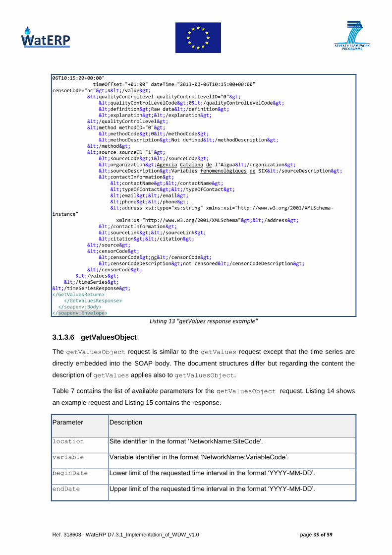
3.1.3.6 getValuesObject
The getValuesObject request is similar to the getValues request except that the time series are
directly embedded into the SOAP body. The document structures differ but regarding the content the
description of getValues applies also to getValuesObject.
Table 7 contains the list of available parameters for the getValuesObject request. Listing 14 shows
an example request and Listing 15 contains the response.
Parameter Description
location Site identifier in the format ‘NetworkName:SiteCode'.
variable Variable identifier in the format ‘NetworkName:VariableCode’.
beginDate Lower limit of the requested time interval in the format ‘YYYY-MM-DD’.
endDate Upper limit of the requested time interval in the format ‘YYYY-MM-DD’.
Ref. 318603 - WatERP D7.3.1_Implementation_of_WDW_v1.0 page 36 of 59
authToken Previously created secutity token.
Table 7 "getValuesObject request parameters"
<soapenv:Envelope xmlns:soapenv="http://schemas.xmlsoap.org/soap/envelope/" xmlns:q0="http://ws.waterOneFlow.aca.gencat.cat" xmlns:xsd="http://www.w3.org/2001/XMLSchema" xmlns:xsi="http://www.w3.org/2001/XMLSchema-instance"> <soapenv:Body> <q0:GetValuesObject> <q0:location>S:430141-002</q0:location> <q0:variable>S:3965408</q0:variable> <q0:startDate>2013-02-06</q0:startDate> <q0:endDate>2013-02-07</q0:endDate> <q0:authToken /> </q0:GetValuesObject> </soapenv:Body> </soapenv:Envelope>
Listing 14 "getValuesObject request example"
<soapenv:Envelope xmlns:soapenv="http://schemas.xmlsoap.org/soap/envelope/" xmlns:xsd="http://www.w3.org/2001/XMLSchema" xmlns:xsi="http://www.w3.org/2001/XMLSchema-instance"> <soapenv:Body> <GetValuesObjectResponse xmlns="http://ws.waterOneFlow.aca.gencat.cat"> <GetValuesObjectReturn> <error xsi:nil="true"/> <queryInfo> <creationTime>2014-02-22T12:24:34.953Z</creationTime> <criteria> <locationParam xsi:nil="true"/> <methodCalled>GetValues</methodCalled> <parameter> <parameter> <name>site</name> <value>S:430141-002</value> </parameter> <parameter> <name>variable</name> <value>S:3965408</value> </parameter> <parameter> <name>startDate</name> <value>2013-02-06</value> </parameter> <parameter> <name>endDate</name> <value>2013-02-07</value> </parameter> </parameter> <timeParam xsi:nil="true"/> <variableParam xsi:nil="true"/> </criteria> <extension xsi:nil="true"/> <note/> <queryURL xsi:nil="true"/> </queryInfo> <timeSeries> <timeSeries> <name xsi:nil="true"/> <sourceInfo xmlns:ns1="http://_1.waterml.cuahsi.org" xsi:type="ns1:SiteInfoType"> <altname xsi:nil="true"/> <elevationM xsi:nil="true"/> <error xsi:nil="true"/> <extension xsi:nil="true"/> <geoLocation> <geogLocation> <srs>EPSG:4258</srs> </geogLocation>

Ref. 318603 - WatERP D7.3.1_Implementation_of_WDW_v1.0 page 37 of 59
<localSiteXY> <localSiteXY> <note/> <projectionInformation>ED50 / UTM zone 29N</projectionInformation> <x>295364.0</x> <y>4503877.0</y> <z xsi:nil="true"/> </localSiteXY> </localSiteXY> </geoLocation> <metadataTime xsi:nil="true"/> <note> <note> <href xsi:nil="true"/> <show xsi:nil="true"/> <title>County</title> <type xsi:nil="true"/> <value>Tarragona</value> </note> <note> <href xsi:nil="true"/> <show xsi:nil="true"/> <title>State</title> <type xsi:nil="true"/> <value>N/D</value> </note> </note> <oid xsi:nil="true"/> <siteCode> <siteCode> <agencyCode xsi:nil="true"/> <agencyName xsi:nil="true"/> <network>STR</network> <siteID xsi:nil="true"/> <value>430141-002</value> </siteCode> </siteCode> <siteName>QLSup(A) - E.Q.1 Amposta M.D. Riu (CHE) (RIADE)</siteName> <siteProperty/> <siteType/> <timeZoneInfo xsi:nil="true"/> <verticalDatum>REDNAP</verticalDatum> </sourceInfo> <values> <values> <censorCode> <censorCode> <censorCode>nc</censorCode> <censorCodeDescription>not censored</censorCodeDescription> <censorCodeID xsi:nil="true"/> </censorCode> </censorCode> <method> <method> <methodCode>0</methodCode> <methodDescription>Not defined</methodDescription> <methodID>0</methodID> <methodLink xsi:nil="true"/> </method> </method> <offset/> <qualifier/> <qualityControlLevel> <qualityControlLevel> <definition>Raw data</definition> <explanation/> <qualityControlLevelCode>0</qualityControlLevelCode> <qualityControlLevelID>0</qualityControlLevelID> </qualityControlLevel>

Ref. 318603 - WatERP D7.3.1_Implementation_of_WDW_v1.0 page 38 of 59
</qualityControlLevel> <sample/> <source> <source> <citation/> <contactInformation> <contactInformation> <address> <address xsi:type="xsd:string"/> </address> <contactName/> <email> <email/> </email> <phone> <phone/> </phone> <typeOfContact/> </contactInformation> </contactInformation> <metadata xsi:nil="true"/> <organization>Agència Catalana de l'Aigua</organization> <sourceCode>1</sourceCode> <sourceDescription>Variables fenomenològiques de SIX</sourceDescription> <sourceID>1</sourceID> <sourceLink> <sourceLink/> </sourceLink> </source> </source> <units xsi:nil="true"/> <value> <value> <accuracyStdDev xsi:nil="true"/> <censorCode>nc</censorCode> <codedVocabularyTerm xsi:nil="true"/> <dateTime>2013-02-06T15:00:00.000Z</dateTime> <dateTimeUTC>2013-02-06T15:00:00.000Z</dateTimeUTC> <labSampleCode xsi:nil="true"/> <metadataTime xsi:nil="true"/> <methodCode>0</methodCode> <methodID xsi:nil="true"/> <offsetTypeCode xsi:nil="true"/> <offsetTypeID xsi:nil="true"/> <offsetValue xsi:nil="true"/> <oid xsi:nil="true"/> <qualifiers/> <qualityControlLevelCode>0</qualityControlLevelCode> <sampleID xsi:nil="true"/> <sourceCode>1</sourceCode> <sourceID xsi:nil="true"/> <timeOffset>+01:00</timeOffset> <value>4</value> </value> <value> <accuracyStdDev xsi:nil="true"/> <censorCode>nc</censorCode> <codedVocabularyTerm xsi:nil="true"/> <dateTime>2013-02-06T15:15:00.000Z</dateTime> <dateTimeUTC>2013-02-06T15:15:00.000Z</dateTimeUTC> <labSampleCode xsi:nil="true"/> <metadataTime xsi:nil="true"/> <methodCode>0</methodCode> <methodID xsi:nil="true"/> <offsetTypeCode xsi:nil="true"/> <offsetTypeID xsi:nil="true"/> <offsetValue xsi:nil="true"/> <oid xsi:nil="true"/> <qualifiers/>

Ref. 318603 - WatERP D7.3.1_Implementation_of_WDW_v1.0 page 39 of 59
<qualityControlLevelCode>0</qualityControlLevelCode> <sampleID xsi:nil="true"/> <sourceCode>1</sourceCode> <sourceID xsi:nil="true"/> <timeOffset>+01:00</timeOffset> <value>4</value> </value> ... <value> <accuracyStdDev xsi:nil="true"/> <censorCode>nc</censorCode> <codedVocabularyTerm xsi:nil="true"/> <dateTime>2013-02-06T10:15:00.000Z</dateTime> <dateTimeUTC>2013-02-06T10:15:00.000Z</dateTimeUTC> <labSampleCode xsi:nil="true"/> <metadataTime xsi:nil="true"/> <methodCode>0</methodCode> <methodID xsi:nil="true"/> <offsetTypeCode xsi:nil="true"/> <offsetTypeID xsi:nil="true"/> <offsetValue xsi:nil="true"/> <oid xsi:nil="true"/> <qualifiers/> <qualityControlLevelCode>0</qualityControlLevelCode> <sampleID xsi:nil="true"/> <sourceCode>1</sourceCode> <sourceID xsi:nil="true"/> <timeOffset>+01:00</timeOffset> <value>4</value> </value> </value> </values> </values> <variable> <categories xsi:nil="true"/> <dataType xsi:nil="true"/> <error xsi:nil="true"/> <extension xsi:nil="true"/> <generalCategory xsi:nil="true"/> <metadataTime xsi:nil="true"/> <noDataValue>-9999.0</noDataValue> <note/> <oid xsi:nil="true"/> <options xsi:nil="true"/> <related xsi:nil="true"/> <sampleMedium xsi:nil="true"/> <speciation/> <timeScale> <isRegular>false</isRegular> <timeSpacing xsi:nil="true"/> <timeSupport>0.0</timeSupport> <unit> <unitAbbreviation>min</unitAbbreviation> <unitCode>1000</unitCode> <unitDescription xsi:nil="true"/> <unitID xsi:nil="true"/> <unitName>minute</unitName> <unitType>Time</unitType> </unit> </timeScale> <unit> <unitAbbreviation>NTU</unitAbbreviation> <unitCode>0001</unitCode> <unitDescription xsi:nil="true"/> <unitID xsi:nil="true"/> <unitName>NTU</unitName> <unitType>NTU</unitType> </unit> <valueType xsi:nil="true"/>

Ref. 318603 - WatERP D7.3.1_Implementation_of_WDW_v1.0 page 40 of 59
<variableCode> <variableCode> <network xsi:nil="true"/> <value>3965408</value> <variableID xsi:nil="true"/> <vocabulary>STR</vocabulary> </variableCode> </variableCode> <variableDescription xsi:nil="true"/> <variableName>Terbolesa</variableName> <variableProperty/> </variable> </timeSeries> </timeSeries> </GetValuesObjectReturn> </GetValuesObjectResponse> </soapenv:Body> </soapenv:Envelope>
Listing 15 "getValuesObject response example"
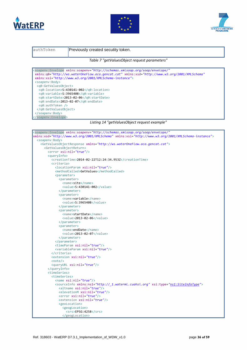
3.1.3.7 getVariableInfo
The method getVariableInfo provides a description of one specific variable or all existing variables,
depending on the parameters passed.
Figure 11 "Queried entities for getVariableInfo/getVariableInfoObject"
As Figure 11 shows, only the variables are being queried here. Table 8 lists the available parameters
that can be passed to the request.
Parameter Description
variable Variable identifier in the format ‘NetworkName:VariableCode’. If the value is omitted
all variables will be returned.
authToken Previously created secutity token
Table 8 "getVariableInfo request parameters"
Listing 16 shows a getVariableInfo request example and Listing 17 shows the resulting response.
The main information which is returned is the name of the variable and the unit of the values provided.
Like with setSitesXML, getSiteInfo and getValues, this method strictly separates the
variablesResponse from the SOAP body by embedding it as a string.

Ref. 318603 - WatERP D7.3.1_Implementation_of_WDW_v1.0 page 41 of 59
<soapenv:Envelope xmlns:soapenv="http://schemas.xmlsoap.org/soap/envelope/" xmlns:q0="http://ws.waterOneFlow.aca.gencat.cat" xmlns:xsd="http://www.w3.org/2001/XMLSchema" xmlns:xsi="http://www.w3.org/2001/XMLSchema-instance"> <soapenv:Body> <q0:GetVariableInfo> <q0:variable>S:3965408</q0:variable> <q0:authToken /> </q0:GetVariableInfo> </soapenv:Body> </soapenv:Envelope>
Listing 16 "getVariableInfo request example"
<soapenv:Envelope xmlns:soapenv="http://schemas.xmlsoap.org/soap/envelope/" xmlns:xsd="http://www.w3.org/2001/XMLSchema" xmlns:xsi="http://www.w3.org/2001/XMLSchema-instance"> <soapenv:Body> <GetVariableInfoResponse xmlns="http://ws.waterOneFlow.aca.gencat.cat"> <GetVariableInfoReturn><?xml version="1.0" encoding="UTF-8" standalone="yes"?> <variablesResponse xmlns="http://www.cuahsi.org/waterML/1.1/"> <queryInfo> <creationTime>2014-02-22T12:35:16.513+00:00</creationTime> <criteria MethodCalled="GetVariableInfo"> <parameter value="S:3965408" name="variable"/> </criteria> </queryInfo> <variables> <variable> <variableCode default="true" vocabulary="S">3965408</variableCode> <variableName>Terbolesa</variableName> <unit> <unitName>NTU</unitName> <unitType>NTU</unitType> <unitAbbreviation>NTU</unitAbbreviation> <unitCode>0001</unitCode> </unit> <noDataValue>-9999.0</noDataValue> <timeScale> <unit> <unitName>minute</unitName> <unitType>Time</unitType> <unitAbbreviation>min</unitAbbreviation> <unitCode>1000</unitCode> </unit> <timeSupport>0.0</timeSupport> </timeScale> <speciation></speciation> </variable> </variables> </variablesResponse> </GetVariableInfoReturn> </GetVariableInfoResponse> </soapenv:Body> </soapenv:Envelope>
Listing 17 "getVariableInfo response example"
3.1.3.8 getVariableInfoObject
Except for some differences in the response structure, the getVariableInfoObject works exactly in
the same way as the getVariableInfo method. It can also return the information of one specific
variable or all variables. The only difference with respect to getVariableInfo is that the response is
directly embedded inside the SOAP body. Table 9 describes the available parameters, Listing 18
contains an example request, and Listing 19 shows the response received from the server.
Ref. 318603 - WatERP D7.3.1_Implementation_of_WDW_v1.0 page 42 of 59
Parameter Description
variable Variable identifier in the format ‘NetworkName:VariableCode’. If the value
is omitted all variables will be returned.
authToken Previously created secutity token.
Table 9 "getVariableInfoObject request parameters"
<soapenv:Envelope xmlns:soapenv="http://schemas.xmlsoap.org/soap/envelope/" xmlns:q0="http://ws.waterOneFlow.aca.gencat.cat" xmlns:xsd="http://www.w3.org/2001/XMLSchema" xmlns:xsi="http://www.w3.org/2001/XMLSchema-instance"> <soapenv:Body> <q0:GetVariableInfoObject> <q0:variable>S:3965408</q0:variable> <q0:authToken /> </q0:GetVariableInfoObject> </soapenv:Body> </soapenv:Envelope>
Listing 18 "getVariableInfoObject request example"
<soapenv:Envelope xmlns:soapenv="http://schemas.xmlsoap.org/soap/envelope/" xmlns:xsd="http://www.w3.org/2001/XMLSchema" xmlns:xsi="http://www.w3.org/2001/XMLSchema-instance"> <soapenv:Body> <GetVariableInfoObjectResponse xmlns="http://ws.waterOneFlow.aca.gencat.cat"> <GetVariableInfoObjectReturn> <error xsi:nil="true" /> <queryInfo> <creationTime>2014-02-22T12:37:35.854Z</creationTime> <criteria> <locationParam xsi:nil="true" /> <methodCalled>GetVariableInfo</methodCalled> <parameter> <parameter> <name>variable</name> <value>S:3965408</value> </parameter> </parameter> <timeParam xsi:nil="true" /> <variableParam xsi:nil="true" /> </criteria> <extension xsi:nil="true" /> <note /> <queryURL xsi:nil="true" /> </queryInfo> <variables> <variable> <variable> <categories xsi:nil="true" /> <dataType xsi:nil="true" /> <error xsi:nil="true" /> <extension xsi:nil="true" /> <generalCategory xsi:nil="true" /> <metadataTime xsi:nil="true" /> <noDataValue>-9999.0</noDataValue> <note /> <oid xsi:nil="true" /> <options xsi:nil="true" /> <related xsi:nil="true" /> <sampleMedium xsi:nil="true" /> <speciation /> <timeScale> <isRegular>false</isRegular> <timeSpacing xsi:nil="true" />

Ref. 318603 - WatERP D7.3.1_Implementation_of_WDW_v1.0 page 43 of 59
<timeSupport>0.0</timeSupport> <unit> <unitAbbreviation>min</unitAbbreviation> <unitCode>1000</unitCode> <unitDescription xsi:nil="true" /> <unitID xsi:nil="true" /> <unitName>minute</unitName> <unitType>Time</unitType> </unit> </timeScale> <unit> <unitAbbreviation>NTU</unitAbbreviation> <unitCode>0001</unitCode> <unitDescription xsi:nil="true" /> <unitID xsi:nil="true" /> <unitName>NTU</unitName> <unitType>NTU</unitType> </unit> <valueType xsi:nil="true" /> <variableCode> <variableCode> <network xsi:nil="true" /> <value>3965408</value> <variableID xsi:nil="true" /> <vocabulary>S</vocabulary> </variableCode> </variableCode> <variableDescription xsi:nil="true" /> <variableName>Terbolesa</variableName> <variableProperty /> </variable> </variable> </variables> </GetVariableInfoObjectReturn> </GetVariableInfoObjectResponse> </soapenv:Body> </soapenv:Envelope>
Listing 19 “getVariableInfoObject response example”
3.2 Mapping to WaterML2
As D2.3-“Open Interface Specification” chapter 3.1.1.2 describes, the ACA data provided by the
WaterOneFlow server has to be mapped to SOS/WaterML2. This chapter will list the information
relevant to generate the basics of the ontology and consider how this information can be extracted from
WaterOneFlow. The consideration will be based on the real responses from the ACA installation
described in chapter 3.1.3.
Figure 12 provides an overview over the OGC O&M standard while Appendix I section 6 gives an
overview over the CUAHSI ODM.

Ref. 318603 - WatERP D7.3.1_Implementation_of_WDW_v1.0 page 44 of 59
Figure 12 "Summary of the OGC Observations and Measurements (O&M) standard"3
Table 10 shows the most significant differences between the entities of WaterML1 (CUAHSI) and
WaterML2 (OGC) focused on the data that is required to generate the ontology. For each element it
shows an example to clarify the similarities or differences.
WaterML2 WaterML1
Feature of interest identifier from feature of interest
inside OM_Observation
Format is free (gml:identifier tag or
wml2:monitoringPoint/@gml:id)
Site identifier from source site
Example: S:3965408
Observed property from OM_Observation
Example: ‘urn:ogc:def:phenomenon:waterpressure’
Variable name from source variable
Example:
<variableName>Terbolesa</variableName>
Offering from the sensor description output list Variable name from source variable
3 http://external.opengeospatial.org/twiki_public/HydrologyDWG/USGSStandardsIssues

Ref. 318603 - WatERP D7.3.1_Implementation_of_WDW_v1.0 page 45 of 59
metadata
Example: ‘WATERPRESSURE’
Example:
<variableName>Terbolesa</variableName>
Sensor from procedure description linked with
OM_Observation
Format is free (wml2:processReference/@xlink:href)
There is no information in the ACA
WaterOneFlow responses what might serve as
the basis for creation of the sensor.
Location from feature of interest monitoring point
Example:
<gml:pos srsName=
"http://www.opengis.net/def/crs/EPSG/0/4258">
40.660 -5.4207
</gml:pos>
GeoLocation from source site
Example:
<geogLocation
xsi:type="LatLonPointType"
srs="EPSG:4258”>
<latitude>40.660</latitude>
<longitude>-5.4207<longitude>
</geogLocation>
Unit from the observation result default point metadata
Example:
<wml2:uom code="bar"/>
Unit name from source variable
Example:
<unitName>NTU</unitName>
Table 10 "Main entities in CUAHSI and OGC"
The transformation of feature of interest, location and unit is not problematic. The notation
of the SRS (Spatial Reference System) has to be changed but the general information is available.
Mapping of the sensor identifier is also possible as there is no special notation provided that the
sensor can be identified. As in WaterOneFlow the sensor is modelled as the combination of a site and a
variable, the two identifiers can be used to generate the unique sensor identifier for WaterML2.
The mapping of observed property and offering is more difficult because the observed
property requires a special format and should use predefined standard URIs. The same applies for
the offering. As an example, Table 10 "Main entities in CUAHSI and OGC" displays
‘urn:ogc:def:phenomenon:waterpressure’ for observed property and ‘WATERPRESSURE’ for
offering.
In consequence, the conversion from WaterOneFlow to SOS requires a mapping from the variable
names used by ACA to the observed properties and offerings used in WaterML2.

Ref. 318603 - WatERP D7.3.1_Implementation_of_WDW_v1.0 page 46 of 59
3.3 ACA Pilot Integration Manager
This chapter describes the current state of implementation of the ACA pilot integration manager (PIM).
D3.3-“WDW 2nd
Prototype” will contain a full documentation of the system. This document will give a
short technical overview focussing on the level of integration of ACA data. The application is
implemented as a web application which polls the ACA server in configured intervals. The sensors’
meaning pairs of site identifier and variable identifier are stored inside a database table. The full content
of the table is listed in Table 11.
Column Description
ID Identifier
SITE_CODE Site identifier
VARIABLE_CODE Variable identifier
START_POLLING Start date from which on the time series should be converted to
SOS/WaterML2
HIGHEST_TIMESTAMP Highest timestamp of the observation results that are already converted to
SOS/WaterML2
DEFINED_IN_SOS ‘false’ indicates that the sensor isn’t yet defined in the SOS server. Once the
application creates the SOS sensor the column will be changed to true.
Table 11 "Columns of sensor table in ACA pilot integration manager"
The application creates the ACA sensor before the first observation result is to be inserted. In order to
avoid polling all the historical data when adding a new sensor, the timestamp where the polling starts
can be configured.
To reduce the risk of destabilizing the WaterOneFlow server, the ACA server has a maximum time
interval that can be queried by one request. If this limit is exceeded the server responds with an error
code to avoid running out of memory. For this reason (and also not to cause instabilities in the PIM
itself), a maximum query interval is defined in the configuration of the PIM. First, for each polled sensor
the available time range available is determined by calling getSiteInfoObject. This data is merged
with the additional information as START_POLLING and HIGHEST_TIMESTAMP stored in the sensor
table. With this data PIM determines the time interval it has to query on the ACA server. After that the
time interval is separated into subintervals as to meet the restrictions of the server about maximum time
intervals allowed for querying. The observation results are obtained by calling getValues. Next, the
response is analysed and converted to WaterML2. The current implementation realizes a very simple
conversion:

Ref. 318603 - WatERP D7.3.1_Implementation_of_WDW_v1.0 page 47 of 59
The sensor identifier is generated by combining site and variable identifier of
WaterOneFlow. The pattern is <siteCodeNetwork>-<siteCode>/<variableCodeVocabulary>-
<variableCode>. For example for site S:430141-002 and variable S:3965408 the sensor
identifier would be S-430141-002/S-3965408.
The observed properties are created by applying the pattern
urn:x-ogc:def:phenomenon:OGC:<variableName>. As for phemomenons, there exists already a
standard list of predefined URNs4. When mapping ACA data these predefined URNs should be
used if possible. Therefore the mapping should map the variable identifier or the variable
names to the phenomenon URNs to be used for WaterML2 generation.
For offering and offeringName the variable name from WaterOneFlow is used. This mapping
is to be reconsidered as it might be altered according to the changed mapping of the observed
properties. Like with the observed property a mapping from the ACA variable name or identifier
to the offering can be added to solve the problem.
The feature of interest is created based on the pattern <siteCodeNetwork>-<siteCode>.
The name of the feature of interest is taken from the site name in WaterOneFlow.
Unit and location are transferred from their counterparts in WaterOneFlow. For location
SRS the prefix urn:ogc:def:crs:EPSG:: is added to meet the restrictions of the SOS protocol.
Figure 13 shows the processing flow when a sensor is polled.
4
https://www.seegrid.csiro.au/subversion/xmml/OGC/branches/SWE_gml2/sweCommon/current/examples/pheno
mena.xml
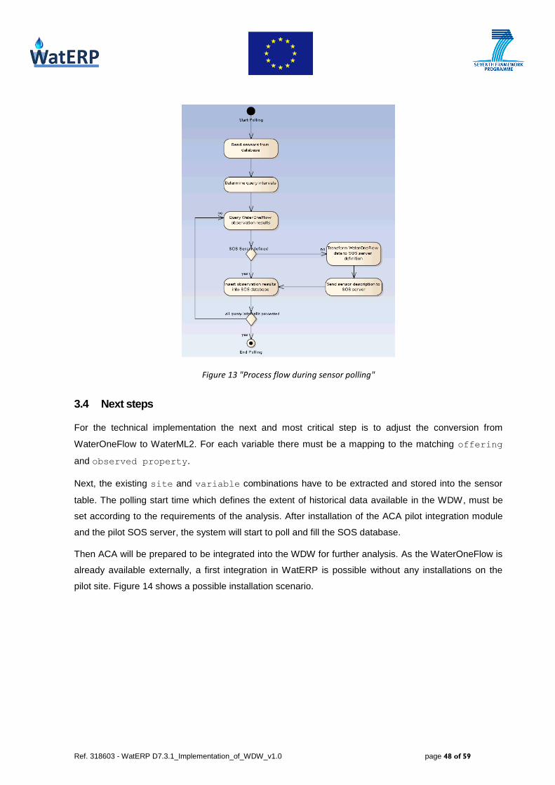
Ref. 318603 - WatERP D7.3.1_Implementation_of_WDW_v1.0 page 48 of 59
Figure 13 "Process flow during sensor polling"
3.4 Next steps
For the technical implementation the next and most critical step is to adjust the conversion from
WaterOneFlow to WaterML2. For each variable there must be a mapping to the matching offering
and observed property.
Next, the existing site and variable combinations have to be extracted and stored into the sensor
table. The polling start time which defines the extent of historical data available in the WDW, must be
set according to the requirements of the analysis. After installation of the ACA pilot integration module
and the pilot SOS server, the system will start to poll and fill the SOS database.
Then ACA will be prepared to be integrated into the WDW for further analysis. As the WaterOneFlow is
already available externally, a first integration in WatERP is possible without any installations on the
pilot site. Figure 14 shows a possible installation scenario.

Ref. 318603 - WatERP D7.3.1_Implementation_of_WDW_v1.0 page 49 of 59
Figure 14 "Possible installation scenario for ACA"
4. SWKA site integration
In this section the activities taken so far to integrate SWKA pilot sensor data into the WDW are
described. First, an overview of the existing data infrastructure for SWKA is given, then the data,
mapping to ontology and the SWKA Integration Manager are explained.
4.1 Existing data infrastructure
The data infrastructure is highly different to the one at ACA. SWKA runs a data warehouse which can
be considered as a black box. All the sensor network results are fed into this system. To make the data
available for WatERP, the observation results have to be exported. In this export, the time interval and
the step size of the time series have to be specified. Furthermore, the exported data has already
passed some steps of preparation before it enters the WDW.
Up to now, the work to analyze and process the data from the SWKA pilot site has been based on an
export provided in the format of an Oracle database dump file5 which had been created by SWKA
containing a snapshot of the observation results. The file was imported in an Oracle6 database on the
development site to implement the data access. From the example table depicted in Figure 15, it can be
noted that the sensor data, with other data fields such as quality and rate, is a series of time and value
pairs. In this table, PP_ID is the sensor ID. Indeed, each sensor has different readings at different
times. Thus, the first level of integration is to convert the data into WaterML2, so that the data can be
stored into an SOS server. To accomplish this task, the entities identified in WP4 for SWKA that have to
be part of the WaterML2 document, are first mapped as described in next section.
5 Data Pump Export http://docs.oracle.com/cd/B28359_01/server.111/b28319/dp_export.htm#i1006388
6Oracle Database (”http://www.oracle.com/technetwork/database/enterprise-edition/downloads/index.html”)

Ref. 318603 - WatERP D7.3.1_Implementation_of_WDW_v1.0 page 50 of 59
Figure 15 “Database table from pilot site SWKA”
4.2 Mapping to WaterML2
D4.1-‘Inference and Simulation Engine Conceptual Design’ chapter 3.2 explains the logical model as
well as the data this model has to be based on.
As displayed in Figure 16 the required features of interest that were identified in D4.1 are:
Karlsruhe City: Urban demand in Karlsruhe city. This is the area of which the DMS is going to
provide the forecasted demand for, and where the DSS will provide recommendations for the
pumps management to satisfy demand with the minimum possible energy cost.
HW Pumping: Hardtwald Water Work. Ground water pumped from well-fields, and distributed
through four pumps with constant displacement. It supplies water to Karlsruhe North and to the
Main Reservoir.
MW Pumping: Mörscher Wald Water Work. Ground water pumped from well-fields, and
distributed through four pumps with constant displacement. It supplies water to Karlsruhe South
and to the Main Reservoir.
RW Pumping: Rheinwald Water Work. Ground water pumped from well-fields, and distributed
through four pumps with constant displacement. It supplies water to Karlsruhe South and the
Main Reservoir.
DW Pumping: Durlacher Water Work. Ground water pumped from three well-fields. It provides
water directly to the system (Karlsruhe City) and to the Main Reservoir.
HB Luss - Main Reservoir: Storage Tank Luss or Main Reservoir, it supplies fresh water to
Karlsruhe City. It is used as an emergency water reserve, to support demand peaks

Ref. 318603 - WatERP D7.3.1_Implementation_of_WDW_v1.0 page 51 of 59
Figure 16 "SWKA logical model"
The most detailed description can be found in table 11 of D4.1. It lists all variables for each feature of
interest and serves as the central information for registering the sensors on the SOS server.
SWKA will provide the mapping of the lines in this table to the PP_IDs in the data warehouse, as well as
the list of locations for each feature of interest within the next deliverable. Then the registration of the
sensors and the loading of the obvservation results will be fully implemented.
4.3 SWKA Pilot Integration Manager
This section is focused on defining the whole process of converting the data into WaterML 2, adding
sensor and sensor observation data from SWKA database onto SOS server by PIM (Pilot Integration
Manager). Currently, the PIM has a very simple implementation in order to prove that for a single
sensor reading, mapping and storing the data is working for SWKA. In the next iteration, the design
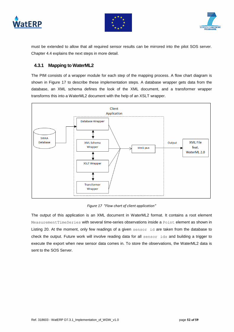
Ref. 318603 - WatERP D7.3.1_Implementation_of_WDW_v1.0 page 52 of 59
must be extended to allow that all required sensor results can be mirrored into the pilot SOS server.
Chapter 4.4 explains the next steps in more detail.
4.3.1 Mapping to WaterML2
The PIM consists of a wrapper module for each step of the mapping process. A flow chart diagram is
shown in Figure 17 to describe these implementation steps. A database wrapper gets data from the
database, an XML schema defines the look of the XML document, and a transformer wrapper
transforms this into a WaterML2 document with the help of an XSLT wrapper.
Figure 17 "Flow chart of client application"
The output of this application is an XML document in WaterML2 format. It contains a root element
MeasurementTimeSeries with several time-series observations inside a Point element as shown in
Listing 20. At the moment, only few readings of a given sensor id are taken from the database to
check the output. Future work will involve reading data for all sensor ids and building a trigger to
execute the export when new sensor data comes in. To store the observations, the WaterML2 data is
sent to the SOS Server.

Ref. 318603 - WatERP D7.3.1_Implementation_of_WDW_v1.0 page 53 of 59
Listing 20 "Output in WaterML2 format"
4.3.2 Load Sensor Metadata
In this step, the sensor metadata and the configuration settings are passed to the WatERP framework
as an XML file whose format is based on SML. The configuration settings are shown in the Figure 18.
Figure 18 “Configuration Settings for PIM”
4.3.3 Configure New Sensor
In the SWKA scenario there exist two types of sensors: in-situ and dynamic. Both kind of sensors have
been configured and subscribed into an SOS server. The SOS server provides an API for managing
deployed sensors and retrieving sensor information related to their measurement (e.g., observations,
measurement, etc.) and configuration (e.g., type of sensor, id, etc.). Based on this stored information,
the SOS server offers some operations to gather sensor information (measurement information and
configuration): i) GetObservation, ii) DescribeSensor, and iii) GetCapabilites.
The current work related to sensor integration inside the WatERP solution has been focused on adding
SWKA sensors into WDW server. In order to perform this task, the first step consists on incorporating
sensors into the SOS server. The process to include a new sensor inside the SOS server includes the
registration of the sensor and the configuration of the sensor’s observations. This process is supported
by two transactional operations: RegisterSensor and InsertObservation.

Ref. 318603 - WatERP D7.3.1_Implementation_of_WDW_v1.0 page 54 of 59
Using these operations, the PIM registers the sensor and inserts the sensor observation from the
database onto the SOS server. For this reason, the client application is fitted with two more wrapper
modules, one with the purpose of registering a sensor and another one to insert the sensor observation.
The standard used to register a sensor is Sensor Model Language (SML). Furthermore, the
observations are inserted following the OGC Observation and Management Specification (O&M). These
standards propose to encode the information of the observation to be inserted into XML. Additionally,
each RegisterSensor operation has two mandatory attributes which are service and version.
The request for this operation is contained in the SensorDescription element. The response to a
RegisterSensor request contains an AssignedSensorID which is the identifier assigned by the
SOS to designate the new sensor. The identifier is of type anyURI and must be either a URN or a URL.
The request of register a sensor and the response from SOS is shown in Listing 21 and Listing 22,
respectively.
Listing 21 "Request to register a sensor"
Listing 22 “Response from SOS for sensor registration”

Ref. 318603 - WatERP D7.3.1_Implementation_of_WDW_v1.0 page 55 of 59
At the moment, the RegisterSensor wrapper is registering sensors using hardcoded data. Some of
these hardcoded data are stored in configuration properties files and some other are stored in the class
variables. This wrapper generates an XML file in the format of SML (SML-XML file) which is sent to
SOS server in order to register the sensor. In the same way, there is a partial implementation of the
InsertObservation operation. If a sensor was previously registered, the re-registration request
receives an error message from SOS in the response, stating that “The sensor is already registered at
this SOS”.
4.3.4 Trigger Import/InsertObservation
Once the sensor has been registered with SOS, the PIM can begin inserting observations for that
sensor. The AddSensorObservation wrapper in the client application gets data from database
tables, creates an XML document using XML schema and transforms this document into O&M standard
using XSLT transformations. As described in 4.3.2, this first PIM version uses information passed as
configuration settings instead of triple store data to describe a sensor in the SOS server such as
feature of interest, observed property, offering, sensor ID and unit. The time
series and measured value are retrieved from the database. Each InsertObservation request
includes the AssignedSensorID returned from the RegisterSensor operation and has mandatory
attributes of service and version. The request of InsertObservation and response from SOS is
shown in Listing 23 and Listing 24.
Listing 23 "Request to SOS for InsertObservation"
It is important to note that the response from SOS contains AssignedObservationID for the new
observation entered. If the same observation is entered twice, an error message is received in the
response body stating that the observation is already present in the SOS database.
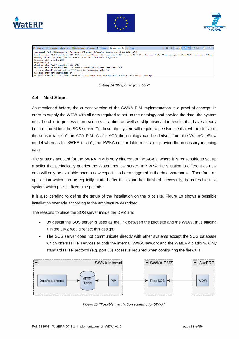
Ref. 318603 - WatERP D7.3.1_Implementation_of_WDW_v1.0 page 56 of 59
Listing 24 “Response from SOS”
4.4 Next Steps
As mentioned before, the current version of the SWKA PIM implementation is a proof-of-concept. In
order to supply the WDW with all data required to set-up the ontology and provide the data, the system
must be able to process more sensors at a time as well as skip observation results that have already
been mirrored into the SOS server. To do so, the system will require a persistence that will be similar to
the sensor table of the ACA PIM. As for ACA the ontology can be derived from the WaterOneFlow
model whereas for SWKA it can’t, the SWKA sensor table must also provide the necessary mapping
data.
The strategy adopted for the SWKA PIM is very different to the ACA’s, where it is reasonable to set up
a poller that periodically queries the WaterOneFlow server. In SWKA the situation is different as new
data will only be available once a new export has been triggered in the data warehouse. Therefore, an
application which can be explicitly started after the export has finished succesfully, is preferable to a
system which polls in fixed time periods.
It is also pending to define the setup of the installation on the pilot site. Figure 19 shows a possible
installation scenario according to the architecture described.
The reasons to place the SOS server inside the DMZ are:
By design the SOS server is used as the link between the pilot site and the WDW, thus placing
it in the DMZ would reflect this design.
The SOS server does not communicate directly with other systems except the SOS database
which offers HTTP services to both the internal SWKA network and the WatERP platform. Only
standard HTTP protocol (e.g. port 80) access is required when configuring the firewalls.
Figure 19 "Possible installation scenario for SWKA"
Ref. 318603 - WatERP D7.3.1_Implementation_of_WDW_v1.0 page 57 of 59
Of course, this installation scenario represents only an early sketch. The final setup will be decided
together with SWKA in the next deliverable D7.3.2.
5. Conclusions and future work
This section summarizes all the activities performed so far and describes the next steps.
The existing data infrastructure has been analysed and the sources for observation result data have
been identified for both clients (ACA and SWKA). Also for each context the access to the pilot data has
been implemented. The implementation of the data access layer is almost complete for both pilots.
Regarding the mapping of the pilots’ data to the ontology, the knowledge acquisition task has reached a
point where the next steps are clear. For ACA, most of the information is already available, but an
additional mapping is required. For SWKA, the missing information has been requested which is
necessary to complete the mapping. As a conclusion, most of the raised uncertainties have been
clarified.
The generation of the WaterML2 documents has been implemented as a prototype. The final definition
of the WaterML2 contents that will serve as the base to generate the ontology is currently in progress.
The implementation of the SOS client for registering new sensors and inserting observations has been
completed.
Both scenarios, ACA and SWKA, have been installed on the development site and tested. To prove if
the access to the WDW works properly, the sensors have also been registered in the WDW and the
data available in the WDW interface layer have been verified.
The results were accomplished based on the work of the other work packages, especially WP1, WP2,
WP3 and WP4. The decisions were drawn in close consultation with other work packages as well as
with the pilots.
For the future work, the WaterML2 content has to be finally specified in order to provide the base of the
population of the ontology.
To finish the integration of the ACA pilot, the mapping of the WaterML1 data to WaterML2 must be
finished. Here, especially observed property and offering are to be adjusted. Afterwards, the list
of required sensors has to be defined and added to the sensor list that controls the polling.
For the SWKA pilot, the mapping of the sensor PP_IDs to WaterML2 must be finished. Further, the PIM
implementation must be extended to support polling of all required sensors as described in chapter 4.4.
Finally, the decision of how to setup the integration on the SWKA pilot site has to be drawn.
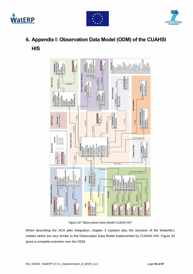
Ref. 318603 - WatERP D7.3.1_Implementation_of_WDW_v1.0 page 58 of 59
6. Appendix I: Observation Data Model (ODM) of the CUAHSI
HIS
Figure 20 "Observation Data Model CUAHSI HIS"
When describing the ACA pilot integration, chapter 3 explains also the structure of the WaterML1
entities which are very similar to the Observation Data Model implemented by CUAHSI HIS. Figure 20
gives a complete overview over the ODM.

Ref. 318603 - WatERP D7.3.1_Implementation_of_WDW_v1.0 page 59 of 59
7. Appendix II: WaterOneFlow Service
Figure 21 "WaterOneFlow Service diagram"
Figure 21 lists all methods implemented by the WaterOneFlow web service. Chapter 3.1.3 gives a more
detailed description of the methods and the parameters, displaying also examples with the data offered
by ACA.