Waterfronts of Portland and South Portland Maine
42
A ULI Advisory Services Panel Report Waterfronts of Portland and South Portland Maine May 11–16, 2014
Transcript of Waterfronts of Portland and South Portland Maine

A UL
I Adv
isory
Ser
vices
Pan
el Re
port
Waterfronts of Portlandand South PortlandMaineMay 11–16, 2014
Portland2014_cover.indd 2 9/26/14 1:41 PM

Waterfronts of Portland and South Portland MaineRegional Strategies for Creating Resilient Waterfronts
May 11–16, 2014
A UL
I Adv
isory
Ser
vices
Pan
el Re
port
An Advisory Services Panel Report2
About the Urban Land Institute
THE MISSION OF THE URBAN LAND INSTITUTE is
to provide leadership in the responsible use of land and in
creating and sustaining thriving communities worldwide.
ULI is committed to
■■ Bringing together leaders from across the fields of real
estate and land use policy to exchange best practices
and serve community needs;
■■ Fostering collaboration within and beyond ULI’s
membership through mentoring, dialogue, and problem
solving;
■■ Exploring issues of urbanization, conservation, regen-
eration, land use, capital formation, and sustainable
development;
■■ Advancing land use policies and design practices
that respect the uniqueness of both built and natural
environments;
■■ Sharing knowledge through education, applied research,
publishing, and electronic media; and
■■ Sustaining a diverse global network of local practice
and advisory efforts that address current and future
challenges.
Established in 1936, the Institute today has more than
32,000 members worldwide, representing the entire spec-
trum of the land use and development disciplines. Profes-
sionals represented include developers, builders, property
owners, investors, architects, public officials, planners,
real estate brokers, appraisers, attorneys, engineers,
financiers, academics, students, and librarians.
ULI relies heavily on the experience of its members. It is
through member involvement and information resources
that ULI has been able to set standards of excellence in
development practice. The Institute has long been rec-
ognized as one of the world’s most respected and widely
quoted sources of objective information on urban planning,
growth, and development.
Cover photo: Clean Air Cool Planet.
© 2014 by the Urban Land Institute 1025 Thomas Jefferson Street, NW Suite 500 West Washington, DC 20007-5201
All rights reserved. Reproduction or use of the whole or any part of the contents without written permission of the copy-right holder is prohibited.
Waterfronts of Portland and South Portland, Maine, May 11–16, 2014 3
About ULI Advisory Services
THE GOAL OF ULI’S ADVISORY SERVICES program
is to bring the finest expertise in the real estate field to
bear on complex land use planning and development proj-
ects, programs, and policies. Since 1947, this program
has assembled well over 400 ULI-member teams to help
sponsors find creative, practical solutions for issues such
as downtown redevelopment, land management strate-
gies, evaluation of development potential, growth manage-
ment, community revitalization, brownfield redevelopment,
military base reuse, provision of low-cost and affordable
housing, and asset management strategies, among other
matters. A wide variety of public, private, and nonprofit or-
ganizations have contracted for ULI’s advisory services.
Each panel team is composed of highly qualified profession-
als who volunteer their time to ULI. They are chosen for their
knowledge of the panel topic and screened to ensure their
objectivity. ULI’s interdisciplinary panel teams provide a holis-
tic look at development problems. A respected ULI member
who has previous panel experience chairs each panel.
The agenda for a five-day panel assignment is intensive.
It includes an in-depth briefing day composed of a tour of
the site and meetings with sponsor representatives; a day
of hour-long interviews of typically 50 to 75 key commu-
nity representatives; and two days of formulating recom-
mendations. Long nights of discussion precede the panel’s
conclusions. On the final day on site, the panel makes an
oral presentation of its findings and conclusions to the
sponsor. A written report is prepared and published.
Because the sponsoring entities are responsible for signifi-
cant preparation before the panel’s visit, including sending
extensive briefing materials to each member and arranging
for the panel to meet with key local community members
and stakeholders in the project under consideration, partici-
pants in ULI’s five-day panel assignments are able to make
accurate assessments of a sponsor’s issues and to provide
recommendations in a compressed amount of time.
A major strength of the program is ULI’s unique ability
to draw on the knowledge and expertise of its members,
including land developers and owners, public officials,
academics, representatives of financial institutions, and
others. In fulfillment of the mission of the Urban Land
Institute, this Advisory Services panel report is intended to
provide objective advice that will promote the responsible
use of land to enhance the environment.
ULI Program StaffGayle Berens
Senior Vice President, Education and Advisory Group
Thomas W. Eitler
Vice President, Advisory Services
Daniel Lobo
Manager, Awards and Publications
Caroline Dietrich
Director of Operations, Education and Advisory Group
Beth Silverman
Director, Education and Advisory Services
Kathryn Craig
Associate, Education and Advisory Group
Natasha Hilton
Associate, Education and Advisory Services
James A. Mulligan
Senior Editor
Laura Glassman, Publications Professionals LLC
Manuscript Editor
Betsy Van Buskirk
Creative Director
Deanna Pineda, Muse Advertising Design
Graphic Designer
Craig Chapman
Senior Director, Publishing Operations

An Advisory Services Panel Report4
About Urban Resilience Panels
WITH A NUMBER OF EXTREME and damaging
weather-related events in recent memory, cities around
the world are thinking about how to become more resil-
ient in the face of these challenges. Resilience has taken
on many meanings in different contexts. The Urban Land
Institute has joined a number of partner industries to cre-
ate a shared definition of resilience: the ability to prepare
and plan for, absorb, recover from, and more success-
fully adapt to adverse events. Implied in this definition is
the ability not just to recover and bounce back, but also to
bounce forward and thrive.
ULI, with generous funding support from the Kresge Foun-
dation, has undertaken a series of panels to assess how
cities can better prepare for changes deriving from global
climate change. These changes range from rising sea
levels, to warmer water and air temperatures, to more ex-
treme weather events such as rainstorms and hurricanes.
The objective is for such panels to offer advice and guid-
ance to communities that will assist their formulation of
plans and policies and that will, in turn, create stronger
responses to and recoveries from such events.
Indeed, this panel effort is focused on not just recovery
in the sense of rebuilding what existed before, but also in
looking forward to rebuilding and developing in the normal
cycle in a way that reduces or eliminates the risks from
such natural events.
Portland and South Portland were selected for this,
the first ULI panel to focus on resilience. As coastal cities
that have historically experienced the consequences of
natural events, and as cities dependent on the water as an
economic and social resource, this choice of venue seems
most appropriate. Fittingly, the motto of Portland is Resur-gum, meaning “I shall rise again,” and the motto of South
Portland is “Forward.” These mottos speak to the intent
of this panel report—to assist these communities in rising
again from the consequences of these adverse events
and, most important, to move forward in formulating plans
and policies that will mitigate the consequences of future
natural events before they occur.

Waterfronts of Portland and South Portland, Maine, May 11–16, 2014 5
Acknowledgments
THE URBAN LAND INSTITUTE WISHES to thank the
cities of Portland and South Portland, Maine, for collabo-
rating to sponsor this panel. Sincere gratitude also goes
to the Kresge Foundation, whose generous support of
ULI’s Urban Resilience Program has made these panels
possible.
The panel would also like to thank the more than 50 stake-
holders from the Greater Portland area who graciously pro-
vided their perspectives during the interview process. This
group of interviewees included industry representatives,
elected officials, local business owners, members of the
historic preservation community and municipal staff. Com-
munity input is a critical component of the panel process
and their views have greatly informed this report.


Waterfronts of Portland and South Portland, Maine, May 11–16, 2014 7
Contents
ULI Panel and Project Staff ...............................................................................................................................8
Background and the Panel’s Assignment ..........................................................................................................9
Building Resilience through a More Diverse Economy ......................................................................................12
Risk Assessment ...........................................................................................................................................17
Planning and Development Strategies for the Built Environment .......................................................................23
Governance and Implementation ....................................................................................................................28
Conclusion ....................................................................................................................................................34
About the Panel .............................................................................................................................................35

An Advisory Services Panel Report8
ULI Panel and Project Staff
Panel ChairJim DeFrancia
President
Lowe Enterprises Community Development Inc.
Aspen, Colorado
Panel MembersStephen M. Antupit
Principal Urban Strategist
CityWorks Inc.
Seattle, Washington
Corinne Packard Beasley
Clinical Assistant Professor
NYU Schack Institute of Real Estate
New York, New York
Dennis Carlberg
Director of Sustainability
Boston University
Boston, Massachusetts
Jessica Pavone
Senior Director, Long Term Recovery, New York State
American Red Cross
New York, New York
Byron Stigge
Director
Level Infrastructure
New York, New York
Richard Ward
Principal
Ward Development Counsel LLC
St. Louis, Missouri
Jeana Wiser
Associate Project Manager, Preservation Green Lab
National Trust for Historic Preservation
Los Angeles, California
ULI Project StaffThomas W. Eitler
Vice President, Education and Advisory Group
Brenden McEneaney
Director, Urban Resilience
Caroline Dietrich
Logistics Manager, Education and Advisory Group
Nicholas Lalla
Analyst to the CEO and Chief Content Officer

Waterfronts of Portland and South Portland, Maine, May 11–16, 2014 9
IN MANY WAYS, THE CITIES of Portland and South
Portland embody the archetype of the quaint New England
seaport community. The history of the region goes back to
some of the first English colonists who arrived on the con-
tinent. The two cities straddle the mouth of the Fore River
as it flows into Casco Bay. Maritime life and industry are a
critical part of the region’s identity and tourism industry, as
is evident by a stroll down Portland’s Commercial Street.
But the port also plays a key infrastructural role, with a
growing container-shipping business and as one of the
eastern seaboard’s largest energy ports.
Although the Greater Portland region retains its small-town
New England charm, it is also the urban hub for all of
Maine. Portland (population 66,000) and South Portland
(population 25,000) anchor a region that is home to a half-
million people, representing half the state’s population and
two-thirds of the state’s economic activity. The cities are
115 miles north of Boston on the Interstate 95 corridor.
Study AreaThe waterfront in Portland and South Portland varies
dramatically between the two cities. In Portland, the
working waterfront combines many active finger piers
with lobstering and fishing operations in full swing, as well
as a few residential land uses, restaurants, and nonma-
rine businesses. The water’s edge in Portland is largely
dedicated to support for commercial vessels. On the east
end of the waterfront is a cruise ship terminal, and the
west end gives way to the container-shipping terminal and
more industrial uses. Commercial Street separates the
waterfront from the city proper, and while the waterfront
sees bustling pedestrian activity, the majority of business
and commercial activity happens several blocks uphill,
away from the water’s edge. South Portland, in contrast,
has little to no commercial tourist or pedestrian activity on
Background and the Panel’s Assignment
CLEA
N AI
R CO
OL
PLAN
ET
A computer model of land at risk from flooding with sea-level rise.
202
3
1
1
1
2
302
4
5
5
5
1
1
1
1
1
2
2
2
201
202
202
202
202
2A
302
3
3
4
4
20
20
20
202
202
44
6
6
1
11
5
5
44 44
6
Toll
Toll
Toll
PKW
Y.
Toll
95
95
95
89
91
91
91
93
495
95
93
89
95
95
93
93
195
495
495
495
90
90
91
93
9595
395
39584
91
91
84
95
PenobscotBay
Casco Bay
N O R T H A T L A N T I C
O C E A N
Massachusetts Bay
CAPE COD BAY
Nantucket Sound
BuzzardsBay
Rhode Island Sound
LONGISLAND SOUND
Gardiners BayNapeagueBay
C H E S H I R E
H I L L S B O R O U G H
S U L L I V A N
A D D I S O N
C A L E D O N I A
F R A N K L I N
L A M O I L L E
O R A N G E
O R L E A N S
R U T L A N D
W A S H I N G T O N
W I N D H A M
W I N D S O R
A N D R O S C O G G I N
C U M B E R L A N D
F R A N K L I N
H A N C O C K
K E N N E B E C
K N O X
L I N C O L N
O X F O R D
P E N O B S C O T
P I S C A T A Q U I S
S A G A D A H O C
S O M E R S E T
W A L D O
W A S H I N G T O N
Y O R K
E S S E X
B E L K N A P
C A R R O L L
C O O S
G R A F T O N
M E R R I M A C K
R O C K I N G H A M
S T R A F F O R D
B A R N S T A B L E
B R I S T O L
D U K E S
E S S E X
F R A N K L I N
H A M P D E N
H A M P S H I R E
M I D D L E S E X
N A N T U C K E T
N O R F O L K
P L Y M O U T H
S U F F O L K
W O R C E S T E R
B R I S T O L
K E N T
N E W P O R T
P R O V I D E N C E
W A S H I N G T O N
H A R T F O R D
M I D D L E S E X
N E W H A V E N
N E WL O N D O N
T O L L A N D
W I N D H A M
Claremont
Keene
Lebanon
Rutland
Amesbury
Bangor
LewistonAuburn
Bath
Biddeford
Brunswick
SacoSanford
Waterville
Westbrook
Portsmouth
Berlin
Dover
Laconia
RochesterSomersworth
Manchester
Nashua
Portland
Springfield
Worcester
Brockton
BrooklineCambridge
Chicopee
Fall River
Framingham
Lowell
LynnMaldenMedford
New Bedford
Quincy
SomervilleWaltham
Weymouth
Cranston East ProvidencePawtucket
Warwick
Waterbury
Bristol
East Hartford
Meriden
New Britain
West Haven
MontpelierAugusta
Concord
Boston
ProvidenceHartford
Vermont
Rhode Island
MAINENEW
HAMPSHIRE
MASSACHUSETTS
Regional map.

An Advisory Services Panel Report10
the waterfront, but rather a diverse array of other uses.
Vessel berthing along the South Portland waterfront is
interspersed between petroleum terminals for crude and
refined-product tankers and barges. Southern Maine Com-
munity College is located at the easterly point of the city,
near the Bug Light lighthouse and a public park. The Coast
Guard maintains an active facility, and there is a waste-
water treatment plant. Perhaps the most visible elements
of the South Portland waterfront are the many petroleum
storage tanks that line the shores, often directly adjacent
to single-family homes.
The Panel’s AssignmentThe cities of Portland and South Portland asked the panel
to recommend strategies to address risks from climate
change. Specifically, the risks caused by sea-level rise
and storm surge were of most concern because of the
waterfront’s importance. The panel focused on building
resilience to these risks in the context of historic preser-
vation, economic development, land use planning, risk
mitigation, and design strategies.
Summary of RecommendationsThe panel’s recommendations fall broadly into three
categories: (a) economic diversity, (b) planning and
development, and (c) leadership and governance. Although
the initial discussions of resilience to climate change risks
focused on building and infrastructure design, economic
issues quickly asserted themselves as posing an important
unanticipated risk to the community. The region has
already begun to consider risks of climate change in
planning for its waterfront and has already taken steps to
protect new development against future risks. The people
of Portland and South Portland are no strangers to storms
and flooding, and the working waterfront is in a constant
state of repair and rebuilding, as required by the aging
infrastructure.
Economic Diversity
The panel clearly recognizes the value of the working
waterfront to the community and commends the cities
for their strong efforts to protect this character-defining
image. In this context, the panel felt viewing the waterfront
not just as a historic preservation project but as a resource
that evolves over time was important. By redefining a
working waterfront, not only can the community honor and
elevate the past, but it can also integrate it with the pres-
ent and accommodate a sustainable future. Perhaps more
important than the economic activity generated by indus-
tries on the working waterfront is the tourism it brings. The
panel recognized this industry to be at serious potential
risk from climate change. As oceans warm and acidify,
fish populations respond in ways that may threaten the
viability of the working waterfront, which in turn threatens
the iconic image that visitors come to see as well as the
great food they expect at Portland’s numerous restaurants.
Diversifying the local economy therefore becomes an
essential way to address this risk to a sustainable working
waterfront.
Planning and Development
Local officials have endeavored to limit nonmarine uses
along the waterfront to protect its working character. How-
ever, upgrades to the infrastructure along the waterfront
are needed today and may only become more pressing
with increasing sea levels and storm surges. Although
the city of Portland currently has regulatory and financing
structures in place for infrastructure improvements, the
needs of aging piers may demand additional resources in
the future. The panel recommends that the cities find a
creative way to leverage mixed-use development near the
waterfront, which could generate funds to pay for needed
infrastructure improvements and provide more of a year-
round base to support downtown businesses.
Leadership and Governance
The panel is impressed by the amount of investigation,
planning, and analysis that has already been done by
Portland and South Portland related to climate change.
Lacking strong leadership on these issues at the state and
federal levels, the local governments, educational institu-
tions, and design community have taken leadership roles
in how to address risks caused by climate change and how
to respond to those risks. Though the panel was struck by

Waterfronts of Portland and South Portland, Maine, May 11–16, 2014 11
the major stakeholders from the waterfront to use the
information from the Risk Data Group and to determine
specific risks faced by properties along the waterfront,
which are likely to be the most vulnerable to sea-level rise
and storm surge. An integrated approach to resilience is
important with a shared resource such as the waterfront.
Some strategies for mitigating flood and storm-surge risk
can simply push the damages down the shore. In other
cases, funding applications for mitigation and adaptation
strategies can be strengthened and improved when they
are completed as a joint effort.
the community’s eagerness to learn about climate change
and recognizes the importance of educating the communi-
ty, a clear community consensus does not exist about the
politics of climate change. Although that disagreement may
be unlikely to change in the near future, community agree-
ment about the decision-making process to address risk
should be possible. To this end, the panel recommends
the formation of two groups. These groups may need to be
created anew or they may fit within existing structures in
the community. The first is a Risk Data Group.
Many of the early questions to the panel focused on
getting accurate data on sea-level rise projections or
flood risk. In reality, the right amount of sea-level rise a
community plans for will depend on the risks faced and the
costs to address those risks—a task outside the scope
of a weeklong panel. Furthermore, risks and projections
change over time as the latest data become available and
the climate itself changes. The Risk Data Group would
be tasked with aggregating the best available science on
climate change projections for the region, thus allowing the
community to agree on which data and projections they
are using for planning purposes.
The second group would be a Resilience Working Group.
This group would consider the waterfront as a whole—
across jurisdictional boundaries. This group would involve
The Bug Light on the South Portland waterfront.

An Advisory Services Panel Report12
city’s historic downtown business district on the peninsula,
with a vibrant dining and nightlife district focused on the
waterfront, and to take advantage of the unique shops in
historic buildings. They also come to visit regional retailers,
including the Maine Mall and the Freeport outlet district
anchored by L.L.Bean’s flagship complex.
Fishing Industry
The fishing industry is represented in the Portland region
with both lobstering and ground-fishing support functions
but should be seen in the context of a far greater array
of these resources distributed among the many smaller
harbors and bays that characterize the shores of Casco
Bay and farther to the northeast on the Atlantic shoreline.
The marine-related industry includes boat docking along
with diverse supporting marine services and facilities such
as bait, ice, fish processing, fueling operations, and boat
maintenance. A highly visible component of the industry
is the array of waterfront piers that extend into the harbor
from Portland’s Commerce Street. The anchor of the Port-
land ground-fishing industry is the Portland Fish Exchange
at the municipal fish pier. Lobstering activity—harvesting,
wholesaling, and retailing—is ubiquitous along the Port-
land waterfront and among the islands of Casco Bay.
Housing
The Portland region’s housing market comprises three pri-
mary sectors: the homes of those who live in the Portland
region year-round; second and vacation homes for house-
holds from near and far, mainly from the large northeast
metropolitan areas of Boston, New York, and Philadelphia;
and seasonal housing for workers attracted from their
permanent residence elsewhere to jobs in the peak tourist
season, especially in the hospitality and retail sectors.
As relayed to the panel in several interviews, the regional
housing market has firmed up in the last several years
THE PANEL’S OBJECTIVE IN REVIEWING the eco-
nomic position of the region is to provide context for con-
sideration of public policies directed at mitigating and
adapting to effects of climate change. The following sec-
tions discuss the existing major regional economies as well
as the more specific local economies and propose ways to
increase resilience through diversification of the economy.
Highlights of the Region’s EconomyMaine’s economy was long dominated by tourism, par-
ticularly vacation homes; limited manufacturing, especially
ship building; and natural resources management: logging
for timber and pulp along with coastal fishing. At the same
time, the Greater Portland region grew into a center of
banking, professional services, health care, and culture.
Unlike much of Maine, the Portland region is active year-
round because of its role as a regional business center.
The excellent and intermodal access to Boston has also
provided economic benefits, as local startups take advan-
tage of that connection and mid-career professionals move
to Portland while retaining their Boston-area affiliations.
In addition, tourists are now more interested in staying
downtown, resulting in a rush of new hotel development in
the core over the past few years.
Tourism
In addition to being a service center to the state and
southern New Hampshire, the Greater Portland region
attracts about a quarter of all tourists to the state annually:
8.4 million of 29.8 million visitors. They come to disperse
to second homes throughout the mountain and lake
districts to the north and the dramatic shoreline extend-
ing to the northeast and Canada. They occupy a vibrant
and diverse array of hotels and motels accessible from
the interstate highways as well as on the waterfront and
within the historic downtown. They come to enjoy the
Building Resilience through a More Diverse Economy

Waterfronts of Portland and South Portland, Maine, May 11–16, 2014 13
The Portland International Jetport is a municipally owned
and operated regional commercial airport serving about
1.7 million passengers annually. Frequent flights to New
York, Washington, D.C., and other major hubs contribute to
Greater Portland’s ability to compete as a business center,
service center, and tourism destination.
Warehousing and Distribution
The Portland region is an important point of warehousing
and distribution for various commodities and products,
given its position at the gateway to the entire state of
Maine and parts of southern New Hampshire and its re-
gional airport and harbor capacities. Truck and limited rail/
truck transfer occurs primarily in suburban business parks,
and the Portland airport accommodates limited air cargo.
Portland Harbor is an especially important component of
this system. Refined petroleum products arrive there by
ship to be distributed primarily by tanker trucks throughout
New England. Crude oil arrives by tanker ships and is
conveyed to Montreal by pipeline for refinement and dis-
tribution in Canada. Evidence of this important economic
activity is made manifest by the several large tank farms
distributed along the south shore of the Fore River, across
from and just upstream from downtown Portland. Eimskip
international shipping company has established a success-
ful container-freight terminal on the Portland waterfront,
bringing valuable global trade between North America and
and is relatively tight today. Few housing starts have
been made in the urban core, and new starts in the
suburbs have not caught up with growing demand. This is
especially the case with rental apartments where a shift
from ownership to rental tenure among segments of the
populace has driven rising rents.
Transportation System
The backbone of the Portland region’s transportation
system is the I-95 highway corridor, which divides into
two branches just south of Portland and converges again
just south of Augusta. The balance of the state’s and the
region’s highway network is a web of primarily two-lane,
undivided highways and roadways. Sections of the result-
ing system can be seriously constrained in selected loca-
tions both within the greater Portland region and beyond,
especially during the peak summer and fall tourist seasons
and during the daily commute across the bridge between
the two cities.
Portland is linked to Boston by Amtrak passenger rail,
which extends to its northern terminus at Brunswick to
the northeast. Express bus service for the two-hour trip
to Boston is likewise available hourly. The Metro system
provides regional bus service with lines that extend radi-
ally from downtown Portland to suburban centers to the
northeast, north, west, and southeast. South Portland’s
bus system connects across the Fore River to downtown
Portland as well as to neighborhoods to the south and
southwest. Overall this public transit system fails to provide
the kind of service that will be required if the region seeks
to lessen its dependence on automobile travel.
A unique, specialized component of the region’s transpor-
tation system is the ferries that connect those who live
on the numerous islands of Casco Bay to the jobs and
resources of Portland’s urban core as well as give access
to the islands for those who provide services and supplies
for both summer and year-round residents. The recently
revived overnight ferry service between Nova Scotia and
Portland via the Nova Star is an exciting component of the
water transportation system.
Portland is a major regional transportation hub. Above, a ferry loads for the recently added service to Nova Scotia.
BILL
NEE
DEL
MAN

An Advisory Services Panel Report14
northern Europe. Limited rail-freight transport arrives at
the riverfront, and plans are underway to add ship-to-train
in addition to ship-to-truck intermodal connections with
the Eimskip operations. Bulk and break-bulk marine freight
capacity with rail and highway connections exist on both
sides of the Fore River, serving Maine’s forest product and
paper export needs, as well as the importing of coal, salt,
and other bulk commodities.
Economic InsightsWithin the immediate area that the panel focused on—
Portland and South Portland—the major economic heart
of these communities is the Portland Peninsula and the
South Portland waterfront with their common orientation
to the harbor and the Fore River. These community assets
create a synergy that makes major contributions to the
local and regional economies.
The Port as a Working Waterfront
A port is where the water’s edge is a source of commerce.
In this context, the port supports three main industries: (a)
the fishing industry; (b) transatlantic shipping, storage, and
distribution of petroleum products; and (c) ferry and limited
cruise services. The economic activity in the port is also
what indirectly supports the tourism industry and provides
a catalyst for the second- and vacation-home market
with its focus on homebuyers who desire views of the
scenic waterfront.
Through these industries, the port becomes a place of
commerce, not merely a scenic or recreational waterfront
as other waterfront tourist cities have become. This work-
ing waterfront is a scarce resource that contributes to the
entire economy (industrial, tourism, and residential). Its
preservation has become a high-priority policy objective of
the local governments. The panel believes both the cities
of Portland and South Portland have shown an outstand-
ing commitment to the marine-related industries and
should continue to pursue this policy objective. However,
preservation should coincide with economic vitality,
which mandates that the effectiveness of these policies
and practices be carefully monitored and assessed. City
government should likewise continue to seek new and
innovative marine-related uses that further increase the
vitality of the waterfront.
Fishing Industry
The fishing industry is a vital part of the working water-
front. Despite its modest contribution to the local economy,
the panel believes that retaining a fishing industry as a
meaningful presence on the waterfront creates an aura
of authenticity that tourists and residents appreciate. This
fishing industry stimulates the tourism economy, filling res-
taurants and hotels and busy retail corridors. The lobster
industry is a component of the fishing industry, and even
with the vast supply of lobsters in the past few years, only
100 lobster vessels still operate in the core of the harbor.
Although fresh lobsters account for a relatively small per-
LIPO
FSKY
BILL
NEE
DEL
MAN
The Eimskip operations add container-shipping services to Portland’s varied working waterfront economy.
The Portland waterfront.

Waterfronts of Portland and South Portland, Maine, May 11–16, 2014 15
centage (estimated at 10 percent to 20 percent) of lobsters
caught in the harbor and consumed there, the prevalence
of lobstering supplies and services along with restaurants
serving whole lobsters contributes positively to the image
of Portland and Maine more broadly. The lobstering and
fishing industries generate many support jobs, includ-
ing bait supply, lobster pounds, bait distribution, gear,
sales, mechanics, and more. However, the majority of the
lobsters caught locally are ultimately processed outside the
region, sometimes shipped as far as Canada, and are used
for other food and nonfood products. Although fewer than
a dozen fish-processing facilities are located along the
Portland waterfront, the industry’s visible presence creates
a brand that is vital to the local economy.
The long-term impacts are not yet clear, but warming and
acidifying oceans are thought to affect local fish and lob-
ster populations. The Gulf of Maine has seen an unprec-
edented boom in lobster catch in recent years, whereas
the catch at Buzzards Bay and points farther south has
dropped precipitously. Furthermore, the ocean changes
have affected the predator/prey relationship, contribut-
ing to the green crab invasion that has affected the clam
industry. The habitat changes have occurred mainly in the
last decade, and fishery stocks can clearly change much
more quickly than the local economy they support can
adapt to such changes.
Marine Services
In addition to fishing, seafood processing, packaging, load-
ing, and distribution, the waterfront is full of other marine-
related industries. The current central waterfront zoning
details the types of marine uses that are preserved on the
waterfront, including activities such as boat building, boat
repairs, boat storage, boat mooring, marinas, docks, and
sail making, in addition to all the fishing-related industries
described previously. These uses are both compatible with
and supportive of the fishing industry, and they should
continue to be encouraged and even incentivized along the
waterfront. Current zoning requires 55 percent of marine
uses in the ground floor of buildings on the piers but allows
nonmarine uses on upper levels. This is intended to cross
subsidize the marine uses. The panel believes this policy
objective is desirable; however, continual monitoring of re-
sults in relation to evolving market conditions is important.
Another sector related to both the fishing industry and the
marine industry is study, research, and education about the
marine industry. The Gulf of Maine Research Institute has
been operating on the waterfront for less than a decade,
providing a working environment for scientific study and
analysis of Maine coast fisheries and related community
education. This highly beneficial use should be encouraged
and leveraged to the benefit of the region’s economy.
Petroleum Storage and Transshipment
South Portland has the largest oil port on the east coast.
Several major companies use the waterfront for distri-
bution and storage on which much of Maine and New
England rely. Crude oil arrives by ship and is transported
to Montreal to be refined and distributed in Canada.
Refined petroleum products arrive by ship and are stored
in tanks on the waterfront before distribution on tanker
trucks throughout New England. Companies operating
on waterfront property in the port rely on its continuous
functioning. Likewise, the regional economy relies on the
availability and efficient distribution of refined petroleum
products. More than seven in ten Maine households use
fuel oil as their primary energy source for home heating, a
higher share than in any other state.
Major Employment Sectors, Portland Region
Sector Number of jobs
Marine jobs 1,200
Health care 3,757
Accommodation and food services 3,103
Educational services 2,942
Finance and insurance 2,813
Professional, scientific, and technical services 2,653
Construction 1,453
Total regional jobs 35,000
Sources: www.city-data.com/work/work-Portland-Maine.html; marine jobs information from personal communication with city of Portland staff.

An Advisory Services Panel Report16
Arts and Culture
In 2013, 8.4 million tourists visited the Greater Portland
region, with culture, arts, and restaurants stated as the
main things that attracted them. Congress Street is filled
with galleries, and Creative Portland encourages artists,
artisans, and a creative class by displaying their art and
products locally. A focus on the arts is becoming a visible
part of the community identity. A major hotel chain that
opened recently downtown committed to extensive use
of local artists throughout its property—a rare but telling
decision indicating the strength and growth of the local
arts community.
Other Economies: “New Economy,” Health Care, and Education
Reliance and dependence on marine-related industries
such as petroleum and fishing are short sighted. The
panel believes the two cities are moving in the direction
of diversifying their economy with various other industries
and should continue to do so. Policies that encourage and
incentivize diverse industries would be highly recom-
mended. Given the strong health care sector and the aging
population (Maine has the highest average age of any state
in the United States), a focus on related businesses should
be encouraged. In addition, the higher education sector
combined with the growing number of millennials and the
development of co-working space would suggest a move
toward focusing on high-tech, med-tech, and startup busi-
nesses. These business sectors should be encouraged to
locate in the Greater Portland region.
Economic Responses to Climate Change RisksDiversifying the economy is a strategy for resilience.
Ocean warming, sea-level rise, and extreme storm risk
put waterfront industries at risk, and overreliance on these
industries is contrary to the objective of economic vitality.
In pursuing this goal, the cities should consider using the
following tools:
■■ Analyze industry and sector growth;
■■ Implement a marketing campaign to bring in new busi-
nesses; and
■■ Enact a tax incentive program for new industry.
Specific policies aimed at encouraging the arts and culture
sector, as well as medical, higher education, technology,
and innovation jobs will serve the region well for the longer
term.
Incremental changes, including modifying structures and
facilities on the water’s edge to be more resilient to sea-
level rise, should be pursued by both public and private
interests. (See “Planning and Development Strategies for
the Built Environment.”)
In addition, providing resilient infrastructure allowing
connection to freight rail will enable service to industrial
properties on the western waterfront. This should include
provisions to mitigate higher river levels in the future.
Oil storage tanks line the South Portland waterfront, sometimes directly adjacent to single-family-home neighborhoods.
Although the fishing industry directly employs a relatively small number of workers, it leverages a much larger economic impact through tourism on the working waterfront.
LIPO
FSKY
LIPO
FSKY

Waterfronts of Portland and South Portland, Maine, May 11–16, 2014 17
PORTLAND AND SOUTH PORTLAND have already
begun to engage in aspects of assessing risks from
climate-related events through multiple avenues. The cities
collaborated to create the 2011 Slovinsky-Carver reports,
which began to address the extent of inundation from
storm surge with various sea-level rise scenarios. The
2011 Cumberland County Hazard Mitigation Plan (HMP),
prepared by the Cumberland County Emergency Manage-
ment Agency, identified the four highest risk events as
flooding, severe winter storms, wildfire, and severe sum-
mer storms through a prioritization methodology. The cities
were both involved in the recent Federal Emergency Man-
agement Agency (FEMA) Flood Map revision process of
highly detailed and customized hydrological modelling that
resulted in up-to-date flood mapping (based on histori-
cal weather data) and provided a fine-grained understand-
ing of the depth of flooding for storm surge–related events
at a parcel level. An initial assessment of flood vulner-
ability for properties on the region’s waterfront has been
performed using the COAST model. The Portland Soci-
ety for Architecture convened the regional design industry
with the larger community in a series of forums on climate
change risk. The Department of Homeland Security is cur-
rently conducting a critical infrastructure assessment that
is evaluating utilities, transportation, communications, and
medical system vulnerabilities. Risk estimates by individ-
ual property owners, insurance companies, businesses,
and investors happen regularly on an ad hoc basis at the
detailed parcel level, and various other risk assessments
have been done through the years beyond the few exam-
ples given here.
However, a comprehensive assessment of the region’s
exposure to climate-related risks has not been done.
City policy makers, business leaders, and residents do
not have a complete picture of the economic, social, and
environmental risks that their homes, businesses, and
the regional economy face today. Furthermore, increas-
ing vulnerabilities in the face of sea-level rise, increased
extreme weather events, and other changes to the climate
exacerbate the confusion in the debate over how to create
a more resilient community.
Risk = Probability × DamageThe concept of risk has two components. The first is the
likelihood of an event happening in a given period. The
second is the damage the event will cause. The product of
these two variables determines risk. Also called exposure,
risk can be reduced primarily by minimizing the damage an
event will cause (since the probability of natural hazards
occurring is beyond the control of an individual or a com-
munity). However, reducing greenhouse gas emissions can
lower the risk profile of future extreme weather events by
slowing or stopping the increase in their severity or the
increase in their probability.
Probability of the Occurrence of Catastrophic Events
Despite the desire for accuracy and certainty of future
climate information to inform city policies and investment,
probabilistic methods and predictive models are the best
tools available. All types of future projections, and particu-
Risk Assessment
Sea-level rise has averaged 1.8 millimeters per year over the last 100 years in Casco Bay, but the average over the last 20 years is 2.5 times higher at 4.5 millimeters per year.LI
POFS
KY

An Advisory Services Panel Report18
Although this panel was concerned with impacts from
climate change, a raft of other types of catastrophic events
deserve planning and preparation, such as major economic
downturn, disease or pandemic flu, terrorism, or social
unrest. The process of assessing risks and considering
mitigation solutions can be extrapolated from the flood risk
process to all other types of risk.
Recently, through the FEMA map revision process, a Flood
Impact Study assessed historical records of storms and
flooding, including the most recent data since the previous
mapping process. This resulted in descriptions of storm
events, wind speeds, wave heights, and resulting storm-
surge levels with probabilities of annual occurrence of 10
percent (ten-year storm), 2 percent (50-year storm), 1 per-
larly climate forecasting, include some level of uncertainty,
yet decisions must be made and plans must proceed. Best
available science provides sufficient ability to predict how
frequently major storms will occur in the Portland region
and to what extent sea-level rise will exacerbate the impact
of extreme storms.
According to the Cumberland County HMP, between 1987
and 2010, FEMA disbursed resources to Cumberland
County for 20 federally declared natural disasters, of
which 17 were flood-related events. Thus, the cities of
Portland and South Portland asked this panel primarily
about resilience planning for this type of event, although
impacts from high winds, winter storms, changing water
temperature and quality, and wildfire did receive attention.
Risk and Probability: The 100-Year Storm Is Not the 100-Year StormWeather events such as storms and floods are frequently referred to in terms of their return period: “the 50-year flood,” “the 100-year storm.” However this designation is misleading, because the return period really refers to the event’s expected probability in any year, not to how long it may take to return. Just as a lucky dice player might roll two sixes in a row, despite the 16 percent probability of rolling a six on each throw, so might an unlucky community face two 100-year storms within a 20-year period. The probability of such independent weather events is given by what is known as a binomial distribution. For example, the following table shows the results of the distribution for the probability of a certain number of 100-year storms (0.01 probability in any year) over a 100-year period:
Likelihood of a 100-year storm
Number of storms in 100-year period Probability (%)
0 36.6
1 37.0
2 18.5
3 6.1
4 1.5
As expected from the name, the most likely scenario, at 37.0 percent probability, is one 100-year storm in a 100-year period; however, almost as likely is seeing no such
storms at all. Perhaps more alarming are the probabilities of seeing more than one such storm—roughly 26 percent chance of seeing two or more of these serious storms in a 100-year period.
If one looks at the probability of seeing the 100-year storm over any 20-year period, the results are also instructive:
Likelihood of a 100-year storm
Number of storms in 20-year period Probability (%)
0 81.8
1 16.5
2 1.6
3 0.1
Although 81.8 percent of the time one would not expect to see a 100-year storm, a 16.5 percent chance—almost one in six—exists that one of those storms would happen in any given 20-year period. In addition, do not forget the small but certainly not zero chance of seeing two of these storms in a given 20-year period.
Planning for risk of extreme weather events is challenging enough, but it must be based on an understanding of the actual risks and probabilities of occurrence—not confused by the shorthand language used to describe such events.

Waterfronts of Portland and South Portland, Maine, May 11–16, 2014 19
cent (100-year storm), and 0.2 percent (500-year storm).
This hydrological and historical climatic study produced
detailed maps that show the extent and depth of flooding
anticipated from each of these four probabilistic events.
The panel’s only critique of this recent process is the
suggestion to consider future prediction methods that may
change the probabilities and extent of inundation. Two
primary factors indicate the extent of inundation will be
increasing over time: a modest rise in the average level
of water in Casco Bay and the increasing frequency and
intensity of coastal storms.
The National Oceanic and Atmospheric Administration
(NOAA) tidal gauge data indicate a long-term trend of 1.8
millimeters per year (seven inches per century) though
the data for the most recent 20 years indicate an annual
average rise of 4.4 millimeters per year (17 inches per
century). These data show the early signs of nonlinear
increase in sea level, which is consistent with most
climate models. An accelerating system such as this only
increases the uncertainty as well as concern about future
conditions. No absolute scientific recommendation can be
made about which rate of increase should be set for future
planning because risk appetite is different for every indi-
vidual. But decisions must be made, and citywide policies
must address some amount of sea-level rise for invest-
ments that have a 50- to 100-year planning horizon, such
as infrastructure investment, urban planning, zoning, and
many other public services. The panel recommends setting
a level of sea-level rise that matches the public risk appe-
tite while at the same time continuing to debate the issue
as new information and best available science evolve.
Potentially more concerning, though supported by a
smaller data set, is the factor of increasing frequency and
intensity of extreme weather events such as nor’easters,
tropical storms, and hurricanes. The anomalous disaster of
Superstorm Sandy, which struck the New Jersey and New
York region in 2012, is only one example of the increasing
frequency and intensity of storms that are predicted to be
seen in the Portland region. Sandy could have very well
taken a path right through the Portland region, and Casco
In Maine this is the fastest rate in last 5,000 years Generally matches global changes over past century (1.8 mm/yr)
Source: Slovinsky, Maine Geological Survey, August 20, 2013.
In the last 20 years at Portland tide gauge, SLR has been: • Rising 130% faster than the historical 1.9 mm/yr (1912-2012) • Rising faster than global changes measured by satellite
altimetry, but just within the error bars (3.2 mm/yr)
Source: Slovinsky, Maine Geological Survey, August 20, 2013.
NOAA tidal gauge data in Casco Bay for the past 100 years.
NOAA tidal gauge data in Casco Bay for the past 20 years.

An Advisory Services Panel Report20
Bay instead of New York Harbor might have experienced
a storm surge a full three feet higher than any previously
recorded water elevation. Other research, such as that
which is ongoing at the University of Maine by Dr. Shaleen
Jain, shows recent rainfall records from 1980 to 2010
place a nine-centimeter rain event at a 12-year return
period compared to a 50-year return period from 1950 to
1980 data.
The impact of rising storm frequency and rising sea level
creates an increased probability of flooding at any given
flood height. Without any changes to physical features,
higher flood levels cause more damage. Thus, a very
quantifiable and direct impact of climate change is in-
creasing annual expected damages (flood risk) of a given
property in the floodplain.
Damage Estimation
The probability of a catastrophic event is only half the risk
equation. If a major storm strikes Portland, but assets
are protected and communities are prepared to respond,
damages will be low and overall climate change risk will
be low. If properties that once were out of the floodplain
do not adapt and evolve to develop some level of flood
protection, damages can be enormous. Within the limits
of New York City, reported insured damages from Sandy
were $18 billion, though actual direct damages were
estimated at double or triple that amount.
In a comprehensive risk assessment a wide variety of
types of damage are considered to capture a full view of
the impacts of a catastrophic event. The direct impact of
flooding and other extreme weather events is the most
straightforward and quantifiable because they occur
specifically to properties in the flood zone and they tend
to be economic in nature, with the exception of loss of life.
But as any community that has experienced a major
disaster knows, costs of a catastrophe stretch much
further than the directly flooded properties themselves. In
the event of a flood that reaches the height of Commercial
Street, an employee of a retail store will be out of work
until the business repairs the shop, restores inventory,
and customers return to the neighborhood. Insurance
coverage can take months to pay out, and many strug-
gling businesses simply cannot come back after a major
storm event, meaning employees have lost their jobs
completely. Homeowners can rack up major debts from
displacement (costs of relocating prior to returning home)
Example of typical risk curves for 2014 and 2050 with no mitigation.
Direct Impacts from Flooding of Assets along the Portland Waterfront
InfrastructureCommercial/industrial Residential
Asset damage (repair cost)
Building damages (repair cost)
Building damages (repair cost)
Inventory loss Personal property loss
Loss of business revenue
Displacement costs
Loss of life
Annual Estimated Damages to a Typical Property or Asset in the Floodplain
0.2%(500-yr)
1%(100-yr)
2%(50-yr)
10%(10-yr)
Storm Event Probability
Est
imat
ed D
amag
es fr
om a
Sin
gle
Stor
m E
vent
2014 Damage Estimate of 100-year flood
2050 Damage Estimate if NO mitigation action is taken

Waterfronts of Portland and South Portland, Maine, May 11–16, 2014 21
or from uninsured repair costs that can saddle them for
years and even cause bankruptcy.
Finally, macroeconomic impacts of catastrophes are
considered in a comprehensive risk assessment. Although
less quantifiable, they can be even more significant to the
long-term viability or vibrancy of a community than direct
or indirect impacts. A city can build a reputation as a
safe place to live or start a business after a serious storm
strikes if infrastructure systems maintain services and the
community adequately prepares. Some cities develop an
image or a brand of resilience through their actions before,
during, and after severe events. Others are known for be-
ing risky. Whole industries can be wiped out after disasters
and never come back. These types of factors begin to put
downward pressure on property values, which, in turn,
reveals declines in tax revenues. These are just a few
examples of the macroeconomic factors that the panel rec-
ommends the Portland region consider through the debate
on how to deal with climate change risks.
Assets to Be EvaluatedFortunately, the geography in the Portland region is
favorable to flood risk because the bold coastline rises up
quickly from the waterfront. This was likely a significant
reason for the location of the town and the long and pros-
perous history of Portland and South Portland. Compared
to many coastal communities along the eastern seaboard,
relatively little land reclamation occurred over the years.
But one can clearly see that those areas that have been
filled are squarely in the 100-year floodplain today.
Typically, three broad categories of assets are assessed:
waterfront infrastructure, waterfront commercial and
industrial businesses, and waterfront residential communi-
ties. City-owned parks and buildings are also included,
though Portland has very few assets in this category.
From a cursory view, the panel noted thousands of public
and private parcels within the 100-year floodplain in the
Portland region. Each parcel sees specific exposure as de-
scribed by the direct damages, multiplied by the probability
of all storm events in a given year. This product describes
the annual expected damages for a given property. Then,
adding the sum of all of the thousands of individual prop-
erty costs to the citywide indirect damages estimate gives
the citywide annual estimated damages value for a given
year. Again, because of increased probability of storm
events, sea-level rise tendencies, increases in waterfront
property values, and other drivers, natural pressure causes
the citywide annual expected damages to increase slightly
every year.
On a property-by-property basis, every asset has many
strategies to reduce flood risk, such as building a wall
around the property, raising the entire elevation of the
property, deploying flood protection devices, and buying
Indirect Impacts from Flooding in the Greater Portland Region
InfrastructureCommercial/industrial Residential
Costs from lost service
Loss of employee wages
Personal debt/bankruptcy
Job loss Reduced home values
Increased insurance rates
Specific Assets in the 100-Year Floodplain in the Portland Region
Asset category South Portland Portland
Physical utility infrastructure
Electrical substation and small Peaker Power Plant in Mill Creek
Wastewater treatment plant
Sanitary pumping stations
Gas primary pumping station
Commercial/industrial Oil storage and distribution facilities
Marinas
Portland pipeline
Waterfront businesses on piers
Commercial Street retail
Eimskip facility
New rail line to Eimskip
Back Cove businesses
Residential Willard Beach neighborhood
Mill Creek neighborhood
Miscellaneous residential units
Condominiums on piers
Back Cove neighborhood

An Advisory Services Panel Report22
flood insurance (see “Planning and Development Strate-
gies for the Building Environment” and “Governance and
Implementation” for full descriptions of physical mitigation
strategies). Many community-scale infrastructural strate-
gies also exist, such as long, linear levee walls, floodgates,
deployable structures, and breakwaters. Such mitigation
measures all have costs as well as benefits. But all proper-
ties and all cities have some subset of mitigation measures
that are cost-effective risk reduction strategies. The pro-
cess of identifying, prioritizing, funding, and implementing
mitigation measures is the hard work of climate change
adaptation and building resilience.
How to Use Risk Assessment InformationThe results of a comprehensive risk assessment tell a
story about a city’s relative vulnerabilities in a quantifi-
able manner. They provide motivation to address high-risk
assets and direction for further feasibility work. Risk
information should inform the comprehensive planning
process to ensure growth is targeted toward appropriate
locations and public investment will retain long-term value.
Risk assessment is one very important tool to ensure the
long-term vitality of a region.
From the panel’s preliminary understanding of the circum-
stances of Portland, even the lowest and most conserva-
tive amounts of sea-level rise result in major risk exposure
to both physical and economic assets.
Citywide Annual Estimated DamagesExpected damages with and without mitigation, 2014 and 2050.
Annu
al e
stim
ated
dam
ages
2014 estimate 2050 estimate with NO mitigation action
2050 estimate WITH mitigation actions
Annualized cost of mitigation measures (insurance, debt service, O&M, etc.)
Infrastructure
Residential
Commercial/industrial
Indirect
InfrastructureResidential
Commercial/industrial
Indirect

Waterfronts of Portland and South Portland, Maine, May 11–16, 2014 23
THIS SECTION FOCUSES ON THE BUILT environment
and examines a range of scales, typologies, and strate-
gies to address sea-level rise and storm surge. The intent
is to recommend strategies that can protect and enhance
property values and economic vitality of the region for a
longer time.
Portland’s central waterfront district is characterized by
historic piers along the waterfront with historic structures
across Commercial Street that make up the Old Port
Historic District. This district is an important element that
defines the character of the city. The panel recommends
the city continue to allow limited strategic development
on the historic wharves as a strategy for building a more
resilient community. In addition, this strategy can provide a
physical buffer to protect the district as a whole and make
the area more resistant to storm surge. This incremental
development needs to be built with high standards for
resilience to protect the historic fabric across Commercial
Street and the historic structures on the water side of the
street within the district.
South Portland’s Fore River waterfront is a low-lying area
characterized by marinas and a mix of residential, commer-
cial, and industrial uses. As this mix evolves, development
along the waterfront should incorporate resilient design strat-
egies that focus on edge protection and grade modification.
This section addresses several major risks and local issues
related to resilience: storm surge mitigation, land use pro-
tection, street network, parking management, stormwater
management, historic preservation, and utilities. For each
section, recommendations are provided as guidance to
address these issues. Specific strategies will be highly
dependent on the individual site, but these recommenda-
tions should serve as high-level guidance for design and
development throughout the study area.
Storm Surge MitigationThe study area includes shoreline with significant exposure
to storm surge from sea-level rise and storm events.
Impacts from wave and wind action are characterized by
horizontally directed high-energy surface flow. The follow-
ing recommendations are intended to mitigate damage
from storm surge.
Recommendations
■■ Require vulnerability assessment for new construction
and major renovation that will have been identified in the
at-risk areas using a questionnaire tool similar to the city
of Boston’s “Preparedness Questionnaire.”
■■ Consider a “carrot” approach that offers education
and information instead of, or in addition to, regulatory
requirements.
■■ Employ storm surge mitigation strategies using tools
appropriate to site-specific conditions and development
opportunities.
■■ Consider opportunities for storm surge protection
through the use of surge barriers to protect critical Mixed-use waterfront.
Planning and Development Strategies for the Built Environment
LIPO
FSKY

An Advisory Services Panel Report24
Implementation Strategies
Policy■■ Required upgrade
■■ New code
■■ Remove barriers
■■ Protect or retreat
■■ Education and training
Street and site scale■■ Raised bulkhead/fill
■■ Living shoreline
■■ Floodable land
■■ Dune restoration or constructed dune
■■ Storm-surge barrier
■■ Underground storage
■■ Street canal
■■ Backflow prevention
■■ Safeguard toxic material storage
■■ Storm-surge resilient landscape design
Building scale■■ Dry flood proofing
■■ Wet flood proofing
■■ Floating building
■■ Amphibious building
■■ Elevated building
■■ Temporary protection
■■ Building system protection
■■ Resource demand reduction
■■ Backflow prevention
■■ Slope stabilization for erosion control
■■ Design structure for increased wind loads
■■ Backup systems
■■ Natural ventilation
■■ Water service protection
Building operations■■ Records and inventory protection
■■ Interior fixtures and finishes
Sources: Linnean Solutions, the Built Environment Coalition, and the Resilient Design Institute, Building Resilience in Boston (Climate Preparedness Working Group of the Boston Green Ribbon Commission, 2013); Building Resiliency Task Force, Urban Green Council, New York; Sea Change: Boston, Sasaki Associates, Boston; Department of City Planning of New York, Urban Waterfront Adaptive Strategies (2013).
Mitigation strategies for the built environment.
IMAG
ES U
SED
WIT
H PE
RMIS
SIO
N O
F TH
E N
EW Y
ORK
CIT
Y D
EPAR
TMEN
T O
F CI
TY P
LAN
NIN
G. A
LL R
IGH
TS R
ESER
VED.

Waterfronts of Portland and South Portland, Maine, May 11–16, 2014 25
infrastructure, such as the Peaker Power Plant or
wastewater treatment facility.
Land Use ProtectionExisting waterfront access throughout Portland and South
Portland serves many users and types of economic activ-
ity. Planning, development, and maintenance of facilities
will increasingly need to account for sea-level rise and
higher-impact storm events. Examples exist of resilient
design strategies that have already been used, such as at
the new Marriott Courtyard hotel that elevated the ground
floor and moved vulnerable equipment away from flood-
prone areas.
Recommendations
■■ On the historic central waterfront wharves, continue to
maintain public access for marine-related uses.
■■ Continue to consider mixed-use development on the
waterfront to allow nonmarine uses to support marine-
related activity. This can include limited residential
development in the eastern waterfront zone and should
be periodically reviewed as market conditions evolve.
■■ Consider tools such as transfer of development rights
that may support continued vitality of the waterfront
while allowing protection of desired areas.
■■ Acknowledge that nonvehicular circulation conflicts
among users such as marine workers, tourists, residents,
and daytime population are acceptable and, in general,
contribute to the experience of waterfront vitality.
■■ Minimize vehicular conflicts with pedestrians through
aggressive parking management and limitations on
surface parking lots.
■■ Provide an integrated regional signage and mobile
wayfinding platform for biking and walking.
■■ Discourage surface parking, which should be allowed
only as an accessory to uses on the wharves. Street-
level parking can provide stormwater mitigation and can
support an active, pedestrian-oriented development on
the waterfront, but only if contained within new struc-
tures that are carefully and intentionally designed and
managed for this purpose.
■■ Allow below-grade parking that may be designed to
serve as intermittent stormwater storage. New mixed-
use structure design must support pedestrian-oriented
uses at the street level and accommodate flooding.
Street NetworkThe community is characterized by hills and low-lying
areas with roadways that can flood on an occasional basis.
In both upland and low-lying areas, roadway pavement
is a major source of stormwater runoff. Many locations
throughout the study area are characterized by wide road-
ways. The street network is also critical to support freight
access for water-dependent businesses. Development
should continue to provide opportunities to create com-
plete streets and improve hydrologic function for resilience.
Recommendations
■■ As low-lying streets’ infrastructure are improved or
reconstructed, incorporate strategies for storm surge
mitigation.
■■ Continue to reduce pavement in other locations to
reduce upstream impacts with soft green infrastructure.
Parking ManagementSurface parking’s impervious surfaces are another major
contributor to stormwater runoff quantity and detrimental
water quality in receiving bodies—especially of concern
with economically vulnerable fisheries. Development
should be designed to reduce the impact of surface flow
across Commercial Street and to mitigate effects on
landside structures.
Recommendations
■■ Identify opportunity sites that, once relieved of surface
parking, can provide resilient structures or site develop-
ment strategies that mitigate surface flow.

An Advisory Services Panel Report26
Historic PreservationPortland has a rich fabric of historic districts and struc-
tures. The following recommendations are intended to
protect historic structures from the effects of sea-level
rise and storm surge. For a more detailed examination of
historic structures, see the subsection on Historic Preser-
vation in “Governance and Implementation.”
Recommendations
■■ Allow flexibility for using innovative strategies on
protected historic buildings.
■■ Develop guidelines and special provisions that will allow
necessary interventions within the Old Port Historic
District. This may include techniques and strategies that
would not otherwise be permitted on buildings listed
on the National Register of Historic Places. The city of
Portland’s Planning and Development Department would
have primary responsibility for this planning activity.
■■ Work with counterparts in a national coalition to allow
implementation of innovative resilience strategies.
Utilities Greater Portland’s utility infrastructure serves critical func-
tions locally as well as for more rural communities through-
out the state of Maine, cities of New England, and North
America. For example, the Portland fuel terminals supply
90 percent of Maine’s heating fuel. However, municipali-
ties in the greater Portland region have a strong record
of successful planning and implementing at this scale, as
evidenced by the ecomaine solid waste-to-energy facility.
Viewed at the community scale, the panel notes that
sea-level rise and the consequences of extreme storm
events do not respect jurisdictional boundaries, and
therefore planning for greater resilience necessarily must
be interjurisdictional and collaborative. This includes
planning for responses to reduce storm wind and surge
intensity. At the site scale, the panel recognizes the value
of low-impact site development strategies and construc-
tion of high-performing structures. These approaches can
■■ To relieve waterfront sites of surface parking, develop
comprehensive program to manage all parking re-
sources as a system that includes on-street parking and
all public and private garages.
■■ Periodically update and report actual parking utilization
data. Align with transportation demand management
planning and commuter-trip-reduction programs.
■■ Develop broad-based community support for enact-
ing ordinances and pricing that encourage car sharing
and other parking requirements in public and private
development.
Stormwater Management Impervious surfaces reduce urban resilience to heavy storm
events and sea-level rise. Impact from this surface-water
runoff is characterized by gravity flow that is regionally
distributed. In addition, degraded water quality affects
health and viability of commercial fisheries. South Portland
continues to be very aggressive in implementing on-site
stormwater detention policies and already has an impact
fee program. Portland has accelerated its Combined Sewer
Overflows program and is implementing a stormwater
charge. The following recommendations seek to improve
resilience and water quality and reduce surface water quan-
tity by reducing impervious surfaces. The goal is to reduce
short-term impacts while improving water quality over the
long term, including the viability of commercial fisheries.
Recommendations
■■ Work at the watershed scale. Confirm stormwater qual-
ity performance targets are aligned, and prioritize key
basin planning among affected jurisdictions to reduce
fertilizer runoff and sewage discharge. Focus should
include nutrient loading impacts to fisheries.
■■ Continue to aggressively implement green infrastructure
strategies.

Waterfronts of Portland and South Portland, Maine, May 11–16, 2014 27
improve resilience because they are not as heavily affected
by interruptions in conventional utility service during and
after storms or catastrophic weather events.
Recommendations
■■ At a policy level, develop comprehensive utility demand
reduction strategies for electrical power, liquid fuel
oil, and potable water. Similarly, strategies to reduce
demand for treatment of stormwater and wastewater
can reduce the need for building expensive, additional
capacity. Demand reduction strategies also reduce pres-
sure on existing infrastructure that may be compromised
by sea-level rise, flooding, and extreme weather events.
■■ At a site level, in the short term, build flood protection
for low-lying utility infrastructure.
■■ Over the long term as system upgrades are implement-
ed, move critical equipment higher, above flood and
storm surge levels.
■■ Explore the viability of new, offshore wind turbines to
dissipate winds and reduce waterfront impacts (see
Jacobson, Archer, and Kempton. “Taming Hurricanes
with Arrays of Offshore Wind Turbines,” Nature Climate Change 4 [2014], 195–200).
■■ Require new development on parcels on the historic
wharves and on the water side of Commercial Street be
built as high-performance buildings and use low-impact
site development strategies.
■■ Exempt new development built to these performance
levels from stormwater utility charges.
■■ To reduce exposure to wind damage, relocate more ex-
posed overhead power and communications infrastruc-
ture below ground.
■■ Elevate electrical vaults and transformers above
flood level.
Mill Creek: A Conceptual Approach to ResilienceAs an example of how a community might evaluate various resilience strategies, the panel examined the Mill Creek neighborhood in South Portland. This conceptual approach is based on the panel’s review of specific uses, site design, topography, and existing protective elements. It is a point of departure for additional study; other nonstructural elements may be appropriate as well. These examples are not specific recommendations but rather an illustration of what the outline of a community resilience plan might look like. The city will need to pursue a specific strategy only after conducting a thorough vulnerability and risk assessment and retaining the appropriate consultants to evaluate the entire edge of the peninsula for applicability of the flood protection elements.
Area to pursue specific federal funding (DHS, FEMA)
Revetment/levee (with integrated bike path)
Sheet pile bulkhead/flood walls
Bulkheads/sills and breakwaters
Deployable barriers/walls
Breakwater

An Advisory Services Panel Report28
THE STRUCTURES AND PROCESSES that a commu-
nity chooses to govern itself are an expression of the com-
munity itself. These governance structures are necessary
to enable public engagement, to address civic challenges,
and to ensure a thriving, vibrant, efficient place for resi-
dents and businesses.
Risks caused by climate change pose unique challenges
for governance structures. The importance of establishing
a shared vision and purpose that extends beyond mu-
nicipal boundaries is critical to addressing the impacts of
climate change and sea-level rise as they occur in nature:
they know no political or jurisdictional boundaries.
In fact, damage from these events often has indirect and
cascading effects that extend across jurisdictions. A road
that is washed out from an extreme precipitation event can
disrupt a supply chain for a manufacturer in a community
unaffected by the storm. Vulnerability to storm and flood
damage can increase insurance premiums and affect
home valuations and tax base across many communi-
ties, not just those directly affected. Ocean warming and
acidification can have regionwide impacts on the marine
economy.
Similarly, response to and mitigation of climate risks
require regional coordination to avoid running at cross pur-
poses; a levee built on one part of the shore will inevitably
direct water to another part of the shore.
These risks are also challenging on a temporal scale. Sea-
level rise poses a long-term, variable risk that creates no
sense of urgency yet extends beyond the planning horizon
for any given development project. Extreme precipita-
tion events pose an acute risk but challenge thresholds
of capacity for long-term capital planning and design for
infrastructure.
Leadership and GovernanceBecause of the unique nature of climate change risks,
the public sector must play a central organizing and
operational role in governance and leadership. Although
collaboration with the business community and civil
society are necessary for effective governance, local
governments have the long-term view and institutional
knowledge necessary to address climate change risk at
the municipal level.
Local governments also have a unique vantage point in un-
derstanding their relative and complementary strengths to
judge how resources may be shared across communities.
However, with respect to climate change this understand-
ing is valuable only if cities coordinate effectively with each
other.
With local government as the lead actor, appropriate gov-
ernance structures that include the private, nonprofit, and
institutional sectors and other relevant community stake-
holders should be established to address climate risks.
In some cases, these entities already exist within the
community but may simply need to incorporate resilience
planning into their mandated activities. In other cases, they
may need to be created to address specific issues.
This section discusses opportunities for leadership and
governance on climate change resilience for Portland and
South Portland.
Data and Risk Assessment
A key challenge in dealing with resilience and climate
change is establishing a clear basis of data and informa-
tion on climate and weather risks on which to make sound
policy decisions. Communicating the resultant decisions
to the broader community and individual constituencies
Governance and Implementation

Waterfronts of Portland and South Portland, Maine, May 11–16, 2014 29
can also be challenging, because information is complex.
Here, again, the local government must play an important
role as an honest broker and credible source of impartial
information.
For the cities of Portland and South Portland, a shared
governance strategy around sea-level rise and severe
storm impacts offers many benefits: potential for saving
costs, leveraging shared resources, and fostering a culture
of collaboration and trust.
By empowering a credible, regionally based third party with
risk analysis and data collection tasks, decision makers in
Portland and South Portland could rely on that entity (the
“Risk Data Group”) to provide them with the best available
scientific information on which to make informed decisions
about community resilience (see “Risk Assessment” to
better understand the analysis needed).
The panel recommends that the Risk Data Group be
tasked with conducting a regular, recurring survey and
synthesis of the sea-level rise and severe storm events
data, particularly in the face of a changing climate, which
has both present and future impacts.
The development of a baseline and repository of informa-
tion addresses two major goals:
■■ Shared understanding of the risks associated with
climate change and sea-level rise (government and
general public focus); and
■■ Buy-in of risk assessment for decision-making purposes
(government focus).
For this approach to be a success, a credible and sus-
tained process for compiling climate risk data should be
established. This Risk Data Group would serve as the gate-
keeper and owner of the data and would be responsible for
using the best technical experts to build and maintain the
knowledge base. When each cycle of the data-gathering
process concludes, the Risk Assessment Group would be
charged with sharing the information more broadly with
various stakeholders:
■■ Leadership within the cities of Portland and South
Portland (see details below);
■■ The broader public, with a focus on individual household
and business resilience risks and preparedness actions;
and
■■ The land use community.
Because science related to sea level and climate change is
in a constant state of flux, the compilation and dissemina-
tion process should take place on a recurring basis (for
example, every three to five years).
Several existing entities could take on the responsibilities
of the Risk Data Group:
■■ Greater Portland Council of Governments;
■■ NOAA Maine Sea Grant;
■■ Climate Change Institute at the University of Maine;
■■ Gulf of Maine Research Institute; and
■■ Inter-Governmental Panel on Climate Change.
A number of examples exist of data sets and best available
science, such as the following:
■■ FEMA;
■■ NOAA; and
■■ Climate Central.
A Risk Data Group and a Resilience Working Group can help achieve community buy-in and consensus for resilience planning.LI
POFS
KY
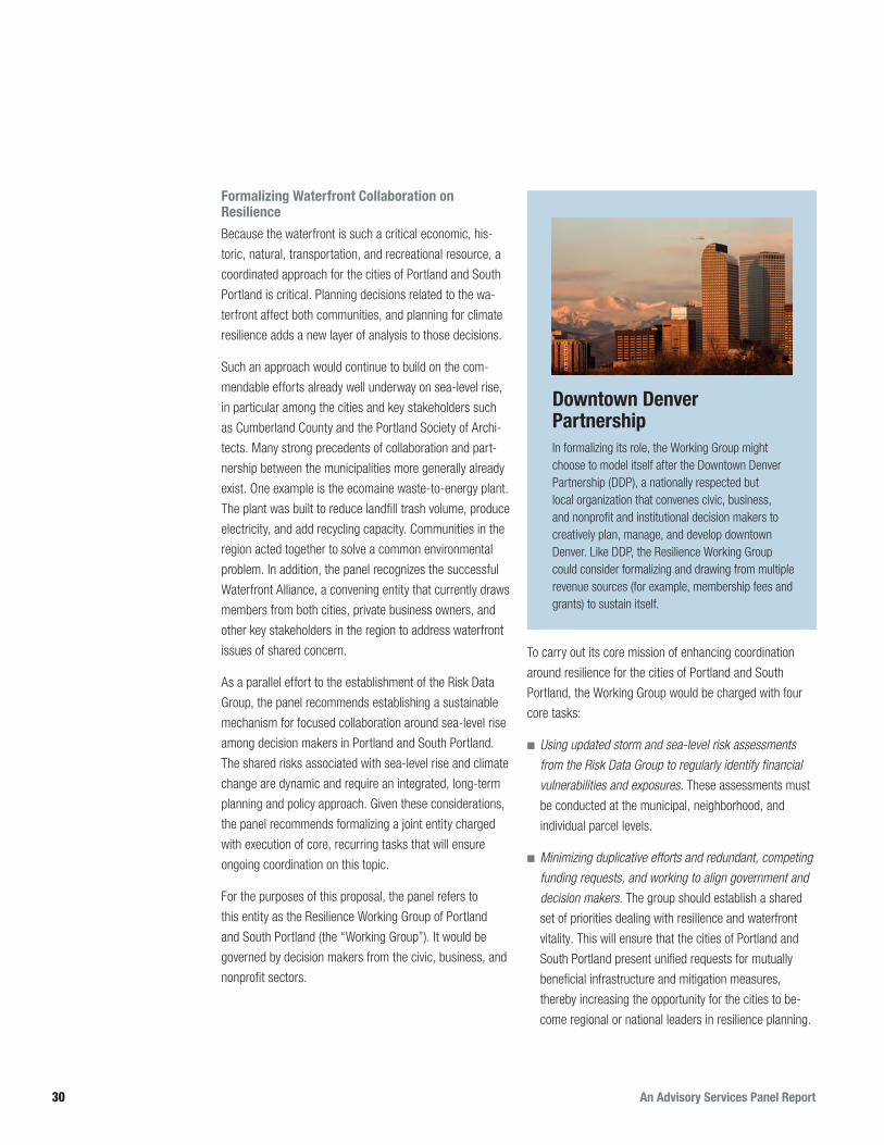
An Advisory Services Panel Report30
Formalizing Waterfront Collaboration on Resilience
Because the waterfront is such a critical economic, his-
toric, natural, transportation, and recreational resource, a
coordinated approach for the cities of Portland and South
Portland is critical. Planning decisions related to the wa-
terfront affect both communities, and planning for climate
resilience adds a new layer of analysis to those decisions.
Such an approach would continue to build on the com-
mendable efforts already well underway on sea-level rise,
in particular among the cities and key stakeholders such
as Cumberland County and the Portland Society of Archi-
tects. Many strong precedents of collaboration and part-
nership between the municipalities more generally already
exist. One example is the ecomaine waste-to-energy plant.
The plant was built to reduce landfill trash volume, produce
electricity, and add recycling capacity. Communities in the
region acted together to solve a common environmental
problem. In addition, the panel recognizes the successful
Waterfront Alliance, a convening entity that currently draws
members from both cities, private business owners, and
other key stakeholders in the region to address waterfront
issues of shared concern.
As a parallel effort to the establishment of the Risk Data
Group, the panel recommends establishing a sustainable
mechanism for focused collaboration around sea-level rise
among decision makers in Portland and South Portland.
The shared risks associated with sea-level rise and climate
change are dynamic and require an integrated, long-term
planning and policy approach. Given these considerations,
the panel recommends formalizing a joint entity charged
with execution of core, recurring tasks that will ensure
ongoing coordination on this topic.
For the purposes of this proposal, the panel refers to
this entity as the Resilience Working Group of Portland
and South Portland (the “Working Group”). It would be
governed by decision makers from the civic, business, and
nonprofit sectors.
To carry out its core mission of enhancing coordination
around resilience for the cities of Portland and South
Portland, the Working Group would be charged with four
core tasks:
■■ Using updated storm and sea-level risk assessments from the Risk Data Group to regularly identify financial vulnerabilities and exposures. These assessments must
be conducted at the municipal, neighborhood, and
individual parcel levels.
■■ Minimizing duplicative efforts and redundant, competing funding requests, and working to align government and decision makers. The group should establish a shared
set of priorities dealing with resilience and waterfront
vitality. This will ensure that the cities of Portland and
South Portland present unified requests for mutually
beneficial infrastructure and mitigation measures,
thereby increasing the opportunity for the cities to be-
come regional or national leaders in resilience planning.
Downtown Denver PartnershipIn formalizing its role, the Working Group might choose to model itself after the Downtown Denver Partnership (DDP), a nationally respected but local organization that convenes civic, business, and nonprofit and institutional decision makers to creatively plan, manage, and develop downtown Denver. Like DDP, the Resilience Working Group could consider formalizing and drawing from multiple revenue sources (for example, membership fees and grants) to sustain itself.
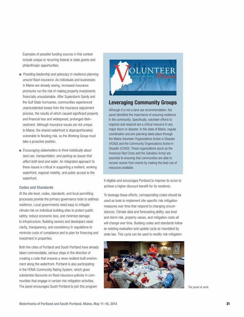
Waterfronts of Portland and South Portland, Maine, May 11–16, 2014 31
Examples of possible funding sources in this context
include unique or recurring federal or state grants and
philanthropic opportunities.
■■ Providing leadership and advocacy in resilience planning around flood insurance. As individuals and businesses
in Maine are already seeing, increased insurance
premiums run the risk of making property investments
financially unsustainable. After Superstorm Sandy and
the Gulf State hurricanes, communities experienced
unprecedented losses from the insurance adjustment
process, the results of which caused significant property
and financial loss and widespread, prolonged disin-
vestment. Although insurance issues are not unique
to Maine, the shared waterfront is disproportionately
vulnerable to flooding risk, so the Working Group must
take a proactive position.
■■ Encouraging stakeholders to think holistically about land use, transportation, and parking as issues that affect both land and water. An integrated approach to
these issues is critical in supporting a resilient, working
waterfront, regional mobility, and public access to the
waterfront.
Codes and Standards
At the site level, codes, standards, and local permitting
processes provide the primary governance tools to address
resilience. Local governments need ways to mitigate
climate risk on individual building sites to protect public
safety, reduce economic loss, and minimize damage
to infrastructure. Building owners and developers need
clarity, transparency, and consistency in regulations to
minimize costs of compliance and to plan for financing and
investment in properties.
Both the cities of Portland and South Portland have already
taken commendable, serious steps in the direction of
creating a code that ensures a more resilient built environ-
ment along the waterfront. Portland is also participating
in the FEMA Community Rating System, which gives
substantial discounts on flood insurance policies in com-
munities that engage in certain risk mitigation activities.
The panel encourages South Portland to join this program
if eligible and encourages Portland to improve its score to
achieve a higher discount benefit for its residents.
To leverage these efforts, corresponding codes should be
used as tools to implement site-specific risk mitigation
measures over time that respond to changing circum-
stances. Climate data and forecasting ability, sea level
and storm risk, property values, and mitigation costs all
will change over time. Building codes and standards follow
an existing evaluation and update cycle as mandated by
state law. This cycle can be used to modify risk mitigation
The panel at work.
Leveraging Community GroupsAlthough it is not a land use recommendation, the panel identified the importance of ensuring resilience in the community. Specifically, volunteer efforts to organize and respond are a critical resource in any major storm or disaster. In the state of Maine, regular coordination and pre-planning takes place through the Maine Volunteer Organizations Active in Disaster (VOAD) and the Community Organizations Active in Disaster (COAD). These organizations (such as the American Red Cross and the Salvation Army) are essential to ensuring that communities are able to recover sooner from events by making the best use of resources available.

An Advisory Services Panel Report32
and management as the Risk Data Group’s understanding
evolves and as property values and mitigation strategies
and technologies change. These tools can also serve to
mitigate insurance premiums, business continuity con-
cerns, and other development risks.
Energy Benchmarking
In the United States, buildings account for 36 percent
of total energy use and 30 percent of greenhouse gas
emissions. Many cities choose to pursue citywide energy
benchmarking as a tool to lower energy use, meet climate
mitigation goals, or reduce greenhouse gas emissions.
Benchmarking involves tracking and reporting energy use,
which is then normalized for building size, type, number of
occupants, and other factors. The most common tool used
for benchmarking is the free Portfolio Manager, developed
by the U.S. Environmental Protection Agency through its
EnergyStar program. Benchmarking shows how buildings
use and waste energy and helps identify opportunities
to lower energy costs and improve building operations.
Buildings with more efficient envelopes are more resilient
to heat and cold stress during energy outages. When ef-
ficiency is combined with renewables and energy storage,
buildings can also be resilient to grid outages and business
interruptions—one of the largest sources of claims in
extreme weather events.
Energy benchmarking precedents have already been
adopted in a number of cities, such as Boston, Chicago,
Denver, New York, Philadelphia, San Francisco, and
Seattle. The panel recommends that Portland and South
Portland consider adopting a benchmarking and disclo-
sure requirement as a step to identifying opportunities for
energy efficiency and demand reduction as strategies for
resilience. The cities should lead by first benchmarking
and reporting on their own buildings.
Historic Preservation
Both Portland and South have a multitude of unique and
treasured historic resources at varying levels of protec-
tion and condition. Greater Portland Landmarks is as an
existing regional entity advocating for the protection and
revitalization of these valuable treasures. According to
the City of Portland Department of Planning, Portland has
eight historic districts and about 60 designated landmarks.
To appropriately prepare Portland’s and South Portland’s
designated and nondesignated historic buildings for the
impacts of sea-level rise and climate change, a compre-
hensive inventory must be completed. Within the inventory,
each individual building should be assigned a priority level
based on an evaluation of intactness, integrity, existing
landmark status, flood/sea-level rise risk level, and other
relevant factors. The priority level will determine how much
and what kind of intervention is acceptable or warranted.
For example, one of the 60 designated landmarks in a
moderate risk area might use flood protection measures
only during a flood event, with minimal impact to the
historic features by creating positive drainage to encour-
age water to flow away from the building or installing small
floodwalls to protect openings to mitigate flood damage. In
contrast, an undesignated historic building in a high-risk
Annapolis Historic Preservation DistrictThe city of Annapolis, Maryland, has been a leader in applying resilience planning to historic preservation. The community went through a process to identify the hazards that affect the community and to determine hazard-prone areas and the magnitude of each hazard. Then an inventory of vulnerable historic and cultural resources was created, and preservation priorities were established. Finally, the amount of potential losses was estimated. This information was used to develop a strategy to provide the optimal protection of historic and cultural resources in the community.

Waterfronts of Portland and South Portland, Maine, May 11–16, 2014 33
area may provide an opportunity to explore innovative
flood and sea-level rise mitigation strategies as well as
more visually invasive, but often necessary, strategies: for
example, relocation of the building to a less threatened
location, or an amphibious retrofit to allow the building to
float when it floods. Instituting innovative and creative ap-
proaches to flood-proofing historic buildings in this context
has the opportunity to push the national debate forward
around historic buildings and flooding.
RecommendationsAs local governments work to understand how to contend
with the consequences of sea-level rise, storm events, and
ocean warming and acidification, sustained coordination
across municipalities and sectors to leverage expertise and
core competencies has value. Following is a summary of
the panel’s recommendations for this section:
■■ Create a Risk Data Group. The Risk Data Group, a
neutral, nonregulatory entity, would be charged with
obtaining recurring, accurate scientific data around
sea-level rise and likelihood of severe storm events and
other climate risks. The Risk Data Group would serve as
the clearinghouse for this information and be respon-
sible for disseminating it.
■■ Create a Resilience Working Group. Using information
gathered by the Risk Data Group, the Resilience Work
Group would
■● Develop risk assessments to understand potential
economic exposure of the waterfront to climate risk;
■● Coordinate and prioritize regional funding and
planning needs to mitigate waterfront exposures to
climate risks;
■● Proactively organize stakeholders to address
insurance-related challenges for vulnerable water-
front properties; and
■● Provide strategic guidance on transportation, mobil-
ity, public access, and land use issues that support a
vibrant, resilient waterfront.
■■ Improve codes and standards. Explore improving
development codes and standards to improve protection
against storm surge and sea-level rise, increase energy
efficiency, and protect historic resources. Consider
participating in and improving scores in the FEMA Com-
munity Rating System. Use education and outreach to
inform landowners and developers about the need for
resiliency in their plans and designs.

An Advisory Services Panel Report34
PORTLAND AND SOUTH PORTLAND have a unique
and precious asset in their waterfront. The two cities are
very different, but share many commonalities as part of a
Maine and Greater New England tradition. Although the ex-
act details of future risks caused by climate change are not
yet known, storm surge, flooding, changes in fisheries, and
extreme precipitation events clearly will play an increasing
role in the long-term ability for these communities to thrive.
The two cities should be commended for taking the initial
steps to understand and plan for a changing climate and
an uncertain future. After extensively touring the water-
front, consulting briefing documents from city staff, and
interviewing dozens of community stakeholders, the panel
makes the following key recommendations:
■■ Economy:
■● Ensure a resilient economy through additional
diversification.
■● Pursue incremental targeted development strategies
to improve resilience of marine and nonmarine uses
on the waterfront.
■■ Risk assessment:
■● Conduct a comprehensive risk assessment.
■■ Design strategies for the built environment:
■● Evaluate the feasibility of suggested design strate-
gies for several areas of priority focus.
■● Foster mixed-use development in keeping with the
history of the wharves but redefining what a working
waterfront means.
■■ Leadership and governance:
■● Create a Risk Data Group to monitor science and
data on risks and establish a shared understanding.
■● Create a Resilience Working Group to collaborate on
shared waterfront resource issues and conduct com-
prehensive risk assessments for waterfront parcels.
■● Explore using codes and standards to increase
protection against storm surge and sea-level rise,
increase energy efficiency, and protect historic
resources.
Conclusion
LIPO
FSKY

Waterfronts of Portland and South Portland, Maine, May 11–16, 2014 35
James M. DeFranciaPanel Chair Aspen, Colorado
DeFrancia is a principal of Lowe Enterprises Inc., a
national real estate development company engaged in
residential, commercial, and resort development activi-
ties, and president of that company’s national Community
Development division. He is also president of Weston
Capital Corporation, a privately held firm engaged in real
estate asset management and development on behalf of
private investors, banks, government agencies, and insur-
ance companies. Earlier, he held several positions with
ITT Corp., including president of its Levitt homebuilding
subsidiary in Puerto Rico and responsibility for the restruc-
turing and sale of ITT/Levitt’s international land assets.
Before joining ITT, DeFrancia held executive positions with
an international investment group in Venezuela. Prior to his
private sector experience, DeFrancia served as an officer
in the U.S. Navy. Posts included Naval Headquarters,
Saigon; aide to the commanding Rear Admiral NSC San
Diego; Office of the Chief of Naval Operations; and the U.S.
Embassy, Caracas, Venezuela.
He recently served as the receiver of the Dancing Bear
project in Aspen, as the receiver of Mountain Sage Town-
homes in Carbondale, Beaver Run Ranch in Pitkin County,
and as managing director for the corporate receiver of
Base Village in Snowmass, Colorado. DeFrancia also
served by British court appointment as the receiver and
manager of Shanghai Links Executive Community Inc.,
a British company holding land use rights in China and
actively engaged in community development in Shanghai.
He held a Resident Visa in China.
DeFrancia is a life trustee of the Urban Land Institute.
He is a past director of the National Association of Home
Builders, former Virginia representative to the Southern
Growth Policies Board, and former member of the Metro-
politan Washington Airports Authority Board. He served
as a member of the Defense Department’s Marsh Panel
and was appointed by the Secretary of Defense specifi-
cally to contribute residential development expertise in
restructuring the housing systems of the Department of
Defense. DeFrancia also served as a member of the Hous-
ing Advisory Group to the Committee on Banking, Finance
and Urban Affairs (U.S. House of Representatives), and
has been a guest lecturer or panelist for the Urban Land
Institute; the Bank Lending Institute; the Lincoln Institute
of Land Policy; the Graduate School of Design, Harvard
University; George Mason University; and the George
Washington University.
He recently served as an adviser to the secretary of the
Navy on maritime strategy in the Western Pacific, as well
as U.S. Navy energy policy, and was awarded the Navy’s
Distinguished Civilian Service medal for those efforts.
He has served as an adviser on growth and develop-
ment policies to the governments of Bermuda, Mexico,
the Netherlands, the United Kingdom, the United Arab
Emirates (Dubai), and Saudi Arabia, as well as the Vatican.
He has similarly advised several U.S. cities and the Port
Authority of New York and New Jersey. In addition, he has
been a contributing writer to publications on urban growth,
transportation, and real estate development.
DeFrancia is a graduate of the U.S. Naval Academy with
a degree in engineering and executive studies in business
and finance at the University of Michigan and the Wharton
School of the University of Pennsylvania.
About the Panel

An Advisory Services Panel Report36
Stephen M. AntupitSeattle, Washington
Antupit uses his 20-plus years of professional experience
as an urban strategies designer to help create socially
equitable and resilient communities. His expertise in
complex urban design, master planning, and private/public
partnership challenges (including the creation of mixed-
income transit communities) is highly respected. His grasp
of market challenges, regional and national policy issues
framing green infrastructure, and smart growth fuels his
consulting practice.
Antupit is a creative force in crafting unique “fun with a
purpose” events that invite people to explore civic and
environmental issues. He is equally skilled in navigating
among officials, community leaders, and various media
and engagement platforms. Currently Antupit is “playing
with food” to create partnerships, projects, and interven-
tions that nurture connectedness and grow delicious green
infrastructure. In relocalizing and making more resilient
urban food systems, Antupit’s goal is to leverage food’s
real power to feed cities that are more shareable.
He cofounded CityLab7, an innovative “do tank” commit-
ted to connecting people through tactical urbanism. He
previously led green urbanism and strategic brand efforts
at Mithun. For more than a decade, Antupit held leadership
positions in all aspects of urban design and mixed-income
redevelopment in local planning and development agen-
cies. He is a consulting partner to Fish to Water and serves
as an expert panelist for the Urban Land Institute.
Corinne Packard BeasleyNew York, New York
Beasley is a clinical assistant professor at the New York
University Schack Institute of Real Estate and brings expe-
rience in both government and private development to her
teaching, which is focused on public/private development
and postcatastrophe reconstruction. She has led students
on projects related to the reconstruction efforts after
Superstorm Sandy in New York City, the Haiti earthquake
of January 2010, the Chile earthquake in 2011, and the
post-tsunami and postwar reconstruction in Sri Lanka.
She is the former vice president of development at the
Hudson Yards Development Corporation, which is the city
entity charged with spearheading the implementation of
the Hudson Yards development program. Before work-
ing there, Beasley was a vice president of the Financial
Services division of the New York City Economic Develop-
ment Corporation (NYCEDC), where she structured city
incentives and discretionary capital investments in real
estate and economic development projects throughout the
five boroughs, including Atlantic Yards and Coney Island.
Before joining NYCEDC, she worked in real estate finance
at Capital Trust and in real estate acquisitions at Heitman.
Beasley has been part of the Clinton Global Initiative Haiti
Action Network and the working group on Resilient Com-
munities and is a member of the Regional Post Disaster
Housing and Sheltering Planning Team, led by the city’s
Office of Emergency Management. She was named the
cochair of ULI’s Post-Sandy Task Force in January 2013.
She graduated from the University of Pennsylvania with
a BA in urban studies and real estate development and a
master’s degree in city planning.
Dennis CarlbergBoston, Massachusetts
Carlberg is Boston University’s first sustainability director.
Under his leadership the university is now recognized as
a green university by the Princeton Review, U.S. Green
Building Council, and Sierra Club, as a result of reducing
its greenhouse gas emissions by 21 percent, energy use
intensity by 19 percent, water consumption by 11 percent,
and waste by 12 percent—all despite 14 percent campus
growth since 2006. At Boston University, Carlberg col-
laborates with campus stakeholders to develop and imple-
ment a broad-based sustainability strategy to integrate
sustainability into the culture and operational functions
of the university. This program addresses 18 issue areas
from climate and energy to waste reduction and com-

Waterfronts of Portland and South Portland, Maine, May 11–16, 2014 37
munity engagement. He spearheaded the effort to prepare
the university for the impacts of climate change and is a
member of the Climate Ready BU Task Force currently
conducting a vulnerability assessment for rising seas,
higher temperatures, and stronger winds.
An architect and a LEED Accredited Professional, Carlberg
has more than 25 years of architectural experience. Before
joining Boston University in 2009, he was a principal at
Arrowstreet, a Boston-based architectural firm where he
focused on sustainable design. His work received Silver
at the International Awards for Livable Communities for
the Urridaholt Masterplan in Gardabaer, Iceland, a Boston
Society of Architects Urban Design Citation in Urban
Design for the Urridaholt Masterplan, and a BSA Unbuilt
Architecture Citation for Design Wind Train.
Carlberg began his career at the Solar Energy Research
Institute (now NREL) and Lawrence Berkeley Laboratory
(now LBNL), conducting daylighting research to reduce
building energy consumption and improve the indoor
environment.
He cochairs the Urban Land Institute Boston’s Sustain-
ability Council and Sea-Level Rise Committee, which has
convened five events on climate preparedness since 2011,
including a daylong collaboration with Ceres on the finan-
cial and insurance industry response to climate risk. In
addition, he is active in several Boston area sustainability
organizations: City of Boston Green Ribbon Commission’s
Higher Education and Climate Preparedness Working
Groups; Metropolitan Area Planning Council’s Regional
Climate Change Adaptation Strategy Advisory Committee;
and Boston Museum of Science’s Environmental Sus-
tainability Committee. Carlberg is also a member of the
Sustainability Tracking, Assessment, and Rating System
(STARS) Steering Committee at the Association for the
Advancement of Sustainability in Higher Education.
He received his master of architecture degree from the
Massachusetts Institute of Technology where he was
awarded the AIA Gold Medal. He received his bachelor
of arts in architecture from the University of California,
Berkeley.
Jessica PavoneNew York, New York
Pavone serves as the senior director for long-term Sandy
recovery for New York state at the American Red Cross.
She leads a team of 60 that supports all New York state
Sandy-impacted communities in their recovery through
granting, case management, and community outreach.
An urban planner who completed her master’s degree
at New York University’s Wagner School in 2002, until
Sandy, Pavone’s primary focus was overseeing large-scale
economic development and land use planning initiatives in
Queens, Brooklyn, Manhattan, and Denver.
Immediately before her current role with the Red Cross,
Pavone served as an assistant vice president with the
New York City Economic Development Corporation, where
she directed $90 million in transportation initiatives in the
Jamaica, Queens, business district, resulting in the 2013
completion in of a $19 million construction project. She
also led multiple urban design initiatives in Lower Manhat-
tan and Brooklyn.
When Sandy hit, Pavone used her knowledge of southeast
Queens to support business recovery within affected
communities in Queens and to contribute to the Special
Initiative for Rebuilding and Resiliency report in 2013,
during Mayor Bloomberg’s administration. She seized the
opportunity to do mission-based work with the Red Cross
and to shift her career focus toward supporting individuals
and communities throughout New York state on their paths
to both recover and become more resilient after Super-
storm Sandy.
Byron StiggeNew York, New York
Stigge is a director at Level Agency for Infrastructure. As
a global thought leader for urban infrastructure plan-
ning, sustainability, and resilience, he has a passion for
understanding technical aspects of how cities function
and the impact infrastructure can have on everyday lives.

An Advisory Services Panel Report38
He studies and practices innovative methods of delivering
energy and climate change planning, water and waste-
water management, transportation planning, and solid
waste management through an integrated design process.
He founded Level to be a specialist consulting firm that
provides technical and planning advice for development
projects with grand aspirations to address climate change,
resilience, economic justice, and environmental protection
in cities.
For the past 15 years, Stigge has been creating sustain-
able infrastructure plans for large-scale development
projects throughout the United States and for cities in more
than 20 countries around the world. Since Superstorm
Sandy hit New York City in 2012, he has spoken, written,
and been deeply engaged in the long-term resilience
planning work for the region. Level has fully participated
with the U.S. Department of Housing and Urban Develop-
ment’s Rebuild by Design planning process in New York
City. Stigge has also been a participant in the Urban Land
Institute Post-Disaster Recovery Advisory Services Panel
and a juror for the FarRoc competition for resilient coastal
development.
Stigge is on the board of directors of the Forum and
Institute for Urban Design. He has lectured and taught
at Harvard Graduate School of Design, Massachusetts
Institute of Technology (MIT), Yale, Washington University
in St. Louis, and Columbia University. He earned dual
undergraduate degrees from Washington University in
St. Louis in civil engineering and architecture, a master
of building technology from MIT, and a master of design
studies in environmental planning from Harvard Graduate
School of Design.
Richard C. Ward St. Louis, Missouri
Ward Development Counsel was established in 2011
by Ward as a platform for engagement in real estate,
economic and community development, planning, and
counseling. Previously he managed the St. Louis office
of Zimmer Real Estate Services, where he was a vice
president and a member of its Development Manage-
ment Group. Before his work with Zimmer, Ward was the
founder and principal owner of Development Strategies
Inc., having led that firm to become a leading national
provider of planning and development advisory services.
Ward’s development planning and counseling services
focus on shaping and advising public/private ventures and
partnerships; project feasibility and strategy; strategic
planning and development team building and selection;
structuring incentive agreements between local govern-
ments and private investors; site selection, acquisition, and
entitlement strategies; urban and land use planning and
controls; and litigation support and expert testimony.
His development counseling and planning assignments
throughout the United States include the following:
downtown revitalization for eight major central cities and
an equal number of satellite central business districts;
more than a dozen urban medical centers and other major
institutions and corporate campuses, all with a focus on
stabilization and restoration of surrounding neighborhoods
and business and industrial districts; economic develop-
ment strategic and business plans on behalf of nearly 20
state, metropolitan regional, central city, urban county, and
major suburban economic development organizations; com-
prehensive planning, land use controls, and development
management on behalf of over 25 municipalities and coun-
ties; technology-focused economic development advisory
services in the St. Louis region leading to the successful
creation of two research parks, two high-tech incubators,
and target industry strategies; and economic, financial, and
market feasibility assessments for a wide array of private
and public real estate investments and ventures.
Ward has been a member of ULI for over 35 years; chaired
its St. Louis District Council, Small Scale Development
Council (Silver) and Public/Private Development Council
(blue); and served on 14 Advisory Services panels. He
served for 20 years on the board of directors of the Inter-
national Economic Development Council (IEDC). He is cer-
tified as an economic developer (CEcD with IEDC); urban
planner (AICP); Counselor of Real Estate; and commercial

Waterfronts of Portland and South Portland, Maine, May 11–16, 2014 39
real estate broker, state of Missouri. He received graduate
degrees in urban planning from Virginia Tech and in urban
design and business administration from Washington
University in St. Louis.
Jeana WiserLos Angeles, California
As associate project manager for the Preservation Green
Lab, Wiser plays a key role in research and policy initia-
tives that build upon the intersection of preservation
and sustainability. Some of her current work is with two
of the Green Lab’s primary programs: America Saves!
and the Partnership for Building Reuse, where she lends
her expertise in project management, collaboration with
academic partners, GIS mapping, data analysis, and
volunteer coordination. In addition, she manages the Green
Lab communications, with specific emphasis on translating
the work of the Green Lab to diverse audiences through a
variety of outlets.
Recently, she has become more involved with exploring the
relationship between older buildings and climate change
and the role of adaptation and resilience. This work is
currently being applied in Annapolis, Maryland, through
her participation on the National Trust’s National Treasure
team.
Before joining Preservation Green Lab in 2011, Wiser
attended the University of Washington in Seattle, earning
a master’s degree in urban planning and a certificate of
historic preservation. She is a member of the Association
of Preservation Technology’s Technical Committee on
Sustainable Preservation and the Urban Land Institute–
Los Angeles, and she serves on the Steering Committee
of a New Orleans–based nonprofit, Building Resilience
Workshop, that convenes diverse sets of stakeholders to
explore innovative strategies to build greater resilience
(both physical and social) in south Louisiana.


A ULI Advisory Services Panel Report
♼ Printed on recycled paper.
1025 Thomas Jefferson Street, NW Suite 500 West Washington, DC 20007-5201
Portland2014_cover.indd 1 9/26/14 1:41 PM