Waterford Estates and Heron Point Residential Jenkins ...
90
FORM-LBF-DXG t r o p e R ™ p a M s u i d a R R D E e h T 6 Armstrong Road, 4th floor Shelton, CT 06484 Toll Free: 800.352.0050 www.edrnet.com Waterford Estates and Heron Point Residential Jenkins Creek Road and Hudson Road Cambridge, MD 21613 Inquiry Number: 04249458.2r March 31, 2015
Transcript of Waterford Estates and Heron Point Residential Jenkins ...
FORM-LBF-DXG
tropeR ™paM suidaR RDE ehT
6 Armstrong Road, 4th floorShelton, CT 06484Toll Free: 800.352.0050www.edrnet.com
Waterford Estates and Heron Point ResidentialJenkins Creek Road and Hudson RoadCambridge, MD 21613
Inquiry Number: 04249458.2rMarch 31, 2015

SECTION PAGE
Executive Summary ES1
Overview Map 2
Detail Map 3
Map Findings Summary 4
Map Findings 7
Orphan Summary 15
Government Records Searched/Data Currency Tracking GR-1
GEOCHECK ADDENDUM
GeoCheck - Not Requested
TC04249458.2r Page 1
Thank you for your business.Please contact EDR at 1-800-352-0050
with any questions or comments.
Disclaimer - Copyright and Trademark NoticeThis Report contains certain information obtained from a variety of public and other sources reasonably available to Environmental DataResources, Inc. It cannot be concluded from this Report that coverage information for the target and surrounding properties does not exist fromother sources. NO WARRANTY EXPRESSED OR IMPLIED, IS MADE WHATSOEVER IN CONNECTION WITH THIS REPORT. ENVIRONMENTALDATA RESOURCES, INC. SPECIFICALLY DISCLAIMS THE MAKING OF ANY SUCH WARRANTIES, INCLUDING WITHOUT LIMITATION,MERCHANTABILITY OR FITNESS FOR A PARTICULAR USE OR PURPOSE. ALL RISK IS ASSUMED BY THE USER. IN NO EVENT SHALLENVIRONMENTAL DATA RESOURCES, INC. BE LIABLE TO ANYONE, WHETHER ARISING OUT OF ERRORS OR OMISSIONS, NEGLIGENCE,ACCIDENT OR ANY OTHER CAUSE, FOR ANY LOSS OF DAMAGE, INCLUDING, WITHOUT LIMITATION, SPECIAL, INCIDENTAL,CONSEQUENTIAL, OR EXEMPLARY DAMAGES. ANY LIABILITY ON THE PART OF ENVIRONMENTAL DATA RESOURCES, INC. IS STRICTLYLIMITED TO A REFUND OF THE AMOUNT PAID FOR THIS REPORT. Purchaser accepts this Report "AS IS". Any analyses, estimates, ratings,environmental risk levels or risk codes provided in this Report are provided for illustrative purposes only, and are not intended to provide, norshould they be interpreted as providing any facts regarding, or prediction or forecast of, any environmental risk for any property. Only a Phase IEnvironmental Site Assessment performed by an environmental professional can provide information regarding the environmental risk for anyproperty. Additionally, the information provided in this Report is not to be construed as legal advice.
Copyright 2015 by Environmental Data Resources, Inc. All rights reserved. Reproduction in any media or format, in wholeor in part, of any report or map of Environmental Data Resources, Inc., or its affiliates, is prohibited without prior written permission.EDR and its logos (including Sanborn and Sanborn Map) are trademarks of Environmental Data Resources, Inc. or its affiliates. All othertrademarks used herein are the property of their respective owners.
TABLE OF CONTENTS

EXECUTIVE SUMMARY
TC04249458.2r EXECUTIVE SUMMARY 1
A search of available environmental records was conducted by Environmental Data Resources, Inc (EDR).The report was designed to assist parties seeking to meet the search requirements of EPA’s Standardsand Practices for All Appropriate Inquiries (40 CFR Part 312), the ASTM Standard Practice forEnvironmental Site Assessments (E 1527-13) or custom requirements developed for the evaluation ofenvironmental risk associated with a parcel of real estate.
TARGET PROPERTY INFORMATION
ADDRESS
JENKINS CREEK ROAD AND HUDSON ROADDORCHESTER County, MD 21613
COORDINATES
38.5714000 - 38˚ 34’ 17.04’’Latitude (North): 76.0997000 - 76˚ 5’ 58.92’’Longitude (West): Zone 18Universal Tranverse Mercator: 404199.5UTM X (Meters): 4269582.5UTM Y (Meters): 10 ft. above sea levelElevation:
USGS TOPOGRAPHIC MAP ASSOCIATED WITH TARGET PROPERTY
38076-E1 CAMBRIDGE, MDTarget Property Map:1988Most Recent Revision:
AERIAL PHOTOGRAPHY IN THIS REPORT
20110727Portions of Photo from:USDASource:
TARGET PROPERTY SEARCH RESULTS
The target property was not listed in any of the databases searched by EDR.
DATABASES WITH NO MAPPED SITES
No mapped sites were found in EDR’s search of available ("reasonably ascertainable ") governmentrecords either on the target property or within the search radius around the target property for thefollowing databases:
STANDARD ENVIRONMENTAL RECORDS
Federal NPL site listNPL National Priority List

EXECUTIVE SUMMARY
TC04249458.2r EXECUTIVE SUMMARY 2
Proposed NPL Proposed National Priority List SitesNPL LIENS Federal Superfund Liens
Federal Delisted NPL site listDelisted NPL National Priority List Deletions
Federal CERCLIS listCERCLIS Comprehensive Environmental Response, Compensation, and Liability Information SystemFEDERAL FACILITY Federal Facility Site Information listing
Federal CERCLIS NFRAP site ListCERC-NFRAP CERCLIS No Further Remedial Action Planned
Federal RCRA CORRACTS facilities listCORRACTS Corrective Action Report
Federal RCRA non-CORRACTS TSD facilities listRCRA-TSDF RCRA - Treatment, Storage and Disposal
Federal RCRA generators listRCRA-LQG RCRA - Large Quantity GeneratorsRCRA-CESQG RCRA - Conditionally Exempt Small Quantity Generator
Federal institutional controls / engineering controls registriesUS ENG CONTROLS Engineering Controls Sites ListUS INST CONTROL Sites with Institutional ControlsLUCIS Land Use Control Information System
Federal ERNS listERNS Emergency Response Notification System
State- and tribal - equivalent CERCLISSHWS Notice of Potential Hazardous Waste Sites
State and tribal landfill and/or solid waste disposal site listsSWF/LF Permitted Solid Waste Disposal Facilities
State and tribal leaking storage tank listsINDIAN LUST Leaking Underground Storage Tanks on Indian Land
State and tribal registered storage tank listsAST Permitted Aboveground Storage TanksINDIAN UST Underground Storage Tanks on Indian Land

EXECUTIVE SUMMARY
TC04249458.2r EXECUTIVE SUMMARY 3
FEMA UST Underground Storage Tank Listing
State and tribal institutional control / engineering control registriesINST CONTROL Voluntary Cleanup Program Applicants/Participants
State and tribal voluntary cleanup sitesVCP Voluntary Cleanup Program Applicants/ParticipantsINDIAN VCP Voluntary Cleanup Priority Listing
State and tribal Brownfields sitesBROWNFIELDS Eligible Brownfields Properties
ADDITIONAL ENVIRONMENTAL RECORDS
Local Brownfield listsUS BROWNFIELDS A Listing of Brownfields Sites
Local Lists of Landfill / Solid Waste Disposal SitesDEBRIS REGION 9 Torres Martinez Reservation Illegal Dump Site LocationsODI Open Dump InventorySWRCY Recycling DirectoryINDIAN ODI Report on the Status of Open Dumps on Indian Lands
Local Lists of Hazardous waste / Contaminated SitesUS CDL Clandestine Drug LabsUS HIST CDL National Clandestine Laboratory Register
Local Land RecordsLIENS 2 CERCLA Lien Information
Records of Emergency Release ReportsHMIRS Hazardous Materials Information Reporting SystemSPILLS 90 SPILLS 90 data from FirstSearch
Other Ascertainable RecordsRCRA NonGen / NLR RCRA - Non Generators / No Longer RegulatedDOT OPS Incident and Accident DataDOD Department of Defense SitesFUDS Formerly Used Defense SitesCONSENT Superfund (CERCLA) Consent DecreesROD Records Of DecisionUMTRA Uranium Mill Tailings SitesUS MINES Mines Master Index FileTRIS Toxic Chemical Release Inventory SystemTSCA Toxic Substances Control Act
EXECUTIVE SUMMARY
TC04249458.2r EXECUTIVE SUMMARY 4
FTTS FIFRA/ TSCA Tracking System - FIFRA (Federal Insecticide, Fungicide, & Rodenticide Act)/TSCA (Toxic Substances Control Act)HIST FTTS FIFRA/TSCA Tracking System Administrative Case ListingSSTS Section 7 Tracking SystemsICIS Integrated Compliance Information SystemPADS PCB Activity Database SystemMLTS Material Licensing Tracking SystemRADINFO Radiation Information DatabaseFINDS Facility Index System/Facility Registry SystemRAATS RCRA Administrative Action Tracking SystemRMP Risk Management PlansUIC Underground Injection Wells DatabaseDRYCLEANERS Registered Drycleaning FacilitiesNPDES Wastewater Permit ListingAIRS Permit and Facility Information ListingLEAD Lead Inspection DatabaseINDIAN RESERV Indian ReservationsSCRD DRYCLEANERS State Coalition for Remediation of Drycleaners ListingFinancial Assurance Financial Assurance Information ListingPCB TRANSFORMER PCB Transformer Registration DatabaseCOAL ASH EPA Coal Combustion Residues Surface Impoundments ListLRP Land Restoration ProgramUS AIRS Aerometric Information Retrieval System Facility SubsystemUS FIN ASSUR Financial Assurance InformationEPA WATCH LIST EPA WATCH LISTCOAL ASH Coal Ash Disposal Site ListingLEAD SMELTERS Lead Smelter SitesPRP Potentially Responsible PartiesCOAL ASH DOE Steam-Electric Plant Operation Data2020 COR ACTION 2020 Corrective Action Program List
EDR HIGH RISK HISTORICAL RECORDS
EDR Exclusive RecordsEDR MGP EDR Proprietary Manufactured Gas PlantsEDR US Hist Auto Stat EDR Exclusive Historic Gas StationsEDR US Hist Cleaners EDR Exclusive Historic Dry Cleaners
EDR RECOVERED GOVERNMENT ARCHIVES
Exclusive Recovered Govt. ArchivesRGA LF Recovered Government Archive Solid Waste Facilities ListRGA HWS Recovered Government Archive State Hazardous Waste Facilities ListRGA LUST Recovered Government Archive Leaking Underground Storage Tank
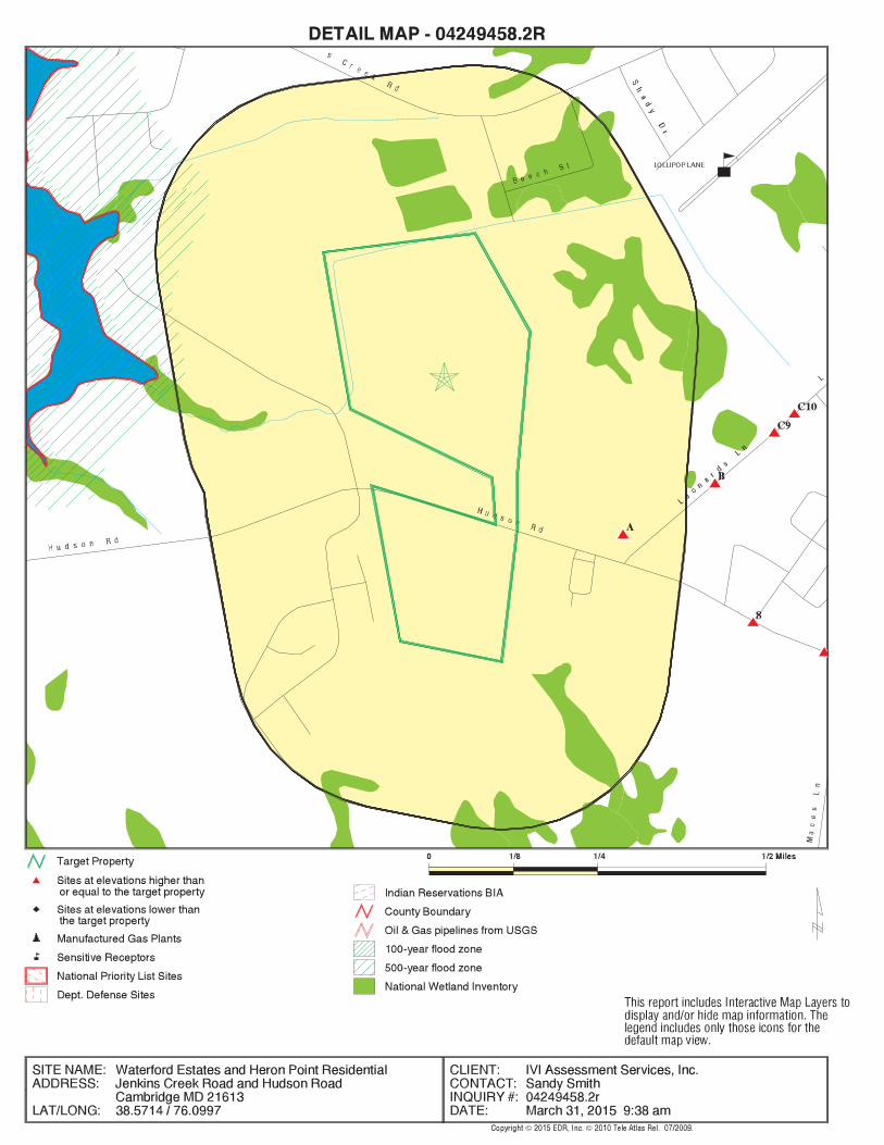
SURROUNDING SITES: SEARCH RESULTS
Surrounding sites were identified in the following databases.
Elevations have been determined from the USGS Digital Elevation Model and should be evaluated ona relative (not an absolute) basis. Relative elevation information between sites of close proximityshould be field verified. Sites with an elevation equal to or higher than the target property have beendifferentiated below from sites with an elevation lower than the target property.Page numbers and map identification numbers refer to the EDR Radius Map report where detaileddata on individual sites can be reviewed.
Sites listed in bold italics are in multiple databases.
Unmappable (orphan) sites are not considered in the foregoing analysis.
EXECUTIVE SUMMARY
TC04249458.2r EXECUTIVE SUMMARY 5
STANDARD ENVIRONMENTAL RECORDS
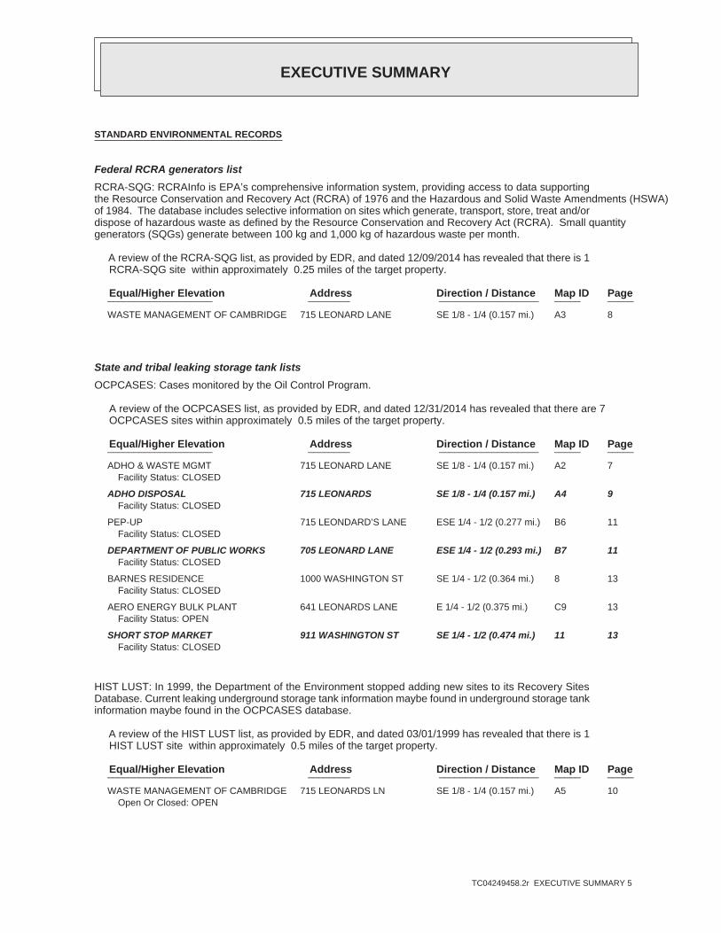
Federal RCRA generators listRCRA-SQG: RCRAInfo is EPA’s comprehensive information system, providing access to data supportingthe Resource Conservation and Recovery Act (RCRA) of 1976 and the Hazardous and Solid Waste Amendments (HSWA)of 1984. The database includes selective information on sites which generate, transport, store, treat and/ordispose of hazardous waste as defined by the Resource Conservation and Recovery Act (RCRA). Small quantitygenerators (SQGs) generate between 100 kg and 1,000 kg of hazardous waste per month.
A review of the RCRA-SQG list, as provided by EDR, and dated 12/09/2014 has revealed that there is 1 RCRA-SQG site within approximately 0.25 miles of the target property.
PageMap IDDirection / Distance Address Equal/Higher Elevation ____________________ ________ ___________________ _____ _____
WASTE MANAGEMENT OF CAMBRIDGE 715 LEONARD LANE SE 1/8 - 1/4 (0.157 mi.) A3 8
State and tribal leaking storage tank listsOCPCASES: Cases monitored by the Oil Control Program.
A review of the OCPCASES list, as provided by EDR, and dated 12/31/2014 has revealed that there are 7 OCPCASES sites within approximately 0.5 miles of the target property.
PageMap IDDirection / Distance Address Equal/Higher Elevation ____________________ ________ ___________________ _____ _____
ADHO & WASTE MGMT 715 LEONARD LANE SE 1/8 - 1/4 (0.157 mi.) A2 7Facility Status: CLOSED
ADHO DISPOSAL 715 LEONARDS SE 1/8 - 1/4 (0.157 mi.) A4 9Facility Status: CLOSED
PEP-UP 715 LEONDARD’S LANE ESE 1/4 - 1/2 (0.277 mi.) B6 11Facility Status: CLOSED
DEPARTMENT OF PUBLIC WORKS 705 LEONARD LANE ESE 1/4 - 1/2 (0.293 mi.) B7 11Facility Status: CLOSED
BARNES RESIDENCE 1000 WASHINGTON ST SE 1/4 - 1/2 (0.364 mi.) 8 13Facility Status: CLOSED
AERO ENERGY BULK PLANT 641 LEONARDS LANE E 1/4 - 1/2 (0.375 mi.) C9 13Facility Status: OPEN
SHORT STOP MARKET 911 WASHINGTON ST SE 1/4 - 1/2 (0.474 mi.) 11 13Facility Status: CLOSED
HIST LUST: In 1999, the Department of the Environment stopped adding new sites to its Recovery SitesDatabase. Current leaking underground storage tank information maybe found in underground storage tankinformation maybe found in the OCPCASES database.
A review of the HIST LUST list, as provided by EDR, and dated 03/01/1999 has revealed that there is 1 HIST LUST site within approximately 0.5 miles of the target property.
PageMap IDDirection / Distance Address Equal/Higher Elevation ____________________ ________ ___________________ _____ _____
WASTE MANAGEMENT OF CAMBRIDGE 715 LEONARDS LN SE 1/8 - 1/4 (0.157 mi.) A5 10Open Or Closed: OPEN
EXECUTIVE SUMMARY
TC04249458.2r EXECUTIVE SUMMARY 6
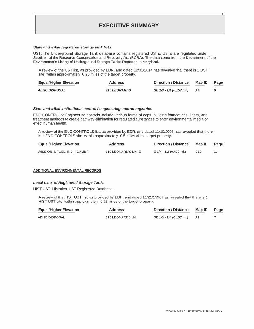
State and tribal registered storage tank listsUST: The Underground Storage Tank database contains registered USTs. USTs are regulated underSubtitle I of the Resource Conservation and Recovery Act (RCRA). The data come from the Department of theEnvironment’s Listing of Underground Storage Tanks Reported in Maryland.
A review of the UST list, as provided by EDR, and dated 12/31/2014 has revealed that there is 1 UST site within approximately 0.25 miles of the target property.
PageMap IDDirection / Distance Address Equal/Higher Elevation ____________________ ________ ___________________ _____ _____
ADHO DISPOSAL 715 LEONARDS SE 1/8 - 1/4 (0.157 mi.) A4 9
State and tribal institutional control / engineering control registriesENG CONTROLS: Engineering controls include various forms of caps, building foundations, liners, andtreatment methods to create pathway elimination for regulated substances to enter environmental media oreffect human health.
A review of the ENG CONTROLS list, as provided by EDR, and dated 11/10/2008 has revealed that there is 1 ENG CONTROLS site within approximately 0.5 miles of the target property.
PageMap IDDirection / Distance Address Equal/Higher Elevation ____________________ ________ ___________________ _____ _____
WISE OIL & FUEL, INC. - CAMBRI 619 LEONARD’S LANE E 1/4 - 1/2 (0.402 mi.) C10 13
ADDITIONAL ENVIRONMENTAL RECORDS
Local Lists of Registered Storage TanksHIST UST: Historical UST Registered Database.
A review of the HIST UST list, as provided by EDR, and dated 11/21/1996 has revealed that there is 1 HIST UST site within approximately 0.25 miles of the target property.
PageMap IDDirection / Distance Address Equal/Higher Elevation ____________________ ________ ___________________ _____ _____
ADHO DISPOSAL 715 LEONARDS LN SE 1/8 - 1/4 (0.157 mi.) A1 7

EXECUTIVE SUMMARY
TC04249458.2r EXECUTIVE SUMMARY 7
Due to poor or inadequate address information, the following sites were not mapped. Count: 3 records.
Site Name Database(s)____________ ____________
UNIVERSITY OF MARYLAND/HORN POINT OCPCASESVEHICLE ACCIDENT OCPCASESHISTORIC AST SITE TAYLOR CONTRACTI OCPCASES

EDR Inc.EDR Inc.EDR Inc.EDR Inc.EDR Inc.EDR Inc.EDR Inc.EDR Inc.EDR Inc.EDR Inc.EDR Inc.EDR Inc.EDR Inc.EDR Inc.EDR Inc.EDR Inc.EDR Inc.EDR Inc.EDR Inc.EDR Inc.EDR Inc.EDR Inc.EDR Inc.EDR Inc.EDR Inc.EDR Inc.EDR Inc.EDR Inc.EDR Inc.EDR Inc.EDR Inc.EDR Inc.EDR Inc.EDR Inc.EDR Inc.EDR Inc.EDR Inc.EDR Inc.EDR Inc.EDR Inc.
EDR Inc.EDR Inc.EDR Inc.EDR Inc.EDR Inc.EDR Inc.EDR Inc.EDR Inc.EDR Inc.EDR Inc.EDR Inc.EDR Inc.EDR Inc.EDR Inc.EDR Inc.EDR Inc.EDR Inc.EDR Inc.EDR Inc.EDR Inc.EDR Inc.EDR Inc.EDR Inc.EDR Inc.EDR Inc.EDR Inc.EDR Inc.EDR Inc.EDR Inc.EDR Inc.EDR Inc.EDR Inc.EDR Inc.EDR Inc.EDR Inc.EDR Inc.EDR Inc.EDR Inc.EDR Inc.EDR Inc.

MAP FINDINGS SUMMARY
SearchTargetDistance Total
Database Property(Miles) < 1/8 1/8 - 1/4 1/4 - 1/2 1/2 - 1 > 1 Plotted
STANDARD ENVIRONMENTAL RECORDS
Federal NPL site list 0 NR 0 0 0 0 1.000NPL 0 NR 0 0 0 0 1.000Proposed NPL 0 NR NR NR NR NR TPNPL LIENS
Federal Delisted NPL site list 0 NR 0 0 0 0 1.000Delisted NPL
Federal CERCLIS list 0 NR NR 0 0 0 0.500CERCLIS 0 NR NR 0 0 0 0.500FEDERAL FACILITY
Federal CERCLIS NFRAP site List 0 NR NR 0 0 0 0.500CERC-NFRAP
Federal RCRA CORRACTS facilities list 0 NR 0 0 0 0 1.000CORRACTS
Federal RCRA non-CORRACTS TSD facilities list 0 NR NR 0 0 0 0.500RCRA-TSDF
Federal RCRA generators list 0 NR NR NR 0 0 0.250RCRA-LQG 1 NR NR NR 1 0 0.250RCRA-SQG 0 NR NR NR 0 0 0.250RCRA-CESQG
Federal institutional controls /engineering controls registries
0 NR NR 0 0 0 0.500US ENG CONTROLS 0 NR NR 0 0 0 0.500US INST CONTROL 0 NR NR 0 0 0 0.500LUCIS
Federal ERNS list 0 NR NR NR NR NR TPERNS
State- and tribal - equivalent CERCLIS 0 NR 0 0 0 0 1.000SHWS
State and tribal landfill and/orsolid waste disposal site lists
0 NR NR 0 0 0 0.500SWF/LF
State and tribal leaking storage tank lists 7 NR NR 5 2 0 0.500OCPCASES 1 NR NR 0 1 0 0.500HIST LUST 0 NR NR 0 0 0 0.500INDIAN LUST
State and tribal registered storage tank lists 1 NR NR NR 1 0 0.250UST
TC04249458.2r Page 4

MAP FINDINGS SUMMARY
SearchTargetDistance Total
Database Property(Miles) < 1/8 1/8 - 1/4 1/4 - 1/2 1/2 - 1 > 1 Plotted
0 NR NR NR 0 0 0.250AST 0 NR NR NR 0 0 0.250INDIAN UST 0 NR NR NR 0 0 0.250FEMA UST
State and tribal institutionalcontrol / engineering control registries
1 NR NR 1 0 0 0.500ENG CONTROLS 0 NR NR 0 0 0 0.500INST CONTROL
State and tribal voluntary cleanup sites 0 NR NR 0 0 0 0.500VCP 0 NR NR 0 0 0 0.500INDIAN VCP
State and tribal Brownfields sites 0 NR NR 0 0 0 0.500BROWNFIELDS
ADDITIONAL ENVIRONMENTAL RECORDS
Local Brownfield lists 0 NR NR 0 0 0 0.500US BROWNFIELDS
Local Lists of Landfill / SolidWaste Disposal Sites
0 NR NR 0 0 0 0.500DEBRIS REGION 9 0 NR NR 0 0 0 0.500ODI 0 NR NR 0 0 0 0.500SWRCY 0 NR NR 0 0 0 0.500INDIAN ODI
Local Lists of Hazardous waste /Contaminated Sites
0 NR NR NR NR NR TPUS CDL 0 NR NR NR NR NR TPUS HIST CDL
Local Lists of Registered Storage Tanks 1 NR NR NR 1 0 0.250HIST UST
Local Land Records 0 NR NR NR NR NR TPLIENS 2
Records of Emergency Release Reports 0 NR NR NR NR NR TPHMIRS 0 NR NR NR NR NR TPSPILLS 90
Other Ascertainable Records 0 NR NR NR 0 0 0.250RCRA NonGen / NLR 0 NR NR NR NR NR TPDOT OPS 0 NR 0 0 0 0 1.000DOD 0 NR 0 0 0 0 1.000FUDS 0 NR 0 0 0 0 1.000CONSENT 0 NR 0 0 0 0 1.000ROD
TC04249458.2r Page 5

MAP FINDINGS SUMMARY
SearchTargetDistance Total
Database Property(Miles) < 1/8 1/8 - 1/4 1/4 - 1/2 1/2 - 1 > 1 Plotted
0 NR NR 0 0 0 0.500UMTRA 0 NR NR NR 0 0 0.250US MINES 0 NR NR NR NR NR TPTRIS 0 NR NR NR NR NR TPTSCA 0 NR NR NR NR NR TPFTTS 0 NR NR NR NR NR TPHIST FTTS 0 NR NR NR NR NR TPSSTS 0 NR NR NR NR NR TPICIS 0 NR NR NR NR NR TPPADS 0 NR NR NR NR NR TPMLTS 0 NR NR NR NR NR TPRADINFO 0 NR NR NR NR NR TPFINDS 0 NR NR NR NR NR TPRAATS 0 NR NR NR NR NR TPRMP 0 NR NR NR NR NR TPUIC 0 NR NR NR 0 0 0.250DRYCLEANERS 0 NR NR NR NR NR TPNPDES 0 NR NR NR NR NR TPAIRS 0 NR NR NR NR NR TPLEAD 0 NR 0 0 0 0 1.000INDIAN RESERV 0 NR NR 0 0 0 0.500SCRD DRYCLEANERS 0 NR NR NR NR NR TPFinancial Assurance 0 NR NR NR NR NR TPPCB TRANSFORMER 0 NR NR 0 0 0 0.500COAL ASH EPA 0 NR NR 0 0 0 0.500LRP 0 NR NR NR NR NR TPUS AIRS 0 NR NR NR NR NR TPUS FIN ASSUR 0 NR NR NR NR NR TPEPA WATCH LIST 0 NR NR 0 0 0 0.500COAL ASH 0 NR NR NR NR NR TPLEAD SMELTERS 0 NR NR NR NR NR TPPRP 0 NR NR NR NR NR TPCOAL ASH DOE 0 NR NR NR 0 0 0.2502020 COR ACTION
EDR HIGH RISK HISTORICAL RECORDS
EDR Exclusive Records 0 NR 0 0 0 0 1.000EDR MGP 0 NR NR NR 0 0 0.250EDR US Hist Auto Stat 0 NR NR NR 0 0 0.250EDR US Hist Cleaners
EDR RECOVERED GOVERNMENT ARCHIVES
Exclusive Recovered Govt. Archives 0 NR NR NR NR NR TPRGA LF 0 NR NR NR NR NR TPRGA HWS 0 NR NR NR NR NR TPRGA LUST
NOTES:
TP = Target Property
NR = Not Requested at this Search Distance
Sites may be listed in more than one database
TC04249458.2r Page 6

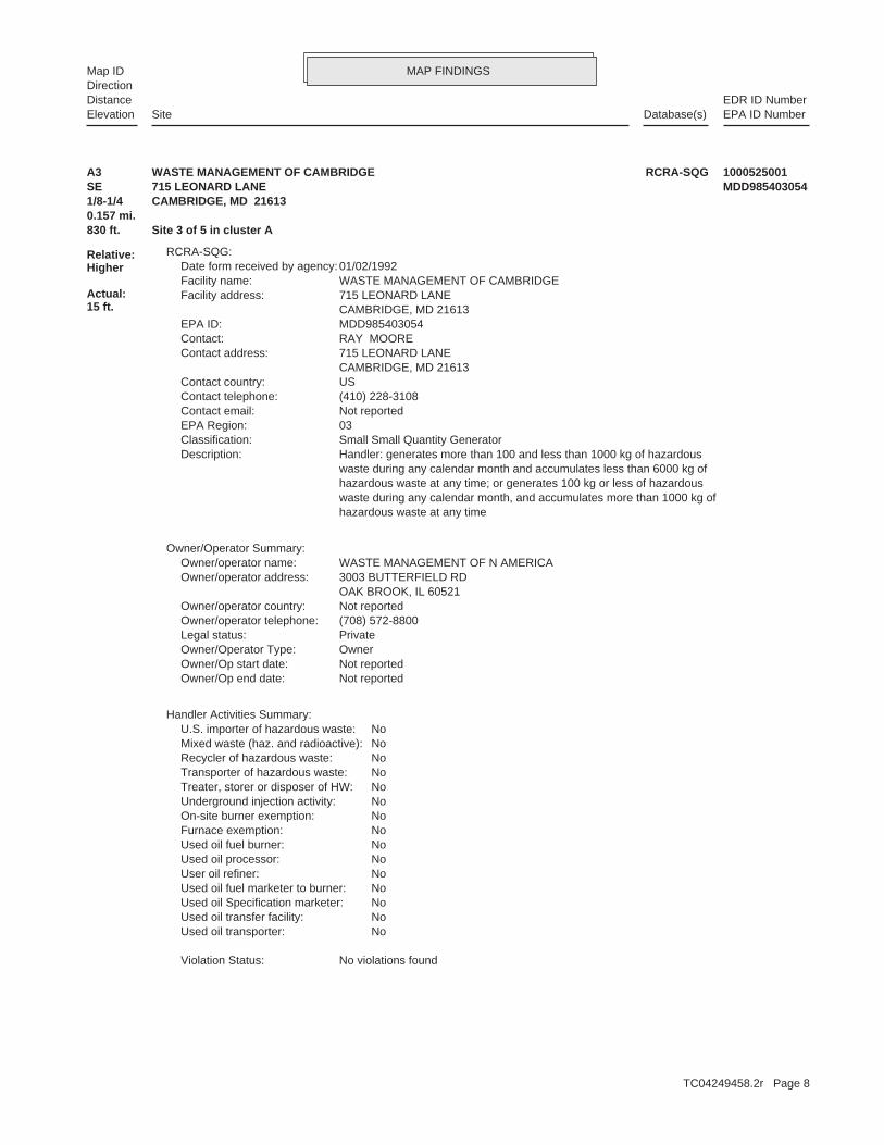
MAP FINDINGSMap IDDirection
EDR ID NumberDistanceEPA ID NumberDatabase(s)SiteElevation
Heating OilProduct:RemovedTank Status:1,000Capacity:9Age:004Tank ID:6005575Facility ID:
Used OilProduct:Permanently out of useTank Status:500Capacity:19Age:003Tank ID:6005575Facility ID:
GasolineProduct:RemovedTank Status:2,000Capacity:15Age:002Tank ID:6005575Facility ID:
DieselProduct:RemovedTank Status:10,000Capacity:15Age:001Tank ID:6005575Facility ID:
Historical UST:
830 ft. Site 1 of 5 in cluster A0.157 mi.
Relative:Higher
Actual:15 ft.
1/8-1/4 CAMBRIDGE, MD 21613SE 715 LEONARDS LN N/AA1 HIST USTADHO DISPOSAL S104637805
16799Registration Number: Not reportedCleanup: Not reportedRelease: 12/09/1992Date Closed: 05/14/1992Date Open: CLOSED/Facility Status/Code: 92-2369DOFacility ID:
OCPCASES:
830 ft. Site 2 of 5 in cluster A0.157 mi.
Relative:Higher
Actual:15 ft.
1/8-1/4 CAMBRIDGE, MD 21613SE 715 LEONARD LANE N/AA2 OCPCASESADHO & WASTE MGMT S104609305
TC04249458.2r Page 7
MAP FINDINGSMap IDDirection
EDR ID NumberDistanceEPA ID NumberDatabase(s)SiteElevation
No violations foundViolation Status:
NoUsed oil transporter: NoUsed oil transfer facility: NoUsed oil Specification marketer: NoUsed oil fuel marketer to burner: NoUser oil refiner: NoUsed oil processor: NoUsed oil fuel burner: NoFurnace exemption: NoOn-site burner exemption: NoUnderground injection activity: NoTreater, storer or disposer of HW: NoTransporter of hazardous waste: NoRecycler of hazardous waste: NoMixed waste (haz. and radioactive): NoU.S. importer of hazardous waste:
Handler Activities Summary:
Not reportedOwner/Op end date: Not reportedOwner/Op start date: OwnerOwner/Operator Type: PrivateLegal status: (708) 572-8800Owner/operator telephone: Not reportedOwner/operator country: OAK BROOK, IL 60521 3003 BUTTERFIELD RDOwner/operator address: WASTE MANAGEMENT OF N AMERICAOwner/operator name:
Owner/Operator Summary:
hazardous waste at any time waste during any calendar month, and accumulates more than 1000 kg of hazardous waste at any time; or generates 100 kg or less of hazardous waste during any calendar month and accumulates less than 6000 kg of Handler: generates more than 100 and less than 1000 kg of hazardousDescription: Small Small Quantity GeneratorClassification: 03EPA Region: Not reportedContact email: (410) 228-3108Contact telephone: USContact country: CAMBRIDGE, MD 21613 715 LEONARD LANEContact address: RAY MOOREContact: MDD985403054EPA ID: CAMBRIDGE, MD 21613 715 LEONARD LANEFacility address: WASTE MANAGEMENT OF CAMBRIDGEFacility name: 01/02/1992Date form received by agency:
RCRA-SQG:
830 ft. Site 3 of 5 in cluster A0.157 mi.
Relative:Higher
Actual:15 ft.
1/8-1/4 CAMBRIDGE, MD 21613SE 715 LEONARD LANE MDD985403054A3 RCRA-SQGWASTE MANAGEMENT OF CAMBRIDGE 1000525001
TC04249458.2r Page 8

MAP FINDINGSMap IDDirection
EDR ID NumberDistanceEPA ID NumberDatabase(s)SiteElevation
Asphalt Coated or Bare SteelTank Material Desc: 07/01/1983Date Intalled: ACompartment Compartment: FalseTank Compartment: GasolineSubstance Description: 2000Tank Capacity: Permanently Out of UseTank Status: 2Tank ID:
Bare or Galvanized SteelPipe Material Desc: Asphalt Coated or Bare SteelTank Material Desc: 01/01/1983Date Intalled: ACompartment Compartment: FalseTank Compartment: DieselSubstance Description: 10000Tank Capacity: Permanently Out of UseTank Status: 1Tank ID:
Tanks:
Bernard J. McHuch Jr.Owner Contact: (410) 228-3108Owner Phone: 21613Owner Zip: MDOwner State: CambridgeOwner City: 715 Leonards LaneOwner Address: Waste Management of Cambridge, Inc.Owner Name:
Owner:
11231Owner Id: 01/12/1994Form Date: Division PresidentForm Title: Bernard McHuch Jr.Form Name: Bernard McHuch Jr.Oper Name: 16799Facility Id:
UST:
16799Registration Number: YESCleanup: YESRelease: 11/28/2007Date Closed: 12/13/1993Date Open: CLOSED/Tank Closure - Motor/Lube OilFacility Status/Code: 94-1663DOFacility ID:
16799Registration Number: YESCleanup: YESRelease: 11/28/2007Date Closed: 12/13/1993Date Open: CLOSED/Tank Closure - Motor/Lube OilFacility Status/Code: 94-1663DOFacility ID:
OCPCASES:
830 ft. Site 4 of 5 in cluster A0.157 mi.
Relative:Higher
Actual:15 ft.
1/8-1/4 Financial AssuranceCAMBRIDGE, MD 21613SE UST715 LEONARDS N/AA4 OCPCASESADHO DISPOSAL U004066005
TC04249458.2r Page 9
MAP FINDINGSMap IDDirection
EDR ID NumberDistanceEPA ID NumberDatabase(s)SiteElevation
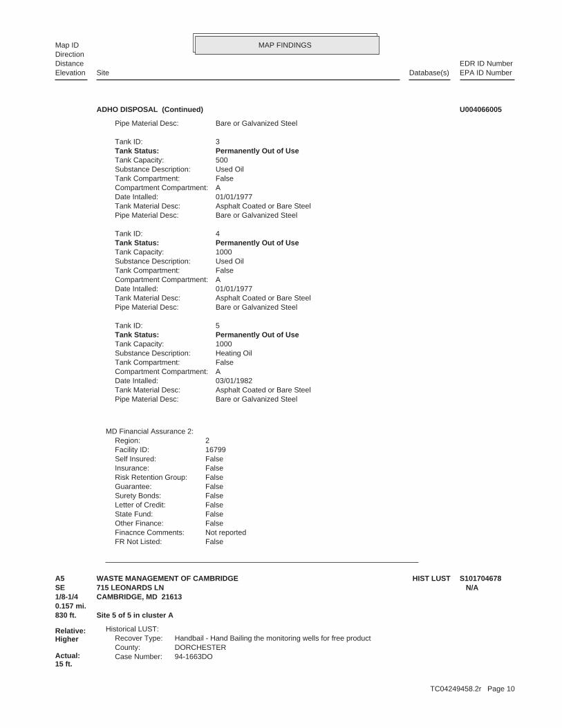
FalseFR Not Listed: Not reportedFinacnce Comments: FalseOther Finance: FalseState Fund: FalseLetter of Credit: FalseSurety Bonds: FalseGuarantee: FalseRisk Retention Group: FalseInsurance: FalseSelf Insured: 16799Facility ID: 2Region:
MD Financial Assurance 2:
Bare or Galvanized SteelPipe Material Desc: Asphalt Coated or Bare SteelTank Material Desc: 03/01/1982Date Intalled: ACompartment Compartment: FalseTank Compartment: Heating OilSubstance Description: 1000Tank Capacity: Permanently Out of UseTank Status: 5Tank ID:
Bare or Galvanized SteelPipe Material Desc: Asphalt Coated or Bare SteelTank Material Desc: 01/01/1977Date Intalled: ACompartment Compartment: FalseTank Compartment: Used OilSubstance Description: 1000Tank Capacity: Permanently Out of UseTank Status: 4Tank ID:
Bare or Galvanized SteelPipe Material Desc: Asphalt Coated or Bare SteelTank Material Desc: 01/01/1977Date Intalled: ACompartment Compartment: FalseTank Compartment: Used OilSubstance Description: 500Tank Capacity: Permanently Out of UseTank Status: 3Tank ID:
Bare or Galvanized SteelPipe Material Desc:
ADHO DISPOSAL (Continued) U004066005
94-1663DOCase Number:DORCHESTERCounty:Handbail - Hand Bailing the monitoring wells for free productRecover Type:
Historical LUST:
830 ft. Site 5 of 5 in cluster A0.157 mi.
Relative:Higher
Actual:15 ft.
1/8-1/4 CAMBRIDGE, MD 21613SE 715 LEONARDS LN N/AA5 HIST LUSTWASTE MANAGEMENT OF CAMBRIDGE S101704678
TC04249458.2r Page 10

MAP FINDINGSMap IDDirection
EDR ID NumberDistanceEPA ID NumberDatabase(s)SiteElevation
OPENOpen/Closed:
WASTE MANAGEMENT OF CAMBRIDGE (Continued) S101704678
16799Registration Number: YESCleanup: YESRelease: 02/24/2005Date Closed: 06/27/2002Date Open: CLOSED/Transfer Accident Motor/Lube OilFacility Status/Code: 02-1648DOFacility ID:
OCPCASES:
1463 ft. Site 1 of 2 in cluster B0.277 mi.
Relative:Higher
Actual:15 ft.
1/4-1/2 CAMBRIDGE, MD 21613ESE 715 LEONDARD’S LANE N/AB6 OCPCASESPEP-UP S105509525
Oden C. Wheeler, Jr.Owner Contact: (410) 228-1955Owner Phone: 21613Owner Zip: MDOwner State: CambridgeOwner City: P.O. Box 255Owner Address: Commissioners of CambridgeOwner Name:
Owner:
3541Owner Id: 03/23/2010Form Date: Eng. TecForm Title: Melvin "Zeke" WilleyForm Name: Not reportedOper Name: 14363Facility Id:
UST:
14363Registration Number: Not reportedCleanup: Not reportedRelease: 07/23/1992Date Closed: 02/20/1992Date Open: CLOSED/Facility Status/Code: 92-1827DOFacility ID:
14363Registration Number: YESCleanup: YESRelease: 02/07/2011Date Closed: 09/09/2010Date Open: CLOSED/DumpingFacility Status/Code: 11-0154DOFacility ID:
OCPCASES:
1549 ft. Site 2 of 2 in cluster B0.293 mi.
Relative:Higher
Actual:15 ft.
1/4-1/2 Financial AssuranceCAMBRIDGE, MD 21613ESE UST705 LEONARD LANE N/AB7 OCPCASESDEPARTMENT OF PUBLIC WORKS U003865889
TC04249458.2r Page 11

MAP FINDINGSMap IDDirection
EDR ID NumberDistanceEPA ID NumberDatabase(s)SiteElevation
FalseFR Not Listed: Not reportedFinacnce Comments: FalseOther Finance: FalseState Fund: FalseLetter of Credit: FalseSurety Bonds: FalseGuarantee: FalseRisk Retention Group: FalseInsurance: FalseSelf Insured: 14363Facility ID: 2Region:
MD Financial Assurance 2:
Bare or Galvanized SteelPipe Material Desc: Asphalt Coated or Bare SteelTank Material Desc: 03/01/1930Date Intalled: ACompartment Compartment: FalseTank Compartment: GasolineSubstance Description: 400Tank Capacity: Permanently Out Of UseTank Status: 4Tank ID:
Bare or Galvanized SteelPipe Material Desc: Asphalt Coated or Bare SteelTank Material Desc: 01/01/1985Date Intalled: ACompartment Compartment: FalseTank Compartment: GasolineSubstance Description: 1000Tank Capacity: Permanently Out of UseTank Status: 3Tank ID:
Bare or Galvanized SteelPipe Material Desc: Asphalt Coated or Bare SteelTank Material Desc: 01/01/1984Date Intalled: ACompartment Compartment: FalseTank Compartment: GasolineSubstance Description: 1000Tank Capacity: Permanently Out of UseTank Status: 2Tank ID:
Bare or Galvanized SteelPipe Material Desc: Asphalt Coated or Bare SteelTank Material Desc: 01/01/1984Date Intalled: ACompartment Compartment: FalseTank Compartment: DieselSubstance Description: 1000Tank Capacity: Permanently Out of UseTank Status: 1Tank ID:
Tanks:
DEPARTMENT OF PUBLIC WORKS (Continued) U003865889
TC04249458.2r Page 12

MAP FINDINGSMap IDDirection
EDR ID NumberDistanceEPA ID NumberDatabase(s)SiteElevation
N/ARegistration Number: YESCleanup: YESRelease: 03/26/2013Date Closed: 12/14/2012Date Open: CLOSED/Vehicle AccidentFacility Status/Code: 13-0361DOFacility ID:
OCPCASES:
1922 ft.0.364 mi.
Relative:Higher
Actual:15 ft.
1/4-1/2 CAMBRIDGE, MD 21613SE 1000 WASHINGTON ST N/A8 OCPCASESBARNES RESIDENCE S112833407
N/ARegistration Number: Not reportedCleanup: YESRelease: Not reportedDate Closed: 06/28/2012Date Open: OPEN/Aboveground Tank LeakFacility Status/Code: 12-0741DOFacility ID:
OCPCASES:
1978 ft. Site 1 of 2 in cluster C0.375 mi.
Relative:Higher
Actual:13 ft.
1/4-1/2 CAMBRIDGE, MD 21613East 641 LEONARDS LANE N/AC9 OCPCASESAERO ENERGY BULK PLANT S112012522
Poured Concrete WallMaterial:ENG CONTROLS:
2123 ft. Site 2 of 2 in cluster C0.402 mi.
Relative:Higher
Actual:13 ft.
1/4-1/2 DORCHESTER, MD 21613East 619 LEONARD’S LANE N/AC10 ENG CONTROLSWISE OIL & FUEL, INC. - CAMBRIDGE S109326101
3006241Facility ID:Historical UST:
8007Registration Number: NOCleanup: NORelease: 11/04/1998Date Closed: 09/08/1997Date Open: CLOSED/Tank Closure - Motor/Lube OilFacility Status/Code: 98-0573DOFacility ID:
OCPCASES:
2505 ft.0.474 mi.
Relative:Higher
Actual:13 ft.
1/4-1/2 CAMBRIDGE, MD 21613SE HIST UST911 WASHINGTON ST N/A11 OCPCASESSHORT STOP MARKET S104631361
TC04249458.2r Page 13

MAP FINDINGSMap IDDirection
EDR ID NumberDistanceEPA ID NumberDatabase(s)SiteElevation
DieselProduct:Currently in useTank Status:550Capacity:21Age:006Tank ID:3006241Facility ID:
KeroseneProduct:Currently in useTank Status:1,000Capacity:21Age:005Tank ID:3006241Facility ID:
GasolineProduct:Currently in useTank Status:4,000Capacity:21Age:004Tank ID:3006241Facility ID:
GasolineProduct:Currently in useTank Status:4,000Capacity:21Age:003Tank ID:3006241Facility ID:
GasolineProduct:Currently in useTank Status:4,000Capacity:21Age:002Tank ID:3006241Facility ID:
GasolineProduct:Currently in useTank Status:4,000Capacity:21Age:001Tank ID:
SHORT STOP MARKET (Continued) S104631361
TC04249458.2r Page 14

ORPHAN SUMMARY
City EDR ID Site Name Site Address Zip Database(s)
Count: 3 records.
CAMBRIDGE S104594897 UNIVERSITY OF MARYLAND/HORN POINT LOVERS LANE 21613 OCPCASESCAMBRIDGE S104601444 VEHICLE ACCIDENT MD RT 343 21613 OCPCASESCAMBRIDGE S111161765 HISTORIC AST SITE TAYLOR CONTRACTI WASHINGTON ST 21613 OCPCASES
TC04249458.2r Page 15
To maintain currency of the following federal and state databases, EDR contacts the appropriate governmental agencyon a monthly or quarterly basis, as required.
Number of Days to Update: Provides confirmation that EDR is reporting records that have been updated within 90 daysfrom the date the government agency made the information available to the public.
STANDARD ENVIRONMENTAL RECORDS
Federal NPL site list
NPL: National Priority ListNational Priorities List (Superfund). The NPL is a subset of CERCLIS and identifies over 1,200 sites for prioritycleanup under the Superfund Program. NPL sites may encompass relatively large areas. As such, EDR provides polygoncoverage for over 1,000 NPL site boundaries produced by EPA’s Environmental Photographic Interpretation Center(EPIC) and regional EPA offices.
Date of Government Version: 12/16/2014Date Data Arrived at EDR: 01/08/2015Date Made Active in Reports: 02/09/2015Number of Days to Update: 32
Source: EPATelephone: N/ALast EDR Contact: 01/08/2015Next Scheduled EDR Contact: 04/20/2015Data Release Frequency: Quarterly
NPL Site Boundaries
Sources:
EPA’s Environmental Photographic Interpretation Center (EPIC)Telephone: 202-564-7333
EPA Region 1 EPA Region 6Telephone 617-918-1143 Telephone: 214-655-6659
EPA Region 3 EPA Region 7Telephone 215-814-5418 Telephone: 913-551-7247
EPA Region 4 EPA Region 8Telephone 404-562-8033 Telephone: 303-312-6774
EPA Region 5 EPA Region 9Telephone 312-886-6686 Telephone: 415-947-4246
EPA Region 10Telephone 206-553-8665
Proposed NPL: Proposed National Priority List SitesA site that has been proposed for listing on the National Priorities List through the issuance of a proposed rulein the Federal Register. EPA then accepts public comments on the site, responds to the comments, and places onthe NPL those sites that continue to meet the requirements for listing.
Date of Government Version: 12/16/2014Date Data Arrived at EDR: 01/08/2015Date Made Active in Reports: 02/09/2015Number of Days to Update: 32
Source: EPATelephone: N/ALast EDR Contact: 01/08/2015Next Scheduled EDR Contact: 04/20/2015Data Release Frequency: Quarterly
NPL LIENS: Federal Superfund LiensFederal Superfund Liens. Under the authority granted the USEPA by CERCLA of 1980, the USEPA has the authorityto file liens against real property in order to recover remedial action expenditures or when the property ownerreceived notification of potential liability. USEPA compiles a listing of filed notices of Superfund Liens.
Date of Government Version: 10/15/1991Date Data Arrived at EDR: 02/02/1994Date Made Active in Reports: 03/30/1994Number of Days to Update: 56
Source: EPATelephone: 202-564-4267Last EDR Contact: 08/15/2011Next Scheduled EDR Contact: 11/28/2011Data Release Frequency: No Update Planned
TC04249458.2r Page GR-1
GOVERNMENT RECORDS SEARCHED / DATA CURRENCY TRACKING

Federal Delisted NPL site list
DELISTED NPL: National Priority List DeletionsThe National Oil and Hazardous Substances Pollution Contingency Plan (NCP) establishes the criteria that theEPA uses to delete sites from the NPL. In accordance with 40 CFR 300.425.(e), sites may be deleted from theNPL where no further response is appropriate.
Date of Government Version: 12/16/2014Date Data Arrived at EDR: 01/08/2015Date Made Active in Reports: 02/09/2015Number of Days to Update: 32
Source: EPATelephone: N/ALast EDR Contact: 01/08/2015Next Scheduled EDR Contact: 04/20/2015Data Release Frequency: Quarterly
Federal CERCLIS list
CERCLIS: Comprehensive Environmental Response, Compensation, and Liability Information SystemCERCLIS contains data on potentially hazardous waste sites that have been reported to the USEPA by states, municipalities,private companies and private persons, pursuant to Section 103 of the Comprehensive Environmental Response, Compensation,and Liability Act (CERCLA). CERCLIS contains sites which are either proposed to or on the National PrioritiesList (NPL) and sites which are in the screening and assessment phase for possible inclusion on the NPL.
Date of Government Version: 10/25/2013Date Data Arrived at EDR: 11/11/2013Date Made Active in Reports: 02/13/2014Number of Days to Update: 94
Source: EPATelephone: 703-412-9810Last EDR Contact: 02/27/2015Next Scheduled EDR Contact: 06/08/2015Data Release Frequency: Quarterly
FEDERAL FACILITY: Federal Facility Site Information listingA listing of National Priority List (NPL) and Base Realignment and Closure (BRAC) sites found in the ComprehensiveEnvironmental Response, Compensation and Liability Information System (CERCLIS) Database where EPA Federal FacilitiesRestoration and Reuse Office is involved in cleanup activities.
Date of Government Version: 07/21/2014Date Data Arrived at EDR: 10/07/2014Date Made Active in Reports: 10/20/2014Number of Days to Update: 13
Source: Environmental Protection AgencyTelephone: 703-603-8704Last EDR Contact: 01/09/2015Next Scheduled EDR Contact: 04/20/2015Data Release Frequency: Varies
Federal CERCLIS NFRAP site List
CERCLIS-NFRAP: CERCLIS No Further Remedial Action PlannedArchived sites are sites that have been removed and archived from the inventory of CERCLIS sites. Archived statusindicates that, to the best of EPA’s knowledge, assessment at a site has been completed and that EPA has determinedno further steps will be taken to list this site on the National Priorities List (NPL), unless information indicatesthis decision was not appropriate or other considerations require a recommendation for listing at a later time.This decision does not necessarily mean that there is no hazard associated with a given site; it only means that,based upon available information, the location is not judged to be a potential NPL site.
Date of Government Version: 10/25/2013Date Data Arrived at EDR: 11/11/2013Date Made Active in Reports: 02/13/2014Number of Days to Update: 94
Source: EPATelephone: 703-412-9810Last EDR Contact: 02/27/2015Next Scheduled EDR Contact: 06/08/2015Data Release Frequency: Quarterly
Federal RCRA CORRACTS facilities list
CORRACTS: Corrective Action ReportCORRACTS identifies hazardous waste handlers with RCRA corrective action activity.
TC04249458.2r Page GR-2
GOVERNMENT RECORDS SEARCHED / DATA CURRENCY TRACKING

Date of Government Version: 12/09/2014Date Data Arrived at EDR: 12/29/2014Date Made Active in Reports: 01/29/2015Number of Days to Update: 31
Source: EPATelephone: 800-424-9346Last EDR Contact: 12/29/2014Next Scheduled EDR Contact: 04/13/2015Data Release Frequency: Quarterly
Federal RCRA non-CORRACTS TSD facilities list
RCRA-TSDF: RCRA - Treatment, Storage and DisposalRCRAInfo is EPA’s comprehensive information system, providing access to data supporting the Resource Conservationand Recovery Act (RCRA) of 1976 and the Hazardous and Solid Waste Amendments (HSWA) of 1984. The databaseincludes selective information on sites which generate, transport, store, treat and/or dispose of hazardous wasteas defined by the Resource Conservation and Recovery Act (RCRA). Transporters are individuals or entities thatmove hazardous waste from the generator offsite to a facility that can recycle, treat, store, or dispose of thewaste. TSDFs treat, store, or dispose of the waste.
Date of Government Version: 12/09/2014Date Data Arrived at EDR: 12/29/2014Date Made Active in Reports: 01/29/2015Number of Days to Update: 31
Source: Environmental Protection AgencyTelephone: 800-438-2474Last EDR Contact: 12/29/2014Next Scheduled EDR Contact: 04/13/2015Data Release Frequency: Quarterly
Federal RCRA generators list
RCRA-LQG: RCRA - Large Quantity GeneratorsRCRAInfo is EPA’s comprehensive information system, providing access to data supporting the Resource Conservationand Recovery Act (RCRA) of 1976 and the Hazardous and Solid Waste Amendments (HSWA) of 1984. The databaseincludes selective information on sites which generate, transport, store, treat and/or dispose of hazardous wasteas defined by the Resource Conservation and Recovery Act (RCRA). Large quantity generators (LQGs) generateover 1,000 kilograms (kg) of hazardous waste, or over 1 kg of acutely hazardous waste per month.
Date of Government Version: 12/09/2014Date Data Arrived at EDR: 12/29/2014Date Made Active in Reports: 01/29/2015Number of Days to Update: 31
Source: Environmental Protection AgencyTelephone: 800-438-2474Last EDR Contact: 12/29/2014Next Scheduled EDR Contact: 04/13/2015Data Release Frequency: Quarterly
RCRA-SQG: RCRA - Small Quantity GeneratorsRCRAInfo is EPA’s comprehensive information system, providing access to data supporting the Resource Conservationand Recovery Act (RCRA) of 1976 and the Hazardous and Solid Waste Amendments (HSWA) of 1984. The databaseincludes selective information on sites which generate, transport, store, treat and/or dispose of hazardous wasteas defined by the Resource Conservation and Recovery Act (RCRA). Small quantity generators (SQGs) generatebetween 100 kg and 1,000 kg of hazardous waste per month.
Date of Government Version: 12/09/2014Date Data Arrived at EDR: 12/29/2014Date Made Active in Reports: 01/29/2015Number of Days to Update: 31
Source: Environmental Protection AgencyTelephone: 800-438-2474Last EDR Contact: 12/29/2014Next Scheduled EDR Contact: 04/13/2015Data Release Frequency: Quarterly
RCRA-CESQG: RCRA - Conditionally Exempt Small Quantity GeneratorsRCRAInfo is EPA’s comprehensive information system, providing access to data supporting the Resource Conservationand Recovery Act (RCRA) of 1976 and the Hazardous and Solid Waste Amendments (HSWA) of 1984. The databaseincludes selective information on sites which generate, transport, store, treat and/or dispose of hazardous wasteas defined by the Resource Conservation and Recovery Act (RCRA). Conditionally exempt small quantity generators(CESQGs) generate less than 100 kg of hazardous waste, or less than 1 kg of acutely hazardous waste per month.
Date of Government Version: 12/09/2014Date Data Arrived at EDR: 12/29/2014Date Made Active in Reports: 01/29/2015Number of Days to Update: 31
Source: Environmental Protection AgencyTelephone: 800-438-2474Last EDR Contact: 12/29/2014Next Scheduled EDR Contact: 04/13/2015Data Release Frequency: Varies
TC04249458.2r Page GR-3
GOVERNMENT RECORDS SEARCHED / DATA CURRENCY TRACKING
Federal institutional controls / engineering controls registries
US ENG CONTROLS: Engineering Controls Sites ListA listing of sites with engineering controls in place. Engineering controls include various forms of caps, buildingfoundations, liners, and treatment methods to create pathway elimination for regulated substances to enter environmentalmedia or effect human health.
Date of Government Version: 09/18/2014Date Data Arrived at EDR: 09/19/2014Date Made Active in Reports: 10/20/2014Number of Days to Update: 31
Source: Environmental Protection AgencyTelephone: 703-603-0695Last EDR Contact: 02/26/2015Next Scheduled EDR Contact: 06/15/2015Data Release Frequency: Varies
US INST CONTROL: Sites with Institutional ControlsA listing of sites with institutional controls in place. Institutional controls include administrative measures,such as groundwater use restrictions, construction restrictions, property use restrictions, and post remediationcare requirements intended to prevent exposure to contaminants remaining on site. Deed restrictions are generallyrequired as part of the institutional controls.
Date of Government Version: 09/18/2014Date Data Arrived at EDR: 09/19/2014Date Made Active in Reports: 10/20/2014Number of Days to Update: 31
Source: Environmental Protection AgencyTelephone: 703-603-0695Last EDR Contact: 02/26/2015Next Scheduled EDR Contact: 06/15/2015Data Release Frequency: Varies
LUCIS: Land Use Control Information SystemLUCIS contains records of land use control information pertaining to the former Navy Base Realignment and Closureproperties.
Date of Government Version: 12/03/2014Date Data Arrived at EDR: 12/12/2014Date Made Active in Reports: 01/29/2015Number of Days to Update: 48
Source: Department of the NavyTelephone: 843-820-7326Last EDR Contact: 02/16/2015Next Scheduled EDR Contact: 06/01/2015Data Release Frequency: Varies
Federal ERNS list
ERNS: Emergency Response Notification SystemEmergency Response Notification System. ERNS records and stores information on reported releases of oil and hazardoussubstances.
Date of Government Version: 09/29/2014Date Data Arrived at EDR: 09/30/2014Date Made Active in Reports: 11/06/2014Number of Days to Update: 37
Source: National Response Center, United States Coast GuardTelephone: 202-267-2180Last EDR Contact: 12/29/2014Next Scheduled EDR Contact: 04/13/2015Data Release Frequency: Annually
State- and tribal - equivalent CERCLIS
SHWS: Notice of Potential Hazardous Waste SitesState Hazardous Waste Sites. State hazardous waste site records are the states’ equivalent to CERCLIS. These sitesmay or may not already be listed on the federal CERCLIS list. Priority sites planned for cleanup using state funds(state equivalent of Superfund) are identified along with sites where cleanup will be paid for by potentiallyresponsible parties. Available information varies by state.
Date of Government Version: 10/01/2009Date Data Arrived at EDR: 12/11/2009Date Made Active in Reports: 12/14/2009Number of Days to Update: 3
Source: Department of the EnvironmentTelephone: 410-537-3000Last EDR Contact: 02/09/2015Next Scheduled EDR Contact: 05/25/2015Data Release Frequency: Semi-Annually
TC04249458.2r Page GR-4
GOVERNMENT RECORDS SEARCHED / DATA CURRENCY TRACKING

State and tribal landfill and/or solid waste disposal site lists
SWF/LF: Permitted Solid Waste Disposal FacilitiesSolid Waste Facilities/Landfill Sites. SWF/LF type records typically contain an inventory of solid waste disposalfacilities or landfills in a particular state. Depending on the state, these may be active or inactive facilitiesor open dumps that failed to meet RCRA Subtitle D Section 4004 criteria for solid waste landfills or disposalsites.
Date of Government Version: 03/12/2015Date Data Arrived at EDR: 03/13/2015Date Made Active in Reports: 03/19/2015Number of Days to Update: 6
Source: Department of the EnvironmentTelephone: 410-537-3375Last EDR Contact: 11/03/2014Next Scheduled EDR Contact: 02/16/2015Data Release Frequency: Annually
State and tribal leaking storage tank lists
OCPCASES: Oil Control Program CasesCases monitored by the Oil Control Program. these cases can be leaking underground storage tanks and other belowgroundreleases, leaking aboveground storage tanks, spills and inspections.
Date of Government Version: 12/31/2014Date Data Arrived at EDR: 03/19/2015Date Made Active in Reports: 03/26/2015Number of Days to Update: 7
Source: Department of EnvironmentTelephone: 410-537-3433Last EDR Contact: 01/05/2015Next Scheduled EDR Contact: 04/20/2015Data Release Frequency: Semi-Annually
HIST LUST: Recovery SitesIn 1999, the Department of the Environment stopped adding new sites to its Recovery Sites Database. Current leakingunderground storage tank information maybe found in the OCPCASES database.
Date of Government Version: 03/01/1999Date Data Arrived at EDR: 03/22/1999Date Made Active in Reports: 04/16/1999Number of Days to Update: 25
Source: Department of the EnvironmentTelephone: 410-537-3433Last EDR Contact: 02/19/2001Next Scheduled EDR Contact: N/AData Release Frequency: No Update Planned
INDIAN LUST R7: Leaking Underground Storage Tanks on Indian LandLUSTs on Indian land in Iowa, Kansas, and Nebraska
Date of Government Version: 09/23/2014Date Data Arrived at EDR: 11/25/2014Date Made Active in Reports: 01/29/2015Number of Days to Update: 65
Source: EPA Region 7Telephone: 913-551-7003Last EDR Contact: 01/26/2015Next Scheduled EDR Contact: 05/11/2015Data Release Frequency: Varies
INDIAN LUST R6: Leaking Underground Storage Tanks on Indian LandLUSTs on Indian land in New Mexico and Oklahoma.
Date of Government Version: 01/23/2015Date Data Arrived at EDR: 02/10/2015Date Made Active in Reports: 03/13/2015Number of Days to Update: 31
Source: EPA Region 6Telephone: 214-665-6597Last EDR Contact: 01/26/2015Next Scheduled EDR Contact: 05/11/2015Data Release Frequency: Varies
INDIAN LUST R4: Leaking Underground Storage Tanks on Indian LandLUSTs on Indian land in Florida, Mississippi and North Carolina.
Date of Government Version: 09/30/2014Date Data Arrived at EDR: 03/03/2015Date Made Active in Reports: 03/13/2015Number of Days to Update: 10
Source: EPA Region 4Telephone: 404-562-8677Last EDR Contact: 01/26/2015Next Scheduled EDR Contact: 05/11/2015Data Release Frequency: Semi-Annually
TC04249458.2r Page GR-5
GOVERNMENT RECORDS SEARCHED / DATA CURRENCY TRACKING

INDIAN LUST R8: Leaking Underground Storage Tanks on Indian LandLUSTs on Indian land in Colorado, Montana, North Dakota, South Dakota, Utah and Wyoming.
Date of Government Version: 01/28/2015Date Data Arrived at EDR: 01/30/2015Date Made Active in Reports: 03/13/2015Number of Days to Update: 42
Source: EPA Region 8Telephone: 303-312-6271Last EDR Contact: 01/26/2015Next Scheduled EDR Contact: 05/11/2015Data Release Frequency: Quarterly
INDIAN LUST R9: Leaking Underground Storage Tanks on Indian LandLUSTs on Indian land in Arizona, California, New Mexico and Nevada
Date of Government Version: 01/08/2015Date Data Arrived at EDR: 01/08/2015Date Made Active in Reports: 02/09/2015Number of Days to Update: 32
Source: Environmental Protection AgencyTelephone: 415-972-3372Last EDR Contact: 01/08/2015Next Scheduled EDR Contact: 05/11/2015Data Release Frequency: Quarterly
INDIAN LUST R1: Leaking Underground Storage Tanks on Indian LandA listing of leaking underground storage tank locations on Indian Land.
Date of Government Version: 02/01/2013Date Data Arrived at EDR: 05/01/2013Date Made Active in Reports: 11/01/2013Number of Days to Update: 184
Source: EPA Region 1Telephone: 617-918-1313Last EDR Contact: 01/30/2015Next Scheduled EDR Contact: 05/11/2015Data Release Frequency: Varies
INDIAN LUST R5: Leaking Underground Storage Tanks on Indian LandLeaking underground storage tanks located on Indian Land in Michigan, Minnesota and Wisconsin.
Date of Government Version: 01/30/2015Date Data Arrived at EDR: 02/05/2015Date Made Active in Reports: 03/09/2015Number of Days to Update: 32
Source: EPA, Region 5Telephone: 312-886-7439Last EDR Contact: 01/26/2015Next Scheduled EDR Contact: 05/11/2015Data Release Frequency: Varies
INDIAN LUST R10: Leaking Underground Storage Tanks on Indian LandLUSTs on Indian land in Alaska, Idaho, Oregon and Washington.
Date of Government Version: 02/03/2015Date Data Arrived at EDR: 02/12/2015Date Made Active in Reports: 03/13/2015Number of Days to Update: 29
Source: EPA Region 10Telephone: 206-553-2857Last EDR Contact: 01/26/2015Next Scheduled EDR Contact: 05/11/2015Data Release Frequency: Quarterly
State and tribal registered storage tank lists
UST: Registered Underground Storage Tank ListRegistered Underground Storage Tanks. UST’s are regulated under Subtitle I of the Resource Conservation and RecoveryAct (RCRA) and must be registered with the state department responsible for administering the UST program. Availableinformation varies by state program.
Date of Government Version: 12/31/2014Date Data Arrived at EDR: 02/20/2015Date Made Active in Reports: 03/11/2015Number of Days to Update: 19
Source: Department of the EnvironmentTelephone: 410-537-3433Last EDR Contact: 01/12/2015Next Scheduled EDR Contact: 04/27/2015Data Release Frequency: Varies
AST: Permitted Aboveground Storage TanksRegistered Aboveground Storage Tanks.
TC04249458.2r Page GR-6
GOVERNMENT RECORDS SEARCHED / DATA CURRENCY TRACKING

Date of Government Version: 12/31/2014Date Data Arrived at EDR: 01/12/2015Date Made Active in Reports: 01/21/2015Number of Days to Update: 9
Source: Department of The EnvironmentTelephone: 410-537-3000Last EDR Contact: 01/12/2015Next Scheduled EDR Contact: 01/26/2015Data Release Frequency: Quarterly
INDIAN UST R5: Underground Storage Tanks on Indian LandThe Indian Underground Storage Tank (UST) database provides information about underground storage tanks on Indianland in EPA Region 5 (Michigan, Minnesota and Wisconsin and Tribal Nations).
Date of Government Version: 01/30/2015Date Data Arrived at EDR: 02/05/2015Date Made Active in Reports: 03/13/2015Number of Days to Update: 36
Source: EPA Region 5Telephone: 312-886-6136Last EDR Contact: 01/26/2015Next Scheduled EDR Contact: 05/11/2015Data Release Frequency: Varies
INDIAN UST R6: Underground Storage Tanks on Indian LandThe Indian Underground Storage Tank (UST) database provides information about underground storage tanks on Indianland in EPA Region 6 (Louisiana, Arkansas, Oklahoma, New Mexico, Texas and 65 Tribes).
Date of Government Version: 01/23/2015Date Data Arrived at EDR: 02/13/2015Date Made Active in Reports: 03/13/2015Number of Days to Update: 28
Source: EPA Region 6Telephone: 214-665-7591Last EDR Contact: 01/26/2015Next Scheduled EDR Contact: 05/11/2015Data Release Frequency: Semi-Annually
INDIAN UST R7: Underground Storage Tanks on Indian LandThe Indian Underground Storage Tank (UST) database provides information about underground storage tanks on Indianland in EPA Region 7 (Iowa, Kansas, Missouri, Nebraska, and 9 Tribal Nations).
Date of Government Version: 09/23/2014Date Data Arrived at EDR: 11/25/2014Date Made Active in Reports: 01/29/2015Number of Days to Update: 65
Source: EPA Region 7Telephone: 913-551-7003Last EDR Contact: 01/26/2015Next Scheduled EDR Contact: 05/11/2015Data Release Frequency: Varies
INDIAN UST R9: Underground Storage Tanks on Indian LandThe Indian Underground Storage Tank (UST) database provides information about underground storage tanks on Indianland in EPA Region 9 (Arizona, California, Hawaii, Nevada, the Pacific Islands, and Tribal Nations).
Date of Government Version: 12/14/2014Date Data Arrived at EDR: 02/13/2015Date Made Active in Reports: 03/13/2015Number of Days to Update: 28
Source: EPA Region 9Telephone: 415-972-3368Last EDR Contact: 01/26/2015Next Scheduled EDR Contact: 05/11/2015Data Release Frequency: Quarterly
INDIAN UST R10: Underground Storage Tanks on Indian LandThe Indian Underground Storage Tank (UST) database provides information about underground storage tanks on Indianland in EPA Region 10 (Alaska, Idaho, Oregon, Washington, and Tribal Nations).
Date of Government Version: 02/03/2015Date Data Arrived at EDR: 02/12/2015Date Made Active in Reports: 03/13/2015Number of Days to Update: 29
Source: EPA Region 10Telephone: 206-553-2857Last EDR Contact: 01/26/2015Next Scheduled EDR Contact: 05/11/2015Data Release Frequency: Quarterly
INDIAN UST R1: Underground Storage Tanks on Indian LandThe Indian Underground Storage Tank (UST) database provides information about underground storage tanks on Indianland in EPA Region 1 (Connecticut, Maine, Massachusetts, New Hampshire, Rhode Island, Vermont and ten TribalNations).
TC04249458.2r Page GR-7
GOVERNMENT RECORDS SEARCHED / DATA CURRENCY TRACKING

Date of Government Version: 02/01/2013Date Data Arrived at EDR: 05/01/2013Date Made Active in Reports: 01/27/2014Number of Days to Update: 271
Source: EPA, Region 1Telephone: 617-918-1313Last EDR Contact: 01/30/2015Next Scheduled EDR Contact: 05/11/2015Data Release Frequency: Varies
INDIAN UST R4: Underground Storage Tanks on Indian LandThe Indian Underground Storage Tank (UST) database provides information about underground storage tanks on Indianland in EPA Region 4 (Alabama, Florida, Georgia, Kentucky, Mississippi, North Carolina, South Carolina, Tennesseeand Tribal Nations)
Date of Government Version: 09/30/2014Date Data Arrived at EDR: 03/03/2015Date Made Active in Reports: 03/13/2015Number of Days to Update: 10
Source: EPA Region 4Telephone: 404-562-9424Last EDR Contact: 01/26/2015Next Scheduled EDR Contact: 05/11/2015Data Release Frequency: Semi-Annually
INDIAN UST R8: Underground Storage Tanks on Indian LandThe Indian Underground Storage Tank (UST) database provides information about underground storage tanks on Indianland in EPA Region 8 (Colorado, Montana, North Dakota, South Dakota, Utah, Wyoming and 27 Tribal Nations).
Date of Government Version: 01/29/2015Date Data Arrived at EDR: 01/30/2015Date Made Active in Reports: 03/13/2015Number of Days to Update: 42
Source: EPA Region 8Telephone: 303-312-6137Last EDR Contact: 01/26/2015Next Scheduled EDR Contact: 05/11/2015Data Release Frequency: Quarterly
FEMA UST: Underground Storage Tank ListingA listing of all FEMA owned underground storage tanks.
Date of Government Version: 01/01/2010Date Data Arrived at EDR: 02/16/2010Date Made Active in Reports: 04/12/2010Number of Days to Update: 55
Source: FEMATelephone: 202-646-5797Last EDR Contact: 01/12/2015Next Scheduled EDR Contact: 04/27/2015Data Release Frequency: Varies
State and tribal institutional control / engineering control registries
ENG CONTROLS: Engineering Controls Site listingEngineering controls include various forms of caps, building foundations, liners, and treatment methods to createpathway elimination for regulated substances to enter environmental media or effect human health.
Date of Government Version: 11/10/2008Date Data Arrived at EDR: 11/21/2008Date Made Active in Reports: 12/17/2008Number of Days to Update: 26
Source: Department of the EnvironmentTelephone: 410-537-3422Last EDR Contact: 03/13/2015Next Scheduled EDR Contact: 06/29/2015Data Release Frequency: Varies
INST CONTROL: Voluntary Cleanup Program Applicants/ParticipantsSites included in the Voluntary Cleanup Program Applicants/Participants listing that have Deed Restrictions.
Date of Government Version: 03/31/2014Date Data Arrived at EDR: 05/15/2014Date Made Active in Reports: 06/03/2014Number of Days to Update: 19
Source: Department of the EnvironmentTelephone: 410-537-3493Last EDR Contact: 03/19/2015Next Scheduled EDR Contact: 06/29/2015Data Release Frequency: Semi-Annually
State and tribal voluntary cleanup sites
TC04249458.2r Page GR-8
GOVERNMENT RECORDS SEARCHED / DATA CURRENCY TRACKING

INDIAN VCP R7: Voluntary Cleanup Priority LisitngA listing of voluntary cleanup priority sites located on Indian Land located in Region 7.
Date of Government Version: 03/20/2008Date Data Arrived at EDR: 04/22/2008Date Made Active in Reports: 05/19/2008Number of Days to Update: 27
Source: EPA, Region 7Telephone: 913-551-7365Last EDR Contact: 04/20/2009Next Scheduled EDR Contact: 07/20/2009Data Release Frequency: Varies
INDIAN VCP R1: Voluntary Cleanup Priority ListingA listing of voluntary cleanup priority sites located on Indian Land located in Region 1.
Date of Government Version: 09/29/2014Date Data Arrived at EDR: 10/01/2014Date Made Active in Reports: 11/06/2014Number of Days to Update: 36
Source: EPA, Region 1Telephone: 617-918-1102Last EDR Contact: 12/31/2014Next Scheduled EDR Contact: 04/13/2015Data Release Frequency: Varies
VCP: Voluntary Cleanup Program Applicants/ParticipantsThe Voluntary Cleanup Program, administrated by the Dept. of the Environment, streamlines the environmental cleanupprocess for sites, usually industrial or commercial properties, that are contaminated, or perceived to be contaminated,by hazardous substances. Developers and lenders are provided with certain limitations on liability and participantsin the program are provided certainty in the process by knowing exactly what will be required.
Date of Government Version: 07/11/2014Date Data Arrived at EDR: 07/11/2014Date Made Active in Reports: 07/28/2014Number of Days to Update: 17
Source: Dept. of the EnvironmentTelephone: 410-537-3000Last EDR Contact: 03/19/2015Next Scheduled EDR Contact: 06/29/2015Data Release Frequency: Semi-Annually
State and tribal Brownfields sites
BROWNFIELDS: Eligible Brownfields PropertiesThe Site Assessment Section of the State Superfund Division is responsible for conducting federally funded assessmentsof eligible brownfields properties. These assessments are undertaken to determine whether there are environmentalcleanup requirements at these sites.
Date of Government Version: 03/09/2015Date Data Arrived at EDR: 03/13/2015Date Made Active in Reports: 03/19/2015Number of Days to Update: 6
Source: Department of EnvironmentTelephone: 410-537-3000Last EDR Contact: 03/10/2015Next Scheduled EDR Contact: 06/22/2015Data Release Frequency: Quarterly
ADDITIONAL ENVIRONMENTAL RECORDS
Local Brownfield lists
US BROWNFIELDS: A Listing of Brownfields SitesBrownfields are real property, the expansion, redevelopment, or reuse of which may be complicated by the presenceor potential presence of a hazardous substance, pollutant, or contaminant. Cleaning up and reinvesting in theseproperties takes development pressures off of undeveloped, open land, and both improves and protects the environment.Assessment, Cleanup and Redevelopment Exchange System (ACRES) stores information reported by EPA Brownfieldsgrant recipients on brownfields properties assessed or cleaned up with grant funding as well as information onTargeted Brownfields Assessments performed by EPA Regions. A listing of ACRES Brownfield sites is obtained fromCleanups in My Community. Cleanups in My Community provides information on Brownfields properties for which informationis reported back to EPA, as well as areas served by Brownfields grant programs.
Date of Government Version: 12/22/2014Date Data Arrived at EDR: 12/22/2014Date Made Active in Reports: 01/29/2015Number of Days to Update: 38
Source: Environmental Protection AgencyTelephone: 202-566-2777Last EDR Contact: 03/24/2015Next Scheduled EDR Contact: 07/06/2015Data Release Frequency: Semi-Annually
TC04249458.2r Page GR-9
GOVERNMENT RECORDS SEARCHED / DATA CURRENCY TRACKING

Local Lists of Landfill / Solid Waste Disposal Sites
ODI: Open Dump InventoryAn open dump is defined as a disposal facility that does not comply with one or more of the Part 257 or Part 258Subtitle D Criteria.
Date of Government Version: 06/30/1985Date Data Arrived at EDR: 08/09/2004Date Made Active in Reports: 09/17/2004Number of Days to Update: 39
Source: Environmental Protection AgencyTelephone: 800-424-9346Last EDR Contact: 06/09/2004Next Scheduled EDR Contact: N/AData Release Frequency: No Update Planned
DEBRIS REGION 9: Torres Martinez Reservation Illegal Dump Site LocationsA listing of illegal dump sites location on the Torres Martinez Indian Reservation located in eastern RiversideCounty and northern Imperial County, California.
Date of Government Version: 01/12/2009Date Data Arrived at EDR: 05/07/2009Date Made Active in Reports: 09/21/2009Number of Days to Update: 137
Source: EPA, Region 9Telephone: 415-947-4219Last EDR Contact: 01/26/2015Next Scheduled EDR Contact: 05/11/2015Data Release Frequency: No Update Planned
SWRCY: Recycling DirectoryA listing of recycling facilities.
Date of Government Version: 12/20/2014Date Data Arrived at EDR: 12/23/2014Date Made Active in Reports: 02/13/2015Number of Days to Update: 52
Source: Department of the EnvironmentTelephone: 410-631-3314Last EDR Contact: 03/23/2015Next Scheduled EDR Contact: 07/06/2015Data Release Frequency: Varies
INDIAN ODI: Report on the Status of Open Dumps on Indian LandsLocation of open dumps on Indian land.
Date of Government Version: 12/31/1998Date Data Arrived at EDR: 12/03/2007Date Made Active in Reports: 01/24/2008Number of Days to Update: 52
Source: Environmental Protection AgencyTelephone: 703-308-8245Last EDR Contact: 02/02/2015Next Scheduled EDR Contact: 05/18/2015Data Release Frequency: Varies
Local Lists of Hazardous waste / Contaminated Sites
US CDL: Clandestine Drug LabsA listing of clandestine drug lab locations. The U.S. Department of Justice ("the Department") provides thisweb site as a public service. It contains addresses of some locations where law enforcement agencies reportedthey found chemicals or other items that indicated the presence of either clandestine drug laboratories or dumpsites.In most cases, the source of the entries is not the Department, and the Department has not verified the entryand does not guarantee its accuracy. Members of the public must verify the accuracy of all entries by, for example,contacting local law enforcement and local health departments.
Date of Government Version: 02/25/2015Date Data Arrived at EDR: 03/10/2015Date Made Active in Reports: 03/25/2015Number of Days to Update: 15
Source: Drug Enforcement AdministrationTelephone: 202-307-1000Last EDR Contact: 03/03/2015Next Scheduled EDR Contact: 06/15/2015Data Release Frequency: Quarterly
US HIST CDL: National Clandestine Laboratory RegisterA listing of clandestine drug lab locations. The U.S. Department of Justice ("the Department") provides thisweb site as a public service. It contains addresses of some locations where law enforcement agencies reportedthey found chemicals or other items that indicated the presence of either clandestine drug laboratories or dumpsites.In most cases, the source of the entries is not the Department, and the Department has not verified the entryand does not guarantee its accuracy. Members of the public must verify the accuracy of all entries by, for example,contacting local law enforcement and local health departments.
TC04249458.2r Page GR-10
GOVERNMENT RECORDS SEARCHED / DATA CURRENCY TRACKING

Date of Government Version: 02/25/2015Date Data Arrived at EDR: 03/10/2015Date Made Active in Reports: 03/25/2015Number of Days to Update: 15
Source: Drug Enforcement AdministrationTelephone: 202-307-1000Last EDR Contact: 03/03/2015Next Scheduled EDR Contact: 06/15/2015Data Release Frequency: No Update Planned
Local Lists of Registered Storage Tanks
Historical UST: Historical UST Registered DatabaseIn 1997 the Department of the Environment sent out registration forms to all the owner’s listed in the UST database.Once they got the registration forms back they entered the information into a new UST database. we call this databaseUST. Because not all owners returned their forms, we kept the old UST database and labeled it HIST UST so thatwe would not be missing any past UST records. This listing is no longer updated or maintained by the agency. Itis current through November 1996.
Date of Government Version: 11/21/1996Date Data Arrived at EDR: 09/10/1997Date Made Active in Reports: 10/22/1997Number of Days to Update: 42
Source: Department of EnvironmentTelephone: 410-537-3433Last EDR Contact: 05/15/2000Next Scheduled EDR Contact: N/AData Release Frequency: No Update Planned
Local Land Records
LIENS 2: CERCLA Lien InformationA Federal CERCLA (’Superfund’) lien can exist by operation of law at any site or property at which EPA has spentSuperfund monies. These monies are spent to investigate and address releases and threatened releases of contamination.CERCLIS provides information as to the identity of these sites and properties.
Date of Government Version: 02/18/2014Date Data Arrived at EDR: 03/18/2014Date Made Active in Reports: 04/24/2014Number of Days to Update: 37
Source: Environmental Protection AgencyTelephone: 202-564-6023Last EDR Contact: 01/30/2015Next Scheduled EDR Contact: 05/11/2015Data Release Frequency: Varies
Records of Emergency Release Reports
HMIRS: Hazardous Materials Information Reporting SystemHazardous Materials Incident Report System. HMIRS contains hazardous material spill incidents reported to DOT.
Date of Government Version: 12/29/2014Date Data Arrived at EDR: 12/30/2014Date Made Active in Reports: 03/09/2015Number of Days to Update: 69
Source: U.S. Department of TransportationTelephone: 202-366-4555Last EDR Contact: 12/30/2014Next Scheduled EDR Contact: 04/13/2015Data Release Frequency: Annually
SPILLS 90: SPILLS90 data from FirstSearchSpills 90 includes those spill and release records available exclusively from FirstSearch databases. Typically,they may include chemical, oil and/or hazardous substance spills recorded after 1990. Duplicate records that arealready included in EDR incident and release records are not included in Spills 90.
Date of Government Version: 07/15/2012Date Data Arrived at EDR: 01/03/2013Date Made Active in Reports: 03/06/2013Number of Days to Update: 62
Source: FirstSearchTelephone: N/ALast EDR Contact: 01/03/2013Next Scheduled EDR Contact: N/AData Release Frequency: No Update Planned
Other Ascertainable Records
TC04249458.2r Page GR-11
GOVERNMENT RECORDS SEARCHED / DATA CURRENCY TRACKING

RCRA NonGen / NLR: RCRA - Non GeneratorsRCRAInfo is EPA’s comprehensive information system, providing access to data supporting the Resource Conservationand Recovery Act (RCRA) of 1976 and the Hazardous and Solid Waste Amendments (HSWA) of 1984. The databaseincludes selective information on sites which generate, transport, store, treat and/or dispose of hazardous wasteas defined by the Resource Conservation and Recovery Act (RCRA). Non-Generators do not presently generate hazardouswaste.
Date of Government Version: 12/09/2014Date Data Arrived at EDR: 12/29/2014Date Made Active in Reports: 01/29/2015Number of Days to Update: 31
Source: Environmental Protection AgencyTelephone: 800-438-2474Last EDR Contact: 12/29/2014Next Scheduled EDR Contact: 04/13/2015Data Release Frequency: Varies
DOT OPS: Incident and Accident DataDepartment of Transporation, Office of Pipeline Safety Incident and Accident data.
Date of Government Version: 07/31/2012Date Data Arrived at EDR: 08/07/2012Date Made Active in Reports: 09/18/2012Number of Days to Update: 42
Source: Department of Transporation, Office of Pipeline SafetyTelephone: 202-366-4595Last EDR Contact: 02/03/2015Next Scheduled EDR Contact: 05/18/2015Data Release Frequency: Varies
DOD: Department of Defense SitesThis data set consists of federally owned or administered lands, administered by the Department of Defense, thathave any area equal to or greater than 640 acres of the United States, Puerto Rico, and the U.S. Virgin Islands.
Date of Government Version: 12/31/2005Date Data Arrived at EDR: 11/10/2006Date Made Active in Reports: 01/11/2007Number of Days to Update: 62
Source: USGSTelephone: 888-275-8747Last EDR Contact: 01/15/2015Next Scheduled EDR Contact: 04/27/2015Data Release Frequency: Semi-Annually
FUDS: Formerly Used Defense SitesThe listing includes locations of Formerly Used Defense Sites properties where the US Army Corps of Engineersis actively working or will take necessary cleanup actions.
Date of Government Version: 06/06/2014Date Data Arrived at EDR: 09/10/2014Date Made Active in Reports: 09/18/2014Number of Days to Update: 8
Source: U.S. Army Corps of EngineersTelephone: 202-528-4285Last EDR Contact: 03/13/2015Next Scheduled EDR Contact: 06/22/2015Data Release Frequency: Varies
CONSENT: Superfund (CERCLA) Consent DecreesMajor legal settlements that establish responsibility and standards for cleanup at NPL (Superfund) sites. Releasedperiodically by United States District Courts after settlement by parties to litigation matters.
Date of Government Version: 01/23/2015Date Data Arrived at EDR: 02/13/2015Date Made Active in Reports: 03/09/2015Number of Days to Update: 24
Source: Department of Justice, Consent Decree LibraryTelephone: VariesLast EDR Contact: 03/30/2015Next Scheduled EDR Contact: 07/13/2015Data Release Frequency: Varies
ROD: Records Of DecisionRecord of Decision. ROD documents mandate a permanent remedy at an NPL (Superfund) site containing technicaland health information to aid in the cleanup.
Date of Government Version: 11/25/2013Date Data Arrived at EDR: 12/12/2013Date Made Active in Reports: 02/24/2014Number of Days to Update: 74
Source: EPATelephone: 703-416-0223Last EDR Contact: 03/10/2015Next Scheduled EDR Contact: 06/22/2015Data Release Frequency: Annually
TC04249458.2r Page GR-12
GOVERNMENT RECORDS SEARCHED / DATA CURRENCY TRACKING

UMTRA: Uranium Mill Tailings SitesUranium ore was mined by private companies for federal government use in national defense programs. When the millsshut down, large piles of the sand-like material (mill tailings) remain after uranium has been extracted fromthe ore. Levels of human exposure to radioactive materials from the piles are low; however, in some cases tailingswere used as construction materials before the potential health hazards of the tailings were recognized.
Date of Government Version: 09/14/2010Date Data Arrived at EDR: 10/07/2011Date Made Active in Reports: 03/01/2012Number of Days to Update: 146
Source: Department of EnergyTelephone: 505-845-0011Last EDR Contact: 02/27/2015Next Scheduled EDR Contact: 06/08/2015Data Release Frequency: Varies
US MINES: Mines Master Index FileContains all mine identification numbers issued for mines active or opened since 1971. The data also includesviolation information.
Date of Government Version: 12/30/2014Date Data Arrived at EDR: 12/31/2014Date Made Active in Reports: 01/29/2015Number of Days to Update: 29
Source: Department of Labor, Mine Safety and Health AdministrationTelephone: 303-231-5959Last EDR Contact: 03/06/2015Next Scheduled EDR Contact: 06/15/2015Data Release Frequency: Semi-Annually
TRIS: Toxic Chemical Release Inventory SystemToxic Release Inventory System. TRIS identifies facilities which release toxic chemicals to the air, water andland in reportable quantities under SARA Title III Section 313.
Date of Government Version: 12/31/2011Date Data Arrived at EDR: 07/31/2013Date Made Active in Reports: 09/13/2013Number of Days to Update: 44
Source: EPATelephone: 202-566-0250Last EDR Contact: 01/29/2015Next Scheduled EDR Contact: 06/08/2015Data Release Frequency: Annually
TSCA: Toxic Substances Control ActToxic Substances Control Act. TSCA identifies manufacturers and importers of chemical substances included on theTSCA Chemical Substance Inventory list. It includes data on the production volume of these substances by plantsite.
Date of Government Version: 12/31/2012Date Data Arrived at EDR: 01/15/2015Date Made Active in Reports: 01/29/2015Number of Days to Update: 14
Source: EPATelephone: 202-260-5521Last EDR Contact: 03/27/2015Next Scheduled EDR Contact: 07/06/2015Data Release Frequency: Every 4 Years
FTTS: FIFRA/ TSCA Tracking System - FIFRA (Federal Insecticide, Fungicide, & Rodenticide Act)/TSCA (Toxic Substances Control Act)FTTS tracks administrative cases and pesticide enforcement actions and compliance activities related to FIFRA,TSCA and EPCRA (Emergency Planning and Community Right-to-Know Act). To maintain currency, EDR contacts theAgency on a quarterly basis.
Date of Government Version: 04/09/2009Date Data Arrived at EDR: 04/16/2009Date Made Active in Reports: 05/11/2009Number of Days to Update: 25
Source: EPA/Office of Prevention, Pesticides and Toxic SubstancesTelephone: 202-566-1667Last EDR Contact: 02/23/2015Next Scheduled EDR Contact: 06/08/2015Data Release Frequency: Quarterly
FTTS INSP: FIFRA/ TSCA Tracking System - FIFRA (Federal Insecticide, Fungicide, & Rodenticide Act)/TSCA (Toxic Substances Control Act)A listing of FIFRA/TSCA Tracking System (FTTS) inspections and enforcements.
Date of Government Version: 04/09/2009Date Data Arrived at EDR: 04/16/2009Date Made Active in Reports: 05/11/2009Number of Days to Update: 25
Source: EPATelephone: 202-566-1667Last EDR Contact: 02/23/2015Next Scheduled EDR Contact: 06/08/2015Data Release Frequency: Quarterly
TC04249458.2r Page GR-13
GOVERNMENT RECORDS SEARCHED / DATA CURRENCY TRACKING

HIST FTTS: FIFRA/TSCA Tracking System Administrative Case ListingA complete administrative case listing from the FIFRA/TSCA Tracking System (FTTS) for all ten EPA regions. Theinformation was obtained from the National Compliance Database (NCDB). NCDB supports the implementation of FIFRA(Federal Insecticide, Fungicide, and Rodenticide Act) and TSCA (Toxic Substances Control Act). Some EPA regionsare now closing out records. Because of that, and the fact that some EPA regions are not providing EPA Headquarterswith updated records, it was decided to create a HIST FTTS database. It included records that may not be includedin the newer FTTS database updates. This database is no longer updated.
Date of Government Version: 10/19/2006Date Data Arrived at EDR: 03/01/2007Date Made Active in Reports: 04/10/2007Number of Days to Update: 40
Source: Environmental Protection AgencyTelephone: 202-564-2501Last EDR Contact: 12/17/2007Next Scheduled EDR Contact: 03/17/2008Data Release Frequency: No Update Planned
HIST FTTS INSP: FIFRA/TSCA Tracking System Inspection & Enforcement Case ListingA complete inspection and enforcement case listing from the FIFRA/TSCA Tracking System (FTTS) for all ten EPAregions. The information was obtained from the National Compliance Database (NCDB). NCDB supports the implementationof FIFRA (Federal Insecticide, Fungicide, and Rodenticide Act) and TSCA (Toxic Substances Control Act). SomeEPA regions are now closing out records. Because of that, and the fact that some EPA regions are not providingEPA Headquarters with updated records, it was decided to create a HIST FTTS database. It included records thatmay not be included in the newer FTTS database updates. This database is no longer updated.
Date of Government Version: 10/19/2006Date Data Arrived at EDR: 03/01/2007Date Made Active in Reports: 04/10/2007Number of Days to Update: 40
Source: Environmental Protection AgencyTelephone: 202-564-2501Last EDR Contact: 12/17/2008Next Scheduled EDR Contact: 03/17/2008Data Release Frequency: No Update Planned
SSTS: Section 7 Tracking SystemsSection 7 of the Federal Insecticide, Fungicide and Rodenticide Act, as amended (92 Stat. 829) requires allregistered pesticide-producing establishments to submit a report to the Environmental Protection Agency by March1st each year. Each establishment must report the types and amounts of pesticides, active ingredients and devicesbeing produced, and those having been produced and sold or distributed in the past year.
Date of Government Version: 12/31/2009Date Data Arrived at EDR: 12/10/2010Date Made Active in Reports: 02/25/2011Number of Days to Update: 77
Source: EPATelephone: 202-564-4203Last EDR Contact: 01/26/2015Next Scheduled EDR Contact: 05/11/2015Data Release Frequency: Annually
ICIS: Integrated Compliance Information SystemThe Integrated Compliance Information System (ICIS) supports the information needs of the national enforcementand compliance program as well as the unique needs of the National Pollutant Discharge Elimination System (NPDES)program.
Date of Government Version: 01/23/2015Date Data Arrived at EDR: 02/06/2015Date Made Active in Reports: 03/09/2015Number of Days to Update: 31
Source: Environmental Protection AgencyTelephone: 202-564-5088Last EDR Contact: 01/09/2015Next Scheduled EDR Contact: 04/27/2015Data Release Frequency: Quarterly
PADS: PCB Activity Database SystemPCB Activity Database. PADS Identifies generators, transporters, commercial storers and/or brokers and disposersof PCB’s who are required to notify the EPA of such activities.
Date of Government Version: 07/01/2014Date Data Arrived at EDR: 10/15/2014Date Made Active in Reports: 11/17/2014Number of Days to Update: 33
Source: EPATelephone: 202-566-0500Last EDR Contact: 01/16/2015Next Scheduled EDR Contact: 04/27/2015Data Release Frequency: Annually
TC04249458.2r Page GR-14
GOVERNMENT RECORDS SEARCHED / DATA CURRENCY TRACKING

MLTS: Material Licensing Tracking SystemMLTS is maintained by the Nuclear Regulatory Commission and contains a list of approximately 8,100 sites whichpossess or use radioactive materials and which are subject to NRC licensing requirements. To maintain currency,EDR contacts the Agency on a quarterly basis.
Date of Government Version: 12/29/2014Date Data Arrived at EDR: 01/08/2015Date Made Active in Reports: 01/29/2015Number of Days to Update: 21
Source: Nuclear Regulatory CommissionTelephone: 301-415-7169Last EDR Contact: 03/09/2015Next Scheduled EDR Contact: 06/22/2015Data Release Frequency: Quarterly
RADINFO: Radiation Information DatabaseThe Radiation Information Database (RADINFO) contains information about facilities that are regulated by U.S.Environmental Protection Agency (EPA) regulations for radiation and radioactivity.
Date of Government Version: 02/27/2015Date Data Arrived at EDR: 02/27/2015Date Made Active in Reports: 03/25/2015Number of Days to Update: 26
Source: Environmental Protection AgencyTelephone: 202-343-9775Last EDR Contact: 02/27/2015Next Scheduled EDR Contact: 04/20/2015Data Release Frequency: Quarterly
FINDS: Facility Index System/Facility Registry SystemFacility Index System. FINDS contains both facility information and ’pointers’ to other sources that contain moredetail. EDR includes the following FINDS databases in this report: PCS (Permit Compliance System), AIRS (AerometricInformation Retrieval System), DOCKET (Enforcement Docket used to manage and track information on civil judicialenforcement cases for all environmental statutes), FURS (Federal Underground Injection Control), C-DOCKET (CriminalDocket System used to track criminal enforcement actions for all environmental statutes), FFIS (Federal FacilitiesInformation System), STATE (State Environmental Laws and Statutes), and PADS (PCB Activity Data System).
Date of Government Version: 01/18/2015Date Data Arrived at EDR: 02/27/2015Date Made Active in Reports: 03/25/2015Number of Days to Update: 26
Source: EPATelephone: (215) 814-5000Last EDR Contact: 03/09/2015Next Scheduled EDR Contact: 06/22/2015Data Release Frequency: Quarterly
RAATS: RCRA Administrative Action Tracking SystemRCRA Administration Action Tracking System. RAATS contains records based on enforcement actions issued under RCRApertaining to major violators and includes administrative and civil actions brought by the EPA. For administrationactions after September 30, 1995, data entry in the RAATS database was discontinued. EPA will retain a copy ofthe database for historical records. It was necessary to terminate RAATS because a decrease in agency resourcesmade it impossible to continue to update the information contained in the database.
Date of Government Version: 04/17/1995Date Data Arrived at EDR: 07/03/1995Date Made Active in Reports: 08/07/1995Number of Days to Update: 35
Source: EPATelephone: 202-564-4104Last EDR Contact: 06/02/2008Next Scheduled EDR Contact: 09/01/2008Data Release Frequency: No Update Planned
RMP: Risk Management Plans
TC04249458.2r Page GR-15
GOVERNMENT RECORDS SEARCHED / DATA CURRENCY TRACKING

When Congress passed the Clean Air Act Amendments of 1990, it required EPA to publish regulations and guidancefor chemical accident prevention at facilities using extremely hazardous substances. The Risk Management ProgramRule (RMP Rule) was written to implement Section 112(r) of these amendments. The rule, which built upon existingindustry codes and standards, requires companies of all sizes that use certain flammable and toxic substancesto develop a Risk Management Program, which includes a(n): Hazard assessment that details the potential effectsof an accidental release, an accident history of the last five years, and an evaluation of worst-case and alternativeaccidental releases; Prevention program that includes safety precautions and maintenance, monitoring, and employeetraining measures; and Emergency response program that spells out emergency health care, employee training measuresand procedures for informing the public and response agencies (e.g the fire department) should an accident occur.
Date of Government Version: 02/01/2015Date Data Arrived at EDR: 02/13/2015Date Made Active in Reports: 03/25/2015Number of Days to Update: 40
Source: Environmental Protection AgencyTelephone: 202-564-8600Last EDR Contact: 01/26/2015Next Scheduled EDR Contact: 05/11/2015Data Release Frequency: Varies
BRS: Biennial Reporting SystemThe Biennial Reporting System is a national system administered by the EPA that collects data on the generationand management of hazardous waste. BRS captures detailed data from two groups: Large Quantity Generators (LQG)and Treatment, Storage, and Disposal Facilities.
Date of Government Version: 12/31/2011Date Data Arrived at EDR: 02/26/2013Date Made Active in Reports: 04/19/2013Number of Days to Update: 52
Source: EPA/NTISTelephone: 800-424-9346Last EDR Contact: 02/24/2015Next Scheduled EDR Contact: 06/08/2015Data Release Frequency: Biennially
UIC: Underground Injection Wells DatabaseA listing of underground injection well locations. The UIC Program is responsible for regulating the construction,operation, permitting, and closure of injection wells that place fluids underground for storage or disposal.
Date of Government Version: 03/11/2014Date Data Arrived at EDR: 04/29/2014Date Made Active in Reports: 05/30/2014Number of Days to Update: 31
Source: Department of the EnvironmentTelephone: 410-537-3507Last EDR Contact: 02/09/2015Next Scheduled EDR Contact: 05/11/2015Data Release Frequency: Varies
DRYCLEANERS: Registered Drycleaning FacilitiesA listing of registered drycleaning facilities.
Date of Government Version: 01/15/2015Date Data Arrived at EDR: 01/16/2015Date Made Active in Reports: 02/19/2015Number of Days to Update: 34
Source: Department of the EnvironmentalTelephone: 410-537-3220Last EDR Contact: 01/12/2015Next Scheduled EDR Contact: 04/27/2015Data Release Frequency: Varies
NPDES: Wastewater Permit ListingA listing of wastewater permit locations.
Date of Government Version: 01/15/2015Date Data Arrived at EDR: 03/13/2015Date Made Active in Reports: 03/19/2015Number of Days to Update: 6
Source: Department of the EnvironmentTelephone: 410-537-3507Last EDR Contact: 03/10/2015Next Scheduled EDR Contact: 06/22/2015Data Release Frequency: Varies
AIRS: Permit and Facility Information ListingA listing of permitted facilities and emissions information.
Date of Government Version: 12/31/2013Date Data Arrived at EDR: 10/30/2014Date Made Active in Reports: 01/08/2015Number of Days to Update: 70
Source: Department of the EnvironmentTelephone: 410-537-3220Last EDR Contact: 01/12/2015Next Scheduled EDR Contact: 04/27/2015Data Release Frequency: Varies
TC04249458.2r Page GR-16
GOVERNMENT RECORDS SEARCHED / DATA CURRENCY TRACKING

LEAD: Lead Inspection DatabaseThe Childhood Lead Poisoning Prevention Program data of lead inspection for the state.
Date of Government Version: 02/11/2015Date Data Arrived at EDR: 02/13/2015Date Made Active in Reports: 02/19/2015Number of Days to Update: 6
Source: Department of Environment, Lead Poisoning Prevention ProgramTelephone: 410-537-3000Last EDR Contact: 03/30/2015Next Scheduled EDR Contact: 07/13/2015Data Release Frequency: Varies
INDIAN RESERV: Indian ReservationsThis map layer portrays Indian administered lands of the United States that have any area equal to or greaterthan 640 acres.
Date of Government Version: 12/31/2005Date Data Arrived at EDR: 12/08/2006Date Made Active in Reports: 01/11/2007Number of Days to Update: 34
Source: USGSTelephone: 202-208-3710Last EDR Contact: 01/15/2015Next Scheduled EDR Contact: 04/27/2015Data Release Frequency: Semi-Annually
SCRD DRYCLEANERS: State Coalition for Remediation of Drycleaners ListingThe State Coalition for Remediation of Drycleaners was established in 1998, with support from the U.S. EPA Officeof Superfund Remediation and Technology Innovation. It is comprised of representatives of states with establisheddrycleaner remediation programs. Currently the member states are Alabama, Connecticut, Florida, Illinois, Kansas,Minnesota, Missouri, North Carolina, Oregon, South Carolina, Tennessee, Texas, and Wisconsin.
Date of Government Version: 03/07/2011Date Data Arrived at EDR: 03/09/2011Date Made Active in Reports: 05/02/2011Number of Days to Update: 54
Source: Environmental Protection AgencyTelephone: 615-532-8599Last EDR Contact: 02/18/2015Next Scheduled EDR Contact: 06/01/2015Data Release Frequency: Varies
COAL ASH: Coal Ash Disposal Site ListingCoal combustion byproduct site locations.
Date of Government Version: 08/13/2010Date Data Arrived at EDR: 01/05/2011Date Made Active in Reports: 01/31/2011Number of Days to Update: 26
Source: Department of the EnvironmentTelephone: 410-537-3507Last EDR Contact: 03/27/2015Next Scheduled EDR Contact: 07/06/2015Data Release Frequency: Varies
Financial Assurance 2: Financial Assurance Information ListingA listing of financial assurance information for storage tank sites.
Date of Government Version: 12/31/2014Date Data Arrived at EDR: 02/20/2015Date Made Active in Reports: 03/11/2015Number of Days to Update: 19
Source: Department of the EnvironmentTelephone: 410-537-3461Last EDR Contact: 01/12/2015Next Scheduled EDR Contact: 04/27/2015Data Release Frequency: Quarterly
PCB TRANSFORMER: PCB Transformer Registration DatabaseThe database of PCB transformer registrations that includes all PCB registration submittals.
Date of Government Version: 02/01/2011Date Data Arrived at EDR: 10/19/2011Date Made Active in Reports: 01/10/2012Number of Days to Update: 83
Source: Environmental Protection AgencyTelephone: 202-566-0517Last EDR Contact: 01/30/2015Next Scheduled EDR Contact: 05/11/2015Data Release Frequency: Varies
COAL ASH EPA: Coal Combustion Residues Surface Impoundments ListA listing of coal combustion residues surface impoundments with high hazard potential ratings.
TC04249458.2r Page GR-17
GOVERNMENT RECORDS SEARCHED / DATA CURRENCY TRACKING

Date of Government Version: 07/01/2014Date Data Arrived at EDR: 09/10/2014Date Made Active in Reports: 10/20/2014Number of Days to Update: 40
Source: Environmental Protection AgencyTelephone: N/ALast EDR Contact: 03/13/2015Next Scheduled EDR Contact: 06/22/2015Data Release Frequency: Varies
US FIN ASSUR: Financial Assurance InformationAll owners and operators of facilities that treat, store, or dispose of hazardous waste are required to provideproof that they will have sufficient funds to pay for the clean up, closure, and post-closure care of their facilities.
Date of Government Version: 03/09/2015Date Data Arrived at EDR: 03/10/2015Date Made Active in Reports: 03/25/2015Number of Days to Update: 15
Source: Environmental Protection AgencyTelephone: 202-566-1917Last EDR Contact: 02/16/2015Next Scheduled EDR Contact: 06/01/2015Data Release Frequency: Quarterly
LRP: Land Restoration ProgramA listing of Land Restoration Program sites. Site types included in the database are: Voluntary Cleanup Program,National Priority List, Brownfields, Site Assessment, Formerly Used Defense Site, State Master List, Non MasterList, Groundwater Investigation and Federal Facility.
Date of Government Version: 07/08/2013Date Data Arrived at EDR: 09/11/2013Date Made Active in Reports: 09/25/2013Number of Days to Update: 14
Source: Department of the EnvironmentTelephone: 410-537-3000Last EDR Contact: 03/13/2015Next Scheduled EDR Contact: 06/22/2015Data Release Frequency: Quarterly
US AIRS MINOR: Air Facility System DataA listing of minor source facilities.
Date of Government Version: 10/16/2014Date Data Arrived at EDR: 10/31/2014Date Made Active in Reports: 11/17/2014Number of Days to Update: 17
Source: EPATelephone: 202-564-2496Last EDR Contact: 03/30/2015Next Scheduled EDR Contact: 07/13/2015Data Release Frequency: Annually
FEDLAND: Federal and Indian LandsFederally and Indian administrated lands of the United States. Lands included are administrated by: Army Corpsof Engineers, Bureau of Reclamation, National Wild and Scenic River, National Wildlife Refuge, Public Domain Land,Wilderness, Wilderness Study Area, Wildlife Management Area, Bureau of Indian Affairs, Bureau of Land Management,Department of Justice, Forest Service, Fish and Wildlife Service, National Park Service.
Date of Government Version: 12/31/2005Date Data Arrived at EDR: 02/06/2006Date Made Active in Reports: 01/11/2007Number of Days to Update: 339
Source: U.S. Geological SurveyTelephone: 888-275-8747Last EDR Contact: 01/15/2015Next Scheduled EDR Contact: 04/27/2015Data Release Frequency: N/A
US AIRS (AFS): Aerometric Information Retrieval System Facility Subsystem (AFS)The database is a sub-system of Aerometric Information Retrieval System (AIRS). AFS contains compliance dataon air pollution point sources regulated by the U.S. EPA and/or state and local air regulatory agencies. Thisinformation comes from source reports by various stationary sources of air pollution, such as electric power plants,steel mills, factories, and universities, and provides information about the air pollutants they produce. Action,air program, air program pollutant, and general level plant data. It is used to track emissions and compliancedata from industrial plants.
Date of Government Version: 10/16/2014Date Data Arrived at EDR: 10/31/2014Date Made Active in Reports: 11/17/2014Number of Days to Update: 17
Source: EPATelephone: 202-564-2496Last EDR Contact: 03/30/2015Next Scheduled EDR Contact: 07/13/2015Data Release Frequency: Annually
TC04249458.2r Page GR-18
GOVERNMENT RECORDS SEARCHED / DATA CURRENCY TRACKING

COAL ASH DOE: Steam-Electric Plant Operation DataA listing of power plants that store ash in surface ponds.
Date of Government Version: 12/31/2005Date Data Arrived at EDR: 08/07/2009Date Made Active in Reports: 10/22/2009Number of Days to Update: 76
Source: Department of EnergyTelephone: 202-586-8719Last EDR Contact: 01/15/2015Next Scheduled EDR Contact: 04/27/2015Data Release Frequency: Varies
Financial Assurance 1: Financial Assurance Information ListingFinancial Assurance information.
Date of Government Version: 05/01/2013Date Data Arrived at EDR: 05/22/2013Date Made Active in Reports: 06/27/2013Number of Days to Update: 36
Source: Department of the EnvironmentTelephone: 410-537-3345Last EDR Contact: 02/02/2015Next Scheduled EDR Contact: 05/18/2015Data Release Frequency: Varies
EPA WATCH LIST: EPA WATCH LISTEPA maintains a "Watch List" to facilitate dialogue between EPA, state and local environmental agencies on enforcementmatters relating to facilities with alleged violations identified as either significant or high priority. Beingon the Watch List does not mean that the facility has actually violated the law only that an investigation byEPA or a state or local environmental agency has led those organizations to allege that an unproven violationhas in fact occurred. Being on the Watch List does not represent a higher level of concern regarding the allegedviolations that were detected, but instead indicates cases requiring additional dialogue between EPA, state andlocal agencies - primarily because of the length of time the alleged violation has gone unaddressed or unresolved.
Date of Government Version: 08/30/2013Date Data Arrived at EDR: 03/21/2014Date Made Active in Reports: 06/17/2014Number of Days to Update: 88
Source: Environmental Protection AgencyTelephone: 617-520-3000Last EDR Contact: 02/09/2015Next Scheduled EDR Contact: 05/25/2015Data Release Frequency: Quarterly
PRP: Potentially Responsible PartiesA listing of verified Potentially Responsible Parties
Date of Government Version: 10/25/2013Date Data Arrived at EDR: 10/17/2014Date Made Active in Reports: 10/20/2014Number of Days to Update: 3
Source: EPATelephone: 202-564-6023Last EDR Contact: 02/13/2015Next Scheduled EDR Contact: 05/25/2015Data Release Frequency: Quarterly
2020 COR ACTION: 2020 Corrective Action Program ListThe EPA has set ambitious goals for the RCRA Corrective Action program by creating the 2020 Corrective ActionUniverse. This RCRA cleanup baseline includes facilities expected to need corrective action. The 2020 universecontains a wide variety of sites. Some properties are heavily contaminated while others were contaminated buthave since been cleaned up. Still others have not been fully investigated yet, and may require little or no remediation.Inclusion in the 2020 Universe does not necessarily imply failure on the part of a facility to meet its RCRA obligations.
Date of Government Version: 04/22/2013Date Data Arrived at EDR: 03/03/2015Date Made Active in Reports: 03/09/2015Number of Days to Update: 6
Source: Environmental Protection AgencyTelephone: 703-308-4044Last EDR Contact: 02/13/2015Next Scheduled EDR Contact: 05/25/2015Data Release Frequency: Varies
LEAD SMELTER 2: Lead Smelter SitesA list of several hundred sites in the U.S. where secondary lead smelting was done from 1931and 1964. These sitesmay pose a threat to public health through ingestion or inhalation of contaminated soil or dust
TC04249458.2r Page GR-19
GOVERNMENT RECORDS SEARCHED / DATA CURRENCY TRACKING
Date of Government Version: 04/05/2001Date Data Arrived at EDR: 10/27/2010Date Made Active in Reports: 12/02/2010Number of Days to Update: 36
Source: American Journal of Public HealthTelephone: 703-305-6451Last EDR Contact: 12/02/2009Next Scheduled EDR Contact: N/AData Release Frequency: No Update Planned
LEAD SMELTER 1: Lead Smelter SitesA listing of former lead smelter site locations.
Date of Government Version: 11/25/2014Date Data Arrived at EDR: 11/26/2014Date Made Active in Reports: 01/29/2015Number of Days to Update: 64
Source: Environmental Protection AgencyTelephone: 703-603-8787Last EDR Contact: 01/05/2015Next Scheduled EDR Contact: 04/20/2015Data Release Frequency: Varies
EDR HIGH RISK HISTORICAL RECORDS
EDR Exclusive Records
EDR MGP: EDR Proprietary Manufactured Gas PlantsThe EDR Proprietary Manufactured Gas Plant Database includes records of coal gas plants (manufactured gas plants)compiled by EDR’s researchers. Manufactured gas sites were used in the United States from the 1800’s to 1950’sto produce a gas that could be distributed and used as fuel. These plants used whale oil, rosin, coal, or a mixtureof coal, oil, and water that also produced a significant amount of waste. Many of the byproducts of the gas production,such as coal tar (oily waste containing volatile and non-volatile chemicals), sludges, oils and other compoundsare potentially hazardous to human health and the environment. The byproduct from this process was frequentlydisposed of directly at the plant site and can remain or spread slowly, serving as a continuous source of soiland groundwater contamination.
Date of Government Version: N/ADate Data Arrived at EDR: N/ADate Made Active in Reports: N/ANumber of Days to Update: N/A
Source: EDR, Inc.Telephone: N/ALast EDR Contact: N/ANext Scheduled EDR Contact: N/AData Release Frequency: No Update Planned
EDR US Hist Auto Stat: EDR Exclusive Historic Gas StationsEDR has searched selected national collections of business directories and has collected listings of potentialgas station/filling station/service station sites that were available to EDR researchers. EDR’s review was limitedto those categories of sources that might, in EDR’s opinion, include gas station/filling station/service stationestablishments. The categories reviewed included, but were not limited to gas, gas station, gasoline station,filling station, auto, automobile repair, auto service station, service station, etc. This database falls withina category of information EDR classifies as "High Risk Historical Records", or HRHR. EDR’s HRHR effort presentsunique and sometimes proprietary data about past sites and operations that typically create environmental concerns,but may not show up in current government records searches.
Date of Government Version: N/ADate Data Arrived at EDR: N/ADate Made Active in Reports: N/ANumber of Days to Update: N/A
Source: EDR, Inc.Telephone: N/ALast EDR Contact: N/ANext Scheduled EDR Contact: N/AData Release Frequency: Varies
EDR US Hist Cleaners: EDR Exclusive Historic Dry CleanersEDR has searched selected national collections of business directories and has collected listings of potentialdry cleaner sites that were available to EDR researchers. EDR’s review was limited to those categories of sourcesthat might, in EDR’s opinion, include dry cleaning establishments. The categories reviewed included, but werenot limited to dry cleaners, cleaners, laundry, laundromat, cleaning/laundry, wash & dry etc. This database fallswithin a category of information EDR classifies as "High Risk Historical Records", or HRHR. EDR’s HRHR effortpresents unique and sometimes proprietary data about past sites and operations that typically create environmentalconcerns, but may not show up in current government records searches.
TC04249458.2r Page GR-20
GOVERNMENT RECORDS SEARCHED / DATA CURRENCY TRACKING

Date of Government Version: N/ADate Data Arrived at EDR: N/ADate Made Active in Reports: N/ANumber of Days to Update: N/A
Source: EDR, Inc.Telephone: N/ALast EDR Contact: N/ANext Scheduled EDR Contact: N/AData Release Frequency: Varies
EDR RECOVERED GOVERNMENT ARCHIVES
Exclusive Recovered Govt. Archives
RGA HWS: Recovered Government Archive State Hazardous Waste Facilities ListThe EDR Recovered Government Archive State Hazardous Waste database provides a list of SHWS incidents derivedfrom historical databases and includes many records that no longer appear in current government lists. Compiledfrom Records formerly available from the Department of the Environment in Maryland.
Date of Government Version: N/ADate Data Arrived at EDR: 07/01/2013Date Made Active in Reports: 01/03/2014Number of Days to Update: 186
Source: Department of the EnvironmentTelephone: N/ALast EDR Contact: 06/01/2012Next Scheduled EDR Contact: N/AData Release Frequency: Varies
RGA LF: Recovered Government Archive Solid Waste Facilities ListThe EDR Recovered Government Archive Landfill database provides a list of landfills derived from historical databasesand includes many records that no longer appear in current government lists. Compiled from Records formerly availablefrom the Department of the Environment in Maryland.
Date of Government Version: N/ADate Data Arrived at EDR: 07/01/2013Date Made Active in Reports: 01/16/2014Number of Days to Update: 199
Source: Department of the EnvironmentTelephone: N/ALast EDR Contact: 06/01/2012Next Scheduled EDR Contact: N/AData Release Frequency: Varies
RGA LUST: Recovered Government Archive Leaking Underground Storage TankThe EDR Recovered Government Archive Leaking Underground Storage Tank database provides a list of LUST incidentsderived from historical databases and includes many records that no longer appear in current government lists.Compiled from Records formerly available from the Department of the Environment in Maryland from 1995-1999..
Date of Government Version: N/ADate Data Arrived at EDR: 07/01/2013Date Made Active in Reports: 01/03/2014Number of Days to Update: 186
Source: Department of the EnvironmentTelephone: N/ALast EDR Contact: 06/01/2012Next Scheduled EDR Contact: N/AData Release Frequency: Varies
OTHER DATABASE(S)
Depending on the geographic area covered by this report, the data provided in these specialty databases may or may not becomplete. For example, the existence of wetlands information data in a specific report does not mean that all wetlands in thearea covered by the report are included. Moreover, the absence of any reported wetlands information does not necessarilymean that wetlands do not exist in the area covered by the report.
CT MANIFEST: Hazardous Waste Manifest DataFacility and manifest data. Manifest is a document that lists and tracks hazardous waste from the generator throughtransporters to a tsd facility.
Date of Government Version: 07/30/2013Date Data Arrived at EDR: 08/19/2013Date Made Active in Reports: 10/03/2013Number of Days to Update: 45
Source: Department of Energy & Environmental ProtectionTelephone: 860-424-3375Last EDR Contact: 11/17/2014Next Scheduled EDR Contact: 03/02/2015Data Release Frequency: No Update Planned
TC04249458.2r Page GR-21
GOVERNMENT RECORDS SEARCHED / DATA CURRENCY TRACKING

NJ MANIFEST: Manifest InformationHazardous waste manifest information.
Date of Government Version: 12/31/2011Date Data Arrived at EDR: 07/19/2012Date Made Active in Reports: 08/28/2012Number of Days to Update: 40
Source: Department of Environmental ProtectionTelephone: N/ALast EDR Contact: 01/12/2015Next Scheduled EDR Contact: 04/27/2015Data Release Frequency: Annually
NY MANIFEST: Facility and Manifest DataManifest is a document that lists and tracks hazardous waste from the generator through transporters to a TSDfacility.
Date of Government Version: 01/01/2015Date Data Arrived at EDR: 02/04/2015Date Made Active in Reports: 02/27/2015Number of Days to Update: 23
Source: Department of Environmental ConservationTelephone: 518-402-8651Last EDR Contact: 02/04/2015Next Scheduled EDR Contact: 05/18/2015Data Release Frequency: Annually
PA MANIFEST: Manifest InformationHazardous waste manifest information.
Date of Government Version: 12/31/2013Date Data Arrived at EDR: 07/21/2014Date Made Active in Reports: 08/25/2014Number of Days to Update: 35
Source: Department of Environmental ProtectionTelephone: 717-783-8990Last EDR Contact: 01/19/2015Next Scheduled EDR Contact: 05/04/2015Data Release Frequency: Annually
RI MANIFEST: Manifest informationHazardous waste manifest information
Date of Government Version: 12/31/2013Date Data Arrived at EDR: 07/15/2014Date Made Active in Reports: 08/13/2014Number of Days to Update: 29
Source: Department of Environmental ManagementTelephone: 401-222-2797Last EDR Contact: 02/23/2015Next Scheduled EDR Contact: 06/08/2015Data Release Frequency: Annually
WI MANIFEST: Manifest InformationHazardous waste manifest information.
Date of Government Version: 12/31/2013Date Data Arrived at EDR: 06/20/2014Date Made Active in Reports: 08/07/2014Number of Days to Update: 48
Source: Department of Natural ResourcesTelephone: N/ALast EDR Contact: 03/13/2015Next Scheduled EDR Contact: 06/29/2015Data Release Frequency: Annually
Oil/Gas Pipelines: This data was obtained by EDR from the USGS in 1994. It is referred to by USGS as GeoData Digital Line Graphsfrom 1:100,000-Scale Maps. It was extracted from the transportation category including some oil, but primarilygas pipelines.
Sensitive Receptors: There are individuals deemed sensitive receptors due to their fragile immune systems and special sensitivityto environmental discharges. These sensitive receptors typically include the elderly, the sick, and children. While the location of allsensitive receptors cannot be determined, EDR indicates those buildings and facilities - schools, daycares, hospitals, medical centers,and nursing homes - where individuals who are sensitive receptors are likely to be located.
AHA Hospitals:Source: American Hospital Association, Inc.Telephone: 312-280-5991The database includes a listing of hospitals based on the American Hospital Association’s annual survey of hospitals.
Medical Centers: Provider of Services ListingSource: Centers for Medicare & Medicaid ServicesTelephone: 410-786-3000A listing of hospitals with Medicare provider number, produced by Centers of Medicare & Medicaid Services,a federal agency within the U.S. Department of Health and Human Services.
TC04249458.2r Page GR-22
GOVERNMENT RECORDS SEARCHED / DATA CURRENCY TRACKING

Nursing HomesSource: National Institutes of HealthTelephone: 301-594-6248Information on Medicare and Medicaid certified nursing homes in the United States.
Public SchoolsSource: National Center for Education StatisticsTelephone: 202-502-7300The National Center for Education Statistics’ primary database on elementaryand secondary public education in the United States. It is a comprehensive, annual, national statisticaldatabase of all public elementary and secondary schools and school districts, which contains data that arecomparable across all states.
Private SchoolsSource: National Center for Education StatisticsTelephone: 202-502-7300The National Center for Education Statistics’ primary database on private school locations in the United States.
Daycare Centers: Child Care ProvidersSource: Department of Human ResourcesTelephone: 410-767-7805
Flood Zone Data: This data, available in select counties across the country, was obtained by EDR in 2003 & 2011 from the FederalEmergency Management Agency (FEMA). Data depicts 100-year and 500-year flood zones as defined by FEMA.
NWI: National Wetlands Inventory. This data, available in select counties across the country, was obtained by EDRin 2002, 2005 and 2010 from the U.S. Fish and Wildlife Service.
Scanned Digital USGS 7.5’ Topographic Map (DRG)Source: United States Geologic SurveyA digital raster graphic (DRG) is a scanned image of a U.S. Geological Survey topographic map. The map imagesare made by scanning published paper maps on high-resolution scanners. The raster imageis georeferenced and fit to the Universal Transverse Mercator (UTM) projection.
STREET AND ADDRESS INFORMATION
© 2010 Tele Atlas North America, Inc. All rights reserved. This material is proprietary and the subject of copyright protectionand other intellectual property rights owned by or licensed to Tele Atlas North America, Inc. The use of this material is subjectto the terms of a license agreement. You will be held liable for any unauthorized copying or disclosure of this material.
TC04249458.2r Page GR-23
GOVERNMENT RECORDS SEARCHED / DATA CURRENCY TRACKING
WWATERFORD ESTATES AND HERON POINT RESIDENTIAL SUBDIVISIONS CAMBRIDGE, MARYLAND CBRE Project #15-460TX-0340
APPENDIX 5 Historical Documentation
(Return to Section 3) (Return to Section 6)
(Return to Section 6.4) (Return to Section 6.6)

Waterford Estates and Heron Point ResidentialJenkins Creek Road and Hudson RoadCambridge, MD 21613
Inquiry Number: 4245121.9March 26, 2015

EDR Aerial Photo Decade Package
Environmental Data Resources, Inc. (EDR) Aerial Photo Decade Package is a screening tool designed to assistenvironmental professionals in evaluating potential liability on a target property resulting from past activities. EDR’sprofessional researchers provide digitally reproduced historical aerial photographs, and when available, provide one photoper decade.
When delivered electronically by EDR, the aerial photo images included with this report are for ONE TIME USEONLY. Further reproduction of these aerial photo images is prohibited without permission from EDR. For moreinformation contact your EDR Account Executive.
Thank you for your business.Please contact EDR at 1-800-352-0050
with any questions or comments.
Disclaimer - Copyright and Trademark Notice
This Report contains certain information obtained from a variety of public and other sources reasonably available to Environmental Data Resources, Inc.It cannot be concluded from this Report that coverage information for the target and surrounding properties does not exist from other sources. NOWARRANTY EXPRESSED OR IMPLIED, IS MADE WHATSOEVER IN CONNECTION WITH THIS REPORT. ENVIRONMENTAL DATARESOURCES, INC. SPECIFICALLY DISCLAIMS THE MAKING OF ANY SUCH WARRANTIES, INCLUDING WITHOUT LIMITATION,MERCHANTABILITY OR FITNESS FOR A PARTICULAR USE OR PURPOSE. ALL RISK IS ASSUMED BY THE USER. IN NO EVENT SHALLENVIRONMENTAL DATA RESOURCES, INC. BE LIABLE TO ANYONE, WHETHER ARISING OUT OF ERRORS OR OMISSIONS, NEGLIGENCE,ACCIDENT OR ANY OTHER CAUSE, FOR ANY LOSS OF DAMAGE, INCLUDING, WITHOUT LIMITATION, SPECIAL, INCIDENTAL,CONSEQUENTIAL, OR EXEMPLARY DAMAGES. ANY LIABILITY ON THE PART OF ENVIRONMENTAL DATA RESOURCES, INC. IS STRICTLYLIMITED TO A REFUND OF THE AMOUNT PAID FOR THIS REPORT. Purchaser accepts this Report AS IS. Any analyses, estimates, ratings,environmental risk levels or risk codes provided in this Report are provided for illustrative purposes only, and are not intended to provide, nor should theybe interpreted as providing any facts regarding, or prediction or forecast of, any environmental risk for any property. Only a Phase I Environmental SiteAssessment performed by an environmental professional can provide information regarding the environmental risk for any property. Additionally, theinformation provided in this Report is not to be construed as legal advice.
Copyright 2015 by Environmental Data Resources, Inc. All rights reserved. Reproduction in any media or format, in whole or in part, of any report or mapof Environmental Data Resources, Inc., or its affiliates, is prohibited without prior written permission.
EDR and its logos (including Sanborn and Sanborn Map) are trademarks of Environmental Data Resources, Inc. or its affiliates. All other trademarksused herein are the property of their respective owners.

Date EDR Searched Historical Sources:Aerial Photography March 26, 2015
Target Property:Jenkins Creek Road and Hudson RoadCambridge, MD 21613
Year Scale Details Source
1960 Aerial Photograph. Scale: 1"=1000' Flight Date: April 20, 1960 EDR
1977 Aerial Photograph. Scale: 1"=1000' Flight Date: March 25, 1977 EDR
1980 Aerial Photograph. Scale: 1"=500' Flight Date: April 22, 1980 EDR
1989 Aerial Photograph. Scale: 1"=750' Flight Date: April 14, 1989 EDR
1995 Aerial Photograph. Scale: 1"=500' DOQQ - acquisition dates: March 25, 1995 USGS/DOQQ
1998 Aerial Photograph. Scale: 1"=500' Flight Date: March 30, 1998 EDR
2005 Aerial Photograph. Scale: 1"=500' Flight Year: 2005 USDA/NAIP
2007 Aerial Photograph. Scale: 1"=500' Flight Year: 2007 USDA/NAIP
2009 Aerial Photograph. Scale: 1"=500' Flight Year: 2009 USDA/NAIP
2011 Aerial Photograph. Scale: 1"=500' Flight Year: 2011 USDA/NAIP
4245121.92
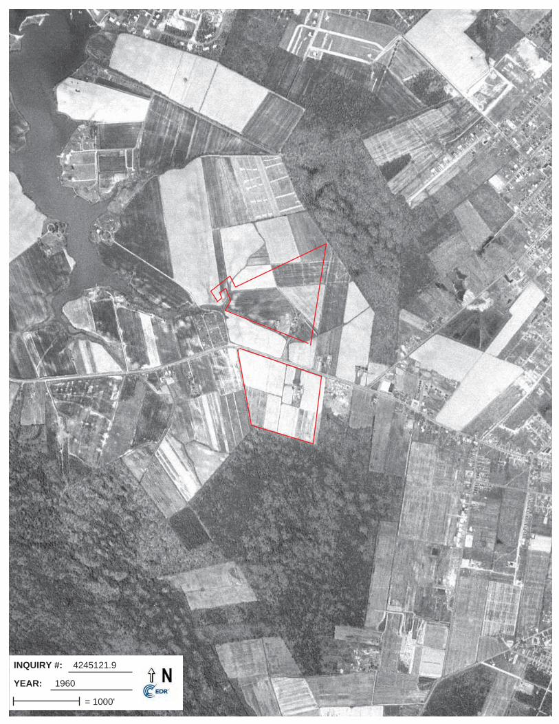
INQUIRY #:
YEAR:
4245121.9
1960
= 1000'

INQUIRY #:
YEAR:
4245121.9
1977
= 1000'

INQUIRY #:
YEAR:
4245121.9
1980
= 500'

INQUIRY #:
YEAR:
4245121.9
1989
= 750'

INQUIRY #:
YEAR:
4245121.9
1995
= 500'
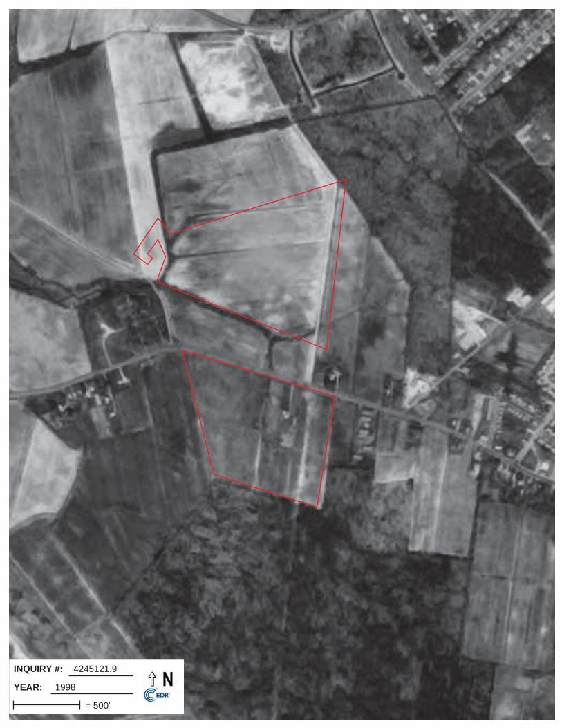
INQUIRY #:
YEAR:
4245121.9
1998
= 500'

INQUIRY #:
YEAR:
4245121.9
2005
= 500'

INQUIRY #:
YEAR:
4245121.9
2007
= 500'

INQUIRY #:
YEAR:
4245121.9
2009
= 500'

INQUIRY #:
YEAR:
4245121.9
2011
= 500'
Waterford Estates and Heron Point ResidentialJenkins Creek Road and Hudson RoadCambridge, MD 21613
Inquiry Number: 4245121.3March 25, 2015
Certified Sanborn® Map Report 3/25/15
Site Name:Waterford Estates and HeronJenkins Creek Road andCambridge, MD 21613
Client Name:IVI Assessment Services, Inc.55 West Red Oak Lane.West Harrison, NY 10604-0000
Contact: Sandy SmithEDR Inquiry # 4245121.3
The Sanborn Library has been searched by EDR and maps covering the target property location as provided by IVIAssessment Services, Inc. were identified for the years listed below. The Sanborn Library is the largest, most completecollection of fire insurance maps. The collection includes maps from Sanborn, Bromley, Perris & Browne, Hopkins,Barlow, and others. Only Environmental Data Resources Inc. (EDR) is authorized to grant rights for commercialreproduction of maps by the Sanborn Library LLC, the copyright holder for the collection. Results can be authenticatedby visiting www.edrnet.com/sanborn.
The Sanborn Library is continually enhanced with newly identified map archives. This report accesses all maps in thecollection as of the day this report was generated.
Certified Sanborn Results:
Site Name: Waterford Estates and Heron Point ResidentialAddress: Jenkins Creek Road and Hudson RoadCity, State, Zip: Cambridge, MD 21613Cross Street:P.O. # PC50314605Project: PC50314605Certification # 80C8-49E6-80B0
Library of Congress
University Publications of America
EDR Private Collection
The Sanborn Library LLC Since 1866™
The Sanborn Library includes more than 1.2 millionfire insurance maps from Sanborn, Bromley, Perris &Browne, Hopkins, Barlow and others which trackhistorical property usage in approximately 12,000American cities and towns. Collections searched:
Sanborn® Library search resultsCertification # 80C8-49E6-80B0
UNMAPPED PROPERTYThis report certifies that the complete holdings of the SanbornLibrary, LLC collection have been searched based on clientsupplied target property information, and fire insurance mapscovering the target property were not found.
Limited Permission To Make CopiesIVI Assessment Services, Inc. (the client) is permitted to make up to FIVE photocopies of this Sanborn Map transmittal and each fire insurancemap accompanying this report solely for the limited use of its customer. No one other than the client is authorized to make copies. Upon requestmade directly to an EDR Account Executive, the client may be permitted to make a limited number of additional photocopies. This permission isconditioned upon compliance by the client, its customer and their agents with EDR's copyright policy; a copy of which is available upon request.
Disclaimer - Copyright and Trademark noticeThis Report contains certain information obtained from a variety of public and other sources reasonably available to Environmental Data Resources, Inc. It cannot beconcluded from this Report that coverage information for the target and surrounding properties does not exist from other sources. NO WARRANTY EXPRESSED ORIMPLIED, IS MADE WHATSOEVER IN CONNECTION WITH THIS REPORT. ENVIRONMENTAL DATA RESOURCES, INC. SPECIFICALLY DISCLAIMS THEMAKING OF ANY SUCH WARRANTIES, INCLUDING WITHOUT LIMITATION, MERCHANTABILITY OR FITNESS FOR A PARTICULAR USE OR PURPOSE. ALLRISK IS ASSUMED BY THE USER. IN NO EVENT SHALL ENVIRONMENTAL DATA RESOURCES, INC. BE LIABLE TO ANYONE, WHETHER ARISING OUT OFERRORS OR OMISSIONS, NEGLIGENCE, ACCIDENT OR ANY OTHER CAUSE, FOR ANY LOSS OF DAMAGE, INCLUDING, WITHOUT LIMITATION, SPECIAL,INCIDENTAL CONSEQUENTIAL, OR EXEMPLARY DAMAGES. ANY LIABILITY ON THE PART OF ENVIRONMENTAL DATA RESOURCES, INC. IS STRICTLYLIMITED TO A REFUND OF THE AMOUNT PAID FOR THIS REPORT. Purchaser accepts this Report "AS IS". Any analyses, estimates, ratings, environmental risklevels or risk codes provided in this Report are provided for illustrative purposes only, and are not intended to provide, nor should they be interpreted as providingany facts regarding, or prediction or forecast of, any environmental risk for any property. Only a Phase I Environmental Site Assessment performed by anenvironmental professional can provide information regarding the environmental risk for any property. Additionally, the information provided in this Report is not to beconstrued as legal advice.
Copyright 2015 by Environmental Data Resources, Inc. All rights reserved. Reproduction in any media or format, in whole or in part, of any report or map ofEnvironmental Data Resources, Inc., or its affiliates, is prohibited without prior written permission.
EDR and its logos (including Sanborn and Sanborn Map) are trademarks of Environmental Data Resources, Inc. or its affiliates. All other trademarks used herein arethe property of their respective owners.
4245121 - 3 page 2


City Directory Images

-
HUDSON RD
Cole Information Services
4245121.5 Page: A1
SourceTarget Street Cross Street
2013
2225 CINDY LONG2229 HERBERT JOHNSON2231 OCCUPANT UNKNOWN2239 L CEPHAS2254 WILLIAM WINDSOR2256 BRADY DEAN2257 BETTY BAKER2259 SHELLEY COLLINS2261 OCCUPANT UNKNOWN2265 EDWARD WILLEY2269 LORRAINE CLAYTON2273 OCCUPANT UNKNOWN2321 OCCUPANT UNKNOWN2339 CRYSTAL WILLEY
DASHAWN MOLOCKGERALDINE WOOLFORDKATRINA WEATHERSPOONLEONARDS GROVE APARTMENTSLYDIA CROPPERLYRIA GREENMARSHA HOPKINSPATRICE CEPHASRANEY MITCHELLROBERTA WONGUSSHARON RIDEOUTSHAVONTE LEWISSHONDA COLLINSSONDRA SANDERSTHERESA BROWNTYNEKA CHASEVICKIE ERA

-
JENKINS CREEK RD
Cole Information Services
4245121.5 Page: A2
SourceTarget Street Cross Street
2013
4 DAVID HURLEY6 JAMES LAVERTY9 MICHAEL BROOKS10 JOHN WATERS11 ANDREW HOCHHEIMER12 OCCUPANT UNKNOWN13 OCCUPANT UNKNOWN14 ELLIS ESKRIDGE15 MIKE PARKER16 PAUL RAICKLE17 JAMES MERRYWEATHER19 DAVID COLMAN21 OCCUPANT UNKNOWN23 WILLIAM BORAM25 PAUL LANDERS2201 IAN CAMPBELL2202 VIVIANN NAPP2204 KEN LORD2206 STEPHEN DAVIS2208 YVONNE WESSLING2210 MICHELLE BARNES2212 RICHARD WOODS2216 OCCUPANT UNKNOWN2218 JESSE MAFFUID2240 ROBERT YORE2242 JOHN ALLEN2265 INDIA MILLEDGE2343 CHRISTOPHER HUBBARD2353 WILLIAM RULE2355 RICK WHEATLEY2359 JOAN NICHOLS

-
HUDSON RD
Cole Information Services
4245121.5 Page: A3
SourceTarget Street Cross Street
2008
2225 SUSAN LONG2229 HERBERT JOHNSON2231 CALVIN MANOKEY2239 L CEPHAS2252 MICHAEL PATRICK2254 J WINDSOR2256 BRADY DEAN2257 BETTY BAKER2259 SHELLEY COLLINS2261 JOEL HOLDEN2265 EDWARD WILLEY2269 RICHARD CLAYTON2300 JEFFREY POWELL2326 LISA WEST2339 AARON BRINKLEY
CRYSTAL WILLEYDANIELLE MOLOCKELBONY WHITEFELECIA ELLISJAMES HILLJAMES HOOPERJASPER SIMPSONK WEATHERSPOONLEONARDS GROVELEROY CAMPERLOUIS FRITZLUCILLE ASKINSLYDIA CROPPERMICHAEL PERRYMIKIA LEWISP LEER BORDLEYRENEAKA CHASEROSHAWNDA CORNISHS RIDEOUTSHAVONTE LEWISSTEPHANIE FITCHETTTERESA BLOODSWORTHTHERESA SLACUMTISH LEETYKISHA CAMPERTYKISHA CAMTERVINCENT WOOLFORDYOUNG NAVIGATOR SHUTTLE LLC
2341 CAMBRIDGE CHURCH OF CHRIST
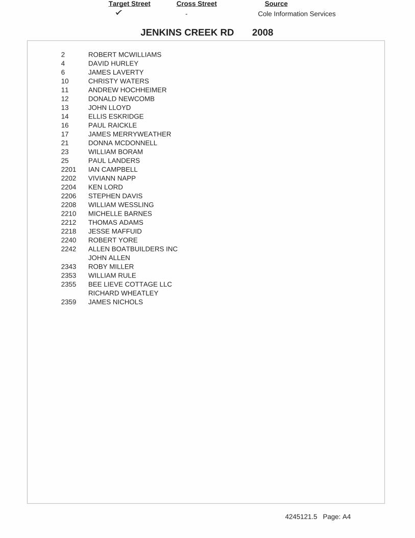
-
JENKINS CREEK RD
Cole Information Services
4245121.5 Page: A4
SourceTarget Street Cross Street
2008
2 ROBERT MCWILLIAMS4 DAVID HURLEY6 JAMES LAVERTY10 CHRISTY WATERS11 ANDREW HOCHHEIMER12 DONALD NEWCOMB13 JOHN LLOYD14 ELLIS ESKRIDGE16 PAUL RAICKLE17 JAMES MERRYWEATHER21 DONNA MCDONNELL23 WILLIAM BORAM25 PAUL LANDERS2201 IAN CAMPBELL2202 VIVIANN NAPP2204 KEN LORD2206 STEPHEN DAVIS2208 WILLIAM WESSLING2210 MICHELLE BARNES2212 THOMAS ADAMS2218 JESSE MAFFUID2240 ROBERT YORE2242 ALLEN BOATBUILDERS INC
JOHN ALLEN2343 ROBY MILLER2353 WILLIAM RULE2355 BEE LIEVE COTTAGE LLC
RICHARD WHEATLEY2359 JAMES NICHOLS

-
HUDSON RD
Cole Information Services
4245121.5 Page: A5
SourceTarget Street Cross Street
2003
2225 STEVE LONG2229 HERBERT JOHNSON2231 CALVIN MANOKEY2252 CAROL PATRICK2253 LOUISE JEWELL2254 WILLIAM WINDSOR2256 BRADY DEAN2257 BETTY BAKER2265 EDWARD WILLEY2273 HELEN PARKER2300 JEFFREY POWELL2326 BRODE S DISCOUNT TIRE CTR
THOMAS BRODE2332 ALLEN BELL
BELLS JANITORIAL SERVICES2339 AARON BRINKLEY
ARLENE JONESFRANCINE LEGRANDEJAMES HOOPERJAMES MOANEYJASPER SIMPSONLAVERNE ELVEYLEON HALLLEONARDS GROVE APARTMENTSNANCY BRYANTPHYLISS PERKINSSTEPHANIE FITCHETTTHERESA COLLINSTHERESA SLACUM

-
JENKINS CREEK RD
Cole Information Services
4245121.5 Page: A6
SourceTarget Street Cross Street
2003
2 ROBERT MCWILLIAMS4 DAVID HURLEY6 JAMES LAVERTY
JAMES LAVERTY9 HELEN GANNON10 CHRISTY WATERS11 PAULA HOCHHEIMER12 DONALD NEWCOMB13 SCOTT LLOYD14 ELLIS ESKRIDGE15 MISSY PARKER16 PAUL RAICKLE17 JAMES MERRYWEATHER19 JODI COLMAN23 WILLIAM BORAM25 BRUCE OWENS2201 MARGARET MACLAUGHLIN2202 NANCY ANDREW2204 LISA RUSSELL
LORD PARTNERS LLC2206 STEPHEN DAVIS2208 WILLIAM WESSLING2210 BILL CHRISTOPHER2212 ADAMS THOMAS H JR CPA
THOMAS ADAMS2216 RODELLA RIMPO2218 JESSE MAFFUID2240 ROBERT YORE2242 ALLEN BOATBUILDERS INC
JOHN ALLEN2355 RICHARD WHEATLEY

-
HUDSON RD
Cole Information Services
4245121.5 Page: A7
SourceTarget Street Cross Street
1999
2225 STEVE LONG2229 HERBERT JOHNSON2253 LOUISE JEWELL2259 CARL PERRY2265 EDWARD WILLEY2272 GREENLAWN CEMETERY2339 ANNA JONES
APRIL ELLERBUSCHBERNICE KOLIASBETTY CORNISHE TYLERF FONTAINEHENRY SHANTAYJ BRYANTJAMES ENNALSJASPER SIMPSONJEREMY MCKELVEYKAREN KIMMEYKATE PHILLIPSL NELSONLEONARDS GROVE APARTMENTSLILLIAN MATTHEWSLOUIS BENNETTP RUARKSHARON JACKSONWILLIAM WILLIS

-
JENKINS CREEK RD
Cole Information Services
4245121.5 Page: A8
SourceTarget Street Cross Street
1999
0 JOHN ALLENPAUL RAICKLE
2 ROBERT MCWILLIAMS4 BRUCE HURLEY6 JAMES LAVERTY10 CHRISTY WATERS11 PAULA HOCHHEIMER14 ERNEST ESKRIDGE16 PAUL RAICKLE23 WILSIE BORAM25 BRUCE OWENS2201 E MACLAUGHLIN
F VICKERS2202 DON ANDREW2204 KEN LORD2206 ROBERT DAVIS2208 YVONNE WESSLING2212 THOMAS ADAMS2216 MAURICE RIMPO2240 GARLAND HEARNE
JANICE BENNETT2242 ALLEN BOATBUILDERS INCORPORATED

-
HUDSON RD
Cole Information Services
4245121.5 Page: A9
SourceTarget Street Cross Street
1995
2225 LONG, STEVE W2231 MANOKEY, CALVIN2253 JEWELL, SAMUEL P2261 ROBINSON, CHARLES2269 CLAYTON, L2273 PARKER, O S JR2300 ROBINSON, GEORGE2321 VINCENT, TERRY2326 COLLINS, T L2339 ANDERSON, WILLIAM H
BAYLOR, RENEEBRYANT, JCORNISH, BETTYCROMWELL, JAMES AHUGHES, DESMONDJOHNSON, S LJONES, ANNA FKANE, CORISTIKOLIAS, BERNICEMACER, AMATTHEWS, LILLIANMEEKINS, CAROLPALMER, PELYNDAPITTMAN, LARONSAMPSON, LARISSASYDNOR, CAROL CWARD, LILLIAN

-
JENKINS CREEK RD
Cole Information Services
4245121.5 Page: A10
SourceTarget Street Cross Street
1995
2 MCWILLIAMS, ROBERT4 HURLEY, BRUCE6 LAVERTY, JAMES W10 WATERS, JOHN C11 HOCHHEIMER, PAULA K12 NEWCOMB, DONALD M SR14 TURNER, W M16 OCCUPANT UNKNOWNN17 MERRYWEATHER, JAMES H25 OWENS, BRUCE W201 ALLEN BOATBUILDERS INC205 MAFFUID, JESSE207 OCCUPANT UNKNOWNN209 OCCUPANT UNKNOWNN215 OCCUPANT UNKNOWNN217 OCCUPANT UNKNOWNN219 OCCUPANT UNKNOWNN224 OCCUPANT UNKNOWNN226 STEWART, WILLIAM H228 HORNEY, B M230 VICKERS, F
Waterford Estates and Heron Point ResidentialJenkins Creek Road and Hudson RoadCambridge, MD 21613
Inquiry Number: 4245121.4March 25, 2015
EDR Historical Topographic Map Report
Environmental Data Resources, Inc.s (EDR) Historical Topographic Map Report is designed to assist professionals inevaluating potential liability on a target property resulting from past activities. EDRs Historical Topographic Map Reportincludes a search of a collection of public and private color historical topographic maps, dating back to the early 1900s.
Thank you for your business.Please contact EDR at 1-800-352-0050
with any questions or comments.
Disclaimer - Copyright and Trademark Notice
This Report contains certain information obtained from a variety of public and other sources reasonably available to Environmental Data Resources, Inc.It cannot be concluded from this Report that coverage information for the target and surrounding properties does not exist from other sources. NOWARRANTY EXPRESSED OR IMPLIED, IS MADE WHATSOEVER IN CONNECTION WITH THIS REPORT. ENVIRONMENTAL DATARESOURCES, INC. SPECIFICALLY DISCLAIMS THE MAKING OF ANY SUCH WARRANTIES, INCLUDING WITHOUT LIMITATION,MERCHANTABILITY OR FITNESS FOR A PARTICULAR USE OR PURPOSE. ALL RISK IS ASSUMED BY THE USER. IN NO EVENT SHALLENVIRONMENTAL DATA RESOURCES, INC. BE LIABLE TO ANYONE, WHETHER ARISING OUT OF ERRORS OR OMISSIONS, NEGLIGENCE,ACCIDENT OR ANY OTHER CAUSE, FOR ANY LOSS OF DAMAGE, INCLUDING, WITHOUT LIMITATION, SPECIAL, INCIDENTAL,CONSEQUENTIAL, OR EXEMPLARY DAMAGES. ANY LIABILITY ON THE PART OF ENVIRONMENTAL DATA RESOURCES, INC. IS STRICTLYLIMITED TO A REFUND OF THE AMOUNT PAID FOR THIS REPORT. Purchaser accepts this Report AS IS. Any analyses, estimates, ratings,environmental risk levels or risk codes provided in this Report are provided for illustrative purposes only, and are not intended to provide, nor should theybe interpreted as providing any facts regarding, or prediction or forecast of, any environmental risk for any property. Only a Phase I Environmental SiteAssessment performed by an environmental professional can provide information regarding the environmental risk for any property. Additionally, theinformation provided in this Report is not to be construed as legal advice.
Copyright 2015 by Environmental Data Resources, Inc. All rights reserved. Reproduction in any media or format, in whole or in part, of any report or mapof Environmental Data Resources, Inc., or its affiliates, is prohibited without prior written permission.
EDR and its logos (including Sanborn and Sanborn Map) are trademarks of Environmental Data Resources, Inc. or its affiliates. All other trademarksused herein are the property of their respective owners.

Historical Topographic Map→
NTARGET QUADTARGET QUADNAME: OXFORDMAP YEAR: 1904
SERIES: 15SCALE: 1:62500
SITE NAME: Waterford Estates and Heron PointResidential
ADDRESS: Jenkins Creek Road and HudsonRoadCambridge, MD 21613
LAT/LONG: 38.5687 / -76.0991
CLIENT: IVI Assessment Services, Inc.CONTACT: Sandy SmithINQUIRY#: 4245121.4RESEARCH DATE: 03/25/2015
The Property
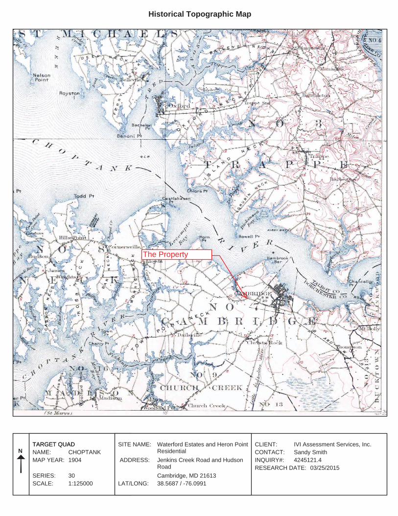
Historical Topographic Map→
NTARGET QUADTARGET QUADNAME: CHOPTANKMAP YEAR: 1904
SERIES: 30SCALE: 1:125000
SITE NAME: Waterford Estates and Heron PointResidential
ADDRESS: Jenkins Creek Road and HudsonRoadCambridge, MD 21613
LAT/LONG: 38.5687 / -76.0991
CLIENT: IVI Assessment Services, Inc.CONTACT: Sandy SmithINQUIRY#: 4245121.4RESEARCH DATE: 03/25/2015
The Property
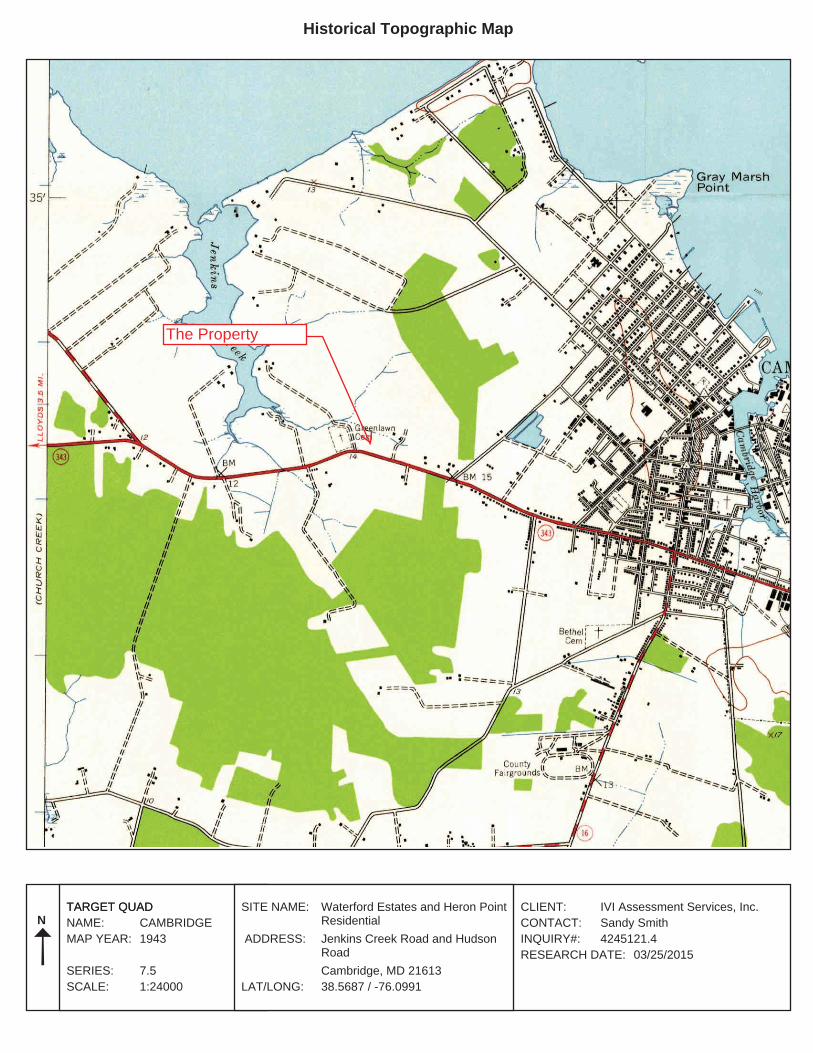
Historical Topographic Map→
NTARGET QUADTARGET QUADNAME: CAMBRIDGEMAP YEAR: 1943
SERIES: 7.5SCALE: 1:24000
SITE NAME: Waterford Estates and Heron PointResidential
ADDRESS: Jenkins Creek Road and HudsonRoadCambridge, MD 21613
LAT/LONG: 38.5687 / -76.0991
CLIENT: IVI Assessment Services, Inc.CONTACT: Sandy SmithINQUIRY#: 4245121.4RESEARCH DATE: 03/25/2015
The Property

Historical Topographic Map→
NTARGET QUADTARGET QUADNAME: CAMBRIDGEMAP YEAR: 1974PHOTOREVISED FROM :1943SERIES: 7.5SCALE: 1:24000
SITE NAME: Waterford Estates and Heron PointResidential
ADDRESS: Jenkins Creek Road and HudsonRoadCambridge, MD 21613
LAT/LONG: 38.5687 / -76.0991
CLIENT: IVI Assessment Services, Inc.CONTACT: Sandy SmithINQUIRY#: 4245121.4RESEARCH DATE: 03/25/2015
The Property

Historical Topographic Map→
NTARGET QUADTARGET QUADNAME: CAMBRIDGEMAP YEAR: 1988
SERIES: 7.5SCALE: 1:24000
SITE NAME: Waterford Estates and Heron PointResidential
ADDRESS: Jenkins Creek Road and HudsonRoadCambridge, MD 21613
LAT/LONG: 38.5687 / -76.0991
CLIENT: IVI Assessment Services, Inc.CONTACT: Sandy SmithINQUIRY#: 4245121.4RESEARCH DATE: 03/25/2015
The Property

WWATERFORD ESTATES AND HERON POINT RESIDENTIAL SUBDIVISIONS CAMBRIDGE, MARYLAND CBRE Project #15-460TX-0340
APPENDIX 6 Previous Reports (Return to Section 6.9)

WWATERFORD ESTATES AND HERON POINT RESIDENTIAL SUBDIVISIONS CAMBRIDGE, MARYLAND CBRE Project #15-460TX-0340
No previous reports were provided to CBRE for review.

WWATERFORD ESTATES AND HERON POINT RESIDENTIAL SUBDIVISIONS CAMBRIDGE, MARYLAND CBRE Project #15-460TX-0340
APPENDIX 7 Personnel Qualifications
(Return to Section 7)
ASSESSMENT AND CONSULTI NG SERVICES
BBrett G. Conner, PG, CEG
Education: Bachelor of Science in Geology, Northern Arizona University Licenses/Registrations Professional Geologist/California No. 7687 Certified Engineering Geologist/California No. 2420 Years of Experience: 12 years
Summary of Professional Experience Mr. Conner has over 12 years of consulting experience in the environmental and geotechnical engineering industries in several states across the West. He has conducted Environmental Site Assessments (ESAs) for a wide range of retail, industrial, and federal clients, including U.S. Army Corps of Engineers, ConocoPhillips, Camping World, Inc., Valspar Corporation, and Stewart & Stevenson Power, Inc. The properties he has evaluated have included former military facilities, pipeline pump stations, manufacturing facilities, and heavy equipment repair shops. Mr. Conner has performed numerous ESAs in accordance with ASTM E1527, the USEPA All Appropriate Inquiry rules, Fannie Mae Delegated Underwriting Standards, Freddie Mac guidelines and other client specific scopes of work. His environmental background includes AHERA building inspections, air-compliance monitoring for asbestos and lead-based paint abatement, and screening-level site assessments at oil production support facilities. Mr. Conner has managed numerous soil and groundwater remediation projects related to petroleum hydrocarbon, ammonium-perchlorate and TCE impact, as well as working with local regulatory agencies to develop closure requirements. Mr. Conner has also conducted geotechnical explorations for proposed construction sites, including a four-story commercial complex, large single-family home developments, and condominium structures. Furthermore, he has monitored the site work and construction of footing lines and foundations, as well as installation of associated utilities including sewer lines, injection wells, plumbing, and electrical conduits. He is experienced in identifying environmental issues related to site operations, building materials, releases, and deferred maintenance.
Pamela Horne - Project Manager
Technical Experience
Phase I & II Environmental Site Assessments (ESAs), Site Transaction Screenings, Regulatory File Reviews, Industrial Hygiene Surveys, pollution liability insurance surveys, desktop environmental review,facility compliance audits; and Spill Prevention, Countermeasure and Control Plans.
Experience Summary
Environmental Project Manager/Senior Scientist with 14 years of environmental consulting experience, primarily in the due diligence arena. Project experience is in the mid-Atlantic region, most notably in the Baltimore-Washington, D.C metropolitan area for a diverse clientele. Property expertise includes industrial/manufacturing facilities, gasoline stations, automobile repair facilities, dry cleaners, marinas, landfill sites, multi-residential complexes, undeveloped/agricultural land, retail shopping centers, commercial and medical offices, and telecommunication towers. Specialties include Phase I ESAs, AAI Rule/ASTM Standard, Small Business Administration (SBA) requirements, technical review, and client relations and management.
Key Projects
400-Acre Property, Howard County, Maryland – Phase I ESA conducted of this property consisting of undeveloped land, farmland, and rural residential/agricultural uses. Petroleum storage tanks, abandoned structures, large-scale dumping, and an adjacent landfill (in process of closure) were identified during the environmental assessment. Undeveloped/Abandoned Property and Former Historic Mill, Ellicott City, Maryland - Phase I ESA conducted of a large undeveloped/abandoned property improved by a former manufacturing plant/mill. Former petroleum storage tanks (above and underground), an abandoned landfill, large quantities of friable asbestos-containing materials, former wells, large scale-dumping, and petroleum staining/contamination were identified during the environmental assessment. In addition, regulatory file reviews were conducted at local and State agencies to document the former landfill and other regulatory/environmental issues associated with the past mill uses. Former Gasoline and Automobile Sales/Service Facility, Silver Spring, Maryland – Phase I ESA conducted of a former gasoline station and automobile sales/service facility. Former petroleum storage tanks, automotive lifts, abandoned/discarded chemical and petroleum containers, prior documented subsurface contamination, and a petroleum release/residue at a retaining wall drain were identified during the environmental assessment. Manufacturing Facility, Baltimore, Maryland – Phase I ESA conducted of a manufacturing facility. Several current chemical/petroleum aboveground storage tanks, former petroleum underground storage tanks (USTs), petroleum impacted soils, damaged wastewater treatment containment and sanitary sewage piping, and improper Federal hazardous waste generator reporting requirements were identified during the environmental assessment. In addition, extensive contamination at an adjacent paint manufacturing facility and a former adjacent dry cleaning facility were revealed.Marina and Boat Repair Facility, Pasadena, Maryland – Phase I ESA conducted of a marina and boat repair facility. Several petroleum aboveground storage tanks and UST, numerous areas of petroleum staining/residue, and several State regulatory cases associated with former petroleum releases were identified during the environmental assessment.
Education
University of MarylandBachelor of Science, Natural Resources Management
Affiliations/Associations/Memberships/Certifications
EPA (40 CFR Part 763) Asbestos Building Inspector OSHA (29 CFR 1910.120) 40-Hour HAZWOPER Training