Water Wells on St. Thomas, U.S. Virgin Islands · Water Wells on St. Thomas, U.S. Virgin Islands By...
82
Water Wells on St. Thomas, U.S. Virgin Islands By Judy I. Steiger and Richard Kessler U.S. GEOLOGICAL SURVEY Open-File Data Report 91-504 Prepared in cooperation with the U.S. VIRGIN ISLANDS WATER AND POWER AUTHORITY San Juan, Puerto Rico 1993
Transcript of Water Wells on St. Thomas, U.S. Virgin Islands · Water Wells on St. Thomas, U.S. Virgin Islands By...

Water Wells on St. Thomas, U.S. Virgin Islands
By Judy I. Steiger and Richard Kessler
U.S. GEOLOGICAL SURVEY
Open-File Data Report 91-504
Prepared in cooperation with the
U.S. VIRGIN ISLANDS WATER AND POWER AUTHORITY
San Juan, Puerto Rico 1993
U.S. DEPARTMENT OF THE INTERIOR BRUCE BABBITT, Secretary
U.S. GEOLOGICAL SURVEY Dallas L. Peck, Director
For additional information write to:
District ChiefU.S. Geological SurveyP.O. Box 364424San Juan, Puerto Rico 00936-4424
Copies of this report can be purchased from:
U.S. Geological Survey Books and Open-File Reports Section Federal Center, Box 25425 Denver, CO 80225-0425
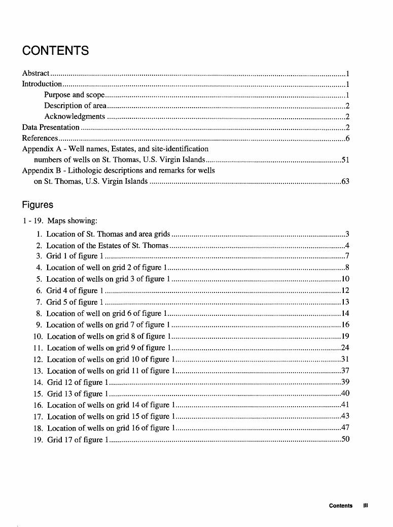
CONTENTS
Abstract..................................................................................................................................................1Intnxluction............................................................................................^
Purpose and scope.......................................................................................................................!Description of area......................................................................................................................2Acknowledgments ......................................................................................................................2
Data Presentation...................................................................................................................................2References..................................................................................................._^Appendix A - Well names, Estates, and site-identification
numbers of wells on St. Thomas, U.S. Virgin Islands...................................................................51Appendix B - Lithologic descriptions and remarks for wells
on St. Thomas, U.S. Virgin Islands ...............................................................................................63
Figures
1-19. Maps showing:
1. Location of St. Thomas and area grids ......................................................................................32. Location of the Estates of St. Thomas.......................................................................................43. Grid 1 of figure 1 .......................................................................................................................74. Location of well on grid 2 of figure 1........................................................................................85. Location of wells on grid 3 of figure 1 ....................................................................................106. Grid 4 of figure 1 .....................................................................................................................127. Grid 5 of figure 1.....................................................................................................................138. Location of well on grid 6 of figure 1......................................................................................149. Location of wells on grid 7 of figure 1....................................................................................16
10. Location of wells on grid 8 of figure 1....................................................................................1911. Location of wells on grid 9 of figure 1....................................................................................2412. Location of wells on grid 10 of figure 1..................................................................................3113. Location of wells on grid 11 of figure 1..................................................................................3714. Grid 12 of figure 1...................................................................................................................3915. Grid 13 of figure 1...................................................................................................................4016. Location of wells on grid 14 of figure 1..................................................................................4117. Location of wells on grid 15 of figure 1..................................................................................4318. Location of wells on grid 16 of figure 1..................................................................................4719. Grid 17 of figure 1...................................................................................................................50
Contents

Tables
1. Estates in St. Thomas, U.S. Virgin Islands,
2-12. Description of:
2. Well located on figure 4.......................3. Wells located on figure 5.....................4. Well located on figure 8.......................5. Wells located on figure 9.....................6. Wells located on figure 10...................7. Wells located on figure 11...................8. Wells located on figure 12...................9. Wells located on figure 13...................
10. Wells located on figure 16...................11. Wells located on figure 17...................12. Wells located on figure 18...................
...9
.11
.15
.17
.20
.25
.32
.38
.42
.44
.48
CONVERSION FACTORS AND ACRONYMS
Multiply
inch
foot
mile
square mile
gallon
gallons per minute
gallons per day
By
25.4
0.3048
1.609
2.590
3.785
0.06308
0.003785
To obtain
millimeter
meter
kilometer
square kilometer
liter
liter per second
cubic meter per day
Acronyms used in this report:
U.S. Geological Survey (USGS)U.S. Virgin Islands (USVI)U.S. Virgin Islands Department of Planning and Natural Resources (VIDPNR)U.S. Virgin Islands Water and Power Authority (VIWAPA)
IV Water wells on St. Thomas, U.S. Virgin Islands

Water Wells on St. Thomas, U.S. Virgin Islands
By Judy I. Steiger and Richard Kessler
Abstract
This report presents a compilation of well-inventory data collected between December 1989 and December 1990 on St. Thomas, U.S. Virgin Islands. The report includes maps of well locations and tables of well-inventory data for 367 wells. The demand for freshwater in St. Thomas has exceeded the supply, because of the growth in population and tourism. Currently, the demand for water in St. Thomas is met by desalinated seawater, rainfall collected in cisterns, and ground water. The well- inventory data in this report provides a database to assist hydrologists, water managers, and planners in the development and full utilization of the ground-water resources of St. Thomas.
INTRODUCTION
Freshwater is a scarce and expensive commodity in the U.S. Virgin Islands (USVI) (Gomez-Gomez and others, 1985). To meet the demand for freshwater in St. Thomas, all available freshwater sources are used. In 1984, desalinated seawater provided about 71 percent of the freshwater supplies, and rooftop-rainfall catchments and ground water provided about 19 and 10 percent of the freshwater supplies respectively (Torres-Sierra and Dacosta, 1984).
The U.S. Virgin Islands Water and Power Authority (VIWAPA) is responsible for the supply and distribution of public water for the U.S. Virgin Islands. Because of increases in population and tourism, the development of the water resources of the USVI is becoming more important for the future of St. Thomas. In planning for long-term supply of water for the USVI, VIWAPA is considering all possible sources of water. It is anticipated that carefully planned ground-water development is the key to an inexpensive water supply in the future if ground-water contamination can be identified and controlled.
Purpose and Scope
The U.S. Geological Survey (USGS) entered into a cooperative program with VIWAPA during 1989 to complete a well inventory of St. Thomas, USVI. This report presents data for 367 wells including locations from the completed inventory conducted in St. Thomas between December 1989 and December 1990.
Introduction 1

Description of Area
St. Thomas is the second largest of the three principal islands (St. Croix, St. Thomas, and St. John) that comprise the U.S. Virgin Islands (fig. 1). The island is approximately 14 miles long and 2 to 3 miles wide and has an area of 32 square miles. The land surface is almost entirely sloping and extends seaward from a central ridge, which is 800 to 1,200 feet high and runs the length of the island. Flat land is confined to only a few small alluvium-filled embayments and parts of Estate Anna's Retreat and Estate Charlotte Amalie (fig. 2) in eastern St. Thomas (Jordan and Cosner, 1973).
Acknowledgments
The authors express their appreciation to the U.S. Virgin Islands Department of Planning and Natural Resources (VIDPNR), Division of Environmental Protection, for their assistance in helping to locate many of the wells on St. Thomas. Also, the cooperation of the many well and land owners who allowed access to their property and provided information about their wells is gratefully acknowledged.
DATA PRESENTATION
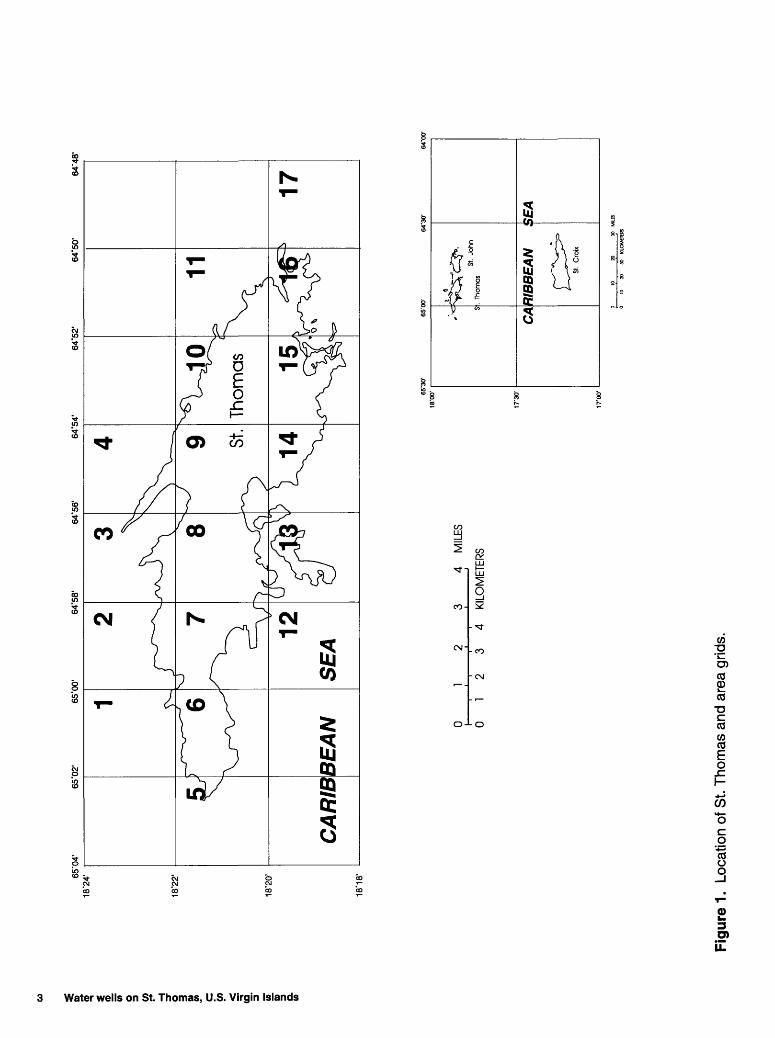
The locations and descriptions of 367 wells constructed before January 1991 on St. Thomas are presented in this report. For ease in locating wells, St. Thomas was divided into 17 grids (fig. 1). All grids shown in figure 1 are presented as separate figures in this report (figs. 3 through 19). Each grid represents a two-minute square section of the USGS 1982 photorevised, 7.5 minute series, topographic maps of St. Thomas. Each figure is published at the original topographic map scale of 1:24,000. Some grids cover areas in which no wells exist.
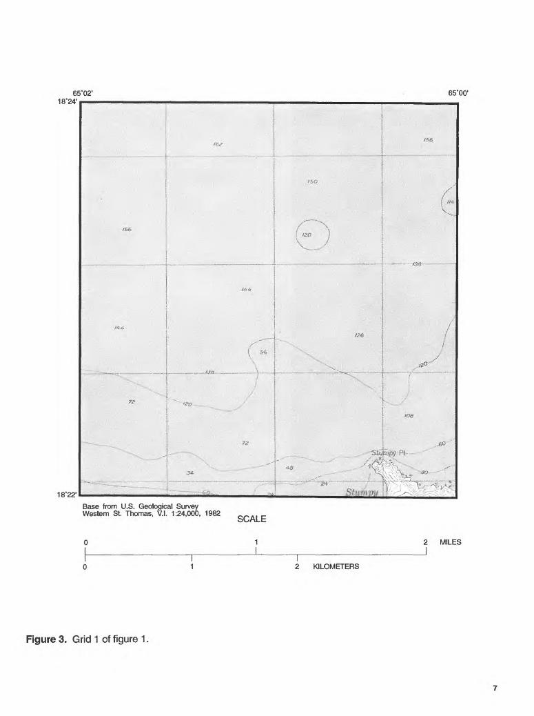
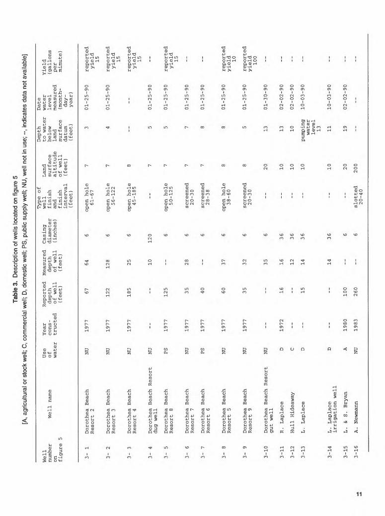
Grids that have wells located on them are followed immediately by a table containing selected well data (tables 2 through 12). When available, information presented in these tables includes: well number as referenced on the preceding figure, well name, primary use of water, year the well was constructed, reported depth of well, measured depth of well, well casing diameter, type of well finish and finish interval, land- surface altitude at well site, depth to water below land-surface datum, date water level measured, and yield of well. The well numbers used in tables 2 through 12 consist of two parts. The first part refers to the grid number from figure 1, and the second part is a sequence number for the well within the grid. These numbers apply only to wells located on the accompanying figure. Identifiers mentioned in other reports can be identified by the site-identification numbers, which are presented in appendix A. The site-identification numbers conform with the established USGS Ground-Water Site Inventory classification scheme. The site- identification number does not change and can be used to reference a specific well in other USGS publications.
The report also identifies the location of wells in terms of Estates in St. Thomas (fig. 2, table 1, and appendix A). Other information included in this report are the subsurface lithologic descriptions (when available) of a well site, and any special information about a well (appendix B).
2 Water wells on St. Thomas, U.S. Virgin Islands
65'0
2'65
'00'
64-5
8'64
'56'
64'5
4'64
'52'
64'5
0'64
-48'
< 5'
Q.
W
18'2
2'
18'2
0'
CA
RIB
BE
AN
4 M
ILE
S
01234
KIL
OM
ETE
RS
65'3
0'
18
W
CA
RIB
BE
AN
0 10
20
30
K
llOM
CTE
RS
Figu
re 1
. Lo
catio
n of
St.
Thom
as a
nd a
rea
grid
s.

i o n> JO c
w (0 5* 3
O.
(0
65*0
4'
18*2
4'65
*02'
65*0
0'64
*58'
64*5
6'64
*54'
64*5
2'64
*50'
64*4
8'
18*2
2'
18*2
0'
18*1
8'
CA
RIB
BE
AN
01
4 M
ILES
01234
KIL
OM
ETE
RS
EX
PL
AN
AT
ION
ES
TATE
AN
D
ES
TATE
N
UM
BE
R-E
stat
e na
me
is s
how
n on
tab
le
1.
Figu
re 2
. Lo
catio
n of
the
Est
ates
of S
t. T
hom
as.
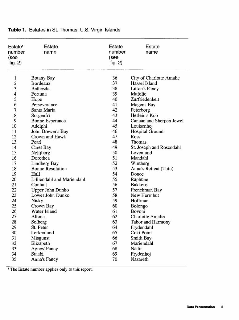
Table 1. Estates in St. Thomas, U.S. Virgin Islands
Estate1 number (seefig. 2)
123456789
1011121314151617181920212223242526272829303132333435
Estate name
Botany BayBordeauxBethesdaFortunaHopePerseveranceSanta MariaSorgenfriBonne EsperanceAdelphiJohn Brewer's BayCrown and HawkPearlCaret BayNeltjbergDorotheaLindberg BayBonne ResolutionHullLilliendahl and MariendahlContantUpper John DunkoLower John DunkoNiskyCrown BayWater IslandAltonaSolbergSt. PeterLerkenlundMisgunstElizabethAgnes' FancyStaabiAnna's Fancy
Estate number (seefig. 2)
3637383940414243444546474849505152535455565758596061626364656667686970
Estate name
City of Charlotte AmalieHassel IslandLitton's FancyMafolieZurfriedenheitMagens BayPeterborgHerlein's KobCanaan and Sherpen JewelLouisenhojHospital GroundRossThomasSt. Joseph and RosendahlLovenlundMandahlWintbergAnna's Retreat (Tutu)DonoeRaphuneBakkeroFrenchman BayNew HerrnhutHoffmanBolongoBovoniCharlotte AmalieTabor and HarmonyFrydendahlCoki PointSmith BayMariendahlNadirFrydenhojNazareth
The Estate number applies only to this report.
Data Presentation
Records of wells in St. Thomas were complied from the USGS historical files, VIDPNR files, previously published reports (Robison and others, 1973; Stevens and others, 1981; Graves and Gonzalez, 1988), and verbal reports of well locations. These records were used to locate wells in the field. All the wells presented in this report have been verified and inventoried by USGS personnel.
Lithologic information and information about the construction of the wells was taken from well-drillers' logs, when available. Wells that could be sounded with a weighted steel tape were measured for depth by USGS personnel. Some of the information on well depths and type of well finish were provided by the well owner or were reported on previous well inventories.
Well casing diameters represent the inside diameter of the casing visible at land surface. In some instances, there may be a smaller diameter casing within the well. The smaller diameter casing is noted in the remarks section of the table.
Land-surface altitudes at the well site were estimated from USGS topographic maps. The contour interval of the topographic maps of St. Thomas is 40 feet. Twenty-foot contour intervals are shown where slopes are low. The accuracy of reporting land-surface altitudes in this report is considered to be half of the contour interval used.
Depth-to-water measurements were made by USGS personnel. Yields were reported by the driller or estimated by the well owner or well manager. Wells that were pumping and had in-line flow meters were measured for yield by USGS personnel.
REFERENCES
Gomez-Gomez, Fernando, Quinones-Marquez, Ferdinand, and Zack, A.L., 1985, U.S. Virgin Islands ground- water resources -National Water Summary 1984: U.S. Geological Survey Water-Supply Paper 2275, p. 409-413.
Graves, R.P., and Gonzalez, Ralph, 1988, Potentiometric surface of the Turpentine Run basin aquifer in the Tutu area, eastern St. Thomas, September 11, 1987: U.S. Geological Survey Water-Resources Investigations Report 88-4131, 1 pi.
Jordan, D.G., and Cosner, O.J., 1973, A survey of the water resources of St. Thomas, Virgin Islands: U.S. Geological Survey Open-File Report, 55 p.
Robison, T.M., and others, 1972, Water records of the U.S. Virgin Islands, 1962-69: U.S. Geological Survey Water Data Report, 163 p.
Stevens, K.E., Gomez-Gomez, Fernando, and Alicea, Jose, 1981, Water wells in the U.S. Virgin Islands, Part 1, St. Thomas: U.S. Geological Survey Open-File Report 82-82, 112 p.
Torres-Sierra, Heriberto, and Dacosta, Rafael, 1984, Estimated water use in St. Thomas, U.S. Virgin Islands, July 1983 - June 1984: U.S. Geological Survey Open-File Data Report 84-721, 1 pi.
Water wells on St. Thomas, U.S. Virgin Islands
65°02' 18'24'
65°00'
/sg
18'22'
*JAa-
34
T '~~f
toe
jeft
Base from U.S. Geological Survey Western St. Thomas, V.I. 1:24,000, 1982
oL/ALt
2 MILES
2 KILOMETERS
Figure 3. Grid 1 of figure 1.
65 18"24'
00' 64'58'
18"22'
Base from U.S. Geological Survey Central St. Thomas, V.I. 1:24,000, 1982
SCALE
2 MILES
2 KILOMETERS
Figure 4. Location of well on grid 2 of figure 1. The well number shown on this figure corresponds to the well number which begins with 2- in table 2 and appendixes A and B.
8 Water wells on St. Thomas, U.S. Virgin Islands

Tabl
e 2.
D
escr
iptio
n of
wel
l loc
ated
on
figur
e 4
[A,
agric
ultu
ral o
r sto
ck w
ell;
--, in
dica
tes
data
not
ava
ilabl
e]
Well
numb
er
Well
na
meon fi
gure 4
2-1
C. Bushfield
Use
Year
of
cons-
water
truc
ted
A
1988
Reported
depth
of we
ll(feet)
250
Measured
dept
hof
well
(feet) __
Casing
diam
eter
(inc
hes)
6
Type of
well
finish
and
finish
inte
rval
(feet)
slot
ted
42-8
2
Land
surface
alti
tude
at we
llsi
te(f
eet)
400
Dept
hto
water
below
land
surface
datu
m(f
eet) __
Date
wate
rlevel
measured
(month-
day -
year
)
__
Yield
(gal
lons
per
minu
te)

64'58' 18°24'
64°56'
18'22'
Base from U.S. Geological Survey Central St. Thomas, V.I. 1:24,000, 1982
SCALE
2 MILES
2 KILOMETERS
Figure 5. Location of wells on grid 3 of figure 1. The well numbers shown on this figure correspond to the well numbers which begin with 3- in table 3 and appendixes A and B.
10 Water wells on St. Thomas, U.S. Virgin Islands
Tabl
e 3.
D
escr
iptio
n of
wel
ls lo
cate
d on
fig
ure
5 [A
, ag
ricul
tura
l or s
tock
wel
l; C
, co
mm
erci
al w
ell;
D, d
omes
tic w
ell;
PS
, pu
blic
sup
ply
wel
l; N
U,
wel
l not
in u
se;
--, i
ndic
ates
dat
a no
t ava
ilabl
e]
Well
number
on
figure
3- 1
3- 2
3-
3
3- 4
3- 5
3- 6
3- 7
3- 8
3- 9
3-10
3-11
3-12
3-13
3-14
3-15
3-16
Well name
5
Dorothea Beach
Resort 2
Dorothea Beach
Resort 3
Dorothea Beach
Resort 4
Dorothea Beach Resort
dug well
Dorothea Beach
Resort 8
Dorothea Beach
Resort 7
Dorothea Beach
Resort 6
Dorothea Beach
Resort 5
Dorothea Beach
Resort 9
Dorothea Beach Resort
gut well
R . Laplace
Hull Hideaway
L . Laplace
L. Laplace
irrigation well
L. &
S. Bryan
A . Ne
wman
n
Use
Year
Re
port
ed Me
asur
ed
Casing
of
cons-
depth
depth
diam
eter
water
tructed
of we
ll
of we
ll
(inches)
(fee
t)
(fee
t)
NU
1977
67
64
6
NU
1977
122
128
6
NU
1977
185
25
6
NU
--
--
10
120
PS
1977
125
--
6
NU
1977
35
28
6
PS
1977
40
--
6
NU
1977
60
37
6
NU
1977
35
32
6
NU
--
--
35
6
D 1972
16
16
36
C --
--
12
36
D --
15
14
36
D --
--
14
36
A
1980
100
--
6
NU
1983
260
--
6
Type of
well
finish
and
finish
interval
(fee
t)
open hole
61-67
open hole
56-122
open hole
45-185
--
open hole
50-125
screened
20-30
screened
28-38
open hole
38-60
screened
20-30
-- -- -- -- --
slotted
20-40
Land
surface
altitude
of well
(feet) 7 7 8 7 7 7 7 8 8
20 10 10 10 10 20
200
Depth
to water
below
land
surface
datum
(feet) 3 4
--
5 5 7 8 8 5
13 13 10
pumping
water
leve
l 13 11 19 --
Date
water
level
measured
( month-
day -
year)
01-25-90
01-25-90
--
01-25-90
01-25-90
01-25-90
01-25-90
01-25-90
01-25-90
01-30-90
02-02-90
02-02-90
10-03-90
10-03-90
02-02-90
--
Yield
(gallons
per
minute )
reported
yield
15
reported
yield
15
reported
yield
15 --
reported
yield
15 -- --
reported
yield
10
reported
yield
100 -- -- -- -- --

64'56' 18'24'
64°54'
18'22'
Base from U.S. Geological Survey Central St. Thomas, V.I. 1:24,000, 1982
SCALE
1 2 MILESJ
2 KILOMETERS
Figure 6. Grid 4 of figure 1.
12 Water wells on St. Thomas, U.S. Virgin Islands
65'04' 18'22'
65'02'
18°20F
Base from U.S. Geological Survey Western St. Thomas, V.I. 1:24,000, 1982
SCALE
1
2 KILOMETERS
2 MILES
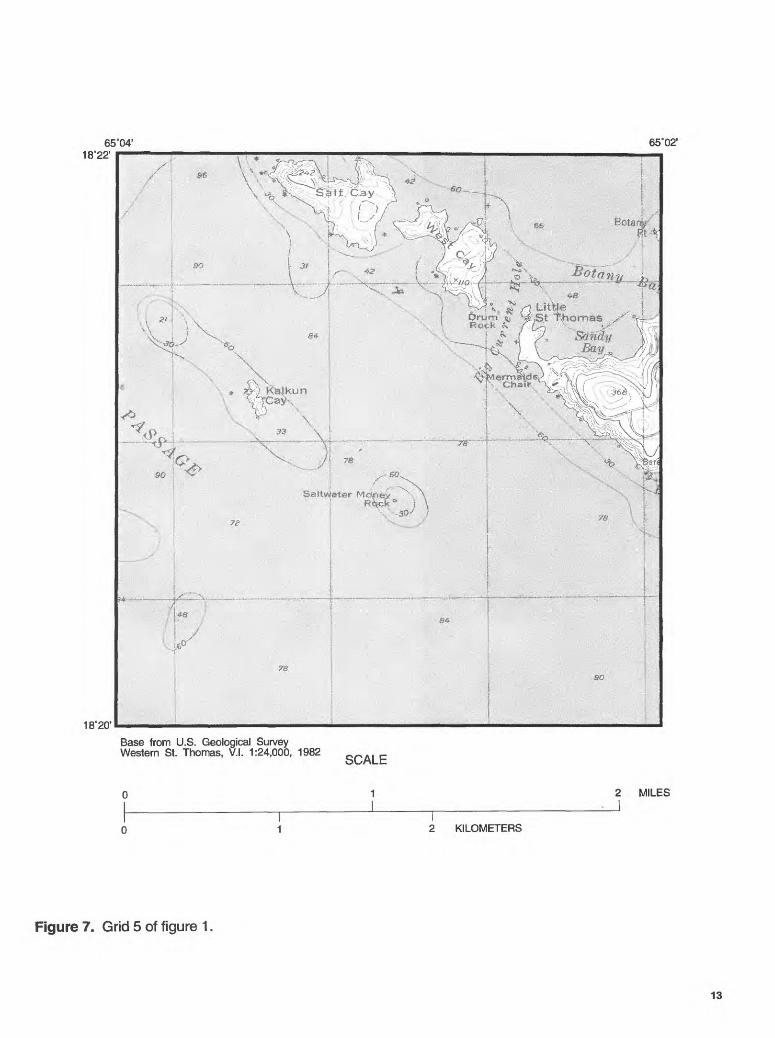
Figure 7. Grid 5 of figure 1.
13

65°02' 65"00'18*22'
18'20'
Base from U.S. Geological Survey Western St. Thomas, V.I. 1:24,000, 1982
SCALE
1 2 MILES
2 KILOMETERS
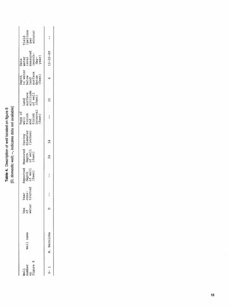
Figure 8. Location of well on grid 6 of figure 1. The well number shown on this figure corresponds to the well number which begins with 6- in table 4 and appendixes A and B.
14 Water wells on St Thomas, U.S. Virgin Islands
Tabl
e 4.
Des
crip
tion
of w
ell l
ocat
ed o
n fig
ure
8 [D
, dom
estic
wel
l; --,
indi
cate
s da
ta n
ot a
vaila
ble]
Well
number
Well
na
meon fi
gure
8
Use
of water
Year
cons
tructed
Reported
dept
hof we
ll(f
eet)
Measured
depth
of well
(feet)
Casing
diam
eter
( inc
hes
)
Type
of
well
fini
shand
fini
shinterval
(fee
t)
Land
surf
ace
altitude
of we
ll(f
eet)
Depth
to wa
ter
below
land
surface
datu
m(f
eet)
Date
wate
rlevel
meas
ured
(month-
day-
year
)
Yiel
d(gallons
per
minu
te)
6-
I W
. W
ernic
ke
D --
--
24
24
--
35
4
12-2
6-8
9
65°00 18°22'
64°58'
18°20'
Base from U.S. Geological Survey Central St. Thomas, V.I. 1:24,000, 1982
SCALE
2 MILES
2 KILOMETERS
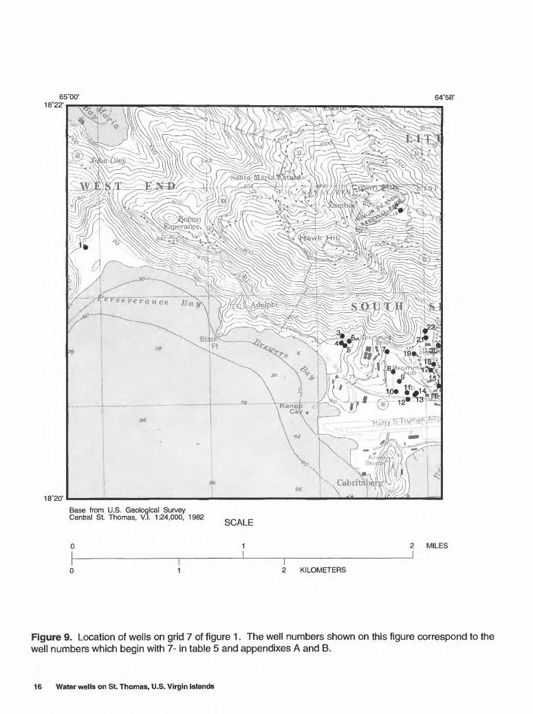
Figure 9. Location of wells on grid 7 of figure 1. The well numbers shown on this figure correspond to the well numbers which begin with 7- in table 5 and appendixes A and B.
16 Water wells on St. Thomas, U.S. Virgin Islands
Tabl
e 5.
Des
crip
tion
of w
ells
loca
ted
on fi
gure
9
[D, d
omes
tic w
ell;
IS, i
nstit
utio
nal w
ell;
NU
, wel
l not
in u
se; -
-, in
dica
tes
data
not
ava
ilabl
e]
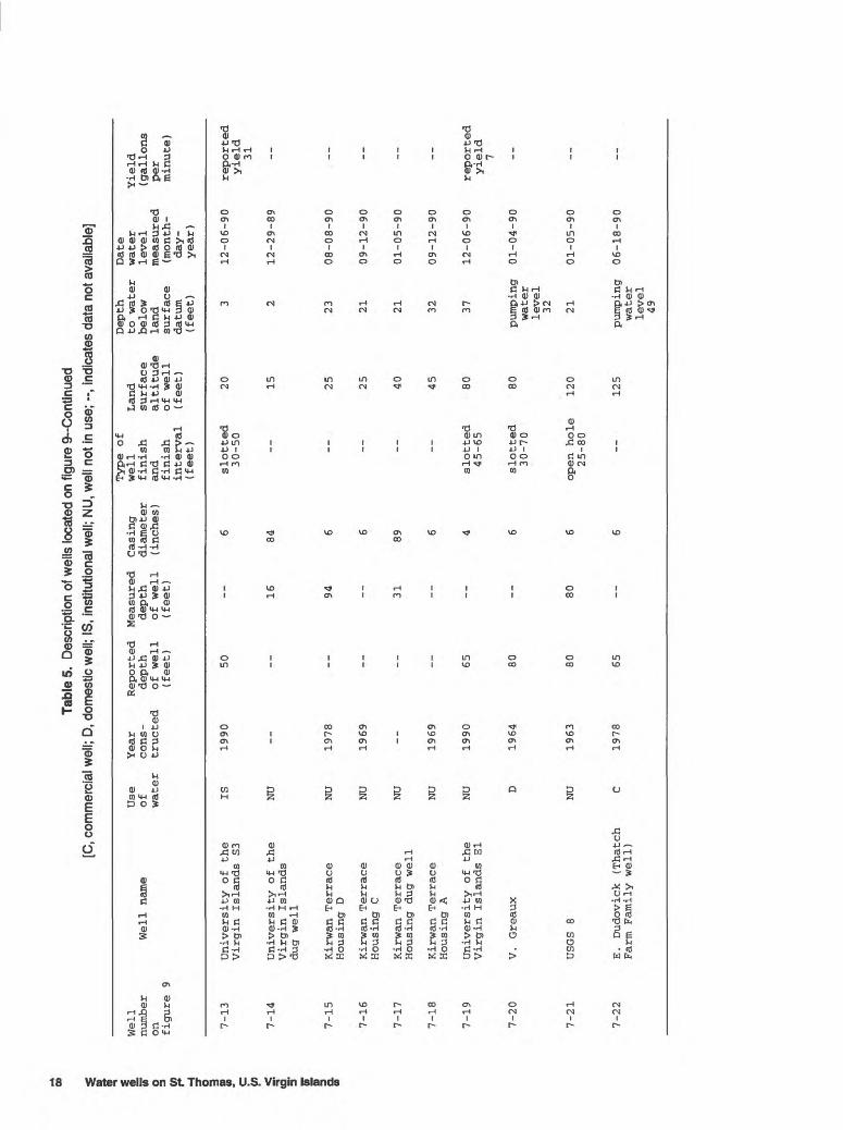
Well
number
on
figure 9
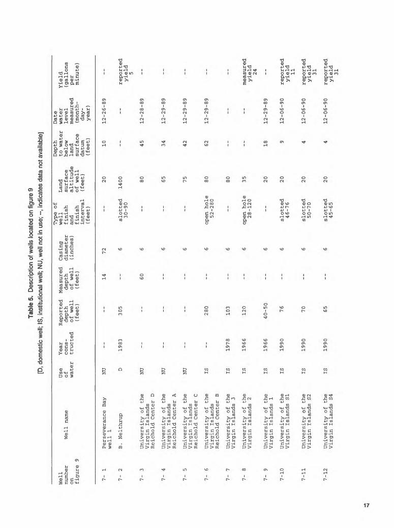
7-
1
7- 2
7- 3
7- 4
7- 5
7-
6
7- 7
7- 8
7-
9
7-10
7-11
7-12
Well name
Perseverance Bay
well 1
B. Nelthrup
University of
th
e Virgin Islands
Reichold Center D
University of th
e Virgin Islands
Reichold Center A
University of
th
e Virgin Islands
Reichold Center C
University of the
Virgin Islands
Reichold Center B
University of
th
e Virgin Islands 3
University of
th
e Virgin Islands 2
University of th
e Virgin Islands 1
University of
the
Virgin Islands SI
University of
th
e Virgin Islands S2
University of
the
Virgin Islands S4
Use
Year
Reported Measured
Casing
of
cons-
depth
depth
diameter
water
tructed
of well
of well
(inches)
(fee
t)
(feet)
NU
--
--
14
72
D 19
83
305
--
6
NU
--
--
60
6
NU
--
--
--
6
NU
--
--
--
6
IS
--
280
--
6
IS
1978
103
--
6
IS
1966
120
--
6
IS
1966
40-50
--
6
IS
1990
76
--
6
IS
1990
70
--
6
IS
1990
65
--
6
Type of
well
finish
and
finish
interval
(fee
t) --
slotted
30-90
-- --
open hole
52-280
--
open hole
28-120
--
slotted
46-76
slotted
50-70
slotted
45-65
Land
surface
altitude
of well
(fee
t) 20
1400 80 65 75 80 80 35 20 20 20 20
Depth
to water
below
land
surface
datum
(feet) 10 -- 45 34 42 62 -- -- 18
9 4 4
Date
water
level
measured
(mon
th-
day-
year)
12-26-89
--
12-28-89
12-29-89
12-29-89
12-29-89
-- --
12-29-89
12-06-90
12-06-90
12-06-90
Yiel
d (gallons
per
minu
te)
--
repo
rted
yi
eld
5 -- -- -- -- --
meas
ured
yield
24 --
repo
rted
yield
11
repo
rted
yield
31
repo
rted
yield
31
Tabl
e 5.
Des
crip
tion
of w
ells
loca
ted
on fi
gure
9-C
ontin
ued
[C, c
omm
erci
al w
ell;
D, d
omes
tic w
ell;
IS, i
nstit
utio
nal w
ell;
NU
, wel
l not
in u
se;
--, in
dica
tes
data
not
ava
ilabl
e]
i 5T o 3 f* i » C < <3 5" w §. (0
Well
number
on figure 9
7-13
7-14
7-15
7-16
7-17
7-18
7-19
7-20
Well
na
me
University of th
eVirgin Islands
S3
University of
th
eVirgin Islands
dug
well
Kirwan Terrace
Housing
D
Kirwan Terrace
Housing
C
Kirwan Terrace
Housing
dug
well
Kirwan Terrace
Housing A
University of the
Virgin Islands
El
V .
Greaux
Use
Year
Reported Measured
Casing
of
cons
- de
pth
depth
diam
eter
water
tructed
of well
of we
ll
(inches)
(feet)
(feet)
IS
1990
50
--
6
NU
--
--
16
84
NU
1978
--
94
6
NU
1969
--
--
6
NU
--
--
31
89
NU
1969
--
6
NU
1990
65
--
4
D
1964
80
--
6
Type of
well
fini
shand
fini
shin
terv
al(f
eet)
slotted
30-5
0
__ __ __ __
slotted
45-65
slot
ted
30-7
0
Land
surface
alti
tude
of we
ll(f
eet) 20 15 25 25 40 45 80 80
Dept
hto
wa
ter
belo
wla
ndsu
rfac
edatum
(feet) 3 2 23 21 21 32 37
pump
ing
water
Date
water
leve
lmeasured
(mon
th-
day-
year)
12-0
6-90
12-29-89
08-08-90
09-12-90
01-05-90
09-12-90
12-06-90
01-04-90
Yield
(gallons
per
minute)
repo
rted
yield
31 __ __ __ __ __
reported
yiel
d7 __
7-21
USGS 8
NU
1963
8080
open
ho
le
120
25-8
0
leve
l 32 21
01-05-90
7-22
E. Dudovick (T
hatc
h C
1978
Farm Fa
mily
well)
6512
5 pumping
06-18-90
wate
rlevel
49

64°58' 18'22f
64'56'
18"20'
Base from U.S. Geological Survey Central St. Thomas, V.I. 1:24,000, 1982
SCALE
1 2 MILES
2 KILOMETERS
Figure 10. Location of wells on grid 8 of figure 1. The well numbers shown on this figure correspond to the well numbers which begin with 8- in table 6 and appendixes A and B.
19
Tabl
e 6.
D
escr
iptio
n of
wel
ls lo
cate
d on
figu
re 1
0 [A
, agr
icul
tura
l or s
tock
wel
l; C,
com
mer
cial
wel
l; D,
dom
estic
wel
l; N
U, w
ell n
ot in
use
; --,
indi
cate
s da
ta n
ot a
vaila
ble]
Water wells
on St o 3 0) (0 C
(0 c3 3' w" 0) 3
Type of
Well
Use
Year
Reported Measured
Casing
well
Land
number
Well name
of
cons
- depth
depth
diameter
finish
surface
on
water
tructed
of well
of well
(inches)
and
altitude
figure 10
(f
eet)
(feet)
finish
of well
interval
(feet)
(fee
t)
8- 1
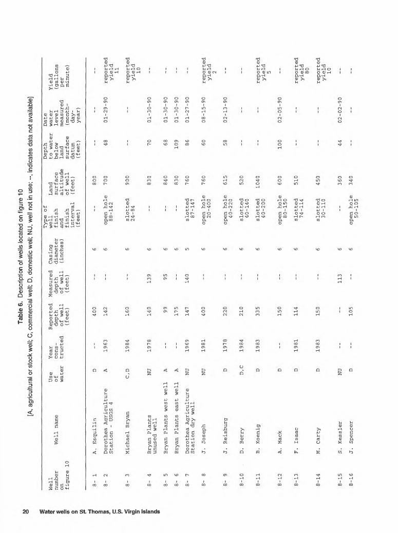
8- 2
8-
3
8- 4
8- 5
8-
6
8-
7
8-
8
8- 9
8-10
.
8-11
8-12
8-13
8-14
8-15
8-16
A. Esquilin
D --
400
Dorothea Agriculture
A
1963
142
Station - USGS 4
Michael Bryan
C,D
1984
160
Bryan Plants
NU
1978
140
unused well
Bryan Plants west well
A
--
99
Bryan Plants east well
A
--
175
Dorothea Agriculture
NU
1969
147
Stat
ion
dry
well
J. Joseph
NU
1981
400
J. Reisburg
D 1978
220
D. Berry
D,C
1984
210
B. Koenig
D 1983
335
A. Mack
D --
150
F. Isaac
D 1981
114
M. Carty
D 1983
150
S. Kessler
NU
J. Spencer
D --
105
6 --
800
6 open hole
700
88-142
6 slotted
900
24-84
139
6 --
830
95
6 --
840
6 --
830
140
5 slotted
760
87-147
6 open hole
760
20-400
6 open hole
615
40-220
6 slotted
520
40-140
6 slotted
1040
40-200
6 open hole
600
80-150
6 sl
otte
d 510
74-114
6 sl
otte
d 450
30-110
113
6 --
360
6 open hole
340
50-105
Depth
Date
to water
water
Yield
below
leve
l (g
allo
ns
land
measured
per
surface
(mon
th-
minu
te)
datum
day-
(feet)
year)
__
__
__
48
01-29-90
reported
yield
11
reported
yield
10
70
01-30-90
68
01-30-90
109
01-30-90
86
01-27-90
60
08-15-90
reported
yiel
d2
58
02-13-90
__
reported
yield
5
100
02-05-90
reported
yield
80
repo
rted
yield
10
44
02-02-90
__

Tabl
e 6.
D
escr
iptio
n of
wel
ls lo
cate
d on
figu
re 1
0-C
ontin
ued
[B, b
ottle
d w
ater
wel
l; C,
com
mer
cial
wel
l; D,
dom
estic
wel
l; PS
, pu
blic
-sup
ply
wel
l; N
U, w
ell n
ot in
use
; --,
indi
cate
s da
ta n
ot a
vaila
ble]
Well
number
on
figure 10
8-17
8-18
8-19
8-20
8-21
8-22
8-23
8-24
8-25
8-26
8-27
8-28
8-29
8-30
8-31
8-32
8-33
Well name
Peterson
Jackson
Kurach
W. Smith
S . Joshua
Kirwan Terrace
Housing B
J. Odato
Delagard
F. El-Haj
Sunny Mountain Water
Island Beachcomber
Hotel
Rock crusher plant
Muhsen/Muhsen
W. Turnbull Estate
Contant west well
W. Turnbull Estate
Contant west well
A. King
Virgin Islands
Use
of
water
NU
NU
NU
NU
NU
NU
NU D D B C C
PS NU
NU
NU
NU
Year
Reported Measured
Casing
cons-
depth
depth
diameter
tructed
of well
of well
(inc
hes)
(feet)
(fee
t)
1966
15
0 15
0 6
115
--
6
1963
153
25
6
1978
345
--
8
26
--
66
1969
64
6
31
132
1935
--
27
120
1987
10
0 --
6
1980
10
5 --
6
1968
40
--
4
18
12
1984
215
--
4 6 6
1989
--
119
3 8
Type of
well
finish
and
finish
interval
(fee
t)
open hole
20-150
open hole
27-115
open hole
4-153
Land
surface
altitude
of well
(fee
t) 100
110 70
open hole
70
42-345
-- -- -- --
slotted
45-65
open hole
22-105
-- --
slotted
100-215
-- -- -- --
55 30 35 30 30 20 10 40 60 80 80 65 50
Depth
to water
below
land
surface
datum
(fee
t) 41 16 -- 29 -- 23 17 15
pumping
water
level
18
pumping
water
level
7 2 6
-
-- 41 32 25
Date
water
leve
l measured
(mon
th-
day-
year)
01-10-90
08-15-90
--
08-15-90
--
09-12-90
01-04-90
01-11-90
01-03-90
01-03-90
01-02-90
02-13-90
01-03-90
01-02-90
01-02-90
01-29-90
01-26-90
Yield
(gallons
per
minute )
-- -- --
reported
yield
25 -- -- -- --
measured
yield
24 -- --
measured
yield
8 -- -- -- --Development Co
rp.

Tabl
e 6.
D
escr
iptio
n of
wel
ls lo
cate
d on
fig
ure
10--
Con
tinue
d
[C,
com
mer
cial
wel
l; D
, do
mes
tic w
ell;
PS,
publ
ic-s
uppl
y w
ell;
NU
, w
ell n
ot in
use
; --,
ind
icat
es d
ata
not a
vaila
ble]
/ater
wells
on St. H O 0) f C < S 5 55" a w
Well
numb
er
Well name
on
figu
re 10
8-34
8-35
8-36
8-37
8-38
8-39
8-40
8-41
8-42
8-43
8-44
8-45
8-46
8-47
8-48
8-49
8-50
8-51
8-52
8-53
8-54
Supe
rcat
Laundry
Frie
ndly
Supermarket
J. Mo
nsan
to
E . Qu
ania
ng
F. Esquirdo
Bamboushay Club
L. Olive
Auba
in
M. Hughes
Soto To
wn
W. Wh
ite
Vanterpool
Virgin Is
le Hotel
H. Richards
J. Gifft
Gilmore
Enterprises
Gott
lieb
Quick
Way
L. Mitchell
K . Thomas
V. He
ndri
cks
Lind
en Corp.
Use
Year
Reported Measured
Casing
of
cons
- depth
depth
diam
eter
wa
ter
tructed
of well
of well
(inches)
(feet)
(feet)
NU NU D
1968
350
NU
1963
86
NU
1958
C 19
44
D 1978
62
D --
28
D 19
78
105
NU
1978
46
5
PS
--
350
NU
--
230
NU
1985
600
D D
1948
38
D --
36
NU
1944
D D --
18
D 19
44
C
6
--
--
6 6
17
90
12
96
6
28
96
6 6 6 6 6 6
72
8
8 55
10
108
16 -- __
Type of
we
ll
Land
finish
surface
and
altitude
finish
of we
ll
interval
(feet)
(feet)
open ho
le70
-110
--
open hole
55-3
50
slotted
42-8
4
-- -- -- -- --
open ho
le32
-465
open ho
le35
-350
__ -- -- --
open
ho
le28
-36
-- -- -- -- --
50 50 90 40 25 20 40 20 70 70 125
120
240 30 25
5 5
10 35 40 20
Depth
Date
to
water
water
Yield
below
leve
l (g
allo
ns
land
measured
per
surface
(mon
th-
minu
te)
datum
day-
(feet)
year
)
25
01-2
6-90
-- __ 30
01-1
8-90
reported
yield
20
13
01-1
9-90
7 01
-19-
90
26
01-2
3-90
19
02-0
1-90
-- 11
01-3
0-90
__ 17
01-3
0-90
re
port
edyield
12
__ -- 20
01-2
9-90
4 01
-26-
90
repo
rted
yield
25
4 01
-23-
90
5 01
-19-
90
10
10-0
3-90
__ __
Tabl
e 6.
D
escr
iptio
n of
wel
ls lo
cate
d on
figu
re 1
0-C
ontin
ued
[B, b
ottle
d w
ater
wel
l; D,
dom
estic
wel
l; PS
, pu
blic
-sup
ply
wel
l; N
U, w
ell n
ot in
use
; --,
indi
cate
s da
ta n
ot a
vaila
ble]
Type of
Well
Use
Year
Reported
Measured
Casing
well
Land
number
Well name
of
cons-
depth
depth
diameter
finish
surface
on
water
tructed
of well
of well
(inches)
and
altitude
figure 10
(fee
t)
(feet)
finish
of well
interval
(feet)
(fee
t)
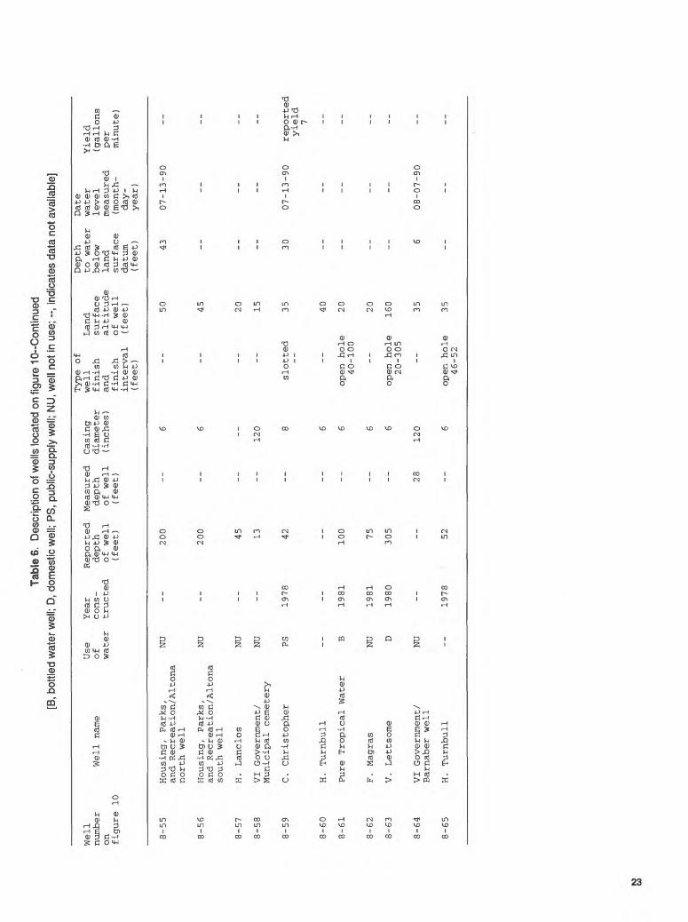
8-55
8-56
8-57
8-58
8-59
8-60
8-61
8-62
8-63
8-64
Housing, Parks,
NU
--
200
6 --
50
and Recreation/Altona
north well
Housing, Parks,
NU
--
200
--
6 --
45
and Recreation/Altona
south well
H. Lanclos
NU
--
45
--
20
VI Government/
NU
--
13
--
120
--
15
Municipal cemetery
C. Christopher
PS
1978
42
--
8 slotted
35
H. Turnbull
--
--
--
--
6 --
40
Pure Tropical Water
B 1981
100
--
6 open hole
20
40-100
F. Magras
NU
1981
75
--
6 --
20
V. Lettsome
D 1980
305
--
6 open hole
160
20-305
VI Government/
NU
--
--
28
120
--
35
Barnaber well
Depth
Date
to water
water
Yield
below
level
(gallons
land
measured
per
surface
(mon
th-
minute)
datum
day-
(fee
t)
year)
43
07-13-90
--
--
--
-- -- 30
07-13-90
reported
yield
7
-- -- -- --
6 08-07-90
8-65
H. Turnbull
1978
52open hole
35
46-52

64'56' 64°54'
18*20'
Base from U.S. Geological Survey Central St. Thomas, V.I. 1:24,000. 1982
SCALE
2 MILES
2 KILOMETERS
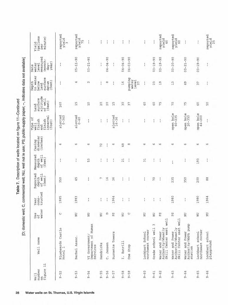
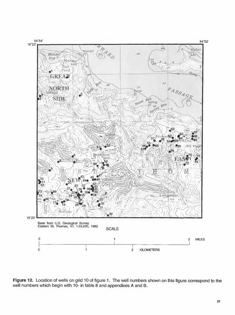
Figure 11 . Location of wells on grid 9 of figure 1. The well numbers shown on this figure correspond to the well numbers which begin with 9- in table 7 and appendixes A and B.
24 Water wells on St. Thomas, U.S. Virgin Islands

Tabl
e 7.
Des
crip
tion
of w
ells
loca
ted
on fi
gure
11
[A, a
gric
ultu
ral o
r sto
ck w
ell;
C, c
omm
erci
al w
ell;
PS,
publ
ic-s
uppl
y w
ell;
NU
, wel
l not
in u
se; -
-, in
dica
tes
data
not
ava
ilabl
e]
Well
number
on
figure 11
9- 1
9- 2
9-
3
9- 4
9-
5
9-
6
9- 7
9-
8
9-
9
9-10
9-11
9-12
9-13
9-14
9-15
9-16
9-17
9-18
Well name
Magens beach
dug well
Magens beach
drilled well
Arboretum
D. Raimer
J . Ladee
Magens Point Hotel
St.
Thomas Dairy E
St.
Thomas Dairy F
St.
Thomas Dairy A
St.
Thomas Dairy B
St .
Thomas Dairy
supply well
St.
Thomas Dairy
dug well
Mahogany Run 1
Mahogany Run 2
Mahogany Run 3
Mahogany Run 3 A
Mahogany Run 3B
Mahogany Run 4
Use
of
water
C C
NU A A C C C A
NU C
NU
PS
PS
PS
PS
NU
NU
Year
Reported
Measured
Casing
cons-
depth
depth
diameter
tructed
of well
of well
(inches)
(feet)
(fee
t) 8 12
0
1984
65
--
8
1949
--
7 72
9 72
1981
200
--
6
1987
350
--
6
1986
320
--
6
1981
315
--
6
125
--
6
149
6
1967
150
--
6
1935
--
23
144
70
--
6
1979
12
7 --
6
1979
139
--
6
1979
128
130
6
1979
--
47
6
1979
--
37
6
Type of
well
Land
finish
surface
and
altitude
finish
of well
interval
(fee
t)
(fee
t)
10 10 20 20
open hole
113
10-200
slotted
180
40-100
slotted
140
60-140
slotted
140 85 85 60 50 60 70 70 70 70 70
Depth
to water
below
land
surface
datum
(fee
t) 5
4 4
-- -- -- 23 23 4 19 32 ~ ~ 20 18 27
Date
water
level
measured
( month-
day -
year
)
04-13-90
04-17-90
04-13-90
-- -- --
04-27-90
04-25-90
04-25-90
04-30-90
04-30-90
-
04-30-90
04-30-90
04-30-90
Yield
(gallons
per
minute)
reported
yield
150 -- --
reported
yield
2 --
reported
yield
6 --
reported
yield
12-15
--
measured
yield
12
-- -- --
measured
yield
6 --

Tabl
e 7.
Des
crip
tion
of w
ells
loca
ted
on fi
gure
11-
Con
tinue
d [A
, agr
icul
tura
l or s
tock
wel
l; C
, com
mer
cial
wel
l; D,
dom
estic
wel
l; PS
, pub
lic-s
uppl
y w
ell;
NU
, wel
l not
in u
se; -
-, in
dica
tes
data
not
ava
ilabl
e]
ater wells
on St.
1 1 o m w c o> '< S 5" 5T m Q. W
Well
number
on
figure 11
9-19
9-20
9-21
9-22
9-23
9-24
9-25
9-26
9-27
9-28
9-29
9-30
9-31
9-32
9-33
9-34
9-35
9-36
Well name
Mahogany Run 5
Mahogany Run 5A
Mahogany Run 7
Mahogany Run 8
Mahogany Run 9
Mahogany Run dug
well
Mahogany Run 11
Mahogany Run 10
/St.
Thomas Dairy
USGS-3
Mahogany Run 12
Mahogany Run 14
Mahogany Run 14 A
Mahogony Run 15
Mahogany Run 16
Mahogany Run 17
F. McConnel
A. Raimer
Moorehead
P. Clooney
Use
of
water
PS NU
PS PS PS NU PS
C
NU
NU
PS
PS
NU
NU A D
NU D
Year
Reported
cons-
depth
tructed
of well
(fee
t)
1979
140
1979
75
1979
19
6
1979
192
125
__
1979
184
__
1979
107
1982
1979
143
1979
16
2
1979
16
8
1979
1962
90
--
260
1968
120
Measured
depth
of well
(fee
t) -- -- -- -- __ 20 -- __ -- 39 -- -- -- -- __
8
260 --
Casing
diameter
(inches)
6 6 6 6 6
90
6 6 6 6 6 6 6 6 6
84
6 6
Type of
well
Land
finish
surface
and
altitude
finish
of well
interval
(feet)
(feet)
70 70 75 75 80 80 80 90 90 95 95
100
100
110
open hole
435
20-90
395
open hole
395
12-260
open hole
500
8-120
Depth
to water
below
land
surface
datum
(feet)
pumping
water
level
23 26 -- --
pumping
water
level
28 --
pumping
water
level
28 __ -- 29 -- 32 38 39 67
2
21 __
Date
water
level
measured
( month-
day -
year
)
04-30-90
04-30-90
-- --
04-30-90
__
05-01-90
__ --
05-01-90
--
05-01-90
05-01-90
05-01-90
05-11-90
04-13-90
04-13-90
__
Yield
(gallons
per
minute)
-- -- --
measured
yield
8
measured
yield 7
__
measured
yield
15 __ -- -- -- -- -- -- __ -- __
reported
yield
8-10
Tabl
e 7.
Des
crip
tion
of w
ells
loca
ted
on fi
gure
11-
Con
tinue
d [A
, ag
ricul
tura
l or s
tock
wel
l; D,
dom
estic
wel
l; IS
, in
stitu
tiona
l wel
l, N
U, w
ell n
ot in
use
; --,
indi
cate
s da
ta n
ot a
vaila
ble]
Well
number
on
figure 11
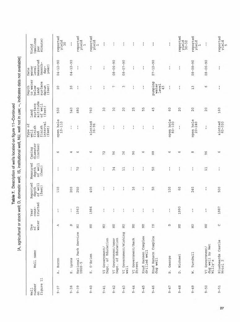
9-37
9-38
9-39
9-40
9-41
9-42
9-43
9-44
9-45
9-46
9-47
9-48
9-49
9-50
9-51
Use
Well name
of
water
A. Bornn
A
E . Lyons
D
National Park Service
NU
USGS- 5
E. O'Brien
NU
VI Government/
NU
Dept.
of Education
VI Government /near
NU
Dept.
of Education
VI Government/Wishing
NU
well
VI Government /Back
NU
Street
Knud Hansen Complex
NU
drilled well
Knud Hansen Complex
ISdug well
B. George
D
D. Michael
NU
W. Turnbull
NU
VI Government/
NU
dug well by Wet
Willy's
Bluebeards Castle
CHotel 2
Year
Reported Measured
Casing
cons-
depth
depth
diameter
tructed
of well
of well
(inches)
(feet)
(fee
t)
110
--
6
200
--
4
1963
25
0 70
6
1984
40
0 --
6
72
34
96
11
36
16
--
96
6
50
50
88
100
--
6
1990
60
--
6
240
--
8
11
96
1987
500
--
6
Type of
well
finish
and
finish
interval
(fee
t)
open hole
10-110
-- __
slotted
36-96
__ __ __ __ __ __
open hole
80-100
--
open hole
20-240
__
slotted
60-200
Land
surface
altitude
of well
(feet)
530
540
680
760 30 30 20 25 55 45 60 20 20 20
160
Depth
to water
below
land
surface
datum
(fee
t) 20 30 __ __ __
7 3 __ __
pumping
water
level
43 __ __ 13
6
__
Date
water
level
measured
(mon
th-
day-
year
)
04-12-90
04-12-90
__ __ __
08-06-90
08-07-90
__ __
07-12-90
__ __
08-08-90
08-06-90
__
Yield
(gallons
per
minute)
reported
yield
30 --
reported
yield
1
reported
yield
1 __ __ __ __ __ __ __
reported
yield
30-3
2
reported
yield
1 __
reported
yield
5
Tabl
e 7.
D
escr
iptio
n of
wel
ls lo
cate
d on
figu
re 1
1--C
ontin
ued
[D; d
omes
tic w
ell;
C, c
omm
erci
al w
ell;
NU
, wel
l not
in u
se;
PS; p
ublic
-sup
ply
pape
r; --,
indi
cate
s da
ta n
ot a
vaila
ble]
3 3. ff < 2. 3T o 3 ^ O 3 0) C <: (D 5' 5T 0) a
Well
number
on figure 11
9-52
9-53
9-54
9-55
9-56
9-57
9-58
9-59
9-60
9-61
9-62
9-63
9-64
9-65
9-66
Use
Well name
of water
Bluebeards Castle
CHotel 1
Barbel As
soc.
NU
VI Government/
NU
Department of
Human
Services
Hendricks
NU
C . Jensen
D
Burnette Towers
PS
I. Estrill
NU
One Stop
C
Lockhart School
NU
northwest corner
Grade school well 3
NU
Water and Power
PSAuthority/ Wheat ly
Skill Center west well
Water and Power
PSAuthority/ Wheat ly
Skill Center east well
Water and Power
NU
Authority/WAPA pump
station
Lockhart school
NU
northeast corner
Lockhart school
NU
playground
Year
Reported Measured
Casing
cons-
depth
depth
diameter
tructed
of well
of well
(inches)
(fee
t)
(fee
t)
1985
350
--
6
1983
45
--
6
53
6
7 --
72
16
1964
36
--
6
21
48
8
31
6
70
--
6 6
1980
235
--
6
350
--
6
1980
200
193
6
1964
88
--
6
Type of
well
finish
and
finish
interval
(feet)
slotted
0-340
slotted
0-40 -- -- --
slotted
16-36
-- -- __ -- __
open hole
60-235
open hole
20-350
open hole
44-200
_-
Land
surface
altitude
of well
(fee
t)
160 15 10 20 20 15 30 37 60 60 75 70 75 60 50
Depth
to water
belo
wla
ndsurface
datum
(fee
t) -- 4 2
--
8
__ 16
pumping
water
level
27 __ 23 19 13 49 37 -_
Date
water
level
measured
(mon
th-
day -
year)
--
05-11-90
03-21-90
--
04-04-90
__
04-04-90
04-03-90
__
03-19-90
03-19-90
03-20-90
03-21-90
03-19-90
__
Yield
(gallons
per
minute)
reported
yield
3
reported
yield
75 __ -- -- __ -- -_ __ --
reported
yield
40
reported
yield
60 __ __
reported
yield
25

Tabl
e 7.
D
escr
iptio
n of
wel
ls lo
cate
d on
fig
ure
11-C
ontin
ued
[C,
com
mer
cial
wel
l; D
, dom
estic
wel
l; PS
, pu
blic
-sup
ply
wel
l; N
U,
wel
l not
in u
se;
--, i
ndic
ates
dat
a no
t ava
ilabl
e]
Well
number
on
figure 11
9-67
9-68
9-69
9-70
9-71
9-72
9-73
9-74
9-75
9-76
9-77
9-78
9-79
9-80
9-81
9-82
Well
na
me
G. Bl
ackh
al
Hall
pick
e
Rodgers
G . Hodge
J. Bl
yden
Moore
L. Mathias
E. Radsatt
Walters
A. Lima
Yeppsen
Yacht
Have
n Ho
tel
St.
Thomas Mall Inc.
W. Turnbull Estate
Thomas west we
ll
W. Tu
rnbu
ll Estate
Thomas ea
st well
Wheat ly
Sh
oppi
ng
Center
Use
Year
Reported Measured
Casing
of
cons-
depth
depth
diam
eter
wa
ter
tructed
of well
of we
ll
(inc
hes)
(feet)
(feet)
C 19
63
100
--
5
D
1964
45
40
6
C,D
1964
67
--
6
D 1978
65
--
6
D 1981
60
--
6
D 1960
--
12
NU
--
--
12
48
C 19
63
56
--
6
D --
9
72
D --
40
--
2
D --
40
6
C --
--
--
6
C --
17
17
PS
1984
155
--
6
PS
--
240
--
6
C 1977
67
--
6
Type of
we
ll
finish
and
finish
inte
rval
(feet)
slotted
40-100
slotted
25-4
5
slotted
21-6
3
slotted
35-6
5
open ho
le
50-60
-- --
slotted
-- -- --
slotted
20-100
--
open ho
le
60-6
7
Land
surface
altitude
of we
ll
(feet) 40 35 25 20 15 20 20 20 20 20 30
5
10 45 110 55
Depth
to water
below
land
surface
datum
(fee
t) 29 --
12
6
--
7
pumping
water
level
15
8
--
pumping
water
level
18 --
pumping
water
level
6
62 --
pumping
water
level
44
Date
water
level
measured
(mon
th-
day -
year
)
04-09-90
-- --
03-21-90
03-29-90
--
04-04-90
04-04-90
04-09-90
--
04-03-90
--
10-04-90
08-08-90
--
04-03-90
Yield
(gal
lons
per
minu
te)
-- --
reported
yield
8-10
repo
rted
yield
12 -- -- --
repo
rted
yield
15
-- -- --
reported
yield
20 --
repo
rted
yield
15
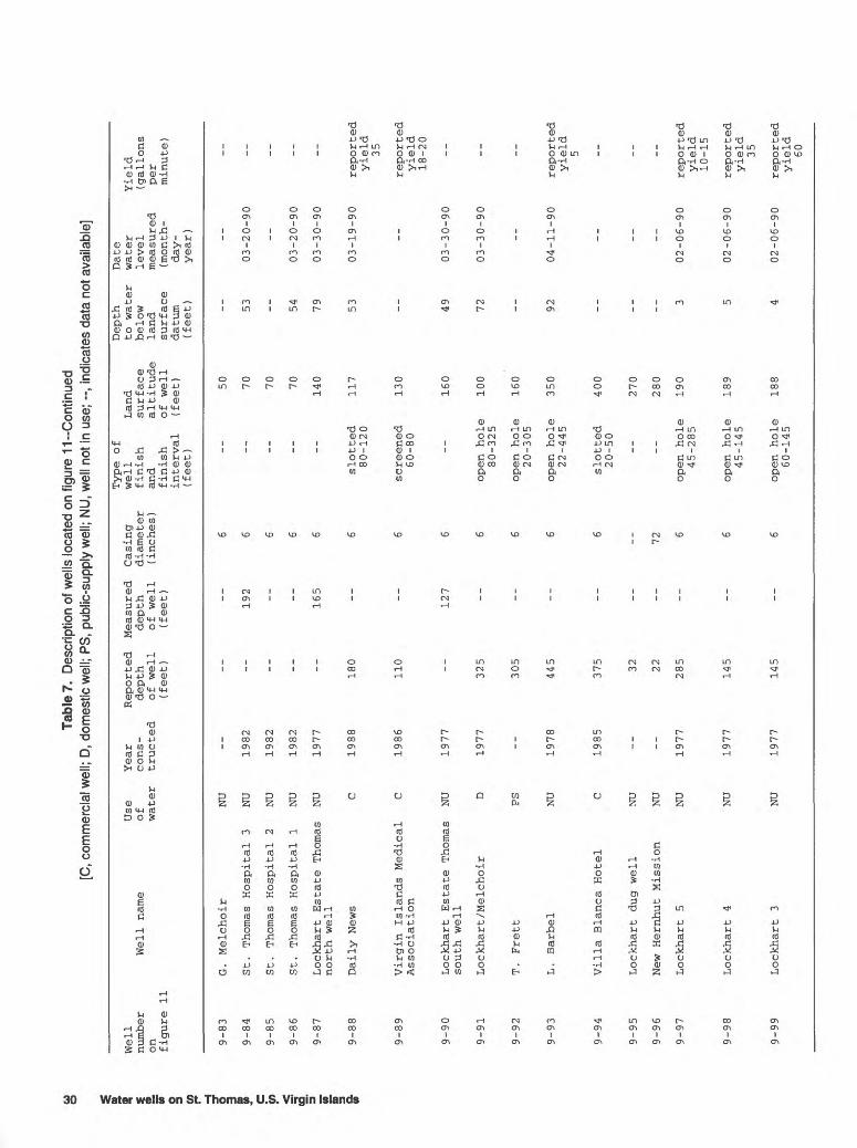
Tabl
e 7.
Des
crip
tion
of w
ells
loca
ted
on fi
gure
11-
Con
tinue
d [C
, com
mer
cial
wel
l; D,
dom
estic
wel
l; PS
, pu
blic
-sup
ply
wel
l; N
U, w
ell n
ot in
use
; --,
indi
cate
s da
ta n
ot a
vaila
ble]
i (D i §? s H
O 3 y c ^* 5' ST 5T 1
Well
numb
eron fi
gure 11
9-83
9-84
9-85
9-86
9-87
9-88
9-89
9-90
9-91
9-92
9-93
9-94
9-95
9-96
9-97
9-98
9-99
Use
Well name
of water
G. Melchoir
NU
St .
Thomas Hospital 3
NU
St.
Thomas Hospital 2
NU
St.
Thomas Hospital 1
NU
Lockhart Estate Thomas
NU
north well
Daily News
C
Virgin Islands Medical
CAssociation
Lockhart Estate Thomas
NU
south well
Lockhart/Melchoir
D
T. Frett
PS
L. Barbel
NU
Villa Blanca Hotel
C
Lockhart dug well
NU
New Hernhut Mission
NU
Lockhart 5
NU
Lockhart 4
NU
Lockhart 3
NU
Year
Reported Measured
Casing
cons-
depth
depth
diameter
tructed
of well
of well
(inches)
(fee
t)
(fee
t)
6
1982
--
192
6
1982
--
--
6
1982
--
--
6
1977
--
165
6
1988
180
--
6
1986
110
--
6
1977
--
127
6
1977
325
--
6
305
--
6
1978
445
--
6
1985
375
--
6
32 22
--
72
1977
285
--
6
1977
145
--
6
1977
145
--
6
Type
of
well
fini
shan
dfi
nish
interval
(fee
t)
-- -- -- __
slot
ted
80-120
screened
60-8
0
__
open
ho
le80-325
open
hol
e20-305
open
hole
22-445
slot
ted
20-50
-- --
open
ho
le45-285
open
ho
le45
-145
open
hole
60-145
Land
surf
ace
alti
tude
of well
(feet) 50 70 70 70 140
117
130
160
100
160
350
400
270
280
190
189
188
Depth
Date
to water
water
belo
w le
vel
land
measured
surface
(mon
th-
datum
day-
(fee
t)
year
)
53
03-2
0-90
-- 54
03-20-90
79
03-30-90
53
03-19-90
__ 49
03-30-90
72
03-30-90
__ 92
04-11-90
__
__
__ __
3 02-06-90
5 02-06-90
4 02-06-90
Yield
(gallons
per
minu
te)
-- -- -- __
reported
yiel
d35
repo
rted
yield
18-2
0
__ __ __
reported
yield
5 __ -- --
repo
rted
yield
10-15
reported
yield
35
repo
rted
yiel
d60
64*54' 18*22'
64*52'
18*20'
* 23 ; -W"
^ ^^S^^^^^^
BasB from U.S. Geological Survey Eastern St. Thomas, V.\. 1:24,000, 1982
SCALE
2 MILES
2 KILOMETERS
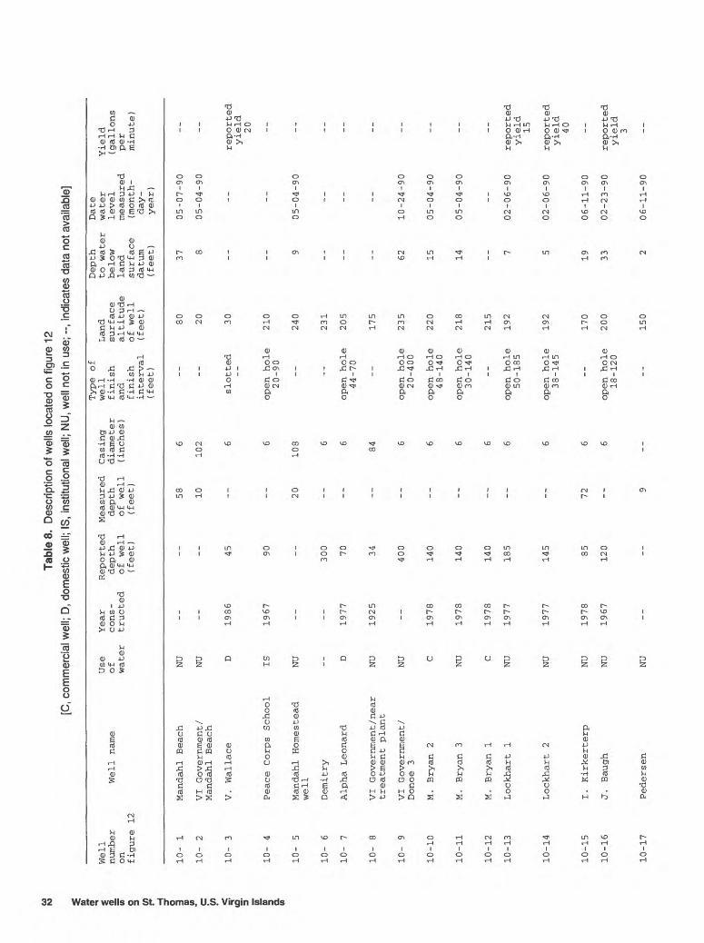
Figure 12. Location of wells on grid 10 of figure 1. The well numbers shown on this figure correspond to the well numbers which begin with 10- in table 8 and appendixes A and B.
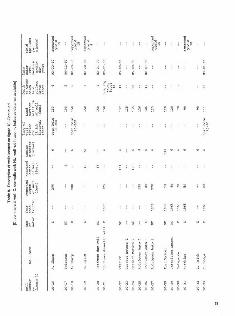
31
Tabl
e 8.
Des
crip
tion
of w
ells
loca
ted
on fi
gure
12
[C, c
omm
erci
al w
ell;
D, d
omes
tic w
ell;
IS,
inst
itutio
nal w
ell;
NU
, wel
l not
in u
se; -
-, in
dica
tes
data
not
ava
ilabl
e]
! i 2. 5T o 3 H O C in " IO 5' 5T a w
Well
number
on figu
re 12
10-
1
10-
2
10-
3
10-
4
10-
5
10-
6
10-
7
10-
8
10-
9
10-10
10-1
1
10-12
10-1
3
10-14
10-15
10-16
Well
name
Mandahl
Beach
VI Government/
Mandahl
Beac
h
V. Wallace
Peace
Corp
s School
Mandahl
Homestead
well
Demitry
Alpha Leonard
VI Government /near
treatment
plant
VI Go
vern
ment
/Do
noe
3
M. Br
yan
2
M. Br
yan
3
M. Bryan 1
Lockhart 1
Lockhart 2
I . Ki
rker
terp
J . Ba
ugh
Use
Year
Re
port
edof
co
ns-
dept
hwater
tructed
of we
ll(f
eet)
NU
NU D
1986
45
IS
1967
90
NU
300
D
1977
70
NU
1925
34
NU
--
400
C 1978
140
NU
1978
140
C 1978
140
NU
1977
185
NU
1977
145
NU
1978
85
NU
1967
120
Measured
Casi
ngdepth
diam
eter
of well
(inc
hes)
(fee
t) 58
6
10
102 6 6
20
108 6 6 84
6 6 6 6 6 6
72
6 6
Type
of
well
finish
and
finish
interval
(fee
t) -- --
slot
ted
--
open hole
20-9
0
-- --
open
hole
44-7
0
__
open
hol
e20-400
open h
ole
48-1
40
open
hole
30-140
--
open
hole
50-185
open
hol
e38-145
--
open
hol
e18-120
Land
surface
altitude
of we
ll(f
eet) 80 20 30
210
240
231
205
175
235
220
218
215
192
192
170
200
Dept
hto
water
belo
wla
ndsu
rfac
edatum
(fee
t) 37 8 -- -- 9 -- __ __ 62 15 14 -- 7 5 19 33
Date
water
leve
lmeasured
(mon
th-
day-
year)
05-0
7-90
05-0
4-90
-- --
05-0
4-90
-- __ __
10-2
4-90
05-0
4-90
05-0
4-90
--
02-0
6-90
02-0
6-90
06-1
1-90
02-2
3-90
Yield
(gal
lons
per
minu
te)
-- -_
reported
yield
20 -_ __ -- __ __ __ __ __ --
reported
yield
15
repo
rted
yield
40
reported
yield
3
10
-17
Ped
erse
nN
U15
006-1
1-9
0
Tabl
e 8.
Des
crip
tion
of w
ells
loca
ted
on fi
gure
12-
Con
tinue
d [C
, com
mer
cial
wel
l; D,
dom
estic
wel
l; N
U, w
ell n
ot in
use
; --,
indi
cate
s da
ta n
ot a
vaila
ble]
Well
number
on
figure 12
10-18
10-17
10-18
10-19
10-20
10-21
10-22
10-23
10-24
10-25
10-26
10-2
7
10-28
10-2
9
10-30
10-31
10-32
10-33
Well name
A .
Sharp
Pedersen
A .
Sharp
E. Eglin
Harthman dug well
Harthman domestic
VITELCO
Gassett Motors 1
Gassett Motors 2
Rodriguez Auto 2
Rodriguez Auto 3
Rodriguez Auto 4
Fort Mylner
Versailles As
soc.
Delagarde
Matthias
L. Smith
C . Hodge
Use
of
water
D
NU D D
NU
well
D
NU -- NU
--
C
NU
NU
NU D D D D
Year
Reported
cons-
depth
tructed
of well
(fee
t)
200
__
200
--
--
--
1978
325
-- -- --
120 80
1978
220
1938
18
1965
40
1965
70
1966
50
__
1967
80
Measured
Casing
depth
diameter
of well
(inches)
(feet)
6
9
6
13
72
15
6
131
6
__
128
6 6 6 6
133 6 6 6 6 6
Type of
well
Land
finish
surface
and
altitude
finish
of well
interval
(feet)
(fee
t)
open hole
150
20-200
150
open hole
150
20-200
150
150
150
137
135
135
126
126
125
120
120 70 90 90
open hole
111
20-80
Depth
to water
below
land
surface
datum
(fee
t) 6 2 6 7 1
pumping
water
level
18 17 -- 22 -- 11 -- -- -- -- -- -- 26
Date
water
level
measured
(mon
th-
day -
year)
02-20-90
06-11-90
02-20-90
02-20-90
02-21-90
02-21-90
05-08-90
--
05-08-90
--
02-07-90
-- -- -- -- -- --
03-01-90
Yield
(gallons
per
minute)
reported
yield
15 --
reported
yield
15
reported
yield
4 -- -- -- -- -- --
reported
yield
15 -- -- --
reported
yield
30 -- --

Tabl
e 8.
Des
crip
tion
of w
ells
loca
ted
on fi
gure
12-
-Con
tinue
d [C
, com
mer
cial
wel
l; D,
dom
estic
wel
l; N
U, w
ell n
ot in
use
; --,
indi
cate
s da
ta n
ot a
vaila
ble]
ater wells
on St.
1 ^ w C w <3 3 W 1
Well
number
on
figure 12
10-34
10-35
10-36
10-3
7
10-38
10-39
10-40
10-41
10-4
2
10-43
10-44
10-45
10-46
10-47
Use
Year
Reported
Measured
Casing
Well name
of
cons-
depth
depth
diameter
water
tructed
of well
of well
(inches)
(fee
t)
(fee
t)
E. Steel
D 1965
150
--
6
0. Harvey
NU
1978
160
--
5
Harthman near
NU
1978
325
80
6Gassett Motors
Crusher well
NU
1978
--
--
6
G. Eglin 1
C 1965
--
--
6
G. Eglin 3
C --
32
5 --
6
G. Eglin 2
C ------
6
Tom Cat Laundry
NU
VI Government /near
NU
--
--
27
108
Church of
God
Holiness
Harthman estate well
--
1965
210
--
6USGS-25
Church of God
NU
1981
265
--
6Holiness
Four Winds Plaza 2
NU
1981
285
--
6
Four Winds Plaza 1
NU
1981
305
--
6
E. Tillet
NU
' 19
63
100
--
6
Type of
well
finish
and
finish
interval
(fee
t) __ --
open hole
36-325
-- --
open hole
40-325
-- -- __
slotted
100-200
__ __
open hole
30-305
open hole
15-100
Land
surface
altitude
of well
(fee
t)
175
138
130
140
144
152
149
160
145
196
200
165
166
186
Depth
to water
below
land
surface
datum
(fee
t) 63 24 21 26 -- 18 14 -- 13 35 __
8
12 22
Date
water
level
measured
(mon
th-
day-
year
)
02-13-90
02-13-90
08-16-90
01-13-90
--
02-09-90
02-09-90
--
03-01-90
12-24-90
__
02-07-90
02-07-90
02-23-90
Yield
(gallons
per
minute)
reported
yield
reported
yield
25 --
reported
yield
60
reported
yield
60
reported
yield
60 -- __
reported
yield
30
reported
yield
35
reported
yield
5-10
reported
yield
12
reported
yield
60

Tabl
e 8.
Des
crip
tion
of w
ells
loca
ted
on fi
gure
12-
-Con
tinue
d [C
, com
mer
cial
wel
l; D,
dom
estic
wel
l; PS
, pu
blic
-sup
ply
wel
l; N
U, w
ell n
ot in
use
; --,
indi
cate
s da
ta n
ot a
vaila
ble]
Well
number
on
figure 12
10-4
8
10-49
10-5
0
10-5
1
10-52
10-53
10-5
4
10-55
10-5
6
10-5
7
10-5
8
10-59
10-6
0
10-61
Use
Year
Reported Measured
Casing
Well name
of
cons-
depth
depth
diameter
water
tructed
of well
of well
(inches)
(feet)
(fee
t)
Ramsey Motors
C 1978
105
6
Virgin Islands
PS
1978
175
--
6 Housing Authority 1
Virgin Islands
NU
1977
15
0 --
6
Housing Authority 2
Virgin Islands
PS
1978
142
--
6 Housing Authority 3
Virgin Islands
NU
1978
140
176
6 Housing Authority 4
C. F.
Rosenberg -
C,D
1963
12
0 --
6 USGS-2
Super Pool Resturant
C 1988
110
--
6
Smith Bay Center
C 19
87
150
--
6
A. Levia
D 1966
110
--
6
U. Pilgrim
D 1967
80
--
6
Fat
Man's/C. Husband
D,C
1985
80
--
6
R. Mercer
NU
--
--
54
6
Stouffer Grand Beach
C --
--
--
6 Hotel A
Stouffer Grand Beach
C 1985
100
--
6 Hotel B
Type of
well
finish
and
finish
interval
(feet)
open hole
65-105
open hole
41-175
open hole
37-150
open hole
73-142
open hole
69-140
open hole
21-120
open hole
60-110
-- --
slotted
40-80
slotted
35-75
-- --
screened
70-90
Land
surface
altitude
of well
(fee
t)
180
231
235
239
278 95 90 85 80 70
40
40 15 15
Depth
to water
below
land
surface
datum
(fee
t) 9
58 61 -- 41 20
pumping
water
level
32 -- 42 39
27
30 -- --
Date
water
level
measured
(mon
th-
day -
year)
02-23-90
02-12-90
02-12-90
--
02-13-90
03-01-90
02-22-90
--
03-01-90
02-22-90
02-22-90
04-12-90
-- --
Yield
(gallons
per
minute)
reported
yield
60
reported
yield
48
reported
yield
47
reported
yield
44
reported
yield
46
reported
yield
5 -- --
reported
yield
45
reported
yield
10
--
measured
yield
36
reported
yield
35-40
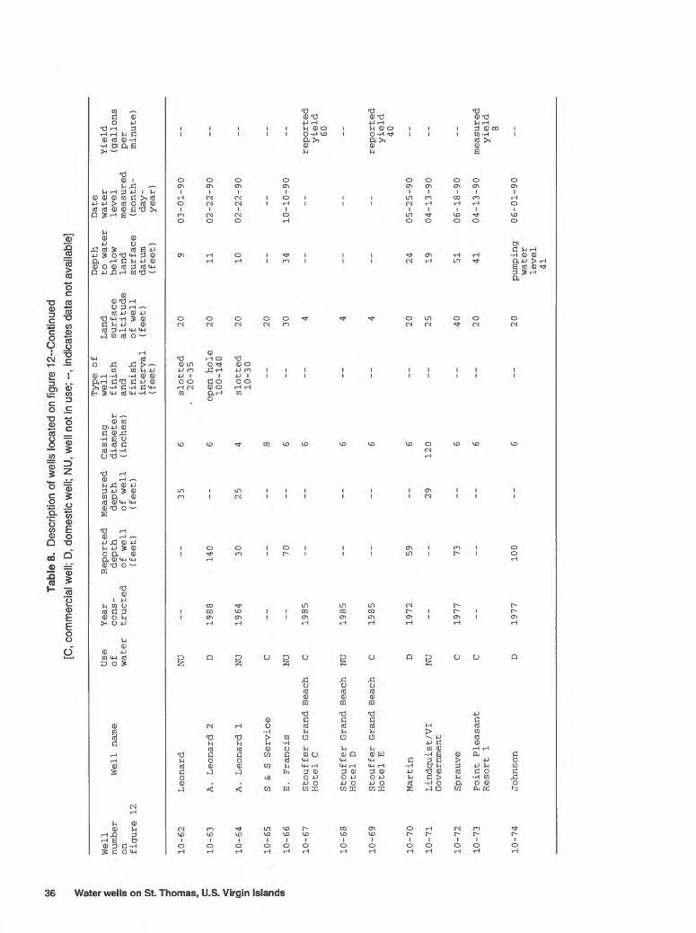
Tabl
e 8.
Des
crip
tion
of w
ells
loca
ted
on fi
gure
12-
Con
tinue
d [C
, com
mer
cial
wel
l; D,
dom
estic
wel
l; N
U, w
ell n
ot in
use
; --,
indi
cate
s da
ta n
ot a
vaila
ble]
r*
5 1 (0 o 3 r* H o 3 w C
C/5 <3 5' 5T D> Q. (A
Well
number
on figure 12
10-6
2
10-63
10-64
10-6
5
10-66
10-67
10-6
8
10-69
10-7
0
10-71
10-72
10-73
10-7
4
Use
Year
Reported
Well name
of
cons-
depth
water
tructed
of well
(fee
t)
Leonard
NU
A. Leonard 2
D 1988
140
A. Leonard 1
NU
1964
30
S &
S Service
C
E. Francis
NU
--
70
Stouffer Grand Beach
C 1985
Hotel C
Stouffer Grand Beach NU
1985
Hotel D
Stouffer Grand Beach
C 1985
Hotel E
Martin
D 1972
59
Lindquist/VI
NU
Government
Sprauve
C 1977
73
Point Pleasant
CResort 1
Johnson
D 1977
100
Measured
Casing
depth
diameter
of we
ll
(inc
hes)
(fee
t)
35
6 6
25
4 8 6 6 6 6 6
29
120 6 6 6
Type of
well
Land
finish
surface
and
altitude
finish
of well
inte
rval
(f
eet)
(fee
t)
slotted
20
20-35
open
hole
2010
0-14
0
slot
ted
2010-30
20 30
4 4 4
20 25 40 20 20
Depth
to water
below
land
surface
datum
(feet) 9
11 10 -- 34 __ __ __ 24 19 51 41
pumping
water
level
41
Date
water
level
measured
(mon
th-
day -
year
)
03-01-90
02-22-90
02-22-90
--
10-10-90
__ __ __
05-25-90
04-13-90
06-18-90
04-13-90
06-01-90
Yield
(gallons
per
minute)
-- __ __ -- --
repo
rted
yield
60 __
repo
rted
yield
40 -- __ --
measured
yield
8 --

64*52' 18*22'
64*50'
18*20'
Base from U.S. Geological Survey Eastern St. Thomas, v.\. 1:24,000, 1982
SCALE
2 KILOMETERS
2 MILES
Figure 13. Location of wells on grid 11 of figure 1. The well numbers shown on this figure correspond to the well numbers which begin with 11- in table 9 and appendixes A and B.
37

Tabl
e 9.
D
escr
iptio
n of
wel
ls lo
cate
d on
figu
re 1
3 [C
, com
mer
cial
wel
l; D,
dom
estic
wel
l; N
U, w
ell n
ot in
use
; --,
indi
cate
s da
ta n
ot a
vaila
ble]
1 (D 1 5T O 3 H O _ C w 1! 3 57 55" 3 a (0
Well
number
on figu
re 13
11-
1
11-
2
11-
3
11-
4
11-
5
11-
6
11-
7
Well
name
Point
Plea
sant
Resort 2
S. Harthman He
irs
Lind
quis
t
Sapphire Bay
Condo
West -supply well
Sapphire Bay
Condo
West-east
well
Sapp
hire
Bay
Cond
oWe
st-w
est
well
S. Harthman He
irs-
Use
of water
NU
NU D C
NU
NU
NU
Year
cons
tr
ucte
d
1989 --
1946
1981
1980
1980
1965
Repo
rted
depth
of we
ll(f
eet)
200 -- -- 100 -- -- 56
Measured
depth
of we
ll(feet) __ 10 13 --
104
108 --
Casing
diam
eter
(inches)
6
120 -- 6 8 8 6
Type of
well
finish
and
finish
inte
rval
(feet)
slotted
40-8
0
-- --
open
hole
40-100
-- __
open hole
Land
surface
altitude
of we
ll(feet) 20 10 10 10 20 20 30
Depth
to water
below
land
surface
datum
(feet) 12
6 3 5 5 4
27
Date
water
level
measured
(mon
th-
day -
year)
04-1
3-90
05-2
5-90
04-1
3-90
06-0
4-90
10-1
8-90
10-1
8-90
06-0
4-90
Yiel
d(gallons
per
minu
te)
reported
yield
70 -- -- -- -- __ --U
SG
S
232
3-5
6

65'00' 18'20'
65'58'
18'18'
Base from U.S. Geological Survey Central St. Thomas, V.I. 1:24,000, 1982
SCALE
Figure 14. Grid 12 of figure 1.
2 KILOMETERS
2 MILES
39
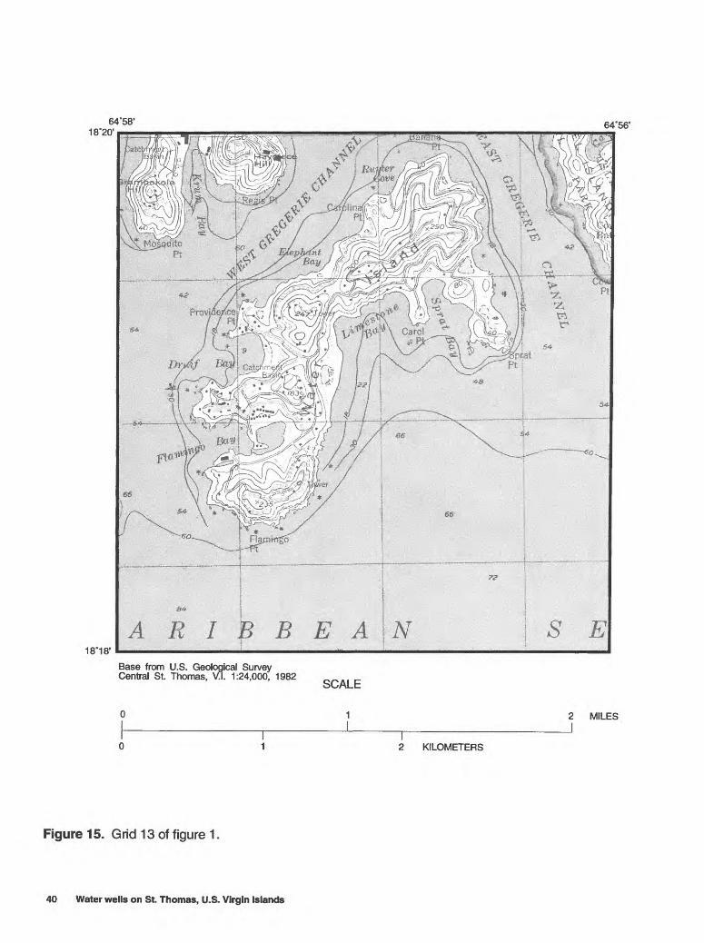
64'58' 18"20'
64'56'
18*18'A R I B B E A
Base from U.S. Geological Survey Central St. Thomas, V.I. 1:24,000, 1982
SCALE
1
2 KILOMETERS
2 MILES
Figure 15. Grid 13 of figure 1.
40 Water wells on St. Thomas, U.S. Virgin Islands

64'56'6454
18*18'
Base from U.S. Geological Survey Central St. Thomas, V.I. 1:24,000, 1982
SCALE
1 2 MILES
2 KILOMETERS
Figure 16. Location of wells on grid 14 of figure 1. The well numbers shown on this figure correspond to the well numbers which begin with 14- in table 10 and appendixes A and B.
41
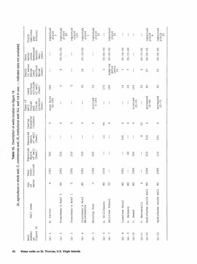
Tabl
e 10
. D
escr
iptio
n of
wel
ls lo
cate
d on
figu
re 1
6 [A
, agr
icul
tura
l or s
tock
wel
l; C
, com
mer
cial
wel
l; IS
, in
stitu
tiona
l wel
l; N
U, w
ell n
ot in
use
; --,
indi
cate
s da
ta n
ot a
vaila
ble]
1 CD CD & O 3 H
O D> W C CO < <3 5' 5T 5" Q. (0
Well
numb
eron figure 16
14-
1
14-
2
14-
3
14-
4
14-
5
14-
6
14-
7
14-
8
14-
9
14-10
14-1
1
14-12
14-1
3
Use
Well name
of water
M. Carter
A
Frenchman's Reef 3
NU
Frenchman's Reef 1
C
Frenchman's Reef
NU
Maintenance
Morning Star
C
A. Willimason
NU
Antilles School
IS
Limetree Hotel
NU
A. Halpern
NU
F . Samad
NU
F. Mercetelli
A
Hydrofarms north well
NU
Hydro farms south well
NU
Year
Reported
Measured
Casing
cons-
depth
depth
diameter
tructed
of well
of well
(inches)
(fee
t)
(fee
t)
1981
585
--
6
1981
235
--
6
1981
230
--
6
1981
35
0 --
6
1982
200
--
6
1955
--
11
96
6
1981
--
100
6
60
--
6
1985
300
--
6
8 53
1986
220
218
6
1986
11
0 10
1 6
Type of
well
finish
and
finish
interval
(fee
t)
open hole
40-585
-- --
slotted
0-195
-- __ -- --
slotted
25-65
--
screened
34-84
screened
15-75
Land
surface
altitude
of well
(feet) 640 5 5
50 20 170
180 10 20
160 20 85 80
Depth
to water
below
land
surface
datum
(fee
t) __ 8
-- 34 __
5
pumping
water
leve
l29
7 7
__
6
27 25
Date
water
level
measured
(mon
th-
day -
year)
__
06-01-90
--
05-16-90
__
06-06-90
06-29-90
05-14-90
05-15-90
__
05-15-90
06-29-90
06-06-90
Yield
(gallons
per
minute)
reported
yield
3
reported
yield
80
reported
yield
125
reported
yield
1
reported
yield
35 --
reported
yield
30 -- -- __ --
reported
yield 8
reported
yield
20
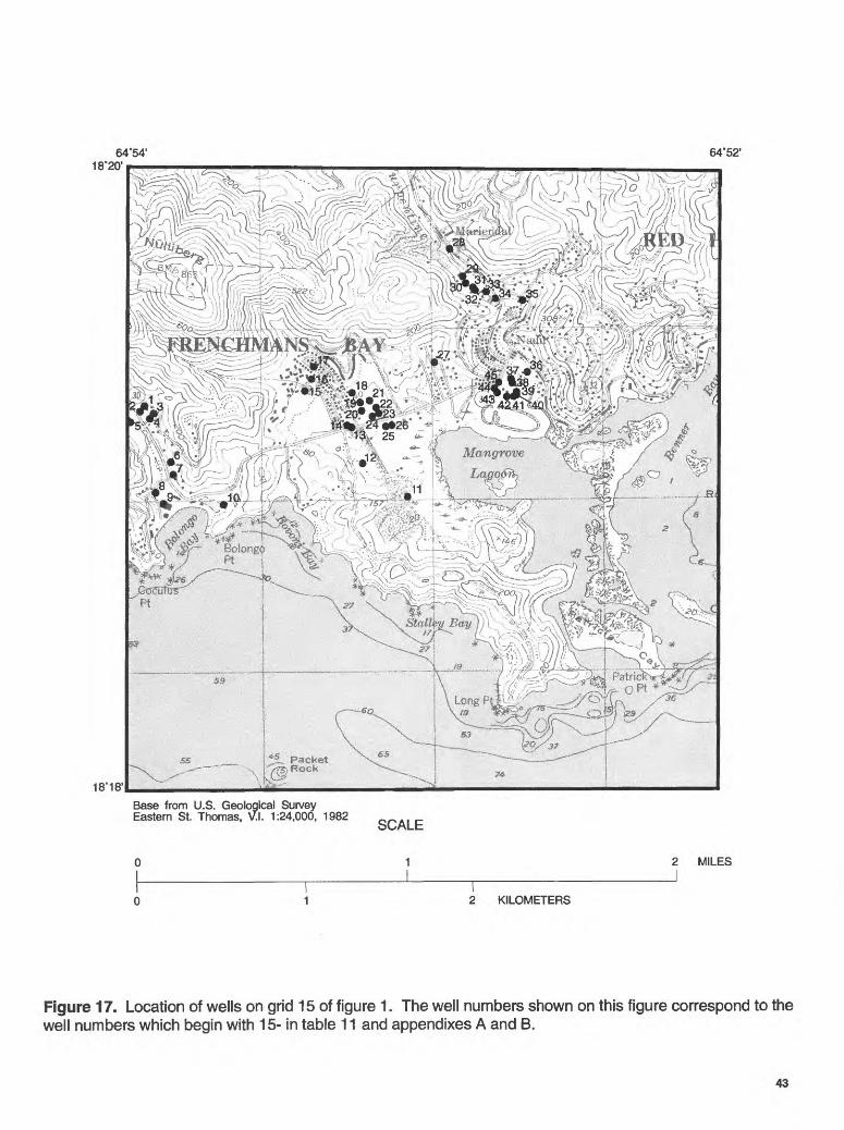
64'54' 18*20'
64*52'
18*18'
-W*^ -18"^ ^ ' I ^^R^J^g:
I ^'.Ayfrr --. " '. \*A
ifT^W* i / ll _ V. i III ii \ ' . _ =* ** ^)\ -«'AA K- <x'. j - ^»wo ^\*"-,- ,<t
Base from U.S. Geological Survey Eastern St. Thomas, \AI. 1:24,000, 1982
SCALE
2 KILOMETERS
2 MILES
Figure 17. Location of wells on grid 15 of figure 1. The well numbers shown on this figure correspond to the well numbers which begin with 15- in table 11 and appendixes A and B.
43

Tabl
e 11
. D
escr
iptio
n of
wel
ls lo
cate
d on
figu
re 1
7 [C
, com
mer
cial
wel
l; D,
dom
estic
wel
l; PS
, pu
blic
-sup
ply
wel
l; N
U, w
ell n
ot in
use
; --,
indi
cate
s da
ta n
ot a
vaila
ble]
1 i 3 155" o 3 r | g w C (0 < <3' 3"
55" 5" 1
Well
number
on figure 17
15-
1
15-
2
15-
3
15-
4
15-
5
15-
6
15-
7
15-
8
15-
9
15-10
15-11
15-1
2
15-13
15-14
15-1
5
Use
Well na
me
of water
A. Jo
seph
D
E. Cherian
D
R. Greenberg
D
McGowen
D
Charlie's Trucking
NU
R . Moran
NU
G. Black
D
Bolongo Bay Hotel
NU
Bolongo Bay Hotel
Csupply well
F. Vialet
NU
Bovoni landfill
NU
R. Charles
Bovoni Baptist
NU
Mission
Bovoni Baptist Church
D
Thomasville
Coop
1
PS
Year
Re
port
edcons-
depth
truc
ted
of we
ll(feet)
1987
150
1965
70
1988
100 75
1987
200
1965
50
1965
50
1965
85
1985
155 9
--
1981
70
1977
55
1977
66
1985
185
Measured
Casing
depth
diameter
of we
ll
(inc
hes)
(fee
t)
6
66
6 6 6 6
47
6 6 6 6
9 120
22
6 6 6 6 6
Type
of
well
finish
and
fini
shin
terv
al(feet)
slot
ted
50-90
open hole
30-7
0
__ --
slotted
60-100
open hole
30-5
0
open hole
30-50
open hole
24-8
5
screened
125-155
-- -- __
open
ho
le30
-50
open
ho
le40-66
slot
ted
40-120
Land
surf
ace
alti
tude
of well
(fee
t) 70 60 50 45 60 30 20 20 15 10 15 20 40 40 70
Dept
hto wa
ter
below
land
surf
ace
datum
(fee
t) 29 17 -- 20 23 20 __ 20 __ 2 7
10 21 __ __
Date
wate
rlevel
measured
( month-
day -
year)
06-06-90
06-05-90
--
06-04-90
06-27-90
10-04-90
__
06-01-90
__
10-16-90
06-27-90
08-10-90
06-11-90
__ __
Yield
(gal
lons
per
minute)
reported
yield
15
reported
yield
15
reported
yield
10 --
reported
yield
20
reported
yield
7
reported
yield
30 __
repo
rted
yield
75 -- --
reported
yield
20
reported
yield
7
reported
yield
7 __
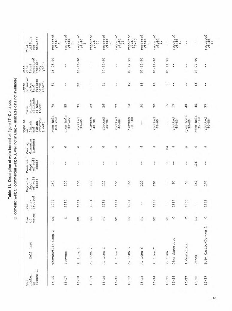
Tabl
e 11
. D
escr
iptio
n of
wel
ls lo
cate
d on
fig
ure
17--
Con
tinue
d
[D,
dom
estic
wel
l; C
, co
mm
erci
al w
ell;
NU
, w
ell n
ot in
use
; -,
ind
icat
es d
ata
not a
vaila
ble]
Well
number
on
figure 17
15-1
6
15-17
15-1
8
15-1
9
15-20
15-21
15-2
2
15-23
15-24
15-25
15-26
15-2
7
15-28
15-2
9
Use
Year
Reported
Well name
of
cons-
depth
water
tructed
of well
(fee
t)
Thomasville Coop 2
NU
1989
250
Stevens
D 1980
100
A. Lima 4
NU
1981
100
A. Lima 2
NU
1981
110
A. Lima 1
NU
1981
110
A. Lima 3
NU
1981
155
A. Lima 5
NU
1981
155
A. Lima 6
NU
220
A. Lima 7
NU
1988
200
M. Lima
NU
Lima Superette
C 19
87
95
Industrious
D 1966
60
Dench
NU
140
Poly Caribe/Devcon 1
C 1981
160
Measured
Casing
depth
diameter
of well
(inches)
(feet)
6 6 6 6 6 6 6 6 6
11
84
6 6
136
6 6
Type of
well
finish
and
finish
interval
(fee
t)
open hole
100-250
open hole
80-100
slotted
30-60
slotted
40-80
slotted
25-85
slotted
40-80
slotted
60-100
--
slotted
65-85
--
slotted
60-80
open hole
30-60
open hole
35-140
slotted
60-80
Land
surface
altitude
of well
(fee
t) 70 85 33 29 26 27 22 20 20 15 15 40 45 35
Depth
Date
to water
water
below
level
land
measured
surface
(mon
th-
datum
day-
(feet)
year
)
51
06-25-90
__
__
28
07-13-90
__
__
21
07-17-90
__
__
19
07-17-90
15
07-17-90
18
07-17-90
8 06-11-90
__
__
-- 13
03-07-90
--
Yield
(gallons
per
minute)
reported
yield
4
reported
yield
5
reported
yield
5
reported
yield
30
reported
yield
25
reported
yield
25
reported
yield
70-75
reported
yield
90
reported
yield
90 --
reported
yield
40 -- --
reported
yield
15
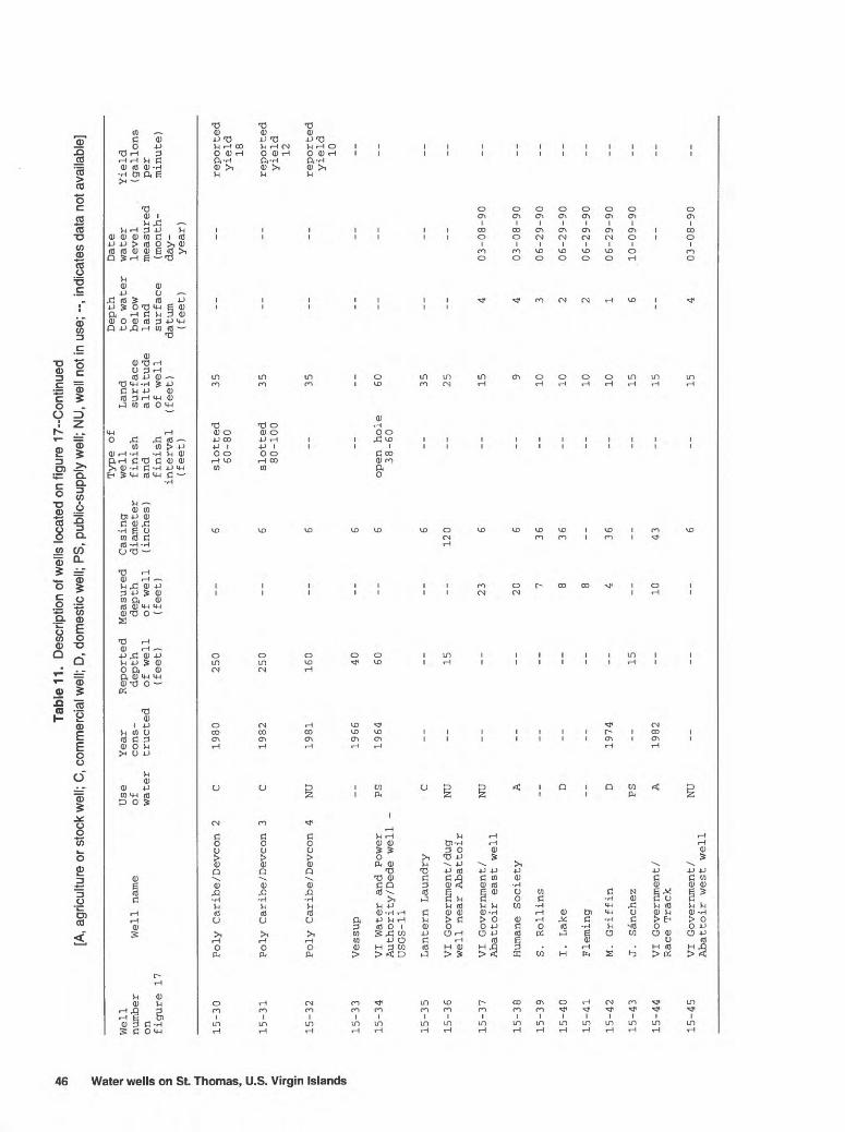
Tabl
e 11
. D
escr
iptio
n of
wel
ls lo
cate
d on
figu
re 1
7--C
ontin
ued
[A, a
gric
ultu
re o
r sto
ck w
ell;
C, c
omm
erci
al w
ell;
D, d
omes
tic w
ell;
PS,
publ
ic-s
uppl
y w
ell;
NU
, wel
l not
in u
se; -
-, in
dica
tes
data
not
ava
ilabl
e]
ater wells
on St.
1 0 0) w C 5° < c3 3 5T 5T 1
Well
number
on
figure 17
15-3
0
15-31
15-32
15-33
15-3
4
15-35
15-36
15-37
15-3
8
15-39
15-4
0
15-41
15-42
15-4
3
15-4
4
Use
Well name
of
water
Poly Caribe/Devcon 2
C
Poly Caribe/Devcon 3
C
Poly Caribe/Devcon 4
NU
Vessup
VI Water and Power
PSAuthor ity/Dede well
-USGS-11
Lantern Laundry
C
VI Government /dug
NU
well near Abattoir
VI Government/
NU
Abattoir east well
Humane Society
A
S. Rollins
I. Lake
D
Fleming
M. Griffin
D
J. Sanchez
PS
VI Government/
ARace Track
Year
Reported
Measured
Casing
cons-
depth
depth
diameter
tructed
of well
of well
(inches)
(fee
t)
(feet)
1980
250
--
6
1982
250
--
6
1981
160
--
6
1966
40
--
6
1964
60
--
6 6
15
--
120
23
6
20
6
7 36
8 36
8
1974
--
4 36
15
1982
--
10
43
Type of
well
Land
finish
surface
and
altitude
finish
of well
interval
(fee
t)
(feet)
slotted
3560-80
slotted
3580-100
35
--
open hole
6038-60
35 25 15
9
10 10 10 10 15 15
Depth
to water
below
land
surface
datum
(fee
t) __ -- -- __ -- __ 4 4 3 2 2 1 6
__
Date
water
level
measured
( month-
day -
year)
__ -- -- __ -- __
03-08-90
03-08-90
06-29-90
06-29-90
06-29-90
06-29-90
10-09-90
_ _
Yield
(gallons
per
minute)
reported
yield
18
reported
yield
12
reported
yield
10 __ -- __ __ -- -- -- -- -- -- __
15-45
VI Government/
Abattoir west well
NU
1503-08-90

64'52' 64°50'
18
>^^nti^j__J,_^j.<^o/^ ̂ ,^ ' jp t', ~^-\^^\ \' --.- o/ I -. v 17 v V
^l^^^GS^^%^^Ovl-^^I's^^6;i}:
>^wy\:^i^!t^o ^~7 v y/fe^^Mx^m * -^.-'ov v /,
Base from U.S. Geological Survey Eastern St. Thomas, V.\. 1:24,000, 1982
SCALE
1 2 MILES
2 KILOMETERS
Figure 18. Location of wells on grid 16 of figure 1. The well numbers shown on this figure correspond to the well numbers which begin with 16- in table 12 and appendixes A and B.
47

4k
00Ta
ble
12.
Des
crip
tion
of w
ells
loca
ted
on fi
gure
18
[C, c
omm
erci
al w
ell;
D, d
omes
tic w
ell;
IS,
inst
itutio
nal w
ell;
NU
, wel
l not
in u
se; -
-, in
dica
tes
data
not
ava
ilabl
e]
ater
wells
on St.
Thomas, U.S.
> ^. 1! 3 5T
5T 3 a
u
Well
number
on
figure 18
16-
1
16-
2
16-
3
16-
4
16-
5
16-
6
16-
7
16-
8
16-
9
16-1
0
16-11
16-12
16-1
3
16-1
4
16-1
5
16-16
Use
Well name
of
water
Harrigan
D
Peters
D
E . Haynes
D
VI Government
NU
near A.
Richards
A. Richards
D
J. Brin
NU
J . Gimenez
D
Compass Point
NU
D. Scott
C
L. Olive
D
Eudora Kean School
IS
American Yacht Harbor
C
Red Hook Plaza
NU
Cabrita Point Condo
NU
S . Harrington
D
R. Alexander
D
Year
Reported
Measured
Casing
cons-
depth
depth
diameter
tructed
of well
of well
(inc
hes)
(f
eet)
(f
eet)
64
62
6 6
1978
55
74
6
1945
--
44
40
1978
60
--
6
1978
50
50
6
35
15
84
1986
250
--
6
1981
11
0 --
6
200
--
6
1989
--
--
6
100
--
6
1987
20
0 20
0 6
1986
95
88
6 6 6
Type of
well
finish
and
finish
interval
(fee
t)
open hole
26-74
-- --
open hole
35-50
-- --
open hole
35-110
open hole
40-110
--
open hole
20-100
open hole
100-200
slotted
40-80
-- __
Land
surface
altitude
of well
(fee
t) 55
50 30 30 30 20 10 10 25 100 40
5
40 15 50 40
Depth
to water
below
land
surface
datum
(fee
t) 29
31
pumping
water
level
51
21
20
9 3
16 -- --
pumping
water
level
60 75
7
56 _-
Date
water
level
measured
( month-
day -
year
)
10-02-90
10-02-90
07-03-90
07-03-90
--
10-10-90
07-03-90
07-02-90
07-02-90
-- --
07-09-90
10-25-90
07-09-90
05-01-90
__
Yield
(gallons
per
minute)
reported
yield
3-5
reported
yield
5 --
reported
yield
7
reported
yield
4 --
reported
yield
20
reported
yield
12
-- --
reported
yield
21
reported
yield
20 -- -- __
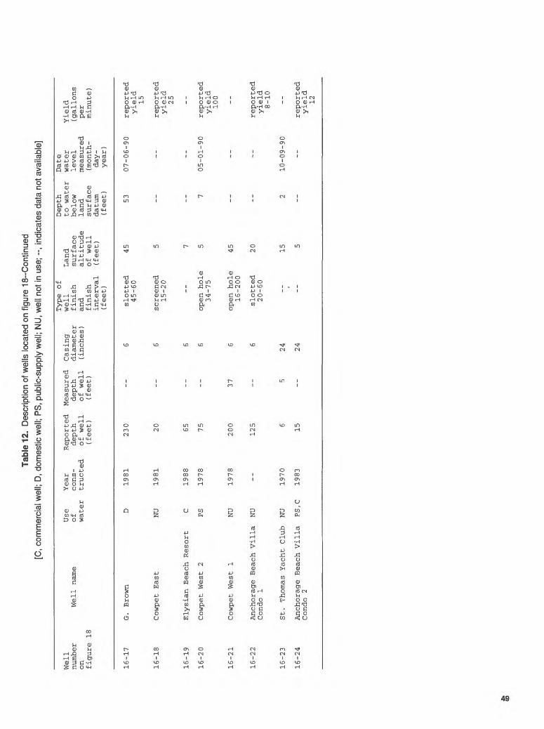
Tabl
e 12
. D
escr
iptio
n of
wel
ls lo
cate
d on
figu
re I
B-C
ontin
ued
[C, c
omm
erci
al w
ell;
D, d
omes
tic w
ell;
PS, p
ublic
-sup
ply
wel
l; N
U, w
ell n
ot in
use
; --,
indi
cate
s da
ta n
ot a
vaila
ble]
Type of
Well
Use
Year
Reported
Measured
Casing
well
Land
number
Well
na
me
of
cons
- depth
depth
diam
eter
fi
nish
surface
on
water
tructed
of we
ll
of we
ll
(inc
hes)
an
d al
titu
de
figu
re 18
(feet)
(feet)
finish
of well
interval
(feet)
(feet)
16-17
16-18
16-19
16-2
0
16-2
1
16-2
2
16-2
3
16-2
4
G. Brown
D 1981
230
Cowpet East
NU
1981
20
Elysian Beach Resort
C 1988
65
Cowpet We
st 2
PS
1978
75
Cowpet We
st 1
NU
1978
200
Anch
orag
e Beach Villa
NU
--
125
Cond
o 1
St.
Thomas Yacht
Club
NU
1970
6
Anch
orag
e Beach Villa
PS,C
19
83
15
Condo
2
6 slotted
45
45-6
0
6 screened
5 15-20
5 7
6 op
en hole
5 34-75
37
6 open hole
45
16-2
00
6 slotted
20
20-6
0
5 24
--
15
24
--
5
Depth
Date
to water
wate
r Yield
below
leve
l (g
allo
ns
land
measured
per
surface
(mon
th-
minu
te)
datum
day-
(feet)
year
)
53
07-0
6-90
reported
yield
15
reported
yield
25
__ 7 05
-01-
90
reported
yield
100
--
reported
yield
8-10
2 10
-09-
90
reported
yield
12

64'50' 18°20'
64'48'
Base from U.S. Geological Survey Eastern St. Thomas, V.\. 1:24,000, 1982
SCALE
Figure 19. Grid 17 of figure 1.
2 KILOMETERS
2 MILES
50 Water wells on St. Thomas, U.S. Virgin Islands
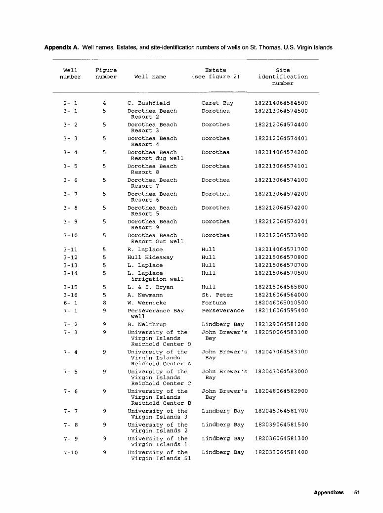
Appendix A. Well names, Estates, and site-identification numbers of wells on St. Thomas, U.S. Virgin Islands
Well number
2- 13- 1
3- 2
3- 3
3- 4
3- 5
3- 6
3- 7
3- 8
3- 9
3-10
3-113-123-133-14
3-153-166- 17- 1
7- 27- 3
7- 4
7- 5
7- 6
7- 7
7- 8
7- 9
7-10
Figure number
45
5
5
5
5
5
5
5
5
5
5555
5589
99
9
9
9
9
9
9
9
Estate Well name (see figure 2)
C. BushfieldDorothea BeachResort 2Dorothea BeachResort 3Dorothea BeachResort 4
Dorothea BeachResort dug wellDorothea BeachResort 8Dorothea BeachResort 7Dorothea BeachResort 6Dorothea BeachResort 5Dorothea BeachResort 9Dorothea BeachResort Gut well
R. LaplaceHull HideawayL. LaplaceL. Laplace irrigation well
L . & S . BryanA . NewmannW. WernickePerseverance Bay well
B. NelthrupUniversity of the Virgin Islands Reichold Center D
University of the Virgin Islands Reichold Center A
University of the Virgin Islands Reichold Center C
University of the Virgin Islands Reichold Center B
University of the Virgin Islands 3University of the Virgin Islands 2University of the Virgin Islands 1University of the Virgin Islands SI
Caret BayDorothea
Dorothea
Dorothea
Dorothea
Dorothea
Dorothea
Dorothea
Dorothea
Dorothea
Dorothea
HullHullHullHull
HullSt. PeterFortunaPerseverance
Lindberg BayJohn Brewer ' s Bay
John Brewer ' s Bay
John Brewer ' s Bay
John Brewer ' s Bay
Lindberg Bay
Lindberg Bay
Lindberg Bay
Lindberg Bay
Site identification
number
182214064584500182213064574500
182212064574400
182212064574401
182214064574200
182213064574101
182213064574100
182213064574200
182212064574200
182212064574201
182212064573900
182214064571700182215064570800182215064570700182215064570500
182215064565800182216064564000182046065010500182116064595400
182129064581200182050064583100
182047064583100
182047064583000
182048064582900
182045064581700
182039064581500
182036064581300
182033064581400
Appendixes 51
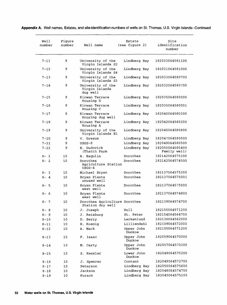
Appendix A. Well names, Estates, and site-identification numbers of wells on St. Thomas, U.S. Virgin Islands-Continued
Well number
7-11
7-12
7-13
7-14
7-15
7-16
7-17
7-18
7-19
7-207-217-22
8- 18- 2
8- 38- 4
8- 5
8- 6
8- 7
8- 88- 98-108-118-12
8-13
8-14
8-15
8-168-178-188-19
Figure number
9
9
9
9
9
9
9
9
9
999
1010
1010
10
10
10
1010101010
10
10
10
10101010
Estate Well name (see figure 2)
University of the Virgin Islands S2University of the Virgin Islands S4
University of the Virgin Islands S3University of the Virgin Islands dug well
Kirwan Terrace Housing D
Kirwan Terrace Housing C
Kirwan Terrace Housing dug wellKirwan Terrace Housing A
University of the Virgin Islands El
V . GreauxUSGS- 8E. Dudovick (Thatch Farm
A. EsqulinDorothea Agriculture Station USGS-4
Michael BryanBryan Plants unused wellBryan Plants west wellBryan Plants east well
Dorothea Agriculture Station dry well
J. JosephJ. ReisburgD . BerryB. KoenigA. Mack
F. Isaac
M. Carty
S. Kessler
J. SpencerPetersonJacksonKurach
Lindberg Bay
Lindberg Bay
Lindberg Bay
Lindberg Bay
Lindberg Bay
Lindberg Bay
Lindberg Bay
Lindberg Bay
Lindberg Bay
Lindberg BayLindberg BayLindberg Bay
DorotheaDorothea
DorotheaDorothea
Dorothea
Dorothea
Dorothea
HullSt. PeterLerkenlundLilliendahlUpper John Dunkoe
Upper John Dunkoe
Upper John Dunkoe
Lower John DunkoeContantLindberg BayLindberg BayLindberg Bay
Site identification
number
182033064581100
182031064581000
182033064580700
182032064580700
182035064580000
182035064580001
182040064580300
182042064580200
182045064580800
182047064580000182049064580500182050064580400
Family well)182142064575300182142064574500
182137064575300182137064575001
182137064575000
182137064574800
182139064574700
182150064571200182154064564700182136064562000182109064572000182100064571200
182059064570000
182057064570300
182049064570200
182049064572700182050064575600182048064574700182045064575100
52 Water wells on St. Thomas, U.S. Virgin Islands
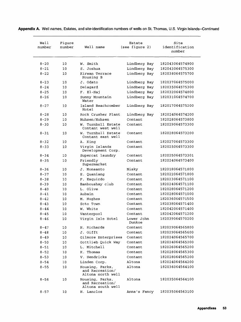
Appendix A. Well names, Estates, and site-identification numbers of wells on St. Thomas, U.S. Virgin Islands-Continued
Well number
8-208-218-22
8-238-248-258-26
8-27
8-288-298-30
8-31
8-328-33
8-348-35
8-368-378-388-398-408-418-428-438-448-458-46
8-478-488-498-508-518-528-538-548-55
8-56
8-57
Figure Estate number Well name (see figure 2)
101010
10101010
10
101010
10
1010
1010
1010101010101010101010
101010101010101010
10
10
W. SmithS . JoshuaKirwan Terrace Housing B
J. OdatoDelagardF. El-HajSunny Mountain WaterIsland Beachcomber HotelRock Crusher PlantMuh s en / Muh s enW. Turnbull Estate Contant west well
W. Turnbull Estate Contant east well
A. KingVirgin Islands Development Corp.Supercat laundryFriendly Supermarket
J. MonsantoE . QuaniangF. EsquirdoBamboushay clubL. OliveAubainM. HughesSoto TownW. WhiteVanterpoolVirgin Isle Hotel
H. RichardsJ. GifftGilmore EnterprisesGottlieb Quick WayL. MitchellK . ThomasV. HendricksLinden Corp.Housing, Parks, and Recreation/ Altona north well
Housing, Parks, and Recreation/ Altona south well
H. Lane 1 os
Lindberg BayLindberg BayLindberg Bay
Lindberg BayLindberg BayLindberg BayLindberg Bay
Lindberg Bay
Lindberg BayContantContant
Contant
ContantContant
ContantContant
NiskyContantContantContantContantContantContantContantContantContantLower John Dunkoe
ContantContantContantContantContantContantContantAltonaAltona
Altona
Anna ' s Fancy
Site identification
number
182043064574900182043064575300182038064575700
182037064575000182035064575300182032064574800182031064574700
182017064575200
182024064574200182028064573800182029064573300
182028064573200
182027064573300182025064573300
182025064573301182024064573400
182018064571800182022064571800182023064571100182024064571100182028064571200182028064571000182036064571500182038064571400182042064571400182042064571200182039064570200
182029064565800182029064565600182024064565700182024064565200182026064565200182028064565300182028064565200182024064564200182036064564100
182035064564100
182035064563100
Appendixes 53

Appendix A. Well names, Estates, and site-identification numbers of wells on St. Thomas, U.S. Virgin Islands-Continued
Well number
8-58
8-598-60
8-61
8-62
8-638-64
8-65
9- 1
9- 2
9- 39- 4
9- 5
9- 6
9- 7
9- 8
9- 9
9-10
9-11
9-12
9-139-149-159-169-179-189-199-209-219-22
Figure number
10
1010
10
10
1010
10
11
11
1111
11
11
11
11
11
11
11
11
11111111111111111111
Estate Well name (see figure 2)
VI Government/ Municipal Cemetery
C. ChristopherH. Turnbull
Pure Tropical Water
F . Magras
V. Lett someVI Government/ Barnaber well
H. Turnbull
Magens Beach dug well
Magens Beach drilled well
ArboretumD. Raimer
J . Ladee
Magens Point Hotel
St. Thomas Dairy E
St. Thomas Dairy F
St. Thomas Dairy A
St. Thomas Dairy B
St . Thomas Dairy supply well
St. Thomas Dairy dug well
Mahogany Run 1Mahogany Run 2Mahogany Run 3Mahogany Run 3 AMahogany Run 3BMahogany Run 4Mahogany Run 5Mahogany Run 5 aMahogany Run 7Mahogany Run 8
Anna ' s Fancy
Anna ' s FancyCity of Charlott AmalieCity of Charlotte AmalieCity of Charlotte AmalieStaabiCity of Charlotte AmalieCity of Charlotte AmalieMagens Bay
Magens Bay
Magens BaySt. Joseph & Rosendal
St. Joseph & Rosendal
St. Joseph & Rosendal
St. Joseph & Rosendal
St. Joseph & Rosendal
St. Joseph & Rosendal
St. Joseph & RosendalLovenlund
St .Joseph & Rosendal
LovenlundLovenlundLovenlundLovenlundLovenlundLovenlundLovenlundLovenlundLovenlundLovenlund
Site identification
number
182033064563100
182037064562700182035064562100
182031064561700
182031064561701
182049064561900182047064561000
182044064561200
182157064552200
182155064552200
182136064553100182146064550500
182143064545900
182141064545700
182142064545600
182141064545300
182142064545000
182141064545000
182149064544800
182148064544700
182150064544500182150064544100182148064543900182148064543800182147064543700182146064543600182145064543500182144064543400182143064543300182142064543300
54 Water wells on St. Thomas, U.S. Virgin Islands
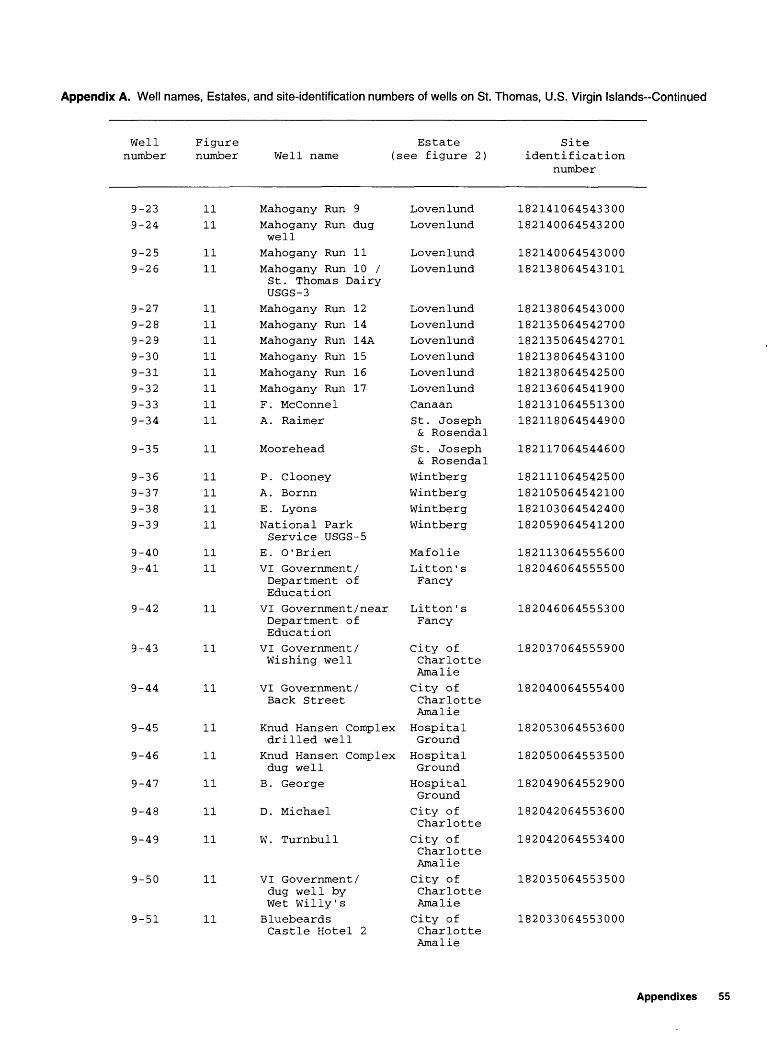
Appendix A. Well names, Estates, and site-identification numbers of wells on St. Thomas, U.S. Virgin Islands-Continued
Well number
9-239-24
9-259-26
9-279-289-299-309-319-329-339-34
9-35
9-369-379-389-39
9-409-41
9-42
9-43
9-44
9-45
9-46
9-47
9-48
9-49
9-50
9-51
Figure Estate number Well name (see figure 2)
1111
1111
1111111111111111
11
11111111
1111
11
11
11
11
11
11
11
11
11
11
Mahogany Run 9Mahogany Run dugwell
Mahogany Run 11Mahogany Run 10 / St. Thomas Dairy USGS-3
Mahogany Run 12Mahogany Run 14Mahogany Run 14AMahogany Run 15Mahogany Run 16Mahogany Run 17F. McConnelA. Raimer
Moorehead
P. ClooneyA . BornnE . LyonsNational Park Service USGS-5
E. O'BrienVI Government/ Department of Education
VI Government /near Department of Education
VI Government/ Wishing well
VI Government/ Back Street
Knud Hansen Complex drilled well
Knud Hansen Complex dug well
B. George
D. Michael
W. Turnbull
VI Government/ dug well by Wet Willy'sBluebeards Castle Hotel 2
LovenlundLovenlund
LovenlundLovenlund
LovenlundLovenlundLovenlundLovenlundLovenlundLovenlundCanaanSt. Joseph & Rosendal
St. Joseph & Rosendal
WintbergWintbergWintbergWintberg
MafolieLitton ' s Fancy
Litton' s Fancy
City of Charlotte AmalieCity of Charlotte AmalieHospital GroundHospital Ground
Hospital GroundCity of CharlotteCity of Charlotte AmalieCity of Charlotte AmalieCity of Charlotte Amalie
Site identification
number
182141064543300182140064543200
182140064543000182138064543101
182138064543000182135064542700182135064542701182138064543100182138064542500182136064541900182131064551300182118064544900
182117064544600
182111064542500182105064542100182103064542400182059064541200
182113064555600182046064555500
182046064555300
182037064555900
182040064555400
182053064553600
182050064553500
182049064552900
182042064553600
182042064553400
182035064553500
182033064553000
Appendixes 55

Appendix A. Well names, Estates, and site-identification numbers of wells on St. Thomas, U.S. Virgin Islands-Continued
Well number
9-52
9-539-54
9-559-569-579-589-599-60
Figure number
11
1111
111111111111
Well name
Bluebeards Castle Hotel 1
Barbel Assoc .VI Government/ Department of Human Services
HendricksC . JensenBurnette TowersI. EstrillOne StopLockhart School
Estate (see figure 2)
City of Charlotte AmalieThomasThomas
ThomasThomasThomasThomasThomasThomas
Site identification
number
182030064552700
182030064551800182030064551500
182029064551200182029064551000182028064551000182029064550500182033064550500182037064550500
northwest corner9-61 11 Grade School Thomas
well 39-62 11 Water and Power Thomas
Authority/ Wheatly Skill Center west well
9-63 11 Water and Power Thomas Authority/ Wheatly Skill Center east well
9-64 11 Water and Power Thomas Authority/ WAPA pump station
9-65 11 Lockhart School Thomas northeast corner
9-66 11 Lockhart School Thomas playground
9-67 11 G. Blackhal Thomas9-68 11 Hallpicke Thomas9-69 11 Rodgers Thomas9-70 11 G. Hodge Thomas9-71 11 J. Blyden Thomas9-72 11 Moore Thomas9-73 11 L. Mathias Thomas9-74 11 E. Radsatt Thomas9-75 11 Walters Thomas9-76 11 A. Lima Thomas9-77 11 Yeppsen Thomas9-78 11 Yacht Haven Hotel Thomas9-79 11 St. Thomas Mall Inc. Thomas9-80 11 W. Turnbull Estate Thomas
Thomas west well9-81 11 W. Turnbull Estate Thomas
Thomas east well9-82 11 Wheatly Thomas
Shopping Center9-83 11 G. Melchoir Thomas
182038064550300
182041064550500
182041064550300
182039064550000
182038064550000
182033064550000
182029064550100182028064550200182025064550300182026064550400182025064550800182025064550600182023064550600182023064550601182022064550500182023064550300182024064550100182017064551300182020064550400182014064550000
182015064545400
182024064545000
182028064545300
56 Water wells on St. Thomas, U.S. Virgin Islands

Appendix A. Well names, Estates, and site-identification numbers of wells on St. Thomas, U.S. Virgin Islands-Continued
Well number
9-84
9-85
9-86
9-87
9-889-89
9-90
9-919-929-939-949-959-969-979-989-99
10- 110- 2
10- 310- 410- 5
10- 6
10- 7
10- 8
10- 9
10-1010-1110-1210-1310-1410-1510-16
10-1710-18
10-19
Figure Estate number Well name (see figure 2)
11
11
11
11
1111
11
1111111111111111111212
121212
12
12
12
12
12121212121212
1212
12
St. Thomas Hospital 3
St. Thomas Hospital 2
St . Thomas Hospital 1Lockhart Estate Thomas north wellDaily NewsVirgin Islands Medical AssociationLockhart Estate Thomas south well
Lockhart/ MelchoirT. FrettL. BarbelVilla Blanca HotelLockhart dug wellNew Hernhut MissionLockhart 5Lockhart 4Lockhart 3Mandahl BeachVI Government/ Mandahl Beach
V. WallacePeace Corps SchoolMandahl Homestead well
Demitry
Alpha Leonard
VI Government/ near treatment plant
VI Government/ Donoe 3
M. Bryan 2M. Bryan 3M. Bryan 1Lockhart 1Lockhart 2I . KirkerterpJ . Baugh
PedersenA . Sharp
E. Eglin
Thomas
Thomas
Thomas
Thomas
ThomasThomas
Thomas
ThomasThomasRaphuneThomasRaphuneNew HernhutDonoeDonoeDonoeMandahlMandahl
MandahlMandahlMandahl
Anna ' s Retreat
Anna' s Retreat
Anna 1 s Retreat
Donoe
DonoeDonoeDonoeDonoeDonoeHof fmanCharlotte AmalieHof fmanCharlotte AmalieCharlotte Amalie
Site identification
number
182031064545500
182033064545500
182036064545600
182037064544600
182035064544800182033064544800
182032064544600
182030064544800182014064544100182009064543300182021064543400182017064542300182002064540700182015064540000182016064540000182016064535900182141064535000182137064533800
182124064532900182125064535700182122064535900
182042064533400
182038064533300
182039064534400
182029064535200
182026064535800182025064535800182024064535800182018064535900182017064535900182012064535400182017064534900
182009064534500182010064534200
182011064534000
Appendixes 57
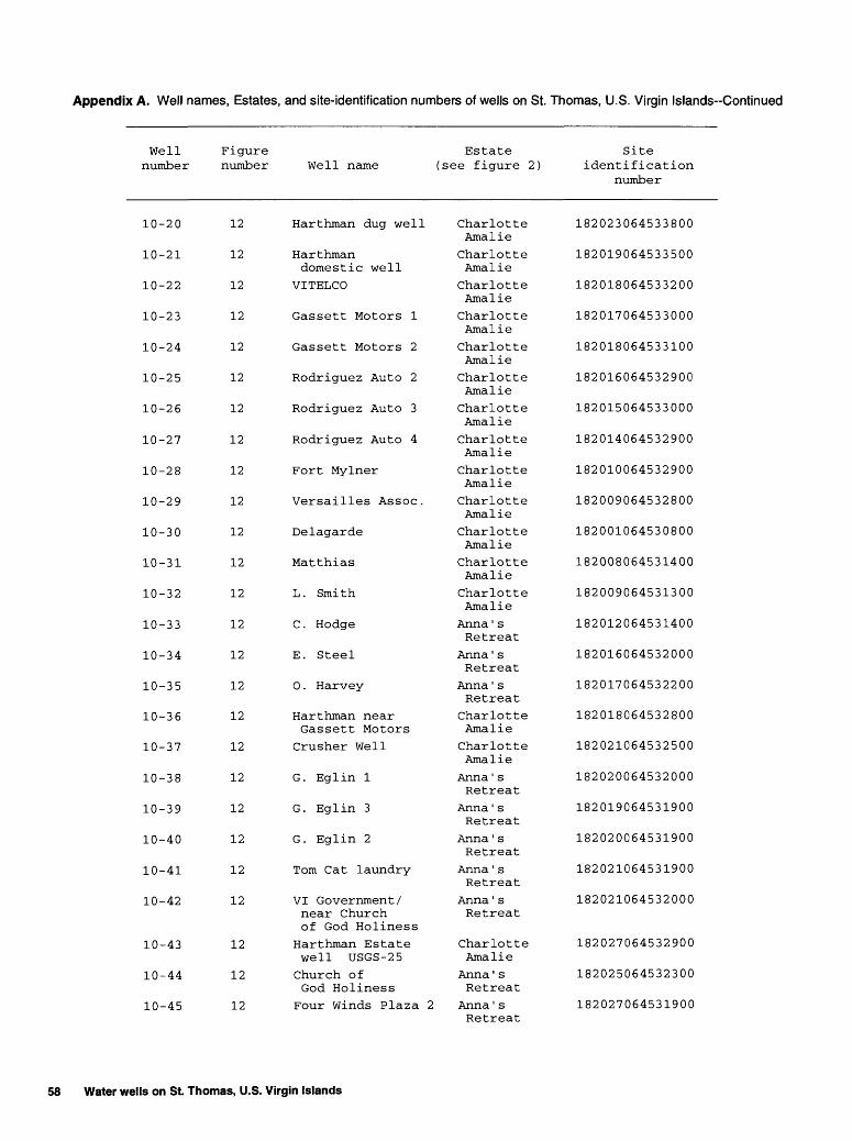
Appendix A. Well names, Estates, and site-identification numbers of wells on St. Thomas, U.S. Virgin Islands-Continued
Well number
10-20
10-21
10-22
10-23
10-24
10-25
10-26
10-27
10-28
10-29
10-30
10-31
10-32
10-33
10-34
10-35
10-36
10-37
10-38
10-39
10-40
10-41
10-42
10-43
10-44
10-45
Figure number
12
12
12
12
12
12
12
12
12
12
12
12
12
12
12
12
12
12
12
12
12
12
12
12
12
12
Estate Well name (see figure 2)
Harthman dug well
Harthman domestic well
VITELCO
Gassett Motors 1
Gassett Motors 2
Rodriguez Auto 2
Rodriguez Auto 3
Rodriguez Auto 4
Fort Mylner
Versailles Assoc.
Delagarde
Matthias
L. Smith
C. Hodge
E. Steel
O . Harvey
Harthman near Gassett Motors
Crusher Well
G. Eglin 1
G. Eglin 3
G. Eglin 2
Tom Cat laundry
VI Government/ near Church of God Holiness
Harthman Estate well USGS-25Church of God Holiness
Four Winds Plaza 2
Charlotte AmalieCharlotte AmalieCharlotte AmalieCharlotte AmalieCharlotte AmalieCharlotte AmalieCharlotte AmalieCharlotte AmalieCharlotte AmalieCharlotte AmalieCharlotte AmalieCharlotte AmalieCharlotte AmalieAnna ' s Retreat
Anna ' s Retreat
Anna ' s Retreat
Charlotte AmalieCharlotte AmalieAnna ' s Retreat
Anna ' s Retreat
Anna ' s Retreat
Anna ' s Retreat
Anna ' s Retreat
Charlotte AmalieAnna ' s Retreat
Anna ' s Retreat
Site identification
number
182023064533800
182019064533500
182018064533200
182017064533000
182018064533100
182016064532900
182015064533000
182014064532900
182010064532900
182009064532800
182001064530800
182008064531400
182009064531300
182012064531400
182016064532000
182017064532200
182018064532800
182021064532500
182020064532000
182019064531900
182020064531900
182021064531900
182021064532000
182027064532900
182025064532300
182027064531900
58 Water wells on St. Thomas, U.S. Virgin Islands

Appendix A. Well names, Estates, and site-identification numbers of wells on St. Thomas, U.S. Virgin Islands-Continued
Well number
10-46
10-47
10-48
10-49
10-50
10-51
10-52
10-53
10-5410-5510-5610-5710-58
10-5910-60
10-61
10-6210-6310-6410-6510-6610-67
10-68
10-69
10-7010-71
10-7210-73
10-7411- 1
11- 2
Figure Estate number Well name (see figure 2)
12
12
12
12
12
12
12
12
1212121212
1212
12
121212121212
12
12
1212
1212
1213
13
Four Winds Plaza 1
E. Tillet
Ramsey Motors
Virgin IslandsHousingAuthority 1
Virgin IslandsHousingAuthority 2
Virgin IslandsHousingAuthority 3
Virgin IslandsHousingAuthority 4
C. F. RosenbergUSGS-2Super Pool ResturantSmith Bay CenterA. LeviaU. PilgrimFat Man ' s /C . Husband
R. MercerStouffer GrandBeach Hotel AStouffer GrandBeach Hotel B
LeonardA. Leonard 2A. Leonard 1S & S ServiceE. FrancisStouffer GrandBeach Hotel CStouffer GrandBeach Hotel DStouffer GrandBeach Hotel E
MartinLindquist/VIGovernmentSprauvePoint PleasantResort 1
JohnsonPoint PleasantResort 2
S. Harthman Heirs
Anna ' sRetreat
Anna ' sRetreat
Anna' sRetreat
Anna ' sRetreat
Anna ' sRetreat
Anna ' sRetreat
Anna ' sRetreat
Frydendahl
FrydendahlFrydendahlFrydendahlFrydendahlFrydendahl
FrydendahlFrydendahl
Fryndenahl
FrydendahlFrydendahlFrydendahlSmith BaySmith BayFrydendahl
Frydendahl
Frydendahl
Smith BaySmith Bay
Smith BaySmith Bay
Smith BaySmith Bay
Smith Bay
Site identification
number
182027064531800
182029064531500
182036064531600
182037064531100
182038064531200
182048064531400
182049064530900
182048064524000
182049064524000182050064523800182051064523500182054064523400182053064522900
182100064522300182057064521600
182056064521700
182055064522100182054064522000182053064522100182050064521800182046064522300182058064520600
182057064520600
182055064520600
182043064521000182041064521100
182037064521200182041064520300
182040064520400182040064520000
182026064513400
Appendixes 59

Appendix A. Well names, Estates, and site-identification numbers of wells on St. Thomas, U.S. Virgin Islands-Continued
Well number
11- 311- 4
11- 5
11- 6
11- 7
14- 114- 214- 314- 4
14- 514- 614- 714- 814- 914-1014-1114-12
14-13
15- 115- 215- 315- 415- 515- 615- 715- 815- 9
15-1015-1115-1215-13
15-14
15-1515-1615-1715-1815-1915-2015-21
Figure number
1313
13
13
13
16161616
1616161616161616
16
171717171717171717
17
17
17
17
17
17
17
17
17
17
17
17
Estate Well name (see figure 2)
LindquistSapphire Bay Condo West-supply wellSapphire Bay Condo West-east wellSapphire Bay Condo West-west well
S. Harthman Heirs USGS-23
M. CarterFrenchman's Reef 3Frenchman's Reef 1Frenchman's Reef maintenance
Morning StarA. WilliamsonAntilles SchoolLimetree HotelA. HalpernF . SamadF. MercetelliHydro farms north well
Hydro farms south well
A. JosephE. CherianR . GreenbergMcGowenCharlie's TruckingR. MoranG. BlackBolongo Bay HotelBolongo Bay Hotel supply well
F. VialetBovoni landfillR. CharlesBovoni Baptist MissionBovoni Baptist Church
Thomas vi lie Coop 1Thomas vi lie Coop 2St evensA. Lima 4A. Lima 2A. Lima 1A. Lima 3
Smith BaySmith Bay
Smith Bay
Smith Bay
Smith Bay
BakkeroeBakkeroeBakkeroeBakkeroe
BakkeroeFrenchman BayFrenchman BayFrenchman BayFrenchman BayFrenchman BayFrenchman BayBolongo
Bolongo
BolongoBolongoBolongoBolongoBolongoBolongoBolongoBolongoBolongo
BovoniBovoniBovoniBovoni
Bovoni
BovoniBovoniBovoniBovoniBovoniBovoniBovoni
Site identification
number
182018064512800182018064511800
182017064511201
182017064511200
182001064510900
181951064544900181929064551700181928064551700181925064552000
181921064550500181929064544200181930064543900181912064545100181911064544200181905064543600181901064542300181919064540700
181918064540600
181914064535700181912064535700181913064535400181911064535500181911064540000181903064535100181901064535100181857064535400181855064535200
181855064534000181857064530300181903064531200181910064531400
181910064531500
181917064532400181919064532200181922064532200181917064531400181915064531300181914064531300181916064531200
60 Water wells on St. Thomas, U.S. Virgin Islands
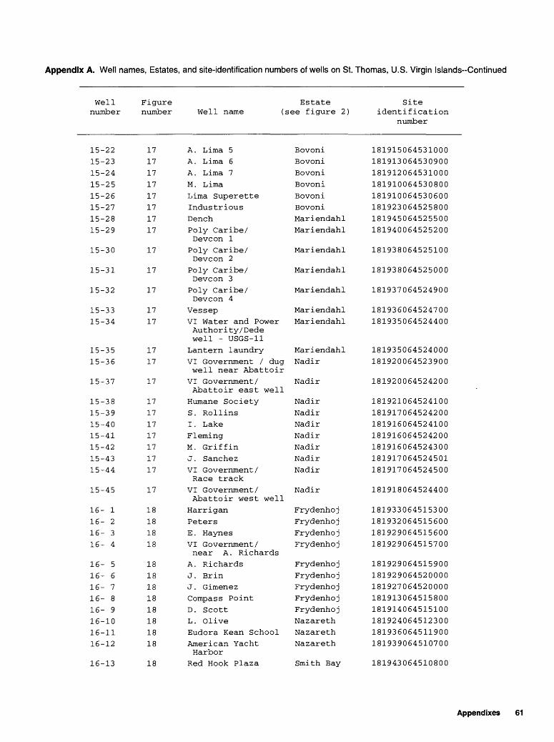
Appendix A. Well names, Estates, and site-identification numbers of wells on St. Thomas, U.S. Virgin Islands-Continued
Well number
15-2215-2315-2415-2515-2615-2715-2815-29
15-30
15-31
15-32
15-3315-34
15-3515-36
15-37
15-3815-3915-4015-4115-4215-4315-44
15-45
16- 116- 216- 316- 4
16- 516- 616- 716- 816- 916-1016-1116-12
16-13
Figure Estate number Well name (see figure 2)
1717171717171717
17
17
17
1717
1717
17
17171717171717
17
18181818
1818181818181818
18
A. Lima 5A. Lima 6A. Lima 7M. LimaLima SuperetteIndustriousDenchPoly Caribe/ Devcon 1Poly Caribe/ Devcon 2Poly Caribe/ Devcon 3Poly Caribe/ Devcon 4
VessepVI Water and Power Author ity/Dede well - USGS-11Lantern laundryVI Government / dug well near Abattoir
VI Government/ Abattoir east wellHumane SocietyS. RollinsI . LakeFlemingM. GriffinJ. SanchezVI Government/ Race track
VI Government/ Abattoir west well
HarriganPetersE . HaynesVI Government/ near A. Richards
A. RichardsJ. BrinJ . GimenezCompass PointD. ScottL. OliveEudora Kean SchoolAmerican Yacht Harbor
Red Hook Plaza
BovoniBovoniBovoniBovoniBovoniBovoniMariendahlMariendahl
Mariendahl
Mariendahl
Mariendahl
MariendahlMariendahl
MariendahlNadir
Nadir
NadirNadirNadirNadirNadirNadirNadir
Nadir
FrydenhojFrydenhojFrydenhojFrydenhoj
FrydenhojFrydenhojFrydenhojFrydenhojFrydenhojNazarethNazarethNazareth
Smith Bay
Site identification
number
181915064531000181913064530900181912064531000181910064530800181910064530600181923064525800181945064525500181940064525200
181938064525100
181938064525000
181937064524900
181936064524700181935064524400
181935064524000181920064523900
181920064524200
181921064524100181917064524200181916064524100181916064524200181916064524300181917064524501181917064524500
181918064524400
181933064515300181932064515600181929064515600181929064515700
181929064515900181929064520000181927064520000181913064515800181914064515100181924064512300181936064511900181939064510700
181943064510800
Appendixes 61
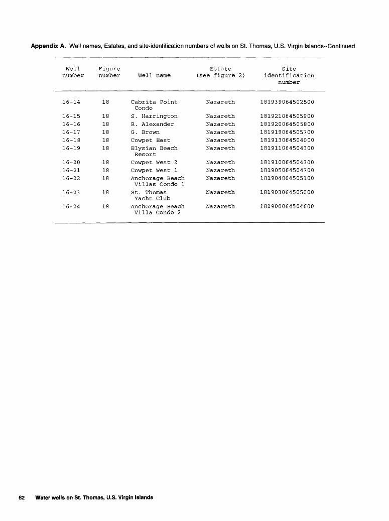
Appendix A. Well names, Estates, and site-identification numbers of wells on St. Thomas, U.S. Virgin Islands-Continued
Wellnumber
Figurenumber Well name
Estate(see figure 2)
Siteidentification
number
16-14 18 Cabrita Point Nazareth 181939064502500 Condo
16-15 18 S. Harrington Nazareth 18192106450590016-16 18 R. Alexander Nazareth 18192006450580016-17 18 G. Brown Nazareth 18191906450570016-18 18 Cowpet East Nazareth 18191306450400016-19 18 Elysian Beach Nazareth 181911064504300
Resort16-20 18 Cowpet West 2 Nazareth 181910064504300 16-21 18 Cowpet West 1 Nazareth 18190506450470016-22 18 Anchorage Beach Nazareth 181904064505100
Villas Condo 116-23 18 St. Thomas Nazareth 181903064505000
Yacht Club16-24 18 Anchorage Beach Nazareth 181900064504600
Villa Condo 2
62 Water wells on St. Thomas, U.S. Virgin Islands
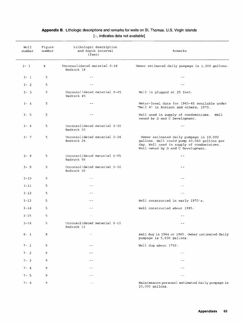
Appendix B. Lithologic descriptions and remarks for wells on St. Thomas, U.S. Virgin Islands
[--, indicates data not available]
Well number
Figure number
Lithologic description and depth interval
(feet)Remarks
2- 1
3- 1
3- 2
3- 3
3- 4
3- 5
3- 6
3- 7
3- 9
6- 1
7- 1
7- 2
7- 3
7- 4
7- 5
7- 6
3
3
3
3
3
3
3
-10
-11
-12
-13
-14
-15
-16
5
5
5
5
5
5
5
Unconsolidated material 0-18 Bedrock 18
Unconsolidated material 0-45 Bedrock 45
Owner estimated daily pumpage is 1,300 gallons
Unconsolidated material 0-30 Bedrock 30
Unconsolidated material 0-26 Bedrock 26
Unconsolidated material 0-55 Bedrock 55
Unconsolidated material 0-30 Bedrock 30
Unconsolidated material 0-12 Bedrock 12
Well is plugged at 25 feet.
Water-level data for 1963-65 available under "Well 4" in Robison and others, 1973.
Well used in supply of condominiums. Well owned by D and C Development.
Owner estimated daily pumpage is 10,000 gallons. Well could pump 40,000 gallons per day. Well used in supply of condominiums. Well owned by D and C Development.
Well constructed in early 1970's.
Well constructed about 1985.
Well dug in 1964 or 1965. Owner estimated daily pumpage is 5,000 gallons.
Well dug about 1750.
Maintenance personel estimated daily pumpage is 20,000 gallons.
Appendixes 63
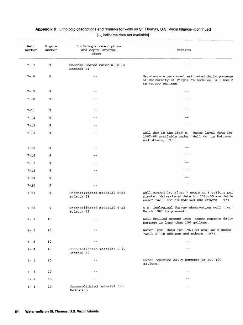
Appendix B. Lithologic descriptions and remarks for wells on St. Thomas, U.S. Virgin Islands-Continued
[--, indicates data not available]
Well number
Figure number
Lithologic description and depth interval
(feet)Remarks
7- 7
7- 9
7-10
Unconsolidated material 0-14 Bedrock 14
Maintenance personnel estimated daily pumpage of University of Virgin Islands wells 1 and 2 is 40,000 gallons.
7-11
7-12
7-13
7-14 Well dug in the 1940's. Water-level data for 1962-68 available under "Well 44" in Robison and others, 1973 .
7-15
7-16
7-17
7-18
7-19
7-20
7-21
9
9
9
9
9
9
9
7-22
i- 1
i- 2
10
10
Unconsolidated material 0-23 Bedrock 23
Unconsolidated material 0-22 Bedrock 22
Well pumped dry after 7 hours at 6 gallons per minute. Water-level data for 1963-69 available under "Well 43" in Robison and others, 1973.
U.S. Geological Survey observation well from March 1982 to present.
Well drilled around 1980. Owner reports daily pumpage is less than 100 gallons.
Water-level data for 1963-69 available under "Well 2" in Robison and others, 1973.
10
10
10
Unconsolidated material 0-40 Bedrock 40
Owner reported daily pumpage is 300-400 gallons.
10
10
10 Unconsolidated material 0-5 Bedrock 5
64 Water wells on St. Thomas, U.S. Virgin Islands
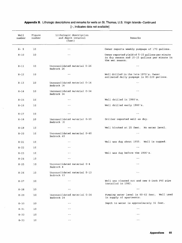
Appendix B. Lithologic descriptions and remarks for wells on St. Thomas, U.S. Virgin Islands-Continued
[-, indicates data not available]
Well number
8- 9
8-10
Figure number
10
10
Lithologic description and depth interval
(feet)Remarks
Owner reports weekly pumpage of 170 gallons.
-- Owner reported yield of 5-15 gallons per minute
5-11
8-12
5-13
8-14
8-26
8-27
8-28
8-29
8-30
8-31
8-32
8-33
10
10
10
10
8-15
8-16
8-17
8-18
8-19
8-20
8-21
8-22
8-23
8-24
8-25
10
10
10
10
10
10
10
10
10
10
10
10
10
10
10
10
10
10
10
Unconsolidated material 0-26 Bedrock 26
Unconsolidated material 0-14 Bedrock 14
Unconsolidated material 0-34 Bedrock 34
Unconsolidated material 0-10 Bedrock 10
Unconsolidated material 0-40 Bedrock 40
Unconsolidated material 0-4 Bedrock 4
Unconsolidated material 0-13 Bedrock 13
Unconsolidated material 0-24 Bedrock 24
in dry season and 10-15 gallons per minute in the wet season.
Well drilled in the late 1970's. Owner estimated daily pumpage is 80-120 gallons.
Well drilled in 1980's.
Well drilled early 1980's.
Driller reported well as dry.
Well blocked at 25 feet. No water level.
Well was dug about 1955. Well is capped.
Well was dug before the 1900's.
Well was cleaned out and new 4-inch PVC pipe installed in 1983.
Pumping water level is 60-62 feet. Well used in supply of apartments.
Depth to water is approximately 31 feet.
Appendixes 65

Appendix B. Lithologic descriptions and remarks for wells on St. Thomas, U.S. Virgin Islands-Continued
[--, indicates data not available]
Well number
Figure number
Lithologic description and depth interval
(feet)Remarks
8-34
8-35
8-36
8-37
8-38
8-39
8-40
8-41
8-42
8-43
8-46
10
10
10
10
10
10
10
10
10
10
10
10
10
Unconsolidated material 0-20 Bedrock 20
Unconsolidated material 0-15 Bedrock 15
Unconsolidated material 0-8 Bedrock 8
Depth reported to be between 90 and 110 feet with 4-inch casing inside of 6-inch casing.
Owner reports an estimated daily pumpage of 380 gallons .
Well dug around 1929.
Water is also used for small laundry on site. 4-inch casing is inside 6-inch casing.
Well used in supply of 23 apartments.
Well drilled in the early 1980's.
Owner reported well yield as trace.
8-47
8-48
8-49
8-50
8-51
8-52
8-53
8-54
8-55
8-56
8-57
8-58
10
10
10
10
10
10
10
10
10
10
10
10
Unconsolidated material 0-15 Bedrock 15
Well drilled in the 1970's, and depth is reported to be between 55 and 60 feet.
Well drilled in the early 1980's.
Well was dug before 1900.
Casing diameter is approximately 3 feet.
Outside diameter is 10 feet and depth is reported to be between 30-35 feet.
Well was dug mid-1700's.
66 Water wells on St. Thomas, U.S. Virgin Islands

Appendix B. Lithologic descriptions and remarks for wells on St. Thomas, U.S. Virgin Islands-Continued
[-, indicates data not available]
Well number
Figure number
Lithologic description and depth interval
(feet)Remarks
i-59
8-64
8-65
9- 1
9- 2
9- 3
9- 4
9- 5
9- 6
9- 7
9- 9
9-10
9-11
10
10
10
10
10
10
10
11
11
11
11
11
11
11
11
11
11
11
Unconsolidated material 0-28 Bedrock 28
Unconsolidated material 0-40 Bedrock 40
Unconsolidated material 0-52
Unconsolidated material 0-65
Unconsolidated material 0-5 Bedrock 5
Unconsolidated material 0-5 Bedrock 5
Unconsolidated material 0-3 Bedrock 3
Unconsolidated material 0-10 Bedrock 10
Well used in supply of aproximately 13 apartments.
Owner estimated daily pumpage is 14,000 gallons.
Owner estimated daily pumpage is 250-400 gallons.
24-inch casing inside of the 120-inch casing.
Well dug about 1750.
Maintenance personnel estimated daily pumpage is 1,500 gallons or 2,000 gallons if rainfall is high.
4-inch casing inside of 6-inch casing.
Well drilled before 1975.
4-inch peforated casing inside of the 6-inch casing.
9-12
9-13
9-14
9-15
9-16
9-17
11
11
11
11
11
11
Water is also used for golf course. Well used in supply of condominiums. Owned by M.R. Holdings Inc.
Water is also used for golf course. Well used in supply of condominiums. Owned by M.R. Holdings Inc.
Appendixes 67
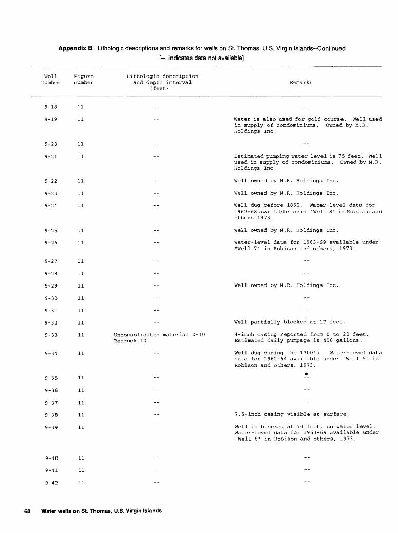
Appendix B. Lithologic descriptions and remarks for wells on St. Thomas, U.S. Virgin Islands-Continued
[--, indicates data not available]
Well number
9-18
9-19
9-20
9-21
9-22
9-23
9-24
9-25
9-26
9-27
9-28
9-29
9-30
9-31
9-32
9-33
9-34
9-35
9-36
9-37
9-38
9-39
9-40
9-41
9-42
Figure Lithologic description number and depth interval
(feet)
11
11
11
11
11
11
11
11
11
11
11
11
11
11
11
11 Unconsolidated material 0-10 Bedrock 10
11
11
11
11
11
11
11
11
11
Remarks
--
Water is also used for golf course. Well used in supply of condominiums. Owned by M.R. Holdings Inc .
--
Estimated pumping water level is 75 feet. Well used in supply of condominiums. Owned by M.R. Holdings Inc .
Well owned by M.R. Holdings Inc.
Well owned by M.R. Holdings Inc.
Well dug before 1860. Water-level data for 1962-68 available under "Well 8" in Robison and others 1973.
Well owned by M.R. Holdings Inc.
Water-level data for 1963-69 available under "Well 7" in Robison and others, 1973.
--
--
Well owned by M.R. Holdings Inc.
--
--
Well partially blocked at 17 feet.
4-inch casing reported from 0 to 20 feet. Estimated daily pumpage is 450 gallons.
Well dug during the 1700's. Water-level data data for 1962-64 available under "Well 5" in Robison and others, 1973.
*
--
--
7.5-inch casing visible at surface.
Well is blocked at 70 feet, no water level. Water-level data for 1963-69 available under "Well 6" in Robison and others, 1973.
--
--
--
68 Water wells on St. Thomas, U.S. Virgin Islands

Appendix B. Lithologic descriptions and remarks for wells on St. Thomas, U.S. Virgin Islands-Continued[--, indicates data not available]
Well number
9-43
9-44
9-45
9-46
9-47
9-48
9-49
9-50
9-51
Figure Lithologic description number and depth interval Remarks
(feet)
11 -- Well dug in the mid-1700's.
11
11
11 -- Well dug before 1919.
11
11 -- Owner plans to use well for public supply.
11 Unconsolidated material 0-15 Bedrock 15
11
11 Unconsolidated material 0-6
9-52
9-65
9-66
9-67
9-68
11
11
9
9
9
9
9
9
9
9
9
9
-54
-55
-56
-57
-58
-59
-60
-61
-62
-63
11
11
11
11
11
11
11
11
11
11
11
11
11
11
11
Bedrock 6
Unconsolidated material 0-40 Bedrock 40
Unconsolidated material 0-25 Bedrock 25
Unconsolidated material 0-36
Unconsolidated material 0-45 Bedrock 45
Unconsolidated material 0-31 Bedrock 31
Unconsolidated material 0-60 Bedrock 60
Unconsolidated material 0-45 Bedrock 45
6-inch casing from 0 to 100 feet with 4-inch slotted screen inside.
4-inch casing inside of the 6-inch casing.
Well dug about 1945.
Well dug in late 1950's and casing diameter is 48-60 inches.
Well owned by Burnette Tower Apartments.
Well dug in the 1950's.
Drilled in late 1980's.
Well is blocked at 31 feet.
U.S. Geological Survey observation well. Well owned by Water and Power Authority.
Well owned by the Water And Power Authority.
Well owned by the Water And Power Authority.
Well was reported as dry, yield less than 1 gallon per minute.
Well owned by the Water and Power Authority.
6-inch casing from 0 to 60 feet.
Appendixes 69
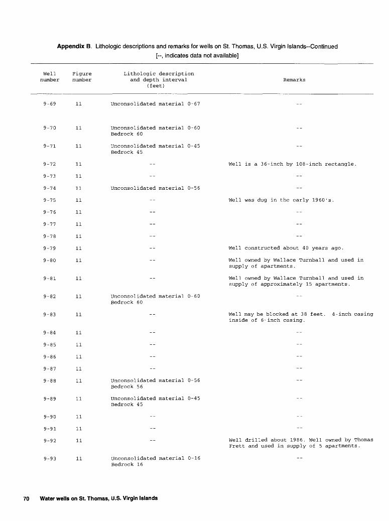
Appendix B. Lithologic descriptions and remarks for wells on St. Thomas, U.S. Virgin Islands-Continued
[--, indicates data not available]
Well number
Figure number
Lithologic description and depth interval
(feet)Remarks
9-69 11 Unconsolidated material 0-67
9-70
9-71
11
11
9-72
9-73
9-74
9-75
9-76
9-77
9-78
9-79
9-80
9-81
9-82
9-83
9-84
9-85
9-86
9-87
9-88
11
11
11
11
11
11
11
11
11
11
11
11
11
11
11
11
11
Unconsolidated material 0-60 Bedrock 60
Unconsolidated material 0-45 Bedrock 45
Unconsolidated material 0-56
Unconsolidated material 0-60 Bedrock 60
9-89 11
Unconsolidated material 0-56 Bedrock 56
Unconsolidated material 0-45 Bedrock 45
Well is a 36-inch by 108-inch rectangle,
Well was dug in the early 1960's.
Well constructed about 40 years ago.
Well owned by Wallace Turnball and used in supply of apartments.
Well owned by Wallace Turnball and used in supply of approximately 15 apartments.
Well may be blocked at 38 feet. 4-inch casing inside of 6-inch casing.
9-90
9-91
9-92
9-93
11
11
11
11 Unconsolidated material 0-16 Bedrock 16
Well drilled about 1986. Well owned by Thomas Frett and used in supply of 5 apartments.
70 Water wells on St. Thomas, U.S. Virgin Islands
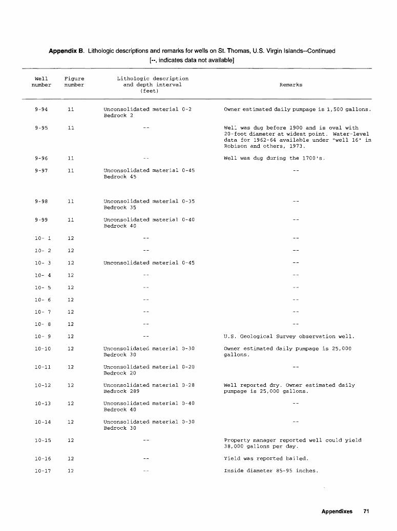
Appendix B. Lithologic descriptions and remarks for wells on St. Thomas, U.S. Virgin Islands-Continued[-, indicates data not available]
Well number
Figure number
Lithologic description and depth interval
(feet)Remarks
9-94
9-95
9-96
9-97
11
11
11
11
Unconsolidated material 0-2 Bedrock 2
Unconsolidated material 0-45 Bedrock 45
Owner estimated daily pumpage is 1,500 gallons.
Well was dug before 1900 and is oval with 20-foot diameter at widest point. Water-level data for 1962-64 available under "well 16" in Robison and others, 1973.
Well was dug during the 1700's.
9-98
9-99
10-11
10-12
10-13
10-14
10-15
10-16
10-17
11
11
10-
10-
10-
10-
10-
10-
10-
10-
10-
10-
1
2
3
4
5
6
7
8
9
10
12
12
12
12
12
12
12
12
12
12
12
12
12
12
12
12
12
Unconsolidated material 0-35 Bedrock 35
Unconsolidated material 0-40 Bedrock 40
Unconsolidated material 0-45
Unconsolidated material 0-30 Bedrock 30
Unconsolidated material 0-20 Bedrock 20
Unconsolidated material 0-28 Bedrock 289
Unconsolidated material 0-40 Bedrock 40
Unconsolidated material 0-30 Bedrock 30
U.S. Geological Survey observation well.
Owner estimated daily pumpage is 25,000 gallons.
Well reported dry. Owner estimated daily pumpage is 25,000 gallons.
Property manager reported well could yield 38,000 gallons per day.
Yield was reported bailed.
Inside diameter 85-95 inches.
Appendixes 71

Appendix B. Lithologic descriptions and remarks for wells on St. Thomas, U.S. Virgin Islands-Continued[--, indicates data not available]
Well number
Figure number
Lithologic description and depth interval
(feet)Remarks
10-18 12
10-19
10-20
10-21
10-22
10-23
10-24
10-25
10-26
10-27
10-28
10-29
10-30
10-31
10-32
10-33
10-34
10-35
10-36
12
12
12
12
12
12
12
12
12
12
12
12
12
12
12
12
12
12
10-37
10-38
12
12
Unconsolidated material 0-10 Bedrock 10
Unconsolidated material 0-20 Bedrock 20
Unconsolidated material 0-30 Bedrock 30
Well drilled in the 1960's. Reported yield is bailed.
Well dug around 1938.
60-72 inch diameter well dug before 1943. Water-level data for 1967-69 available under "Well 18" in Robison and others, 1973.
Well drilled in 1972 or 1973.
Well drilled in 1972 or 1973.
Well covered over. Water-level data for 1958-69 available under "Well 26" in Robison and other, 1973.
Well drilled in the 1960's
Well caved in to 105 feet.
Owner reported depth 125 feet, previous inventory reported depth of 210 feet.
Well reported to be redrilled to 225 feet in 1979. Water-level data for 1967-69 available under "Well 24" in Robison and others, 1973.
10-39
10-40
10-41
12
12
12
Owner reported depth to be 385 feet. Previous Previous inventory reported depth of 225 feet with casing to 40 feet.
72 Water wells on St. Thomas, U.S. Virgin Islands

Appendix B. Lithologic descriptions and remarks for wells on St. Thomas, U.S. Virgin Islands-Continued
[--, indicates data not available]
Well number
Figure number
Lithologic description and depth interval
(feet)Remarks
10-42
10-43
10-44
10-45
10-46
10-47
10-48
10-49
10-50
10-51
10-52
10-53
10-54
10-55
10-56
10-57
10-58
10-59
10-60
10-61
10-62
10-63
12
12
12
12
12
12
12
12
12
12
12
12
12
12
12
12
12
12
12
12
12
12
Unconsolidated material 0-30 Bedrock 30
Unconsolidated material 0-24 Bedrock 24
Unconsolidated material 0-10 Bedrock 10
Unconsolidated material 0-32 Bedrock 32
Unconsolidated material 0-32 Bedrock 32
Unconsolidated material 0-12 Bedrock 12
Unconsolidated material 0-18 Bedrock 18
Unconsolidated material 0-65 Bedrock 65
Unconsolidated material 0-28 Bedrock 28
Unconsolidated material 0-30 Bedrock 30
Unconsolidated material 0-80 Bedrock 80
Well dug before 1942. Water-level data for 1962-63 available under "Well 23" in Robison and others, 1973.
Water is being used at temporary archeologic site. Water-level data for 1965-69 available under "Well 19" in Robison and others, 1973.
Well is covered over.
Well is owned by the U.S. Virgin Islands Housing Authority.
Well is owned by the U.S. Virgin Islands Housing Authority.
Water-level data for 1963-69 available under "Well 9" in Robison and others, 1973.
Well screen diameter is 5 inches.
Well drilled in the early 1970's
Appendixes 73
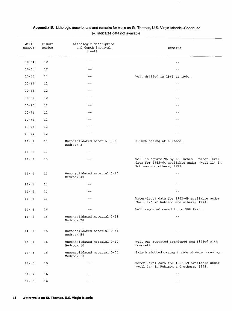
Appendix B. Lithologic descriptions and remarks for wells on St. Thomas, U.S. Virgin Islands-Continued
[-, indicates data not available]
Well number
10-64
10-65
10-66
10-67
10-68
10-69
10-70
10-71
10-72
10-73
10-74
11- 1
11- 2
11- 3
11- 4
11- 5
11- 6
11- 7
14- 1
14- 2
Figure Lithologic description number and depth interval Remarks
(feet)
12
12
12 -- Well drilled in 1963 or 1964.
12
12
12
12
12
12
12
12
13 Unconsolidated material 0-3 8-inch casing at surface. Bedrock 3
13
13 Well is square 96 by 96 inches. Water-level data for 1962-64 available under "Well 11" in Robison and others, 1973.
13 Unconsolidated material 0-40 Bedrock 40
13
13
13 -- Water-level data for 1965-69 available under "Well 12" in Robison and others, 1973.
16 -- Well reported caved in to 508 feet.
16 Unconsolidated material 0-28Bedrock 28
14- 3
14- 4
14- 5
14- 6
14- 7
14- 8
16
16
16
16
16
16
Unconsolidated material 0-54 Bedrock 54
Unconsolidated material 0-10 Bedrock 10
Unconsolidated material 0-60 Bedrock 60
Well was reported abandoned and filled with concrete.
4-inch slotted casing inside of 6-inch casing.
Water-level data for 1962-69 available under "Well 34" in Robison and others, 1973.
74 Water wells on St. Thomas, U.S. Virgin Islands
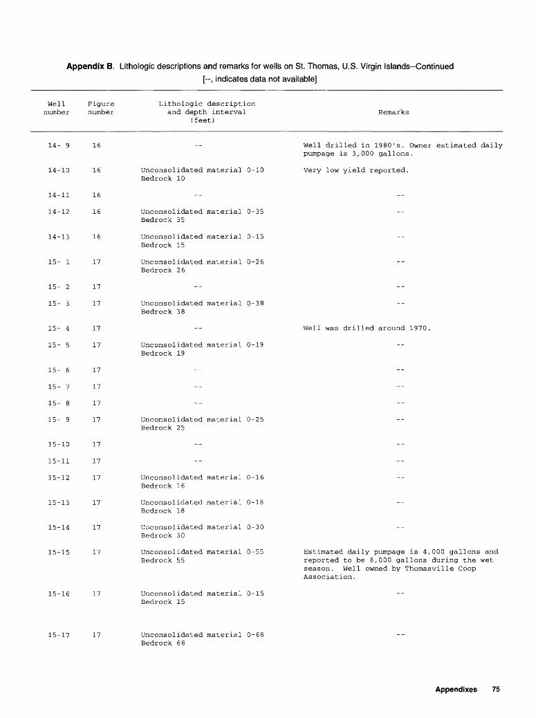
Appendix B. Lithologic descriptions and remarks for wells on St. Thomas, U.S. Virgin Islands-Continued
[--, indicates data not available]
Well number
Figure number
Lithologic description and depth interval
(feet)Remarks
14- 9
14-10
14-11
14-12
14-13
15- 1
16
16
16
16
16
17
Unconsolidated material 0-10 Bedrock 10
Unconsolidated material 0-35 Bedrock 35
Unconsolidated material 0-15 Bedrock 15
Unconsolidated material 0-26 Bedrock 26
Well drilled in 1980's. Owner estimated daily pumpage is 3,000 gallons.
Very low yield reported.
15
15
15
15
15
15
15
15
15
15
15
?
- 3
- 4
- 5
- 6
- 7
- 8
- 9
-10
-11
-12
17
17
17
17
17
17
17
17
17
17
17
15-13
15-14
15-15
15-16
17
17
17
17
Unconsolidated material 0-38 Bedrock 38
Unconsolidated material 0-19 Bedrock 19
Unconsolidated material 0-25 Bedrock 25
Unconsolidated material 0-16 Bedrock 16
Unconsolidated material 0-18 Bedrock 18
Unconsolidated material 0-30 Bedrock 30
Unconsolidated material 0-55 Bedrock 55
Unconsolidated material 0-15 Bedrock 15
Well was drilled around 1970.
Estimated daily pumpage is 4,000 gallons and reported to be 8,000 gallons during the wet season. Well owned by Thomasville Coop Association.
15-17 17 Unconsolidated material 0-68 Bedrock 68
Appendixes 75
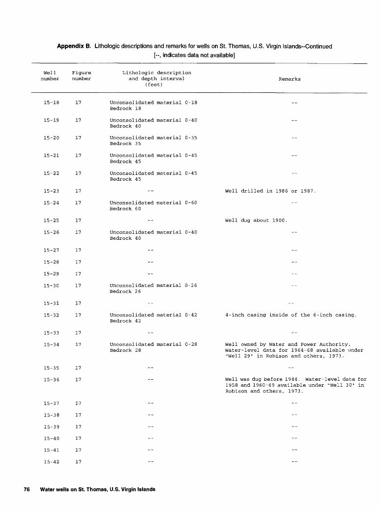
Appendix B. Lithologic descriptions and remarks for wells on St. Thomas, U.S. Virgin Islands-Continued
[--, indicates data not available]
Well number
Figure number
Lithologic description and depth interval
(feet)Remarks
15-18
15-19
15-20
15-21
15-22
17
17
17
17
17
15-23
15-24
15-25
15-26
15-27
15-28
15-29
15-30
15-31
15-32
15-33
15-34
15-35
15-36
15-37
15-38
15-39
15-40
15-41
15-42
17
17
17
17
17
17
17
17
17
17
17
17
17
17
17
17
17
17
17
17
Unconsolidated material 0-18 Bedrock 18
Unconsolidated material 0-40 Bedrock 40
Unconsolidated material 0-35 Bedrock 35
Unconsolidated material 0-45 Bedrock 45
Unconsolidated material 0-45 Bedrock 45
Unconsolidated material 0-60 Bedrock 60
Unconsolidated material 0-40 Bedrock 40
Unconsolidated material 0-26 Bedrock 26
Unconsolidated material 0-42 Bedrock 42
Unconsolidated material 0-28 Bedrock 28
Well drilled in 1986 or 1987
Well dug about 1900.
4-inch casing inside of the 6-inch casing.
Well owned by Water and Power Authority. Water-level data for 1964-68 available under "Well 29" in Robison and others, 1973.
Well was dug before 1944. Water-level data for 1958 and 1960-69 available under "Well 30" in Robison and others, 1973.
76 Water wells on St. Thomas, U.S. Virgin Islands
Appendix B. Lithologic descriptions and remarks for wells on St. Thomas, U.S. Virgin Islands-Continued
[-, indicates data not available]
Well number
Figure number
Lithologic description and depth interval
(feet)Remarks
15-43
15-44
17
17
Well was constructed about 1970. Well casing is 3.5 feet by 2.5 feet. Well used in supply of 5 apartments.
15-45
16- 1
17
18 Well reported drilled in early 1960's.
16-
16-
16-
16-
16-
16-
16-
16-
2
3
4
5
6
7
8
9
18
18
18
18
18
18
18
18
16-10 18
Unconsolidated material 0-20 Bedrock 20
Unconsolidated material 0-37 Bedrock 37
Unconsolidated material 0-30 Bedrock 30
Unconsolidated material 0-18 Bedrock 18
Well reported drilled about 1980. Reported depth is 65-70 feet.
Water-level data for 1962-68 available under "Well 13" in Robison and others, 1973.
Well dug in the early 1910's.
Reported 4-inch slotted casing from 0 to 200 feet.
16-11
16-12
16-13
16-14
16-15
16-16
16-17
16-18
16-19
18
18
18
18
18
18
18
18
18
Unconsolidated material 0-7 Bedrock 7
Unconsolidated material 0-1 Bedrock 1
Unconsolidated material 0-10 Bedrock 10
Unconsolidated material 0-20
Well drilled in late 1970's. Well may have caved in to 75-80 feet.
Company president estimated daily pumpage is 3,000 gallons.
Well drilled about 1980.
Sand filter on botton of casing. Maintenance personnel estimated daily pumpage is 40,000 gallons.
Appendixes 77

Appendix B. Lithologic descriptions and remarks for wells on St. Thomas, U.S. Virgin Islands-Continued
[-, indicates data not available]
Well number
Figure number
Lithologic description and depth interval
(feet)Remarks
16-20
16-21
16-22
16-23
16-24
18
18
18
18
18
Unconsolidated material 0-28 Bedrock 28
Unconsolidated material 0-15 Bedrock 15
Unconsolidated material 0-25 Bedrock 25
Well used in supply of condominiums. Well owned by Cowper Bay West Condos.
Well blocked at 37 feet, no water level.
Drilled in early 1980's. 4-inch slotted casing inside of 6-inch casing to 125 feet.
Well used in supply of condominiums. Well owned by Anchorage Condo Association.
78 Water wells on St. Thomas, U.S. Virgin Islands