Water Supply Availability Committee Meeting Presentation ... · Water Supply Availability Committee...
10
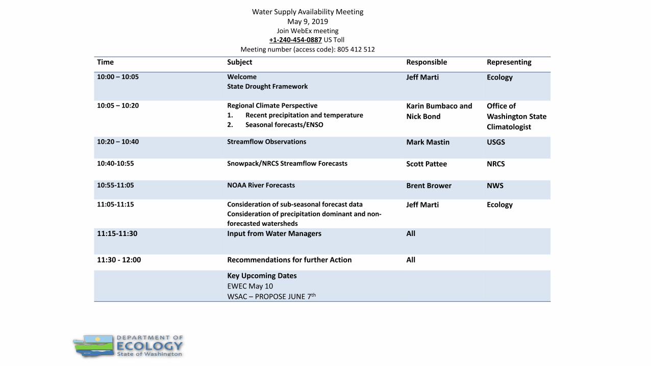
Time Subject Responsible Representing 10:00 – 10:05 Welcome State Drought Framework Jeff Marti Ecology 10:05 – 10:20 Regional Climate Perspective 1. Recent precipitation and temperature 2. Seasonal forecasts/ENSO Karin Bumbaco and Nick Bond Office of Washington State Climatologist 10:20 – 10:40 Streamflow Observations Mark Mastin USGS 10:40-10:55 Snowpack/NRCS Streamflow Forecasts Scott Pattee NRCS 10:55-11:05 NOAA River Forecasts Brent Brower NWS 11:05-11:15 Consideration of sub-seasonal forecast data Consideration of precipitation dominant and non- forecasted watersheds Jeff Marti Ecology 11:15-11:30 Input from Water Managers All 11:30 - 12:00 Recommendations for further Action All Key Upcoming Dates EWEC May 10 WSAC – PROPOSE JUNE 7 th Water Supply Availability Meeting May 9, 2019 Join WebEx meeting +1-240-454-0887 US Toll Meeting number (access code): 805 412 512
Transcript of Water Supply Availability Committee Meeting Presentation ... · Water Supply Availability Committee...
Time Subject Responsible Representing
10:00 – 10:05 WelcomeState Drought Framework
Jeff Marti Ecology
10:05 – 10:20 Regional Climate Perspective1. Recent precipitation and temperature2. Seasonal forecasts/ENSO
Karin Bumbaco and Nick Bond
Office of Washington State Climatologist
10:20 – 10:40 Streamflow Observations Mark Mastin USGS
10:40-10:55 Snowpack/NRCS Streamflow Forecasts Scott Pattee NRCS
10:55-11:05 NOAA River Forecasts Brent Brower NWS
11:05-11:15 Consideration of sub-seasonal forecast dataConsideration of precipitation dominant and non-forecasted watersheds
Jeff Marti Ecology
11:15-11:30 Input from Water Managers All
11:30 - 12:00 Recommendations for further Action All
Key Upcoming DatesEWEC May 10WSAC – PROPOSE JUNE 7th
Water Supply Availability MeetingMay 9, 2019
Join WebEx meeting +1-240-454-0887 US Toll
Meeting number (access code): 805 412 512
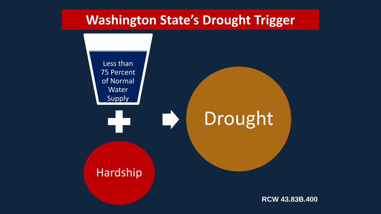
Less than 75 Percent of Normal
Water Supply
Hardship
Drought
Washington State’s Drought Trigger
RCW 43.83B.400
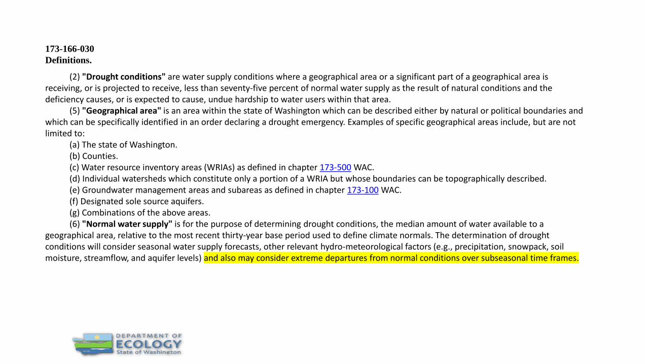
173-166-030Definitions.
(2) "Drought conditions" are water supply conditions where a geographical area or a significant part of a geographical area is receiving, or is projected to receive, less than seventy-five percent of normal water supply as the result of natural conditions and the deficiency causes, or is expected to cause, undue hardship to water users within that area.
(5) "Geographical area" is an area within the state of Washington which can be described either by natural or political boundaries and which can be specifically identified in an order declaring a drought emergency. Examples of specific geographical areas include, but are not limited to:
(a) The state of Washington.(b) Counties.(c) Water resource inventory areas (WRIAs) as defined in chapter 173-500 WAC.(d) Individual watersheds which constitute only a portion of a WRIA but whose boundaries can be topographically described.(e) Groundwater management areas and subareas as defined in chapter 173-100 WAC.(f) Designated sole source aquifers.(g) Combinations of the above areas.(6) "Normal water supply" is for the purpose of determining drought conditions, the median amount of water available to a
geographical area, relative to the most recent thirty-year base period used to define climate normals. The determination of drought conditions will consider seasonal water supply forecasts, other relevant hydro-meteorological factors (e.g., precipitation, snowpack, soil moisture, streamflow, and aquifer levels) and also may consider extreme departures from normal conditions over subseasonal time frames.

Ryderwood, Cowlitz County
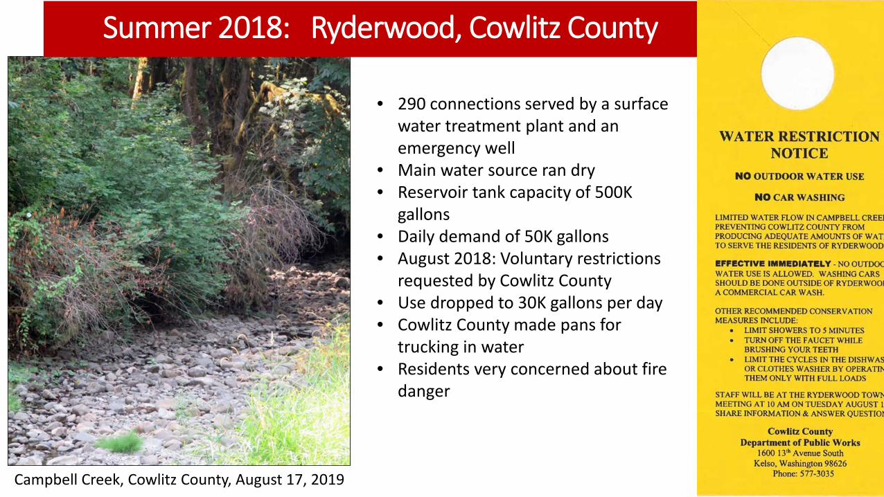
Summer 2018: Ryderwood, Cowlitz County
Campbell Creek, Cowlitz County, August 17, 2019
• 290 connections served by a surface water treatment plant and an emergency well
• Main water source ran dry• Reservoir tank capacity of 500K
gallons• Daily demand of 50K gallons• August 2018: Voluntary restrictions
requested by Cowlitz County• Use dropped to 30K gallons per day• Cowlitz County made pans for
trucking in water• Residents very concerned about fire
danger

Campbell Creek Sept. 12, 2018
After rainfall
Campbell CreekAug. 17, 2018Dry creekbed
Thank you