
Water Sources by Passage 2.16.20-Sheet1 - Arizona Trail · Water quality may vary greatly and it is...
13
Arizona Trail Water Reports 2/16/20 Water reports are compiled from personal experiences, hikers, e-mails, and phone calls. Check regularly for updates. Please send any current water reports to Fred Gaudet at [email protected] or call (480) 983-0112 Trail users are posting current water conditions on the Arizona Trail APP. These postings will be more recent than most Water Reports. Mileage -- south to north -- agrees with Arizona Trail Segment Passages and GPS data at www.aztrail.org. Information in this report is provided as a service to the community. Information in this report may not be accurate. Natural water sources in Arizona can and do rapidly change. Resupply box may be empty. The user of this information is solely responsible for their own safety. Hike your own hike. Man made water sources are listed as TOWN or other facility. Some locations may be closed and no water available. The LOCATION will indicate if a water source is off trail with a note, such as 0.5m E Abbreviations: m - mile; N - north; E -east; S - south; W - west. "~" means "approximately" Water Codes: w0-not reliable or none; w1-seasonal or "iffy"; w2-probable; w3-fairly reliable; w4-very reliable source It is recommended that water sources be verified with local sources, such as Forest Service Ranger Stations, National Park Service, BLM offices, or AZA Trail Stewards. Water quality may vary greatly and it is recommend that water sources be treated to reduce risk of water borne diseases. Historic Passa S-N Location Type Water Report Date Reported Date Miles Miles Reliabiity by Posted 20.8 Passage 1 Huachuca Mountains: International Border - Parker Canyon Lake 8.1 8.1 Bathtub Spring (aka Tub Spring) spring 3 nice flow; about 30 seconds for a liter 8/7/19 B. Kraay 8/17/19 9.5 9.5 Bear Spring 0.5 m W; multiple trees spring 3 god flow; clear, cool 3/7/19 GM Gramps 3/12/19 13.5 13.5 Sunnyside Canyon creek 1 to 2 lots of small pools 8/7/19 B. Kraay 8/17/19 15.4 15.4 cement water trough; spring box 50 yds south & above trail spring box 2 full; looked fine 8/7/19 B. Kraay 8/17/19 16.9 16.9 Scotia Canyon creek 1 to 2 lots of small pools 8/7/19 B. Kraay 8/17/19 17.4 17.4 windmill with solar panels windmill 0-1 seem derelict 3/4/18 Wyoming 3/7/18 19.7 19.7 Parker Cyn Lake store 1.6m NW store 4 Water Sources on the Arizona Trail by Passages Water Reliability scale: 0 = not reliable; 1 = seasonal or "iffy"; 2 = probable; 3 = fairly reliable; 4 = definite source.
Transcript of Water Sources by Passage 2.16.20-Sheet1 - Arizona Trail · Water quality may vary greatly and it is...
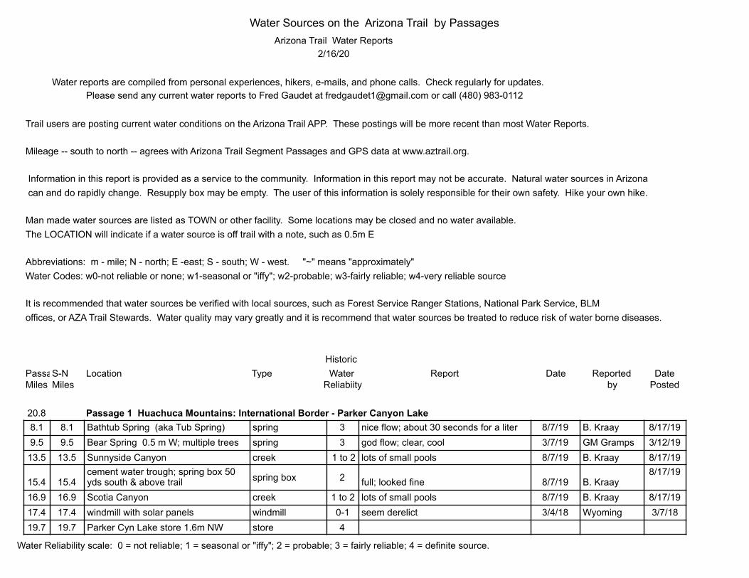
Arizona Trail Water Reports2/16/20
Water reports are compiled from personal experiences, hikers, e-mails, and phone calls. Check regularly for updates.Please send any current water reports to Fred Gaudet at [email protected] or call (480) 983-0112
Trail users are posting current water conditions on the Arizona Trail APP. These postings will be more recent than most Water Reports.
Mileage -- south to north -- agrees with Arizona Trail Segment Passages and GPS data at www.aztrail.org.
Information in this report is provided as a service to the community. Information in this report may not be accurate. Natural water sources in Arizona can and do rapidly change. Resupply box may be empty. The user of this information is solely responsible for their own safety. Hike your own hike.
Man made water sources are listed as TOWN or other facility. Some locations may be closed and no water available.The LOCATION will indicate if a water source is off trail with a note, such as 0.5m E
Abbreviations: m - mile; N - north; E -east; S - south; W - west. "~" means "approximately"Water Codes: w0-not reliable or none; w1-seasonal or "iffy"; w2-probable; w3-fairly reliable; w4-very reliable source
It is recommended that water sources be verified with local sources, such as Forest Service Ranger Stations, National Park Service, BLMoffices, or AZA Trail Stewards. Water quality may vary greatly and it is recommend that water sources be treated to reduce risk of water borne diseases.
Historic Passage S-N Location Type Water Report Date Reported DateMiles Miles Reliabiity by Posted
20.8 Passage 1 Huachuca Mountains: International Border - Parker Canyon Lake8.1 8.1 Bathtub Spring (aka Tub Spring) spring 3 nice flow; about 30 seconds for a liter 8/7/19 B. Kraay 8/17/199.5 9.5 Bear Spring 0.5 m W; multiple trees spring 3 god flow; clear, cool 3/7/19 GM Gramps 3/12/19
13.5 13.5 Sunnyside Canyon creek 1 to 2 lots of small pools 8/7/19 B. Kraay 8/17/19
15.4 15.4cement water trough; spring box 50 yds south & above trail spring box 2 full; looked fine 8/7/19 B. Kraay
8/17/19
16.9 16.9 Scotia Canyon creek 1 to 2 lots of small pools 8/7/19 B. Kraay 8/17/1917.4 17.4 windmill with solar panels windmill 0-1 seem derelict 3/4/18 Wyoming 3/7/1819.7 19.7 Parker Cyn Lake store 1.6m NW store 4
Water Sources on the Arizona Trail by Passages
Water Reliability scale: 0 = not reliable; 1 = seasonal or "iffy"; 2 = probable; 3 = fairly reliable; 4 = definite source.

14.2 Passage 2 Canelo Hills East: Parker Canyon Lake - Canelo Pass2.4 23.2 Parker Canyon Creek creek 2 AWESOME good flow; clear cold 8/17/19 B. Kraay 8/25/193.7 24.5 Trap Tank ~0.1mE dirt tank 1 plenty of water 8/17/19 B. Kraay 8/25/19
10.3 31.1 Middle Canyon intermittent pools 1 lots of water 8/17/19 B. Kraay 8/25/19
16.2 Passage 3 Canelo Hills West: Canelo Pass - Patagonia0.0 35.0 Flower Tank ~1.5m S dirt tank 1 looks full 2/10/17 Guino 2/12/173.5 38.5 Down Under Tank dirt tank 1 full with plenty of water 8/17/19 B. Kraay 8/25/193.5 38.5 Down Under pipe at cement dam pipe 1 to 2 small flow 3/5/18 Wyoming 3/7/18
5.1 40.1 Cott Tank Exclosure-Red Rock Cyn solar well, spigot & creek
1 to 2 tank-plenty but murky & stagnant 8/17/19 B. Kraay 8/25/196.8 41.8 Red Bank Well (float in cattle trough) well 3 dry 8/17/19 B. Kraay 8/25/197.3 42.3 Gate Spring 0.15m NW spring 2 to 3 dry 8/17/19 B. Kraay 8/25/19
16.2 51.2 Patagonia Town
21.8 Passage 4 Temporal Gulch: Patagonia - Gardner Canyon Road4.8 56.0 FS#72 Stock Tank dirt tank 1 water but swanky 3/6/18 Wyoming 3/15/186.0 57.2 Temporal Gulch intermittent pools 1 flowing 3/6/18 Wyoming 3/15/188.9 60.1 Anaconda Spring spring/seep 1 full 3/10/19 GM Gramps 3/12/19
12.6 63.8 Walker Basin Trailhead cement dam 1 flowing 3/6/18 Wyoming 3/15/1815.6 66.8 Bear Spring/Casa Blanca Canyon spring/creek 2 to 3 Casa Blanca flowing well 4/4/48 D. Dooley 4/8/1818.6 69.8 Tunnel Spring spring 1 water flowing 3/10/19 GM Gramps 3/12/1918.8 70.0 Gardner Canyon at Tunnel Spring TH creek 1 water flowing 3/10/19 GM Gramps 3/12/1921.8 73.0 Cave Ck--just before Garden Cny TH creek 0-1 flowing well; clear, cold 3/10/19 GM Gramps 3/12/19
13.8 Passage 5 Santa Rita Mountains: Gardner Canyon Road - Oak Tree Canyon3.7 76.7 Kentucky Camp spigot 3 to 4 spigots on 4/4/48 D. Dooley 4/8/187.0 80.0 stock pond 0.1m W dirt tank 1 full of murky water 3/11/19 GM Gramps 3/12/199.9 82.9 Bowman Spring cement tank 2 to 3 tank full; nothing in canyon 4/8/16 J. Coker 4/12/16
go thru a gate to the west (off the road); then follow a faint road paralleling the fenceline north a short way. Stay with this road as it jogs west then heads down into a pretty, secluded canyon. Where the road ends at the canyon bottom, continue up the wash to an old rusty trough, then walk up a small side canyon following a PVC pipe to a round cement tank. 31.78451° N 110.76316° 13.4 86.4 metal cattle trough with faucet faucet in corral 2 to 3 full
(water pump timer controlled; do not change timer) 4/5/48 D. Dooley 4/8/18
Water Sources on the Arizona Trail by Passages
Water Reliability scale: 0 = not reliable; 1 = seasonal or "iffy"; 2 = probable; 3 = fairly reliable; 4 = definite source.

13.8 86.8 tank ~0.6m E down Oak Tree Cnyn dirt tank 1 full 4/16/17 S. Redfield 4/17/17
13.1 Passage 6 Las Colinas: Oak Tree Canyon - Lakes Road1.6 88.4 tank;150' E on FR4064- just N of road tank 1 to 2 metal tank 1/3 full; brownish/green 4/8/16 J. Coker 4/12/1611.4 98.2 road to The Lake, 0.7nW large cow pond 2-Jan low; murky with cattle; dead fish 5/22/13 La Zorra13.1 99.9 The Lake; an old dirt dam ~1.25mW large cow pond 2 low; murky with cattle; dead fish 5/22/13 La Zorra 5/27/13
12.7 Passage 7 Las Cienegas: Lakes Road - Gabe Zimmerman TH0.2 100.1 Twin Tanks dirt tank 2 full 4/5/48 D. Dooley 4/8/186.7 106.6 Sahuarita Road resupply box 0-1 10 gallons 3/10/19 J. Coker 3/22/197.4 107.3 Duck Tank; NE 0.2m of Hwy83 dirt tank 2 good, esp. north tank 3/3/17 J. Coker 3/13/17
13.9 Passage 8 Rincon Valley: Gabe Zimmerman TH - Saguaro National Park0.4 113.0 Cienga Creek creek 3 flowing 3/15/19 GM Gramps 3/22/194.7 117.3 La Posta Quemada Ranch: 0.25m W store/faucets 4 water on (in bathrooms) 3/4/17 J. Coker 3/13/177.2 119.8 La Sevilla picnic area faucet 3 at corner of stone ramada; spigot on 3/9/18 Wyoming 3/13/17
13.7 126.3 Rincon Creek creek 1 flowing 3/14/19 GM Gramps 3/22/19
24.6 Passage 9 Rincon Mountains: Saguaro National Park - Redington Road2.3 128.8 drainage 32.14714, -110.64063 creek 1 running 3/10/18 Wyoming 3/15/182.7 129.2 creek/wilderness boundary creek 1 flowing well 4/7/18 D. Dooley 4/8/188.9 135.4 Grass Shack Chimenea Ck 2 flowing well 3/15/19 GM Gramps 3/22/19
13.4 139.9 Manning Camp creek 4 excellent; best water on trail 4/8/18 D. Dooley 4/9/1815.7 142.2 Italian Spring spring 3 flowing well 3/16/19 GM Gramps 3/22/1919.6 146.1 Tanque Verde Canyon creek/pools 1 flowing well 3/16/19 GM Gramps 3/22/1922.3 148.8 Italian Trap Tank ~0.5m W tank 1 metal tank at corral full 4/15/14 S. Morrris 4/21/14
13.2 Passage 10 Redington Pass: Redington Road - Gordon Hirabayashi TH4.3 155.4 The Lake large stock pond 2 still and murky 3/27/16 Sparky2016 4/1/166.3 157.4 Aqua Calinete Wash small creek 1 flowing, clear 3/17/19 GM Gramps 3/22/198.2 159.3 West Spring: spring uphill ~0.1mE big storage tank 1 trough full;; flowing on ground 3/17/19 GM Gramps 3/22/19
10.6 161.7 Molina Basin Campground none 0 none 1/23/18 E. Butler 1/23/18
18.5 Passage 11 Santa Catalina Mountains: Gordon Hirabayashi TH - Marshall Gulch TH2.2 166.5 Sycamore Reservoir reservoir 1 flowing well 3/17/19 GM Gramps 3/22/19
Water Sources on the Arizona Trail by Passages
Water Reliability scale: 0 = not reliable; 1 = seasonal or "iffy"; 2 = probable; 3 = fairly reliable; 4 = definite source.

3.2 167.5 Sycamore Canyon creek 1 strong flow 3/31/17 Taylor 4/7/175.2 169.5 Sabino Canyon creek 1 strong flow 3/31/17 Taylor 4/7/176.7 171.0 Hutch's Pool 0.25m N big pools 3 to 4 large pool 12/3/17 HobbitCribbage12/7/174/7/1711.6 175.9 Romero Pass/Canyon ~2m NW creek 2 some pools before Pass 4/4/15 OnnaMove 4/5/1514.9 179.2 Lemmon Creek creek 1 flowing well 3/18/19 GM Gramps 3/22/19
21.6 Pusch Ridge Wilderness Bypass (an alternate for Passage 11--Santa Catlina Mountains and part of Passage 12--Oracle Ridge)0.0 0.0 Gordon Hirabayashi Trailhead none 0 none 1/23/18 E. Butler 1/23/185.7 5.7 pool after campground pool 1 pool 3/29/13 F. Gaudet 4/2/14
11.111.1
Paradise Visitor Center 0.8mW spigot 1depart trail at incinerator road (dirt) head west downhill to hwy then west uphill to center on right 1/23/18 E. Butler
1/23/18
11.6 11.6 BigelowTH; 0.4m to ParadiseVist.Centspigotspigot 1 April 1-Nov 30 1/23/18 E. Butler 1/23/1814.1 14.1 trail jct to F-86 small wash 1-2 small flow 10/22/13 F. Gaudet 4/2/1414.2 14.2 Novio stream for 0.1m before Falls small stream 1-2 small flow 10/22/13 F. Gaudet 4/2/1417.3 17.3 Crystal Spring: water above trail spring 1-2 pool 10/22/13 F. Gaudet 4/2/1417.9 17.9 rock outcropping wash 1 small pool 1/17/14 F. Gaudet 4/2/1419.9 19.9 Green Spring in metal tub spring ~ 50' uphill over rocky slab & thru fence 10/22/13 F. Gaudet 4/2/14
15.5 Passage 12 Oracle Ridge: Marshall Gulch TH - American Flag TH1.0 183.8 Summerhaven town 4 water in visitor center restroom 11/10/14 Roncloud 11/16/14
Mt Lemmon Community Center building 1 open Fri-Sun 8am-5pm 1/23/18 E. Butler 1/23/1811.9 194.7 water trough at road junction metal trough 1 full 3/19/19 GM Gramps 3/22/1913.6 196.4 High Jinks Ranch spigots on 4 50 yardsS; water from hose cold 3/13/18 Wyoming 3/15/1815.5 198.3 American Flag Trailhead no water 0 8/18/18 8/18/18
8.6 Passage 13 Oracle: American Flag TH - Tiger Mine TH4.0 202.3 Kannally Ranch 1.9mSW Wildlife Corridor 3 open 7am-5pm daily 1/23/18 E. Butler 1/23/184.3 202.6 Kannally Wash windmill/well 0-1 spigot off—water level low; some cans 1/27/20 V. Micallef 1/27/207.0 205.3 Highway 77 40ydsS next to sign-in resupply box 0-1 18 gallons; please rem. empties 1/3/17 F. Earnest 1/4/178.6 206.9 Tiger Mine TH ~170' N at switchback resupply box 0-1 9 public; please rem. empties 1/31/19 K. Taylor 2/2/19
27.8 Passage 14 Black Hills: Tiger Mine TH - Freeman Road TH0.0 206.9 Tiger Mine TH ~170' N at switchback resupply box 0-1 9 public; please rem. empties 1/31/19 K. Taylor 2/2/195.6 212.5 road 0-1 windmill ~0.3mE 6.0 212.9 Pipeline Road--section 31 0-1 same windmill ~1.0mSE
Water Sources on the Arizona Trail by Passages
Water Reliability scale: 0 = not reliable; 1 = seasonal or "iffy"; 2 = probable; 3 = fairly reliable; 4 = definite source.
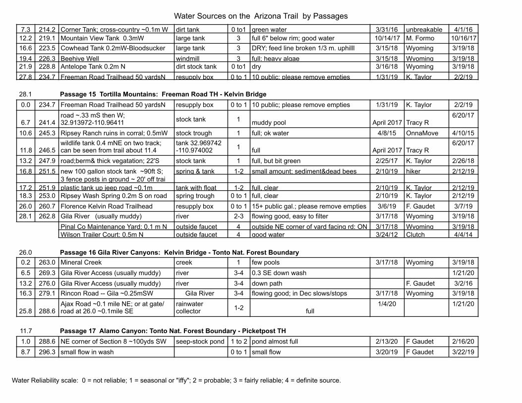
7.3 214.2 Corner Tank; cross-country ~0.1m W dirt tank 0 to1 green water 3/31/16 unbreakable 4/1/1612.2 219.1 Mountain View Tank 0.3mW large tank 3 full 6" below rim; good water 10/14/17 M. Formo 10/16/1716.6 223.5 Cowhead Tank 0.2mW-Bloodsucker large tank 3 DRY; feed line broken 1/3 m. uphilll 3/15/18 Wyoming 3/19/1819.4 226.3 Beehive Well windmill 3 full; heavy algae 3/15/18 Wyoming 3/19/1821.9 228.8 Antelope Tank 0.2m N dirt stock tank 0 to1 dry 3/16/18 Wyoming 3/19/1827.8 234.7 Freeman Road Trailhead 50 yardsN resupply box 0 to 1 10 public; please remove empties 1/31/19 K. Taylor 2/2/19
28.1 Passage 15 Tortilla Mountains: Freeman Road TH - Kelvin Bridge0.0 234.7 Freeman Road Trailhead 50 yardsN resupply box 0 to 1 10 public; please remove empties 1/31/19 K. Taylor 2/2/19
6.7 241.4road ~.33 mS then W; 32.913972-110.96411 stock tank 1 muddy pool April 2017 Tracy R
6/20/17
10.6 245.3 Ripsey Ranch ruins in corral; 0.5mW stock trough 1 full; ok water 4/8/15 OnnaMove 4/10/15
11.8 246.5wildlife tank 0.4 mNE on two track; can be seen from trail about 11.4
tank 32.969742 -110.974002 1 full April 2017 Tracy R
6/20/17
13.2 247.9 road;berm& thick vegatation; 22'S stock tank 1 full, but bit green 2/25/17 K. Taylor 2/26/1816.8 251.5 new 100 gallon stock tank ~90ft S; spring & tank 1-2 small amount; sediment&dead bees 2/10/19 hiker 2/12/19
3 fence posts in ground ~ 20' off trai17.2 251.9 plastic tank up jeep road ~0.1m tank with float 1-2 full, clear 2/10/19 K. Taylor 2/12/1918.3 253.0 Ripsey Wash Spring 0.2m S on road spring trough 0 to 1 full, clear 2/10/19 K. Taylor 2/12/1926.0 260.7 Florence Kelvin Road Trailhead resupply box 0 to 1 15+ public gal.; please remove empties 3/6/19 F. Gaudet 3/7/1928.1 262.8 Gila River (usually muddy) river 2-3 flowing good, easy to filter 3/17/18 Wyoming 3/19/18
Pinal Co Maintenance Yard; 0.1 m N outside faucet 4 outside NE corner of yard facing rd; ON 3/17/18 Wyoming 3/19/18Wilson Trailer Court; 0.5m N outside faucet 4 good water 3/24/12 Clutch 4/4/14
26.0 Passage 16 Gila River Canyons: Kelvin Bridge - Tonto Nat. Forest Boundary0.2 263.0 Mineral Creek creek 1 few pools 3/17/18 Wyoming 3/19/186.5 269.3 Gila River Access (usually muddy) river 3-4 0.3 SE down wash 1/21/20
13.2 276.0 Gila River Access (usually muddy) river 3-4 down path F. Gaudet 3/2/1616.3 279.1 Rincon Road -- Gila ~0.25mSW Gila River 3-4 flowing good; in Dec slows/stops 3/17/18 Wyoming 3/19/18
25.8 288.6Ajax Road ~0.1 mile NE; or at gate/road at 26.0 ~0.1mile SE
rainwater collector 1-2 full
1/4/20 1/21/20
11.7 Passage 17 Alamo Canyon: Tonto Nat. Forest Boundary - Picketpost TH1.0 288.6 NE corner of Section 8 ~100yds SW seep-stock pond 1 to 2 pond almost full 2/13/20 F Gaudet 2/16/208.7 296.3 small flow in wash 0 to 1 small flow 3/20/19 F Gaudet 3/22/19
Water Sources on the Arizona Trail by Passages
Water Reliability scale: 0 = not reliable; 1 = seasonal or "iffy"; 2 = probable; 3 = fairly reliable; 4 = definite source.
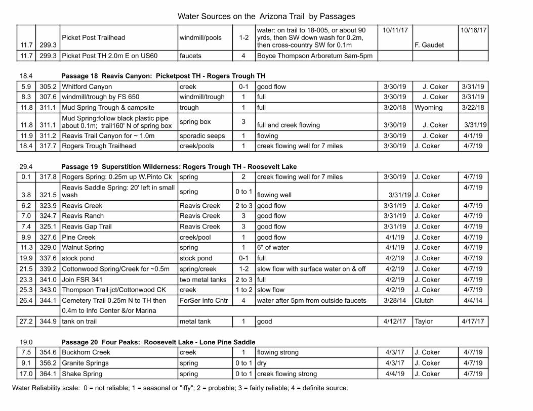
11.7 299.3Picket Post Trailhead windmill/pools 1-2
water: on trail to 18-005, or about 90 yrds, then SW down wash for 0.2m, then cross-country SW for 0.1m
10/11/17
F. Gaudet
10/16/17
11.7 299.3 Picket Post TH 2.0m E on US60 faucets 4 Boyce Thompson Arboretum 8am-5pm
18.4 Passage 18 Reavis Canyon: Picketpost TH - Rogers Trough TH5.9 305.2 Whitford Canyon creek 0-1 good flow 3/30/19 J. Coker 3/31/198.3 307.6 windmill/trough by FS 650 windmill/trough 1 full 3/30/19 J. Coker 3/31/1911.8 311.1 Mud Spring Trough & campsite trough 1 full 3/20/18 Wyoming 3/22/18
11.8 311.1Mud Spring:follow black plastic pipe about 0.1m; trail160' N of spring box spring box 3 full and creek flowing 3/30/19 J. Coker 3/31/19
11.9 311.2 Reavis Trail Canyon for ~ 1.0m sporadic seeps 1 flowing 3/30/19 J. Coker 4/1/1918.4 317.7 Rogers Trough Trailhead creek/pools 1 creek flowing well for 7 miles 3/30/19 J. Coker 4/7/19
29.4 Passage 19 Superstition Wilderness: Rogers Trough TH - Roosevelt Lake0.1 317.8 Rogers Spring: 0.25m up W.Pinto Ck spring 2 creek flowing well for 7 miles 3/30/19 J. Coker 4/7/19
3.8 321.5Reavis Saddle Spring: 20' left in small wash spring 0 to 1 flowing well 3/31/19 J. Coker
4/7/19
6.2 323.9 Reavis Creek Reavis Creek 2 to 3 good flow 3/31/19 J. Coker 4/7/197.0 324.7 Reavis Ranch Reavis Creek 3 good flow 3/31/19 J. Coker 4/7/197.4 325.1 Reavis Gap Trail Reavis Creek 3 good flow 3/31/19 J. Coker 4/7/199.9 327.6 Pine Creek creek/pool 1 good flow 4/1/19 J. Coker 4/7/1911.3 329.0 Walnut Spring spring 1 6" of water 4/1/19 J. Coker 4/7/1919.9 337.6 stock pond stock pond 0-1 full 4/2/19 J. Coker 4/7/1921.5 339.2 Cottonwood Spring/Creek for ~0.5m spring/creek 1-2 slow flow with surface water on & off 4/2/19 J. Coker 4/7/1923.3 341.0 Join FSR 341 two metal tanks 2 to 3 full 4/2/19 J. Coker 4/7/1925.3 343.0 Thompson Trail jct/Cottonwood CK creek 1 to 2 slow flow 4/2/19 J. Coker 4/7/1926.4 344.1 Cemetery Trail 0.25m N to TH then ForSer Info Cntr 4 water after 5pm from outside faucets 3/28/14 Clutch 4/4/14
0.4m to Info Center &/or Marina27.2 344.9 tank on trail metal tank 1 good 4/12/17 Taylor 4/17/17
19.0 Passage 20 Four Peaks: Roosevelt Lake - Lone Pine Saddle7.5 354.6 Buckhorn Creek creek 1 flowing strong 4/3/17 J. Coker 4/7/199.1 356.2 Granite Springs spring 0 to 1 dry 4/3/17 J. Coker 4/7/19
17.0 364.1 Shake Spring spring 0 to 1 creek flowing strong 4/4/19 J. Coker 4/7/19
Water Sources on the Arizona Trail by Passages
Water Reliability scale: 0 = not reliable; 1 = seasonal or "iffy"; 2 = probable; 3 = fairly reliable; 4 = definite source.

17.9 365.0 Bear Spring spring/pool 1 creek flowing strong 4/4/19 J. Coker 4/7/1918.8 365.9 Pigeon Spring ~0.05m N spring 2 water at spring 4/4/19 J. Coker 4/7/19
19.3 Passage 21 Pine Mountain: Lone Pine Saddle - Sunflower
8.9 375.0Little Pine Flat along FR422 and wildlife trick tanks 400' W/downstream
small flows/pools fiberglass tub 0 to 1 creek flowing well 4/5/19 J. Coker 4/7/19
10.8 376.9 Circle M Spring 0.5mE spring 0 to 1 flowing 4/2/17 Roncloud 4/7/1712.4 378.5 Boulder Creek creek 1 dry 4/5/19 J. Coker 4/7/19
13.2 379.3Boulder Pools sign/path; pool in creek bed 200' NE under trees at base of E facing slope
pools in ck. bed 2-3 flowing strong at Crabtree (NW of Crabtree Sp) 4/6/19 J. Coker
4/7/19
13.4 379.5 Boulder Creek creek 1 flowing strong 4/6/19 J. Coker 4/7/19
15.2 381.3road crossing Boulder creek; stock
tank ~200 yds SE on road creek & pond 0-1 good flow 4/6/19 J. Coker4/7/19
17.5 383.6 Sycamore Creek creek 3 very good flow strong flow 4/6/19 J. Coker 4/7/19
16.6 Passage 22 Saddle Mountain: Sunflower - Mount Peeley2.3 387.7 Rock spring ~80 yds E spring 1 some pools 10/22/12 D. Bedore 10/31/123.9 389.3 stock pond dirt stock pond 0 to 1 dry 4/7/18 Roncloud 4/12/184.9 390.3 wash along wash 1 pools 4/7/18 Roncloud 4/12/185.9 391.3 creek in Section 25 creek/pools 1 small stream and pools 4/13/16 Blankhikers 4/17/1611.9 397.3 McFarland Canyon for ~0.5m creek 1 to 2 3 small pools; not enough to get 4/11/18 D. Jensen 4/12/1812.6 398.0 wash creek 0 to 1 water 9/26/15 Wyoming 9/29/1514.0 399.4 wash wash 1 water Fall 15 S. Redfield 11/29/1515.5 400.9 Thicket Spring - sign; W 160' on path spring; pools 2-3 flowing & pools 4/8/18 Roncloud 4/12/18
24.3 Passage 23 Mazatzal Divide: Mount Peeley - Red Hills Trail8.4 410.4 Bear Spring 0.2m E spring box 3 plenty of sweet water 4/8/18 Roncloud 4/12/18
10.4 412.4 Windsor Seep 0.1m S seep/pools 0 to 1 slow flow 4/14/17 Taylor 4/17/1714.6 416.6 Chilson Spring 150 ft. uphill at sign spring box 1-2 about 6" of water in spring 11/17/17 F. Gaudet 11/18/1717.1 419.1 Horse Camp Seep/creek seep/pot holes 2 to 3 ~2' of water in big pot hole 11/19/16 F. Gaudet 11/18/1717.9 419.9 Hopi Spring ~0.05m E spring 1 flowing across trail 4/17/16 Roadrunner 4/24/1621.3 423.3 Wet Bottom Creek (look downstream) creek/pools 1 small pools down creek 12/6/15 F. Gaudet 12/18/1522.6 424.6 wash pools & creek 1 small pools 4/16/16 Blankhikers 4/17/16
Water Sources on the Arizona Trail by Passages
Water Reliability scale: 0 = not reliable; 1 = seasonal or "iffy"; 2 = probable; 3 = fairly reliable; 4 = definite source.
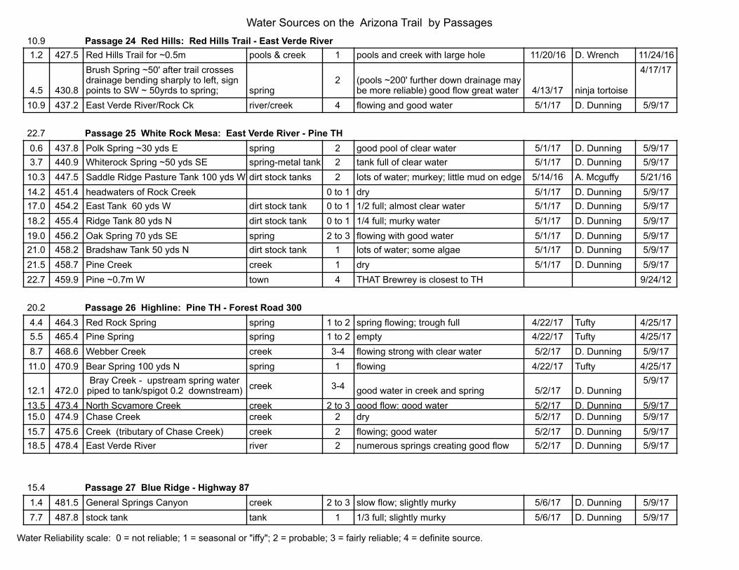
10.9 Passage 24 Red Hills: Red Hills Trail - East Verde River1.2 427.5 Red Hills Trail for ~0.5m pools & creek 1 pools and creek with large hole 11/20/16 D. Wrench 11/24/16
4.5 430.8
Brush Spring ~50' after trail crosses drainage bending sharply to left, sign points to SW ~ 50yrds to spring; spring
2 (pools ~200' further down drainage may be more reliable) good flow great water 4/13/17 ninja tortoise
4/17/17
10.9 437.2 East Verde River/Rock Ck river/creek 4 flowing and good water 5/1/17 D. Dunning 5/9/17
22.7 Passage 25 White Rock Mesa: East Verde River - Pine TH0.6 437.8 Polk Spring ~30 yds E spring 2 good pool of clear water 5/1/17 D. Dunning 5/9/173.7 440.9 Whiterock Spring ~50 yds SE spring-metal tank 2 tank full of clear water 5/1/17 D. Dunning 5/9/17
10.3 447.5 Saddle Ridge Pasture Tank 100 yds W dirt stock tanks 2 lots of water; murkey; little mud on edge 5/14/16 A. Mcguffy 5/21/1614.2 451.4 headwaters of Rock Creek 0 to 1 dry 5/1/17 D. Dunning 5/9/1717.0 454.2 East Tank 60 yds W dirt stock tank 0 to 1 1/2 full; almost clear water 5/1/17 D. Dunning 5/9/1718.2 455.4 Ridge Tank 80 yds N dirt stock tank 0 to 1 1/4 full; murky water 5/1/17 D. Dunning 5/9/1719.0 456.2 Oak Spring 70 yds SE spring 2 to 3 flowing with good water 5/1/17 D. Dunning 5/9/1721.0 458.2 Bradshaw Tank 50 yds N dirt stock tank 1 lots of water; some algae 5/1/17 D. Dunning 5/9/1721.5 458.7 Pine Creek creek 1 dry 5/1/17 D. Dunning 5/9/1722.7 459.9 Pine ~0.7m W town 4 THAT Brewrey is closest to TH 9/24/12
20.2 Passage 26 Highline: Pine TH - Forest Road 3004.4 464.3 Red Rock Spring spring 1 to 2 spring flowing; trough full 4/22/17 Tufty 4/25/175.5 465.4 Pine Spring spring 1 to 2 empty 4/22/17 Tufty 4/25/178.7 468.6 Webber Creek creek 3-4 flowing strong with clear water 5/2/17 D. Dunning 5/9/1711.0 470.9 Bear Spring 100 yds N spring 1 flowing 4/22/17 Tufty 4/25/17
12.1 472.0Bray Creek - upstream spring water
piped to tank/spigot 0.2 downstream) creek 3-4 good water in creek and spring 5/2/17 D. Dunning5/9/17
13.5 473.4 North Scyamore Creek creek 2 to 3 good flow; good water 5/2/17 D. Dunning 5/9/1715.0 474.9 Chase Creek creek 2 dry 5/2/17 D. Dunning 5/9/1715.7 475.6 Creek (tributary of Chase Creek) creek 2 flowing; good water 5/2/17 D. Dunning 5/9/1718.5 478.4 East Verde River river 2 numerous springs creating good flow 5/2/17 D. Dunning 5/9/17
15.4 Passage 27 Blue Ridge - Highway 871.4 481.5 General Springs Canyon creek 2 to 3 slow flow; slightly murky 5/6/17 D. Dunning 5/9/177.7 487.8 stock tank tank 1 1/3 full; slightly murky 5/6/17 D. Dunning 5/9/17
Water Sources on the Arizona Trail by Passages
Water Reliability scale: 0 = not reliable; 1 = seasonal or "iffy"; 2 = probable; 3 = fairly reliable; 4 = definite source.
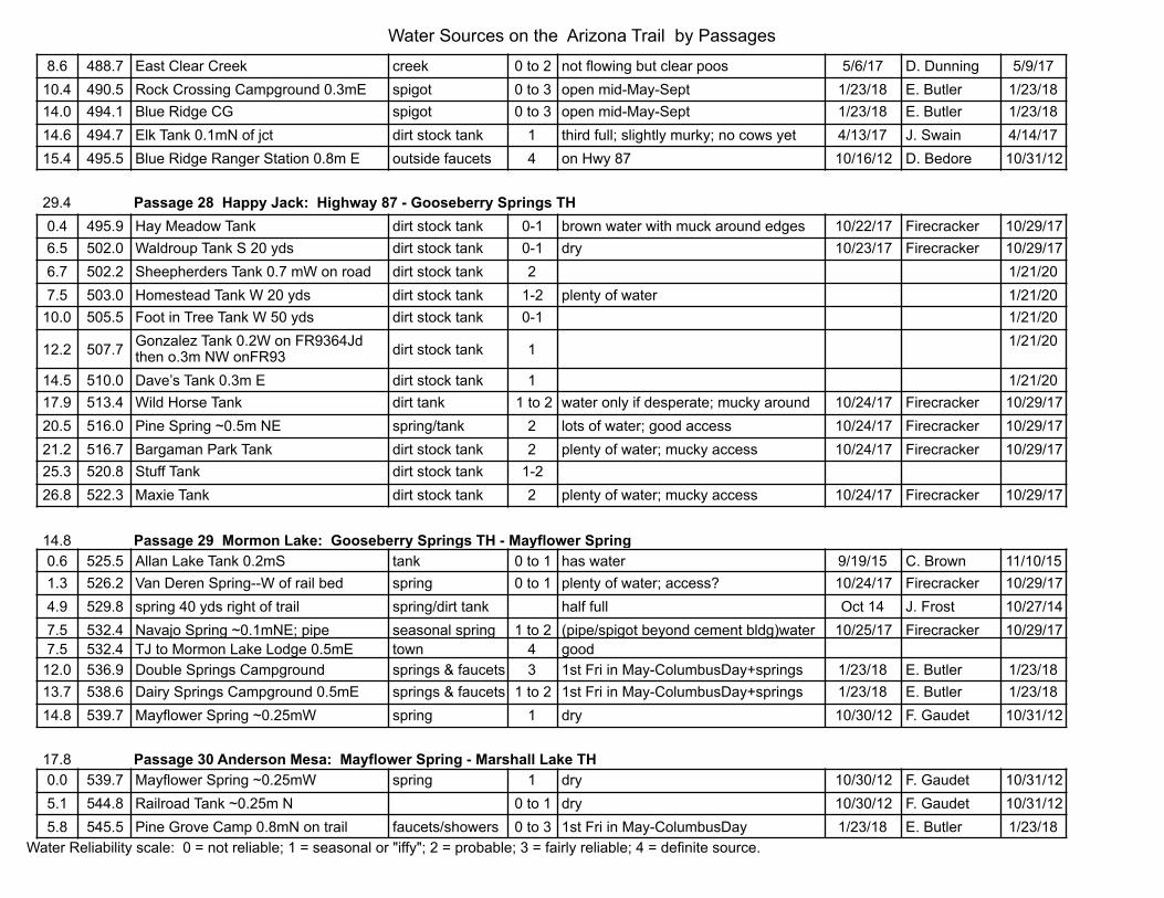
8.6 488.7 East Clear Creek creek 0 to 2 not flowing but clear poos 5/6/17 D. Dunning 5/9/1710.4 490.5 Rock Crossing Campground 0.3mE spigot 0 to 3 open mid-May-Sept 1/23/18 E. Butler 1/23/1814.0 494.1 Blue Ridge CG spigot 0 to 3 open mid-May-Sept 1/23/18 E. Butler 1/23/1814.6 494.7 Elk Tank 0.1mN of jct dirt stock tank 1 third full; slightly murky; no cows yet 4/13/17 J. Swain 4/14/1715.4 495.5 Blue Ridge Ranger Station 0.8m E outside faucets 4 on Hwy 87 10/16/12 D. Bedore 10/31/12
29.4 Passage 28 Happy Jack: Highway 87 - Gooseberry Springs TH0.4 495.9 Hay Meadow Tank dirt stock tank 0-1 brown water with muck around edges 10/22/17 Firecracker 10/29/176.5 502.0 Waldroup Tank S 20 yds dirt stock tank 0-1 dry 10/23/17 Firecracker 10/29/176.7 502.2 Sheepherders Tank 0.7 mW on road dirt stock tank 2 1/21/207.5 503.0 Homestead Tank W 20 yds dirt stock tank 1-2 plenty of water 1/21/20
10.0 505.5 Foot in Tree Tank W 50 yds dirt stock tank 0-1 1/21/20
12.2 507.7 Gonzalez Tank 0.2W on FR9364Jd then o.3m NW onFR93 dirt stock tank 1 1/21/20
14.5 510.0 Dave’s Tank 0.3m E dirt stock tank 1 1/21/2017.9 513.4 Wild Horse Tank dirt tank 1 to 2 water only if desperate; mucky around 10/24/17 Firecracker 10/29/1720.5 516.0 Pine Spring ~0.5m NE spring/tank 2 lots of water; good access 10/24/17 Firecracker 10/29/1721.2 516.7 Bargaman Park Tank dirt stock tank 2 plenty of water; mucky access 10/24/17 Firecracker 10/29/1725.3 520.8 Stuff Tank dirt stock tank 1-226.8 522.3 Maxie Tank dirt stock tank 2 plenty of water; mucky access 10/24/17 Firecracker 10/29/17
14.8 Passage 29 Mormon Lake: Gooseberry Springs TH - Mayflower Spring0.6 525.5 Allan Lake Tank 0.2mS tank 0 to 1 has water 9/19/15 C. Brown 11/10/151.3 526.2 Van Deren Spring--W of rail bed spring 0 to 1 plenty of water; access? 10/24/17 Firecracker 10/29/174.9 529.8 spring 40 yds right of trail spring/dirt tank half full Oct 14 J. Frost 10/27/147.5 532.4 Navajo Spring ~0.1mNE; pipe seasonal spring 1 to 2 (pipe/spigot beyond cement bldg)water 10/25/17 Firecracker 10/29/177.5 532.4 TJ to Mormon Lake Lodge 0.5mE town 4 good
12.0 536.9 Double Springs Campground springs & faucets 3 1st Fri in May-ColumbusDay+springs 1/23/18 E. Butler 1/23/1813.7 538.6 Dairy Springs Campground 0.5mE springs & faucets 1 to 2 1st Fri in May-ColumbusDay+springs 1/23/18 E. Butler 1/23/1814.8 539.7 Mayflower Spring ~0.25mW spring 1 dry 10/30/12 F. Gaudet 10/31/12
17.8 Passage 30 Anderson Mesa: Mayflower Spring - Marshall Lake TH0.0 539.7 Mayflower Spring ~0.25mW spring 1 dry 10/30/12 F. Gaudet 10/31/125.1 544.8 Railroad Tank ~0.25m N 0 to 1 dry 10/30/12 F. Gaudet 10/31/125.8 545.5 Pine Grove Camp 0.8mN on trail faucets/showers 0 to 3 1st Fri in May-ColumbusDay 1/23/18 E. Butler 1/23/18
Water Sources on the Arizona Trail by Passages
Water Reliability scale: 0 = not reliable; 1 = seasonal or "iffy"; 2 = probable; 3 = fairly reliable; 4 = definite source.
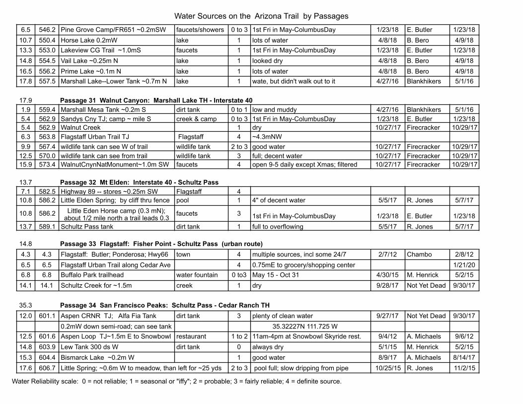
6.5 546.2 Pine Grove Camp/FR651 ~0.2mSW faucets/showers 0 to 3 1st Fri in May-ColumbusDay 1/23/18 E. Butler 1/23/1810.7 550.4 Horse Lake 0.2mW lake 1 lots of water 4/8/18 B. Bero 4/9/1813.3 553.0 Lakeview CG Trail ~1.0mS faucets 1 1st Fri in May-ColumbusDay 1/23/18 E. Butler 1/23/1814.8 554.5 Vail Lake ~0.25m N lake 1 looked dry 4/8/18 B. Bero 4/9/1816.5 556.2 Prime Lake ~0.1m N lake 1 lots of water 4/8/18 B. Bero 4/9/1817.8 557.5 Marshall Lake--Lower Tank ~0.7m N lake 1 wate, but didn't walk out to it 4/27/16 Blankhikers 5/1/16
17.9 Passage 31 Walnut Canyon: Marshall Lake TH - Interstate 401.9 559.4 Marshall Mesa Tank ~0.2m S dirt tank 0 to 1 low and muddy 4/27/16 Blankhikers 5/1/165.4 562.9 Sandys Cny TJ; camp ~ mile S creek & camp 0 to 3 1st Fri in May-ColumbusDay 1/23/18 E. Butler 1/23/185.4 562.9 Walnut Creek 1 dry 10/27/17 Firecracker 10/29/176.3 563.8 Flagstaff Urban Trail TJ Flagstaff 4 ~4.3mNW9.9 567.4 wildlife tank can see W of trail wildlife tank 2 to 3 good water 10/27/17 Firecracker 10/29/17
12.5 570.0 wildlife tank can see from trail wildlife tank 3 full; decent water 10/27/17 Firecracker 10/29/1715.9 573.4 WalnutCnynNatMonument~1.0m SW faucets 4 open 9-5 daily except Xmas; filtered 10/27/17 Firecracker 10/29/17
13.7 Passage 32 Mt Elden: Interstate 40 - Schultz Pass7.1 582.5 Highway 89 -- stores ~0.25m SW Flagstaff 4
10.8 586.2 Little Elden Spring; by cliff thru fence pool 1 4" of decent water 5/5/17 R. Jones 5/7/17
10.8 586.2 Little Eden Horse camp (0.3 mN); about 1/2 mile north a trail leads 0.3
faucets 3 1st Fri in May-ColumbusDay 1/23/18 E. Butler 1/23/1813.7 589.1 Schultz Pass tank dirt tank 1 full to overflowing 5/5/17 R. Jones 5/7/17
14.8 Passage 33 Flagstaff: Fisher Point - Schultz Pass (urban route)4.3 4.3 Flagstaff: Butler; Ponderosa; Hwy66 town 4 multiple sources, incl some 24/7 2/7/12 Chambo 2/8/126.5 6.5 Flagstaff Urban Trail along Cedar Ave 4 0.75mE to grocery/shopping center 1/21/206.8 6.8 Buffalo Park trailhead water fountain 0 to3 May 15 - Oct 31 4/30/15 M. Henrick 5/2/15
14.1 14.1 Schultz Creek for ~1.5m creek 1 dry 9/28/17 Not Yet Dead 9/30/17
35.3 Passage 34 San Francisco Peaks: Schultz Pass - Cedar Ranch TH12.0 601.1 Aspen CRNR TJ; Alfa Fia Tank dirt tank 3 plenty of clean water 9/27/17 Not Yet Dead 9/30/17
0.2mW down semi-road; can see tank 35.32227N 111.725 W 12.5 601.6 Aspen Loop TJ~1.5m E to Snowbowl restaurant 1 to 2 11am-4pm at Snowbowl Skyride rest. 9/4/12 A. Michaels 9/6/1214.8 603.9 Lew Tank 300 ds W dirt tank 0 always dry 5/1/15 M. Henrick 5/2/1515.3 604.4 Bismarck Lake ~0.2m W 1 good water 8/9/17 A. Michaels 8/14/1717.6 606.7 Little Spring; ~0.6m W to meadow, than left for ~25 yds 2 to 3 pool full; slow dripping from pipe 10/25/15 R. Jones 11/2/15
Water Sources on the Arizona Trail by Passages
Water Reliability scale: 0 = not reliable; 1 = seasonal or "iffy"; 2 = probable; 3 = fairly reliable; 4 = definite source.

22.5 611.6 Kelly Tank dirt tank;resupply 0 to 1 2 gallons; remove empties if using 5/12/17 A. Michaels 6/29/17box 50 paces N of gate, left side behind couple of trees, but visible from trail
24.5 613.6 Borrego Trick Tank trough trough 1 head left/W on road ~0.25mile turning right/NE~0.1 mile to reach trough 10/13/18 S. Redfield
11/2/18
26.6 615.7 Badger Tank ~0.1m E dirt tank 0 to 1 dry 5/12/17 A. Michaels 6/29/1727.6 616.7 Bonita Tank dirt tank 0 to 1 dry 5/12/17 A. Michaels 6/29/1734.4 623.5 East Cedar Tank ~0.25m S spring/tank 1 water in tank 5/12/17 A. Michaels 6/29/1735.3 624.4 Trailhead/FR9008A~0.1left/south metal tank 3 tank full; resupply box18 gallons 9/25/17 Not Yet Dead 9/30/17
resupply box behind bushes left of sign
24.5 Passage 35 Babbit Ranch: Cedar Ranch TH - Moqui State Station6.2 630.6 Rabbit Tank ~0.5m S dirt stock tank 0 to 1 full 10/8/12 D. Bedore 10/10/129.5 633.9 Dirt Tank at powerline dirt stock tank 0 to 1 water in tank 9/6/15 R. Corfman 9/10/15
16.1 640.5 Upper Lockwood Tank dirt stock tank 0 to 1 dry 5/2/16 Roadrunner 5/5/16
17.9 642.3 Lockwood Tank; metal tank/trough; east of both earthern tanks near corral 36" covered tank 2 plenty of water 9/25/17 Not Yet Dead
9/30/17
18.0 Passage 36 Coconino Rim: Moqui Stage Station - Grandview Tower4.1 653.0 "Russell" big metal tank 0 to 1 6" of water 9/23/17 Not Yet Dead 9/30/176.7 655.6 Russell Tank large dirt tank 2 small lake 9/23/17 Not Yet Dead 9/30/17
12.5 661.4 wildlife tank ~0.1m SW uphill at carin fiberglass tank 2 full & clear 9/23/17 Not Yet Dead 9/30/1717.7 666.6 wildlife tank 0.5m;~25ydsE of FR307 fiberglass tank 2 full & clear 5/4/17 F. Gaudet 5/7/17
18.0 666.9 Grandview Lookout Tower water when staffed 0 to 1 no water 4/29/17 Taylor
5/11/17
22.5 Passage 37 Grand Canyon South Rim: Grandview Tower - South Kaibab TH4.4 671.3 Watson Tank dirt tank 0 to 1 dry 9/23/17 Not Yet Dead 9/30/177.2 674.1 Upper Tex X tank after leavingFR303D dirt tank 0 to 1 dry 4/29/17 Taylor 5/11/17
14.0 680.9 Tusayan ~0.2m W town 4 many places15.5 682.4 Tusayan:TusayanGreenway Tr ~0.7mS town 4 many places20.3 687.2 Mather campground ~0.2m N faucets 4 water on 5/13/16 Firecracker 5/19/1620.7 687.6 Mather Point Visitor Center ~1.0m W faucets 422.5 689.4 South Kaibab Trail at Yaki Point spigot by corrals 4 always on 1/23/18 E. Butler 1/23/18
Water Sources on the Arizona Trail by Passages
Water Reliability scale: 0 = not reliable; 1 = seasonal or "iffy"; 2 = probable; 3 = fairly reliable; 4 = definite source.

21.8 Passage 38 Grand Canyon Inner Gorge: South Kaibab TH - North Kaibab TH0.0 689.4 South Kaibab Trail at Yaki Point spigot by corrals 4 always on 1/23/18 E. Butler 1/23/187.0 696.4 Footbridge Bright Angel Crk 4 always on 1/23/18 E. Butler 1/23/187.5 696.9 Phantom Ranch faucet 4 always on 1/23/18 E. Butler 1/23/188.4 697.8 footbridges Bright Angel Crk 4
14.7 704.1 Cottonwood Camp spigot 4 spigot on May - Oct 1/23/18 E. Butler 1/23/1816.1 705.5 Yard area at pump house residence spigot 4 spigot on 5/4/17 Taylor 5/11/1720.1 709.5 Supai Tunnel: on when N. Rim open spigot 1 to 2 spigot on 5/14/16 Firecracker 5/19/1621.8 711.2 North Kaibab Trailhead right of trail water fountain 1 to 2 water on when N. Rim open; water on 5/5/16 Roadrunner 5/11/1621.8 711.2 North Rim Ranger Station/Camp spigot 4
~0.5m W to Ranger Station; ~1m W to camp
12.0 Passage 39 Grand Canyon - North Rim: North Kaibab TH - Grand Canyon National Boundary9.8 721.0 Log residence near park entrance: two blue 5 gallon 0 to 1 one gallon on porch 9/9/17 Not Yet Dead 9/30/17
20.7 Passage 40 Kaibab Plateau South: Grand Canyon National Boundary - Telephone Hill TH0.5 723.7 Upper North Canyon creek 0-1 will be gone soon 4/25/18 J. Neff 4/29/18
2.2 725.4 Sourdough Well (& pond 100yds N) well 0-1 (cement cap on well)pond looks good 4/25/18 J. Neff 4/29/18
4.8 728.0 Crystal Spring spring 1 excellent good water 7/6/19 BiFrost 7/14/19
5.4 728.6 North Canyon Sprg ~0.6m E into cny spring 2 plenty of water 10/7/16 L. Neff 10/27/167.7 730.9 Dog Lake pond 1 looks good 7/6/19 BiFrost 7/14/197.8 731.0 wildlife drinker on left side of trail concrete drinker 0 to 1 good water 7/6/19 BiFrost 7/14/19
9.7 732.9 Kaibab Lodge on Hwy 67; 2.7mSW lodge 4~1.2mS on FR216; right 1.1mS on FR216B; right 0.1mNW on FR3767 & stay on FR3767 0.3mSW
1/21/20
15.5 738.7 Little Pleasant Valley Tank 2 dirt tanks 1 good water 7/6/19 BiFrost 7/14/1917.9 741.1 Crane Lake pond 2 plenty but dirty 9/17/17 Not Yet Dead 9/30/17
16.6 Passage 41 Kaibab Plateau Central: Telephone Hill TH - Highway 89A6.3 750.2 Road & Wildlife Tank cement tank 1 to 2 full with good water 6/2/16 R. Steady 6/25/168.4 752.3 Murray Lake TH on FR205 resupply box 0 to 1 before TH at S end of fence on E; none 5/6/17 Taylor 5/11/1711.1 755.0 Ridge Tank (Buffalo Trick Tank) steel tank 2 good water at trick tank 7/5/19 BiFrost 7/14/19
Water Sources on the Arizona Trail by Passages
Water Reliability scale: 0 = not reliable; 1 = seasonal or "iffy"; 2 = probable; 3 = fairly reliable; 4 = definite source.

15.0 758.9 Big Ridge Tank dirt &metal tanks 0 to 1 dry 9/16/17 Not Yet Dead 9/30/1715.0 758.9 Jacob Lake Inn ~2.1m W store/café/motel/gas 4 spigot off in front of store 5/3/15 Bird Food 5/20/15
16.5 760.4 Jacob Lake Inn ~2.4m SW; on Hwy. US89A & jct with AZ Hwy 67
store/café/motel/gas 4
~0.7mSW on FR205; onto Ceballos Trail (right/north side of road) ~2.3mSW then W to Hwy. 0.3mN on Hwy
16.4 Passage 42 Kaibab Plateau North: Highway 89A - Winter Road
6.0 766.4Orderville Trick Tank; nw ~0.6m on two track (FR D155); 36.797964 -112.154798
tank&trough 1 to 2dripping; trough1/4 full;cloudy 5/22/17 Tracy R
6/20/17
6.8 767.2Ponderosa Trick Tank ~0.25 NE onto road then trail E 36.805881 -112.140426
tanks and trough 1full 7/4/19 BiFrost
7/14/19
6.9 767.3 umbrella tank water box o to 1 water 7/4/19 BiFrost 7/14/199.2 769.6 Government Reservoir dirt tank 0 to 1 dry 7/4/19 BiFrost 7/14/19
13.8 774.2 Rock Canyon Apron 0.25SE on cow trails; 36.888639 112.132309 trough 1 tasted great 5/22/17 Tracy R
6/20/17
10.6 Passage 43 Buckskin Mountain: Winter Road - Utah State Line
0.0 776.8
Wildlife Tank West W on Winter road then right away a right onto another road for 0.4mW then another road right 0.2mN -112.113260, 36.921737
metal trough 2full 5/22/17 Tracy R
6/20/17
6.6 783.4 Wildlife tank/guzzler; right/E of trail; cement tank 2 full & decent water 7/4/19 BiFrost 7/14/19hard to see going north; easy to see going south
10.6 787.4 Arizona-Utah State line campground campers/day 0 to 1 no water in campground 1/23/18 E, Butler 1/23/18or ~1.2m N at Wire Pass Trailhead hikers water from day hikers at Wire Pass TH 7/8/16 p.bunyon 7/16/16
Water Sources on the Arizona Trail by Passages
Water Reliability scale: 0 = not reliable; 1 = seasonal or "iffy"; 2 = probable; 3 = fairly reliable; 4 = definite source.


