WATER CROSSING INVENTORY INSTRUCTION...
272
WATER CROSSING INVENTORY INSTRUCTION MANUAL CROWN FOREST ROADS AND WATER CROSSINGS PROGRAM Ministry of Natural Resources June 1, 2004
-
Upload
nguyendang -
Category
Documents
-
view
217 -
download
2
Transcript of WATER CROSSING INVENTORY INSTRUCTION...

WATER CROSSING INVENTORY INSTRUCTION MANUAL
CROWN FOREST ROADS AND WATER CROSSINGS PROGRAM Ministry of Natural Resources June 1, 2004

CROWN FOREST ROADS AND WATER CROSSINGS PROGRAM Water Crossing Inventory Instruction Manual
June 1, 2004 i
CONTENTS
INTRODUCTION ..................................................................................................1
OBJECTIVES & APPROACH ...............................................................................2
RESPONSIBILITY DETERMINATION .........................................................................3 ROAD NETWORK SELECTION...................................................................................3 ACCESSIBILITY OF WATER CROSSINGS.................................................................5 INVENTORY SCHEDULING........................................................................................6 SAFETY CONSIDERATIONS FOR FIELD CREWS .....................................................7 PUBLIC SAFETY – DEALING WITH ENCOUNTERED HAZARDS...............................8 TERMINOLOGY AND DEFINITIONS ............................................................................9
BRIDGES ................................................................................................................................. 9 CROSS DRAINAGE CULVERTS.......................................................................................... 10 PRIMARY STRUCTURE........................................................................................................ 10
EQUIPMENT .............................................................................................................12 SAFETY ................................................................................................................................. 12 MEASURING EQUIPMENT................................................................................................... 12 DATA RECORDING .............................................................................................................. 12
DATA COLLECTION AND MANAGEMENT .......................................................13
ADVANTAGES OF ELECTRONIC DATA COLLECTION............................................13 ELECTRONIC DATA PREPARATION .......................................................................14
INTRODUCTION.................................................................................................................... 14 HP iPAQ H5550 SET-UP AND OPERATIONAL OVERVIEW .............................................. 14 SHAPEFILE PREPARATION................................................................................................ 16 ARCPAD VERSION 6.0.3 SOFTWARE INSTALLATION .................................................... 18 FIELD MAPS.......................................................................................................................... 18 GENERATING ADDITIONAL CROSSINGS FROM NEW ROAD DATA ............................. 18
ELECTRONIC DATA COLLECTION ..........................................................................19 ARCPAD APPLICATION INSTRUCTIONS .......................................................................... 19 Arcpad Water Crossing Toolbar on the PenCentra (Full VGA) ....................................... 19 Arcpad Water Crossing Toolbar on the IPAQ H5550 (1/4 VGA) ...................................... 19 Adding Layers ...................................................................................................................... 21 GPS Settings......................................................................................................................... 21 Water Crossing Symbolization ........................................................................................... 21 PenCentra (Full VGA) Data Entry Form Screens .............................................................. 22 HP IPAQ (1/4 VGA) Data Entry Form Screens ................................................................... 24 Pick List for Inspector and all Comment Fields................................................................ 26 Select a Water Crossing by WC_ID .................................................................................... 26 Adding New Data.................................................................................................................. 28 File Backup/Synchronization .............................................................................................. 28 Capturing Other Spatial Features....................................................................................... 28
OTHER DATA............................................................................................................29 DATA COLLECTION FORMS............................................................................................... 29 DIGITAL PICTURES.............................................................................................................. 29 PROJECT PRODUCTION STATISTICS - DAILY FIELD LOG............................................. 30
ANALYSIS AND REPORTS ...............................................................................31
WATER CROSSING RANKING TOOL ...............................................................................31
DATA DICTIONARY ...........................................................................................34
PART A - GENERAL ATTRIBUTES ................................................................................35 PART B – WHOLE CROSSING ATTRIBUTES - FIELD.....................................................39

CROWN FOREST ROADS AND WATER CROSSINGS PROGRAM Water Crossing Inventory Instruction Manual
June 1, 2004 ii
PART C – INDIVIDUAL STRUCTURES ATTRIBUTES - FIELD ........................................51 PART D – FISHERIES ATTRIBUTES ............................................................................64
PROCEDURES FOR COMPLETING HABITAT/FISHERIES VALUES DATA FORMS...............................................................................................................70
INTRODUCTION ............................................................................................................70 HABITAT PRESENCE/ABUNDANCE .................................................................................71 USE OF THE FISH HABITAT ATTRIBUTE TABLES ..............................................................71 FISH HABITAT COMMENTS ............................................................................................73 FIELD FISH HABITAT COMMENTS...................................................................................73 EXAMPLES ..................................................................................................................74
APPENDIX I - SUPPORT CONTACTS.............................................................84
APPENDIX II - DATA COLLECTION FORMS ...................................................85
TALLY SHEETS FOR FIELD DATA COLLECTIONWATER CROSSING SAFETY HAZARD
IDENTIFICATION FORM..................................................................................................86 WATER CROSSING SAFETY HAZARD IDENTIFICATION FORM............................................89 DIGITAL PICTURE LOG ............................................................................................90 FRWCI - DAILY LOG..................................................................................................91 DAILY FIELD LOG SUMMARY .........................................................................................92 FISH HABITAT/FISHERIES VALUES DATA INPUT FORM.....................................................93
APPENDIX III - ATTRIBUTE SUMMARY ..........................................................95
Part A - GENERAL Attributes................................................................................................. 95 Part B – WHOLE CROSSING Attributes - Field .................................................................... 96 Part C – INDIVIDUAL STRUCTURES Attributes – Field ....................................................... 99 Part D – FISHERIES Attributes – Office/Field Assessment................................................. 101
APPENDIX IV - GLOSSARY ...........................................................................104
APPENDIX V – PHOTOGRAPH LIBRARY.......................................................108
APPENDIX VI – REFERENCE DOCUMENTS .................................................119
APPENDIX VII – FUR TRAP EXTRICATION ...................................................120
APPENDIX VIII – WATER CROSSING SHAPEFILE ATTRIBUTE LIST ..........122
APPENDIX IX – ATTRIBUTE INDEX SORTED BY DATA DICTIONARY NAME..........................................................................................................................126
APPENDIX X – ATTRIBUTE INDEX SORTED BY ARCPAD SCREEN NAME 130

CROWN FOREST ROADS AND WATER CROSSINGS PROGRAM Water Crossing Inventory Instruction Manual
June 1, 2004 1
INTRODUCTION Water crossings are a common feature on forest access roads throughout the province of Ontario. A preliminary analysis of provincial data estimates there are currently 90,000 plus water crossings on Crown land. Knowledge of the present status of this infrastructure is incomplete. The design and condition of water crossings or the failure to properly maintain crossings may result in the development of hazardous conditions that pose a threat to public safety and/or a risk of environmental damage. Defective water crossings can have significant impacts on fish and fish habitat both from an erosion/sedimentation and fish passage perspective. A systematic analysis of the risks to fish and fish habitat has not been done in Ontario to date. In December 2000 the provincial Forest Road and Water Crossing Initiative (FRWCI) was established to address several matters related to the roads and water crossing infrastructure on Crown land in the Area of the Undertaking (AOU). The mandate of this initiative includes:
• determination of the current status of forest roads and water crossings on Crown land throughout the AOU;
• identification of existing infrastructure hazards and potential problems that pose a threat to public safety and/or present a risk of environmental damage;
• development of a multi-year strategic approach in cooperation with recognized users, to plan and undertake as expeditiously as possible, remedial work necessary to reduce or eliminate confirmed liabilities;
• identification of measures to be taken to ensure full compliance with legislation, policy, guidelines and existing resource plans;
• clearly defining the liabilities (civil and environmental) associated with roads and water crossings on Crown land.
• clearly defining individual and/or shared responsibilities for MNR, the forest industry and other parties who have specific interests in specific roads;
• recommending improvements to existing access/road-use planning mechanisms, and;
• identification of any ongoing projects/programs (internal or external to MNR) that relate directly to this initiative and establish appropriate linkages to ensure efficiency, avoid duplication of effort and maximize partnership opportunities
To date the Forest Road and Water Crossing Initiative has made significant progress addressing many of the above items. Work has been completed on the review of legislation, policy and applicable guidelines, and some clarification has been provided with respect to liabilities and responsibility. A water crossing inventory methodology has been developed and tested and a multi-year operational inventory program was initiated in 2002 and continued in 2003. This assessment will permit the prioritization of remedial work necessary to immediately begin to eliminate or reduce safety and environmental concerns. Additionally, work has been completed on the development of a database application, Water Crossing Ranking Tool (WCRT), which will be used to manage water crossing information and analyze risks to public safety and environmental factors. Dialogue with the Department of Fisheries and Oceans (DFO) has been ongoing since the commencement of the FRWCI and DFO has collaborated on the development of the FRWCI water crossing inventory methodology. Additionally, DFO has indicated full support for the systematic approach proposed by the FRWCI. The FRWCI “project” was completed in the fall of 2003 at which time project results and products were transferred to MNR program groups for subsequent policy development, procedural improvements and ongoing operational implementation. The Crown Forest Roads and Water Crossings Program will be coordinated by the Land Management Section beginning in July 2004.

CROWN FOREST ROADS AND WATER CROSSINGS PROGRAM Water Crossing Inventory Instruction Manual
June 1, 2004 2
OBJECTIVES & APPROACH In order to address the first two items of the Forest Road and Water Crossing Initiative mandate, an Inventory Team was formed in February 2001. The Inventory Team assembled information to identify the magnitude of the task (eg. 90,000+ water crossings) and determined the status of current data holdings for roads and water crossings. MNR district offices and Sustainable Forest Licence (SFL) holders were canvassed and it was confirmed that very few management units had a methodology in place to inventory, assess and maintain current information on the status of water crossings. It was also determined that many management units have obligations crossings arising from Independent Forest Audits to address action items that pertain to water crossings. Considerable interest was expressed in obtaining guidance with respect to the best approach to begin to assemble and manage appropriate water crossing information. The development of the FRWCI water crossing inventory methodology commenced in the spring of 2001 and led to pilot testing on twelve management units across the province. Eleven SFL companies and twelve MNR districts were involved in the cooperative pilot test projects. The Department of Fisheries and Oceans (DFO) also participated in the development of the inventory methodology and pilot project training. The pilot inventory methodology was modified to incorporate the changes proposed by the pilot participants. The FRWCI water crossing inventory was implemented operationally in 2002 and 2003. Participants in the 2002 and 2003 operational programs were debriefed and identified the need for minimal refinements to the methodology and attributes. Appropriate changes have been incorporated into the 2004 version. Additionally, work was completed on the Water Crossing Ranking Tool (WCRT) application, which has been developed to store, analyze and manage water crossing data. The FRWCI water crossing inventory methodology was designed with the following objectives:
• develop an efficient, rapid and cost-effective assessment procedure that collects essential and relevant information on water crossing design and condition
• develop a methodology that would be endorsed by DFO and seek DFO’s assistance with design, development and testing
• maximize involvement of MNR and SFL companies in development and testing
• ensure field procedures can be competently completed by personnel from forest industry, MNR or forestry consultant/contractors
• offer an electronic data capture option
• develop a data base application to manage and analyze data that is compatible with MNR and forest industry computer systems
• provide an analytical tool that will prioritize remedial work according to risk to public safety and fisheries/environmental concerns
• ensure that the database can easily be updated and report formats meet user needs It is important to understand that the FRWCI water crossing inventory is not a detailed stream or fisheries evaluation, nor is it intended to provide a detailed engineering analysis of water crossing infrastructures. The FRWCI water crossing inventory methodology and products, including the Water Crossing Ranking Tool (WCRT), will be available to all SFL holders and MNR districts upon request.

CROWN FOREST ROADS AND WATER CROSSINGS PROGRAM Water Crossing Inventory Instruction Manual
June 1, 2004 3
PROJECT PLANNING
RESPONSIBILITY DETERMINATION Inventory Coordinators must consider several factors when deciding which roads and water crossings should be assessed and in what priority. First, it is important to determine for each road or road network, who is responsible for monitoring and maintenance. The party responsible for any given road will also be responsible for the water-crossing inventory of that road. Funding provided to MNR districts should be utilized to inventory water crossings on road networks that are determined to be the Crown’s responsibility. Similarly, SFL holders would be expected to fund and undertake inventory work on road networks for which they have responsibility. The methodology and criteria to partition and assign responsibility for roads and water crossings on Crown land may be referenced in the FRWCI Task Team Report (Oct 2003). Direction to implement this report was received from MNR’s Executive Committee in November 2003. The report was posted on the Environmental Bill of Rights Registry in December 2003 and is available on the MNR web site: http://ontariosforests.mnr.gov.on.ca (go to: Complete List of Publications) or by contacting the Crown Forest Roads and Water Crossings - Program Coordinator, MNR, Land Management Section, Peterborough.
ROAD NETWORK SELECTION Planning of the inventory project is necessary to ensure project teams are making informed decisions, efficient use of time while in the field and wise use of allocated funds. Planning of road networks to travel is best achieved if there is interdisciplinary input, i.e. discuss with staff in your office whose field activities may have recently taken them along roads you are thinking of traveling. Conservation Officers, lands technicians, biologist, etc. may be able to identify locations where recent wash-outs have occurred, or trees have fallen blocking further travel within the planned road network. The complexity and degree of planning required will depend on the experience of the project team (see chart below). For teams initiating their first inventory, project plans should take into consideration the learning curve required. As knowledge of the inventory process broadens and awareness of the benefits increase, teams will begin to rely more on experience, comments or suggestions from participants and /or advice and directions from others as to where inventories are to be focused when developing their project plans.
1st
Inventory • Gain understanding of information to be gathered, ArcPad application, and data collection methodology.
• Traverse easily accessible roads to inventory water crossings.
• Decide in advance action to be taken if road is blocked, i.e. time spent to remove obstacle vs. record and return at later date if more practical.
• Demonstrate value to stakeholders.
• Begin to define/clarify future roles and responsibilities between District Office and Forest Industry partners.
• Record experiences and apply to next year’s inventory plan of road networks and blocked locations.

CROWN FOREST ROADS AND WATER CROSSINGS PROGRAM Water Crossing Inventory Instruction Manual
June 1, 2004 4
Teams will want to consider and prioritize how much work can be accomplished by utilizing normal trucks or 4x4’s vs. time and costs of accessing water crossings with ATV’s. As inventory experience and the number of sites visited increases, teams will to start thinking about taking advantage of other resource management activities in their areas that could be used to access or identify proposed road networks to inventory (e.g. traveling with the CO’s, combining with a wildlife inventory being conducted by aircraft to note unmaintained roads and an estimated number of water crossings for use in developing travel requirements, costs, etc.) Other factors that may influence priority are:
Traffic Volume: Roads that receive higher use might take precedence over infrequently traveled roads so that hazardous safety conditions are attended to first on roads with higher traffic volume. The type of vehicle usage should also be considered. Problematic Areas: Some geographic areas of a management unit may be more prone to water flow damage and have a higher probability of re-occurring problems because of topography, soil types, beaver activity, hydrographic attributes or poor construction practices. If there is a tendency for failures to be more significant or severe, it is also likely, these locations may pose a greater safety concern. Sensitive Areas: Certain locations in a management unit may have specific fisheries values that are more sensitive to disturbance and would be a priority for preventative maintenance or remedial repairs if problems were encountered, e.g. areas with cold water streams, sensitive species, or specific management considerations. Older Road Systems: Water crossings on older road systems may be more prone to failure because construction standards of-the-day were less rigorous or due to the deterioration of building materials. On the other hand, old infrastructure that has not failed over many years may be fully stabilized and adequate for the time being.
2nd
Inventory • Utilize experience from previous project(s) to strengthen planning and road selection to obtain best value for allocated funds.
• Analyze number of accessible vs. in-accessible water crossings, and sites requiring revisiting.
• Utilize experience from previous project(s) to strengthen fisheries component.
• Identify /record unmaintained roads or road networks. Develop strategies and conduct analysis of costs to identify number of water crossings, effort /cost to access and equipment to conduct this type of an inventory.
Successive Inventories • Utilize experience from previous project(s) to strengthen planning and road selection to obtain best value for allocated funds.
• Analyze number of accessible vs. in-accessible water crossings, unmaintained road network(s) and sites requiring revisiting.

CROWN FOREST ROADS AND WATER CROSSINGS PROGRAM Water Crossing Inventory Instruction Manual
June 1, 2004 5
Newer Road Systems Recently constructed roads or roads where remedial work has been done to culverts might be considered if there are unique requirements or circumstances, but teams should question the value of time spent to identify sites with no issues at the expense of omitting known or suspected problem locations.
Local Plans or Provincial Directions District resource management plans may provide guidance on roads that should be considered. Decommissioning of roads may restrict future access to some roads and water crossings. Independent Forest Audits may identify the need to collect specific information to support or meet required remedial action items. The new requirements of the new Forest Management Planning Manual (expected in June 2004) should be reviewed and considered. Availability of Supporting Fisheries Information District or forest industry biologists should be consulted as part of the planning process to determine availability of stream information such as cold water, cool water, warm water, sensitive species (e.g. brook trout) and fisheries values (high value fisheries, degraded fisheries, heavily exploited fisheries etc.). Local Knowledge of Road Network Accessibility Teams may want to speak with local Conservation Officers or other district staff whose fieldwork or resource activities take them on roads that are being considered in the project plan. These individuals may be able to identify recent washouts or in-accessible stretches of roads. Recent aerial photography or satellite imagery may be helpful in making this determination.
ACCESSIBILITY OF WATER CROSSINGS Teams need to consider obstacles they may encounter while in the field, how much time to spend at a problem site and when to note the impasse and turn around. Field teams will encounter deteriorated sections of road and/or damaged water crossings that will impede or prevent access to the remainder of the road system. Impasses would fall into two broad categories: site specific and temporary in nature, e.g. recent wash-out or fallen tree; and degenerated roads or road networks where a bridge has been removed or a berm erected preventing further travel. Inventory Coordinators must provide direction with respect to how much time and effort crews should expend in attempting to circumvent barriers (washouts, rough road, eroded hills, overgrown road). Direction must also be provided to ensure crew safety and prevent damage to vehicles or other equipment (e.g. ATV’s). Crews must ensure they do not cause additional harmful effects to washed out crossings if they are traversed by a vehicle. Teams will assess each problem site and determine if they can safely circumvent the barrier with reasonable effort. If the situation is questionable, it should not be attempted. The value of getting past the barrier must also be evaluated. If the barrier is near the end of a road and no other water crossings are expected, there would be no need to continue. If the barrier blocks access to a significant portion of the road network, it may be worth the effort to circumvent the barrier and continue with the survey. Unmaintained roads often have a high potential for roadway hazards. Failures may go unforeseen in the absence of inspection or maintenance. Time spent getting past a barrier may

CROWN FOREST ROADS AND WATER CROSSINGS PROGRAM Water Crossing Inventory Instruction Manual
June 1, 2004 6
only lead to other obstacles that may require considerable time and/or specialized equipment to overcome. Determining the extent of degenerated roads in an area is recommended prior to attempting to get beyond the first barrier. When impassible sites are encountered and crews are forced to turn around, it must be documented that the remainder of the road system is inaccessible for assessment. Inventory Coordinators will determine if further efforts to access the remaining portion of the road are warranted or possible (e.g. ATV). Consideration might be given to doing a reconnaissance flight in conjunction with other flying projects (e.g. nest or aquatic surveys) to determine if other barriers exist on the remaining section of road. The “Crossing Existence” attribute will be used to record accessibility limitations. As it is often common practice to retain all roads on maps even though many roads may have been decommissioned, are overgrown or have degenerated and are no longer travelable it is likely that field crews will encounter some roads that “no longer exist”. This information should be provided to persons responsible for maintaining road database information. It is recommended that criteria and a process be developed to remove “roads that no longer exist” from the current road database. Consideration should be given to transferring this edited information to a “retired road” map product. Refer to the FRWCI Task Team Report, MNR, 2003 for additional information.
INVENTORY SCHEDULING Since inventory crews are not able to take measurements at crossings throughout the year, it is necessary to understand when the greatest amount of information could be obtained through one visit to the site. This does not preclude further visits to a site only that one visit was used as the standard for most crossings. The first place to start is to review the natural flow cycle within a year. The conceptualized flow rate within a one year period is described below. Flow rates are low in January and February but gradually begin increasing in March and peak in late April and May. In June flow rates are declining and reach summer lows typically in July. Flow rates begin to increase again in August and September with peak fall flows in October and early November. Measurements taken in the spring may or may not capture normal high water levels at structures and observations of low water levels will not be possible. Measurements taken in mid-summer will allow estimation of high water levels based on such indicators as rust marks in culverts or staining on shoreline rocks but will not provide an adequate estimate of water levels for fall spawning fish species (e.g. brook trout, lake trout, whitefish). Conducting surveys too soon in the season should be avoided as it will likely yield incomplete results. Measurements taken in early fall (August, September, October) appear to provide the best opportunity to estimate high water levels and water levels going into the fall. Severe storm events at any time of year cause problems for observers in the field. If such events are encountered during the inventory period, observers are to take what observations and measurements they can, always remembering safety, and record in a comment box that a severe storm event prevented some observations from being taken. In this case, the Inventory Coordinator and his or her team will have to decide if it will be necessary to temporarily suspend field work until high water levels subside or plan to revisit the site at a later date to obtain more representative water level data. Late Fall work may also compromise inventory results. Inventory work should be discontinued when freeze-up begins or snow cover is present. Snow cover particularly reduces the value of photos and increases safety concerns (slipping and hidden fur traps).

CROWN FOREST ROADS AND WATER CROSSINGS PROGRAM Water Crossing Inventory Instruction Manual
June 1, 2004 7
Conceptualized Annual Flow Rate
High
Flow Rate
Low J F M A M J J A S O N D
Month of the Year
SAFETY CONSIDERATIONS FOR FIELD CREWS
Water Crossing Inventory work may cause you to travel on roads that are infrequently used and in poor condition; help may be long in coming if you have an accident or breakdown. It is essential that you ensure your equipment is in optimum condition, that you have reliable communication capabilities with your office and that you take all precautions to work safely. The following suggestions will help ensure a safe and successful program. Vehicle Preparation: Always do a circle check of the vehicle before starting the daily activities. Besides checking the operating condition of the truck (lights, tires, fluids etc) the truck should have a first aid kit, chains or tow ropes, a long handled shovel, axe and a three foot jack-all.
Safe Vehicle Operation: All vehicles must be operated in a safe manner according to driving conditions. Operators must know vehicle limitations and discontinue travel if road conditions pose a risk to personnel or equipment. Persons using ATVs must be properly trained and only operate ATVs within safe operating limits.
Sign-out: Ensure daily sign out procedures are in place and followed in case a search is required if the field crew does not return. Communication Equipment: A satellite phone will provide the most reliable communication coverage for safety as well as direct contact for operational support. Alternatively, vehicles should be equipped with MNR or industry radios.
Communication with Haul Trucks: Advise the SFL holder and their contractors when you will be operating on a specific road network. They will be able to advise you of their current activities (i.e. hauling, construction) and tell their employees of your plans. The field crew data collection truck should be equipped with a two-way radio that is frequency compatible with the haul trucks on the road. The drivers appreciate the “heads up contact” – thus preventing surprise meetings at undesirable locations.
Roadside Warning Signs and Crew Protection: The Ministry of Labour, through the Occupational Health and Safety Act (OHSA) and Regulations for Construction Projects, R.S.O.
Unsuitable Survey Period
Preferred Survey Period
Discontinue Survey

CROWN FOREST ROADS AND WATER CROSSINGS PROGRAM Water Crossing Inventory Instruction Manual
June 1, 2004 8
1990 and R.R.O.213/91 as amended, regulate the safety of workers on construction sites. Surveying (pre-engineering) is a component of construction. Therefore, the field crews and their employer must comply with section 67, 68 and 69 of OHSA. These sections speak to the requirements for warning signs, barriers (traffic cones), a traffic protection plan and traffic safety vests. The Ontario Traffic Manual Book 7 Temporary Conditions ISBN 0-7794-0858-6 pages 136 and 137 show the proper placement of warning signs and traffic cones. The use of a magnetic base strobe light that can be plugged into either a cigarette lighter or an accessory power source is also a good safety enhancement.
Site Hazards: Slips and falls due to slippery or loose fill slope material is a constant hazard. Care must be taken to avoid being sucked into the culvert when working around the inlets during high flow conditions. A PFD should be worn at sites with deep water or swift current. Be aware that hip waders can become a hazard if they fill with water. Fur Traps: Fur traps are often located in or near culverts and may be skillfully camouflaged. There is a risk of stepping in traps or inadvertently placing hands or arms in traps. Survey crews should use a probe stick to check grassy or brushy sites. Crews should also have a 3m section of ¼ inch rope to enable self-extrication if accidentally caught in a conibear trap (see Appendix V). It is also good practice to contact trappers in advance to get current information on their trap sets in the survey area. Chainsaws: If chainsaws are going to be used by MNR staff to remove windfalls from roads, users will require operator certification provided by the Safe Chainsaw Operation Course. For non-MNR employees, the Occupational Health and Safety Act requires the employer to provide information and instruction to workers to protect their health and safety.
PUBLIC SAFETY – DEALING WITH ENCOUNTERED HAZARDS The party responsible for maintenance of a road on Crown land has the obligation to ensure reasonable care is taken to identify hazards and provide adequate warning to road users so as to prevent or minimize the possibility of injury or damage to property. While conducting the Water Crossing Inventory it is likely that field crews will encounter a variety of maintenance problems which may present possible safety hazards to varying degrees. Safety concerns will be documented using a Water Crossing Safety Hazard Identification Form (Appendix II). In completing the form, based on visual observations, the inspector will chose either High Hazard, Low Hazard or Potential Hazard to describe the safety concern(s) at the water crossing. Once a condition has been identified, it will be the severity of the condition that will determine if it is a high, low or potential hazard. Digital photos should also be taken. A separate Water Crossing Safety Hazard Identification Form must be completed for each problem crossing. Safety hazards are also recorded and classified on the electronic /paper inventory tally sheet. For more information refer to the "Safety Hazard" attribute description on page 37. Field crews should be prepared to mark encountered hazards with wide band flagging tape before they leave the site. Upon returning to the office, field crews will be required to report encountered hazards and submit Water Crossing Safety Hazard Identification Forms. MNR districts and forest companies must have a procedure in place to receive this information and take appropriate action to further enhance hazard warnings if necessary (e.g. signage, barricades, berms etc) until remedial action is undertaken. Inventory Coordinators should discuss this subject with senior staff before commencing the inventory. Field staff conducting this inventory are not expected to decide if a water crossing structure is safe from an engineering perspective. Items such as undersized stringers or internal rot would not be identified by the visual observations of this inventory. Not submitting a Water Crossing

CROWN FOREST ROADS AND WATER CROSSINGS PROGRAM Water Crossing Inventory Instruction Manual
June 1, 2004 9
Safety Hazard Identification Form, does not mean that the water crossing is safe, only that no hazards or potential hazards were observed. Through the use of the Water Crossing Safety Hazard Identification Form, field observations are being recorded and submitted for follow up. The receiver of this information will take appropriate action. Signage standards for permanent and temporary hazard warning signs may be found in the Crown Land Bridge Management Report, MNR, 1989. Additional information on liability and risk can be found in the FRWCI Task Team Report, MNR, 2003.
TERMINOLOGY and DEFINITIONS This document utilizes terminology and definitions that relate to engineering, fisheries management and computer systems. A glossary of terms is provided in Appendix IV.
BRIDGES
There has been considerable discussion as to how to collect the field data for bridges as part of this initiative. Bridge structures pose a challenge due to the many variations, types and sizes. Also, the condition and structural aspects of bridges can only be properly assessed by individuals who have been trained and are qualified to carry out bridge inspections. The Crown Land Bridge Management Report (1989) complies with the Ontario Highway Bridge Design Code which defines a “bridge” as any structure, including “culverts”, with a span greater than three metres. Span is defined as the distance between centre of load bearing support to centre of load bearing support. As part of this inventory, it is necessary to determine the width of waterway opening of a water crossing structure. To do this, the clear span must be determined. Clear span is defined as: Clear Span – The unobstructed horizontal distance measured between the inside walls of a
culvert (diameter) or supports (abutments and/or piers) of a bridge, sometimes referred to as the unsupported length of a structure. For multi-span bridges, the bridge opening would be the sum of it’s clear spans.
For the purposes of this project:
• a culvert, regardless of its span (diameter), will be identified as a culvert
• a bridge structure with a span greater than 3 metres will be identified as a bridge
• a bridge structure with a span of 3 metres or less will be identified as a box culvert. (see the attribute checklist for specific types).
Each of these water crossing structures may have a negative impact on fish or fish habitat or may pose a potential risk to public safety if they deteriorate significantly. The water crossing inventory will therefore assess both of these aspects as well as record some of the basic measurements and observations of the structure. Refer to “DIAGRAMS RELATED TO INDIVIDUAL STRUCTURAL MEASUREMENTS” beginning on page 51. The water crossing inventory will not, however, conduct condition assessments for any structure (including culverts) with spans greater than 3 metres because this type of evaluation must be done by qualified inspectors. The Safety Hazard Identification Form will be completed for any safety hazards or potential safety hazards that are identified. Water

CROWN FOREST ROADS AND WATER CROSSINGS PROGRAM Water Crossing Inventory Instruction Manual
June 1, 2004 10
crossing inventory information will also be forwarded to appropriate staff who will arrange for any necessary follow-up inspections by qualified inspectors. Some districts may have an existing bridge inventory. If this inventory is up to date, some of the specification data can be transferred to save time rather than collecting it again in the field.(e.g. bridge opening size, number of spans, etc). If the bridge inventory is no longer up to date, the water crossing inventory will provide the opportunity to identify new or changed structures and provide basic information. Inventory Coordinators should contact regional engineering staff to determine how the water crossing inventory procedure can be used to compliment existing bridge inventory data.
CROSS DRAINAGE CULVERTS Although the Water Crossing Inventory Project does not require the assessment of cross-drainage culverts, there is an option in the Channel Type attribute to record cross-drainage culverts. Since these features will not exist in the shapefile, which was created by intersecting water bodies with roads, they will have to be added (see page 24). These culverts are not considered water crossings as they are not natural water courses and typically do not pose a risk to fish and fish habitat. Assessment of cross-drainage culverts will not be a priority unless there is a public safety or specific maintenance concern or it is recognized that significant erosion is occurring that may impact fisheries habitat in adjacent water bodies.
PRIMARY STRUCTURE The primary structure is the structure at a multiple-structure crossing that poses the least resistance to fish access and/or fish passage at extreme water levels. In the case where there is more than one culvert, the primary culvert would be the culvert that is largest in size and positioned lowest in the fill slope
A. Multiple Structures at Different Heights
Road Surface
Primary Structure

CROWN FOREST ROADS AND WATER CROSSINGS PROGRAM Water Crossing Inventory Instruction Manual
June 1, 2004 11
B. Multiple Structures at Approximately the same Height The determination of the primary structure becomes more difficult when the structures are situated at approximately the same height. In this case use your best judgement to select the structure that you feel is the primary structure. Often the structure in the middle of the array is a good choice.
Primary Structure
Road Surface

CROWN FOREST ROADS AND WATER CROSSINGS PROGRAM Water Crossing Inventory Instruction Manual
June 1, 2004 12
EQUIPMENT The following is a list of suggested equipment for use during the field assessment. There are no hard and fast rules regarding what equipment to use – use what works best given the situation.
SAFETY • Safety signs indicating “Persons at Work” or “Survey Crew”
• Orange traffic safety vest
• Traffic cones
• Magnetic strobe light
• Orange fluorescent spray paint/flagging tape
• PFD
• Safety throw rope
• Hard hats
• Truck support equipment (chain, long handle shovel, jack-all, first aid kit, etc.)
• Communication Options ( radio, satellite phone)
• Wide band flagging tape “CAUTION OPEN TRENCH” to mark encountered safety hazards
• Temporary hazard warning signs
• Staff/pole to probe for hidden trap sets
• 3m rope for emergency self-extrication from conibear traps
MEASURING EQUIPMENT • Waders
• Metre stick and/or 2.5 meter stacked scaling stick
• Surveyor’s tape
• Surveyor’s rod
• Surveyor’s level
• Hand level
• Angle measurement tool
− Acu-Angle – (known source - Lee Valley)
− Compass with clinometer
− Suunto clinometer
− Abney level
− Haga altimeter
• Flashlight
DATA RECORDING • Data collection unit
− HP iPAQ H5550 or (PenCentra 200 through phase-out; see page 13)
− HP Slim Thumb Keyboard
− CF + Expansion Pack
− Compact Flash GPS Unit with external antenna
− External/Re-radiating Antenna
− 256 MB Secure Digital Memory Card
− Auto Adaptor
− ArcPad 6.0.3
− USB to Wireless 802.11b adapter for Laptop or Desktop Computer
• Data Collection Forms and Clipboard
• Field Maps
• Digital Camera and extra memory cards

CROWN FOREST ROADS AND WATER CROSSINGS PROGRAM Water Crossing Inventory Instruction Manual
June 1, 2004 13
DATA COLLECTION and MANAGEMENT
ADVANTAGES OF ELECTRONIC DATA COLLECTION Electronic data collection was considered a preferred option for this inventory project. The advantages of using electronic data loggers in the field are as follows:
• Allows spatial data to be used in conjunction with GPS for navigational purposes and culvert location prediction
• Record attributes directly into a pre-generated spatial data set of logical water crossings
• Add new spatial data with a GPS
• Reduce time spent and errors made entering data in the office; ensures mandatory fields are recorded while on site
• Less paper management
• Data can be transferred and shared immediately for review and analysis by office staff
• Facilitates updating of water crossing database quickly and efficiently when conditions change
• Changes forms in response to user input
• Provides pick lists for all data fields Several equipment options were investigated prior to the 2001 pilot inventory. The Fijitsu PenCentra 200 was selected as having the most desirable features and capabilities at a reasonable unit cost. The PenCentra was field tested during the 2001 pilot project and was found to be durable. The unit was again used for the 2002 program and solutions were developed to overcome all identified operational problems. It was concluded that the 2003 FRWCI water crossing inventory would continue to use the PenCentra. In 2003 the limitations of the Pen Centra became too significant to overcome as the technology had become obsolete. The change to more cost effective and up to date hardware became necessary. The HP iPAQ H5550 was selected due to its high speed processor (400MHz), most memory in its class (128MB), low cost (less than one third of the cost of the Pen Centra), rich set of security features and high degree of expandability. Beginning in 2004, technical support will be provided for the HP iPAQ H5550 and the PenCentra which will be phased-out by 2005. A user “network” will be established to share technical advice and troubleshooting solutions. If participants elect to utilize other hardware (laptops, other data collectors) please be advised that the Crown Forest Roads and Water Crossing Program will attempt, but cannot guarantee, technical support for units other than the HP iPAQ H5550 and the PenCentra (through phase-out). The current inventory design focuses on the collection of attributes that are deemed essential by stakeholders who have been involved to date. The attributes selected are those that address the immediate needs of all parties involved and does not include the collection or use of other data or modeling software, e.g. digital terrain data, forest inventory data, culvert capacity /volume software, etc. In the future, use of additional data themes or commercial engineering software that could provide analysis and prediction of characteristics of crossings that have not yet been inventoried, or to develop hazard assessment models could be undertaken. These decisions would be made at that time dependant upon resources, costs, corporate, regional, or local needs and ability, etc.

CROWN FOREST ROADS AND WATER CROSSINGS PROGRAM Water Crossing Inventory Instruction Manual
June 1, 2004 14
ELECTRONIC DATA PREPARATION
INTRODUCTION A Water Crossing Inventory begins with data preparation. This is where a number of existing GIS data themes are overlaid to create the initial set of logical water crossings and populate a number of attributes. Where a road centerline overlays a single-line stream, a single logical water-crossing point is created at the point of intersection. When a road centerline overlays a water polygon, a single logical water-crossing point is created in the center of the line segment that overlays the polygon. The logical water crossing inherits attributes from the source road and water layers including link identifiers, feature names and classifications. Logical water-crossing points obtain a selection of administrative attributes from overlays with other layers (OBM index, OMNR administration, Geographic Township, SFL licence). Data Prep applications have been produced to run in both ArcView 3.2 and ArcView 8.3. The ArcView 8.3 version offers a more up to date Windows Interface which is more intuitive for today’s GIS professionals. It also offers the ability to update an existing Water Crossing Shape file by adding administrative attributes to crossings added subsequent to the original data preparation. It should also be noted that updates are being made only to the ArcView 8.3 version and that ArcView 3.2 will not be supported much longer. As with any data processing exercise, Data Prep will produce the best results with complete, accurate and up-to-date source data. Two additional attributes may have to be added to wcp shapefiles created prior to 2003. Refer to “Responsibility” and “Name of Owner” in the Data Dictionary. To add these attributes:
• Open ArcView 3.2
• Click on Tables in the Window entitled Untitled
• Click on Add, browse to the applicable DBF file and add it
• Click on Open
• Click on the tables menu in the main window> Start Editing
• Click on the Edit menu > Add Field
• Enter: RESP, String, 3
• Click on OK
• Click on the Edit menu > Add Field
• Enter: RESP_NAME, String, 25
• Click on OK
• Click on the tables menu > Stop Editing
• Save Edits to the DBF file and exit
HP iPAQ H5550 SET-UP AND OPERATIONAL OVERVIEW ActiveSync Installation on Desktop Computer
To be able to connect the HP iPAQ H5550 to a desktop computer:
• Install MicroSoft ActiveSync (provided in the package with the HP iPAQ H5550) on the computer you will be using during the project for Data Prep, file transfers and backups.
• At the end of the install, restart PC if recommended by software.
• Connect the HP iPAQ H5550 to the PC using the USB Docking Station that came with the HP iPAQ H5550. Connect the Docking Station power with the HP iPAQ H5550 power cable/adapter.

CROWN FOREST ROADS AND WATER CROSSINGS PROGRAM Water Crossing Inventory Instruction Manual
June 1, 2004 15
• Insert the HP iPAQ H5550 into the Docking Station
• Start ActiveSync by double clicking the icon on the desktop.
• On the “Get Connected” window, click next. Active sync software will automatically detect the connection. This only has to be done once.
• Active Sync will ask you if you would like to set up a partnership. Answer Yes and follow the Wizard. Include ”Files” in the list of choices when prompted as to the types of data to be synchronized.
• On the Active Sync Options menu select the Sync Mode tab. Check Synchronize Manually.
• On the Active Sync Tools menu select Backup/Restore and perform a Full Backup of the HP iPAQ H5550
• Use of the USB Wireless 802.11b adapter can be used for subsequent connections to the Desktop or LapTop computer. Follow the adapter’s instructions on creating an Ad-Hoc network using static IP addresses. Refer to the Water Crossing Website http://wcp.pmo.mnr.gov.on.ca/wcp.html for more details.
Checking Battery on HP iPAQ H5550
• Click Start > Settings > System (tab at bottom)
• Click ‘Power’
• In the ‘Power Properties Window’, power left in the batteries is indicated on the screen.
• Press ‘OK’ to close.
• Be aware that the main memory will be wiped clean and require a re-install of the ArcPad application and all data if:
− The unit is left idle for a week. * Users should ensure they use iPAQ backup available in the main menu to back data up to the storage card. Checking Memory on HP iPAQ H5550
• Click Start > Settings > System (tab at bottom)
• Click Memory
Refer to the 2003 manual for set up details for the PenCentra 200 which will be phased out by 2005.

CROWN FOREST ROADS AND WATER CROSSINGS PROGRAM Water Crossing Inventory Instruction Manual
June 1, 2004 16
SHAPEFILE PREPARATION
Step 1
• To download the DataPrep2 ArcView project and the Provincial data layers from the Water Crossing Project Intranet Web Site:
• Create a water crossing folder on your computer where you will store your files.
• Open Internet Explorer on your PC
• Go to address: http://wcp.pmo.mnr.gov.on.ca/dataprep.html
• Download the Zone*.zip appropriate to your district file and the DataPrep2.apr file into the water crossing folder created above
Step 2 The WaterCrossing2/Data Prep folder contains the following zipped shapefiles for each of the 4 UTM projections in the province: MNR_District, FMU, OBM, Township. The MNR_Dist shapefile has a field to indicate the District name. The FMU shapefile has fields to indicate the Forest Management Unit name as well as the SFL holder. The OBM shapefile has a field to indicate the OBM tile number. The TWP shapefile has a field to indicate the Township name. Make sure that these fields are populated for your project area in the projection that you will be using. Additional data layers that you will need to access are: lakes and rivers, streams, and roads. These layers can be obtained from NRVIS Lite or a SNIF shapefile export from NRVIS. The water poly layer from NRVIS Lite contains lakes, rivers and wetlands. Be sure to extract only the lakes and rivers from the waterpoly shapefile before running the dataprep2 project. In order to have the Watercrossing Point shapefile populated with road name, waterbody name, road classification, waterbody classification (thermal code), and channel type, make sure there are items on your shapefiles containing this data. The item names are up to you. You may have to perform a join to an external table. Step 3
• Open the DataPrep2.apr project file.
• Add the lakes, rivers, streams, roads, MNR_Dist, FMU, OBM and Townships to the Water Crossing Data View.
• From the Water Crossing menu, select the Step 1 menu option. This step will ask you to identify the fields that contain the data for populating the road name, waterbody name, road classification, waterbody classification (thermal code), channel type, Water Link ID (fmfobj_ID) and Road Link ID.
• From the Water Crossing menu, select the Step 2 menu option. This step will intersect your water and roads layers to produce a Water Crossing shapefile. The Water Crossing shapefile will extract information from some of the other layers such as MNR_District, FMU, OBM and Township, if you have added them to your map. The Water Crossing shapefile is now ready for your project. Copy one of the projection files (TWP.prj) from the provincial data sets you used and rename it to the same name as the shape file but with a .prj extension, ie: wcp1.prj. This file is required to operate the GPS.
• To use the New Data Prep (NDP) Arcview 8.3 version: • Copy wcp_ndp.mxd from http://wcp.pmo.mnr.gov.on.ca/wcp.html • Include it in a Data Prep directory with the required input layers
• Open wcp_ndp.mxd in ArcMap, add the necessary data layers (roads, rivers, lakes and administrative shape files)
• Click on the Data Prep button on the Tool bar

CROWN FOREST ROADS AND WATER CROSSINGS PROGRAM Water Crossing Inventory Instruction Manual
June 1, 2004 17
• Fill out the form
• The resultant Water Crossing Point Shape File will be displayed when the process has completed
Step 4 This step describes how to create a TIFF image for use as a background in your ArcPad project.
• Start ArcMap in ArcInfo 8.
• Add the drainage, roads and any other layers you want included in your background image to the ’Table of Contents’.
• Add a contiguous layer, such as the OBM polygons or FMU polygons, to the bottom of the Table of Contents. This is required for the creation of the TIFF.
• Set symbols as appropriate. Set contiguous layer to white.
• Zoom to the area that you want in the image.
• Click on File > Export Map
• Select file type TIFF and give it a file name
• Select the Options button and make sure the “Create World” box is checked off
• Set resolution to 450 dots per inch
• Click OK
• Click Export button
• Start ArcToolbox
• Click Conversion Tools > Export from Raster
• Double click ‘Raster to MR. SID’
• In Input Raster Box, enter path of TIFF or Browse to its location
• Set compression ratio to 20
• Enter a file name for the MR. SID file
• Click OK NOTE: If NAD 83 Geo-TIFF files are available, then this method is preferable to Step4
- Start ArcToolbox - Click Conversion Tools>Export from Raster - Double Click ‘Raster to MR. SID’ - In Input Raster Box, enter path of Geo-TIFF file or Browse to its location - Set compression ratio to 20 - Enter a file name for the MR.SID output file - Click OK
• if the roads on the Geo-TIFF are hard to see, a clip of the District NRVIS Lite road layer can be added to the project view
To acquire Ontario Land Base Map Data in Geotiff format for MNR internal use free of charge please contact:
Email: [email protected] Phone: (705) 755-1878 Information Access Section Ministry of Natural Resources P.O. Box 7000 300 Water Street Peterborough, Ontario K9J 8M5

CROWN FOREST ROADS AND WATER CROSSINGS PROGRAM Water Crossing Inventory Instruction Manual
June 1, 2004 18
Step 5
• Connect the Data Collection Unit to your PC
• Using Windows Explorer, navigate to the files you have created in the Data Prep Exercise. Select all wcp shapefiles and the wcp.prj file. Right click and copy.
• Navigate down the drive listing until you find:
“Mobile Device > My HandHeld PC >My Documents” and highlite it
In the right hand pane right click to create a New Folder and name it wcp. Navigate to it and right click and paste all the files. The wcp working directory cannot be located on a Storage Card. Background files in MR.SID or other formats can be stored on a Storage Card and added as Layers in Arcpad.
ARCPAD VERSION 6.0.3 SOFTWARE INSTALLATION
• Go to Address: http://wcp.pmo.mnr.gov.on.ca/wcp.html or http://www.esri.com/software/arcgis/arcpad/download.html
• Download the ArcPad 6.0.3 installation utility and run it on your desktop
• Use the option on the ArcPad start menu item to install ArcPad 6.0.3 on the Data Collection Unit
• You will be required to re-enter the KeyCode that came with the ArcPad 6.0 CD
WCP DATA COLLECTION APPLICATION INSTALLATION (requires ArcPad 6.0.3)
• Go to Address: http://wcp.pmo.mnr.gov.on.ca/wcp.html
• Download the latest Water Crossing Project ArcPad Application zip file and extract the files
• Using Windows Explorer, navigate to where you stored the wcp files and copy them
• Navigate to Mobile Device/My HandHeld PC/Program Files/Applets
• Paste the wcp files into the ArcPad Applets folder.
• To Start the WCP Application, go to Start>Programs>Arcpad 6.0.3
FIELD MAPS Field maps should be prepared to assist crews with orientation and to serve as back up if electronic equipment malfunctions. Field maps should contain logical water crossing locations, the unique id, roads, water, townships, OBM grid, road and water body names (if available), and the selected road network(s) to be inventoried and assessed. These maps are necessary if the electronic data loaded in the PenCentra is unavailable due to equipment/program malfunction or battery problems. Proper field maps will ensure that crews can still complete a productive workday in the event of electronic equipment failure.
GENERATING ADDITIONAL CROSSINGS FROM NEW ROAD DATA If a new road is created, new water crossings may result. The process to add new water crossings to an existing wcp shapefile is to perform the data preparation steps (1 – 3) with only the new road segments as source road input, being careful to start the numbering of the “Crossing Unique Identifier” at an appropriate available value. This will result in a shapefile containing only the water crossings associated with the new road. Merge the new shapefile with the existing wcp shapefile.

CROWN FOREST ROADS AND WATER CROSSINGS PROGRAM Water Crossing Inventory Instruction Manual
June 1, 2004 19
ELECTRONIC DATA COLLECTION
ARCPAD APPLICATION INSTRUCTIONS Arcpad Water Crossing Toolbar on the PenCentra (Full VGA)
1. 2. 3. 4. 5. 6. 7. 8. 9. 10.
Toolbuttons: 1. Open Map
New Map Save Map Save Map As Exit
2. Add Layer 3. Layers 4. GPS Active
GPS Position Window GPS Debug GPS Tracklog
5. Zoom In Zoom Out Pan
6. Find 7. Zoom to Full Extent 8. Select Water Crossing (custom toolbutton)
Zoom to selected Clear Select
9. Add Water Crossing at GPS Position (custom toolbutton) 10. Options
Arcpad Water Crossing Toolbar on the IPAQ H5550 (1/4 VGA)
1 2 3 4 5 6
Toolbuttons: 1. Open Map

CROWN FOREST ROADS AND WATER CROSSINGS PROGRAM Water Crossing Inventory Instruction Manual
June 1, 2004 20
2. Add Layer
3. GPS Active
4. Zoom In
5. Select/Add Water Crossing at Cursor Location
6. Add Water Crossing at GPS Position If the Toolbar does not appear as above after starting ArcPad, reset the System Files Path in the Arcpad Application. Click on Options Toolbutton, scroll to the Paths tab and set the System Files Path to the path shown below. Exit Arcpad. The WC Custom Toolbar should appear when Arcpad is restarted.

CROWN FOREST ROADS AND WATER CROSSINGS PROGRAM Water Crossing Inventory Instruction Manual
June 1, 2004 21
Adding Layers Click “Add Layer” button and add the wcp shapefile as well as any background image files (MR. SID) you need. Click on the “Edit Existing Water Crossing” button and select any Water Crossing point shape on the screen to initialize the custom Water Crossing Form. When the form loads, click on the “Crossing ID” field. The form is now ready for editing. Closing the form with “OK” will save any edits that were performed on the attributes of the water crossing.
GPS Settings
These settings are based on the CRUX 2 GPS inserted in the left PC Card slot (slot 1) of the PenCentra or the CF Card Slot on the H5550 Expansion Pack. The first initialization may take up to 10 minutes. Ensure all connections are secure and turn on the GPS Debug option to see whether the GPS is sending NMEA strings to the PenCentra. If the GPS fails to acquire 3D signal, it may be necessary to restart the Data Collection Unit using the reset button.
Water Crossing Symbolization The symbol used to represent each crossing is a Penant inside a solid coloured circle. The circle will be either black or red. If the “Inspection Date” field is empty, the water crossing will be symbolized in black. If the “Inspection Date” field has been populated, the water crossing will be symbolized in red.

CROWN FOREST ROADS AND WATER CROSSINGS PROGRAM Water Crossing Inventory Instruction Manual
June 1, 2004 22
PenCentra (Full VGA) Data Entry Form Screens

CROWN FOREST ROADS AND WATER CROSSINGS PROGRAM Water Crossing Inventory Instruction Manual
June 1, 2004 23

CROWN FOREST ROADS AND WATER CROSSINGS PROGRAM Water Crossing Inventory Instruction Manual
June 1, 2004 24
HP IPAQ (1/4 VGA) Data Entry Form Screens The only mandatory field is the Inspection Date. If it is not filled in, a warning message will appear and exiting from the page will not be permitted. Canceling the warning message will result in today’s date being entered as the Inspection Date. Input Fields in Red indicate those attributes most critical to the Water Crossing Ranking Tool. Although as many fields as possible should be completed, leaving any of the fields in red blank will have a negative impact on the ranking score of the crossing. The Site Details B page includes a check box for indicating that the Primary Structure at the crossing is a Bridge. Checking this box will result in the disabling of fields on subsequent pages that are not required for Bridges. The Number of Structures entry is important as the Structure entry pages beyond the number indicated will not be accessible.

CROWN FOREST ROADS AND WATER CROSSINGS PROGRAM Water Crossing Inventory Instruction Manual
June 1, 2004 25

CROWN FOREST ROADS AND WATER CROSSINGS PROGRAM Water Crossing Inventory Instruction Manual
June 1, 2004 26
Pick List for Inspector and all Comment Fields The input box for the inspector’s name, and all comment fields, will have a pick list arrow at the end of it. Initially, the pick list will be empty. Once an entry is stored in the shape file, it will appear in the pick list. Every entry or 300 entries (whichever is less), stored in the shapefile, will appear in the pick list. The last entry made will appear at the top of the list.
Select a Water Crossing by WC_ID
• Start Arcpad and add the water crossing point layer
• Click the Find Tool button and the following popup will appear.
• Click on the popup as shown by the cursor

CROWN FOREST ROADS AND WATER CROSSINGS PROGRAM Water Crossing Inventory Instruction Manual
June 1, 2004 27
Expand the shapefile table and select WC_ID. Click OK.
• Type in range of water crossing ID’s you are looking for.
• Click on the find icon as shown below
• Select a water crossing id number
• Click the Feature Properties Button
The Water Crossing Edit form will open ready for editing.

CROWN FOREST ROADS AND WATER CROSSINGS PROGRAM Water Crossing Inventory Instruction Manual
June 1, 2004 28
Adding New Data New data must be added when a water crossing is encountered whose location does not exist in the wcp shapefile. This situation will occur if drainage and road features were missing from the data prep base layers or a local drainage culvert is to be assessed. To add a new water crossing encountered in the field, click the “Add Water Crossing at GPS Position” button. A new point shape will be created and the form will open for editing.
If the Select Tool is active and a location on the shapefile not corresponding to a water crossing is tapped or clicked, the option to add a water crossing becomes available (non GPS capture). Two warning boxes will be presented before the crossing is added and the edit form appears.
File Backup/Synchronization It is recommended that the shapefile data be backed up as frequently as possible by copying the “wcp” folder to the Storage Card2 memory card.
iPAQ H5550 - use the IPAQ Backup Utility from the Start Menu
PenCentra - Navigate to: My HandHeld PC>My Documents Right click on “wcp” folder and copy it. Navigate to: My HandHeld PC>Storage Card2 Paste the folder.
Additionally the wcp folder should be copied to the \My Documents\Synchronized Files folder every time the PenCentra is to be placed in the Docking Station. Once in the docking station use Active Sync to perform an incremental Backup (Tools > Backup/Restore). Once the backup is complete, manually synchronize the PenCentra by clicking on the Synchronize button in Active Sync, this will ensure the latest copy of your shape files will always exist on the DeskTop computer. In order to Synchronize, the folder and file names in one Synchronization directory must be identical to those in the other synchronization directory.
Capturing Other Spatial Features Field work involved with the water crossing inventory may present an opportunity to capture road centrelines and other spatial features. It is recommended that a separate GPS unit be used for this purpose. The ArcPad Water Crossing Application has been specifically designed for the inventory and spatial capturing of water crossings. It does not allow for the collection of other spatial features such as roads and drainage. In order to collect spatial features, other than water crossings, using the Pen Centra and ArcPad, the Water Crossing application must be temporarily disabled. The collection of spatial features, other than water crossings, using the Data Collection Units, will not be supported by the CFRWCP Support staff at this time. In order to restore ArcPad 6.0.3 to its default settings, for use in collecting other spatial features, delete the custom Water Crossing configuration file by navigating to
My Handheld PC > Program Files > Arcpad > Applets Delete the wcp.apa file
Restore the Water Crossing Application by executing the wcp.exe file again.

CROWN FOREST ROADS AND WATER CROSSINGS PROGRAM Water Crossing Inventory Instruction Manual
June 1, 2004 29
OTHER DATA
DATA COLLECTION FORMS Data collection forms have been provided for use in case electronic data collection equipment malfunctions or becomes unavailable. They can be found in Appendix II.
DIGITAL PICTURES Photographs of water crossing attributes can serve various purposes but excessive photos, poor quality photos or improperly catalogued photos will have limited value. Any staff that will have involvement in utilizing or analyzing inventory data should be consulted on the type of photographs that would be useful to them (e.g. a biologist will likely be interested in different images than an engineer). The Inventory Coordinator should provide specific direction to field crews with respect to photo requirements and periodically check photo quality and quantity. Safety Hazards or Unusual Features Photographs should be taken of a crossing if there are obvious safety concerns or unusual features. A sufficient number of photographs should be taken in order for someone viewing the photographs to gain a reasonable understanding of the problem. The following are examples of situations when digital pictures should be taken:
• Blockage
• Public Safety Hazard
• High Erosion
• Crossing or Structure Type is “Other”
• Structure Damage or Failure
• If in Doubt Biologist’s Requirements Digital photographs combined with measurements and observations taken at a crossing provide biologists with a better understanding of conditions at the site and how those conditions may affect passage of fish upstream and habitat values downstream. Upstream and downstream photographs can provide useful information on meander, blockages (natural or man made), flow rate, stream type, bank stability and erosion, relief of adjacent areas, aquatic vegetation and potential for sediment transport and erosion (see example photographs on following page). Photographs of the crossing provide visual reference of the extent of erosion on fill slopes and approaches, type of material being eroded and the potential for acute or chronic erosion problems. They also provide biologists with a better understanding of the condition and configuration of culverts. All of the information collected at a crossing helps biologists make an informed decision regarding risk to fish and fish habitat. Photographs, along with other information collected at a crossing, also play an important role in the process of understanding the type of remedial action that may be appropriate at a particular site. Examples of the types of pictures that might assist the biologist and road engineer are:
• overall view up stream
• overall view down stream
• road approach in both directions

CROWN FOREST ROADS AND WATER CROSSINGS PROGRAM Water Crossing Inventory Instruction Manual
June 1, 2004 30
• close up of each end of the culvert
• any erosion of the fill slopes
• close up of particular problems or hazards Photo Cataloguing and Storage Picture storage varies with different cameras and a large number of photos will be taken. In most cases, additional memory, or the ability to download on site, will be required. To reduce the picture size, a JPEG format is to be used. Select an appropriate resolution setting to adequately capture the desired image. A resolution that is too low will provide poor image quality; unnecessarily high resolution requires excessive storage. The Digital Picture Log Form must be filled in whenever digital pictures are taken. The purpose of this form is to aid in organizing the digital pictures after they have been downloaded and link them to the “Culvert Unique ID”. Adopting the following identification convention will assist with cataloguing photos, ensure proper identification and simplify retrieval. Improperly catalogued photos have no value. Pictures should be named as follows.
• ....overall view up stream ......................................................unique ID# -U
• ....overall view down stream..................................................unique ID# -D
• road approach in both directions......................................unique ID# -R1 .......................................unique ID# -R2
• a close up of the upstream end of the culvert ...................unique ID# -CU
• a close up of the downstream end of the culvert ..............unique ID# -CD
• any erosion of the fill slopes..............................................unique ID# -F1 ..............................................unique ID# -F2
• any safety hazards (washouts, unsafe bridge, etc) ..........unique ID# -S1 ..........unique ID# -S2 Examples:
1234-CD 1234-CU 1234-F1 1234-F2 1234-R1
1234-R2 1234-U 4567-S1 5678-S1
PROJECT PRODUCTION STATISTICS - DAILY FIELD LOG The Daily Field Log will be used to evaluate the time and costs involved in completing inventory work across the province. It is essential that this information be collected and assembled to enable future project planning and improved cost projections for capital budget submissions. It is strongly recommended that this information be maintained on an ongoing basis versus attempting to assemble and reconcile information at the end of the project. The Daily Field Log Summary appears in Appendix II, page 92. Inventory Coordinators will be required to submit a completed Daily Field Log Summary at the end of the project.

CROWN FOREST ROADS AND WATER CROSSINGS PROGRAM Water Crossing Inventory Instruction Manual
June 1, 2004 31
ANALYSIS and REPORTS
Water Crossing Ranking Tool (WCRT)
The FRWCI water crossing inventory methodology will provide base information on the current status of the existing infrastructure. Inventory data must be processed and analyzed in order to provide meaningful information for decision making. The Water Crossing Ranking Tool was developed to receive, analyze and store water crossing inventory data. The application employs a ranking system that evaluates: risk to public safety, design and condition status and implications to fish and fish habitat. This ranking enables the proper prioritization of remedial work to eliminate or reduce safety hazards and/or environmental concerns.
The Water Crossing Ranking Tool was developed in Microsoft VISUAL BASIC 6 (utilizing MS JET data bases) and was designed to be compatible with MNR and forest industry computer systems. The application was developed to receive digital data downloaded from field data collectors as well as “Fisheries and Fish Habitat Values Data” provided by the fisheries biologist. The application produces a series of standard reports and has an adhoc query capability. Information may be rolled-up from individual management units to district, region or provincial levels. The Water Crossing Ranking Tool manages data and information in the following manner (also refer to diagram on following page):
1. Digital stream and road information is prepared and input into a field data collector (or maps and manual tally sheets are utilized).
2. Design and condition attributes collected by the field survey are imported into the Water Crossing Ranking Tool.
3. Standard reports are produced that rank each crossing based on risk to public safety and structure design and condition (Public Safety Report, Design/Condition Rank Report). The ranking determines the priority for remedial action for all of the water crossings surveyed to date. It is important to note that critical information pertaining to migration blockage and erosion causing downstream sedimentation is provided by the first stage (field survey) of the inventory process. This information is significant to fish and fish habitat and will influence the initial ranking outcome.
4. The Initial Biologist Report is produced for each water crossing summarizing the field data collected for each attribute by the field survey. This report is provided to the fisheries biologist.
5. The fisheries biologist utilizes the field survey results and any other relevant information to complete a “Fisheries and Fish Habitat Values Data Form”. This information is input into the Water Crossing Ranking Tool.
6. A revised ranking of each water crossing is calculated based on public safety, structure design and condition, plus fisheries and fish habitat values. This revised ranking determines the revised priority for remedial action for all of the water crossings surveyed to date.
7. As water crossings are monitored or re-inspected, it will be possible to import updated information and the overall ranking of all crossings will be re-calculated.
8. The Water Crossing Ranking Tool has the flexibility to produce ad-hoc and roll-up reports.
The ranking system used to evaluate the status of individual water crossings and prioritize remedial work is largely described in the help files associated with the application. The ranking system was calibrated and adjusted utilizing the 2002 inventory data.

CROWN FOREST ROADS AND WATER CROSSINGS PROGRAM Water Crossing Inventory Instruction Manual
June 1, 2004 32
Water Crossing Ranking Tool (WCRT)
Initial Report: ranking based on design & condition [available after field survey]
Field Survey
Data Collector download or Tally Sheet data input
Output
Water Crossing statistics and info provided to Biologist
Output
Biologist completes Fisheries & Fish Habitat Values Data Form
Input
Updating
- remedial work completed
- monitoring detects change
Revised Report: ranking based on design & condition + fisheries & fish habitat rank [available after Biologist input]
Ad Hoc Reports Capability
Roll-Up Reports Capability
Output
Field Data Prep
WCRT
Input
Input
Biologist utilizes all other available fisheries information
1
2
3
4
5
6
7
8

CROWN FOREST ROADS AND WATER CROSSINGS PROGRAM Water Crossing Inventory Instruction Manual
June 1, 2004 33
Rank Calculation Framework for Determination of Priority for Remedial Action at Existing Water Crossings
Priority for Remedial Action
Public Safety Rank (Stage 1)
Fish/Fish
Habitat Rank
Site Fish Habitat/ Fisheries Potential Rank (Stage 2)
Design/ Condition Rank (Stage 1)
Attributes Contributing to Habitat Rank: Upstream/Downstream Spawning. Feeding, Nursery/Rearing Habitat (OE/FMO) Migration Habitat (OE/FMO) Channel Type (FMO) Thermal Regime (OE) Attributes Contributing to Fisheries Rank: Fisheries Values (OE) Sensitive Fish Species (OE) Fishery Management Efforts (OE)
Comprised of: - Habitat Rank - Fisheries Rank
Comprised of: - Barrier to Passage Rank - Erosion/ Sedimentation Rank
Attributes Contributing to Barrier to Passage Rank: Structure Blockage (FMO) Height of Opening, Height Above Outlet Pool, Width of Opening, Length of Covered Stream, Outlet Pool Water Surface to Outlet Pool high Water Mark, Inside Top to Outlet Pool Bottom, Inside Top to Inside Water Surface, Inside Top to Inside High Water Calculated Structure Diameter, (CC) Structure Condition (FMO) Length of Covered Stream (FMO) Water Velocity (CC) (not used at present time) Fish Sustained Swimming Speed (Set value by species, used in computer application only) Upstream Spawning Multiplier (OE) Attributes Contributing to Erosion/ Sedimentation Rank: Road Surface Width (FMO) Calculated Structure Length (CC) Erosion on Upstream/Downstream Fill Slopes (FMO) Fill Slope Material (FMO) Upstream/Downstream Fill Height (FMO) Upstream/Downstream Fill Slope Angle (FMO) Erosion on Road Approaches (FMO) Road Approach Material (FMO) Upstream/Downstream Fill Slopes Unstable Downstream Spawning Multiplier (OE)
FMO = field measurement/observation OE = office entry CC = computer calculated

CROWN FOREST ROADS AND WATER CROSSINGS PROGRAM Water Crossing Inventory Instruction Manual
June 1, 2004 34
DATA DICTIONARY The current inventory design focuses on the collection of attributes that are deemed essential by stakeholders who have been involved to date. The attributes selected are those that address the immediate needs of all parties involved and does not include the collection or use of other data or modeling software, e.g. digital terrain data, forest inventory data, culvert capacity /volume software, etc. In the future, use of additional data themes or commercial engineering software that could provide analysis and prediction of characteristics of crossings that have not yet been inventoried, or to develop hazard assessment models could be undertaken. These decisions would be made at that time dependant upon resources, costs, and corporate, regional, and local needs and abilities. The data dictionary has been organized into four categories of attributes. Combined, this listing represents the complete list of attributes that are included in the water crossing inventory. See Appendix V – Photograph Library, for images of many attributes and pick list options. All measurements are recorded in centimeters and may be rounded to the nearest 10 centimeters.
PART A – GENERAL Attributes
The GENERAL category contains attributes that may be initially populated through the Data Preparation Application using existing data sources at the MNR District. If digital spatial data is not available or is incorrect, attributes may be entered/edited through the ArcPad Application or Arcview. These attributes should be populated, where possible, prior to the commencement of the field assessment.
PART B – WHOLE CROSSING Attributes The WHOLE CROSSING category contains attributes that are populated from data and observations collected in the field and apply to the crossing as a whole. All attributes relate back to the ‘Field Inspection Date’ and ‘Name of Field Inspector’.
PART C – INDIVIDUAL STRUCTURES Attributes
The INDIVIDUAL STRUCTURES category contains attributes that are populated from data and observations collected in the field for each structure at the crossing. There may be no attributes recorded in this category for a crossing (because the structure no longer exists) or there may be multiple sets of attributes collected for a crossing (because the crossing is comprised of multiple structures). All attributes relate back to the ‘Field Inspection Date’ and ‘Name of Field Inspector’.
PART D – FISHERIES Attributes
The FISHERIES category contains attributes that will be populated by a fisheries biologist through a desktop application based on interpretation of local knowledge, office records and recorded field data/observations. These attributes are not included in the shapefile dbf.

CROWN FOREST ROADS AND WATER CROSSINGS PROGRAM Water Crossing Inventory Instruction Manual
June 1, 2004 35
Part A - GENERAL Attributes Crossing Unique Identifier
• A numeric identifier that is unique for an individual water crossing within an MNR administrative district.
• System generated during data prep process when stream data and road data are intersected to generate water crossing point data.
• Manual assignment/entry required for new crossings Crossing Business Identifier
• An alphanumeric identifier that relates to local or existing data/information that may be linked to water crossing database (e.g. Bridge Inventory)
• Only one business identifier per crossing can be recorded in the database at this time.
OBM Map Tile
• 13 digit numeric identifier e.g. 2017540053900
• Populated during data prep process
• Manual entry required for new crossings Township
• Populated during data prep process
• Manual entry required for new crossings MNR District
• Populated during data prep process or entered manually
• Manual entry required for new crossings MNR Area
• Administrative unit within MNR district
• Optional, requirement determined by district
• Manual entry required for new crossings SFL Holder
• Populated during data prep process or entered manually
• Manual entry required for new crossings FMU Name/Number
• Populated during data prep process
• Manual entry required for new crossings Road Link ID
• Relate key to road database used in data prep process (e.g. FMF Object ID)
• Populated during data prep process

CROWN FOREST ROADS AND WATER CROSSINGS PROGRAM Water Crossing Inventory Instruction Manual
June 1, 2004 36
Road Name
• Populated during data prep process or entered manually
• Optional FMP Road Class
• Populated during data prep process or entered manually
• Classification of road into one of three types, as designated in a FMP.
• Acceptable values: Primary Secondary Tertiary
Generic Road Class
• Populated during data prep process or entered manually
• Optional, allows for entry of non-standard classification of roads that may exist locally Responsibility
• Populated during data prep process or entered manually
• Class responsible for the maintenance and upkeep of the water crossing
• Classification of water crossing into one of three types
• If left blank, the WCRT will populate with user defined default
• Acceptable values: MNR SFL OTH
Name of Owner
• Populated during data prep process or entered manually
• Specific group or individual responsible for the maintenance and upkeep of the water crossing
• Text string of up to 50 characters allowed Waterbody Link ID
• Relate key to waterbody database used in data prep (e.g. FMF Object ID)
• Populated during data prep process Waterbody Name
• Populated during data prep process or entered manually
• Optional

CROWN FOREST ROADS AND WATER CROSSINGS PROGRAM Water Crossing Inventory Instruction Manual
June 1, 2004 37
Channel Type
• Acceptable values: Perennial Intermittent Local Drainage
• Populated during data prep process. In those situations where the classification of streams in the data is in question, the biologist needs to review the information collected in the field and change the classification where necessary.
• The ranking tool applies a score to the channel type that is input during the data prep process. The ranking tool does not apply a score to local drainage. This score is added to the thermal regime score. The resulting score is used to increase the Habitat Rank.
• Permanent streams tend to have well defined channels and have water in them at least 9 months of the year.
• Intermittent streams tend not to have well defined channels. Vegetation of various types is often present in the areas where water flow normally occurs. Flows occur in these types of streams less than 9 months of the year.
• Perennial and intermittent streams both have value as fish habitat. Intermittent streams should not be dismissed as unimportant since they may provide valuable fish habitat at certain times of the year. Both types of streams are important for defining the productivity of a watershed.
• A culvert installed for local drainage is usually placed in locations where runoff water would normally accumulate. The intent of local drainage culverts is to facilitate the movement of runoff water from one side of the road to the other because the road has interrupted the normal movement of water for example, through low lying areas.
• ‘Local Drainage’ crossings will normally be new crossings and will have to be added to the database since there should not have been a channel centerline in the water base data that would have generated a logical water crossing during the data prep process.
• If the channel type is adjusted based on field observations by the inventory crew and/or biologist the ranking tool will flag that a change was made. The inventory coordinator needs to follow the district protocol for identifying that this change needs to be made to the NRVIS data base.
Thermal Regime
• Populated during data prep process or adjusted manually by biologist
• Acceptable values: Coldwater Coolwater Warmwater Unknown
• A score is applied to the thermal regime that is input during the data prep process or as the result of field observations. This score is added to the channel type score. The resulting score is used to increase the Habitat Rank.
• Most watercourses in the province have not been formally assessed, therefore categorization of a particular watercourse may not be easy. Knowledge of the species within that watershed or the species that normally inhabit or use a watercourse from time to time can provide an indication of the thermal regime.
• Currently the inventory systems most commonly in use are the wadeable streams inventory system and the aquatic habitat inventory system. The wadeable streams system is not applicable across the entire province and should only be used in appropriate locations. New methods for river assessments and standardized habitat assessment methods for inland waterbodies are currently under development and may be available for use at some point in the future.
• If the thermal regime is adjusted based on field observations by the inventory crew and/or biologist the ranking tool will flag that a change was made. The inventory coordinator needs to follow the district protocol for identifying that this change needs to be made to the NRVIS data base.

CROWN FOREST ROADS AND WATER CROSSINGS PROGRAM Water Crossing Inventory Instruction Manual
June 1, 2004 38
Crossing Constructed Year
• Crossings constructed prior to the implementation of the Access Roads and Water Crossings Guidelines have the potential to cause more problems than crossings constructed after implementation of the guidelines. This attribute will also be important in determining what the “construction standards of the day” were at the time of construction and who may be responsible for the crossing structure.
• If year is not known, leave blank
• If construction spans more than one year, enter year construction was completed
• Year of construction may be determined by consulting previous FMPs, AWSs and supplemental aerial photography (SAP). This approach will not be valid if the crossing had failed and was replaced at a later date.
Crossing Constructed Year Comment
• If year is not known, indicate best available information such as a range, a FMP term, or a before or after reference
Data Prep Comment
• Any comments relating to the population of the “General Attributes”

CROWN FOREST ROADS AND WATER CROSSINGS PROGRAM Water Crossing Inventory Instruction Manual
June 1, 2004 39
Part B – WHOLE CROSSING Attributes - Field Visit Number (Version)
• Facilitated the tracking of subsequent assessments of a specific water crossing in the 2002 water crossing inventory. Since the wcp shapefile could only contain one record per crossing, the “visit number” provided the number of relevant historical records available in copies of the wcp shapefile. Beginning in 2003, historical records will be stored in the Water Crossing Ranking Tool as long as the data is imported to the application prior to re-assessment and the “MNR District” and “Crossing Unique Identifier” remain the same.
• Before any assessment takes place, the number is zero. Each time an assessment of the same crossing takes place, the number is to be incremented by 1.
• The first time a crossing is assessed the value will be “1”. The second time a crossing is assessed the value will be “2”, and so on. Re-assessment may be required after remedial action is completed or when it is determined that the crossing has been damaged (e.g. storm event, beaver dam failure).
Field Inspection Date
• Date of field inspection that relates to recorded field attributes. Name of Field Inspector
• Name of the inspector who supervised the collection of field attributes collected on the “Field Inspection Date”.
Field Comments
• General comments relating to the field inspection of a specific crossing not recorded in other comment attributes.
Field Fish Habitat Comment
• Comments specifically relating to fish and fish habitat as observed by the field crew.
• Record any fish and/or fish activity (e.g. spawning) observed during the inspection of the crossing.
• It is also important to record the type and location of any barriers that are present in the watercourse and are visible from the crossing.
• Biologists will review these comments during their analysis of fish habitat in relation to the crossing.
Crossing Existence
• Provides a better understanding of the progress of the Water Crossing Inventory and evaluates the reliability of the source data used to generate the logical water crossing point data.
• Record one of the following nine situations with the appropriate CODE:
Found Where Predicted (FPR) – Default Revised location (RLO) – Logical water crossing in wrong place, implies error in base data,
explain in “Crossing Existence Comments” New Crossing Added (NEW) – Used mainly for “Channel Type: Local Drainage”
- If not “Local Drainage”, implies error in base data, explain in “Crossing Existence Comments”

CROWN FOREST ROADS AND WATER CROSSINGS PROGRAM Water Crossing Inventory Instruction Manual
June 1, 2004 40
Does Not Exist (DNE) – Confirmed error in base data, explain in “Crossing Existence Comments”
Not Found (NFO) – Unable to confirm specific error in base data Excluded (EXL) – Logical water crossing is not part of survey, explain in “Crossing Existence
Comments” that responsibility rests with another agency eg. MTO or municipal roads board
Deferred (DEF) - Logical crossing not assessed due to constraints (e.g. time, money,
priorities); explain in “Crossing Existence Comments” Not Accessible – Road Over Grown (NRO) – Unable to access crossing (not passable by
vehicle) Not Accessible – ATV Required (ATV) – Unable to access crossing with 4X4 truck but
passable by smaller vehicle eg ATV Not Accessible – Other Barrier (OTH) – unable to access crossing, describe barrier and its
location in “Crossing Existence Comments” Crossing Existence Comments
• Comments relating to “Crossing Existence” attribute Crossing Type
• Classification of the crossing (where water meets road) into six general categories
• Record one of the following six categories with the appropriate CODE: Intact Crossing (INT)
- Default, structure remains in place, allows safe passage by conventional 4X4 ½ ton truck.
Ford – engineered (FEN) - Passable by conventional 4X4 ½ ton truck; designed and properly constructed to provide safe passage and avoid environmental impact; roadbed is intermittently under water
- Since safety is assessed at these types of crossings the ranking tool applies the appropriate score based on field observations.
- If this is checked in the drop down menu it is assumed that there are no environmental impacts. Therefore, the ranking tool applies a low score to fish passage and erosion/sediment concerns.
Ford – ad hoc (FAH)
- Failed or decommissioned crossing that has be modified with on-site or imported materials to re-establish access for vehicles, but has not been properly constructed to provide safe passage by conventional 4X4 ½ ton truck and/or avoid environmental impact; evidence of fording by vehicles; roadbed is intermittently under water.
- Utilize “Crossing Existence” comment field to describe noteworthy situations. - Since safety is assessed at these types of crossings the ranking tool applies the appropriate score based on field observations.
- This attribute is linked to the “Ad Hoc Fording” attribute. Failed Crossing - Impassible (FCR)
- A failed crossing that is not passable by conventional 4X4 ½ ton truck and passage by ATVs is unlikely; no evidence of fording by vehicles; eg. washout, collapsed bridge etc.
- The ranking tool will apply a default score to fish passage and erosion/sedimentation in those situations where a failed crossing is identified.
Decommissioned Structure (DST)
- Structure properly removed and site stabilized; not passable by conventional 4X4 ½ ton truck and passage by ATV is unlikely; no evidence of fording by vehicles.
Submerged or Flooded Structure (FST) - not passable by conventional 4X4 ½ ton truck; and passage by ATV is unlikely; structure
is submerged and cannot be observed e.g. beaver pond has flooded back over the road.

CROWN FOREST ROADS AND WATER CROSSINGS PROGRAM Water Crossing Inventory Instruction Manual
June 1, 2004 41
Ad hoc Fording
• Is there an indication of motorized vehicles fording the channel at or near the crossing location? Users may have utilized on-site or imported materials (including building materials) to restore passage to a failed or decommissioned crossing. Modifications may create a safety hazard, contribute to environmental damage or block fish migration. Utilize “Crossing Existence” comment field to describe noteworthy situations.
• Record “T” (true) if the answer is yes. “F” (false) is the default attribute.
• If “True” is selected for this attribute the ranking tool looks at the “Ad Hoc Fording Actual/Potential Environmental Damage” and “Ad Hoc Fording Blocked Fish Passage” attributes.
Ad hoc Fording Actual/Potential Environmental Damage
• If ad hoc fording is present, does it pose a significant risk for erosion of stream bank or streambed?
• Record “T” (true) if the answer is yes. “F” (false) is the default attribute.
• If “True” is selected for this attribute this information is incorporated into calculation of an erosion/sedimentation score in the ranking tool.
Ad hoc Fording Blocked Fish Passage
• If ad hoc fording is present, do any related modifications to the channel pose a significant impediment to fish passage?
• Record “T” (true) if the answer is yes. “F” (false) is the default attribute.
• If “True” is selected for this attribute this information is incorporated into the calculation of a fish passage score in the ranking tool.
Safety Hazard
• Document any safety concerns by completing a Water Crossing Safety Hazard Identification Form. Identify, on the form, whether the safety concern is high, low, or potential for each hazard condition that exists at the crossing. Digital photos should be taken. Upon returning to the office, field crews will be required to report encountered hazards and submit Water Crossing Safety Hazard Identification Forms. MNR districts and forest companies must have a procedure in place to receive this information and take appropriate action to further enhance hazard warnings if necessary (e.g. signage, barricades, berms etc) until remedial action is undertaken. Inventory Coordinators should discuss this subject with senior staff before commencing the inventory.
• Record an overall safety hazard rank in the water crossing data based on the completed Water Crossing Safety Hazard Identification Form. A separate Water Crossing Safety Hazard Identification Form must be completed for each crossing where a high, low or potential safety hazard has been identified.
• The ranking uses direct field observations to generate a public safety rank (not a score, score contribute to ranks). The public safety rank is combined with a fish and fish habitat rank to produce an overall rank for remedial action.
• Acceptable values:
High – defined as an existing safety hazard at the crossing that requires immediate action. Such a hazard could result in an accident causing damage, injury or even death to the unsuspecting user of the road. A condition described as a high hazard is one that needs to be brought to the immediate attention of the responsible agency (e.g. washout, road flooded, large hole in deck, broken stringer, etc.) Field crews should be prepared to mark encountered hazards with wide band flagging tape before they leave the site.

CROWN FOREST ROADS AND WATER CROSSINGS PROGRAM Water Crossing Inventory Instruction Manual
June 1, 2004 42
Low – defined as an existing safety hazard at the crossing that does not require immediate action, however if not addressed will develop into a High Safety Hazard. (lack of adequate signage, small hole in deck, significant erosion, etc.) Field crews should be prepared to mark encountered hazards with wide band flagging tape before they leave the site.
Potential – defined as a condition at a crossing that is not yet a safety hazard but
has the potential to develop into a hazardous condition. Monitoring may be required. (minor erosion, evidence of crushed timbers, beaver activity, etc.)
None - no public safety hazard was observed.
Suggested Remedial Action – Replace/Remove Existing Structure
• If, in the opinion of the field inspector, the obvious course of action is to replace or remove the existing structure, record “T” for true. The default is “F” for false.
• Observations can be used in the ranking tool to help determine the type of remedial action that may be necessary at a crossing.
Suggested Remedial Action – Repair Existing Structure
• If, in the opinion of the field inspector, the obvious course of action is to repair the existing structure, record “T” for true. The default is “F” for false.
• Observations can be used in the ranking tool to help determine the type of remedial action that may be necessary at a crossing.
Suggested Remedial Action – Clear Channel
• If, in the opinion of the field inspector, the obvious course of action is to remove materials blocking the channel either upstream, downstream or inside of the existing structure, record “T” for true. The default is “F” for false.
• Observations can be used in the ranking tool to help determine the type of remedial action that may be necessary at a crossing.
Suggested Remedial Action – Remove Beaver Dam
• If, in the opinion of the field inspector, the obvious course of action is to remove a problematic beaver dam either upstream or downstream of the existing structure, record “T” for true. The default is “F” for false.
• Observations can be used in the ranking tool to help determine the type of remedial action that may be necessary at a crossing.
Suggested Remedial Action – Signage Required
• If, in the opinion of the field inspector, the obvious course of action is to place signage on the road approaches to the existing structure, record “T” for true. The default is “F” for false.
• Record “T” for true if existing signage is inadequate or needs replacement. Provide explanation in the “Remedial Action Comment”.
• Observations can be used in the ranking tool to help determine the type of remedial action that may be necessary at a crossing.
Suggested Remedial Action – Other
• If, in the opinion of the field inspector, alternative measures should be implemented and are described in the "Remedial Action Comment”, record “T” for true. The default is “F” for false.
• Observations can be used in the ranking tool to help determine the type of remedial action that may be necessary at a crossing.

CROWN FOREST ROADS AND WATER CROSSINGS PROGRAM Water Crossing Inventory Instruction Manual
June 1, 2004 43
Remedial Action Comment
• Comments that provide details relating to “Suggested Remedial Action” attributes.
• Observations can be used in the ranking tool to help determine the type of remedial action that may be necessary at a crossing.
Beaver Dam Upstream
• Is there a beaver dam upstream which impacts the performance of the crossing?
• An upstream beaver dam may prevent or limit water from reaching the water crossing.
• A beaver dam immediately upstream can cause far more damage to a crossing when the dam fails as compared to an upstream dam a considerable distance away.
• Record “T” (true) if the answer is yes. “F” (false) is the default attribute.
• This information is used to interpret scores and ranks that the ranking tool produced as the result of field measurements and observations. For example the ranking tool may return a high score because there is insufficient water in the structure to pass fish. This score needs to be interpreted with consideration of the influence of the upstream beaver dam.
• If there is an upstream beaver dam the ranking tool with automatically identify a “potential safety hazard” if no safety hazard has been identified.
Beaver Dam Downstream
• Is the crossing influenced by water backed up by a downstream beaver dam?
• A downstream beaver dam could be backing up water over the road and/or crossing to such an extent that measurements are not possible and the “Crossing Type” was recorded as ‘Submerged or Flooded Structure’.
• A downstream beaver dam may also create a back water that influences the measurements taken at the crossing but has not completely flooded it.
• Record “T” (true) if the answer is yes. “F” (false) is the default attribute.
• This information is used to interpret scores and ranks that the ranking tool produced as the result of field measurements and observations. For example the ranking tool may return a low score because the structure is completely full of water. This score needs to be interpreted with consideration of the influence of the downstream beaver dam.
• If there is an downstream beaver dam the ranking tool with automatically identify a “potential safety hazard” if no safety hazard has been identified. The ranking tool will also use this information to adjust the fish passage and erosion/sedimentation scores.
Road Surface Width
• Width of the roadbed surface between tops of fill slopes.
• Road surface width is used in the ranking tool in conjunction with fill height and angle of the fill slopes in order to identify the calculated length of the structure. The ranking tool compares the actual length of the structure to the calculated length of the structure. If the actual structure is too short then there is greater potential for erosion and sedimentation.
• Measured in centimeters, may round to the nearest 10 centimeters. Upstream Fill Slope Angle Downstream Fill Slope Angle
• The angle between the horizontal plane and the slope of the bank (see diagram below). The measurement of the slope angle can be taken at any point on the slope. The measurement is taken from a location near the structure that is representative of the average fill slope angle of the bank. The distance from the structure that the
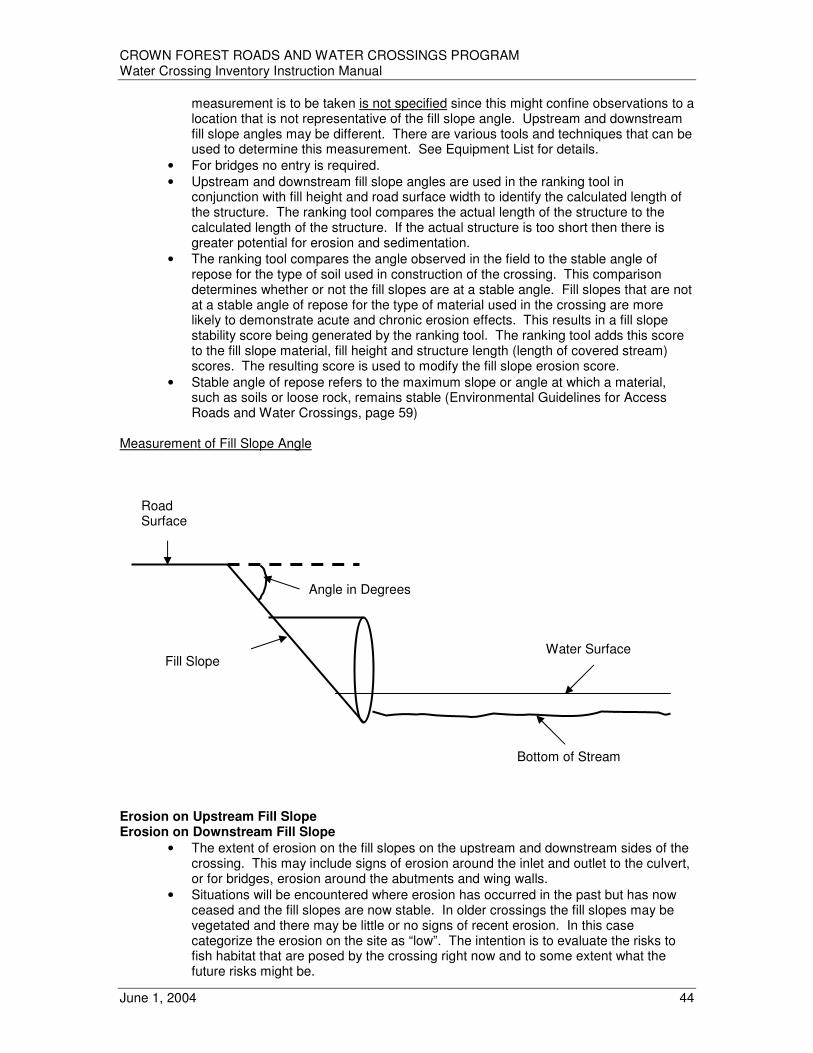
CROWN FOREST ROADS AND WATER CROSSINGS PROGRAM Water Crossing Inventory Instruction Manual
June 1, 2004 44
measurement is to be taken is not specified since this might confine observations to a location that is not representative of the fill slope angle. Upstream and downstream fill slope angles may be different. There are various tools and techniques that can be used to determine this measurement. See Equipment List for details.
• For bridges no entry is required.
• Upstream and downstream fill slope angles are used in the ranking tool in conjunction with fill height and road surface width to identify the calculated length of the structure. The ranking tool compares the actual length of the structure to the calculated length of the structure. If the actual structure is too short then there is greater potential for erosion and sedimentation.
• The ranking tool compares the angle observed in the field to the stable angle of repose for the type of soil used in construction of the crossing. This comparison determines whether or not the fill slopes are at a stable angle. Fill slopes that are not at a stable angle of repose for the type of material used in the crossing are more likely to demonstrate acute and chronic erosion effects. This results in a fill slope stability score being generated by the ranking tool. The ranking tool adds this score to the fill slope material, fill height and structure length (length of covered stream) scores. The resulting score is used to modify the fill slope erosion score.
• Stable angle of repose refers to the maximum slope or angle at which a material, such as soils or loose rock, remains stable (Environmental Guidelines for Access Roads and Water Crossings, page 59)
Measurement of Fill Slope Angle
Erosion on Upstream Fill Slope Erosion on Downstream Fill Slope
• The extent of erosion on the fill slopes on the upstream and downstream sides of the crossing. This may include signs of erosion around the inlet and outlet to the culvert, or for bridges, erosion around the abutments and wing walls.
• Situations will be encountered where erosion has occurred in the past but has now ceased and the fill slopes are now stable. In older crossings the fill slopes may be vegetated and there may be little or no signs of recent erosion. In this case categorize the erosion on the site as “low”. The intention is to evaluate the risks to fish habitat that are posed by the crossing right now and to some extent what the future risks might be.
Water Surface
Bottom of Stream
Angle in Degrees
Fill Slope
Road Surface

CROWN FOREST ROADS AND WATER CROSSINGS PROGRAM Water Crossing Inventory Instruction Manual
June 1, 2004 45
• For bridges no entry is required.
• The ranking tool uses the observations from the field to generate a fill slope erosion severity score.
• Categorize fill slope erosion into one of four categories and record appropriate CODE:
Severe (SEV)
− Erosion in the form of deep, wide gullies on the fill slopes.
− May be an extensive network of deep gullies or there may be one or two deep gullies. The loss of material is quite evident from the fill slopes and/or roadbed.
− Deep gullies are greater than 10 centimeters in depth.
− Fill slopes may also be deeply cut around the inlets and outlets in those cases where the culvert is too short or there is blockage of the culvert.
− Fill slopes may also be deeply cut around the abutments and wing walls at bridges.
− Fill slopes may show signs of slumping, which may be quite extensive in some cases, as a result of undercutting by water.
− Extensive deposits of eroded material may be apparent at the base of the fill slopes or immediately downstream. Point bars are often quite apparent downstream of the crossing.
− In severe cases eroded material may actual block or partially block the culvert.
− Culvert may appear perched, even if installed properly, due to scouring around the inlet and/or outlet.
Moderate (MOD)
− Some erosion in the form of rills and gullies is apparent on the fill slopes. The loss of material from the fill slopes and/or roadbed is still apparent but is less pronounced than in the case of severe erosion.
− Rills or gullies are not deeply cut (5cm to10cm in depth)
− Rills or gullies may still be well defined.
− Fill slopes may show some signs of undercutting around the inlets and outlets of culverts.
− Fill slopes may show some signs of erosion around abutments and wing walls at bridges.
− Some signs of slumping may be apparent due to undercutting by water.
− Some eroded material may be apparent at the base of the fill slopes or immediately downstream. Point bars may still be apparent downstream of the crossing.
− In some cases eroded material may be deposited in the culvert but the culvert is not substantially blocked by it.
− Culvert may begin to show perching where water is undercutting the fill slopes.
Low (LOW)
− Some erosion may be apparent on the fill slopes, but tends to be shallow and less well defined. There does not appear to be a great loss of material from the fill slopes.
− Rills are less than 5cm deep.
− Slopes appear stable and there appears to be little movement of material into the water. Eroded material is minimal at the base of the fill slopes and is not readily apparent downstream of the crossing. Small point bars may or may not be apparent downstream of the crossing.
− There is little or no cutting of the fill slopes around the inlets and outlets of culverts or around the abutments and wing walls of bridges.

CROWN FOREST ROADS AND WATER CROSSINGS PROGRAM Water Crossing Inventory Instruction Manual
June 1, 2004 46
None (NON)
− Virtually no erosion on the fill slopes. Those that are present are very indistinct and shallow. Loss of material from the fill slopes is very slight or non- existent.
− Slopes appear stable and there appears to be little or no movement of material into the water. Eroded material is very minimal or not present at the base of the fill slopes and is not apparent downstream of the crossing. Point bars are not seen downstream.
− There is no cutting of the fill slopes around the inlets and outlets of culverts or around the abutments and wing walls of bridges.
Fill Slope Material
• The type of road building materials utilized on the fill slopes on both sides of the road.
• Different materials offer varying degrees of erosion protection or conversely are more prone to erosion (see table below). The ranking tool uses the observations from the field to generate a fill slope soil erodability score. The ranking tool adds this score to the fill slope stability, fill height and structure length (length of covered stream) scores. The resulting score is used to modify the fill slope erosion score.
• For bridges no entry is required.
• Materials used on the surface of fill slopes may be different than the materials used as the main base fill for the roadbed
• Where fill slopes are effectively stabilized and no significant erosion is encountered, the type of material used on the fill slopes is easily determined.
• Where fill slopes are completely vegetated and fill slope material is not easily recognizable it may be necessary to assume fill slope material is the same as the material observed on road shoulders and/or approaches.
• Where fill slope material has eroded significantly or slumped and base fill (e.g. clay) is exposed and also eroding, it is more appropriate to select the category of material used in the base fill (e.g. clay). This selection is made because the base fill material will likely be more prone to continued erosion, water transport and/or has greater potential to cause negative downstream effects.
• Categorize the material that comprises the fill slopes into one of four categories and record appropriate CODE:
- Silt / Clay (SCL) - Sand (SND) - Pit Run Gravel (GRV) - Rock / Cobble (ROC)
Fill Type Description Erosion Considerations
Clay / Silt - very fine textured soils - particle size smaller than 75um (No. 200
sieve) - likely on-site material
- easily eroded and suspended in fast and slow flowing water
- can be transported downstream long distances
Sand - obvious graininess with particle size ranging from 4.75mm (No.4 ) to 75um (No. 200)
- likely on-site material
- easily eroded - limited suspension in water but subject
to downstream transport in rapidly flowing water
Pit Run Gravel (Till)
- variable combination of soil-gravel-cobble ranging from 75mm (75mm to 4.75 mm (No. 4 Sieve)
- typically imported fill material
- components subject to varying degree of erosion and water suspension/ transport depending on particle size
Rock / Cobble - large cobble, blast rock, rip-rap (larger than 75mm)
- typically imported fill material
- used to stabilize fill slopes because of erosion resistance
- dislodged material remains at site

CROWN FOREST ROADS AND WATER CROSSINGS PROGRAM Water Crossing Inventory Instruction Manual
June 1, 2004 47
Upstream Fill Height Downstream Fill Height
• Fill slopes that are very high have greater potential for erosion because they have a greater surface area for water to act on. There is also potential for greater importation and deposition of material because a greater quantity of material could be eroded. The ranking tool uses the observations from the field to generate a fill height score. The ranking tool adds this score to the fill slope stability, fill slope material and structure length (length of covered stream) scores. The resulting score is used to modify the fill slope erosion score.
• For bridges no entry is required.
• Fill heights are also used with road width to determine if a culvert is the appropriate length.
• Measured to the nearest centimeter. May be rounded to the nearest 10 centimeters. A survey rod works well for this purpose.
• Measurements are taken from the bottom of the streambed to the top of the road surface whether the culvert is situated below, on or above the streambed.
• This is a vertical measurement. Do not measure along the angle of the fill slope.
• If the culvert or other structure is too short and the fill extends to the end of the structure and beyond, it may not be possible to stand on the end of the structure to take the measurement. In this case, stand on the fill slope at the point where the fill material meets the water and reach out as far as possible with the survey rod to take the measurement. Be careful not to lose footing.
Measurement of Fill Height for Culvert at or Below Grade
Water Surface
Measure fill height from the bottom of the streambed to the top of the road surface. This is a vertical measurement. Do not measure along the fill slope face.
Bottom of Stream
Road Surface
Fill Slope
Survey Rod
Fill Height

CROWN FOREST ROADS AND WATER CROSSINGS PROGRAM Water Crossing Inventory Instruction Manual
June 1, 2004 48
Measurement of Fill Height for a Culvert That is Perched
Upstream Fill Slopes Unstable Downstream Fill Slopes Unstable
• A subjective assessment of stability on upstream and downstream fill slopes after visually examining the method and extent of stabilization efforts.
• For bridges no entry is required.
• A fill slope that is unstable will be unable to develop a satisfactory vegetative cover until it has eroded back to a stable angle of repose. This erosion may result in a narrower roadbed, culvert blockage or negative impacts on fish habitat.
• Generally, fill slopes should be no steeper than two horizontal to one vertical (2:1). However, some fill materials can be stabilized very effectively at a steeper angle. Vegetation and rip rap are examples of slope stabilization methods.
• Stable angle of repose refers to the maximum slope or angle at which a material such as soil or loose rock remains stable (Environmental Guidelines for Access Roads and Water Crossings, Page 59)
• By measuring the actual road width, fill height and slope angle, a comparison can be made between the installed culvert length and the calculated length of the culvert required. The ranking tool compares the actual length of the structure (length of covered stream) to the calculated length of the structure. If the actual structure is too short the application looks to see if the fill slopes are stable. Even if the actual structure is too short the fill slopes could be stable thus the potential for erosion and sedimentation is reduced. Thus the structure length score could be reduced as the result of stabilization efforts.
• If, in the opinion of the field inspector, the fill slope is unstable (record separately for upstream and downstream fill slopes), record “T” (true). “F” (false) is the default attribute.
Water Surface
Measure fill height from the bottom of the streambed to the top of the road surface. This is a vertical measurement. Do not measure along the fill slope face.
Bottom of Stream
Road Surface
Fill Slope
Survey Rod
Fill Height

CROWN FOREST ROADS AND WATER CROSSINGS PROGRAM Water Crossing Inventory Instruction Manual
June 1, 2004 49
Erosion on Road Approaches
• The extent of erosion on both sides of both approaches. Approaches include the roadbed, cleared right-of-way and any ditches that drain directly into a waterway on both the upstream and downstream sides.
• For bridges erosion on the abutments is considered part of the erosion on road approaches.
• Situations will be encountered where erosion has occurred in the past but has now ceased and the approaches are now stable. In older crossings the approaches may be vegetated and there may be little or no signs of recent erosion. In this case categorize the erosion on the site as “low”. The intention is to evaluate the risks to fish habitat that are posed by the crossing right now and to some extent what the future risks might be. The ranking tool uses the observations from the field to generate a road approach erosion severity score.
• Include a comment in “Field Comments” if constructed ditches are present which direct runoff directly into the watercourse. Offshoot ditches that direct runoff into the bush or vegetated areas (such that eroded material does not find its way into the watercourse) do not require a comment.
• Based on observations of the extent of erosion on both sides of both approaches, categorize the average condition into one of four categories and record appropriate CODE:
Severe (SEV)
− Erosion in the form of deep, wide gullies on the approach slopes.
− May be an extensive network of deep gullies or there may be one or two deep gullies. The movement of material is quite evident from the approaches.
− Deep gullies are greater than 10 centimeters in depth.
− Approach slopes may show signs of slumping, which may be quite extensive in some cases, as a result of undercutting or saturation by water.
− Extensive deposits of eroded material may be apparent at the base of the approach slopes or immediately downstream. Point bars are often quite apparent downstream of the crossing.
Moderate (MOD)
− Some erosion in the form of rills and gullies is apparent on the approaches. The loss of material from the approaches and/or roadbed is still apparent but is less pronounced than in the case of severe erosion.
− Rills or gullies are not deeply cut (5cm to 10cm in depth)
− Rills or gullies may still be well defined.
− Some signs of slumping may be apparent on approach slopes due to undercutting or saturation by water.
− Some eroded material may be apparent at the base of the approach slopes or immediately downstream. Point bars may still be apparent downstream of the crossing.
Low (LOW)
− Some erosion may be apparent on the approach slopes, but tends to be shallow and less well defined. There does not appear to be a great loss of material from the approaches.
− Rills are less than 5cm deep.
− Slopes appear stable and there appears to be little movement of material into the water. Eroded material is minimal at the base of the approach slopes and is not readily apparent downstream of the crossing. Small point bars may or may not be apparent downstream of the crossing.

CROWN FOREST ROADS AND WATER CROSSINGS PROGRAM Water Crossing Inventory Instruction Manual
June 1, 2004 50
None (NON)
− Virtually no erosion on the approach slopes. Those that are present are very indistinct and shallow. Loss of material from the approach slopes is very slight or non-existent.
− Slopes appear stable and there appears to be little or no movement of material into the water. Eroded material is very minimal or not present at the base of the approach slopes and is not apparent downstream of the crossing. Point bars are not seen downstream.
Road Approach Material
• The type of road building materials present on all four approach slopes combined.
• Different materials offer varying degrees of erosion protection or conversely are more prone to erosion (see table below). The ranking tool uses the observations from the field to generate a road approach erodability score. The resulting score is used to modify the road approach erosion score.
• Materials present on road approaches may be different than the materials used as the main base fill for the roadbed
• Where approaches are effectively stabilized and no significant erosion is encountered, the type of material present on the approaches is easily determined.
• Where approaches are completely vegetated and material is not easily recognizable it may be necessary to assume approach materials are the same as adjacent on-site soils.
• Where a mixture of soils is encountered, record the most predominant.
• Categorize the material that comprises the approach slopes into one of four categories and record appropriate CODE:
- Silt / Clay (SCL) - Sand (SND) - Pit Run Gravel (GRV) - Rock / Cobble (ROC)
Fill Type Description Erosion Considerations
Clay / Silt - very fine textured soils - particle size smaller than 75um (No. 200
sieve) - likely on-site material
- easily eroded and suspended in fast and slow flowing water
- can be transported downstream long distances
Sand - obvious graininess with particle size ranging from 4.75mm (No.4 ) to 75um (No. 200)
- likely on-site material
- easily eroded - limited suspension in water but subject
to downstream transport in rapidly flowing water
Pit Run Gravel (Till)
- variable combination of soil-gravel-cobble ranging from 75mm (75mm to 4.75 mm (No. 4 Sieve)
- typically imported fill material
- components subject to varying degree of erosion and water suspension/ transport depending on particle size
Rock / Cobble - large cobble, blast rock, rip-rap (larger than 75mm)
- typically imported fill material
- used to stabilize fill slopes because of erosion resistance
- dislodged material remains at site
Number of Structure Records
• Related to the number of ‘Individual Structure’ records for a crossing.
• One or more for “Crossing Type: Intact Structure” and “Crossing Type: Failed Structure”
• Usually zero for all other “Crossing Types”
Number of Digital Photos
• Record how many digital photos were taken at each crossing

CROWN FOREST ROADS AND WATER CROSSINGS PROGRAM Water Crossing Inventory Instruction Manual
June 1, 2004 51
Part C – INDIVIDUAL STRUCTURES Attributes - Field Structure Type
• General description of type of structure.
• If more than one structure, record attribute for every one
• Record one of the following 15 structure types with the appropriate CODE for each structure:
Round Culvert – corrugated steel (RST) Round Culvert – other steel (ROS) Round Culvert – plastic (RPL) Round Culvert – concrete (RCO) Arch Culvert – steel (AST) Arch Culvert – concrete (ACO) Box Culvert – wood (BWO) Box Culvert – concrete (BCO) Bridge – steel stringer (BSS) Bridge – log stringer (BLS) Bridge – timber stringer (BTS) Bailey Bridge (BBY) Portable Bridge (BPO) Other Structure (OTH)
Bottom Type
• Provides additional information on the construction characteristics of the water crossing structure. This information is useful for determining the impact the structure may have on the passage of water, sediment, woody material and fish. A biologist reviewing the results of a filed inspection would use this information to assist in the determination of impacts on fish passage or if harmful alteration, disruption or destruction of fish habitat has or is occurring.
• Refers to the bottom of the water crossing structure and not the bottom substrate in the watercourse found upstream or downstream of the crossing. In the case of structures which have preserved the natural substrate they refer to the area influenced by the structure.
• Record the one of the following three bottom types for each structure at the water crossing with the appropriate CODE:
Natural (NAT)
− Refers to those structures that do not have artificial (man made) bottoms and have largely preserved the natural substrate (e.g. bridges, arch culverts). The natural channel width may or may not have been altered.
Artificial (ART)
− Refers to those structures that have artificial or man made bottoms. Artificial bottoms can include corrugated steel, steel, concrete, plastic or wood. In the case of some large structures that are installed properly (i.e. below grade) and have not increased water velocity natural substrate may now be apparent in the structure. Indicate that this is a structure with an artificial bottom but indicate in “Field Comments” that natural substrate is now present.
Unknown (UNK)
− Refers to those situations where various conditions at the site (depth of water, high flows, darkly stained water etc.) make it difficult or impossible to determine the type of bottom in the structure.

CROWN FOREST ROADS AND WATER CROSSINGS PROGRAM Water Crossing Inventory Instruction Manual
June 1, 2004 52
Number of Spans
• Record for bridges only
• The number of clear width of water openings as in the horizontal distance between supports of a bridge
Primary Structure – Inside Top to Inside High Water
• A Primary structure would be the structure at a multiple structure crossing that poses the least resistance to fish access and/or fish passage under extreme water levels. In the case where there is more than one culvert, the primary culvert would be the culvert that would typically be the largest size and positioned the lowest in the slope bank.
• The ranking tool uses this measurement subtracted from the height of the opening to estimate the height of water in the spring. The ranking tool uses the estimated height of water in the spring to calculate a score which reflects the ability of the structure to allow the passage of spring spawning fish.
• Measured for Primary Structure only, in centimeters
• A – B (See diagrams below). The measurement is taken from the inside top of the structure to the high water mark as defined by the rust mark. If the structure is overtopped by water, record the measurement of A – B as 0. This means that the ranking tool will identify that the structure is completely full in the spring; therefore water depth will be considered sufficient for passage of fish. However, this decision may contribute to a high score for water velocity in the structure. If a rust mark is not apparent (e.g. new steel culvert, plastic culvert) but there are obvious on-site indicators that the assumption that A – B equals 0 is inappropriate, the assessor may enter an estimated value for A – B and must record the rational in the Structure Condition Comment field.
Primary Structure – Inside Top to Inside Water Surface
• The ranking tool uses this measurement subtracted from the height of the opening to estimate the height of water in the fall. The ranking tool uses the estimated height of water in the fall to calculate a score which reflects the ability of the structure to allow the passage of fall spawning fish. If the structure is overtopped by water record the measurement of A – C as 0. This means that the ranking tool will identify that the structure is completely full in the fall.
• Measured for Primary Structure only, in centimeters
• A – C (See Diagrams below) Primary Structure – Inside Top to Outlet Pool Bottom
• The ranking tool uses the height of opening measurement subtracted from this measurement to determine if the structure is properly embedded in the watercourse or if it is perched. The ranking tool uses the resulting information to generate a score that reflects the ability of fish to access and pass through the structure.
• Measured for Primary Structure only, in centimeters
• A – F (See Diagrams below) Primary Structure – Outlet Pool Water Surface to Outlet Pool High Water Mark
• The ranking tool uses this measurement added to the depth of water in the pool to provide an estimate of the height of water in the pool in the spring. The ranking tool uses the estimated height of water in the spring to calculate a score which reflects the ability of spring spawning fish to gain access to the structure.
• Measured for Primary Structure only, in centimeters
• E – G (See Diagrams below)

CROWN FOREST ROADS AND WATER CROSSINGS PROGRAM Water Crossing Inventory Instruction Manual
June 1, 2004 53
Height of Opening
• The ranking tool compares this measurement to the height of opening that is generated by the engineering application used to estimate the opening size of culverts. The ranking tool subsequently generates a score based on this comparison. The ranking tool also uses this measurement in combination with other measurements to generate a variety of values which relate to the ability of fish to access and pass through a structure.
• Measured in centimeters
• A – D (See Diagrams below) Height Above Outlet Pool
• The ranking tool uses this measurement subtracted from the measurement of the inside top of the structure to the outlet pool bottom to estimate the height of water in the fall. The ranking tool uses the estimated height of water in the fall to calculate a score which reflects the ability of fall spawning fish to gain access to the structure.
• Measured in centimeters
• A – E (See Diagrams below) Width of Opening
• The ranking tool uses this measurement for arch and box culverts and bridges. The ranking tool compares this measurement to the height of opening that is generated by the engineering application used to estimate the opening size of culverts or bridges. The ranking tool subsequently generates a score based on this comparison.
• Measured in centimeters
• Culvert width or bridge clear span or total clear span of multi-span bridge
• W – X (See Diagrams below) Length of Covered Stream
• The ranking tool compares the actual length of the structure (length of covered stream) to the calculated length of the structure from the engineering application and generates a score that reflects the ability of fish to pass through the structure.
• Measured in centimeters
• Culvert length, width of bridge deck
• H – I (See Diagrams below) Structure Condition
• The condition of the structure affects its ability to pass water, fish, sediment and woody material. Of particular concern is the influence of structure condition on the volume of water that can travel through a culvert as well as the water velocity within it. The inability to move adequate volumes of water can lead to the softening of roadbeds or to the creation of washouts. The ability of fish to pass upstream through the crossing is determined by the sustained swimming speed over distance for each individual species and the encountered water velocity within the pipe. The ranking tool uses this observation to generate a score that when used with other scores reflects the ability of fish to access a structure.
• The structural integrity of culverts can be jeopardized by perforation due to abrasion and/or rust. Water escaping the structures through these holes can undermine the pipe resulting in roadbed collapse and siltation of the streambed. In addition, culverts can be crushed or punctured from the top. Heavy vehicles (traveling over culverts that have inadequate fill protection on them) can push rocks through the culvert. Roadbed material can then seep through the hole into the culvert.
• The performance of the culvert can be affected by mechanical damage. The exposed ends of culverts can become damaged when they are snagged by a road grader

CROWN FOREST ROADS AND WATER CROSSINGS PROGRAM Water Crossing Inventory Instruction Manual
June 1, 2004 54
blade or because of beaver removal activities (explosives, backhoe etc.). There are occasions when the collar that holds two sections of a culvert together fails. Water can then escape the confines of the pipe and erode the fill material around the pipe. This can lead to the collapse of the road surface and siltation downstream. A similar situation called “piping” can also lead to siltation and roadbed collapse. Piping occurs when water passes on the outside of the culvert due to inadequate compaction or the use of poor fill material during installation.
• If the structure (including culverts) has a span or opening width greater than three meters, its condition can only be assessed by individuals trained to do bridge inspections. For liability reasons, do not attempt to rank the structure condition. Record as ‘Not Assessed’. Comments may be placed in the “Structure Condition Comment” field.
• Record an overall structure condition rank with the appropriate CODE:
Not Assessed (NAS) Intact (INT) Slightly Damaged (SDA) Moderately Damaged (MDA) Extremely Damaged EDA)
Structure Condition Comment
• Comments specifically relating to the assessment of “Structure Condition”
• Recommended if “Structure Condition” is not recorded as ‘Intact’.
• May include comments about the obvious condition of large (> 3 meters) structures
• Observations can be used in the ranking tool to help determine the type of remedial action that may be necessary at a crossing.
Culvert Collar Separation
• Culverts only
• See “Structure Condition” description
• Record “T” for true if separation exists, “F” for false (default).
• Observations can be used in the ranking tool to help determine the type of remedial action that may be necessary at a crossing.
Deformed Culvert
• Culverts only
• Includes crushed, bent, and collapsed culverts
• See “Structure Condition” description
• Record “T” for true if culvert is deformed, “F” for false (default).
• Observations can be used in the ranking tool to help determine the type of remedial action that may be necessary at a crossing.
Damaged Culvert Ends
• Culverts only
• See “Structure Condition” description
• Record “T” for true if culvert ends are damaged, “F” for false (default).
• Observations can be used in the ranking tool to help determine the type of remedial action that may be necessary at a crossing.

CROWN FOREST ROADS AND WATER CROSSINGS PROGRAM Water Crossing Inventory Instruction Manual
June 1, 2004 55
Culvert Rust Perforations
• Culverts only
• See “Structure Condition” description
• Record “T” for true if rust perforations exist, “F” for false (default).
• Observations can be used in the ranking tool to help determine the type of remedial action that may be necessary at a crossing.
Subsidence of Road Surface
• Any structure
• See “Structure Condition” description
• Record “T” for true if road surface is subsiding, “F” for false (default).
• Observations can be used in the ranking tool to help determine the type of remedial action that may be necessary at a crossing.
Structure Blockage
• Although a water crossing structure has been properly designed and constructed, water may not be passing through due to accumulation of debris, products of erosion, or beaver activity (active dam building in or adjacent to the crossing, debris from a collapsed dam).
• The ranking tool uses the observations from the field to generate a blockage score. This score is then used in the determination of a score that reflects the ability of fish to access the structure.
• Record one of the following assessments with the appropriate CODE: Substantial (SUB) – 50% or more blockage Partial (PAR) – more than 10% and less than 50% blockage Clear (CLR) – 10% or less blockage
External Blockage
• Blockage is external to structure.
• A crossing could be blocked due to the collapse of an upstream corduroy bridge, beaver dam activity or simply the accumulation of drifting debris
• Record “T” for true if structure blockage is external, “F” for false (default).
• Observations can be used in the ranking tool to help determine the type of remedial action that may be necessary at a crossing.
Internal Blockage
• Blockage is internal to structure.
• Record “T” for true if structure blockage is internal, “F” for false (default).
• Observations can be used in the ranking tool to help determine the type of remedial action that may be necessary at a crossing.
Structure Blockage Comment
• Comments specifically relating to “Structure Blockage”, “External Blockage” and “Internal Blockage” fields.
• Recommended where “Structure Blockage” is not “Clear:”
• Observations can be used in the ranking tool to help determine the type of remedial action that may be necessary at a crossing.

CROWN FOREST ROADS AND WATER CROSSINGS PROGRAM Water Crossing Inventory Instruction Manual
June 1, 2004 56
Beaver Activity Blockage
• Is structure blockage caused by beaver activity?
• Record “T” (true) if the answer is yes. “F” (false) is the default attribute.
• Observations can be used in the ranking tool to help determine the type of remedial action that may be necessary at a crossing.
Woody Debris Blockage
• Is structure blockage caused by accumulation of drifting woody debris?
• Record “T” (true) if the answer is yes. “F” (false) is the default attribute.
• Observations can be used in the ranking tool to help determine the type of remedial action that may be necessary at a crossing.
Sediment Blockage
• Is structure blockage caused by soil, sediment, or eroded fill?
• Record “T” (true) if the answer is yes. “F” (false) is the default attribute.
• Observations can be used in the ranking tool to help determine the type of remedial action that may be necessary at a crossing.
Structural Damage Blockage
• Is structure blockage caused by structural damage?
• Record “T” (true) if the answer is yes. “F” (false) is the default attribute.
• Observations can be used in the ranking tool to help determine the type of remedial action that may be necessary at a crossing.

CROWN FOREST ROADS AND WATER CROSSINGS PROGRAM Water Crossing Inventory Instruction Manual
June 1, 2004 57
DIAGRAMS RELATED TO INDIVIDUAL STRUCTURE MEASUREMENTS Measurements Related to Culvert Length
H I J K N L O M
HI = Length of Covered Stream JK = Road Surface Width LM = Fill Height (H1) on downstream side of the road surface NO = Fill Height (H2) on upstream side of the road surface Measurements Required at a Round Corrugated Steel, Steel, Wood, Plastic, Concrete Culverts
Properly Placed Culvert
A A A A A B G C E D F
AB, AC, AD, AE, AF, EG are measurements that are taken in the field
Length of Covered Stream
Road Surface Width
Fill Height H1
(downstream)
Fill Height H2
(upstream)
Culvert
Rust Line
Water Level
Water Surface
Bottom of stream
High Water Mark on Bank

CROWN FOREST ROADS AND WATER CROSSINGS PROGRAM Water Crossing Inventory Instruction Manual
June 1, 2004 58
Perched Culvert
A A A A A B C D G E F E
AB, AC, AD, AE, AF, EG are all measurements that are taken in the field All measurements are taken from the top of the culvert. This method of taking measurements is different than that used by engineers. This method is being used because it provides an easily understandable reference point (i.e. top of the culvert) to take measurements from. The only measurement not taken from the top of the culvert is the measurement of the high water mark (measured E to G). In this case the high water mark is measured from the water surface. In some cases the high water mark may not be as apparent or easily measured right at the culvert outlet. Thus the measurement of E to G and should be taken at the closest location where a high water mark can be recognized. AD = Height of Opening (diameter of culvert, determined by direct measurement) AD – AB = Depth of water in culvert in spring (CC) AD – AC = Depth of water in culvert at time of measurement (CC) AF – AD = Distance from bottom of culvert to bottom of stream
(culvert outlet drop) (CC) AF – AE + EG = Depth of water in stream in spring (CC) AF – AE = Depth of water in stream at time of measurement (CC) CC indicates value will be calculated by the Water Crossing Ranking Tool
Rust Line
Water Level
Water Surface
Bottom of stream
High Water Mark on Bank

CROWN FOREST ROADS AND WATER CROSSINGS PROGRAM Water Crossing Inventory Instruction Manual
June 1, 2004 59
Measuring Damaged Culverts If the culvert end is damaged or deformed, treat the culvert as a box culvert (measure height and width). Measure an imaginary box, which best represents the area of the culvert opening. Allow for openings outside the box to fill in for the voids inside the box to get an average opening.

CROWN FOREST ROADS AND WATER CROSSINGS PROGRAM Water Crossing Inventory Instruction Manual
June 1, 2004 60
Measurements Required at a Wood or Concrete Box Culverts
A A A A A
B C D G E F E The inside width of the box culvert is also required in order to be able to determine the opening area so that the flow of water that can pass through the culvert can be calculated.
W X A
D AB, AC, AD, AE, AF, EG, WX are all measurements that are taken in the field All measurements, with the exception of width (WX) are taken from the inner surface of the culvert at the top of the culvert AD = Height of opening (determined by direct measurement) AD – AB = Depth of water in culvert in spring (CC) AD – AC = Depth of water in culvert at time of measurement (CC) AF – AD = Distance from bottom of culvert to bottom of stream
(culvert outlet drop) (CC) AF – AE + EG = Depth of water in stream in spring (CC) AF – AE = Depth of water in stream at time of measurement (CC) WX = Width of opening
High Water Stain
Water Level
Water Surface
Bottom of stream
High Water Mark on Bank
Inner Surface of Culvert
Width of Opening
Height of Opening

CROWN FOREST ROADS AND WATER CROSSINGS PROGRAM Water Crossing Inventory Instruction Manual
June 1, 2004 61
Measurements Required at Arch Culverts
A A A A A B C G D
E E F Inside width of the arch culvert is also required in order to be able to determine the volume of water that can pass through the culvert.
A W X D AB, AC, AD, AE, AF, EG, WX are all measurements that are taken in the field All measurements, with the exception of width (WX) are taken from the top of the culvert. Where an arch culvert is constructed of thick material, such as concrete, the measurements should be taken from the inner surface of the culvert, if this can be accomplished safely. AD = Height of opening (determined by direct measurement, measure from the top of the culvert
to the bottom of the footings) AD – AB = Depth of water in culvert in spring (CC) AD – AC = Depth of water in culvert at time of measurement (CC) AF – AD = Distance from bottom of culvert to bottom of stream (culvert outlet drop) (CC) AF – AE + EG = Depth of water in stream in spring (CC) AF – AE = Depth of water in stream at time of measurement (CC) WX = Width of opening
High Water Stain or Rust Mark
Water Level
Water Surface (E) Bottom of Stream (F)
High Water Mark on Bank
Width of Opening
Height of Opening

CROWN FOREST ROADS AND WATER CROSSINGS PROGRAM Water Crossing Inventory Instruction Manual
June 1, 2004 62
Measurements Required at Bridges Single Span Bridges
W X A A A B E
F AF = Height of bridge (determined by direct measurement) AF – AB = Depth of water in spring (CC) AF – AE = Depth of water at time of measurement (CC) WX = Width of opening (Clear Span) The following measurements are not required for bridges:
o fill height (upstream/downstream) o fill slope angle (upstream/downstream) o fill material o erosion on fill slopes (upstream/downstream) o fill slopes unstable (upstream/downstream)
It is recognized that the distance from the bottom of the bridge to the bottom of the watercourse (AF) may be difficult to measure in those situations where high structures and/or fast flowing water is encountered. In those cases where there is no current and the bridge is less than 4 metres high, the measurement can usually be taken with a survey rod. Where the bridge is greater than 4 metres high and there is little or no current, an old measuring tape with a weight on the end can be used. Where a structure greater than 4 metres in height is encountered and/or the current is fast flowing, a best estimate can be used to populate the AF measurement field. Since bridges do not normally pose a problem for the passage of fish, water, sediment and woody material, this appears to be a reasonable approach. The sites where bridges are utilized often pose significantly higher safety concerns for the survey crew. Survey crews should be aware of the hazards and take appropriate precaution.
High Water Mark
Water Surface
Bottom of stream
Abutment Underside of Bridge (Bottom of Stringers)
Width of Opening (Clear Span)
Span
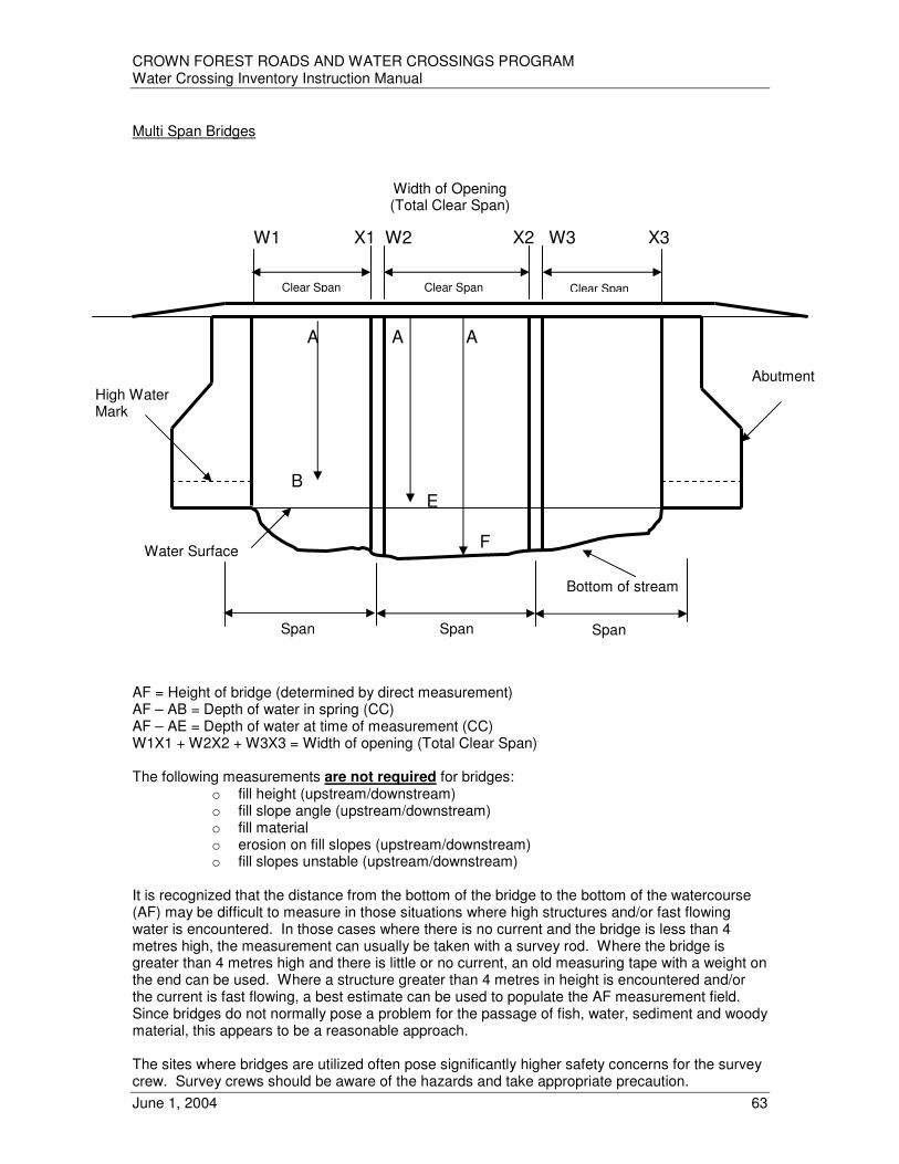
CROWN FOREST ROADS AND WATER CROSSINGS PROGRAM Water Crossing Inventory Instruction Manual
June 1, 2004 63
Multi Span Bridges
W1 X1 W2 X2 W3 X3 B E
F AF = Height of bridge (determined by direct measurement) AF – AB = Depth of water in spring (CC) AF – AE = Depth of water at time of measurement (CC) W1X1 + W2X2 + W3X3 = Width of opening (Total Clear Span) The following measurements are not required for bridges:
o fill height (upstream/downstream) o fill slope angle (upstream/downstream) o fill material o erosion on fill slopes (upstream/downstream) o fill slopes unstable (upstream/downstream)
It is recognized that the distance from the bottom of the bridge to the bottom of the watercourse (AF) may be difficult to measure in those situations where high structures and/or fast flowing water is encountered. In those cases where there is no current and the bridge is less than 4 metres high, the measurement can usually be taken with a survey rod. Where the bridge is greater than 4 metres high and there is little or no current, an old measuring tape with a weight on the end can be used. Where a structure greater than 4 metres in height is encountered and/or the current is fast flowing, a best estimate can be used to populate the AF measurement field. Since bridges do not normally pose a problem for the passage of fish, water, sediment and woody material, this appears to be a reasonable approach. The sites where bridges are utilized often pose significantly higher safety concerns for the survey crew. Survey crews should be aware of the hazards and take appropriate precaution.
A A A
High Water Mark
Water Surface
Bottom of stream
Abutment
Width of Opening (Total Clear Span)
Span Span Span
Clear Span Clear Span Clear Span

CROWN FOREST ROADS AND WATER CROSSINGS PROGRAM Water Crossing Inventory Instruction Manual
June 1, 2004 64
PART D – FISHERIES Attributes
Fisheries Evaluation Date
• Populated during fish habitat/fisheries values evaluation process.
• Date the fisheries evaluation was completed. Name of Fisheries Evaluator
• Populated during fish habitat/fisheries values evaluation process.
• Name of the individual who completed the fisheries evaluation. Fisheries Comments
• Populated during fish habitat/fisheries values evaluation process.
• A comment box has been provided for the biologist to record comments. This comment box helps to document the biologist’s thinking and rationale related to their classification of fisheries values.
• Biologists should record pertinent information such as sources of information, sensitive species that are present, etc. Comments contained in this box will be included in the database.
Fish Habitat Comments
• Populated during fish habitat/fisheries values evaluation process.
• This comment box helps to document the biologist’s thinking and rationale related to their habitat type/abundance classifications. Biologists need to record the species that they considered in their analysis and any other pertinent information such as the source of their information e.g. stream survey, personal observation, etc. They also need to record whether or not there were any barriers on the watercourse and how they were considered in the abundance/significance classifications.
Upstream Spawning Habitat
• Populated during fish habitat/fisheries values evaluation process.
• Acceptable values: Unknown Actual – Abundant Actual – Sufficient Actual – Limited Actual – Rare Potential – Abundant Potential – Sufficient Potential – Limited Potential – Rare
• When spawning habitat upstream of a crossing has actually been identified or confirmed, the significance of this habitat is considered and one selection is made within the “Actual” spawning habitat grouping.
• When spawning habitat upstream of a crossing is suspected but has not actually been identified or confirmed, the significance of this habitat (abundant, sufficient, limited, rare, unknown) is considered and one selection is made within the “Potential” spawning habitat grouping.
• If there is no information on spawning habitat upstream of a crossing, then “Unknown” is selected
CROWN FOREST ROADS AND WATER CROSSINGS PROGRAM Water Crossing Inventory Instruction Manual
June 1, 2004 65
Downstream Spawning Habitat
• Populated during fish habitat/fisheries values evaluation process.
• Acceptable values: Unknown Actual – Abundant Actual – Sufficient Actual – Limited Actual – Rare Potential – Abundant Potential – Sufficient Potential – Limited Potential – Rare
• When spawning habitat downstream of a crossing has actually been identified or confirmed, the significance of this habitat is considered and a selection is made in one of the “Actual” (abundant, sufficient, limited, rare) columns across from “Downstream Spawning”.
• When spawning habitat downstream of a crossing is suspected but has not actually been identified or confirmed, the significance of this habitat is considered and a selection is made in one of the “Potential” (abundant, sufficient, limited, rare) columns across from “Downstream Spawning”.
• If there is no information on spawning habitat downstream of a crossing then “Unknown” is selected.
Upstream Feeding Habitat
• Populated during fish habitat/fisheries values evaluation process.
• Acceptable values: Unknown Actual – Abundant Actual – Sufficient Actual – Limited Actual – Rare Potential – Abundant Potential – Sufficient Potential – Limited Potential – Rare
• When feeding habitat upstream of a crossing has actually been identified or confirmed, the significance of this habitat is considered and a selection is made in one of the “Actual” (abundant, sufficient, limited, rare) columns across from “Upstream Feeding”.
• When feeding habitat upstream of a crossing is suspected but has not actually been identified or confirmed, the significance of this habitat is considered and a selection is made in one of the “Potential” (abundant, sufficient, limited, rare) columns across from “Upstream Feeding”.
• If there is no information on feeding habitat upstream of a crossing then “Unknown” is selected.
Downstream Feeding Habitat
• Populated during fish habitat/fisheries values evaluation process.
• Acceptable values: Unknown Actual – Abundant Actual – Sufficient Actual – Limited Actual – Rare

CROWN FOREST ROADS AND WATER CROSSINGS PROGRAM Water Crossing Inventory Instruction Manual
June 1, 2004 66
Potential – Abundant Potential – Sufficient Potential – Limited Potential – Rare
• When feeding habitat downstream of a crossing has actually been identified or confirmed, the significance of this habitat is considered and a selection is made in one of the “Actual” (abundant, sufficient, limited, rare) columns across from “Downstream Feeding”.
• When feeding habitat downstream of a crossing is suspected but has not actually been identified or confirmed, the significance of this habitat is considered and a selection is made in one of the “Potential” (abundant, sufficient, limited, rare) columns across from “Downstream Feeding”.
• If there is no information on feeding habitat upstream of a crossing then “Unknown” is selected.
Upstream Nursery/Rearing Habitat
• Populated during fish habitat/fisheries values evaluation process.
• Acceptable values: Unknown Actual – Abundant Actual – Sufficient Actual – Limited Actual – Rare Potential – Abundant Potential – Sufficient Potential – Limited Potential – Rare
• When nursery/rearing habitat upstream of a crossing has actually been identified or confirmed, the significance of this habitat is considered and a selection is made in one of the “Actual” (abundant, sufficient, limited, rare) columns across from “Upstream Nursery/Rearing”.
• When nursery/rearing habitat upstream of a crossing is suspected but has not actually been identified or confirmed, the significance of this habitat is considered and a selection is made in one of the “Potential” (abundant, sufficient, limited, rare) columns across from “Upstream Nursery/Rearing”.
• If there is no information on nursery/rearing habitat upstream of a crossing then “Unknown” is selected.
Downstream Nursery/Rearing Habitat
• Populated during fish habitat/fisheries values evaluation process.
• Acceptable values: Unknown Actual – Abundant Actual – Sufficient Actual – Limited Actual – Rare Potential – Abundant Potential – Sufficient Potential – Limited Potential – Rare
• When nursery/rearing habitat downstream of a crossing has actually been identified or confirmed, the significance of this habitat is considered and a selection is made in one of the “Actual” (abundant, sufficient, limited, rare) columns across from “Downstream Nursery/Rearing”.

CROWN FOREST ROADS AND WATER CROSSINGS PROGRAM Water Crossing Inventory Instruction Manual
June 1, 2004 67
• When nursery/rearing habitat downstream of a crossing is suspected but has not actually been identified or confirmed, the significance of this habitat is considered and a selection is made in one of the “Potential” (abundant, sufficient, limited, rare) columns across from “Downstream Nursery/Rearing”.
• If there is no information on nursery/rearing habitat downstream of a crossing then “Unknown” is selected.
Migration Habitat
• Populated during fish habitat/fisheries values evaluation process.
• Acceptable values: Unknown Actual – Marginal Actual – Important Actual – Critical Potential – Marginal Potential – Important Potential – Critical
• When migration habitat has actually been identified, the significance of this habitat is considered and a selection is made in one of the “Actual” (marginal, important, critical) columns across from “Migration”.
• When migration habitat is suspected but has not actually been identified, the significance of this habitat is considered and a selection is made in one of the “Potential” (marginal, important, critical) columns across from “Migration”.
• Critical Migration Habitat: Refers to migration habitat which provides significant access to habitats vital to sustaining fish populations (e.g. access to spawning area, movement of young fish from spawning areas to nursery areas etc.). The rareness of these vital habitats, their high productive capacity and their high importance in sustaining subsistence, commercial or recreation fisheries are considerations for placing migration habitat in this category.
• Important Migration Habitat: Refers to migration habitat which provides access to habitats which are important to fish but are not considered critical to sustaining fish populations (e.g. feeding areas etc.). In this case habitat types being accessed are sufficiently abundant, have moderate productive capacity or are still important in sustaining subsistence, commercial or recreation fisheries.
• Marginal Migration Habitat: Refers to migration habitat which provides access to habitats which are abundant, have low productive capacity or are of limited importance in sustaining subsistence, commercial or recreation fisheries.
• If there is no information on migration habitat then “Unknown” is selected. Fisheries Values
• Populated during fish habitat/fisheries values evaluation process.
• Acceptable values: High Moderate Low Unknown
• The identification of fisheries values attempts to strengthen our understanding of the linkage between the potential or actual effects of a water crossing on fish populations, the fisheries that have developed based on those populations, and on our efforts to manage those fisheries.
• Biologists are asked to look at the fisheries that actually have developed or may develop on the watercourse itself or upstream or downstream of the water crossing.

CROWN FOREST ROADS AND WATER CROSSINGS PROGRAM Water Crossing Inventory Instruction Manual
June 1, 2004 68
• A subjective determination of the value of the fisheries is made by the biologist. This determination needs to take into account the social aspects of the fishery (e.g. level of use by recreational anglers; level of subsistence use by First Nations, fishing quality) and the economic aspects of the fishery (e.g. actual/potential level of tourism development, actual/potential commercial bait and food fisheries, contribution to local and provincial economy).
• Biologists are asked to identify the fisheries values as high, moderate or low. Where there is no information on the fisheries values, “Unknown” would be selected.
Fishery Management Efforts
• Populated during fish habitat/fisheries values evaluation process.
• The management efforts attribute attempts to categorize the level of management effort that is being applied to a particular fishery.
• Management effort does not have to be confined to actions taken by the government and can include actions taken by cottage associations or other partners (e.g. CFIP). In many ways this attribute is attempting to define the level of investment in a particular fishery. The level of management effort applied to a fishery also tends to suggest its status. The status in turn provides some sense of the ability of that fishery to deal with habitat impacts that may result from water crossings. An improper water crossing could have a significant negative impact on the achievement of management objectives.
• Fish population(s) being rehabilitated: The fish populations have been degraded due to over-exploitation and/or habitat alteration or loss. There are clearly sustainability concerns both for the fish populations and fisheries that are based on those populations. As a result, intensive management actions are being taken to rehabilitate the fish populations. In this situation it is assumed that the fish population cannot tolerate much, if any, loss of habitat (e.g. a spawning area).
• Fish population(s) over-exploited/actions taken to reduce harvest: The fish population is under some stress commonly due to over-exploitation. Due to the natural resilience of fish populations, the population has not yet been degraded. However, without management intervention, degradation of the population would occur over time. Management actions are actively being taken to reduce the harvest to a level that the fish populations can sustain.
• Fish population(s) fully allocated/actions taken to ensure harvest is within management objectives:
A fish population whose annual allowable yield has been fully allocated to various fisheries. The fish population is not yet showing signs of stress but it is very close to the limit defined by the management objectives for that fishery (e.g. a trophy fishery) or by the biological capability of that population. In situations where 100% of the annual allowable yield has been allocated, there is much less room for error and management actions are being taken to ensure harvests remain within the appropriate limits.
• Fish population(s) being managed using region wide actions: This attribute attempts to capture those situations where the fish population is not under stress, may not be fully allocated, or the decision has been made to manage the populations using management actions applied on a region wide or division wide basis (e.g. region wide maximum size limits for walleye).
• Where there is no information on management efforts, “Unknown” would be selected.

CROWN FOREST ROADS AND WATER CROSSINGS PROGRAM Water Crossing Inventory Instruction Manual
June 1, 2004 69
Sensitive Fish Species
• Populated during fish habitat/fisheries values evaluation process.
• Acceptable values: Known / Suspected Presence Absent/Unknown
• The presence or absence of sensitive species (e.g. brook trout, aurora trout, lake trout, muskellunge, lake sturgeon, endangered species etc.) attempts to recognize some of the unique ecological values that are associated with a fishery. Sensitive species being referred to here tend to have very specific habitat requirements.
• Sensitive species are assumed to have a lower tolerance for habitat loss or disruption due to the effects of water crossings within a watershed.
• The following web sites may be consulted for updated material on rare, endangered or threatened species:
http://www.cosewic.gc.ca http://www.speciesatrisk.gc.ca/sar/main.htm http://www.ontarioparks.com/sar.html
Channel Type
• The biologist has the opportunity during the Fish Habitat/Fisheries Values process to adjust the selection of channel type that was made during the data prep process. Based on additional information, including information provided by field crews, the biologist may change the initial selection.
Thermal Regime
• The biologist has the opportunity during the Fish Habitat/Fisheries Values process to adjust the selection of thermal that was made during the data prep process. Based on additional information, including information provided by field crews, the biologist may change the initial selection.
• A description of the species that are indicative of warmwater, coolwater and coldwater habitats can be found in Appendix B of Minns et al, 1996.

CROWN FOREST ROADS AND WATER CROSSINGS PROGRAM Water Crossing Inventory Instruction Manual
June 1, 2004 70
PROCEDURES FOR COMPLETING HABITAT/FISHERIES VALUES DATA FORMS
Introduction The fish habitat and fisheries values components are to be completed by a biologist in the office after the initial fieldwork has been completed. During the pilot projects field crews indicated that they were uncomfortable making these determinations particularly those related to fish habitat. Similarly, the biologists indicated their desire to be more involved in the determination of the presence or absence of fish habitat at or near crossings. A two stage process was developed to address these concerns. It is important to note that critical information pertaining to effects on upstream migration and erosion causing downstream sedimentation is provided by Stage 1 (field survey) of the inventory process. This information will influence the initial ranking outcome. Conceptually a crossing affects fish habitat through 2 mechanisms.
Additional detailed fisheries information is added to the database at Stage 2 by inputting the information contained in the “Fish Habitat/Fisheries Value Data Input Form” (Appendix II) which is completed by a biologist. This additional information will result in a potential adjustment of the ranking priority for remedial action. As this is relative information, it is important to understand that the methodology provides an opportunity to raise the relative significance of individual water crossings based on legitimate information. If other less significant water crossings are designated in the same manner (i.e. a very conservative approach is adopted) then the value of the ranking system will be significantly diminished.
Watercourse
Water Crossing Location
Upstream – Effects on Migration A water crossing affects upstream fish habitat, particularly spawning habitat, by influencing the ability of fish to access and pass through the structure. Thus the effects on upstream habitat are really effects on migration.
Downstream – Erosion/ Sedimentation Effects A water crossing affects downstream fish habitat, particularly spawning habitat, directly due to the downstream movement of sediment eroded from the water crossing.
Direction of Flow

CROWN FOREST ROADS AND WATER CROSSINGS PROGRAM Water Crossing Inventory Instruction Manual
June 1, 2004 71
After the initial fieldwork is completed the biologist will be provided with the following information for each water crossing:
• A printout of information that was collected in the field
• The initial ranking of the crossing for remedial action based on the design/condition attributes
• Digital photographs of the crossing site
• A blank “Fish Habitat/Fisheries Values” data input form The biologist can use information from the fieldwork, aerial photographs, topographic maps, lake survey information, local knowledge or any other information that is available regarding fish and fish habitat to complete the fish habitat and fisheries values components of the assessment. This does not preclude the need for a field inspection by the biologist to confirm the presence or absence of certain habitat types.
Habitat Presence/Abundance As a result of the pilot projects it was recognized that the identification of nursery, rearing and food supply areas for a whole range of possible species is difficult. However, there appeared to be a greater comfort level with being able to identify spawning and migration areas provided the species of interest was limited to sportfish. This problem was presented to DFO who concurred that only sportfish would be considered for this exercise. It is important to recognize that if there is knowledge that a certain site is used by other species for example, certain forage fish (e.g. spot-tail shiners, lake herring etc.) then this knowledge should be used in the assessment of the crossing. Note that feeding, nursery and rearing habitat types are still listed as attributes. This was done for two reasons, 1/ the Fisheries Act indicates that these are the habitat types that are important to fish and, 2/ to ensure that there was a place to record information related to these habitat types should they be present at or near a crossing. DFO agreed that nursery and rearing habitats could be combined into one category due to the difficulty in distinguishing between the two types.
Use of the Fish Habitat Attribute Tables The presence and relative abundance of fish habitat at, above or below a crossing site is determined by a biologist. The biologist should look at the watercourse as a whole versus just at the site of the crossing. To make this determination a biologist would use comments provided by field crews in a habitat comment box, information contained in aerial photographs, digital photographs from the site, topographical maps and local knowledge of species and habitat values and any other information that is available regarding fish and fish habitat to complete the fish habitat and fisheries values components of the assessment. In some cases field visits by the biologist may be undertaken to help in completing the fish habitat and fisheries values assessment. The biologist needs to pay particular attention to spawning habitat upstream and downstream of a water crossing because this information will be used to modify the rank related to access and passage through a culvert. It will also be used to rank erosion/sedimentation effects of a crossing downstream. Fish habitat upstream and downstream may be identified as “potential” or “known/confirmed”. For each specific habitat type only one of the tables is used. For example, if a known spawning site and several suspected or potential spawning sites are located upstream of a crossing then only the “Known/Confirmed Habitat – Upstream” table is used. If there is no specific knowledge about the other habitat types either upstream or downstream then “unknown” is indicated.

CROWN FOREST ROADS AND WATER CROSSINGS PROGRAM Water Crossing Inventory Instruction Manual
June 1, 2004 72
The use of “Rare”, “Limited”. “Sufficient” and “Abundant” categories within each table reflect the tolerance for loss of that habitat type in the watercourse. The concept of “tolerance for loss” is described below. In the situation where there are a number of similar habitat types along a watercourse (i.e. they are “abundant”) there is some tolerance for loss. In the situation where there is only one habitat type, for example a single spawning area, there is no tolerance for loss. Again, the intent is to assess the habitat along the watercourse versus just at the crossing site. It is often useful for the biologist to ask “How would the fish react if the crossing failed and prevented access to upstream habitats and/or caused sedimentation downstream? Do they have other habitat options?”. When assessing the level of abundance of a particular habitat type it is necessary to pay attention to physical barriers in the watercourse. For example there may be a known spawning site and several potential sites on a watercourse. However, there is a barrier after the known spawning site that prevents use of the upstream potential sites. In this case the abundance of spawning sites is “rare” for the watercourse. The “limited” and “sufficient” abundance categories should be looked at from the point of view of the fish. If the fish have only one option, should their first choice in habitat become unusable or unavailable, then that habitat type may be considered “limited”. However, if they have multiple options, should their first choice in habitat become unusable or unavailable, then that habitat type may be considered “sufficient”. Migration habitat presents some unique challenges since it cannot be categorized in terms of habitat abundance and thus tolerance for loss in the same way as the other habitat types. Migration habitat is to be categorized as Critical, Important, Marginal or Unknown. With the exception of the “Unknown” category these are the same categories that are used in the DFO habitat compensation policy.
Critical Migration Habitat: Refers to migration habitat which provides significant access to habitats vital to sustaining fish populations (e.g. access to spawning area, movement of young fish from spawning areas to nursery areas etc.). The rareness of these vital habitats, their high productive capacity and their high importance in sustaining subsistence, commercial or recreation fisheries are considerations for placing migration habitat in this category. Important Migration Habitat: Refers to migration habitat which provides access to habitats which are important to fish but are not considered critical to sustaining fish populations (e.g. feeding areas etc.). In this case habitat types being accessed are sufficiently abundant, have moderate productive capacity or are still important in sustaining subsistence, commercial or recreation fisheries. Marginal Migration Habitat: Refers to migration habitat which provides access to habitats which are abundant, have low productive capacity or are of limited importance in sustaining subsistence, commercial or recreation fisheries. Unknown Migration Habitat: If there is no information on migration habitat then “Unknown” is selected.
Since a crossing can influence both upstream (e.g. movement of adult fish to spawning areas) and downstream (e.g. movement of fry from spawning areas to nursery/rearing habitat) migration, a biologist needs to consider migration in terms of the location of the crossing in relation to upstream and downstream habitats.

CROWN FOREST ROADS AND WATER CROSSINGS PROGRAM Water Crossing Inventory Instruction Manual
June 1, 2004 73
Tolerance for Loss – Conceptual Approach
Fish Habitat Comments A comment box will be provided on the “Fish Habitat/Fisheries Values Data Input Form” for the biologist to concisely record comments. This comment box helps to document the biologist’s thinking and rationale related to the habitat type/abundance classifications. Biologists need to record the species that they considered in their analysis and any other pertinent information such as the source of their information e.g. stream survey, personal observation etc. They also need to record whether or not there were any barriers on the watercourse and how they were considered in the abundance/significance classifications. Comments contained in this box will be included in the database … it is important to be concise.
Field Fish Habitat Comments Field crews will also have the opportunity to record comments related to fish habitat in a “Field Fish Habitat Comment” box (Part B). For example they might indicate that they observed fish at a particular crossing or they observed fish spawning. It is also important for field crews to record the type and location of any barriers that are present in the watercourses that are visible from the crossing. Biologists need to review the comments provided by field crews during their analysis of fish habitat in relation to crossings.
Abundant Rare
Habitat Abundance
Some
Tolerance
For Loss
None

CROWN FOREST ROADS AND WATER CROSSINGS PROGRAM Water Crossing Inventory Instruction Manual
June 1, 2004 74
Examples 1/ Potential Spawning Habitat Upstream of a Crossing Potential spawning habitat for walleye is identified upstream from a crossing. No other potential or actual spawning habitat has been identified for the remainder of the watercourse. There are no downstream barriers preventing the use of this potential spawning area.
- Across from “Upstream Spawning” Indicate an “x” under the “Rare Potential” column. - Indicate “Unknown” with an “x” for all other habitat types. - Across from “Migration” indicate an “x” under the “Unknown” column.
Habitat Type Habitat Abundance
Rare Limited Sufficient Abundant
Actual Potential Actual Potential Actual Potential Actual Potential Unknown
Upstream
Spawning X
Feeding X
Nursery/ Rearing
X
Downstream
Spawning X
Feeding X
Nursery/ Rearing
X
* Check one box per habitat type
Habitat Type Habitat Value
Critical Important Marginal
Actual Potential Actual Potential Actual Potential Unknown
Migration X
* Check one box only In the “Fish Habitat Comment Box” indicate that potential walleye spawning habitat was suggested by a member of the public in 2001 but has not yet been confirmed as being used by walleye. It would also be appropriate to indicate that no other spawning habitat has been located on the watercourse and there are no downstream barriers.
Water Crossing Location
Potential Spawning Habitat
Direction of Flow

CROWN FOREST ROADS AND WATER CROSSINGS PROGRAM Water Crossing Inventory Instruction Manual
June 1, 2004 75
2/ Several Potential Feeding Habitats Located Upstream and Downstream of a Crossing Two potential feeding habitats for walleye have been identified upstream and 2 potential feeding habitats have been identified downstream from a crossing. Thus walleye appear to have several options for feeding. There are no barriers that would prevent the use of any of the potential feeding sites. Walleye appear to be able to move through each of the potential sites (i.e. there are no barriers that would prevent passage). Large numbers of young-of-the-year walleye were captured in 1999 at the crossing location by university graduate students.
- Across from “Upstream Feeding” Indicate an “x” under the “Abundant Potential” column.
- Indicate “Unknown” with an “x” for all other habitat types. - Across from “Downstream Feeding” Indicate an “x” under the “Abundant Potential”
column. - Indicate “Unknown” with an “x” for all other habitat types. - Across from “Migration” indicate an “x” under the “Important Actual” column.
Habitat Type Habitat Abundance
Rare Limited Sufficient Abundant
Actual Potential Actual Potential Actual Potential Actual Potential Unknown
Upstream
Spawning X
Feeding X
Nursery/ Rearing
X
Downstream
Spawning X
Feeding X
Nursery/ Rearing
X
* Check one box per habitat type
Habitat Type Habitat Value
Critical Important Marginal
Actual Potential Actual Potential Actual Potential Unknown
Migration X
* Check one box only
Water Crossing Location
Potential Feeding Habitats
Direction of Flow

CROWN FOREST ROADS AND WATER CROSSINGS PROGRAM Water Crossing Inventory Instruction Manual
June 1, 2004 76
In the “Fish Habitat Comment Box” indicate that potential walleye feeding habitat was suggested based on a field survey (2002) but they have not yet been confirmed as being used by walleye. Also indicate the capture of large number of YOY walleye at the crossing location. It would also be appropriate to indicate that there are no downstream barriers.
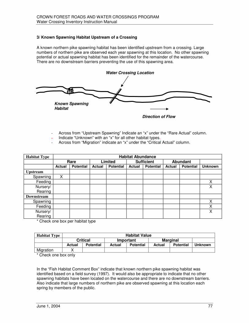
CROWN FOREST ROADS AND WATER CROSSINGS PROGRAM Water Crossing Inventory Instruction Manual
June 1, 2004 77
3/ Known Spawning Habitat Upstream of a Crossing
A known northern pike spawning habitat has been identified upstream from a crossing. Large numbers of northern pike are observed each year spawning at this location. No other spawning potential or actual spawning habitat has been identified for the remainder of the watercourse. There are no downstream barriers preventing the use of this spawning area.
- Across from “Upstream Spawning” Indicate an “x” under the “Rare Actual” column. - Indicate “Unknown” with an “x” for all other habitat types. - Across from “Migration” indicate an “x” under the “Critical Actual” column.
Habitat Type Habitat Abundance
Rare Limited Sufficient Abundant
Actual Potential Actual Potential Actual Potential Actual Potential Unknown
Upstream
Spawning X
Feeding X
Nursery/ Rearing
X
Downstream
Spawning X
Feeding X
Nursery/ Rearing
X
* Check one box per habitat type
Habitat Type Habitat Value
Critical Important Marginal
Actual Potential Actual Potential Actual Potential Unknown
Migration X
* Check one box only In the “Fish Habitat Comment Box” indicate that known northern pike spawning habitat was identified based on a field survey (1997). It would also be appropriate to indicate that no other spawning habitats have been located on the watercourse and there are no downstream barriers. Also indicate that large numbers of northern pike are observed spawning at this location each spring by members of the public.
Water Crossing Location
Known Spawning Habitat
Direction of Flow

CROWN FOREST ROADS AND WATER CROSSINGS PROGRAM Water Crossing Inventory Instruction Manual
June 1, 2004 78
4/ Several Known Spawning Habitats Located Upstream and Several Known Nursery Areas Downstream of a Crossing Two known spawning habitats for northern pike have been identified upstream from a crossing. Observations at the known spawning sites suggest that usage of the sites by pike vary from year to year. Habitat conditions appear to be favorable for pike spawning each year. Some distance downstream, close to a lake, are two other spawning areas. Three known nursery habitats have also been identified downstream from the same crossing. Thus northern pike appear to have several options for spawning and nursery areas. There are no downstream barriers that would prevent the use of any of the sites.
- Across from “Upstream Spawning” Indicate an “x” under the “Sufficient Actual” column.
- Indicate “Unknown” with an “x” for all other habitat types. - Across from “Downstream Spawning” Indicate an “x” under the “Abundant Actual”
column. - Across from “Downstream Nursery/Rearing” Indicate an “x” under the “Abundant
Actual” column. - Indicate “Unknown” with an “x” for all other habitat types. - Across from “Migration” indicate an “x” under the “Important Actual” column.
Habitat Type Habitat Abundance
Rare Limited Sufficient Abundant
Actual Potential Actual Potential Actual Potential Actual Potential Unknown
Upstream
Spawning X
Feeding X
Nursery/ Rearing
X
Downstream
Spawning X
Feeding X
Nursery/ Rearing
X
* Check one box per habitat type
Habitat Type Habitat Value
Critical Important Marginal
Actual Potential Actual Potential Actual Potential Unknown
Migration X
* Check one box only
Water Crossing Location
Known Spawning Habitat Known Nursery
Habitats
Direction of Flow

CROWN FOREST ROADS AND WATER CROSSINGS PROGRAM Water Crossing Inventory Instruction Manual
June 1, 2004 79
In the “Fish Habitat Comment Box” indicate that known northern pike spawning habitat was identified based on a field survey (1994). It would also be appropriate to indicate that two other spawning habitats have been identified further downstream close to a lake and that there are no downstream barriers. The categorization of spawning habitat as “sufficient” may need to be reconsidered if the biologist has reason to believe that the sites are used in those years when the downstream spawning areas are unusable. Migration is considered important because it is known that the pike use the upstream spawning sites and that the young of the year fish move past the crossing to downstream nursery areas. If the upstream spawning areas are used when the site near the lake is unusable then it may be appropriate to indicate that migration is “significant” at the crossing site.

CROWN FOREST ROADS AND WATER CROSSINGS PROGRAM Water Crossing Inventory Instruction Manual
June 1, 2004 80
5/ Several Known and Potential Habitats Located Upstream and Downstream of a Crossing Two known spawning area for brook trout have been identified upstream. A potential spawning habitat and a known nursery area have been identified downstream from a crossing. There are no other spawning areas upstream or downstream. Thus brook trout appear to have a couple of options for spawning upstream of the crossing but these are the only sites on the watercourse. There are no downstream barriers that would prevent the use of any of the spawning sites.
- Across from “Upstream Spawning” Indicate an “x” under the “Limited Actual” column. - Indicate “Unknown” with an “x” for all other habitat types. - Across from “Downstream Spawning” Indicate an “x” under the “Rare Potential”
column. - Across from “Downstream Nursery/Rearing” Indicate an “x” under the “Rare Actual”
column. - Indicate “Unknown” with an “x” for all other habitat types. - Across from “Migration” indicate an “x” under the “Critical Actual” column.
Habitat Type Habitat Abundance
Rare Limited Sufficient Abundant
Actual Potential Actual Potential Actual Potential Actual Potential Unknown
Upstream
Spawning X
Feeding X
Nursery/ Rearing
X
Downstream
Spawning X
Feeding X
Nursery/ Rearing
X
* Check one box per habitat type
Habitat Type Habitat Value
Critical Important Marginal
Actual Potential Actual Potential Actual Potential Unknown
Migration X
* Check one box only
Water Crossing Location
Known Spawning Habitat
Potential Spawning Habitat
Known Nursery Area
Direction of Flow

CROWN FOREST ROADS AND WATER CROSSINGS PROGRAM Water Crossing Inventory Instruction Manual
June 1, 2004 81
In the “Fish Habitat Comment Box” indicate that known brook trout spawning habitat was identified based on a field survey (2000) and that the potential site downstream was also identified during that survey. It would also be appropriate to indicate that no other spawning habitat has been located on the watercourse and there are no downstream barriers. The length of the stream suggests that spawning habitat is not abundant. Thus it would appear that there are limited spawning sites for the brook trout living in the watercourse.

CROWN FOREST ROADS AND WATER CROSSINGS PROGRAM Water Crossing Inventory Instruction Manual
June 1, 2004 82
6/ Combination of Known and Potential Spawning Habitats Influenced by a Downstream Barrier Two potential spawning habitats for walleye have been identified upstream and 1 known spawning habitat has been identified downstream from a crossing. Thus walleye appear to have several options for spawning. However there is major downstream barrier that would prevent the use of any of the potential spawning sites upstream.
- Across from “Upstream Spawning” Indicate an “x” under the “Abundant Potential” column.
- Indicate “Unknown” with an “x” for all other habitat types. - Across from “Downstream Spawning” Indicate an “x” under the “Rare Actual” column. - Indicate “Unknown” with an “x” for all other habitat types. - Across from “Migration” indicate an “x” under the “Marginal Actual” column.
Habitat Type Habitat Abundance
Rare Limited Sufficient Abundant
Actual Potential Actual Potential Actual Potential Actual Potential Unknown
Upstream
Spawning X
Feeding X
Nursery/ Rearing
X
Downstream
Spawning X
Feeding X
Nursery/ Rearing
X
* Check one box per habitat type
Habitat Type Habitat Value
Critical Important Marginal
Actual Potential Actual Potential Actual Potential Unknown
Migration X
* Check one box only In the “Fish Habitat Comment Box” indicate that potential walleye spawning habitat is suggested based on interpretation of aerial photographs (2002). Indicate the presence of a major downstream barrier (a water control structure) that prevents the use of potential spawning
Water Crossing Location
Potential Spawning Habitat
Potential Spawning Habitat
Known Spawning Habitat
Major In Stream Barrier Direction of Flow

CROWN FOREST ROADS AND WATER CROSSINGS PROGRAM Water Crossing Inventory Instruction Manual
June 1, 2004 83
habitats upstream. Since the major barrier is permanent in nature the walleye population upstream of the barrier have access to 2 potential spawning sites. The categorization of potential spawning sites as “abundant” recognizes that the walleye population confined to that portion of the watercourse above the barrier is limited in size and may have a number of options for spawning. Since no other spawning habitats exist downstream the reality is that spawning habitat downstream is rare. Migration is considered “marginal” due to the present of the downstream barrier.

CROWN FOREST ROADS AND WATER CROSSINGS PROGRAM Water Crossing Inventory Instruction Manual
June 1, 2004 84
APPENDIX I - Support Contacts Name Title /Location Tel. /Email Support Role
705-755-2130 Tom Malone (team lead)
Manager Base Data Infrastructure Information Resources Management Branch Peterborough
Inventory project management and budgeting
807-475-1536 Mark Sobchuk Regional Fisheries Specialist
Northwest Region Thunder Bay
Fisheries Data Attribute Interpretation and WCRT application
705-235-1158 Ron Lapointe Regional Engineering Technologist
Northeast Region Timmins
Engineering Issues
705-946-7464 Don McGorman
Data Analyst Natural Resources Information Branch Land & Resources Data Admin Section, Sault Ste Marie [email protected]
Attribute Format, Data Management / Modeling
807-468-2708 Peter Schaffer Senior Technician
Kenora District Office Information Management Section
Use of equipment and problems Software use
705-568-3232 Paula Klockars GIS Officer
Kirkland Lake District Office
Use of equipment and problems Software use
705-755-1294 Joe Okorn Data Support Officer
Information Resources Management Branch Peterborough [email protected]
HP iPAQ, PenCentra and ArcPad Application Support
705-755-1295 Bill Millar Data Analyst
Information Resources Management Branch Peterborough [email protected]
Project Management Support and Logistics
705-755-2136 Richard Abraham
Spatial Database Specialist Information Resources Management Branch Peterborough [email protected]
HP iPAQ, PenCentra and ArcPad Application Support
807-473-3144 Andy Smeiegielski
Regional Information Services Coordinator Northwast Region
WCRT application support
807-475-1755 Gwen MacIsaac
Geomatics Analytical Technician Thunder Bay Geomatics Service Centre
WCRT application support
705-356-2234 Ext. 227 Brad Eagleson Integrated Resource Management
Specialist
Use of equipment and problems Software use
to be announced Peter Hynard Program Coordinator
Crown Forest Roads and Water Crossings, Lands Management Section, Peterborough [email protected]
Coordinator of overall CFRWC program implementation - 2004
807-223-7515 Bob McColm District Manager
Dryden District Project Coordinator - Forest Roads and Water Crossings Initiative [email protected]
Former project coordinator - FRWCI

CROWN FOREST ROADS AND WATER CROSSINGS PROGRAM Water Crossing Inventory Instruction Manual
June 1, 2004 85
APPENDIX II - Data Collection Forms

CROWN FOREST ROADS AND WATER CROSSINGS PROGRAM Water Crossing Inventory Instruction Manual
June 1, 2004 86
Tally Sheets for Field Data Collection

CROWN FOREST ROADS AND WATER CROSSINGS PROGRAM Water Crossing Inventory Instruction Manual
June 1, 2004 87

CROWN FOREST ROADS AND WATER CROSSINGS PROGRAM Water Crossing Inventory Instruction Manual
June 1, 2004 88

CROWN FOREST ROADS AND WATER CROSSINGS PROGRAM Water Crossing Inventory Instruction Manual
June 1, 2004 89
Water Crossing Safety Hazard Identification Form
HAZARD RANKING ���� HIGH ���� LOW ���� POTENTIAL
Beaver Activity
Scour
Blockage Signage (lack of)
Erosion Structural
Component Failure
Perforated/ Punctured
Surface Collapse
Piping Symmetry
Road Constriction
Wash out
Description of Hazard ____________________________________________________________________________________________________________________________________________________________________________________________________________________________________________________________
Road Overtopped
Other (specify)
Action Taken to Mark Hazard ________________________________________________________________________________________________________________________________________________________________________________________________________________________________________________
Recommended Follow-up Remedial Action ________________________________________________________________________________________________________________________________________________ Remedial Action Completed ____________________ Date______
Number of Photos: ______ Photo I.D.: Form completed by: ________________________ Date: ________________ Report Submitted to: _________________________ Date: ______________ _
The information recorded on this form is based on visual observations only. It is not intended to be an assessment of the structural integrity of the culvert or bridge.
Crossing ID Number: ____________Road Name: _____________________ Crossing Type: __________________ Location: _______________________ _____________________

CROWN FOREST ROADS AND WATER CROSSINGS PROGRAM Water Crossing Inventory Instruction Manual
June 1, 2004 90
DIGITAL PICTURE LOG
Date : ___________________ Inspector:
Unique Crossing ID #
Camera Pic #
New Reference #
Comments

CROWN FOREST ROADS AND WATER CROSSINGS PROGRAM Water Crossing Inventory Instruction Manual
June 1, 2004 91
FRWCI - DAILY LOG Date: _____________________ Prepared by: _________________________
Office Preparation Work
Total Person Hours _____ No. of Persons _____
Description of Work
Office Follow-up Work
Total Person Hours _______
No. of Persons _____
Description of Work
Fill in chart below only if crossing warrants additional comments.
Fill in chart below only if crossing warrants additional comments. Crossing ID # Location Comments
TRAVEL DETAILS Location / Road Name: _________________________________________
Odometer Reading Total Travel km of Road Start Finish km Assessed
PERSON HOURS No of Persons in Field Crew ______ Names __________________________
Total Field Time Commuting On-site WC Survey Between WCs
WATER CROSSING DETAILS Assessed includes: FPR, RLO, NEW
Number of Water Crossings Not Located includes: DNE, NFO,
Assessed Not Located Not Attempted Not Attempted includes: EXL, DEF, NRO, ATV, OTH

CROWN FOREST ROADS AND WATER CROSSINGS PROGRAM Water Crossing Inventory Instruction Manual
June 1, 2004 92
Daily Field Log Summary To be completed and submitted at end of project.
Person Hours Person Hours Travel Distance Number of Water Crossings
Date Location (Road)
Prep Follow up
Total Field
Commute On Site Survey
Between WCs
Total Travel
km Road Assessed
Assessed Not Found
Not Attempted
FPR RLO DNE NFO EXL DEF NEW NRO ATV OTH (Crossing Existence Codes)
MNR District / SFL __________________ Mgmt Unit __________

CROWN FOREST ROADS AND WATER CROSSINGS PROGRAM Water Crossing Inventory Instruction Manual
June 1, 2004 93
Fish Habitat/Fisheries Values Data Input Form Page 1 of 2
Crossing unique Identifier
Name of Fisheries Evaluator
Fisheries Evaluation Date
Habitat Evaluation
Habitat Type Habitat Abundance
Rare Limited Sufficient Abundant
Actual Potential Actual Potential Actual Potential Actual Potential Unknown
Upstream
Spawning
Feeding
Nursery/ Rearing
Downstream
Spawning
Feeding
Nursery/ Rearing
* Check one box per habitat type Migration Evaluation
Habitat Type Habitat Value
Critical Important Marginal
Actual Potential Actual Potential Actual Potential Unknown
Migration
Fish Habitat Comments

CROWN FOREST ROADS AND WATER CROSSINGS PROGRAM Water Crossing Inventory Instruction Manual
June 1, 2004 94
Page 2 of 2 Fisheries Values
Fisheries Values Selection
High
Moderate
Low
Unknown
* Check one box Fishery Management Efforts
Management Efforts Selection Fish population(s) being rehabilitated Fish population(s) being over-exploited/ actions taken to reduce harvest Fish population(s) fully allocated/actions being taken to ensure harvest is within mgmt objectives
Fish population(s) is being managed using region wide actions Unknown
* Check one box per habitat type Sensitive Fish Species Sensitive Species Selection Known/Presence Suspected Absent/Unknown
* Check one box per habitat type Fisheries Comment Box
Thermal Regime Channel Type
Attribute Selection
Thermal Regime (OE) - Coldwater - Coolwater - Warmwater - Unknown No Change From Data Prep
Attribute Selection Channel Type (FMO) – Perennial - Intermittent - Unknown No Change From Data Prep

CROWN FOREST ROADS AND WATER CROSSINGS PROGRAM Water Crossing Inventory Instruction Manual
June 1, 2004 95
APPENDIX III - ATTRIBUTE SUMMARY Part A - GENERAL Attributes
Attribute Format Units Length Pick List Code Source
Crossing Unique Identifier Integer 12 Data Prep, Field, Office
Crossing Business Identifier Text string 12 Office files
OBM Map Tile Text string 13 Data Prep – Automated
Township Text string 60 Data Prep – Automated
MNR District Text string 45 Data Prep – Automated
MNR Area Text string 45 Data Prep – Manual
SFL Holder Text string 45 Data Prep – Automated
FMU Name/Number Text string 45 Data Prep – Automated
Road Link ID Integer 12 Data Prep - Automated
Road Name Text string 45 Data Prep – Automated or Manual
FMP Road Class Pick list 15 Primary
Secondary
Tertiary
Primary
Secondary
Tertiary
Data Prep – Automated or Manual
Generic Road Class Text string 25 Data Prep – Automated or Manual
Responsibility Text string 3 MNR
SFL
OTH
Data Prep – Automated or Manual
Name of Owner Text string 50 Data Prep – Automated or Manual
Waterbody Link ID Integer 12 Data Prep – Automated
Waterbody Name Text string 45 Data Prep – Automated or Manual
Channel Type Pick list 15 Perennial
Intermittent
Local Drainage
Perennial
Intermittent
Local Drainage
Data Prep – Automated or Manual
Field (Local Drainage)
Thermal Regime Pick list 12 Coldwater
Coolwater
Warmwater
Unknown
Coldwater
Coolwater
Warmwater
Unknown
Data Prep – Automated
Crossing Constructed Year Integer 4 Office files
Crossing Constructed Year
Comment
Text string 100 Office Files
Data Prep Comment Text string 100 Office Files

CROWN FOREST ROADS AND WATER CROSSINGS PROGRAM Water Crossing Inventory Instruction Manual
June 1, 2004 96
Part B – WHOLE CROSSING Attributes - Field
Attribute Format Units Length Pick List Codes Source
Visit Number (Version) Integer 3 Field Entry
Field Inspection Date Date Field Entry
Name of Field Inspector Text string 45 Field Entry
Field Comments Text string 100 Field Assessment
Field Fish Habitat Comment Text string 100 Field Assessment
Crossing Existence Pick list 3 Found where predicted
Revised location
New crossing added
Does not exist
Not found
Excluded
Deferred
Not Accessible – road overgrown
Not accessible – ATV required
Not accessible – other barrier
FPR
RLO
NEW
DNE
NFO
EXL
DEF
NRO
ATV
OTH
Field Assessment
Crossing Existence Comments Text string 100 Field Assessment
Crossing Type Pick list 3 Intact crossing
Ford – engineered
Ford – ad hoc
Failed crossing
Decommissioned structure
Submerged or flooded structure
INT
FEN
FAH
FCR
DST
FST
Field Assessment
Ad hoc Fording T/F 1 True
False
T
F
Field Assessment
Ad hoc Fording Actual/Potential
Environmental Damage
T/F 1 True
False T
F
Field Assessment
Ad hoc Fording Blocked Fish
Passage
T/F 1 True
False T
F
Field Assessment
Safety Hazard Pick list High
Low
Potential
None
High
Low
Potential
None
Field Assessment
Suggested Remedial Action
– Replace/Remove Existing
Structure
T/F 1 True
False
T
F
Field Assessment
Suggested Remedial Action
– Repair Existing Structure
T/F 1 True
False
T
F
Field Assessment

CROWN FOREST ROADS AND WATER CROSSINGS PROGRAM Water Crossing Inventory Instruction Manual
June 1, 2004 97
Attribute Format Units Length Pick List Codes Source
Suggested Remedial Action
– Remove Blockage
T/F 1 Yes
No
T
F
Field Assessment
Suggested Remedial Action
– Remove Beaver Dam
T/F 1 Yes
No
T
F
Field Assessment
Suggested Remedial Action
– Signage Required
T/F 1 Yes
No
T
F
Field Assessment
Suggested Remedial Action
– Other
T/F 1 Yes
No
T
F
Field Assessment
Remedial Action Comment Text string 100 Field Assessment
Beaver Dam Upstream T/F 1 Yes
No
T
F
Field Assessment
Influence of Beaver Dam
Downstream
T/F 1 Yes
No
T
F
Field Assessment
Road Surface Width Integer Centimeters 4 Field Measurement (J – K)
Upstream Fill Slope Angle Integer Degrees 3 Field Measurement
Downstream Fill Slope Angle Integer Degrees 3 Field Measurement
Erosion on Upstream Fill Slope Pick list 3 Severe
Moderate
Low
None
SEV
MOD
LOW
NON
Field Assessment
Erosion on Downstream Fill Slope Pick list 3 Severe
Moderate
Low
None
SEV
MOD
LOW
NON
Field Assessment
Fill Slope Material Pick list 3 Silt/clay
Sand
Pit Run Gravel
Rock/Cobble
SCL
SND
GRV
ROC
Field Assessment
Upstream Fill Height Integer Centimeters 4 Field Measurement
Downstream Fill Height Integer Centimeters 4 Field Measurement
Upstream Fill Slopes Unstable T/F 1 True
False
T
F
Field Assessment
Downstream Fill Slopes Unstable T/F 1 True
False
T
F
Field Assessment
Erosion on Road Approaches
Pick list 10 Severe
Moderate
Low
None
SEV
MOD
LOW
NON
Field Assessment

CROWN FOREST ROADS AND WATER CROSSINGS PROGRAM Water Crossing Inventory Instruction Manual
June 1, 2004 98
Attribute Format Units Length Pick List Codes Source
Road Approach Material Pick list 30 Silt/clay
Sand
Pit Run Gravel
Rock/Cobble
SCL
SND
GRV
ROC
Field Assessment
Number of Structure Records Integer Count 2 Field Assessment
Number of Digital Photos Integer Count 2 Field Assessment

CROWN FOREST ROADS AND WATER CROSSINGS PROGRAM Water Crossing Inventory Instruction Manual
June 1, 2004 99
Part C – INDIVIDUAL STRUCTURES Attributes – Field
Attribute Format Units Length Pick List Code Source
Structure Type
Pick list 3 Round culvert – corrugated steel
Round culvert – other steel
Round culvert – plastic
Round culvert– concrete
Arch culvert – steel
Arch culvert – concrete
Box culvert – wood
Box culvert – concrete
Bridge – steel stringer
Bridge – log stringer
Bridge – timber stringer
Bailey Bridge
Portable Bridge
Other Structure
RST
ROS
RPL
RCO
AST
ACO
BWO
BCO
BSS
BLS
BTS
BBY
BPO
OTH
Field Assessment
Bottom Type Pick list 3 Natural
Artificial
Unknown
NAT
ART
UNK
Field Assessment
Number of Spans Integer 2 Field Assessment (bridges only)
Primary Structure
– Inside top to inside high water
Integer Centimeters 4 Field Measurement (A – B)
PRIMARY ONLY
Primary Structure
– Inside top to inside water surface
Integer Centimeters 4 Field Measurement (A – C)
PRIMARY ONLY
Primary Structure
– Inside top to outlet pool bottom
Integer Centimeters 4 Field Measurement (A – F)
PRIMARY ONLY
Primary Structure
– Outlet pool water surface to
outlet pool high water mark
Integer Centimeters 4 Field Measurement (E – G)
PRIMARY ONLY
Height of Opening Integer Centimeters 4 Field Measurement (A – D)
Height Above Outlet Pool Integer Centimeters 4 Field Measurement (A – E)
Width of Opening Integer Centimeters 4 Field Measurement (W – X)
Length of Covered Stream Integer Centimeters 4 Field Measurement (H – I)
Structure Condition Pick list 3 Not Assessed
Intact
Slightly Damaged
Moderately Damaged
Extremely Damaged
NAS
INT
SDA
MDA
EDA
Field Assessment
Structure Condition Comment Text string 100 Field Assessment

CROWN FOREST ROADS AND WATER CROSSINGS PROGRAM Water Crossing Inventory Instruction Manual
June 1, 2004 100
Attribute Format Units Length Pick List Code Source
Culvert Collar Separation T/F True
False
Field Assessment
Deformed Culvert T/F True
False
Field Assessment
Damaged Culvert Ends T/F True
False
Field Assessment
Culvert Rust Perforations T/F True
False
Field Assessment
Subsidence of Road Surface T/F True
False
Field Assessment
Structure Blockage Pick list 3 Substantial
Partial
Clear
SUB
PAR
CLR
Field Assessment
External Blockage T/F True
False
Field Assessment
Internal Blockage T/F True
False
Field Assessment
Structure Blockage Comment Text string 100 Field Assessment
Beaver Activity Blockage T/F True
False
Field Assessment
Woody Debris Blockage T/F True
False
Field Assessment
Sediment Blockage T/F True
False
Field Assessment
Structural Damage Blockage T/F True
False
Field Assessment

CROWN FOREST ROADS AND WATER CROSSINGS PROGRAM Water Crossing Inventory Instruction Manual
June 1, 2004 101
Part D – FISHERIES Attributes – Office/Field Assessment
Attribute Format Units Length Pick List Code Source
Fisheries Evaluation Date Date Office
Name of Fisheries Evaluator Text string Office
Fisheries Comment Text string Office
Fish Habitat Comment Text string Office
Upstream Spawning Habitat Pick list Unknown
Actual – Abundant
Actual – Sufficient
Actual – Limited
Actual – Rare
Potential – Abundant
Potential – Sufficient
Potential – Limited
Potential – Rare
Office
Downstream Spawning Habitat Pick list Unknown
Actual – Abundant
Actual – Sufficient
Actual – Limited
Actual – Rare
Potential – Abundant
Potential – Sufficient
Potential – Limited
Potential – Rare
Office
Upstream Feeding Habitat Pick list Unknown
Actual – Abundant
Actual – Sufficient
Actual – Limited
Actual – Rare
Potential – Abundant
Potential – Sufficient
Potential – Limited
Potential – Rare
Office

CROWN FOREST ROADS AND WATER CROSSINGS PROGRAM Water Crossing Inventory Instruction Manual
June 1, 2004 102
Attribute Format Units Length Pick List Code Source
Downstream Feeding Habitat Pick list Unknown
Actual – Abundant
Actual – Sufficient
Actual – Limited
Actual – Rare
Potential – Abundant
Potential – Sufficient
Potential – Limited
Potential – Rare
Office
Upstream Nursery/Rearing Habitat Pick list Unknown
Actual – Abundant
Actual – Sufficient
Actual – Limited
Actual – Rare
Potential – Abundant
Potential – Sufficient
Potential – Limited
Potential – Rare
Office
Downstream Nursery/Rearing
Habitat
Pick list Unknown
Actual – Abundant
Actual – Sufficient
Actual – Limited
Actual – Rare
Potential – Abundant
Potential – Sufficient
Potential – Limited
Potential – Rare
Office
Migration Habitat Pick list Unknown
Actual – Marginal
Actual – Important
Actual – Critical
Potential – Marginal
Potential – Important
Potential – Critical
Office
Fisheries Value Pick list High
Moderate
Low
Unknown
Office

CROWN FOREST ROADS AND WATER CROSSINGS PROGRAM Water Crossing Inventory Instruction Manual
June 1, 2004 103
Attribute Format Units Length Pick List Code Source
Fishery Management Efforts Pick list Rehabilitation
Over-exploited, actions to reduce
harvest
Fully allocated, ensuring mgmt
objectives
Region wide actions
Unknown
Office
Sensitive Fish Species Pick list Known / Suspected Presence
Absent / Unknown
Office

CROWN FOREST ROADS AND WATER CROSSINGS PROGRAM Water Crossing Inventory Instruction Manual
June 1, 2004 104
APPENDIX IV - Glossary
Abutment A substructure supporting the end of a single span or the extreme end of a multi-span superstructure.
Access Road A road constructed by the public or private sector on Crown land under the Public Lands Act or the Crown Forest Sustainability Act. These low volume roads generally have a gravel surface.
Angle of Repose The maximum slope or angle at which a material such as soil or loose rock remains stable. The angle which the sloping face of a bank of loose earth, or gravel or other materials makes with the horizontal.
Approach A road segment leading to the water crossing guiding and carrying the traffic over the water crossing.
Area of the Undertaking The geographic area covered by the Class Environmental Assessment for Timber Management on Crown Lands in Ontario.
Bailey Bridge A patented prefabricated type of bridge used since 1942 on low volume roads. A variety of bridge lengths and configurations can be assembled from standard components and the unit can be launched into position.
Bridges Structures, including culverts, with a span greater than three meters.
Bridge Clearance The vertical distance between the lowest part of the superstructure (usually the bottom of the stringer) and the water surface directly under the bridge.
Bridge Opening The sum of it’s clear spans (see clear span).
Clear Span The unobstructed horizontal distance measured between the inside walls of a culvert (diameter) or supports (abutments and/or piers) of a bridge, sometimes referred to as the unsupported length of a structure.
Cross Culverts (Cross Drains or Drainage Culverts) A drainage culvert installed to convey storm or ditch water from one side of the roadway to the other. These are not considered water crossings and there is no fisheries or water quality value.
Culvert A drainage structure - either a short bridge 3.0 meters or less in length or a structure with enough fill over it so that little of its strength is needed to support the traffic load. A conduit for conveying surface water through an embankment.

CROWN FOREST ROADS AND WATER CROSSINGS PROGRAM Water Crossing Inventory Instruction Manual
June 1, 2004 105
Culvert, Arch A bottomless concave structure (steel or concrete) which is supported by its own curve and placed on footings along its length.
Culvert, Box Timber structures with a span or opening width three meters or less. These structures can have either a wooden bottom or a natural bottom (similar to a bridge).
Culvert, CSP Corrugated steel pipe is the common material used for culverts. The term refers to the factory assembled round shapes connected together with couplers. They are usually coated with a galvanized or aluminum coating to protect against corrosion.
Culvert, HDPE A culvert made of high density polyethylene pipe available in corrugated or smooth surfaces.
Culvert, Multiplate A series of interlocking steel plates are bolted together to make the required length and shape. Multi-plate culverts are normally field assembled in place.
Culvert Uplift The upward movement of a culvert end, resulting from hydraulic and buoyancy forces.
Drainage Area With respect to water crossings, the area drained by the stream or watercourse down to the point at which the water crossing is located.
Debris Any material including floating woody materials, and other trash, moved by a flowing stream that may reduce flow at a water crossing by causing a blockage.
Erosion The wearing away of the land surface or roadway by the detachment and transport of soil particles through the action of water, wind or other geological processes.
Fish Habitat Resources and conditions essential for the production of fish, including water quality and quantity, spawning grounds, nursery, rearing, food supply, and migration areas on which fish depend, directly or indirectly, for there life processes.
Floodplain That portion of a river valley, adjacent to the river or stream channel, which is covered with water when the river or stream overflows its banks during floods.
Ford A shallow place where a stream may be crossed by traffic.
Ford, Ad hoc A ford that evolved by the actions of fording taking place. The crossing location was not designed or constructed for that purpose.
Ford, Engineered A ford where the location of the stream bottom has been designed and constructed for the purposes of fording, using non-erodable materials.

CROWN FOREST ROADS AND WATER CROSSINGS PROGRAM Water Crossing Inventory Instruction Manual
June 1, 2004 106
Fording The actions of crossing a stream in the wet by wading or with a vehicle.
High Water Mark (HWM) The highest visible mark left behind by a flood, usually located on the stream bank. It can be recognized by ice scars, debris deposits, or a change in vegetation.
Intermittent Stream A stream, creek or river which flows for fewer than nine consecutive months of the year under average precipitation conditions.
Logical Water Crossing A water crossing predicted by the computer through a topological overlay of a road layer with a water layer (i.e. results of the Data Preparation Procedure). Depending on the completeness and accuracy of the source road and water data, an actual water crossing may or may not exist at the predicted location
Multi-span bridge A bridge consisting of one or more piers resulting in more than one span.
Occupational Health and Safety Act Regulation 692 contains provisions applying to timber haul roads, such as road signs and the structural capacity of bridges. The Act also covers safety on construction sites; administered by the Ministry of Labour.
Perennial (Permanent) Stream A stream, creek or river which flows more than nine months of the year under average precipitation conditions.
Perched A term used to describe a culvert having its bottom higher than the stream bed so as to create a vertical drop at the outlet which can block fish migration. Bottom of culvert may or may not be above the down stream water surface.
Pier A substructure built to support the ends of the spans of a multiple-span superstructure at intermediate points between the abutments
Piping Subsurface erosion caused by the movement or percolation of water outside and parallel to a culvert.
Point Bars Eroded material that is deposited downstream at the first bend in the watercourse where the water velocity slows. At these locations the eroded material will be deposited in bars extending out into the channel from the inside bank of the bend.
Portable Bridge A pre-fabricated single span steel bridge designed in such a manner that allows it to be moved from one site to another. Typically used by forest companies that only require short term access to specific areas.
Rip rap Large rocks, cobbles or boulders placed compactly or irregularly to prevent scour or erosion by water or debris.

CROWN FOREST ROADS AND WATER CROSSINGS PROGRAM Water Crossing Inventory Instruction Manual
June 1, 2004 107
Scour The erosion of soil when it occurs under water, as in the case of the streambed or undermining of a bridge abutment or culvert (which may result in a perched condition).
Sediment Soils or other materials transported by wind or water as a result of erosion.
Slope Protection Protection of embankment slopes against wave action, erosion, or scour (riprap, vegetation, erosion control blankets)
Slope Treatment Describes what is done to protect the embankment from scour or erosion.
Span The horizontal distance between the end bearings, centre to centre, that support the superstructure of a bridge.
Stable Slope A fill or cut slope that is trimmed flatter than its natural angle of repose. Gravity does not cause individual soil particles to move down the slope if it is stable. A person should be able to walk up a stable slope without causing slumping and sliding of soil particles.
Subsidence The settlement of land surface, in this case sections of a roadway or water crossing, caused by the consolidation or removal of underlying soil.
Washout The failure of a culvert, bridge, embankment, or other structure resulting from the action of flowing water.
Waterway Opening The sum of all clear spans of a water crossing structure.
Wing Walls An extension of a bridge abutment, constructed to retain the roadway fill material and prevent its entry into the watercourse.

CROWN FOREST ROADS AND WATER CROSSINGS PROGRAM Water Crossing Inventory Instruction Manual
June 1, 2004 108
APPENDIX V – Photograph Library

CROWN FOREST ROADS AND WATER CROSSINGS PROGRAM Water Crossing Inventory Instruction Manual
June 1, 2004 109

CROWN FOREST ROADS AND WATER CROSSINGS PROGRAM Water Crossing Inventory Instruction Manual
June 1, 2004 110

CROWN FOREST ROADS AND WATER CROSSINGS PROGRAM Water Crossing Inventory Instruction Manual
June 1, 2004 111

CROWN FOREST ROADS AND WATER CROSSINGS PROGRAM Water Crossing Inventory Instruction Manual
June 1, 2004 112

CROWN FOREST ROADS AND WATER CROSSINGS PROGRAM Water Crossing Inventory Instruction Manual
June 1, 2004 113

CROWN FOREST ROADS AND WATER CROSSINGS PROGRAM Water Crossing Inventory Instruction Manual
June 1, 2004 114

CROWN FOREST ROADS AND WATER CROSSINGS PROGRAM Water Crossing Inventory Instruction Manual
June 1, 2004 115

CROWN FOREST ROADS AND WATER CROSSINGS PROGRAM Water Crossing Inventory Instruction Manual
June 1, 2004 116

CROWN FOREST ROADS AND WATER CROSSINGS PROGRAM Water Crossing Inventory Instruction Manual
June 1, 2004 117

CROWN FOREST ROADS AND WATER CROSSINGS PROGRAM Water Crossing Inventory Instruction Manual
June 1, 2004 118

CROWN FOREST ROADS AND WATER CROSSINGS PROGRAM Water Crossing Inventory Instruction Manual
June 1, 2004 119
APPENDIX VI – Reference Documents Access Roads Manual, MNR, 1992 Beaver and Otter Trapping: Open Water Techniques. 1992. C. L. Dobbins. Beaver Pond Publishing and Printing, Greenville, PA. 16125. 114 pp. Conibear Craft, Forth Edition. 1997. G. J. Case. 92pp. Crown Land Bridge Management Final Report, MNR, 1989 Criteria for the Removal of Water Crossings of Abandoned Roads, MNR, 1997 Defensible Methods for Pre and Post-Development Assessment of Fish Habitat in the Great Lakes. A Prototype Methodology for Headland and Offshore Structures, Great Lakes Laboratory for Fisheries and Aquatic Sciences, Department of Fisheries and Oceans, 867 Lakeshore Road, P.O. Box 5050, Burlington Ontario, L7R 4A6, C.K. Minns, J.D. Meisner, J.E. Moore, L.A. Grieg, R.G. Randall, 1995 Environmental Guidelines For Access Roads and Water Crossings MNR 1988 FERIC Log Bridge Construction Handbook 1980 Fish Passage, Culvert Inspection Procedures, Water Restoration Technical Circular No. 11 2000, M.A. Parker, Ministry of Environment, Lands and Parks, B.C. Forest Roads and Water Crossings Initiative – Task Team Report, MNR, 2003 Handbook of Steel Drainage & Highway Construction Products, American Iron and Steel Institute, First Canadian Edition, 1984. Junior Training Manual, MTO, 1976 Methods for Inventory and Environmental Risk Assessment of Road Drainage Crossings, 9877 1809-SDTDC 1998, United States Department of Agriculture, Forestry Service. No Net Loss of Fish Habitat: An audit of forest road crossings of fish-bearing streams in British Columbia, 1996-1999. Can. Tech. Rep. Aquat. Sci. 2319, D.J. Harper and J.T. Quigley, 2000. Woodlot Roads Stream Crossings, 1992, Glen C. Brathwaite, P.Eng., Government of Canada

CROWN FOREST ROADS AND WATER CROSSINGS PROGRAM Water Crossing Inventory Instruction Manual
June 1, 2004 120
APPENDIX VII – FUR TRAP EXTRICATION

CROWN FOREST ROADS AND WATER CROSSINGS PROGRAM Water Crossing Inventory Instruction Manual
June 1, 2004 121
Conibear Craft, Forth Edition. 1997. G. J. Case. 92pp.

CROWN FOREST ROADS AND WATER CROSSINGS PROGRAM Water Crossing Inventory Instruction Manual
June 1, 2004 122
APPENDIX VIII – WATER CROSSING SHAPEFILE ATTRIBUTE LIST

CROWN FOREST ROADS AND WATER CROSSINGS PROGRAM Water Crossing Inventory Instruction Manual
June 1, 2004 123
Water Crossing Inventory Shapefile - Attribute List
Field Name Field Alias Format Length Pick List Text Field Code
Wc_Id Crossing Unique Identifier integer 12
Prep_comm Data Prep. Comment text string 100
Wcext_Id Crossing Business Identifier integer 12
Con_year Crossing Constructed Year date
Con_comm Crossing Constructed Comment
text string 100
Obm_Name OBM Map Tile text string 13
Twp_Name Township Name text string 60
Mnr_Dist MNR District text string 45
Mnr_ Area MNR Area text string 45
Sfl_Name SFL Holder text string 45
Fmu_Name FMU Name/Number text string 45
Rd_Id Road Link ID integer 12
Rd_Name Road Name text string 45
Fmp_Class FMP Road Class text string 15 Primary Secondary Tertiary
Primary Secondary Tertiary
Rd_Class Generic Road Class text string 25
Resp Responsibility text string 3 Ministry of Natural Resources SFL Holder Other
MNR SFL OTH
Resp_name Name of Owner text string 50
Wb_Id Water Link ID integer 12
Wb_Name Water Name text string 45
Ch_type Channel Type text string 15 Perennial Intermittent Local Drainage
Perennial Intermittent Local Drain.
Wb_Class Thermal Regime text string 12 Coldwater Coolwater Warmwater Unknown
Coldwater Coolwater Warmwater Unknown
Wc_ver Version integer 3
Insp_dat Inspection Date date
Insp_by Inspector text string 45
Fld_comm Field Comments text string 100
Fld_fish Field Fish Habitat Comment text string 100
Wc_exist Crossing Existance text string 3 Found where predicted Revised Location New Crossing Does not exist Not found Excluded Deferred Not accessible road overgrown Not accessible ATV req. Not accessible Other Barrier
FPR RLO NEW DNE NFO EXL DEF NRO ATV OTH
Exist_comm Existence Comment text string 100

CROWN FOREST ROADS AND WATER CROSSINGS PROGRAM Water Crossing Inventory Instruction Manual
June 1, 2004 124
Field Name Field Alias Format Length Pick List Text Field Code
Num_str Number of Structures integer 2
Wc_type Crossing Type text string 3 Intact Crossing Ford-Engineered Ford-Ad hoc Failed Crossing Decommissioned Structure Submerged/Flooded
INT FEN FAH FCR DST FST
Ford_adh Ad-hoc Fording T/F 1
Ford_dam Fording Damage T/F 1
Blck_pass Blocked fish passage T/F 1
Pub_safety Safety Hazard text string 10 High Low Potential None
High Low Potential None
Rem_repl Remedial remove/replace T/F 1
Rem_repair Remedial repair T/F 1
Rem_clear Remedial clear channel T/F 1
Rem_beaver Remedial remove beaver dam T/F 1
Rem_sign Remedial signage required T/F 1
Rem_other Remedial other T/F 1
Rem_comm Remedial action comment text string 100
Beaver_up Beaver Dam upstream T/F 1
Beaver_dn Beaver Dam downstream T/F 1
Photonum Number of Photos integer 2
Rd_width Road Width integer 4
Usfs_ang Upstream Fill Slope Angle integer 3
Dsfs_ang Downstream Fill Slope Angle integer 3
Usfs_ero Upstream Fill Slope erosion text string 3 Severe Moderate Low None
SEV MOD LOW NON
Dsfs_ero Downstream Fill Slope erosion text string 3 Severe Moderate Low None
SEV MOD LOW NON
Fs_mat Fill slope material text string 3 Silt and/or Clay Sand Pit-Run Gravel Rock
SCL SND GRV ROC
Usfs_ht Upstream Fill Slope height integer 4
Dsfs_ht Downstream Fill Slope height integer 4
Usfs_uns Upstream Fill Slope unstable T/F 1
Dsfs_uns Downstream Fill Slope unstable T/F 1
Rd_ero Erosion on Road Approaches text string 3 Severe Moderate Low None
SEV MOD LOW NON
Rd_mat Road Approach material text string 3 Silt and/or Clay Sand Pit-Run Gravel Rock
SCL SND GRV ROC

CROWN FOREST ROADS AND WATER CROSSINGS PROGRAM Water Crossing Inventory Instruction Manual
June 1, 2004 125
Field Name Field Alias Format Length Pick List Text Field Code
C1_type Structure Type text string 3 Culvert - round steel Culvert - round other steel Culvert - round plastic Culvert - round concrete Culvert - arch steel Culvert - arch concrete Culvert - box wooden Culvert - box concrete Bridge - steel stringer Bridge - log stringer Bridge - timber stringer Bridge - bailey Bridge - portable Other structure
RST ROS RPL RCO AST ACO BWO BCO BSS BLS BTS BBY BPO OTH
C1_bott Bottom Type text string 3 Natural Artificial Unknown
NAT ART UNK
C1_ab Inside - top to high water mark integer 4
C1_ac Inside - top to water surface integer 4
C1_af Inside - top to bottom of outlet pool integer 4
C1_eg Surface of pool to high water mark integer 4
C1_ad Height of opening integer 4
C1_ae Height above outlet pool integer 4
C1_wx Width of opening integer 4
C1_hi Length of covered stream integer 4
C1_span Number of spans integer 2
C1_cond Structure Condition text string 3 Not assessed Intact Slightly damaged Moderately damaged Extremely damaged
NAS INT SDA MDA EDA
C1_condcomm Condition Comment text string 100
C1_colsep Culvert collar separation T/F 1
C1_defcul Deformed culvert T/F 1
C1_damcul Damaged culvert ends T/F 1
C1_rustcul Culvert rust perforations T/F 1
C1_rdsub Subsidence of road surface T/F 1
C1_block Structure blockage text string 3 Substantial Partial Clear
SUB PAR CLR
C1_extblk External blockage T/F 1
C1_intblk Internal blockage T/F 1
C1_blkcomm Structure blockage comment text string 100
C1_beavblk Beaver activity blockage T/F 1
C1_woodblk Woody debris blockage T/F 1
C1_sedblk Sediment blockage T/F 1
C1_damblk Structural damage blockage T/F 1

CROWN FOREST ROADS AND WATER CROSSINGS PROGRAM Water Crossing Inventory Instruction Manual
June 1, 2004 126
APPENDIX IX – ATTRIBUTE INDEX SORTED BY DATA DICTIONARY NAME

CROWN FOREST ROADS AND WATER CROSSINGS PROGRAM Water Crossing Inventory Instruction Manual
June 1, 2004 127
Data Dictionary Name
ArcPad Screen Name Shape File Alias Shapefile Short Name
Page
Ad hoc Fording Fording - Ad-Hoc Fording Ad-hoc Fording Ford_adh 41
Ad hoc Fording
Actual/Potential
Environmental Damage
Fording - Fording Damage Fording Damage Ford_dam 41
Ad hoc Fording Blocked
Fish Passage
Fording - Blocked Fish
Passage
Blocked fish passage Blck_pass 41
Beaver Activity Blockage Beaver Activity Blockage Beaver activity blockage C1_beavblk 56
Beaver Dam Upstream Beaver Dam Upstream Beaver Dam upstream Beaver_up 43
Bottom Type Bottom Type Bottom Type C1_bott 51
Channel Type Channel Type Channel Type Ch_type 37, 69
Crossing Business
Identifier
Business ID Crossing Business
Identifier
35
Crossing Constructed Year Crossing Constructed Year Crossing Constructed Year Con_year 38
Crossing Constructed Year
Comment
Crossing Constructed Year
Comment
Crossing Constructed
comment
Con_comm 38
Crossing Existence Crossing Existence Crossing Existance Wc_exist 39
Crossing Existence
Comments
Crossing Existence
Comments
Existence Comment Exist_comm 40
Crossing Type Crossing Type Crossing Type Wc_type 40
Crossing Unique Identifier Crossing ID Crossing Unique Identifier Wc_Id 35
Culvert Collar Separation Culvert Collar Separation Culvert collar separation C1_colsep 54
Culvert Rust Perforations Culvert Rust Perforations Culvert rust perforations C1_rustcul 55
Damaged Culvert Ends Damaged Culvert Ends Damaged culvert ends C1_damcul 54
Data Prep Comment Data Prep Comment Data Prep Comment Prep_comm 38
Deformed Culvert Deformed Culvert Deformed culvert C1_defcul 54
Downstream Feeding
Habitat
65
Downstream Fill Height Fill Slopes – Downstream
– Height
Downstream Fill Slope
height
Dsfs_ht 47
Downstream Fill Slope
Angle
Fill Slopes – Downstream
– Angles
Downstream Fill Slope
Angle
Dsfs_ang 43
Downstream Fill Slopes
Unstable
Downstream Fill Slopes
Unstable
Downstream Fill Slope
unstable
Dsfs_uns 48
Downstream
Nursery/Rearing Habitat
66
Downstream Spawning
Habitat
65
Erosion on Downstream
Fill Slope
Fill Slopes – Downstream
– Erosion
Downstream Fill Slope
erosion
Dsfs_ero 44
Erosion on Road
Approaches
Erosion on Road
Approaches
Erosion on Road
Approaches
Rd_ero 49
Erosion on Upstream Fill
Slope
Fill Slopes – Upstream –
Erosion
Upstream Fill Slope
Erosion
Usfs_ero 44
External Blockage External Blockage External blockage C1_extblk 55
Field Comments General Field Comments Field Comments Fld_comm 39
Field Fish Habitat
Comment
Field Fish Habitat
Comment
Field Fish Habitat
Comment
Fld_fish 39
Field Inspection Date Inspection Date Inspection Date Insp_dat 39
Fill Slope Material Fill Slope Material Fill slope material Fs_mat 46
Fish Habitat Comment 64
Fisheries Comment 64
Fisheries Evaluation Date 64

CROWN FOREST ROADS AND WATER CROSSINGS PROGRAM Water Crossing Inventory Instruction Manual
June 1, 2004 128
Data Dictionary Name
ArcPad Screen Name Shape File Alias Shapefile Short Name
Page
Fisheries Value 67
Fishery Management
Efforts
68
FMP Road Class FMP road Class FMP Road Class Fmp_Class 36
FMU Name/Number FMU Name FMU Name/Number Fmu_Name 35
Generic Road Class Generic Road Class Generic Road Class Rd_Class 36
Height Above Outlet Pool A-E Height above outlet pool C1_ae 53
Height of Opening A-D Height of opening C1_ad 53
Influence of Beaver Dam
Downstream
Beaver Dam Downstream Beaver Dam downstreaam Beaver_dn 43
Internal Blockage Internal Blockage Internal blockage C1_intblk 55
Length of Covered Stream Length of Covered Stream Length of covered stream C1_hi 53
Migration Habitat 67
MNR Area MNR Area MNR Area Mnr_Area 35
MNR District MNR District MNR District Mnr_Dist 35
Name of Field Inspector Inspector Inspector Insp_by 39
Name of Fisheries
Evaluator
54
Name of Owner Name of Owner Resp_name 36
Number of Digital Photos Number of Photos Number of Photos Photonum 50
Number of Spans Number of spans 52
Number of Structure
Records
Number of Structures Num_str 50
OBM Map Tile OBM Map OBM Map Tile Obm_Name 35
Primary Structure
– Inside top to inside high
water
Primary Structure
Measurements – A-B
Inside – top to high water
mark
C1_ab 52
Primary Structure
– Inside top to inside water
surface
Primary Structure
Measurements – A-C
Inside – top to water
surface
C1_ac 52
Primary Structure
– Inside top to outlet pool
bottom
Primary Structure
Measurements – A-F
Inside – top to bottom of
outlet pool
C1_af 52
Primary Structure
– Outlet pool water surface
to outlet pool high water
mark
Primary Structure
Measurements – E-G
Surface of pool to high
water mark
C1_eg 52
Remedial Action Comment Remedial Comments Remedial action comment Rem_comm 43
Responsibility Responsibility Resp 36
Road Approach Material Road Approach Material Road Approach material Rd_mat 50
Road Link ID Road Link ID Road Link ID Rd_Id 35
Road Name Road Name Road Name Rd_Name 36
Road Surface Width Road Width Road Width Rd_width 43
Safety Hazard Safety Hazard Safety Hazard Pub_safety 41
Sediment Blockage Sediment Blockage Sediment blockage C1_sedblk 56
Sensitive Fish Species 69
SFL Holder SFL Holder SFL Holder Sfl_Name 35
Structural Damage
Blockage
Structural Damage
Blockage
Structural damage
blockage
C1_damblk 56
Structure Blockage Structure blockage Structure blockage C1_block 55
Structure Blockage
Comment
Structure Blockage
Comment
Structure blockage
comment
C1_blkcomm 55

CROWN FOREST ROADS AND WATER CROSSINGS PROGRAM Water Crossing Inventory Instruction Manual
June 1, 2004 129
Structure Condition Structure Condition Structure Condition C1_cond 53
Structure Condition
Comment
Structure Condition
Comment
Condition Comment C1_condcomm 54
Structure Type
Structure Type Structure Type C1_type 51
Subsidence of Road
Surface
Subsidence of Road
Surface
Subsidence of road surface C1_rdsub 55
Suggested Remedial
Action
– Replace/Remove
Existing Structure
Remedial Action –
Replace/Remove
Remedial remove/replace Rem_repl 42
Suggested Remedial
Action
– Repair Existing Structure
Remedial Action – Repair
Structure
Remedial repair Rem_repair 42
Suggested Remedial
Action
– Remove Blockage
Remedial Action – Clear
Channel
Remedial clear channel Rem_clear 42
Suggested Remedial
Action
– Remove Beaver Dam
Remedial Action – Remove
Beaver Dam
Remedial remove beaver
dam
Rem_beaver 42
Suggested Remedial
Action
– Signage Required
Remedial Action – Signage
Required
Remedial signage required Rem_sign 42
Suggested Remedial
Action
– Other
Remedial Action – Other Remedial other Rem_other 42
Thermal Regime Thermal Regime Thermal Regime Wb_Class 37, 69
Township Township Township Name Twp_Name 35
Upstream Feeding Habitat 65
Upstream Fill Height Fill Slopes – Upstream –
Height
Upstream Fill Slope height Usfs_ht 47
Upstream Fill Slope Angle Fill Slopes – Upstream –
Angles
Upstream Fill Slope Angle Usfs_ang 43
Upstream Fill Slopes
Unstable
Upstream Fill Slopes
Unstable
Upstream Fill Slope
unstable
Usfs_uns 48
Upstream Nursery/Rearing
Habitat
66
Upstream Spawning
Habitat
64
Visit Number (Version) Visit Number (Version) Version Wc_ver 39
Waterbody Link ID Water Link ID Water Link ID Wb_Id 36
Waterbody Name Waterbody Name Water Name Wb_Name 36
Width of Opening Width of Opening Width of opening C1_wx 53
Woody Debris Blockage Woody Debris Blockage Woody debris blockage C1_woodblk 56

CROWN FOREST ROADS AND WATER CROSSINGS PROGRAM Water Crossing Inventory Instruction Manual
June 1, 2004 130
APPENDIX X – ATTRIBUTE INDEX SORTED BY ARCPAD SCREEN NAME

CROWN FOREST ROADS AND WATER CROSSINGS PROGRAM Water Crossing Inventory Instruction Manual
June 1, 2004 131
ArcPad Screen Name Data Dictionary Name
Shape File Alias Shapefile Short Name
Page
Downstream Feeding
Habitat
65
Downstream
Nursery/Rearing Habitat
66
Downstream Spawning
Habitat
65
Fish Habitat Comment 64
Fisheries Comment 64
Fisheries Evaluation Date 64
Fisheries Value 67
Fishery Management
Efforts
68
Migration Habitat 67
Name of Fisheries
Evaluator
64
Sensitive Fish Species 69
Upstream Feeding Habitat 65
Upstream Nursery/Rearing
Habitat
66
Upstream Spawning
Habitat
64
A-D Height of Opening Height of opening C1_ad 53
A-E Height Above Outlet Pool Height above outlet pool C1_ae 53
Beaver Activity Blockage Beaver Activity Blockage Beaver activity blockage C1_beavblk 56
Beaver Dam Downstream Influence of Beaver Dam
Downstream
Beaver Dam downstreaam Beaver_dn 43
Beaver Dam Upstream Beaver Dam Upstream Beaver Dam upstream Beaver_up 43
Bottom Type Bottom Type Bottom Type C1_bott 51
Business ID Crossing Business
Identifier
Crossing Business
Identifier
35
Channel Type Channel Type Channel Type Ch_type 37 69
Crossing Constructed Year Crossing Constructed Year Crossing Constructed Year Con_year 38
Crossing Constructed Year
Comment
Crossing Constructed Year
Comment
Crossing Constructed
comment
Con_comm 38
Crossing Existence Crossing Existence Crossing Existance Wc_exist 39
Crossing Existence
Comments
Crossing Existence
Comments
Existence Comment Exist_comm 40
Crossing ID Crossing Unique Identifier Crossing Unique Identifier Wc_Id 35
Crossing Type Crossing Type Crossing Type Wc_type 40
Culvert Collar Separation Culvert Collar Separation Culvert collar separation C1_colsep 54
Culvert Rust Perforations Culvert Rust Perforations Culvert rust perforations C1_rustcul 55
Damaged Culvert Ends Damaged Culvert Ends Damaged culvert ends C1_damcul 54
Data Prep Comment Data Prep Comment Data Prep Comment Prep_comm 38
Deformed Culvert Deformed Culvert Deformed culvert C1_defcul 54
Downstream Fill Slopes
Unstable
Downstream Fill Slopes
Unstable
Downstream Fill Slope
unstable
Dsfs_uns 48
Erosion on Road
Approaches
Erosion on Road
Approaches
Erosion on Road
Approaches
Rd_ero 49
External Blockage External Blockage External blockage C1_extblk 55
Field Fish Habitat
Comment
Field Fish Habitat
Comment
Field Fish Habitat
Comment
Fld_fish 39
Fill Slope Material Fill Slope Material Fill slope material Fs_mat 46

CROWN FOREST ROADS AND WATER CROSSINGS PROGRAM Water Crossing Inventory Instruction Manual
June 1, 2004 132
ArcPad Screen Name Data Dictionary Name
Shape File Alias Shapefile Short Name
Page
Fill Slopes – Downstream
– Angles
Downstream Fill Slope
Angle
Downstream Fill Slope
Angle
Dsfs_ang 43
Fill Slopes – Downstream
– Erosion
Erosion on Downstream
Fill Slope
Downstream Fill Slope
erosion
Dsfs_ero 44
Fill Slopes – Downstream
– Height
Downstream Fill Height Downstream Fill Slope
height
Dsfs_ht 47
Fill Slopes – Upstream –
Angles
Upstream Fill Slope Angle Upstream Fill Slope Angle Usfs_ang 43
Fill Slopes – Upstream –
Erosion
Erosion on Upstream Fill
Slope
Upstream Fill Slope
Erosion
Usfs_ero 44
Fill Slopes – Upstream –
Height
Upstream Fill Height Upstream Fill Slope height Usfs_ht 47
FMP road Class FMP Road Class FMP Road Class Fmp_Class 36
FMU Name FMU Name/Number FMU Name/Number Fmu_Name 35
Fording - Ad-Hoc Fording Ad hoc Fording Ad-hoc Fording Ford_adh 41
Fording - Blocked Fish
Passage
Ad hoc Fording Blocked
Fish Passage
Blocked fish passage Blck_pass 41
Fording - Fording Damage Ad hoc Fording
Actual/Potential
Environmental Damage
Fording Damage Ford_dam 41
General Field Comments Field Comments Field Comments Fld_comm 39
Generic Road Class Generic Road Class Generic Road Class Rd_Class 36
Inspection Date Field Inspection Date Inspection Date Insp_dat 39
Inspector Name of Field Inspector Inspector Insp_by 39
Internal Blockage Internal Blockage Internal blockage C1_intblk 55
Length of Covered Stream Length of Covered Stream Length of covered stream C1_hi 53
MNR Area MNR Area MNR Area Mnr_Area 35
MNR District MNR District MNR District Mnr_Dist 35
Name of Owner Name of Owner Resp_name 36
Number of Photos Number of Digital Photos Number of Photos Photonum 50
Number of spans Number of Spans 52
Number of Structures Number of Structure
Records
Num_str 50
OBM Map OBM Map Tile OBM Map Tile Obm_Name 35
Primary Structure
Measurements – A-B
Primary Structure
– Inside top to inside high
water
Inside – top to high water
mark
C1_ab 52
Primary Structure
Measurements – A-C
Primary Structure
– Inside top to inside water
surface
Inside – top to water
surface
C1_ac 52
Primary Structure
Measurements – A-F
Primary Structure
– Inside top to outlet pool
bottom
Inside – top to bottom of
outlet pool
C1_af 52
Primary Structure
Measurements – E-G
Primary Structure
– Outlet pool water surface
to outlet pool high water
mark
Surface of pool to high
water mark
C1_eg 52
Remedial Action – Clear
Channel
Suggested Remedial
Action
– Remove Blockage
Remedial clear channel Rem_clear 42
Remedial Action – Other Suggested Remedial
Action
– Other
Remedial other Rem_other 42

CROWN FOREST ROADS AND WATER CROSSINGS PROGRAM Water Crossing Inventory Instruction Manual
June 1, 2004 133
Remedial Action – Remove
Beaver Dam
Suggested Remedial
Action
– Remove Beaver Dam
Remedial remove beaver
dam
Rem_beaver 42
Remedial Action – Repair
Structure
Suggested Remedial
Action
– Repair Existing Structure
Remedial repair Rem_repair 42
Remedial Action –
Replace/Remove
Suggested Remedial
Action
– Replace/Remove
Existing Structure
Remedial remove/replace Rem_repl 42
Remedial Action – Signage
Required
Suggested Remedial
Action
– Signage Required
Remedial signage required Rem_sign 42
Remedial Comments Remedial Action Comment Remedial action comment Rem_comm 43
Responsibility Responsibility Resp 36
Road Approach Material Road Approach Material Road Approach material Rd_mat 50
Road Link ID Road Link ID Road Link ID Rd_Id 35
Road Name Road Name Road Name Rd_Name 36
Road Width Road Surface Width Road Width Rd_width 43
Safety Hazard Safety Hazard Safety Hazard Pub_safety 41
Sediment Blockage Sediment Blockage Sediment blockage C1_sedblk 56
SFL Holder SFL Holder SFL Holder Sfl_Name 35
Structural Damage
Blockage
Structural Damage
Blockage
Structural damage
blockage
C1_damblk 56
Structure blockage Structure Blockage Structure blockage C1_block 55
Structure Blockage
Comment
Structure Blockage
Comment
Structure blockage
comment
C1_blkcomm 55
Structure Condition Structure Condition Structure Condition C1_cond 53
Structure Condition
Comment
Structure Condition
Comment
Condition Comment C1_condcomm 54
Structure Type Structure Type
Structure Type C1_type 51
Subsidence of Road
Surface
Subsidence of Road
Surface
Subsidence of road surface C1_rdsub 55
Thermal Regime Thermal Regime Thermal Regime Wb_Class 37 69
Township Township Township Name Twp_Name 35
Upstream Fill Slopes
Unstable
Upstream Fill Slopes
Unstable
Upstream Fill Slope
unstable
Usfs_uns 48
Visit Number (Version) Visit Number (Version) Version Wc_ver 39
Water Link ID Waterbody Link ID Water Link ID Wb_Id 36
Waterbody Name Waterbody Name Water Name Wb_Name 36
Width of Opening Width of Opening Width of opening C1_wx 53
Woody Debris Blockage Woody Debris Blockage Woody debris blockage C1_woodblk 56

WATER CROSSING INVENTORY INSTRUCTION MANUAL
CROWN FOREST ROADS AND WATER CROSSINGS PROGRAM Ministry of Natural Resources June 1, 2004

CROWN FOREST ROADS AND WATER CROSSINGS PROGRAM Water Crossing Inventory Instruction Manual
June 1, 2004 i
CONTENTS
INTRODUCTION ..................................................................................................1
OBJECTIVES & APPROACH ...............................................................................2
RESPONSIBILITY DETERMINATION .........................................................................3 ROAD NETWORK SELECTION...................................................................................3 ACCESSIBILITY OF WATER CROSSINGS.................................................................5 INVENTORY SCHEDULING........................................................................................6 SAFETY CONSIDERATIONS FOR FIELD CREWS .....................................................7 PUBLIC SAFETY – DEALING WITH ENCOUNTERED HAZARDS...............................8 TERMINOLOGY AND DEFINITIONS ............................................................................9
BRIDGES ................................................................................................................................. 9 CROSS DRAINAGE CULVERTS.......................................................................................... 10 PRIMARY STRUCTURE........................................................................................................ 10
EQUIPMENT .............................................................................................................12 SAFETY ................................................................................................................................. 12 MEASURING EQUIPMENT................................................................................................... 12 DATA RECORDING .............................................................................................................. 12
DATA COLLECTION AND MANAGEMENT .......................................................13
ADVANTAGES OF ELECTRONIC DATA COLLECTION............................................13 ELECTRONIC DATA PREPARATION .......................................................................14
INTRODUCTION.................................................................................................................... 14 HP iPAQ H5550 SET-UP AND OPERATIONAL OVERVIEW .............................................. 14 SHAPEFILE PREPARATION................................................................................................ 16 ARCPAD VERSION 6.0.3 SOFTWARE INSTALLATION .................................................... 18 FIELD MAPS.......................................................................................................................... 18 GENERATING ADDITIONAL CROSSINGS FROM NEW ROAD DATA ............................. 18
ELECTRONIC DATA COLLECTION ..........................................................................19 ARCPAD APPLICATION INSTRUCTIONS .......................................................................... 19 Arcpad Water Crossing Toolbar on the PenCentra (Full VGA) ....................................... 19 Arcpad Water Crossing Toolbar on the IPAQ H5550 (1/4 VGA) ...................................... 19 Adding Layers ...................................................................................................................... 21 GPS Settings......................................................................................................................... 21 Water Crossing Symbolization ........................................................................................... 21 PenCentra (Full VGA) Data Entry Form Screens .............................................................. 22 HP IPAQ (1/4 VGA) Data Entry Form Screens ................................................................... 24 Pick List for Inspector and all Comment Fields................................................................ 26 Select a Water Crossing by WC_ID .................................................................................... 26 Adding New Data.................................................................................................................. 28 File Backup/Synchronization .............................................................................................. 28 Capturing Other Spatial Features....................................................................................... 28
OTHER DATA............................................................................................................29 DATA COLLECTION FORMS............................................................................................... 29 DIGITAL PICTURES.............................................................................................................. 29 PROJECT PRODUCTION STATISTICS - DAILY FIELD LOG............................................. 30
ANALYSIS AND REPORTS ...............................................................................31
WATER CROSSING RANKING TOOL ...............................................................................31
DATA DICTIONARY ...........................................................................................34
PART A - GENERAL ATTRIBUTES ................................................................................35 PART B – WHOLE CROSSING ATTRIBUTES - FIELD.....................................................39

CROWN FOREST ROADS AND WATER CROSSINGS PROGRAM Water Crossing Inventory Instruction Manual
June 1, 2004 ii
PART C – INDIVIDUAL STRUCTURES ATTRIBUTES - FIELD ........................................51 PART D – FISHERIES ATTRIBUTES ............................................................................64
PROCEDURES FOR COMPLETING HABITAT/FISHERIES VALUES DATA FORMS...............................................................................................................70
INTRODUCTION ............................................................................................................70 HABITAT PRESENCE/ABUNDANCE .................................................................................71 USE OF THE FISH HABITAT ATTRIBUTE TABLES ..............................................................71 FISH HABITAT COMMENTS ............................................................................................73 FIELD FISH HABITAT COMMENTS...................................................................................73 EXAMPLES ..................................................................................................................74
APPENDIX I - SUPPORT CONTACTS.............................................................84
APPENDIX II - DATA COLLECTION FORMS ...................................................85
TALLY SHEETS FOR FIELD DATA COLLECTIONWATER CROSSING SAFETY HAZARD
IDENTIFICATION FORM..................................................................................................86 WATER CROSSING SAFETY HAZARD IDENTIFICATION FORM............................................89 DIGITAL PICTURE LOG ............................................................................................90 FRWCI - DAILY LOG..................................................................................................91 DAILY FIELD LOG SUMMARY .........................................................................................92 FISH HABITAT/FISHERIES VALUES DATA INPUT FORM.....................................................93
APPENDIX III - ATTRIBUTE SUMMARY ..........................................................95
Part A - GENERAL Attributes................................................................................................. 95 Part B – WHOLE CROSSING Attributes - Field .................................................................... 96 Part C – INDIVIDUAL STRUCTURES Attributes – Field ....................................................... 99 Part D – FISHERIES Attributes – Office/Field Assessment................................................. 101
APPENDIX IV - GLOSSARY ...........................................................................104
APPENDIX V – PHOTOGRAPH LIBRARY.......................................................108
APPENDIX VI – REFERENCE DOCUMENTS .................................................119
APPENDIX VII – FUR TRAP EXTRICATION ...................................................120
APPENDIX VIII – WATER CROSSING SHAPEFILE ATTRIBUTE LIST ..........122
APPENDIX IX – ATTRIBUTE INDEX SORTED BY DATA DICTIONARY NAME..........................................................................................................................126
APPENDIX X – ATTRIBUTE INDEX SORTED BY ARCPAD SCREEN NAME 130

CROWN FOREST ROADS AND WATER CROSSINGS PROGRAM Water Crossing Inventory Instruction Manual
June 1, 2004 1
INTRODUCTION Water crossings are a common feature on forest access roads throughout the province of Ontario. A preliminary analysis of provincial data estimates there are currently 90,000 plus water crossings on Crown land. Knowledge of the present status of this infrastructure is incomplete. The design and condition of water crossings or the failure to properly maintain crossings may result in the development of hazardous conditions that pose a threat to public safety and/or a risk of environmental damage. Defective water crossings can have significant impacts on fish and fish habitat both from an erosion/sedimentation and fish passage perspective. A systematic analysis of the risks to fish and fish habitat has not been done in Ontario to date. In December 2000 the provincial Forest Road and Water Crossing Initiative (FRWCI) was established to address several matters related to the roads and water crossing infrastructure on Crown land in the Area of the Undertaking (AOU). The mandate of this initiative includes:
• determination of the current status of forest roads and water crossings on Crown land throughout the AOU;
• identification of existing infrastructure hazards and potential problems that pose a threat to public safety and/or present a risk of environmental damage;
• development of a multi-year strategic approach in cooperation with recognized users, to plan and undertake as expeditiously as possible, remedial work necessary to reduce or eliminate confirmed liabilities;
• identification of measures to be taken to ensure full compliance with legislation, policy, guidelines and existing resource plans;
• clearly defining the liabilities (civil and environmental) associated with roads and water crossings on Crown land.
• clearly defining individual and/or shared responsibilities for MNR, the forest industry and other parties who have specific interests in specific roads;
• recommending improvements to existing access/road-use planning mechanisms, and;
• identification of any ongoing projects/programs (internal or external to MNR) that relate directly to this initiative and establish appropriate linkages to ensure efficiency, avoid duplication of effort and maximize partnership opportunities
To date the Forest Road and Water Crossing Initiative has made significant progress addressing many of the above items. Work has been completed on the review of legislation, policy and applicable guidelines, and some clarification has been provided with respect to liabilities and responsibility. A water crossing inventory methodology has been developed and tested and a multi-year operational inventory program was initiated in 2002 and continued in 2003. This assessment will permit the prioritization of remedial work necessary to immediately begin to eliminate or reduce safety and environmental concerns. Additionally, work has been completed on the development of a database application, Water Crossing Ranking Tool (WCRT), which will be used to manage water crossing information and analyze risks to public safety and environmental factors. Dialogue with the Department of Fisheries and Oceans (DFO) has been ongoing since the commencement of the FRWCI and DFO has collaborated on the development of the FRWCI water crossing inventory methodology. Additionally, DFO has indicated full support for the systematic approach proposed by the FRWCI. The FRWCI “project” was completed in the fall of 2003 at which time project results and products were transferred to MNR program groups for subsequent policy development, procedural improvements and ongoing operational implementation. The Crown Forest Roads and Water Crossings Program will be coordinated by the Land Management Section beginning in July 2004.

CROWN FOREST ROADS AND WATER CROSSINGS PROGRAM Water Crossing Inventory Instruction Manual
June 1, 2004 2
OBJECTIVES & APPROACH In order to address the first two items of the Forest Road and Water Crossing Initiative mandate, an Inventory Team was formed in February 2001. The Inventory Team assembled information to identify the magnitude of the task (eg. 90,000+ water crossings) and determined the status of current data holdings for roads and water crossings. MNR district offices and Sustainable Forest Licence (SFL) holders were canvassed and it was confirmed that very few management units had a methodology in place to inventory, assess and maintain current information on the status of water crossings. It was also determined that many management units have obligations crossings arising from Independent Forest Audits to address action items that pertain to water crossings. Considerable interest was expressed in obtaining guidance with respect to the best approach to begin to assemble and manage appropriate water crossing information. The development of the FRWCI water crossing inventory methodology commenced in the spring of 2001 and led to pilot testing on twelve management units across the province. Eleven SFL companies and twelve MNR districts were involved in the cooperative pilot test projects. The Department of Fisheries and Oceans (DFO) also participated in the development of the inventory methodology and pilot project training. The pilot inventory methodology was modified to incorporate the changes proposed by the pilot participants. The FRWCI water crossing inventory was implemented operationally in 2002 and 2003. Participants in the 2002 and 2003 operational programs were debriefed and identified the need for minimal refinements to the methodology and attributes. Appropriate changes have been incorporated into the 2004 version. Additionally, work was completed on the Water Crossing Ranking Tool (WCRT) application, which has been developed to store, analyze and manage water crossing data. The FRWCI water crossing inventory methodology was designed with the following objectives:
• develop an efficient, rapid and cost-effective assessment procedure that collects essential and relevant information on water crossing design and condition
• develop a methodology that would be endorsed by DFO and seek DFO’s assistance with design, development and testing
• maximize involvement of MNR and SFL companies in development and testing
• ensure field procedures can be competently completed by personnel from forest industry, MNR or forestry consultant/contractors
• offer an electronic data capture option
• develop a data base application to manage and analyze data that is compatible with MNR and forest industry computer systems
• provide an analytical tool that will prioritize remedial work according to risk to public safety and fisheries/environmental concerns
• ensure that the database can easily be updated and report formats meet user needs It is important to understand that the FRWCI water crossing inventory is not a detailed stream or fisheries evaluation, nor is it intended to provide a detailed engineering analysis of water crossing infrastructures. The FRWCI water crossing inventory methodology and products, including the Water Crossing Ranking Tool (WCRT), will be available to all SFL holders and MNR districts upon request.

CROWN FOREST ROADS AND WATER CROSSINGS PROGRAM Water Crossing Inventory Instruction Manual
June 1, 2004 3
PROJECT PLANNING
RESPONSIBILITY DETERMINATION Inventory Coordinators must consider several factors when deciding which roads and water crossings should be assessed and in what priority. First, it is important to determine for each road or road network, who is responsible for monitoring and maintenance. The party responsible for any given road will also be responsible for the water-crossing inventory of that road. Funding provided to MNR districts should be utilized to inventory water crossings on road networks that are determined to be the Crown’s responsibility. Similarly, SFL holders would be expected to fund and undertake inventory work on road networks for which they have responsibility. The methodology and criteria to partition and assign responsibility for roads and water crossings on Crown land may be referenced in the FRWCI Task Team Report (Oct 2003). Direction to implement this report was received from MNR’s Executive Committee in November 2003. The report was posted on the Environmental Bill of Rights Registry in December 2003 and is available on the MNR web site: http://ontariosforests.mnr.gov.on.ca (go to: Complete List of Publications) or by contacting the Crown Forest Roads and Water Crossings - Program Coordinator, MNR, Land Management Section, Peterborough.
ROAD NETWORK SELECTION Planning of the inventory project is necessary to ensure project teams are making informed decisions, efficient use of time while in the field and wise use of allocated funds. Planning of road networks to travel is best achieved if there is interdisciplinary input, i.e. discuss with staff in your office whose field activities may have recently taken them along roads you are thinking of traveling. Conservation Officers, lands technicians, biologist, etc. may be able to identify locations where recent wash-outs have occurred, or trees have fallen blocking further travel within the planned road network. The complexity and degree of planning required will depend on the experience of the project team (see chart below). For teams initiating their first inventory, project plans should take into consideration the learning curve required. As knowledge of the inventory process broadens and awareness of the benefits increase, teams will begin to rely more on experience, comments or suggestions from participants and /or advice and directions from others as to where inventories are to be focused when developing their project plans.
1st
Inventory • Gain understanding of information to be gathered, ArcPad application, and data collection methodology.
• Traverse easily accessible roads to inventory water crossings.
• Decide in advance action to be taken if road is blocked, i.e. time spent to remove obstacle vs. record and return at later date if more practical.
• Demonstrate value to stakeholders.
• Begin to define/clarify future roles and responsibilities between District Office and Forest Industry partners.
• Record experiences and apply to next year’s inventory plan of road networks and blocked locations.

CROWN FOREST ROADS AND WATER CROSSINGS PROGRAM Water Crossing Inventory Instruction Manual
June 1, 2004 4
Teams will want to consider and prioritize how much work can be accomplished by utilizing normal trucks or 4x4’s vs. time and costs of accessing water crossings with ATV’s. As inventory experience and the number of sites visited increases, teams will to start thinking about taking advantage of other resource management activities in their areas that could be used to access or identify proposed road networks to inventory (e.g. traveling with the CO’s, combining with a wildlife inventory being conducted by aircraft to note unmaintained roads and an estimated number of water crossings for use in developing travel requirements, costs, etc.) Other factors that may influence priority are:
Traffic Volume: Roads that receive higher use might take precedence over infrequently traveled roads so that hazardous safety conditions are attended to first on roads with higher traffic volume. The type of vehicle usage should also be considered. Problematic Areas: Some geographic areas of a management unit may be more prone to water flow damage and have a higher probability of re-occurring problems because of topography, soil types, beaver activity, hydrographic attributes or poor construction practices. If there is a tendency for failures to be more significant or severe, it is also likely, these locations may pose a greater safety concern. Sensitive Areas: Certain locations in a management unit may have specific fisheries values that are more sensitive to disturbance and would be a priority for preventative maintenance or remedial repairs if problems were encountered, e.g. areas with cold water streams, sensitive species, or specific management considerations. Older Road Systems: Water crossings on older road systems may be more prone to failure because construction standards of-the-day were less rigorous or due to the deterioration of building materials. On the other hand, old infrastructure that has not failed over many years may be fully stabilized and adequate for the time being.
2nd
Inventory • Utilize experience from previous project(s) to strengthen planning and road selection to obtain best value for allocated funds.
• Analyze number of accessible vs. in-accessible water crossings, and sites requiring revisiting.
• Utilize experience from previous project(s) to strengthen fisheries component.
• Identify /record unmaintained roads or road networks. Develop strategies and conduct analysis of costs to identify number of water crossings, effort /cost to access and equipment to conduct this type of an inventory.
Successive Inventories • Utilize experience from previous project(s) to strengthen planning and road selection to obtain best value for allocated funds.
• Analyze number of accessible vs. in-accessible water crossings, unmaintained road network(s) and sites requiring revisiting.

CROWN FOREST ROADS AND WATER CROSSINGS PROGRAM Water Crossing Inventory Instruction Manual
June 1, 2004 5
Newer Road Systems Recently constructed roads or roads where remedial work has been done to culverts might be considered if there are unique requirements or circumstances, but teams should question the value of time spent to identify sites with no issues at the expense of omitting known or suspected problem locations.
Local Plans or Provincial Directions District resource management plans may provide guidance on roads that should be considered. Decommissioning of roads may restrict future access to some roads and water crossings. Independent Forest Audits may identify the need to collect specific information to support or meet required remedial action items. The new requirements of the new Forest Management Planning Manual (expected in June 2004) should be reviewed and considered. Availability of Supporting Fisheries Information District or forest industry biologists should be consulted as part of the planning process to determine availability of stream information such as cold water, cool water, warm water, sensitive species (e.g. brook trout) and fisheries values (high value fisheries, degraded fisheries, heavily exploited fisheries etc.). Local Knowledge of Road Network Accessibility Teams may want to speak with local Conservation Officers or other district staff whose fieldwork or resource activities take them on roads that are being considered in the project plan. These individuals may be able to identify recent washouts or in-accessible stretches of roads. Recent aerial photography or satellite imagery may be helpful in making this determination.
ACCESSIBILITY OF WATER CROSSINGS Teams need to consider obstacles they may encounter while in the field, how much time to spend at a problem site and when to note the impasse and turn around. Field teams will encounter deteriorated sections of road and/or damaged water crossings that will impede or prevent access to the remainder of the road system. Impasses would fall into two broad categories: site specific and temporary in nature, e.g. recent wash-out or fallen tree; and degenerated roads or road networks where a bridge has been removed or a berm erected preventing further travel. Inventory Coordinators must provide direction with respect to how much time and effort crews should expend in attempting to circumvent barriers (washouts, rough road, eroded hills, overgrown road). Direction must also be provided to ensure crew safety and prevent damage to vehicles or other equipment (e.g. ATV’s). Crews must ensure they do not cause additional harmful effects to washed out crossings if they are traversed by a vehicle. Teams will assess each problem site and determine if they can safely circumvent the barrier with reasonable effort. If the situation is questionable, it should not be attempted. The value of getting past the barrier must also be evaluated. If the barrier is near the end of a road and no other water crossings are expected, there would be no need to continue. If the barrier blocks access to a significant portion of the road network, it may be worth the effort to circumvent the barrier and continue with the survey. Unmaintained roads often have a high potential for roadway hazards. Failures may go unforeseen in the absence of inspection or maintenance. Time spent getting past a barrier may

CROWN FOREST ROADS AND WATER CROSSINGS PROGRAM Water Crossing Inventory Instruction Manual
June 1, 2004 6
only lead to other obstacles that may require considerable time and/or specialized equipment to overcome. Determining the extent of degenerated roads in an area is recommended prior to attempting to get beyond the first barrier. When impassible sites are encountered and crews are forced to turn around, it must be documented that the remainder of the road system is inaccessible for assessment. Inventory Coordinators will determine if further efforts to access the remaining portion of the road are warranted or possible (e.g. ATV). Consideration might be given to doing a reconnaissance flight in conjunction with other flying projects (e.g. nest or aquatic surveys) to determine if other barriers exist on the remaining section of road. The “Crossing Existence” attribute will be used to record accessibility limitations. As it is often common practice to retain all roads on maps even though many roads may have been decommissioned, are overgrown or have degenerated and are no longer travelable it is likely that field crews will encounter some roads that “no longer exist”. This information should be provided to persons responsible for maintaining road database information. It is recommended that criteria and a process be developed to remove “roads that no longer exist” from the current road database. Consideration should be given to transferring this edited information to a “retired road” map product. Refer to the FRWCI Task Team Report, MNR, 2003 for additional information.
INVENTORY SCHEDULING Since inventory crews are not able to take measurements at crossings throughout the year, it is necessary to understand when the greatest amount of information could be obtained through one visit to the site. This does not preclude further visits to a site only that one visit was used as the standard for most crossings. The first place to start is to review the natural flow cycle within a year. The conceptualized flow rate within a one year period is described below. Flow rates are low in January and February but gradually begin increasing in March and peak in late April and May. In June flow rates are declining and reach summer lows typically in July. Flow rates begin to increase again in August and September with peak fall flows in October and early November. Measurements taken in the spring may or may not capture normal high water levels at structures and observations of low water levels will not be possible. Measurements taken in mid-summer will allow estimation of high water levels based on such indicators as rust marks in culverts or staining on shoreline rocks but will not provide an adequate estimate of water levels for fall spawning fish species (e.g. brook trout, lake trout, whitefish). Conducting surveys too soon in the season should be avoided as it will likely yield incomplete results. Measurements taken in early fall (August, September, October) appear to provide the best opportunity to estimate high water levels and water levels going into the fall. Severe storm events at any time of year cause problems for observers in the field. If such events are encountered during the inventory period, observers are to take what observations and measurements they can, always remembering safety, and record in a comment box that a severe storm event prevented some observations from being taken. In this case, the Inventory Coordinator and his or her team will have to decide if it will be necessary to temporarily suspend field work until high water levels subside or plan to revisit the site at a later date to obtain more representative water level data. Late Fall work may also compromise inventory results. Inventory work should be discontinued when freeze-up begins or snow cover is present. Snow cover particularly reduces the value of photos and increases safety concerns (slipping and hidden fur traps).

CROWN FOREST ROADS AND WATER CROSSINGS PROGRAM Water Crossing Inventory Instruction Manual
June 1, 2004 7
Conceptualized Annual Flow Rate
High
Flow Rate
Low J F M A M J J A S O N D
Month of the Year
SAFETY CONSIDERATIONS FOR FIELD CREWS
Water Crossing Inventory work may cause you to travel on roads that are infrequently used and in poor condition; help may be long in coming if you have an accident or breakdown. It is essential that you ensure your equipment is in optimum condition, that you have reliable communication capabilities with your office and that you take all precautions to work safely. The following suggestions will help ensure a safe and successful program. Vehicle Preparation: Always do a circle check of the vehicle before starting the daily activities. Besides checking the operating condition of the truck (lights, tires, fluids etc) the truck should have a first aid kit, chains or tow ropes, a long handled shovel, axe and a three foot jack-all.
Safe Vehicle Operation: All vehicles must be operated in a safe manner according to driving conditions. Operators must know vehicle limitations and discontinue travel if road conditions pose a risk to personnel or equipment. Persons using ATVs must be properly trained and only operate ATVs within safe operating limits.
Sign-out: Ensure daily sign out procedures are in place and followed in case a search is required if the field crew does not return. Communication Equipment: A satellite phone will provide the most reliable communication coverage for safety as well as direct contact for operational support. Alternatively, vehicles should be equipped with MNR or industry radios.
Communication with Haul Trucks: Advise the SFL holder and their contractors when you will be operating on a specific road network. They will be able to advise you of their current activities (i.e. hauling, construction) and tell their employees of your plans. The field crew data collection truck should be equipped with a two-way radio that is frequency compatible with the haul trucks on the road. The drivers appreciate the “heads up contact” – thus preventing surprise meetings at undesirable locations.
Roadside Warning Signs and Crew Protection: The Ministry of Labour, through the Occupational Health and Safety Act (OHSA) and Regulations for Construction Projects, R.S.O.
Unsuitable Survey Period
Preferred Survey Period
Discontinue Survey

CROWN FOREST ROADS AND WATER CROSSINGS PROGRAM Water Crossing Inventory Instruction Manual
June 1, 2004 8
1990 and R.R.O.213/91 as amended, regulate the safety of workers on construction sites. Surveying (pre-engineering) is a component of construction. Therefore, the field crews and their employer must comply with section 67, 68 and 69 of OHSA. These sections speak to the requirements for warning signs, barriers (traffic cones), a traffic protection plan and traffic safety vests. The Ontario Traffic Manual Book 7 Temporary Conditions ISBN 0-7794-0858-6 pages 136 and 137 show the proper placement of warning signs and traffic cones. The use of a magnetic base strobe light that can be plugged into either a cigarette lighter or an accessory power source is also a good safety enhancement.
Site Hazards: Slips and falls due to slippery or loose fill slope material is a constant hazard. Care must be taken to avoid being sucked into the culvert when working around the inlets during high flow conditions. A PFD should be worn at sites with deep water or swift current. Be aware that hip waders can become a hazard if they fill with water. Fur Traps: Fur traps are often located in or near culverts and may be skillfully camouflaged. There is a risk of stepping in traps or inadvertently placing hands or arms in traps. Survey crews should use a probe stick to check grassy or brushy sites. Crews should also have a 3m section of ¼ inch rope to enable self-extrication if accidentally caught in a conibear trap (see Appendix V). It is also good practice to contact trappers in advance to get current information on their trap sets in the survey area. Chainsaws: If chainsaws are going to be used by MNR staff to remove windfalls from roads, users will require operator certification provided by the Safe Chainsaw Operation Course. For non-MNR employees, the Occupational Health and Safety Act requires the employer to provide information and instruction to workers to protect their health and safety.
PUBLIC SAFETY – DEALING WITH ENCOUNTERED HAZARDS The party responsible for maintenance of a road on Crown land has the obligation to ensure reasonable care is taken to identify hazards and provide adequate warning to road users so as to prevent or minimize the possibility of injury or damage to property. While conducting the Water Crossing Inventory it is likely that field crews will encounter a variety of maintenance problems which may present possible safety hazards to varying degrees. Safety concerns will be documented using a Water Crossing Safety Hazard Identification Form (Appendix II). In completing the form, based on visual observations, the inspector will chose either High Hazard, Low Hazard or Potential Hazard to describe the safety concern(s) at the water crossing. Once a condition has been identified, it will be the severity of the condition that will determine if it is a high, low or potential hazard. Digital photos should also be taken. A separate Water Crossing Safety Hazard Identification Form must be completed for each problem crossing. Safety hazards are also recorded and classified on the electronic /paper inventory tally sheet. For more information refer to the "Safety Hazard" attribute description on page 37. Field crews should be prepared to mark encountered hazards with wide band flagging tape before they leave the site. Upon returning to the office, field crews will be required to report encountered hazards and submit Water Crossing Safety Hazard Identification Forms. MNR districts and forest companies must have a procedure in place to receive this information and take appropriate action to further enhance hazard warnings if necessary (e.g. signage, barricades, berms etc) until remedial action is undertaken. Inventory Coordinators should discuss this subject with senior staff before commencing the inventory. Field staff conducting this inventory are not expected to decide if a water crossing structure is safe from an engineering perspective. Items such as undersized stringers or internal rot would not be identified by the visual observations of this inventory. Not submitting a Water Crossing

CROWN FOREST ROADS AND WATER CROSSINGS PROGRAM Water Crossing Inventory Instruction Manual
June 1, 2004 9
Safety Hazard Identification Form, does not mean that the water crossing is safe, only that no hazards or potential hazards were observed. Through the use of the Water Crossing Safety Hazard Identification Form, field observations are being recorded and submitted for follow up. The receiver of this information will take appropriate action. Signage standards for permanent and temporary hazard warning signs may be found in the Crown Land Bridge Management Report, MNR, 1989. Additional information on liability and risk can be found in the FRWCI Task Team Report, MNR, 2003.
TERMINOLOGY and DEFINITIONS This document utilizes terminology and definitions that relate to engineering, fisheries management and computer systems. A glossary of terms is provided in Appendix IV.
BRIDGES
There has been considerable discussion as to how to collect the field data for bridges as part of this initiative. Bridge structures pose a challenge due to the many variations, types and sizes. Also, the condition and structural aspects of bridges can only be properly assessed by individuals who have been trained and are qualified to carry out bridge inspections. The Crown Land Bridge Management Report (1989) complies with the Ontario Highway Bridge Design Code which defines a “bridge” as any structure, including “culverts”, with a span greater than three metres. Span is defined as the distance between centre of load bearing support to centre of load bearing support. As part of this inventory, it is necessary to determine the width of waterway opening of a water crossing structure. To do this, the clear span must be determined. Clear span is defined as: Clear Span – The unobstructed horizontal distance measured between the inside walls of a
culvert (diameter) or supports (abutments and/or piers) of a bridge, sometimes referred to as the unsupported length of a structure. For multi-span bridges, the bridge opening would be the sum of it’s clear spans.
For the purposes of this project:
• a culvert, regardless of its span (diameter), will be identified as a culvert
• a bridge structure with a span greater than 3 metres will be identified as a bridge
• a bridge structure with a span of 3 metres or less will be identified as a box culvert. (see the attribute checklist for specific types).
Each of these water crossing structures may have a negative impact on fish or fish habitat or may pose a potential risk to public safety if they deteriorate significantly. The water crossing inventory will therefore assess both of these aspects as well as record some of the basic measurements and observations of the structure. Refer to “DIAGRAMS RELATED TO INDIVIDUAL STRUCTURAL MEASUREMENTS” beginning on page 51. The water crossing inventory will not, however, conduct condition assessments for any structure (including culverts) with spans greater than 3 metres because this type of evaluation must be done by qualified inspectors. The Safety Hazard Identification Form will be completed for any safety hazards or potential safety hazards that are identified. Water

CROWN FOREST ROADS AND WATER CROSSINGS PROGRAM Water Crossing Inventory Instruction Manual
June 1, 2004 10
crossing inventory information will also be forwarded to appropriate staff who will arrange for any necessary follow-up inspections by qualified inspectors. Some districts may have an existing bridge inventory. If this inventory is up to date, some of the specification data can be transferred to save time rather than collecting it again in the field.(e.g. bridge opening size, number of spans, etc). If the bridge inventory is no longer up to date, the water crossing inventory will provide the opportunity to identify new or changed structures and provide basic information. Inventory Coordinators should contact regional engineering staff to determine how the water crossing inventory procedure can be used to compliment existing bridge inventory data.
CROSS DRAINAGE CULVERTS Although the Water Crossing Inventory Project does not require the assessment of cross-drainage culverts, there is an option in the Channel Type attribute to record cross-drainage culverts. Since these features will not exist in the shapefile, which was created by intersecting water bodies with roads, they will have to be added (see page 24). These culverts are not considered water crossings as they are not natural water courses and typically do not pose a risk to fish and fish habitat. Assessment of cross-drainage culverts will not be a priority unless there is a public safety or specific maintenance concern or it is recognized that significant erosion is occurring that may impact fisheries habitat in adjacent water bodies.
PRIMARY STRUCTURE The primary structure is the structure at a multiple-structure crossing that poses the least resistance to fish access and/or fish passage at extreme water levels. In the case where there is more than one culvert, the primary culvert would be the culvert that is largest in size and positioned lowest in the fill slope
A. Multiple Structures at Different Heights
Road Surface
Primary Structure

CROWN FOREST ROADS AND WATER CROSSINGS PROGRAM Water Crossing Inventory Instruction Manual
June 1, 2004 11
B. Multiple Structures at Approximately the same Height The determination of the primary structure becomes more difficult when the structures are situated at approximately the same height. In this case use your best judgement to select the structure that you feel is the primary structure. Often the structure in the middle of the array is a good choice.
Primary Structure
Road Surface

CROWN FOREST ROADS AND WATER CROSSINGS PROGRAM Water Crossing Inventory Instruction Manual
June 1, 2004 12
EQUIPMENT The following is a list of suggested equipment for use during the field assessment. There are no hard and fast rules regarding what equipment to use – use what works best given the situation.
SAFETY • Safety signs indicating “Persons at Work” or “Survey Crew”
• Orange traffic safety vest
• Traffic cones
• Magnetic strobe light
• Orange fluorescent spray paint/flagging tape
• PFD
• Safety throw rope
• Hard hats
• Truck support equipment (chain, long handle shovel, jack-all, first aid kit, etc.)
• Communication Options ( radio, satellite phone)
• Wide band flagging tape “CAUTION OPEN TRENCH” to mark encountered safety hazards
• Temporary hazard warning signs
• Staff/pole to probe for hidden trap sets
• 3m rope for emergency self-extrication from conibear traps
MEASURING EQUIPMENT • Waders
• Metre stick and/or 2.5 meter stacked scaling stick
• Surveyor’s tape
• Surveyor’s rod
• Surveyor’s level
• Hand level
• Angle measurement tool
− Acu-Angle – (known source - Lee Valley)
− Compass with clinometer
− Suunto clinometer
− Abney level
− Haga altimeter
• Flashlight
DATA RECORDING • Data collection unit
− HP iPAQ H5550 or (PenCentra 200 through phase-out; see page 13)
− HP Slim Thumb Keyboard
− CF + Expansion Pack
− Compact Flash GPS Unit with external antenna
− External/Re-radiating Antenna
− 256 MB Secure Digital Memory Card
− Auto Adaptor
− ArcPad 6.0.3
− USB to Wireless 802.11b adapter for Laptop or Desktop Computer
• Data Collection Forms and Clipboard
• Field Maps
• Digital Camera and extra memory cards

CROWN FOREST ROADS AND WATER CROSSINGS PROGRAM Water Crossing Inventory Instruction Manual
June 1, 2004 13
DATA COLLECTION and MANAGEMENT
ADVANTAGES OF ELECTRONIC DATA COLLECTION Electronic data collection was considered a preferred option for this inventory project. The advantages of using electronic data loggers in the field are as follows:
• Allows spatial data to be used in conjunction with GPS for navigational purposes and culvert location prediction
• Record attributes directly into a pre-generated spatial data set of logical water crossings
• Add new spatial data with a GPS
• Reduce time spent and errors made entering data in the office; ensures mandatory fields are recorded while on site
• Less paper management
• Data can be transferred and shared immediately for review and analysis by office staff
• Facilitates updating of water crossing database quickly and efficiently when conditions change
• Changes forms in response to user input
• Provides pick lists for all data fields Several equipment options were investigated prior to the 2001 pilot inventory. The Fijitsu PenCentra 200 was selected as having the most desirable features and capabilities at a reasonable unit cost. The PenCentra was field tested during the 2001 pilot project and was found to be durable. The unit was again used for the 2002 program and solutions were developed to overcome all identified operational problems. It was concluded that the 2003 FRWCI water crossing inventory would continue to use the PenCentra. In 2003 the limitations of the Pen Centra became too significant to overcome as the technology had become obsolete. The change to more cost effective and up to date hardware became necessary. The HP iPAQ H5550 was selected due to its high speed processor (400MHz), most memory in its class (128MB), low cost (less than one third of the cost of the Pen Centra), rich set of security features and high degree of expandability. Beginning in 2004, technical support will be provided for the HP iPAQ H5550 and the PenCentra which will be phased-out by 2005. A user “network” will be established to share technical advice and troubleshooting solutions. If participants elect to utilize other hardware (laptops, other data collectors) please be advised that the Crown Forest Roads and Water Crossing Program will attempt, but cannot guarantee, technical support for units other than the HP iPAQ H5550 and the PenCentra (through phase-out). The current inventory design focuses on the collection of attributes that are deemed essential by stakeholders who have been involved to date. The attributes selected are those that address the immediate needs of all parties involved and does not include the collection or use of other data or modeling software, e.g. digital terrain data, forest inventory data, culvert capacity /volume software, etc. In the future, use of additional data themes or commercial engineering software that could provide analysis and prediction of characteristics of crossings that have not yet been inventoried, or to develop hazard assessment models could be undertaken. These decisions would be made at that time dependant upon resources, costs, corporate, regional, or local needs and ability, etc.

CROWN FOREST ROADS AND WATER CROSSINGS PROGRAM Water Crossing Inventory Instruction Manual
June 1, 2004 14
ELECTRONIC DATA PREPARATION
INTRODUCTION A Water Crossing Inventory begins with data preparation. This is where a number of existing GIS data themes are overlaid to create the initial set of logical water crossings and populate a number of attributes. Where a road centerline overlays a single-line stream, a single logical water-crossing point is created at the point of intersection. When a road centerline overlays a water polygon, a single logical water-crossing point is created in the center of the line segment that overlays the polygon. The logical water crossing inherits attributes from the source road and water layers including link identifiers, feature names and classifications. Logical water-crossing points obtain a selection of administrative attributes from overlays with other layers (OBM index, OMNR administration, Geographic Township, SFL licence). Data Prep applications have been produced to run in both ArcView 3.2 and ArcView 8.3. The ArcView 8.3 version offers a more up to date Windows Interface which is more intuitive for today’s GIS professionals. It also offers the ability to update an existing Water Crossing Shape file by adding administrative attributes to crossings added subsequent to the original data preparation. It should also be noted that updates are being made only to the ArcView 8.3 version and that ArcView 3.2 will not be supported much longer. As with any data processing exercise, Data Prep will produce the best results with complete, accurate and up-to-date source data. Two additional attributes may have to be added to wcp shapefiles created prior to 2003. Refer to “Responsibility” and “Name of Owner” in the Data Dictionary. To add these attributes:
• Open ArcView 3.2
• Click on Tables in the Window entitled Untitled
• Click on Add, browse to the applicable DBF file and add it
• Click on Open
• Click on the tables menu in the main window> Start Editing
• Click on the Edit menu > Add Field
• Enter: RESP, String, 3
• Click on OK
• Click on the Edit menu > Add Field
• Enter: RESP_NAME, String, 25
• Click on OK
• Click on the tables menu > Stop Editing
• Save Edits to the DBF file and exit
HP iPAQ H5550 SET-UP AND OPERATIONAL OVERVIEW ActiveSync Installation on Desktop Computer
To be able to connect the HP iPAQ H5550 to a desktop computer:
• Install MicroSoft ActiveSync (provided in the package with the HP iPAQ H5550) on the computer you will be using during the project for Data Prep, file transfers and backups.
• At the end of the install, restart PC if recommended by software.
• Connect the HP iPAQ H5550 to the PC using the USB Docking Station that came with the HP iPAQ H5550. Connect the Docking Station power with the HP iPAQ H5550 power cable/adapter.

CROWN FOREST ROADS AND WATER CROSSINGS PROGRAM Water Crossing Inventory Instruction Manual
June 1, 2004 15
• Insert the HP iPAQ H5550 into the Docking Station
• Start ActiveSync by double clicking the icon on the desktop.
• On the “Get Connected” window, click next. Active sync software will automatically detect the connection. This only has to be done once.
• Active Sync will ask you if you would like to set up a partnership. Answer Yes and follow the Wizard. Include ”Files” in the list of choices when prompted as to the types of data to be synchronized.
• On the Active Sync Options menu select the Sync Mode tab. Check Synchronize Manually.
• On the Active Sync Tools menu select Backup/Restore and perform a Full Backup of the HP iPAQ H5550
• Use of the USB Wireless 802.11b adapter can be used for subsequent connections to the Desktop or LapTop computer. Follow the adapter’s instructions on creating an Ad-Hoc network using static IP addresses. Refer to the Water Crossing Website http://wcp.pmo.mnr.gov.on.ca/wcp.html for more details.
Checking Battery on HP iPAQ H5550
• Click Start > Settings > System (tab at bottom)
• Click ‘Power’
• In the ‘Power Properties Window’, power left in the batteries is indicated on the screen.
• Press ‘OK’ to close.
• Be aware that the main memory will be wiped clean and require a re-install of the ArcPad application and all data if:
− The unit is left idle for a week. * Users should ensure they use iPAQ backup available in the main menu to back data up to the storage card. Checking Memory on HP iPAQ H5550
• Click Start > Settings > System (tab at bottom)
• Click Memory
Refer to the 2003 manual for set up details for the PenCentra 200 which will be phased out by 2005.

CROWN FOREST ROADS AND WATER CROSSINGS PROGRAM Water Crossing Inventory Instruction Manual
June 1, 2004 16
SHAPEFILE PREPARATION
Step 1
• To download the DataPrep2 ArcView project and the Provincial data layers from the Water Crossing Project Intranet Web Site:
• Create a water crossing folder on your computer where you will store your files.
• Open Internet Explorer on your PC
• Go to address: http://wcp.pmo.mnr.gov.on.ca/dataprep.html
• Download the Zone*.zip appropriate to your district file and the DataPrep2.apr file into the water crossing folder created above
Step 2 The WaterCrossing2/Data Prep folder contains the following zipped shapefiles for each of the 4 UTM projections in the province: MNR_District, FMU, OBM, Township. The MNR_Dist shapefile has a field to indicate the District name. The FMU shapefile has fields to indicate the Forest Management Unit name as well as the SFL holder. The OBM shapefile has a field to indicate the OBM tile number. The TWP shapefile has a field to indicate the Township name. Make sure that these fields are populated for your project area in the projection that you will be using. Additional data layers that you will need to access are: lakes and rivers, streams, and roads. These layers can be obtained from NRVIS Lite or a SNIF shapefile export from NRVIS. The water poly layer from NRVIS Lite contains lakes, rivers and wetlands. Be sure to extract only the lakes and rivers from the waterpoly shapefile before running the dataprep2 project. In order to have the Watercrossing Point shapefile populated with road name, waterbody name, road classification, waterbody classification (thermal code), and channel type, make sure there are items on your shapefiles containing this data. The item names are up to you. You may have to perform a join to an external table. Step 3
• Open the DataPrep2.apr project file.
• Add the lakes, rivers, streams, roads, MNR_Dist, FMU, OBM and Townships to the Water Crossing Data View.
• From the Water Crossing menu, select the Step 1 menu option. This step will ask you to identify the fields that contain the data for populating the road name, waterbody name, road classification, waterbody classification (thermal code), channel type, Water Link ID (fmfobj_ID) and Road Link ID.
• From the Water Crossing menu, select the Step 2 menu option. This step will intersect your water and roads layers to produce a Water Crossing shapefile. The Water Crossing shapefile will extract information from some of the other layers such as MNR_District, FMU, OBM and Township, if you have added them to your map. The Water Crossing shapefile is now ready for your project. Copy one of the projection files (TWP.prj) from the provincial data sets you used and rename it to the same name as the shape file but with a .prj extension, ie: wcp1.prj. This file is required to operate the GPS.
• To use the New Data Prep (NDP) Arcview 8.3 version: • Copy wcp_ndp.mxd from http://wcp.pmo.mnr.gov.on.ca/wcp.html • Include it in a Data Prep directory with the required input layers
• Open wcp_ndp.mxd in ArcMap, add the necessary data layers (roads, rivers, lakes and administrative shape files)
• Click on the Data Prep button on the Tool bar

CROWN FOREST ROADS AND WATER CROSSINGS PROGRAM Water Crossing Inventory Instruction Manual
June 1, 2004 17
• Fill out the form
• The resultant Water Crossing Point Shape File will be displayed when the process has completed
Step 4 This step describes how to create a TIFF image for use as a background in your ArcPad project.
• Start ArcMap in ArcInfo 8.
• Add the drainage, roads and any other layers you want included in your background image to the ’Table of Contents’.
• Add a contiguous layer, such as the OBM polygons or FMU polygons, to the bottom of the Table of Contents. This is required for the creation of the TIFF.
• Set symbols as appropriate. Set contiguous layer to white.
• Zoom to the area that you want in the image.
• Click on File > Export Map
• Select file type TIFF and give it a file name
• Select the Options button and make sure the “Create World” box is checked off
• Set resolution to 450 dots per inch
• Click OK
• Click Export button
• Start ArcToolbox
• Click Conversion Tools > Export from Raster
• Double click ‘Raster to MR. SID’
• In Input Raster Box, enter path of TIFF or Browse to its location
• Set compression ratio to 20
• Enter a file name for the MR. SID file
• Click OK NOTE: If NAD 83 Geo-TIFF files are available, then this method is preferable to Step4
- Start ArcToolbox - Click Conversion Tools>Export from Raster - Double Click ‘Raster to MR. SID’ - In Input Raster Box, enter path of Geo-TIFF file or Browse to its location - Set compression ratio to 20 - Enter a file name for the MR.SID output file - Click OK
• if the roads on the Geo-TIFF are hard to see, a clip of the District NRVIS Lite road layer can be added to the project view
To acquire Ontario Land Base Map Data in Geotiff format for MNR internal use free of charge please contact:
Email: [email protected] Phone: (705) 755-1878 Information Access Section Ministry of Natural Resources P.O. Box 7000 300 Water Street Peterborough, Ontario K9J 8M5

CROWN FOREST ROADS AND WATER CROSSINGS PROGRAM Water Crossing Inventory Instruction Manual
June 1, 2004 18
Step 5
• Connect the Data Collection Unit to your PC
• Using Windows Explorer, navigate to the files you have created in the Data Prep Exercise. Select all wcp shapefiles and the wcp.prj file. Right click and copy.
• Navigate down the drive listing until you find:
“Mobile Device > My HandHeld PC >My Documents” and highlite it
In the right hand pane right click to create a New Folder and name it wcp. Navigate to it and right click and paste all the files. The wcp working directory cannot be located on a Storage Card. Background files in MR.SID or other formats can be stored on a Storage Card and added as Layers in Arcpad.
ARCPAD VERSION 6.0.3 SOFTWARE INSTALLATION
• Go to Address: http://wcp.pmo.mnr.gov.on.ca/wcp.html or http://www.esri.com/software/arcgis/arcpad/download.html
• Download the ArcPad 6.0.3 installation utility and run it on your desktop
• Use the option on the ArcPad start menu item to install ArcPad 6.0.3 on the Data Collection Unit
• You will be required to re-enter the KeyCode that came with the ArcPad 6.0 CD
WCP DATA COLLECTION APPLICATION INSTALLATION (requires ArcPad 6.0.3)
• Go to Address: http://wcp.pmo.mnr.gov.on.ca/wcp.html
• Download the latest Water Crossing Project ArcPad Application zip file and extract the files
• Using Windows Explorer, navigate to where you stored the wcp files and copy them
• Navigate to Mobile Device/My HandHeld PC/Program Files/Applets
• Paste the wcp files into the ArcPad Applets folder.
• To Start the WCP Application, go to Start>Programs>Arcpad 6.0.3
FIELD MAPS Field maps should be prepared to assist crews with orientation and to serve as back up if electronic equipment malfunctions. Field maps should contain logical water crossing locations, the unique id, roads, water, townships, OBM grid, road and water body names (if available), and the selected road network(s) to be inventoried and assessed. These maps are necessary if the electronic data loaded in the PenCentra is unavailable due to equipment/program malfunction or battery problems. Proper field maps will ensure that crews can still complete a productive workday in the event of electronic equipment failure.
GENERATING ADDITIONAL CROSSINGS FROM NEW ROAD DATA If a new road is created, new water crossings may result. The process to add new water crossings to an existing wcp shapefile is to perform the data preparation steps (1 – 3) with only the new road segments as source road input, being careful to start the numbering of the “Crossing Unique Identifier” at an appropriate available value. This will result in a shapefile containing only the water crossings associated with the new road. Merge the new shapefile with the existing wcp shapefile.

CROWN FOREST ROADS AND WATER CROSSINGS PROGRAM Water Crossing Inventory Instruction Manual
June 1, 2004 19
ELECTRONIC DATA COLLECTION
ARCPAD APPLICATION INSTRUCTIONS Arcpad Water Crossing Toolbar on the PenCentra (Full VGA)
1. 2. 3. 4. 5. 6. 7. 8. 9. 10.
Toolbuttons: 1. Open Map
New Map Save Map Save Map As Exit
2. Add Layer 3. Layers 4. GPS Active
GPS Position Window GPS Debug GPS Tracklog
5. Zoom In Zoom Out Pan
6. Find 7. Zoom to Full Extent 8. Select Water Crossing (custom toolbutton)
Zoom to selected Clear Select
9. Add Water Crossing at GPS Position (custom toolbutton) 10. Options
Arcpad Water Crossing Toolbar on the IPAQ H5550 (1/4 VGA)
1 2 3 4 5 6
Toolbuttons: 1. Open Map

CROWN FOREST ROADS AND WATER CROSSINGS PROGRAM Water Crossing Inventory Instruction Manual
June 1, 2004 20
2. Add Layer
3. GPS Active
4. Zoom In
5. Select/Add Water Crossing at Cursor Location
6. Add Water Crossing at GPS Position If the Toolbar does not appear as above after starting ArcPad, reset the System Files Path in the Arcpad Application. Click on Options Toolbutton, scroll to the Paths tab and set the System Files Path to the path shown below. Exit Arcpad. The WC Custom Toolbar should appear when Arcpad is restarted.

CROWN FOREST ROADS AND WATER CROSSINGS PROGRAM Water Crossing Inventory Instruction Manual
June 1, 2004 21
Adding Layers Click “Add Layer” button and add the wcp shapefile as well as any background image files (MR. SID) you need. Click on the “Edit Existing Water Crossing” button and select any Water Crossing point shape on the screen to initialize the custom Water Crossing Form. When the form loads, click on the “Crossing ID” field. The form is now ready for editing. Closing the form with “OK” will save any edits that were performed on the attributes of the water crossing.
GPS Settings
These settings are based on the CRUX 2 GPS inserted in the left PC Card slot (slot 1) of the PenCentra or the CF Card Slot on the H5550 Expansion Pack. The first initialization may take up to 10 minutes. Ensure all connections are secure and turn on the GPS Debug option to see whether the GPS is sending NMEA strings to the PenCentra. If the GPS fails to acquire 3D signal, it may be necessary to restart the Data Collection Unit using the reset button.
Water Crossing Symbolization The symbol used to represent each crossing is a Penant inside a solid coloured circle. The circle will be either black or red. If the “Inspection Date” field is empty, the water crossing will be symbolized in black. If the “Inspection Date” field has been populated, the water crossing will be symbolized in red.
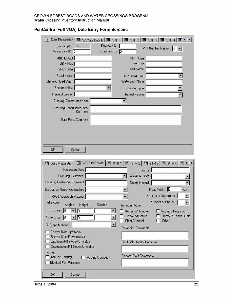
CROWN FOREST ROADS AND WATER CROSSINGS PROGRAM Water Crossing Inventory Instruction Manual
June 1, 2004 22
PenCentra (Full VGA) Data Entry Form Screens

CROWN FOREST ROADS AND WATER CROSSINGS PROGRAM Water Crossing Inventory Instruction Manual
June 1, 2004 23

CROWN FOREST ROADS AND WATER CROSSINGS PROGRAM Water Crossing Inventory Instruction Manual
June 1, 2004 24
HP IPAQ (1/4 VGA) Data Entry Form Screens The only mandatory field is the Inspection Date. If it is not filled in, a warning message will appear and exiting from the page will not be permitted. Canceling the warning message will result in today’s date being entered as the Inspection Date. Input Fields in Red indicate those attributes most critical to the Water Crossing Ranking Tool. Although as many fields as possible should be completed, leaving any of the fields in red blank will have a negative impact on the ranking score of the crossing. The Site Details B page includes a check box for indicating that the Primary Structure at the crossing is a Bridge. Checking this box will result in the disabling of fields on subsequent pages that are not required for Bridges. The Number of Structures entry is important as the Structure entry pages beyond the number indicated will not be accessible.

CROWN FOREST ROADS AND WATER CROSSINGS PROGRAM Water Crossing Inventory Instruction Manual
June 1, 2004 25

CROWN FOREST ROADS AND WATER CROSSINGS PROGRAM Water Crossing Inventory Instruction Manual
June 1, 2004 26
Pick List for Inspector and all Comment Fields The input box for the inspector’s name, and all comment fields, will have a pick list arrow at the end of it. Initially, the pick list will be empty. Once an entry is stored in the shape file, it will appear in the pick list. Every entry or 300 entries (whichever is less), stored in the shapefile, will appear in the pick list. The last entry made will appear at the top of the list.
Select a Water Crossing by WC_ID
• Start Arcpad and add the water crossing point layer
• Click the Find Tool button and the following popup will appear.
• Click on the popup as shown by the cursor

CROWN FOREST ROADS AND WATER CROSSINGS PROGRAM Water Crossing Inventory Instruction Manual
June 1, 2004 27
Expand the shapefile table and select WC_ID. Click OK.
• Type in range of water crossing ID’s you are looking for.
• Click on the find icon as shown below
• Select a water crossing id number
• Click the Feature Properties Button
The Water Crossing Edit form will open ready for editing.

CROWN FOREST ROADS AND WATER CROSSINGS PROGRAM Water Crossing Inventory Instruction Manual
June 1, 2004 28
Adding New Data New data must be added when a water crossing is encountered whose location does not exist in the wcp shapefile. This situation will occur if drainage and road features were missing from the data prep base layers or a local drainage culvert is to be assessed. To add a new water crossing encountered in the field, click the “Add Water Crossing at GPS Position” button. A new point shape will be created and the form will open for editing.
If the Select Tool is active and a location on the shapefile not corresponding to a water crossing is tapped or clicked, the option to add a water crossing becomes available (non GPS capture). Two warning boxes will be presented before the crossing is added and the edit form appears.
File Backup/Synchronization It is recommended that the shapefile data be backed up as frequently as possible by copying the “wcp” folder to the Storage Card2 memory card.
iPAQ H5550 - use the IPAQ Backup Utility from the Start Menu
PenCentra - Navigate to: My HandHeld PC>My Documents Right click on “wcp” folder and copy it. Navigate to: My HandHeld PC>Storage Card2 Paste the folder.
Additionally the wcp folder should be copied to the \My Documents\Synchronized Files folder every time the PenCentra is to be placed in the Docking Station. Once in the docking station use Active Sync to perform an incremental Backup (Tools > Backup/Restore). Once the backup is complete, manually synchronize the PenCentra by clicking on the Synchronize button in Active Sync, this will ensure the latest copy of your shape files will always exist on the DeskTop computer. In order to Synchronize, the folder and file names in one Synchronization directory must be identical to those in the other synchronization directory.
Capturing Other Spatial Features Field work involved with the water crossing inventory may present an opportunity to capture road centrelines and other spatial features. It is recommended that a separate GPS unit be used for this purpose. The ArcPad Water Crossing Application has been specifically designed for the inventory and spatial capturing of water crossings. It does not allow for the collection of other spatial features such as roads and drainage. In order to collect spatial features, other than water crossings, using the Pen Centra and ArcPad, the Water Crossing application must be temporarily disabled. The collection of spatial features, other than water crossings, using the Data Collection Units, will not be supported by the CFRWCP Support staff at this time. In order to restore ArcPad 6.0.3 to its default settings, for use in collecting other spatial features, delete the custom Water Crossing configuration file by navigating to
My Handheld PC > Program Files > Arcpad > Applets Delete the wcp.apa file
Restore the Water Crossing Application by executing the wcp.exe file again.

CROWN FOREST ROADS AND WATER CROSSINGS PROGRAM Water Crossing Inventory Instruction Manual
June 1, 2004 29
OTHER DATA
DATA COLLECTION FORMS Data collection forms have been provided for use in case electronic data collection equipment malfunctions or becomes unavailable. They can be found in Appendix II.
DIGITAL PICTURES Photographs of water crossing attributes can serve various purposes but excessive photos, poor quality photos or improperly catalogued photos will have limited value. Any staff that will have involvement in utilizing or analyzing inventory data should be consulted on the type of photographs that would be useful to them (e.g. a biologist will likely be interested in different images than an engineer). The Inventory Coordinator should provide specific direction to field crews with respect to photo requirements and periodically check photo quality and quantity. Safety Hazards or Unusual Features Photographs should be taken of a crossing if there are obvious safety concerns or unusual features. A sufficient number of photographs should be taken in order for someone viewing the photographs to gain a reasonable understanding of the problem. The following are examples of situations when digital pictures should be taken:
• Blockage
• Public Safety Hazard
• High Erosion
• Crossing or Structure Type is “Other”
• Structure Damage or Failure
• If in Doubt Biologist’s Requirements Digital photographs combined with measurements and observations taken at a crossing provide biologists with a better understanding of conditions at the site and how those conditions may affect passage of fish upstream and habitat values downstream. Upstream and downstream photographs can provide useful information on meander, blockages (natural or man made), flow rate, stream type, bank stability and erosion, relief of adjacent areas, aquatic vegetation and potential for sediment transport and erosion (see example photographs on following page). Photographs of the crossing provide visual reference of the extent of erosion on fill slopes and approaches, type of material being eroded and the potential for acute or chronic erosion problems. They also provide biologists with a better understanding of the condition and configuration of culverts. All of the information collected at a crossing helps biologists make an informed decision regarding risk to fish and fish habitat. Photographs, along with other information collected at a crossing, also play an important role in the process of understanding the type of remedial action that may be appropriate at a particular site. Examples of the types of pictures that might assist the biologist and road engineer are:
• overall view up stream
• overall view down stream
• road approach in both directions

CROWN FOREST ROADS AND WATER CROSSINGS PROGRAM Water Crossing Inventory Instruction Manual
June 1, 2004 30
• close up of each end of the culvert
• any erosion of the fill slopes
• close up of particular problems or hazards Photo Cataloguing and Storage Picture storage varies with different cameras and a large number of photos will be taken. In most cases, additional memory, or the ability to download on site, will be required. To reduce the picture size, a JPEG format is to be used. Select an appropriate resolution setting to adequately capture the desired image. A resolution that is too low will provide poor image quality; unnecessarily high resolution requires excessive storage. The Digital Picture Log Form must be filled in whenever digital pictures are taken. The purpose of this form is to aid in organizing the digital pictures after they have been downloaded and link them to the “Culvert Unique ID”. Adopting the following identification convention will assist with cataloguing photos, ensure proper identification and simplify retrieval. Improperly catalogued photos have no value. Pictures should be named as follows.
• ....overall view up stream ......................................................unique ID# -U
• ....overall view down stream..................................................unique ID# -D
• road approach in both directions......................................unique ID# -R1 .......................................unique ID# -R2
• a close up of the upstream end of the culvert ...................unique ID# -CU
• a close up of the downstream end of the culvert ..............unique ID# -CD
• any erosion of the fill slopes..............................................unique ID# -F1 ..............................................unique ID# -F2
• any safety hazards (washouts, unsafe bridge, etc) ..........unique ID# -S1 ..........unique ID# -S2 Examples:
1234-CD 1234-CU 1234-F1 1234-F2 1234-R1
1234-R2 1234-U 4567-S1 5678-S1
PROJECT PRODUCTION STATISTICS - DAILY FIELD LOG The Daily Field Log will be used to evaluate the time and costs involved in completing inventory work across the province. It is essential that this information be collected and assembled to enable future project planning and improved cost projections for capital budget submissions. It is strongly recommended that this information be maintained on an ongoing basis versus attempting to assemble and reconcile information at the end of the project. The Daily Field Log Summary appears in Appendix II, page 92. Inventory Coordinators will be required to submit a completed Daily Field Log Summary at the end of the project.

CROWN FOREST ROADS AND WATER CROSSINGS PROGRAM Water Crossing Inventory Instruction Manual
June 1, 2004 31
ANALYSIS and REPORTS
Water Crossing Ranking Tool (WCRT)
The FRWCI water crossing inventory methodology will provide base information on the current status of the existing infrastructure. Inventory data must be processed and analyzed in order to provide meaningful information for decision making. The Water Crossing Ranking Tool was developed to receive, analyze and store water crossing inventory data. The application employs a ranking system that evaluates: risk to public safety, design and condition status and implications to fish and fish habitat. This ranking enables the proper prioritization of remedial work to eliminate or reduce safety hazards and/or environmental concerns.
The Water Crossing Ranking Tool was developed in Microsoft VISUAL BASIC 6 (utilizing MS JET data bases) and was designed to be compatible with MNR and forest industry computer systems. The application was developed to receive digital data downloaded from field data collectors as well as “Fisheries and Fish Habitat Values Data” provided by the fisheries biologist. The application produces a series of standard reports and has an adhoc query capability. Information may be rolled-up from individual management units to district, region or provincial levels. The Water Crossing Ranking Tool manages data and information in the following manner (also refer to diagram on following page):
1. Digital stream and road information is prepared and input into a field data collector (or maps and manual tally sheets are utilized).
2. Design and condition attributes collected by the field survey are imported into the Water Crossing Ranking Tool.
3. Standard reports are produced that rank each crossing based on risk to public safety and structure design and condition (Public Safety Report, Design/Condition Rank Report). The ranking determines the priority for remedial action for all of the water crossings surveyed to date. It is important to note that critical information pertaining to migration blockage and erosion causing downstream sedimentation is provided by the first stage (field survey) of the inventory process. This information is significant to fish and fish habitat and will influence the initial ranking outcome.
4. The Initial Biologist Report is produced for each water crossing summarizing the field data collected for each attribute by the field survey. This report is provided to the fisheries biologist.
5. The fisheries biologist utilizes the field survey results and any other relevant information to complete a “Fisheries and Fish Habitat Values Data Form”. This information is input into the Water Crossing Ranking Tool.
6. A revised ranking of each water crossing is calculated based on public safety, structure design and condition, plus fisheries and fish habitat values. This revised ranking determines the revised priority for remedial action for all of the water crossings surveyed to date.
7. As water crossings are monitored or re-inspected, it will be possible to import updated information and the overall ranking of all crossings will be re-calculated.
8. The Water Crossing Ranking Tool has the flexibility to produce ad-hoc and roll-up reports.
The ranking system used to evaluate the status of individual water crossings and prioritize remedial work is largely described in the help files associated with the application. The ranking system was calibrated and adjusted utilizing the 2002 inventory data.

CROWN FOREST ROADS AND WATER CROSSINGS PROGRAM Water Crossing Inventory Instruction Manual
June 1, 2004 32
Water Crossing Ranking Tool (WCRT)
Initial Report: ranking based on design & condition [available after field survey]
Field Survey
Data Collector download or Tally Sheet data input
Output
Water Crossing statistics and info provided to Biologist
Output
Biologist completes Fisheries & Fish Habitat Values Data Form
Input
Updating
- remedial work completed
- monitoring detects change
Revised Report: ranking based on design & condition + fisheries & fish habitat rank [available after Biologist input]
Ad Hoc Reports Capability
Roll-Up Reports Capability
Output
Field Data Prep
WCRT
Input
Input
Biologist utilizes all other available fisheries information
1
2
3
4
5
6
7
8

CROWN FOREST ROADS AND WATER CROSSINGS PROGRAM Water Crossing Inventory Instruction Manual
June 1, 2004 33
Rank Calculation Framework for Determination of Priority for Remedial Action at Existing Water Crossings
Priority for Remedial Action
Public Safety Rank (Stage 1)
Fish/Fish
Habitat Rank
Site Fish Habitat/ Fisheries Potential Rank (Stage 2)
Design/ Condition Rank (Stage 1)
Attributes Contributing to Habitat Rank: Upstream/Downstream Spawning. Feeding, Nursery/Rearing Habitat (OE/FMO) Migration Habitat (OE/FMO) Channel Type (FMO) Thermal Regime (OE) Attributes Contributing to Fisheries Rank: Fisheries Values (OE) Sensitive Fish Species (OE) Fishery Management Efforts (OE)
Comprised of: - Habitat Rank - Fisheries Rank
Comprised of: - Barrier to Passage Rank - Erosion/ Sedimentation Rank
Attributes Contributing to Barrier to Passage Rank: Structure Blockage (FMO) Height of Opening, Height Above Outlet Pool, Width of Opening, Length of Covered Stream, Outlet Pool Water Surface to Outlet Pool high Water Mark, Inside Top to Outlet Pool Bottom, Inside Top to Inside Water Surface, Inside Top to Inside High Water Calculated Structure Diameter, (CC) Structure Condition (FMO) Length of Covered Stream (FMO) Water Velocity (CC) (not used at present time) Fish Sustained Swimming Speed (Set value by species, used in computer application only) Upstream Spawning Multiplier (OE) Attributes Contributing to Erosion/ Sedimentation Rank: Road Surface Width (FMO) Calculated Structure Length (CC) Erosion on Upstream/Downstream Fill Slopes (FMO) Fill Slope Material (FMO) Upstream/Downstream Fill Height (FMO) Upstream/Downstream Fill Slope Angle (FMO) Erosion on Road Approaches (FMO) Road Approach Material (FMO) Upstream/Downstream Fill Slopes Unstable Downstream Spawning Multiplier (OE)
FMO = field measurement/observation OE = office entry CC = computer calculated

CROWN FOREST ROADS AND WATER CROSSINGS PROGRAM Water Crossing Inventory Instruction Manual
June 1, 2004 34
DATA DICTIONARY The current inventory design focuses on the collection of attributes that are deemed essential by stakeholders who have been involved to date. The attributes selected are those that address the immediate needs of all parties involved and does not include the collection or use of other data or modeling software, e.g. digital terrain data, forest inventory data, culvert capacity /volume software, etc. In the future, use of additional data themes or commercial engineering software that could provide analysis and prediction of characteristics of crossings that have not yet been inventoried, or to develop hazard assessment models could be undertaken. These decisions would be made at that time dependant upon resources, costs, and corporate, regional, and local needs and abilities. The data dictionary has been organized into four categories of attributes. Combined, this listing represents the complete list of attributes that are included in the water crossing inventory. See Appendix V – Photograph Library, for images of many attributes and pick list options. All measurements are recorded in centimeters and may be rounded to the nearest 10 centimeters.
PART A – GENERAL Attributes
The GENERAL category contains attributes that may be initially populated through the Data Preparation Application using existing data sources at the MNR District. If digital spatial data is not available or is incorrect, attributes may be entered/edited through the ArcPad Application or Arcview. These attributes should be populated, where possible, prior to the commencement of the field assessment.
PART B – WHOLE CROSSING Attributes The WHOLE CROSSING category contains attributes that are populated from data and observations collected in the field and apply to the crossing as a whole. All attributes relate back to the ‘Field Inspection Date’ and ‘Name of Field Inspector’.
PART C – INDIVIDUAL STRUCTURES Attributes
The INDIVIDUAL STRUCTURES category contains attributes that are populated from data and observations collected in the field for each structure at the crossing. There may be no attributes recorded in this category for a crossing (because the structure no longer exists) or there may be multiple sets of attributes collected for a crossing (because the crossing is comprised of multiple structures). All attributes relate back to the ‘Field Inspection Date’ and ‘Name of Field Inspector’.
PART D – FISHERIES Attributes
The FISHERIES category contains attributes that will be populated by a fisheries biologist through a desktop application based on interpretation of local knowledge, office records and recorded field data/observations. These attributes are not included in the shapefile dbf.

CROWN FOREST ROADS AND WATER CROSSINGS PROGRAM Water Crossing Inventory Instruction Manual
June 1, 2004 35
Part A - GENERAL Attributes Crossing Unique Identifier
• A numeric identifier that is unique for an individual water crossing within an MNR administrative district.
• System generated during data prep process when stream data and road data are intersected to generate water crossing point data.
• Manual assignment/entry required for new crossings Crossing Business Identifier
• An alphanumeric identifier that relates to local or existing data/information that may be linked to water crossing database (e.g. Bridge Inventory)
• Only one business identifier per crossing can be recorded in the database at this time.
OBM Map Tile
• 13 digit numeric identifier e.g. 2017540053900
• Populated during data prep process
• Manual entry required for new crossings Township
• Populated during data prep process
• Manual entry required for new crossings MNR District
• Populated during data prep process or entered manually
• Manual entry required for new crossings MNR Area
• Administrative unit within MNR district
• Optional, requirement determined by district
• Manual entry required for new crossings SFL Holder
• Populated during data prep process or entered manually
• Manual entry required for new crossings FMU Name/Number
• Populated during data prep process
• Manual entry required for new crossings Road Link ID
• Relate key to road database used in data prep process (e.g. FMF Object ID)
• Populated during data prep process

CROWN FOREST ROADS AND WATER CROSSINGS PROGRAM Water Crossing Inventory Instruction Manual
June 1, 2004 36
Road Name
• Populated during data prep process or entered manually
• Optional FMP Road Class
• Populated during data prep process or entered manually
• Classification of road into one of three types, as designated in a FMP.
• Acceptable values: Primary Secondary Tertiary
Generic Road Class
• Populated during data prep process or entered manually
• Optional, allows for entry of non-standard classification of roads that may exist locally Responsibility
• Populated during data prep process or entered manually
• Class responsible for the maintenance and upkeep of the water crossing
• Classification of water crossing into one of three types
• If left blank, the WCRT will populate with user defined default
• Acceptable values: MNR SFL OTH
Name of Owner
• Populated during data prep process or entered manually
• Specific group or individual responsible for the maintenance and upkeep of the water crossing
• Text string of up to 50 characters allowed Waterbody Link ID
• Relate key to waterbody database used in data prep (e.g. FMF Object ID)
• Populated during data prep process Waterbody Name
• Populated during data prep process or entered manually
• Optional

CROWN FOREST ROADS AND WATER CROSSINGS PROGRAM Water Crossing Inventory Instruction Manual
June 1, 2004 37
Channel Type
• Acceptable values: Perennial Intermittent Local Drainage
• Populated during data prep process. In those situations where the classification of streams in the data is in question, the biologist needs to review the information collected in the field and change the classification where necessary.
• The ranking tool applies a score to the channel type that is input during the data prep process. The ranking tool does not apply a score to local drainage. This score is added to the thermal regime score. The resulting score is used to increase the Habitat Rank.
• Permanent streams tend to have well defined channels and have water in them at least 9 months of the year.
• Intermittent streams tend not to have well defined channels. Vegetation of various types is often present in the areas where water flow normally occurs. Flows occur in these types of streams less than 9 months of the year.
• Perennial and intermittent streams both have value as fish habitat. Intermittent streams should not be dismissed as unimportant since they may provide valuable fish habitat at certain times of the year. Both types of streams are important for defining the productivity of a watershed.
• A culvert installed for local drainage is usually placed in locations where runoff water would normally accumulate. The intent of local drainage culverts is to facilitate the movement of runoff water from one side of the road to the other because the road has interrupted the normal movement of water for example, through low lying areas.
• ‘Local Drainage’ crossings will normally be new crossings and will have to be added to the database since there should not have been a channel centerline in the water base data that would have generated a logical water crossing during the data prep process.
• If the channel type is adjusted based on field observations by the inventory crew and/or biologist the ranking tool will flag that a change was made. The inventory coordinator needs to follow the district protocol for identifying that this change needs to be made to the NRVIS data base.
Thermal Regime
• Populated during data prep process or adjusted manually by biologist
• Acceptable values: Coldwater Coolwater Warmwater Unknown
• A score is applied to the thermal regime that is input during the data prep process or as the result of field observations. This score is added to the channel type score. The resulting score is used to increase the Habitat Rank.
• Most watercourses in the province have not been formally assessed, therefore categorization of a particular watercourse may not be easy. Knowledge of the species within that watershed or the species that normally inhabit or use a watercourse from time to time can provide an indication of the thermal regime.
• Currently the inventory systems most commonly in use are the wadeable streams inventory system and the aquatic habitat inventory system. The wadeable streams system is not applicable across the entire province and should only be used in appropriate locations. New methods for river assessments and standardized habitat assessment methods for inland waterbodies are currently under development and may be available for use at some point in the future.
• If the thermal regime is adjusted based on field observations by the inventory crew and/or biologist the ranking tool will flag that a change was made. The inventory coordinator needs to follow the district protocol for identifying that this change needs to be made to the NRVIS data base.

CROWN FOREST ROADS AND WATER CROSSINGS PROGRAM Water Crossing Inventory Instruction Manual
June 1, 2004 38
Crossing Constructed Year
• Crossings constructed prior to the implementation of the Access Roads and Water Crossings Guidelines have the potential to cause more problems than crossings constructed after implementation of the guidelines. This attribute will also be important in determining what the “construction standards of the day” were at the time of construction and who may be responsible for the crossing structure.
• If year is not known, leave blank
• If construction spans more than one year, enter year construction was completed
• Year of construction may be determined by consulting previous FMPs, AWSs and supplemental aerial photography (SAP). This approach will not be valid if the crossing had failed and was replaced at a later date.
Crossing Constructed Year Comment
• If year is not known, indicate best available information such as a range, a FMP term, or a before or after reference
Data Prep Comment
• Any comments relating to the population of the “General Attributes”

CROWN FOREST ROADS AND WATER CROSSINGS PROGRAM Water Crossing Inventory Instruction Manual
June 1, 2004 39
Part B – WHOLE CROSSING Attributes - Field Visit Number (Version)
• Facilitated the tracking of subsequent assessments of a specific water crossing in the 2002 water crossing inventory. Since the wcp shapefile could only contain one record per crossing, the “visit number” provided the number of relevant historical records available in copies of the wcp shapefile. Beginning in 2003, historical records will be stored in the Water Crossing Ranking Tool as long as the data is imported to the application prior to re-assessment and the “MNR District” and “Crossing Unique Identifier” remain the same.
• Before any assessment takes place, the number is zero. Each time an assessment of the same crossing takes place, the number is to be incremented by 1.
• The first time a crossing is assessed the value will be “1”. The second time a crossing is assessed the value will be “2”, and so on. Re-assessment may be required after remedial action is completed or when it is determined that the crossing has been damaged (e.g. storm event, beaver dam failure).
Field Inspection Date
• Date of field inspection that relates to recorded field attributes. Name of Field Inspector
• Name of the inspector who supervised the collection of field attributes collected on the “Field Inspection Date”.
Field Comments
• General comments relating to the field inspection of a specific crossing not recorded in other comment attributes.
Field Fish Habitat Comment
• Comments specifically relating to fish and fish habitat as observed by the field crew.
• Record any fish and/or fish activity (e.g. spawning) observed during the inspection of the crossing.
• It is also important to record the type and location of any barriers that are present in the watercourse and are visible from the crossing.
• Biologists will review these comments during their analysis of fish habitat in relation to the crossing.
Crossing Existence
• Provides a better understanding of the progress of the Water Crossing Inventory and evaluates the reliability of the source data used to generate the logical water crossing point data.
• Record one of the following nine situations with the appropriate CODE:
Found Where Predicted (FPR) – Default Revised location (RLO) – Logical water crossing in wrong place, implies error in base data,
explain in “Crossing Existence Comments” New Crossing Added (NEW) – Used mainly for “Channel Type: Local Drainage”
- If not “Local Drainage”, implies error in base data, explain in “Crossing Existence Comments”

CROWN FOREST ROADS AND WATER CROSSINGS PROGRAM Water Crossing Inventory Instruction Manual
June 1, 2004 40
Does Not Exist (DNE) – Confirmed error in base data, explain in “Crossing Existence Comments”
Not Found (NFO) – Unable to confirm specific error in base data Excluded (EXL) – Logical water crossing is not part of survey, explain in “Crossing Existence
Comments” that responsibility rests with another agency eg. MTO or municipal roads board
Deferred (DEF) - Logical crossing not assessed due to constraints (e.g. time, money,
priorities); explain in “Crossing Existence Comments” Not Accessible – Road Over Grown (NRO) – Unable to access crossing (not passable by
vehicle) Not Accessible – ATV Required (ATV) – Unable to access crossing with 4X4 truck but
passable by smaller vehicle eg ATV Not Accessible – Other Barrier (OTH) – unable to access crossing, describe barrier and its
location in “Crossing Existence Comments” Crossing Existence Comments
• Comments relating to “Crossing Existence” attribute Crossing Type
• Classification of the crossing (where water meets road) into six general categories
• Record one of the following six categories with the appropriate CODE: Intact Crossing (INT)
- Default, structure remains in place, allows safe passage by conventional 4X4 ½ ton truck.
Ford – engineered (FEN) - Passable by conventional 4X4 ½ ton truck; designed and properly constructed to provide safe passage and avoid environmental impact; roadbed is intermittently under water
- Since safety is assessed at these types of crossings the ranking tool applies the appropriate score based on field observations.
- If this is checked in the drop down menu it is assumed that there are no environmental impacts. Therefore, the ranking tool applies a low score to fish passage and erosion/sediment concerns.
Ford – ad hoc (FAH)
- Failed or decommissioned crossing that has be modified with on-site or imported materials to re-establish access for vehicles, but has not been properly constructed to provide safe passage by conventional 4X4 ½ ton truck and/or avoid environmental impact; evidence of fording by vehicles; roadbed is intermittently under water.
- Utilize “Crossing Existence” comment field to describe noteworthy situations. - Since safety is assessed at these types of crossings the ranking tool applies the appropriate score based on field observations.
- This attribute is linked to the “Ad Hoc Fording” attribute. Failed Crossing - Impassible (FCR)
- A failed crossing that is not passable by conventional 4X4 ½ ton truck and passage by ATVs is unlikely; no evidence of fording by vehicles; eg. washout, collapsed bridge etc.
- The ranking tool will apply a default score to fish passage and erosion/sedimentation in those situations where a failed crossing is identified.
Decommissioned Structure (DST)
- Structure properly removed and site stabilized; not passable by conventional 4X4 ½ ton truck and passage by ATV is unlikely; no evidence of fording by vehicles.
Submerged or Flooded Structure (FST) - not passable by conventional 4X4 ½ ton truck; and passage by ATV is unlikely; structure
is submerged and cannot be observed e.g. beaver pond has flooded back over the road.

CROWN FOREST ROADS AND WATER CROSSINGS PROGRAM Water Crossing Inventory Instruction Manual
June 1, 2004 41
Ad hoc Fording
• Is there an indication of motorized vehicles fording the channel at or near the crossing location? Users may have utilized on-site or imported materials (including building materials) to restore passage to a failed or decommissioned crossing. Modifications may create a safety hazard, contribute to environmental damage or block fish migration. Utilize “Crossing Existence” comment field to describe noteworthy situations.
• Record “T” (true) if the answer is yes. “F” (false) is the default attribute.
• If “True” is selected for this attribute the ranking tool looks at the “Ad Hoc Fording Actual/Potential Environmental Damage” and “Ad Hoc Fording Blocked Fish Passage” attributes.
Ad hoc Fording Actual/Potential Environmental Damage
• If ad hoc fording is present, does it pose a significant risk for erosion of stream bank or streambed?
• Record “T” (true) if the answer is yes. “F” (false) is the default attribute.
• If “True” is selected for this attribute this information is incorporated into calculation of an erosion/sedimentation score in the ranking tool.
Ad hoc Fording Blocked Fish Passage
• If ad hoc fording is present, do any related modifications to the channel pose a significant impediment to fish passage?
• Record “T” (true) if the answer is yes. “F” (false) is the default attribute.
• If “True” is selected for this attribute this information is incorporated into the calculation of a fish passage score in the ranking tool.
Safety Hazard
• Document any safety concerns by completing a Water Crossing Safety Hazard Identification Form. Identify, on the form, whether the safety concern is high, low, or potential for each hazard condition that exists at the crossing. Digital photos should be taken. Upon returning to the office, field crews will be required to report encountered hazards and submit Water Crossing Safety Hazard Identification Forms. MNR districts and forest companies must have a procedure in place to receive this information and take appropriate action to further enhance hazard warnings if necessary (e.g. signage, barricades, berms etc) until remedial action is undertaken. Inventory Coordinators should discuss this subject with senior staff before commencing the inventory.
• Record an overall safety hazard rank in the water crossing data based on the completed Water Crossing Safety Hazard Identification Form. A separate Water Crossing Safety Hazard Identification Form must be completed for each crossing where a high, low or potential safety hazard has been identified.
• The ranking uses direct field observations to generate a public safety rank (not a score, score contribute to ranks). The public safety rank is combined with a fish and fish habitat rank to produce an overall rank for remedial action.
• Acceptable values:
High – defined as an existing safety hazard at the crossing that requires immediate action. Such a hazard could result in an accident causing damage, injury or even death to the unsuspecting user of the road. A condition described as a high hazard is one that needs to be brought to the immediate attention of the responsible agency (e.g. washout, road flooded, large hole in deck, broken stringer, etc.) Field crews should be prepared to mark encountered hazards with wide band flagging tape before they leave the site.
CROWN FOREST ROADS AND WATER CROSSINGS PROGRAM Water Crossing Inventory Instruction Manual
June 1, 2004 42
Low – defined as an existing safety hazard at the crossing that does not require immediate action, however if not addressed will develop into a High Safety Hazard. (lack of adequate signage, small hole in deck, significant erosion, etc.) Field crews should be prepared to mark encountered hazards with wide band flagging tape before they leave the site.
Potential – defined as a condition at a crossing that is not yet a safety hazard but
has the potential to develop into a hazardous condition. Monitoring may be required. (minor erosion, evidence of crushed timbers, beaver activity, etc.)
None - no public safety hazard was observed.
Suggested Remedial Action – Replace/Remove Existing Structure
• If, in the opinion of the field inspector, the obvious course of action is to replace or remove the existing structure, record “T” for true. The default is “F” for false.
• Observations can be used in the ranking tool to help determine the type of remedial action that may be necessary at a crossing.
Suggested Remedial Action – Repair Existing Structure
• If, in the opinion of the field inspector, the obvious course of action is to repair the existing structure, record “T” for true. The default is “F” for false.
• Observations can be used in the ranking tool to help determine the type of remedial action that may be necessary at a crossing.
Suggested Remedial Action – Clear Channel
• If, in the opinion of the field inspector, the obvious course of action is to remove materials blocking the channel either upstream, downstream or inside of the existing structure, record “T” for true. The default is “F” for false.
• Observations can be used in the ranking tool to help determine the type of remedial action that may be necessary at a crossing.
Suggested Remedial Action – Remove Beaver Dam
• If, in the opinion of the field inspector, the obvious course of action is to remove a problematic beaver dam either upstream or downstream of the existing structure, record “T” for true. The default is “F” for false.
• Observations can be used in the ranking tool to help determine the type of remedial action that may be necessary at a crossing.
Suggested Remedial Action – Signage Required
• If, in the opinion of the field inspector, the obvious course of action is to place signage on the road approaches to the existing structure, record “T” for true. The default is “F” for false.
• Record “T” for true if existing signage is inadequate or needs replacement. Provide explanation in the “Remedial Action Comment”.
• Observations can be used in the ranking tool to help determine the type of remedial action that may be necessary at a crossing.
Suggested Remedial Action – Other
• If, in the opinion of the field inspector, alternative measures should be implemented and are described in the "Remedial Action Comment”, record “T” for true. The default is “F” for false.
• Observations can be used in the ranking tool to help determine the type of remedial action that may be necessary at a crossing.

CROWN FOREST ROADS AND WATER CROSSINGS PROGRAM Water Crossing Inventory Instruction Manual
June 1, 2004 43
Remedial Action Comment
• Comments that provide details relating to “Suggested Remedial Action” attributes.
• Observations can be used in the ranking tool to help determine the type of remedial action that may be necessary at a crossing.
Beaver Dam Upstream
• Is there a beaver dam upstream which impacts the performance of the crossing?
• An upstream beaver dam may prevent or limit water from reaching the water crossing.
• A beaver dam immediately upstream can cause far more damage to a crossing when the dam fails as compared to an upstream dam a considerable distance away.
• Record “T” (true) if the answer is yes. “F” (false) is the default attribute.
• This information is used to interpret scores and ranks that the ranking tool produced as the result of field measurements and observations. For example the ranking tool may return a high score because there is insufficient water in the structure to pass fish. This score needs to be interpreted with consideration of the influence of the upstream beaver dam.
• If there is an upstream beaver dam the ranking tool with automatically identify a “potential safety hazard” if no safety hazard has been identified.
Beaver Dam Downstream
• Is the crossing influenced by water backed up by a downstream beaver dam?
• A downstream beaver dam could be backing up water over the road and/or crossing to such an extent that measurements are not possible and the “Crossing Type” was recorded as ‘Submerged or Flooded Structure’.
• A downstream beaver dam may also create a back water that influences the measurements taken at the crossing but has not completely flooded it.
• Record “T” (true) if the answer is yes. “F” (false) is the default attribute.
• This information is used to interpret scores and ranks that the ranking tool produced as the result of field measurements and observations. For example the ranking tool may return a low score because the structure is completely full of water. This score needs to be interpreted with consideration of the influence of the downstream beaver dam.
• If there is an downstream beaver dam the ranking tool with automatically identify a “potential safety hazard” if no safety hazard has been identified. The ranking tool will also use this information to adjust the fish passage and erosion/sedimentation scores.
Road Surface Width
• Width of the roadbed surface between tops of fill slopes.
• Road surface width is used in the ranking tool in conjunction with fill height and angle of the fill slopes in order to identify the calculated length of the structure. The ranking tool compares the actual length of the structure to the calculated length of the structure. If the actual structure is too short then there is greater potential for erosion and sedimentation.
• Measured in centimeters, may round to the nearest 10 centimeters. Upstream Fill Slope Angle Downstream Fill Slope Angle
• The angle between the horizontal plane and the slope of the bank (see diagram below). The measurement of the slope angle can be taken at any point on the slope. The measurement is taken from a location near the structure that is representative of the average fill slope angle of the bank. The distance from the structure that the

CROWN FOREST ROADS AND WATER CROSSINGS PROGRAM Water Crossing Inventory Instruction Manual
June 1, 2004 44
measurement is to be taken is not specified since this might confine observations to a location that is not representative of the fill slope angle. Upstream and downstream fill slope angles may be different. There are various tools and techniques that can be used to determine this measurement. See Equipment List for details.
• For bridges no entry is required.
• Upstream and downstream fill slope angles are used in the ranking tool in conjunction with fill height and road surface width to identify the calculated length of the structure. The ranking tool compares the actual length of the structure to the calculated length of the structure. If the actual structure is too short then there is greater potential for erosion and sedimentation.
• The ranking tool compares the angle observed in the field to the stable angle of repose for the type of soil used in construction of the crossing. This comparison determines whether or not the fill slopes are at a stable angle. Fill slopes that are not at a stable angle of repose for the type of material used in the crossing are more likely to demonstrate acute and chronic erosion effects. This results in a fill slope stability score being generated by the ranking tool. The ranking tool adds this score to the fill slope material, fill height and structure length (length of covered stream) scores. The resulting score is used to modify the fill slope erosion score.
• Stable angle of repose refers to the maximum slope or angle at which a material, such as soils or loose rock, remains stable (Environmental Guidelines for Access Roads and Water Crossings, page 59)
Measurement of Fill Slope Angle
Erosion on Upstream Fill Slope Erosion on Downstream Fill Slope
• The extent of erosion on the fill slopes on the upstream and downstream sides of the crossing. This may include signs of erosion around the inlet and outlet to the culvert, or for bridges, erosion around the abutments and wing walls.
• Situations will be encountered where erosion has occurred in the past but has now ceased and the fill slopes are now stable. In older crossings the fill slopes may be vegetated and there may be little or no signs of recent erosion. In this case categorize the erosion on the site as “low”. The intention is to evaluate the risks to fish habitat that are posed by the crossing right now and to some extent what the future risks might be.
Water Surface
Bottom of Stream
Angle in Degrees
Fill Slope
Road Surface

CROWN FOREST ROADS AND WATER CROSSINGS PROGRAM Water Crossing Inventory Instruction Manual
June 1, 2004 45
• For bridges no entry is required.
• The ranking tool uses the observations from the field to generate a fill slope erosion severity score.
• Categorize fill slope erosion into one of four categories and record appropriate CODE:
Severe (SEV)
− Erosion in the form of deep, wide gullies on the fill slopes.
− May be an extensive network of deep gullies or there may be one or two deep gullies. The loss of material is quite evident from the fill slopes and/or roadbed.
− Deep gullies are greater than 10 centimeters in depth.
− Fill slopes may also be deeply cut around the inlets and outlets in those cases where the culvert is too short or there is blockage of the culvert.
− Fill slopes may also be deeply cut around the abutments and wing walls at bridges.
− Fill slopes may show signs of slumping, which may be quite extensive in some cases, as a result of undercutting by water.
− Extensive deposits of eroded material may be apparent at the base of the fill slopes or immediately downstream. Point bars are often quite apparent downstream of the crossing.
− In severe cases eroded material may actual block or partially block the culvert.
− Culvert may appear perched, even if installed properly, due to scouring around the inlet and/or outlet.
Moderate (MOD)
− Some erosion in the form of rills and gullies is apparent on the fill slopes. The loss of material from the fill slopes and/or roadbed is still apparent but is less pronounced than in the case of severe erosion.
− Rills or gullies are not deeply cut (5cm to10cm in depth)
− Rills or gullies may still be well defined.
− Fill slopes may show some signs of undercutting around the inlets and outlets of culverts.
− Fill slopes may show some signs of erosion around abutments and wing walls at bridges.
− Some signs of slumping may be apparent due to undercutting by water.
− Some eroded material may be apparent at the base of the fill slopes or immediately downstream. Point bars may still be apparent downstream of the crossing.
− In some cases eroded material may be deposited in the culvert but the culvert is not substantially blocked by it.
− Culvert may begin to show perching where water is undercutting the fill slopes.
Low (LOW)
− Some erosion may be apparent on the fill slopes, but tends to be shallow and less well defined. There does not appear to be a great loss of material from the fill slopes.
− Rills are less than 5cm deep.
− Slopes appear stable and there appears to be little movement of material into the water. Eroded material is minimal at the base of the fill slopes and is not readily apparent downstream of the crossing. Small point bars may or may not be apparent downstream of the crossing.
− There is little or no cutting of the fill slopes around the inlets and outlets of culverts or around the abutments and wing walls of bridges.

CROWN FOREST ROADS AND WATER CROSSINGS PROGRAM Water Crossing Inventory Instruction Manual
June 1, 2004 46
None (NON)
− Virtually no erosion on the fill slopes. Those that are present are very indistinct and shallow. Loss of material from the fill slopes is very slight or non- existent.
− Slopes appear stable and there appears to be little or no movement of material into the water. Eroded material is very minimal or not present at the base of the fill slopes and is not apparent downstream of the crossing. Point bars are not seen downstream.
− There is no cutting of the fill slopes around the inlets and outlets of culverts or around the abutments and wing walls of bridges.
Fill Slope Material
• The type of road building materials utilized on the fill slopes on both sides of the road.
• Different materials offer varying degrees of erosion protection or conversely are more prone to erosion (see table below). The ranking tool uses the observations from the field to generate a fill slope soil erodability score. The ranking tool adds this score to the fill slope stability, fill height and structure length (length of covered stream) scores. The resulting score is used to modify the fill slope erosion score.
• For bridges no entry is required.
• Materials used on the surface of fill slopes may be different than the materials used as the main base fill for the roadbed
• Where fill slopes are effectively stabilized and no significant erosion is encountered, the type of material used on the fill slopes is easily determined.
• Where fill slopes are completely vegetated and fill slope material is not easily recognizable it may be necessary to assume fill slope material is the same as the material observed on road shoulders and/or approaches.
• Where fill slope material has eroded significantly or slumped and base fill (e.g. clay) is exposed and also eroding, it is more appropriate to select the category of material used in the base fill (e.g. clay). This selection is made because the base fill material will likely be more prone to continued erosion, water transport and/or has greater potential to cause negative downstream effects.
• Categorize the material that comprises the fill slopes into one of four categories and record appropriate CODE:
- Silt / Clay (SCL) - Sand (SND) - Pit Run Gravel (GRV) - Rock / Cobble (ROC)
Fill Type Description Erosion Considerations
Clay / Silt - very fine textured soils - particle size smaller than 75um (No. 200
sieve) - likely on-site material
- easily eroded and suspended in fast and slow flowing water
- can be transported downstream long distances
Sand - obvious graininess with particle size ranging from 4.75mm (No.4 ) to 75um (No. 200)
- likely on-site material
- easily eroded - limited suspension in water but subject
to downstream transport in rapidly flowing water
Pit Run Gravel (Till)
- variable combination of soil-gravel-cobble ranging from 75mm (75mm to 4.75 mm (No. 4 Sieve)
- typically imported fill material
- components subject to varying degree of erosion and water suspension/ transport depending on particle size
Rock / Cobble - large cobble, blast rock, rip-rap (larger than 75mm)
- typically imported fill material
- used to stabilize fill slopes because of erosion resistance
- dislodged material remains at site

CROWN FOREST ROADS AND WATER CROSSINGS PROGRAM Water Crossing Inventory Instruction Manual
June 1, 2004 47
Upstream Fill Height Downstream Fill Height
• Fill slopes that are very high have greater potential for erosion because they have a greater surface area for water to act on. There is also potential for greater importation and deposition of material because a greater quantity of material could be eroded. The ranking tool uses the observations from the field to generate a fill height score. The ranking tool adds this score to the fill slope stability, fill slope material and structure length (length of covered stream) scores. The resulting score is used to modify the fill slope erosion score.
• For bridges no entry is required.
• Fill heights are also used with road width to determine if a culvert is the appropriate length.
• Measured to the nearest centimeter. May be rounded to the nearest 10 centimeters. A survey rod works well for this purpose.
• Measurements are taken from the bottom of the streambed to the top of the road surface whether the culvert is situated below, on or above the streambed.
• This is a vertical measurement. Do not measure along the angle of the fill slope.
• If the culvert or other structure is too short and the fill extends to the end of the structure and beyond, it may not be possible to stand on the end of the structure to take the measurement. In this case, stand on the fill slope at the point where the fill material meets the water and reach out as far as possible with the survey rod to take the measurement. Be careful not to lose footing.
Measurement of Fill Height for Culvert at or Below Grade
Water Surface
Measure fill height from the bottom of the streambed to the top of the road surface. This is a vertical measurement. Do not measure along the fill slope face.
Bottom of Stream
Road Surface
Fill Slope
Survey Rod
Fill Height

CROWN FOREST ROADS AND WATER CROSSINGS PROGRAM Water Crossing Inventory Instruction Manual
June 1, 2004 48
Measurement of Fill Height for a Culvert That is Perched
Upstream Fill Slopes Unstable Downstream Fill Slopes Unstable
• A subjective assessment of stability on upstream and downstream fill slopes after visually examining the method and extent of stabilization efforts.
• For bridges no entry is required.
• A fill slope that is unstable will be unable to develop a satisfactory vegetative cover until it has eroded back to a stable angle of repose. This erosion may result in a narrower roadbed, culvert blockage or negative impacts on fish habitat.
• Generally, fill slopes should be no steeper than two horizontal to one vertical (2:1). However, some fill materials can be stabilized very effectively at a steeper angle. Vegetation and rip rap are examples of slope stabilization methods.
• Stable angle of repose refers to the maximum slope or angle at which a material such as soil or loose rock remains stable (Environmental Guidelines for Access Roads and Water Crossings, Page 59)
• By measuring the actual road width, fill height and slope angle, a comparison can be made between the installed culvert length and the calculated length of the culvert required. The ranking tool compares the actual length of the structure (length of covered stream) to the calculated length of the structure. If the actual structure is too short the application looks to see if the fill slopes are stable. Even if the actual structure is too short the fill slopes could be stable thus the potential for erosion and sedimentation is reduced. Thus the structure length score could be reduced as the result of stabilization efforts.
• If, in the opinion of the field inspector, the fill slope is unstable (record separately for upstream and downstream fill slopes), record “T” (true). “F” (false) is the default attribute.
Water Surface
Measure fill height from the bottom of the streambed to the top of the road surface. This is a vertical measurement. Do not measure along the fill slope face.
Bottom of Stream
Road Surface
Fill Slope
Survey Rod
Fill Height

CROWN FOREST ROADS AND WATER CROSSINGS PROGRAM Water Crossing Inventory Instruction Manual
June 1, 2004 49
Erosion on Road Approaches
• The extent of erosion on both sides of both approaches. Approaches include the roadbed, cleared right-of-way and any ditches that drain directly into a waterway on both the upstream and downstream sides.
• For bridges erosion on the abutments is considered part of the erosion on road approaches.
• Situations will be encountered where erosion has occurred in the past but has now ceased and the approaches are now stable. In older crossings the approaches may be vegetated and there may be little or no signs of recent erosion. In this case categorize the erosion on the site as “low”. The intention is to evaluate the risks to fish habitat that are posed by the crossing right now and to some extent what the future risks might be. The ranking tool uses the observations from the field to generate a road approach erosion severity score.
• Include a comment in “Field Comments” if constructed ditches are present which direct runoff directly into the watercourse. Offshoot ditches that direct runoff into the bush or vegetated areas (such that eroded material does not find its way into the watercourse) do not require a comment.
• Based on observations of the extent of erosion on both sides of both approaches, categorize the average condition into one of four categories and record appropriate CODE:
Severe (SEV)
− Erosion in the form of deep, wide gullies on the approach slopes.
− May be an extensive network of deep gullies or there may be one or two deep gullies. The movement of material is quite evident from the approaches.
− Deep gullies are greater than 10 centimeters in depth.
− Approach slopes may show signs of slumping, which may be quite extensive in some cases, as a result of undercutting or saturation by water.
− Extensive deposits of eroded material may be apparent at the base of the approach slopes or immediately downstream. Point bars are often quite apparent downstream of the crossing.
Moderate (MOD)
− Some erosion in the form of rills and gullies is apparent on the approaches. The loss of material from the approaches and/or roadbed is still apparent but is less pronounced than in the case of severe erosion.
− Rills or gullies are not deeply cut (5cm to 10cm in depth)
− Rills or gullies may still be well defined.
− Some signs of slumping may be apparent on approach slopes due to undercutting or saturation by water.
− Some eroded material may be apparent at the base of the approach slopes or immediately downstream. Point bars may still be apparent downstream of the crossing.
Low (LOW)
− Some erosion may be apparent on the approach slopes, but tends to be shallow and less well defined. There does not appear to be a great loss of material from the approaches.
− Rills are less than 5cm deep.
− Slopes appear stable and there appears to be little movement of material into the water. Eroded material is minimal at the base of the approach slopes and is not readily apparent downstream of the crossing. Small point bars may or may not be apparent downstream of the crossing.

CROWN FOREST ROADS AND WATER CROSSINGS PROGRAM Water Crossing Inventory Instruction Manual
June 1, 2004 50
None (NON)
− Virtually no erosion on the approach slopes. Those that are present are very indistinct and shallow. Loss of material from the approach slopes is very slight or non-existent.
− Slopes appear stable and there appears to be little or no movement of material into the water. Eroded material is very minimal or not present at the base of the approach slopes and is not apparent downstream of the crossing. Point bars are not seen downstream.
Road Approach Material
• The type of road building materials present on all four approach slopes combined.
• Different materials offer varying degrees of erosion protection or conversely are more prone to erosion (see table below). The ranking tool uses the observations from the field to generate a road approach erodability score. The resulting score is used to modify the road approach erosion score.
• Materials present on road approaches may be different than the materials used as the main base fill for the roadbed
• Where approaches are effectively stabilized and no significant erosion is encountered, the type of material present on the approaches is easily determined.
• Where approaches are completely vegetated and material is not easily recognizable it may be necessary to assume approach materials are the same as adjacent on-site soils.
• Where a mixture of soils is encountered, record the most predominant.
• Categorize the material that comprises the approach slopes into one of four categories and record appropriate CODE:
- Silt / Clay (SCL) - Sand (SND) - Pit Run Gravel (GRV) - Rock / Cobble (ROC)
Fill Type Description Erosion Considerations
Clay / Silt - very fine textured soils - particle size smaller than 75um (No. 200
sieve) - likely on-site material
- easily eroded and suspended in fast and slow flowing water
- can be transported downstream long distances
Sand - obvious graininess with particle size ranging from 4.75mm (No.4 ) to 75um (No. 200)
- likely on-site material
- easily eroded - limited suspension in water but subject
to downstream transport in rapidly flowing water
Pit Run Gravel (Till)
- variable combination of soil-gravel-cobble ranging from 75mm (75mm to 4.75 mm (No. 4 Sieve)
- typically imported fill material
- components subject to varying degree of erosion and water suspension/ transport depending on particle size
Rock / Cobble - large cobble, blast rock, rip-rap (larger than 75mm)
- typically imported fill material
- used to stabilize fill slopes because of erosion resistance
- dislodged material remains at site
Number of Structure Records
• Related to the number of ‘Individual Structure’ records for a crossing.
• One or more for “Crossing Type: Intact Structure” and “Crossing Type: Failed Structure”
• Usually zero for all other “Crossing Types”
Number of Digital Photos
• Record how many digital photos were taken at each crossing

CROWN FOREST ROADS AND WATER CROSSINGS PROGRAM Water Crossing Inventory Instruction Manual
June 1, 2004 51
Part C – INDIVIDUAL STRUCTURES Attributes - Field Structure Type
• General description of type of structure.
• If more than one structure, record attribute for every one
• Record one of the following 15 structure types with the appropriate CODE for each structure:
Round Culvert – corrugated steel (RST) Round Culvert – other steel (ROS) Round Culvert – plastic (RPL) Round Culvert – concrete (RCO) Arch Culvert – steel (AST) Arch Culvert – concrete (ACO) Box Culvert – wood (BWO) Box Culvert – concrete (BCO) Bridge – steel stringer (BSS) Bridge – log stringer (BLS) Bridge – timber stringer (BTS) Bailey Bridge (BBY) Portable Bridge (BPO) Other Structure (OTH)
Bottom Type
• Provides additional information on the construction characteristics of the water crossing structure. This information is useful for determining the impact the structure may have on the passage of water, sediment, woody material and fish. A biologist reviewing the results of a filed inspection would use this information to assist in the determination of impacts on fish passage or if harmful alteration, disruption or destruction of fish habitat has or is occurring.
• Refers to the bottom of the water crossing structure and not the bottom substrate in the watercourse found upstream or downstream of the crossing. In the case of structures which have preserved the natural substrate they refer to the area influenced by the structure.
• Record the one of the following three bottom types for each structure at the water crossing with the appropriate CODE:
Natural (NAT)
− Refers to those structures that do not have artificial (man made) bottoms and have largely preserved the natural substrate (e.g. bridges, arch culverts). The natural channel width may or may not have been altered.
Artificial (ART)
− Refers to those structures that have artificial or man made bottoms. Artificial bottoms can include corrugated steel, steel, concrete, plastic or wood. In the case of some large structures that are installed properly (i.e. below grade) and have not increased water velocity natural substrate may now be apparent in the structure. Indicate that this is a structure with an artificial bottom but indicate in “Field Comments” that natural substrate is now present.
Unknown (UNK)
− Refers to those situations where various conditions at the site (depth of water, high flows, darkly stained water etc.) make it difficult or impossible to determine the type of bottom in the structure.

CROWN FOREST ROADS AND WATER CROSSINGS PROGRAM Water Crossing Inventory Instruction Manual
June 1, 2004 52
Number of Spans
• Record for bridges only
• The number of clear width of water openings as in the horizontal distance between supports of a bridge
Primary Structure – Inside Top to Inside High Water
• A Primary structure would be the structure at a multiple structure crossing that poses the least resistance to fish access and/or fish passage under extreme water levels. In the case where there is more than one culvert, the primary culvert would be the culvert that would typically be the largest size and positioned the lowest in the slope bank.
• The ranking tool uses this measurement subtracted from the height of the opening to estimate the height of water in the spring. The ranking tool uses the estimated height of water in the spring to calculate a score which reflects the ability of the structure to allow the passage of spring spawning fish.
• Measured for Primary Structure only, in centimeters
• A – B (See diagrams below). The measurement is taken from the inside top of the structure to the high water mark as defined by the rust mark. If the structure is overtopped by water, record the measurement of A – B as 0. This means that the ranking tool will identify that the structure is completely full in the spring; therefore water depth will be considered sufficient for passage of fish. However, this decision may contribute to a high score for water velocity in the structure. If a rust mark is not apparent (e.g. new steel culvert, plastic culvert) but there are obvious on-site indicators that the assumption that A – B equals 0 is inappropriate, the assessor may enter an estimated value for A – B and must record the rational in the Structure Condition Comment field.
Primary Structure – Inside Top to Inside Water Surface
• The ranking tool uses this measurement subtracted from the height of the opening to estimate the height of water in the fall. The ranking tool uses the estimated height of water in the fall to calculate a score which reflects the ability of the structure to allow the passage of fall spawning fish. If the structure is overtopped by water record the measurement of A – C as 0. This means that the ranking tool will identify that the structure is completely full in the fall.
• Measured for Primary Structure only, in centimeters
• A – C (See Diagrams below) Primary Structure – Inside Top to Outlet Pool Bottom
• The ranking tool uses the height of opening measurement subtracted from this measurement to determine if the structure is properly embedded in the watercourse or if it is perched. The ranking tool uses the resulting information to generate a score that reflects the ability of fish to access and pass through the structure.
• Measured for Primary Structure only, in centimeters
• A – F (See Diagrams below) Primary Structure – Outlet Pool Water Surface to Outlet Pool High Water Mark
• The ranking tool uses this measurement added to the depth of water in the pool to provide an estimate of the height of water in the pool in the spring. The ranking tool uses the estimated height of water in the spring to calculate a score which reflects the ability of spring spawning fish to gain access to the structure.
• Measured for Primary Structure only, in centimeters
• E – G (See Diagrams below)

CROWN FOREST ROADS AND WATER CROSSINGS PROGRAM Water Crossing Inventory Instruction Manual
June 1, 2004 53
Height of Opening
• The ranking tool compares this measurement to the height of opening that is generated by the engineering application used to estimate the opening size of culverts. The ranking tool subsequently generates a score based on this comparison. The ranking tool also uses this measurement in combination with other measurements to generate a variety of values which relate to the ability of fish to access and pass through a structure.
• Measured in centimeters
• A – D (See Diagrams below) Height Above Outlet Pool
• The ranking tool uses this measurement subtracted from the measurement of the inside top of the structure to the outlet pool bottom to estimate the height of water in the fall. The ranking tool uses the estimated height of water in the fall to calculate a score which reflects the ability of fall spawning fish to gain access to the structure.
• Measured in centimeters
• A – E (See Diagrams below) Width of Opening
• The ranking tool uses this measurement for arch and box culverts and bridges. The ranking tool compares this measurement to the height of opening that is generated by the engineering application used to estimate the opening size of culverts or bridges. The ranking tool subsequently generates a score based on this comparison.
• Measured in centimeters
• Culvert width or bridge clear span or total clear span of multi-span bridge
• W – X (See Diagrams below) Length of Covered Stream
• The ranking tool compares the actual length of the structure (length of covered stream) to the calculated length of the structure from the engineering application and generates a score that reflects the ability of fish to pass through the structure.
• Measured in centimeters
• Culvert length, width of bridge deck
• H – I (See Diagrams below) Structure Condition
• The condition of the structure affects its ability to pass water, fish, sediment and woody material. Of particular concern is the influence of structure condition on the volume of water that can travel through a culvert as well as the water velocity within it. The inability to move adequate volumes of water can lead to the softening of roadbeds or to the creation of washouts. The ability of fish to pass upstream through the crossing is determined by the sustained swimming speed over distance for each individual species and the encountered water velocity within the pipe. The ranking tool uses this observation to generate a score that when used with other scores reflects the ability of fish to access a structure.
• The structural integrity of culverts can be jeopardized by perforation due to abrasion and/or rust. Water escaping the structures through these holes can undermine the pipe resulting in roadbed collapse and siltation of the streambed. In addition, culverts can be crushed or punctured from the top. Heavy vehicles (traveling over culverts that have inadequate fill protection on them) can push rocks through the culvert. Roadbed material can then seep through the hole into the culvert.
• The performance of the culvert can be affected by mechanical damage. The exposed ends of culverts can become damaged when they are snagged by a road grader

CROWN FOREST ROADS AND WATER CROSSINGS PROGRAM Water Crossing Inventory Instruction Manual
June 1, 2004 54
blade or because of beaver removal activities (explosives, backhoe etc.). There are occasions when the collar that holds two sections of a culvert together fails. Water can then escape the confines of the pipe and erode the fill material around the pipe. This can lead to the collapse of the road surface and siltation downstream. A similar situation called “piping” can also lead to siltation and roadbed collapse. Piping occurs when water passes on the outside of the culvert due to inadequate compaction or the use of poor fill material during installation.
• If the structure (including culverts) has a span or opening width greater than three meters, its condition can only be assessed by individuals trained to do bridge inspections. For liability reasons, do not attempt to rank the structure condition. Record as ‘Not Assessed’. Comments may be placed in the “Structure Condition Comment” field.
• Record an overall structure condition rank with the appropriate CODE:
Not Assessed (NAS) Intact (INT) Slightly Damaged (SDA) Moderately Damaged (MDA) Extremely Damaged EDA)
Structure Condition Comment
• Comments specifically relating to the assessment of “Structure Condition”
• Recommended if “Structure Condition” is not recorded as ‘Intact’.
• May include comments about the obvious condition of large (> 3 meters) structures
• Observations can be used in the ranking tool to help determine the type of remedial action that may be necessary at a crossing.
Culvert Collar Separation
• Culverts only
• See “Structure Condition” description
• Record “T” for true if separation exists, “F” for false (default).
• Observations can be used in the ranking tool to help determine the type of remedial action that may be necessary at a crossing.
Deformed Culvert
• Culverts only
• Includes crushed, bent, and collapsed culverts
• See “Structure Condition” description
• Record “T” for true if culvert is deformed, “F” for false (default).
• Observations can be used in the ranking tool to help determine the type of remedial action that may be necessary at a crossing.
Damaged Culvert Ends
• Culverts only
• See “Structure Condition” description
• Record “T” for true if culvert ends are damaged, “F” for false (default).
• Observations can be used in the ranking tool to help determine the type of remedial action that may be necessary at a crossing.

CROWN FOREST ROADS AND WATER CROSSINGS PROGRAM Water Crossing Inventory Instruction Manual
June 1, 2004 55
Culvert Rust Perforations
• Culverts only
• See “Structure Condition” description
• Record “T” for true if rust perforations exist, “F” for false (default).
• Observations can be used in the ranking tool to help determine the type of remedial action that may be necessary at a crossing.
Subsidence of Road Surface
• Any structure
• See “Structure Condition” description
• Record “T” for true if road surface is subsiding, “F” for false (default).
• Observations can be used in the ranking tool to help determine the type of remedial action that may be necessary at a crossing.
Structure Blockage
• Although a water crossing structure has been properly designed and constructed, water may not be passing through due to accumulation of debris, products of erosion, or beaver activity (active dam building in or adjacent to the crossing, debris from a collapsed dam).
• The ranking tool uses the observations from the field to generate a blockage score. This score is then used in the determination of a score that reflects the ability of fish to access the structure.
• Record one of the following assessments with the appropriate CODE: Substantial (SUB) – 50% or more blockage Partial (PAR) – more than 10% and less than 50% blockage Clear (CLR) – 10% or less blockage
External Blockage
• Blockage is external to structure.
• A crossing could be blocked due to the collapse of an upstream corduroy bridge, beaver dam activity or simply the accumulation of drifting debris
• Record “T” for true if structure blockage is external, “F” for false (default).
• Observations can be used in the ranking tool to help determine the type of remedial action that may be necessary at a crossing.
Internal Blockage
• Blockage is internal to structure.
• Record “T” for true if structure blockage is internal, “F” for false (default).
• Observations can be used in the ranking tool to help determine the type of remedial action that may be necessary at a crossing.
Structure Blockage Comment
• Comments specifically relating to “Structure Blockage”, “External Blockage” and “Internal Blockage” fields.
• Recommended where “Structure Blockage” is not “Clear:”
• Observations can be used in the ranking tool to help determine the type of remedial action that may be necessary at a crossing.

CROWN FOREST ROADS AND WATER CROSSINGS PROGRAM Water Crossing Inventory Instruction Manual
June 1, 2004 56
Beaver Activity Blockage
• Is structure blockage caused by beaver activity?
• Record “T” (true) if the answer is yes. “F” (false) is the default attribute.
• Observations can be used in the ranking tool to help determine the type of remedial action that may be necessary at a crossing.
Woody Debris Blockage
• Is structure blockage caused by accumulation of drifting woody debris?
• Record “T” (true) if the answer is yes. “F” (false) is the default attribute.
• Observations can be used in the ranking tool to help determine the type of remedial action that may be necessary at a crossing.
Sediment Blockage
• Is structure blockage caused by soil, sediment, or eroded fill?
• Record “T” (true) if the answer is yes. “F” (false) is the default attribute.
• Observations can be used in the ranking tool to help determine the type of remedial action that may be necessary at a crossing.
Structural Damage Blockage
• Is structure blockage caused by structural damage?
• Record “T” (true) if the answer is yes. “F” (false) is the default attribute.
• Observations can be used in the ranking tool to help determine the type of remedial action that may be necessary at a crossing.

CROWN FOREST ROADS AND WATER CROSSINGS PROGRAM Water Crossing Inventory Instruction Manual
June 1, 2004 57
DIAGRAMS RELATED TO INDIVIDUAL STRUCTURE MEASUREMENTS Measurements Related to Culvert Length
H I J K N L O M
HI = Length of Covered Stream JK = Road Surface Width LM = Fill Height (H1) on downstream side of the road surface NO = Fill Height (H2) on upstream side of the road surface Measurements Required at a Round Corrugated Steel, Steel, Wood, Plastic, Concrete Culverts
Properly Placed Culvert
A A A A A B G C E D F
AB, AC, AD, AE, AF, EG are measurements that are taken in the field
Length of Covered Stream
Road Surface Width
Fill Height H1
(downstream)
Fill Height H2
(upstream)
Culvert
Rust Line
Water Level
Water Surface
Bottom of stream
High Water Mark on Bank

CROWN FOREST ROADS AND WATER CROSSINGS PROGRAM Water Crossing Inventory Instruction Manual
June 1, 2004 58
Perched Culvert
A A A A A B C D G E F E
AB, AC, AD, AE, AF, EG are all measurements that are taken in the field All measurements are taken from the top of the culvert. This method of taking measurements is different than that used by engineers. This method is being used because it provides an easily understandable reference point (i.e. top of the culvert) to take measurements from. The only measurement not taken from the top of the culvert is the measurement of the high water mark (measured E to G). In this case the high water mark is measured from the water surface. In some cases the high water mark may not be as apparent or easily measured right at the culvert outlet. Thus the measurement of E to G and should be taken at the closest location where a high water mark can be recognized. AD = Height of Opening (diameter of culvert, determined by direct measurement) AD – AB = Depth of water in culvert in spring (CC) AD – AC = Depth of water in culvert at time of measurement (CC) AF – AD = Distance from bottom of culvert to bottom of stream
(culvert outlet drop) (CC) AF – AE + EG = Depth of water in stream in spring (CC) AF – AE = Depth of water in stream at time of measurement (CC) CC indicates value will be calculated by the Water Crossing Ranking Tool
Rust Line
Water Level
Water Surface
Bottom of stream
High Water Mark on Bank

CROWN FOREST ROADS AND WATER CROSSINGS PROGRAM Water Crossing Inventory Instruction Manual
June 1, 2004 59
Measuring Damaged Culverts If the culvert end is damaged or deformed, treat the culvert as a box culvert (measure height and width). Measure an imaginary box, which best represents the area of the culvert opening. Allow for openings outside the box to fill in for the voids inside the box to get an average opening.

CROWN FOREST ROADS AND WATER CROSSINGS PROGRAM Water Crossing Inventory Instruction Manual
June 1, 2004 60
Measurements Required at a Wood or Concrete Box Culverts
A A A A A
B C D G E F E The inside width of the box culvert is also required in order to be able to determine the opening area so that the flow of water that can pass through the culvert can be calculated.
W X A
D AB, AC, AD, AE, AF, EG, WX are all measurements that are taken in the field All measurements, with the exception of width (WX) are taken from the inner surface of the culvert at the top of the culvert AD = Height of opening (determined by direct measurement) AD – AB = Depth of water in culvert in spring (CC) AD – AC = Depth of water in culvert at time of measurement (CC) AF – AD = Distance from bottom of culvert to bottom of stream
(culvert outlet drop) (CC) AF – AE + EG = Depth of water in stream in spring (CC) AF – AE = Depth of water in stream at time of measurement (CC) WX = Width of opening
High Water Stain
Water Level
Water Surface
Bottom of stream
High Water Mark on Bank
Inner Surface of Culvert
Width of Opening
Height of Opening

CROWN FOREST ROADS AND WATER CROSSINGS PROGRAM Water Crossing Inventory Instruction Manual
June 1, 2004 61
Measurements Required at Arch Culverts
A A A A A B C G D
E E F Inside width of the arch culvert is also required in order to be able to determine the volume of water that can pass through the culvert.
A W X D AB, AC, AD, AE, AF, EG, WX are all measurements that are taken in the field All measurements, with the exception of width (WX) are taken from the top of the culvert. Where an arch culvert is constructed of thick material, such as concrete, the measurements should be taken from the inner surface of the culvert, if this can be accomplished safely. AD = Height of opening (determined by direct measurement, measure from the top of the culvert
to the bottom of the footings) AD – AB = Depth of water in culvert in spring (CC) AD – AC = Depth of water in culvert at time of measurement (CC) AF – AD = Distance from bottom of culvert to bottom of stream (culvert outlet drop) (CC) AF – AE + EG = Depth of water in stream in spring (CC) AF – AE = Depth of water in stream at time of measurement (CC) WX = Width of opening
High Water Stain or Rust Mark
Water Level
Water Surface (E) Bottom of Stream (F)
High Water Mark on Bank
Width of Opening
Height of Opening

CROWN FOREST ROADS AND WATER CROSSINGS PROGRAM Water Crossing Inventory Instruction Manual
June 1, 2004 62
Measurements Required at Bridges Single Span Bridges
W X A A A B E
F AF = Height of bridge (determined by direct measurement) AF – AB = Depth of water in spring (CC) AF – AE = Depth of water at time of measurement (CC) WX = Width of opening (Clear Span) The following measurements are not required for bridges:
o fill height (upstream/downstream) o fill slope angle (upstream/downstream) o fill material o erosion on fill slopes (upstream/downstream) o fill slopes unstable (upstream/downstream)
It is recognized that the distance from the bottom of the bridge to the bottom of the watercourse (AF) may be difficult to measure in those situations where high structures and/or fast flowing water is encountered. In those cases where there is no current and the bridge is less than 4 metres high, the measurement can usually be taken with a survey rod. Where the bridge is greater than 4 metres high and there is little or no current, an old measuring tape with a weight on the end can be used. Where a structure greater than 4 metres in height is encountered and/or the current is fast flowing, a best estimate can be used to populate the AF measurement field. Since bridges do not normally pose a problem for the passage of fish, water, sediment and woody material, this appears to be a reasonable approach. The sites where bridges are utilized often pose significantly higher safety concerns for the survey crew. Survey crews should be aware of the hazards and take appropriate precaution.
High Water Mark
Water Surface
Bottom of stream
Abutment Underside of Bridge (Bottom of Stringers)
Width of Opening (Clear Span)
Span

CROWN FOREST ROADS AND WATER CROSSINGS PROGRAM Water Crossing Inventory Instruction Manual
June 1, 2004 63
Multi Span Bridges
W1 X1 W2 X2 W3 X3 B E
F AF = Height of bridge (determined by direct measurement) AF – AB = Depth of water in spring (CC) AF – AE = Depth of water at time of measurement (CC) W1X1 + W2X2 + W3X3 = Width of opening (Total Clear Span) The following measurements are not required for bridges:
o fill height (upstream/downstream) o fill slope angle (upstream/downstream) o fill material o erosion on fill slopes (upstream/downstream) o fill slopes unstable (upstream/downstream)
It is recognized that the distance from the bottom of the bridge to the bottom of the watercourse (AF) may be difficult to measure in those situations where high structures and/or fast flowing water is encountered. In those cases where there is no current and the bridge is less than 4 metres high, the measurement can usually be taken with a survey rod. Where the bridge is greater than 4 metres high and there is little or no current, an old measuring tape with a weight on the end can be used. Where a structure greater than 4 metres in height is encountered and/or the current is fast flowing, a best estimate can be used to populate the AF measurement field. Since bridges do not normally pose a problem for the passage of fish, water, sediment and woody material, this appears to be a reasonable approach. The sites where bridges are utilized often pose significantly higher safety concerns for the survey crew. Survey crews should be aware of the hazards and take appropriate precaution.
A A A
High Water Mark
Water Surface
Bottom of stream
Abutment
Width of Opening (Total Clear Span)
Span Span Span
Clear Span Clear Span Clear Span

CROWN FOREST ROADS AND WATER CROSSINGS PROGRAM Water Crossing Inventory Instruction Manual
June 1, 2004 64
PART D – FISHERIES Attributes
Fisheries Evaluation Date
• Populated during fish habitat/fisheries values evaluation process.
• Date the fisheries evaluation was completed. Name of Fisheries Evaluator
• Populated during fish habitat/fisheries values evaluation process.
• Name of the individual who completed the fisheries evaluation. Fisheries Comments
• Populated during fish habitat/fisheries values evaluation process.
• A comment box has been provided for the biologist to record comments. This comment box helps to document the biologist’s thinking and rationale related to their classification of fisheries values.
• Biologists should record pertinent information such as sources of information, sensitive species that are present, etc. Comments contained in this box will be included in the database.
Fish Habitat Comments
• Populated during fish habitat/fisheries values evaluation process.
• This comment box helps to document the biologist’s thinking and rationale related to their habitat type/abundance classifications. Biologists need to record the species that they considered in their analysis and any other pertinent information such as the source of their information e.g. stream survey, personal observation, etc. They also need to record whether or not there were any barriers on the watercourse and how they were considered in the abundance/significance classifications.
Upstream Spawning Habitat
• Populated during fish habitat/fisheries values evaluation process.
• Acceptable values: Unknown Actual – Abundant Actual – Sufficient Actual – Limited Actual – Rare Potential – Abundant Potential – Sufficient Potential – Limited Potential – Rare
• When spawning habitat upstream of a crossing has actually been identified or confirmed, the significance of this habitat is considered and one selection is made within the “Actual” spawning habitat grouping.
• When spawning habitat upstream of a crossing is suspected but has not actually been identified or confirmed, the significance of this habitat (abundant, sufficient, limited, rare, unknown) is considered and one selection is made within the “Potential” spawning habitat grouping.
• If there is no information on spawning habitat upstream of a crossing, then “Unknown” is selected

CROWN FOREST ROADS AND WATER CROSSINGS PROGRAM Water Crossing Inventory Instruction Manual
June 1, 2004 65
Downstream Spawning Habitat
• Populated during fish habitat/fisheries values evaluation process.
• Acceptable values: Unknown Actual – Abundant Actual – Sufficient Actual – Limited Actual – Rare Potential – Abundant Potential – Sufficient Potential – Limited Potential – Rare
• When spawning habitat downstream of a crossing has actually been identified or confirmed, the significance of this habitat is considered and a selection is made in one of the “Actual” (abundant, sufficient, limited, rare) columns across from “Downstream Spawning”.
• When spawning habitat downstream of a crossing is suspected but has not actually been identified or confirmed, the significance of this habitat is considered and a selection is made in one of the “Potential” (abundant, sufficient, limited, rare) columns across from “Downstream Spawning”.
• If there is no information on spawning habitat downstream of a crossing then “Unknown” is selected.
Upstream Feeding Habitat
• Populated during fish habitat/fisheries values evaluation process.
• Acceptable values: Unknown Actual – Abundant Actual – Sufficient Actual – Limited Actual – Rare Potential – Abundant Potential – Sufficient Potential – Limited Potential – Rare
• When feeding habitat upstream of a crossing has actually been identified or confirmed, the significance of this habitat is considered and a selection is made in one of the “Actual” (abundant, sufficient, limited, rare) columns across from “Upstream Feeding”.
• When feeding habitat upstream of a crossing is suspected but has not actually been identified or confirmed, the significance of this habitat is considered and a selection is made in one of the “Potential” (abundant, sufficient, limited, rare) columns across from “Upstream Feeding”.
• If there is no information on feeding habitat upstream of a crossing then “Unknown” is selected.
Downstream Feeding Habitat
• Populated during fish habitat/fisheries values evaluation process.
• Acceptable values: Unknown Actual – Abundant Actual – Sufficient Actual – Limited Actual – Rare

CROWN FOREST ROADS AND WATER CROSSINGS PROGRAM Water Crossing Inventory Instruction Manual
June 1, 2004 66
Potential – Abundant Potential – Sufficient Potential – Limited Potential – Rare
• When feeding habitat downstream of a crossing has actually been identified or confirmed, the significance of this habitat is considered and a selection is made in one of the “Actual” (abundant, sufficient, limited, rare) columns across from “Downstream Feeding”.
• When feeding habitat downstream of a crossing is suspected but has not actually been identified or confirmed, the significance of this habitat is considered and a selection is made in one of the “Potential” (abundant, sufficient, limited, rare) columns across from “Downstream Feeding”.
• If there is no information on feeding habitat upstream of a crossing then “Unknown” is selected.
Upstream Nursery/Rearing Habitat
• Populated during fish habitat/fisheries values evaluation process.
• Acceptable values: Unknown Actual – Abundant Actual – Sufficient Actual – Limited Actual – Rare Potential – Abundant Potential – Sufficient Potential – Limited Potential – Rare
• When nursery/rearing habitat upstream of a crossing has actually been identified or confirmed, the significance of this habitat is considered and a selection is made in one of the “Actual” (abundant, sufficient, limited, rare) columns across from “Upstream Nursery/Rearing”.
• When nursery/rearing habitat upstream of a crossing is suspected but has not actually been identified or confirmed, the significance of this habitat is considered and a selection is made in one of the “Potential” (abundant, sufficient, limited, rare) columns across from “Upstream Nursery/Rearing”.
• If there is no information on nursery/rearing habitat upstream of a crossing then “Unknown” is selected.
Downstream Nursery/Rearing Habitat
• Populated during fish habitat/fisheries values evaluation process.
• Acceptable values: Unknown Actual – Abundant Actual – Sufficient Actual – Limited Actual – Rare Potential – Abundant Potential – Sufficient Potential – Limited Potential – Rare
• When nursery/rearing habitat downstream of a crossing has actually been identified or confirmed, the significance of this habitat is considered and a selection is made in one of the “Actual” (abundant, sufficient, limited, rare) columns across from “Downstream Nursery/Rearing”.

CROWN FOREST ROADS AND WATER CROSSINGS PROGRAM Water Crossing Inventory Instruction Manual
June 1, 2004 67
• When nursery/rearing habitat downstream of a crossing is suspected but has not actually been identified or confirmed, the significance of this habitat is considered and a selection is made in one of the “Potential” (abundant, sufficient, limited, rare) columns across from “Downstream Nursery/Rearing”.
• If there is no information on nursery/rearing habitat downstream of a crossing then “Unknown” is selected.
Migration Habitat
• Populated during fish habitat/fisheries values evaluation process.
• Acceptable values: Unknown Actual – Marginal Actual – Important Actual – Critical Potential – Marginal Potential – Important Potential – Critical
• When migration habitat has actually been identified, the significance of this habitat is considered and a selection is made in one of the “Actual” (marginal, important, critical) columns across from “Migration”.
• When migration habitat is suspected but has not actually been identified, the significance of this habitat is considered and a selection is made in one of the “Potential” (marginal, important, critical) columns across from “Migration”.
• Critical Migration Habitat: Refers to migration habitat which provides significant access to habitats vital to sustaining fish populations (e.g. access to spawning area, movement of young fish from spawning areas to nursery areas etc.). The rareness of these vital habitats, their high productive capacity and their high importance in sustaining subsistence, commercial or recreation fisheries are considerations for placing migration habitat in this category.
• Important Migration Habitat: Refers to migration habitat which provides access to habitats which are important to fish but are not considered critical to sustaining fish populations (e.g. feeding areas etc.). In this case habitat types being accessed are sufficiently abundant, have moderate productive capacity or are still important in sustaining subsistence, commercial or recreation fisheries.
• Marginal Migration Habitat: Refers to migration habitat which provides access to habitats which are abundant, have low productive capacity or are of limited importance in sustaining subsistence, commercial or recreation fisheries.
• If there is no information on migration habitat then “Unknown” is selected. Fisheries Values
• Populated during fish habitat/fisheries values evaluation process.
• Acceptable values: High Moderate Low Unknown
• The identification of fisheries values attempts to strengthen our understanding of the linkage between the potential or actual effects of a water crossing on fish populations, the fisheries that have developed based on those populations, and on our efforts to manage those fisheries.
• Biologists are asked to look at the fisheries that actually have developed or may develop on the watercourse itself or upstream or downstream of the water crossing.

CROWN FOREST ROADS AND WATER CROSSINGS PROGRAM Water Crossing Inventory Instruction Manual
June 1, 2004 68
• A subjective determination of the value of the fisheries is made by the biologist. This determination needs to take into account the social aspects of the fishery (e.g. level of use by recreational anglers; level of subsistence use by First Nations, fishing quality) and the economic aspects of the fishery (e.g. actual/potential level of tourism development, actual/potential commercial bait and food fisheries, contribution to local and provincial economy).
• Biologists are asked to identify the fisheries values as high, moderate or low. Where there is no information on the fisheries values, “Unknown” would be selected.
Fishery Management Efforts
• Populated during fish habitat/fisheries values evaluation process.
• The management efforts attribute attempts to categorize the level of management effort that is being applied to a particular fishery.
• Management effort does not have to be confined to actions taken by the government and can include actions taken by cottage associations or other partners (e.g. CFIP). In many ways this attribute is attempting to define the level of investment in a particular fishery. The level of management effort applied to a fishery also tends to suggest its status. The status in turn provides some sense of the ability of that fishery to deal with habitat impacts that may result from water crossings. An improper water crossing could have a significant negative impact on the achievement of management objectives.
• Fish population(s) being rehabilitated: The fish populations have been degraded due to over-exploitation and/or habitat alteration or loss. There are clearly sustainability concerns both for the fish populations and fisheries that are based on those populations. As a result, intensive management actions are being taken to rehabilitate the fish populations. In this situation it is assumed that the fish population cannot tolerate much, if any, loss of habitat (e.g. a spawning area).
• Fish population(s) over-exploited/actions taken to reduce harvest: The fish population is under some stress commonly due to over-exploitation. Due to the natural resilience of fish populations, the population has not yet been degraded. However, without management intervention, degradation of the population would occur over time. Management actions are actively being taken to reduce the harvest to a level that the fish populations can sustain.
• Fish population(s) fully allocated/actions taken to ensure harvest is within management objectives:
A fish population whose annual allowable yield has been fully allocated to various fisheries. The fish population is not yet showing signs of stress but it is very close to the limit defined by the management objectives for that fishery (e.g. a trophy fishery) or by the biological capability of that population. In situations where 100% of the annual allowable yield has been allocated, there is much less room for error and management actions are being taken to ensure harvests remain within the appropriate limits.
• Fish population(s) being managed using region wide actions: This attribute attempts to capture those situations where the fish population is not under stress, may not be fully allocated, or the decision has been made to manage the populations using management actions applied on a region wide or division wide basis (e.g. region wide maximum size limits for walleye).
• Where there is no information on management efforts, “Unknown” would be selected.

CROWN FOREST ROADS AND WATER CROSSINGS PROGRAM Water Crossing Inventory Instruction Manual
June 1, 2004 69
Sensitive Fish Species
• Populated during fish habitat/fisheries values evaluation process.
• Acceptable values: Known / Suspected Presence Absent/Unknown
• The presence or absence of sensitive species (e.g. brook trout, aurora trout, lake trout, muskellunge, lake sturgeon, endangered species etc.) attempts to recognize some of the unique ecological values that are associated with a fishery. Sensitive species being referred to here tend to have very specific habitat requirements.
• Sensitive species are assumed to have a lower tolerance for habitat loss or disruption due to the effects of water crossings within a watershed.
• The following web sites may be consulted for updated material on rare, endangered or threatened species:
http://www.cosewic.gc.ca http://www.speciesatrisk.gc.ca/sar/main.htm http://www.ontarioparks.com/sar.html
Channel Type
• The biologist has the opportunity during the Fish Habitat/Fisheries Values process to adjust the selection of channel type that was made during the data prep process. Based on additional information, including information provided by field crews, the biologist may change the initial selection.
Thermal Regime
• The biologist has the opportunity during the Fish Habitat/Fisheries Values process to adjust the selection of thermal that was made during the data prep process. Based on additional information, including information provided by field crews, the biologist may change the initial selection.
• A description of the species that are indicative of warmwater, coolwater and coldwater habitats can be found in Appendix B of Minns et al, 1996.

CROWN FOREST ROADS AND WATER CROSSINGS PROGRAM Water Crossing Inventory Instruction Manual
June 1, 2004 70
PROCEDURES FOR COMPLETING HABITAT/FISHERIES VALUES DATA FORMS
Introduction The fish habitat and fisheries values components are to be completed by a biologist in the office after the initial fieldwork has been completed. During the pilot projects field crews indicated that they were uncomfortable making these determinations particularly those related to fish habitat. Similarly, the biologists indicated their desire to be more involved in the determination of the presence or absence of fish habitat at or near crossings. A two stage process was developed to address these concerns. It is important to note that critical information pertaining to effects on upstream migration and erosion causing downstream sedimentation is provided by Stage 1 (field survey) of the inventory process. This information will influence the initial ranking outcome. Conceptually a crossing affects fish habitat through 2 mechanisms.
Additional detailed fisheries information is added to the database at Stage 2 by inputting the information contained in the “Fish Habitat/Fisheries Value Data Input Form” (Appendix II) which is completed by a biologist. This additional information will result in a potential adjustment of the ranking priority for remedial action. As this is relative information, it is important to understand that the methodology provides an opportunity to raise the relative significance of individual water crossings based on legitimate information. If other less significant water crossings are designated in the same manner (i.e. a very conservative approach is adopted) then the value of the ranking system will be significantly diminished.
Watercourse
Water Crossing Location
Upstream – Effects on Migration A water crossing affects upstream fish habitat, particularly spawning habitat, by influencing the ability of fish to access and pass through the structure. Thus the effects on upstream habitat are really effects on migration.
Downstream – Erosion/ Sedimentation Effects A water crossing affects downstream fish habitat, particularly spawning habitat, directly due to the downstream movement of sediment eroded from the water crossing.
Direction of Flow

CROWN FOREST ROADS AND WATER CROSSINGS PROGRAM Water Crossing Inventory Instruction Manual
June 1, 2004 71
After the initial fieldwork is completed the biologist will be provided with the following information for each water crossing:
• A printout of information that was collected in the field
• The initial ranking of the crossing for remedial action based on the design/condition attributes
• Digital photographs of the crossing site
• A blank “Fish Habitat/Fisheries Values” data input form The biologist can use information from the fieldwork, aerial photographs, topographic maps, lake survey information, local knowledge or any other information that is available regarding fish and fish habitat to complete the fish habitat and fisheries values components of the assessment. This does not preclude the need for a field inspection by the biologist to confirm the presence or absence of certain habitat types.
Habitat Presence/Abundance As a result of the pilot projects it was recognized that the identification of nursery, rearing and food supply areas for a whole range of possible species is difficult. However, there appeared to be a greater comfort level with being able to identify spawning and migration areas provided the species of interest was limited to sportfish. This problem was presented to DFO who concurred that only sportfish would be considered for this exercise. It is important to recognize that if there is knowledge that a certain site is used by other species for example, certain forage fish (e.g. spot-tail shiners, lake herring etc.) then this knowledge should be used in the assessment of the crossing. Note that feeding, nursery and rearing habitat types are still listed as attributes. This was done for two reasons, 1/ the Fisheries Act indicates that these are the habitat types that are important to fish and, 2/ to ensure that there was a place to record information related to these habitat types should they be present at or near a crossing. DFO agreed that nursery and rearing habitats could be combined into one category due to the difficulty in distinguishing between the two types.
Use of the Fish Habitat Attribute Tables The presence and relative abundance of fish habitat at, above or below a crossing site is determined by a biologist. The biologist should look at the watercourse as a whole versus just at the site of the crossing. To make this determination a biologist would use comments provided by field crews in a habitat comment box, information contained in aerial photographs, digital photographs from the site, topographical maps and local knowledge of species and habitat values and any other information that is available regarding fish and fish habitat to complete the fish habitat and fisheries values components of the assessment. In some cases field visits by the biologist may be undertaken to help in completing the fish habitat and fisheries values assessment. The biologist needs to pay particular attention to spawning habitat upstream and downstream of a water crossing because this information will be used to modify the rank related to access and passage through a culvert. It will also be used to rank erosion/sedimentation effects of a crossing downstream. Fish habitat upstream and downstream may be identified as “potential” or “known/confirmed”. For each specific habitat type only one of the tables is used. For example, if a known spawning site and several suspected or potential spawning sites are located upstream of a crossing then only the “Known/Confirmed Habitat – Upstream” table is used. If there is no specific knowledge about the other habitat types either upstream or downstream then “unknown” is indicated.

CROWN FOREST ROADS AND WATER CROSSINGS PROGRAM Water Crossing Inventory Instruction Manual
June 1, 2004 72
The use of “Rare”, “Limited”. “Sufficient” and “Abundant” categories within each table reflect the tolerance for loss of that habitat type in the watercourse. The concept of “tolerance for loss” is described below. In the situation where there are a number of similar habitat types along a watercourse (i.e. they are “abundant”) there is some tolerance for loss. In the situation where there is only one habitat type, for example a single spawning area, there is no tolerance for loss. Again, the intent is to assess the habitat along the watercourse versus just at the crossing site. It is often useful for the biologist to ask “How would the fish react if the crossing failed and prevented access to upstream habitats and/or caused sedimentation downstream? Do they have other habitat options?”. When assessing the level of abundance of a particular habitat type it is necessary to pay attention to physical barriers in the watercourse. For example there may be a known spawning site and several potential sites on a watercourse. However, there is a barrier after the known spawning site that prevents use of the upstream potential sites. In this case the abundance of spawning sites is “rare” for the watercourse. The “limited” and “sufficient” abundance categories should be looked at from the point of view of the fish. If the fish have only one option, should their first choice in habitat become unusable or unavailable, then that habitat type may be considered “limited”. However, if they have multiple options, should their first choice in habitat become unusable or unavailable, then that habitat type may be considered “sufficient”. Migration habitat presents some unique challenges since it cannot be categorized in terms of habitat abundance and thus tolerance for loss in the same way as the other habitat types. Migration habitat is to be categorized as Critical, Important, Marginal or Unknown. With the exception of the “Unknown” category these are the same categories that are used in the DFO habitat compensation policy.
Critical Migration Habitat: Refers to migration habitat which provides significant access to habitats vital to sustaining fish populations (e.g. access to spawning area, movement of young fish from spawning areas to nursery areas etc.). The rareness of these vital habitats, their high productive capacity and their high importance in sustaining subsistence, commercial or recreation fisheries are considerations for placing migration habitat in this category. Important Migration Habitat: Refers to migration habitat which provides access to habitats which are important to fish but are not considered critical to sustaining fish populations (e.g. feeding areas etc.). In this case habitat types being accessed are sufficiently abundant, have moderate productive capacity or are still important in sustaining subsistence, commercial or recreation fisheries. Marginal Migration Habitat: Refers to migration habitat which provides access to habitats which are abundant, have low productive capacity or are of limited importance in sustaining subsistence, commercial or recreation fisheries. Unknown Migration Habitat: If there is no information on migration habitat then “Unknown” is selected.
Since a crossing can influence both upstream (e.g. movement of adult fish to spawning areas) and downstream (e.g. movement of fry from spawning areas to nursery/rearing habitat) migration, a biologist needs to consider migration in terms of the location of the crossing in relation to upstream and downstream habitats.

CROWN FOREST ROADS AND WATER CROSSINGS PROGRAM Water Crossing Inventory Instruction Manual
June 1, 2004 73
Tolerance for Loss – Conceptual Approach
Fish Habitat Comments A comment box will be provided on the “Fish Habitat/Fisheries Values Data Input Form” for the biologist to concisely record comments. This comment box helps to document the biologist’s thinking and rationale related to the habitat type/abundance classifications. Biologists need to record the species that they considered in their analysis and any other pertinent information such as the source of their information e.g. stream survey, personal observation etc. They also need to record whether or not there were any barriers on the watercourse and how they were considered in the abundance/significance classifications. Comments contained in this box will be included in the database … it is important to be concise.
Field Fish Habitat Comments Field crews will also have the opportunity to record comments related to fish habitat in a “Field Fish Habitat Comment” box (Part B). For example they might indicate that they observed fish at a particular crossing or they observed fish spawning. It is also important for field crews to record the type and location of any barriers that are present in the watercourses that are visible from the crossing. Biologists need to review the comments provided by field crews during their analysis of fish habitat in relation to crossings.
Abundant Rare
Habitat Abundance
Some
Tolerance
For Loss
None

CROWN FOREST ROADS AND WATER CROSSINGS PROGRAM Water Crossing Inventory Instruction Manual
June 1, 2004 74
Examples 1/ Potential Spawning Habitat Upstream of a Crossing Potential spawning habitat for walleye is identified upstream from a crossing. No other potential or actual spawning habitat has been identified for the remainder of the watercourse. There are no downstream barriers preventing the use of this potential spawning area.
- Across from “Upstream Spawning” Indicate an “x” under the “Rare Potential” column. - Indicate “Unknown” with an “x” for all other habitat types. - Across from “Migration” indicate an “x” under the “Unknown” column.
Habitat Type Habitat Abundance
Rare Limited Sufficient Abundant
Actual Potential Actual Potential Actual Potential Actual Potential Unknown
Upstream
Spawning X
Feeding X
Nursery/ Rearing
X
Downstream
Spawning X
Feeding X
Nursery/ Rearing
X
* Check one box per habitat type
Habitat Type Habitat Value
Critical Important Marginal
Actual Potential Actual Potential Actual Potential Unknown
Migration X
* Check one box only In the “Fish Habitat Comment Box” indicate that potential walleye spawning habitat was suggested by a member of the public in 2001 but has not yet been confirmed as being used by walleye. It would also be appropriate to indicate that no other spawning habitat has been located on the watercourse and there are no downstream barriers.
Water Crossing Location
Potential Spawning Habitat
Direction of Flow

CROWN FOREST ROADS AND WATER CROSSINGS PROGRAM Water Crossing Inventory Instruction Manual
June 1, 2004 75
2/ Several Potential Feeding Habitats Located Upstream and Downstream of a Crossing Two potential feeding habitats for walleye have been identified upstream and 2 potential feeding habitats have been identified downstream from a crossing. Thus walleye appear to have several options for feeding. There are no barriers that would prevent the use of any of the potential feeding sites. Walleye appear to be able to move through each of the potential sites (i.e. there are no barriers that would prevent passage). Large numbers of young-of-the-year walleye were captured in 1999 at the crossing location by university graduate students.
- Across from “Upstream Feeding” Indicate an “x” under the “Abundant Potential” column.
- Indicate “Unknown” with an “x” for all other habitat types. - Across from “Downstream Feeding” Indicate an “x” under the “Abundant Potential”
column. - Indicate “Unknown” with an “x” for all other habitat types. - Across from “Migration” indicate an “x” under the “Important Actual” column.
Habitat Type Habitat Abundance
Rare Limited Sufficient Abundant
Actual Potential Actual Potential Actual Potential Actual Potential Unknown
Upstream
Spawning X
Feeding X
Nursery/ Rearing
X
Downstream
Spawning X
Feeding X
Nursery/ Rearing
X
* Check one box per habitat type
Habitat Type Habitat Value
Critical Important Marginal
Actual Potential Actual Potential Actual Potential Unknown
Migration X
* Check one box only
Water Crossing Location
Potential Feeding Habitats
Direction of Flow

CROWN FOREST ROADS AND WATER CROSSINGS PROGRAM Water Crossing Inventory Instruction Manual
June 1, 2004 76
In the “Fish Habitat Comment Box” indicate that potential walleye feeding habitat was suggested based on a field survey (2002) but they have not yet been confirmed as being used by walleye. Also indicate the capture of large number of YOY walleye at the crossing location. It would also be appropriate to indicate that there are no downstream barriers.

CROWN FOREST ROADS AND WATER CROSSINGS PROGRAM Water Crossing Inventory Instruction Manual
June 1, 2004 77
3/ Known Spawning Habitat Upstream of a Crossing
A known northern pike spawning habitat has been identified upstream from a crossing. Large numbers of northern pike are observed each year spawning at this location. No other spawning potential or actual spawning habitat has been identified for the remainder of the watercourse. There are no downstream barriers preventing the use of this spawning area.
- Across from “Upstream Spawning” Indicate an “x” under the “Rare Actual” column. - Indicate “Unknown” with an “x” for all other habitat types. - Across from “Migration” indicate an “x” under the “Critical Actual” column.
Habitat Type Habitat Abundance
Rare Limited Sufficient Abundant
Actual Potential Actual Potential Actual Potential Actual Potential Unknown
Upstream
Spawning X
Feeding X
Nursery/ Rearing
X
Downstream
Spawning X
Feeding X
Nursery/ Rearing
X
* Check one box per habitat type
Habitat Type Habitat Value
Critical Important Marginal
Actual Potential Actual Potential Actual Potential Unknown
Migration X
* Check one box only In the “Fish Habitat Comment Box” indicate that known northern pike spawning habitat was identified based on a field survey (1997). It would also be appropriate to indicate that no other spawning habitats have been located on the watercourse and there are no downstream barriers. Also indicate that large numbers of northern pike are observed spawning at this location each spring by members of the public.
Water Crossing Location
Known Spawning Habitat
Direction of Flow

CROWN FOREST ROADS AND WATER CROSSINGS PROGRAM Water Crossing Inventory Instruction Manual
June 1, 2004 78
4/ Several Known Spawning Habitats Located Upstream and Several Known Nursery Areas Downstream of a Crossing Two known spawning habitats for northern pike have been identified upstream from a crossing. Observations at the known spawning sites suggest that usage of the sites by pike vary from year to year. Habitat conditions appear to be favorable for pike spawning each year. Some distance downstream, close to a lake, are two other spawning areas. Three known nursery habitats have also been identified downstream from the same crossing. Thus northern pike appear to have several options for spawning and nursery areas. There are no downstream barriers that would prevent the use of any of the sites.
- Across from “Upstream Spawning” Indicate an “x” under the “Sufficient Actual” column.
- Indicate “Unknown” with an “x” for all other habitat types. - Across from “Downstream Spawning” Indicate an “x” under the “Abundant Actual”
column. - Across from “Downstream Nursery/Rearing” Indicate an “x” under the “Abundant
Actual” column. - Indicate “Unknown” with an “x” for all other habitat types. - Across from “Migration” indicate an “x” under the “Important Actual” column.
Habitat Type Habitat Abundance
Rare Limited Sufficient Abundant
Actual Potential Actual Potential Actual Potential Actual Potential Unknown
Upstream
Spawning X
Feeding X
Nursery/ Rearing
X
Downstream
Spawning X
Feeding X
Nursery/ Rearing
X
* Check one box per habitat type
Habitat Type Habitat Value
Critical Important Marginal
Actual Potential Actual Potential Actual Potential Unknown
Migration X
* Check one box only
Water Crossing Location
Known Spawning Habitat Known Nursery
Habitats
Direction of Flow

CROWN FOREST ROADS AND WATER CROSSINGS PROGRAM Water Crossing Inventory Instruction Manual
June 1, 2004 79
In the “Fish Habitat Comment Box” indicate that known northern pike spawning habitat was identified based on a field survey (1994). It would also be appropriate to indicate that two other spawning habitats have been identified further downstream close to a lake and that there are no downstream barriers. The categorization of spawning habitat as “sufficient” may need to be reconsidered if the biologist has reason to believe that the sites are used in those years when the downstream spawning areas are unusable. Migration is considered important because it is known that the pike use the upstream spawning sites and that the young of the year fish move past the crossing to downstream nursery areas. If the upstream spawning areas are used when the site near the lake is unusable then it may be appropriate to indicate that migration is “significant” at the crossing site.

CROWN FOREST ROADS AND WATER CROSSINGS PROGRAM Water Crossing Inventory Instruction Manual
June 1, 2004 80
5/ Several Known and Potential Habitats Located Upstream and Downstream of a Crossing Two known spawning area for brook trout have been identified upstream. A potential spawning habitat and a known nursery area have been identified downstream from a crossing. There are no other spawning areas upstream or downstream. Thus brook trout appear to have a couple of options for spawning upstream of the crossing but these are the only sites on the watercourse. There are no downstream barriers that would prevent the use of any of the spawning sites.
- Across from “Upstream Spawning” Indicate an “x” under the “Limited Actual” column. - Indicate “Unknown” with an “x” for all other habitat types. - Across from “Downstream Spawning” Indicate an “x” under the “Rare Potential”
column. - Across from “Downstream Nursery/Rearing” Indicate an “x” under the “Rare Actual”
column. - Indicate “Unknown” with an “x” for all other habitat types. - Across from “Migration” indicate an “x” under the “Critical Actual” column.
Habitat Type Habitat Abundance
Rare Limited Sufficient Abundant
Actual Potential Actual Potential Actual Potential Actual Potential Unknown
Upstream
Spawning X
Feeding X
Nursery/ Rearing
X
Downstream
Spawning X
Feeding X
Nursery/ Rearing
X
* Check one box per habitat type
Habitat Type Habitat Value
Critical Important Marginal
Actual Potential Actual Potential Actual Potential Unknown
Migration X
* Check one box only
Water Crossing Location
Known Spawning Habitat
Potential Spawning Habitat
Known Nursery Area
Direction of Flow

CROWN FOREST ROADS AND WATER CROSSINGS PROGRAM Water Crossing Inventory Instruction Manual
June 1, 2004 81
In the “Fish Habitat Comment Box” indicate that known brook trout spawning habitat was identified based on a field survey (2000) and that the potential site downstream was also identified during that survey. It would also be appropriate to indicate that no other spawning habitat has been located on the watercourse and there are no downstream barriers. The length of the stream suggests that spawning habitat is not abundant. Thus it would appear that there are limited spawning sites for the brook trout living in the watercourse.

CROWN FOREST ROADS AND WATER CROSSINGS PROGRAM Water Crossing Inventory Instruction Manual
June 1, 2004 82
6/ Combination of Known and Potential Spawning Habitats Influenced by a Downstream Barrier Two potential spawning habitats for walleye have been identified upstream and 1 known spawning habitat has been identified downstream from a crossing. Thus walleye appear to have several options for spawning. However there is major downstream barrier that would prevent the use of any of the potential spawning sites upstream.
- Across from “Upstream Spawning” Indicate an “x” under the “Abundant Potential” column.
- Indicate “Unknown” with an “x” for all other habitat types. - Across from “Downstream Spawning” Indicate an “x” under the “Rare Actual” column. - Indicate “Unknown” with an “x” for all other habitat types. - Across from “Migration” indicate an “x” under the “Marginal Actual” column.
Habitat Type Habitat Abundance
Rare Limited Sufficient Abundant
Actual Potential Actual Potential Actual Potential Actual Potential Unknown
Upstream
Spawning X
Feeding X
Nursery/ Rearing
X
Downstream
Spawning X
Feeding X
Nursery/ Rearing
X
* Check one box per habitat type
Habitat Type Habitat Value
Critical Important Marginal
Actual Potential Actual Potential Actual Potential Unknown
Migration X
* Check one box only In the “Fish Habitat Comment Box” indicate that potential walleye spawning habitat is suggested based on interpretation of aerial photographs (2002). Indicate the presence of a major downstream barrier (a water control structure) that prevents the use of potential spawning
Water Crossing Location
Potential Spawning Habitat
Potential Spawning Habitat
Known Spawning Habitat
Major In Stream Barrier Direction of Flow

CROWN FOREST ROADS AND WATER CROSSINGS PROGRAM Water Crossing Inventory Instruction Manual
June 1, 2004 83
habitats upstream. Since the major barrier is permanent in nature the walleye population upstream of the barrier have access to 2 potential spawning sites. The categorization of potential spawning sites as “abundant” recognizes that the walleye population confined to that portion of the watercourse above the barrier is limited in size and may have a number of options for spawning. Since no other spawning habitats exist downstream the reality is that spawning habitat downstream is rare. Migration is considered “marginal” due to the present of the downstream barrier.

CROWN FOREST ROADS AND WATER CROSSINGS PROGRAM Water Crossing Inventory Instruction Manual
June 1, 2004 84
APPENDIX I - Support Contacts Name Title /Location Tel. /Email Support Role
705-755-2130 Tom Malone (team lead)
Manager Base Data Infrastructure Information Resources Management Branch Peterborough
Inventory project management and budgeting
807-475-1536 Mark Sobchuk Regional Fisheries Specialist
Northwest Region Thunder Bay
Fisheries Data Attribute Interpretation and WCRT application
705-235-1158 Ron Lapointe Regional Engineering Technologist
Northeast Region Timmins
Engineering Issues
705-946-7464 Don McGorman
Data Analyst Natural Resources Information Branch Land & Resources Data Admin Section, Sault Ste Marie [email protected]
Attribute Format, Data Management / Modeling
807-468-2708 Peter Schaffer Senior Technician
Kenora District Office Information Management Section
Use of equipment and problems Software use
705-568-3232 Paula Klockars GIS Officer
Kirkland Lake District Office
Use of equipment and problems Software use
705-755-1294 Joe Okorn Data Support Officer
Information Resources Management Branch Peterborough [email protected]
HP iPAQ, PenCentra and ArcPad Application Support
705-755-1295 Bill Millar Data Analyst
Information Resources Management Branch Peterborough [email protected]
Project Management Support and Logistics
705-755-2136 Richard Abraham
Spatial Database Specialist Information Resources Management Branch Peterborough [email protected]
HP iPAQ, PenCentra and ArcPad Application Support
807-473-3144 Andy Smeiegielski
Regional Information Services Coordinator Northwast Region
WCRT application support
807-475-1755 Gwen MacIsaac
Geomatics Analytical Technician Thunder Bay Geomatics Service Centre
WCRT application support
705-356-2234 Ext. 227 Brad Eagleson Integrated Resource Management
Specialist
Use of equipment and problems Software use
to be announced Peter Hynard Program Coordinator
Crown Forest Roads and Water Crossings, Lands Management Section, Peterborough [email protected]
Coordinator of overall CFRWC program implementation - 2004
807-223-7515 Bob McColm District Manager
Dryden District Project Coordinator - Forest Roads and Water Crossings Initiative [email protected]
Former project coordinator - FRWCI

CROWN FOREST ROADS AND WATER CROSSINGS PROGRAM Water Crossing Inventory Instruction Manual
June 1, 2004 85
APPENDIX II - Data Collection Forms

CROWN FOREST ROADS AND WATER CROSSINGS PROGRAM Water Crossing Inventory Instruction Manual
June 1, 2004 86
Tally Sheets for Field Data Collection

CROWN FOREST ROADS AND WATER CROSSINGS PROGRAM Water Crossing Inventory Instruction Manual
June 1, 2004 87

CROWN FOREST ROADS AND WATER CROSSINGS PROGRAM Water Crossing Inventory Instruction Manual
June 1, 2004 88

CROWN FOREST ROADS AND WATER CROSSINGS PROGRAM Water Crossing Inventory Instruction Manual
June 1, 2004 89
Water Crossing Safety Hazard Identification Form
HAZARD RANKING ���� HIGH ���� LOW ���� POTENTIAL
Beaver Activity
Scour
Blockage Signage (lack of)
Erosion Structural
Component Failure
Perforated/ Punctured
Surface Collapse
Piping Symmetry
Road Constriction
Wash out
Description of Hazard ____________________________________________________________________________________________________________________________________________________________________________________________________________________________________________________________
Road Overtopped
Other (specify)
Action Taken to Mark Hazard ________________________________________________________________________________________________________________________________________________________________________________________________________________________________________________
Recommended Follow-up Remedial Action ________________________________________________________________________________________________________________________________________________ Remedial Action Completed ____________________ Date______
Number of Photos: ______ Photo I.D.: Form completed by: ________________________ Date: ________________ Report Submitted to: _________________________ Date: ______________ _
The information recorded on this form is based on visual observations only. It is not intended to be an assessment of the structural integrity of the culvert or bridge.
Crossing ID Number: ____________Road Name: _____________________ Crossing Type: __________________ Location: _______________________ _____________________

CROWN FOREST ROADS AND WATER CROSSINGS PROGRAM Water Crossing Inventory Instruction Manual
June 1, 2004 90
DIGITAL PICTURE LOG
Date : ___________________ Inspector:
Unique Crossing ID #
Camera Pic #
New Reference #
Comments

CROWN FOREST ROADS AND WATER CROSSINGS PROGRAM Water Crossing Inventory Instruction Manual
June 1, 2004 91
FRWCI - DAILY LOG Date: _____________________ Prepared by: _________________________
Office Preparation Work
Total Person Hours _____ No. of Persons _____
Description of Work
Office Follow-up Work
Total Person Hours _______
No. of Persons _____
Description of Work
Fill in chart below only if crossing warrants additional comments.
Fill in chart below only if crossing warrants additional comments. Crossing ID # Location Comments
TRAVEL DETAILS Location / Road Name: _________________________________________
Odometer Reading Total Travel km of Road Start Finish km Assessed
PERSON HOURS No of Persons in Field Crew ______ Names __________________________
Total Field Time Commuting On-site WC Survey Between WCs
WATER CROSSING DETAILS Assessed includes: FPR, RLO, NEW
Number of Water Crossings Not Located includes: DNE, NFO,
Assessed Not Located Not Attempted Not Attempted includes: EXL, DEF, NRO, ATV, OTH

CROWN FOREST ROADS AND WATER CROSSINGS PROGRAM Water Crossing Inventory Instruction Manual
June 1, 2004 92
Daily Field Log Summary To be completed and submitted at end of project.
Person Hours Person Hours Travel Distance Number of Water Crossings
Date Location (Road)
Prep Follow up
Total Field
Commute On Site Survey
Between WCs
Total Travel
km Road Assessed
Assessed Not Found
Not Attempted
FPR RLO DNE NFO EXL DEF NEW NRO ATV OTH (Crossing Existence Codes)
MNR District / SFL __________________ Mgmt Unit __________

CROWN FOREST ROADS AND WATER CROSSINGS PROGRAM Water Crossing Inventory Instruction Manual
June 1, 2004 93
Fish Habitat/Fisheries Values Data Input Form Page 1 of 2
Crossing unique Identifier
Name of Fisheries Evaluator
Fisheries Evaluation Date
Habitat Evaluation
Habitat Type Habitat Abundance
Rare Limited Sufficient Abundant
Actual Potential Actual Potential Actual Potential Actual Potential Unknown
Upstream
Spawning
Feeding
Nursery/ Rearing
Downstream
Spawning
Feeding
Nursery/ Rearing
* Check one box per habitat type Migration Evaluation
Habitat Type Habitat Value
Critical Important Marginal
Actual Potential Actual Potential Actual Potential Unknown
Migration
Fish Habitat Comments

CROWN FOREST ROADS AND WATER CROSSINGS PROGRAM Water Crossing Inventory Instruction Manual
June 1, 2004 94
Page 2 of 2 Fisheries Values
Fisheries Values Selection
High
Moderate
Low
Unknown
* Check one box Fishery Management Efforts
Management Efforts Selection Fish population(s) being rehabilitated Fish population(s) being over-exploited/ actions taken to reduce harvest Fish population(s) fully allocated/actions being taken to ensure harvest is within mgmt objectives
Fish population(s) is being managed using region wide actions Unknown
* Check one box per habitat type Sensitive Fish Species Sensitive Species Selection Known/Presence Suspected Absent/Unknown
* Check one box per habitat type Fisheries Comment Box
Thermal Regime Channel Type
Attribute Selection
Thermal Regime (OE) - Coldwater - Coolwater - Warmwater - Unknown No Change From Data Prep
Attribute Selection Channel Type (FMO) – Perennial - Intermittent - Unknown No Change From Data Prep

CROWN FOREST ROADS AND WATER CROSSINGS PROGRAM Water Crossing Inventory Instruction Manual
June 1, 2004 95
APPENDIX III - ATTRIBUTE SUMMARY Part A - GENERAL Attributes
Attribute Format Units Length Pick List Code Source
Crossing Unique Identifier Integer 12 Data Prep, Field, Office
Crossing Business Identifier Text string 12 Office files
OBM Map Tile Text string 13 Data Prep – Automated
Township Text string 60 Data Prep – Automated
MNR District Text string 45 Data Prep – Automated
MNR Area Text string 45 Data Prep – Manual
SFL Holder Text string 45 Data Prep – Automated
FMU Name/Number Text string 45 Data Prep – Automated
Road Link ID Integer 12 Data Prep - Automated
Road Name Text string 45 Data Prep – Automated or Manual
FMP Road Class Pick list 15 Primary
Secondary
Tertiary
Primary
Secondary
Tertiary
Data Prep – Automated or Manual
Generic Road Class Text string 25 Data Prep – Automated or Manual
Responsibility Text string 3 MNR
SFL
OTH
Data Prep – Automated or Manual
Name of Owner Text string 50 Data Prep – Automated or Manual
Waterbody Link ID Integer 12 Data Prep – Automated
Waterbody Name Text string 45 Data Prep – Automated or Manual
Channel Type Pick list 15 Perennial
Intermittent
Local Drainage
Perennial
Intermittent
Local Drainage
Data Prep – Automated or Manual
Field (Local Drainage)
Thermal Regime Pick list 12 Coldwater
Coolwater
Warmwater
Unknown
Coldwater
Coolwater
Warmwater
Unknown
Data Prep – Automated
Crossing Constructed Year Integer 4 Office files
Crossing Constructed Year
Comment
Text string 100 Office Files
Data Prep Comment Text string 100 Office Files

CROWN FOREST ROADS AND WATER CROSSINGS PROGRAM Water Crossing Inventory Instruction Manual
June 1, 2004 96
Part B – WHOLE CROSSING Attributes - Field
Attribute Format Units Length Pick List Codes Source
Visit Number (Version) Integer 3 Field Entry
Field Inspection Date Date Field Entry
Name of Field Inspector Text string 45 Field Entry
Field Comments Text string 100 Field Assessment
Field Fish Habitat Comment Text string 100 Field Assessment
Crossing Existence Pick list 3 Found where predicted
Revised location
New crossing added
Does not exist
Not found
Excluded
Deferred
Not Accessible – road overgrown
Not accessible – ATV required
Not accessible – other barrier
FPR
RLO
NEW
DNE
NFO
EXL
DEF
NRO
ATV
OTH
Field Assessment
Crossing Existence Comments Text string 100 Field Assessment
Crossing Type Pick list 3 Intact crossing
Ford – engineered
Ford – ad hoc
Failed crossing
Decommissioned structure
Submerged or flooded structure
INT
FEN
FAH
FCR
DST
FST
Field Assessment
Ad hoc Fording T/F 1 True
False
T
F
Field Assessment
Ad hoc Fording Actual/Potential
Environmental Damage
T/F 1 True
False T
F
Field Assessment
Ad hoc Fording Blocked Fish
Passage
T/F 1 True
False T
F
Field Assessment
Safety Hazard Pick list High
Low
Potential
None
High
Low
Potential
None
Field Assessment
Suggested Remedial Action
– Replace/Remove Existing
Structure
T/F 1 True
False
T
F
Field Assessment
Suggested Remedial Action
– Repair Existing Structure
T/F 1 True
False
T
F
Field Assessment

CROWN FOREST ROADS AND WATER CROSSINGS PROGRAM Water Crossing Inventory Instruction Manual
June 1, 2004 97
Attribute Format Units Length Pick List Codes Source
Suggested Remedial Action
– Remove Blockage
T/F 1 Yes
No
T
F
Field Assessment
Suggested Remedial Action
– Remove Beaver Dam
T/F 1 Yes
No
T
F
Field Assessment
Suggested Remedial Action
– Signage Required
T/F 1 Yes
No
T
F
Field Assessment
Suggested Remedial Action
– Other
T/F 1 Yes
No
T
F
Field Assessment
Remedial Action Comment Text string 100 Field Assessment
Beaver Dam Upstream T/F 1 Yes
No
T
F
Field Assessment
Influence of Beaver Dam
Downstream
T/F 1 Yes
No
T
F
Field Assessment
Road Surface Width Integer Centimeters 4 Field Measurement (J – K)
Upstream Fill Slope Angle Integer Degrees 3 Field Measurement
Downstream Fill Slope Angle Integer Degrees 3 Field Measurement
Erosion on Upstream Fill Slope Pick list 3 Severe
Moderate
Low
None
SEV
MOD
LOW
NON
Field Assessment
Erosion on Downstream Fill Slope Pick list 3 Severe
Moderate
Low
None
SEV
MOD
LOW
NON
Field Assessment
Fill Slope Material Pick list 3 Silt/clay
Sand
Pit Run Gravel
Rock/Cobble
SCL
SND
GRV
ROC
Field Assessment
Upstream Fill Height Integer Centimeters 4 Field Measurement
Downstream Fill Height Integer Centimeters 4 Field Measurement
Upstream Fill Slopes Unstable T/F 1 True
False
T
F
Field Assessment
Downstream Fill Slopes Unstable T/F 1 True
False
T
F
Field Assessment
Erosion on Road Approaches
Pick list 10 Severe
Moderate
Low
None
SEV
MOD
LOW
NON
Field Assessment

CROWN FOREST ROADS AND WATER CROSSINGS PROGRAM Water Crossing Inventory Instruction Manual
June 1, 2004 98
Attribute Format Units Length Pick List Codes Source
Road Approach Material Pick list 30 Silt/clay
Sand
Pit Run Gravel
Rock/Cobble
SCL
SND
GRV
ROC
Field Assessment
Number of Structure Records Integer Count 2 Field Assessment
Number of Digital Photos Integer Count 2 Field Assessment

CROWN FOREST ROADS AND WATER CROSSINGS PROGRAM Water Crossing Inventory Instruction Manual
June 1, 2004 99
Part C – INDIVIDUAL STRUCTURES Attributes – Field
Attribute Format Units Length Pick List Code Source
Structure Type
Pick list 3 Round culvert – corrugated steel
Round culvert – other steel
Round culvert – plastic
Round culvert– concrete
Arch culvert – steel
Arch culvert – concrete
Box culvert – wood
Box culvert – concrete
Bridge – steel stringer
Bridge – log stringer
Bridge – timber stringer
Bailey Bridge
Portable Bridge
Other Structure
RST
ROS
RPL
RCO
AST
ACO
BWO
BCO
BSS
BLS
BTS
BBY
BPO
OTH
Field Assessment
Bottom Type Pick list 3 Natural
Artificial
Unknown
NAT
ART
UNK
Field Assessment
Number of Spans Integer 2 Field Assessment (bridges only)
Primary Structure
– Inside top to inside high water
Integer Centimeters 4 Field Measurement (A – B)
PRIMARY ONLY
Primary Structure
– Inside top to inside water surface
Integer Centimeters 4 Field Measurement (A – C)
PRIMARY ONLY
Primary Structure
– Inside top to outlet pool bottom
Integer Centimeters 4 Field Measurement (A – F)
PRIMARY ONLY
Primary Structure
– Outlet pool water surface to
outlet pool high water mark
Integer Centimeters 4 Field Measurement (E – G)
PRIMARY ONLY
Height of Opening Integer Centimeters 4 Field Measurement (A – D)
Height Above Outlet Pool Integer Centimeters 4 Field Measurement (A – E)
Width of Opening Integer Centimeters 4 Field Measurement (W – X)
Length of Covered Stream Integer Centimeters 4 Field Measurement (H – I)
Structure Condition Pick list 3 Not Assessed
Intact
Slightly Damaged
Moderately Damaged
Extremely Damaged
NAS
INT
SDA
MDA
EDA
Field Assessment
Structure Condition Comment Text string 100 Field Assessment

CROWN FOREST ROADS AND WATER CROSSINGS PROGRAM Water Crossing Inventory Instruction Manual
June 1, 2004 100
Attribute Format Units Length Pick List Code Source
Culvert Collar Separation T/F True
False
Field Assessment
Deformed Culvert T/F True
False
Field Assessment
Damaged Culvert Ends T/F True
False
Field Assessment
Culvert Rust Perforations T/F True
False
Field Assessment
Subsidence of Road Surface T/F True
False
Field Assessment
Structure Blockage Pick list 3 Substantial
Partial
Clear
SUB
PAR
CLR
Field Assessment
External Blockage T/F True
False
Field Assessment
Internal Blockage T/F True
False
Field Assessment
Structure Blockage Comment Text string 100 Field Assessment
Beaver Activity Blockage T/F True
False
Field Assessment
Woody Debris Blockage T/F True
False
Field Assessment
Sediment Blockage T/F True
False
Field Assessment
Structural Damage Blockage T/F True
False
Field Assessment

CROWN FOREST ROADS AND WATER CROSSINGS PROGRAM Water Crossing Inventory Instruction Manual
June 1, 2004 101
Part D – FISHERIES Attributes – Office/Field Assessment
Attribute Format Units Length Pick List Code Source
Fisheries Evaluation Date Date Office
Name of Fisheries Evaluator Text string Office
Fisheries Comment Text string Office
Fish Habitat Comment Text string Office
Upstream Spawning Habitat Pick list Unknown
Actual – Abundant
Actual – Sufficient
Actual – Limited
Actual – Rare
Potential – Abundant
Potential – Sufficient
Potential – Limited
Potential – Rare
Office
Downstream Spawning Habitat Pick list Unknown
Actual – Abundant
Actual – Sufficient
Actual – Limited
Actual – Rare
Potential – Abundant
Potential – Sufficient
Potential – Limited
Potential – Rare
Office
Upstream Feeding Habitat Pick list Unknown
Actual – Abundant
Actual – Sufficient
Actual – Limited
Actual – Rare
Potential – Abundant
Potential – Sufficient
Potential – Limited
Potential – Rare
Office

CROWN FOREST ROADS AND WATER CROSSINGS PROGRAM Water Crossing Inventory Instruction Manual
June 1, 2004 102
Attribute Format Units Length Pick List Code Source
Downstream Feeding Habitat Pick list Unknown
Actual – Abundant
Actual – Sufficient
Actual – Limited
Actual – Rare
Potential – Abundant
Potential – Sufficient
Potential – Limited
Potential – Rare
Office
Upstream Nursery/Rearing Habitat Pick list Unknown
Actual – Abundant
Actual – Sufficient
Actual – Limited
Actual – Rare
Potential – Abundant
Potential – Sufficient
Potential – Limited
Potential – Rare
Office
Downstream Nursery/Rearing
Habitat
Pick list Unknown
Actual – Abundant
Actual – Sufficient
Actual – Limited
Actual – Rare
Potential – Abundant
Potential – Sufficient
Potential – Limited
Potential – Rare
Office
Migration Habitat Pick list Unknown
Actual – Marginal
Actual – Important
Actual – Critical
Potential – Marginal
Potential – Important
Potential – Critical
Office
Fisheries Value Pick list High
Moderate
Low
Unknown
Office

CROWN FOREST ROADS AND WATER CROSSINGS PROGRAM Water Crossing Inventory Instruction Manual
June 1, 2004 103
Attribute Format Units Length Pick List Code Source
Fishery Management Efforts Pick list Rehabilitation
Over-exploited, actions to reduce
harvest
Fully allocated, ensuring mgmt
objectives
Region wide actions
Unknown
Office
Sensitive Fish Species Pick list Known / Suspected Presence
Absent / Unknown
Office

CROWN FOREST ROADS AND WATER CROSSINGS PROGRAM Water Crossing Inventory Instruction Manual
June 1, 2004 104
APPENDIX IV - Glossary
Abutment A substructure supporting the end of a single span or the extreme end of a multi-span superstructure.
Access Road A road constructed by the public or private sector on Crown land under the Public Lands Act or the Crown Forest Sustainability Act. These low volume roads generally have a gravel surface.
Angle of Repose The maximum slope or angle at which a material such as soil or loose rock remains stable. The angle which the sloping face of a bank of loose earth, or gravel or other materials makes with the horizontal.
Approach A road segment leading to the water crossing guiding and carrying the traffic over the water crossing.
Area of the Undertaking The geographic area covered by the Class Environmental Assessment for Timber Management on Crown Lands in Ontario.
Bailey Bridge A patented prefabricated type of bridge used since 1942 on low volume roads. A variety of bridge lengths and configurations can be assembled from standard components and the unit can be launched into position.
Bridges Structures, including culverts, with a span greater than three meters.
Bridge Clearance The vertical distance between the lowest part of the superstructure (usually the bottom of the stringer) and the water surface directly under the bridge.
Bridge Opening The sum of it’s clear spans (see clear span).
Clear Span The unobstructed horizontal distance measured between the inside walls of a culvert (diameter) or supports (abutments and/or piers) of a bridge, sometimes referred to as the unsupported length of a structure.
Cross Culverts (Cross Drains or Drainage Culverts) A drainage culvert installed to convey storm or ditch water from one side of the roadway to the other. These are not considered water crossings and there is no fisheries or water quality value.
Culvert A drainage structure - either a short bridge 3.0 meters or less in length or a structure with enough fill over it so that little of its strength is needed to support the traffic load. A conduit for conveying surface water through an embankment.

CROWN FOREST ROADS AND WATER CROSSINGS PROGRAM Water Crossing Inventory Instruction Manual
June 1, 2004 105
Culvert, Arch A bottomless concave structure (steel or concrete) which is supported by its own curve and placed on footings along its length.
Culvert, Box Timber structures with a span or opening width three meters or less. These structures can have either a wooden bottom or a natural bottom (similar to a bridge).
Culvert, CSP Corrugated steel pipe is the common material used for culverts. The term refers to the factory assembled round shapes connected together with couplers. They are usually coated with a galvanized or aluminum coating to protect against corrosion.
Culvert, HDPE A culvert made of high density polyethylene pipe available in corrugated or smooth surfaces.
Culvert, Multiplate A series of interlocking steel plates are bolted together to make the required length and shape. Multi-plate culverts are normally field assembled in place.
Culvert Uplift The upward movement of a culvert end, resulting from hydraulic and buoyancy forces.
Drainage Area With respect to water crossings, the area drained by the stream or watercourse down to the point at which the water crossing is located.
Debris Any material including floating woody materials, and other trash, moved by a flowing stream that may reduce flow at a water crossing by causing a blockage.
Erosion The wearing away of the land surface or roadway by the detachment and transport of soil particles through the action of water, wind or other geological processes.
Fish Habitat Resources and conditions essential for the production of fish, including water quality and quantity, spawning grounds, nursery, rearing, food supply, and migration areas on which fish depend, directly or indirectly, for there life processes.
Floodplain That portion of a river valley, adjacent to the river or stream channel, which is covered with water when the river or stream overflows its banks during floods.
Ford A shallow place where a stream may be crossed by traffic.
Ford, Ad hoc A ford that evolved by the actions of fording taking place. The crossing location was not designed or constructed for that purpose.
Ford, Engineered A ford where the location of the stream bottom has been designed and constructed for the purposes of fording, using non-erodable materials.
CROWN FOREST ROADS AND WATER CROSSINGS PROGRAM Water Crossing Inventory Instruction Manual
June 1, 2004 106
Fording The actions of crossing a stream in the wet by wading or with a vehicle.
High Water Mark (HWM) The highest visible mark left behind by a flood, usually located on the stream bank. It can be recognized by ice scars, debris deposits, or a change in vegetation.
Intermittent Stream A stream, creek or river which flows for fewer than nine consecutive months of the year under average precipitation conditions.
Logical Water Crossing A water crossing predicted by the computer through a topological overlay of a road layer with a water layer (i.e. results of the Data Preparation Procedure). Depending on the completeness and accuracy of the source road and water data, an actual water crossing may or may not exist at the predicted location
Multi-span bridge A bridge consisting of one or more piers resulting in more than one span.
Occupational Health and Safety Act Regulation 692 contains provisions applying to timber haul roads, such as road signs and the structural capacity of bridges. The Act also covers safety on construction sites; administered by the Ministry of Labour.
Perennial (Permanent) Stream A stream, creek or river which flows more than nine months of the year under average precipitation conditions.
Perched A term used to describe a culvert having its bottom higher than the stream bed so as to create a vertical drop at the outlet which can block fish migration. Bottom of culvert may or may not be above the down stream water surface.
Pier A substructure built to support the ends of the spans of a multiple-span superstructure at intermediate points between the abutments
Piping Subsurface erosion caused by the movement or percolation of water outside and parallel to a culvert.
Point Bars Eroded material that is deposited downstream at the first bend in the watercourse where the water velocity slows. At these locations the eroded material will be deposited in bars extending out into the channel from the inside bank of the bend.
Portable Bridge A pre-fabricated single span steel bridge designed in such a manner that allows it to be moved from one site to another. Typically used by forest companies that only require short term access to specific areas.
Rip rap Large rocks, cobbles or boulders placed compactly or irregularly to prevent scour or erosion by water or debris.

CROWN FOREST ROADS AND WATER CROSSINGS PROGRAM Water Crossing Inventory Instruction Manual
June 1, 2004 107
Scour The erosion of soil when it occurs under water, as in the case of the streambed or undermining of a bridge abutment or culvert (which may result in a perched condition).
Sediment Soils or other materials transported by wind or water as a result of erosion.
Slope Protection Protection of embankment slopes against wave action, erosion, or scour (riprap, vegetation, erosion control blankets)
Slope Treatment Describes what is done to protect the embankment from scour or erosion.
Span The horizontal distance between the end bearings, centre to centre, that support the superstructure of a bridge.
Stable Slope A fill or cut slope that is trimmed flatter than its natural angle of repose. Gravity does not cause individual soil particles to move down the slope if it is stable. A person should be able to walk up a stable slope without causing slumping and sliding of soil particles.
Subsidence The settlement of land surface, in this case sections of a roadway or water crossing, caused by the consolidation or removal of underlying soil.
Washout The failure of a culvert, bridge, embankment, or other structure resulting from the action of flowing water.
Waterway Opening The sum of all clear spans of a water crossing structure.
Wing Walls An extension of a bridge abutment, constructed to retain the roadway fill material and prevent its entry into the watercourse.

CROWN FOREST ROADS AND WATER CROSSINGS PROGRAM Water Crossing Inventory Instruction Manual
June 1, 2004 108
APPENDIX V – Photograph Library

CROWN FOREST ROADS AND WATER CROSSINGS PROGRAM Water Crossing Inventory Instruction Manual
June 1, 2004 109

CROWN FOREST ROADS AND WATER CROSSINGS PROGRAM Water Crossing Inventory Instruction Manual
June 1, 2004 110

CROWN FOREST ROADS AND WATER CROSSINGS PROGRAM Water Crossing Inventory Instruction Manual
June 1, 2004 111

CROWN FOREST ROADS AND WATER CROSSINGS PROGRAM Water Crossing Inventory Instruction Manual
June 1, 2004 112

CROWN FOREST ROADS AND WATER CROSSINGS PROGRAM Water Crossing Inventory Instruction Manual
June 1, 2004 113

CROWN FOREST ROADS AND WATER CROSSINGS PROGRAM Water Crossing Inventory Instruction Manual
June 1, 2004 114

CROWN FOREST ROADS AND WATER CROSSINGS PROGRAM Water Crossing Inventory Instruction Manual
June 1, 2004 115

CROWN FOREST ROADS AND WATER CROSSINGS PROGRAM Water Crossing Inventory Instruction Manual
June 1, 2004 116

CROWN FOREST ROADS AND WATER CROSSINGS PROGRAM Water Crossing Inventory Instruction Manual
June 1, 2004 117

CROWN FOREST ROADS AND WATER CROSSINGS PROGRAM Water Crossing Inventory Instruction Manual
June 1, 2004 118

CROWN FOREST ROADS AND WATER CROSSINGS PROGRAM Water Crossing Inventory Instruction Manual
June 1, 2004 119
APPENDIX VI – Reference Documents Access Roads Manual, MNR, 1992 Beaver and Otter Trapping: Open Water Techniques. 1992. C. L. Dobbins. Beaver Pond Publishing and Printing, Greenville, PA. 16125. 114 pp. Conibear Craft, Forth Edition. 1997. G. J. Case. 92pp. Crown Land Bridge Management Final Report, MNR, 1989 Criteria for the Removal of Water Crossings of Abandoned Roads, MNR, 1997 Defensible Methods for Pre and Post-Development Assessment of Fish Habitat in the Great Lakes. A Prototype Methodology for Headland and Offshore Structures, Great Lakes Laboratory for Fisheries and Aquatic Sciences, Department of Fisheries and Oceans, 867 Lakeshore Road, P.O. Box 5050, Burlington Ontario, L7R 4A6, C.K. Minns, J.D. Meisner, J.E. Moore, L.A. Grieg, R.G. Randall, 1995 Environmental Guidelines For Access Roads and Water Crossings MNR 1988 FERIC Log Bridge Construction Handbook 1980 Fish Passage, Culvert Inspection Procedures, Water Restoration Technical Circular No. 11 2000, M.A. Parker, Ministry of Environment, Lands and Parks, B.C. Forest Roads and Water Crossings Initiative – Task Team Report, MNR, 2003 Handbook of Steel Drainage & Highway Construction Products, American Iron and Steel Institute, First Canadian Edition, 1984. Junior Training Manual, MTO, 1976 Methods for Inventory and Environmental Risk Assessment of Road Drainage Crossings, 9877 1809-SDTDC 1998, United States Department of Agriculture, Forestry Service. No Net Loss of Fish Habitat: An audit of forest road crossings of fish-bearing streams in British Columbia, 1996-1999. Can. Tech. Rep. Aquat. Sci. 2319, D.J. Harper and J.T. Quigley, 2000. Woodlot Roads Stream Crossings, 1992, Glen C. Brathwaite, P.Eng., Government of Canada

CROWN FOREST ROADS AND WATER CROSSINGS PROGRAM Water Crossing Inventory Instruction Manual
June 1, 2004 120
APPENDIX VII – FUR TRAP EXTRICATION

CROWN FOREST ROADS AND WATER CROSSINGS PROGRAM Water Crossing Inventory Instruction Manual
June 1, 2004 121
Conibear Craft, Forth Edition. 1997. G. J. Case. 92pp.

CROWN FOREST ROADS AND WATER CROSSINGS PROGRAM Water Crossing Inventory Instruction Manual
June 1, 2004 122
APPENDIX VIII – WATER CROSSING SHAPEFILE ATTRIBUTE LIST

CROWN FOREST ROADS AND WATER CROSSINGS PROGRAM Water Crossing Inventory Instruction Manual
June 1, 2004 123
Water Crossing Inventory Shapefile - Attribute List
Field Name Field Alias Format Length Pick List Text Field Code
Wc_Id Crossing Unique Identifier integer 12
Prep_comm Data Prep. Comment text string 100
Wcext_Id Crossing Business Identifier integer 12
Con_year Crossing Constructed Year date
Con_comm Crossing Constructed Comment
text string 100
Obm_Name OBM Map Tile text string 13
Twp_Name Township Name text string 60
Mnr_Dist MNR District text string 45
Mnr_ Area MNR Area text string 45
Sfl_Name SFL Holder text string 45
Fmu_Name FMU Name/Number text string 45
Rd_Id Road Link ID integer 12
Rd_Name Road Name text string 45
Fmp_Class FMP Road Class text string 15 Primary Secondary Tertiary
Primary Secondary Tertiary
Rd_Class Generic Road Class text string 25
Resp Responsibility text string 3 Ministry of Natural Resources SFL Holder Other
MNR SFL OTH
Resp_name Name of Owner text string 50
Wb_Id Water Link ID integer 12
Wb_Name Water Name text string 45
Ch_type Channel Type text string 15 Perennial Intermittent Local Drainage
Perennial Intermittent Local Drain.
Wb_Class Thermal Regime text string 12 Coldwater Coolwater Warmwater Unknown
Coldwater Coolwater Warmwater Unknown
Wc_ver Version integer 3
Insp_dat Inspection Date date
Insp_by Inspector text string 45
Fld_comm Field Comments text string 100
Fld_fish Field Fish Habitat Comment text string 100
Wc_exist Crossing Existance text string 3 Found where predicted Revised Location New Crossing Does not exist Not found Excluded Deferred Not accessible road overgrown Not accessible ATV req. Not accessible Other Barrier
FPR RLO NEW DNE NFO EXL DEF NRO ATV OTH
Exist_comm Existence Comment text string 100

CROWN FOREST ROADS AND WATER CROSSINGS PROGRAM Water Crossing Inventory Instruction Manual
June 1, 2004 124
Field Name Field Alias Format Length Pick List Text Field Code
Num_str Number of Structures integer 2
Wc_type Crossing Type text string 3 Intact Crossing Ford-Engineered Ford-Ad hoc Failed Crossing Decommissioned Structure Submerged/Flooded
INT FEN FAH FCR DST FST
Ford_adh Ad-hoc Fording T/F 1
Ford_dam Fording Damage T/F 1
Blck_pass Blocked fish passage T/F 1
Pub_safety Safety Hazard text string 10 High Low Potential None
High Low Potential None
Rem_repl Remedial remove/replace T/F 1
Rem_repair Remedial repair T/F 1
Rem_clear Remedial clear channel T/F 1
Rem_beaver Remedial remove beaver dam T/F 1
Rem_sign Remedial signage required T/F 1
Rem_other Remedial other T/F 1
Rem_comm Remedial action comment text string 100
Beaver_up Beaver Dam upstream T/F 1
Beaver_dn Beaver Dam downstream T/F 1
Photonum Number of Photos integer 2
Rd_width Road Width integer 4
Usfs_ang Upstream Fill Slope Angle integer 3
Dsfs_ang Downstream Fill Slope Angle integer 3
Usfs_ero Upstream Fill Slope erosion text string 3 Severe Moderate Low None
SEV MOD LOW NON
Dsfs_ero Downstream Fill Slope erosion text string 3 Severe Moderate Low None
SEV MOD LOW NON
Fs_mat Fill slope material text string 3 Silt and/or Clay Sand Pit-Run Gravel Rock
SCL SND GRV ROC
Usfs_ht Upstream Fill Slope height integer 4
Dsfs_ht Downstream Fill Slope height integer 4
Usfs_uns Upstream Fill Slope unstable T/F 1
Dsfs_uns Downstream Fill Slope unstable T/F 1
Rd_ero Erosion on Road Approaches text string 3 Severe Moderate Low None
SEV MOD LOW NON
Rd_mat Road Approach material text string 3 Silt and/or Clay Sand Pit-Run Gravel Rock
SCL SND GRV ROC

CROWN FOREST ROADS AND WATER CROSSINGS PROGRAM Water Crossing Inventory Instruction Manual
June 1, 2004 125
Field Name Field Alias Format Length Pick List Text Field Code
C1_type Structure Type text string 3 Culvert - round steel Culvert - round other steel Culvert - round plastic Culvert - round concrete Culvert - arch steel Culvert - arch concrete Culvert - box wooden Culvert - box concrete Bridge - steel stringer Bridge - log stringer Bridge - timber stringer Bridge - bailey Bridge - portable Other structure
RST ROS RPL RCO AST ACO BWO BCO BSS BLS BTS BBY BPO OTH
C1_bott Bottom Type text string 3 Natural Artificial Unknown
NAT ART UNK
C1_ab Inside - top to high water mark integer 4
C1_ac Inside - top to water surface integer 4
C1_af Inside - top to bottom of outlet pool integer 4
C1_eg Surface of pool to high water mark integer 4
C1_ad Height of opening integer 4
C1_ae Height above outlet pool integer 4
C1_wx Width of opening integer 4
C1_hi Length of covered stream integer 4
C1_span Number of spans integer 2
C1_cond Structure Condition text string 3 Not assessed Intact Slightly damaged Moderately damaged Extremely damaged
NAS INT SDA MDA EDA
C1_condcomm Condition Comment text string 100
C1_colsep Culvert collar separation T/F 1
C1_defcul Deformed culvert T/F 1
C1_damcul Damaged culvert ends T/F 1
C1_rustcul Culvert rust perforations T/F 1
C1_rdsub Subsidence of road surface T/F 1
C1_block Structure blockage text string 3 Substantial Partial Clear
SUB PAR CLR
C1_extblk External blockage T/F 1
C1_intblk Internal blockage T/F 1
C1_blkcomm Structure blockage comment text string 100
C1_beavblk Beaver activity blockage T/F 1
C1_woodblk Woody debris blockage T/F 1
C1_sedblk Sediment blockage T/F 1
C1_damblk Structural damage blockage T/F 1

CROWN FOREST ROADS AND WATER CROSSINGS PROGRAM Water Crossing Inventory Instruction Manual
June 1, 2004 126
APPENDIX IX – ATTRIBUTE INDEX SORTED BY DATA DICTIONARY NAME

CROWN FOREST ROADS AND WATER CROSSINGS PROGRAM Water Crossing Inventory Instruction Manual
June 1, 2004 127
Data Dictionary Name
ArcPad Screen Name Shape File Alias Shapefile Short Name
Page
Ad hoc Fording Fording - Ad-Hoc Fording Ad-hoc Fording Ford_adh 41
Ad hoc Fording
Actual/Potential
Environmental Damage
Fording - Fording Damage Fording Damage Ford_dam 41
Ad hoc Fording Blocked
Fish Passage
Fording - Blocked Fish
Passage
Blocked fish passage Blck_pass 41
Beaver Activity Blockage Beaver Activity Blockage Beaver activity blockage C1_beavblk 56
Beaver Dam Upstream Beaver Dam Upstream Beaver Dam upstream Beaver_up 43
Bottom Type Bottom Type Bottom Type C1_bott 51
Channel Type Channel Type Channel Type Ch_type 37, 69
Crossing Business
Identifier
Business ID Crossing Business
Identifier
35
Crossing Constructed Year Crossing Constructed Year Crossing Constructed Year Con_year 38
Crossing Constructed Year
Comment
Crossing Constructed Year
Comment
Crossing Constructed
comment
Con_comm 38
Crossing Existence Crossing Existence Crossing Existance Wc_exist 39
Crossing Existence
Comments
Crossing Existence
Comments
Existence Comment Exist_comm 40
Crossing Type Crossing Type Crossing Type Wc_type 40
Crossing Unique Identifier Crossing ID Crossing Unique Identifier Wc_Id 35
Culvert Collar Separation Culvert Collar Separation Culvert collar separation C1_colsep 54
Culvert Rust Perforations Culvert Rust Perforations Culvert rust perforations C1_rustcul 55
Damaged Culvert Ends Damaged Culvert Ends Damaged culvert ends C1_damcul 54
Data Prep Comment Data Prep Comment Data Prep Comment Prep_comm 38
Deformed Culvert Deformed Culvert Deformed culvert C1_defcul 54
Downstream Feeding
Habitat
65
Downstream Fill Height Fill Slopes – Downstream
– Height
Downstream Fill Slope
height
Dsfs_ht 47
Downstream Fill Slope
Angle
Fill Slopes – Downstream
– Angles
Downstream Fill Slope
Angle
Dsfs_ang 43
Downstream Fill Slopes
Unstable
Downstream Fill Slopes
Unstable
Downstream Fill Slope
unstable
Dsfs_uns 48
Downstream
Nursery/Rearing Habitat
66
Downstream Spawning
Habitat
65
Erosion on Downstream
Fill Slope
Fill Slopes – Downstream
– Erosion
Downstream Fill Slope
erosion
Dsfs_ero 44
Erosion on Road
Approaches
Erosion on Road
Approaches
Erosion on Road
Approaches
Rd_ero 49
Erosion on Upstream Fill
Slope
Fill Slopes – Upstream –
Erosion
Upstream Fill Slope
Erosion
Usfs_ero 44
External Blockage External Blockage External blockage C1_extblk 55
Field Comments General Field Comments Field Comments Fld_comm 39
Field Fish Habitat
Comment
Field Fish Habitat
Comment
Field Fish Habitat
Comment
Fld_fish 39
Field Inspection Date Inspection Date Inspection Date Insp_dat 39
Fill Slope Material Fill Slope Material Fill slope material Fs_mat 46
Fish Habitat Comment 64
Fisheries Comment 64
Fisheries Evaluation Date 64

CROWN FOREST ROADS AND WATER CROSSINGS PROGRAM Water Crossing Inventory Instruction Manual
June 1, 2004 128
Data Dictionary Name
ArcPad Screen Name Shape File Alias Shapefile Short Name
Page
Fisheries Value 67
Fishery Management
Efforts
68
FMP Road Class FMP road Class FMP Road Class Fmp_Class 36
FMU Name/Number FMU Name FMU Name/Number Fmu_Name 35
Generic Road Class Generic Road Class Generic Road Class Rd_Class 36
Height Above Outlet Pool A-E Height above outlet pool C1_ae 53
Height of Opening A-D Height of opening C1_ad 53
Influence of Beaver Dam
Downstream
Beaver Dam Downstream Beaver Dam downstreaam Beaver_dn 43
Internal Blockage Internal Blockage Internal blockage C1_intblk 55
Length of Covered Stream Length of Covered Stream Length of covered stream C1_hi 53
Migration Habitat 67
MNR Area MNR Area MNR Area Mnr_Area 35
MNR District MNR District MNR District Mnr_Dist 35
Name of Field Inspector Inspector Inspector Insp_by 39
Name of Fisheries
Evaluator
54
Name of Owner Name of Owner Resp_name 36
Number of Digital Photos Number of Photos Number of Photos Photonum 50
Number of Spans Number of spans 52
Number of Structure
Records
Number of Structures Num_str 50
OBM Map Tile OBM Map OBM Map Tile Obm_Name 35
Primary Structure
– Inside top to inside high
water
Primary Structure
Measurements – A-B
Inside – top to high water
mark
C1_ab 52
Primary Structure
– Inside top to inside water
surface
Primary Structure
Measurements – A-C
Inside – top to water
surface
C1_ac 52
Primary Structure
– Inside top to outlet pool
bottom
Primary Structure
Measurements – A-F
Inside – top to bottom of
outlet pool
C1_af 52
Primary Structure
– Outlet pool water surface
to outlet pool high water
mark
Primary Structure
Measurements – E-G
Surface of pool to high
water mark
C1_eg 52
Remedial Action Comment Remedial Comments Remedial action comment Rem_comm 43
Responsibility Responsibility Resp 36
Road Approach Material Road Approach Material Road Approach material Rd_mat 50
Road Link ID Road Link ID Road Link ID Rd_Id 35
Road Name Road Name Road Name Rd_Name 36
Road Surface Width Road Width Road Width Rd_width 43
Safety Hazard Safety Hazard Safety Hazard Pub_safety 41
Sediment Blockage Sediment Blockage Sediment blockage C1_sedblk 56
Sensitive Fish Species 69
SFL Holder SFL Holder SFL Holder Sfl_Name 35
Structural Damage
Blockage
Structural Damage
Blockage
Structural damage
blockage
C1_damblk 56
Structure Blockage Structure blockage Structure blockage C1_block 55
Structure Blockage
Comment
Structure Blockage
Comment
Structure blockage
comment
C1_blkcomm 55

CROWN FOREST ROADS AND WATER CROSSINGS PROGRAM Water Crossing Inventory Instruction Manual
June 1, 2004 129
Structure Condition Structure Condition Structure Condition C1_cond 53
Structure Condition
Comment
Structure Condition
Comment
Condition Comment C1_condcomm 54
Structure Type
Structure Type Structure Type C1_type 51
Subsidence of Road
Surface
Subsidence of Road
Surface
Subsidence of road surface C1_rdsub 55
Suggested Remedial
Action
– Replace/Remove
Existing Structure
Remedial Action –
Replace/Remove
Remedial remove/replace Rem_repl 42
Suggested Remedial
Action
– Repair Existing Structure
Remedial Action – Repair
Structure
Remedial repair Rem_repair 42
Suggested Remedial
Action
– Remove Blockage
Remedial Action – Clear
Channel
Remedial clear channel Rem_clear 42
Suggested Remedial
Action
– Remove Beaver Dam
Remedial Action – Remove
Beaver Dam
Remedial remove beaver
dam
Rem_beaver 42
Suggested Remedial
Action
– Signage Required
Remedial Action – Signage
Required
Remedial signage required Rem_sign 42
Suggested Remedial
Action
– Other
Remedial Action – Other Remedial other Rem_other 42
Thermal Regime Thermal Regime Thermal Regime Wb_Class 37, 69
Township Township Township Name Twp_Name 35
Upstream Feeding Habitat 65
Upstream Fill Height Fill Slopes – Upstream –
Height
Upstream Fill Slope height Usfs_ht 47
Upstream Fill Slope Angle Fill Slopes – Upstream –
Angles
Upstream Fill Slope Angle Usfs_ang 43
Upstream Fill Slopes
Unstable
Upstream Fill Slopes
Unstable
Upstream Fill Slope
unstable
Usfs_uns 48
Upstream Nursery/Rearing
Habitat
66
Upstream Spawning
Habitat
64
Visit Number (Version) Visit Number (Version) Version Wc_ver 39
Waterbody Link ID Water Link ID Water Link ID Wb_Id 36
Waterbody Name Waterbody Name Water Name Wb_Name 36
Width of Opening Width of Opening Width of opening C1_wx 53
Woody Debris Blockage Woody Debris Blockage Woody debris blockage C1_woodblk 56

CROWN FOREST ROADS AND WATER CROSSINGS PROGRAM Water Crossing Inventory Instruction Manual
June 1, 2004 130
APPENDIX X – ATTRIBUTE INDEX SORTED BY ARCPAD SCREEN NAME

CROWN FOREST ROADS AND WATER CROSSINGS PROGRAM Water Crossing Inventory Instruction Manual
June 1, 2004 131
ArcPad Screen Name Data Dictionary Name
Shape File Alias Shapefile Short Name
Page
Downstream Feeding
Habitat
65
Downstream
Nursery/Rearing Habitat
66
Downstream Spawning
Habitat
65
Fish Habitat Comment 64
Fisheries Comment 64
Fisheries Evaluation Date 64
Fisheries Value 67
Fishery Management
Efforts
68
Migration Habitat 67
Name of Fisheries
Evaluator
64
Sensitive Fish Species 69
Upstream Feeding Habitat 65
Upstream Nursery/Rearing
Habitat
66
Upstream Spawning
Habitat
64
A-D Height of Opening Height of opening C1_ad 53
A-E Height Above Outlet Pool Height above outlet pool C1_ae 53
Beaver Activity Blockage Beaver Activity Blockage Beaver activity blockage C1_beavblk 56
Beaver Dam Downstream Influence of Beaver Dam
Downstream
Beaver Dam downstreaam Beaver_dn 43
Beaver Dam Upstream Beaver Dam Upstream Beaver Dam upstream Beaver_up 43
Bottom Type Bottom Type Bottom Type C1_bott 51
Business ID Crossing Business
Identifier
Crossing Business
Identifier
35
Channel Type Channel Type Channel Type Ch_type 37 69
Crossing Constructed Year Crossing Constructed Year Crossing Constructed Year Con_year 38
Crossing Constructed Year
Comment
Crossing Constructed Year
Comment
Crossing Constructed
comment
Con_comm 38
Crossing Existence Crossing Existence Crossing Existance Wc_exist 39
Crossing Existence
Comments
Crossing Existence
Comments
Existence Comment Exist_comm 40
Crossing ID Crossing Unique Identifier Crossing Unique Identifier Wc_Id 35
Crossing Type Crossing Type Crossing Type Wc_type 40
Culvert Collar Separation Culvert Collar Separation Culvert collar separation C1_colsep 54
Culvert Rust Perforations Culvert Rust Perforations Culvert rust perforations C1_rustcul 55
Damaged Culvert Ends Damaged Culvert Ends Damaged culvert ends C1_damcul 54
Data Prep Comment Data Prep Comment Data Prep Comment Prep_comm 38
Deformed Culvert Deformed Culvert Deformed culvert C1_defcul 54
Downstream Fill Slopes
Unstable
Downstream Fill Slopes
Unstable
Downstream Fill Slope
unstable
Dsfs_uns 48
Erosion on Road
Approaches
Erosion on Road
Approaches
Erosion on Road
Approaches
Rd_ero 49
External Blockage External Blockage External blockage C1_extblk 55
Field Fish Habitat
Comment
Field Fish Habitat
Comment
Field Fish Habitat
Comment
Fld_fish 39
Fill Slope Material Fill Slope Material Fill slope material Fs_mat 46

CROWN FOREST ROADS AND WATER CROSSINGS PROGRAM Water Crossing Inventory Instruction Manual
June 1, 2004 132
ArcPad Screen Name Data Dictionary Name
Shape File Alias Shapefile Short Name
Page
Fill Slopes – Downstream
– Angles
Downstream Fill Slope
Angle
Downstream Fill Slope
Angle
Dsfs_ang 43
Fill Slopes – Downstream
– Erosion
Erosion on Downstream
Fill Slope
Downstream Fill Slope
erosion
Dsfs_ero 44
Fill Slopes – Downstream
– Height
Downstream Fill Height Downstream Fill Slope
height
Dsfs_ht 47
Fill Slopes – Upstream –
Angles
Upstream Fill Slope Angle Upstream Fill Slope Angle Usfs_ang 43
Fill Slopes – Upstream –
Erosion
Erosion on Upstream Fill
Slope
Upstream Fill Slope
Erosion
Usfs_ero 44
Fill Slopes – Upstream –
Height
Upstream Fill Height Upstream Fill Slope height Usfs_ht 47
FMP road Class FMP Road Class FMP Road Class Fmp_Class 36
FMU Name FMU Name/Number FMU Name/Number Fmu_Name 35
Fording - Ad-Hoc Fording Ad hoc Fording Ad-hoc Fording Ford_adh 41
Fording - Blocked Fish
Passage
Ad hoc Fording Blocked
Fish Passage
Blocked fish passage Blck_pass 41
Fording - Fording Damage Ad hoc Fording
Actual/Potential
Environmental Damage
Fording Damage Ford_dam 41
General Field Comments Field Comments Field Comments Fld_comm 39
Generic Road Class Generic Road Class Generic Road Class Rd_Class 36
Inspection Date Field Inspection Date Inspection Date Insp_dat 39
Inspector Name of Field Inspector Inspector Insp_by 39
Internal Blockage Internal Blockage Internal blockage C1_intblk 55
Length of Covered Stream Length of Covered Stream Length of covered stream C1_hi 53
MNR Area MNR Area MNR Area Mnr_Area 35
MNR District MNR District MNR District Mnr_Dist 35
Name of Owner Name of Owner Resp_name 36
Number of Photos Number of Digital Photos Number of Photos Photonum 50
Number of spans Number of Spans 52
Number of Structures Number of Structure
Records
Num_str 50
OBM Map OBM Map Tile OBM Map Tile Obm_Name 35
Primary Structure
Measurements – A-B
Primary Structure
– Inside top to inside high
water
Inside – top to high water
mark
C1_ab 52
Primary Structure
Measurements – A-C
Primary Structure
– Inside top to inside water
surface
Inside – top to water
surface
C1_ac 52
Primary Structure
Measurements – A-F
Primary Structure
– Inside top to outlet pool
bottom
Inside – top to bottom of
outlet pool
C1_af 52
Primary Structure
Measurements – E-G
Primary Structure
– Outlet pool water surface
to outlet pool high water
mark
Surface of pool to high
water mark
C1_eg 52
Remedial Action – Clear
Channel
Suggested Remedial
Action
– Remove Blockage
Remedial clear channel Rem_clear 42
Remedial Action – Other Suggested Remedial
Action
– Other
Remedial other Rem_other 42

CROWN FOREST ROADS AND WATER CROSSINGS PROGRAM Water Crossing Inventory Instruction Manual
June 1, 2004 133
Remedial Action – Remove
Beaver Dam
Suggested Remedial
Action
– Remove Beaver Dam
Remedial remove beaver
dam
Rem_beaver 42
Remedial Action – Repair
Structure
Suggested Remedial
Action
– Repair Existing Structure
Remedial repair Rem_repair 42
Remedial Action –
Replace/Remove
Suggested Remedial
Action
– Replace/Remove
Existing Structure
Remedial remove/replace Rem_repl 42
Remedial Action – Signage
Required
Suggested Remedial
Action
– Signage Required
Remedial signage required Rem_sign 42
Remedial Comments Remedial Action Comment Remedial action comment Rem_comm 43
Responsibility Responsibility Resp 36
Road Approach Material Road Approach Material Road Approach material Rd_mat 50
Road Link ID Road Link ID Road Link ID Rd_Id 35
Road Name Road Name Road Name Rd_Name 36
Road Width Road Surface Width Road Width Rd_width 43
Safety Hazard Safety Hazard Safety Hazard Pub_safety 41
Sediment Blockage Sediment Blockage Sediment blockage C1_sedblk 56
SFL Holder SFL Holder SFL Holder Sfl_Name 35
Structural Damage
Blockage
Structural Damage
Blockage
Structural damage
blockage
C1_damblk 56
Structure blockage Structure Blockage Structure blockage C1_block 55
Structure Blockage
Comment
Structure Blockage
Comment
Structure blockage
comment
C1_blkcomm 55
Structure Condition Structure Condition Structure Condition C1_cond 53
Structure Condition
Comment
Structure Condition
Comment
Condition Comment C1_condcomm 54
Structure Type Structure Type
Structure Type C1_type 51
Subsidence of Road
Surface
Subsidence of Road
Surface
Subsidence of road surface C1_rdsub 55
Thermal Regime Thermal Regime Thermal Regime Wb_Class 37 69
Township Township Township Name Twp_Name 35
Upstream Fill Slopes
Unstable
Upstream Fill Slopes
Unstable
Upstream Fill Slope
unstable
Usfs_uns 48
Visit Number (Version) Visit Number (Version) Version Wc_ver 39
Water Link ID Waterbody Link ID Water Link ID Wb_Id 36
Waterbody Name Waterbody Name Water Name Wb_Name 36
Width of Opening Width of Opening Width of opening C1_wx 53
Woody Debris Blockage Woody Debris Blockage Woody debris blockage C1_woodblk 56