Water Corporation take on Referential Topology WALIS Referential Topology Workshop April 09...
13
Water Corporation take on Referential Topology WALIS Referential Topology Workshop April 09 Presenter: David Bulfield
-
Upload
paula-hoover -
Category
Documents
-
view
221 -
download
0
Transcript of Water Corporation take on Referential Topology WALIS Referential Topology Workshop April 09...

Water Corporation takeon Referential Topology
WALIS Referential Topology Workshop April 09
Presenter: David Bulfield

2
Cadastral Re-alignment Project
• What is the Cadastral Re-alignment Proposal ?– It is a misnomer for an asset re-alignment exercise to shift the
locations of some 3+million asset records to a new set of cadastral boundaries across the State.
• Land base is maintained independently by Water Corporation based on proposed subdivision & Development activity
• Asset information is plotted in relation to proposed or actual parcel edges and road casements.
3
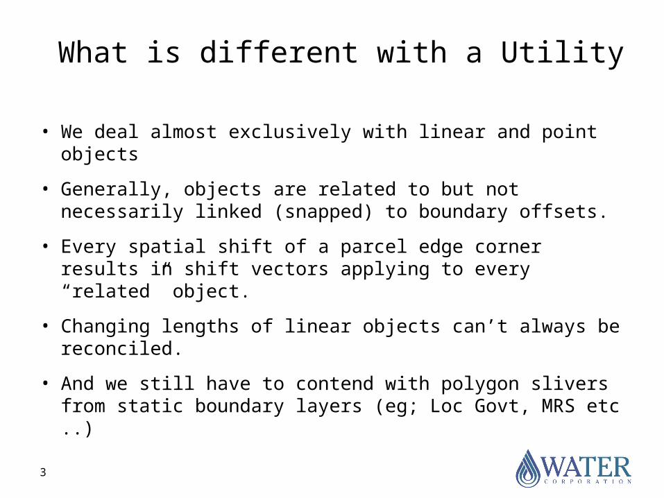
What is different with a Utility
• We deal almost exclusively with linear and point objects
• Generally, objects are related to but not necessarily linked (snapped) to boundary offsets.
• Every spatial shift of a parcel edge corner results in shift vectors applying to every “related” object.
• Changing lengths of linear objects can’t always be reconciled.
• And we still have to contend with polygon slivers from static boundary layers (eg; Loc Govt, MRS etc ..)

4
(not) Just another map!
WaterWaterSewerSewer

5
Conflict in Our Business Needs
Submit Development Application to
DPI
DPI Refers to Agencies for
comment
Applicant submits
proposed asset details for approval
Engineering/precalc survey
revisions
Deposit Plan at Landgate
WAPC Final Approval
Data captured into GIS – continually revised & updated from Survey information
Landgate capture data from lodged survey plans.
Current lodged survey plans applicable until this point

6
The Cadastral relativity problem• Data was originally digitised from hardcopy plans at various
scales with a resulting low degree of spatial accuracy.
• ~1992, the Water Corporation stopped utilising spatial updates from the authoritative Landgate database and maintained data in isolation.
• Landgate continued to improve accuracy of its SCDB.
• Adhoc acquisitions of data from Landgate in outlying urban areas revealed a growing disparity with Core Land data.
• Recent expansion (explosion) of digital data requests and experienced GIS users indicates customers may not be as willing to “warp” our data to fit theirs.

7
Examples of current data variation
Figure 1
Example of variation of road centreline to parcel edges. - Boyanup
Road centreline - Green
Parcel edges - Black
Figure 2
Example of parcel edge variation Landgate to Water Corporation. - Boyanup
Landgate - Blue
Water Corporation - Black

8
Another example
Road centre-line
Our street location

9
Issues with Boundary Offset Relationships
2.5m offset from corner
Note change in pipe length
!

10
So, What’s the point?
• If we never share our data – keep it to ourselves, then we don’t need to do anything.
• Why not just ignore the impact on others and our own data capture issues and continue as before.
• Why not just delete all the land and start again.
• Someone else has done this before – why not ask them why they did it (& how)?

11
Our Project - Progress to date
• Phase 1 - Feasibility completed– Identified a significant impact on the business
when comparing our asset locations against other external datasets.
– Identified at least 17 prospective toolsets ostensibly covering the land base alignment process.
• Phase 2 - toolset evaluation pilot, cost and revised process discovery just started.

12
Other takeaways!
• Regardless of the known, accurate absolute location of our assets, we are obliged to relate asset location to cadastre.
• Use of Imagery greatly increases the perception of land base error.
• There is a product discrepancy between source data and user’s required accuracies.
• Dependent customer agencies should not be subjected to unnecessary “shifts”.
13
THANK YOU