WASHINGTON I GEOLOGIC NEWSLETTER - WA - DNR › Publications › ger_washington_geology_198… ·...
19
WASHINGTON I GEOLOGIC NEWSLETTER Volume 13 Numbers 3 & 4 Geologist Mike Korosec of the Division of Geology and Earth Resources works to unravel stratigraphic puzzles in the southwest quarter of Washington as part of the state geologic map project (see story on p. 1). STATE OF WASHINGTON DEPARTMENT OF NATURAL RESOURCES BRIAN J. BOYLE, Commissioner of Public Lands ART STEARNS, Supervisor DIVISION OF GEOLOGY AND EARTH RESOURCES RAYMOND LASMAN IS, State Geologist October 1985
Transcript of WASHINGTON I GEOLOGIC NEWSLETTER - WA - DNR › Publications › ger_washington_geology_198… ·...

WASHINGTON I
GEOLOGIC NEWSLETTER
Volume 13 Numbers 3 & 4
Geologist Mike Korosec of the Division of Geology and Earth Resources works to unravel stratigraphic puzzles in the southwest quarter of Washington as part of the state geologic map project (see story on p. 1 ) .
STATE OF WASHINGTON DEPARTMENT OF NATURAL RESOURCES
BRIAN J. BOYLE, Commissioner of Public Lands ART STEARNS, Supervisor
DIVISION OF GEOLOGY AND EARTH RESOURCES RAYMOND LASMAN IS, State Geologist
October 1985

_ "To pO(tlond
""'· Exit 108 ·:
South
Sound .. C
Moll :i: ~ .. 0 .. iii
O Artlit Circle
1¥1ortln Woy
\- !5
GEOLOGY AND /.
EARTH R~CES l fen ·~ ~· } .~ ... i ~-------'--~~-~ '? 0PaUl•on\ : •••• •• Par k1no. • ·• • ~- .•.. , . • • . .• . . . . • .
C" IJ)
r~~ .. 'Entrance
..
· ....... 0. · 4224 6th Ave. S.E., Lacey, Washington Albuhon,
MAILING ADDRESS:
Department of Natural Resources Division of Geology and Earth Resources Mail Stop PY-12 Olympia, WA 98504
(206) 459-6372
Field office address:
Department of Natural Resources Division of Geology and Earth Resources Spokane County Agricultural Center N. 222 Havana Spokane, WA 99202
(509) 456-3255
t N
' St. Mortin~
Coll•~•
,
The Washington Geologic Newsletter, a quarterly report of geologic articles, is published by the Division of Geology and Earth Resources, Department of Natural Resources. The newsletter is free upon request.
The Division also publishes bulletins, information circulars, reports of Investigations, and geologic maps. A list of these publlcat ions will be sent upon request .

STATE GEOLOGIC MAP PROGRESS
Initial plans for producing an updated geologic map
of the state wer,e reported in this newsletter in October, 1983 (see "Division to start work on new geologic map"}. First, a review of those plans for those who do not have access to the October, 1983, newsletter:
The new state geologic map is to be published at 1 :250,000 scale, and it will be published in four quadrants. The quadrant boundaries are 47°15' N. lat. and 120°30' W. long. The southwest quadrant will be published in 1986, and the northeast in 1988. The northwest and southeast quadrants will be published in 1990 and 1992, but the order of publication has not been decided. The geologic map quadrants will be printed on a new topo· graphic base map produced by the Division , using source data from the U.S. Geological Survey l: 100,000 (30' x 1 ° ) series of topographic maps.
The geology is being compiled in two stages. Existing geologic mapping and reconnaissance geologic mapping by Division staff geologists is being compiled at 1:100,000 scale. Each staff geologist has responsibility for compilation of two or more 1:100,000-scafe geologic maps. When these compilations have been completed, reviewed, and adjusted to produce a consistent geologic portrayal, they wil I be used as source materials for the 1 :250,000-scale geologic compilation. The 1:100,000-scale maps will be printed in three colors in our Geologic Map (GM) series, or open-filed, as appropriate. Following extensive review and editing, the 1 :250;000 compilation will become the source document for cartographic preparation of printer's materials. This general plan wil l be followed for all four state geologic map quadrants.
Since October, 1983, there has been considerable progress in both the southwest and northeast quadrants. The southwest quadrant is being compiled by five staff geologists in the Olympia office - Mike Korosec, Josh Logan, Bill Phillips, Hank Schasse, and Tim Walsh. Geologic compilation for the 18 30' x 1 ° quadrangles that fall entirely or partly within the state map southwest quadrant are expected to be completed by the end of October, 1985. The compilers will complete a master description of map units and correlatioh diagram at the
same time. These map products will begin to become available, either in open-file or published form, by the end of 1985.
The new southwest quadrant 1 :250,000-scale base maps should be completed by mid-November, 1985. They are being prepared by cartographers Don Hiller, Keith Ikerd, and Nancy Herman .
The southwest quadrant 1 :250,000-scale geologic compilation should be completed by the end of 1985, and editorial and cartographic work should be finished in time to allow for publication by June or July, 1986.
During the last two years, the southwest quadrant compilers and field assistants - Keith Kaler, Curtis Cushman, and Matt McClincy - have spent thousands of hours both in the office and in the field, working on the geology of southwest Washington. They have been on field trips with several geologic mappers from other organizations, logged tens of thousands of miles on the road, collected nearly 250 rocks for chemical analysis, and submitted approximately 30 sam ples for age dating. The Division has sponsored two dozen mapping projects around the state by university personnel. The Centralia, Mount Rainier, Mount St. Helens, Mount Adams, and Vancouver 1: 100,000 sheets, all in or bordering the Cascade Range, have required the most work, since in general they are the least-mapped quadrangles in the southwest quadrant.
The staff of the Division's field office in Spokane - Keith Stoffel, Nancy Joseph, Bonnie Bunning (recently transferred to Olympia), and field assistant Stephanie Zurenko - are making good progress on the northeast quadrant. A 1:100,000-scale geologic compilation has been finished for the Robinson Mountain quadrangle. The Oroville, Chewelah, and Colville quadrangles should be finished by December, 1985, and the Republic and Spokane quadrangles should be finished by next spring. The Spokane staff has also established many contacts with geologic mappers who have worked or are working in northeast Washington, and they have completed an initial survey of existing geologic maps.
GRADUATE STUDENT MAPPING UNDER THE STATE GEOLOGIC MAP PROGRAM
Fol lowing a successful program last year, the Division of Geology and Earth Resources is again sponsoring graduate students who are engaged in thesis projects that will contribute geologic mapping to our continuing state geologic map program. In 1984 the Division sponsored 14 graduate students, five working in the southwest quadrant of the state, six in the northeast, and three in the northwest. We are pleased to report that the graduate stu-
dent support project succeeded in providing geologic maps in some poorly mapped areas of the state, in supporting graduate students who are working on thesis projects involving geologic mapping in Washington , and in strengthening the t ies between the Division and university departments of geology.
The 1985 request for proposals was issued on March 11, with a May 15 deadlihe for submission of
proposals. This request placed the hfghest priority on proposals for geologic mapping in the northeast quadrant of the state, for which we plan to publish a new state geologic map quadrant in 1988. Included in the request was a map of the northeast quadrant showing the areas where geologic mapping is most needed.
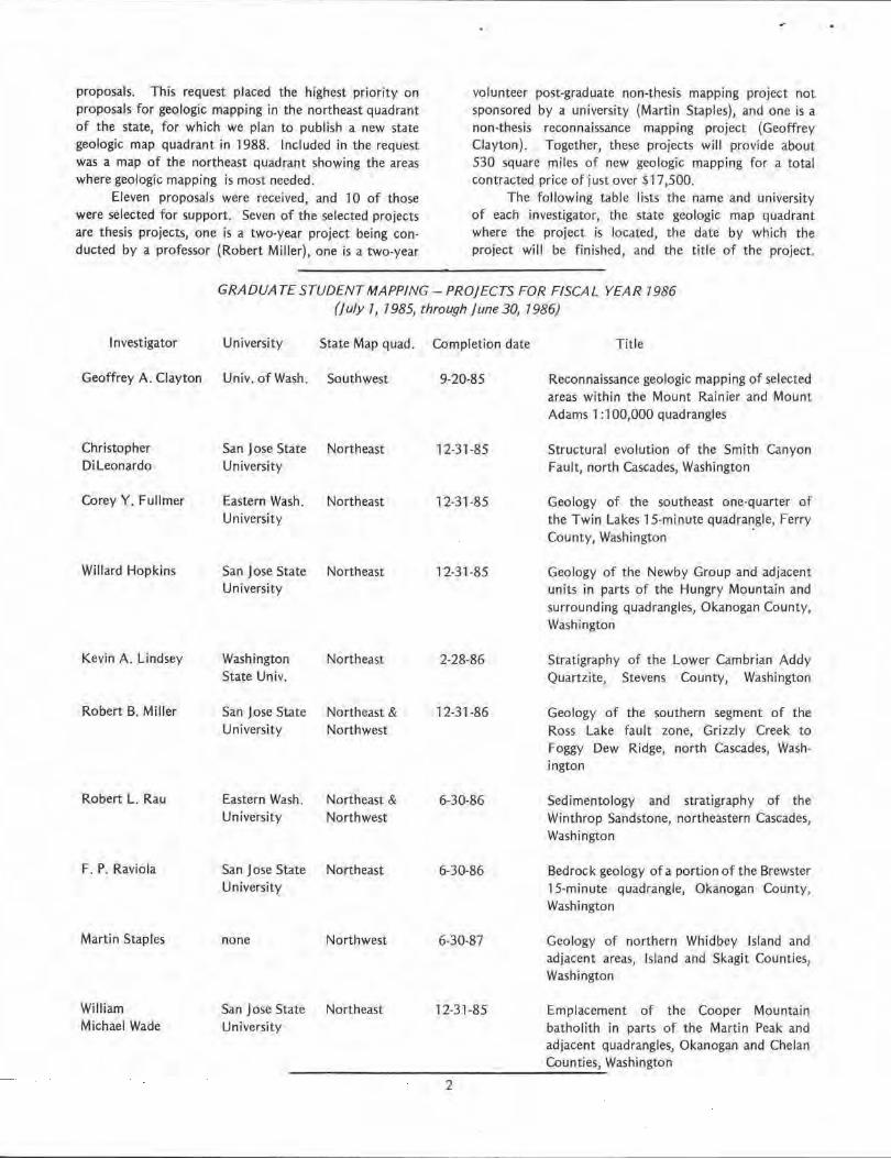
Eleven proposal.s were received, and 10 of those were selected for support. Seven of the selected projects are thesis project.s, one is a two-year project being conducted by a professor {Robert Miller), one is a two-year
volunteer post-graduate non-thesis mapping project not sponsored by a university {Martin Staples), and one is a non-thesis reconnaissance mapping project (Geoffrey Clayton). Together, these projects will provide about 530 square miles of new geologic mapping for a total contracted price of just over $17,500.
The following table lists the name and university of each investigator, the state geologic map quadrant where the project is located, the date by which the project will be finished, and the title of the project.
GRADUATE STUDENT MAPPING-PROJECTS FOR FISCAL YEAR 7986 (J u/y 7, 1985, through j une 30, 7 986)
Investigator
Geoffrey A: Clayton
Christopher Di l eonardo
Corey Y. Fullmer
Willard Hopkins
Kevin A. Lindsey
Robert B. Miller
Robert L. Rau
F. P. Raviola
Martin Staples
William Michael Wade
University State Map quad.
Univ. of Wash. Southwest
San Jose State Northeast University
Eastern Wash. Northeast University
San Jose State Northeast University
Washington Northeast State Univ.
San Jose State Northeast & University Northwest
Eastern Wash. Northeast & University Northwest
San Jose State Northeast University
none Northwest
San Jose State Northeast University
Completion date Title
9-20-85 Reconnaissance geologic mapping of selected areas within the Mount Rainier and Mount Adams 1 :100,000 quadrangles
12-31-85 Structural evolution of the Smith Canyon Fault, north Cascades, Washington
12-31-85 Geology of the southeast one-quarter of the Twin Lakes 15-minute quadrangle, Ferry County, Washington ·
l2-31-85 Geology of the Newby Group and adjacent units in parts of the Hungry Mountain and surrounding quadrangles, Okanogan County, Washington
2-28-86 Stratigraphy of the Lower Cambrian Addy Quartzite, Stevens County, Washington
12-31-86 Geology of the southern segment of the Ross Lake fault zone, Grizzly Creek to Foggy Dew Ridge, north Cascades, Washington
6-30-86
6-30-86
6,30,87
12-31-85
Sedimentology and stratigraphy of the Winthrop Sandstone, northeastern Cascades, Washington
Bedrock geology of a portion of the Brewster 15-minute quadrangle, Okanogan County, Washington
Geology of northern Whidbey Island and adjacent areas, Island and Skagit Counties, Washington
Emplacement of the Cooper Mountain batholith in parts of the Martin Peak and adjacent quadrangles, Okanogan and Chelan Counties, Washington - - - --,---------------
2

1984 LAW AFFECTS HOLDERS OF StVERED MINERAL RIGHTS
The 1984 state fegislature passed a new law (Title 78 RCW, Chapter 252) that allows a surface-rights owner to extinguish and acquire the subsurface-mineral rights to his land if the owner of the mineral rights has not used those rights in 20 years, or has not filed a statement of claim to the mineral rights with the appropriate county auditor by June 7, 1986, whichever is later.
The mineral interest is considered used if; 1) 2) 3) 4) 5) 6) 7) 8)
9)
Minerals have been produced from it; Operations for injection1 withdrawal, storage, or disposal have been conducted; Rents or royalties have been paid for the purpose of using the mineral interest; The mineral interest has been exercised for the purpose of unitization or pooling for production; In the case of coal or other solid minerals, the minerals have been produced from a common vein or seam; Taxes have been paid on the mineral interest; Any use relating to or authorized by the instrument conveying the mineral interest has been taken; A sale, lease, mortgage or other transfer of mineral interest has been recorded in the appropriate county auditor's office prior to the end of the 20-year period or within two years of the date of enactment June 7, 1984, whichever is later; A statement of claim has been filed by the owner of the mineral interest in the county auditor's office before June 7, 1986.
A surface owner can extinguish and acquire title to the unused mineral rights by: 1) Delivering in person or by registered mail a 60-day ''Notice of Intent to File a Claim of Abandonment and
Extinguishment'; to the last known address of the mineral-interest owner; 2) If the fast known mineral-interest owner cannot by determined after due diligence, the surface owner may
serve notice upon the holder of the mineral interest by publishing a notice once a week for three consecutive weeks in:
a) b)
a newspaper of general circulation published in the county; or if there is no paper published in the county, by publishing the notice in a paper in an adjoining county; or
c) if there is no paper published in an adjoining county, by publishing the notice in a newspaper of general circulation published in the state capital.
Mineral interests held by a public entity are not subject to a claim of abandonment. Legal forms for filing a "Statement of Claim of Mineral lnterest'1 or a ''Claim of Abandonment and Extinguishment of Mineral Interest" can be purchased from Washington Legal Blank, Inc. of Issaquah, Washington (800-824-4929). The forms should be filed with the county auditor of the county in which the mineral rights are located.
ROCKHOUNDS: CAUTION
Please be advised that when collecting petrified wood, minerals, or fossils you should not trespass on lands administered by Washington State Game Department. In 1981 the department promulgated WAC 232-12-254, which makes it un lawful to remove any materials from lands administered by the Game Department without a permit issued by the director.
MISSING-LINK DEPARTMENT
The Washington Geologic Newsletter was not issued in July, because of the retirement of the editor. Thus, this October edition incorporates Numbers 3 and 4 of Volume 13.
3
SURVEY OF MINING AND MINERAL ACTIVITY
The annual questionnaire o n mining and mineral activity in Washington has been mailed to companies and individuals on our mailing list for the 1985 work year.
If you were active 1n the state in 1985 but have not received a questionnaire, please write or cal l Bonnie Bunning in Olympia at (206) 459-6372 or Nancy Joseph in Spokane at (509) 456-3255.
The information submitted to us wil l be reported in our January newsletter. We welcome as much · detail as you care to provide. Nothing is considered confidential unless expressly noted. The deadline for returned questionnaires is November 11, 1985.

ABANDONED COAL MINE INVENTORY UPDATE
by Henry W. Schasse *
In 1984, the Washington Department of Natural Resources, Division of Geology and Earth Resources (OGER}, in a cooperative agreement with the federal Office of Surface Mining (OSM), completed an inventory of abandoned coal mines 1n the state. The inventory identified 84 problem areas in eight counties with abandoned mine land.
AML problems were assigned priorities which relate to the. danger they pose to the general public. Priority 1 problems represent a serious threat to public health, safety, and(or) general welfare; these are extreme danger problems. Priority 2 problems represent a moderate or limited threat to public health, safety and(or) general welfare.
Twenty-six of the problem areas identified by the inventory were classed as priority 1, earmarking them for future reclamation consideration by OSM. The results of this study (LaSalata and others, 1985) were summarized in OGER Open-File Report 84-6 (an nounced in the Washington Geologic Newsletter, April 1985).
In addition to the OGER inventory, five areas within the above areas were targeted for more detailed inventories (Walsh and LaSalata, 1984). Contracts were awarded by OSM to consulting companies for detailed inventories in the five areas, which are: Newcastle-Coal Creek, Roslyn-Cle Elum, Renton, Issaquah, and Bel lingham. These inventories were completed in late 1984 and early 1985. The final reports of the DGE R and the five detailed inventories are available for reference at the OGER library in Lacey, Washington , and in the communities where the inventories were performed. The ,general results of the five inventories are given below. The final reports are referenced at the end of this article.
Newcastle-Coal Creek At least 166 AML features were identified by this
inventory. Twenty-seven were classed as priority 1 problems, and 34 were classed as priority 2. Of the five inventoried areas, this area contains the most serious AML hazards.
Work associated with the inventory also included the immediate erectioh of temporary fences around 16 of the worst hazards until more permanent closures could be designed. OSM has contracted for engineering services to develop closure designs for the priority 1 hazards. The contractor is Skelly and Loy Engineers-Consultants of Lexington, Kentucky, which also performed the inventory. The contract work will consist of the design of closures, development of construction specifications, and estimation of closure costs. OSM plans to begin construction on the first group of closures in the summer of 1986. Copies of
* Division of Ceo}ogy and Earth Resouzces Geolopst. 4
the inventory final report {Skelly and Loy, 1985} are available at the Issaquah and Newport Way branches of the King County Library System.
Roslyn-Cle Elum · Seventeen AML problem areas were defined by the
inventory in an area containing at least 160 identified AML features. Eight of the problem areas were classed as priority 1, and eight were classed as priority 2.
A pre-bid scheduled for July 2, 1985, was to address reclamation for the priority 1 problems. The reclamation was scheduled to be completed by September of this year at a cost of approximately $150,000.
A copy of the final report of the AML inventory (Walker and Shideler, 1984) is available for reference at the Office of Kittitas County Planner in Ellensburg, Washington.
Renton Seven areas disturbed by past mining were investi
gated for this inventory. One priority 2 AML problem was identified. No reclamation is planned for this area. The final report (Morrison-Knudsen, Inc., 1985) is available to the public at the Renton Public Library.
Issaquah Fifty,five identified AML features and 19 problem
areas were recognized in and near the city of Issaquah. Two of the problem areas were classed as priority 1, ahd 17 were classed as priority 2. Reclamation to rectify the priority 1 problems is targeted for 1986 by OSM. A copy of the inventory final report (Goodson and Associates, 1984) can be seen at the Environmehtal Coordinator office in Issaquah .
Bellingham Two large mines and two smaller mines have operated
in the past in Bellingham. Three priority 2 AML problems were identified for each of the two large mines. No AML hazards were identified for the two smaller mines. A copy of the final report (Tetra Tech, Inc., 1984) is available at the Bel lingham City Planner office. No reclamation is planned, as no priority 1 problems were identified.
REFERENCES
Goodson and Associates, Inc., 1984, Abandoned coal mine survey in the area of Issaquah, King County, Washington: U.S. Office of Surface Mining contracted to Goodson and Associates, Inc. [Denver I, 2 vols., 8 plates.

LaSalata, F. V.; Menard, M. C.; Walsh, T. J.; Schasse, H. W., 1985, Inventory of abandoned coal mines in the State of Washington: Washington Division of Geology and Earth Resources Open-File Report 84-6, 42 p.1 4 appendices.
Morrison-Knudsen Company, Inc., 1985, Engineering investigation for the Renton, Washington area : U.S. Office of Surface Mining, contract no. )5140078, contracted to Morrison-Knudsen Company Engineers-Consultants, Inc. [Boise], 87 p., 8 plates.
Skelly and Loy Engineers-Consultants, 1985, Abandoned coal mine survey, Coal Creek, King County, Washington: U.S. Office of Surface Mining contracted to Skelly and Loy Engineers-Consultants [Harrisburg], 3 vols., 2 plates.
NWMA TO CONVENE
The Northwest Mi ning Association will hold its 91 st annual convention December 5-7 in Spokane, Washington . More than 70 speakers will describe new operating ideas and discoveries, market developments, and changes in regulations. A workshop titled "Micro-Computer Applications for the Mineral Industry" will precede the con· vention on December 2-4, and the Pacific lntermountain Mining Show will be held concurrently.
Thursday sessions are: pre-convention government/ industry forum; geology of precious metals I; swdent poster session; geophysics/geochemistry; new opportunities for mining and minerals; and regulatory developments.
Friday sessions are: geology of precfous metals 11 ; student poster session ; state reports-U .S. ; markets/ economics; industrial minerals; health and safety; geology of precious metals 111; student poster session; provincial reports- Canada; mine management; and energy.
Saturday sessions are: geology of gold and silver deposits-Canada; geostatistics; Alaskan development; and U.S. Bureau of Mines open house-75th anniversary celebration .
For information on registration and other activities connected with the convention, write to Northwest Mining Association, 633 Peyton Bldg., Spokane, WA 99201; phone (509} 624-1158.
5
Tetra Tech, Inc., 1984, Final report- Bellingham abandoned mine land survey: U.S. Office of Surface Mining, contract no. J 5140076, contracted to Tetra Tech, Inc. [Englewood, Colo.], 33 p., 7 plates.
Walker, C. W.; Shideler, J. C.1 1984, Final report on abandoned coal mine hazards in the Roslyn coal field, Kittitas County, Washington: U.S. Office of Surface Mining, contract no. J 5140044, contracted to George E. Maddox and Associates [SpokaneJ, 3 vols., 5 envelopes of maps.
Walsh, T. J .; LaSalata, F. V.1 1984, Abandoned coal mine inventory: Washington Geologic Newsletter, v. 12, no. 3, p. 1-4.
PRODUCTION BEGINS AT THE WAUCONDA WHITESTONE DEPOSIT
by Charles Gulick 1 and Paul Carne~i2
Columbia River Carbonates of Woodland, Wash., and Genstar Stone Products of Baltimore, Md., have began production at their Wauconda Whitestone deposit in northeastern Okanogan County.
Genstar conducted extensive reconnaissance of calcium carbonate whiting potential in Washington state from September through December, 1984. Several major marble districts were identified, geochemically sampled, and structurally analyzed. In December, a previously unrecognized site in sec. 13, T. 38 N., R. 30 E. was discovered by the authors. Subsequent mapping, comprehensive core drilling, and geochemical testing delineated the Wauconda Whitestone deposit.
The deposit is located offToroda Creek Road about four miles north of Waucohda, where the marble crops out in a series of mountainside bluffs. The overall structure consists of a podiform calcite marble lens nested within micaceous and calc-silicate schists, phyllites, and amphibo· lites of the Permian Spectacle Formation.
Quarrying and crushing began in September and will continue through November, weather permitting. The marble will be stockpiled for milling by Columbia River Carbonates at their Woodland, Wash., processing fac ility, currently under construction.
Geologic consultant, 2 Genstar Director of Land Management.

"' C .2
PACIFIC COAST COAL TO OPEN JOHN HENRY MINE
Pacific Coast Coal Co. plans to begin operations at its John Henry mine in King County this fall, and coat production from the facility might begin as early as the spring of 1986, according to a company new release.
The King County zoning and subdivision examiner had recommended approval of a 402-acre rezoning which would al low surface coal mining at the site. Federal approval was received earlier.
According to the company, the John Henry mine will produce 250,000 tons per year of coal to supply Puget Sound industries which presently rely on imported coal. The mine would employ 90 people.
VALUE OF WASHINGTON MINERAL PRODUCTION ($ in Thousands)
Sand, Stone &
1 Year Gravel Coal Cement Other Total
1975 54,353 30,000 26,924 31,307 142,584
1976 49,170 31,200 63,764 46,859 180,993 1977 62,481 31,200 49,000 52,015 194,696 1978 70,430 NIA 72,886 30,805 174,121
1979 95,433 NIA 82,354 47,161 224,948 1980 76,251 76,496 89,208 41,903 283,858 1981 77,465 77 ,154 102,129 32,894 289,632 1982 72,845 94,864 79,000 30,785 277,494 1983 84,525 102,814 102,940 290,279 1984 86,400 108,925 108,821 304,146
Includes gold, silver, copper, lead, zinc, tungsten, etc.
Table: NT08
Source: Department of Natural Resources
300 -- ----
-
~ 200 -~
"' 0 a
100
- --
-
-
I ' I I
1975 1976 1977 1978 1979 1980 1981 1982 1983 1984
VALUE OF WASHINGTON MINERAL PRODUCTION
6
CARL McFARLAND RETIRES
Carl McFarland, who managed the Division of Geology and Earth Resources regulatory programs (Surface Mined land Reclamation, Oil and Gas Drilling, and Geothermal Drilling), retired on May 31, 1985, after almost 17 years of service with the Department of Natural Resources.
Carl holds Bachelor of Science and Master of Science degrees in geology from Brigham Young University, where he attended from 1949 to 1955. Between 1955 and 1968 he worked for the Atlantic Refining Company, as a self-employed construction contractor, and as a building inspector for the City of Olympia, He came to work in the Lands Division of the Department of Natural Resources in 1968 as a geologist 2. In 1971 he was promoted to geologist 3. His duties with the Lands Division included mineral and oil and gas leasing and sales of minerals from state-managed lands.
He transferred to the Division of Geology and Earth Resources in 1978, where he compiled publications on oil and gas exploration and mining operations, mantained the Division 's oil and gas drilling records, and participated in field studies to assess oil and gas potential in western Washington. In 1983 Carl was promoted to geologist 4 and assumed responsibility for managing the surface mining, oil and gas, and geothermal regulatory programs.
Our staff regards Carl highly, both personally and professionally. His sense of humor and willingness to help in any situation - whether it was to give advice on a reclamation or drilling project, or an analysis and suggestions on someone's remodeling plans - meant that his time was never his own. But the Division and Department and many of his coworkers are unquestionably the richer for his contributions.
Carl tells us that he and his wife, Margaret, plan to travel, and they will go on an extended trip to England. We strongly suspect that he will continue to take on an occasional construction project as well.
STAFF CHANGES
The Division of Geology and Earth Resources has experienced several staff changes in recent months.
Carl McFarland's retirement is covered in another article in this newsletter. We have just finished recruiting for his replacement, and plan to have that person on staff before the end of November.
The retirement of Wayne Moen on June 30, 1982, left our Olympia office without a staff economic geologist. We have rectified this situation by promoting Bonnie Bunning to Geologist 4 and transferring her to Olympia. Bonnie formerly served as lead geologist in our Spokane field office. Her promotion became effective on May 6, 1985.

Bonnie's vacant position in Spokane was fill ed by promotion. Keith Stoffel, formerly Geologist 2 in the Spokane field office, was promoted to Geologist 3 and Spokane field office lead geologist effective April 1, 1985.
The resu lting vacancy in the Spokane office was filled with the hirfng of Nancy Joseph as economic geologist at the Geologist 2 level. Nancy's appointment was effective on July 1, 1985. She has had considerable experience as an economic geologist in the State of Washington, having most recently worked for ASARCO in Spokane.
Our editor, Laura Bray, retired last spring (see April 1985 Washington Geologic Newsletter). We have succeeded in upgrading the position to that of a Geologist/ Editor and have filled the position by hiring Larry Stout,
effective on August 12, 1985. Larry has considerable experience as a geologic editor for the Missouri Geological Survey and several other organizations, most recently the U.S. Agency for International Development.
Finally, Pam Whitlock, who has served as our office manager for almost 10 years, most recently in an Administrative Assistant 2 position, has landed a promotion to Administrative Assistant 3 with the State Department of Community Development in Olympia. Her move became effective on September 23, 1985. Our vacant Administrative Assistant 2 position will be fi lled by Susan Davis, effective on October 14, 1985. Susan is now an Administrative Assistant 2 with the State Department of Fisheries in Olympia.
RECENTLY RELEASED PUBLICATIONS OF THE WASHINGTON DIVISION OF GEOLOGY
AND EARTH RESOURCES Copies of these publications may be obtained by
writing to the Department of Natural Resources, Division of Geology and Earth Resources, Olympia, WA 98504.
Please send $1 to cover our handling and distribution charge for your total publication order.
Hooper, P.R.; Webster, G.D.; Camp, V, E., 1985, Geologic map of the Clarkston 15-minute quadrangle, Washington and Idaho : Washington Division of Geology and Earth Resources Geologic Map GM-31, 1 sheet, scale 1:48,000. Free.
The geologic map of the Clarkston 15-tn inute quadrangle, Washington and Idaho, is the latest in a continuing series of geologic maps published by the Division of Geology and Earth Resources and funded by the U.S. Department of Energy. The purpose of this map series is to improve and make public geologic coverage in areas of the Columbia Basin where the interpretation of complex stratigraphy and structure are particularly important for the evaluation of the Hanford Reservation as a potential site for the long-term storage of nuclear waste.
The map is printed in fu ll color at a scale of 1 :48,000, and includes one cross section, legend, and an abbreviated description of map units. The text includes detailed descriptions of the map units, a table showing average chemical analyses of Columbia River basalt lava flows and dikes, with standard deviations given for flows with ten or more analyses, and references cited.
P.R. Hooper and G.D. Webster are Professors of Geology at Washington State University, and V.E. Camp is a former Washington State University graduate student in geology.
7
MIiis, J. W., 1985, Geologic maps of the Marcus and Kettle Falls quadrangles, Stevens and Ferry Counties, Washington: Wash ington Division of Geology and Earth Resources Geologic Map GM-32, 2 sheets, scale 1 :24,000. Price $5.53 plus .47 tax .
The geologic maps of the Marcus and Kettle Falls quadrangles, Stevens and Ferry Counties, Washington, comprise two 1 :24,000-scale plates and an 18-page text. Plates 1, Kettle Falls quadrangle, and 2, Marcus quadrangle, are printed in full color with abbreviated legends and descriptions of map units, The text includes detailed descriptions of the geologic units, interpretations of the structural geology, references cited, and 14 figures, most of which are stereograms illustrating the structural geology of the two quadrangles.
The text and maps were prepared by J.W. Mills, former Professor of Geology at Washington State University, who has many years of experience in the geologic mapping, structural analysis, and economic geology of northeastern Washington. Dr. Mills mapped these two quadrangles during the summers of 1962, 1963, and 1964 with the assistance of Herbert Bradshaw and Robert Souders.
Noson, L. L.; Ludwin, R. S.; Crosson, R. S., 1985, Compilation of earthquake hypocenters in western Washington-1979 ; Washington Division of Geology and Earth Resources Information Circu lar 79, 19 p, Price $ .46 plus .04 tax.
This is the eighth report in an annual series designed to provide a standarized compilation of earthquake locatlo[ls determined from network data. A multistation

telemetered seismograph network has been operated in western Washington on a continuous basis since 1970 by the Geophysics Program, University of Washington. Stations transmit data on the location, sizes, and properties of earthquakes back to the central faci lity. These data are compiled for the published reports, which contain machineplotted yearly summary maps with the epicenter locations and magnitudes. A chronological list of earthquakes is presented for each year.
NEW OPEN-FILE REPORTS AVAILABLE FROM THE WASHINGTON DIVISION OF GEOLOGY AND
EARTH RESOURCES
The following open-file reports may be purchased from the Department of Natural Resources, Division of Geology and Earth Resources, Olympia, WA 98504; they are also available for inspection in our Division library.
Please send $1 to cover our handling and distribution charge for your total publication order.
Mil ler, R. B., 1985, The pre-Tertiary Rimrock Lake inlier, southern Cascades, Washington: Washington Division of Geology and Earth Resources OpenFile Report 85-21 16 p., 1 plate. Price $1.39 p)us .11 tax.
Lasmanis, Raymond; Hall, Tammy, 1985, A geologic feasib!lity study for the Superconducting Super Collider: Washington Division of Geology and Earth Resources Open-File Report 85-3, 41 p., 6 plates. Price $5,30 pJus .45 tax.
GEMS ANO MINERALS BROCHURE REPRINTED
During 1983 a joint effort between Bob Pattie of Washington State Mineral Council and the Division of Geology and Earth Resources, Department of Natural Resources, produced a brochure titled ' 'Gems and Minerals of Washington". The first printing of 25,000 has been distributed.
We wish to announce the reprinting of this popular pamphlet in a slightly revised version. It provides the reader an overview of the state's mining history, a list of museums and rock clubs, and a location map showing noted collecting sites.
The brochure can be obtained free of charge from the Division. Multiple copies will be sent to rock clubs and other organizations upon written request.
8
The first report in this series, Information Circular 53, published in 1974, contains a description of network instrumentation, background information, a glossa(y of terms, and a compilation of earthquake data for 1970, 1971, and 1972. Information Circu lars 55 and 56 contain information on earthquakes that occurred in 1973 and 1974; Information Circulars 64, 65, 66, and 72 contain information for the years 1975, 1976, 1977, and 1978, respective I y.
Mills, J. W., 1985, Geology of the Kettle Falls, Marcus, Colville, and Echo Valley quadrangles, northeast Washington: Washington Division of Geology and Earth Resources Open-File Report 85-4, 6 p. Price $0.46 plus .04 tax.
Danes, Z. F ., 1985, Sedimentary thickness in the Puget Sound area, Washington, derived from aeromaghetlc data: Washington Division of Geology and Earth Resources Open-File Report 85-5, 15 p. Price $0.46 plus .04 tax.
Blackwell, D. D.; Steele, J. L.; Kelley, S. A., 1985, Heat flow and geothermal studies in the State of Wash· ington: Washington Division of Geologv. and Earth Resources Open-File Report 85-6, 83 pages. Price $ 2.32 plus .18 tax.
Mil ls, J. W.; Duncan, G. W.; Brainard, R. C.; Hogge, C. E,; Laskowski, E. R., 1985, Geologic maps of the Echo Valley and the north part of the Colville 7t-minute quadrangles, Washington: Washington Division of Geology and Earth Resources Open-File Report 85-7, 2 sheets, scale 1 :24,000. Price $ 1.39 plus .11 tax.
GSA ANNOUNCES DNAG SERIES
The Geological Society of America announces the publication of GSA 's Decade of North American Geology (DNAG} project. It has been described as "one of the most extensive publication efforts ever undertak,en in the earth sciences."
The set includes 28 volumes with 6 fie ld gtJides, 4 special topical volumes, 23 continental-ocean transects, and 7 continent-scale geologic or geophysical maps of North America. The director of the U.S. Geological Survey has said, "The DNAG publications will undoubtedly prove to be a standard reference for North American geology for many decades to come."
A prospectus of the DNAG publications wil l be mailed to more than 65,000 earth scientists, Price information and details of the speciaf purchase options t hat will be offered until March 1, 1986, are included in the prospectus.

NEW OREGON MAPS AVAILABLE
Two maps which together provide minerals information from the eastern border of Oregon to 131° W. longitude in the Pacific Ocean have been published this year by the Oregon Department of Geology and Mineral Industries. The maps are non-technical and intended for use by the general public.
The "Mineral Resources Map of Oregon" (GMS-36), which covers the state, summarizes past mineral production, describes current minerals activities, and suggests areas where as-yet-undiscovered resources may be found.
The " Mineral Resources Map, Off5hore Oregon"
(GMS-37) covers an area from the crest of the Coast Range to 300 nautical miles west of the Oregon coast, including the recently declared Exclusive Economic Zone; the Gorda Ridge, a target of mineral exploration; and the Juan de Fuca Ridge, where hot springs and accompanying mineralization were discovered a few years ago. The bathymetry of the map enables the user to locate features described in recent newspaper and magazine articles.
Each map is printed in color at a scale of 1 :500,000 and measures 42 x 59 inches. They can be purchased by sending prepayment of $8 for GMS-36 and $6 for GMS-37 to the Oregon Department of Geology and Mineral Industries, 1005 State Office Bldg., Portland, OR 97201.
SUMMARY OF U.S. GEOLOGICAL SURVEY CURRENT ACTIVITIES IN WASHINGTON
The projects cited below are taken from a list supplied by the USGS In July 1985. We have categorized the work under a few broad headings here for convenience, although several of the projects have broader overall scope than the headings would indicate, or a somewhat different focus outside Washington.
GEOLOGIC MAPPING AND STRATIGRAPHY
Geologic map of the Cascade Range - Compilation of a geologic map of the Cascade Range in the State of Washington at 1 :500,000. {Compilation of an identical map for the Oregon Cascades will be initiated.) An index to K-Ar determinations on Neogene volcanic rocks in northeastern California and geologic maps of pans of the Susanville and Yakima 2-degree quadrangles are also being prepared. [Project chief: J.G. Smith.J
Mount St. Helens basement rocks - A 1 :62,500-scale geologic map of the Mount St. Helens National Volcanic Monument will be prepared, to be published by the Washington Department of Natural Resources. Geologic maps of the Spirit Lake East and West 7!1:i-minute quadrangles and a geologic map of the Spirit Lake 15-minute quadrangle are also being prepared. Fissiontrack and additional K-Ar dates for the Spirit Like area will be acquired; geochemical, isotopic, and fluid-inclusion studies of plutonic rocks will continue; a reconnaissance study of Tertiary rocks in the Washington Cascades will be initiated. [ Project chief: R.C. Evarts. J
Okanogan 2-degree quadrangle - Mapping of the Boot Mountain 15-minute quadrangle and field checking of selected problem areas in other parts of the Okanogan quadrangle. The Omak 1 :l 00,000-scale geologic map will be compiled, and the Sherman Peak 15-degree quadrangle at 1 :62,500-scale will be submitted for publication . [Project chief: K.F. Fox.]
9
Geologic map of the Colville Indian Reservation - Work to include prepartion of a geologic map of the reservation for publication and preparation of a bulletin or professional paper on some of the glacial-lake deposits of the reservation. [Project chief: C.D. Rinehart.]
West Wenatchee 1-degree quadrangle - Work continues on preparation of text material and updating of the Snoqualmie Pass 1:100,000-scale full-color geologic map. Dating studies of Tertiary and Quaternary rocks in the Snoqualmie Pass quadrangle and chem ical analyses to evaluate chemical trends in eruptive sequences will continue. lProject chief: R.W. Tabor.]
Concrete 2-degree quadrangle, east half - Modal and petrographic analyses in the study area under way. Compilation of the 1 :100,000-scale geologic maps of the Robinson Mountain and Twisp quadrangles will continue. Approximately 24 K-Ar age determinations will be made. (Project chief: R.W. Tabor.]
Olympic Peninsula, Washington continental margin - Work includes report on the Tortlary evolution and petroleum potential of the Oregon and Washington continental margin. Field and laboratory studies to evaluate the hydrocarbon potential of the middle Eocene and late Oligocene to late midd le Miocene melanges along the west coast and adjacent continental shelf of the. Olympic Peninsula wil l be completed. The geologic map of the southwestern Washington continental margin wW be completed, and compilation of a geologic map for the northwest Washington shelf at 1 :250,000 will be initiated. Geologic mapping will be re-plotted onto new 7Yl-minute base maps and will be used to prepare a 1 :62,500-scale map of the geology of the Cape Flattery area. Reconnaissance geology of the Aberdeen 15-minute quadrangle will be completed. A geologic strip map of the Cape AiavaPoint of the Arches coastal area is being prepared. [ Project chief: P.O. Sna :ely. J

Geochronology - A reconnaissance K-Ar geochronologic study of Mount Adams, Washington, will be done to delineate the age of major volcanic units and reconstruct the eruptive history. A report will be prepared on the results of Rb-Sr and K-Ar studies in the Glacier Peak Wilderness, Washington. A comparison will be made of strontium and oxygen isotope variations to evaluate hydrothermal and anatectic processes in formation of the plutonic complex. [Project chief: R.J. Flock.]
Sauk River 1-degree quadrangle - Isotope studies will continue with K-Ar, U-Th-Pb, and fission-track dating of rocks of the Sauk River 1-degree quadrangle. The traceelement content of amphibolites and greenstones in separate metamorphic terranes wi 11 be evaluated for distinguishing chemical patterns. Petrographic studies will continue, and field work will be completed. The terrane-boundary fault that passes under Glacier Peak will be investigated for indications that it might control recent volcanism and(or) hot springs. [Project chief: R.W. Tabor.]
Paleozoic biostratigraphic framework of eastern Washington - Graptolite collections from the Ledbetter Formation will be studied, and Cambra-Ordovician collections will be researched. A report on Mississippian brachiopod biogeography will be in progress. [Project chief: J .T. Dutro.]
Genesis of basalt - A report on flow correlations in the Grande Ronde Basalt in Washington will be completed. [Project chief: R.T. Helz.. ]
LANDSLIDES
Ground-failure hazards in the Columbia River Valley - Reports on landslides in the White Bluffs area of central Washington will be completed. [ Project chief: W.H. Hays.]
ORE DEPOSITS
Sea-floor hydrothermal studies - Chemical analyses of vent samples from the Juan de Fuca Ridge will be completed. Experiments on thermophilic bacteria in hydrothermal seawater will continue. (Project chief: J.L. Bischoff.]
Juan de Fuca Ridge: Structure and metallogenic processes - Focus on analysis of hydrothermal fluids, massive-metal-sulfide samples, sea-floor photographs, color video, and ancillary geophysical data collected during the AL VIN submersible cruise of October 1984. USGS R/V S.P. Lee was to refurbish the acoustic-transponder network used to position survey and sampling activities, define the depth and $hape of the magma
10
chamber under the ridge axis using ocean-bottom seismometers, conduct a photographic survey of the main AL VIN work sites of last year, and attempt dredge sampling of su lfide mineral deposits not sampled by AL VIN. I Project chief: W.R. Normark.J
Modern massive sulfides - Efforts will focus on analyses of submarine massive sulfide deposits of Juan de Fuca Ridge, offshore Washington and Oregon . [Project chief: Robin Brett.]
Massive sulfide deposits - Fifty percent of the fieldwork and map compilation for the States of Washington and Oregon will be completed. Data on the massive sulfide occurrences included on the metallogenic maps will be entered in a computer file. [Project chief: Robert Earhart.]
Juan de Fuca sulfides - Analyses of Juan de Fuca sulfides, basalts, and water will continue. l Project ch[ef: J.A. Philpotts.]
Geochem istry of stratabound sulfide deposits -Sulfur- and oxygen-isotope studies of sat!)ples from J Uan de Fuca Ridge offshore Washington and Oregon will continue. J Project chief: W.C. Shanks.]
Uranium - Stream, spring, and near-surface waters in the vicinity of an actively forming uranium deposit in northeastern Washington were found to contain recently emplaced (daughter-poor) uranium in surficial organicrich sediments. The data have been evaluated by statistical methods and modeled using mineral solution equilibria. Batch leaching of uraniferous woody peat from northeastern Washington was initiated to determine the chemical lability of contained uranium and to elucidate bonding mechanisms. Detailed studies of the Flodelle Creek uranium deposit in northeast Washington show that tho deposit started forming after the Frazier glaciation, about 11 ,000 years ago. Data suggest that surficial utanium deposits constitute a significant low-cost uranium resource. Reports on surficial uranium deposits of Flodelle Creek will be prepared. [Project chief: R.A. Zielinski, J. K. Otton.J
OIL AND GAS
Formation, composition, and resources of sedimentary rocks - Study includes petroleum geochemical assessment of melange wedges of coastal Washington, description of offshore gas hydrate occurrences, and development of a model for depositional facies in shelf deposits of Pliocene and Pleistocene age off the U.S. Pacific Coast. [Project chief: K.A. Kvenvolden.]

Frontier Tertiary and Mesozoic hydrocarbon basins Field-oriented research on the onshore oil and gas
potential of western Oregon and Washington will continue. lProject chief: R.G. Stanley.]
Convergent-margin characterization for deep-sourcehydrocarbon potential - A systematic sampling of outcrop and seeps from a late Eocene to midd le Miocene ac
cretionary melange terrane along the west coast of the Olympic Peninsula in Washington has been undertaken . Kerogen analyses identified gas-prone organic matter ranging from immature to mature. [Project chief: K.A. Kvenvolden.)
Sediment transport and deformation - Geomorphic
study of the Oregon-Washington Excl usive Economic Zone will continue. lProject chief: D. Drake.]
!SEE ALSO GEOLOGIC MAPPING: Olympic Peninsula, Washington continental margin l
VOLCANOLOGY
Interactions among volcanoes, glaciers, and water -Geologic mapping of the Snoqualmie Pass 1..cJegree quadrangle will be completed. Surfjclal geologic mapping
in Vancouver, Washington, Portland, Oregon, and the Columbia River Gorge will be under way. Field work tentatively planned at Glacier Peak. l Project chief: R.B. Waitt.]
Beryllium isotopes - Ini tial analysis of samples from the Cascade Range to establish feasibility of using an isotope of beryllium as a geochemical tracer in volcanic arcs to evaluate crustal recycling has been completed. A report on the results of this study will be in preparation. (Project chief: S.E. Church.]
Experimental investigation of liquefaction potential Instrumentation to measure deep and surficral ground
motion and pore pressure in the Mount St. Helens area is currently in place. I Project chief: T.L. Holzer.]
Spirit Lake liquefaction studies - During FY 1985, monitoring of instruments installed in the target area will be continued and these instruments and supporting electronics wi ll be maintained. Assessment of liquefaction potential at the three debris dams will be completed. [Project chief: A.T.F. Chen, T . L. Youd.]
Geothermal/tectonic/seismic studies - The work wi ll focus on continued seismic monitoring of Mount St. Helens and other volcanoes In northern Oregon and Wash· ington and completion of the study on the relation between regional seismotectonics and volcanism and the study of the seismicity in the first few hours after the
11
cataclysmic eruption of Mount St. Helens on May T8, 1980. Studies of the earthquakes near Swift Reservoir and of the seismotectonics in the forearc region of southwestern Washington will be completed. Investigation of the relation between the tectonics of the back arc and changes in forearc seismicity and arc volcanism will begin .
Compilation of a historical earthquake catalog of Washington, by scanning available helicorder records for the period 1935 to 1970, will be under way. Installation of 3-component seismic stations in the Cascade Range, including the Spirit Lake area, will continue. [Project
chief: C.S. Weaver.]
Mount St. Helens engineering studies - Reading and surveying of inclinometers in cooperation with the Water Resources Division wil l continue. Slope stability (static and dynamic) and piping studies will be completed. Cooperation with the Corps of Engineers on slope stability
at debris-dammed lakes at Mount St. Helens will continue. The 12-chapter professional paper on the debris dams will be submitted for technical review. [Project chief: R.L.
Schuster.]
Volcanic hazards - Field work will continue at
Mount Rairiier for revision of the existing volcanic hazard evaluation. Lab work on the density distribution of juvenile dacite of the Mount St. Helens blast deposit of 1980 will be completed. Reports on results of these investigations will be in preparation. l Project chief:
R.P. Hoblitt.]
Cascade volcanoes tephra hazards - Outcrops of tephra exposed at Mount St. Helens since 1980 will be examined. The summary report on the principal pre-
1980 tephra-fall deposits from Mount St. Helens will be technically reviewed and revised. !Project chief: D.R.
Mullineaux . I
Multiphase fluid flow in geothermal and volcanic systems - Field study of the furrow problem at the South
Coldwater area of Mount St. Helens and examination of other locales for evidence of the erosive phase of the
lateral blast. Laboratory work on simulations or eruption of vaporizable liquids.. f Project chief: S.W. Kieffer.]
Geochemistry of gas-forming elements - Hydrogen gas monitoring capability will be added to the South Ridge station at Mount St. Helens. [ Project chief; Motoaki
Sato.J
Volcanology and petrology of late Cenozoic magmatic systems - Mapping of the Quaternary stratovolcano
and its peripheral basaltic centers at Mount Adams will be completed, and petrographic, chemical, and isotopic studies of the volcanic rocks will continue. [ Project chief; R.L. Christianson.]

Mount St. Helens volcano monitoring - Investigations of the Mount St. Helens dome, including monitoring of eruptions and prediction of periods of renewed dome growth and other activity, wil l continue. Our ability to forecast relatively large explosions from the dome will be refined. The possibi lity of monitoring the dome from the rim of the crater will be further explored. Strainrneters will be installed on the dome to remotely determine strain; the data will be telemetered to the Cascade Volcano Observatory. The program of ai rborne measurement of hydrogen gas will continue, along with development of high-precision aerial photographic monitoring of dome deformation. Night flights during and before eruptions to determine hot deformed areas on the dome and development of infrared monitoring methods will continue. Laboratory analyt1cal capability will be enhanced so that gas samples from fumaroles and the dome will be analyzed immediately. A hydrogen sensor will be installed on the dome to determine if there is a premonitory hydrogen fl ux prior to gas and ash emissions and if long-term visible decreases in steam emissions are accompanied by decreases in hydrogen , as may be expected if magmatic gas emissions are sealed . nit and magnetic mon itoring will be extended to the lava dome. Analysis of electrical self-potential, very low frequency, seismic Bouguer gravity, and magnetic fie ld intensity maps of the crater will be completed, and risk assessments will continue. [ Project chief: N.S. Macleod .J
Mineralogy and geochemistry of active hydrothermal and fumarolic alteration processes - Work includes reports on fumaro lic incrustations related to the 1980-82 eruptive activity of Mount St. Helens. [Project chief; T.E.C. Keith.]
Volcano crisis assistance team - Activities focus on additional portable volcano-monitoring equipment needed for emergency responses to volcanic crises; creating and maintaining a computer fi le and map-photo library of currently and potentially active domestic and foreign Volcanoes; and selecti ng and training 1-3 support staff for the emergency response team. (Project chief: N .G. Banks.]
Volcano monitoring - Work involves detai led analysis of Mount Rainier thermal data. Analysis of existing Long Valley airborne thermal data wil l be completed. Preparatic;>n of reports on Long Valley and Mount Rainier data will proceed. [Project chief: H.H. Kieffer. I
Remote-sensing investigations of volcanoes -Heat flux, enthalpy, and total energy yield in relation to growth of Mount St . Helens dome and magma supply rate will be updated. The resulting data will be used to analyze the eruption rate during the current eruption cycle, the thermal-energy yield for the 1980-84 period,
12
and the implications for volcano hazards. J Project chief: J.D. Friedman.]
Carbon cycle - Studies of volcanic ash from Mount St. Helens in lake sediments at a number of localities in Washington will be completed. [Project chief: W.E. Dean.}
TECTONICS, GEOPHYSICS, SEISMOLOGY
Active seismology in fault zones - Analysis of seismic-refraction data from Washington and preparation of reports will continue. Interpretation of a long-range seismic-refraction profile across the Columbia Plateau will be completed. [Project chief: W.D. Mooney.]
Northwest U.S. subduction-zone risk assessment -Potential strong ground motions and tsunamis from postulated great subduction earthquakes in the Pacific Northwest will be estimated. Strong ground motions from the 1984 Morgan Hill earthquake will be modeled. [Project chief: T.H. Heaton.]
Deep gas geophysics - Work involves mapping of assumed accretion-related sediments in western Washington, called the Western Washington Conductivity Anomaly (WWCA) because there is no direct evidence that the anomalous rocks are entirely sedimentary. However, magnetotelluric (MT) data suggest that the conductivity anomaly is caused by accretion and underthrusting of a major fore-arc basin, probably in the Late Cretaceous or early Tertiary. Further fieldwork using MT surveys revealed that the Methow trough of northern Washington is probably analogous to the WWCA and has 8 km and more of rnarine sedimentary rocks of Cretaceous-Jurassic age tectonically thickened and underthrust to the east. The driving mechanism for this tectonic event was probably the docking of the North Cascades crystalline complex. !Project chief: W.D. Stanley.]
Geophysics of the Cascade Range - Emphasis will be on completing maps and reports documenting the results of geophysical surveys in the Cascades Range. I Project chief: D.L. Williams.]
Aeromagnetic surveys of the Cascade Range - The compilation of aeromagnetic data over the entire Cascade Range will continue. {Project chief: R.J. Blakely.l
State geophysical maps - Gravity maps of Washing· ton are being prepared. [Project chief: J.M. De Noyer.]
Pullman-Moscow basin magnetotelluric survey -A rnagnetotelluric survey of the Pullman-Moscow basin in Idaho and Washington will be conducted. The electrical contrasts involved and problems associated with two- and three-dimensional structures will be evaluated. [Project chief: D.P. Klein.]

Offshore electromagnetic crustal studles - Further testing of offshore electromagnetic equipment will be under way. It is planned to deploy nine magnetometers on the ocean bottom ear,t of the Juan de Fuca Ridge. [Project chief: A.W. Green, Jr.]
RECENT U.S. GEOLOGICAL SURVEY PUBLICATIONS ADDED TO OUR DIVISION LIBRARY
The fo llowing reports are now available for inspectioh in our Division library . If you wish to purchase any of these published reports, please contact the U.S. Geological Survey, Public Inquiries Office, Room 678, U.S. Courthouse, 1020 Riverside, Spokane, WA 99201; (509) 456-2524.
Alpha, T. R.; Myers, Bobbie, 1985, Physiographlc diagrams of Mount St. Helens, Washington, showing changes in its summit crater, 1983: U.S. Geological Survey Miscellaneous Field Studies Map M F-1771, 1 sheet.
Flanigan, V. J .; Sherrard, M. S., 1985, Aeromagnetic map of the Glacier Peak Wilderness and adjacent areas, Chelan, Skagit, and Snohomish Counties, Washington: U.S. Geological Survey Miscellaneous Field Studies Map MF-1652-B, 1 sheet, scale 1:100,000.
Minard, J. P., 1985, Geologic map of Quaternary deposits of the Pothole quadrangle, Okanogan County, Washington: U.S. Geological Survey Miscellaneous Field Studies Map MF-1680, 1 sheet, scale 1 :24,000.
Young, J.C.; Dembroff, G. R.; Barats, G. M., 1985, Map showing depth to bedrock in the Seattle 30' by 60' quadrangle, Washington: U.S. Geological Survey Miscellaneous Field Studies Map M F-1692, I sheet, scale 1 :100,000.
The following U.S. Geological Survey Open-Fi le Reports are now available for inspection in our Division library. However, if you wish to purchase any of these reports, please write or call:
Open-File Services Section Western Distribution Branch U.S. Geological Survey Box 25425, Federal Center Denver, CO 80225 (303) 236-7476
Prepayment is required. Open-file reports are announced, with price, in the monthly list, ''New Pub· lications of the Geological Survey.'' A free subscription to the list may be obtained on application to: Mailing List Unit, U.S. Geological Survey, 329 National Center, Reston, VA 22092-
13
Remote-sensing studies of the Cascade Range -Major emphasis will be on completing a report describing and documenting the regional break in concentrations of linear features that appear to be an extension of the High Lava Plains structural and volcanic trend across the Cascade Range. [Project chief: D.H. Knepper.]
Driedger, C. L.; Kennard, P. M., 1984, Ice volumes on Cascade volcanoes-Mount Rainier, Mount Hood, Three Sisters, and Mount Shasta: U.S. Geological Survey Open-File Report 84-581, 55 p.
Ebbert, J. C., 1984, The quality of ground water in the principal aquifers of northeastern north-central Washington: U.S. Geological Survey Water Resources Investigations Report 83-4102, 112 p.
Knepper, D. H., Jr., 1985, Analysis of linear features mapped from Landsat images of the Cascade Range, Washington, Oregon, and California : U.S. Geological Survey Open-File Report 85-150, 30 p.
Kresch, D. L., 1985, Spirit Lake dam-failure flood routing assessment: U.S. Geological Survey Open-File Report 82-770, 8 p.
Ort, M. H.; Tabor, R. W., 1985, Major- and trace-element composition of greenstones, greenschists, amphibolites, and selected mica schists and gneisses from the north Cascades, Washington: U.S. Geological Survey Open-File Report 85-434, 14 p.
Sikon ia, W. G., 1985, Impact on the Columbia River of an outburst of Spirit Lake: U.S. Geological Survey Water-Resources Investigations Report 85-4054, 55 p,
Williams, J. R., 1981, Principal surface-water inflow to Puget Sound, Washington: U.S. Geological Survey Water-Resources Investigations Report 84-40901
6 sheets, scale 1 :500,000.
REPORTS OF CURRENT INTEREST
These reports have been acquired by our Division library, where they are available for reference work.
Barton, Nick, 1984, Rock mass quality and support recommendations for basalt at the candidate repository horizon, based on the Q-system; fi nal report: Rockwell Hanford Operations SD-BWI-ER· 012 Rev 0, 93 p.
Bloomquist1 R. G.; Black, G. L.; Parker, D.S.; Sifford, A.; Simpson, S. J.; Street, L. V., 1985, Evaluation and ranking of geothermal resources for electrical

generation or electrical offset in Idaho, Montana, Oregon, and Washington: Washington State Energy Office, 3 vol.
Clifton, P. M., 1985, Groundwater travel time uncertainty analysis-Sensttivity of results to model geometry, and correlations and cross correlations among input parameter,: Rockwell Hanford Operations RHOBW-ST-70 P, 60 p.
Cline, D. R., 1984, Groundwater levels and pumpage in east-central Washington, including the Odessa-Lind area, 1967 to 1981: Washington Department of Ecology Water-Supply Bulletin 55, 34 p.
Gentry, H. R., 1984, Soil survey of Grant County, Wash-ington: U.S. Soil Conservation Service, 329 p.
Long, P. E.; Wood, B. J ., 1984, Structures, textures, and cooling histories of Columbia River basalt flows: Rockwell Hanford Operations RHO-BW-SA-212 P, 68 p.
Rohay, A. C.; Glover, D. W.; Malone, S. D., 1985, Timeterm analysis of upper crustal structure in the Columbia Basin, Washington: Rockwell Hanford Operations RHO-BW-SA-435 P, 19 p.
Runchal, A. K.; Merkhofer, M. W.; Olmstead, Elizabeth; Davis, J. 0., 1984, Probability encoding of hydrologic parameters for basalt-Elicitation of expert opinions from a panel of three Basalt Was re Isolation Project staff hydrologists : Rockwell Hanford Operations RHO-BW-CR-1 46 P, 56 p.
Stockman, D. D., 1981, Soil survey of Lincoln County, Washington: U.S. Soil Conservation Service, 167 p.
Stone, Randolph ; Hill , R. W., 1980, Underground coal gasification site selection and characterization in Washington State and gasification test designs: Lawrence Livermore Laboratory UCRL-53052, 56 p.
Thompson, D. S., 1984, High-angle drilling for the Centralia partial-seam crip test: Lawrence Livermore Laboratory UCRL-53508, 26 p.
Washington Department of Natural Resources, 1985, Oil and gas leasing program: Washington Department of Natural Resources, 76 p.
Washington Natural Heritage Program, 1985, State of Washington natural heritage plan: Washington Department of Natural Resources, 153 p,
14
THESES ADDED TO OUR DIVISION LIBRARY
We have recently acquired the following theses in our Division library, where they are now available for reference work.
Barnett, D. 8., 1985, A paleoenvironmental reconstruction of the upper Roslyn Formation, central Washington, with implications for coal exploration: Eastern Washington University Master of Science thesis, 167 P.
Booth, D. 8., 1984, Glacier dynamics and the development of glacial landforms in the eastern Puget Lowland, Washington: University of Washington Doctor of Philosophy thesis, 217 p.
Boyd, J. W., IV, 1983, The geology and alteration of the Slate, Creek breccia pipe, Whatcom County, Washington: University of Arizona Master of Science thesis, 89 p.
Cozza, L. M., 1984, Low temperature ashing of subbituminous coals from the Little Dirty coal seam1
Centralia, Washington: Washington State. University Master of Science non-thesis report1 31 p.
Eccleston, Charles, 1984, The mechanics of creep movement and its relationship to progressive landslides on Manastash Ridge, near Ellensburg, Washington: Western Washington University Master of Science thesis, 194 p.
Fraser, G. T., 1985, Stratigraphy, sedimentology, and structure of the Swauk Formation in the Swauk Pass area central Cascades, Washington: Washington State' University Master of Science thesis, 219 p.
Gilkey, K. E., 19831 Sedimentology of the North Fork and South Fork Toutle River mudflows generated during the 1980 eruption of Mount St. Helens: University of California, Santa Barbara, Master of Arts thesis, 254 p.
Goodge, J. W., 1983, Fold reorientation and quartz microfabric in the Okanogan dome mylonite zone, Washington-Kinematic and tectonic implications: University of Montana Master of Science thesis, 65 p,
Hagood, M. C., 1985, Structure and evolution of the Horse Heaven Hills in south-central Washington : Portland State University Master of Science thesfs, 201 p.
Hansen, V. L., 1983, Kinematic interpretation of mylonitic
•

•
rocks in Okanogan dome, north-central Washington, and implications for dome evolution: University of Montana Master of Science thesis, 53 p.
Hyde, B. Q., 1985, The economic geology of the Fifteen Mile Creek area, Stevens County
I northeast Wash
ington: Western Washington University Master of Science thesis, 87 p.
Luker, J. A., Jr., ·1985, Sedimentology of the Ellensburg Formation northwest of Yakima, Washington: Eastern Washington University Master of Science thesis, 184 p.
Marcott, Keith, 1984, The sedimentary petrography, depositional environment and tectonic setting of the Aldwell Formation, northern Olympic Peninsula, Washington: Western Washington University Master of Science thesis, 78 p.
Pacht, J. A., 1980, Sedimentology and petrofogy of the late Cretat::eous Nanaimo Group In the Nanaimo Basin, Washington and Brltish Columbia- Implications for Late Cretaceous tectonics: Ohio State University Doctor of Philosophy thesis, 368 p.
Powell, J. E., 1982, Geology of the Columbia Hills, Klickitat County, Washington: University of Idaho Master of Science thesis, 56 p.
Rigby, J. G., 1982, The sedlmentology, minerafogy1
and depositional environment of a sequence of Quaternary catastrophic flood-derived lacustrine turbidites near Spokane, Washington: University of Idaho Master of Science thesis, 134 p.
Schwartz, C. G., 1985, The paleomagnetism of Mesozoic sedimentary, volcanic, and plutonic rocks in the Methow Valley, eastern Okanogan County, Washington: Western Washington University Master of Science thesis, 144 p.
Sims, F. R.1 1984, Bedrock geology of the Omak quadrangle and the northeast portion of the Ruby quadrangle, Okanogan County, Washington: University of Idaho Master of Science thesis, 93 p.
Singer, S. H., 1984, Geology of the west half of the Disautel 15' quadrangle, Okanogan County, Washington: University of Idaho Master of Science thesis, 101 p.
Smith, D. R., 1984, The petrology and geochemistry of high Cascade volcanics in southern WashingtonMount St. Helens volcano and the Indian Heaven basalt field: Rice University Doctor of Philosophy thesis, 409 p.
Spencer, P. K., 1984, Lower Tertiary biostratigraphy and paleoecology of the Quilcene-Discovery Bay area, northeast Olympic Peninsula, Washington: University of Washington Doctor of Philosophy thesis, 173 p.
Syverson, T. L., 1984, History and origin of debris torrents in the Smith Creek drainage, Whatcom County, Washington: Western Washington University Master of Science thesis, 84 p.
Taber, J. J., Jr., 1983, Crustal structure and seismicity of the Wash ington continental margin: University of Washington Doctor of Philosophy thesis, 159 p.
Taggart, B. E., 1984, Net shore-drift of Kitsap County, Washington: Western Washington University Master of Science thesis, 95 p.
Taylor, S. B., 1985, Stratigraphy, sedimentology, and paleogeography of the Swauk Formation in the Liberty area, central Cascades, Washington: Washington State University Master of Science thesis, 199 p.
OI L AND GAS DRILLING PERMITS
Well
Wilexco, Inc. Wilexco-Carbonado 4-5
Wilexco, Inc. Wilexco-Carbonado 2-5
Wi lexco, Inc, Wilexco-Carbonado 3-5
Wi le1<co, Inc. Wilexco-Champion 4-8
Permit No.
399
400
401
402
Well type
C
C
C
C
Location
1,097' FNL, 220' FWL, sec. 5, T . 18 N., R. 6 E .. Pierce County
1,688' FSL, 2,042' FE L, sec. 5, T . 18 N., R. 6 E., Pierce County
1,728.9' FSL, 914' FWL, sec. 5, T . 18 N., R. 6 E., Pierce County
400' FNL, 978' FWL, sec. 8, T. 18 N ., R. 6 E. , Pierce County
15
Estimated Ground total Date permit elevation (hi depth (ft) issued
1,010 4,400 7-2-85
1,140 3,200 7-2-85
1 ,160 4,400 7-2'85
1.160 4,000 7-2-85

.. •
OIL AND GAS DRILLING PERMITS - Continued
Estimated Permit Wel l Ground total Date permit
Well No. type Location elevation (ft) depth (ft) issued
Wilexoo, Inc. 403 C 857' FSL, 1,887' FWL, 1,830 4,000 7 -2-85 Wilexco-Champion 3-8 sec. 8, T . 18 N., R. 6 E.,
Pierce County
Wi)exco, Inc. 404 C 2,127' FN L, 1,200' FE L, 1,680 2,500 7-2-85 Wi lexco-Carbonado 1-17 sec. 17, T . 18 N., R. 6 E.,
Pierce County
Wilexco, Inc. 405 C 1,068' FSL, 1,072' FE L, 1,720 2,500 7-2-85 Wilexco-Carbonado 2-17 sec. 17, T . 18 N., R. 6 E.,
Pierce County
Wile-Xco, Inc. 406 C 531' FNL, 1,789' FWL, 1,820 3,500 7-2-85 Wi lexco-Champion 4-20 sec. 20, T . 18 N., A. 6 E.,
Pierce County
Wilexco, Inc. 407 C 1,526' FNL, 1,936' FEL, 1,860 2,600 7-2-85 Wilexco-Champlon 1-20 sec. 20, T. 18 N., R. 6 E.,
Pierce County
Wi lexco, Inc. 408 C 832' FSL, 1,231 ' FEL , 2,005 2,400 7-2-85 W)lexco-Champion 2-20 sec. 20, T . 18 N., A. 6 E.,
Pierce County
MTA Resources, Inc, 409 E 2,300' FNL, 1,050' FWL, 70 1,500 8-26-85 Dahl 1 sec. 32, T. 40 N., A . 1 E.,
Whatcom County
E = oi l and gas exploratory well s C: stratigraph ic test C : coal-bed methane well.
Wells spudded, wells completed, permfts cancelled
Date Date plugged Total Permit Well Permit No. spudded and abandoned depth (ft) cancelled
AMOCO Prod. Company WC-83-5 (strat test) 357 11-05-83 11-26-83 1,998
AMOCO Prod. Company WC-83-2 (strat test) 358 10-04-83 11..03-83 2,980
AMOCO Prod. Company WC-83-1 (strat test) 359 10-01-83 10-18-83 1,500
AMOCO Prod, Company WC-83-10 (strat test) 360 10-01-83 1-20-84 1,135
AMOCO Prod. Company WC-83-6 (strat test) 361 11 -23-83 1-13-84 1,999
AMOCO Prod. Company WC-83-14 (strat test) 368 1-20-84 2-16-84 1,752
AMOCO Prod. Company WC-83-15 (strat test) 369 4-01-84 4-21-84 680
AMOCO Prod. Company WC-83-27 (strat test) 370 2-18-84 3-08-84 2,000
AMOCO Prod. Company WC-83-17 (strat test) 374 3-23-84 4-07-84 1,7361
AMOCO Prod. Company WC-83-21 (strat test) 378 4-01-84 4-10-84 1,5171
AMOCO Prod. Company WC-83-29 (strat test) 383 4-13-84 4-20-84 1,025
AMOCO Prod. Company Amoco-Weyerhaeuser No. 1-29 386 6 -26-84 1-29-85 12,293
Shell Western E & P Inc. Maughan et al No. 1-5 387 X
Shell Western E & P Inc. Maughan et al No . 1-12 394 X
AMOCO Prod. Company Weyerhaeuser C1 396 5-20-85 5-28-85 2,500
L.B. Petroleum, Inc. Kerr yn BN 34-11 398 8-18-85 4,886
MTA Resources, Inc. Dahl 1 409 9-17-85
1 Converted to water well.
16

£9Z l!WJ8d
uoi6u!&4SeM 'll!dWAJO
Ol'1d 30'1l.SOd ·s·n 3l. Vij >nna
WASHINGTON I
GEOLOGIC NEWSLETTER
vOS86 VM 'VldWA 10 S3J~nOS3~ H.l~V3 ONV A901039 :10 NOISl/\10
S3J~nOS3~ 1v~n.1vN ::10 .1N3WHl\fd30
IN THIS ISSUE ....
State Geologic Map Progress 1 Severed Mineral Rights 3
Abandoned Coal Mine Inventory 4 NWMA 5
Mine Start-ups 5, 6 New Publications 7 USGS Activities 9
Oil and Gas Drilling Permits 15