WASHINGTON GEOLOGIC NEWSLETTER
21
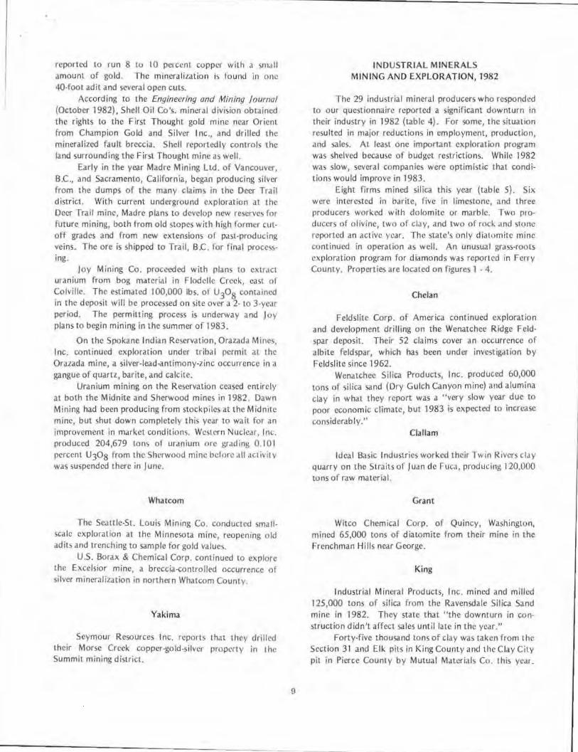
January 1983 Volume 11 WASHINGTON GEOLOGIC NEWSLETTER Coal miners - Cle Elum mine, 1957 BRIAN J. BOYLE COMMISSIONER OF PUBLIC LANDS Number 1 ART STEARNS, Supervisor DEPARTMENT OF NATURAL RESOURCES RAYMOND LASMANIS, State Geologist DIVISION OF GEOLOGY AND EARTH RESOURCES
Transcript of WASHINGTON GEOLOGIC NEWSLETTER
January 1983 Volume 11
WASHINGTON GEOLOGIC NEWSLETTER
Coal miners - Cle Elum mine, 1957
BRIAN J. BOYLE
COMMISSIONER OF PUBLIC LANDS
Number 1
ART STEARNS, Supervisor
DEPARTMENT OF NATURAL RESOURCES
RAYMOND LASMANIS, State Geologist
DIVISION OF GEOLOGY AND EARTH RESOURCES
NEW DEVELOPMENTS IN MINERALS AND ENERGY IN WASHINGTON, 1982
by Bonnie Bunning*
Data for the 1982 summary of mineral and energy activity was voluntarily supplied on a Division of Geology and Earth Resources questionnaire mailed to mining companies throughout the United States and Canada. Twenty-seven percent of those questioned responded. This year's total (78) of active companies (table 1) compares favorably to the number reported in the previous 2
years. During the past 3 years, the number of major US. mining and exploration companies working in the state has declined in favor of individual prospectors, small local companies, and Canadian exploration firms.
A minimum of $3,426,000 was invested by private companies for exploration and development of metallic commod ities in Washington. An additional Sl ,228,500
Table 1. -Active mining and exploration companies - Metallic and industrial commodities, J 982
1. Ace Park.er Mines and Minerals Corp., Ltd. 40. Jones Quarry
2. American Copper & Nick.el Co., Inc. 41. Joy Mining Co.
3. Amoco Minerals Co. 42. Knox, Kaufman Inc.
4. Arbor Resources Corp. 43. Lane Mt. Silica Co.
5. Aniva Resources Ltd. 44. LaSota.Jones Lead-Zinc Corp.
6. Asamera, lnc. 45. Lehigh Portland Cement
7. Atlas Minerals Division · Atlas Corp. 46. George Maddox & Associates
8. Azure Resources Ltd. 47. Madre Mining Ltd.
9. L. F. Baum and Associates 48. Meridian Land & Minerals Co.
10. Beck, David 49. Milchem, Inc.
11. Boise Cascade Corp. 50. Mining & Investments Co.
12. Bristol Northwest. Silica 51. Montana Barite Co.
13. The Bunk.er Hill Co. 52. Mutual Materials Co.
14. C-E Minerals Combustion Engineering, Inc. 53. Namone Aggregates, Inc.
15. CSS Management and Cleopatra Mining Co. 54. Nord Resources Corp.
16. Canorex (nternational. Inc. 55. Northwest Alloys Inc.
17. Cascarle Talc Inc. 56. Olivine Corp.
18. Chevron Resources Co. 57. Orazada Mines Inc.
19. Chewelah Eagle Mining Co. 58. Bill Palmer - Mine Evaluation & Development
20. Columbia Cement Corp. 59. Palmer Coking Coal
21. Cominco American lnc. 60. Placer Amex, Inc.
22. Consolidated Mining Resources, lnc. 61. Plexus Resources Corp.
23. Costa, George 62. Rexcon, Inc.
24. Crown Resources Corp. 68. Rocky Mountain Energy Co.
25. Dillon Exploration Inc. 64. Seattle-St. Louis Mining Co.
26. Duval Corp. 65. Seymour Resources Inc.
27. Erdosh, George 66. Shell Oil Co.· Mining Exploration
28. Exploration Ventures Co. 67. Silver King Mining and Milling Co.
29. Feldslhe Corp. of America 68. Smith Limest&ne
30. Gold Bond Mining Co. 69. Sunshine Mining Co.
31. Gold Fields Mining Corp. 70. Tacoma Lime
32. Gold Leaf Mining Corp. 71. U.S. Borax & Chemical Corp.
33. Hallauer, Wilbur 72. United Cascade Mining Co .• Inc.
34. Hansen, Spenst 73. Utah Mines Ltd.
35. Hecla Mining Co. 74. Van Horn and Watson Mining Co.
36. Houston International Minerals Corp. 75. Vulcan Mountain Inc.
37. IMC Olivine 76. Wenatchee Silica Products, Inc.
38. Ideal Basic Industries 77. Western Nuclear, Inc.
39. Industrial Mineral Products, Inc. 78. Witco Chemical Corp,
• Geologist with Division of Geology and Earth Resources field office in Spokane.
1
was cxpcnJed to develop industrial mineral commodities. On st.Ile lc1mb, 352 prospecting lca~cs and mining
contracts returned S245, 138 10 the 11 ust a..:counts for th<' period 7-1-81 to 6-30-82. This figure is down slightly from the previous fiscal year ($266,108). Revenues from oil and gas leasing were up dramatically this fiscal year -from $945,834 to 54,624,337, due principally to sub· stantial gains from oil and gas bonus bidding. There were 1,110 leases for oil and gas held on state land~ in the 1981-1982 fiscal-year period. Sand, gravel, and othcr industrial materials returned $256,512 to the state, while coal leasing and royalties provided $6,960. Both figures record distinct reductions from the 1980-1981 year.
In December, the Bureau ol Land Management announcccJ it was turning over a , ecord S582,035 to the stJtc from mineral leasing on federal lands in Washington
I 1 time~ the revenue generated rur Wdshington in 198 l .
METALLIC MINERAL EXPLORATION AND MINING
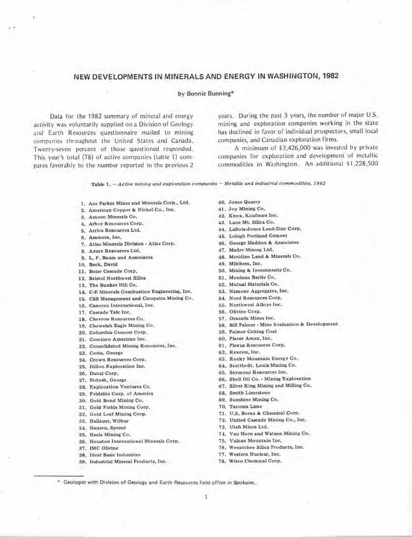
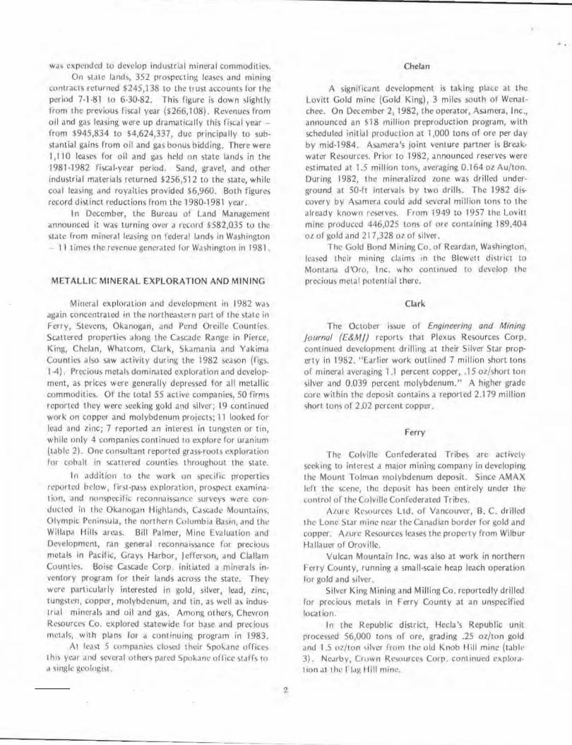
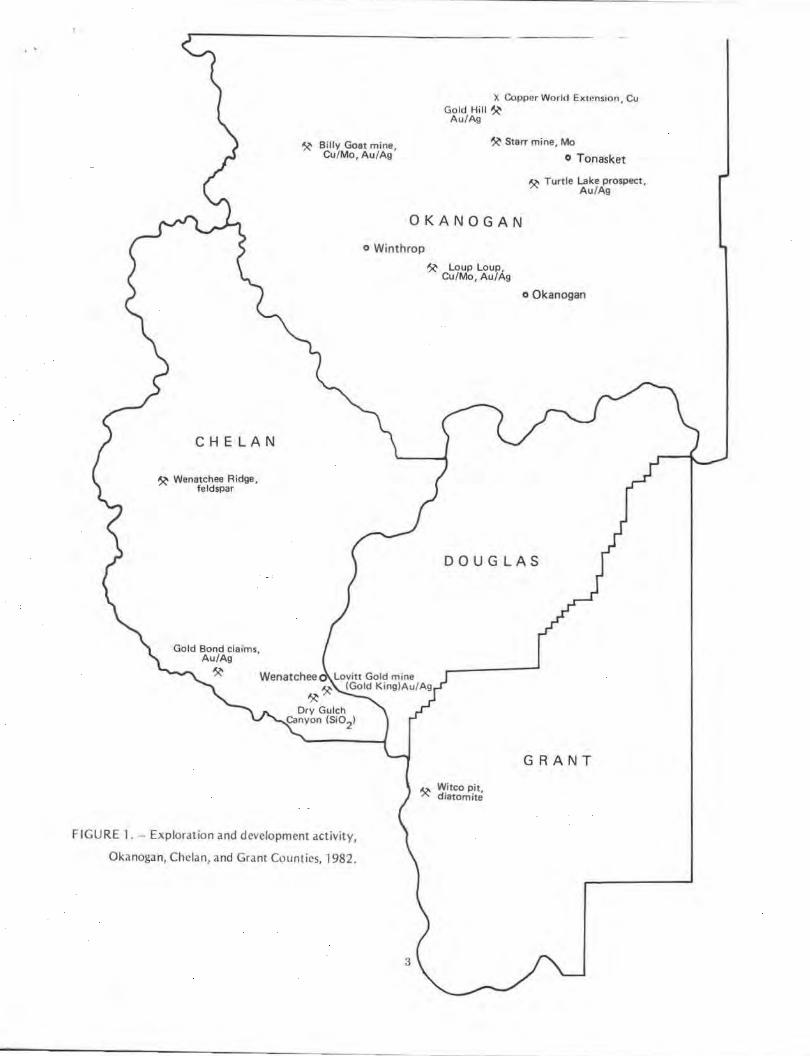
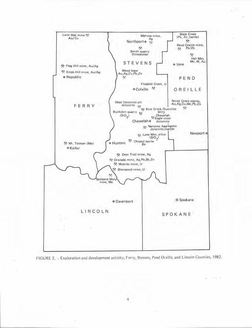
Mineral exploration and development in 1982 w,,~ again concentrated in the northea~tern part of the state in Ferry, Stcvens, Okanogan, and Pend Oreille Counties. Scattered properties along the Cascade Range in Pierce, King, Chelan, Whatcom, Clark, S1'.imania and Yakima Counties also saw activity during the 1982 season (fig~. 1-4). Precious metals dominated exploration and develop· ment, as prices were generally depressed for all metc1llic commodities. Of the total 55 active companies, 50 firms rrponcd they were seeking go ld and silver; 19 continued work on copper and molybdenum projects; l l looked for lead and line; 7 reported an interest in tungsten or tin, while only 4 companies continued 10 explore for uranium (table 2). One consultant reported grass-roots exploration for cohJlt in ~caucred counties throughout the state.
In addition to the work on specific properties rt'portcJ below, firs1-pass e>.r,loration, prospect examination, Jnd nonspecific rcconn.iissance surveys were 1.on· ducted in the oi..anog,1n Highland\, Casc.idc Mount,lins, Olympic Pt·nin~ula, the northern Columb1J Basin, and thl· Willapil Hi lls areas. Bill Palmer, Mine Evaluation and Development, ran general reconnaissance for precious metals in Pacific, Grays Harbor, Jefferson, and Clallam Counties. Boise Cascade Corp. initiated a minerals inventory program for their l,mds across the state. They were particularly interested in gold, silver, lead, zinc, tungsten, copper, molybdenum, and tin, as well as industrial minera ls and o il and gas. Among others, Chevron Resources Co. explored statewide for base and precious m0tals, with pldns for a continuing program in 1983.
At least 5 companies closed their Spol-.ane offiu'.'~ !Im ye.it .111d sever.ii tllhcrs p,1red Srol..ane of lier staffs 111 ,, single ~Ct)logist.
2
Chelan
A sign1l 1c.'lnl development is taking place at the Lovitt Gold mine (Gold King), 3 miles south ot Wcnat· chee. On December 2, 1982, the operator, Asamera, Inc., announced an $18 million preproduction program, with scheduled initial production at 1,000 tons of ore per day by mid-1984. Asamera's joint venture partner is Breakwater Resources. Prior to 1982, announced reserves were estimated at 1.5 million tons, averaging 0.164 oz Au/ton. During 1982, the mineralized zo ne was drilled underground at 50-ft intervals by two drills. The 1982 dis· covery by Asamcr;i could add several million tons to thc already known reserves. From 1949 to 1957 the Lovitt mine produced 446.025 tons of ore containing 189,404 oz of gold and 217,328 oz of silver.
The Gold Bond Mining Co. of Reardtrn, Washington, k·a~ed thei, mining claims ,n the BleWt'tt diwict to Montdna d 'Oro, Inc. who continued to develop the p1 ecious metal rotcntial there.
Clark
The October issue of Enqineering and Mining journal (E&MJ) reports that Plexus Resources Corp. continued development drilling at their Silver Star prop· erty in 1982. "Earlier work outlined 7 million short tons of mineral averaging 1 .1 percent copper, .15 oz/short ton silver and 0.039 percent molybdenum.'' A higher grade core within the deposit contains a reported 2 .179 million short tons of 2 .02 percent copper.
Ferry
The Colville Confederated Tribes arc act ivcty seek ing to interest a major mining company in developing the Mount Tolman molybdenum deposit. Since AMAX left l he scene, the deposit has been ent ircly under the control of the Culville Confederated Tribes.
A1.u1 c l{c,outccs Ltd. of Vancouver, B. C. drilled 1he Lone S1a1 mine ne.ir the Canadian border for !:Old Jnd copper. Azure Resources leases the property from Wilbur Hallauer of Oroville.
Vulcan Mountain Inc. was also at work in northern Ferry County, running a small-scale heap leach operation for gold and silver.
Silver King Mining and Milling Co. reportedly drilled for precious metals in Ferry County at an unspecified location.
In the Republic district, Hecla 's Republic unit processed 56,000 tons of ore, grading .25 oz/ton gold Jnd 15 111/ton .. ilvcr from the olJ Knob Hill mine (Wblt• 3). Ncc1rby, Cwwn Rc.,ources Corp. continued e,plt)1.t· tion ,lt the fl,t14 I lill mine
..
~ Billy Goat mine, Cu/Mo, Au/Ag
)I. Copper World Exwnsion, Cu Gold Hill~
Au/Ag
~ Starr mine, Mo
o Tonasket
~ Turtle Lake prospect, Au/Ag
OKANOGAN
CHELAN
~ Wenatchee Ridge, fe ldspar
o Winthrop
~ Loup Loup, Cu/Mo, Au/Ag
o Okanogan
DOUGLAS
Gold Bond cla ims, Au/Ag
~ Wenatchee Lovitt Gold mine
~ ~ (Gold King)Au/Ag
Dry Gulch Canyon (Si0
2)
FIGURE 1. - Exploration and development activity,
Okanogan, Chelan, and Grant Counties, 1982.
3
.o. Witco Pit, "" diatomite
GRANT
Lone Star mine~ Au/Cu
~ Flag Hill mine, Au /Ag
~ Knob Hill mine, Au/Ag
o Republic
FERRY
~ Mt. Tolman (Mo)
o Keller
LINCOLN
Melrose mine Ag ,
Northport o ~
~ Smith quarry (limestone)
STEVENS
Weed lease Au,Ag,Cu,Pb,Zn ~
Flodelle Creek, U
o Colville ~
Slate Creek (Pb, Zn, barite)
~ Pend Oreille mine, ~ Pb/Zn
o lone
~ Hall Mtn .
Mo, W, Au
PEND
ORE ILLE
West Dolomite pit Noisy Creek claims, dolomite Au,Ag,Cu,Mo,Pb,Zn
"I:~ Blue Creek Quartzite ~ Buckskin quarry ~ Si02
(Si02) ~" Chewelah ,,,.. Eagle mi,:tE'
Chewelah o dolomite
~ Nanome Aggr~gates dolomite ,marble
~ Lane Mtn. silica (Si0
2)
Chopot barite Ba
~ Deer Trail mine, Ag
~ Orazada mine, Ag,Pb,Sb,Zn
~ Midnite mine, U
~ Sherwood mine, U
Newport o
o Davenport o Spokane
SPOKANE
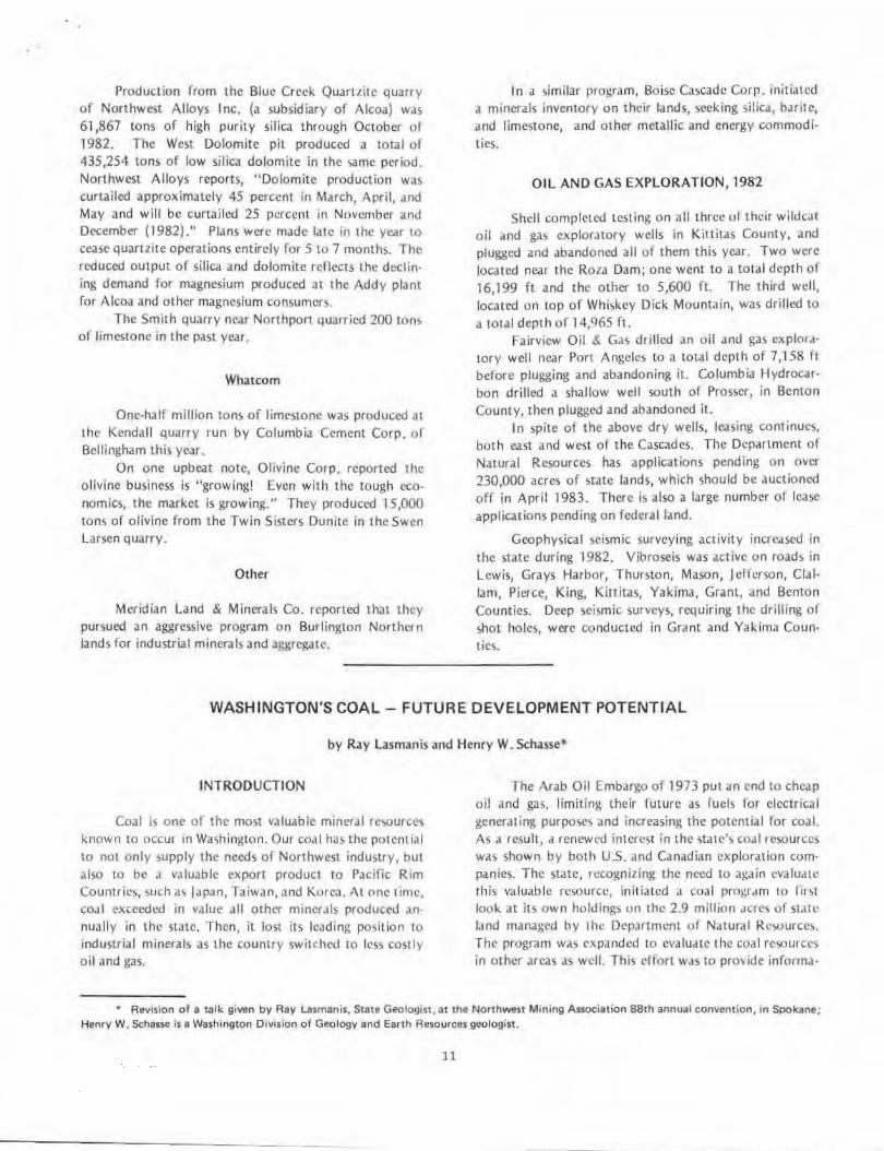
FIGURE 2. - Exp loration and development activity, Ferry, Stevens, Pend Oreille, and Lincoln Counties, 1982.
-1
o Bell ingham
~ Kendall quarry l imestone
~ Excelsior m,ne Au,A g
WHA T COM
-, ~ Mt. Baker
~ Swen Larson quarry olivine
~ Twin Sisters quarry olivine
Minnesota mine ~ Au/Ag
Concrete o ~ Londonderry deposit
talc, soapstone
SKAGIT
o Mt. Vernon
SNOHOMISH
o Snohomish
o Seattle KING
X Section 31 clay pit
North Bend o
o Index
Apex-Damon ~ Au/Ag
~ Gilbreath properties
A u/Ag, Cu/Mo, Pb/Zn
Ravensdale ·'-" Silica Sand mine .......
(Si02
) X Elk clay pit
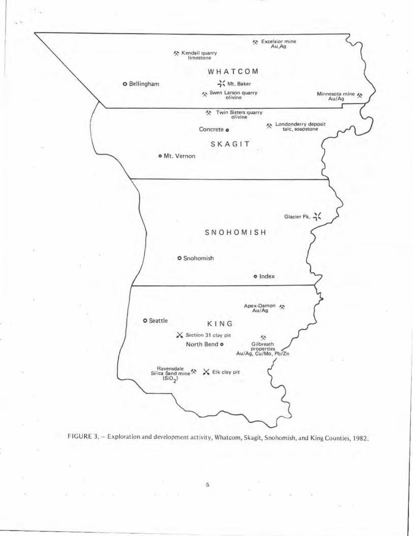
FIGURE 3. - Exploration and development activity, Whatcom, Skagit, Snohomish, and King Counties, 1982.
5
- ------------- - -
Tacoma o
THURSTON
X Clay City prt clay
PIERCE ·
LEW IS
o Morton
COWLITZ
~ Carbon River prospect Cu/Mo, Au/Ag
. . ,, Mt. Ra1n1er -, ...
~( Mt. St. Helens
SKAMANIA
,...,. Wind River '- prospect
Au/Ag
CLARK
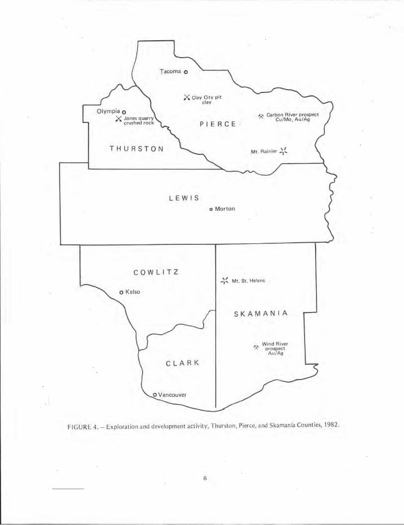
FIGU RE 4. - Exploration and development activity, Thurston, Pierce, and Skamania Counties, 1982.
6
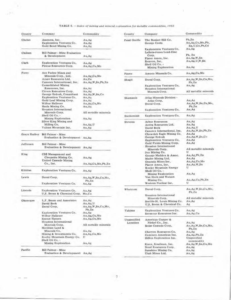
TABLE 2. - /11t/1•x of minitl/l and mineral i:x11loralinn for metallic commmlilit!G, /91{2
County Company Commodity County Company Commodity
Chelan Asamera, Inc. Au.Ag Pend Oreille The Bunker Hill Co. Pb,Zn Exploration Ventures Co. Au.Ag George Costa Au,Ag,Cu,Mo,Pb. Gold Bond Mining Co. Au.Ag Zn.U,Co,Pb,Cd
Exploration Ventures Co. Au,A&
Clallam Bill Pahner • Mine Evaluation Lasota.Jones Lead-Zinc & Development Au,Ag Corp. Pb, Zn
Placer Amex. Ine. Au,Ag,W,Sn
Exploration VPntures Co. R.excon. Inc. Au,Ag.U,W,Sn
Clark Au,Ag SbeU OD Co.· Plexus Resources Corp. Au,Ag,Cu,Mo Mining Exploration Au.A&:
Ferry Ace Parker Mines and Pierce Amoco Minerals Co. Au,Ag,Cu,Mo Minerals Corp., Ltd. Au,Ag,Cu,Mo
Azure Resources Ltd. Au,Cu Skagit DuvaJ Corp. Au,A11.W ,Sn.Cu,Mo, Canorex 1.ntematlonaJ, Inc. Au.Ag,W ,Sn)'b,Zn Pb.Zn Consolidated Mining Explorallon Ventures Co. Au.Ag
Resources, Inc. Au.Ag Houston lntemationol Crown Resources Corp. Au,Ag Minerals Corp. All mNilllle minerals George Erdosh, Consultant Au,Ag,W ,Sn,Co Exploration Ventures Co. Au.Ag Skamania Atlas Minerals Division • Gold Leaf Minini: Corp. Au,Ag Atlas Corp. Au,Ai: Wilbur HaJJauer Au.Ag,Cu,Mo Duval Corp. Au,Ag,W ,Sn.Cu.Mo, Hecla Mining Co. Au.Ag Pb.Zn Houston International ExploroUon Ventures Co. Au.Ag
Minerals Corp. All metallic mincnls Shell Oil Co.· Snohomish Exploration Ventures Co. Au.Al!
Mlntng Explor&tion Au.Ag Silver King Minin& and Stevens Arbor Resources Au.Al!
Milling Co. Au,Ag,U Arriva Resources Ltd. Au.All Vulcan Moun1.aln Inc. Au,Ag David Beck Au,Ag.U
Canorex Internationnl, Inc. Au,Ag,W ,Sn.Pb.Zn Grays Harbor Bill Pahner • Mlne Chewelah Eagle Mining Co. Au,Ag
Evaluation & Development Au,Ag George Erdosb Au,Ag.W ,Sn.Co Exploration Ventures Co. Au.Ag
,retrcrson Bill Palmer • Mine Gold Fields Mining Corp, AU,Alt
Evaluation & Developmenl Au,Ag Houston Internationnl Minerals Corp. All metallic minerals
Joy Mining Co. u King CSS Management and George Maddox & Assoc. Au,Ag,Pb.Zn
Cleopatra Mining Co. Au.Ag Madre Mining Ltd. Au,Ag Unltcd Cascade Mining Orazada Mlnes Inc. Au,Ag,Cu.Mo
Co., lnc. Au,Ag,Cu,Mo,Pb,Zn Placer Amcx, Inc. Au,A1t.W,Sn Rocky Mountain Energy u
Kittitas Exploration Ventures Co. Au.Ag Shell Oil Co. • Mining Exploration Au.Att
Lewis Duval Corp. Au.Ag,W ,Sn,Cu,Mo, Van Horn and Watson Pb,Zn Mining Co. Au.Ait.Cu,Pb,Zn
Exploration Venlures Co. Au,Ag W estcrn Nuclear 1 ne. u
Lincoln Ex1>loration Ventures Co. Au.Ag Whatcom Duval Corp. Au,A1t.W .Sn.Cu.Mo, Pb,Zn U.S. Borax & Chem1cal Corp. Mo.Cu Houston lnlcrnuional
Mineral.$ Corp. All m~taUic mincr.;ls Okano1tan L.F. Baum and Associates Au,Ag Seattle-St. Louis Minin1t Co. Au,AI!
David Beck Au,Ag,U U.S. Borax & Chemical Co. Ag Duval Corp. Au,Ag,W ,Sn.Cu.Mo,
Pb,Zn Yakima Exploratlon Ventures Co. Au.All Exploration Ventures Co. Au,Ag Seymour Resources Inc. Au,Ait.Cu Wilbur Hallauer Au.Ag.Cu.Mo Spenst Hansen A u.Ag,Cu,Mo Unspecified American Copper&: Houston international Location Ni.eke! Co., Inc. Au,AI\
Minerals Corp. All metallic minerals Boise Cascade Corp. Au,Ai:.W ,Sn,Cu,Mo. Meridian Land &. Pb.Zn
Minerals Co. Au.Ag Chevron Resources Co. Au,Ag Mining &: ln"estments Co. Au,Ag,Cu,Mo Cominco American Tnc. Au,Ag,Pb,Zn Rocky Mountain Energy Co. u Dillon Exploration Inc. Unspecified Shull OU Co. - commodily
Mining Exploration Au.Ag Knox, Kaufman, Inc. Au,Ag,W ,Sn,Cu,Mo Nord Resources Corp. Au,Ag
Pacific Bill Palmer - Mine Sunshine Mining Co. Au,Ag Evaluation &: Development Au,Ag Utah Mines Ltd. Au.Ag
7
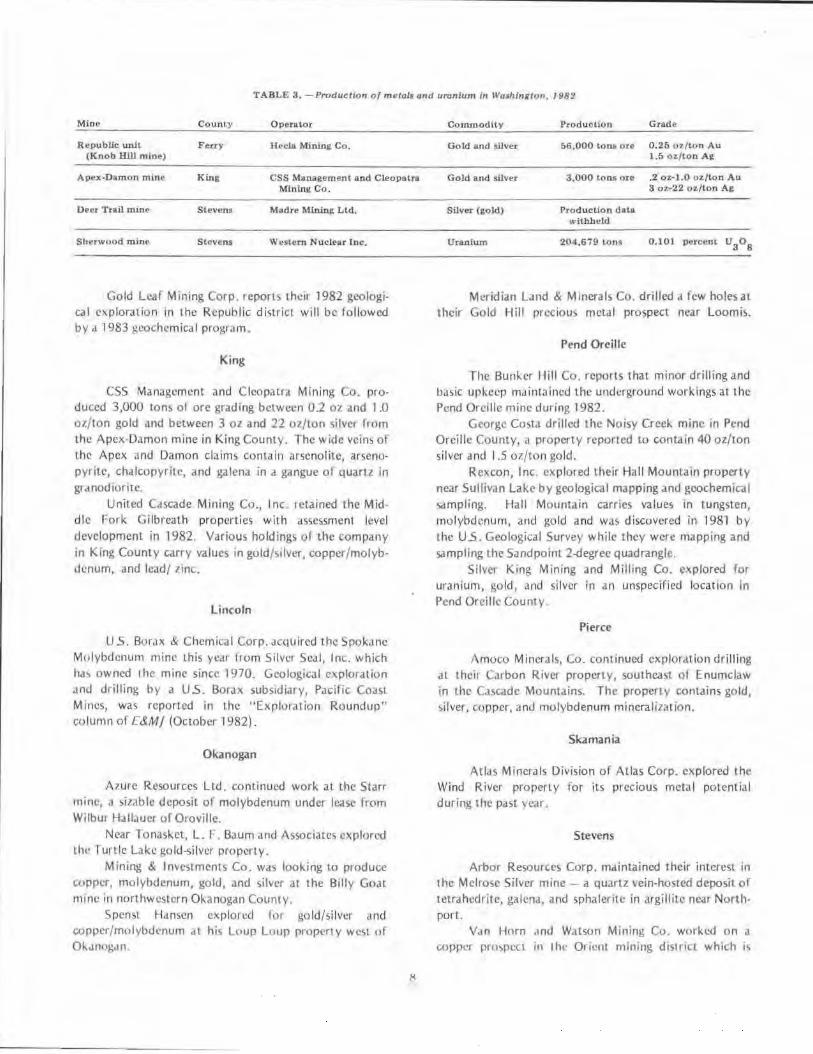
TABLE 3. -Production of metal• and uranium in IVas/iington, 1982
Mine County Operator
Republic unit F'euy Jfocla Mining Co. (Knob Hill min e)
Apex-Damon mine King CSS Management and Cleopatra Mining Co.
Deer Trail m ine Stevens Madre Mining Ltd.
Sherwood mine Stevens Western Nuclear Inc.
Gold Leaf Mining Corp. reports their 1982 geologica l exp loration in the Republic district will be fo llowed by ,J 1983 geochemical program.
King
CSS Management and Cleopatra Mining Co. produced 3,000 Lons of ore grading between 02 oz and 1 .0 oz/ton gold and between 3 oz and 22 oz/ton silver from the Apex-Damon mine in King County. The wide veins of the Apex an<.l Damon claims contain arscnolite, arsenopyrite, chalcopyrite, and galena in a gangue of quartz in gr .tnodiorite.
United C.iscade Mining Co., Inc. retained the Middl e Fork Gilbreath properties wirh assessment level development in 1982. Various holdings of the company in King County carry values in gold/silver, copper/molybdenum, and lead/ zinc.
Lincoln
U 5. Borax & Chemica l Corp. acquired the Spok,llle Molybdenum mine this yc,.11 lrom Silver Seal, Inc. which ha) owned the mine since 1970. Geological exploration and drilling by a US. Borax subsidiary, Pacific Coast Mines, was reported in the "Exploration Roundup'' co lumn of C&M/ (October 1982).
Okanogan
A1ure Resources Ltd. continued work at the Starr mine, a siable deposit of molybdenum under lease from Wilbur Hallauer of Oroville.
Near Tonasket, L_ F. Baum and Associates explored thc furtlc LJ.kc gokl-si lvcr property.
Mining & Investments Co. was looking to produce copper, molybdenum, gold, and silver at the Billy Goat mine in northwestern Okanog<1n County.
Spenst H&rn,en explored f0r gold/silver dnd copper/molybdenum at hi,; Loup Loup proper! y west of Ol...1nog.1n .
Commodity Production Grade
Go Id and silver &6.000 tons ore 0.2& 01,Hon Au 1.5 oz/ton Ag
Go ld and silver 3,000 tons ore .2 oz-1.0 oz/to n Au 3 o'l.-22 oz/ton Ag
Silver (gold) Production data l<' ithheld
Uranium 204,679 ~ons 0.101 percent Us0s
Meridian Land & M rnerals Co. drilled a few holes at their Gold Hill prec ious metal prospect near Loomb.
Pend Oreille
The Bunker Hill Co. reports that minor drilling and basic upkeep maintained the underground workings at the Pend Oreille mine during 1982.
George Costa drilled the Noisy Creek mine in Pend Oreille County, a property reported to contain 40 oz/ton silver and I .5 oz/ ton gold.
Rexcon, Inc. explored their Hall Mountain property near Sullivan Lake by geological mapping and goochemical sampling. Hall Mountain carries values in tungsten, mo lybd enu m, and gold and was discovered in 1981 by the US. Geologica l Survey while they were mapping and sampling the Sandpoint 2-degree quadrangle.
Silver King Mining and Milling Co. explored for uranium, gold, and silver in an unspecified location in Pend Oreille County_
Pierce
Amoco Minerals, Co. continued exploration drilling &t their Carbon River property, southeast o f Enumclaw in the C.iscade Mountains. The property contains gold, ,ilver. copper, and molybdenum mineralization.
Skamania
All.is Minerals Division of Atlas Corp_ explored the Wind River properly for its precious melal potential during the past year.
Stevens
Arbor Resources Corp. maintained their interest in the Melrose Silver mine - a quanz vein-hosted deposit of tetrahedrite, galena, and sphalerit e in argillite near North· port.
Van Horn ,,nd Watson Mining Co. worked on d
c.oppcr p,owcct in tht· Orient mining district which is
reported lo run 8 Lu IO pet cenl copper with a sm,111 amount of gold. The mincra liltlt ion is tound in one 40-foot adit and several open cuts.
Accord ing to the Engineering and Mining Journal (October 1982), Shell Oil Co's. mineral division obtained lhe rights to the First Thought gold mine near Orient from Champion Gold and Silver Inc., and drilled the mineralized fault breccia. Shell reportedly controls the land surrounding the First Thought mine as well.
Early in the year Madre Mining Ltd. of Vancouver, B.C., and Sacramento, California, began producing silver from the dumps of the many claims in the Deer Trail district. With current underground exploration at the Deer Trail mine, Madre plans to develop new reserves for future mining, both from old slopes with high former cutoff grades and from new extensions of past-producing veins. The ore is shipped to Trail, B.C. for final processing.
Joy Mining Co. proceeded with plans Lo extr,tct uranium from bog material in Flodellc Creek, cast of Colville. The estimated 100,000 lbs. of u3o8 contained in the deposit will be processed on site over a 2· to 3-yedr period. The permitting process is underway and Joy plans to begin mining in the summer of 1983.
On the Spokane Indian Reservation, Orazada Mines, Inc. continued exploration under triba I permit at the Orazada mine, a silver-lead-antimony-zinc occurrence in a gangue of quartz, barite, and calcite.
Uranium mining on the Reservation ceased entirely at both the Midnite and Sherwood mines in 1982. Dawn Mining had been producing from stockpiles at the Midnite mine, but shut down completely this yec1r to wait for an improvement in market conditions. Western Nuclear, Inc. produced 204,679 tons of uranium ore grading 0. 101 percent U308 from the Sherwood mine before ,Ill c1ctivit y was suspended there in June.
Whatcom
The Seattle-St. Louis Mining Co. conducted smallscale exploration at the Minnesota mine, reopening old ad its and trenching to sample for gold values.
U.S. Borax & Chemical Corp. continued to explore the Excelsior mine, a breccia-contro lled occurrence of silver mineraliLation in northern Whatcom County.
Yakima
Seymour Resources Inc. repo1 ts that they drtllcd their Morse Creek copper-go ld-s ilver propl·rty in the Summit mining district.
9
INDUSTRIAL MINERALS MINING AN D EXPLORATION, 1982
The 29 industrial mineral producers who responded to our questionnaire reported a significant downturn in their industry in 1982 (table 4). For some, the situation resu lted in major reductions in employment, production, and sales. At least one important exploration program was shelved because of budget restrictions. While 1982 was slow, several companies were optimistic that conditions would improve in 1983.
Eight firms mined silica this year (table 5). Six were interested in barite, five in limestone, and three producers worked with dolomite or marble. Two producers of olivine, two of clay, and two of rod. and stone reported an active year. The state's on ly diatomitc mine continued in operation as well. An unusual grass-roots exploration program for diamonds was report ed in Ferry County. Properties arc located on figures 1 · 4.
Chelan
Feldslitc Corp. of America continued exploration and development drilling on the Wenatchee Ridge Feldspar deposit. Their 52 claims cover an occurrence of albite feldspar, which has been under investigation by Feldslite since 1962.
Wenatchee Silica Products, Inc. produced 60,000 tons of silica sand (Dry Gulch Canyon mine) and alumina clay in what they report was a "very slow year due to poor economic climate, but 1983 is expected to increase considerably."
Clallam
Ideal Basic Industries worked their Twin Rivers cl.1y quarry on the Straits of Juan de Fuca , producing 120,000 tons of raw material.
Grant
Witco Chemical Corp. of Quincy, Washington, mined 65,000 tons of diatomite from their mine in the Frenchman Hills near George.
King
Ind ustrial M incral Products, Inc. mined and milled 125,000 tons of silica from the Ravensdale Silica Sand mine in 1982. They state that "the downturn in construction didn't affect sales until late in the year."
Forty-five thousand tons of clay was taken from the Section 31 and Elk pits in King County and the Clay City pit in Pierce County by Mutual Materials Co. this yeM.
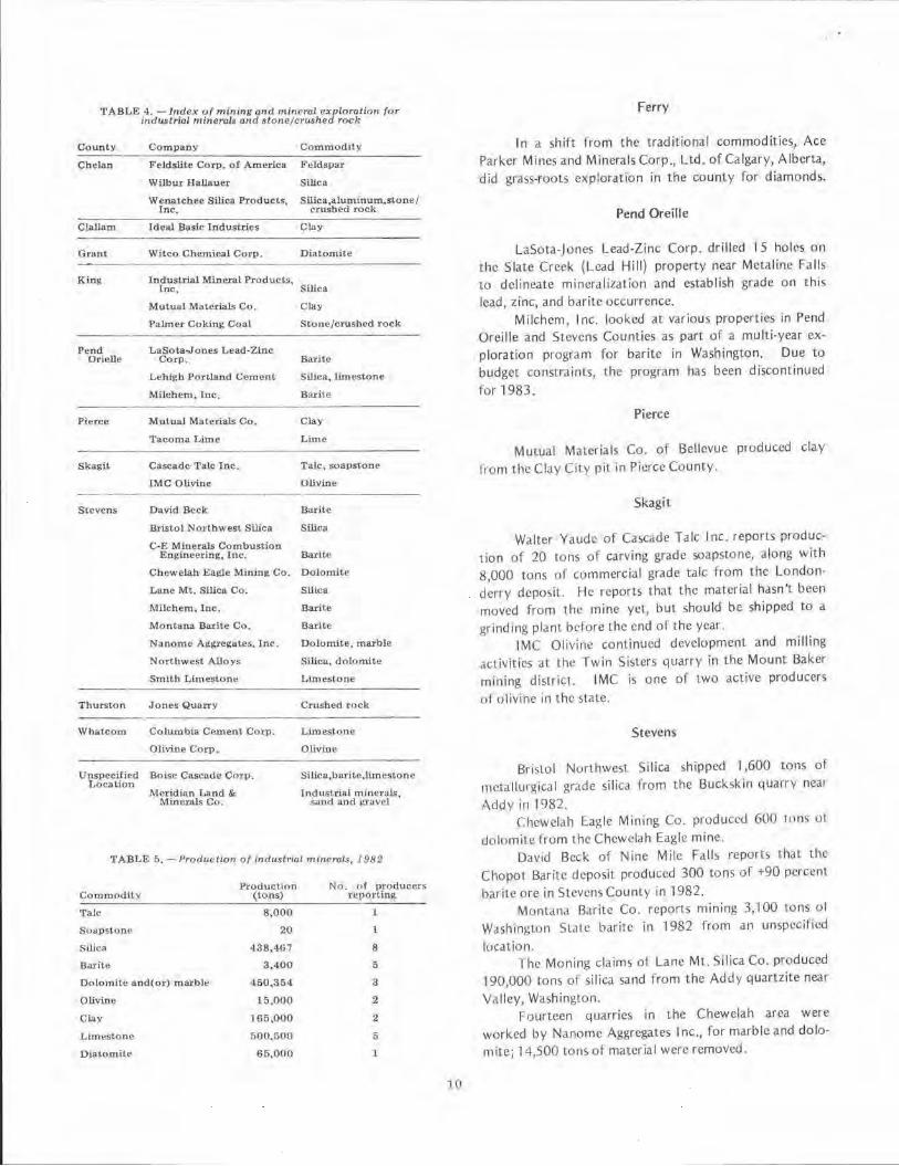
TABLE 4. - lltdex of mining and mineral exploration for industrial mineral/I and stone/crW;hed roa/1
County Company Commodity
Chelan Fe.ldslite Corp. of America Feldspar
Wilbur Hallauer Silicn
Wenatchee Silica Products, Inc.
SIHca,alumlnum,stone/ ('rushed rock
Claliam Idea.I Baste lndustties Clay
Grant Witco Chemical Corp. Diatomite
King Industrial Mineral Product9, Inc, Silica
Mutuu.1 MuCJ:ials C(1. Clay
Palmer Coking Coal Stone/crushed rock
Pend LaSota.Jones Lead-Zinc Otielle Corp. Bo.rite
Lehigh P<Jrtland Cement Silica, limestone
Milchem, lnc. Barile
Pierce Mutual Materials Co. Clay
•racoma Lime Lime
Skagit Cascade Talc lnc. Talc, t;oapstone
IMC Olivine Olivine - ----Stevens David Beck Barite
Bristol Northwest Silica Slli"a
C·E Miuerals Combustion Engineering, lnc. Barlte
Chewelah Eagle Mining Co. Dolomite
LilnC Mt. Silico. Co. SUica
Mitchem. Inc. Barite
Montana Barite Co. Barile
Nanomu Aggxeitutes, Jnc. Dolomite, marble
Northwest Alloys Silica, dolomite
Smith Limestone Limestorie
Thurston Jones Quarry Crushed Tock
Whatcom Columbia Cement Cotp. Limestone
Olivine Corp. Olivine
Unspecified Location
Boise Cascade Cmp. Silica,barite,limestone
Meridian Land & Industria l mint>r,tl;;, Minerals Co. sand and 11ruvcl
TABLE(>. -Pro(1uctlon of lnctustnal mineral,;, 191:12
Commf>dity Produotion No . of producers
(tons) r~rortlng
TaJc 8,000 l
Suapstune 20 l
SWca 438,467 8
Barite 3,400 5
Dolomite and(or) marblt! 450,354 3
Olivine 15,000 2
Clay 165,000 2
Limestone 500,500 5
Diatornite 65,000 l
10
Ferry
In a shift from the traditional commoditie~, Ace Parker Mines and Minerals Corp., Ltd. of Calgary, Alberta, did grass-roots exp loration in the county for diamonds.
Pend Oreille
LaSota-Jones Lead-Zinc Corp. drilled 15 holes on the Slate Creek (Lead Hill) property near Metaline Falls to delineate mineralization and establish grade on this lead, zinc, and barite occurrence.
M ilchem, Inc. looked at various properties in Pend Oreille and Stevens Counties as part of a multi-year exploration program for barite in Wash ington. Due to budget constraints, the program has been discontinued for 1983.
Pierce
Mutual Materials Co. of Bellevue produced clay from the Clay City pit in Pierce County.
Skagit
Walter Yaude of Cascade Talc Inc. reports production of 20 tons of carving grade soapstone, along with 8,000 tons of commercial grade talc from the London· derry deposit. He reports that the material hasn't been moved from the mine yet, but shou ld be shipped to a grinding plant before the end of the year.
IMC Olivine continued development and milling act ivitTcs al the fwin Sisters quarry in the Mount Baker mining district. IMC is one of two active producers of olivine in the state.
Stevens
Bristol Nurthwe!>l Silica shipped 1,600 tons of metallurgical grade silica from the Buct...skin quarry near !'\ddy in 1982.
Chcwel,th Eagle Mining Co. produced 600 terns u1 dolomite from the Chewelah Eagle mine,
David Beck of Nine Mile Falls reports that the Chopot Barile deposit produced 300 tons of +90 percent baritc ore in Stevens County in 1982.
Montana Baritc Co. repons min ing 3,100 tons o1 We1shington State barite in 1982 from an unspeci1icd location.
The Moning claims of Lane Mt. SIiica Co. produced 190,000 tons of silica sand from the Addy quartzite near Valley, Washington.
Fourteen quarries in the Chewelah area were worked by Nanomc Aggregates Inc., for marble and dolomite; 14,500 Lons of material were removed.
Production from the Blue Creek Quartzite quarry of Northwest Alloys Inc. (a subsidiary of Alcoa) was 61,867 tons of high purity si lica through October of 1982. The West Dolomite pit produced a total of 435,254 tons of low silica dolomite in the same period. Northwest Alloys reports, "Dolomite production was curtailed approximately 45 percent in March, April, and May and will be curtailed 25 percent in November and December (1982)." Plans were made late in the year 10
cease quartzite operations entirely for 5 to 7 months. The reduced output of si lica and dolomite reflects the decli ning demand for magnesium produced at the Addy plant for Alcoa and other magnesium consumers.
The Smith quarry near Northport quarried 200 tons of limestone in the past year.
Whatcom
One-half million LOns of limestone was produced at the Kendall quarry run by Columbia Cement Corp. of Bellingham this year.
On one upbeat note, Olivine Corp. reported the olivine business is "growing! Even with the tough economics, the market is growing." They produced 15,000 tons of olivine from the Twin Sisters Dunite in the Swen Larsen quarry.
Other
Meridian Land & Minerals Co. reported that they pursued an aggressive program on Burlington Northern lands for industrial minerals and aggregate.
In a similar program, Boise Cascade Corp. initiated a minerals inventory on their lands, seeking silica, bar it e, and limestone, and other metallic and energy commodi· t ies.
OIL AND GAS EXPLORATION, 1982
Shell completed testing on all three of their wildcat oil and gas explorJLOry wells in Kittitas County, and plugged and abandoned all of them this year. Two were located near the Roza Dam; one went to a total depth of 16,199 ft and the other to 5,600 ft. The third well, located on top of Whiskey Dick Mountain, was drilled to a total depth of 14,965 ft.
Fairview Oil & Gas drilled an oil and gas explo1ci· tory well near Port Angeles to a total depth of 7,158 ft before plugging and abandoning it. Columbia Hydrocarbon drilled a shallow well south of Prosser, in Benton County, then plugged and abandoned it.
In spite of the above dry wells, leasing cont inucs, both east and west of the Cascades. The Department of Natural Resources has applications pending on over 230,000 acres of state lands, which should be auctioned off in April 1983. There is also a large number or lea)e applications pending on federal land.
Geophysical seismic surveying ac1ivit y increased in the state during 1982. Vibroseis was active on roads in Lewis, Grays Harbor, Thurston, Mason, Jefferson, Clal· lam, Pierce, King, Kittitas, Yakima, Grant, and Benton Counties. Deep seismic surveys, requiring the drilling of shot hole>, were conducted in Grant and Yakima Counties.
WASHINGTON'S COAL - FUTURE DEVELOPMENT POTENTIAL
by Ray Lasman is and Henry W. Schasse*
INTRODUCTION
Coal is one of the most valuable mineral resources known to occur in Wash ington. Our coal has the potential to not only supply the needs of Northwest industry, but also to be a valuable export product to Pacific Rim Countries, such a~ Japan, Taiwan, and Kurca. At one time, coJI exceeded in value all other minerdls produced an· nually in the state. Then, it lost its leading position to industrial minerals as the country switrhcd to less costly oil and gas.
The Arab Oil Embargo of 1973 put an end to cheap oil and gas, limiting their future as fue ls for electrical generating purposes and increasing the potential for coal. As a result, c1 renewed interest in the statC"'s coal resources was shown by both U.S. and Canadian exploration com· panics. The state, recognizing the need to again evaluate this valuable resource, init iatcd a coal pro~rc1m to fir~t look at its own holding) on the 2.9 million acn.!) of state land managed by the Department of Ndtural Re~urces. The program was expanded to evaluate the coa l rec;ourcc) in other areas as well. This etfort was to provide informa-
• Revision of a talk given by Ray Lasmanis, State Geologist, at the Northwest Mining Association 88th annual convention, in Spokane; Henry W. Schasse is a Washington Division of Geology and Earth Resources geologist.
11
tion which wou ld be useful to exploration companies looking for coal deposits to mine, and to plahners as a basis for making decisions on urban growth and develop· ment.
This art icle discusses the current status of mining and exploration, the coal program of the Washington Division of Geology and Earth Resources , and the fuLUre development potentia l of Washingto ri's coal resources.
COAL RANK AND RESERVES
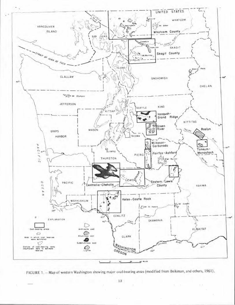
The rank of Washington's coal ranges from lignite in the southwestern part of the state to anthracite in Lhl' Glacier field in north-central Whatcom County (fig. l). In general, llh' rank increases wilh age: early to middle Eocene deposits arc bituminous fJl'k coals, most latl' Eocene dcpo>its arc subbituminous rant- c.:oab, and Oligoccm• deposits arc lignite:-,. The ,rnthracite occurrences MC
found only in small areas of intense deformation. The coal reserves of Washington remaining in the
ground as of January ·1, 1960 were e~timated to be 6,185 mil lion short tons (Beik man, and others, 1961). Of that tot.ii, about 5 million tom was anthracite, 1,869 mi llion tons bituminous, 4,194 mil lion tons subbituminous coal, and 117 million tons lignite. Since that time, mining has removed 54 million tons..l/ of subbituminous and 2 million tons1/ of bituminous coal. However, now reserves have been reported by Moen ( 1969) and Vonheeder {1976) that increase the remaining reserves of bituminous co,d in Whatcom County by approximately 53 million tons. Additional coal resources have also been reported for the Green River District of King County (Morris and Ame~, 1980) I hat increase the in-pl;H;e reserve of bitumilll}Lts co,11 by 179 million t0ns. These totals ;ire summ.iri1cd in t.1ble I.
The rc~ult ing in-place reserves, based on pub lished information, are 6,361 mil lion tons of coal. Addit ional re~crves have been developed in recent years but till' companies wish to keep the data contidential.
I ab le I . - Coal reserves of Washingto111 198 71 by rank (in millions of tons)
Anthracite 5 Bituminous 2,099 Subbituminous 4,140 Lignite 117
TOTAL 6,361
EX PLORATION AND DEVELOPMENT
Whatcom and Skagit Counties
Recent interest has been shown by several major mining and energy companies in the area north of Bellingham. Amax. Coal Co. of Denver has been exploring throughout western Washington for the past severJI years. In 1981, Amax completed a dril ling project between Bellingham and Lynden in the Whatcom basin. Approximately 15,000 ft of drilling in 11 drill ho les was completed. /\max was actively invo lved in .i leasing program in 1981, and they hope to resume rurther exploration efforts in 1983.
North Amer ican [. xploration Co. was reported to
have drilled 1,300 fl during the summer of 1980 in Whatcom County for J major Oklahoma petroleum company.
Uuh International, Inc. of Salt Lake City has been engaged in active exploration of Washington coal for the past several years. They were engaged in exploratory drilling in Whatcom and Skagit Counties Lhis past summer.
King County
Palmer Coking Coal Co. is the only producer presently mining in King County. Palmer is currently strip mining underground mine barrier pillars in the McKay and Franklin No. 12 seams. Palmer also mined the Franklin No.'s 10 and 12 scams by underground methods as recently as 1974, and the Landsburg beds as recently as 1976 . Palmer has been producing approl\imately 5,000 tons of coal ,rnnually fur the past 3 years. Production for 1982 is e:-,tima1 cd at 7,200 short tons. Their coal is used for loca l institutiona l and residential heating.
In a press release on August 5th- ot last year, the Pacific Coast Coa l Co. announced plans to develop a new coal mine near Black Diamond on lands leased from Palmer Coking Coal Co . The mine is to be an open-pit type operation with a design production capacity of 250,000 clean tons per year. The coal produced will compete directly with comparable coal from Utah and Wyoming prc~cntly being consumed by Washington industry and various federal and state institutions. Estimated mine life at full prod uction is 16 years. Pacific Coast Coal Co. anticipates that underground mining may once again bo economical by the 1990's and could extend the mine life. The new mine will be n;:imed the John
Henry No, I.
11 Based on production of clean coal reponed to the Division o1 Geology and Earth Resources (recovery factor of 80 percent, com
monly used for str ip mining, included).
3J A recovery factor of 50 percen1 was used based on reported tonnage of clean coa l , most ot which was mined by under
ground methods.
VANCOUVER
ISLAND
CLALLAM
GRAYS
HARBOR
b
fXPU>NAT ION
CJ Cool · be-orinQ artas
0 A,•o 1n w,..1e:h cool ,uervu
we,, " ''"'ot ,o ( -,; ,.,
Outtin, ot cool-D10,,n~ roch ln1urln:11nf dote to H11mol• , ... ,.,.,
CHELAN
YAK IMA
D Anth,oc1t1 cool
~ 81HHl'H "OU$ coot • Subbilurninou, cool
•;.._ _ _,.'°==~t,::_o __ ~>~O =~4,0 • •t..U
FIGURE l. - Map of western Washington showing major coa l-bearing areas (modified from Beikman, and others, 1961 ).
13
•••
•••
Meridian Land and Minerals Co., a Burlington Northern subsidiary, drilled six holes in their mineral holdings in the Green River area to establish reserve~ during the summers of 1980 and 1981.
Kittitas County
Although coal occurs in the Taneum and Manastash areas of Kittitas County, the only area of importance in the past, or which offers much likelihood for future development, is the Roslyn field. This field has seen a fair amount of exploratory urilling in the past decade or so. The more recent activities include 31 boreholes drilled by Burlington Northern in 1978. Three holes were drilled by Amax Coal Co. in 1979. AMCA/Luscar, based in Kentucky, recently evaluated the coal reserves on an arC<l under lease by Pctroniinerals of Santa Ana, California, in the Roslyn and Cle Elum area and believes there is a potent ial reserve base of 30 to 35 million tons. The Roslyn district is one of the few areas in Washington where underground mechanized mining has been successfully employed in the past.
Pierce County
Currently, Meridian Land and Minerals Co . (Bur ling· ton Northern) is involved in a core dri ll ing program to evaluate their mineral holdings in the Wilkeson to Fairfax area. Also, Terraspace, Inc., of Rockville, Maryland, has taken over a project initially started by Gulf Resources and Chemicals Exploration Co. to do a technical and economic feasibility study of hydraulic coa l mining in the Wilkeson-Carbonado coal field. The first phase of this project, the potential site evaluation, is due to be completed by July of 1983. The contract is with the U.S. Bureau of Mines. The objective of the program is to
design an economically viable underground hydraulic coal mining system for moderate to steeply pitching bituminous coalbeds.
Southwestern Washington Coal Fields
The southwestern Washington coal fields include the Centralia-Chehalis area, the Kelso·Castle Rock area, and the Vader area.
Washington Irrigation and Development Co. (WIDCO) continued confirmation drilling and scam characterization on its reserve holdings in the Tono basin where it produces between 4 and 5 million tons a yeat from the Centralia strip mine located in the CentraliaChehalis district. Production for 1982 Is estimated at 4,161,000 short tons o1 coal. Reserves arc estimated to be adcquat e for a not her 35 years.
14
A unique secondary coal recovery operation has been conducted by Old King Coal Co., Inc. on mine waste produced by WIDCO. Coal, uneconomical to recover by large equipment, is salvaged in a satellite operation. A further example of energy conservation is Old King Coal Co.'s plan to recover 65,000 tons of coal fines from the old Stoker mine waste area. During 1982, Old King Coal Co. sold 34,228 clean short tons of coal to customers other than WIDCO and an additional 6,500 tons to WIDCO for power generation .
Kennecott Minerals Corp. of Salt Lake City, is currently involved in exploratory drilling of the CurtisVader-Ryderwood area of western Lewis and northwestern Cowlitz Counties. Kennecott has explored the area fo r the past 2 years. They arc involved in a joint venture with GCO Minera ls Co., a subsidiary of International Paper Co. According to Kennecott's public relations officer - Kennecott ha:; a land base of 9,000 acres; GCO has a much larger base reported to be in the vicinity of 40,000 acres. Drilling is being done to block out reserves and to determine coa l quality. The project is still in its early stages.
Asotin County
Lignite occurs in southeastern Asotin County within sedimentary strata that arc interbeddcd with flows of Yakima Basalt of Miocene age. Minor amounts of lign ite were prod uced for local use in the early part of the century. No further mining has occurred since t hat time. However, the area is again receiving consideration. Uta h International, Inc. began drilling in 1977. They drilled 10 to 12 hole~, totaling approximately 2,000 lineal feet. The company is reported to be actively exploring on the Oregon .side of the lignite field. Kemmerer Coal Co. (now part ot Gulf Resources) drilled 10 to 11 holes totaling 2,500 to 3,000 ft in 1980 and 1981.
Several other mining and energy companies, not mentioned here, continue to evaluate existing data in office stud ic~ prior to committfn~ funds fL>r explor·arinn c1nd drilling. Some of the companies arc listed in tdblc 2.
l able 2. - Companies active in cool exploration in Washington, 7 982
Cominco American, Inc. Getty Oil Co. Kennecott Minerals Corp. Meridian Land & Minerals Co. North American Coal Corp. Shell Oil Co. United States Steel Corp. Utah lntcrnatioml , Inc. Washington Irrigation and Development Co.

COAL ACTIVITIES OF THE DIVISION OF GEOLOGY AND EARTH RESOURCES
The Division of Geology and Earth Resources (OGER) of the state's Department of Natura l Resources has been conducting studies of Washington's coal resources since 1974. With renewed interest in the nation's coal resources as a result of the energy shortage, the state became interested in learning more about coal on stateadministered lands. A program was init iated, concentrating on Whatcom County, where the greatest amount of state land underlain by coal-bearing rocks occurs. I nitially, a compilation of all available data relating to the geology and coa l resources of Whatcom County was generated . In addition, a series of reports which outline the areas of coal-bearing rocks, computed coal reserves, and locations of state-owned lands for a ll the major coal areas of the state (except King County) was produced. A coal-sampling program was also und erway during this t ime period.
Results of the coal-sampling program were released as an open-file report (Phillips, Walsh, and Schasse, 1982) in July of 1982. The report presents analyses for 135 coal samples from 89 sampling localities in nine Washington counties. Stratigraphic sections, measured and recorded at 37 of the sampli ng localities, are also included in the report. In 1977 the coa l program was expanded to include al l of Washington's coa l deposits.
In 1978 a project was initiated in the Roslyn· Cle Elum area resulting in a OGER open-file report (Wa lker, 1980) containing informat ion on coal quality, coal reserves, and 25 separate maps illustrating the geology, geologic structure of the major coal beds, mining conditions, stratigraphic relationships of the coal measures and surrounding rocks, scam thickness, and overburden thickness.
A project was begun in 1980 to sLUd y the Miocene lignite occurrences in Asotin County in the southeast corner of the state. A program that involved reconnaissa ncc mapping, data col lection, and sampling of basa lts and lignite was carried out during 1980. The resu lts of the first season's field work were presented in a OGER open-file report (Stoffel, 1981) released in September, 1981. A second season of field work was conducted to
answer questions raised during the first half of the project. A fina l report on the results of the project is currenl IY being prepared and will be available in 1983.
Projects to study the coal resources in the Newcastle -Tiger Mountain area and the Green River district of King County were also initiated in 1980. A similar project to study the coa l resources of the Wilkeson.Carbonado coal field in Piercr County was begun in 1981 . The King and Pierce Cou nty studies should be comp let cd by late 1983.
1 F,
FUTURE DEVELOPMENT POTENTIAL OF WASHINGTON COAL
Washington's coa l development has been hampered by the limited size of individ ual coal fields, their variable composition, and by hard-to-m ine steeply dipping beds. These factors coupled with the considerable thickness of overburden over many areas make them unsuitable for low-cost, open-pit mi ning operations (the Centralia coal field is an exception). Historicall y, the high cost of mining Washington coal has made it very difficu lt for Washington coa l prod ucers to compete in markets within the state, and virtually impossible for them to compete in out-of-state markets. However, with the recent surge of interest shown by exploration companies over the past decade or so, the potential ex ists for the discovery of new reserves, particularly in front ier areas which could also be amenable to economically competitive mining methods.
The currently estab lished coal reserves in Washington underlie an area of only about one-third of the known area of coal-bearing rock in the state (fig. I). Possibly, other large areas of coal-bearing rocks are concealed beneath a mantle of glacial drift or alluvium. The principal areas where such conditions exi,t are north of Enterprise in northwestern Whatcom County, between the Skagit and King County areas, between the IssaquahGrand Ridge and Green River coal fields of King County, between the King and Pierce County areas, and between the Centralia-Chehalis coal district and the Kelso.Castle Rock area. There is good reason to believe that many of these areas conta in potentially significant coa l deposits within 3,000 ft of the surface. There are large areas in Chelan and Kittitas Counties and smaller areas in Snohomish and eastern King Counties underla in by potentially coal-bear ing rocks of Cretaceous or lower TcrtiJrY sedimentary rocks of the Swauk Formation.
Progress has been made utilizing hydraulic techniques in underground mining by the Canadians, the Japanese, and the Russians. In Canada, Kaiser Resources1
Ltd. has been successfully employing hydraulic mining dt
its Sparwood, Brit ish Columbia operations since the early 1970's. Kaiser's underground hydraulic mining operation produces approximately 1 million tons of raw coa l per year. In a SO-foot-thick se.im that dips 25-50°, Kaiser has increased recovery from 10 to 12 percent, where conventional underground mining had been formerly emp loyed, to 55 to 60 percent with hydraulic mining. Productivity also increased sign ificantly to between 25 to 30 Lons per worker shift. Similar successes have been experienced by the Japanese and Russians in seams with dips as steep as 60 to 80°.
As mentioned earlier, a company is current ly
operating under a grant from the US. Bureau of Mines to do <1 feasibility study of hydraulic mining of the steeply dipping coJI scams in the Wilkeson-Carbonado area of Pierce County. They will be investigating methods similar to those employed by Kaiser Resources. Hopefully, these efforts will develop techniques that will eventually allow state coal producers to be more competitive in tht' regional and the international marketplace.
Concerns brought on by the energy crisis have brought in-!>itu or underground coal gasification (UCG) into consideration as an alternate energy source. Underground coal gasification is one of the most promising of the various processes to produce clean fuels from coal. With th is method both low and medium BTU product gas have been obtained by air and steam/oxygen injection, respectively. If successful, underground coal gasification would quadruple the proven U 5 . reserves of coa l. Costs of fuels produced by UCG are projected to be 65 to 75 percent of those produced by conventional surface coalconversion processes. Through this technique lignites and other low-grade coals, uneconomical to mine through conventional means, could be developed as a commercial energy source. Steeply dipping and tectonica lly disturbed scams, ignored in the past as being uneconomical to mine, could be gasified.
At least 18 UCG field tests have been conducted in the U.S . since 1973. The U.S. Department of Energy and Gas Research Institute jointly sponsored a series of tests being conducted by Lawrence Livermore National Laboratory (LLNL) in cooperation with the Washington Irrigation and Development Co. (WIDCO) in the Tono basin about 5 miles northeast of Centralia. During the past year, a series of five large block field experiments were performed within the Big Dirty coal seam. T he blocks were later excavated so that burn cavity geometry could be studied, as well as the cavity growth process response lo changes 1n varying amounts of steam/oxygen and air which were injected during the tests. The tests were successful and indicated that the Big Dirty seam is suitab le fur in-situ g..tsification. Further tests arc sched· uled for the summer of 1983. A budget of $2,700,000 has been proposed for a large-scale test that wil l consume about 2,000 tons of coal.
The ultimate goa l of these exper iments is the successful gasification of multiple scams approximately 600 ft below ground level in the Tona basin. 2 miles east of the WIDCO mine and powerplant complex. A successful experiment would allow a transfer of UCG tec hnology to many of Washington's coal scams that are presently uneconomical to mine. Ultimate use of the generated gas would probably be a boiler feedstock for electrical power generation. A consensus of opinion indicates that the UCG prOCC!>S can be commercial within the next 10 years.
lh
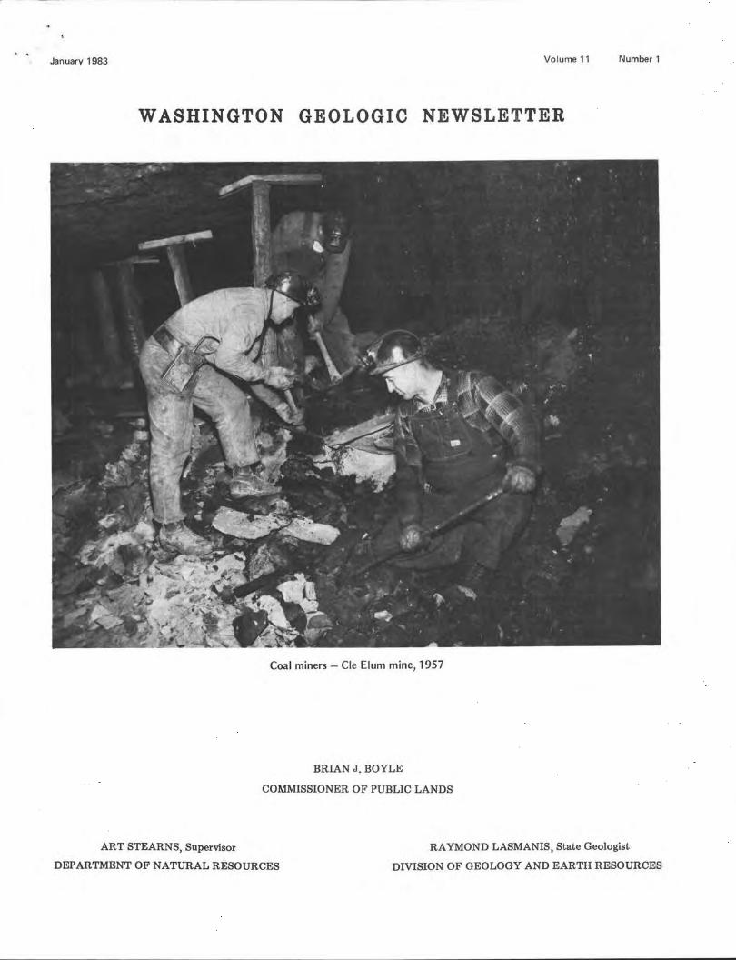
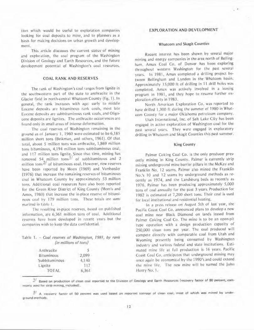
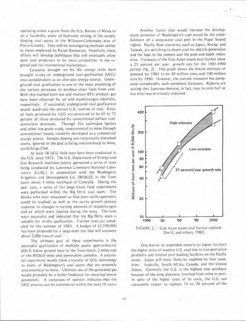
Another factor that would increase the development poteniia l of Washington's coal would be the establishment of a deep-water coal port in the Puget Sound region. Pacific Rim countries, such as Japan, Korea, and Taiwan. are switch ing to steam coal for electric generation and for heat in the cement and the pulp and paper industries. Forecasts of the East Asian steam coal market show a 21 percent per year growth rate for the 1985-1990 period (fig. 2). This graph shows the lowest estimate of demand by 1985 to be 40 million tons, and I 00 million tons by 1990. However, the current recession has dampened considerably such optimistic forecasts. Reports are stating 1hat Japanese demand, in fact, may be only half or less what was previously expected.
.J:l :::::. :, .... ~
0 0 o. c,, @J ... ra 4)
> t C.
"' C 0 ... t'. 0 .r. "' -0
"' C ,g ~
400
200
100 Low estimate
80
60 21 percent/year growth rate
40
20
10 L-~~-'-~~~J.-~~--''--~~ ....... ~ ....J
1980 '85 '90 '95 2000
FIGURE 2. - East Asian steam coal mark0t outlool... (Swifl, and others, 1980).
One barrier lo expanded exports to Japan has been the higher price of western US. coal due to transportation problems and limited port loading facilities on the Pacific coast. Japan will most likely be supplied by fo ur countries : Australia, South Africa, Canada, and the United States. Currently the U.S. is the highest cost producer because of the long distances involved from mine to port. In spite of the higher costs of its coals, the U 5. can reasonably expect to capture 10 to 20 percent o f the
l:ast Asian ex port market, because a concern of P<1cific Rim buyers is stability of supply.
The quality of coa l req uired by Pacif·ic Rim buyers at least until 1990-1995 should have the following minimum specifications: 10,800 BTU's per pound heat ing value; 10 percent ash, 10 percent moisture, and less than 1 percent su lfur . Coals of this quality are found in southwest Wyoming, northeast Utah, northwest Colorado, southwest Utah, and parts of the San Juan River and Raton Mesa regions of Colorado and New Mexico. Washington also has coals that meet the specifications mentioned above, although current prod uction is very smal l and comes from one mine in King Cou nty.
At least 11 possible coal port termina l sites have been proposed for Washington. The on ly port facility in the advanced stages of the development process in Washington is at Kalama on the Columbia River. The likelihood that a deep-water port will be built on Washington's coast or in the Puget Sound region, at least within the next decade, is slim.
An increased demand for steam coal in [ast Asia, and some technological advances will allow lower BTU coal to be used. Then the geographic area which can supply coal will expand to include the Powder River basin are.a of Wyoming and Montana. This will increase the possibi lity for a deep-water coal port in the Puget Sound region of Washington to handle these coals. With a coal port located within the state, Washington's coal wou ld become attractive by virture of its location.
In order to take full advantage of economic recovery in the future, exploration of Washington coal fields should be initiated as rapid ly as possible. The Division of Geology and Earth Resources of the Department of Natural Resources is doing everything possible to assemble and make data available so that new coal development becomes a reality in Washington.
REFERENCES
Beikman, H. M.; Gower, H. D.; Dana, T. A. M., 1961, Coal reserves of Washington: Washington Division of Mines and Geology Bulletin 47, 115 p.
Hansen, R. S.; Meadows, R. G.; Larou, F., Jr.; Black, W. V ., 1982, Puget Sound coal export opportunities and issues ; Prepared by CH2M HI LL for the Central Puget Sound Economic Development District, 96 p.
Hill, R. W.; Thotsness, C. B., 1982, The Centralia partial steam CRIP test, preliminary design: Lawrence Livermore Laboratory UCI D - 19610, November 19, 1982, 36 p,
l7
Hill, R. W.; Thorst1l'~s. C. B .. ·1982, The large block ll.:~ts. Pn::print or paper given at American I nstitutc ,>I Chemical Engineers Meeting, Anaheim, California, June 7-9, 1982; Lawrence Livermore National Laboratory, 42 p.
Hill, R. W.; Thorsness, C. B.; Cena, W. R.; Stephens, D. R., 1980, Results from the Third LLNL Underground Coal Gasification Experiment at Hoe Creek : Sixth Underground Coal Convention Symposium, Proceedings, Afton, Oklahoma, I uly 1980.
Kaiser Resources, ltd., Hydraulic Mining: Brochure prepared by Kaiser Resources Ltd., Vancouver, British Columbia, Canada.
Livingston, V. E., 1974, Coal in Washington . In Energy Resources of Washington: Washington Division of Geology and Earth Resources Information Circular 50,158p.
Moen, W. S., 1969, Mines and mineral deposits of Whatcom County, Washington: Washington Division of Mines and Geology Bulletin 57, 133 p., 14 plates.
Mortis, D. J .; Ames, P.R., 1980, Additional coal resources in the Green River district, King County, Washington: Pacific Northwest Metals and Minerals Confer· once, Seattle, May 7-9, 1980, 20 p.
Phi llips, W. M.; Walsh, T. W.; Schasse, H. W., 1982, Analyses and measured sections of Washington coals: Washington Division of Geology and Earth Resources Open-File Report 82-5, 181 p.
Stoffel, K. L., 1981. Preliminary report on the geology of the Grande Ronde lignite field, Asotin County, Washington: Washington Division of Geology and Earth Resources Open-File Report 81-6, 30 p., 1 plate.
Swift, W. H .; Scott, M. J .; Haskins, J . P ., 1980, Beluga coal export market study . In Rao, P. D.; Wolff, E. N., editors, 1980, Focus on Alaska's coal '80: Proceedings of conference held at the University of Alaska, Fairbanks, October 21-23, 1980, Ml RL Report no. 50, p. 358-373.
Vonheeder, E. R., 1975, Washington state coal resources: Washington Division of Geology and Earth Resources Geologic Newsletter, v. 3, no. 4, p. 9-11.
Vonhceder, E. R., 1976, Coal exploration on stateadministered lands in Whatcom and Skagit Counties during 1976: Washington Division of Geology and Earth Resources Geologic Newsletter, v. 5, no. 1, p, 11-17.
Vonheeder, E. R., 1979, Nonmetallic and industrial minerals and energy exploration: Washington Division of Geology and Earth Resources Geologic Newsletter, v. 7, no. 1, p. 7-8.
Vonheeder, E. R., 1982, Minerals and energy exploration activities in Washington, 1981: Washington Division of Geology and Earth Resources Geologic Newsletter, v. 101 no. I, p, 1-8.
W,tlkcr, C. W ., 1980, Geology ,ltld energy re,ourccs or the Roslyn-Cle Elum area, KitLitas County, Washington : Wash,ngtun Division of Geology and Earth Rl·· ,ourccs Open-rile Report 80-1, 59 p., 25 plates.
Washington Department of Commerce and Economic Development, 1981 , Coal/bulk commodity/ transportation issue paper: Washington Department of Commerce and Economic Development Physical Distribution Office, Seattle, May 22, 1981, 13 p.
Western Governor's Policy Office (WESTPO), 1981, Western US. steam coal exports to the Pacific Basin: Joint study of the Western Coal Export Task rorce and the Working Groups of Japan, The Republic of China, and The Republic of Korea, McGraw-Hill .
DON FORD RETIRES
Dunc1ld (Don) M. Ford announced his pending l'~' t iremcnt to be effective February l , 1983. Don served the Department of Natural Resources Division of Geology and Earth Resources as Assistant State Geo logist from 1970 to 1983. During this period , ht:wasresponsible for the .tdministration of the Surface Mined Land Reclamation Act involving coordination between state and county agencies, dealing with the public and coordinating and training area personnel. He served a~ Deputy Oil and Gas Supervisor in the implementation of the Oil and Gas Conservation Act. The revised o il and gas and the geothermal resources drilling regulations were largely the handiwork of Don. In addition, he wc.1s involved in the supervision of the Environmental Geology and Opera-1ion. ~ection of the division.
1 8
Representing the State of Washington, Don worked with other states in the establishment of the National Association of State Land Reclamationists, an organization of states designed to coordinate state reclamation activity, to serve in a liaison capacity with the federal government, and to provide input to legislation. He later served as national chairman and on the executive board.
During the past 4 years, he has represented the division and the department on the Geologic Overview Committee of the Basalt Waste Isolation Prolect by Rockwell Hanford Operations and the U.S. Department of Energy.
Prior to transfer to the Geology Division in 1970. Don served as Mineral Lands Supervisor with the Lands Division of the department. 1,, this division Don had the responsibility of hand ling oil and gas and mineral leasing or state-owned lands and the sale of valuable mineral matcrfals. During his time with the Lands Division, he assisted in the c.1cquisition of two Twin Beech aircraft for the department. His flight log book shows that he logged approximately 300 hours flying for the department in administrative and fire control activities. Don's flying interest dates back to World War II days when he flew B-24's over Europe. He continued his interest in military flying by participating in the Air Force Reserves, This resulted in his being recalled to active duty for 10 years in 1968-69 when he flew C-124's with the Military Airlift Command.
Don has been with the department for 25 years. He has indicated that he will miss the department and the cha llenges of dealing with people on difficult issues.
BEDROCK GEOLOGIC MAP OF THE OKANOGAN RANGE
AVA ILABLE FOR PURCHASE
Dr. Fred I. Menz.er, Jr., has prepared a "Bedrock Geologic Map of the Central Okanogan Range, Washington," in conjunction with an article he has written for a Geological Society of America bullet in [ in press J . The map can be purchased from the Western State College roundation, 120 N. Blvd., Gunn ison, CO, 81230. The map, with gravity lines, is available for $5 and is accompanied by "A Note on the Gravity of the Central Okano· gan Range, Washington," by Chandler, A. Swanberg. A limited number of the same map, without gravity lines, is available ror $4. The map location is T. 33-36 N., R. 21-26E.; scalu 1 :63,360. A copy of the map is available for reference at the Division of Geology and Earth Resources library.
~ . .
THESES ADDEO TO DIVISION LIBRARY
The following theses were recently added to our division library where they are now available fo r reference work:
Cruver, S. K., 1981, The geology and mineralogy of bentonites and associated rocks of the Chuckanut Formation, Mount Higgins area, north Cascades, Washington: Western Washington University M.S . thesis, 105 p., 2 plates.
Fenton, R. L., 1974, The syntactic log as a too l for correlating basalt stratigraphy: Washington State University M.S. thesis, 59 p.
Fischer, H. J ., 1981, The lithology and diagenesis of the Metaline Formation, northeastern Washington: University of Idaho Ph.D. thesis, 175 p.
Frasse, F. I., 1981, Geology and structure of the western and southern margins of Twin Sisters Mountain, north Cascades, Washington: Western Washington University M.S. thesis, 87 p.1 2 plates.
Gager, B. R., 1982, Stratigraphy, sedimentology, and tectonic implications of the Tiger Formation, Pend Oreille and Stevens Counties, Washington: University of Washington M.S. thesis, 176 p., 6 plates.
Gavenda, R. T., 1980, A characterization of the soils and landscape at the Manis Mastodon Site, Sequim, Washington: Washington State University M.S. thesis, 70 p.
lohnson, 5. Y ., 1982, Stratigraphy, sedimentology, and tectonic setti ng of the Eocene Chuckanut Formation, northwest Washington: University of Washington Ph.D. thesis, 221 p., 4 plates.
Phillips, R. L., 1980, Compressional wave velocities to 2000 bars of basalts from the Columbia Plateau, Washington: Southern Methodist University M.S. thesis, 71 p.
Pitts, G. S., 1979, Interpretation of gravity measurements made in the Cascade Mountains and adjoining Basin and Range province in centra l Oregon: Oregon State University M.S. thesis, 186 p.
19
Street-Marlin, L. V ., 1981, The chemical composition of the Shuksan metamorphic suite in the Gee Point· Finney Creek area, north Cascades, Washington: Western Wash ington University M .S. thesis, 98 p., 1 plate.
RECENT GEOLOGIC REPORTS ADDED TO OUR DIVISION LIBRARY
The following reports have recently been acquired by the Division of Geology and Earth Resources and arc now available for reference work in the library:
Alpha, T. R.; Morley, ). M.; Myers, Bobbie; lcighley, Terry, 1982, Physiographic diagrams of Mount St. Helens, Washington, showing changes in its summit crater, 1981: U5. Geological Survey Miscellaneous Field Studies Map MF-1420, 1 sheet.
Bendix Field Engineering Corp., 1982, Survey of lands held for uranium exploration, development, and production in fourteen western states for Lhe 6-month period ending June 30, 1982: U.S. Department of Energy G J BX-21 9(82), 22 p.
Bortleson, G. C.; Chrzastowski, M. J .; Helgerson, A. K., 1980, Historical changes of shoreline and wetland at eleven major deltas in the Puget Sound region, Washington: U.S. Geological Survey Hydrologic Atlas HA-617, 11 sheets.
Close, T. C., 1982, Summary report - Miner.31 Investigation of the Goat Rocks Wilderness study area (FS), Lowis and Yakima Counties, Washington: U.S. Bureau of Mines MLA 130-82, 11 p.
Fleshman, B. R.; Dodd, S. P., 1982, National uranium resource evaluation, Ritzville quadrangle, Washing· ton: U.S . Department of Energy PGJ /F-041 (82), 62 p., 3 sheets microfiche, 18 plates.
International Exploration, 1982, Geophysical interpretation of airborne magnetic data, Midnite-Sherwood mines, NE Washington: US. Department of Energy GJBX-110(82), 55 p., 9 plates.
Tabor, R. W., 1982, Geologic map of the Wonder Mountain roadless area, Mason County, Washington: US. Geo logical Survey M isccllaneous Field Studies Map MF-1418-A, 1 sheet, scale 1 :62,500.
Tabor, R. W.; Fr izzell, V. A., Jr.; Yeats, R. S.; Whetten, J. T ., 1982, Geologic map of the Eagle Rock and Glacier Peak roadless areas, Snohomish and King Counties, Washington: U.S. Geological Survey Miscellaneous Field Studies Map MF-1380-A, 1 sheet, scale 1:100,000.
RECENT U.S. GEOLOGICAL SURVEY OPEN-FILE REPORTS ADDED TO OUR DIVISION LIBRARY
The following U.S. Geological Survey Open-File Reports arc now availab le for inspection in our division library. However, if you wish to purchase any of these reports, please write or call:
Open-File Service Section Branch of Distribution U.S. Geological Survey Box 25425, Federal Center Denver, CO 80225 (303) 234-5888
Prepayment is required. Open-file reports are announced, with price, in the monthly list, ''New Publications of the Geological Survey." A free subscription to the list may be obtained on application to: Mailing List Unit, U.S. Geological Survey, 329 National Center, Rcston, VA 22092.
Beget, J. E., 1982, Postglacial volcanic deposits at Glacier Peak, Washington, and potential hazards frorn future eruptions: U.S. Geological Survey Open-File Report 82-830, 77 p.
Dcthicr, D. P.; Satioles, S. A.; Minard, J.P., 1982, Preliminary geologic map of the Mc1xwclton quadrangle, Island County, Washington: U.S. Geological Survey Open-File Report 82-192, 13 p., 1 plate, scalC! 1 :24,000.
20
Evans, J. G., 1982, Preliminary geologic map ot th<' Stensgar Mountain quadrangle, Stevens County 1
Washington: U.S. Geological Survey Open-File Report 82-492, 1 sheet, scale 1 :24,000.
Jacobson, M. L.; Rodriguez, T. R.; Seiders, W. H., compilers, 1982, Summaries of technical reports, volume XIV, prepared by participants in National Earthquake Hazards Reduction Program: U.S. Geological Survey Open-File Report 82-840, 472 p.
Schneider, Robert; Trask, N. )., 1982, U.S. Geological Survey research in radioacLive waste disposal -Fiscal year 1980: U.S. Geological Survey OpenFile Report 82-509, 110 P-
Smith, D. B.; Zielinski, R. A.; Taylor, H. E., 1982, Leaching characteristics of ash from thl' May 18, 1980, eruption of Mount St. Hcli:ns volcano, Wushington: U.S. Gcologil. .. tl Survey Open-File Report 82-987, 22 p.
Staatz, M. H.; Armbrustmacher, T. J ., 'I 982, Preliminary map of the thorium provinces in the conterminous United States: U.S. Geological Survey Open-File Report 79-567U, 1 sheet, scale 1 :5,000,000.
Stanley, W. D., 1982, A regional magnctotelluric ~urvey of the Cascade Range region, northwestern United States: U.S. Geological Survey Open-File Report 82-126, 7 sheets microfiche.
T.1bor, R. W.,; friaell, V. A., Jr.; Booth, D. B.;Whettl'n, J. T.: Waitt, R. B., Jr.; Zartman, R. E., 1982, Preliminary geologic map of the Skykomish River l :100,000 quadrangle, Washington: U.S. Geological Survey Open-File Report 82-747, 31 p.1 1 plate, scale 1 :100,000.
U.S. Geological Survey, 1982, Research, investigations, and technical developments, National Mapping Program, 1981 : U.S. Geological Survey Opcn-F ile Report 82·236, 85 p.
• #