Wallingford Conservation Area Appraisal · Wallingford Conservation Area Appraisal Wallingford...
36
Wallingford Conservation Area Appraisal Consultation Draft October - November 2017
Transcript of Wallingford Conservation Area Appraisal · Wallingford Conservation Area Appraisal Wallingford...
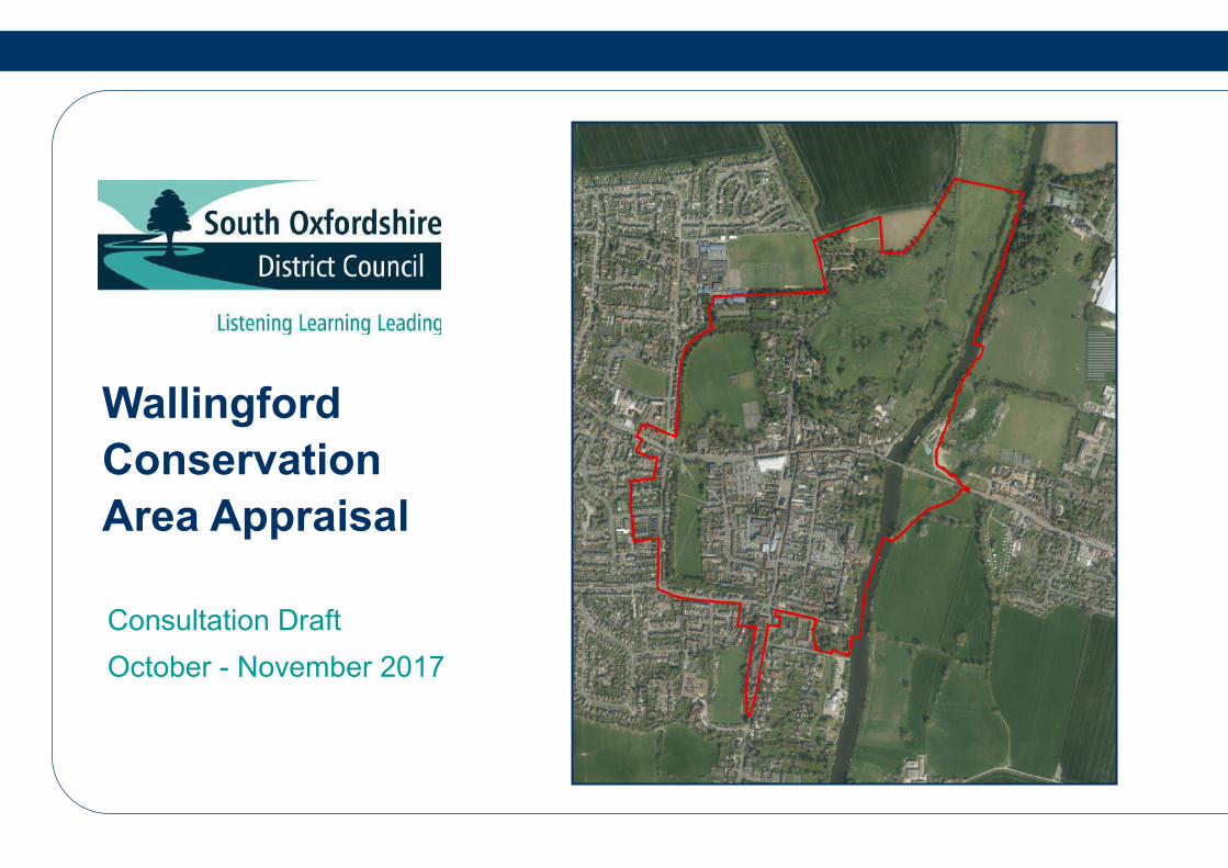
Wallingford
Conservation
Area Appraisal
Consultation Draft
October - November 2017
Wallingford Conservation Area Appraisal
Wallingford Conservation Area Appraisal Consultation Draft Oct-Nov 2017 2
Acknowledgements
This document has been produced with thanks to The Conservation Studio who produced a thorough draft of the area in 2012. Their draft has formed the basis for this amended and updated document.
Conservation and Design Team South Oxfordshire District Council 135 Eastern Avenue Milton Park OX14 4SB
Tel: 01235 422600
Email: [email protected]
www.southoxon.gov.uk
All maps are reproduced from, or based upon, Ordnance Survey material with the permission of Ordnance Survey on behalf of the Controller of Her Majesty’s Stationery Office. © Crown copyright.
Unauthorised reproduction infringes Crown copyright and may lead to prosecution or civil proceedings.
South Oxfordshire District Council 100018668 2012
Contact Copyright
Wallingford Conservation Area Appraisal
Wallingford Conservation Area Appraisal Consultation Draft Oct-Nov 2017 3
1. Introduction and Policy Context ……………………......4
2. Summary of Special Interest ………………………...…..8
3. Assessment of Special Interest ……………….……..….10
Location and Geography……………………………………….
General Character and Plan Form…………………………….
Listed Buildings………………………………………………….
Local Interest Buildings………………………………………...
Landscape Setting……………………………………………...
4. Historic Development and Archaeology......................19
The origins and historic development of the area…………...
Archaeology……………………………………………………..
5. Spatial Analysis ……………………….……………….....24
Street Pattern and Layout……………………………………...
Building Plots…………………………………………………...
Activity and prevailing or former uses………………………..
Views and Vistas……………………………………………….
Trees, Landscape and open spaces ………………………..
Biodiversity Value……………………………………………...
Public Realm…………………………………………………...
6. Character Analysis …………………………….....…………...37
Character Area 1: Victorian Suburbs: Croft Road and St Johns Road
Character Area 2: The Saxon Embankments: Kinecroft and Bullcroft
Character Area 3: Western Town Wall Infill: Goldsmiths Lane environs
Character Area 4: High Street
Character Area 5: Market Place, St Marys Street and St Martins Street
Character Area 6: Eastern Town Wall Infill: Wood Street environs
Character Area 7: Riverside: Thames Street
Character Area 8: Wallingford Castle and Meadow
Character Area 9: Northern Approach: Castle Street
Character Area 10: Southern Approach: Reading Road and Squires
Walk……………………………………………………………………
7. Boundary Changes ………………………..…….……….…....76
8. Future Management of the Conservation Area …….…….77
9. References and Useful Information ……...……….………..81
10. Listed Buildings …………………………………….……….....82
Appendix A: Local Interest Buildings
Appendix B: All Maps
Contents
Wallingford Conservation Area Appraisal
Wallingford Conservation Area Appraisal Consultation Draft Oct-Nov 2017 4
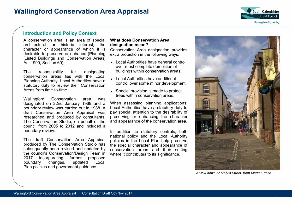
A conservation area is an area of special architectural or historic interest, the character or appearance of which it is desirable to preserve or enhance (Planning [Listed Buildings and Conservation Areas] Act 1990, Section 69). The responsibility for designating conservation areas lies with the Local Planning Authority. Local Authorities have a statutory duty to review their Conservation Areas from time-to-time. Wallingford Conservation area was designated on 22nd January 1969 and a boundary review was carried out in 1988. A draft Conservation Area Appraisal was researched and produced by consultants, The Conservation Studio, on behalf of the council from 2005 to 2012 and included a boundary review. The draft Conservation Area Appraisal produced by The Conservation Studio has subsequently been revised and updated by the council’s Conservation/Design Team in 2017 incorporating further proposed boundary changes, updated Local Plan policies and government guidance.
What does Conservation Area designation mean?
Conservation Area designation provides extra protection in the following ways:
Local Authorities have general control over most complete demolition of buildings within conservation areas;
Local Authorities have additional control over some minor development;
Special provision is made to protect trees within conservation areas.
When assessing planning applications, Local Authorities have a statutory duty to pay special attention to the desirability of preserving or enhancing the character and appearance of the conservation area.
In addition to statutory controls, both national policy and the Local Authority policies in the Local Plan help preserve the special character and appearance of conservation areas and their setting where it contributes to its significance.
Introduction and Policy Context
A view down St Mary’s Street from Market Place
Wallingford Conservation Area Appraisal
Wallingford Conservation Area Appraisal Consultation Draft Oct-Nov 2017 5
What is the purpose of a conservation area appraisal?
The aim of this Appraisal is to:
Identify the special architectural or historic interest and the changing needs of the conservation area;
Define the conservation area boundaries;
Increase public awareness and involvement in the preservation and enhancement of the area;
Provide a framework for informed planning decisions;
Guide controlled and positive management of change within the conservation area to minimise harm and encourage high quality, contextually responsive design.
Planning Policy Context
The development plan currently comprises the South Oxfordshire Core Strategy 2012 and the saved policies of the South Oxfordshire Local Plan 2011. Other material planning considerations include the National Planning Policy Framework 2012 (NPPF), Planning Practice Guidance (PPG) and the emerging South Oxfordshire Local Plan 2032.
Full details of the enabling legislation, local development management policies and effects of conservation area designation can be found on the Council’s website and in the advisory documents listed in Section 9.
Consultation
Consultation is an important part of the designation process. Local views will be sought prior to the designation or alteration of conservation areas and suggestions and comments are welcomed. This will be carried out in accordance with the council’s Statement of Community Involvement June 2017. Notice of a newly designated or altered conservation area is publicised in the London Gazette, a local newspaper and registered in the Local Land Charges Register.
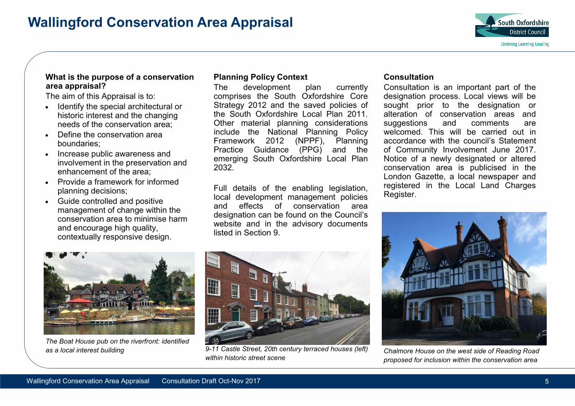
9-11 Castle Street, 20th century terraced houses (left)
within historic street scene Chalmore House on the west side of Reading Road
proposed for inclusion within the conservation area
The Boat House pub on the riverfront: identified
as a local interest building
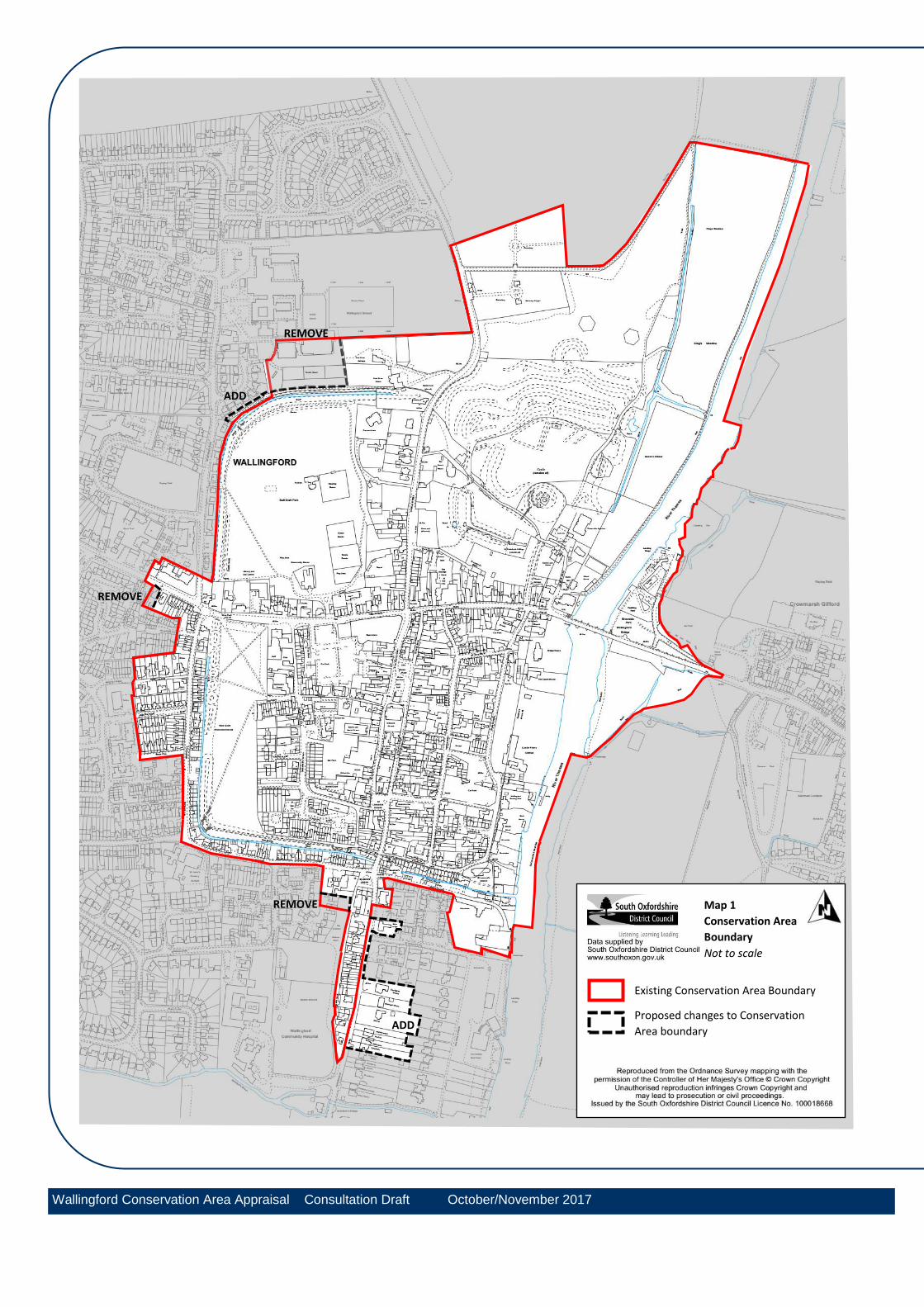
Map 1
Conservation Area
Boundary
Not to scale
Existing Conservation Area Boundary
Proposed changes to Conservation
Area boundary
REMOVE
ADD
REMOVE
REMOVE
ADD
Wallingford Conservation Area Appraisal Consultation Draft October/November 2017
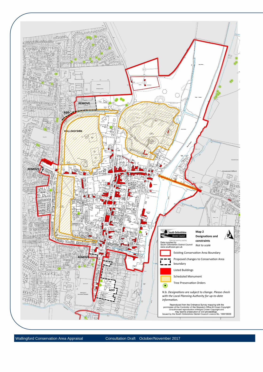
Map 2
Designations and
constraints
Not to scale
Existing Conservation Area Boundary
Proposed changes to Conservation Area
boundary
Listed Buildings
Scheduled Monument
Tree Preservation Orders
REMOVE
ADD
REMOVE
REMOVE
ADD N.b. Designations are subject to change. Please check with the Local Planning Authority for up-to-date information.
Wallingford Conservation Area Appraisal Consultation Draft October/November 2017
Wallingford Conservation Area Appraisal
Wallingford Conservation Area Appraisal Consultation Draft Oct-Nov 2017 8
The primary significance of Wallingford conservation area is as a town located on an important river crossing over the River Thames. It became a major historical military strategic site under the Saxons and has the best-preserved town plan of this period in England complete with 11th century motte and bailey castle. Wallingford also developed as an important market centre with exclusive trade links via river and road from early times.
This assessment of significance follows the framework set out in Historic England’s 2008 document Conservation Principles:
Evidential value: the potential of a place to yield evidence about past human activity.
Historical value: the ways in which past people, events and aspects of life can be connected through a place to the present - it tends to be illustrative or associative.
Aesthetic value: the ways in which people draw sensory and intellectual stimulation from a place.
Communal value: the meanings of a place for the people who relate to it, or for whom it figures in their collective experience or memory.
Evidential value: high (national importance) There is high evidential value in the archaeological remains of Wallingford which consists of both the below-ground archaeological remains and its buildings. There is yet more to be discovered in terms of below and above ground archaeology with archaeological reports emerging with new information regularly. Significant archaeological investigation was carried out during the early 21st century encapsulated by the Wallingford Burh to Borough Research Project. This discovered large numbers of finds both within and out of the Saxon town walls and supported the understanding that the Saxon town was initially designed as a fortress rather than as a town. Large numbers of finds were discovered and dated in the areas outside of the Saxon defences and particularly in the area to the south suggesting that there was settlement in Wallingford long before the Saxon development of the town. The findings of this project in combination with the reports on previous major digs culminated in a published monograph by The Society for Medieval Archaeology (2013).
Historical value: high (nationally important)
Wallingford conservation area has high historical illustrative value from pre-historic and Roman times to the present day. This is represented in the town’s evolution and form; the persistence of ancient routes, the remarkable survival of the Saxon street plan, defensive earthworks, the moated castle site and the range of buildings from Medieval times to the present day which includes the urban expansions of the 19
th
and early 20th centuries.
Each character area defined within this appraisal has a distinct historic character, which adds to the historic interest of the whole conservation area.
2. Summary of Special Interest
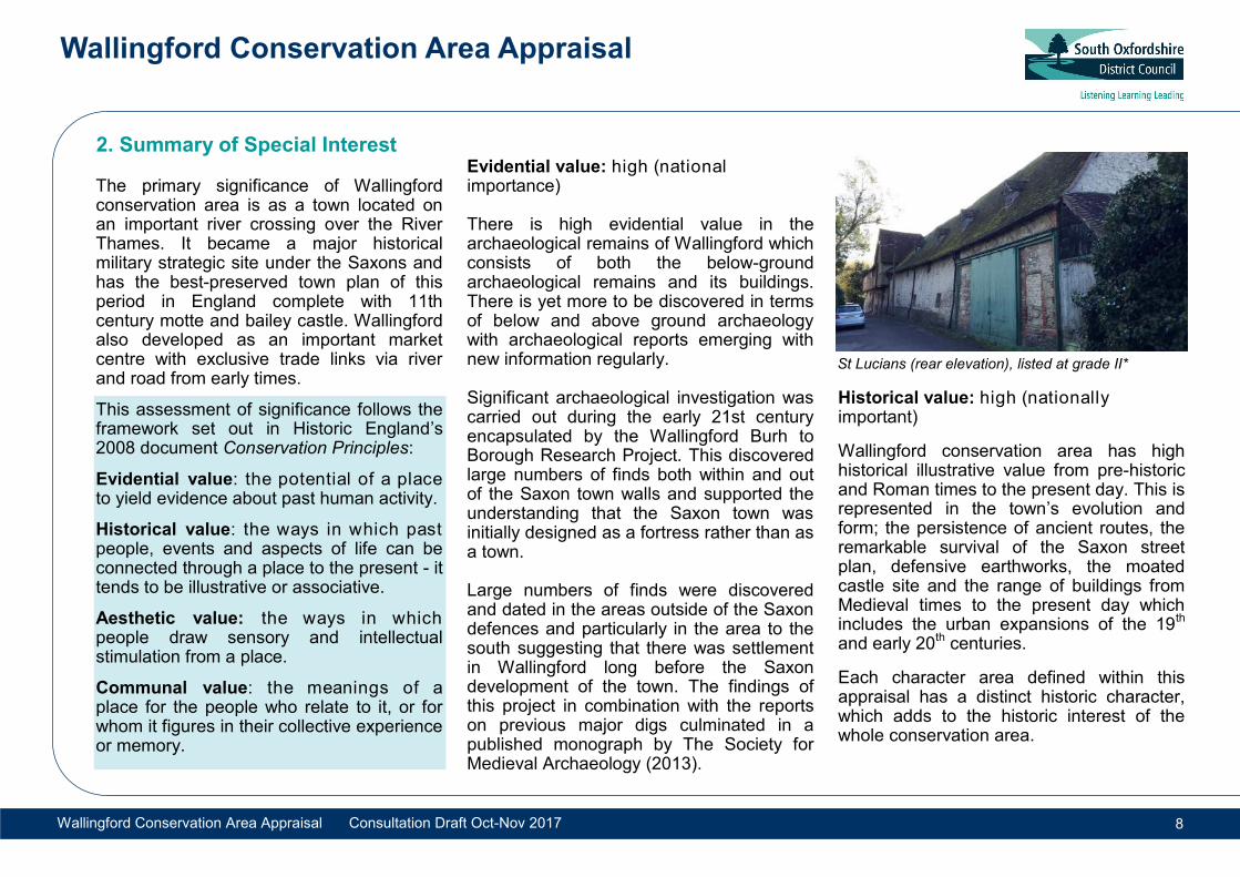
St Lucians (rear elevation), listed at grade II*
Wallingford Conservation Area Appraisal
Wallingford Conservation Area Appraisal Consultation Draft Oct-Nov 2017 9
Wallingford conservation area has high associational value in its royal connections. King Alfred developed Wallingford as a defensive military town to protect Wessex from the Danes in the Saxon period. Wallingford Castle was later built on instruction from William the Conqueror and thereafter became an important royalist residence and stronghold.
It was held by Empress Matilda during the 12th century civil war and after the war the town was granted a Charter by Matilda’s son and heir Henry II. The castle was almost continuously a royal residence until the time of King Henry VIII.
Wallingford then played a pivotal role in the English Civil War, being the last major royalist stronghold to surrender in 1646.
Wallingford also holds importance as the home of Judge William Blackstone of Castle Priory whose 18th Century Commentaries on the Laws of England helped shape the legal system and Constitution of the newly created United States of America.
Aesthetic value: medium to high (regional and national importance)
Wallingford conservation area’s aesthetic interest arises from the architectural qualities of individual buildings, the landscape and river setting, ancient earthworks, Saxon enclosures and street plan. The open green spaces of the Kinecroft, Bullcroft and Castle Meadows are offset by the close-knit nature of the streets in between. The Victorian and Edwardian extensions to the town consist of planned streets with individual details and designs that show conscious aesthetic intent.
Communal value: medium (regional importance)
Wallingford conservation area has had a historic communal use from early times as demonstrated by the development of the town with market centre. It has a thriving and active local community and its heritage value is enriched by the continuance of long standing local events and activities associated with leisure and religion.
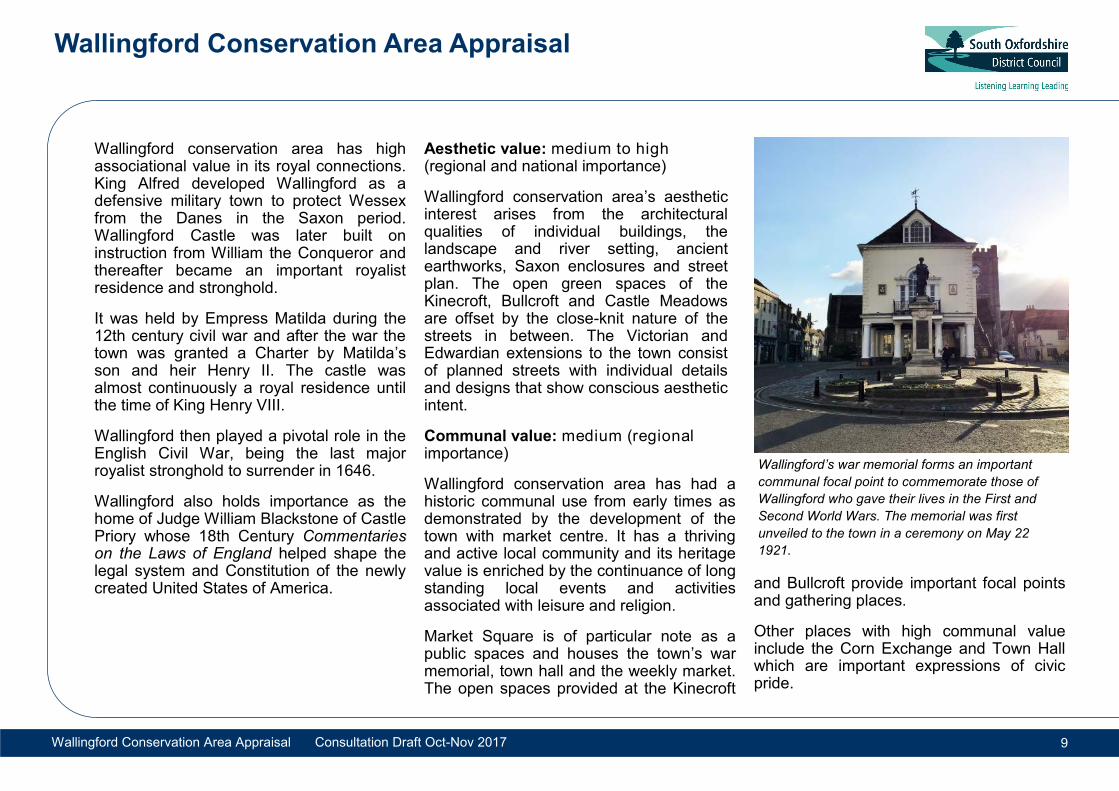
Market Square is of particular note as a public spaces and houses the town’s war memorial, town hall and the weekly market. The open spaces provided at the Kinecroft
and Bullcroft provide important focal points and gathering places.
Other places with high communal value include the Corn Exchange and Town Hall which are important expressions of civic pride.
Wallingford’s war memorial forms an important
communal focal point to commemorate those of
Wallingford who gave their lives in the First and
Second World Wars. The memorial was first
unveiled to the town in a ceremony on May 22
1921.
Wallingford Conservation Area Appraisal
Wallingford Conservation Area Appraisal Consultation Draft Oct-Nov 2017 10
3.1 Location and Geography Wallingford is within south Oxfordshire on the flat, low-lying floodplain of the River Thames. It is bounded on its east by the River Thames which flows from north to south framing the eastern edge of the settlement. The town is approximately 50 miles west of London, 20 kilometres (12 ½ miles) south-west of Oxford and 9km east of Didcot. The A4130, which connects Henley to Didcot, passes through the town centre from east to west. In the 1990s a southern bypass was provided to alleviate traffic congestion in the town centre. Wallingford is well connected by road and local bus services to Oxford, Reading and Henley. There is a railway station at Cholsey, three miles away. Mooring facilities are available for those arriving by boat along the River Thames. The town lies on the Thames Path National Trail which runs for 184 miles from the source of the Thames to the Thames Barrier in Greenwich. Routes 4 and 5 of the National Cycle Network pass through the town. Wallingford lies on a gravel spur next to the river although the level of the land in
the town is generally no more than 55 metres above sea level. The town is immediately surrounded by the flat flood plain of the river, although on the east side of the river beyond Newnham Murren and Mongewell, the land rises gradually along a gentle escarpment. To the west, the land also rises to Cholsey Hill (74 metres) and Brightwell-cum-Sotwell (105 metres). Whilst clay is found in the Vale to the east of the River Thames, the immediate geology is gravel and alluvium over chalk. This provides the distinctive flints and clunch (chalk building stone) which is typical of the area, along with deep red or blue bricks made from the local clay. Historically, the limestone of the Oxford Heights to the north of Wallingford has also provided a popular building material.
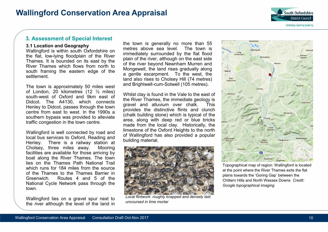
Topographical map of region: Wallingford is located
at the point where the River Thames exits the flat
plains towards the ‘Goring Gap’ between the
Chiltern Hills and North Wessex Downs Credit:
Google topographical imaging
3. Assessment of Special Interest
Local flintwork: roughly knapped and densely laid
uncoursed in lime mortar
Wallingford Conservation Area Appraisal
Wallingford Conservation Area Appraisal Consultation Draft Oct-Nov 2017 11
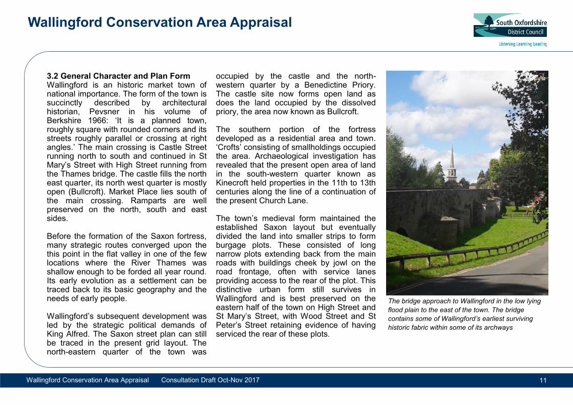
3.2 General Character and Plan Form Wallingford is an historic market town of national importance. The form of the town is succinctly described by architectural historian, Pevsner in his volume of Berkshire 1966: ‘It is a planned town, roughly square with rounded corners and its streets roughly parallel or crossing at right angles.’ The main crossing is Castle Street running north to south and continued in St Mary’s Street with High Street running from the Thames bridge. The castle fills the north east quarter, its north west quarter is mostly open (Bullcroft). Market Place lies south of the main crossing. Ramparts are well preserved on the north, south and east sides. Before the formation of the Saxon fortress, many strategic routes converged upon the this point in the flat valley in one of the few locations where the River Thames was shallow enough to be forded all year round. Its early evolution as a settlement can be traced back to its basic geography and the needs of early people. Wallingford’s subsequent development was led by the strategic political demands of King Alfred. The Saxon street plan can still be traced in the present grid layout. The north-eastern quarter of the town was
occupied by the castle and the north-western quarter by a Benedictine Priory. The castle site now forms open land as does the land occupied by the dissolved priory, the area now known as Bullcroft. The southern portion of the fortress developed as a residential area and town. ‘Crofts’ consisting of smallholdings occupied the area. Archaeological investigation has revealed that the present open area of land in the south-western quarter known as Kinecroft held properties in the 11th to 13th centuries along the line of a continuation of the present Church Lane. The town’s medieval form maintained the established Saxon layout but eventually divided the land into smaller strips to form burgage plots. These consisted of long narrow plots extending back from the main roads with buildings cheek by jowl on the road frontage, often with service lanes providing access to the rear of the plot. This distinctive urban form still survives in Wallingford and is best preserved on the eastern half of the town on High Street and St Mary’s Street, with Wood Street and St Peter’s Street retaining evidence of having serviced the rear of these plots.
The bridge approach to Wallingford in the low lying
flood plain to the east of the town. The bridge
contains some of Wallingford’s earliest surviving
historic fabric within some of its archways
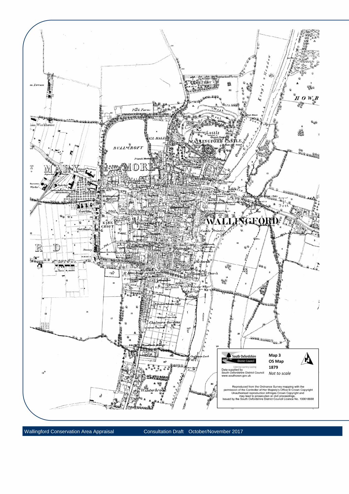
Map 3
OS Map
1879
Not to scale
Wallingford Conservation Area Appraisal Consultation Draft October/November 2017
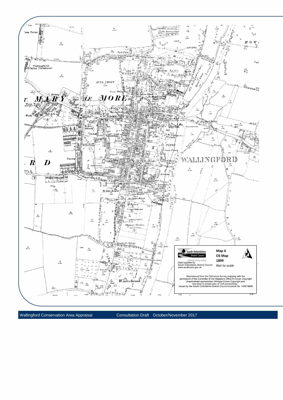
Map 4
OS Map
1899
Not to scale
Wallingford Conservation Area Appraisal Consultation Draft October/November 2017
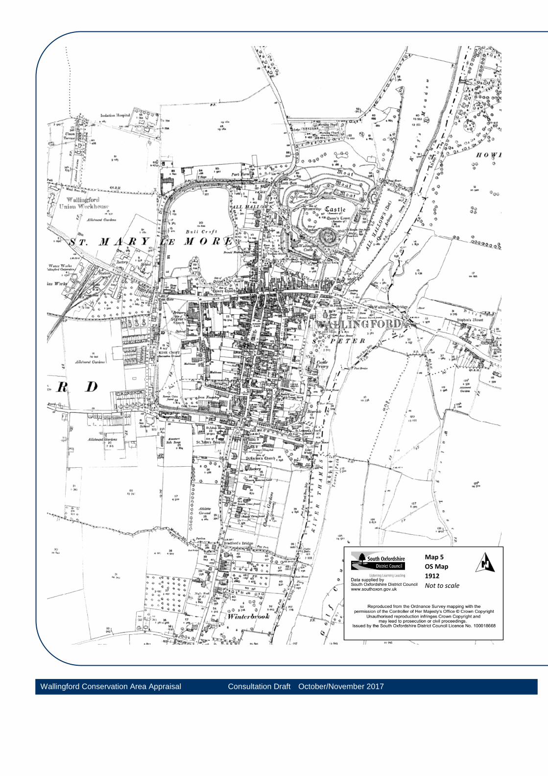
Map 5
OS Map
1912
Not to scale
Wallingford Conservation Area Appraisal Consultation Draft October/November 2017
Wallingford Conservation Area Appraisal
Wallingford Conservation Area Appraisal Consultation Draft Oct-Nov 2017 15
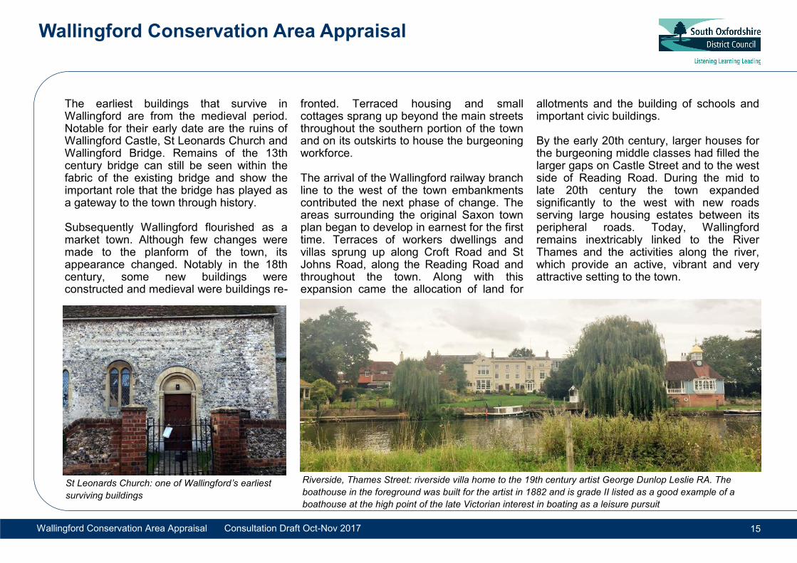
The earliest buildings that survive in Wallingford are from the medieval period. Notable for their early date are the ruins of Wallingford Castle, St Leonards Church and Wallingford Bridge. Remains of the 13th century bridge can still be seen within the fabric of the existing bridge and show the important role that the bridge has played as a gateway to the town through history. Subsequently Wallingford flourished as a market town. Although few changes were made to the planform of the town, its appearance changed. Notably in the 18th century, some new buildings were constructed and medieval were buildings re-
fronted. Terraced housing and small cottages sprang up beyond the main streets throughout the southern portion of the town and on its outskirts to house the burgeoning workforce. The arrival of the Wallingford railway branch line to the west of the town embankments contributed the next phase of change. The areas surrounding the original Saxon town plan began to develop in earnest for the first time. Terraces of workers dwellings and villas sprung up along Croft Road and St Johns Road, along the Reading Road and throughout the town. Along with this expansion came the allocation of land for
allotments and the building of schools and important civic buildings. By the early 20th century, larger houses for the burgeoning middle classes had filled the larger gaps on Castle Street and to the west side of Reading Road. During the mid to late 20th century the town expanded significantly to the west with new roads serving large housing estates between its peripheral roads. Today, Wallingford remains inextricably linked to the River Thames and the activities along the river, which provide an active, vibrant and very attractive setting to the town.
St Leonards Church: one of Wallingford’s earliest
surviving buildings
Riverside, Thames Street: riverside villa home to the 19th century artist George Dunlop Leslie RA. The
boathouse in the foreground was built for the artist in 1882 and is grade II listed as a good example of a
boathouse at the high point of the late Victorian interest in boating as a leisure pursuit
Wallingford Conservation Area Appraisal
Wallingford Conservation Area Appraisal Consultation Draft Oct-Nov 2017 16
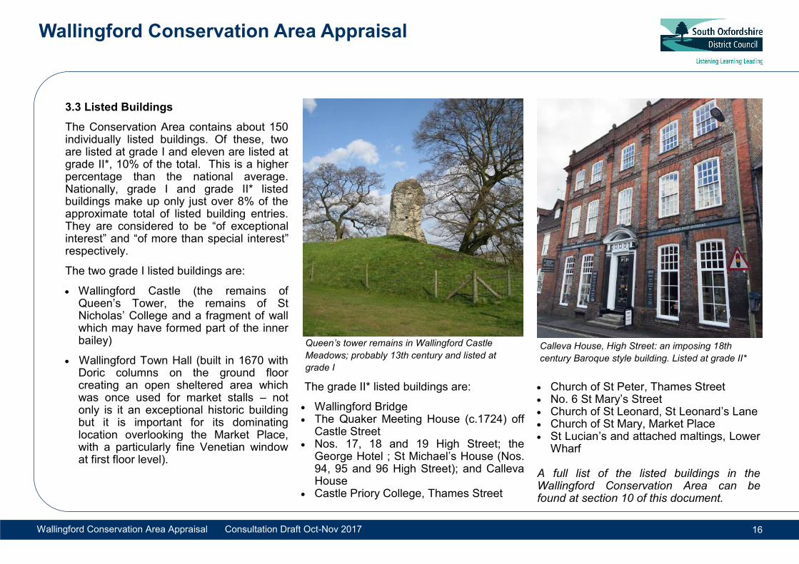
3.3 Listed Buildings
The Conservation Area contains about 150 individually listed buildings. Of these, two are listed at grade I and eleven are listed at grade II*, 10% of the total. This is a higher percentage than the national average. Nationally, grade I and grade II* listed buildings make up only just over 8% of the approximate total of listed building entries. They are considered to be “of exceptional interest” and “of more than special interest” respectively.
The two grade I listed buildings are:
Wallingford Castle (the remains of Queen’s Tower, the remains of St Nicholas’ College and a fragment of wall which may have formed part of the inner bailey)
Wallingford Town Hall (built in 1670 with Doric columns on the ground floor creating an open sheltered area which was once used for market stalls – not only is it an exceptional historic building but it is important for its dominating location overlooking the Market Place, with a particularly fine Venetian window at first floor level).
The grade II* listed buildings are:
Wallingford Bridge The Quaker Meeting House (c.1724) off
Castle Street Nos. 17, 18 and 19 High Street; the
George Hotel ; St Michael’s House (Nos. 94, 95 and 96 High Street); and Calleva House
Castle Priory College, Thames Street
Church of St Peter, Thames Street No. 6 St Mary’s Street Church of St Leonard, St Leonard’s Lane Church of St Mary, Market Place St Lucian’s and attached maltings, Lower
Wharf A full list of the listed buildings in the Wallingford Conservation Area can be found at section 10 of this document.
Calleva House, High Street: an imposing 18th
century Baroque style building. Listed at grade II*
Queen’s tower remains in Wallingford Castle
Meadows; probably 13th century and listed at
grade I
Wallingford Conservation Area Appraisal
Wallingford Conservation Area Appraisal Consultation Draft Oct-Nov 2017 17
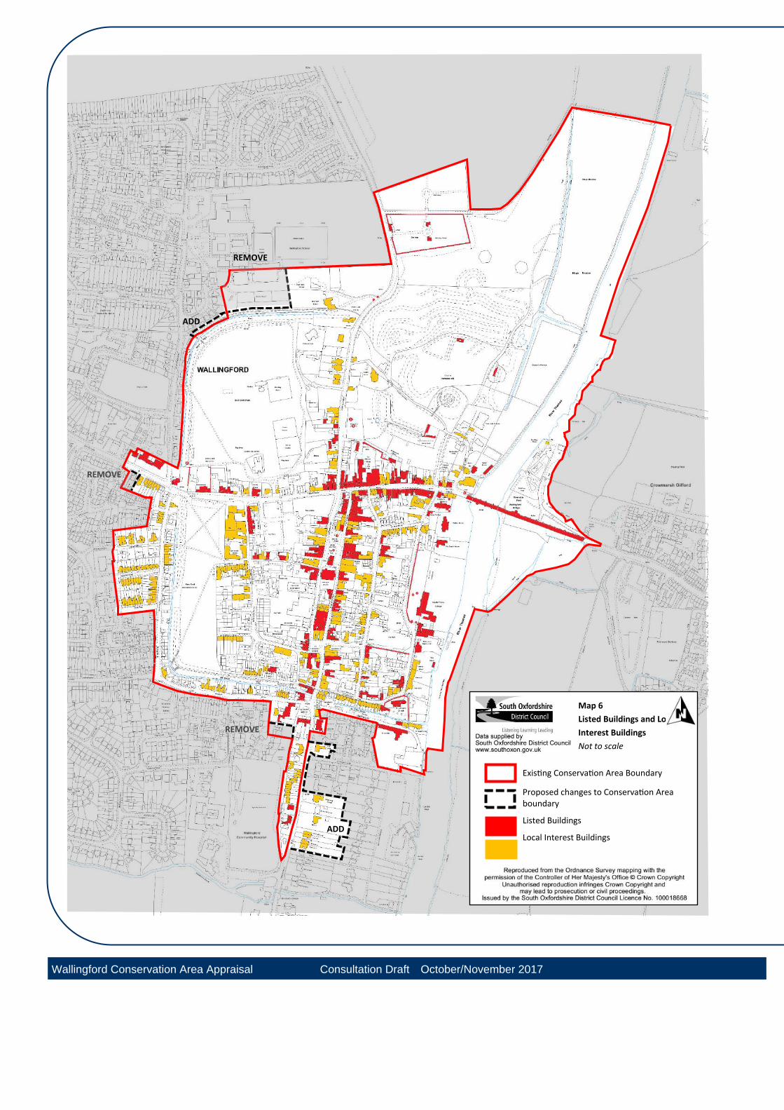
3.4 Local Interest Buildings
Some buildings are not listed but make a positive contribution to the special architectural and historic character of the conservation area. These buildings meet the criteria set out by Historic England in Local Heritage Listing: Historic England Advice Note 7. Although they are not statutorily protected, the effect of developments upon their significance can be considered within planning applications against the tests of paragraph 135 of the National Planning Policy Framework as ‘non-designated heritage assets’. Local Interest Buildings are identified in yellow on Map 6. Photographs and descriptions are included as an appendix to this document. Some examples of buildings which have been identified are: World War II Pill Box at the Riverside
Park
Riverside, Riverholm and Middle Wharf on Thames Street
The Old Free Library and Methodist Church on St Leonards Square.
The Boat House public house on the Riverside
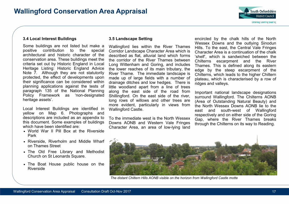
3.5 Landscape Setting
Wallingford lies within the River Thames Corridor Landscape Character Area which is described as flat, alluvial land which forms the corridor of the River Thames between Long Wittenham and Goring, and includes the lower reaches of its main tributary, the River Thame. The immediate landscape is made up of large fields with a number of drainage ditches and low hedges. There is little woodland apart from a line of trees along the east side of the road from Shillingford. On the east side of the river, long rows of willows and other trees are more evident, particularly in views from Wallingford Castle. To the immediate west is the North Wessex Downs AONB and Western Vale Fringes Character Area, an area of low-lying land
encircled by the chalk hills of the North Wessex Downs and the outlying Sinodun Hills. To the east, the Central Vale Fringes Character Area is a continuation of the chalk ‘shelf’, which is sandwiched between the Chilterns escarpment and the River Thames. This is defined along its eastern edge by the steep escarpment of the Chilterns, which leads to the higher Chiltern plateau, which is characterised by a row of ridges and valleys. Important national landscape designations surround Wallingford. The Chilterns AONB (Area of Outstanding Natural Beauty) and the North Wessex Downs AONB lie to the east and south-west of Wallingford respectively and on either side of the Goring Gap, where the River Thames breaks through the Chilterns on its way to Reading.
The distant Chiltern Hills AONB visible on the horizon from Wallingford Castle motte
REMOVE
ADD
REMOVE
ADD
REMOVE
Map 6
Listed Buildings and Local
Interest Buildings
Not to scale
Existing Conservation Area Boundary
Proposed changes to Conservation Area boundary
Listed Buildings
Local Interest Buildings
Wallingford Conservation Area Appraisal Consultation Draft October/November 2017
Wallingford Conservation Area Appraisal
Wallingford Conservation Area Appraisal Consultation Draft Oct-Nov 2017 19
4.1 The origins and historic development of Wallingford Prehistoric/Roman Wallingford’s early history is continuously emerging as a result of archaeological investigations. The southern boundary between Wallingford and the neighbouring parish of Cholsey was marked by an ancient stream flowing east into the Thames (now known as Bradford’s Brook, which lay well south of the town defences. This suburban area included the early pagan Saxon cemetery and also the now lost church of St Lucian. The area was almost certainly part of the original pre-burh Saxon settlement. Neolithic flints have been found just north of the town defences, and numerous Bronze Age artefacts have been dredged from the river. A high status Bronze Age island settlement was discovered during the building of the modern Winterbrook Bridge and Iron Age settlements are being revealed by modern development to the south and west of the town. Though no structural remains have linked Wallingford to the Roman period, 19th century records of large numbers of Roman coins and pottery found to the west of the town make it likely that some form of Roman activity took place.
Saxon (410-1066) Whilst Wallingford today contains one of the best examples of a late Saxon town plan in England, an early Saxon cemetery outside the defensive earthworks to the south west of Kinecroft contains burials from the 5th-7th centuries, suggesting that there was a settlement beside the river for at least four hundred years before the creation of the 9th century burh. Wallingford was clearly already an important settlement by the time it was first mentioned in a Saxon document of c. 919 AD as one of the largest fortified towns built by King Alfred to defend Wessex against Danish attack. (Winchester, his capital, was the same size as Wallingford) . The town was located at the boundary of Wessex and was strategically important. The town’s Saxon defences eventually comprised large earthworks constructed on three sides, probably topped by timber fortifications, and surrounded by a water-filled ditch. The defences formed a rectangular enclosure against the river, with bridgehead on the east bank of the river to guard the river crossing. Bridges were required to cross the ditches into the town watched over by gatehouses that controlled traffic into and out of the town.
The earthworks even now maintain a formal boundary between the historic town and its more recent suburbs. Only minor alterations have occurred to the essential street layout in the past 500 years and the streets inside the Saxon defences are remarkably well preserved. Some additional lanes and passageways were made for convenience but the principle routes remain very much the same as in the early 10th century. By the 11th century 276 properties in the town were held by the king and a royal garrison of ‘housecarls’ was maintained, probably in the north east quarter of the town. Wallingford had a mint from the 10th to 13th century, where a moneyer struck coins bearing the town’s name - a royal privilege. It was possibly located in the vicinity of Goldsmiths Lane. Post Norman Conquest (c.1066-1485) The second major phase of Wallingford’s development began after the Norman Conquest, when Robert d’Oyley carried out William I’s orders, building a sizeable motte and bailey castle (mound and enclosed area) in the north-east quadrant of the town, adjacent to the Thames, making good use of the northern Saxon rampart and moat.
4. Historic Development
Wallingford Conservation Area Appraisal
Wallingford Conservation Area Appraisal Consultation Draft Oct-Nov 2017 20
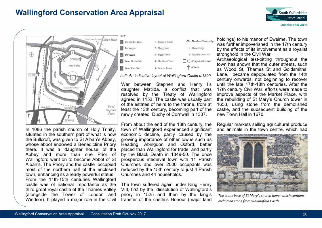
In 1086 the parish church of Holy Trinity, situated in the southern part of what is now the Bullcroft, was given to St Alban’s Abbey, whose abbot endowed a Benedictine Priory there. It was a ‘daughter house’ of the Abbey and more than one Prior of Wallingford went on to become Abbot of St Alban’s. The Priory and the castle occupied most of the northern half of the enclosed town, enhancing its already powerful status. From the 11th-15th centuries Wallingford castle was of national importance as the third great royal castle of the Thames Valley (alongside the Tower of London and Windsor). It played a major role in the Civil
War between Stephen and Henry I’s daughter Matilda, a conflict that was resolved by the Treaty of Wallingford agreed in 1153. The castle was usually part of the estates of heirs to the throne, from at least the 13th century, becoming part of the newly created Duchy of Cornwall in 1337. From about the end of the 13th century, the town of Wallingford experienced significant economic decline, partly caused by the growing importance of other towns such as Reading, Abingdon and Oxford, better placed than Wallingford for trade, and partly by the Black Death in 1349-50. The once prosperous medieval town with 11 Parish Churches and over 2000 occupants was reduced by the 15th century to just 4 Parish Churches and 44 households. The town suffered again under King Henry VIII, first by the dissolution of Wallingford’s priory in 1525 and then by the king’s transfer of the castle’s Honour (major land
holdings) to his manor of Ewelme. The town was further impoverished in the 17th century by the effects of its involvement as a royalist stronghold in the Civil War. Archaeological test-pitting throughout the town has shown that the outer streets, such as Wood St, Thames St and Goldsmiths’ Lane, became depopulated from the 14th century onwards, not beginning to recover until the late 17th-18th centuries. After the 17th century Civil War, efforts were made to improve aspects of the Market Place, with the rebuilding of St Mary’s Church tower in 1653, using stone from the demolished castle, and the subsequent building of the new Town Hall in 1670. Regular markets selling agricultural produce and animals in the town centre, which had
The stone base of St Mary’s church tower which contains
reclaimed stone from Wallingford Castle
Left: An indicative layout of Wallingford Castle c.1300
Wallingford Conservation Area Appraisal
Wallingford Conservation Area Appraisal Consultation Draft Oct-Nov 2017 21
been fundamental to the town’s economy throughout the medieval period, continued to well into the 19th century, by which time more industrial activities had developed. The 18th century Developing industries particularly malting and brewing, were able to make use of the quick Thames route to London to bring a new phase of prosperity to the town. The trade was served by the development of new wharfs along Thames Street. The money this brought in, combined with the fashionable influences of the capital, had a significant impact upon many of the buildings in Wallingford. Many of the older, mostly timber framed, properties were re-fronted or modernised
using brick, whilst others had their roofs raised or parapets introduced to hide old-fashioned pitched roofs. Some properties were newly built in the classical Georgian style whilst others were given a radical facelift, sometimes using render to hide the original timber frame or local stonework. 19th and 20th centuries It was not until the 19th century that the town needed to expand beyond the Saxon footprint. Most new housing was sited along existing routes and paths around the defensive ditches such as St Johns Road and Croft Road. A small run of cul-de-sac terrace streets were constructed off Croft Road at this time, forming Croft Villas, Egerton Road, South View and Springdale. The town’s widespread use of brick continued into the 19th century, although the relative prosperity it had represented was much reduced. The coming of the railway in 1866 led to a station being constructed to the west of the town centre. A number of good quality terraced workers cottages, some larger semi-detached villas, and an imposing school building were all constructed in the latter half of the 19th century. The railway did not bring any great prosperity to Wallingford, but this has meant
that the settlement has not been radically extended or altered and today retains its character as a small, but busy, ‘market’ town. The river, aside from its trade potential, began to be recognised for its picturesque qualities and leisure opportunities. Large villas were constructed along the west bank of the Thames, turning the once busy wharf area of Thames Street into a quiet residential lane. In the mid and late 20th century the town expanded with new housing being provided on the outskirts as well as a the Hithercroft Estate, the town’s major employment area. In 1992, a bypass was built to the south and west of the town which advantageously removed most of the traffic through the narrow streets in the town centre.
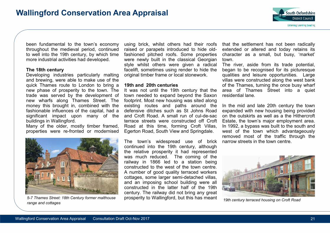
5-7 Thames Street: 18th Century former malthouse
range and cottages 19th century terraced housing on Croft Road
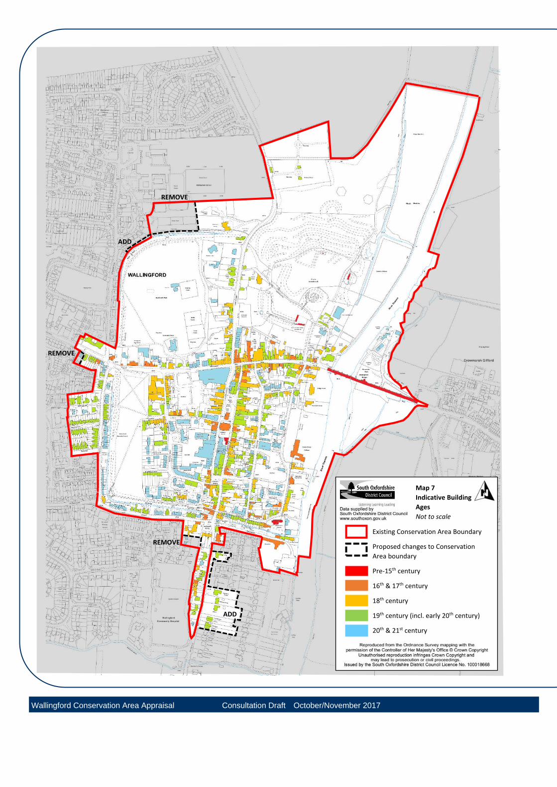
Map 7
Indicative Building
Ages
Not to scale
Existing Conservation Area Boundary
Proposed changes to Conservation
Area boundary
Pre-15th century
16th & 17th century
18th century
19th century (incl. early 20th century)
20th & 21st century
REMOVE
REMOVE
REMOVE
ADD
ADD
Wallingford Conservation Area Appraisal Consultation Draft October/November 2017
Wallingford Conservation Area Appraisal
Wallingford Conservation Area Appraisal Consultation Draft Oct-Nov 2017 23
4.2 Archaeology The town of Wallingford is justly renowned for its surviving late Saxon burh and medieval rampart-ditch defences, and for the complex and extensive earthworks of a Norman castle imposed into the north east quarter of the urban space. The main known archaeological sites are the burh defences, Bullcroft, Kinecroft and the site of the castle. These are designated as Scheduled Monuments but there are many sites of known archaeological significance in the town that are not scheduled. Wallingford was highlighted as follows in the 1975 Historic Towns in Oxfordshire survey: “The importance of Wallingford’s archaeology... is only heightened by comparison with the other towns, for (apart from Oxford) it is the only late Saxon walled town in the region.... Late Saxon and early medieval layers are unlikely to be stratified deep beneath or destroyed by later archaeological deposits as they frequently are in Oxford... Some [unpublished] archaeological work has already taken place on the castle and the defences, but many components of the early town, like the domestic and industrial buildings, the churches, the street plan and the waterfront remain unstudied. Because there is still so
much to be learnt about this period, large scale work on any of these aspects is likely to produce results of national importance”. From 2008-11, The Wallingford Burh to Borough Project, funded by a substantial grant from the Arts and Humanities Research Council, made a major study of the town’s development from 800-1400AD, also initiating an on-going garden test-pitting programme for 100 investigations throughout the town. Alongside this, a study of the documentary evidence for the Castle and Priory has been made by The Wallingford Historical and Archaeological Society. The three resultant publications so far have revealed the archaeological sensitivity and potential of the majority of the area covered by the Wallingford Conservation Area. It reflects the complexity and multi layered nature of the character of the settlement seen above ground today.
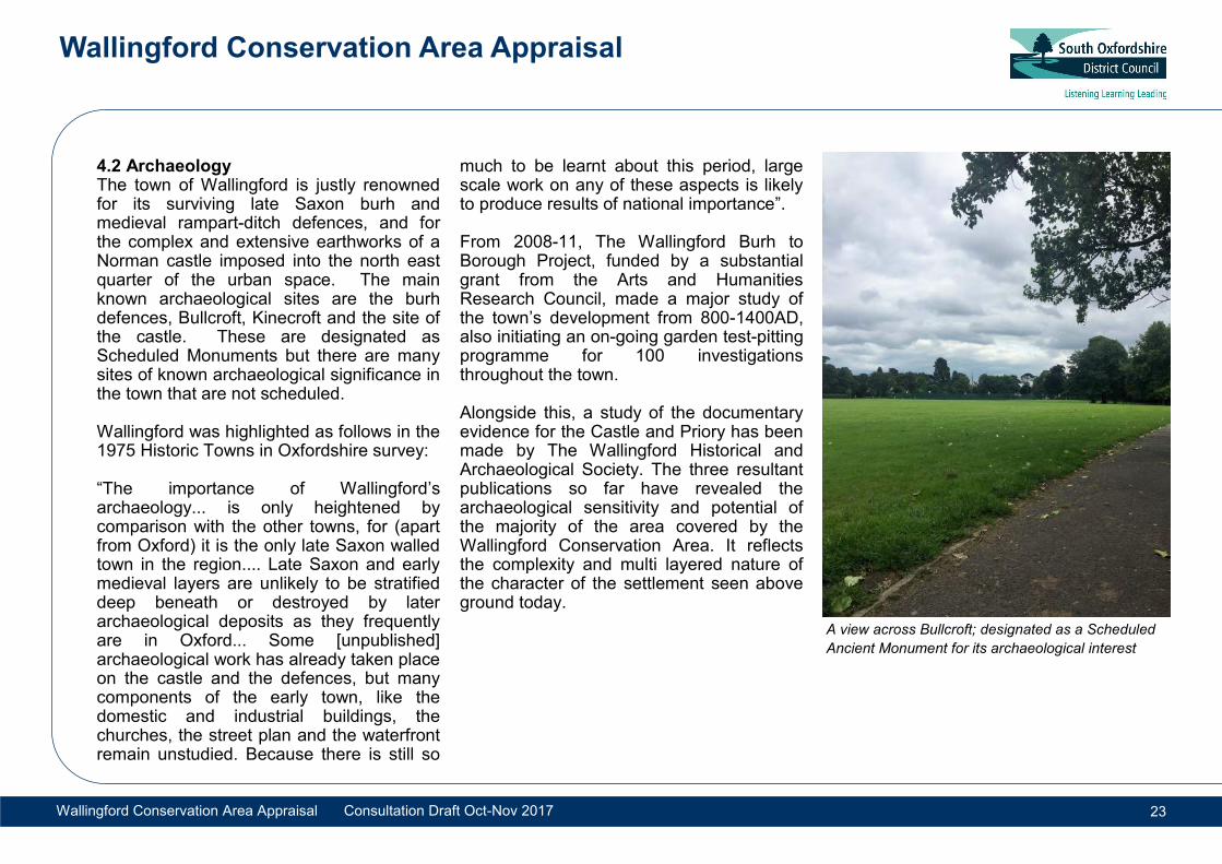
A view across Bullcroft; designated as a Scheduled
Ancient Monument for its archaeological interest
Wallingford Conservation Area Appraisal
Wallingford Conservation Area Appraisal Consultation Draft Oct-Nov 2017 24
5.1 Street pattern and layout Wallingford is a nucleated settlement contained by embankments within a roughly rectangular area to create four distinct quarters. The layout of roads are considered and planned unlike the organic and incidental nature in which many historic places have developed; a result of the
defensive nature of the settlement’s origins. Whilst the northern quarters are open spaces, the southern quarters of the town are developed and fragmented by a network of secondary routes. From the main cross roads, High Street crossing the main north to south route, are narrow lanes and alleyways which lead to the secondary streets within the two southern quarters respectively. These smaller connecting routes are Hart Street, Mousey Lane and St Leonards Lane in the south eastern quarter which connect to Wood Street and Thames Street. Feathers Yard and Church Lane in the south western quarter connect to Goldsmiths Lane in the south western quarter. Additional smaller routes of this kind may have been lost and are the subject of ongoing research into the early layout of the town. The main north-to-south route in the southern half of the town may have originally been a continuously wide street of the proportions that can be seen at Market Place and St Leonards Square, tapering only at its ends near the northern and southern gates. It is often presumed that the infilling of these areas in market towns may
have evolved from the occupation of these areas by permanent market stalls. In Wallingford, two narrower streets have been formed either end of the market place, St Marys and St Martins Street. Beyond the confines of the Saxon town, the main crossroads extend radially away from the town towards other nearby settlements. The High Street would have formed the most significant transport route because it provided the main river crossing route over the Thames. Today, although this is a busy vehicular route, the Market Place forms the busy commercial centre of the town. Very little alteration has occurred to the established layout within the Saxon enclosed town other than the creation of New Street and the possible rerouting of traffic nearer to Broughton Mill east of the early south gate. Secondary routes were laid out between the outer roads in the 19th and 20th centuries to accommodate new housing. These infilled the areas of land between the radial roads particularly to the west of the town. Little alteration was otherwise made to the original town layout with the exception of the addition of New Street and the rerouting of Thames Street in the southeast quarter.
Summary of key features:
Well preserved Saxon street layout centred around a cross roads and en-closed by defensive ditches and embank-ments
Surviving medieval burgage plots in town centre
Wide range of building periods repre-senting the the medieval period to the pre-sent day
Large high quality open spaces with historic interest at the Kinecroft, Bullcroft and Castle Meadows
Variety of built character and appear-ance forming a rich multi-layered urban environment
5. Spatial Analysis
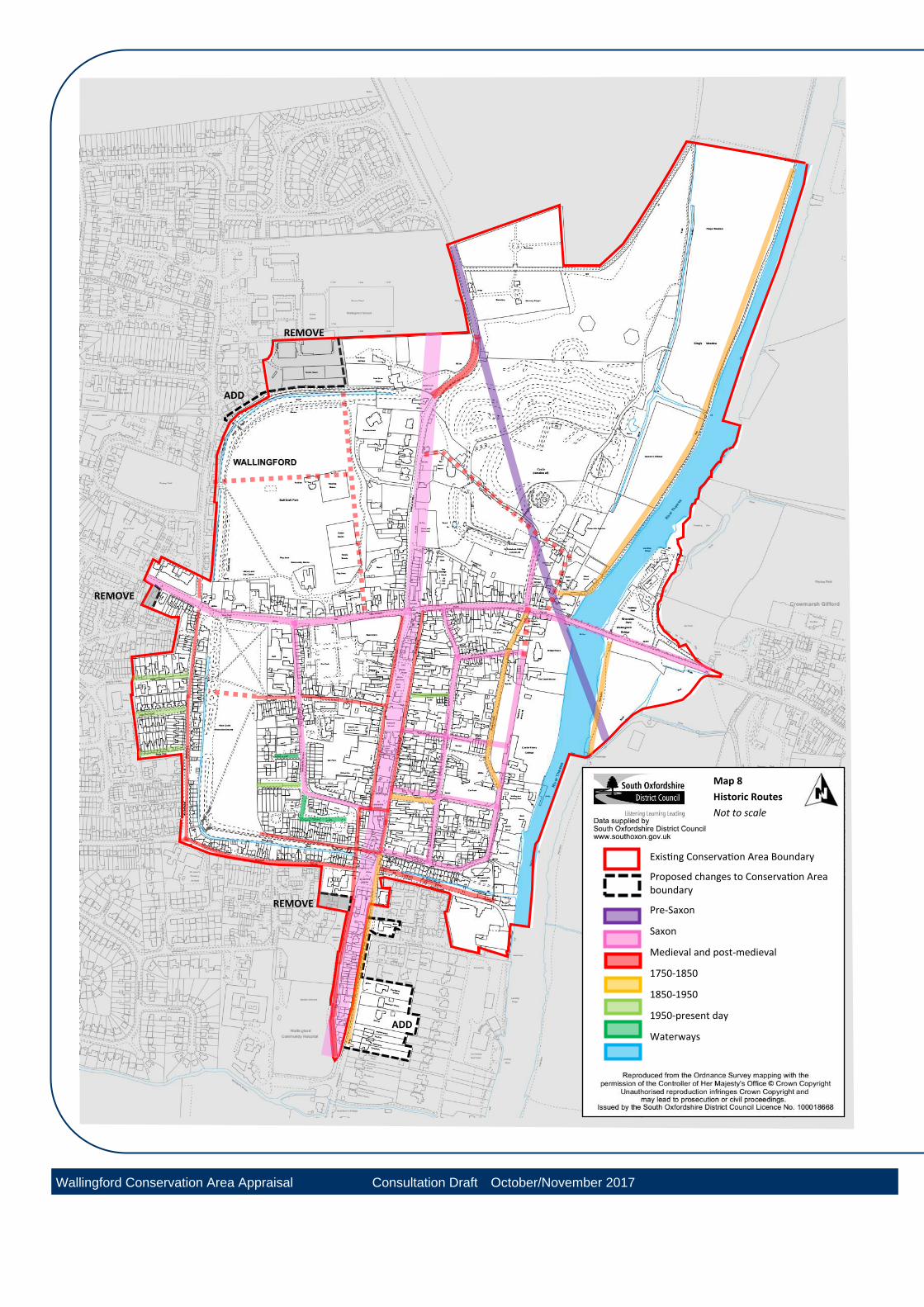
Map 8
Historic Routes
Not to scale
Existing Conservation Area Boundary
Proposed changes to Conservation Area boundary
Pre-Saxon
Saxon
Medieval and post-medieval
1750-1850
1850-1950
1950-present day
Waterways
REMOVE
ADD
REMOVE
REMOVE
ADD
Wallingford Conservation Area Appraisal Consultation Draft October/November 2017
Wallingford Conservation Area Appraisal
Wallingford Conservation Area Appraisal Consultation Draft Oct-Nov 2017 26
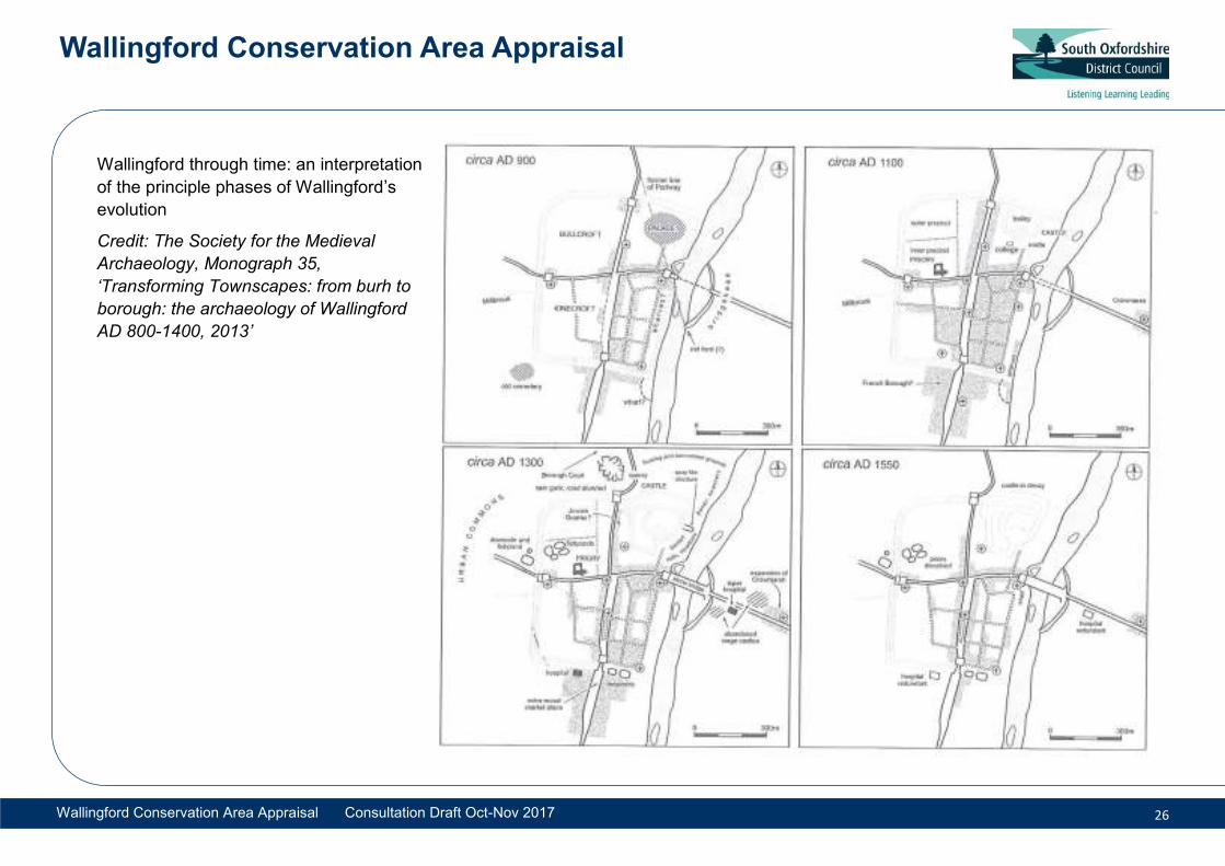
Wallingford through time: an interpretation
of the principle phases of Wallingford’s
evolution
Credit: The Society for the Medieval
Archaeology, Monograph 35,
‘Transforming Townscapes: from burh to
borough: the archaeology of Wallingford
AD 800-1400, 2013’
Wallingford Conservation Area Appraisal
Wallingford Conservation Area Appraisal Consultation Draft Oct-Nov 2017 27
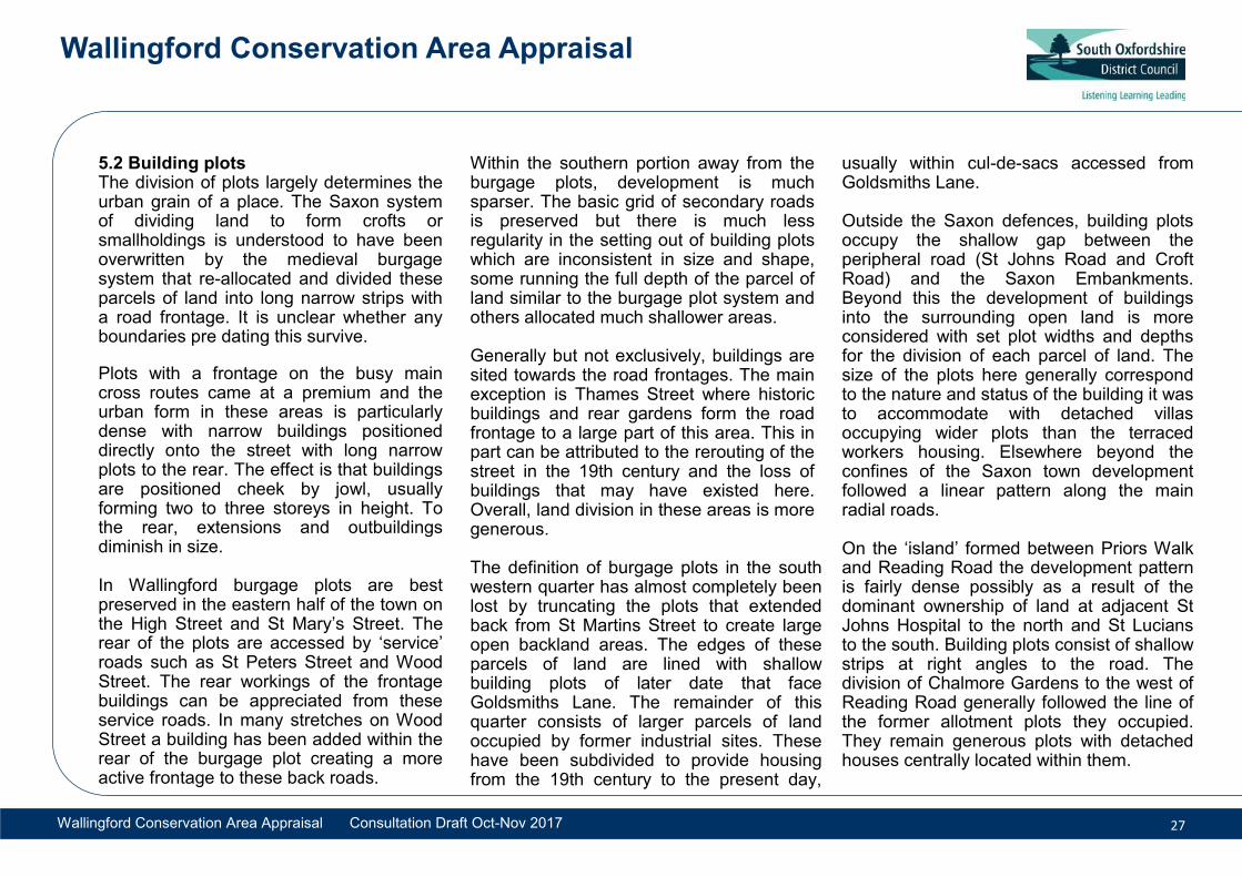
5.2 Building plots The division of plots largely determines the urban grain of a place. The Saxon system of dividing land to form crofts or smallholdings is understood to have been overwritten by the medieval burgage system that re-allocated and divided these parcels of land into long narrow strips with a road frontage. It is unclear whether any boundaries pre dating this survive. Plots with a frontage on the busy main cross routes came at a premium and the urban form in these areas is particularly dense with narrow buildings positioned directly onto the street with long narrow plots to the rear. The effect is that buildings are positioned cheek by jowl, usually forming two to three storeys in height. To the rear, extensions and outbuildings diminish in size. In Wallingford burgage plots are best preserved in the eastern half of the town on the High Street and St Mary’s Street. The rear of the plots are accessed by ‘service’ roads such as St Peters Street and Wood Street. The rear workings of the frontage buildings can be appreciated from these service roads. In many stretches on Wood Street a building has been added within the rear of the burgage plot creating a more active frontage to these back roads.
Within the southern portion away from the burgage plots, development is much sparser. The basic grid of secondary roads is preserved but there is much less regularity in the setting out of building plots which are inconsistent in size and shape, some running the full depth of the parcel of land similar to the burgage plot system and others allocated much shallower areas. Generally but not exclusively, buildings are sited towards the road frontages. The main exception is Thames Street where historic buildings and rear gardens form the road frontage to a large part of this area. This in part can be attributed to the rerouting of the street in the 19th century and the loss of buildings that may have existed here. Overall, land division in these areas is more generous. The definition of burgage plots in the south western quarter has almost completely been lost by truncating the plots that extended back from St Martins Street to create large open backland areas. The edges of these parcels of land are lined with shallow building plots of later date that face Goldsmiths Lane. The remainder of this quarter consists of larger parcels of land occupied by former industrial sites. These have been subdivided to provide housing from the 19th century to the present day,
usually within cul-de-sacs accessed from Goldsmiths Lane. Outside the Saxon defences, building plots occupy the shallow gap between the peripheral road (St Johns Road and Croft Road) and the Saxon Embankments. Beyond this the development of buildings into the surrounding open land is more considered with set plot widths and depths for the division of each parcel of land. The size of the plots here generally correspond to the nature and status of the building it was to accommodate with detached villas occupying wider plots than the terraced workers housing. Elsewhere beyond the confines of the Saxon town development followed a linear pattern along the main radial roads. On the ‘island’ formed between Priors Walk and Reading Road the development pattern is fairly dense possibly as a result of the dominant ownership of land at adjacent St Johns Hospital to the north and St Lucians to the south. Building plots consist of shallow strips at right angles to the road. The division of Chalmore Gardens to the west of Reading Road generally followed the line of the former allotment plots they occupied. They remain generous plots with detached houses centrally located within them.
Map 9
Building Plots
Not to scale
Existing Conservation Area Boundary
Proposed changes to Conservation Area
boundary
Burgage Plots
Fragmented Burgage Plots
Market Place infill
Road edge plots (linear)
REMOVE
ADD
REMOVE
REMOVE
ADD
Definition: Burgage plots are long narrow plots of land in towns,
generally laid out at right angles to main streets. The rear of the plots
may be accessed by a back lane. They are so-called because
‘burgage tenure’ was a particular form of property-holding in medieval
towns which led to a pattern distinctive of medieval town planning.
Within a block, plots may be of a uniform width (sometimes 20 feet).
The main buildings, generally shops or houses, occupied the
frontages, with the rear containing ancillary buildings, and open space
which was often used for digging cess pits and rubbish pits. The
boundaries between plots may remain marked by high stone or brick
walls and there may be evidence of more land-intensive uses (cattle
market, light industrial) being carried out here that would not be found
on the main streets.
Wallingford Conservation Area Appraisal Consultation Draft October/November 2017
Wallingford Conservation Area Appraisal
Wallingford Conservation Area Appraisal Consultation Draft Oct-Nov 2017 29
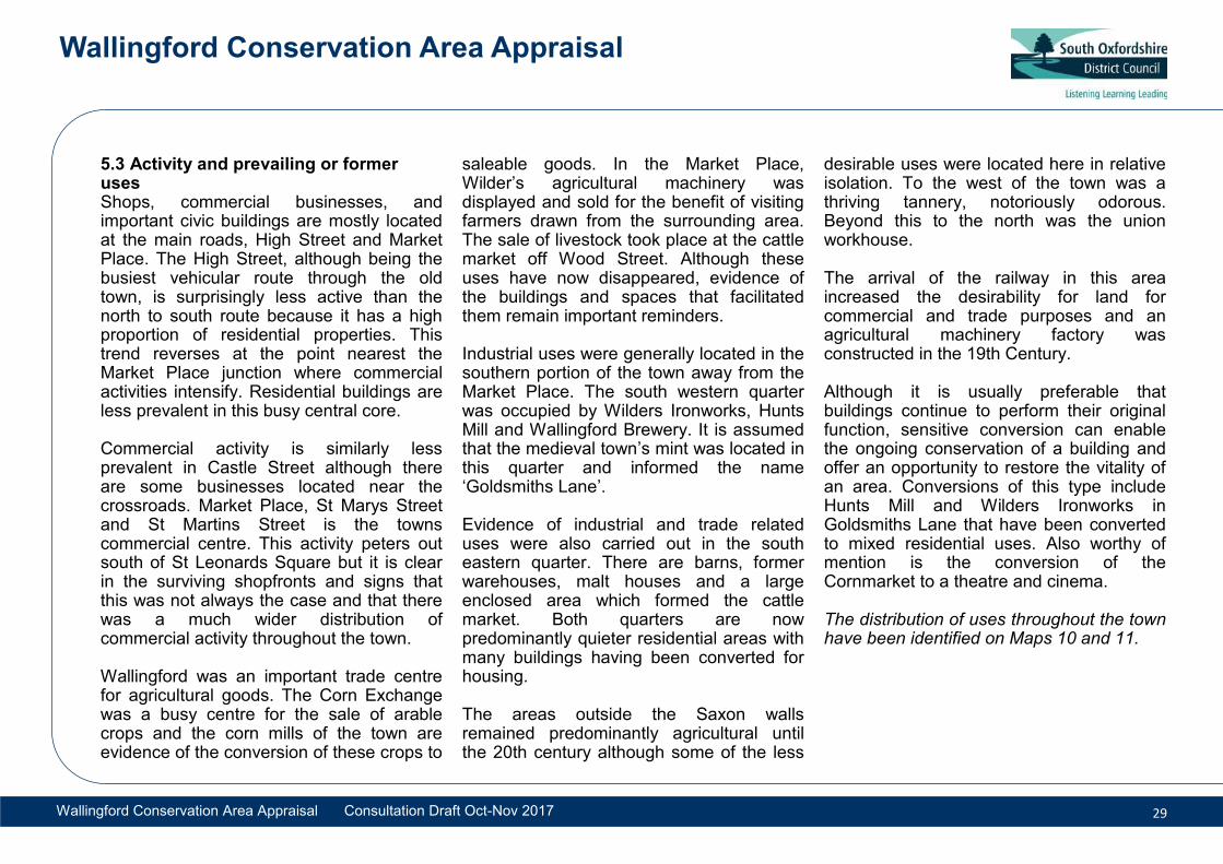
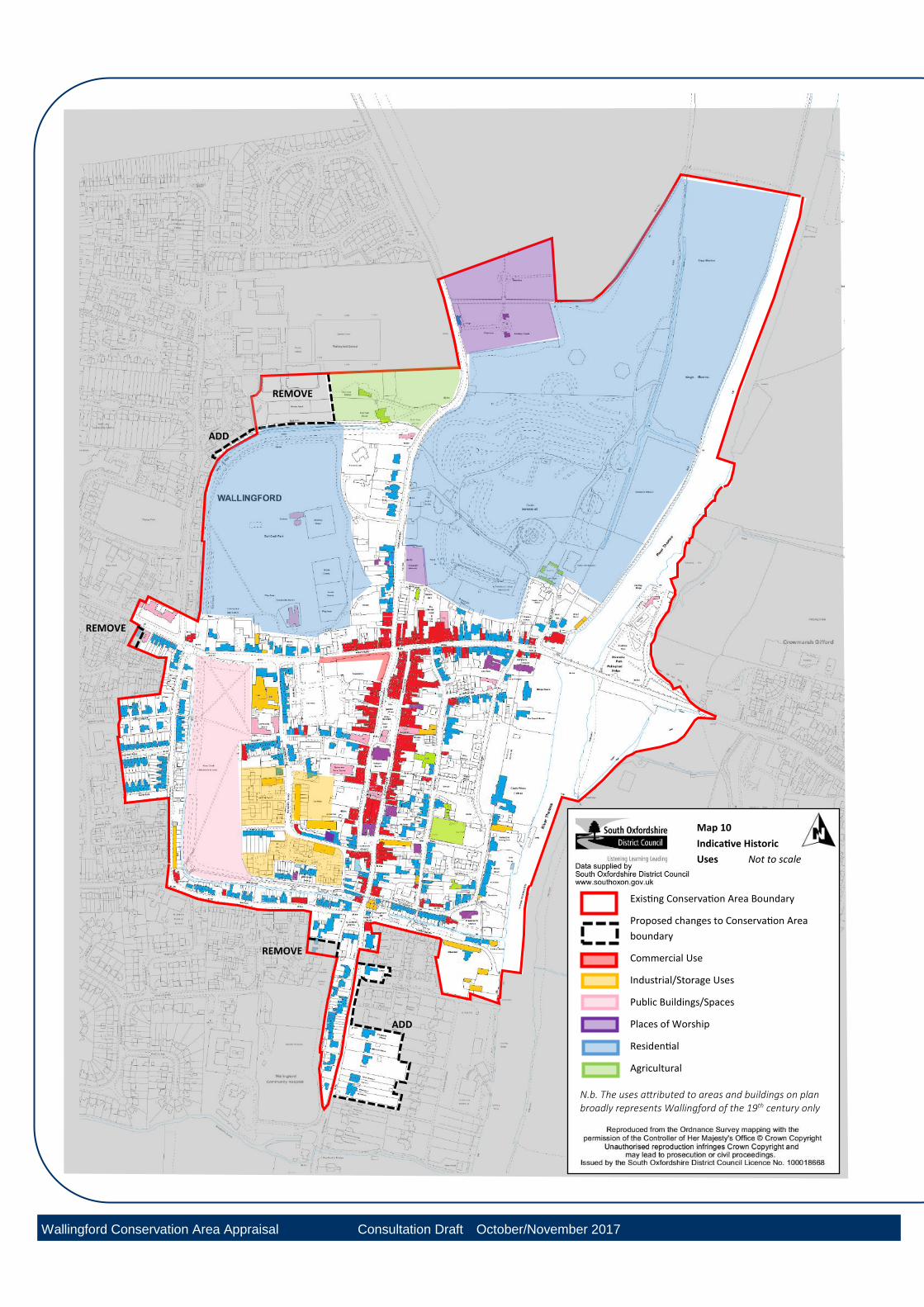
5.3 Activity and prevailing or former uses Shops, commercial businesses, and important civic buildings are mostly located at the main roads, High Street and Market Place. The High Street, although being the busiest vehicular route through the old town, is surprisingly less active than the north to south route because it has a high proportion of residential properties. This trend reverses at the point nearest the Market Place junction where commercial activities intensify. Residential buildings are less prevalent in this busy central core. Commercial activity is similarly less prevalent in Castle Street although there are some businesses located near the crossroads. Market Place, St Marys Street and St Martins Street is the towns commercial centre. This activity peters out south of St Leonards Square but it is clear in the surviving shopfronts and signs that this was not always the case and that there was a much wider distribution of commercial activity throughout the town. Wallingford was an important trade centre for agricultural goods. The Corn Exchange was a busy centre for the sale of arable crops and the corn mills of the town are evidence of the conversion of these crops to
saleable goods. In the Market Place, Wilder’s agricultural machinery was displayed and sold for the benefit of visiting farmers drawn from the surrounding area. The sale of livestock took place at the cattle market off Wood Street. Although these uses have now disappeared, evidence of the buildings and spaces that facilitated them remain important reminders. Industrial uses were generally located in the southern portion of the town away from the Market Place. The south western quarter was occupied by Wilders Ironworks, Hunts Mill and Wallingford Brewery. It is assumed that the medieval town’s mint was located in this quarter and informed the name ‘Goldsmiths Lane’. Evidence of industrial and trade related uses were also carried out in the south eastern quarter. There are barns, former warehouses, malt houses and a large enclosed area which formed the cattle market. Both quarters are now predominantly quieter residential areas with many buildings having been converted for housing. The areas outside the Saxon walls remained predominantly agricultural until the 20th century although some of the less
desirable uses were located here in relative isolation. To the west of the town was a thriving tannery, notoriously odorous. Beyond this to the north was the union workhouse. The arrival of the railway in this area increased the desirability for land for commercial and trade purposes and an agricultural machinery factory was constructed in the 19th Century. Although it is usually preferable that buildings continue to perform their original function, sensitive conversion can enable the ongoing conservation of a building and offer an opportunity to restore the vitality of an area. Conversions of this type include Hunts Mill and Wilders Ironworks in Goldsmiths Lane that have been converted to mixed residential uses. Also worthy of mention is the conversion of the Cornmarket to a theatre and cinema. The distribution of uses throughout the town have been identified on Maps 10 and 11.
Map 10
Indicative Historic
Uses Not to scale
REMOVE
ADD
REMOVE
REMOVE
ADD
Existing Conservation Area Boundary
Proposed changes to Conservation Area
boundary
Commercial Use
Industrial/Storage Uses
Public Buildings/Spaces
Places of Worship
Residential
Agricultural
N.b. The uses attributed to areas and buildings on plan broadly represents Wallingford of the 19th century only
Wallingford Conservation Area Appraisal Consultation Draft October/November 2017
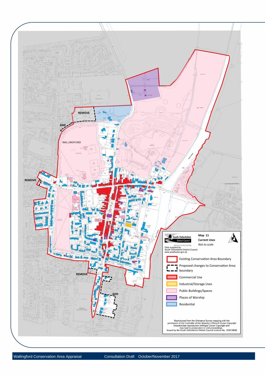
Map 11
Current Uses
Not to scale
Existing Conservation Area Boundary
Proposed changes to Conservation Area
boundary
Commercial Use
Industrial/Storage Uses
Public Buildings/Spaces
Places of Worship
Residential
REMOVE
ADD
REMOVE
REMOVE
ADD
Wallingford Conservation Area Appraisal Consultation Draft October/November 2017
Wallingford Conservation Area Appraisal
Wallingford Conservation Area Appraisal Consultation Draft Oct-Nov 2017 32
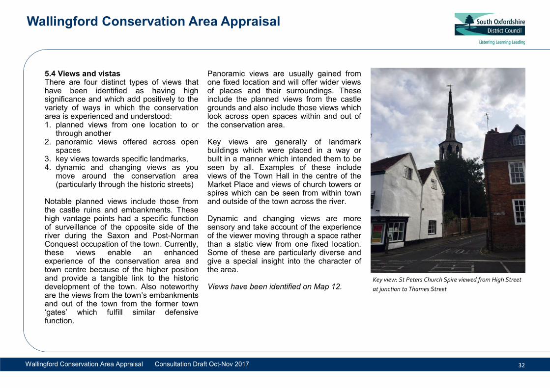
5.4 Views and vistas There are four distinct types of views that have been identified as having high significance and which add positively to the variety of ways in which the conservation area is experienced and understood: 1. planned views from one location to or
through another 2. panoramic views offered across open
spaces 3. key views towards specific landmarks, 4. dynamic and changing views as you
move around the conservation area (particularly through the historic streets)
Notable planned views include those from the castle ruins and embankments. These high vantage points had a specific function of surveillance of the opposite side of the river during the Saxon and Post-Norman Conquest occupation of the town. Currently, these views enable an enhanced experience of the conservation area and town centre because of the higher position and provide a tangible link to the historic development of the town. Also noteworthy are the views from the town’s embankments and out of the town from the former town ‘gates’ which fulfill similar defensive function.
Panoramic views are usually gained from one fixed location and will offer wider views of places and their surroundings. These include the planned views from the castle grounds and also include those views which look across open spaces within and out of the conservation area. Key views are generally of landmark buildings which were placed in a way or built in a manner which intended them to be seen by all. Examples of these include views of the Town Hall in the centre of the Market Place and views of church towers or spires which can be seen from within town and outside of the town across the river. Dynamic and changing views are more sensory and take account of the experience of the viewer moving through a space rather than a static view from one fixed location. Some of these are particularly diverse and give a special insight into the character of the area. Views have been identified on Map 12.
Key view: St Peters Church Spire viewed from High Street
at junction to Thames Street
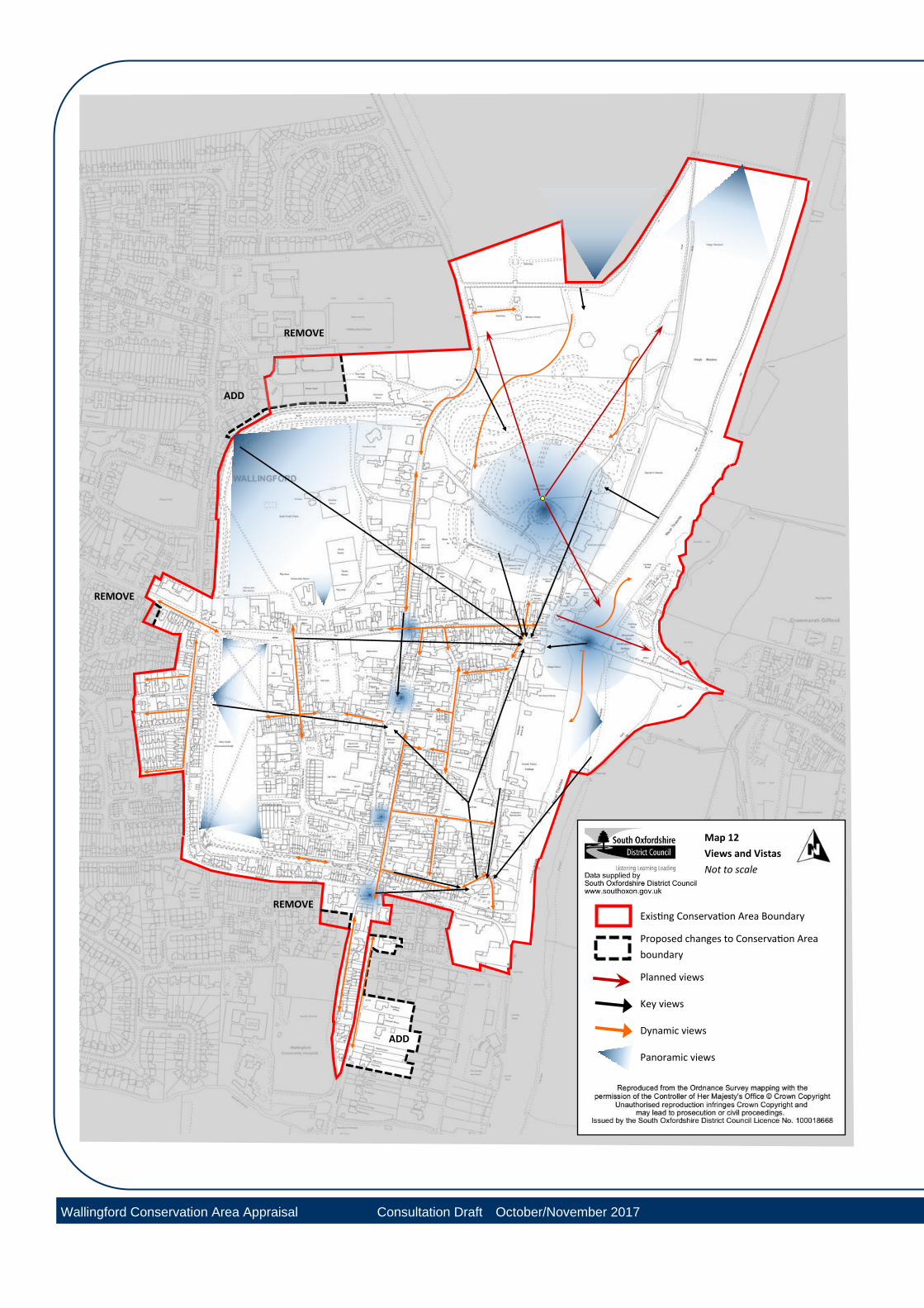
Map 12
Views and Vistas
Not to scale
Existing Conservation Area Boundary
Proposed changes to Conservation Area
boundary
Planned views
Key views
Dynamic views
Panoramic views
REMOVE
ADD
REMOVE
REMOVE
ADD
Wallingford Conservation Area Appraisal Consultation Draft October/November 2017
Wallingford Conservation Area Appraisal
Wallingford Conservation Area Appraisal Consultation Draft Oct-Nov 2017 34
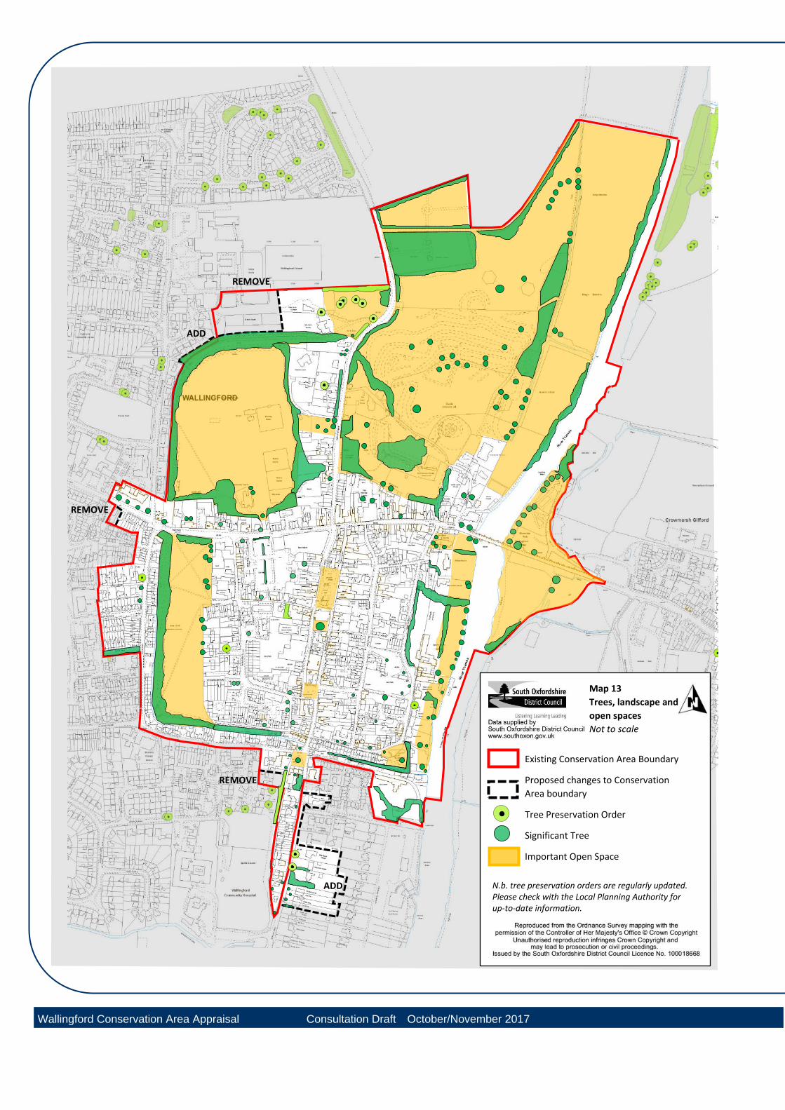
5.5 Trees, landscape and open spaces The Kinecroft, Bullcroft and Castle Meadows site form four large areas of open green space providing relief and contrast to the built form of the town. They provide space for informal and organised outdoor activities which are much valued by the town’s occupants. They provide essential room for trees and greenery. Of particular note are the tree topped ramparts which form a strong visual divide between the old Saxon town and the town’s extension beyond. The quality and openness of these inner town spaces provides visual connection to the setting of the conservation area beyond. The open space on the opposite bank of the river Thames consists of open flood meadows that are particularly unspoilt. These can be appreciated from the bridge and from the castle grounds and towpaths. Although originally the sides of the towpath would have been kept clear, those within the northern portion of the town are well treed with willows and other native trees and planting. From the town, the wooded escarpment of the Chilterns forms a green backdrop and makes an important contribution in views within the Conservation Area.
Some private gardens have also been identified as important open spaces for their contribution to the character of a specific area. The garden areas of the riverside properties provide wide open spaces which provide the river frontage with a green rather than hard built edge. At 16 Castle Street, a wide side garden provides an important visual break between the edge of the old town and later buildings beyond. Important open spaces, trees, greenery and landscapes have been identified on Map 13
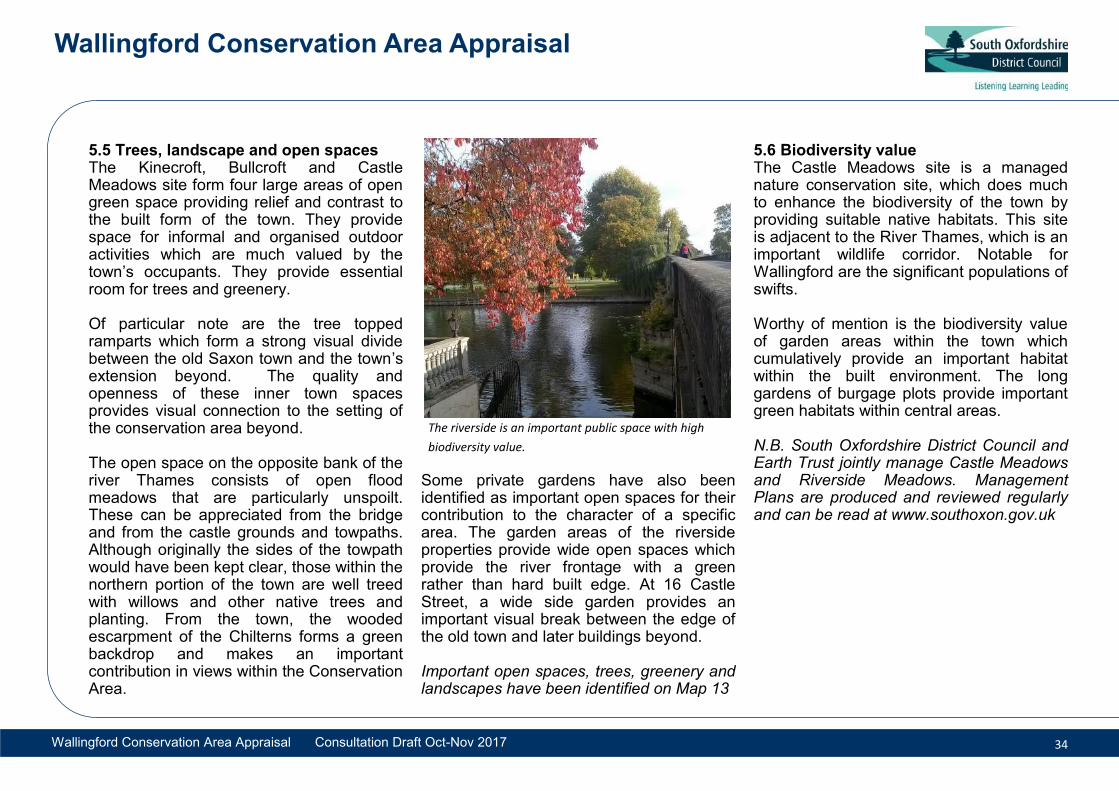
5.6 Biodiversity value The Castle Meadows site is a managed nature conservation site, which does much to enhance the biodiversity of the town by providing suitable native habitats. This site is adjacent to the River Thames, which is an important wildlife corridor. Notable for Wallingford are the significant populations of swifts. Worthy of mention is the biodiversity value of garden areas within the town which cumulatively provide an important habitat within the built environment. The long gardens of burgage plots provide important green habitats within central areas. N.B. South Oxfordshire District Council and Earth Trust jointly manage Castle Meadows and Riverside Meadows. Management Plans are produced and reviewed regularly and can be read at www.southoxon.gov.uk
The riverside is an important public space with high
biodiversity value.
ADD
ADD
REMOVE
REMOVE
Map 13
Trees, landscape and
open spaces
Not to scale
REMOVE
Existing Conservation Area Boundary
Proposed changes to Conservation
Area boundary
Tree Preservation Order
Significant Tree
Important Open Space
N.b. tree preservation orders are regularly updated. Please check with the Local Planning Authority for up-to-date information.
Wallingford Conservation Area Appraisal Consultation Draft October/November 2017
Wallingford Conservation Area Appraisal
Wallingford Conservation Area Appraisal Consultation Draft Oct-Nov 2017 36
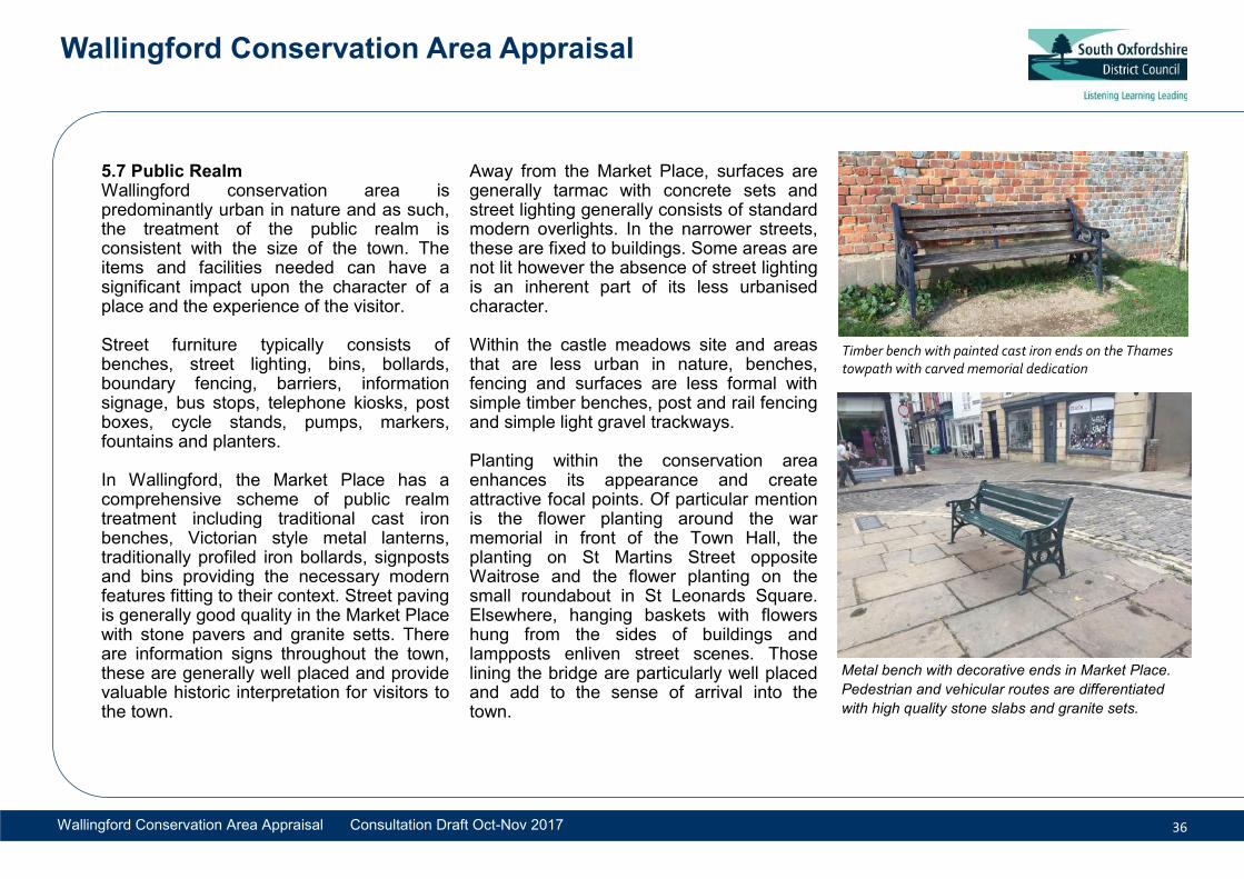
5.7 Public Realm Wallingford conservation area is predominantly urban in nature and as such, the treatment of the public realm is consistent with the size of the town. The items and facilities needed can have a significant impact upon the character of a place and the experience of the visitor. Street furniture typically consists of benches, street lighting, bins, bollards, boundary fencing, barriers, information signage, bus stops, telephone kiosks, post boxes, cycle stands, pumps, markers, fountains and planters. In Wallingford, the Market Place has a comprehensive scheme of public realm treatment including traditional cast iron benches, Victorian style metal lanterns, traditionally profiled iron bollards, signposts and bins providing the necessary modern features fitting to their context. Street paving is generally good quality in the Market Place with stone pavers and granite setts. There are information signs throughout the town, these are generally well placed and provide valuable historic interpretation for visitors to the town.
Away from the Market Place, surfaces are generally tarmac with concrete sets and street lighting generally consists of standard modern overlights. In the narrower streets, these are fixed to buildings. Some areas are not lit however the absence of street lighting is an inherent part of its less urbanised character. Within the castle meadows site and areas that are less urban in nature, benches, fencing and surfaces are less formal with simple timber benches, post and rail fencing and simple light gravel trackways. Planting within the conservation area enhances its appearance and create attractive focal points. Of particular mention is the flower planting around the war memorial in front of the Town Hall, the planting on St Martins Street opposite Waitrose and the flower planting on the small roundabout in St Leonards Square. Elsewhere, hanging baskets with flowers hung from the sides of buildings and lampposts enliven street scenes. Those lining the bridge are particularly well placed and add to the sense of arrival into the town.
Timber bench with painted cast iron ends on the Thames towpath with carved memorial dedication
Metal bench with decorative ends in Market Place.
Pedestrian and vehicular routes are differentiated
with high quality stone slabs and granite sets.