Wallbridge Mining Company Ltd. Rudy Lake AMT Survey
30
Wallbridge Mining Company Ltd. Rudy Lake AMT Survey GEOSYSTEM |. 20794 AMT SURVEY, RUDY LAKE PROJECT MORGAN TOWNSHIP, ONTARIO. M o o OPERATIONAL REPORT Volume 1/1 prepared for WALLBRIDGE MINING COMPANY LIMITED O H O by GEOSYSTEM CANADA INC Ottawa, Ontario. RECEIVED DEC 1 5 2000 October 2000
Transcript of Wallbridge Mining Company Ltd. Rudy Lake AMT Survey
Wallbridge Mining Company Ltd. Rudy Lake AMT Survey
GEOSYSTEM |. 20794
AMT SURVEY,RUDY LAKE PROJECTMORGAN TOWNSHIP,
ONTARIO.
Moo
OPERATIONAL REPORT
Volume 1/1
prepared for
WALLBRIDGE MINING COMPANY LIMITED
OHO
byGEOSYSTEM CANADA INC
Ottawa, Ontario.
RECEIVEDDEC 1 5 2000
October 2000

Wallbridge Mining Company Ltd. Rudy Lake AMT Survey
CONTENTS1. INTRODUCTION ...........................................................................................................l
1.1 SURVEY DESIGN..................................................................................................................l1.2 DATA ACQUISITION ............................................................................................................l
2. DATA PROCESSING AND EDITING...........................................................................!2.1 PROCESSING OVERVIEW ......................................................................................................22.2 ROBUST PROCESSING ..........................................................................................................2
3. DATA PRESENTATION ................................................................................................33.1 DATA DESCRIPTION AND DIMENSIONALITY...........................................................................3
3.2 STATIC SHIFT......................................................................................................................33.3 PSEUDO-SECTIONS..............................................................................................................3
4. BIBLIOGRAPHY ...........................................................................................................4
Figures
Figure 1: Profile locations...................................................................................................................lFigure 2: Sounding 797E17, located in the central part of the grid......................................................3
AppendicesI: Pseudo-section of Field Data II: Personnel and equipment
n-1: PersonnelII-2: EquipmentH-3: Data Format
III: Station Coordinates
PlatesPlate 1: Station and profile locations, scale 1:5,000.
Report prepared by:
IcNeice, M. Se. Senior Geophysicist
RudyLake_OP.doc

Wallbridge Mining Company Ltd. Rudy Lake AMT Survey
SUMMARY
Twenty-five audio-magnetotelluric (AMT) measurements were collected in Morgan Township, Sudbury, Ontario at an average spacing of 300m along 5 north-south oriented lines, spaced 300m apart (~6 line kilometers). AMT data in the frequency range 5.0-20,000 Hz, were acquired on October 3 and 4th, 2000, using three 5-channel Metronix 24 bit ADU-06 acquisition systems. One system was a fixed reference station in a culturally quiet location, while the other system was used within the prospect area. Each AMT measurement consisted of a perpendicular pair of 50m dipoles; two orthogonal magnetic field sensors, and one vertical magnetic field sensor. Robust processing resulted in generally good data quality within the survey area. Data were edited, rotated using Swift decomposition (principle axis), and static shifted. The results are shown as a series of pseudo-sections of apparent resistivity and phase for each of the TE and TM modes, in frequency-distance space.

Wallbridge Mining Company Ltd. Rudy Lake AMT Survey
1. INTRODUCTIONThis report describes acquisition and processing procedures of an audio-frequency magnetotelluric (AMT) survey conducted in Morgan Township near the north edge of the Sudbury Basin, on behalf of Wallbridge Mining Company Ltd.. A total of 25 AMT stations were occupied along 5 north-south oriented profiles. Station coordinates are listed in Appendix III.
1.1 Survey design
Figure 1: Profile locations.Coordinates are in meters on the UTM grid.
The survey was carried out by Geosystem Canada Inc. using two 24-bit ADU-06 systems manufactured by Metronix GmbH of Braunschweig, Germany. Magnetic sensors were the BF-6 induction coils produced by Electro-Magnetic Instruments Inc. (EMI) of El Cerrito, California. Appendix II contains a description of the personnel and equipment used for the survey, along with a description of the data formats.Layout followed the normal MT axis convention, that is, a right-handed system with z positive downwards. Dipole lengths of 50 meters and a fixed acquisition azimuth of geographic north was used throughout the survey. Access to the grid was by 4WD vehicle as far as possible, and then on foot. Due to the low system weight, the operator and 2 helpers were able to pack all of the necessary gear without difficulty.
1.2 Data AcquisitionThe time series data were acquired in 2 sample bands. The highest sample rate used was 40960 Hz for a duration of 7 seconds. A 4069 Hz sample band was recorded for 6 minutes. The 4096 Hz sample band was decimated to a sample rate of 256 Hz to compute the low frequency data.

Wallbridge Mining Company Ltd. Rudy Lake AMT Survey
2. DATA PROCESSING AND EDITING
2.1 Processing overviewThe basic steps required to transform field time-series to usable data are as follows:
1. Automatic selection of coherent data segments (low noise) by comparison of the electric and magnetic fields in each band (40960,4096, and 256 Hz);
2. Robust processing of the 300 most coherent data segments in each sample band;3. Merging of individual bands (3) to form a complete sounding curve;4. Checking of calculated curves for geophysical plausibility.
Data were archived on CD ROM on a daily basis after the time series was transferred from the field computers to the processing computer. Time series were viewed with the Metronix visualization program QuickLook. Automatic coherency selection and robust processing were carried out using routines developed by Jim Larsen (Larsen and others, 1996). Data analysis, interpretation, and presentation were completed with Geosystem's interpretation software, WinGLink.
2.2 Robust processingRobust processing techniques were employed to improve data quality and reduce the effects of noise bias. The method of Larsen and others (1996) was used to estimate smooth magnetotelluric transfer functions (i.e. impedances) relating the electric and magnetic field data.Data segments were automatically selected on the basis of electric and magnetic field coherency, and used as input to the robust processing algorithm. The magnetic and electric fields are used in an iterative re-weighted method to determine the impedance tensor. During the iterations, the electric fields are corrected in both the frequency and time domains, utilizing a smooth MT transfer function to estimate the electric field data from the magnetic fields. The total time required to robust process a single sounding was approximately 10 minutes.The program outputs data at 8 equi-spaced frequencies per decade (e.g. 10, 15, 22, 32, 42, 48, 62, and 82 Hz). All of the soundings were processed using the robust algorithm.

Wallbridge Mining Company Ltd. Rudy Lake AMT Survey
3. DATA PRESENTATION
3.1 Data description and dimensionalityThe AMT responses are primarily two-dimensional over the acquired frequency band. Data were rotated to principal axis (Swift angle), with an average strike direction of 5 O0, decomposing the data into responses parallel and perpendicular to strike (the TE and TM modes respectively). At most stations, piow is aligned along the strike direction and is therefore the TE mode. An example of this is shown in figure 2.
1*:•s : i in3 "o. l
iDO
'S 90-
1 -80-
-180-
*
4
*
10^ 11
• . *• *
K * 4.
r4 11p
r-*-"
.*...
r3 Kmod CMC)
i-*'*".
*..~""
r2 11
*
4
r1 IB"
Figure 2: Sounding 797E17, located in the central part of the grid.The blue apparent resistivity curve is identified as the TM mode; the overall curve shapes at all of the sites in this prospect are in general similar.
3.2 Static shiftStatic shift, i.e. the frequency-independent shift of apparent resistivity curves, is caused by near-surface conductive inhomogeneities, which distort the local electric fields (Groom and Bailey, 1989). Without external data, there is no unique way of resolving this effect. Impedance phase, which is proportional to the slope of the apparent resistivity curves, is nearly independent of static shift. Phase pseudo-sections were therefore used as a guide to static-shifting of the apparent resistivity curves. In general, piow was shifted to coincide with
the high-frequency end of the curves.
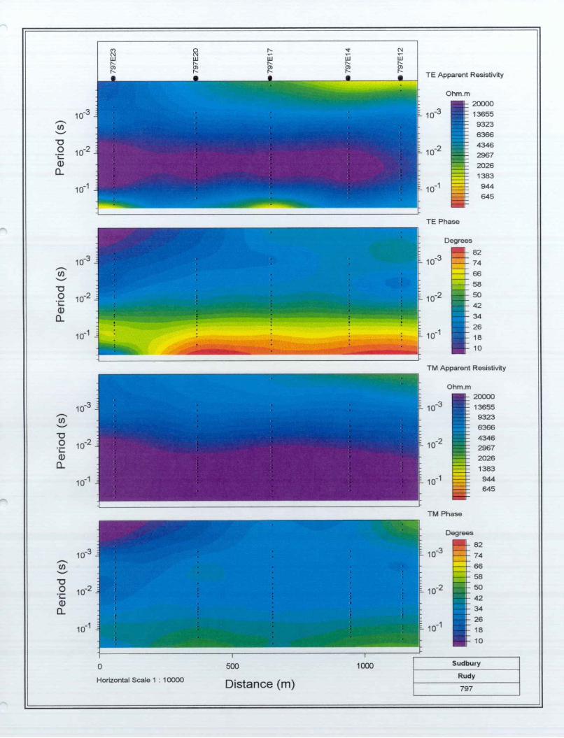
3.3 Pseudo-sectionsPseudo-sections (in frequency/distance space) of observed apparent resistivity and phase are plotted for all lines used for inversion in Appendix I.

Wallbridge Mining Company Ltd.
4. BIBLIOGRAPHYGroom, R., and Bailey, R.
Larsen, J., Mackie, R.L., Manzella, A., Fordelisi, A. and Rieven, S.
Swift, C.M., Jr.
Rudy Lake AMT Survey
1989 Decomposition of magnetotelluric impedance tensors in the presence of three-dimensional galvanic distortion: J. Geophys. Res., 94B, 1 913-1926.
1996 Robust smooth magnetotelluric transfer functions: Geophys. J. Int. 124, 801-919.
1967 A Magnetotelluric Investigation of an Electrical Conductivity Anomaly in the Southwestern United States: Ph.D. Thesis, MIT
Wight, D.E. 1988 SEG MT/EMAP Data Interchange Standard, Revision 1.0: SEG, Oklahoma City. 91pp.

Wallbridge Mining Company Ltd. Rudy Lake AMT Survey
APPENDIX I: PSEUDO SECTIONS OF FIELD DATA
Note: NORTH is to the LEFT on all sections.

TE Apparent Resistivity
Horizontal Scale 1 : 10OOO
SOD
Distance (m) 794
to
TE Apparent Resistivity
Horizontal Scale 1 : 10000
500
Distance (m)
1000
TM Apparent Resistivity
Sudbury
Rudy
797

Horizontal Scale 1 : 10000
500
Distance (m)
1000
TE Apparent Resistivity
Ohm. m
'- 1 0"
10-2
^ 10-1
TE Phase
Degrees
- 10'
i- 1 0
ii L 10"
-2
TM Apparent Resistivity
Ohm.m
:- 1 0-3
- 10
:- 1 0"
-2
200001365593236366434629672026
1383944645
T M Phase
Degrees
e~ 1 0-3
s- 10-2
82
74
66
58
5O
42
34
26
18
10
Sudbury
Rudy
8OO

wl— T3
TE Apparent Resistivity
Ohm.m
Horizontal Scale 1 : 10000
500
Distance (m)
1000 Sudbury
Rudy
803

a
Horizontal Scale 1 : 10000
500
Distance (m)
TE Apparent Resistivity
Ohm. m
8O3

Wallbridge Mining Company Ltd. Rudy Lake AMT Survey
APPENDIX II: PERSONNEL AND EQUIPMENT
Appendix II-l: PersonnelParty Chief l Interpretation..... Gary McNeiceOperators ...............................Gerry Shields, Mike KingField Assistants....... D. Seguin, A. Libbey-Lahaie, Luc Laurin and Lucien Patry
Appendix 11-2: EquipmentADU-06 (data acquisition unit):
32 bit internal computer, two 24 bit A/D converter, 4096 sample/sec and 49Ksample7secdata rate, standard LAN connection for transfer to system computer.
GPS system:Motorola internal GPS receiver; clock precision ± 130ns to satellite reference; 8 parallelchannels; LI 1575.42MHz; C/A code.
Magnetic Sensors, AMT:Hx,Hy EMIBF-6 (l to 25000 Hz). Sensitivity 0.15 V/nTHz EMI BF-6 (l to 25000 Hz). Sensitivity 0.15 V/nT
Electric Sensors:4x25m dipoles, Shielded cables with stainless steel rods.
System computer:Ruggedized Pentium notebook PC Computer, with 32Mb RAM and 3.2 Gb hard disk.
Power Supply:ADU-06 12V 34 Ah sealed lead acid batterySystem computer 12V 12 Ah sealed lead acid battery
Environmental:Temperature:
ADU-06 -400C to +75 0C BF-6 -10^0+45"^
Weights:ADU-06 5.0 kg BF-6 2.5 kg
Wallbridge Mining Company Ltd. Rudy Lake AMT Survey
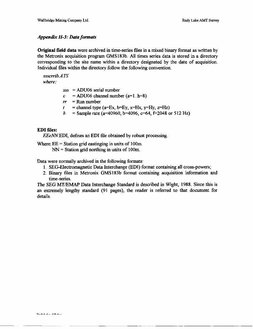
Appendix 11-3: Data formats
Original field data were archived in time-series files in a mixed binary format as written by the Metronix acquisition program GMS183b. All times series data is stored in a directory corresponding to the site name within a directory designated by the date of acquisition. Individual files within the directory follow the following convention.
ssscrrtb.ATS where:
sss - ADU06 serial numberc = ADU06 channel number (az l.. 11=8)rr — Run numbert = channel type ^Ex, b=Ey, ^Hx, j^Hy, ^Hz)b = Sample rate (3=40960, b^096, 0=64,1=2048 or 512 Hz)
EDI files:EEeNN.EDI, defines an EDI file obtained by robust processing.
Where: EE = Station grid eastinging in units of 100m. NN = Station grid northing in units of 100m.
Data were normally archived in the following formats:1. SEG-Electromagnetic Data Interchange (EDI) format containing all cross-powers;2. Binary files in Metronix GMS183b format containing acquisition information and
time-series.The SEG MT/EMAP Data Interchange Standard is described in Wight, 1988. Since this is an extremely lengthy standard (91 pages), the reader is referred to that document for details.

Wallbridge Mining Company Ltd. Rudy Lake AMT Survey
ME1Byte
off-set1
3
59
13
17253335373839414749535761656973778185899397101105109
110
111113121129
130
131145157161173175177179181183
ADR
OOOH
002H
004H008H
OOCH
010H01 8H020H022H024H025h026h028H02EH030H034H038H03CH040H044H048H04CH050H054H058H05CH060H064H068H06CH
06DH
06EH070H078H080H
089H
082H090H09CHOAOHOACHOAEHOBOHOB2HOB4HOB6H
rRONK TIME SEIByte
2
2
44
4
8822112624444444444444441
1
2881
1
1412412222222
Type
INTEGER
INTEGER
LONGINTSINGLE
LONGINT
DOUBLEBYTE
INTEGERINTEGER
BYTEBYTECHARCHAR
INTEGERSINGLESINGLESINGLESINGLESINGLESINGLESINGLESINGLESINGLESINGLESINGLEBYTELONGLONGLONGCHAR
CHAR
INTEGERDOUBLEDOUBLE
CHAR
BYTE
BYTECHARCHARCHARCHARBYTE
INTEGERINTEGERINTEGER
INTEGERS
UES: ATS FORMATName
Header LengthHeader VersionSamplesSample Freq.
LSBVReserved
Reserved
Info
Length of Header in Byte
Version Number of Header (*100)4
Number of SamplesSample Frequency
Start Time of Measurement (in seconds since 1.1.70)LSBUnitinmV2ReservedSerial number of ADU06Serial number of ADB06 (ADC Board)Channel number (0 . . . 7)ReservedChannel Type (Ex,Ey,Hx ,Hy ,Hz)Sensor Type (MFS05, BF4...)Serial number of sensorxl coordinates of Dipole(m)yiz2x2 coordinates of Dipole (m)y2z2e-field dipole length (m)Angle (00znorth) (degrees 0)Probe resistivity (ohm)DC offset voltage3 (mV)Internal gain amplification (1 or 30)4ReservedLatitude (msec)Longitude (msec)Elevation (cm)Lat/Long Type: 'U' user defined, 'G' internal OPS clockType of additional coordinates: 'U' UTM 'G' Gauss-KrugerReference medianX coordinateY coordinateGPS/CLK status: 'G' OPS locked 'C' CLK synchronized 'N' CLK not synchronizedApproximate accuracy of GPS/CLK: 9 means accuracy of 109ReservedSurvey header file nameType of measurement: MT or CSAMTLog file of system self testResult of self test 'OK' or 'NO'ReservedNumber of calibration frequencies in fileLength of frequency entry (32 byte)Version of calibration format (*100)Start address of calibration information in header (400H)

Wallbridge Mining Company Ltd. Rudy Lake AMT Survey
185193205209221225229233241245247249253257273289305321337449513
10251025102910331037104110451057
OB8HOCOHOCCHODOHODCHOEOHOE4HOE8HOFOHOF4HOF6HOF8HOFCH100H110H120H130H140H150h1COH200H400H400H404H408H40ch410H414H420H
400HH-(n.l)*20H400H-Hi*20H
g124124448422441616161616
1126451232444441232324
Samples
BYTECHARLONGCHARLONG
SINGLESINGLEBYTE
SINGLEINTEGERINTEGER
LONGBYTECHARCHARCHARCHARCHARCHARCHARCHAR
SINGLESINGLESINGLESINGLESINGLEBYTE
LONGINT
ReservedFile name of ADU06 cal fileDate/time of calibrationFile name of sensor calibrationDate/time of calibrationPower-line freq. 1Power-line freq.2ReservedCSAMT transmitter frequencyCSAMT time series blockCSAMT stacks/blockCSAMT block lengthReservedClientContractorAreaSurvey IDOperatorReservedWeatherCommentsCalibration frequency 1FrequencyAmplitude: e-field (V) - h-field (nT/V)Phase (degrees)Accuracy of amplitude (W)Accuracy of phase (+I- degrees)ReservedCalibration frequency 2Calibration frequency nTime series data

Wallbridge Mining Company Ltd. Rudy Lake AMT Survey
APPENDIX III: COORDINATES
All coordinates from single site GPS. NAD27 Datum. Elevation estimates are poor.
793E14 793E17 794e12 794E21 794E23 797E12 797E14 797E17 797E20 797E23 800E12 800E14 800E17 800E20 800E23 803E12 803E14 803E17 803E20 803E23 806E12 806E14 806E17 806E20 806E23
479406.074479403.699479417.698479385.817479387.608479737.121479717.817479728.155479692.997479684.279480102.227480088.435480066.906479986.76479983.857480305.016480301.912480301.175480292.486480277.984480611.978480605.814480594.061480584.898480587.793
5171619.6995171918.5015171416.8635172277.8575172490.8345171418.2485171614.0115171909.0665172188.5325172499.7035171425.9825171622.6515171919.0465172212.555172489.135171480.8765171635.8395171929.6965172259.3855172564.4
5171439.1345171635.4695171942.3265172261.5225172566.48
46464646464646464646464646464646464646464646464646
Latitude41 52.1424142424141424242414142424241414242424141424242
1.7445.513.420.345.651.91.4710.520.645.952.21.8311.320.347.752.72.212.922.846.352.72.6413
22.9
-81-81-81-81-81-81-81-81-81-81-81-81-81-81-81-81-81-81-81-81-81-81-81-81-81
^onQi16161616161515151515151515151515151515151515151515
tude10.4210.589.84311.4811.4354.855.7455.357
57.4637.6138.2939.3543.1743.3528.0728.2428.3228.7829.5113.6213.9414.5415.0214.93
Eiev.(m)346.86343.3341.29350.26368.89323.27343.01358.61337.1324.93336.09339.4355.53390.79348.57350.9339.62349.2350.37362.41320.18336.35335.15356.52359.62

N479500 480000 480500
5172500 -
5172000 -
5171500 -
. . . . . . r . . . .794E23
* 794E21
* 793E17
t 793E14
* 794e12
....................... g 797E23 8QOE
** 800E
797E20
* 797E17
m 797E14
0
797E12
* 803E23
"23
m 803E20
20
* * 800E17 803E17
. " 800E14 X*3™
*m
m 803E12
800E12
- 5172500
-5172000
- 5171500
479500 480000 480500
t) AMT Sounding
Scale 1:10000200
i400
i
m
600 Morgan TownshipRudy Lake Project
Station Locations

41I11NW2002 2.20794 MORGAN 020
Wallbridge Mining Company LimitedGeophysical ReportRudy's Lake Project
Morgan Township AMT Report
Prepared by: Mark Hall B.Se. Geology
December 2000
Wallbridge Mining Company Limited 129 Fielding Road Lively Ontario P3Y 1L7 (705) 682-9297
RECEIVEDDEC 1 5 2000
iEOSClENCE ASSESSMENT _____OFFICE

Table of Contents
1. Introduction
2. Location and access
3. Property
4. History of Exploration
5. Anomalies and interpretation
6. Recommendations
7. References
8. Figures
9. Attachments
41I11NW2002 2.20794 MORGAN 020C

1. Introduction
The Wallbridge Mining Company Limited acquired this property, mining claim S- 1225797, by staking in January of 1999. The property was acquired in order to explore for Sudbury type copper, nickel, PGE deposits. It is a reasonable assumption that the obvious surface showings would have been discovered over the years and that any near surface targets would have been detected by airborne surveys. Audio Magneto Telluric (AMT) technology has the ability to detect deposits at greater depths than conventional EM type geophysics Therefore, in order to identify deep targets, an AMT geophysical survey was performed.
2. Location and Access
Starting from the town of Chemlsford take the only road running north from town. This road eventually leads to the Nickel Mine offset road. Follow this road north to Sandchery Creek. The bridges here and to the north have been removed, therefore ATV is the best method of travel. The road crosses Sandcherry Creek several times. At approximately 6 kilometers north of the first crossing the road takes a sharp turn east then north. The road crosses the east boundary of the claim at this bend.
3. Property
The property consists of l - 9 unit unpatented mining claim S-1225797, situate in Morgan Township being the north 1/2 of the north 1/2 lot 8 Con 5, the south 1/2 of lot 8 Con VI, the west 1/2 of the south 1/2 lot 7 Con VI and the northwest 1/4 of the north 1/2 of lot 7 Con V. The claim is held 10007o by Wallbridge.
4. History of Exploration
There has been considerable exploration in Morgan Township in the past, but there is been no significant ground exploration on the subject lands. The location has been covered by unreported airborne surveys.
5. Anomalies and interpretation
See attached Geosystem report for details.
Geosystems indicated that the survey data was good and free from cultural interference. Still, the survey did not detect any anomalies.

6. Recommendations
Though there were no anomalies discovered, there is still a possibility of small or disseminated deposits that might not be detected by the system . If further exploration is contemplated, consideration should be given to detailed mapping and assaying to detect bedrock favorable to hosting Sudbury type mineralization, including disseminated sulfides.
7. References
Geologic map 2361Morgan GDIF (See Sudbury Resident Geologist Office)OGS Special Volume #1 SV#1MapP-2419
8. Figures
a. Location mapb. AMT station map
9. Attachments
a. Geosystem AMT report - Rudy's Lake.
Mark Hall B.Se. Geology

Ontario i. . _ ̂LWVvlOpmOnlDeclaration of Assessment Work Performed on Mining LandMining Act, Subsection 65(2) and 66(3), R.S.0. 1990
Transaction Number (office use)
UJOQ1Q.Assessment Files Research Imaging
sections 65(2) and 66(3) of the Mining Act. Under section 8 of the Mining Act, fas ent work and correspond with the mining land holder. Questions about this collector tent and Mines, 3rd Floor, 933 Ramsey Lake Road, Sudbury, Ontario, P3E 685
41I11NW2002 2.20794 MORGAN 9 QQ
Instructions: - For work performed on Crown Lands before recording a claim, use fo - Please type or print in ink.
1. Recorded holder(s) (Attach a list if necessary)Name Wallbridge Mining Co. Ltd.Address 129 Fielding Road Lively P3Y 1L7
Name
Address
Client Number 392385Telephone Number
Fax Number
(706) 682-9297
(705)682-2144
Client Number
Telephone Number
Fax Number
2. Type of work performed: Check K) and report on only ONE of the following groups for this declaration.
Geotechnical: prospecting, surveys, assays and work under section 18 (regs)
Physical: drilling stripping, trenching and associated assays D Rehabilitation
Work Type Audio Magneto Telluric (AMT)
JDate* Work From 3
Performed Day
Oct 2000 To 12| Month | Year Day
Dec. 2000
| Month | Year
Global Positioning System Dob (if available) Township/Area Morgan Twp.
M or O-Ptan Number 4087
Office UseCommodity
Total S Value of ^ ^^r. Work Claimed f /. J 7 X
NTS Reference
Mining Division Sudbury
Resident Geologist /* District Jt/aLflL/.ftLI
Please remember to: - obtain a work permit from the Ministry of Natural Resources as required;- provide proper notice to surface rights holders before starting work;- complete and attach a Statement of Costs, form 0212;- provide a map showing contiguous mining lands that are linked for assigning work;- include two copies of your technical report.
3. Person or companies who prepared the technical report (Attach a list if necessary)Name Geosystem Canada Inc.Address 560 Stonebridge Lane, Pickering Ontario LI W 383Name Mark HalAddress 129 Fiekfing Road Lively P3Y 1L7Name
Address
4. Certification by Recorded Holder or Agentl. Mark Hall . do hereby certify that l have oei
(Print Name)
Telephone Number (906)831-1599Fax Number (905)831-0548Telephone Number (705)682-9297Fax Number (705) 682-2144Telephone Number
Fax Number
-sonal knowledge of the facts set forth in
this Declaration of Assessment Work completion and, to the best of my
the work to be performed or witnessed the same during or after its annexed report is true.
Signature of Recorded Holder or
Agenfs Address v 129 Fielding Road Lively Ontario P3Y 1L7
Telephone Number 682-9297
0241 (03/97)
"RECEIVEDDEC 1 5 20CO
GEOSCIENCE ASSESSMENT
A 7
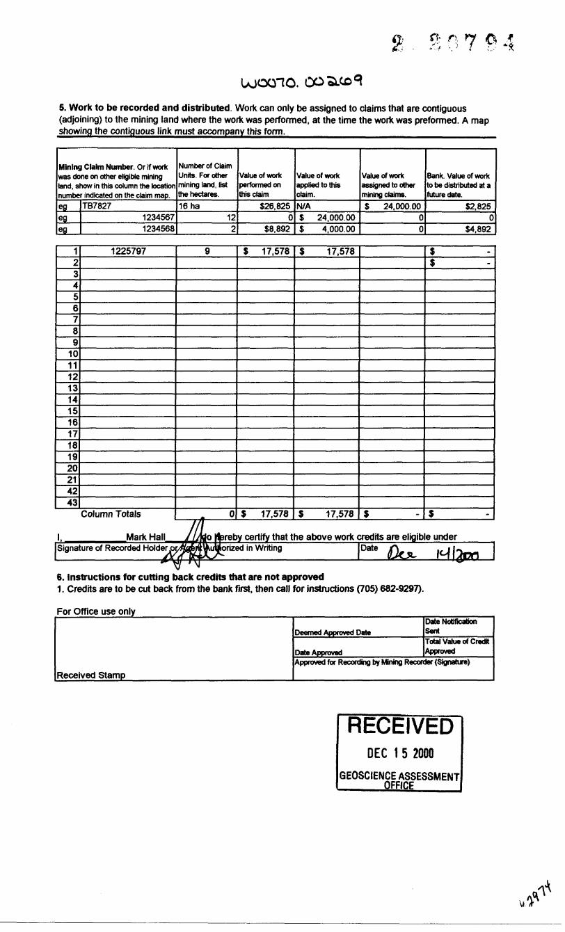
UOOGIO.5. Work to be recorded and distributed. Work can only be assigned to claims that are contiguous (adjoining) to the mining land where the work was performed, at the time the work was preformed. A map showing the contiguous link must accompany this form.
Mining Claim Number Or if work was done on other eligible mining land, show in this column the location number indicated on the claim map.egegeg
TB782712345671234568
Number of Claim Units. For other mining land, list the hectares.16 ha
122
Value of work performed on this claim
S26,8250
S8,892
Value of work applied to this claim.
N/AS 24,000.00S 4,000.00
Value of work assigned to other mining claims.
S 24.000.0000
Bank. Value of work to be distributed at a future date.
12.8250
S4.892
123456789
1011121314151617181920214243
1225797
Column Totals
9
0
$ 17,578
$ 17,578
S 17,578
S 17,578 S
1s
s
l. Mark Hall reby certify that the above work credits are eligible underSignature of Recorded Holder lorized in Writing
6. Instructions for cutting back credits that are not approved1. Credits are to be cut back from the bank first, then call for instructions (705) 682-9297).
For Office use only
Received Stamp
Deemed Approved Date
Date Approved
Date Notification SentTotal Value of Credit Approved
Approved for Recording by Mining Recorder (Signature)
RECEIVEDDEC 1 5 2000
GEOSCIENCE ASSESSMENT __ OFFICE

o /*' '*
Ministry of Northern Development and Mines
Statement of Costs for Assessment Credit
Transaction Number (office use)
OJ001O.OO.XCc9
Personal information collected on this form is obtained under the authority of 6(1) of the Assessment Work Regulation 6/96. Under section 8 of the Mining Act, the information is a public record. This information will be used to review the assessment work and correspond with the mining land holder. Questions about this collection should be directed to the Chief Mining Recorder, Ministry of Northern Development and Mines, 6th ROOT, 933 Ramsey Lake Road, Sudbury, Ontario P3E 6B5.
Work Type
LinecuttingAMT stationsSupervisionReport writing
Units of WorkDepending on the type of work, list the number of hours/days worked, meters of drilling, kilometers
of grid line, number of samples etc.
6.622|Km25 Station
1 days2 days
Associated Costs (e.g. supplies, mobilization and demobilization)
Transportation Costs
Food and Lodging Costs
Cost Per Unit
S 289.22S 588.503 300.00S 300.00
Total Value of Assessment Work
Total Cost
S 1,915:20S 14,712.50S 300.00S 600.00
S 50.00
S 17,578
Calculation of filing Discounts:
1. Work filed within two years of performance is claimed at IdO/ft of the above Total value of Assessment Work.2. If work is filed after two years and up to five years after performance, it can only be clairned at 50^ of the total Value of Assessment Work. If this situation applies to your claims, use the cateulafon below.-—^—————-—-—^—^^-——-————
TOTAL VALUE OF ASSESSMENT WORK x 0.50' Total value of assessment work claimed.
Note:- Work older than 5 years is not eligible for credit.- A recorded holder may be required to verify expenditures claimed in this statement of costs within 45 days of a request for verification and/or corrections/clarification is not made, the Minister may reject all or part of the assessment work submitted._______________________
Certification verifying costs:
Mark Hall , do hereby certify, that the amounts shown are as accurate as mayreasonably be determined and the costs were incurred while conducting assessment work on the lands indicated on the accompanying Declaration of Work form as _an officer^ _ l am authorized to make this certification.
RECEIVEDDEC t 5 2000
GEOSCIENCE ASSESSMENT— OrrlCfc____

Ministry of Mlnistere duNorthern Development Developpement du Nordand Mines et des Mines Ontario
Geoscience Assessment Office 933 Ramsey Lake Road
January 18,2001 6th FloorSudbury, Ontario
Mark Hall P3E 6B5 WALLBRIDGE MINING COMPANY LIMITED129 FIELDING ROAD Telephone: (888) 415-9845 LIVELY, ONTARIO Fax: (877)670-1555 P3Y-1L7
Visit our website at:www.gov.on.ca/MNDM/MINES/LANDS/mlsmnpge.htm
Dear Sir or Madam: Submission Number: 2 .20794
Status Subject: Transaction Number(s): W0070.00269 Approval
We have reviewed your Assessment Work submission with the above noted Transaction Number(s). The attached summary page(s) indicate the results of the review. WE RECOMMEND YOU READ THIS SUMMARY FOR THE DETAILS PERTAINING TO YOUR ASSESSMENT WORK.
If the status for a transaction is a 45 Day Notice, the summary will outline the reasons for the notice, and any steps you can take to remedy deficiencies. The 90-day deemed approval provision, subsection 6(7) of the Assessment Work Regulation, will no longer be in effect for assessment work which has received a 45 Day Notice. Allowable changes to your credit distribution can be made by contacting the Geoscience Assessment Office within this 45 Day period, otherwise assessment credit will be cut back and distributed as outlined in Section #6 of the Declaration of Assessment work form.
Please note any revisions must be submitted in DUPLICATE to the Geoscience Assessment Office, by the response date on the summary.
If you have any questions regarding this correspondence, please contact JIM MCAULEY by e-mail at [email protected] or by telephone at (705) 670-5858.
Yours sincerely,
ORIGINAL SIGNED BYLucille JeromeActing Supervisor, Geoscience Assessment OfficeMining Lands Section
Correspondence ID: 15621 Copy for: Assessment Library

Work Report Assessment Results
Submission Number: 2.20794
Date Correspondence Sent: January 18, 2001______________________Assessor:JIM MCAULEY^^^^^^^^^^^^^^^^^^^
Transaction First ClaimNumber Number Township(s); Area(s) Status Approval Date
W0070.00269 1225797 MORGAN Approval January 11,2001
Section:14 Geophysical EM
At the discretion of the Ministry, the assessment work performed on the mining lands noted in this work report may be subject to inspection and/or investigation at any time.
Correspondence to: Recorded Holder(s) and/or Agent(s):Resident Geologist Mark HallSudbury, ON WALLBRIDGE MINING COMPANY LIMITED
LIVELY, ONTARIO Assessment Files Library - Sudbury, ON
Page: 1Correspondence ID: 15621

OotN
is -^
*i* TOp-v7J'- ~7h:- v
d" l*' H* 14'
90 4011* tt'
i V ' \
** JLA
10
1 l
1.1-J
N
MGBtl... - ' ls I 'll . v.- . -J KX
tf 1*4*0 I4ftff4
'7-li , -.. ^
123^16^: !' '
i
Ni'B *•r.
^ | — __, J^,l ' — —^^v
l-?'' -' l ; ' '- : ; ' ^ s'v \r iY -"- ; ' ' '-xt'{' i ' •;- .' ,. - - - .\^' x.! ""7-^ ' !: i 1 ' O1 ' ' ' kt"
-^: ^''"7^^^./--^ f y"". ' i'^"""feB^
L4W4 j
; 123714^1'
[4T?*I l
A
,. v*I4T7M HfTlT
.1
f-A,rii^J '•-' -, -i):*i.K', l f TT**
'^''
t-^^T T7 —^\f~^ ~~rr ——!' - ' \ -i ' - l' ••" •'''l m.*.m-m*
M*7Rft , fc- l IfTTUa K ,. "' ' l BBW5 . .
_ . -i""""114*1
r r
CM"
y
tUIT \
;ht
Lake
b—-ITJ/yO/1 iflAl /'T -.s.. l ^^V,.
.
... ^ :f ^^ ! ^7// .-/' '
• VV- "^^.Wi'-.. " fe fr J'TV.I'r - v :'^i'f^-H/'
/-^-.-—m
-"•"•Afjf: *
T ,,, i **.-., :' r- '-..__-" •••' -is i i .- c\ :\ ^ \'ij - - l v ;iii.U-..- -4^ ̂ ^4^ i4-s4-^u i-v/'-rit?- lv ^i ~"'-.i^yJH- :i'^,/-.i iv\ttiMp
S *\.'Svfr f -/;, - ,^ t-.--
60
y ^--5^,,,, fe ̂•\JX e
/V asm
MzdOl /' ' -" \ vl: .f t"-v'V
M
1*341 ] B4T4) l MM*. j'"" ^'"-iv^. ,---t v xl -i.'- - i -V .1f li JV *' *r^^-fr* ——j —.7
r*v^f cT"1 "*^ l ™ *- V. \ -
ma \ f Mt**'..V
1^^''
/'li
-..Jt!__4*1————W——.' ! ' l 'a ''Is ' *- ' \UHV .1 UHI ' . ' J4U* ' " AtV^V44Bf ,1 M*r j', ,]A*M*
1 i l l
i ____ rfj^^ ' *| *i;,^ Hi^" !t,*#~7u
/ i
•-!B i*Illftr* l HWT7
l
l* xl HUMl
Illllli.
.0
v^t^-:T:
^., r-^tf"
11
firn.
so
•09
f
:?: :\-' ! ''' ' i.1 ^ 1'•ll (l '-\ l^•''{^4. ,! l|.' •'.' L-^ - /7 ^^
^^U-^jS^|t^'^Jfflr4' ' T ' ^^
l' MMic i i ntwi* -..'. ^ j ttitM ̂ y'
- .-^.'^ ,'n.'
y
•^ * m^ca s' -i
;
nw*" l^/x i -btl r' '"^ - ^'
^— Ti X;.-'i F-..^
|CX " - ' -i-J1 ^1 ^ - ^! -^-4'
^s^ ~f?^~T" ~*——^ET11""** !tSi^ft*'!™^?* * *" ~" i y /"••^-^ L " l' h. ^ f "B. ' T
l " i^-s. 'i ^.- l i l: ' i! /fBTiJ
* 1unn /l,^-^ -Vi /i i-^ ^i
' i.' '
* tIO*1M 1C
jiJi l
lOMrt 1 ionic
L.__a__\.n i ; -
,; \-^ io*m , i-'"-W ^ i---^- -^-\--.^
, fl - *'vil untBD j itwm'\\M ' i
, J v
w;^^s*
^-_ — l
M, .H^;1^.l ^-i-,.. --:.;.s[ y'i L-''
- tA . .j.
^'
, l
•^ Q'l L-4 Q l'viy - ;-\ r*' - v, :'""1 i j• K—^J—^J^U^^^^L^-^!-r——-^--"-^-
:X-te- 4:*!;'fifHf~ ..fe- Kflf)ailPi-*?-c*L"^T-^^f^ -l tt ^ f M : . ' W* S . l I.MW : \ *^- l '*- *"
i. V\i
.H'O'~* "
r - K
•* l^,. f
fi - l .•/' : 114341 - .'. j 11*1411'/' .
l
1,1*341
•i t
.vV l
8 '
-. X
"V-.
10 E 90.li* B 1 li*1 1* 1 2O• l" 14'4O
81" 12'50
i i '
\ •rf ,-f
f
xIIJl'"..-^
! X
SMP 401?M/ 09
Ministry ofNaturalResources
Ministry ofNorthern Developmentand Mines
Ontario
INDEX TO LAND DISPOSITION
PLAN
G-4087TOWNSHIP
MORGAN
M.N.n. ADMINISTRATIVE DISTRICT
SUDBURYMINING DIVISION
SUDBURYLAND TITLES/REGISTRY DIVISION
SUDBURY
Sea 1*1:20000
tnon 100AMvtrM
IDftB 0ri H HH HH k-
1000 MOO 4BDO mo* 7900 MOD 1000 10 WU.- PHI
Contour Inltnul 10 U*1ftt
SYMBOLSBoundary
Township, Meridian, Baseline Road allowance; surveyed
shoreline-
Lot/Concession; surveyed . . . . . . . . . . . . . . . . . .unsurveyed
Pancat; surveyed
unsurvcycd . . . . . . . . . . . . . , . . . . . . . . . .
Righl-of-way; road
railway utility
Reservation
Cliff.Pit.Pil*.-...-.---......
Contour . . . . , . . . . . . . . . . . . . . . . , . . . , . . , . . . .InterpolatedApproximateDepression
Control point (horizontal)
Flooded land . . . . , . , . , , , . . , , . . , , , , ,
Mine head •frame
Pipeline (above ground J
Railway; single track . . . . . . . , , , . . . . . . . . . . . . .double track - ...... ... .... ...abandoned . - . . . . . . . . . . . .
Road; highway, county, township- access trail, bush •••-
Shor&llne (original)
Transmission line . . . . . , Wooded area
DISPOSITION OF CROWN LANDSPatent
Surface A Mining Rights- Surface Rights Only Mining Rights On l y.,,,..
LeaseSurface a Mining Rights- Surface Rights Only
Mining Rights Only
Licence oi Occupation
OrdernivGouncil
Cancelled . .... ............
Re&ervation
Sand Z G ravel - - - - . .L AM D USE PERMIT
eQ
ac
Map base and land disposition drafting by Surveys a nd M apping Rrqnrh, Mmislry of Natural Rusnureas
AREAS WITHDRAWN F ROM D ISPOSTIONM.R.O. - MINING RIGHTS ONLY S.R.O. - SURFACE RIGHTS ONLY M.+S. - MINING AND SURFACE RIGHTS
De&cription Order No. Disposition F ile
EC.35 W-S-5/99 FEB.10/99 M&S 195150
. 35 W-S-24JOO 2000/05/26 M+S 195150
NOTES
NO flTAKme OH tut KD or rut VEKHILUON RIVER WITHIN T*3F LOT s , CONCESiJdN l.
THE INFORMATION THAT APPEARS ON THIS MAP HAS BEEN COMPILED FROM VARIOUS SOURCES, AND ACCURACY l S NOTGUARANTEED. THOSE WISHING TO STAKE MINING CLAIMS SHOULD CONSULT WITH THE MIMING RECORDER MINISTRY O F NORTHERN DEVELOPMENT AND MINES. FOR ADDITIONAL h FORM AT ION ON THE STATUS OF THE LANDS SHOWN H ERE ON
Tho disposition otland, local ion of lo) fabric and parcel boundaries an thia m da* was compiled for adffliniairative purposes only

41I11NW2002 2.20794 MORGAN 210
Wallbrdge Mining Dec 2000 Scale 1-5000
N
AMT station
AMT station location sketch