walking wonders
66
walking wonders ENG
-
Upload
zell-am-see-kaprun -
Category
Documents
-
view
239 -
download
2
description
Dear hiking fan, In this ‚hiking guide‘, you’ll find ten of the best hiking tours in Zell am See-Kaprun.
Transcript of walking wonders

walkingwonders
ENG

2
Travelling means reaching a destination; hiking means to be on the road. (Prof. Dr. Theodor Heuss)

3
Dear hiking fan,
In this ‚hiking guide‘, you’ll find ten of the best hiking tours in Zell am See-Kaprun. Discover the practically unspoilt Alpine world surrounding the local mountains of Kitzsteinhorn, Maiskogel, and Schmitten-höhe. You can look forward to well-kept hiking trails, breathtaking views and un-forgettable experiences in nature.
We have added a hiking pass to this bro-chure, too. Have lots of fun climbing the summits and visiting the Alpine huts of Zell am See-Kaprun. Depending on how many routes you discover, you’ll receive the bronze, silver or gold hiking needle at the end of your stay.
Good luck to all the walkers!
Your hiking team of Zell am See-Kaprun
easy average hard
Levels of difficulty

4
Regardless of their respective level of difficulty, all the stages of our tours ask for a minimum of fitness and in the majority of the cases a good head for heights. The trails have been divided into walking trails and mountain trails (blue, red, and black).
Walking trails require neither mountain experience, nor any spe-cial equipment. The signs in the respective colours along the trails indicate the level of difficulty.
The red mountains trails require sufficient fitness and a minimum of equipment for hiking in the Alpine region. At least one person in the group ought to have some experi-ence of hiking tours in the moun-tains.
On black mountain trails, i.e. on Alpine tours, every participant has to be sure of step and needs a good head for heights.
In connection stamina and physical fitness you have to keep in mind that the height of the terrain plays an important role. People who are fit in flat country don’t necessarily have to be fit enough for a tour in the mountains. Moving from sea
level or lower regions to the Alpine region without taking the time to adapt properly can cause problems as well.
‚Experience of hiking tours in the mountains‘ means that you have participated in Alpine tours before and climbed to an altitude which is higher than the region where you live and above the timber line. ‚Being sure of step‘ means that you don’t have any problems moving around in regions without visib-le paths. ‚Having a good head for heights‘, on the other hand, can be quite subjective for every single person. Some might be fine when climbing narrow clefts while fee-ling uncomfortable when moving in heavily sloping areas. Others get nervous at the edge of a summit. For this reason, you should evaluate the up-coming situations before-hand by taking a thorough look at the description of the route.
Before setting out on a tour, you absolutely have to plan your tour carefully and study all the available information. Get a topographical map to a scale of 1:50,000 or prefe-rably 1:25,000 to plan your trip and don’t forget to watch the current weather forecast. Be hard on your-
i Important information for hikers

5
self when it comes to judging your fitness! Remember that you have to act on your own responsibility!
Your backpack mustn’t be too heavy. However, take enough pro-visions (food and drink) – water is of major importance! Furthermo-re your equipment must include some emergency equipment such as a first-aid kit, a mobile phone, a bivouac sack, a torch, etc. Don’t venture out into the mountains without sturdy walking shoes with deep-tread soles. Your clothing also has to be suitable for the Al-pine region, which means that you have to take some protection against rain and – for regions abo-ve 1,500 metres of altitude – a woollen hat and gloves, even in the summer months. Trekking poles come in handy for the ascent and descent. And don’t forget a slee-ping bag in case you stay overnight in a hut.
The walking times indicated for the tours are an average. The specifica-tions, especially regarding the level of difficulty, apply in good weather. When rain or snow is falling, when the ground is wet or when there is fog, the level of difficulty can incre-ase immensely.
On mountain trails you always have to be prepared to face Alpine risks and dangers. Therefore you should definitely check the rele-vant literature.
Important phone numbers:Emergency call: 112(Dial 112 instead of the pin code and your mobile phone will auto-matically search for the best net.)Mountain rescue service: 140Rescue service: 144Weather forecast for the Alpine region: Special service – personal counselling: +43 (0)512 291600Mondays to Saturdays from 1 pm to 6 pm meteorologists trained as mountain guides are glad to answer your questions.
If you would like to get some infor-mation beforehand on the Internet, we can recommend the following links:
www.bergsteigen.at Category ‚Weather‘
www.alpenverein.at Category ‚Service‘ Menu item ‚Weather‘

6
Technical difficulty Demands the hikers must meet
Hiking trail• easily accessible path• wide trails with only
little inclination
• no experience or mountain equipment needed
Red mountain
trail
• average difficulty, many narrow and steep stretches
• some short, secured climbing stretches
• Alpine experience needed• physical fitness required• being secure of step• minimum of Alpine equipment
Black mountain
trail
• difficult, narrow, almost always steep, often no path visible
• secured climbing stretches over longer distances
• thorough Alpine experience• good physical fitness• secure of step and a good
head for heights• complete Alpine equipment
i Important information for hikers
7
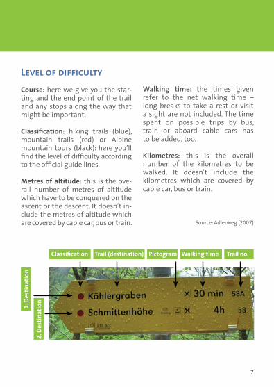
Level of difficultyCourse: here we give you the star-ting and the end point of the trail and any stops along the way that might be important.
Classification: hiking trails (blue), mountain trails (red) or Alpine mountain tours (black): here you’ll find the level of difficulty according to the official guide lines.
Metres of altitude: this is the ove-rall number of metres of altitude which have to be conquered on the ascent or the descent. It doesn’t in-clude the metres of altitude which are covered by cable car, bus or train.
Walking time: the times given refer to the net walking time – long breaks to take a rest or visit a sight are not included. The time spent on possible trips by bus, train or aboard cable cars has to be added, too. Kilometres: this is the overall number of the kilometres to be walked. It doesn’t include the kilometres which are covered by cable car, bus or train.
Source: Adlerweg (2007)
1. D
estin
atio
n
Classification Trail (destination) Walking time Trail no.Pictogram
2. D
estin
atio
n

8
Sisi's Circular Path
Following the traces of Empress Sisi
More than 120 years ago our empress took a stroll on Schmittenhöhe to watch the sunrise. In the unique Elisa-beth Chapel, you find photos and a si-gned picture of the empress. From the Elisabeth Chapel you head toward the Panorama mountain restaurant. After about 200 metres in the south eastern direction, you arrive at another stop on Sisi’s way: some presentation boards. Downhill from the mountain station on Schmittenhöhe, you follow the tra-ces of Empress Sisi framed by the ext-raordinary panorama of more than 30
mountains rising to an altitude of more than 3,000 metres. After about 30 minutes you arrive back at your starting point at the Elisabeth Chapel. Discover the story behind Sisi’s stroll and let her take you to the imperial world long gone.
Height profile
0,25 0,5 0,75km
1850
1900
1950
2000
hmStart Ziel
1

9
Information: Tour classification:Fitness: * Suitable for families: yesTechnique: * Demanding: noExperience value: ***** Public Transport: yesStarting point: Schmittenhöhe mountain station at 2,000 metresTransport: Car or bus to the valley station of Schmittenhöhebahn (oldest cable railway in the province of Salzburg)End point: Schmittenhöhe mountain station at 2,000 metresRefreshments: Berghotel Schmittenhöhe and Schmitten CaféParking: Schmittenhöhe valley stationBus transfer: Shuttle service betw. Zell am See and Kaprun half-hourly. Change buses in Postplatz square in Zell am See
Detail of the map
)
Breiteckalm
Nösslingalm
Finsterbach
Schmittenhöhe
Hochzeller Alm
Herrensteigscharte
Schmitten Café Berghotel Schmittenhöhe
0 100 200 300 40050Meter
Start
N
No. 1 0,5 h 20 Metres of altitude

10
Guggenhöhenweg
Around Kaprun
From Kaprun town hall, you follow Imbachstraße eastwards to the snack bar Guggenbichl. You can stop there for refreshments, some Pinzgau delicacies and a look at the farmyard, before the path climbs the mountains. First you cross a ditch and then the gradually as-cending serpentine path leads you eastwards through mixed wood-lands in flat territory. The serpenti-ne trail then passes through young woods and an alder forest to lead you downhill again to the castle to Schlossstraße bringing you back to the town centre.
Information: Tour classification:Fitness: ** Suitable for families: yesTechnique: ** Demanding: noExperience value: **** Public Transport: yesStarting point: Kaprun town hallTransport: Car or bus End point: Town centre KaprunRefreshments: Snack bar GuggenbichlParking: Car park near the Baumbar at the entrance of the townBus transfer: Shuttle service betw. Zell am See a. Kaprun half-hourly.
2

11
No. 30 2,5 h 120 Metres of altitude
Height profile
Detail of the map
!
!
!
!
!
!!
!!
!
Kaprun
JausenstationGuggenbichl
Filzmoos
Pichldörfl
Burg Kaprun
Hauserdörfl
Eßreitdörfl
Moossiedlung
Schaufelberg
Kapruner Ache
Start
0 140 280 420 56070Meter
¯
0,5 1 1,5 2 2,5 3 3,5km
600
700
800
900
1000
hmStart Ziel
12
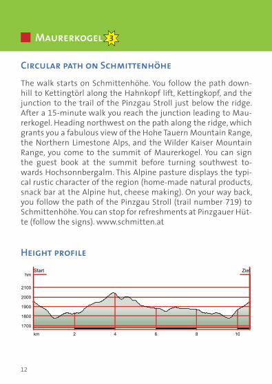
Maurerkogel
Circular path on Schmittenhöhe
The walk starts on Schmittenhöhe. You follow the path down-hill to Kettingtörl along the Hahnkopf lift, Kettingkopf, and the junction to the trail of the Pinzgau Stroll just below the ridge. After a 15-minute walk you reach the junction leading to Mau- rerkogel. Heading northwest on the path along the ridge, which grants you a fabulous view of the Hohe Tauern Mountain Range, the Northern Limestone Alps, and the Wilder Kaiser Mountain Range, you come to the summit of Maurerkogel. You can sign the guest book at the summit before turning southwest to-wards Hochsonnbergalm. This Alpine pasture displays the typi-cal rustic character of the region (home-made natural products, snack bar at the Alpine hut, cheese making). On your way back, you follow the path of the Pinzgau Stroll (trail number 719) to Schmittenhöhe. You can stop for refreshments at Pinzgauer Hüt-te (follow the signs). www.schmitten.at
Height profile
2 4 6 8 10km
1700
1800
1900
2000
2100
hmStart Ziel
3

13
Information: Tour classification:Fitness: *** Suitable for families: noTechnique: *** Demanding: yesExperience value: ******* Public Transport: yesStarting point: Schmittenhöhe mountain station at 2,000 metresTransport: Car or bus to the valley station of SchmittenhöhebahnEnd point: Schmittenhöhe mountain station at 2,000 metresRefreshments: Hochsonnbergalm, Berghotel Schmittenhöhe, Schmitten Café, Pinzgauer HütteParking: Schmittenhöhe valley stationBus transfer: Shuttle service betw. Zell am See a. Kaprun half-hourly. Change buses in Postplatz square in Zell am See
*During the course of this hiking tour you’ll leave the road network of Zell am See. For this reason, the trail doesn’t have a number.
Detail of the map
No Number* 4,0 h 498 Metres of altitude
!
!
!
!
!
!
!
e)
e)
e)
e)
e)
e)
e)
e)
e)
e)
e)
e) e)
Kurzeck
Angerberg
Haslingalm
Haslingalm
RohrertörlNösslingalm
Walcherbach
KettingkopfMaurerkogel
ViehlehenalmMittereckalm
Friedensbach
Untergosenalm
Wurzeckgraben
Kesselscharte
Moserbauernalm
Hochsonnbergalm
Pinzgauer Hütte
Kottingeinödenalm
Innere Reisenbergalm
Gasthof Winkelmoos F
Start
0 260 520 780 1.040130Meter
¯
Schmitten Pfiff

Jausenstation Pfefferbauer The Pfefferbauer is situated 100 m above the Zell am See and offers its guests a marvelous view over the town of Zell am See and the mountain world of the Pinzgau. It is the ideal starting point for numerous walks and smaller
hiking tours. On our sun terrace, with the panoramic view, we serve tradi-tional cuisine and regional dishes; in doing so, we use local farming prod-ucts which aro also on sale for guests to take home. On the 3rd Sunday of each month there is a musical session at Pfefferbauer, at which mu-sicians and listeners who love regional folk music are equally welcome.
Jausenstation Pfefferbauer • Monika Pfeffer • Einöd 70 5700 Zell am See • phone +43 (0) 6542-73450, +43 (0) [email protected] • www.pfefferbauer.comOpen on weekends (Fri. – Sun., holidays) April – June and Mid-Oct. – December, closed on Mondays from July – Mitte Okt.
Gleiwitzer HütteVisit us at our cottage on a hight of 2,176 m – open from June 5th
Overnight accommodation – traditional food Opportunities to hike: Imbachhorn, Hoher Tenn, Rettenzink, Loop trail from Fusch to KaprunTel. +43 (0)664 92 94 989 • www.gleiwitzerhuette.at

15
Lifestyle Sporthaus Intersport Bründl Main store: 06547/8388, Subway Snowboardstore:
06547/8388-35, Monday to Friday 9am – 12.30pm and 2.30pm - 6pm, Saturday 9am - 6pm |
Bike’s World opposite main store: 06547/8388-60 | Tauern Spa Shop 06547/2040-2025, daily from
9am - 7pm | Gletschershop Kitzsteinhorn Alpincenter: 06547/8621-360, daily from 8.30am – 4.30pm
1.600 m2 of feelgood architecture an 4 levels, „Sinnbar“ & café, 3D cinema, lounge with open fi replace, Apple internet, 76 parking spaces, underground car park.
ww
w.n
ill.
at
| ©2
011
| Ph
oto
: Fa
ista
ue
r
Summer 2011 at Bründl.www.bruendl.at
gegenüber Haupt-geschäft

16
Ebenbergalmweg
Keilberg – Bergheim – Ebenbergalm
This walk starts at the restaurant ‚Dorfschen-ke‘ in Zell am See/Schüttdorf. From there you head uphill on the street leading to Keilberg. After about 15 minutes trail no. 52 leads you through the woods towards Zell am See, past the Bergheim apartments to Ebenbergalm Al-pine Hut – taste some local culinary delights and enjoy the view of Zell am See. Going down-hill you arrive in the town centre of Zell am See after about 30 minutes. On your way to Zell you should definitely stop at the Aubauer, the farm of the Pichler family. There, you are pampered with home-made products, can take refresh-ments, or buy something at the ex-farm sale.
Information: Tour classification:Fitness: ** Suitable for families: noTechnique: *** Demanding: yesExperience value: **** Public Transport: yesStarting point: Schüttdorf at the restaurant ‚Dorfschenke‘Transport: Taxi, car or bus (stop Areitalm), since Schüttdorf is not the terminusEnd point: Town centre of Zell am See (along the lakeside prome- nade you reach Schüttdorf within 35 minutes)Refreshments: Ebenbergalm Alpine Hut, Aubauer FarmParking: Car park at AreitbahnBus transfer: Shuttle service betw. Zell am See a. Kaprun half-hourly.
4

17
No. 52 2,0 h 250 250 Metres of altitude
Height profile
Detail of the map
!
!
!
!
)
e)
e)
e)
e)
e)
e)
e)
e)
e)
e)
e))
) e) e)
e
e )
e )
e )
e )
e )
e )
e )
e )
e )
e )
e )
e )
e )
e )
e )
e )
StartPeilgut
Keilberg
Schüttdorf
Schüttbach
Ebenbergalm
Zell am See
Plettsauberg
Kühlergraben
Granisiedlung
Gasthof Mittelstation
Aubauer
0 190 380 570 76095Meter
¯
1 2 3 4km
700
800
900
1000
1100
hmStart Ziel

18
Jetzbachastensteig
At the feet of the Mooserboden reservoirsThe steep path of Jetzbachastensteig to the Glocknerblick inn passes across Jetzbachbrücke bridge up to Augut farm and Schne-ckenreith mountain hut. Here you can taste local products like the home-made cheese which is so typical for Pinzgau. Following the road uphill you find the beginning of the steep path taking you through high forest and deciduous woodland up the mountain to the ‚Ast’n‘. From there, it is not far anymore to the Alpine inn of Glocknerblick where you can stop for refreshments and enjoy the breathtaking view of the Mooserboden reservoirs. Once there, you definitely have deserved a ‚Brettljause‘, which is a hearty cold snack served on a wooden plate (Brettl). A nice way down pas-ses Heli’s Maiskogelalmhütte Alpine hut with a petting zoo for children and takes you to the centre of Kaprun via Forststrasse street on Schaufelberg. If you feel hungry on your way to the val-ley, you can stop for refreshments at the restaurant Stangerbauer or Weisssteinalm mountain inn. 20 minutes before reaching your final destination you shouldn’t miss the opportunity to stop at the Unteraigen inn where you can taste local products and home-made schnapps. We are sure you’ll arrive in Kaprun in high ‚spirits‘.
Height profile
2 4 6 8 10km
80010001200140016001800
hmStart Ziel
5

19
No. 29 + 3,0 h 830 870 Metres of altitude
Information: Tour classification:Fitness: **** Suitable for families: noTechnique: **** Demanding: yesExperience value: ****** Public Transport: yesWalking time: Approx. 3 h, approx. 2.5 h via Heli’s Maiskogelalm- hütte Alpine hut (Maiskogelbahn cable car takes you to the valley until 5 pm)Starting point: Jetzbachbrücke bridgeTransport: Bus (bus stop at Künstleralm Inn), or car since Jetzbach- brücke bridge is not the end point End point: Town centre of KaprunRefreshments: Schneckenreith mountain hut, Alpine inn Glocknerblick, Heli’s Maiskogelalmhütte Alpine hut, restaurant Stangerbauer, Weißsteinalm, restaurant UnteraigenParking: Klammsee lakeBus transfer: Shuttle service betw. Zell am See an. Kaprun half-hourly.
Detail of the map
! !
!
!
!
!
!
!
!
!
!
!!
!!
!
e) e) e) e) e) e) e) e) e) e) e) e)
Start
Kaprun
Gassen
Riedlalm
Maiskogel
Bürgkogel
Pichldörfl
Winklerdörfl
Schaufelberg
Falkenbachwand
Dreiwallnerhöhe
Kaprun-Werksiedlung
Sigm.-Thun-Klamm
Gasthof Glocknerblick
Schneckenreith
Heli´s Maiskogelalmhütte
StangerbauerWeißsteinalm
Unteraigen
0 230 460 690 920115Meter
¯

20
The Alpine pastures of Ebmatten-Fürthermoaralm are located between the reservoirs of Mooserboden and Was-serfallboden surrounded by ten 3,000-metre summits. Having strolled across the lush green meadows where 140 cattle and 700 sheep are grazing, you’ll know to appreciate the products of Fürthermoaralm: butter, cheese, yoghurt, milk, buttermilk, ba-con, sausages, bread, and schnapps. The pasture museum (the old Alpine hut dates from the 18th century) is well worth a visit, too. There, you can take a step back in time and see how the Alpine herdsmen and dairymen used to live. If you’d like to stop for prayer, you are very welcome at our chapel. For our small guests, we have a petting zoo and a playground. And of course, you can stay over-night in one of the idyllic rooms or the dormitory.
Ebmatten-Fürthermoaralm Family Aberger • A-5710 Kaprun, PO box2Phone hut: +43 (0) 6547-7158 23435 • Farm: +43 (0) 6549-7208E-Mail: [email protected] • www.fuerthermoar.at

21
Kaprun Alpine ReservoirsUnforgettable impressions! With Europe´s largest open inclined elevator you will reach a breathtakingworld of high mountains. Enjoy nature and enginee-ring. The sensory world of electricity and ice and a guided tour of the dam wall complete your excursionprogramme.
Opening hours end of May – mid September Daily from 8.10 am – 4.45 pm
InformationVERBUND Tourismus GmbH T +43 (0)50 313 23 201 E [email protected] www.verbund.com/tourismus
Excursion to the water reservoirs.Experience nature and technology!
RZ_20110301_VERBUND_Tourismus_Ins_105x148_Layout 1 25.03.11 12:06 Seite 2

22
„What I have not learnt, I have discovered on foot.“ (Johann Wolfgang von Goethe)

HANWAG GMBH | WIESENFELDSTR. 7 | D-85256 VIERKIRCHEN | TEL: + 49 (0) 81 39 / 93 56 0 | WWW.HANWAG.DE
ALASKA GTX®
The Alaska GTX® is an extremely rugged, multiple award-winning trekking boot from our collection. It is manufac-tured using extremely strong, waxed nubuk leather with ‚reduced-seams‘ which guarantees durability and form stability. a Gore-Tex lining keeps the Alaska GTX® waterproof whilst the Vibram® Fuora Sole with memory-graded insole guarantees sure-footedness in every terrain.
”EXPERIENCE IS THE SOURCE OF ALL FORMS OF KNOWLEDGE..“ [ARISTOTELE]

24
Nr. 718
Information: Tour classification:Fitness: ****** Suitable for families: noTechnique: ***** Demanding: yesExperience value: ****** Public Transport: yesWalking time: 9 h (7 h if you take the cable car to the valley)Character: Alpine mountain tour (black)Starting point: Mountain inn at Mooserboden or the church Heid- nische Kirche near the dam of Moserboden reservoirTransport: Bus since Mooserboden valley station is not end point End point: Alpine inn at Enzinger BodenRefreshments: Fürthermoaralm, Alpine restaurant at Mooserboden, Hotel Rudolfshütte Bus transfer: Shuttle service betw. Zell am See a. Kaprun half-hourly. For the way back we recommend a taxi.
Mooserboden - Kapruner Törl - Rudolfshütte 6
From the Mooserboden make your way along the eastern side of the reservoir. The same path up to the Riffltor and, instead of turning left, continue along the path until the Karlingerbach river crosses it. From here, the path continues up to the Kapruner Törl. Now make your way from the Törl descending again to beneath the Unteren Rifflkeeses and further on to the Hinteren Ochsen-flecke. From here, cross over the river and continue along the path towards the east. The Rudolfhütte is reached by crossing over stone steps. The hut is open from the middle of June to the end of September offering comfortable rooms for an over-night stay (www.alpinzentrum-rudolfshuette.at). From this point, you either start your way down to the Alpine inn of Enzingerboden or take the Weisssee Gletscherbahn cable car, which is in service in the summer months from 9:30 am to 5 pm, and get a bus or taxi to take you to Kaprun or Zell am See.

25
Height profile
Detail of the map
No. 716 + 7,0 h 919 Metres of altitude
!
!
e)
e)
e)
e)
e)
e)
e)
e)
e)
e)
e)
e)
e)
e)
e)
e)
e)
e)
e)
e)
e)
e)
e)
e)
e)
e)
e)
e)
e)
e)
e)
e)
e)
e)
e)
e)
e)
e)
e)
e)
e)
e)
e) e)
e)
e)
e)e)
e)
e)
e)
e)
e)
e)
e)
e)
e)
e)
e)
e)
e)
e)
e)
e )
e )
e )
e )
e )
e )
e )
e )
e )
e )
e )
e )
e )
e )
e )
e)
e)
e)
e)
e)
e)
e)
e)
e)
e)
e)
e)
e)
Start
Stausee
Grünsee
Ebmaten
Übelkar
Wurfkar
Wurfkees
Eisboden
Riffltor
Sedlgrat
Eiserkees
Hüttental
Hocheiser
Die Tröge
Hahnkampl
Sametjoch
Törlköpfe
Höhenburg
WeißenbachRotenbäche
Hohe Riffl
Grießkogel
Mitterberg
Scharkogel
RötenkogelStierbichl
Dichtenbach
Bärenleiten
Klausenwand
Schwarzkarl
Sprengkogel
Rifflkarkees
Schwarzköpfl
Eiswandbichl
Geralscharte
Eiserscharte
Hochsedlgrat
Enzingerboden
KarlingerkeesEisbodenlacke
Führerscharte
Drachslerwand
Kleiner Eiser
Kapruner Törl
FürthermoaralmWasserfallkees
Grießkogelkees
Schwarzkarlsee
Schattseitköpfl
Niedere Scharte
Schwarzköpflkees
Unteres Rifflkees
Hochweißenfeldkees
Stausee Mooserboden
Mittlerer Bärenkopf
Vorderer Schafbichl
Oberes Hocheiserkees
Hintere Ochsenflecke
Unterer Kleineisersee
Oberes Rifflkees (Totenlöcher)
Bergrestaurant Mooserboden
Rudolfshütte
0 530 1.060 2.120265Meter
¯
2 4 6 8 10 12km
1800
2000
2200
2400
2600
2800
hmStart Ziel

26
Jägersteig - „Schmidolins Feuertaufe“
The trail starts at the cityXpress mountain station and gradually ascends to open pastures (hiking trails to Schmittenhöhe nos. 50 and 56). After a short distance the Jägersteig path (trail no. 56) turns into the woods on your left. This is an ideal trail for the entire family at about 1,400 metres above sea level. The hike takes you along romantic, shady forest paths to Glocknerwiese meadows. Once there, you head south to the Areitbahn mountain station. In the area of the Jägersteig route, the New-Experience Family Trail known as „Schmidolin’s baptism of fire“ is located, with a wide va-riety of stations to test your nimbleness, adroitness and dexterity. This summer many brand new stations. For more information see www.schmitten.at or ask at one of the base terminal stations.
Detail of the map
7
475474__2
476
477
494
493
479
480__1
478
480__2
482
481
.35
492
42__13
42__18__ _
490__1
495__3
491
489__2
489__1495__
19
495__16
473__1
473__1
472__1
472__2
472__3
474__1
.36474__1
.36
483
484__1
484__2
486
475474__2
476
477
494
493
479
480__1
478
480__2
482
481
.35
492
42__13
42__18__ _
490__1
495__3
491
489__2
489__1
.34
495__19
495__16
999000___
.35555....33333333333333335555555555555
49514444999955551111____ 5_699995555____
111166669_9999____4444 _5555____
untere Schleife
obere Schleife
Jägersteig
Flying Fox
Schmidolins Welt - Naturstationen Wackelnde Steine
/Fotopoint
Steilhang
FeuerradZündschnüre - Schmidolins Kletterpark
Glühende Kohlen

27
Information: Tour classification:Fitness: * Suitable for families: yesTechnique: ** Demanding: noExperience value: **** Public Transport: yesWalking time: 0.5 h on Jägersteig path; 1.5 h to the half-way station; 2 h to hike from Areitbahn mountain station to Zell am See / Schüttdorf / Salomon Station (Maiskogelbahn cable car takes you to the valley until 5 pm)Starting point: cityXpress mountain stationTransport: bus to cityXpress valley station and ascent by cable car (you can also conquer this stretch on foot along the new Schmittenhöhe trail no.50; approx. 1.5 h), or car since trassXpress valley station is not the end point End point: Areitbahn mountain station (the cable car takes you down to Zell am See) or you can choose to hike down to Zell, which takes about 2 hRefreshments: Areitalm Alpine innBus transfer: Shuttle service betw. Zell am See a. Kaprun half-hourly.
Height profile
No. 56 + 0,5 h 80 Metres of altitude
0,25 0,5 0,75 1 1,25km
1200
1300
1400
1500
1600
hmStart Ziel


29
schmitten.at
High altitude promenade
DiscgolfDiscgolf
MOUNTAINYOGA
HIGHLIGHTS SUMMER 2011
schmitten.at
Boat cruises

30
Alpengasthaus Glocknerblick
The unique location of the Glocknerblick has often been described as the most beautiful in the Alps. The impressive panorama ext-ends from the Großglockner, the highest mountain in Austria at 3,798 m, to the Dachstein range, the Hochkönig and further on to the Steinernen Meer with the Watzmann.This ideal family excursion point can be easily reached by various hiking paths and is only 20 minutes from the top station of the Maiskogel. Stefan Eder, the mountain guide, is very happy to give you information about the possibility of different tours or simply allow yourself to be spoilt by our homemade specialities.
Alpengasthaus Glocknerblick Stefan and Christine Ederphone +43 (0) 664-8206000
Open from Beginning of June till the end of September

family mountain, hiking paradise & sledding fun The Maiskogel is the mountain of enjoyment for
the whole family. Nestled between 3,000-meter
giants, this grassy-green mountain greets us with
its friendliest face. In summer, the Maiskogel
excites visitors with fantastic, free guided hikes,
sun terraces, enjoyable refreshment opportunities
and a brand-new highlight, the Maisfl itzer.
maisi-tips: Ride the Maiskogelbahn up, take a 30-min hike to the Unterbergalm, and enjoy hearty traditional Pinzgau favorites.
Petting zoo: right next to the sunny terrace of Heli`s Maiskogel-Alm
Live music: every Sunday at Heli`s Maiskogel-Alm
Free guided hikes from monday till friday with our trained guideWilli (preorder by phone kindly requested).
+43 (0)6547 20113 www.maiskogel.at
MaisiflitzerYear-round Alpine Coaster in Kaprun
wunderbar_wandern_v3.indd 2 13.03.11 16:24

32
Höhenpromenade – Sonnalm – Schmittenhöhe
Variant 1A bus will take you to the car park of Schmittenhöhebahn AG. On the perfectly developed trail of Sonnkogelweg (no. 64) you pass the Alpine Resort Hotel Schwebebahn and the restaurant and guest-house Farchenegg. The path quickly ascends and grants you im-pressive views of Zell am See and Lake Zell. After about 0.5 h you ar-rive at Jaga-Alm mountain inn and after another hour at mountain hotel Blaickner’s Sonnalm (situated next to the mountain railways station of Sonnenalmbahn). Schiedhofalm mountain inn is located at the end of several serpentines. The mountain of Sonnkogel is at a walking distance of a mere 40 minutes. At the inn of Sonnkogel, you turn into the adventure trail of Höhenpromenade (no. 68). The high altitude promenade was redesigned in 2010. Lots of informa-tion boards, panorama platforms, long distance telescopes and surprises along the way will open new views of the Schmitten to visitors. It passes the mountain of Salersbachköpfl and the lower part of the mountain ridge before leading along the pastures of Hochzelleralm to the Schmittenhöhe mountain station at 1,965 metres of altitude. There, you can enjoy the view of 30 summits of more than 3,000 metres of altitude and of Elisabeth Chapel. We can recommend the Schmitten Café and the mountain hotel if you like to stop for refreshment. (The Schmittenhöhebahn cable car offers ascent and descent.) The hiking tour continues along the mountain ridge downhill to Kettingalm pasture (no. 719 - Pinzgau Stroll). Keep following the signs to Pfaffenkendelsteig (no. 69; over-night stay possible at Pinzgauer Hütte Alpine hut) for 1.5 kilometres to get to Schmittenhöheweg (trail no. 50) or Areitweg (trail no. 56A, 51). You can take either of these trails down into the valley or choose between the cityXpress and Areitbahn to drop you off in the centre of Zell am See or Schüttdorf respectively.
8

33
Variant 2
a) Ascending on the Sonnenalmbahn cable car reduces the walking time by 1.5 h.b) Ascending on the Sonnenalmbahn cable car and continuing with Sonnkogelbahn reduces the walking time by 3.5 h.
Variant 3
a) Ascending on the Sonnenalmbahn cable car reduces the walking time by 4 h.b) Descending on the Schmittenhöhebahn reduces the walking time by 3.5 h.Tip: every Sunday from June 26th to August 28th 2011 a hiking tour along the mountain range to the mountain of Sonnkogel is offered in the company of the Elisabeth Band. www.schmitten.at
Nos. 64, 68, 719, 69, 50, 56A, 51 + 6,5 h 1072 1239 m
Information: Tour classification:Fitness: ****** Suitable for families: yesTechnique: **** Demanding: yesExperience value: ****** Public Transport: yesWalking time: 7.5 to 8 h (6.5 h if you take the cable car to the valley)Character: Mountain tour (red)Starting point: Schmittenhöhebahn/Sonnenalmbahn valley stationTransport: bus End point: cityXpress valley station (town centre of Zell am See) or Areitbahn valley station (Schüttdorf)Refreshments: Restaurant Farchenegg, Blaickner’s Sonnalm, Schmied- hofalm, Sonnkogel Restaurant, Hochzelleralm, Schmitten Café and Berghotel, Areit Alm, Pinzgauer Hütte Bus transfer: Shuttle service betw. Zell am See a. Kaprun half-hourly.

34
Höhenpromenade – Sonnalm – Schmittenhöhe
Height profile variant 2
2 4 6 8 10km
600800
100012001400160018002000
hmStart Ziel
Height profile variant 1
2 4 6 8 10 12 14 16km
800
1200
1600
2000
hmStart Ziel
Height profile variant 3
2 4 6 8km
800
1200
1600
2000
hmStart Ziel

35
Detail of the map variant 2
Detail of the map variant 1

Höhenpromenade – Sonnalm – Schmittenhöhe
Detail of the map variant 3
Pinzgau Ticket
1
2
3 10
11 12
4
5
6
7
8
9
Unken
Steinpaß
Lofer
St. Martin
Dienten
LendEschenau
Maria Alm
Saalfelden
Weißbach
Mitterlengau HinterglemmViehhofen Gerling
Maishofen
ThumersbachLehenbrücke
Zell am SeeFürth Taxenbach
GriesBruckKaprun
Piesendorf
UttendorfMittersill
Schneiderau
Enzinger Boden
Mooserboden
Lärchwand
Kesselfall
Kitzsteinhorn
Fusch
FerleitenBucheben
Kolm-Saigurn
Embach
Rauris
Franz Josefs Höhe
Wiesersberg
LeogangHochfilzen
Saalbach
Schmittenhöhe-bahn
260
65690
680
660
670
661
640
620
640
650
660672
571
572
64
651
Wald
BrambergNeukirchen
Krimml Krimml Bhf
Königsleiten670
673
Schmittenhöhe Kohlmaisbahn/SchattbergXpress Weißsee-Rudolfshütte Krimmler Wasserfälle Großglockner Hirschbichl-Diesbachstausee Hochkönig Wildpark Ferleiten Kolm-Saigurn Stauseen Mooserboden Wildkogelbahn Kitzsteinhorn
123456789101112
Experience the beauty of Pinzgau with our modern buses. Walking, sightseeing, experiencing nature or just enjoying your time.From June 11th 2011 until October 2nd 2011 the Pinzgau Ticket is valid on all bus lines in this region.
Prices: adults 41; children (from 6 to 14 years) 20.50(Tolls and fees for private roads are not included!)Valid for five days after buying the ticket.
More information at:phone: +43/6542/5444 [email protected] www.postbus.at/sbg
The remedy against getting rusty is cleansing one’s system, going hiking, and eating light food. (Unknown Author)

Pinzgau Ticket
1
2
3 10
11 12
4
5
6
7
8
9
Unken
Steinpaß
Lofer
St. Martin
Dienten
LendEschenau
Maria Alm
Saalfelden
Weißbach
Mitterlengau HinterglemmViehhofen Gerling
Maishofen
ThumersbachLehenbrücke
Zell am SeeFürth Taxenbach
GriesBruckKaprun
Piesendorf
UttendorfMittersill
Schneiderau
Enzinger Boden
Mooserboden
Lärchwand
Kesselfall
Kitzsteinhorn
Fusch
FerleitenBucheben
Kolm-Saigurn
Embach
Rauris
Franz Josefs Höhe
Wiesersberg
LeogangHochfilzen
Saalbach
Schmittenhöhe-bahn
260
65690
680
660
670
661
640
620
640
650
660672
571
572
64
651
Wald
BrambergNeukirchen
Krimml Krimml Bhf
Königsleiten670
673
Schmittenhöhe Kohlmaisbahn/SchattbergXpress Weißsee-Rudolfshütte Krimmler Wasserfälle Großglockner Hirschbichl-Diesbachstausee Hochkönig Wildpark Ferleiten Kolm-Saigurn Stauseen Mooserboden Wildkogelbahn Kitzsteinhorn
123456789101112
Experience the beauty of Pinzgau with our modern buses. Walking, sightseeing, experiencing nature or just enjoying your time.From June 11th 2011 until October 2nd 2011 the Pinzgau Ticket is valid on all bus lines in this region.
Prices: adults 41; children (from 6 to 14 years) 20.50(Tolls and fees for private roads are not included!)Valid for five days after buying the ticket.
More information at:phone: +43/6542/5444 [email protected] www.postbus.at/sbg

38
Variant 1From Berggasthof Mitterberg, you follow the broad forest road to a small and narrow path through the woods up to Schwalben-wand mountain. Along the mountain ridge you come to the peak of Schönwiesenkopf. There, you can decide to descend to Schüt-zingalm (closed in summer 2011), a traditional mountain inn offering local delicacies. Afterwards one begins the descent back to the starting point Of course, you can begin the hike from Thu-mersbach as well. Walking to the Berggasthof Mitterberg takes you about another two hours. Walking time: 5 h
Variant 2After a snack at the inn at Schönwieskopf (kilometre 7) you con-tinue on the mountain ridge until reaching Hundstein and the inn called Statzerhaus. There you turn back to the starting point. Walking time: 7 h
Variant 3If on arriving at Hundstein (kilometre 11), you don’t feel like hea-ding downhill the same day, you can stay overnight at Statzer-haus. After a rich breakfast at sunrise the descent to the valley is just a piece of cake. Walking time: 4 h ascent, 4 h descent
Schwalbenwand, Schönwieskopf, Hundstein 9

39
Nos. 80, 81, 82 + 5 h 811 811 Metres of altitude
Height profile variant 1
2 4 6 8 10 12km
1000
1200
1400
1600
1800
2000
hmStart Ziel
Height profile variant 2
2 4 6 8 10 12 14 16 18 20km
1000
1400
1800
2200
hmStart Ziel
Height profile variant 3
2 4 6 8 10 12 14 16 18 20km
1000
1400
1800
2200
hmStart Ziel

40
Information: Tour classification:Fitness: ***** Suitable for families: yesTechnique: **** Demanding: noExperience value: ****** Public Transport: yesMetres: 811 metres from Berggasthof Mitterberg (at 1,200 of altitude metres) to Schwalbenwand (at 2,011 metres), another 106 metres up to Hundstein (at 2,117 metres). You reach Hundstein via Schönwieskopf (at 1,994 metres); 811 metres from Schwalbenwand, 917 metres from HundsteinStarting point: Berggasthof MitterbergTransport: Taxi or carEnd point: Berggasthof MitterbergRefreshments: Berggasthof Mitterberg, Schützingalm, StatzerhausParking: Berggasthof Mitterberg (parking fee of approx. 1,– €)Bus transfer: Shuttle service betw. Zell am See a. Thumersb. half-hourly
Schwalbenwand, Schönwieskopf, Hundstein
Detail of the map variant 1
Start
Dilling
Sonns
eiten
Reithalm
Grießalm
ReiteralmMichlbach
Entfeldalm
AmmereralmHanneshofalm
Schützingalm
Schattbachalm
Kammerer Bach
Pointner Berg
Schwalbenwand
Unterdillingalm
Pointschneideralm
Schönwieskopf
Gasthof Mitterberghof
0 260 520 780 1.040130Meter
¯

41
Hiking creates more intellect than sitting on your hands. (Paracelsus)

42
Detail of the map variant 3
Detail of the map variant 2
!
!
!
!
e)
e)
e)
e)
e)
e)
e)
e)
Start
Lahntal
Reithalm
Loiblalm
Weberalm
GrießalmReiteralm Michlbach
Krinnbach
Grießbauer
Ammereralm
Taubenbach
Lahnerbach
OberhausalmJetzbachalm
Schützingalm
Ebnerscharte
Gerlinger Alm
Gasthof Mitterberghof
Kammerer Bach
Pointner Berg
Schwalbenwand
SchönwieskopfFleischbankalm
Unterdillingalm
Gschwendtgraben
PointschneideralmVorderjetzbachalm
Statzerhaus
Hundstein
0 480 960 1.440 1.920240Meter
¯
Hundstein
Statzerhaus
!
!
!
!
!
e)
e)
e)
e)
e)
e)
e)
e)
Start
Hatzalm
Lahntal
Reithalm
Pülzlalm
Loiblalm
Weberalm
Grießalm
ReiteralmMichlbach
Krinnbach
GrießbauerGrießaualm
Entfeldalm
Ammereralm
Taubenbach
Lahnerbach
Ochsenkopf
Oberhausalm
LengmaisalmJetzbachalm
EnzianhütteMoosalmhaus
Kammereggalm
Hochschleipf
Ebnerscharte
Gerlinger Alm
Alpkendlbauer
Kammerer Bach
Pointner Berg
Schwalbenwand
Fleischbankalm
Gmeinegggraben
Alpkendlgraben
Unterdillingalm
PointschneideralmVorderjetzbachalm
Fleischbankgraben
Gasthof Mitterberghof
Schönwieskopf
0 400 800 1.200 1.600200Meter
¯
Schwalbenwand, Schönwieskopf, Hundstein
Nationalpark GalleryCinema 3000
ICE ARENATop of Salzburg
Experience the fascination, energy and grandeur of high alpine nature on top of the Kitzsteinhorn: the Gipfelwelt 3000 opens up magnifi cent views of the Nationalpark Hohe Tauern.
❚ NEW: Nationalpark Gallery mystical info stations located inside the mountain and an impressive Panorama-Plattform.❚ Cinema 3000 spectacular natural ambiance and seemingly unlimited panoramic pictures.❚ Panorama-Plattform „Top of Salzburg“ Salzburg´s highest panorama platform.❚ ICE ARENA slippery slides in summer snow, snow beach, ICE BAR and much more.
NEU:
44
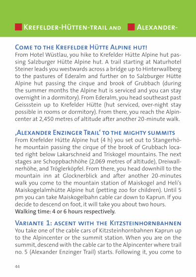
Krefelder-Hütten-trail and Alexander-
Come to the Krefelder Hütte Alpine hut!From Hotel Wüstlau, you hike to Krefelder Hütte Alpine hut pas-sing Salzburger Hütte Alpine hut. A trail starting at Naturhotel Steiner leads you westwards across a bridge up to Hinterwallberg to the pastures of Ederalm and further on to Salzburger Hütte Alpine hut passing the cirque and brook of Grubbach (during the summer months the Alpine hut is serviced and you can stay overnight in a dormitory). From Ederalm, you head southeast past Geissstein up to Krefelder Hütte (hut serviced, over-night stay possible in rooms or dormitory). From there, you reach the Alpin-center at 2,450 metres of altitude after another 20-minute walk.
‚Alexander Enzinger Trail‘ to the mighty summitsFrom Krefelder Hütte Alpine hut (4 h) you set out to Stangerhö-he mountain passing the cirque of the brook of Grubbach loca-ted right below Lakarschneid and Triskogel mountains. The next stages are Schoppbachhöhe (2,069 metres of altitude), Dreiwall-nerhöhe, and Tröglerköpfel. From there, you head downhill to the mountain inn at Glocknerblick and after another 20-minutes walk you come to the mountain station of Maiskogel and Heli’s Maiskogelalmhütte Alpine hut (petting zoo for children). Until 5 pm you can take Maiskogelbahn cable car down to Kaprun. If you decide to descend on foot, it will take you about two hours. Walking time: 4 or 6 hours respectively.
Variante 1: ascent with the Kitzsteinhornbahnen You take one of the cable cars of Kitzsteinhornbahnen Kaprun up to the Alpincenter or the summit station. When you are on the summit, descend with the cable car to the Alpincenter where trail no. 5 (Alexander Enzinger Trail) starts. Following it, you come to

45
Enzinger-trail No. 711, 5 + 4,5 h 1423 650 m
the cable car station of Maiskogelbahn which takes you to the valley until 5 pm. If you decide to descend on foot, it will take you about two hours. Walking time: 4 or 6 hours respectively. Tip: Every Thursday (July-August) Gletscherbahn offers this tour as a one-day guided tour free of charge. Meeting point: 09:30 Uhr Kitzsteinhorn valley station. From the Alpincenter (2,450 m) furt-ther tours for the entire family. www.kitzsteinhorn.at
Variant 2: everything in one dayStarting point is Hotel Wüstlau. Then you set out up the mountain to Krefelder Hütte Alpine hut (trail No. 711) and continue on Ale-xander Enzinger Trail (trail no. 5) until you reach the Alpine hut on Maiskogel. The tour starts at 7 am. Walking time: 9 h if you take the cable car of Maiskogelbahn down to the valley until 5 pm.
Variant 3: two days with an overnight stayYou stay overnight at Krefelder Hütte or Salzburger Hütte (star-ting point Hotel Wüstlau, climbing the mountain on trail no. 711). Taking lunch and accommodation in one of the rooms or the dormitory (walking time approx. 4.5 h). Hike to the Alpincenter at 2,450 metres of altitude. There you board the cable car to the summit at 3,029 metres of altitude (www.kitzsteinhorn.at). After the descent you return to the hut where you stay overnight. Af-ter a rich breakfast at sunrise you set out towards the valley on Alexander Enzinger Trail (trail no. 5) to Maiskogelbahn mountain station. Walking time first day: 5 h. Walking time second day: 4 h (descent with the Maiskogelbahn until 5 pm) or 6 h (walk down). Another idea for a tour: from the Alpincenter you can take an Alpi-ne trail following the wind gap Kammerscharte to the mountain reservoirs of Mooserboden and Limbergsperre dam.
10

46
Information: Tour classification:Fitness: ****** Suitable for families: noTechnique: ***** Demanding: noExperience value: ****** Public Transport: yesCharacter: Mountain tour (red)Metres 1,423 m to Krefelder Hütte, an other 150 m to theof altitude: Alpincenter; 650 m to Maiskogel Alpine hut (Maisko- gel mountain station) another 870 m to Kaprun centreStarting point: Naturhotel Steiner (bus stop: Hotel Wüstlau)Transport: Taxi or car since Hotel Steiner is not end pointEnd point: Maiskogelbahn valley station (with the cable car to the valley) or town centre of Kaprun if you prefer to walkRefreshments: Salzburger Hütte, Krefelder Hütte, Alpincenter, Glocknerblick, Heli’s Maiskogelalmhütte Alpine HutParking: Next to Naturhotel Steiner, Lake KlammseeBus transfer: Shuttle service betw. Zell am See a. Kaprun half-hourly.
Krefelder-Hütten- a. Alexander-Enzinger-Trail
Detail of the map variant 1
!
!
!
! !
!
!
!
!
!
!
!
!
!
!
!!
!!
!
e )
e )
e )
e )
e )
e )
e )
e
e )
e )
e )
e )
e )
e )
e )
e )
e )
e )
e )
e )
e )
e )
e )
e)
e)
e)
e)
e)
e)
e)
e)
e)
e)
e)
e)
e)
e)
e)
e)
e)
e)
e)
e) e) e) e) e) e) e) e) e) e) e) e)
Start
Kaprun
Gassen
Schröck
Grünalm
Mühlbach
Riedlalm
UnterholzMooslehen
Rainwiese
Geißstein
Saladeralm
AhornbodenHohe Arche
Tristkogel
Grünalmkar
Schattberg
Rettenzink
Katzenkopf
Dietersbach
Mühlbachtal
BambachkopfEder Hochalm
Eder Grundalm
Kapruner Ache
SchranbachalmGrießbachKöpfl
Krapfbrachkopf
Salzburger Hütte
Erlach Mitteralm
LarmFkogelscharte
Seppinger Grundalm
Sigm.-Thun-Klamm
Kesselfall Alpenhaus
Gletscherbahnen Kaprun
GlocknerblickHeli´s Maiskogelalmhütte
StangerbauerWeißsteinalm
Unteraigen
0 660 1.320 1.980 2.640330Meter
¯
Alpincenter

47
Detail of the map variant 2
!
!
! !
!
e )
e )
e )
e )
e )
e )
e )
e )
e )
e )
e )
e )
e )
e )
e )
e)
e)
e)
e)
e)
e)
e)
e)
e)
e)
e)
e)
e)
e)
e)
e) e) e) e) e) e) e) e) e) e) e) e)
Start
Gassen
Grünalm
Lakaralm
Wirtsalm
Rettinger
Maiskogel
KrapfgrundTristkogel
Grünalmkar
Dietersbach
StangenhöheBambachkopf
Salbachkopf
Unterbergalm
Steinkarlalm
Eder Hochalm
Lakarschneid
Mittagskogel
Eder Grundalm
Kapruner Ache
Hohes Kampeck
Schoppachhöhe
Zeferetgraben
Steinerbaueralm
Erlach Grundalm
Krefelder Hütte
Salzburger Hütte
Erlach Mitteralm
Steinkarlscharte
Sigm.-Thun-Klamm
Kesselfall Alpenhaus
Gasthof Glocknerblick
Mittelstation-Breitriesenalm
Heli´s Maiskogelalmhütte
0 470 940 1.410 1.880235Meter
¯
Alpincenter
!
!
!
! !
!
!
!
!
!
!
!
!
!
!
!!
!!
!
e )
e )
e )
e )
e )
e )
e )
e
e )
e )
e )
e )
e )
e )
e )
e )
e )
e )
e )
e )
e )
e )
e )
e)
e)
e)
e)
e)
e)
e)
e)
e)
e)
e)
e)
e)
e)
e)
e)
e)
e)
e)
e) e) e) e) e) e) e) e) e) e) e) e)
Kaprun
GassenGrünalm
Roßkopf
Lakaralm
Mühlbach
Wirtsalm Riedlalm
Brandlsee
Rainwiese
Rettinger
Geißstein
Saladeralm
Schranbach
Ahornboden
Schattberg
Dietersbach
Mühlbachtal
Bambachkopf
Salbachkopf
Unterbergalm
Eder Hochalm
Winklergrund
Lakarschneid
Mittagskogel
Eder Grundalm
Hackl Grundalm
GrießbachKöpflKrapfbrachkopf
Steinerbaueralm
MesserfeldKöpfl
Salzburger Hütte
LarmFkogelscharte
Seppinger Grundalm
Kaprun-Werksiedlung
Sigm.-Thun-Klamm
Kesselfall Alpenhaus
Krapfhütte (Jagdhütte)
Gletscherbahnen Kaprun
Start
Glocknerblick
Heli´s Maiskogelalmhütte
Stangerbauer
Weißsteinalm
Unteraigen
Alpincenter
0 660 1.320 1.980 2.640330Meter
¯Detail of the map variant 3
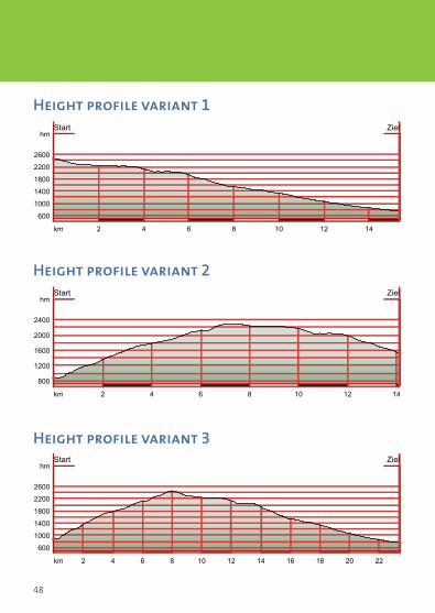
48
Height profile variant 3
2 4 6 8 10 12 14km
600
1000
1400
1800
2200
2600
hmStart Ziel
Height profile variant 2
2 4 6 8 10 12 14 16 18 20 22km
600
1000
1400
1800
2200
2600
hmStart Ziel
Height profile variant 1
2 4 6 8 10 12 14km
800
1200
1600
2000
2400
hmStart Ziel

49
The Krefelder Hütte The traditional over 100-year old Krefelder Hütte is pictures-quely located beneath the peak of the famous mountain “Kitz-steinhorn”, a short distance between the alpine centre and Lang-wiedboden. The cottage is also accessible for ramblers taking the Alexander-Enzinger-Weg or Krefelder-Hütten-Weg. In summer months the lodge is a great spot to start hill walks and moun-tain tours of all different degrees of difficulties. Families, groups and even novices love taking the Krefelder Hütte as a beautiful stop-off for their excursions. During winter month our cozy lodge, situated right on the slopes, provides the ideal accommodation for all winter activities!Come and enjoy our whole variety of delicious homemade Austri-an dishes and snacks. Relax in the snug hospitality of your hosts, the Strolz’ family. We would be delighted to serve you Austrian homely food at any time of the day and offer accommodation at reasonable pricing.
Krefelder Hütte • Fam. Christian Strolz Kitzsteinhorn 30 • A-5710 Kaprun • Tel: +43 (0) 6547-7780Open: July and August and November until May [email protected] • www.krefelderhuette.com

50
Wanderweg / hiking trailWeitwanderweg / hiking trailRadweg / bike trailE-Bike Verleih- & AkkustationE-bike hire & battery station
^^
^
^^^
^ ^
Schmittentunnel
Schmittentunnel
Glocknerrunde
Alexander-Enzinger-Weg
Arnoweg
Arnoweg
Glocknerrunde
NEW Maisiflitzer - A
lpin Coaster
Kitzsteinhorn3203 m
Großglockner3798 m
Großvenediger3674 m
Zell am See
Kaprun
Schüttdorf
Maiskogel1675 m
Hirschkogel1720 m
Breiteck1900 m
Sonnkogel1850 m
Schmittenhöhe2000 m
StauseeMooserboden
2040 m
Imbachhorn2470 m
Piffscharte1775 m
StauseeWasserfallboden
BurgKaprun
KAPRUNERTAL
Flugplatz
Erlhofplatte
SchlossFischhorn
Tauern-Radwanderweg
Reithalle
Strandbad
Kammer-scharte
KlettergebietGletscherseeplatten
KlettergebietRettenwand
Lakarscharte 2488 mRichtung Niedernsill
Drei-Wallner-Höhe1859 m
Klamm-SeeSigmund-Thun-
KlammPiesendorf
Strandbad Seepromenade
Zeller Schifffahrt Überfahrtund Rundfahrt
Bellevue
Ronachkopf1326 m
Hundstein2117 m
Höhen-wanderweg
Strandbad
Wasserskischule Freibad Maishofen
THUMERSBACHTAL
HöhenwanderwegSchwalbenwand
2011 m
Strandbad
Schloss Prielau
Strandbad
HallenbadEishalle
Seepromenade
Panoramaweg
Schmittental
Sonnenalm1400 m
Salersbachköpfl1984 m
Maurerkogel2074 m
Areit1400 m
Honigkogel1857 m
YachtclubSegelschule
Gr. Wiesbachhorn3564 m
Hoher Tenn3368 m
Bahnhof
Mittelstation1411 m
Salzach
Brandlscharte2371 m
Kajakcenter
Beachvolleyball
Windsurfcenter
BeachvolleyballEsplanade
Seespitz
Sonnhof
Kurpark
Seecamp
Hohe Kammer2636 m
Gr. Schmiedinger2926 m
Schmiedinger ScharteRichtung Stubachtal
Maurerkogel2995 m
Gletschersee
Bundessport- undFreizeitzentrum
Rosskopf2302 m
Geißstein2230 m
Tennishalle
Congress-Center
Reitweg
GutEdelweiß
Maishofen
Autobahn München/Salzburg/Wien,
Lofer/Unken
Großglockner-Hochalpenstraße
Bruck
Langwied 1976 m
Lärchwand-Schrägaufzug
Lärchwand-Schrägaufzug
Waldheim
Talschluss
Thumersbach
WC
Tauern SPA
Golfplatz36 Loch
Areitbahn I
Schm
itten
höhe
bahn
Sonnenalmbahn
Sonnkogelbahn
city
Xpre
ss
Lang
wie
dbah
n
Gle
tsch
erje
t 2G
ipfe
lbah
n
Gletscherj
et 1
etscherj
et 1
Panoramabahn
Maiskogelb
ahn
Köhlergraben
Breiteckalm
Der Sonnberg
Kitz900m
H
HH
H
H
HH
H
H
H
50
33
33
5a
23
5
35
69
50
50
50
57
51A
52
54
53
55
56
50
61
6358a
64
65
66
64
61
67 69
68
1
56a
55
51
51
719
711
719
719
711
711
724
723
726 726
25
41b
41a
41b 41c41bSisi-
Rundweg
Kinder-spielplatz
PinzgauerSpaziergangALPINCENTER, 2452 m:
InfoService, Internet@free
1984 m 67
ErlebniswegHöhenpromenade
Disc GolfParcours
SchmidolinsFeuertaufe
Maisiflitzer - A
lpin CoasterSigmund-Thun-Sigmund-Thun-KlammKlamm
711711
GleiwitzerHütte
Heinrich SchwaigerHaus
BergrestaurantMooserboden
3
Jausenstation Unteraigen
20
JausenstationPfefferbauer
35
KesselfallAlpenhaus
5
JausenstationGuggenbichl
6
Klammsee-stüberl
7
JausenstationStangerbauer
19
BergrestaurantGletschermühle
9
Krefelderhütte 10
1
2
Ebmatten-Fürthermoaralm
4
Almwirtschaft Schneckenreith
14
Ederalm13
Salzburger Hütte
12
Häuslalm11 Maiskogelalm "Heli’s Hütte"16
Unterbergalm17
Saulochalm18
Alpengasthaus Glocknerblick
15
Schober Alm 21
Areitalm22
GasthofMittelstation
24
Ebenbergalm 25
BerggasthausHasling
36
Statzerhaus38
Enzianhütte37
BerghotelJagaalm
34
Sonnkogel Bergrestaurant
31
Schmiedhofalm 32
Kettingalm 30
Pinzgauer Hütte
29
Hochsonnbergalm 27
Schmitten Café26
Hochzeller Alm28
Mitterberghof39
GipfelRestaurant
8
GLETSCHERPLATEAU, 2900 m:Höhenloipe, Gletscher-Shuttle, Glacier Park,Magnetköpfllifte, Gletscher Trail
Ice Arena
Glocknerhaus 23
BerghotelBlaickner’s Sonnalm 33
GIPFELWELT 3000, 3029 m:Nationalpark Gallery, Cinema 3000Panorama-Plattform „Top of Salzburg“
NEW
Schützingalm40

51
Wanderweg / hiking trailWeitwanderweg / hiking trailRadweg / bike trailE-Bike Verleih- & AkkustationE-bike hire & battery station
^^
^
^^^
^ ^
Schmittentunnel
Schmittentunnel
Glocknerrunde
Alexander-Enzinger-Weg
Arnoweg
Arnoweg
Glocknerrunde
NEW Maisiflitzer - A
lpin Coaster
Kitzsteinhorn3203 m
Großglockner3798 m
Großvenediger3674 m
Zell am See
Kaprun
Schüttdorf
Maiskogel1675 m
Hirschkogel1720 m
Breiteck1900 m
Sonnkogel1850 m
Schmittenhöhe2000 m
StauseeMooserboden
2040 m
Imbachhorn2470 m
Piffscharte1775 m
StauseeWasserfallboden
BurgKaprun
KAPRUNERTAL
Flugplatz
Erlhofplatte
SchlossFischhorn
Tauern-Radwanderweg
Reithalle
Strandbad
Kammer-scharte
KlettergebietGletscherseeplatten
KlettergebietRettenwand
Lakarscharte 2488 mRichtung Niedernsill
Drei-Wallner-Höhe1859 m
Klamm-SeeSigmund-Thun-
KlammPiesendorf
Strandbad Seepromenade
Zeller Schifffahrt Überfahrtund Rundfahrt
Bellevue
Ronachkopf1326 m
Hundstein2117 m
Höhen-wanderweg
Strandbad
Wasserskischule Freibad Maishofen
THUMERSBACHTAL
HöhenwanderwegSchwalbenwand
2011 m
Strandbad
Schloss Prielau
Strandbad
HallenbadEishalle
Seepromenade
Panoramaweg
Schmittental
Sonnenalm1400 m
Salersbachköpfl1984 m
Maurerkogel2074 m
Areit1400 m
Honigkogel1857 m
YachtclubSegelschule
Gr. Wiesbachhorn3564 m
Hoher Tenn3368 m
Bahnhof
Mittelstation1411 m
Salzach
Brandlscharte2371 m
Kajakcenter
Beachvolleyball
Windsurfcenter
BeachvolleyballEsplanade
Seespitz
Sonnhof
Kurpark
Seecamp
Hohe Kammer2636 m
Gr. Schmiedinger2926 m
Schmiedinger ScharteRichtung Stubachtal
Maurerkogel2995 m
Gletschersee
Bundessport- undFreizeitzentrum
Rosskopf2302 m
Geißstein2230 m
Tennishalle
Congress-Center
Reitweg
GutEdelweiß
Maishofen
Autobahn München/Salzburg/Wien,
Lofer/Unken
Großglockner-Hochalpenstraße
Bruck
Langwied 1976 m
Lärchwand-Schrägaufzug
Lärchwand-Schrägaufzug
Waldheim
Talschluss
Thumersbach
WC
Tauern SPA
Golfplatz36 Loch
Areitbahn I
Schm
itten
höhe
bahn
Sonnenalmbahn
Sonnkogelbahn
city
Xpre
ss
Lang
wie
dbah
n
Gle
tsch
erje
t 2G
ipfe
lbah
n
Gletscherj
et 1
etscherj
et 1
Panoramabahn
Maiskogelb
ahn
Köhlergraben
Breiteckalm
Der Sonnberg
Kitz900m
H
HH
H
H
HH
H
H
H
50
33
33
5a
23
5
35
69
50
50
50
57
51A
52
54
53
55
56
50
61
6358a
64
65
66
64
61
67 69
68
1
56a
55
51
51
719
711
719
719
711
711
724
723
726 726
25
41b
41a
41b 41c41bSisi-
Rundweg
Kinder-spielplatz
PinzgauerSpaziergangALPINCENTER, 2452 m:
InfoService, Internet@free
1984 m 67
ErlebniswegHöhenpromenade
Disc GolfParcours
SchmidolinsFeuertaufe
Maisiflitzer - A
lpin CoasterSigmund-Thun-Sigmund-Thun-KlammKlamm
711711
GleiwitzerHütte
Heinrich SchwaigerHaus
BergrestaurantMooserboden
3
Jausenstation Unteraigen
20
JausenstationPfefferbauer
35
KesselfallAlpenhaus
5
JausenstationGuggenbichl
6
Klammsee-stüberl
7
JausenstationStangerbauer
19
BergrestaurantGletschermühle
9
Krefelderhütte 10
1
2
Ebmatten-Fürthermoaralm
4
Almwirtschaft Schneckenreith
14
Ederalm13
Salzburger Hütte
12
Häuslalm11 Maiskogelalm "Heli’s Hütte"16
Unterbergalm17
Saulochalm18
Alpengasthaus Glocknerblick
15
Schober Alm 21
Areitalm22
GasthofMittelstation
24
Ebenbergalm 25
BerggasthausHasling
36
Statzerhaus38
Enzianhütte37
BerghotelJagaalm
34
Sonnkogel Bergrestaurant
31
Schmiedhofalm 32
Kettingalm 30
Pinzgauer Hütte
29
Hochsonnbergalm 27
Schmitten Café26
Hochzeller Alm28
Mitterberghof39
GipfelRestaurant
8
GLETSCHERPLATEAU, 2900 m:Höhenloipe, Gletscher-Shuttle, Glacier Park,Magnetköpfllifte, Gletscher Trail
Ice Arena
Glocknerhaus 23
BerghotelBlaickner’s Sonnalm 33
GIPFELWELT 3000, 3029 m:Nationalpark Gallery, Cinema 3000Panorama-Plattform „Top of Salzburg“
NEW
Schützingalm40

52
All mountain huts at a glance
Open from June 5th to October 2nd 2011phone +43 (0)664 929 49 89over-night stay possible
1
4
Gleiwitzerhütte 2,176 m
2
Due to construction works closed in summer 2011.
Heinrich Schwaiger Haus 2,802 m
Ebmatten-Fürthermoaralm 1,793 m
Open fromBeginning of June till Mid-Sept. 2011phone +43 (0)6547 7158 23435or 06549 7208over-night stay possible
3
Open from May 27th to Sept. 18th 2011, dailyphone +43 (0)6547 8458
Bergrestaurant Mooserboden 2,040 m

53
Open from the beginning of June till the beginning of Octoberdaily, over-night stay possiblephone +43 (0)664 925 28 28
5 Kesselfall Alpenhaus 1,034 m
6
Open from Beginning of July till end of September, closed on Mondaysphone +43 (0)6547 8578over-night stay possible
Jausenstation & Pension Guggenbichl 865 m
7
Open fromMay 7th to September 25th 2011TäglichTel. +43 (0)5 0313 23201
Klammseestüberl 850 m
8
Open from May 9th to Juli 2nd 2011 daily from 9.00 am – 4.15 pmphone +43 (0)6547 8621
Gipfel Restaurant 3,029 m

54
All mountain huts at a glance
Open fromBeginning of July till the end of Aug.phone +43 (0)6547 7780over-night stay possible
Krefelderhütte 2,295 m10
Open from Beginning of July till Mid-Sept.phone +43 (0)6547 7024
Häuslalm 1,976 m11
Open from Mid-June till the end of Septemberphone +43 (0)664 373 45 87 or 06549 7349over-night stay possible
Salzburger Hütte 1,860 m12
9 Bergrestaurant Gletschermühle 2,452 m
Open fromMai 1st to Juni 14th 2011 daily from 9.00 am – 4.15 pmphone +43 (0)6547 8621

55
Open from Mid-May – beginning of Oct., daily, phone +43 (0)664 2524469or +43 (0)664 5126999 over-night stay possible
14 Almwirtschaft Schneckenreith 920 m
15
Open fromBeginning of June till the end ofSept., phone +43 (0)664 820 60 00
Alpengasthaus Glocknerblick 1,670 m
16
Open fromBeginning of May till the end of Oct.phone +43 (0)676 527 57 40
Maiskogelalm „Heli’s Hütte“ 1,540 m
Ederalm 1,420 m
Open fromMid-June till the beginning of Sept. phone +43 (0)664 391 85 77 or +43 (0)664 391 87 27
13

56
All mountain huts at a glance
Open from Mid/End of May till Mid-October Closed on Mondays!phone +43 (0)664 226 13 12
Saulochalm 1,558 m18
Open from July 1st till Mid-Sept., daily, else on request!phone +43 (0)6547 8804over-night stay possible
Jausenstation Stangerbauer 1,100 m
19
Open from daily till ca. Mid-Septemberphone +43 (0)6547 7277over-night stay possible
Jausenstation Unteraigen ca. 860 m
20
17 Unterbergalm 1,570 mOpen from Mid/End of June till the end of Septemberphone +43 (0)6549 7376or +43 (0)664 442 76 66

57
Jausenstation Stangerbauer 1,100 m
Open from June 11th to September 18th 2011Closed on Tuesdaysphone +43 (0)6542 57177
22 Areitalm 1,400 m
24
Open from Mid-June till Mid-September onrequest, phone +43 (0)6542 72356
GasthofMittelstation 1,411 m
Schober Alm 1,100 m
Open year round daily from 11.00 pm phone +43 (0)6542 55777
21
Closed in summer 2011.
23 Glocknerhaus ca. 1,600 m

58
All mountain huts at a glance
Open fromBeginning of June till the end of Sept. phone +43 (0)664 545 55 68or 0664 281 90 53
Hochsonnbergalm 1,841 m
27
Open fromMid-May till Mid-Octoberfrom 9.00 am – 5.00 pmphone +43 (0)664 281 08 74
Hochzeller Alm 1,960 m28
26 Schmitten Café 1,965 m
Open fromMai 14th to Odtober 16th 2011dailyphone +43 (0)6542 789-120
25
Open year roundphone +43 (0)664 351 23 07
Ebenbergalm 996 m

59
Hochzeller Alm 1,960 m
Open fromJuni 11th to September 18th 2011New: playground near the restau-rant, phone +43 (0)6542 789-120
31 Sonnkogel Bergrestaurant 1,850 m
32
Open fromMid-June till the end of OctoberClosed on Tuesdays and Wednesdaysphone +43 (0)664 182 62 90
Schmiedhofalm 1,730 m
Kettingalm 1,800 m
Closed in summer 2011.
30
Open fromJune 1st to October 16th 2011phone +43 (0)6549 7861over-night stay possible
Pinzgauer Hütte 1,704 m29

60
All mountain huts at a glance
Open from April till June and from Mid-Oct. till Dez. on weekendsJuly till Mid-Oct. closed on Mondaysphone +43 (0)664 512 69 90over-night stay possible
Jausenstation Pfefferbauer 900 m
35
Open from Easter till OctoberClosed on Wednesdaysphone +43 (0)6542 56617
Berggasthaus Hasling ca. 870 m
36
34 Berghotel Jagaalm 1,120 m
Open fromMay 28th to October 16th 2011daily from 11.00 am – 8.00 pmphone +43 (0)6542 72969 over-night stay possible
33
Open from Mid-June till Mid-Sep-tember, daily from 9.00 am – 5.00 pmphone +43 (0)6542 73262over-night stay possible
Berghotel Blaickner’s Sonnalm 1,400 m

61
Berggasthaus Hasling ca. 870 m
Open daily till the end of Oktoberphone +43 (0)6542 72493 over-night stay possible
39 BerggasthofMitterberg 1,200 m
40
Closed in summer 2011.
Schützingalm 1,250 m
Statzerhaus 2,117 m
Open fromEnd of May till the end of Octoberphone +43 (0)6542 74438 or +43 (0)664 144 59 52over-night stay possible
38
Open fromBeginning of May till the end of Octoberphone +43 (0)664 321 24 50
Enzianhütte 1,300 m37

62
Stamps for the hiking needle, which you can get in the Zell am See or Kaprun Information!
Hiking needle gold Hiking needle silver Hiking needle bronze40 points 30 points 20 points
Key: The level of difficulty of the trail determines the number of points:Blue stamp Red stamp Black stamp1 point 3 points 5 points
No. 14Almwirtschaft
Schnecken-reith
No. 4Ebmatten-
Fürther- moaralm
No. 35Jausenstation Pfefferbauer
No. 6Guggenbichl
No. 15GasthausGlockner-
blick
No. 39Berggasthof Mitterberg
No. 33Berghotel Blaickner’s Sonnalm
No. 3BergrestaurantMooserboden
No. 10Krefelder
Hütte

63
Stamps for the hiking needle, which you can get in the Zell am See or Kaprun Information!
Imprint: Editor: Zell am See-Kaprun Tourism GmbH, www.zellamsee-kaprun.com, concept and graphics: Christian Nindl Grafik Design GmbH, 2011, www.nindlgrafik.at, photos: Gletscherbahnen Kaprun AG, Schmittenhöhebahnen AG, Zell am See-Kaprun Archiv, listed guesthouses and moun-tain huts, www.alpenverein-muenchen-oberland.de
No. 25Ebenberg-
alm
No. 32Schmied-
hofalm
No. 22Areit Alm
No. 29Pinzgauer
Hütte
No. 27Hochsonn-
bergalm
No. 20Jausenstation
Unteraigen
No. 12Salzburger
Hütte
No. 38Statzerhaus
No. 16Maiskogel-alm Heli’s
Hütte

Num
ber o
f poi
nts
Hik
ing
need
le
Y
es, I
wan
t fre
e in
form
atio
n ab
out
the
area
of Z
ell a
m S
ee-K
apru
n.
Nam
e
Addr
ess
Phon
e:
E-M
ail
gold
silv
er
bron
ze
Det
ach
coup
on h
ere