WA-II-130 Marsh Mills (Haley's Mill, Spielman Mill)
80
WA-II-130 Marsh Mills (Haley's Mill, Spielman Mill) Architectural Survey File This is the architectural survey file for this MIHP record. The survey file is organized reverse- chronological (that is, with the latest material on top). It contains all MIHP inventory forms, National Register nomination forms, determinations of eligibility (DOE) forms, and accompanying documentation such as photographs and maps. Users should be aware that additional undigitized material about this property may be found in on-site architectural reports, copies of HABS/HAER or other documentation, drawings, and the “vertical files” at the MHT Library in Crownsville. The vertical files may include newspaper clippings, field notes, draft versions of forms and architectural reports, photographs, maps, and drawings. Researchers who need a thorough understanding of this property should plan to visit the MHT Library as part of their research project; look at the MHT web site (mht.maryland.gov) for details about how to make an appointment. All material is property of the Maryland Historical Trust. Last Updated: 05-15-2018
Transcript of WA-II-130 Marsh Mills (Haley's Mill, Spielman Mill)
WA-II-130
Marsh Mills (Haley's Mill, Spielman Mill)
Architectural Survey File
This is the architectural survey file for this MIHP record. The survey file is organized reverse-
chronological (that is, with the latest material on top). It contains all MIHP inventory forms, National
Register nomination forms, determinations of eligibility (DOE) forms, and accompanying documentation
such as photographs and maps.
Users should be aware that additional undigitized material about this property may be found in on-site
architectural reports, copies of HABS/HAER or other documentation, drawings, and the “vertical files” at
the MHT Library in Crownsville. The vertical files may include newspaper clippings, field notes, draft
versions of forms and architectural reports, photographs, maps, and drawings. Researchers who need a
thorough understanding of this property should plan to visit the MHT Library as part of their research
project; look at the MHT web site (mht.maryland.gov) for details about how to make an appointment.
All material is property of the Maryland Historical Trust.
Last Updated: 05-15-2018
NPS Fonn 10-900 (Rev. 10-90)
United States Department of the Interior ~ional Park Service
NATIONAL REGISTER OF HISTORIC PLACES REGISTRATION FORM
a.18 No. 1024-0018
WA-Il-130
This fonn is for use in nominating or requesting detenninations for individual properties and districts. Sae instructions in How to Complete the National Register of Historic Places Registration Fonn (National Register Bulletin 16A). Canplete each item by marking "x" in the appropriate box or by entering the information requested. If any item does not apply to the property being documented, enter "N/A" for "not applicable." For functions, architectural classification, materials, and areas of significance, enter only categories and subcategories from the instructions. Place additional entries and narrative items on continuation sheets (NPS Fonn 10-900a). Use a typewriter, word processor, or conputer, to complete all items.
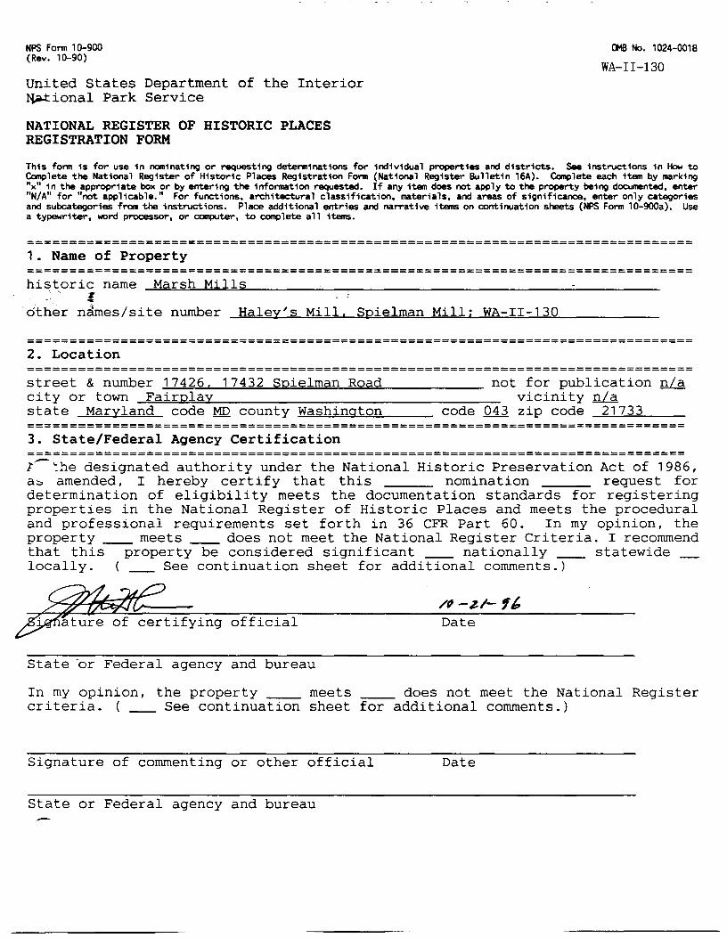
=============================================================================== 1. Name of Property =============================================================================== historic name Marsh Mills
~ ~~'"-=----~~;..-o..~~~~~~........,.~~~~~~~~~~~~~~~~~~~~~ -·other n.irnes/site number Haley's Mill, Spielman Mill; WA-II-130
=============================================================================== 2. Location =============================================================================== street & number 17426. 17432 Spielman Road not for publication n/a city or town -=F~a=i=·r~p=-=l=a~Y~~~~~~~~~~~~~~~~~~~- vicinity n/a state Maryland code MD county Washington code 043 zip code 21733 ============================================================================== 3. State/Federal Agency Certification ============================================================================== 1...-.:he designated authority under the National Historic Preservation Act of 1986, a:::, amended, I hereby certify that this nomination request for determination of eligibility meets the documentation standards for registering properties in the National Register of Historic Places and meets the procedural and professional requirements set forth in 36 CFR Part 60. In my opinion, the property~~ meets ~~does not meet the National Register Criteria. I recommend that this property be considered significant ~- nationally ~- statewide locally. ( ~-See continuation sheet for additional comments.)
/P-ZI- fb Date
State ·or Federal agency and bureau
In my opinion, the property meets does not meet the National Register criteria. ( ~-See continuation sheet for additional comments.)
Signature of commenting or other official Date
State or Federal agency and bureau
USDI/NPS NRHP Registration Form Marsh Mills Washington County, MD Page 2
---============================================================================ National Park Service Certification
============================================================================== I, hereby certify that this property is:
entered in the National Register ~- See continuation sheet.
determined eligible for the National Register
See continuation sheet. determined not eligible for the National Register
removed from the National Register
other (explain) :
Signature of Keeper Date of Action
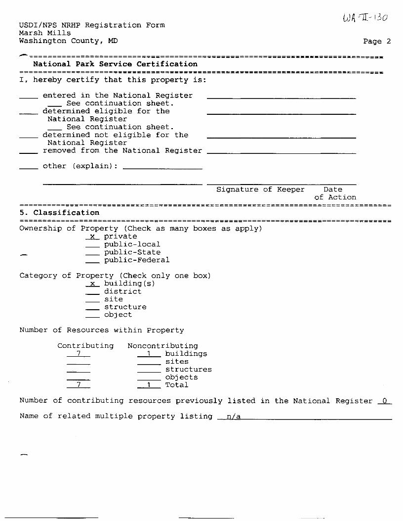
================================================================================ 5. Classification ================================================================================ Ownership of Property (Check as many boxes as apply)
--2L private public-local
~- public-State ~- public-Federal
Category of Property (Check only one box) --2L. building(s)
district site structure object
Number of Resources within Property
Contributing 7
7
Noncontributing 1 buildings
1
sites structures objects Total
Number of contributing resources previously listed in the National Register ~0-
Name of related multiple property listing ~~n~a~~~~~~~~~~~~~~~~~-
USDI/NPS NRHP Registration Form Marsh Mills Washington County, MD Page 3
~==============================================================================
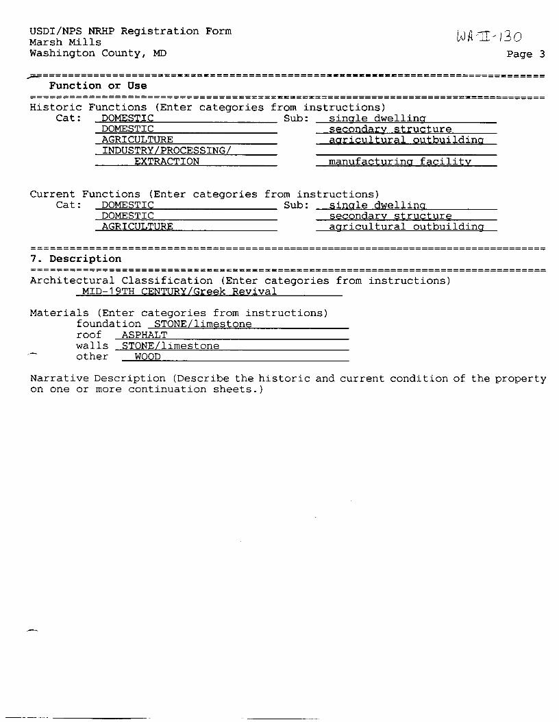
Function or Use ================================================================================= Historic
Cat: Functions (Enter categories
DOMESTIC DOMESTIC AGRICULTURE INDUSTRY/PROCESSING/
EXTRACTION
Current Functions (Enter categories Cat: DOMESTIC
DOMESTIC AGRICULTURE
from instructions) Sub: single dwelling
secondary structure agricultural outbuilding
manufacturing facility
from instructions) Sub: single dwelling
secondary structure agricultural outbuilding
================================================================================= 7. Description ================================================================================= Architectural Classification (Enter categories from instructions)
MID-19TH CENTURY/Greek Revival
Materials (Enter categories from instructions) foundation STONE/limestone roof ASPHALT walls STONE/limestone other ~~W~O~O~D::;_~~~~~~~~~~~~~~~
Narrative Description (Describe the historic and current condition of the property on one or more continuation sheets.)
USDI/NPS NRHP Registration Form Marsh Mills Washington County, MD
t;JA--11 - I 3 o Page 4
.---~============================================================================== Statement of Significance
================================================================================= Applicable National Register Criteria (Mark "x" in one or more boxes for the criteria qualifying the property for National Register listing)
~x~ A Property is associated with events that have made a significant contribution to the broad patterns of our history.
B Property is associated with the lives of persons significant in our past.
~x~ C Property embodies the distinctive characteristics of a type, period, or method of construction or represents the work of a master, or possesses high artistic values, or represents a significant and distinguishable entity whose components lack individual distinction.
D Property has yielded, or is likely to yield information important in prehistory or history.
Criteria Considerations (Mark "X" in all the boxes that apply.)
A owned by a religious institution or used for religious purposes.
B removed from its original location.
C a birthplace or a grave.
D a cemetery.
E a reconstructed building, object, or structure.
F a commemorative property.
G less than 50 years of age or achieved significance witpin the past 50 years.
Areas of Significance (Enter categories from instructions) ARCHITECTURE INDUSTRY
Period of Significance ca. 1850-ca. 1920
Significant Dates ca. 1850
Significant Person (Complete if Criterion B is marked above) n a
Cultural Affiliation n a
~chitect/Builder unknown
Narrative Statement of Significance (Explain the significance of the property on one or more continuation sheets.)
USDI/NPS NRHP Registration Form Marsh Mills
WA~Jt-/jo
Washington County, MD Page 5
~==============================================================================
Major Bibliographical References ================================================================================= (Cite the books, articles, and other sources used in preparing this form on one or more continuation sheets.)
Previous documentation on file (NPS) preliminary determination of individual listing (36 CFR 67) has been
requested. previously listed in the National Register previously determined eligible by the National Register designated a National Historic Landmark recorded by Historic American Buildings Survey # recorded by Historic American Engineering Record #
Primary Location of Additional Data State Historic Preservation Office Other State agency Federal agency Local government University Other
Name of repository:
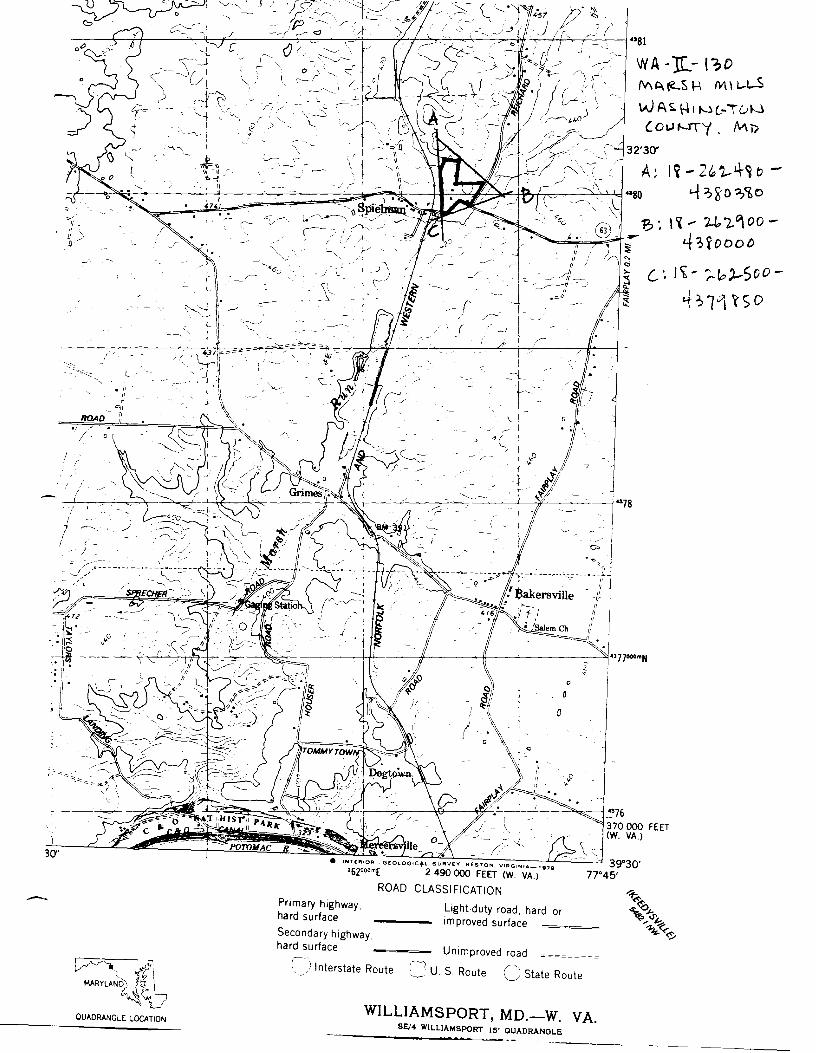
================================================================================= J_Q. Geographical Data
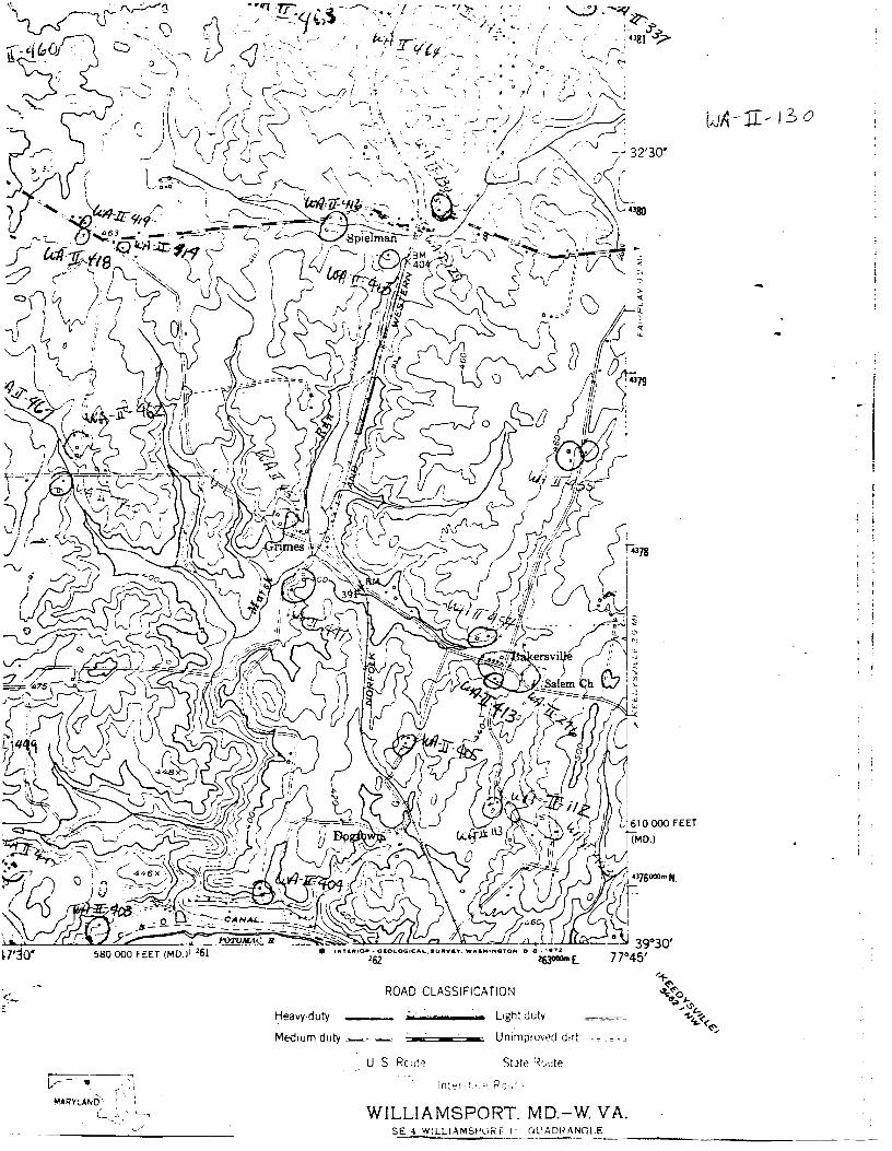
=============================================================================== n~reage of Property approximately 12 acres USGS quadrangle Williamsport. MD-WV UTM References (Place additional UTM references on a continuation sheet)
Zone Easting Northing Zone Easting Northing A .1Ji 262480 4380380 C .1Ji 262500 4379850 B .1Ji 262900 4380000 D
See continuation sheet.
Verbal Boundary Description (Describe the boundaries of the property on a continuation sheet.)
Boundary Justification (Explain why the boundaries were selected on a continuation sheet.)
11. Form Prepared By =============================================================================== name/title Paula S. Reed Ph.D
organization Paula S. Reed & Associates
street & number 105 N. Potomac St.
city or town ---"-'H=a~a~e=r~s=-=t=o~w=n'--~~~~~~~~~~~ -
date August 9. 1995
telephone (301) 739-2070
state MD zip code -=2~1~7~4~0~~~-
USDI/NPS NRHP Registration Form Marsh Mills Washington County, MD
WA -Jl~ t3o Page 6
~============================================================================
• _Jitional Documentation =============================================================================== Submit the following items with the completed form:
Continuation Sheets
Maps A USGS map (7.5 or 15 minute series) indicating the property's location. A sketch map for historic districts and properties having large acreage or numerous resources.
Photographs Representative black and white photographs of the property.
Additional items (Check with the SHPO or FPO for any additional items)
Property Owner ================================================================================= (Complete this item at the request of the SHPO or FPO.) name Karen & Ben Bell-Andrews; Dennis & Wendy Hite
street & number 17426; 17432 Spielman Road telephone
.Q.ty or town Fairplay state _.MQ_ zip code ~2~1~7~3~3"'-~~
Paperwork Reduction Act Statement: This information is being collected for applications to the National Register of Historic Places to nominate properties for listing or determine eligibility for listing, to list properties, and to amend existing listings. Response to this request is required to obtain a benefit in accordance with the National Historic Preservation Act, as amended (16 U.S.C. 470 et seq.). Estimated Burden Statement: Public reporting burden for this fonn is estimated to average 18. 1 hours per response including the time for reviewing instructions, gathering and maintaining data, and completing and reviewing the fonn. Direct comments regarding this burden estimate or any aspect of this fonn to the Chief, Administrative Services Division, National Park Service, P.O. Box 37127, Washington, DC 20013-7127; and the Office of Management and Budget, Paperwork Reductions Project (1024-0018), Washington, DC 20503.
NPS Form 10-900-a (8-86)
United States Department of the Interior National Park Service -h.n.CIONAL REGISTER OF HISTORIC PLACES CONTINUATION SHEET
Section 7 Page _7_
OMB No. 1024-0018
WA-II-130 Marsh Mills Washington County, MD
=================================================================================
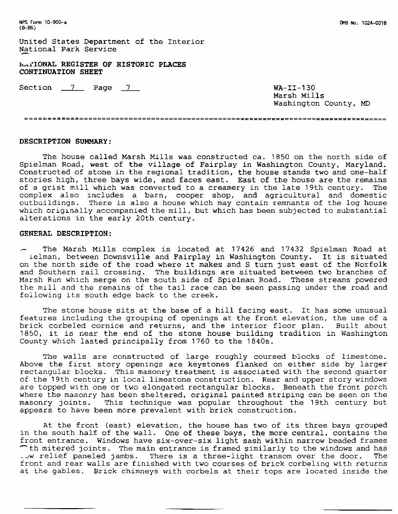
DESCRIPTION SUMMARY:
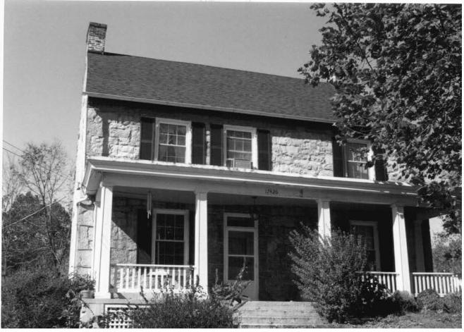
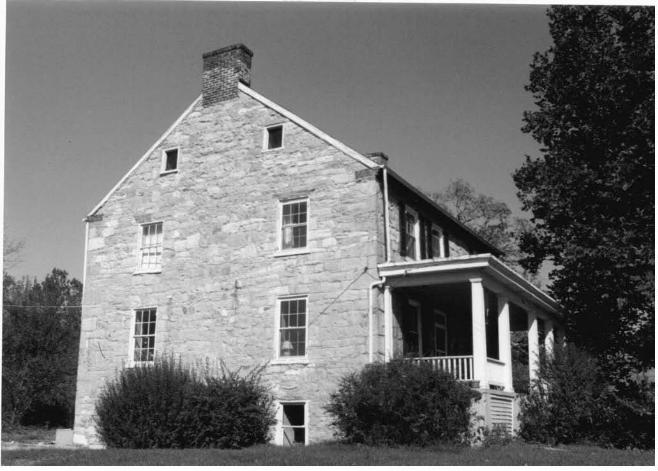
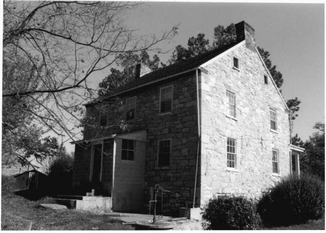
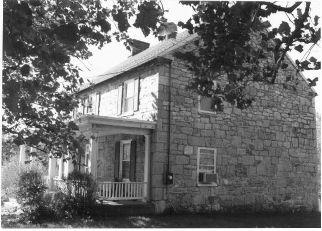
The house called Marsh Mills was constructed ca. 1850 on the north side of Spielman Road, west of the village of Fairplay in Washington County, Maryland. Constructed of stone in the regional tradition, the house stands two and one-half stories high, three bays wide, and faces east. East of the house are the remains of a grist mill which was converted to a creamery in the late 19th century. The complex also includes a barn, cooper shop, and agricultural and domestic outbuildings. There is also a house which may contain remnants of the log house which originally accompanied the mill, but which has been subjected to substantial alterations in the early 20th century.
GENERAL DESCRIPTION:
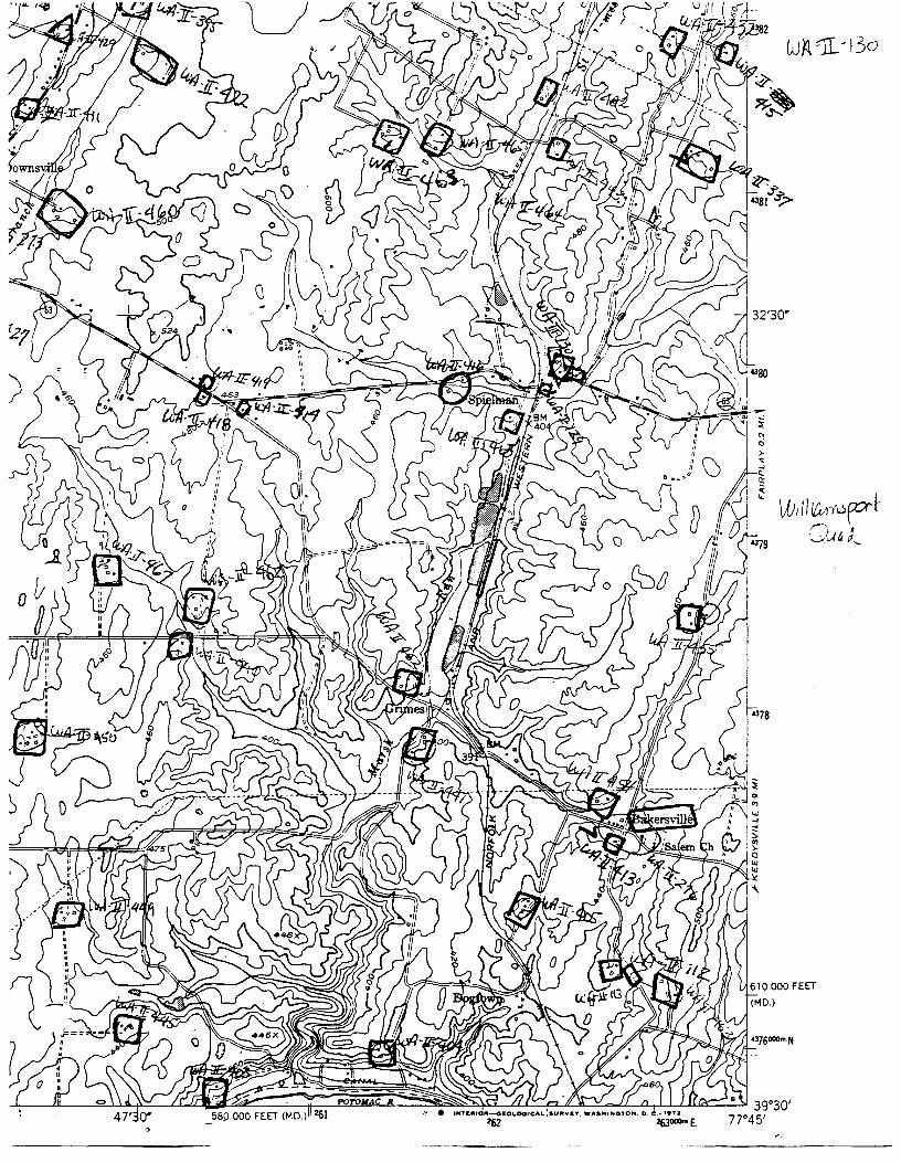
The Marsh Mills complex is located at 17426 and 17432 Spielman Road at ielman, between Downsville and Fairplay in Washington County. It is situated
on the north side of the road where it makes and S turn just east of the Norfolk and Southern rail crossing. The buildings are situated between two branches of Marsh Run which merge on the south side of Spielman Road. These streams powered the mill and the remains of the tail race can be seen passing under the road and following its south edge back to the creek.
some unusual the use of a Built about
Washington
The stone house sits at the base of a hill facing east. It has features including the grouping of openings at the front elevation, brick corbeled cornice and returns, and the interior floor plan. 1850, it is near the end of the stone house building tradition in County which lasted principally from 1760 to the 1840s.
The walls are constructed of large roughly coursed blocks of limestone. Above the first story openings are keystones flanked on either side by larger rectangular blocks. This masonry treatment is associated with the second quarter of the 19th century in local limestone_ construction. Rear and upper story windows are topped with one or two elongated rectangular blocks. Beneath the front porch where the masonry has been sheltered, original painted striping can be seen on the masonry joints. This technique was popular throughout the 19th century but appears to have been more prevalent with brick construction.
At the front (east) elevation, the house has two of its three bays grouped in the south half of the wall. One of these bays, the more central, contains the front entrance. Windows have six-over-six light sash within narrow beaded frames - th mitered joints. The main entrance is framed similarly to the windows and has -~w relief paneled jambs. There is a three-light transom over the door. The front and rear walls are finished with two courses of brick corbeling with returns at the gables. Brick chimneys with corbels at their tops are located inside the
NPS Fonn 10-900-a (8-86)
United States Department of the Interior National Park Service -~ .• ~:J.'IONAL REGISTER OF HISTORIC PLACES CONTINUATION SHEET
Section 7 Page _8_
()18 No. 1024-0018
WA-II-130 Marsh Mills Washington County, MD
=================================================================================
end walls.
A ca. 1920s porch extends across the front of the house. It is supported by square columns connected by a balustrade. At the rear of the house is a one-baywide concrete block enclosure, possibly following the configuration of an earlier rear porch. At the south elevation at ground level is a full sized window and door leading into the cellar.
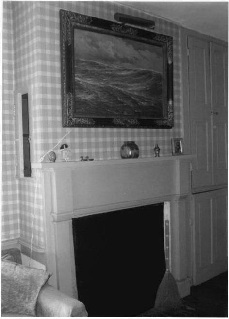
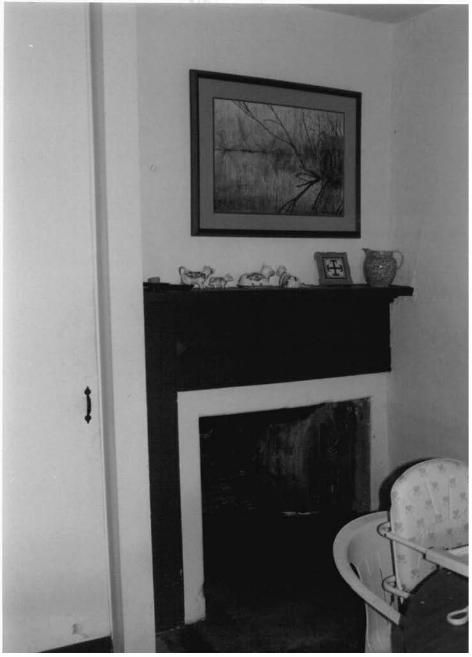
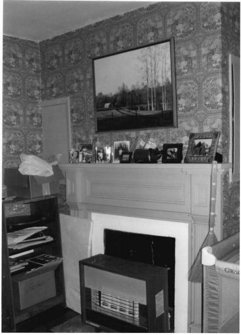
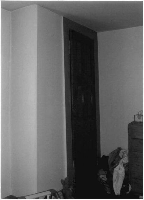
The interior of the house is divided into four rooms at the ground, first and second story levels. At the first story level, however, one partition has been removed between the two rear rooms, creating three rooms on this floor. The front entrance opens into the southeast room which contains a staircase to the second floor and a fireplace with adjoining cupboards. The fireplace is fitted with a relatively plain Greek Revival style mantel with square pilasters and a corbeled s:J:ielf. To the right or west of the fireplace is a cupboard with low relief . 1eled doors, original hardware and a turned wooden knob. The staircase has a round handrail, turned newel with knob and square balusters. The northeast room apparently originally functioned as a parlor and has a fireplace with a similar, but more elaborate mantelpiece with multiple fielded panels. The southwest room is now a kitchen, although it apparently was not so originally. The marks on the ceiling, walls, and floor are clearly visible, showing where the partition was located between this and the northwest room. The northwest room has a small fireplace with a mantel having a raised beveled horizontal panel. The rear exterior door opens into this room.
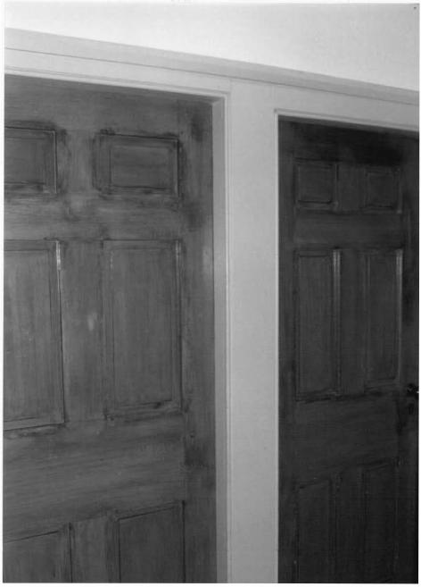
None of the four second floor rooms has a fireplace. There is a rather unusual arrangement with four doors to these four upper level rooms, all opening onto a small landing at the head of the stair. All of the doors have six low relief panels. Other second floor features include cupboards with original hardware and turned wooden knobs and peg rails.
The ground floor or cellar has two storage rooms, one a root cellar, at the north end. The south two rooms were the original kitchen and dining room. The kitchen was in the southwest corner room with a door that opens to the outside. In the south wall is a large service fireplace with a mantel shelf supported by triangular brackets. There is also an unusual storage cupboard in this room; it has a door with two vertical low relief panels. The area above the door contains four storage compartments, the two lower of which are drawers. One drawer pull remains of the turned wooden type like others in the house.
The southeast room at the front corner of the basement contained the dining -~om. This room also has a stair with a turned newel and rounded handrail leading to the main level stairway.
NPS Form 10-900-a (8-86)
United States Department of the Interior National Park Service -h.n:rIONAL REGISTER OF HISTORIC PLACES CONTINUATION SHEET
Section 7 Page _9_
()18 No. 1024-0018
WA-II-130 Marsh Mills Washington County, MD
=================================================================================
The house is in good condition and remarkable for its intact interior.
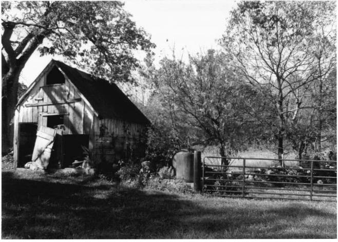
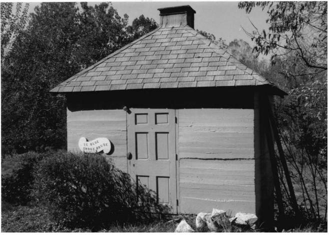
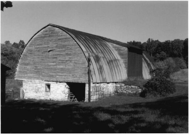
In addition to the main house, there are several contributing outbuildings representing the late 19th-early 20th century period, and a mid-20th century frame barn which utilizes an early stone foundation. Farthest south of the house is a frame carriage shed. North of this shed is a frame building said to have been the cooperage for the mill, which may also have served as an out-kitchen. It is a two bay, one story structure with vertical board siding and a large brick exterior chimney at its south end wall. Next to the north, is a smokehouse. Although constructed of poured concrete, and therefore probably dating from the early 20th century, it is a square structure with a hipped roof with a vent at the top, following the form of 19th century smokehouses in the county. Farther to the north is a small agricultural outbuilding, gable-fronted and of frame construction with a steeply pitched roof. The barn is considered non-contributing as a result t>E extensive alterations in the mid-20th century; it is a frame structure resting
stone foundations, with a cantilevered forebay and a ramp or bank at the back to access the loft area. The original structure above the foundations was replaced, probably in the 1950s, with the present arched roof which springs from the foundation level.
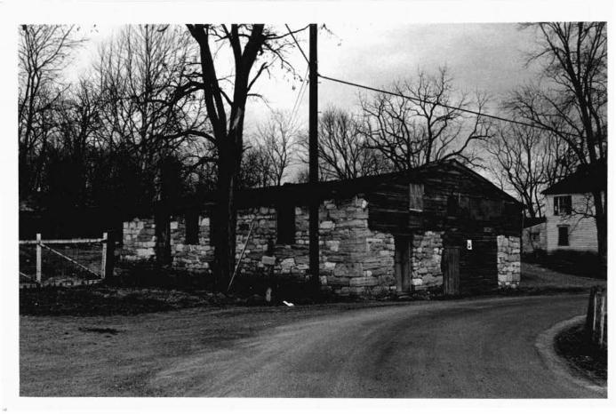
The remains of the mill are located east of the house. The original foundations are present, capped with a low-pitched gable roof. The removal of the top of the structure probably occurred in the 1880s when the structure was converted from a merchant mill to a creamery. According to an illustration in the 1877 Atlas, the building originally was a two-and-a-half story, stone structure with a. gamb.~~l .roof. The alterations to the mill reflect the historic shift from grain . to' oaJ:ry.' "in the agricultural economy of Washington County, and it is considered a contributing resource. Traces of the mill race are still visible where it exits the south end of the building, passes beneath the road and runs along the south side of the road to rejoin Marsh Run. East of the mill is a (contributing) American Foursquare style house of frame construction which may incorporate remnants of a log house which served as the original miller's dwelling on the property.
NPS Form 10-900-a (8-86)
United States Department of the Interior lja_tional Park Service
NATIONAL REGISTER OF HISTORIC PLACES CONTINUATION SHEET
Section 8 Page 10
CJ1B No. 1024-0018
WA-II-130 Marsh Mills Washington County, MD
=================================================================================
SIGNIFICANCE SUMMARY
The house at Marsh Mills is significant under Criterion C for its architecture, as an example of a type of stone construction which characterized the vernacular architecture of Washington County from about 1760 through the mid-19th century. Constructed ca. 1850, the house represents the last phase of the stone building tradition in the county; by the 1840s, this method had largely been superseded by brick or frame construction. The house retains a high degree of integrity, and exemplifies stone construction techniques and architectural detailing current at the time when the stone construction tradition was waning in the region. The property derives additional significance from its association with the milling industry, which was important to the economic development of the Cumberland Valley region from the 1730s through the late 19th century. The mill was converted to a creamery about 1888; its altered condition reflects the shift ~0m grain to dairy farming which transformed the agricultural economy of the
.Ji On in the late 19th century .... The period of significance, ca. 1 850-ca. 1 920, is defined to encompass the range of domestic, agricultural, and industrial resources which characterize the property.
NPS Fonn 10-900-a (8-86)
United States Department of the Interior ~tional Park Service
hnTIONAL REGISTER OF HISTORIC PLACES CONTINUATION SHEET
Section 8 Page 11
()18 No. 1024-0018
WA-II-130 Marsh Mills Washington County, MD
=================================================================================
HISTORIC CONTEXT
MARYLAND COMPREHENSIVE HISTORIC PRESERVATION PLAN DATA
Geographic Organization: Western Maryland
Chronological/Developmental Period(s):
Rural Agrarian Intensification 1680-1815 A.D. Agricultural/Industrial Transition 1815-1870 A.D. Industrial/Urban Dominance 1870-1930 A.D.
Prehistoric/Historic Period Theme(s):
Architecture/Landscape Architecture/Community Planning
Resource Type:
Category: Building(s)
Historic Environment: Rural
Historic Function(s) and Use(s):
Domestic/single dwelling Domestic/secondary structure Agriculture/agricultural outbuilding Industry/Processing/Extraction/mill
Known Design Source: none
NPS Fonn 10-900-a (8-86)
United States Department of the Interior N9tional Park Service Nat tm-rIONAL REGISTER OF HISTORIC PLACES CONTINUATION SHEET
Section 8 Page 12
Q1B No. 1024-0018
WA-II-130 Marsh Mills Washington County, MD
=================================================================================
RESOURCE HISTORY AND HISTORIC CONTEXT
Records show that while log was the preferred building material in the late 18th and first half of the 19th centuries, the local limestone was the next most used construction material until the 1830s and '40s when brick overtook the use of stone. The frequent use of stone as a building material is associated with limestone land which provided a particularly good source of materials. Surveys of stone buildings in the Cumberland Valley reveal that there is a distinct beginning and ending to the period of stone construction with few examples dating from after 1850.
The stone house at Marsh Mills was constructed about 1850. An equity court proceeding in 1853 records an advertisement for public sale of the mill property with about 30 acres of land "with a new stone dwelling and other improvements thereon". This document confirms the age of the stone house at Haley's Mill as ia.e~ing been build late in the history of stone construction in Washington County, and the larger Cumberland Valley. The interior and exterior features are very intact and consistent with 1850s vernacular traditions in the area.
The decline in the use of local limestone as a building material seems to have come concurrently with the decline in the milling industry in Washington County. Washington County contains the lower portion of the Cumberland Valley, a fertile limestone basin between mountain ridges. The Cumberland Valley is a broad band of rich limestone land extending from the Susquehanna River near Harrisburg, Pennsylvania to the Potomac River south of Hagerstown, Maryland. With its fertile land and other resources, the Cumberland.Valley played a crucial role in initial settlement and expansion, the French and Indian War, the Civil War and the development of transportation links and industrialization. The Cumberland Valley was a breadbasket for America for nearly a century from the 1770s to the close of the Civil War resulting in its being served by some of the nation's most important transportation routes.
The Cumberland Valley area was opened for settlement in the 1730s. To the north, in the Pennsylvania portion of the valley, that colony's proprietary government established a policy to encourage Scots-Irish settlers to move into the· Cumberland Valley and Germans to settle in the area east of South Mountain and east of the Cumberland Valley because of cultural friction between the two groups. Consequently, concentrated German settlement occurred in York and Adams Counties in Pennsylvania and then as Germans migrated to the south and west, Frederick and Washington Counties in Maryland.
,-. These people of Germanic descent had entered America through the port of Philadelphia. They had been for the most part, agrarians of various Protestant religious groups who had been persecuted in their homeland. German settlers began
NPS Form 10-900-a (8-86)
CJ1B No. 1024-0016
United States Department of the Interior National Park Service
~---i'IONAL REGISTER OF HISTORIC PLACES CONTINUATION SHEET
Section 8 Page 1 3 WA-II-130 Marsh Mills Washington County, MD
=================================================================================
arriving in Washington County in the 1730s. Jacob Rohrer had a grist mill in operation on the Antietam Creek by the late 1730s, which suggests that there were enough farms being worked at the time to keep his mill in business. Grain farming became prominent and as a result, many grist and flour mills were established. The mills took advantage of ample water power to convert grain to more easily marketable meal and flour or to provide custom work for local farmers.
The prominence of milling was a significant feature of the local economy. It reflects the influence of Pennsylvania in that the lower Cumberland Valley in Maryland developed a general agricultural economy with emphasis on wheat and other small grains, rather than the staple economy focusing on tobacco which developed in eastern Maryland. James T. Lemon in The Best Poor Man's Country asserts that Pennsylvania's economy based on general farming was largely the result of markets that opened up at the time Pennsylvania was being settled. Export trade with the 1d,.est Indies, New England, southern Europe and Ireland, as well as sales to ships'
)Visioners, created a demand for flour, bread, wheat as well as corn, lumber and t~ax seed. 1 These trade markets opened up after older colonies like Virginia and Maryland had established bilateral trade of tobacco with England which limited their ability to develop an exchange in new commodities. Pennsylvania was founded about the same time as the new extended trade markets were developed, causing its agricultural system to be significantly shaped by the contemporary market situation. 2 In contrast to Pennsylvania, according to Lemon, the tobacco colonies to the south had a lower average living standard, a slower rate of white population growth and few subsequent towns, at least until they turned to wheat production. 3 The long-term dominance of Cumberland Valley wheat production is illustrated by records which show that by 1870, Washington County had the highest yield of wheat in bushels per acre in Maryland. The county's average yield per acre in that year was 25-3/4 bushels, as compared with a statewide average of 14~ bushels per acre. 4
1 James T. Lemon, The Best Poor Man's Country (Baltimore: The Johns Hopkins Press, 1972) p. 26, citing Arthur L. Jensen, the Maritime Commerce of Colonial Philadelphia (Madison: State Historical Society of Wisconsin, 1 963) Chap. 1 , and Gordon C. Bjork, "The Weaning of the American Economy: Independence, Market Changes and Economic Development", Journal of Economic History, 24 (1964): 545.
2 Ibid.
3 Ibid I p. 1 2 7 .
4 J. Thomas Scharf, History of Western Maryland, p. 974.
NPS Form 10-900-a (8-86)
United States Department of the Interior National Park Service
h .• .rIONAL REGISTER OF HISTORIC PLACES CONTINUATION SHEET
Section 8 Page 14
()1B No. 1024-0018
WA-II-130 Marsh Mills Washington County, MD
=================================================================================
According to Susan Winter Frye, in her study on mill settlement patterns in Washington County,
Philadelphia initially provided the chief market outlet with Baltimore, Wilmington, and Richmond close behind. The leading flour marketing centers remained in the central colonies throughout the remainder of the 18th century and into the 19th century, as Pennsylvania, Maryland, and Virginia became the foremost grain producers during this period. 5
Much of this high production is attributable to the very fertile farms of the Cumberland Valley. The many mills which were established along waterways in Washington County were either "merchant mills" which were commercial enterprises, grinding meal or flour that was sold to brokers in the port cities, or custom mills which ground farmers' grain to their specifications for their own use.
The milling industry in Washington County and elsewhere was revolutionized by the introduction of Oliver Evans' water-powered automatic system of milling in the 1780s. In Evans' system, grain was not touched by human hands once it entered the mill. It was instead, carried from bottom to top of the mill several times by way of a system of belts and wheels and buckets. This new automated system reduced labor by half and improved the quality of flour. 6 From the 1780s through the 1850s, Washington County and other parts of the Cumberland Valley prospered, largely due to successful agricultural production. This 60-year span coincided with the construction of farmsteads and expansion of villages and the phenomenon of stone construction.
A second revolution in the milling industry occurred about a decade after the Civil War ended when new types of mechanization took place. In the 1870s, a "New Process" was developed involving the regrinding of grain middlings and gleaning additional flour from them using a "middling purifier". The purifier was a frame containing multiple silk screens which filtered the flour. In the 1880s another technological advance took place with the introduction of steel roller mills to replace the use of grinding stones. Both the roller mills and grain purifiers were introduced from Wisconsin which after the Civil War began to eclipse Baltimore and Philadelphia as grain market centers. Roller mills were really developed to process hard red wheat grown in the plains states and were not necessary for grinding the softer winter wheat grown in the East. However,
5 Susan Winter Frye, "Evolution of Mill Settlement Patterns in the Antietam Drainage, Washington County, Maryland". Thesis, College of William and Mary, Williamsburg, VA, 1984, p.24.
6 Ibid, p. 2 6 .
NPS Fonn 10-900-a (8-86)
United States Department of the Interior National Park Service
a.._ • .L'IONAL REGISTER OF HISTORIC PLACES CONTINUATION SHEET
Section 8 Page 1 5
()18 No. 1024-0018
WA-II-130 Marsh Mills Washington County, MD
=================================================================================
merchant mills in Washington County and other areas of the Cumberland Valley and mid-Atlantic region made the expensive conversion to use of steel rollers in an attempt to remain competitive with western flour producers. From the 1880s into the early 1900s, the history of milling in Maryland and Washington County is a troubled one with foreclosures and failures and eventually with most mills shutting down except for local custom work. This history is reflected by Marsh Mills.
The mill was apparently established in the late 18th century by Samuel Wolgamott [also spelled Wolgamore]. He was assessed in the 1783 Tax for a mill valued at £400. In June of 1811, John Wolgamore sold to Henry Coffman 157-3/4 acres for £3116.5, including Wolgamore 's Mill. Apparently, Henry Coffman encountered financial difficulties or failed to pay his taxes since the Hagerstown Torchlight and Public Advertiser listed a public sale to be held on November 11, J..818 for "A valuable Grist Mill and 23 acres limestone land with a two story log
~lling house thereon. The above property is well known by the name of wolgamore 's Mill, and is situated about eight miles from Hagerstown . 11
Apparently Coffman managed to keep the property or at least a portion of it, for he sold the mill with 45 acres to James Coffman in June of 1 828. The mill property passed from Coffman to Joseph Emmert to Joseph Long, to Joshua Newcomer in 1839, '41, and '56 respectively. In 1856, the late Joseph Long's property was sold to settle his debts as described in equity court case #1212 (Chancery Record 4/736). The equity court proceeding records that public notice was given "of the sale of the merchant mill and about 30 acres of land with a new stone house and other improvements thereon ... 11
• Joseph Long died in September of 1851, which means that the house was either built by him shortly before his death or, probably more likely, by his son David just after his father's death.
The property remained in the Newcomer family from 1856 until 1871, when the mill and stone house were sold separately. The mill and five acres were sold to Cyrus F. Davis for $2000 on August 15, 1871 (Deed Book WMCKK, Page 673). On the same date, Newcomer sold the stone house and farm buildings to William H. Banks and Jesse D. Banks (Deed Book 74, Page 412) for $4000. The two pieces of property have remained separate to the present time. The mill was purchased by Thomas M. Haley in 1874 and he owned it until 1879. It was then sold to and operated by Allen and Mary J. Wandling until 1885 when the mill and 4i acres was purchased by Jonas Spielman whose name this small community now carries. In 1 888, Jonas Spielman sold the mill to the Willow Grove Creamery Co. (Deed Book 92, Page 262). At this point the mill was converted to a creamery with butter-making machinery and ceased to operate as a grain mill. This conversion is significant in its own -.:ght, reflecting the historic shift from a grain- to a dairy-based economy which
.aracterized the region during the period.
NPS Fonn 10-900-a (8-86)
United States Department of the Interior National Park Service
1~d·rIONAL REGISTER OF HISTORIC PLACES CONTINUATION SHEET
Section 9 Page 16
()18 No. 1024-0018
WA-II-130 Marsh Mills Washington County, MD
=================================================================================
MAJOR BIBLIOGRAPHICAL REFERENCES
Frye, Susan Winter, "Evolution of Mill Settlement Patterns in the ntietam Drainage, Washington County, Maryland". Thesis, Master of Arts, College of William and Mary, 1984.
Maryland Inventory of Historic Properties, Maryland Historical Trust, Crownsville, Maryland.
Washington County Land Records.
NPS Form 10-900-a (8-86)
United States Department of the Interior l:lational Park Service
~ATIONAL REGISTER OF HISTORIC PLACES CONTINUATION SHEET
Section 10 Page 1 7
CJolB No. 1024-0018
WA-II-130 Marsh Mills Washington County, MD
=================================================================================
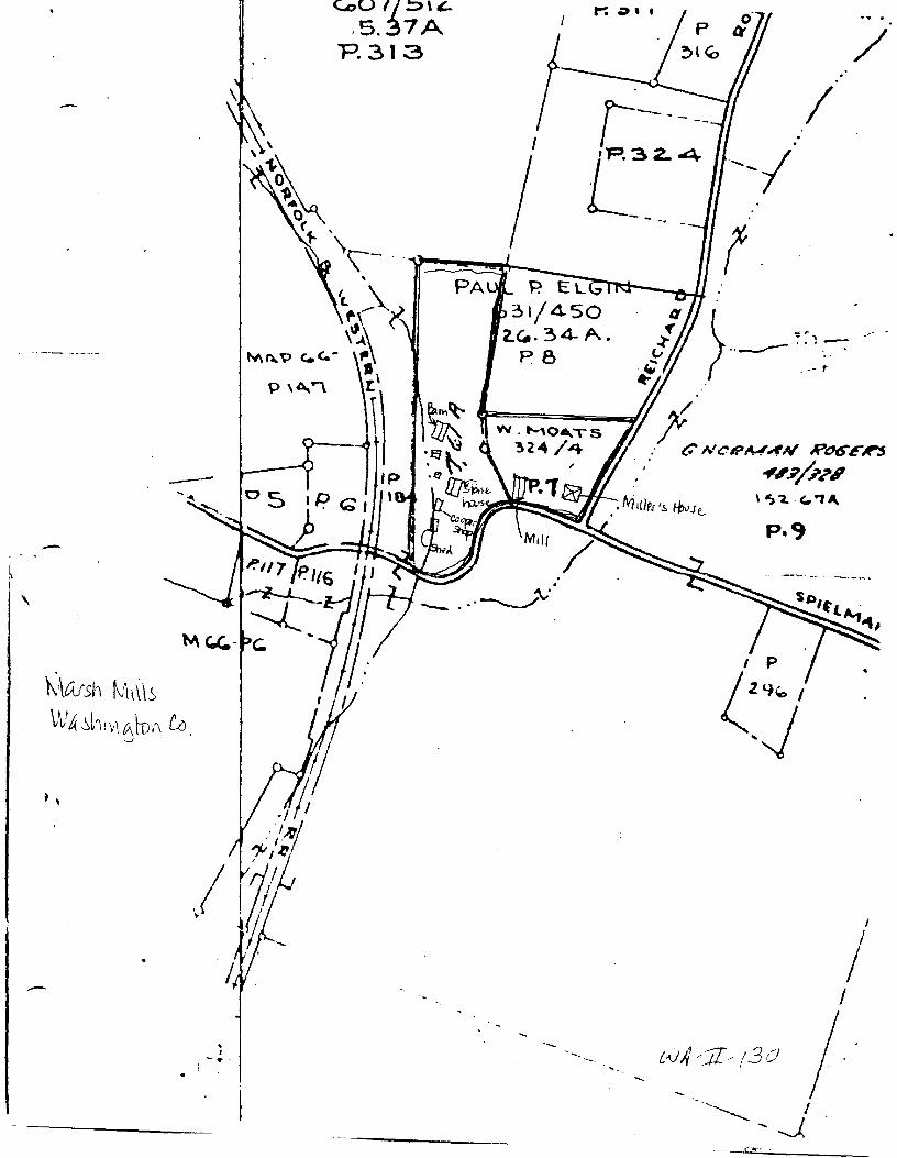
GEOGRAPHICAL INFORMATION
Verbal Boundary Description: The nominated property is shown on the accompanying map, and corresponds to parcels 7 and 8 indicated on Washington County Tax Map number 67.
Boundary Justification: The nominated property, approximately 12 acres, comprises the remnant of the acreage historically associated with the resource and provides an appropriate setting for the complex.
-\
t '
-
-.... ""'
. J ·-·
G,07/ !:>\'
, 5.~7A P.313 /
I
r---- --I - --c 2- 4 --.1· I
t ~ -:~, -· ··---- ... . --:
--- ,.
c;F"=====---m-=z/) x W · MO.,_TS /. ~24 /4 : C NoR~;fN R"t>"E~
. ""-';P?I \ 'S"'2. -<..'1~
p.,
~· --···~
I
I
I
·- ··-
NPS Form 10-900-a (8-86)
United States Department of the Interior National Park Service -h~~IONAL REGISTER OF HISTORIC PLACES CONTINUATION SHEET
Section 10 Page 18
()18 No. 1024-0018
WA-II-130 Marsh Mills Washington County, MD
=================================================================================
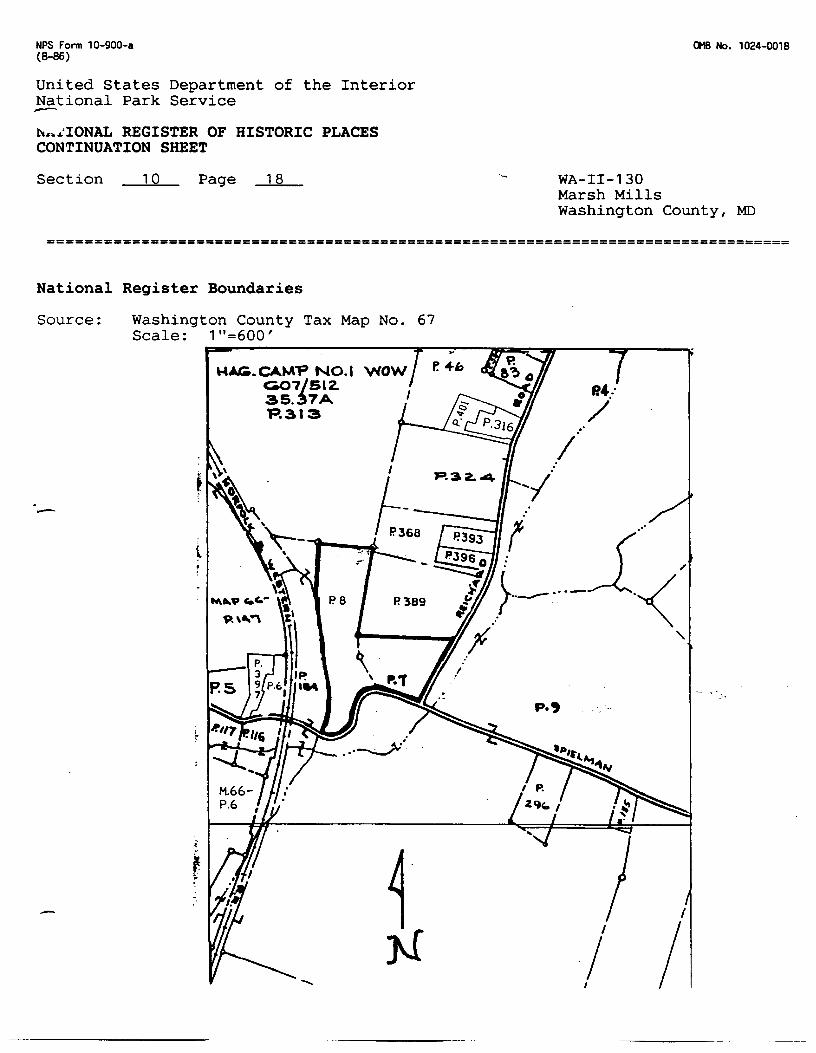
National Register Boundaries
Source: Washington County Tax Map No. 67 Scale: 1"=600'
t
r -.
MIJ:9.CAM"P NO.I G07/SIZ. 35.~7A. "P.313
-
P.32..4
1 N
.•·
'
p.,
I
I
::::-,/ _
~I) D
I_ . ,, ,, -f'
"'" ROAD 11
(- a
/ :"'
;._ r-'
-- ~
~r-
,--'
-."
~~~~~~
c.; . ..--''\ J
~-l ~ " ~6a ~ \ -_/ I
_\\__ ,~
-
-r12
.. -.:~/i§L· __ ~,,.~a~~4~~4~~~~~-~~,jrf:-~f--~~-:--~n.,n•oomN ~~ § 1• i. ·" 1'/
~· t"
,I l
30"
-
QUADRANGLE LOCATION
0
_.c___-=~-1-~76
• INTERIOFl-GEOLOGtC+.L SURVEY. RESTON. VIRGINIA-1979 262°•0 mE 2 490 000 FEET (W. VA.)
Primary highway, hard surface
ROAD CLASSI Fl CATION
Light-duty road. hard or improved surface
370 000 FEET (W. VA.)
39°30' 77°45'
Secondary highway, ha rd surface
Unimproved road =========
Interstate Route ·-( ~ :_____. U. S Route L State Route
WILLIAMSPORT, MD.-W. VA. SE;/4 WILLIAMSPORT 15' QUADRANGLE
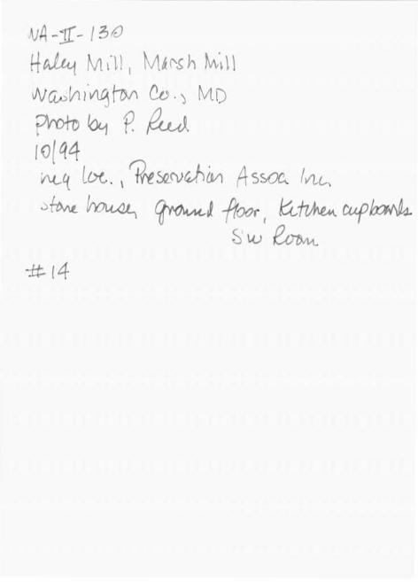
wA -lf- r 31'
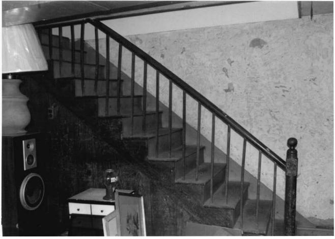
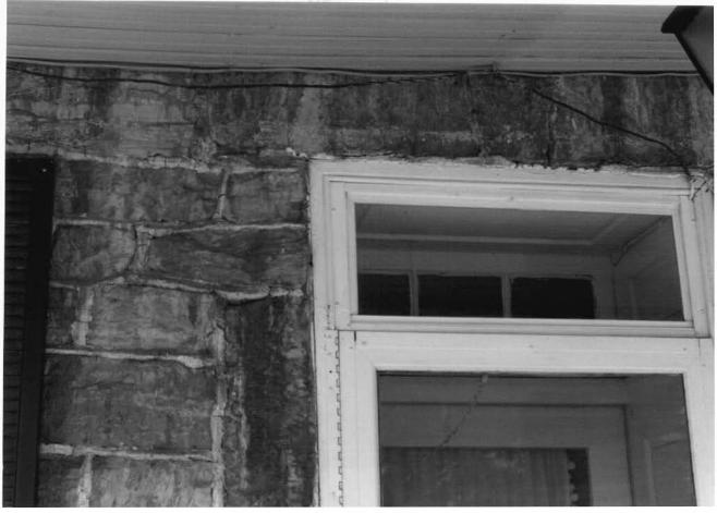
f-f ~ur M ~ u vi c. t£ Vi '"" ·l u (N«L;hiMTu ec .) Mb pwx-o&t p. ~ ID( q4 Af ~, ~. rpl't-<)tJVtJlcYl ~SO!,, { Y1L .
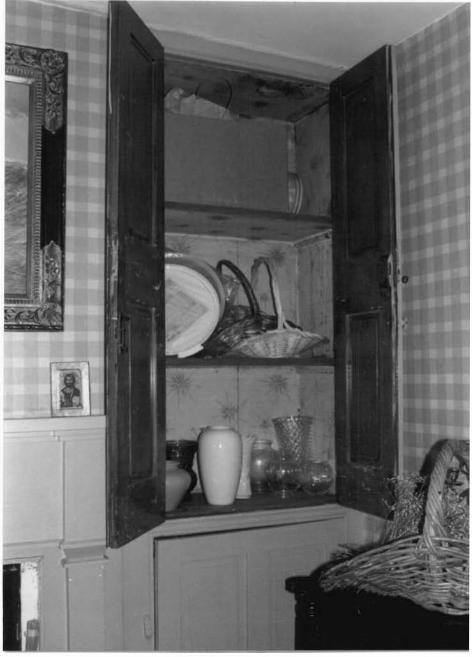
~ f tMe. h<J k..4J_ , Y\t\.~ f!Cf)l , SE rO?YY1
-::{{: 1
WA-1f- /3o
+t~ f\:t~ll, MA~~ t "~n Nfw hwu(, fwi 0J ( Mb
pnoro ~ r ,~~ I
{ (1{ q tf· I~ I Uri. 1
1..)M<JtJVuittC.. .ls~~ IYU. ;:,ft>.AQ. J'\Ol<4l. f'YU1..;,, -P!oor Ss WOM
I J
:tt= 6
'NA <l[- ! 3n
Hl-1~ {Vl~ I/ l M~ t, ~ 11
~h1~hYl Cb. M1,
pMo b-: ~ fuJ l of q 4-
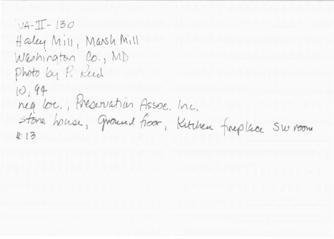
rv_ q_, lttrt-. r~.a;JV~ fk~. ~c. s 1-M~ f\IJ kAt._ I f'vl. 4.Mt. ft (!{Jf / ,J VtJ (0 ffhL
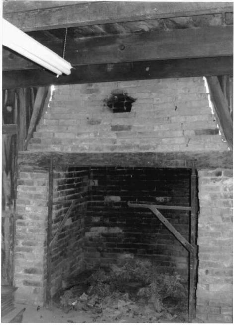
:{:f ~
· -~ · t ,' - I 3 o ./1t;_,lr2Lf Mt1l, M~rs'11\11,1\ WfJA h1~ TIY1 CD. 1 MD f h?fD h-t P. M 10/q4 ho_q ~ c . fJf'tCQ. N U,fl ().11 4s SCz:.. ! JIU .
'~ ~, ~ -{wo<-, Nw ~ :if I CJ
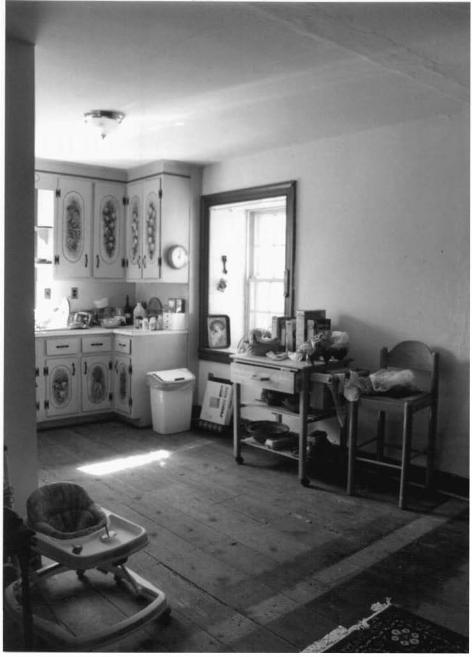
~VA -.1I- t3o tf ~ M;11 I M6.tsltl M ·, 11
.,(JMVl\v\tj h>Vl CtJ.) iv1 I
erofr ~ r. ~ to(q4 ~ Cct. ?~4..ho,., As:5>6C . l'll.c_
~~ ~LUU_/ ~ ~I s/-u._1'1'.5
-# { z.
•JA-1[- . 3a
H ~ fvt i \J I NlUJ-5~ f\\, \\ VJ(Uh1.NATh-ri ~.) ~lf>
p~~ ~ t: ~LLJ lu ~tr ~ /ix. , PN<Jvvw{µ, A<;soe.. lv'\L .
~~ f.tJ1A.,i,._, ~J .f<»-, ~ ~r-L(lk 5w l'Co"< tl;
·VA -j[- / 3t0
H~ M\·i1 l tv1&i'Sh ~·~\\
Ncu.)V11·~ f1M Cv." MD
?ro+o ~ P. ~ 1o(q4 V\.t.~ ltX. . \ ~~rv0hlvi 4 s~ fVl~ ~~ ~ ~J ft()(}r I k:<.:tv~~ CU(J~
~\{) ~
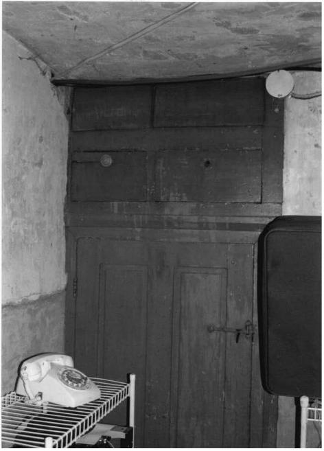
-:f:t l 4
wA -Jr- t3u ~~ ~'11l \ ' f\ll~l'8 IA. {V\1. t l
JJM~~ Cc. I Mt )
~N;tl) ~ P. ~ 10( q tf M # loe, .~wti.t.Vi fJs.>a\ fVLL . ,t-.. _ I $e..UM /. .A
.) ! ()YlL. flOU.4.t_ 4 ~'"~ ( I (X)r s~ f (}(JIN\.
~ lG
LvA-11:-130 HcJ.ut M~ LI, ~h fv\.; It lv'a1J?-L1ttq~ ~- , Mp fNtb h.t f. ~ 1o(q4 .\Uf. Lot.. ?~~~ f+t;~crc,- IAL. ~+Mt. 0v;~I ~ ft.yx I (;)~1;. l tv.-t L"vt1 ~ (Ce
wA~'1:· l30 +{~ tvi.d\ fvtw~ M~ t\ Lvwh1 ~q h1t &. 1 l'vt D ~~p~ I tJ/q tf-~ l.rx.. 1~h)~ ,JsEcz:.. }~. sftv..t. ~ ~ n~ s rz ro~
I I
--if r1
lvA -If· I 3 o H~ 1'i11/ J iV\..U.fJ h M~ l I W(U) ~-f?M C-0 . I M1> oMfv ~ ~ 1~,,r. 1of q4 ~ lac- . 'Prt4JJV~ ~c~ I YL0.
~ ~ ~ .;.. r~DMsf1u.J;_J. M1.\kr~ ~ltMAt tJ~ \-~. ~ (~
wA ~TC- t3o
Hcdu.t ""' il I I Nt ~.s (,, tv\, \ \ vV wAw1rf~ CtJ \ MD prcro b-t P ~~ 1-0(q4 ~ far_ : ~~M ~srr. / tvtc..
~r2-'1' .shop , Sw v~
;!i: rq
L.uA-.:rI- t3 o +I~ fvt ti I ) M_6rsh tvidl s
1 1JM~f!M. C-0. i MD protv ~ p~ lo(qf ~ Loi. ~Mor. ~ I Af-.
~ s~ ~ f N-P l_p_u_
-1t io
vVA ,1[-130
Hai.ui M1\l 1 ~\ti~h M~ll ' ·l'tW ~ llJv\ {le, ) fVt D photo &r f M ro 144
. J ~. ~. N<v-vuftM ~- /YLl. ~q huv.... \N. ~ -:it z !
LvA-17:- t3o tf~ Mill. M_O.t-S t1 tvt~ l \
IAJfuJ ~ flM 0_ ._ ~' ~ :-rOfD ~ ~~ 10 ( q4 ~ l&G. f ~~W,1 A~. /Al.
~u~, siw ~ {:Ft 2
wA-1l - r30
tt~ lv1~ t/1 M~tsh M·~lt UJU,,a fwvvt f1M Lb, Mb ~ro °'1 P f!u l
t·o ( q cf ~Lor.,. ~~ ~Dt-. jV\,l.
b~ 1'Jw V\lW I
-±t: 2 _:;
~VA <If - t?>O
H~a.'1 Mtll : \/1.U.t6h M; ll NMh1n~fovi C'-c.) 1..11.D Jh:>fo 6l-f. 1-? ~J.
.fJ(14 ~~Q. ~Vf.4- 1 w. v1eu:, £, t.leuM?o;,.,
Jt (
'}J{J -Tf - t 3/)
t.f~ M11 11 Ma rs/A rv1 i1~.s
WMh1~~~ Oo. l M1> prom ~ R f!_u A. {()/f4-
. ' r..,l{f !...-tn.. /"1'l<)IJVah.{)ri ltsscv, hu.
Sffv'tq_ hov~JJ. . I ~\!\I ~lJ S+ f;. ~ &1/ 1Lfit.Vi s :lF z
w~ .. 1f - t3 o {ful.~41 M1.l l
1 f.ll~Js~ fi11i1 I
\A)~ h I f'l~ fr Y\ ~. ) /vl 0 pimv ~ 't? ?u J. r o/ct <.f
';") - 1 Y'/1.ft. 1"c. . r~ut>~ ~. in'-.
~e. ho l1./.u_ 1'J E V\u.J. s -# u_ · e le uui'uviJ ::tf 3
WA-1r t 3o H~ Mill) M~h Mitt
Wll4 h lYLt( MM ~t . 1 vi b protv ~ R ~ ro( q(f
~ /.c(,. ?r%hJ~ ~~O(,,_ l>N_ .
,'::JtfJ"';u_ 0.o~ . ~ u_; Lh.u.J I Mlf;. e.J.e,t.J~ ~
tf-4
vVA-1I - 130
:Jal tLf 1'-11 , · u , Mt/J's t-i ~11,i1 I Wi<? hi vi.q foYI ~.I M _'t) eroru ~ P. ~ (o(qq.,
(\{_,!.. ~. r~~ ~ ,Yll.. Sfvvu. htJLU1.t- ~-~ ~ ;- tJ+-& - EJrwilPDM ~ ~I twA :lt s
:)lA --.1I- t3o t/w~\11.1!~ 1 Ma.~Mdl "vv1h1i\~~ Cb. MD (Wm~ Yi~ lD /'1:-
~ fol. (f'Wh!u:fw;, 1~ . I vu. .
~~Q ~ . -:i:~1 foY\t eJtvcJiVi ~G
--
ABSTRACT ~JA-II-130 Speilman Hill Complex Fairplay Vicinity private
19th Century
This complex would appear to date from the second quarter of the 19th century. Included in the group are ruins of a grist mill, possibly of stone and frame construction and a two story, three bay stone house. The 19th century date is suggested by the type of exterior masonry and woodwork that both buildings have.
Co:'_'.!y II
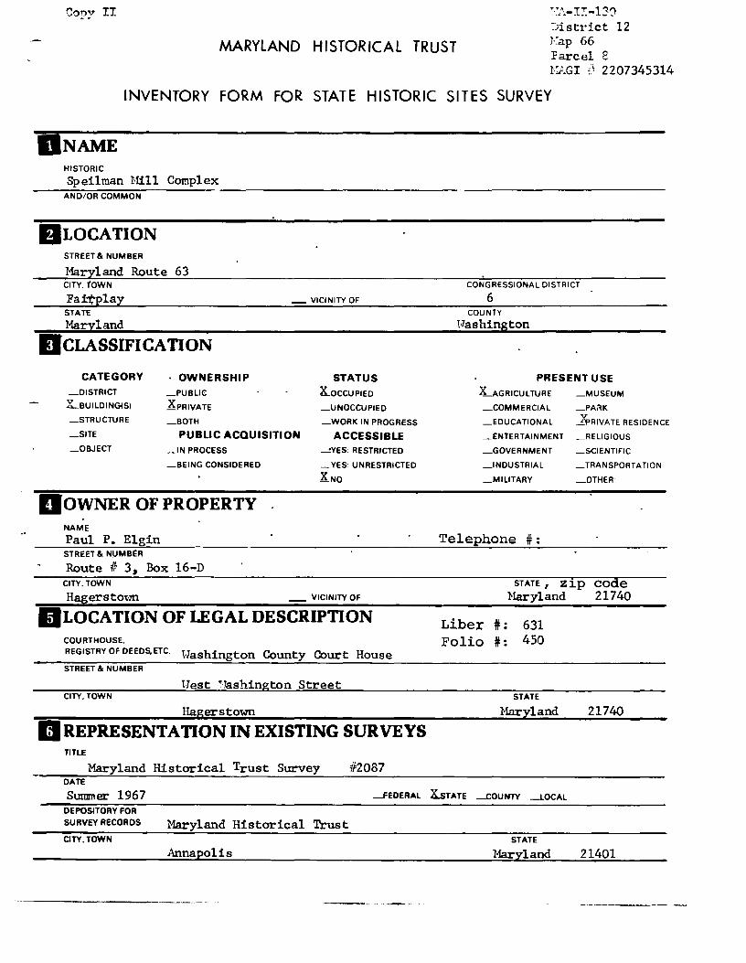
MARYLAND HISTORICAL TRUST
·~}i.-I:':-130
~)istrict 12 V.ap 66 Parcel E l·:AGI '::~ 2207345314
INVENTORY FORM FOR STATE HISTORIC SITES SURVEY
UN AME HISTORIC
Speilman Hill Complex AND/OR COMMON
flLOCATION STREET & NUMBER
Maryland Route 63 CITY. TOWN
Fai'tplay STATE
Maryland
- VICINITY OF
DcLAsSIFICATION
CATEGORY _DISTRICT
X...BUILDING(S)
_STRUCTURE
_SITE
_OBJECT
· OWNERSHIP STATUS _PUBLIC K_ocCUPIED
XPRIVATE _UNOCCUPIED
_BOTH _WORK IN PROGRESS
PUBLIC ACQUISITION ACCESSIBLE _IN PROCESS -.!YES: RESTRICTED
-BEING CONSIDERED _YES: UNRESTRICTED
XNo
DOWNER OF PROPERTY NAME
Paul P. Elgin STREET & NUMB£R
Route 11 3, Box 16-D CITY. TOWN
Hagerstown - VICINITY OF
llLOCATION OF LEGAL DESCRIPTION COURTHOUSE. REGISTRY OF DEEDS.ETC. Washington County Court House STREET & NUMBER
Hest TTashington Street CITY. TOWN
Hagerstown
II REPRESENTATION IN EXISTING SURVEYS TITLE
Maryland Historical Trust Survey /!2087 DATE
CONGRESSIONAL DISTRICT
6 COUNTY
Washington
PRESENT USE
UGRICULTURE _MUSEUM
_COMMERCIAL _PA~K
_EDUCATIONAL ~RIVATE RESIDENCE
_ENTERTAINMENT _RELIGIOUS
_GOVERNMENT _SCIENTIFIC
_INDUSTRIAL
_MILITARY
Telephone #:
_TRANSPORTATION
_OTHER·
STATE, zip code Maryland 21740
Liber #: 631 Folio #: 450
STATE
Maryland 21740
Summer 1967 -FEDERAL X.STATE _COUNTY _LOCAL
DEPOSITORY FOR
SURVEY RECORDS
CITY.TOWN
Maryland Historical Trust
Annapolis STATE
Maryland 21401
B DESCRIPTION
K_EXCELLENT
-GOOD
-FAIR
CONDITION
_DETERIORATED
_RUINS
_UNEXPOSED
CHECK ONE
_UNALTERED
~LTERED <: 50%
CHECK ONE
.ZORIGINAL SITE
_MOVED DATE __ _
DESCRIBE THE PRESENT AND ORIGINAL (IF KNOWN) PHYSICAL APPEARANCE
This complex which includes the ruins of a grist mill and a stone house is located on the north side of Maryland Route 63 at Speilman east of Harsh Run and the Norfolk and Uestern Railroad tracks and west of Fairplay in Hashington County. The house is situated on relatively level ground and faces southeast. It is a two and one half story, three bay limestone building with a partially subterranean ground story. :ralls are constructed of roughly coursed local limestone with the stones being relatively large in size. Several types of masonry trim are utilized at the openings. An entrance into the ground story is topped with a flat arch of cut stones. Several main story windows have small wedge shaped stones centered at their lintels and upper story windows have long rectangular stones set across their tops.
Windows have narrow frames finished with a bead at the inside edge. These hold six over six pane double hung sashes. Hinge pins for shutters remain in most frames. Openings in the front elevation are grouped toward the south corner with two of the three bays of the front elevation south of its center. The main entrance is located in the central bay of the front elevation. A three light transom is present above the door. A 20th century porch supported by square pillars resting on concrete piers extends across the front elevation.
Modern asphalt shingles for the roof which terminates with barge boards set directly againbc the end walls. Brick chimneys with corbels at their tops are located inside the end walls.
East of the house are ruins of a stone grist mill which operated during the 19th century on this property. The upper stories of the mill have been removed and may have been timber framed. It is now finished with a low pitched gable roof. A former owner of the property indicated the building had been converted from a mill to a creamery.
The house appears to be in excellent condition. The property, containing slightly more than 30 acres includes parts of the land grants, ''Resurvey on T-;"ateJ: Sunk" and '"delen 1 s Lookout."
CONTINUE ON SEPARATE SHEET IF NECESSARY
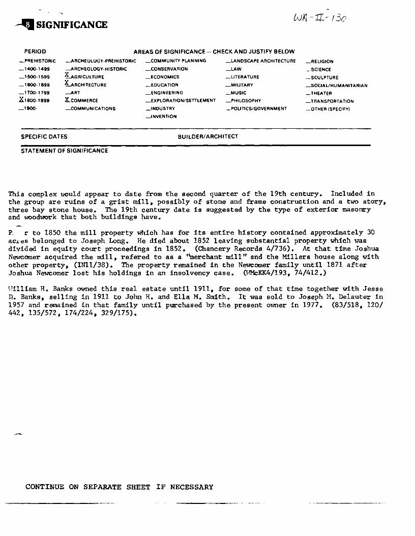
--'I SIGNIFICANCE
PERIOD AREAS OF SIGNIFICANCE -- CHECK AND JUSTIFY BELOW
_PREHISTORIC --ARCHEOLOGY-PREHISTORIC _COMMUNITY PL.ANNING
_CONSERVATION
_ECONOMICS
_LANDSCAPE ARCHITECTURE
_LAW _ 1400-1499 --ARCHEOLOGY-HISTORIC
_1500-1599 LGRICULTURE
_1600-1699 LRCHITECTURE
_ 1700-1799 -ART
.x 1800-1899 x_coMMERCE
_1900- -COMMUNICATIONS
SPECIFIC DATES
STATEMENT OF SIGNIFICANCE
_EDUCATION
_ENGINEERING
_EXPLORATION/SETTLEMENT
_INDUSTRY
_INVENTION
_LITERATURE
_MILITARY
_MUSIC
_PHILOSOPHY
_POLITICS/GOVERNMENT
BUILDER/ ARCHITECT
_RELIGION
_SCIENCE
_SCULPTURE
_SOCIAUHUMANITARIAN
_THEATER
_TRANSPORTATION
_OTHER ISPECIFY)
This complex would appear to date from the second quarter of the 19th century. Included in the group are ruins of a grist mill, possibly of stone and frame construction and a two story, three bay stone house. The 19th century date is suggested by the type of exterior masonry and lYOodwork that both buildings ~ve.
P. r to 1850 the mill property which has for its entire history contained approximately 30 acres belonged to Joseph Long. He died about 1852 leaving substantial property which was diyided in equity court proceedings in 1852. {Chancery Records 4/736). At that time Joshua Newcomer acquired the mill, refered to as a ''merchant mill" and the Millers house along with other property, {INll/38). The property remained in the Newcomer family until 1871 after Joshua Newcomer lost his holdings in an insolvency case. {WMcKK4/193, 74/412.)
Pilliam H. Banks owned this real estate until 1911, for n. Banks, selling in 1911 to John H. and Ella M. Smith. 1957 and remained in that family until pU:rchased by the 442, 135/572, 174/224, 329/175).
CONTINUE ON SEPARATE SHEET IF NECESSARY
some of that time together with Jesse It was sold to Joseph M. Delauter in
present owner in 1977. {83/518, 120/
wA--it.-130'.
IJMAJOR BIBLIOGRAPHICAL REFERENCES
CONTINUE ON SE~~TE SHEET If NECESSARY
lliJGEOGRAPHICAL DATA ACREAGE OF NOMINATED PROPERTY Slightly more than 30 acres
VERBAL-BOUNDARY DESCRIPTION
LIST ALL STATES AND COUNTIES FOR PROPERTIES OVERLAPPING STATE OR COUNTY BOUNDARIES
STATE COUNTY
STATE COUNTY
mFORM PREPARED BY NAME/ TITLE
Paula·Stoner Dickey, Consultant· ORGANIZATION.
Washington County Historical Sites Survey STREET & NUMBER
County Office Building, 33 West Washington Street CITY OR TOWN
Hagerstown
DATE
February 1978 TELEPHONE
791-3025 STATE
Ma,rylapd 21740
The Maryland Historic Sites Inventory was officially created by an Act of the Maryland Legislature, to be found in the Annotated Code of Maryland, Article 41, Section 181 KA, 1974 Supplement.
The Survey and Inventory are being prepared for information and record purposes only and do not constitute any infringement of individual property rights.
RETURN TO: Maryland Historical Trust The Shaw House, 21 State Circle Annapolis, Maryland 21401 (301) 267-1438
PS• t toe
J I
- j
! !
I l
580 000 FEET (MO.JI' 261
<-- ROAD CLASSIFICATION
Heavy duty -- --- L1gh~ duty
Medium-duty ~- -· =-==-==-:c· Unimproved dirt
State ~'..>de ~-·::;
, ( 'I
MAllYLAND ' l (_~~' ', 'c_, WILLIAMSPORT. MD.-W VA.
SE.4 w:LLIAMSPur;:c 1·_c:il~Gl~--------
Speilman Mill Complex
Maryland Route 63 Fairplay Vicinity

Speilman Mill Complex
Maryland Route 63 Fairplay Vicinity
PAULA STONER OICKl't
CONSULTANT. WASHINGTON CO HISTORICAL SITES SURVEY
I
I
Speilman Mill Complex
Maryland Route 63 Fairplay Vicinity
t AULA ST ,,..ER 01. .. KEY
CONSU' TANT. WASHINGTON CO
HISlORICAL SITES SURVEY