W MOUNTAINS - maine.gov · WESTERN MOUNTAINS 2 Grafton Notch Scenic Byway 4 Old Canada Road...
13
Transcript of W MOUNTAINS - maine.gov · WESTERN MOUNTAINS 2 Grafton Notch Scenic Byway 4 Old Canada Road...

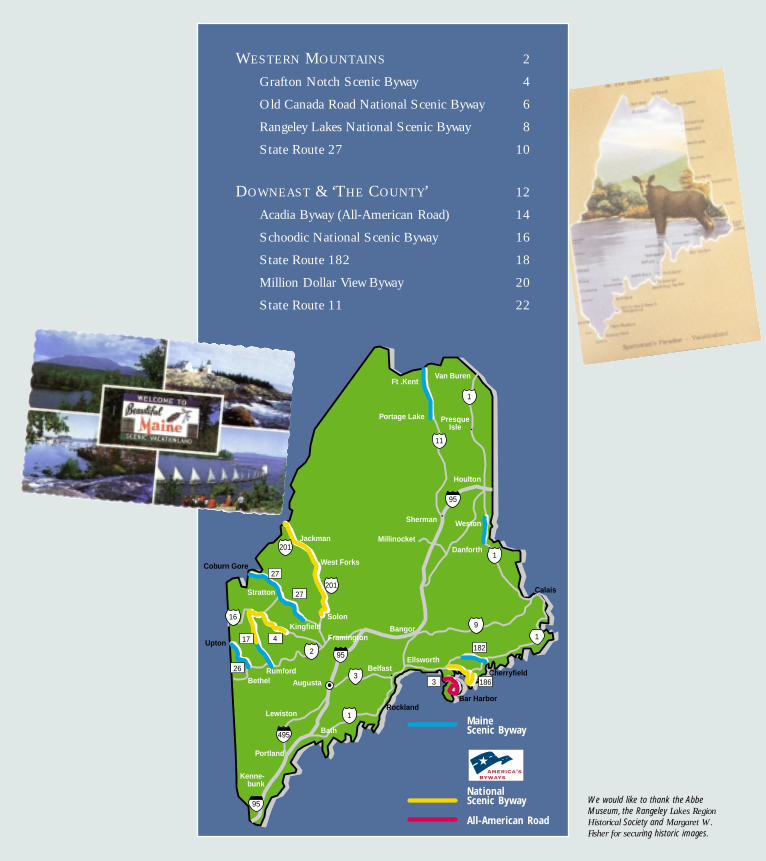
WESTERN MOUNTAINS 2
Grafton Notch Scenic Byway 4
Old Canada Road National Scenic Byway 6
Rangeley Lakes National Scenic Byway 8
State Route 27 10
DOWNEAST & ‘THE COUNTY’ 12
Acadia Byway (All-American Road) 14
Schoodic National Scenic Byway 16
State Route 182 18
Million Dollar View Byway 20
State Route 11 22
Maine Scenic Byway
National Scenic Byway
All-American Road
Kenne-bunk
Portland
LewistonRockland
Augusta
Belfast
Bangor
EllsworthRumford
Bethel
Calais
Jackman
West Forks
Ft .KentVan Buren
Houlton
Millinocket
Sherman
95
95
95
495
Bar Harbor
Portage Lake
Weston
Danforth
Cherryfield
Solon
Stratton
Coburn Gore
Kingfield
Upton182
1863
201
27
27
417
26
1
1
1
11
16
3
9
1
201
2
PresqueIsle
Bath
Framington
We would like to thank the AbbeMuseum, the Rangeley Lakes Region Historical Society and Margaret W.Fisher for securing historic images.


ourneyingalong this
rural two-laneroad, a travelergets a feeling forhow beautiful —and challenging— life must havebeen for theregion’s early settlers. Crumbled foun-dations of old farmhouses and weath-ered stone walls mark the landscape,much of which is now either a desig-nated state park or privately-ownedworking forestland.
Originally a path defined byglaciers and swift-moving rivers
that cut through the mountainsand lead to lush valley farm-
lands, this route beginsjust a few miles
north of theSunday River
Resort and travelsalong Route 26 leading into
Grafton Notch State Park and to theborder with New Hampshire. The Bear
River parallelsthe road formuch of the way.Visitors travelingthrough GraftonNotch State Parkshould be sure tostop and explorethe short hiking
paths leading to the park’s sights,including Screw Auger Falls andMother Walker Falls.
Length: 21 miles
Travel Time: 1hour
Recreation: Foliage viewing;Alpine and cross country skiing; bicycling; golf; hiking;wildlife watching
Events: Mollyockett Day, Harvest Fest,Chowdah Cook-Off
Sidetrips: Spruce Meadow (for picnicking);Appalachian Trail; Grafton Loop Trail, a 42-mile hik-ing trail, that connects the Appalachian Trail tosome of the region’s most impressive peaks;Deertrees Theatre, Sunday River Resort; SundayRiver covered bridge
Information: Bethel Area Chamber of Commerce, 800-442-5826;www.bethelmaine.com
Grafton Notch Scenic BywayRoute 26
A path
defined by
glaciers and
swift-moving
rivers and
leading to
lush valley
farmlands
CambridgeRiver
Upton
Newry
Bethel
SundayRiver
BaldMt.
StoweMt.
Screw AugerFalls
AppalachianTrail
Baldpate Mt.
Old SpeckMt.
Lake Umbagog
Grafton Notch State Park
120
5
5
2
2
26
26
MAI
NE
NEW
HAM
PSH
IRE
Bear River
J
Upper Screw Augur Falls. Nance Trueworthy 5
The landscape isdotted withweathered stonecairns that markthe area’s excel-lent hikingroutes, includingthe famousAppalachianTrail.

bottom boatscalled bateaux, tolay siege to theFrench settle-ment at Quebec.Today, the vitalityof the region isbolstered by thearea’s working
forests, and Route 201 remains animportant trade route linking Canadaand the U.S. with the internationalborder crossing at Sandy Bay.
Length: 78 miles
Travel Time: 3 hours
Recreation: Backcountry camping; bicycling;boating; fishing; hiking; hunting; snowmobiling; swim-ming; whitewater rafting; foliage viewing;wildlife watching
Sidetrips: Whitewater rafting at The Forks wherethe Kennebec and Dead rivers meet; Solon-Bingham Rail Trail; boating on manmade WymanLake;Appalachian Trail; Lakewood Theater inMadison, one of the oldest, continuous operatingsummer music theaters in the U.S.
Information: Old Canada Road Scenic Byway,207-672-3971;[email protected]
Old Canada Road National Scenic BywayU.S. Route 201
Classic
clapboard
homes
harken back
to boom days
when lumber
barons
reigned over
the
surrounding
forest
he OldCanada
Road (U.S Route201) leads travel-ers on a tripthrough time. Intowns likeBingham, classicclapboard homesline the streets and harken back to theboom days of the 19th and early 20thcenturies when lumber barons reignedover the surrounding forest. In placeslike The Forks, modern day adventur-ers gather to camp in the backcountryand raft down swift-flowing rivers.
Route 201 follows old rivertrading routes of the Abenaki tribe.Benedict Arnold made part of
this interconnectednetwork of waterways
famous during theRevolutionary War
when he led a tough band of soldiers up the
Kennebec and Dead rivers in flat
Moxie Mt.
The Forks
Parlin PondAttean Pond
Jackman
Moose River
Wyman Lake
MAI
NE
QUEB
EC C
ANAD
A
6/15
Kennebec River
201
201
Solon
Bingham
16
16Caratunk
Appalachian Trail
West ForksDead RiverT
During the19th and early20th centuriesriver driversguided logsdown theKennebec Riverduring timberharvests.
7Wyman Lake. Douglas Merriam

ed mountainsides.Travelers searchfor moose thatfrequent theregion’s roadsidesfeeding on tendergrasses, leaves andbranches. This isalso a excellentroute for viewing
foliage in the autumn when the sur-rounding mountainsides are paintedvivid orange, yellow and red.
Length: National designation 35.6 miles;Maine designation 51.75 miles
Travel Time: 2.5 hours
Recreation: Bicycling, boating, camping, fishing, golfhiking, hunting, moose watching, skiing, snowmobil-ing, tennis
Sidetrips: Angel Falls;Appalachian Trail; ByronSchool House; Coos Canyon; Oquossoc village;Rangeley Lakes Historical Society; Rangeley LakesState Park, Rangeley Logging Museum; SaddlebackMountain Ski Area;Wilhelm Reich Museum
Events: Rangeley Snowmobile Snodeo; SaddlebackMountain Bronco Buster Challenge; Strawberry,Blueberry and Apple festivals; Logging Festival;Outdoor Sporting Heritage Day
Information: Rangeley Lakes Chamber ofCommerce, 1-800-685-2537;www.rangeleymaine.com
Rangeley Lakes National Scenic BywayState Routes 4 & 17
Stunning
views of
Rangeley,
Mooselookme-
guntic and
Upper
Richardson
lakes and the
richly forested
mountainsides
outes 4and 17
wrap aroundRangeley Lake,the centerpiece ofthis scenic route,like a loose scarf.Beginning in themid-1800s,sportsmen jour-neyed to this ruggedly pristine regionin search of fabled 10 to 12 poundbrook trout and landlocked salmon.
Today, this four-season destina-tion attracts visitors who love the out-
doors for fishing, camping, hik-ing, bicycling, boating,hunting, moosewatching,
snowmobiling and skiing. The route scales the Appalachian Mountain
ridgeline before dropping torolling valleys and hills.
The Height of Land on Route17 is the route’s showstopper, withstunning views of Mooselookmegunticand Upper Richardson lakes,Toothaker Island and the richly forest-
RRoxbury
SwiftRiver
ByronCoos
Canyon
Oquossoc
Saddleback Mt.
Rangeley
Madrid
MooselookmegunticLake
Rangeley Lake
UpperRichardson
Lake
Rumford
2
16
16
2
17
4
4/16
Toothaker Island
Heightof Land
Mexico
Maine Scenic BywayNational Scenic Byway
Moose canoften be seenat dawn anddusk, feedingon tenderplants near theroadside.
9
Sunset overRangeley Lake.Michele Stapleton

Dead River whereBenedict Arnold ledtroops north on anill-fated expeditionto conquer the cityof Quebec. Northof Eustis, the land-scape grows wilderas the route passes
Shadagee Falls, Sarampus Falls and theChain of Ponds. Continuing on, theroute climbs through the BoundaryMountains to Coburn Gore and theinternational border.
Length: 47 miles
Travel Time: 1.5 hours
Recreation: Alpine and cross country skiing; bicy-cling; boating; camping; fishing; golf; hiking; hunting;mountain biking; wildlife watching; foliage viewing;whitewater rafting
Events: Kingfield Days, Old Home Days
Sidetrips: Stanley Museum; Sugarloaf USA;Carrabasset Valley Touring Center; Carrabassett ValleyAnti Gravity Center;“Moose Alley” (Route 16between Stratton and Rangeley); Narrow GaugeRailroad Trail;Appalachian Trail
Information: Sugarloaf Area Chamber ofCommerce, 207-235-2645;www.sugarloafareachamber.org
State Route 27Kingfield to Coburn Gore
The
picturesque
town of
Kingfield, the
swift-flowing
Carrabassett
River and
views of the
Bigelow
Range
kiers andsnowmo-
bilers know thisroute well, as itconnects the his-toric 19th centurymill town ofKingfield withSugarloaf USA,Stratton and Eustis. Travelers who ven-ture beyond these popular winter destina-tions in any season will be rewarded withspectacular views all the way to the inter-national border crossing at Coburn Gore.
In the south, this byway beginsin the picturesque town of Kingfield andwinds along the swift-flowingCarrabassett River with views of MountAbraham and the Bigelow Range. North
of Stratton, the routepasses by the man-made FlagstaffLake and through
Cathedral Pines,the largest stand of old
growth forest in the state. The majesticred pines cover 220 acres and date back200 years. Route 27 then traces the
Chainof Ponds
Sugarloaf USA
Coburn Gore
Stratton
Eustis
Kingfield
CarrabassettRiver
Appalachian Trail
Flagstaff Lake
North Branch Dead River
Dead River
Shadagee FallsSarampus Falls
27
2716
142
MAI
NEQU
EBEC
CAN
ADA
Cathedral PinesS
During theRevolutionaryWar, BenedictArnold led aband ofAmerican sol-diers up theDead River inflat-bottom boatscalled bateaux tolay siege to thecity of Quebec.
11
CarrabassettRiver. MicheleStapleton

Downeast and ‘The County’
he rocky shores of Maine’s downeast coast were formed
20,000 years ago when the great glaciers of the Ice Age
settled on the coastal plains. The weight of the ice created what is
known as the “drowned coast,” with deepwater harbors, hundreds
of islands and the eastern United States’ only fjord. The land and
the sea has supported a succession of cultures, beginning
with Native people and later the French
and the English, who fought bitterly over
the territory until the Peace of Paris in
1763, more than 12 years before the
Declaration of Independence. Today, pic-
turesque fishing villages sit alongside grand
hotels and “cottages” built during the early
20th century for wealthy visitors escaping the summer heat in
Boston, New York and Philadelphia.
Following U.S. Route 1 north, travelers turn inland and
trace the St. Croix River and the international border with
Canada. Maine has two scenic byways in this uniquely beautiful
land known as “The County.”
T
13Bar Harbor and Frenchman Bay. Dean Abramson

locations in Maine.Visitors looking toavoid the heavy sea-sonal traffic cantravel the AcadiaByway aboard thefree Island Explorerbus network thatconnects the parkwith inns, camp-
grounds and the island’s village centers.
Length: 40 miles
Travel Time: 3 hours
Recreation: Bicycling; canoeing; cross country skiing;hiking; horseback riding; kayaking; sailing; swimming;whale watching; foliage viewing,
Sidetrips: Cadillac Mountain; Echo Lake, Hull’s CoveSchool House and Church of Our Father (NationalRegister), Isle au Haut, Jesup Memorial Library,Jordan Pond House, Sand Beach, Sieur de MontsSpring,Thunder Hole,The Turrets and other NationalRegister buildings at College of the Atlantic,WildGardens of Acadia, Abbe Museum
Events: Arcady Music Festival, Bar Harbor MusicFestival, Blessing of the Fleet, National Park Day,Native American Festival, Open Garden Day,Warblersand Wildflowers Festival
Information: Bar Harbor Chamber of Commerce,(207) 288-5103, www.barharborinfo.com;AcadiaNational Park, www.nps.gov/acad
Acadia Byway – All-American RoadRoute 3 and Acadia National Park Loop Road
Twenty-six
mountains,
22 lakes
and ponds,
beaches
and other
natural
wonders on
this island
ong beforethe French
explorer SamuelChamplain “dis-covered” L’Isles desMonts Deserts(Mount DesertIsland) and theBritish andFrench foughtnearly 100 years for sovereignty overthe region, Native cultures made thisbeautiful island their home.
In the first half of the 20thcentury, a number of wealthy familiesbuilt sprawling shingle-style cottageswith John D. Rockefeller, Jr., contribut-ing a vast network of carriage roads.
Modern day visitors still bike andhike under a canopy of trees
along these “broken stone”roads to visit the 26 moun-
tains, 22 lakes and ponds,beaches and other naturalwonders on this island.Connected to the main-
land by a causeway, MountDesert and Acadia National
Park are the most frequently visited
SalisburyCove Hulls Cove
BarHarbor
AcadiaNational
Park
ParkLoopRoad
SandBeach
ThunderHole
OtterCove
OtterCreek
JordanPond
CadillacMt.
SealHarbor
AcadiaNational
Park
Eagle Lake
102198
198102
102
3
3
3
3
L
Intricate hand-woven basketsmade by Wabanifamilies werepopular amongwealthy Victorianvisitors to MountDesert.
15Sunrise at Otter Cliffs. Michele Stapleton

examples of sim-ple New Englandarchitecture fromthe 18th and19th centuries.This route passesthrough the onlymainland sectionof Acadia Na-
tional Park and the breathtakingSchoodic Point.
Length: 29 miles
Travel Time: 1.5 hours
Recreation: Bicycling; hiking; kayaking; picnicking;wildlife watching; foliage viewing
Sidetrips: Channing Chapel Public Library;Gouldsboro Village Library (National Register);Prospect Harbor Light (National Register);Passenger ferry to Mt. Desert Island; QuarryWharf; Old Sullivan Stone Store (NationalRegister); Sullivan Library and Historical Society;Tunk Mountain and Donnell Pond
Events: Lobster Festival, Sullivan Daze; FarmsteadBarn;Annual Trade Day; Schoodic Arts Festival
Information: www.schoodicbyway.org; SchoodicArea Chamber of Commerce: 207-963-7658,www.acadia-schoodic.org
Schoodic National Scenic BywayRoutes 1 and 186
Harbors and
coves filled
with wooden
piers that
come alive
with the
daily catchhe coldNorth
Atlantic waters ofthe downeastcoast served his-torically as fishinggrounds forNative culturesand the earliestEuropeans.
To this day, the harbors and covesare filled with lobster boats and wood-en piers that come alive with the dailycatch. The shoreline is marked bylighthouses, wildflowers, osprey, eaglesand views of Cadillac Mountain and Mount Desert Island. Blueberry
barrens turn the sur-rounding hills violet
and green in latesummer and bril-liant scarlet in theautumn. Seaside
villages and working harbors from Sullivan to
Prospect Harbor reveal well-preserved
Sullivan
W. Gouldsboro
Schoodic Head
Gouldsboro
Schoodic Point
Petit MananLighthouse
Egg RockLight
186
1
195
1
186
1
ProspectHarbor
Birch HarborPark Loop
Road
FrenchmanBay
Winter Harbor
Mark IslandLighthouse
AcadiaNational Park
T
Lobstermenwork the coldNorth Atlanticwaters usingtraps to catchthe populardelicacy.
17Lobster boats near Gouldsboro. Michele Stapleton


Grand Lake.Weston also hasmany interestinghistoric buildingssuch as theWestonCommunityChurch, whichwas moved acrossthe ice of East
Grand Lake from Canada, as well asmodern accommodations of the FirstSettler’s Lodge.
The byway reaches its high pointnear the top of Peekaboo Mountain,and travelers may continue north toexplore Aroostook County or enter NewBrunswick, Canada, through Orient’sborder crossing.
Length: 8 miles
Travel Time: 1 hour
Recreation: Crosscountry skiing; fishing; four-wheeling; hiking; canoeing; kayaking; sailing; boating;snowmobiling, wildlife watching; leaf-peeping
Events: Ice Fishing Derby; sailing/boating regattasand canoe/kayak races, Danforth “Summerfest”
Contacts: Town of Weston Administrator,207-448-2316 and e-mail, [email protected];Greater East Grand Lake Area Chamber ofCommerce 207-448-7381 and e-mail,[email protected]
Million Dollar View Scenic BywayU.S. Route 1
Front-row
seating
for the
vast and
impressive
views
both east
and west
ere awarm wel-
come awaits thetraveler in the ruralcommunities alongthe byway route.Aptly called the"Million DollarView", this stretchof U. S. Route 1offers travelers unsurpassed views of theChiputneticook chain of lakes includingEast Grand, Brackett and Deering (allteeming with fish). Travelers can alsoview rolling hayfields, Mount Katahdin,Peekaboo Mountain and the landscapeof New Brunswick, Canada. Travelers
may spot local wildlifeincluding bears, deer,eagles, loons and moose.
Scenic turnouts providefront-row seating for
the vast and impressiveviews to the east and west. Danforth, a former lum-
ber town in the Baskahegan RiverValley, marks the southerly limit of thebyway and provides many small-townamenities. Weston is the location of anhistoric portage used by Native culturesand early settlers connecting BaskaheganStream to Butterfield Landing on East
DeeringLake
Peekaboo Mt.
Orient
Weston
Brackett Lake
BashakeganStream
Danforth
East Grand Lake
MAI
NE
NEW
BRU
NSW
ICK,
CAN
ADA
1
1
H
Native culturesand early set-tlers traversedthe region’slakes and rivers,carrying theircanoes overlandat portages likethe one inWeston.
21
Early morningmist inDanforth.DouglasMerriam