Visual guide for bushfire risk assessment in Western Australia · visual guide for bushfire risk...
16
visual guide for bushfire risk assessment in western australia Reference tool for Level 1 Bushfire Attack Level Assessors FIRST EDITION. FEBRUARY 2016
Transcript of Visual guide for bushfire risk assessment in Western Australia · visual guide for bushfire risk...
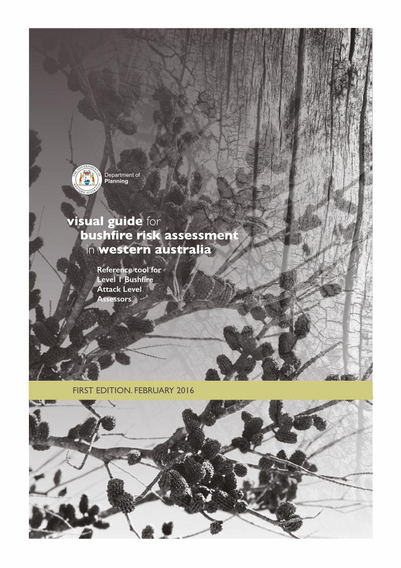
visual guide forbushfire risk assessmentin western australia
visual guide forbushfire risk assessmentin western australia
Reference tool for Level 1 Bushfire Attack Level Assessors
FIRST EDITION. FEBRUARY 2016

© State of Western Australia
Published by theDepartment of PlanningGordon Stephenson House140 William StreetPerth WA 6000
Locked Bag 2506Perth WA 6001
Published February 2016
website: www.planning.wa.gov.auemail: [email protected]
tel: 08 6551 9000 fax: 08 6551 9001National Relay Service: 13 36 77infoline: 1800 626 477
This document is available in alternative formats on application to Communication Branch.
Disclaimer
This document has been published by the Department of Planning. Any representation, statement, opinion or advice expressed or implied in this publication is made in good faith and on the basis that the Government, its employees and agents are not liable for any damage or loss whatsoever which may occur as a result of action taken or not taken, as the case may be, in respect of any representation, statement, opinion or advice referred to herein. Professional advice should be obtained before applying the information contained in this document to particular circumstances.
FIRST EDITION. FEBRUARY 2016
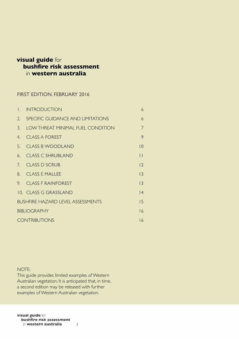
1. INTRODUCTION 6
2. SPECIFIC GUIDANCE AND LIMITATIONS 6
3. LOW THREAT MINIMAL FUEL CONDITION 7
4. CLASS A FOREST 9
5. CLASS B WOODLAND 10
6. CLASS C SHRUBLAND 11
7. CLASS D SCRUB 12
8. CLASS E MALLEE 13
9. CLASS F RAINFOREST 13
10. CLASS G GRASSLAND 14
BUSHFIRE HAZARD LEVEL ASSESSMENTS 15
BIBLIOGRAPHY 16
CONTRIBUTIONS 16
NOTE: This guide provides limited examples of Western Australian vegetation. It is anticipated that, in time, a second edition may be released with further examples of Western Australian vegetation.
3

4

Figure 1 Government legislation, policy documents and other publications
Department of Planningpolicydocuments
Planningbulletins andfactsheets
Othergovernmentdocuments
Legislation • Planning and Development Act 2005 and Building Act 2011 and supporting regulations– to be followed by duty holders and decision-makers.
• SPP 3.7 Planning in Bush�re Prone Areas and Guidelines for Planning in Bush�re Prone Areas: – to be given due regard by decision-makers
– recommendations should be followed by owners, developers and accredited individuals.
• Planning bulletins and fact sheets should be referred to for further explanation on duties.
• This and other related documents published by Government have no legal status and should therefore be used as per the purpose and application noted.
PurposeThis guide has been developed for use by individuals during Level 1 BAL Assessor training on classifying vegetation typically found in Western Australia using Method 1 in Australian Standard Construction of Buildings in Bushfire-Prone Areas (AS 3959). It has also been developed to assist suitably qualified and experienced practitioners’ understanding of BAL and Bushfire Hazard Level assessments.
The Office of Bushfire Risk Management (OBRM) has produced the Mapping Standard for Bush Fire Prone Areas, which outlines the criteria for determining whether vegetation is bushfire prone for the purposes of mapping bushfire prone areas of the State. The criteria in the OBRM standard differs from that contained in this guide, which is appropriate given that this document assists users to determine bushfire attack and hazard levels, whereas the OBRM standard supports a binary determination of ‘bushfire prone’ or not.
ApplicationThis guide has been produced to support delivery of the Level 1 BAL Assessor training by organisations recognised as accrediting bodies. Figure 1 illustrates where the guide sits in comparison with Government legislation and policy.
The guide should be used in conjunction with AS 3959. Decision-makers should use AS 3959 for making determinations and refer to this visual guide as a supporting tool.
BAL assessments (Case-by-case basis)The examples of vegetation classification in this guide are provided for class discussion during Level 1 BAL Assessor training. BAL assessments undertaken by Level 1 BAL Assessors require judgement of vegetation on a case-by-case basis and justification of the determination.
AcknowledgementsThe Department of Planning engaged Fire Protection Association Australia to develop this guide. Photographs were supplied (unless otherwise acknowledged) by bushfire consultants Roger Banks, Geoffrey Lush and Greg Penney.
5

For planning proposals and development applications, SPP 3.7 and the Bushfire Guidelines identify BAL and Bushfire Hazard Level assessments as a means of assessing bushfire risk. Part of these assessments requires vegetation to be classified into one of the seven categories defined by AS 3959, or as low-threat/non-hazardous vegetation.
2. Specific guidance and limitations1. Assessment of Vegetation
a. Classification of vegetation must not be solely undertaken on the basis of a single sampling area. Additionally, assessment of vegetation should avoid areas where changes in vegetation types occur or where modification of a vegetation class is evident. In these circumstances, multiple assessments should be carried out for each vegetation plot to provide a more representative assessment of the vegetation type.
b. The vegetation classification guidance provided in AS 3959 considers foliage cover to be the sole determining factor in the classification of vegetation. However, with respect to assessing the likely contribution to potential fire behaviour, it is often more important to consider vegetation structure rather than canopy cover. This is reflected in this guide and is underpinned by the mathematical modelling of radiant heat flux used in AS 3959. Canopy cover should not be relied on as the sole determining factor in vegetation classification.
c. Where ambiguity exists as to the classification of vegetation structure, the worst case scenario is to apply (being that which results in the higher level of radiant heat flux impact).
2. Assessment of Modified Vegetationa. Assessment of vegetation must account for
the mature vegetation structure as opposed to what the assessor observes on the day, for instance:i. For the purposes of AS 3959 Method 1
BAL assessment, areas of modified vegetation (unless maintained in a permanently minimal fuel state satisfying AS 3959 clause 2.2.3.2(f)) are to be assessed in their natural unmodified state.
ii. For the purposes of AS 3959 Method 1 BAL assessment, vegetation destroyed or damaged by a bushfire or other natural disaster is to be assessed on its revegetated mature state.
1. Introduction An amendment in 2015 to the Fire and Emergency Services Act 1998 provides the Fire and Emergency Services Commissioner with the power to make an order designating areas as bushfire prone.
The designation of areas as bushfire prone triggers requirements under the Planning and Development (Local Planning Schemes) Amendment Regulations 2015 and the Building Regulations 2012: � for the planning process, a Bushfire Attack Level (BAL) assessment in accordance with Australian Standard AS 3959-2009 Construction of buildings in bushfire-prone areas (AS 3959) will be required before the development of a single house or ancillary dwelling on a lot that is equal to or greater than 1,100m2, or any other habitable or specified building, on land that is identified on the Map of Bush Fire Prone Areas. Where the BAL rating is BAL–40 or BAL–Flame Zone, development approval will also be required; and
� for the building permit process, a BAL assessment will be required to be submitted for the building surveyor’s assessment in relation to Class 1, Class 2 and Class 3 buildings and associated Class 10a buildings or decks.
For BAL assessments, AS 3959 classifies vegetation into seven types. These are: � forest � woodland � shrubland � scrub � rainforest � mallee/mulga � grassland.
The aim of these classifications is to help determine the level of bushfire impact and construction requirements through the above-mentioned planning and building requirements, and application of the Building Code of Australia. They will also inform bushfire management measures developed in accordance with the State Planning Policy 3.7 Planning in Bushfire Prone Areas (SPP 3.7) and the Guidelines for Planning in Bushfire Prone Areas (Bushfire Guidelines).
This classification approach uses a generalised description of vegetation based on the Australian Surveying and Land Information Group (AUSLIG) classification system (Australian Natural Resources Atlas: No.7 – Native Vegetation), also referred to as the ‘Specht system’ (Specht, 1970). This has recently been replaced by the Native Vegetation Information System (NVIS), which is similar to the AUSLIG system.
6
b. In the absence of a specific Western Australian fuel hazard assessment guide for modified fuel loads, deviation from AS 3959 Table B2 may only be made through an alternative solution that can fully justify the variation in fuel loads. This explicitly falls outside the scope of an accredited Level 1 BAL Assessor and Level 2 Bushfire Planning Practitioner – Prescriptive and is not considered a Deemed to Satisfy solution in accordance with the standard provisions of AS 3959.
3. Classification of Vegetation Structuresa. The descriptors and examples of vegetation
found in Section 2 of AS 3959 are useful to an extent, but have limitations due to being based on a national system that cannot account for all variations at a local, regional or state level. This is because AUSLIG is aimed at a national characterisation of vegetation.
b. The underlying principle applied throughout this guide is that vegetation is classified on the basis of its contribution to fire behaviour and its relationship with the specific fire behaviour models adopted in AS 3959. Note: All references in this guide to fire behaviour models are a direct reference to the fire behaviour models adopted in AS 3959 (refer Table B1 of that document).
c. This means that, due to its structural form (layer of dominant trees), vegetation in this guide may be classified as a different type of vegetation to what it would otherwise be commonly classified under ecological classification systems due to its fire behaviour characteristics. An example of this is the ecological classification of rainforest.
d. Generally, vegetation assessed ecologically as rainforest, excluding that found in tropical areas, should for the purpose of fire behaviour be classified as Class A Forest.
e. Classification of forests and woodlands is based on a dominant tree species that forms a canopy and is clearly separated from understorey layers. In some locations, however, the differences in height between the uppermost layer of short trees and the next layer(s) down of shrubs are only marginal. Where these layers blend into each other to form a continuous layer of fuel from the ground to the canopy they should be regarded as tall heaths or scrub.
f. Classification of forests and woodlands under AS 3959 are based on foliage cover thresholds (<30 per cent for woodland and <70 per cent for forests). Assessment of these thresholds
should take into consideration seasonal constraints such as prolonged drought, poor tree health and changes in hydrology, which may result in foliage cover being sparser than would otherwise be the case if the vegetation was in a healthier state. A more accurate assessment can be undertaken by conducting multiple samples across a site and surrounding areas, and making the assessment based on the vegetation being in the healthiest possible condition.
7

Note: This section does not detail the low threat vegetation exclusions stated in AS 3959 clauses 2.2.3.2(a)-(d), which must be directly referred to. Level 3 Bushfire Planning Practitioners – Performance may be able to justify additional low threat vegetation classifications not expressly illustrated in this section.
3. Low threat minimal fuel condition
“Low threat vegetation, including grassland managed in a minimal fuel condition, maintained lawns, golf courses, maintained public reserves and parklands, vineyards, orchards, cultivated gardens, commercial nurseries, nature strips and windbreaks. Note: Minimal fuel condition means there is insufficient fuel available to significantly increase the severity of the bushfire attack (recognisable as short-cropped grass for example, to a nominal height of 100 mm).” AS 3959 clause 2.2.3.2(f)1
“Non-vegetated areas, including waterways, roads, footpaths, buildings and rocky outcrops.” AS 3959 clause 2.2.3.2(e)2
1, 2 Reproduced with permission from SAI Global Ltd under Licence 1510-c001.
A B
C D
E F
8
PHOTOGRAPHSA Orchard with mowed understoreyB Local government public open space with mowed grassC Local government public open space with mowed grassD Landscaped gardens in private estateE Rocky outcropF Golf course
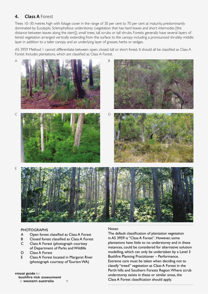
4. Class A ForestTrees 10–30 metres high with foliage cover in the range of 30 per cent to 70 per cent at maturity, predominantly dominated by Eucalypts. Sclerophyllous understorey (vegetation that has hard leaves and short internodes [the distance between leaves along the stem]), small trees, tall scrubs or tall shrubs. Forests generally have several layers of tiered vegetation arranged vertically extending from the surface to the canopy including a pronounced shrubby middle layer in addition to a taller canopy and an underlying layer of grasses, herbs or sedges.
AS 3959 Method 1 cannot differentiate between open, closed, tall or short forest. It should all be classified as Class A Forest. Includes plantations, which are classified as Class A Forest.A B
C D
E
9
PHOTOGRAPHSA Open forest classified as Class A ForestB Closed forest classified as Class A ForestC Class A Forest (photograph courtesy
of Department of Parks and WildlifeD Class A ForestE Class A Forest located in Margaret River
(photograph courtesy of Tourism WA)
Notes: The default classification of plantation vegetation in AS 3959 is “Class A Forest”. However, some plantations have little to no understorey and in these instances, could be considered for alternative solution modelling, which can only be undertaken by a Level 3 Bushfire Planning Practitioner – Performance. Extreme care must be taken when deciding not to classify “treed” vegetation as Class A Forest in the Perth hills and Southern Forests Region. Where scrub understorey exists in these or similar areas, the Class A Forest classification should apply.

5. Class B WoodlandTrees 2–30 metres high with foliage cover in the range of 10 to 30 per cent at maturity, predominantly dominated by Eucalypts and Acacias. Woodlands are dominated by trees but generally lack the shrubby middle layer and deep surface litter layer that is characteristic of forests and have a more grassy ground layer. Modelled using McArthur fire behaviour, assigned 15t/ha understorey with 25t/ha total fuel load. In accordance with AS 3959, vegetation identified as Class B Open Woodlands should be classified on the basis of the understorey.
A B
C
E
G
D
F
10
PHOTOGRAPHSA Banksia woodland (photograph courtesy
of the Department of Fire and Emergency Services)
B Class B WoodlandC Class B Woodland (grassy understorey)D Class B Woodland (grassy understorey)E Class B WoodlandF Class B WoodlandG Banksia woodland (photograph courtesy
of Department of Parks and Wildlife)

6. Class C ShrublandShrub vegetation less than two metres high. Also known as heath or shrubland. Modelled in AS 3959 using Catchpole [et al] fire behaviour, assigned 15t/ha understorey with 15t/ha total fuel load. Note: immature Class D Scrub must not be classified as Class C Shrubland. It must be assessed on its mature state being greater than two metres in height.
<2m
<2m
<2m
<2m
<2m
>2mScrub
<2m
A B
C D
FE
11
PHOTOGRAPHSA–F Class C Shrubland less than two metres
high
Note: Vegetation classified as Class C Shrubland can include significantly diverse variations as evidenced in the above photographs. The density and fuel arrangement of specific examples of shrubland vegetation could be considered for alternative solution modelling, which can only be undertaken by an accredited Level 3 Bushfire Planning Practitioner – Performance.
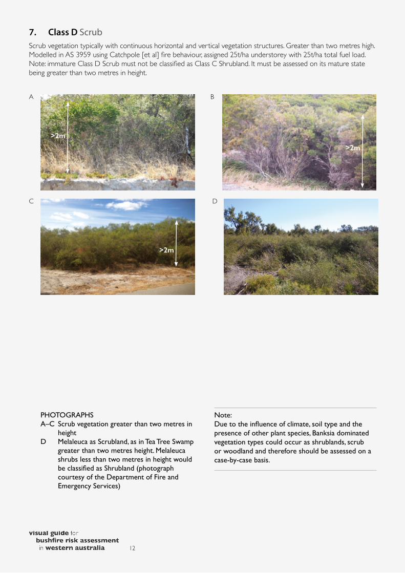
7. Class D ScrubScrub vegetation typically with continuous horizontal and vertical vegetation structures. Greater than two metres high. Modelled in AS 3959 using Catchpole [et al] fire behaviour, assigned 25t/ha understorey with 25t/ha total fuel load. Note: immature Class D Scrub must not be classified as Class C Shrubland. It must be assessed on its mature state being greater than two metres in height.
>2m
>2m
>2m
A B
C D
12
PHOTOGRAPHSA–C Scrub vegetation greater than two metres in
heightD Melaleuca as Scrubland, as in Tea Tree Swamp
greater than two metres height. Melaleuca shrubs less than two metres in height would be classified as Shrubland (photograph courtesy of the Department of Fire and Emergency Services)
Note: Due to the influence of climate, soil type and the presence of other plant species, Banksia dominated vegetation types could occur as shrublands, scrub or woodland and therefore should be assessed on a case-by-case basis.

9. Class F RainforestGenerally, vegetation assessed ecologically as rainforest, excluding that found in tropical areas, should for the purpose of fire behaviour be classified as Class A Forest.
Kimberley Carson Rainforest (photograph courtesy of Department of Parks and Wildlife)
8. Class E MalleeMulti-stemmed vegetation dominated by eucalypts. Typically less than 30 per cent canopy cover with an understorey of low shrubs or sparse grasses. Found in very limited areas of Western Australia between the Esperance Plains, Avon Wheatbelt and Coolgardie regions only.
Class E Mallee (photograph courtesy of Department of Fire and Emergency Services)
Note: In some situations, trees that have been cut down may coppice and form what appears to be a mallee form. Where vegetation appears to be consistent with mallee but is located in geographical areas away from known mallee communities, further investigation should be carried out to assess the correct vegetation classification based on the expected steady state of the vegetation over a reasonable planning horizon i.e. 30 years.
13
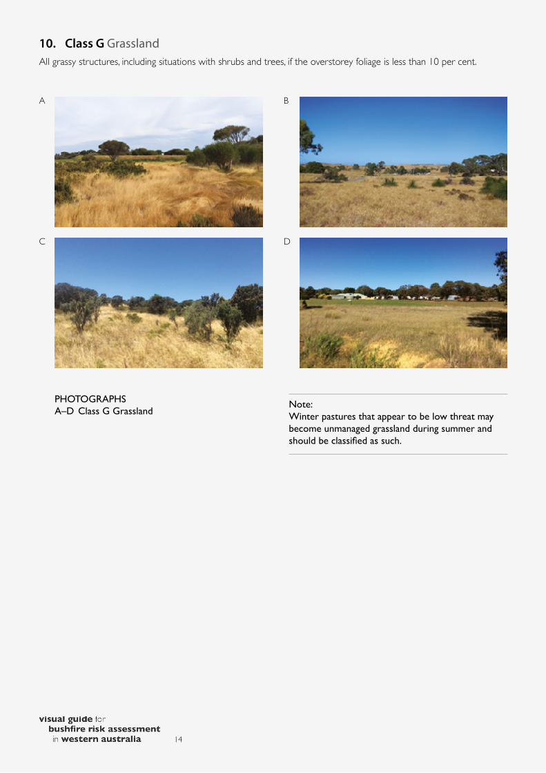
10. Class G GrasslandAll grassy structures, including situations with shrubs and trees, if the overstorey foliage is less than 10 per cent.
A B
C D
14
PHOTOGRAPHSA–D Class G Grassland
Note: Winter pastures that appear to be low threat may become unmanaged grassland during summer and should be classified as such.

Bushfire Hazard Level assessmentsA Bushfire Hazard Level assessment is a “broad brush” means of identifying the potential bushfire hazard level associated with a proposed development site. It is a qualitative assessment, typically using aerial or satellite imagery or physical site inspection, to identify vegetation structures that may have the potential to facilitate increased levels of bushfire behaviour. Bushfire Hazard Level assessments do not consider the level of hazard by land area or the scale of a development. By comparison, a BAL assessment is ground truthed, site specific and more accurately reflects potential bushfire impact in relation to a subject building.
It is important to acknowledge a qualitative Bushfire Hazard Level assessment is different to a quantified BAL assessment using AS 3959. Vegetation classifications are also different between the Bushfire Hazard Level assessment and AS 3959. Due to the variation in both assessment methodology and vegetation classification, care must be taken not to confuse the results of the various assessment types. For instance, an extreme hazard level does not necessarily mean land is unsuitable for development nor that it will have a BAL rating exceeding BAL–29. By comparison, a BAL–Flame Zone rating clearly demonstrates there is potential for significant bushfire impact and residential development is unsuitable in those areas.
As Bushfire Hazard Level assessments are designed as a strategic assessment, they are useful for determining whether a site requires further analysis of the level of bushfire-related risk.
Note: Due to the differences between the Bushfire Hazard Level assessment and AS 3959, completion or review of a Bushfire Hazard Level assessment is considered to be beyond the scope of accredited practice for a Level 1 BAL Assessor.
Note: Variations to the standard Bushfire Hazard Level assessment classifications (including reductions based on fuel structure modification or site parameters) are considered a performance-based design solution, which is work a Level 3 Bushfire Planning Practitioner – Performance will be accredited to undertake. Where alternative hazard levels are proposed, they must be fully justified using a comparative approach to the standard hazard level assessment standards.
15

BibliographyCatchpole, W.R., Bradstock, R.A, Choate, J., Fogarty, L.G.,Gellie, N., McCarthy, G.J, McCaw, W.L., Marsden-Smedley, J.B. and Pearce, G. (1998). Co-operative development of equations for heathland fire behaviour. In Proceedings 3rd International Conference Forest Fire Research and 14th Conference on Fire and Forest Meteorology (pp. 631-645). Luso, Coimbra: Portugal.
Douglas, Graham, Gooding, Owen and Leahy, Justine. (2014). Vegetation classes: Victorian bushfire management overlay. Burwood East, Victoria. Country Fire Authority.
New South Wales Fire Service. Classification of vegetation formations. Lidcombe, New South Wales: Author.
Specht, R.L. (1970). Vegetation. In Leeper, G.W. (Ed.), Australian Environment (4th ed., pp. 44–67). Melbourne, Victoria: Melbourne University Press.
Standards Australia. (2009). Australian Standard AS 3959-2009 Construction of buildings in bushfire-prone areas. Sydney, NSW. SAI Global Limited.
ContributionsOn behalf of FPA Australia, bushfire consultants: Greg Penney with Roger Banks and Geoffrey Lush.
Department of Fire and Emergency Services
Department of Commerce’s Building Commission division
Department of Parks and Wildlife
16