
Virginia’s Water Features Water and Virginia’s History Water features were important to the...
14
Virginia’s Water Features
-
Upload
august-hancock -
Category
Documents
-
view
230 -
download
1
Transcript of Virginia’s Water Features Water and Virginia’s History Water features were important to the...

Virginia’s Water Features

Water and Virginia’s History
• Water features were important to the early history of Virginia.
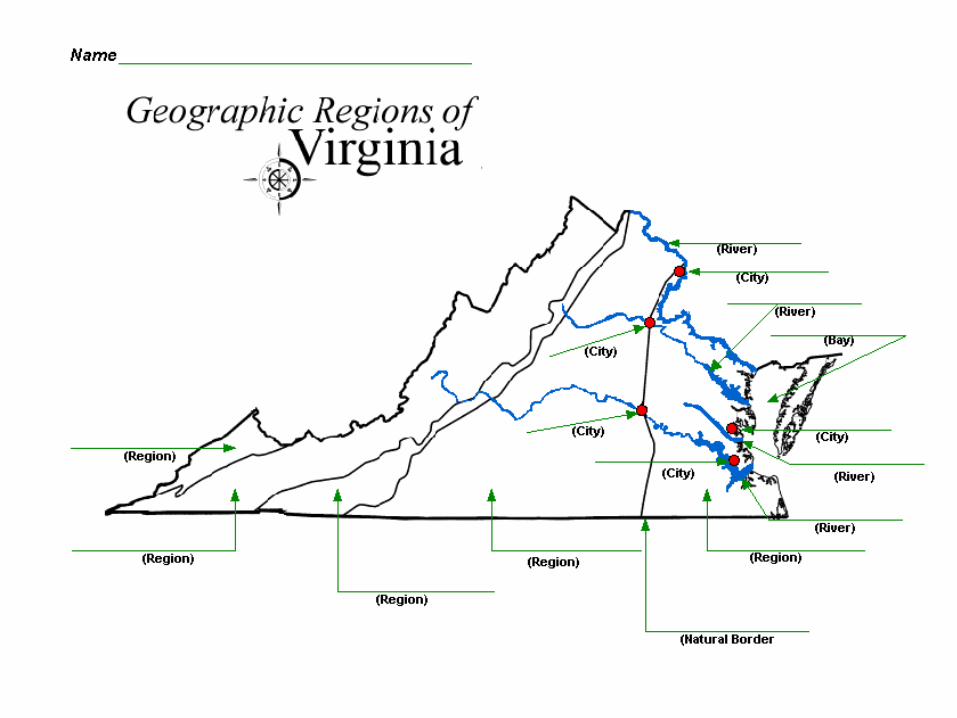
• Many early Virginia cities developed along the Fall Line, the natural border between the Tidewater (Coastal Plain) and Piedmont regions.

The Fall Line
• The Fall Line is where the land rises sharply and where the waterfalls prevent further travel on the river.

Development of Cities
• Cities developed in areas that had access to the Atlantic Ocean.
• The Atlantic Ocean provided transportation links between Virginia and other places such as Europe, Africa, and the Caribbean.

Development of Cities
• Cities developed around the mouth of the Chesapeake Bay.
• The Chesapeake Bay has rich natural resources and a natural harbor.
• Harbor – a part of water deep enough to anchor a ship.

Development of Cities
• Natural resources – things that exist in or are formed by nature.
• The Chesapeake Bay provided a safe harbor and was a source of food and transportation for early Virginians.

Virginia’s Four Major Rivers
• All of these rivers begin in the western portion of Virginia and flow eastward until they empty into the Chesapeake Bay.
• The four major rivers that flow into the Chesapeake Bay are separated by peninsulas.
• James River – Flows into the Chesapeake Bay. Richmond and Jamestown are located along the James River.
• York River – flows into the Chesapeake Bay. Yorktown is located along the York River.

Virginia’s Four Major Rivers
• Potomac River – Flows into the Chesapeake Bay. Alexandria is located along the Potomac River.
*The Potomac River forms the northern boundary of Virginia.
• Rappahannock River – Flows into the Chesapeake Bay. Fredericksburg is located on the Rappahannock River!

Virginia’s Four Major Rivers
• Each river was a source of food and provided a pathway for exploration and settlement of Virginia.

Lake Drummond
• Lake Drummond is located in the Coastal Plain (Tidewater) region.
• Lake Drummond is a shallow natural lake surrounded by the Dismal Swamp.

The Dismal Swamp
• Located in the Coastal Plain (Tidewater) region.
• A variety of wildlife live in the Dismal Swamp.
• George Washington explored and surveyed the Dismal Swamp.

Virginia’s Eastern Shore Peninsula
• Peninsula – a piece of land bordered by water on three sides.
• VA’s Eastern Shore Peninsula is separated from the mainland of Virginia by the Chesapeake Bay!

Virginia’s Eastern Shore Peninsula
• The Eastern Shore is a peninsula bordered by the Chesapeake Bay to the west and the Atlantic Ocean to the east.