Villages Strategy - Cootamundra–Gundagai Regional Council
56
Villages Strategy 2018
Transcript of Villages Strategy - Cootamundra–Gundagai Regional Council

Villages Strategy 2018

2
Villages Strategy
Drafted 2017
Adopted 2018
© Cootamundra-Gundagai Regional Council
Cootamundra-Gundagai Regional Council acknowledges the significant input given to this project by the Australian Rail and Track Corporation, Department of
Primary Industries, Goldenfields Water, Roads and Maritime Services and the keen members of the community.

3
Contents 1. Introduction 4
1.1. Message From the Mayor & General Manager 5
1.2. Purpose of the Villages Strategy 6
1.3. Strategic Context 7
1.4. Preparation of the Strategy 11
2. CGRC Wide Actions 12
2.1. Overview 13
2.2. Environment 13
2.3. Connections 14
2.4. Economic Opportunity 15
2.5. Planning Principles 16
3. Villages and Rural Communities 17
3.1. Adjungbilly 18
3.2. Coolac 19
3.3. Muttama 24
3.4. Nangus 26
3.5. Stockinbingal 31
3.6. Tumblong 39
3.7. Wallendbeen 41
4. Work Items 47
Samuel Matthews (9 years old) of Stockinbingal Primary School’s survey of the “perfect” village.

4
Introduction
Coolac Railway Yard

Introduction
1.1. Message from the Mayor & General Manager
We are pleased to announce the release of the Cootamundra-
Gundagai Regional Council Villages Strategy 2018.
The Cootamundra-Gundagai Regional Council area is home to a
number of diverse village communities. Set in stunning scenery with
proud histories, these communities offer lifestyle and housing
alternatives to our towns. Often located along major transport
corridors, our villages are emerging as economic drivers for the
growing services and logistics industry. By planning for growth, Council
can assist land owners and prospective villagers undertake
development today while not compromising the health and wellbeing
of future generations.
This strategy has been the result of robust community consultation and
background research. The feedback and conversations during this
process have been phenomenal and a testament to the passion and
dedication of our community.
Abb McAlister Allen Dwyer
Mayor General Manager
Mayor Abb McAlister & General Manager Allen Dwyer

6
1.2. Purpose of the Villages Strategy
The purpose of the Cootamundra-Gundagai Regional Council Villages
Strategy 2018 is to provide clear, strategic indicators for the
development of the villages of Cootamundra-Gundagai Regional
Council Local Government Area over the next 30 years and beyond. The
plan aims to inform residential and economic growth, whilst still being
flexible and responsive to opportunities.
By articulating the vision of the community through land use planning,
we are able to better use our land and manage competing demands for
that land. Future planning today, ensures that we will be operating and
developing in a more sustainable, prosperous and innovative manner
minimising adverse impacts on neighbours and ensuring quality of life
and service availability for future generations.
This strategy is based on extensive community consultation and
planning analysis to provide a blueprint for village planning and
associated projects. This process has focused on identifying community
direction with opportunities for growth, be that population and/or
economic. Actions to achieve these outcomes are listed and a works
schedule has been created to assist in the delivery of these actions. The
strategy will be reviewed every five years to ensure that emerging
trends and opportunities are captured.
The future vision of each village or rural community guides the
proposed land use planning actions and helps other decision makers in
the allocation of resources such as services and infrastructure. This
strategy provides the framework to deliver the community strategic
plan’s vision of “A vibrant region attracting people, investment and
business through innovation, diversity and community spirit.” At a
Council level, this strategy informs the Local Environmental Plan,
Development Control Plan, Contribution Plan, Development Servicing
Plans and Long Term Financial Plan.
Cootamundra-Gundagai Regional Council

7
1.3. Strategic Context
The Cootamundra-Gundagai Regional Council Villages Strategy was
developed over a 12 month period of consultation and review. This
section outlines the context within which this strategy was developed.
It is also worth noting that future review of some of these documents
will in turn refer back to this strategy such as the future amalgamated
local environmental plan and development control plan.
Community Strategic Plan: Our Place, Our Future 2018-28
The Integrated Planning and Reporting
framework for local councils was developed to
help Councils strengthen community
participation in decision making, provide
corporate strategic emphasis and reduce
duplication of work. As a part of this Integrated
Planning and Reporting framework, Council is
required to prepare a community strategic plan.
The community strategic plan is a ten year document with high level
objectives, developed by the community articulating the vision of “A
vibrant region attracting people, investment and business through
innovation, diversity and community spirit.”
The formulation of the community strategic plan is based on the
principles of equity, access, participation and rights. The plan takes a
holistic view of our community by addressing social, economic,
environment and civic leadership issues.
The key direction of “Sustainable natural and built environments: we
connect with the places and spaces around us” speaks directly to the
role and purpose of the Villages Strategy and demonstrates the
connection between the community strategic plan and this strategy.
Environmental Planning & Assessment Act 1979
The Environmental Planning & Assessment Act 1979 and associated
regulation legislate how local environmental plans and other planning
controls are to be created. The Villages Strategy aims to inform
changes to the existing Local Environmental Plans (Cootamundra and
Gundagai) and inform the forthcoming Cootamundra-Gundagai Local
Environmental Plan.
Objectives from the Act to encourage the proper management of land
have influenced and shaped a number of the actions and
recommendations of the Villages Strategy.
NSW 2021
The NSW State Plan is a 10 year plan to
guide policy and budget decision making.
NSW 2021 works in conjunction with the
NSW Budget to deliver identified
community priorities. It sets goals and
measurable targets outlining immediate
actions that will help achieve these goals. These goals reflect the
Government’s commitment to whole of State growth and delivery of
projects, to improve opportunities and quality of life for people in
regional and metropolitan NSW.
The Plan indirectly guides residential development through
infrastructure planning. Major infrastructure plans have been used to
inform, justify and support recommendations of the Villages Strategy.
8
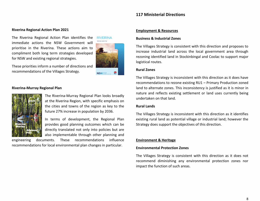
Riverina Regional Action Plan 2021
The Riverina Regional Action Plan identifies the
immediate actions the NSW Government will
prioritise in the Riverina. These actions aim to
compliment both long term strategies developed
for NSW and existing regional strategies.
These priorities inform a number of directions and
recommendations of the Villages Strategy.
Riverina-Murray Regional Plan
The Riverina-Murray Regional Plan looks broadly
at the Riverina Region, with specific emphasis on
the cities and towns of the region as key to the
future 27% increase in population by 2036.
In terms of development, the Regional Plan
provides good planning outcomes which can be
directly translated not only into policies but are
also implementable through other planning and
engineering documents. These recommendations influence
recommendations for local environmental plan changes in particular.
117 Ministerial Directions
Employment & Resources
Business & Industrial Zones
The Villages Strategy is consistent with this direction and proposes to
increase industrial land across the local government area through
rezoning identified land in Stockinbingal and Coolac to support major
logistical routes.
Rural Zones
The Villages Strategy is inconsistent with this direction as it does have
recommendations to rezone existing RU1 – Primary Production zoned
land to alternate zones. This inconsistency is justified as it is minor in
nature and reflects existing settlement or land uses currently being
undertaken on that land.
Rural Lands
The Villages Strategy is inconsistent with this direction as it identifies
existing rural land as potential village or industrial land; however the
Strategy does support the objectives of this direction.
Environment & Heritage
Environmental Protection Zones
The Villages Strategy is consistent with this direction as it does not
recommend diminishing any environmental protection zones nor
impact the function of such areas.

9
Heritage Conservation
The Villages Strategy is inconsistent with this direction as it seeks to
repeal the heritage conservation area in Stockinbingal. This is
considered minor, as all heritage listed items would remain and would
be better preserved should urban renewal occur in the precinct.
Housing, Infrastructure & Urban Development
Residential Zones
The Villages Strategy is consistent with this direction as it encourages
a greater diversity of housing type and tenure with the aim of making
effective and efficient use of existing and planned infrastructure.
Importantly, the Strategy seeks to minimise residential impacts on
other zones.
Caravan Parks & Manufactured Home Estates
The Villages Strategy makes provision and recommendations for short
term accommodation such as caravan parks and camp grounds in
certain areas. The objectives of this direction are supported and
complied with.
Home Occupations
The Villages Strategy is consistent with this direction as it aims to
continue and support home occupations in dwellings.
Integrated Land Use & Transport
The Villages Strategy is consistent with this direction as it promotes
greater employment opportunities and increases in services in villages,
thereby reducing the travel distances of residents.
Hazard & Risk
Acid Sulfate Soils
The Villages Strategy is consistent with this direction as it does not
propose development on land identified as containing acid sulfate
soils.
Mine Subsidence and Unstable Land
The Villages Strategy is consistent with this direction as it does not
propose development on land identified as unstable or in a mine
subsidence area.
Flood Prone Land
The Villages Strategy is inconsistent with this direction as there are
recommendations to rezone existing rural land which has been
mapped as flood prone to residential (village). This is considered minor,
as it is believed that this land has been incorrectly mapped and is
actually subject to inundation. Such land will not be rezoned until flood
mapping is renewed. Should the land identified to be subject to
inundation, development controls relating to floor heights will be
applied.
Planning for Bushfire Protection
Noting that review of the bushfire mapping for the local government
area will be undertaken in the near future, the Villages Strategy does
propose rezoning some land currently identified as being bushfire
prone, however is consistent with the objectives of this direction.

10
Regional Planning
Implementation of Regional Plans
The Villages Strategy has been formulated and influenced by the
Riverina-Murray Regional Plan and a number of actions and work items
are directly supported by the regional plan.
Local Plan Making
Approval & Referral Requirements
The Villages Strategy is consistent with this direction as it does not
include recommendations of provisions which would require the
concurrence, consultation or referral of development applications to a
Minister or public authority.
Reserving Land for Public Purposes
The Villages Strategy does not seek to create, alter or reduce existing
zones or reservations of land for public purposes and is consistent with
this direction.
Site Specific Provisions
The Villages Strategy does not propose any site specific works or
projects on land which would require spot rezoning and thus be subject
to a planning proposal. The Strategy is consistent with this direction.
Community engagement at the Wattle Time Fair 2017
11
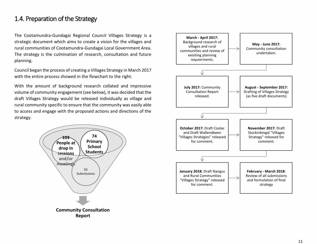
1.4. Preparation of the Strategy
The Cootamundra-Gundagai Regional Council Villages Strategy is a
strategic document which aims to create a vision for the villages and
rural communities of Cootamundra-Gundagai Local Government Area.
The strategy is the culmination of research, consultation and future
planning.
Council began the process of creating a Villages Strategy in March 2017
with the entire process showed in the flowchart to the right.
With the amount of background research collated and impressive
volume of community engagement (see below), it was decided that the
draft Villages Strategy would be released individually as village and
rural community specific to ensure that the community was easily able
to access and engage with the proposed actions and directions of the
strategy.
Community Consultation Report
92 Submissions
103 People at
drop in sessions and/or
meetings
74 Primary School
Students
March - April 2017:Background research of
villages and rural communities and review of
exisiting planning requierments.
May - June 2017: Community consultation
undertaken.
July 2017: Community Consultation Report
released.
August - September 2017: Drafting of Villages Strategy
(as five draft documents)
October 2017: Draft Coolac and Draft Wallendbeen
"Villages Strategies" released for comment.
November 2017: Draft Stockinbingal "Villages Strategy" released for
comment.
January 2018: Draft Nangus and Rural Communities
"Villages Strategy" released for comment.
February - March 2018: Review of all submissions and formulation of final
strategy

12
CGRC Wide Actions
Stockinbingal Recreation Ground

13
2.1. Overview
The villages and rural communities of the Cootamundra-Gundagai
Local Government Area are able to trace their early settlement to the
mid to late 19th century, with individual areas surveyed between then
and 1927.
The villages were originally service centres of agricultural communities
and often fulfilled the need for staging posts along major roads. Later
the majority of the villages and rural communities (bar Adjungbilly and
Nangus) were serviced by rail. Their role as service centres is
demonstrated by the urban form of these communities. Those which
serviced primary road corridors are centred on the road, while those
which became dependent on the railway as a local industry actually
turned away from the original “main street” and reorientated to the
railway corridor.
Future development opportunities were a key point to community
engagement It was important that along with background analysis of
growth potential, the existing community’s desires regarding growth
are taken into account. This is a critical outcome of this strategy as
recommendations to expand a village or rural community’s footprint
have to be well justified to satisfy the planning system in New South
Wales.
Access to services and businesses were explored, with economic
opportunities evaluated on a case by case basis. While there are many
barriers to commercial and industrial development in the villages,
there are also opportunities in these areas which are lacking in the
towns.
Recommendations for growth are individual. Each village and rural
community is separately addressed under Part 3 of this strategy.
2.1. Environment
Sustainability is crucial to the future viability of the region and small
communities like the villages and rural communities have a real
opportunity to be case studies and examples of sustainable
development and living. Individual to each village and rural community
are actions and directions to achieve this, noting the constraints such
as bushfire and flooding of each individual area.
Coupled with this is the need to protect and enhance habitat for native
flora and fauna. Villages and rural communities are often home to
remnant habitats which have been cleared elsewhere for agricultural
purposes.
Focus on environmental standards through the development control
plan will be able to achieve urban greening and regeneration of
remnant flora and fauna communities. Enhancing these areas also
provides additional economic opportunities for bird watchers and
promotes a sense of pride of place.
Action 2.1: Develop a “village” chapter in the Development Control
Plan which promotes passive environmental design in dwellings.
Action 2.2: Create a street tree master plan for all villages and rural
communities.
Action 2.3: All village subdivision is to have a minimum vegetation
requirement to enhance existing flora and fauna habitat.
Action 2.4: Stormwater networks will be designed to incorporate
water sensitive urban design principles.

14
2.3. Connections
The villages and rural communities of the Cootamundra-Gundagai
Local Government Area are all located along main roads and some also
have rail connections available.
The physical road connections between the villages range from
regional roads to federal roads. All of these roads have significant
freight movements each day. This high level of use, while demanding
of the road physically, ensures that generally roads connecting the
villages are to a high standard for C Class vehicles.
Recreational links between the villages and rural communities and the
towns are lacking. Recently, there has been a push to investigate rail
trails as a possible recreational link between the towns and villages. At
this stage, only the Tumut Branch Line, which runs from Cootamundra
to Tumut via Gundagai would be a viable option for this.
The proposed Rail Trail would be roughly 35 Kilometres between
Coolac and Tumblong, via Gundagai.
Another identified recreational track is a walking and riding trail along
the Murrumbidgee River between Gundagai and Nangus; roughly 30
kilometres. Such a track would be similar to the 27 kilometre
Murrumbidgee Discovery Track in the Australian Capital Territory. It is
envisioned that such a track could provide economic benefit to
adjoining land holders and Nangus who currently run, or could run,
accommodation services or hire services which could lease kayaks,
canoes, etc. to users seeking to recreate along the Murrumbidgee.
Existing and proposed recreational routes
Action 2.5: Develop a costed, route plan for a rail trail Coolac-
Gundagai-Tumblong.
Action 2.6: Survey Murrumbidgee walking and riding trail and
identify enabling works.

15
2.4. Economic Opportunities
The villages and rural communities of the Cootamundra-Gundagai
Local Government Area are all located along main roads with the
majority of identified economic opportunities related to tourism and
service provision for travellers.
These opportunities are further explored under each individual village
and rural community in Part 3 of this Strategy. However, some general
principles and general encouragement of new economic opportunities
and expansion of existing economic opportunities should be
stimulated.
Using natural advantages such as proximity to other centres and
leveraging of existing and planned infrastructure, the villages have
many advantages for people looking to start a business due to the low
buy in cost of real estate and the ability to tap into commuters as
customers.
Spheres of influence for CGRC's villages
Action 2.7: Dedicate an individual page to each village on the
Council’s website.
Action 2.8: Create a single brochure which covers the
Cootamundra-Gundagai Regional Council Local Government Area
promoting economic opportunities and experiences in the villages
and towns.
Action 2.9: Review Contributions Plans to identify opportunities for
funding for village works, which will also provide opportunity for
works in kind arrangements for developments in the villages.

16
2.5. Planning Principles
Each individual village and rural community presented a differing vision
for the future. It has become evident that there is no “one size fits all”
land use planning approach when dealing with the villages and rural
communities of Cootamundra-Gundagai Regional Council. The role of
the Villages Strategy is to provide clear strategic indicators for the
development of the villages of Cootamundra-Gundagai Regional
Council Local Government Area over the next 30 years and beyond. The
plan aims to inform residential and economic growth, whilst still being
flexible and responsive to opportunities.
Under Part 3 of this strategy, each village and rural community will
have a discussion if applicable, on the building form and scale of each
community and how that will be represented in planning legislation
such as through the local environmental plan and the development
control plan.
Based on the Villages Strategy, a hierarchy of potential future
residential settlement and economic expansion has been created to
help guide Council policy as well as informing the community
diagrammatically how their local government area is likely to change
over the next three decades.
Residential Hierarchy Projection 2048
Murray Street, Cootamundra’s tree lined verges add character and prestige
Stockinbingal
Coolac
Wallendbeen
Nangus
Tumblong
Muttama
Adjungbilly
Action 2.10: Create a how to guide for developing in villages.
Action 2.11: Implement zoning changes proposed for the villages
no later than 2020.
500+
200+
Water & Sewer
Water
Water
Water

17
Villages & Rural Communities
Canola time around Cootamundra

18
3.1. Adjungbilly
Adjungbilly is the smallest of the rural communities in Cootamundra-
Gundagai Regional Council. Unlike other centres, it lacks a distinct
urban form and can be generally assumed to centre on the Bongongo
Public School which doubles as the community hall.
Adjungbilly is set atop a picturesque hill scape serving agricultural
purposes. Significant road upgrades have improved access over the
years, however accessibility and access to services are still a challenge
for most residents. Forestry is a major industry in this community with
large swathes of land dedicated to state forest pine plantations. Many
historical private plantations also exist. These plantations often cause
friction with adjoining land holders who battle weeds and feral animals
which shelter in these forests.
Opportunities for residential growth and/or economic expansion in
Adjungbilly were not identified through community engagement and
the lack of built form makes it difficult to identify opportunities.
Adjungbilly Community Hall
Adjungbilly Locality
The Native Geranium & the Superb Fairywren are both found in Adjungbilly
Action 3.1: Support community initiatives to renovate and expand
the usage potential of the Adjungbilly Community Hall.
Action 3.2: Partner with the Department of Education in delivering
improved recreational facilities that can be used jointly by the
school and community.
Action 3.3: Further investigate land use and zoning of Adjungbilly
as a part of the Rural Lands Strategy.
Adjungbilly Road
Adjungbilly
Creek
Cemetery

19
3.2. Coolac
Overview
Located on the Hume Highway and connected to the main southern
railway line via Cootamundra since 1885. Coolac has served
continuously since European settlement in the early 19th century as a
travellers and freight service centre. Coolac has also seen periods as a
mining town, dairy country and grazing country.
With Gundagai so close and
railway connection to the
larger towns of Cootamundra
and Tumut, Coolac’s
population growth was never
assured as there has not been
a requirement to develop a
larger residential service
industry beyond a general
store.
Coolac is noted for a number
of historical buildings,
particularly the Beehive Hotel,
Windmill Cottage, churches
and numerous 19th century
homes.
Coolac has a strong military
history, with a particularly
strong showing in the Second
World War. The Coolac
Memorial Hall was built with
funds raised by the
community and today serves as an iconic Coolac building which is used
extensively by the community.
Urban Form
Coolac was proclaimed a village on 20th March 1885. The southern
section of Coolac known as Pettit displays a traditional grid layout.
With the Hume Highway running through Coolac until 2013, the main
buildings of Coolac were spread out along this road. There was no
denser settlement of houses with most residents being either
surrounding farmers or shop keepers.
No reticulated water is connected to the village at this point in time.
However, Council plans to extend potable water to Coolac in the short
term, to support industrial, commercial and residential growth. Most
dwellings have a septic system, though it is expected that some
systems are failing and some dwellings do not treat their sewerage.
The main road, Coolac Road, is a well formed two way highway. Now a local road after the bypass, this road offers greater capacity than that which is required and offers opportunities for amenity improvements (such as tree plantings) and the capacity to utilise the road reserve for temporary events.
Coolac Goods Shed is one of the only station buildings still remaining in the village
Coolac Road
Hume Highway
Tumut
Branch Line
Pettit
Muttama Road
Coolac
Village
Centre
Coolac Locality

20
Infrastructure
Coolac is centred on the intersection of Muttama Road and the Hume
Highway, with the southern portion of Petitt centred on the
intersection of Gobarralong Road and the Hume Highway. These
intersections are entry points from the Hume Highway to Muttama,
Cootamundra and Adjungbilly. Some major roads are sealed, with
Coolac Road and Gobarralong Road able to take heavy vehicles. The
majority of roads in the Coolac community are unsealed. The state and
schedule for grading of these roads was raised during community
consultation as a concern; however overall the roads would be
classified to be in a good condition.
The branch line from Cootamundra to Tumut ran through Coolac with
the town serviced by a station and goods yard. A platform in Pettit
(known as Pettitts) was constructed in 1946. Most stations on the
Tumut Branch Line were closed in 1975, however the line was not
officially abandoned until 1984 when floods damaged the line. The
Hume Highway bypass of Coolac lifted part of the railway line, meaning
that any reopening or reuse of the Tumut Branch Line would require
acquisition and construction of a new portion to traverse the Hume
Highway. The option for conversion to a rail trail has been raised. A 35
kilometre rail trail is proposed from Coolac to Tumblong via Gundagai.
This is seen as not only a recreational link between these villages and
Gundagai, but also a tourism driver and an option for commuting
between the town and villages.
Potable water is not connected to Coolac at this point in time with
Muttama Creek and Daisy Bed Creek being key water channels which
some pump from. A number of residents have bores and some rely
solely on rainwater and trucked water. Recent commitment by Council
to connect Coolac to potable water in the short term means that
potential residential development can be intensified and opportunities
are greatly expanded for commercial and industrial development.
Coolac residents rely on septic systems, however it is likely that some
houses may have failing septic systems or even no treatment system
at all. Particularly with the addition of potable water, Coolac will be an
area for septic tank inspections and compliance into the future.
There is no stormwater network in Coolac. Noting the significant run
off issues from the Hume Highway and Muttama Road, mapping and
creating a stormwater network will be a priority for Council. Integrating
a stormwater network with street trees could be an option for
achieving multiple outcomes with one project.
Energy is available via poles and wires, however connection to natural
gas is not available. A bottle service does deliver to some residences.
NBN coverage of Coolac will be through Skymuster satellite
technology. If the system works as intended, it may offer Coolac a
digital advantage for population growth with more people able to work
remotely and ease of opportunity for people to establish home
businesses, connect with specialists and operate in virtual markets and
workplaces.
Recreational infrastructure is available in Coolac. The recreation
grounds adjacent to the Coolac Memorial Hall have public toilets, a
number of playing fields, cricket nets, tennis courts, seating and so on.
Unfortunately the recreation ground and its facilities, while loved by
the community, have significant maintenance issues which make them
almost unusable.
Action 3.4: Stage rezoning and development along existing roads.
Action 3.5: Masterplan potable water infrastructure to maximise
lot yield for future development potential.
Action 3.6: Support community initiatives to renovate and expand
the usage potential of Coolac Memorial Hall and Recreation
Grounds.

21
Services
Coolac Provisional School was opened in February 1872 and became a
public school in 1874. Provisional schools required a minimum of 15
children to be established and conversion to a public school required
25 pupils. Coolac Public School was closed in 1981. The school is now a
privately owned residence and children in Coolac either attend school
in Jugiong or Gundagai.
The Coolac Post Office was established in 1870, notified by the
Government Gazette on Wednesday, 29 June 1870. Today the post
office is operated out of the General Store.
Increased road usage means that commuters and freight drivers are looking for an all-purpose
rest and amenity location.
Opportunities
Location
The location of Coolac, being 1.5 hours from Canberra, one hour and
fifteen minutes to Wagga Wagga, fifty minutes to Tumut and two hours
to Albury-Wodonga places Coolac as an ideal location to stop, revive
and survive. With a growing focus on healthier food alternatives,
organic produce and unique experiences, Coolac has the opportunity
to become a premier rest stop location synonymous with offering
quality food, opportunities for letting dogs off lead and allowing
children to play before getting back on the road.
In the short to medium term, opportunities can be created to allow
growth of industry and population within the community by rezoning
to allow for as many compatible land uses as possible. Designating
Coolac as a location where people can experiment and try new things,
will present Coolac as a destination for “tree changers” and other
entrepreneurs to trial new methods and ideas for the transport service
industry. A long term measure of success will be successful approval of
brown tourist signage promoting the 4 kilometres of Coolac Road as a
scenic route.
Action 3.7: Support residential growth to ensure existing services
are maintained in Coolac.
Action 3.8: Improved directional and promotional advertising
signage to Coolac.
Action 3.9: Support development which caters to the road
transport and tourism industry.

22
Agriculture
There are a number of small holdings around Coolac and historically
the area has been noted as being prime dairy country. Feedback has
indicated a desire for Coolac to be explored as a small farms
community, with opportunities for market gardens, speciality farms
and small farms which could be harmonised with a service industry
element such as cafés, nurseries, permaculture schools, farmstays and
so on. Digital opportunities are also available with connection to the
NBN, meaning that small holdings in Coolac could blog about their
experiences and sell products online.
In order to achieve this, alternate zoning must be applied to Coolac as
the current zoning of RU1 – Primary Production limits holdings to 40
hectares and the SP3 – Tourist zone prohibits residential
accommodation. RU5 – Village would be appropriate for the majority
of Coolac however other uses central to highway services such as
service stations, restaurants and so on; will need to be considered
under alternate zoning or as additional permitted uses. Community
consultation highlighted that the people of Coolac want their
community to grow and that there be ample opportunity for people to
create acreage lots/farmlets with ancillary cafes, bed and breakfasts,
road side stalls and so on. A residential containment border and
minimum lot size of 2 hectares for residential development on the
village centre’s outskirts should be established to limit the
infrastructure burden on Council and maintain a village feel.
Fledgling farm gate industry is beginning to develop in Coolac.
Coolac and Muttama Road Intersection
The land surrounding the Coolac and Muttama Road intersection is a
highly trafficked area affording the most opportunity for highway
service industries. Noting that some service industries such as service
stations, mechanics and pubs can be incompatible with residential
precincts, it would be prudent of Council to limit the spread of such
land uses. Key to success of this precinct is for people to be able to park
their vehicle and walk to a number of different experiences. Pedestrian
mobility should be considered as a long term measure of success for
this precinct. Formalised car parking is apparent in the vicinity of the
Memorial Hall and General Store. Car parking is also available for
patrons at the Beehive Hotel. A priority to facilitate commercial success
of this area will be the creation of a pedestrian network connected to
businesses, attractions, amenities and car parking. Car parking must
include provision for trailers,
caravans and trucks.
Action 3.10: Rezone Coolac
Village to be a mixture of
RU5 – Village to support
residential and commercial
growth.
Action 3.11: Rezone north
of Muttama Road and east
of Coolac Road to be
suitable for industrial
development.
Action 3.12: Create a
movement plan for Coolac. Potential commercial and industrial activity area

23
Coolac Road
Formerly the Hume Highway, Coolac Road is an asset for the Coolac
community. The wide road reserve offers opportunities for signage,
road side stalls, food vans, markets and other pop up events. A key
project identified through consultation was to create a statement
feature for Coolac. Options include a grand tree lined avenue and/or
art trail.
Tree lined avenues create statements and formulate positive
impressions of an area. Particularly when the trees change with the
seasons offering year round scenic opportunities. However, trees,
particularly large trees can be a maintenance burden through limbs
dropping and interference with road pavement integrity. Coolac Road
has powerlines which would limit some tree planting on the western
side, however the wide road reserve means that this can be worked
around. Tree planting should be investigated for Coolac Road as it
would improve amenity, be a statement feature and assist with
stormwater runoff.
Roadside art is an option which could be incorporated into the Coolac
Road streetscape or even the railway corridor. Many rural towns have
transformed their local economy through public art such as Sheffield
in Tasmania with its famous murals and the annual Mural Fest event.
As the birthplace of the Bald Archies, it is clear that Coolac has a
humorous view as to “serious” art and any art trail or project would
have to be reflective of the people of Coolac. Local history, stories,
people and events could be immortalised through mural, sculpture,
poetry, story and so on, providing a more interactive experience which
would require people to take a walking tour of Coolac Road to truly
appreciate the displays.
Action 3.13: Support the establishment of street trees and urban
greening along Coolac Road.
Action 3.14: Instigate the establishment of the “Coolac Art Trail.”
Action 3.15: Investigate options of incorporating Coolac Road into
the proposed Rail Trail as a method of bridging the “missing link.”
An art trail does not limit the scope for imagination. Clockwise from left: "Eat for England" a part of the Wildspace Network Art Trail, "1833" sculpture at Battery Point in Tasmania, “Cribs” by Brenda Baker and “Carhenge” by Jim Reinders.

24
3.3. Muttama
Overview
Muttama Run was listed as a pastoral licence to F Tait in 1845, but it
was gold which emanated this community. Gold mining commenced
on the Muttama Reef Mine in 1862, after being notified as a part of the
South Western District Gold Fields on 13 October 1861. In 1882,
roughly 800 men were known to have been prospecting in Muttama,
meaning that it is likely that Muttama had a population of over 1,000
people for a time.
Muttama Reef Post Office was opened 1 February 1876, renamed
Muttama Post Office in 1889 and closed 12 October 1979.
The Tumut Branch Line was constructed in the mid-1880s, with
Muttama Station opening 1 June 1886. The station was closed in 1975
and the Tumut Branch Line was abandoned in 1984. Unfortunately the
station and platform were demolished, though the station masters
residence remains.
Muttama was home to 21 men who served in World War One, four of
which were killed. 45 men and women served in World War Two, four
of which were killed. Those who gave their lives are immortalised in
remembrance gates to the recreation ground built in 1947.
Muttama Station in 1975 © Mark Zanker
Muttama Locality
Action 3.16: Improve access to and amenity of Muttama cemetery.
Cemetery
Burra Road
Muttama Road
Recreation
Ground
Tumut
Branch
Line
Muttama
Hall
Muttama
Creek

25
Opportunities
Travelling through Muttama along Muttama Road (Hoskins Street)
despite being signposted from 100 kilometres per hour to 80
kilomteres per hour it is not always clear to people that they have
passed through Muttama. Lowering the speed limit further to 60
kilometres per hour was suggested during consultation, however the
amount of entry and exit points and number of vehicle movements
does not warrant 60 kilometres per hour at this time. If the aim is not
necessarily to get people to stop in Muttama, but rather recognise that
they are passing through Muttama, then this can be achieved through
more obvious welcome signs at either end of Hoskins Street and
highlight tree planting.
As a point of interest a sculpture come direction sign should be placed
at the intersection of Hoskins Street and Bridge Street to direct any
who are interested to the Muttama Hall and the recreation ground. At
the Hall a community notice board and information on the history of
Muttama should be erected as a method of communicating with the
Muttama community and visitors alike.
Upgrades and necessary repair work at the Muttama Hall are made
complicated by a lack of leadership from Council over the years, the
age of the Hall (built 1925) and the differing priorities of committee
members. A practical approach may need to be taken to evaluate the
cost of repairing and bringing the Hall to a usable standard versus
demolition and construction of a new facility – however that is a
community decision.
The recreation ground being Crown Land is able to apply for grants
should a committee of management be formed which complies with
standards required by Crown Lands. In this instance, Council could
offer an assisting role in helping the committee of management lodge
necessary documents for recogition and endorse subsequent grant
requests such as requests for funds to upgrade the tennis courts.
Maintenance and signposting of the cemetery was seen as a priority of
the residents of Muttama. Creating a clear entryway from Muttama
Road to the cemetery using structures such as a gateway and/or trees
to signify that this is the entrance would be necessary. Safety was also
raised as a concern with the current gate operation requiring visitors
to park on the side of a regional road and wrestle with the farm gate.
Installation of a cattle grid is an option, if Short Street (designated,
unformed road from Muttama Road to the cemetery) is unable to be
fenced off.
The cemetery itself is a protected area and for some months of the year
the cemetery is not able to be mowed. To ensure that graves are still
accessible, creating a pathway to the various grave areas would reduce
snake danger and improve mobility for elderly and less mobile people.
Noting that Short Street is unformed nor physically seperated from the
neighbouring paddock, establishment of a clearly signposted and
maintained parking area should be investigated.
Rather lacklustre entry
Action 3.17: Highlight tree plantings, directional signage and clear
entry points to Muttama to be prioritised.
Action 3.18: Support the Hall and Recreation Ground Committees
to source funds for upgrades and promote usage of facilities.
26
3.4. Nangus
Overview
The “Nangus” Run was mentioned in the Government Gazette on the
8th of November 1845 as being a pastoral licence in favour of James
and William MacArthur, the sons of John MacArthur, the Australian
wool pioneer. James and William ran sheep of the famous MacArthur
bloodline on their Nangus property. In the following decades, Nangus
is mentioned sporadically in gazettes due largely to the Nangus Road
which was a main road between Gundagai and Wagga Wagga.
Despite being only gazetted as a village in 1925, it is clear that the
Nangus community existed well before this as demonstrated by
numerous mentions of local dances and meetings in newspapers.
With the decision to name Canberra as the capital in 1908, thought was
turned to connecting the new capital to Sydney and Melbourne via
direct train line, with an eventual direct rail connection to Perth via
Adelaide. A popular proposal at the time was to construct a railway
from Junee to Canberra which would have been routed through
Nangus and Gundagai. The route of Sydney-Goulburn-Canberra-
Gundagai-Nangus-Junee-Wagga Wagga-Albury was to become the
Main Southern Line. The former Main Line via Harden was to become
the Riverina Line which would then travel through Cootamundra West
to Stockinbingal. The line running between Cootamundra and Junee
was to become a branch line. The Depression and Second World War
thwarted these plans however and the Main South Line was retained
and duplicated between Cootamundra and Junee. The survey of the
proposed Nangus Railway line had occurred in 1925, so it is conceivable
that the original survey of the village of Nangus was done as a result of
this.
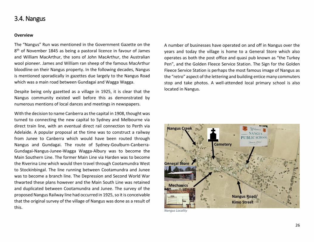
A number of businesses have operated on and off in Nangus over the
years and today the village is home to a General Store which also
operates as both the post office and quasi pub known as “the Turkey
Pen”, and the Golden Fleece Service Station. The Sign for the Golden
Fleece Service Station is perhaps the most famous image of Nangus as
the “retro” aspect of the lettering and building entice many commuters
stop and take photos. A well-attended local primary school is also
located in Nangus.
Nangus Locality
Cemetery
Nangus Road/
Kimo Street
Mechanics
General Store
Nangus Creek

27
Urban Form
Nangus is laid out in a grid pattern which parallels Kimo Street (Nangus
Road). The layout and form has not altered since the village was
surveyed in 1925, however many residential holdings encompass more
than one lot. This is a combination of requiring space for a septic
disposal area and access to bores and/or rainwater tanks.
All streets lack formal curb and guttering and no stormwater network
exists. During inundation events, this leads to excessive pooling and
detention issues particularly along Kimo Street. A footpath exists,
running along Kimo Street and Hulong Street. Council intends to extend
the footpath along Kimo Street in two future stages, first to the
Memorial Hall and then on to the General Store.
While there are no formal street trees in Nangus, the southern side of
the Kimo Street road reserve has naturally occurring gums and other
natives growing. Aside from the school, the Nangus cemetery,
Memorial Hall and recreational grounds are on the northern side of
Kimo Street and are the main community facilities of the village.
Infrastructure
Nangus is centred on Kimo Street which forms part of Nangus Road –
a regional road linking Gundagai and Junee. A footpath exists along
parts of Kimo Street and Hulong Street; however the village is currently
devoid of stormwater, water or sewer infrastructure. As a part of the
Merger Implementation Funding for the amalgamation of former
Cootamundra and Gundagai Shires, funds have been set aside to
connect the village of Nangus to reticulated water. This is expected to
raise the desirability of Nangus as an alternate lifestyle option and may
result in future residential subdivision and growth.
NBN coverage of Nangus is through Sky Muster which is a satellite
service offering Nangus a digital advantage for population growth with
more people able to work remotely and ease of opportunity for people
to establish home businesses, connect with specialists and operate in
virtual markets and workplaces.
Recreational infrastructure is available in Nangus with the playground
collocated with the Nangus Memorial Hall on Kimo Street. The
playground is identified under opportunities and constraints as a key
site for renewal.
Services
Nangus has been serviced by a public school since 1935. Nangus Public
School operated with 27 students in 2017. Nangus Public School has
two fulltime teachers and extra assistance for specialised teaching and
administration. Along with the low student to teacher ratio, these
facilities are very attractive to parents with children which may require
more attention. The school has been a driving force behind a lot of
improvement works around Nangus and as with most villages, the
school is considered the heart of the community.
A post office servicing Nangus has been operating since 1 July 1897.
Today the post office is located on Kimo Street as a part of the General
Store.
Action 3.19: Conduct a stormwater analysis of Nangus.
Action 3.20: Create a street tree masterplan for Nangus.
Action 3.21: Support the implementation of potable water
connections to existing residents and identify other urban release
areas which can leverage off this asset.
Action 3.22: Support residential growth to ensure viability of
Nangus Public School and other services.

28
Opportunities
Location
The location of Nangus, being 15 minutes from Gundagai offers the
village as a residential lifestyle alternative to Gundagai. The Nangus
Road is the main route from the Hume Highway to Junee which could
afford the village opportunity to capture passing vehicular traffic.
In the short to medium term, opportunities can be created to allow for
residential infill growth in Nangus and support the service and amenity
industry. Particular attention needs to be focused on wayfinding and
signage around Nangus. Tourism traffic to Junee from the Hume
Highway is a significant contributor to vehicle movements along
Nangus Road and through Nangus.
Economic activity off the back of unique experiences and amenities will
ensure that opportunistic visitors will plan all future trips to include a
rest stop and/or stop over in Nangus or see it highlighted as “the route
to take” for travelling to Junee.
Recreation
Nangus’ recreation precinct is largely centred behind the Memorial
Hall and contains a playing field and playground. The grounds are
largely maintained by the community. Installation of an irrigation
system and an increase in the variety of sports and recreational
activities which could take place on the grounds would ensure that the
area is continuously used. The locality and access to newly renovated,
accessible toilets, means that facilities such as a picnic area could be
multipurpose as an unofficial rest area along Nangus Road, area for
people to have a picnic and use the recreation ground and/or
playground and could be a meeting place for annual cemetery visits
and grave tidy ups.
Improvement of the existing playground will expand the ages which
the playground appeals to and by collocating other activity areas such
as cricket nets and a half court, children and teenagers can overlap in
their recreational experience and there will be greater opportunities
for imagination play.
Ornamental entry gates to the recreation ground and fencing to
designate playing fields would assist in distinguishing the area from the
surrounds and be eye catching to passing motorists; such gates could
also be replicated in a similar style for entry to the cemetery.
Community precinct layout
Action 3.23: Support the Hall and Recreation Ground Committees
to source funds for upgrades and promote usage of facilities.

29
Agriculture
Sheep farming is the main agricultural activity undertaken around
Nangus and even the village of Nangus has the odd sheep or two to
keep the grass down on village lots.
Without a Rural Land Strategy to accurately map and evaluate the
agricultural potential of land in the local government area, it would be
pre-emptive to suggest what agricultural activity is best suited to the
Nangus area. However, smaller, fragmented acreages could flourish
surrounding Nangus if they are connected to the new reticulated water
service. These acreages can play a role in the supply of land for
marginal and boutique agricultural pursuits such as heritage animal
breeding, market gardens and the like. These small farm enterprises
are often the backbone to local markets and small grocers.
Proposed village and surrounding acreage expansion
Connection to Gundagai
Nangus is socially and historically connected to Gundagai. The Nangus
Road was an original regional road connecting Gundagai and Wagga
Wagga. Kimo Estate is a historically significant station being the
remainder of “Kimo Run”. Kimo Estate has been diversified beyond just
agriculture to provide facilities for functions and short term
accommodation which would be complimented by increased use of
the Murrumbidgee River and a recreational route to Nangus.
Creating a trail along the Murrumbidgee River or Nangus Road, could
be used by cyclists, walkers, horse riders and so on. This would increase
tourism in the area and provide opportunities for education on the
history of the district and identification of native flora and fauna.
Should a trail between Gundagai and Nangus be successful,
opportunities would exist to expand the trail to connect communities
such as Wantabadgery, Oura and even Wagga Wagga.
A walking and riding along the Murrumbidgee River offers opportunities for recreational activity but also opportunities for businesses and land holders to cater to these people’s needs.
Action 3.24: Support development of small farm enterprises in
identified areas surrounding Nangus.
Action 3.25: Rezone to expand the RU5 - Village zone and RU4 –
Primary Production Small Lots as proposed, with all lots in the RU5
Zone to be connected to potable water.
Action 3.26: Survey and determine route for a walking and riding
trail from Gundagai to Nangus along the Murrumbidgee River.

30
Kimo Street
Aside from formalising the recreation ground and incorporating
activity from the Memorial Hall and cemetery into the precinct, the
general amenity of Kimo Street could be improved over time with some
small and large projects. Formalised street trees add character to any
street and Nangus already has a good collection of native trees along
the southern side of Kimo Street which could be expanded upon. Any
tree planting needs to be mindful of the powerlines running along Kimo
Street.
Kerb and guttering would assist in dealing with stormwater pooling as
well as adding a “neatness” quality to Kimo Street. However, current
table drains could be re-dug and the lack of kerb and guttering does
contribute to the rural character of the village. Kerb and guttering is
not recommended as a part of the 2018 strategy, however should be
revisited in subsequent reviews and once a stormwater analysis is
conducted.
Homage to the current and historical sheep farming could be
considered as a road side art project, which would become a point of
interest to those travelling through Nangus, but also educate about the
history of the area.
Signage into the village is essential for identity and to denote the
significance of Nangus as a village and not a rural community.
Public art which speaks to the agriculture primacy and heritage of the Nangus area would add character and interest to Kimo Street. The above sculptures have been used to a similar effect in Uranquinty. Two art displays at the eastern and western ends of Kimo Street would also assist in creating clear entry points.
Action 3.27: Create a clear entry points to Nangus along Kimo
Street through signage and public art.
Action 3.28: Extend the footpath network in conjunction with
street tree plantings along Kimo Street.
New village entry signs which are attractive and informative, while minimising distraction will be placed on the approaches to Nangus on Nangus Road.

31
3.5. Stockinbingal
Overview
Stockinbingal, having been notified prior to the construction of the
railway (Lake Cargelligo Branch Line) developed a basic commercial
district along Martin Street. The Stockinbingal Hotel, Commercial Bank
and other merchants were located along Martin Street. Commercial
development began along Hibernia Street after the construction of the
railway.
The purchase of the Commercial Hotel by Thomas Ellwood in 1909 was
to have a profound impact on the prestige and architecture of
Stockinbingal. Mr. Ellwood modified the Commercial Hotel from a
single storey weatherboard building, to a two storey brick premises
with an impressive 12 foot wide lace work balcony dominating the
intersection of Dudauman, Martin and Hibernia Streets. A wing was
added on in 1913 which provided more lodgings and opportunities for
two commercial tenancies. During this time, Thomas Ellwood also built
Ellwood Hall which was of a similar architectural style as the new wing.
Shop fronts were installed at the front of the Hall – one of which serves
today as the Stockinbingal Post Office. The Hall was a common meeting
place for the Stockinbingal community with dances, meetings and films
regularly shown.
Stockinbingal has a proud military history with a number of residents
serving in both world wars and subsequent conflicts. 75 men are listed
as having served in World War 1 on the Stockinbingal Honour Roll, 18
of which died on active service. 102 men served in World War 2 and 12
women, 4 of whom died.
Stockinbingal Locality
Ellwood's Hotel in the early 20th century
Cemetery Proposed
Inland Rail
Burley Griffin
Way
Stockinbingal Road
Lake
Cargelligo
Branch Line
Recreation
Ground
32
Urban Form
While Stockinbingal grew due to the railway, settlement occurred as
early as 1881 and was centred on what was then the road to
Wallendbeen being Martin and Hoskins Streets. With the railway built
in 1883, commercial and residential development was planned in
parallel to the rail line as shown with Troy, Temora, Hibernia and Wood
Streets.
The urban form and lot layout of Stockinbingal remains almost exactly
the same as the town plan in 1885, with quarter acre blocks along Troy,
Hibernia and Martin Streets and half acre blocks in the streets behind
these. Larger one and two acre blocks were designated to the east of
the creeks.
Today, Stockinbingal is characterised by village streets which lack
formal curb and guttering outside of the Hibernia and Martin Street
precinct. A rest stop is located on Hibernia Street in front of the train
station. As the area is unsealed, it regularly becomes dusty and
presents maintenance issues in wet conditions.
The rest area/train station is a focal point for highway travellers and
any industry which would seek to build on this would be centred on
this area. As all shops along Hibernia Street are either empty or private
residences, no real commercial precinct is evident in Stockinbingal.
However, the opening of a few shops would drastically change this and
the area would see a rise in pedestrian activity and may experience
overflow from highway users.
Ellwood Hall is still the social hub for the community with the post
office now operating from one of the shop frontages and community
events regularly held in the hall.
Stockinbingal Public School and King George V Park on Britannia Street
are another focal point in the community, with the school students
noted as the “lifeblood of the community” in community feedback. The
recreation grounds on O’Brien Street, Tennis Courts on Britannia Street
and the Lawn Bowls Club on Hibernia Street are host to a range of
community groups and are generally well maintained.
Lack of a pedestrian network across Stockinbingal severely diminishes
the ability for children and the elderly to move around the village. Lack
of a stormwater network and street trees means that at times moving
around is further exacerbated by pooling stormwater and/or extreme
heat. Due to the disparate activity centres, movement around the
village for even a couple of hundred meters is often undertaken via car.
Typical historic and new dwelling in Stockinbingal
Action 3.29: Create a Stockinbingal specific section of the
Development Control Plan which reflects the existing character and
aspiration of the community.
33
Infrastructure
Stockinbingal was originally centred along the original road to
Wallendbeen with Martin Street serving as the “main street.” The
construction and opening of the Lake Cargelligo Branch Line in 1893
realigned the town to be laid out in an east – west grid, with Hibernia
and Troy Streets parallel to the railway line. The Stockinbingal to Parkes
Line was constructed in 1916 as a route for east west freight trains to
avoid crossing the Blue Mountains, west of Sydney. The proposed
Inland Rail connecting Brisbane to Melbourne is to use the
Stockinbingal to Parkes alignment with a line between Stockinbingal
and Illabo to be created.
Hibernia Street and parts of Martin Street are the only areas of
Stockinbingal to have curb and guttering and some footpath
infrastructure.
Stockinbingal has connection to town water for the majority of
residents. Sewer is not available, with the majority of residents utilising
a septic system. With a number of quarter acre lots in single ownership
with dwellings constructed, concern is held for the effectiveness and
compliance of absorption trench septic systems. Additionally
Stockinbingal is mapped as being flood prone throughout the
residential area and groundwater is believed to be close to the surface
in some areas. Because of this, sewer is assessed as a priority for
Stockinbingal currently, but also a necessity to support future growth.
Additional stormwater infrastructure, would assist in flooding and
inundation events. Creating a sewer and stormwater network,
essentially from nothing is a massive undertaking for any Council let
alone a rural Council of just over ten thousand people, however land
pressures in Cootamundra and Gundagai mean that to encourage
growth in the Council area it is important that new areas for growth be
identified. Stockinbingal has been identified as an area for potential
growth and providing the infrastructure and amenity to achieve this is
a priority.
The natural gas bulk line runs within the vicinity of Stockinbingal,
though Stockinbingal does not have a connection. A bottled gas service
is available through private operators. Should there be a greater
catchment of people in the future, it is conceivable that Stockinbingal
would be connected to the gas network.
NBN coverage of Stockinbingal is through a fixed wireless tower
offering Stockinbingal a digital advantage for population growth with
more people able to work remotely and ease of opportunity for people
to establish home businesses, connect with specialists and operate in
virtual markets and workplaces.
Recreational infrastructure is available in Stockinbingal with
playground and tennis court facilities located on Britannia Street. The
War Memorial has also been moved to this location. The Stockinbingal
recreation ground are located on O’Brien Street providing a cricket oval
and amenities.
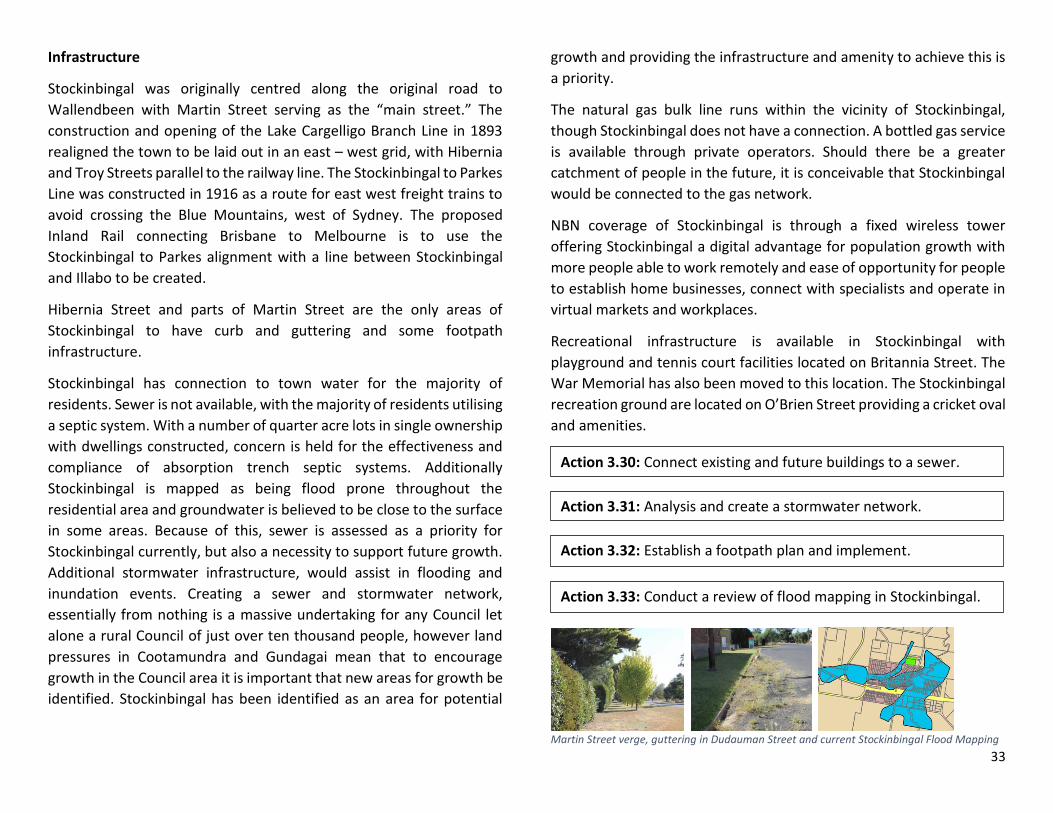
Martin Street verge, guttering in Dudauman Street and current Stockinbingal Flood Mapping
Action 3.30: Connect existing and future buildings to a sewer.
Action 3.31: Analysis and create a stormwater network.
Action 3.32: Establish a footpath plan and implement.
Action 3.33: Conduct a review of flood mapping in Stockinbingal.

34
Services
Stockinbingal Public School operated with 27 students in 2017 with two
fulltime teachers. Stockinbingal Public School is fortunate to have had
upgrades which enable less physically able children to access all school
buildings and facilities.
A post office servicing Stockinbingal has been operating in various
locations since 1891. Today the post office is located on Martin Street
in one of the shopfronts of Ellwood Hall.
Ellwood Hall is the current home of the Stockinbingal Post Office
Opportunities
Location
The location of Stockinbingal, being 15 minutes to Cootamundra, 25
minutes to Temora, 40 minutes to Young and 30 minutes to Harden-
Murrumburrah, affords Stockinbingal potential as a lifestyle alternative
for young families and workers in these larger localities. Additionally,
Stockinbingal is an easy drive or destination for cyclists from these
localities.
In the short to medium term, opportunities can be created to allow for
residential infill growth in Stockinbingal and support the service and
amenity industry. Particular attention needs to be focussed on
wayfinding and signage to and around Stockinbingal. Use of street
signs off Burley Griffin Way will further encourage people to venture
into the village. Economic activity which is suited to short stay visitors
such as cafes, bakeries, pubs, unique experiences and amenities will
ensure that opportunistic visitors will plan all future trips to include a
rest stop and/or stopover in Stockinbingal.
Travel Distances
Action 3.34: Improve signage and wayfinding for Stockinbingal.
Action 3.35: Extend RU5 – Village Zoning for future growth.

35
Recreation
Stockinbingal has two recreation precincts and a separate recreation
facility being the Lawn Bowls Club. The tennis courts and playground
on Britannia Street known as King George V Park are within proximity
of the school and are regularly used by children and the Tennis Club.
The playground equipment is functional and typical of most small
communities. It is noted as providing limited use to children outside of
the 8 year old to 14 year age bracket. Because of this, it would be
appropriate to supplement the existing playground equipment with
equipment for young children and intergenerational play equipment
such as an expression swing where parents can play with toddlers.
Older children in Stockinbingal tend to utilise the recreation ground
and creek environment for play opportunities. Council conducted a
session with school students of Stockinbingal Primary in May 2017 and
a village design competition to gauge opportunities for improving the
liveability of Stockinbingal for children. Council also received written
submissions from Stockinbingal students, with the desire for a skate
park or BMX facilities raised. Noting that to choose between these two
options limits play opportunities, Council is proposing that a modular
pump track be installed in Stockinbingal which would allow for either
BMX riding or skate boarding. In conjunction with a shared path across
the village, opportunities for children to physically recreate and move
about the village safely will be linked through a formal pedestrian
network.
Inland Rail
The proposed Inland Rail is a freight route which will connect regional
areas to the ports of Brisbane and Melbourne. For the Cootamundra-
Gundagai Regional Council area this means that primary producers and
value add industries will have rail access to the ports of Brisbane,
Sydney and Melbourne.
Stockinbingal has the capacity to establish an intermodal facility which
could service the proposed Inland Rail, Lake Cargelligo Branch line
(connecting to Griffith via Temora – Roto Line) and Burley Griffin Way.
The existing grain depots at Stockinbingal could be further enhanced
with opportunities for access to two more ports to be available through
the proposed Inland Rail.
Potential industrial zoning to support Inland Rail
Action 3.36: Support grant applications and community initiatives
for improved and expanded recreation facilities.
Action 3.37: Improve accessibility around the village, with
recreational areas highlighted as priority areas for connection.
Action 3.38: Rezone to support freight and logistical land uses with
access to the Inland Rail, Lake Cargelligo Branch Line and Burley
Griffin Way.
36
Ellwood Hall
The hall is a gathering place for the community with a number of get-
togethers taking place on a regular basis. There is a Stockinbingal Hall
Users Committee, however income for necessary repairs and upgrades
is scarce due to the state of the hall. There is no heating or cooling
system to help regulate temperatures and the amenities are
rudimentary. Feedback is that if the hall was upgraded to be usable in
hot and cold periods and amenities were improved, the hall would be
used on a more regular basis.
In order for the hall to become a viable community function centre and
meeting place, investment needs to be made to allow for year round
use. Making the hall desirable for people to hire for parties, exercise
classes, weddings, debutante balls, school functions, indoor markets,
committee meetings, community meetings, bingo, trivia nights and
other private functions. A cost efficient method of achieving this would
be to break the hall into zones for use.
The supper room is an option for an isolated user space. The supper
room could be sealed, insulated and fitted with heating and cooling to
allow for year round use. Amenity improvements such as painting the
walls and installing windows could be investigated. Comparisons to the
insulation and upgrade of the Wallendbeen Memorial Hall’s supper
room and subsequent usage highlights just how useful such a versatile
space can be.
In order to hold functions, upgrades to the toilets and kitchen should
be considered to be more attractive to caterers and those wishing to
hold parties, receptions and so on.
Use of the yard next to the hall can be viewed as an asset as a spill over
area for functions, parties and receptions or used separately as a site
for open air markets.
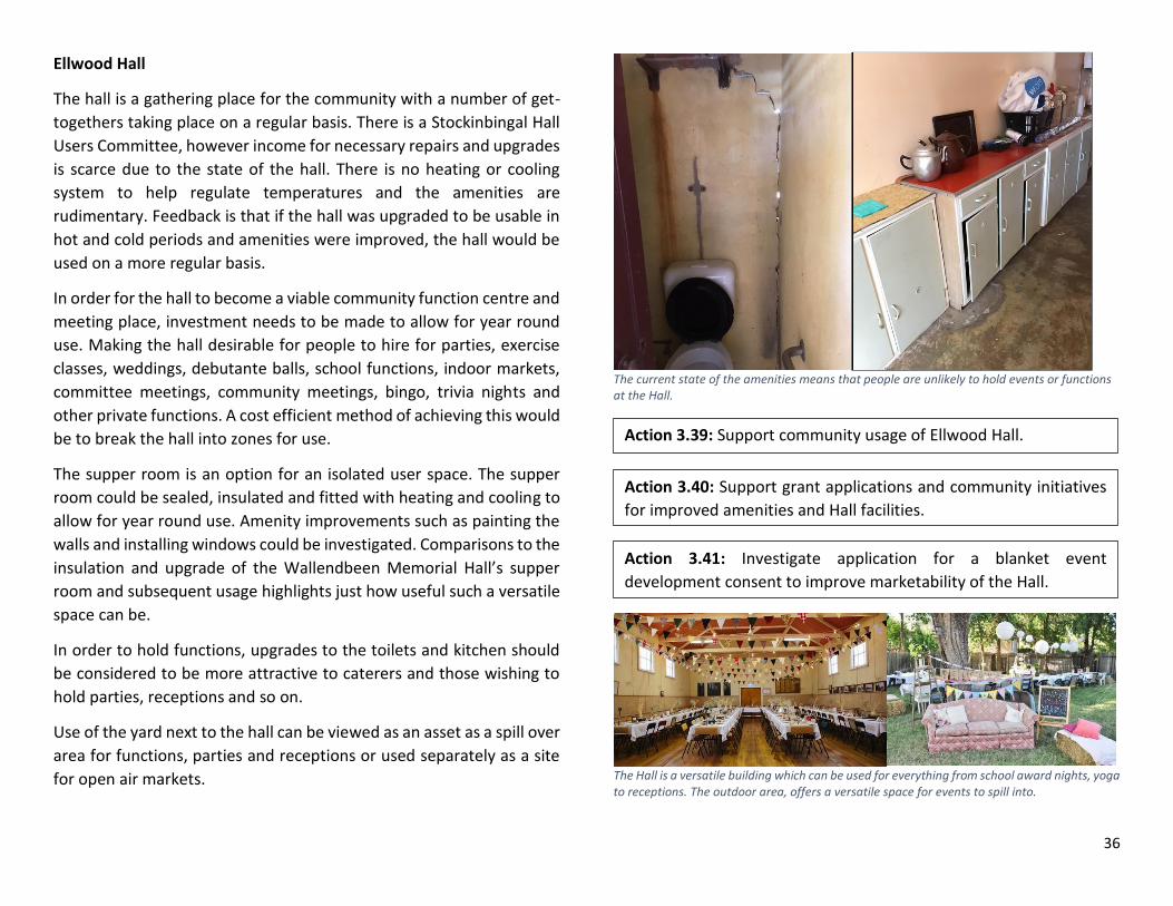
The current state of the amenities means that people are unlikely to hold events or functions at the Hall.
The Hall is a versatile building which can be used for everything from school award nights, yoga to receptions. The outdoor area, offers a versatile space for events to spill into.
Action 3.39: Support community usage of Ellwood Hall.
Action 3.40: Support grant applications and community initiatives
for improved amenities and Hall facilities.
Action 3.41: Investigate application for a blanket event
development consent to improve marketability of the Hall.

37
Hibernia Street
Hibernia Street was nominated as the “main street” of Stockinbingal
by the majority of respondents to community consultation, however
most former shops now sit either vacant or are used as houses. The
heritage conservation area further constrains the use and
redevelopment of this area with a perception that the heritage
conservation area means that redevelopment, extensions,
augmentation and even maintenance is not permissible.
Unfortunately, this has led to urban decay. In the short term, the reality
of Hibernia Street being the commercial core of Stockinbingal is
unlikely and is best viewed as a medium to long term goal.
In order to achieve this, it is recommended that the heritage
conservation area be repealed and that zoning along Hibernia Street
be changed from RU5 – Village Zone to a commercial zoning. This
would mean that any new development or land use can only be that
which is permissible in a commercial zone.
To improve amenity, a landscaping plan should be undertaken which
identifies appropriate plants and street furniture which will create a
more inviting environment for people to stop and chat.
Hibernia Street
Train Station/Rest Area
Formerly the junction for the Lake Cargelligo Branch Line and
Stockinbingal-Parkes Line, Stockinbingal was a two platform station
which was closed to passengers in the 1970s. Today, only one platform
remains and the station buildings on the remaining platform are locked
and generally in a state of disrepair.
The rest area contains a toilet and picnic area which is often deserted
due to the impact of weather (mainly heat) on the facilities. The
parking area is serviced by a dirt road which in summer creates a dust
hazard or is filled with deep pot holes in winter.
Community feedback indicated that there is a large train spotting
community in Stockinbingal and enthusiasts regularly visit the village
to photograph various freight trains.
The position of this site along Hibernia Street means that it has high
exposure to passing motorists and a captive audience of those using
rest facilities. Opportunities for this area include interactive displays on
the heritage of Stockinbingal, train displays and information at the
station as well as the holding of short events such as markets.
Action 3.42: Repeal Heritage Conservation Area in Stockinbingal.
Action 3.43: Promote Hibernia Street as the “main street” with an
emphasis on creating a space for visitors and locals to interact and
support commercial development.
Action 3.44: Support ongoing maintenance and restoration of the
Stockinbingal Train Station.
Action 3.45: Improve function and usage of rest area by sealing the
parking area and supporting community plantings.
Action 3.46: Allow for markets and other short events to occur in
the rest area and adjoining park.

38
Camping and Caravanning
Free camping is available at the recreation ground at Stockinbingal
with power available and shower facilities accessible to campers and
caravans. The free camping facility is not signposted from the highway
or even at the recreation ground and so it is rarely utilised.
The use of the recreation ground for camping and caravans is an
untapped asset which could generate revenue easily. Signposting the
availability of free camping and caravan parking will direct more
opportunistic traffic to the site which in turn will generate word of
mouth coverage of Stockinbingal through caravanning and grey nomad
blogs and forums.
A number of power points are scattered across the Recreation Ground
The Recreation Ground has a number of facilities including undercover areas and toilets (background)
Action 3.47: Improve wayfinding and signage to the recreation
ground.
Action 3.48: Advertise the availability of free camping and use of
powered sites.
Action 3.49: Support opportunities to improve facilities including a
BBQ area and seating.
39
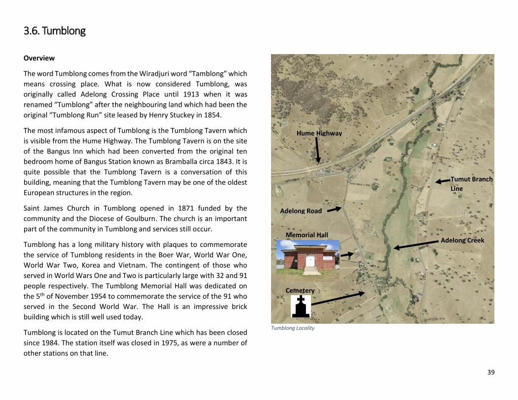
3.6. Tumblong
Overview
The word Tumblong comes from the Wiradjuri word “Tamblong” which
means crossing place. What is now considered Tumblong, was
originally called Adelong Crossing Place until 1913 when it was
renamed “Tumblong” after the neighbouring land which had been the
original “Tumblong Run” site leased by Henry Stuckey in 1854.
The most infamous aspect of Tumblong is the Tumblong Tavern which
is visible from the Hume Highway. The Tumblong Tavern is on the site
of the Bangus Inn which had been converted from the original ten
bedroom home of Bangus Station known as Bramballa circa 1843. It is
quite possible that the Tumblong Tavern is a conversation of this
building, meaning that the Tumblong Tavern may be one of the oldest
European structures in the region.
Saint James Church in Tumblong opened in 1871 funded by the
community and the Diocese of Goulburn. The church is an important
part of the community in Tumblong and services still occur.
Tumblong has a long military history with plaques to commemorate
the service of Tumblong residents in the Boer War, World War One,
World War Two, Korea and Vietnam. The contingent of those who
served in World Wars One and Two is particularly large with 32 and 91
people respectively. The Tumblong Memorial Hall was dedicated on
the 5th of November 1954 to commemorate the service of the 91 who
served in the Second World War. The Hall is an impressive brick
building which is still well used today.
Tumblong is located on the Tumut Branch Line which has been closed
since 1984. The station itself was closed in 1975, as were a number of
other stations on that line.
Tumblong Locality
Cemetery
Memorial Hall
Adelong Road
Adelong Creek
Tumut Branch
Line
Hume Highway
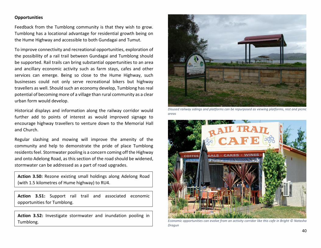
40
Opportunities
Feedback from the Tumblong community is that they wish to grow.
Tumblong has a locational advantage for residential growth being on
the Hume Highway and accessible to both Gundagai and Tumut.
To improve connectivity and recreational opportunities, exploration of
the possibility of a rail trail between Gundagai and Tumblong should
be supported. Rail trails can bring substantial oppertunities to an area
and ancillary economic activity such as farm stays, cafes and other
services can emerge. Being so close to the Hume Highway, such
businesses could not only serve recreational bikers but highway
travellers as well. Should such an economy develop, Tumblong has real
potential of becoming more of a village than rural community as a clear
urban form would develop.
Historical displays and information along the railway corridor would
further add to points of interest as would improved signage to
encourage highway travellers to venture down to the Memorial Hall
and Church.
Regular slashing and mowing will improve the amenity of the
community and help to demonstrate the pride of place Tumblong
residents feel. Stormwater pooling is a concern coming off the Highway
and onto Adelong Road, as this section of the road should be widened,
stormwater can be addressed as a part of road upgrades.
Disused railway sidings and platforms can be repurposed as viewing platforms, rest and picnic areas
Economic opportunities can evolve from an activity corridor like this cafe in Bright © Natasha Dragun
Action 3.50: Rezone existing small holdings along Adelong Road
(with 1.5 kilometres of Hume highway) to RU4.
Action 3.51: Support rail trail and associated economic
opportunities for Tumblong.
Action 3.52: Investigate stormwater and inundation pooling in
Tumblong.

41
3.7. Wallendbeen
Overview
In 1840 Alexander Mackay arrived in Australia to manage numerous
properties including Wallendbeen Station. Alexander and his wife
Annie are considered the first European settlers in Wallendbeen having
lived at Rose Cottage on Wallendbeen Station prior to purchasing
Wallendbeen Station.
Wallendbeen had been gazetted for settlement in 1853 and the next
half century saw the settlement establish numerous buildings and
services for a town. These include numerous hotels, a produce mill,
tannery, butter factory, police station, general store, school, post office
and so on. The Great Southern Railway arrived in 1877 bringing further
services and prosperity to the settlement.
Gazetted as a village in 1885, Wallendbeen was quickly becoming a
major resting spot for travellers along the Young Road as well as a hub
to the high yielding agricultural plots surrounding it. Wallendbeen was
proclaimed a municipal district in 1892, before being proclaimed a
town in 1894 with over 600 residents and numerous stores and
facilities.
Over time, Wallendbeen has declined with surrounding towns of Young
and Cootamundra growing in size. The impact of the First World War
cannot be discounted for its effect on the population of regional areas.
Wallendbeen in particular suffered from the First World War with 18
men dying and numerous more settling elsewhere after returning
home to Australia.
Military pride and history is evident throughout the district and while
nearby towns such as Harden-Murrumburrah can claim to be the
birthplace of the Australian Light Horse Regiment, it is Wallendbeen
which is home to the founder of the First Australian Horse, Major
General Kenneth Mackay. Made up by many residents of the district,
the First Australian Horse saw combat in the Boer War, with the men
and women of Wallendbeen serving in other conflicts which the
Australian Defence Force has since participated.
Wallendbeen Locality
Cemetery
Olympic Highway
Burley Griffin Way
Barry Grace Oval
Wallendbeen Silos
Main Southern
Railway
Memorial Hall

42
Urban Form
Wallendbeen was gazetted for settlement in 1853 and proclaimed a
town on the 6th October 1894. Centred on the north-south Young Road,
Wallendbeen is laid out in a grid pattern which, unlike flatter country
such as Cootamundra, is not in perfect equidistant blocks. Early streets
such as Mackay, Grey, King and Queen Streets parallel the Young Road.
However, the gradients and the path of Connaughtman’s Creek mean
that the majority of this land could not be densely built upon. These
parcels did offer convenient stock reserves and community land with
the frontage to the Young Road convenient for travellers.
The construction of the railway in 1877, provided an opportunity for
Wallendbeen to realign in parallel to the Railway. This is evident in the
urban form of Wallendbeen today. The majority of industry and
services have been concentrated in this western portion of the town.
Town lots were originally surveyed as half acres (roughly 2,000 metres
square), with blocks to the south of Bland Street and to the east of the
Young Road surveyed as larger “suburban” blocks.
The town is zoned RU5-Village with a minimum lot size of 2,000 metres
square. While town water is available to most residences, there is no
sewer and natural gas is not connected.
Storm water is an issue with most streets devoid of curb and guttering.
Coupled with the sloping nature of most blocks, run off from the
streets invariably detain on private property.
Wallendbeen has two focal points. The western section of King Street
and northern section of Lackey Street display the remnants of
commercial and social enterprise in Wallendbeen, with the majority of
buildings now used for private residences. The Wallendbeen Hotel, the
Memorial Hall and the Public School still function on King Street today
and are key features of what is considered Wallendbeen’s “main
street.”
The second focal point is the intersection of the Olympic Highway
(Young Road) and Burley Griffin Way (road to Griffith). A disused petrol
station dominates the south eastern corner of the intersection. Today
the building operates as the Wallendbeen Post Office and offers some
general necessities. The south western corner is a designated rest stop
with toilets. A monument to the region’s famous, high quality dryland
wheat and information signs are located in this rest stop. The rest area
is often used by grey nomads and other short term travellers as a safe
night stop.
Burley Griffin Way is a physical barrier between the bulk of
Wallendbeen residents and the post office/general store. The highway
is also a barrier to potential patrons of the Wallendbeen Hotel.
Wallendbeen Hotel
Action 3.53: Use directional signage off the highways to promote
Wallendbeen village.

43
Infrastructure
Wallendbeen was originally centred on the Young Road (now Olympic
Highway). Today Wallendbeen can be assessed as sitting on the
Olympic Highway and Burley Griffin Way. Traffic counts show that
along the Olympic Highway south of Wallendbeen 2,070 vehicles use
the road per day with 1,583 movements north of the town. East of
Wallendbeen 1,674 vehicles use Burley Griffin Way and 1,316 vehicles
to the west. These highways offer enormous logistical support and
tourism potential to Wallendbeen.
Most local roads in Wallendbeen are sealed, with King Street the only
one to have curb and guttering.
While the main line from Sydney to Melbourne (Great Southern
Railway) runs through Wallendbeen, Wallendbeen is not a stop for
passengers. Railway commuters wishing to visit Wallendbeen must
stop at Cootamundra, where a connecting bus service will take them
to Wallendbeen.
The GrainCorp silos and depot along the railway line are still technically
operational, however due to lower volumes of harvest and the
increased capacity at the Cootamundra yards, the silos have only been
operational on an “as needs” basis.
Wallendbeen has connection to town water for the majority of
residents. Sewer is not available, with the majority of residents utilising
a septic system. It must be acknowledged however, that there would
be a significant number of septic systems which may be failing and
some residences may be occupied at this time without a septic system
at all.
The natural gas bulk line runs within the vicinity of Wallendbeen,
though Wallendbeen does not have a connection.
Stormwater systems are rudimentary. Spoon drains, swales and other
open drains deal with the bulk of inundation and runoff. The hilly
nature of Wallendbeen and integration of major creeks into the town
limits means that local, minor flooding occurs regularly during rain
events.
NBN coverage of Wallendbeen will be through Skymuster satellite
technology. Anecdotally, the community is worried about reliability
and speed of this service, however, if the system works as intended, it
may offer Wallendbeen a digital advantage for population growth with
more people able to work remotely and ease of opportunity for people
to establish home businesses, connect with specialists and operate in
virtual markets and workplaces.
Recreational infrastructure is available in Wallendbeen. The white
picket fence of Barry Grace Oval is often the only landmark passers-by
on the Burley Griffin Way note about Wallendbeen and the use,
maintenance and facilities of Barry Grace Oval are a testament to the
pride and sporting passion of the community of Wallendbeen. Palmer
Park on Lackey Street is considered the “town park” however it lacks
variety of equipment and amenities to encourage longer stays.
Action 3.54: Conduct a stormwater analysis of Wallendbeen and
create a works schedule to alleviate inundation pressures.
Action 3.55: Designate and build a safe crossing point for
pedestrians and cyclists across Burley Griffin Way.
Action 3.56: Create a shared path from the village centre to the
cross roads via Barry Grace Oval.

44
Services
Wallendbeen Public School operated with 14 students in 2017. Due to
low enrolments, Wallendbeen Primary School has one fulltime teacher
and one part time teacher. This means that the junior class must
combine with the senior class for two days every week. As with most
villages, the school is considered the heart of the community and to
lose it would be devastating to any growth potential for the town.
A post office servicing Wallendbeen has been operating in various
locations since 1875. Today the post office is located on the south
eastern corner of the Olympic Highway and Burley Griffin Way
intersection and is physically dislocated from the town with the two
highways acting as a barrier to pedestrians.
Opportunities
Location
The location of Wallendbeen, being 15 minutes to Cootamundra, 20
minutes to Young and 10 minutes to Harden-Murrumburrah, affords
Wallendbeen potential as a lifestyle alternative for young families and
workers in these larger localities. Additionally, Wallendbeen is an easy
drive or destination for cyclists from these localities.
In the short to medium term, opportunities can be created to allow for
residential infill growth in Wallendbeen and support the service and
amenity industry. Particular attention needs to be focused on
wayfinding and signage to Wallendbeen. Having Wallendbeen
designated by the Roads and Maritime Authority as a Historical Town
will assist in signage along both highways. Use of street signs off Burley
Griffin Way will further encourage people to venture down to King
Street.
Economic activity which is suited to short stay visitors such as cafes,
bakeries, pubs, unique experiences and amenities will ensure that
opportunistic visitors will plan all future trips to include a rest stop
and/or stop over in Wallendbeen.
Travel distances
Despite passenger trains using the line, passenger services no longer stop at Wallendbeen. Wallendbeen is instead serviced by a connecting bus from Cootamundra train station.

45
Recreation
Wallendbeen is noted for Barry Grace Oval, which with its white picket
fence and position along Burley Griffin Way is the only glimpse most
travellers see of Wallendbeen. Barry Grace Oval is a large recreation
facility with associated buildings and structures for viewing sporting
matches and providing hosting facilities. Playground equipment is
available at the Oval. However, it was raised during community
consultation as a concern due to its age and safety issues. Exercise
equipment was also raised as being a deficit for Wallendbeen.
Collocation of an exercise station or spaced at points around the oval
were suggested. To maximise the use of the Oval and any exercise
equipment, upgrades to lighting for safety would also be needed.
Palmer Park is considered the local playground, however the park lacks
a footpath from Wallendbeen Primary School. Additionally, it is around
the corner to King Street and so is out of sight should a family be
spending time at the Wallendbeen Hotel. A large stormwater drain
borders the park parallel to Lackey Street. Palmer Park’s play
equipment could be relocated to Barry Grace Oval to replace
dangerous playground structures there, with Palmer Park to receive
new equipment providing traditional play experiences, interactive play
experiences for parents and young children and imaginative structures
for older and more confident children.
In order to create a long stay park, a mixture of equipment which
targets all age groups is required. To further enhance Palmer Park, in
addition to the existing seating, a barbeque structure could be
established. Council could coordinate bookings of Palmer Park for
events such as birthdays and picnics.
Agriculture
Wheat and other crop production is a key identity, however
opportunities exist to diversify this, increasing income and population.
Any opportunities for change in zoning and land uses in RU1 – Primary
Production Land will be explored and evaluated as a part of the
Cootamundra-Gundagai Regional Council Rural Lands Strategy.
Community consultation highlighted that the people of Wallendbeen
did not want their town to physically expand due to the impact this
would have on high value agricultural land. A residential containment
border should be established with a buffer area for smaller existing
farmlets allowed for.
Identity tied to agriculture is a given for Wallendbeen. New town
signage could be used to signify this, with the cross roads/rest area
precinct with the milestone sculptures already performing this
function.
Canola in front of historic Wallendbeen Church building
Action 3.57: Improve lighting at Barry Grace Oval.
Action 3.58: Redesign Palmer Park as a long stay park.

46
King Street Precinct
The King Street Precinct offers enormous economic and social
potential for Wallendbeen. The community’s soul lays in this precinct
and its ability to value add to the social and economic health of the
community could be realised through some considered planning and
key projects. In order to ensure ongoing commercial activity in
Wallendbeen it is essential that permitted land uses encourage this.
The current zoning of RU5 – Village means that former shops now serve
as residences. Council does not advocate to change this overnight and
acknowledges the existing use rights of owners and tenants using these
shop fronts as dwellings. However, alternate zoning would ensure that
use and development into the future would be in keeping with the
aspirations the people of Wallendbeen have for this precinct.
In order to achieve revitalisation of the King Street Precinct and
capture the feedback from the community for projects such as tree
planting, community space, silo art and so on; a master planning
process can investigate and prioritise opportunities for short, medium
and long term implementation. Partnerships with local land owners,
government agencies, charities, community organisations, the people
of Wallendbeen and Council can to be identified and placed against
individual outcomes and timeframes.
The Crossroads
While the two highways physically dislocate Wallendbeen from the
general store, this area is highly utilised by travellers. Grey nomads stay
overnight, day commuters use the rest rooms and picnic tables. The
area is defined by the impressive wheat sculptures. Opportunities exist
to enhance this area based on the needs of highway commuters.
Redevelopment of the general store to include fuel services would
provide the only petrol point between Harden and Temora and
Cootamundra and Young. A service station would also increase local
employment opportunities for youths.
Crossroads roundabout
Action 3.59: Rezone King Street to a commercial zone.
Action 3.60: Create a masterplan for King Street to address
stormwater, street trees and historical significance.
Action 3.61: Acknowledge the military history of Wallendbeen by
creating a “Remembrance Precinct.”
Action 3.62: Assist the Roads and Maritime Services to better
maintain the roundabout.
Action 3.63: Encourage commercial activity of highway services by
allowing for supporting land uses to develop at the Crossroads.

47
Work Items
Spring time around Gundagai
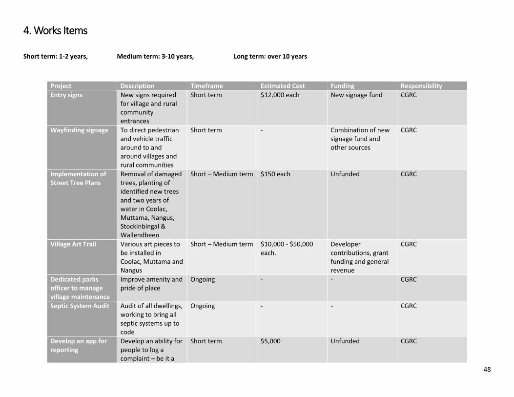
48
4. Works Items
Short term: 1-2 years, Medium term: 3-10 years, Long term: over 10 years
Project Description Timeframe Estimated Cost Funding Responsibility
Entry signs New signs required for village and rural community entrances
Short term $12,000 each New signage fund CGRC
Wayfinding signage To direct pedestrian and vehicle traffic around to and around villages and rural communities
Short term - Combination of new signage fund and other sources
CGRC
Implementation of Street Tree Plans
Removal of damaged trees, planting of identified new trees and two years of water in Coolac, Muttama, Nangus, Stockinbingal & Wallendbeen
Short – Medium term $150 each Unfunded CGRC
Village Art Trail Various art pieces to be installed in Coolac, Muttama and Nangus
Short – Medium term $10,000 - $50,000 each.
Developer contributions, grant funding and general revenue
CGRC
Dedicated parks officer to manage village maintenance
Improve amenity and pride of place
Ongoing - - CGRC
Septic System Audit Audit of all dwellings, working to bring all septic systems up to code
Ongoing - - CGRC
Develop an app for reporting
Develop an ability for people to log a complaint – be it a
Short term $5,000 Unfunded CGRC

49
maintenance concerns
pot hole, long grass, and so on using an app which will provide Council with photos and a GPS coordinates
Footpaths Create a footpath masterplan for ongoing implementation
Masterplan – short term Implementation - ongoing
- Unfunded CGRC
Cemetery mapping Digital portal to find and view graves in the cemeteries
Short term - Merger Implementation Fund
CGRC
Cemetery beautification
Number of initiatives to create an environment which is pleasant, respectful and easy to move around all cemeteries
On going - Merger Implementation Fund
CGRC
Cemetery entrance Create an “entrance” which respects the emotional needs of cemetery visitors, is safe from traffic movements on Muttama Road and provides clear direction
Short term $20,000 Unfunded CGRC
Cemetery Car Parking
Formal car parking area in Muttama
Short-Medium term - Unfunded CGRC
Water connection to cemeteries
Provide taps to Coolac, Stockinbingal and Nangus cemeteries
Medium Term $10,000 General Revenue/Community Donations
CGRC and Community
Community notice board and information sign
Installed outside Muttama Hall
Short term $2,000 Developer contributions
CGRC
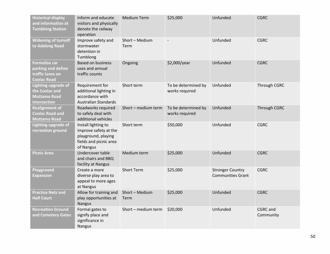
50
Historical display and information at Tumblong Station
Inform and educate visitors and physically denote the railway operation
Medium Term $25,000 Unfunded CGRC
Widening of turnoff to Adelong Road
Improve safety and stormwater detention in Tumblong
Short – Medium Term
- Unfunded CGRC
Formalise car parking and define traffic lanes on Coolac Road
Based on business uses and annual traffic counts
Ongoing $2,000/year Unfunded CGRC
Lighting upgrade of the Coolac and Muttama Road intersection
Requirement for additional lighting in accordance with Australian Standards
Short term To be determined by works required
Unfunded Through CGRC
Realignment of Coolac Road and Muttama Road
Roadworks required to safely deal with additional vehicles
Short – medium term To be determined by works required
Unfunded Through CGRC
Lighting upgrade of recreation ground
Install lighting to improve safety at the playground, playing fields and picnic area of Nangus
Short term $50,000 Unfunded CGRC
Picnic Area Undercover table and chairs and BBQ facility at Nangus
Medium term $25,000 Unfunded CGRC
Playground Expansion
Create a more diverse play area to appeal to more ages at Nangus
Short Term $25,000 Stronger Country Communities Grant
CGRC
Practice Nets and Half Court
Allow for training and play opportunities at Nangus
Short – Medium Term
$25,000 Unfunded CGRC
Recreation Ground and Cemetery Gates
Formal gates to signify place and significance in Nangus
Short – medium term $20,000 Unfunded CGRC and Community

51
Other conflicts memorial
Acknowledgment of Nangus residents who served in conflicts other than World War Two.
Short term $10,000 Saluting their Service grant from Department of Veterans Affairs and ANZAC Community Grant from NSW
CGRC
Reticulated water connections to Coolac & Nangus
Connection to Gundagai & Goldenfields Water reticulated water network
Short term - Merger Implementation Funding
CGRC
Survey of walking and riding trail between Gundagai and Nangus
Utilising crown reserves and other routes along the Murrumbidgee
Short term - Unfunded CGRC
Upgrade of Hibernia Street
Clearing of overgrown garden beds, replanting and street furniture in Stockinbingal
Short term $20,000 Unfunded CGRC
Seating in vicinity of the cenotaph
Bench in the style of the cenotaph for people to reflect and for less mobile people to sit during ceremonies
Medium term $10,000 Developer Contributions
CGRC
Stormwater audit and implementation plan Stockinbingal
Investigation into the existing stormwater network, which correlated with data from inundation and flooding events will produce an implementation plan for works
Medium term - Funded via Stronger Communities Fund – Major Projects Program, Stormwater Mitigation strategy
CGRC
Stormwater Network Creating a stormwater network in Stockinbingal
Medium – long term Requires a masterplan for costings
Utilities Fund CGRC
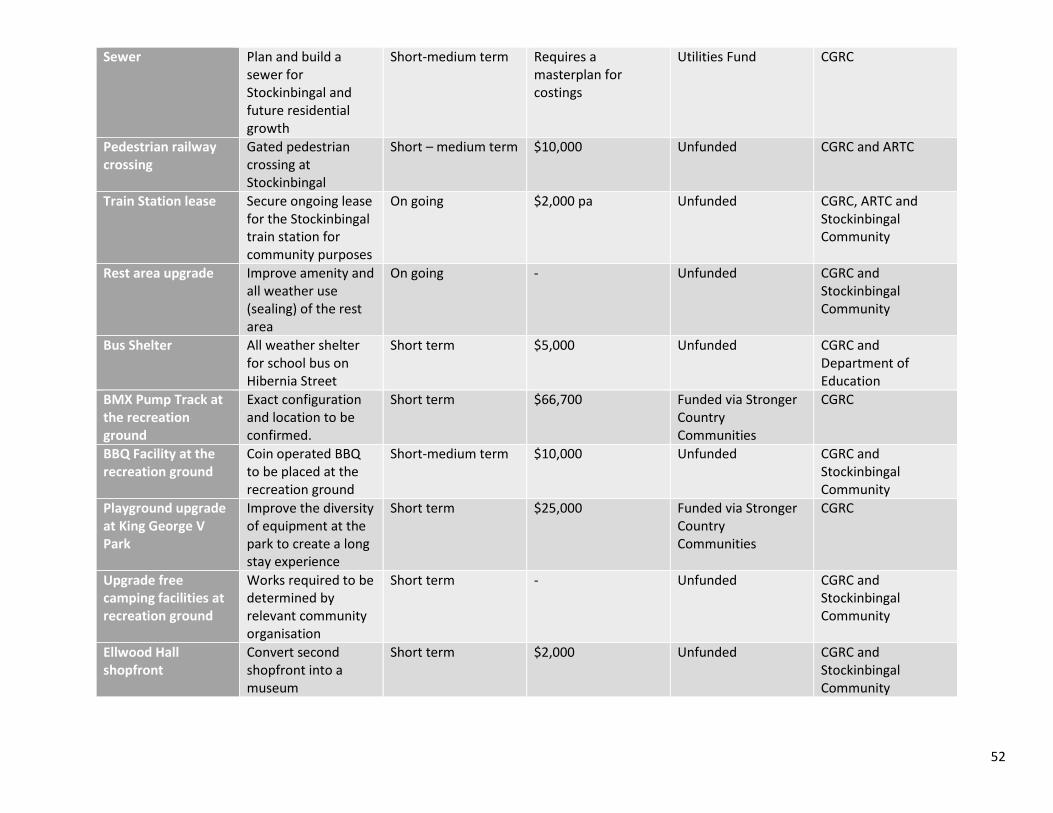
52
Sewer Plan and build a sewer for Stockinbingal and future residential growth
Short-medium term Requires a masterplan for costings
Utilities Fund CGRC
Pedestrian railway crossing
Gated pedestrian crossing at Stockinbingal
Short – medium term $10,000 Unfunded CGRC and ARTC
Train Station lease Secure ongoing lease for the Stockinbingal train station for community purposes
On going $2,000 pa Unfunded CGRC, ARTC and Stockinbingal Community
Rest area upgrade Improve amenity and all weather use (sealing) of the rest area
On going - Unfunded CGRC and Stockinbingal Community
Bus Shelter All weather shelter for school bus on Hibernia Street
Short term $5,000 Unfunded CGRC and Department of Education
BMX Pump Track at the recreation ground
Exact configuration and location to be confirmed.
Short term $66,700 Funded via Stronger Country Communities
CGRC
BBQ Facility at the recreation ground
Coin operated BBQ to be placed at the recreation ground
Short-medium term $10,000 Unfunded CGRC and Stockinbingal Community
Playground upgrade at King George V Park
Improve the diversity of equipment at the park to create a long stay experience
Short term $25,000 Funded via Stronger Country Communities
CGRC
Upgrade free camping facilities at recreation ground
Works required to be determined by relevant community organisation
Short term - Unfunded CGRC and Stockinbingal Community
Ellwood Hall shopfront
Convert second shopfront into a museum
Short term $2,000 Unfunded CGRC and Stockinbingal Community

53
Ellwood Hall amenities upgrade
Demolition of existing toilets and new toilet facility constructed. New kitchen facility
Short term $100,000 Unfunded CGRC and Stockinbingal Community
Ellwood Hall heating and cooling
Install a heating and cooling system
Short term $50,000 Unfunded CGRC and Stockinbingal Community
Ellwood Hall sealing of supper room
Seal existing supper room
Short term $50,000 Unfunded CGRC and Stockinbingal Community
Off leash Dog Area Designate an off leash dog area
Short term - - CGRC
Wallendbeen Town Centre Masterplan
Investigation of options for the centre of town. The end result of which is an artistic impression and master plan of the town centre
Short term $80,000 Unfunded CGRC
Upgrade of King Street
Removal of privet trees and replace with new trees, improve footpath and install kerb and guttering
Short term $60,000 Unfunded CGRC
Lighting upgrade of the cenotaph
Either rewire existing heritage lights, or install accent lights in the ground
Short term $5,000 Unfunded CGRC
Improved access to the cenotaph
Steps to be upgraded with supporting rails installed
Short term $5,000 Unfunded CGRC
Planting of the Lone Pine
Requires removal of privet trees
Short term - - CGRC
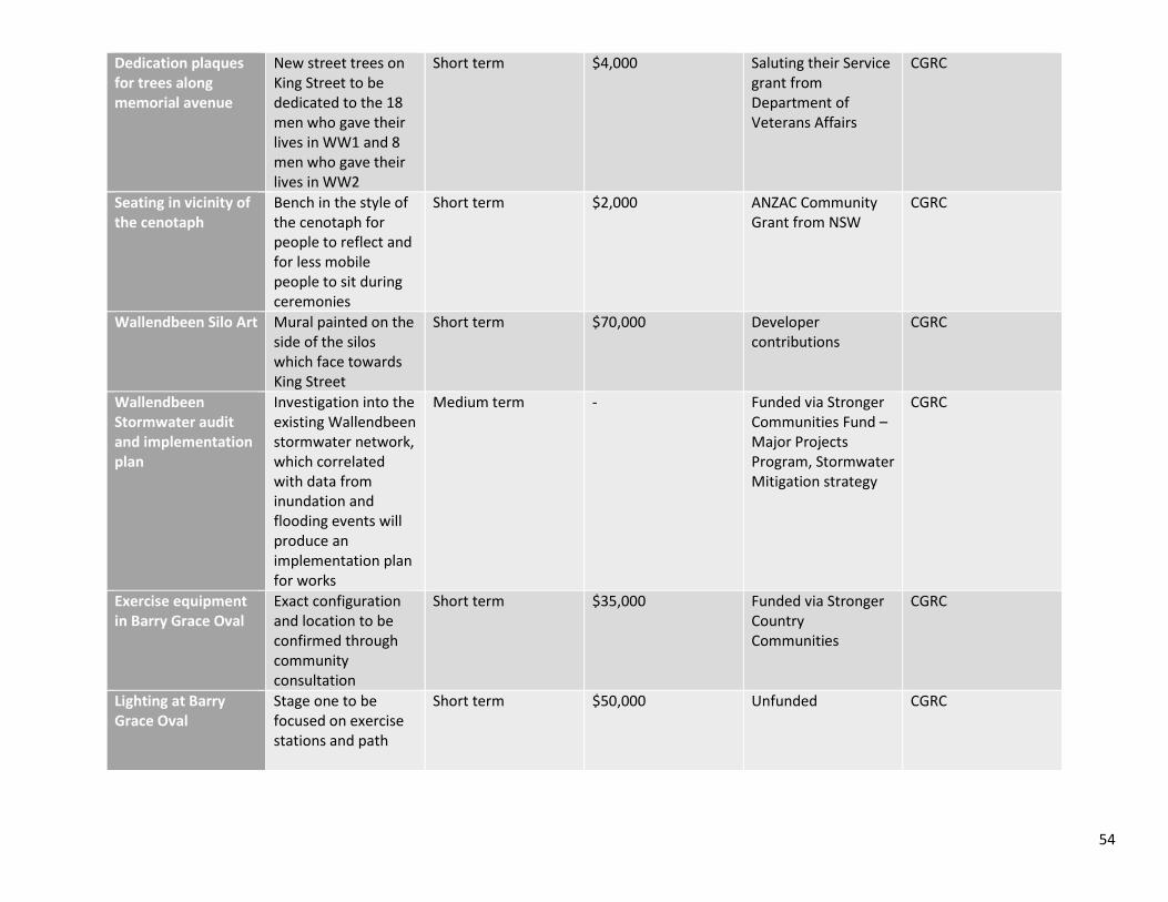
54
Dedication plaques for trees along memorial avenue
New street trees on King Street to be dedicated to the 18 men who gave their lives in WW1 and 8 men who gave their lives in WW2
Short term $4,000 Saluting their Service grant from Department of Veterans Affairs
CGRC
Seating in vicinity of the cenotaph
Bench in the style of the cenotaph for people to reflect and for less mobile people to sit during ceremonies
Short term $2,000 ANZAC Community Grant from NSW
CGRC
Wallendbeen Silo Art Mural painted on the side of the silos which face towards King Street
Short term $70,000 Developer contributions
CGRC
Wallendbeen Stormwater audit and implementation plan
Investigation into the existing Wallendbeen stormwater network, which correlated with data from inundation and flooding events will produce an implementation plan for works
Medium term - Funded via Stronger Communities Fund – Major Projects Program, Stormwater Mitigation strategy
CGRC
Exercise equipment in Barry Grace Oval
Exact configuration and location to be confirmed through community consultation
Short term $35,000 Funded via Stronger Country Communities
CGRC
Lighting at Barry Grace Oval
Stage one to be focused on exercise stations and path
Short term $50,000 Unfunded CGRC

55
Shared Path Plan and build a shared path connecting Wallendbeen Village, Barry Grace Oval and the Crossroads
Short term $150,000 Developer contributions to part fund
CGRC
Redesign and build of Palmer Park as a long stay park
Improve the diversity of equipment at the park to create a long stay experience
Short term $164,344 Funded via Stronger Country Communities
CGRC
Beautification of cross roads roundabout
In conjunction with RMS upgrade the roundabout to be more aesthetically pleasing and easy to maintain
Short – medium term - - CGRC & RMS
Safe pedestrian and cyclist crossing of Burley Griffin Way
Along the alignment of the proposed shared path
Short term $10,000 Unfunded CGRC & RMS
Perform maintenance and other works at Wallendbeen Train Station
Coordinate with Wallendbeen community group for works days to upgrade the Wallendbeen Train Station
On going - - ARTC
Lease of Station Masters Residence
Encourage the lease of the station masters residence to be primarily for commercial purposes
Short term - - CGRC & ARTC
Perform annual clearance works on Connaughtman’s Creek
To improve the amenity of Wallendbeen and reduce the risks of fires and snakes
Ongoing - - CGRC & LLS