Village Assessment Survey COUNTY ATLAS -...
30
Village Assessment Survey COUNTY ATLAS 2013 Central Equatoria State Kajo-Keji County
-
Upload
nguyentruc -
Category
Documents
-
view
245 -
download
1
Transcript of Village Assessment Survey COUNTY ATLAS -...

Village Assessment Survey
COUNTY ATLAS
2013
Central Equatoria State
Kajo-Keji County

Four (4) Counties Assessed
Map
In
dex
Village Assessment Survey
Planning Map and Dashboard..…………Page 1
General Section…………...……...Page 2 - 5
Main Ethnicities and Languages.………...Page 2
Infrastructure and Services……...............Page 3
Land Ownership and Settlement Type ….Page 4
Returnee Land Allocation Status..……...Page 5
Livelihood Section…………..…...Page 6 - 9
Major Livelihood Practices..…………...Page 6
Major Food Crops Grown...…………..Page 7
Major Problem Affecting Farming……..Page 8
Major Livelihood Shocks……….............Page 9
Health Section………..………..Page 10 - 13
Access to Health Facilities……………Page 10
Health Facility & Services Offered...Page 11& 12
Health Awareness Programmes………Page 13
WASH Section…………..………...Page 14 - 20
Natural Source of Water……...……….…..Page 14
Water Point and Physical Accessibility….…Page 15
Water Management & Conflict....….………Page 16
WASH Education...….……………….…….Page 17
Latrine Type and Use...………....………….Page 18
Education Section………….……...Page 19 - 22
Access to Education Facilities...……………Page 19
Level of Edu. & Medium of Instruction...…..Page 20
Teacher to Student Ratio...……………….Page 21
Primary School Facilities...…………………Page 22
Protection Section…………..…….Page 23 - 25
Presence of Rule of Law Institutions...…….Page 23
External Threats, Violations & Risks...……..Page 24
Internal Threats, Violations & Risks...……...Page 25
The Village Assessment Survey (VAS) has been used by IOM since 2007 and is a comprehensive
data source for South Sudan that provides detailed information on access to basic services, infra-
structure and other key indicators essential to informing the development of efficient reintegra-
tion programmes. The most recent VAS represents IOM’s largest effort to date encompassing 30
priority counties comprising of 871 bomas, 197 payams, 468 health facilities, and 1,277 primary
schools. There was a particular emphasis on assessing payams outside state capitals, where com-
paratively fewer comprehensive assessments have been carried out. IOM conducted the assess-
ment in priority counties where an estimated 72% of the returnee population (based on esti-
mates as of 2012) has resettled.
The county atlas provides spatial data at the boma level and should be used in conjunction with
the VAS county profile.
INTERNATIONAL ORGANIZATION FOR MIGRATION
New Industrial Area ● Northern Bari ● Juba ● South Sudan
Email: [email protected] | Web: http://southsudan.iom.int
Established in 1951, IOM is the principal inter governmental organization in the field of migration and works closely with governmental, intergovernmental and non-governmental partners. With 149 member states, a further 12 states holding observer status and offices in over 100 countries,
IOM works to help ensure the orderly and humane management of migration, to promote international cooperation on migration issues, to assist in the search for practical solutions to migration problems and to provide humanitarian assistance to migrants in need, including refugees and inter-
nally displaced people
This map product is for planning purposes only. The names and boundaries on this
map product/atlas do not imply official endorsement or acceptance by the Govern-
ment of Republic of South Sudan or IOM. IOM cannot guarantee that this map is
error free and therefore will not accept liability for consequential and indirect dam-
ages arising from the use of this map product. DIS
CLA
IMER
O
VERV
IEW
MA
P
Page Numbers preceded by reflect data sourced from the Boma Questionnaire, while page numbers preceded by present information sourced
from the respective Technical Questionnaire.
Please refer to the accompanying digital atlas for more detailed information of the map
product. Maps are also available at http://southsudan.iom.int/reports/VAS or scan the QR
code below to go directly to the web page.

99
9
9
9
9 9
9
9
9
9
9
9 9
9
99
9 9
99
9
9
9
9 9 9
9
99
9
Morobo( Central
Equatoria )
Lainya( Central
Equatoria )
Juba( Central
Equatoria )
Magwi( Eastern
Equatoria )
Lugor
RomogiMekinda
LubuleDirago
SaregoroKile
Nyigo
SaregoroMagura
Dwani
Giwaya
GworongLoguleja
Odujo
Nyungule
Saburi
Muresuk
Wojira
Sukole
BajiPasuleGworongLode
Kagwa
Lijo
Sodogo
WudujiMaguraKuruja
DwaniSunyuKimu
MordukSokare
Lewu
Ariwa
Deribe
Kagai
Kudupi
NyaingaMaraga
Didiro
Jale
Itorogwe
Melia
Kilolo
BeliakLedong
Wojira
WajiDeji
Alusi
Merok
Kaibo
Lomura
LipiLoopo
Watukujong
NyingKoiba
Poki
Kwenda
Pidi
Nyabara
Juka
NyagiLukalili
WuduLobwo
Mundari
Lokunguru LokojoKajongonyi-3
Lijaba-1
Kinyiba
Kaibo
Jombur
Kasura
Gulu
NyigoLorida
Sonder
Mutongo
Leswa
Jerebong
LoropiLotonyo
Lomonga
Ajira
RudulokokaMangaloti
Mereguga
Jingoro
Godo
Payeye
KangiriUmbuku
Lubule
AndersireLokungura
Bongilo
Wuruta
Jalimo
Mekor
LireBajurMuludyang
Kabiko
Momonga
Lorida
KasurakWakeGungi
Jikidi
Farm
DijuBanyajur
OmbioJurukata
Beliak
Jonyari
Sokare
LilyeGobur
BekatMonobek
OngijoJoru
Lorini
Mogiri B
Jamujin
Mogiri A
Tipere
Alisinia
Yenteng
BondisiLemerituku
WalokKomudu
Ajio
Bujere
Lorudung
Wutaman
Kalibere
GiloriKiriga
Joge
Kala 2
LomiriBoroboro
Andejo
Kanyi
MangalotiPure
Madasar
Payawa
LoraMangalatore
GwonsokSokare 11
Nyandu
Kudusi
Sokare 1Jujubeng
Deredek
Maranga
Bura
Momonga
Doro
Dibod
Jondal
Moli
Adubi
Gaderu
Mondi
Lopura
GumboMononyik
Maremo
Gimere
Mamung
Ngoga
KiboMorododo
Kayaya
Gille
Ngayinga
Nyomuding
KokidiPorodong
Nakonyen
KinyanyaCrimini
Mononyik 2
Kayaya
Londi
Muremaring
Londi 1
Mulugor
SumborLomena
Moijo
Limi
Kigwo
Leikor
Sera Jale
Kiri Pamoju
Litoba
Logili
Bamurye
Wudu
Jalinio
KinyibaLogu
Bori
LikamerokKudaji
Longira Mere
MikerRomogi
Kala
Ajio
KendiriKerwa Mangalatore Sokare
Ciaderu
KansukLori
Rodo
UGANDA
Planning Map & Dashboard
MoroboKajo-Keji
LainyaYei
Juba
Terekeka
Lakes
CentralEquatoria Eastern
Equatoria
Jonglei
WesternEquatoria
DEMOCRATICREPUBLICOF CONGO
UGANDA
Area Payams Bomas
Villages HealthFacilities
EducationFacilities
Data Source:Year:Projection:Spheroid:Comments & Feedback:Map Index:
NBS, OCHA, IOM, ESRI2013
GeographicWGS84
[email protected]/SS/VAS/S01C006/PLN
km2 5 31248 45 74
2,518
Returnees to the County Compared with State Total
217,931ESTIMATED HOST POPULATION:
RETURNEE POPULATION: 38,743
Percentage of Returnees to the Host Population0% 100%
Legend
9 Boma Survey PointsVillages
&( State CapitalRiverLakesInternational Boundary
RoadsLocal/UrbanPrimarySecondaryTertiaryCounty BoundaryState Boundary
Kajo-Keji County Page 1
18%
* Final Boundary between the Republic of South Sudan and the Republic of Sudan has not yet been determined.** Final status of the Abyei area is not yet determined
0 8 16 244Kilometers
:
21,760
79,121
64,976
43,700
20,190
1,49016,550 11,430
7,925 1,3480
10,00020,00030,00040,00050,00060,00070,00080,00090,000
2007 2008 2009 2010 2011 2012
Retur
nees
Year of Return
Central Equatoria Kajo-Keji
Payam Boma Number of Villages
Leikor 15Moijo 4Limi 8Kigwo 6Pamoju 8Sera Jale 8Kiri 8Litoba 6Bamurye 5Logili 7Logu 11Bori 13Wudu 12Kinyiba 9Jalinio 13Likamerok 4Miker 7Longira 8Kudaji 4Mere 9Romogi 5Kala 6Ajio 7Kendiri 6Sokare 7Mangalatore 7Kerwa 5Rodo 8Ciaderu 15Kansuk 8Lori 9
Nyepo
VILLAGE INFORMATION
Kangapo I
Kangapo II
Lire
Liwolo

Morobo( Central
Equatoria )
Lainya( Central
Equatoria )
Juba( Central
Equatoria )
Magwi( Eastern
Equatoria )
MoijoLimi
Kigwo
Leikor
SeraJale
Kiri Pamoju
Litoba
Logili
Bamurye
Wudu
Jalinio
KinyibaLogu
Bori
LikamerokKudaji
Longira Mere
Miker Romogi
Kala
Ajio
Kendiri
Kerwa Mangalatore Sokare
Ciaderu
KansukLori
Rodo
..
.
.
.
..
.
.
.
.
.
..
.
..
. .
..
.
.
.
. . .
.
..
.
UGANDAVillagesRiver/StreamLake/Marsh
Main TribesKukuLugbara
RoadsLocal/UrbanPrimarySecondaryTertiaryCounty BoundaryState BoundaryInternational Boundary
Main Ethnicities and Languages Spoken
Kajo-Keji County.
Main Languages
Bari
Legend
Page 2
Data Source:Year:Projection:Spheroid:Comments & Feedback:Map Index:
NBS, OCHA, IOM, ESRI2013
GeographicWGS84
[email protected]/SS/VAS/S01C006/THM010 6 12 183
Kilometers..
KukuLugbara
Bari Kuku Others Total BomasKuku 4 26 - 30 Lugbara - 1 - 1 Others - - - - Total Bomas 4 27 0 31
COUNTY MAIN LANGUAGE SPOKENKajo-Keji
MAIN
TRIBE
99
9
9
9
99
9
9
9
9
9
99
9
99
9 9
99
9
9
9
9 9 9
9
99
9
99
9
9
9
99
9
9
9
9
9
99
9
99
9 9
99
9
9
9
9 9 9
9
99
9
Morobo( Central
Equatoria )
Lainya( Central
Equatoria )
Juba( Central
Equatoria )
Magwi( Eastern
Equatoria )
MoijoLimi
Kigwo
Leikor
Sera Jale
KiriPamoju
Litoba
Logili
Bamurye
Wudu
Jalinio
KinyibaLogu
Bori
LikamerokKudajiLongira Mere
MikerRomogi
Kala
Ajio
KendiriKerwa Mangalatore
Sokare
Ciaderu
KansukLori
Rodo
4 W4 W N
W
r @ E O 4 B W N
B W N
B W4 B W
r 4 B W
4 B W
r B W
E 4 B W N
r E 4 W
E 4 B W
E 4 B W
r E B W
4 B W N
4 B W N 4 B
r E 4 B W N
r E 4 B W N4 B W
r 4 B W N
E
4 B W
O
B
E 4 B W
E O B W N
r E B N
B W N
UGANDABoma Survey Points9 Bomas with Infrastructure
9 Bomas without InfrastructureVillagesRiver/StreamLake/Marsh
RoadsLocal/UrbanPrimarySecondaryTertiaryCounty BoundaryState BoundaryInternational Boundary
Kajo-Keji County
Legend
Infrastructure Police Station Orphanage Boma
MarketPublic
TransportMobile
CoverageReligious
Est. Roads Bridges
Number of Bomas 9 1 12 3 19 24 25 12
Satisfaction Level 11% 0% 17% 0% 5% 38% 8% 33%
B W NKajo-Keji r @ E O 4
Infrastructure and Services
Page 3
Data Source:Year:Projection:Spheroid:Comments & Feedback:Map Index:
NBS, OCHA, IOM, ESRI2013
GeographicWGS84
[email protected]/SS/VAS/S01C006/THM020 6 12 183
Kilometers

99
9
9
9
99
9
9
9
9
9
99
9
99
9 9
99
9
9
9
9 9 9
9
99
9
Morobo( Central
Equatoria )
Lainya( Central
Equatoria )
Juba( Central
Equatoria )
Magwi( Eastern
Equatoria )
MoijoLimi
Kigwo
Leikor
Sera Jale
Kiri
Pamoju
Litoba
Logili
Bamurye
Wudu
Jalinio
Kinyiba
Logu
Bori
LikamerokKudaji
LongiraMere
MikerRomogi
Kala
Ajio
Kendiri
Kerwa Mangalatore Sokare
Ciaderu
KansukLori
Rodo
dd
d
d
d
d d
d
d
d
d
d
d dd
d
d
d d
dd
d
d
dd
d
d
d
dd
d
UGANDA
Legend9 Boma Survey Points
Villages
RoadsLocal/UrbanPrimarySecondaryTertiaryRiver/StreamLake/MarshCounty BoundaryState BoundaryInternational Boundary
Land Ownership & Settlement Types
Kajo-Keji County
$>d\
Individual
Free Communal
Ancestral
Leased Land
Land Ownership Type
/ Informal Land Tenure
Page 4
Data Source:Year:Projection:Spheroid:Comments & Feedback:Map Index:
NBS, OCHA, IOM, ESRI2013
GeographicWGS84
[email protected]/SS/VAS/S01C006/THM030 6 12 183
Kilometers
Perma-nent
Seaso-nal
Temp-orary
Noma-dic
KudajiLongiraLikamerokMikerRomogiMereRodoLoriCiaderuKansukSera JaleKiriPamojuLitobaLimiLeikorKigwoMoijoBamuryeBoriJalinioKinyibaLoguLogiliWuduKalaAjioKendiriSokareMangalatoreKerwaTotal 31 0 0 0
Kang
apo I
ILiw
oloPa
yam Boma
TYPE OF SETTLEMENT
Lire
Nyep
oKa
ngap
o I

Morobo( Central
Equatoria )
Lainya( Central
Equatoria )
Juba( Central
Equatoria )
Magwi( Eastern
Equatoria )
Moijo
Limi
Kigwo
Leikor
Sera Jale
KiriPamoju
Litoba
Logili
Bamurye
Wudu
Jalinio
KinyibaLogu
Bori
LikamerokKudaji
LongiraMere
Miker
Romogi
Kala
Ajio
Kendiri
KerwaMangalatore
Sokare
Ciaderu
KansukLori
Rodo
UGANDALegendLand Allocation Status by Boma
YesNot specifiedNoVillagesRiver/StreamLake/Marsh
RoadsLocal/UrbanPrimarySecondaryTertiaryCounty BoundaryState BoundaryInternational Boundary
Returnee Land Allocation Status
Kajo-Keji County Page 5
Data Source:Year:Projection:Spheroid:Comments & Feedback:Map Index:
NBS, OCHA, IOM, ESRI2013
GeographicWGS84
[email protected]/SS/VAS/S01C006/THM040 6 12 183
Kilometers

99
9
9
9
99
9
9
9
9
9
99
9
99
9 9
99
9
9
9
9 9 9
9
99
9
99
9
9
9
99
9
9
9
9
9
99
9
99
9 9
99
9
9
9
9 9 9
9
99
9
Morobo( Central
Equatoria )
Lainya( Central
Equatoria )
Juba( Central
Equatoria )
Magwi( Eastern
Equatoria )
MoijoLimi
Kigwo
Leikor
Sera Jale
Kiri
Pamoju
Litoba
Logili
Bamurye
Wudu
Jalinio
Kinyiba
Logu
Bori
LikamerokKudajiLongira Mere
MikerRomogi
Kala
Ajio
Kendiri
Kerwa Mangalatore Sokare
Ciaderu
KansukLori
Rodo
UGANDA
l Ul U
l U o
l U
l U
l U
l Ul U
l U
l U
l U
l U
l U
l Ul U
l Ul U
l U l U o
l Ul U
l U o
l U
l Ul U
l U
l U
l U o
l Ul U
l U o
LegendBoma Survey Points9 Reported
9 Not Reported Villages
River/StreamLake/Marsh
RoadsLocal/UrbanPrimarySecondaryTertiaryCounty BoundaryState BoundaryInternational Boundary
Kajo-Keji County
lUo
FarmingLivestock
Fishing
Major Livelihood Practices and Seasonal Migration
F Migration
Page 6
Data Source:Year:Projection:Spheroid:Comments & Feedback:Map Index:
NBS, OCHA, IOM, ESRI2013
GeographicWGS84
[email protected]/SS/VAS/S01C006/THM05
Major Livelihood Practices
0 6 12 183Kilometers
Farming, 39% Livestock, 39%
Fishing, 6%
Other, 16%
0% 20% 40% 60% 80% 100%
Liveli
hood
Acti
vities
99
9
9
9
99
9
9
9
9
9
99
9
99
9 9
99
9
9
9
9 9 9
9
99
9
99
9
9
9
99
9
9
9
9
9
99
9
99
9 9
99
9
9
9
9 9 9
9
99
9
Morobo( Central
Equatoria )
Lainya( Central
Equatoria )
Juba( Central
Equatoria )
Magwi( Eastern
Equatoria )
MoijoLimi
Kigwo
Leikor
Sera Jale
KiriPamoju
Litoba
Logili
Bamurye
Wudu
Jalinio
KinyibaLogu
Bori
LikamerokKudaji
Longira Mere
MikerRomogi
Kala
Ajio
Kendiri
KerwaMangalatore
Sokare
Ciaderu
Kansuk
Lori
Rodo
UGANDA
l s tn s
l sn s
l s tn s
l s nn s
l s t nn s
l s t nn l s
l s t n l s
l s t n n l s
l sn s
l s t n l s E
l s n n s
l s tn s
l s t n s
s t sl s tn l s
l st nn s
l s t n n s l st nn s
l s nn s
l s nn s
l s n n s
l s t l s
l s t n n l s
l s t n ss t n n s
l s t n nl s E l s t
n s
l s t n n l s
l s n n sl s n s
n s
LegendBoma Survey Points9 Food Crops Reported
9 No Food Crops ReportedVillagesRiver/StreamLake/Marsh
RoadsLocal/UrbanPrimarySecondaryTertiaryCounty BoundaryState BoundaryInternational Boundary
Kajo-Keji County
lstnnlsE
MaizeSorghum
SesameGroundnuts
Vegetables
Millet
CassavaRice
Major Food Crops Grown
Page 7
Data Source:Year:Projection:Spheroid:Comments & Feedback:Map Index:
NBS, OCHA, IOM, ESRI2013
GeographicWGS84
[email protected]/SS/VAS/S01C006/THM06
Major Food Crops
0 6 12 183Kilometers
Maize, 28
Sorghum, 30
Sesame, 21
Groundnut, 29
Vegetable, 16
Millet, 9
Cassava, 31
Rice, 2
0 5 10 15 20 25 30 35Maize
Sorghum
Sesame
Groundnut
Vegetable
Millet
Cassava
Rice
Number of Bomas
Major Food Crops Grown in the County

99
9
9
9
99
9
9
9
9
9
99
9
99
9 9
99
9
9
9
9 9 9
9
99
9
Morobo( Central
Equatoria )
Lainya( Central
Equatoria )
Juba( Central
Equatoria )
Magwi( Eastern
Equatoria )
MoijoLimi
Kigwo
Leikor
Sera Jale
KiriPamoju
Litoba
Logili
Bamurye
Wudu
Jalinio
KinyibaLogu
Bori
LikamerokKudajiLongira Mere
MikerRomogi
Kala
Ajio
Kendiri
Kerwa Mangalatore Sokare
Ciaderu
Kansuk
Lori
Rodo
UGANDA
n C +D u
n C + D u
n C +D u
n C +D u
n C + D u
n C D u
n C + D u
n C + u
n C +D u
n C + D u
n C + D u
n C u
n C + D un C +D uC + D u
n C +D u
n C +D u
n C + u
n C D u
n CD u
n C + D u
n C D u
n C + D u
C + un C + u
n C + D u n C+ u
n C + D u
n C + D un C D u
n C D
Legend9 Boma Survey Points
VillagesRiver/StreamLake/Marsh
RoadsLocal/UrbanPrimarySecondaryTertiaryCounty BoundaryState BoundaryInternational Boundary
Major Problems Affecting Farming
Kajo-Keji County
nC+Du
Crop DiseaseOther Crop Damage*
Market Accessibility
ConflictNatural Disaster
Page 8
Data Source:Year:Projection:Spheroid:Comments & Feedback:Map Index:
NBS, OCHA, IOM, ESRI2013
GeographicWGS84
[email protected]/SS/VAS/S01C006/THM07
Major Problems (Farming)
*Other Crop Damage includes damage caused by: Livestock, Wildlife, Birds & Insects/Pest 0 6 12 183
Kilometers
Lack of Input31%
Drought7%
Storage Facility31%
Market Facility31%
Major Problem Affecting Fishermen
Grazing Land15%
Drought4%
Water19%
Market Fac.20%
Conflict17%
Diseases22%
Other3%
Major Problem Affecting Livestock Herders

Morobo( Central
Equatoria )
Lainya( Central
Equatoria )
Juba( Central
Equatoria )
Magwi( Eastern
Equatoria )
Moijo
Limi
Kigwo
Leikor
Sera Jale
KiriPamoju
Litoba
Logili
Bamurye
Wudu
Jalinio
Kinyiba Logu
Bori
LikamerokKudaji
Longira Mere
Miker Romogi
Kala
Ajio
Kendiri
KerwaMangalatore Sokare
Ciaderu
KansukLori
Rodo
UGANDA
nU n I
U
U n I
U nn
U w n I
U w I D
u U wn I
U n I
U w n I
U w n I
U n I
U n
U n
U n
U n IU n
z U wn D
n I
U n I
z Un I
U wn I
n IU n I
U w n I D
LegendLivelihood Shock Experienced
YesNot specifiedNoVillagesRiver/StreamLake/Marsh
RoadsLocal/UrbanPrimarySecondaryTertiaryCounty BoundaryState BoundaryInternational Boundary
Major Livelihood Shocks (Last Two Years)
Kajo-Keji County
uzUwnID
DroughtFloodLivestock diseaseHuman EpidemicCrop DiseasePestConflict
Page 9
Data Source:Year:Projection:Spheroid:Comments & Feedback:Map Index:
NBS, OCHA, IOM, ESRI2013
GeographicWGS84
[email protected]/SS/VAS/S01C006/THM08
Livelihood Shocks
0 6 12 183Kilometers

99
9
9
9
99
9
9
9
9
9
99
9
99
9 9
99
9
9
9
9 9 9
9
99
9
Morobo( Central
Equatoria )
Lainya( Central
Equatoria )
Juba( Central
Equatoria )
Magwi( Eastern
Equatoria )
MoijoLimi
Kigwo
Leikor
Sera Jale
Kiri Pamoju
Litoba
Logili
Bamurye
Wudu
Jalinio
KinyibaLogu
Bori
Likamerok
KudajiLongira
Mere
Miker
Romogi
Kala
Ajio
Kendiri
Kerwa
Mangalatore
Sokare
Ciaderu
KansukLori
Rodo
UGANDA
x
x
x
x
xx
x
x
x
xx
w
x
x w
x
x
x
x
x
x
x
x
x
x
x
x
x
xx
xx
x
z
x
x
x
wx
x
xw
x
x
x
Legend9 Boma Survey Points
VillagesAccess to Health Facility
Easy
Medium
DifficultRiver/StreamLake/Marsh
RoadsLocal/UrbanPrimarySecondaryTertiaryCounty BoundaryState BoundaryInternational Boundary
Access to Health Facilities
Kajo-Keji County
zwx
HospitalPHCCPHCU
Page 10
Data Source:Year:Projection:Spheroid:Comments & Feedback:Map Index:
NBS, OCHA, IOM, ESRI2013
GeographicWGS84
[email protected]/SS/VAS/S01C006/THM09
PHCC: Primary Health Care CentrePHCU: Primary Health Care Unit
Type of Health Facility
f Others
0 6 12 183Kilometers
Health facilities shown in RED are in open air or with temporary structures.
Payam Bomas Bomas with Health Facility Hospitals PHCC PHCU Others
Lire 6 6 0 0 7 0Nyepo 4 4 0 1 5 0Kangapo I 8 8 0 1 8 0Kangapo II 7 7 1 0 12 0Liwolo 6 5 0 2 8 0
HEALTH FACILITY INFORMATION
99
9
9
9
99
9
9
9
9
9
99
9
99
9 9
99
9
9
9
9 9 9
9
99
9
Morobo( Central
Equatoria )
Lainya( Central
Equatoria )
Juba( Central
Equatoria )
Magwi( Eastern
Equatoria )
MoijoLimi
Kigwo
Leikor
Sera Jale
KiriPamoju
Litoba
Logili
Bamurye
Wudu
Jalinio
KinyibaLogu
Bori
LikamerokKudaji
LongiraMere
MikerRomogi
Kala
Ajio
KendiriKerwaMangalatore
Sokare
Ciaderu
Kansuk
Lori
Rodo
UGANDA
>
>&
>&>&
>&
>&
>
>&
>>
>A & h /
>&
> >A & L
>
>
>
>
>A &
>&
>
>
>&
>A & L
>
> >
>
>L
>/
>
>/
>A &
>
>
>/
>A & L
>
>
>
Legend9 Boma Survey Points
VillagesHealth Facilities
Services ReportedNo Services Reported
River/StreamLake/Marsh
RoadsLocal/UrbanPrimarySecondaryTertiaryCounty BoundaryState BoundaryInternational Boundary
Kajo-Keji County
Health Facilities and Services Offered
Page 11
Data Source:Year:Projection:Spheroid:Comments & Feedback:Map Index:
NBS, OCHA, IOM, ESRI2013
GeographicWGS84
[email protected]/SS/VAS/S01C006/THM100 7.5 15 22.53.75
Kilometers
>A&Lh/
Out Patient
In PatientMaternity Ward
Laboratory
Feeding CentrePsycho-Social Support
Services Offered
Please refer to the next map for more services

99
9
9
9
99
9
9
9
9
9
99
9
99
9 9
99
9
9
9
9 9 9
9
99
9
Morobo( Central
Equatoria )
Lainya( Central
Equatoria )
Juba( Central
Equatoria )
Magwi( Eastern
Equatoria )
MoijoLimi
Kigwo
Leikor
Sera Jale
KiriPamoju
Litoba
Logili
Bamurye
Wudu
Jalinio
KinyibaLogu
Bori
LikamerokKudaji
LongiraMere
MikerRomogi
Kala
Ajio
KendiriKerwa Mangalatore
Sokare
Ciaderu
KansukLori
Rodo
UGANDA
h L [ eL [ e
h L [ e
x h L [ eh L e
h L [ e
h L e
x h L [ e
x h L [ e
x h L [ e
x h L [ e
x h L [ e
x h L [ e
x L [ ex L [ e
x L [ e
x h L [ e
x h [ e
x h L [ e
x L [ e
x h L
x L e
x h [ e
x h L e
x L [ eLegend9 Boma Survey Points
VillagesHealth Facilities
Services ReportedNo Services Reported
River/StreamLake/Marsh
RoadsLocal/UrbanPrimarySecondaryTertiaryCounty BoundaryState BoundaryInternational Boundary
Kajo-Keji County
Health Facilities and Services Offered (Continued)
Page 12
Data Source:Year:Projection:Spheroid:Comments & Feedback:Map Index:
NBS, OCHA, IOM, ESRI2013
GeographicWGS84
[email protected]/SS/VAS/S01C006/THM100 7.5 15 22.53.75
Kilometers
xhLD[e
Drug Dispensary
Epidemiological Data
ImmunizationVehicles for Referral
Paid ServiceHealth Education
Services Offered

99
9
9
9
99
9
9
9
9
9
99
9
99
9 9
99
9
9
9
9 9 9
9
99
9
Morobo( Central
Equatoria )
Lainya( Central
Equatoria )
Juba( Central
Equatoria )
Magwi( Eastern
Equatoria )
MoijoLimi
Kigwo
Leikor
Sera Jale
KiriPamoju
Litoba
Logili
Bamurye
Wudu
Jalinio
Kinyiba
Logu
Bori
LikamerokKudaji Longira
Mere
MikerRomogi
Kala
Ajio
KendiriKerwa Mangalatore Sokare
Ciaderu
Kansuk
Lori
Rodo
UGANDA
L e
L e
L e
L e
L e
L e
L e e
L e
L e
L e
L e
L e
L e
L e
L e
L e
L eL e
L e
L e
L eL e
L L e
L e
L eL e
L e
Legend9 Boma Survey Points
VillagesRiver/StreamLake/Marsh
RoadsLocal/UrbanPrimarySecondaryTertiaryCounty BoundaryState BoundaryInternational Boundary
Health Awareness Programmes (Boma Perspective)
Kajo-Keji County Page 13
Data Source:Year:Projection:Spheroid:Comments & Feedback:Map Index:
NBS, OCHA, IOM, ESRI2013
GeographicWGS84
[email protected]/SS/VAS/S01C006/THM11
Le
Health Awareness Prog.ImmunizationHIV/AIDS EducationHealth Education
STID: Sexually Transmitted Infectious DiseasesOTD: Other Transmitted Diseases
0 7.5 15 22.53.75Kilometers
Payam Boma Hy
giene
Child
Nu
tritio
nFa
mily
Pla
nning
Repr
oduc
tive
Healt
hST
IDOT
DKudaji
LongiraLikamerok
MikerRomogi
MereRodo
LoriCiaderuKansuk
Sera JaleKiri
PamojuLitoba
LimiLeikorKigwoMoijo
BamuryeBori
JalinioKinyiba
LoguLogili
WuduKalaAjio
KendiriSokare
MangalatoreKerwa
Total 27 27 25 22 23 6
Liwolo
HEALTH EDUCATION TOPICS
Lire
Nyep
oKa
ngap
o IKa
ngap
o II

99
9
9
9
99
9
9
9
9
9
99
9
99
9 9
99
9
9
9
9 9 9
9
99
9
Morobo( Central
Equatoria )
Lainya( Central
Equatoria )
Juba( Central
Equatoria )
Magwi( Eastern
Equatoria )
MoijoLimi
Kigwo
Leikor
Sera Jale
Kiri
Pamoju
Litoba
Logili
Bamurye
Wudu
Jalinio
Kinyiba
Logu
Bori
LikamerokKudajiLongira
Mere
MikerRomogi
Kala
Ajio
Kendiri
Kerwa Mangalatore Sokare
Ciaderu
KansukLori
Rodo
UGANDA
L PP
L P UP
P
P
P
P
P
P
PP
PP
PP
P
L P
PPP
L P
PL P
P P
P
P
P
P
Legend9 Boma Survey Points
VillagesRiver/StreamLake/Marsh
RoadsLocal/UrbanPrimarySecondaryTertiaryCounty BoundaryState BoundaryInternational Boundary
Kajo-Keji County
LPU
RiverStream
Spring
Natural Sources of Water
Page 14
Data Source:Year:Projection:Spheroid:Comments & Feedback:Map Index:
NBS, OCHA, IOM, ESRI2013
GeographicWGS84
[email protected]/SS/VAS/S01C006/THM12
Natural Sources of Water
0 6 12 183Kilometers

99
9
9
9
99
9
9
9
9
9
99
9
99
9 9
99
9
9
9
9 9 9
9
99
9
Morobo( Central
Equatoria )
Lainya( Central
Equatoria )
Juba( Central
Equatoria )
Magwi( Eastern
Equatoria )
MoijoLimi
Kigwo
Leikor
Sera Jale
KiriPamoju
Litoba
Logili
Bamurye
Wudu
Jalinio
KinyibaLogu
Bori
Likamerok
Kudaji
LongiraMere
Miker Romogi
Kala
Ajio
Kendiri
Kerwa MangalatoreSokare
Ciaderu
Kansuk
Lori
Rodo
UGANDA
MM
M
M
M
M M
M
M
M
M
M
M M
M
M
M
M
M
M
M
M
M
MM M
M X
MM
M k
Legend9 Boma Survey Points
VillagesAccess to Water Source
Easy
Medium
DifficultRiver/Stream
Lake/MarshRoads
Local/UrbanPrimarySecondaryTertiaryCounty BoundaryState BoundaryInternational Boundary
Kajo-Keji County
Hom
Water Points and Physical Accessibility
UMXkY
Borehole
HafirTap
Water Tanker
Page 15
Data Source:Year:Projection:Spheroid:Comments & Feedback:Map Index:
NBS, OCHA, IOM, ESRI2013
GeographicWGS84
[email protected]/SS/VAS/S01C006/THM13
Sources of Water
0 6 12 183Kilometers

99
9
9
9
99
9
9
9
9
9
99
9
99
9 9
99
9
9
9
9 9 9
9
99
9
Morobo( Central
Equatoria )
Lainya( Central
Equatoria )
Juba( Central
Equatoria )
Magwi( Eastern
Equatoria )
MoijoLimi
Kigwo
Leikor
Sera Jale
KiriPamoju
Litoba
Logili
Bamurye
Wudu
Jalinio
Kinyiba
Logu
Bori
LikamerokKudajiLongira
Mere
MikerRomogi
Kala
Ajio
KendiriKerwa Mangalatore Sokare
Ciaderu
KansukLori
Rodo
UGANDA
>D
>[ D
>[
>[ D
>[ D
>[ D>[ D
>[ D
>[ D
>[
>[ D
>[ D
>[ D >[ D
>[ D
>[ D
>[ D
>[ D >[ D
>[ D
>[ D
>[ D
>[ D >[ D>[ D
>[ D
>[ D
>[ D
>[
>[
Legend9 Boma Survey Points
VillagesRiver/StreamLake/Marsh
RoadsLocal/UrbanPrimarySecondaryTertiaryCounty BoundaryState BoundaryInternational Boundary
Water Management and Related Conflicts
Kajo-Keji County
>[D
Water User CommitteeWater FeeConflict for Water
Page 16
Data Source:Year:Projection:Spheroid:Comments & Feedback:Map Index:
NBS, OCHA, IOM, ESRI2013
GeographicWGS84
[email protected]/SS/VAS/S01C006/THM140 6 12 183
Kilometers

99
9
9
9
99
9
9
9
9
9
99
9
99
9 9
99
9
9
9
9 9 9
9
99
9
Morobo( Central
Equatoria )
Lainya( Central
Equatoria )
Juba( Central
Equatoria )
Magwi( Eastern
Equatoria )
MoijoLimi
Kigwo
Leikor
Sera Jale
KiriPamoju
Litoba
Logili
Bamurye
Wudu
Jalinio
Kinyiba
Logu
Bori
LikamerokKudaji
LongiraMere
MikerRomogi
Kala
Ajio
KendiriKerwa Mangalatore
Sokare
Ciaderu
Kansuk
Lori
Rodo
UGANDA
R P S TR P S T
R S T
R P S T
R P S TR P S T
R P S
R P S T
R P S T
R P S
R P S T
R P S T
R P S T
R P S T
R P S T
R P S T
R P S TR P S T
R P S
R P S R P SR P S
R P S T
R P S TR P S
Legend9 Boma Survey Points
VillagesRiver/StreamLake/Marsh
RoadsLocal/UrbanPrimarySecondaryTertiaryCounty BoundaryState BoundaryInternational Boundary
Water, Sanitation and Hygiene Education
Kajo-Keji County
RPST
Hand Washing
Clean Drinking Water
Good Hygiene
Garbage Disposal
Page 17
Data Source:Year:Projection:Spheroid:Comments & Feedback:Map Index:
NBS, OCHA, IOM, ESRI2013
GeographicWGS84
[email protected]/SS/VAS/S01C006/THM15
WASH Education Topics
0 6 12 183Kilometers

Morobo( Central
Equatoria )
Lainya( Central
Equatoria )
Juba( Central
Equatoria )
Magwi( Eastern
Equatoria )
Moijo
Limi
Kigwo
Leikor
Sera Jale
Kiri
Pamoju
Litoba
Logili
Bamurye
Wudu
Jalinio
KinyibaLogu
Bori
LikamerokKudaji
LongiraMere
MikerRomogi
Kala
Ajio
KendiriKerwa Mangalatore Sokare
Ciaderu
KansukLori
Rodo
UGANDA
OO Ó
O Ó
O Ó
O Ó
O Ó
O ÓO
O Ó
O Ó
O Ó
N O Ó
N O Ó
O ÓO Ó
O Ó
O Ó
N O Ó
O Ó
N O Ó O
N O
N O
OO O
O
Ó
LegendPresence of Latrine & Use
Not PresentPresent & Not usedPresent & Not SpecifiedPresent & UsedVillages
River/StreamLake/Marsh
RoadsLocal/UrbanPrimarySecondaryTertiaryCounty BoundaryState BoundaryInternational Boundary
Latrine Types and Use
Kajo-Keji County
NOÓ
Public Latrines
Private Latrines
Open Air
Page 18
Data Source:Year:Projection:Spheroid:Comments & Feedback:Map Index:
NBS, OCHA, IOM, ESRI2013
GeographicWGS84
[email protected]/SS/VAS/S01C006/THM160 6 12 183
Kilometers

Morobo( Central
Equatoria )
Lainya( Central
Equatoria )
Juba( Central
Equatoria )
Magwi( Eastern
Equatoria )
MoijoLimi
Kigwo
Leikor
Sera Jale
Kiri
Pamoju
Litoba
Logili
Bamurye
Wudu
Jalinio
Kinyiba
Logu
Bori
Likamerok
Kudaji
Longira Mere
MikerRomogi
Kala
Ajio
Kendiri
Kerwa Mangalatore Sokare
Ciaderu
KansukLori
Rodo
UGANDA
Legend
H Education facility
9 Boma Survey PointsVillages
Acces to Education facilityEasy
Medium
Difficult
River/StreamLake/Marsh
RoadsLocal/UrbanPrimarySecondaryTertiaryCounty BoundaryState BoundaryInternational Boundary
Access to Education Facilities
Kajo-Keji County Page 19
Data Source:Year:Projection:Spheroid:Comments & Feedback:Map Index:
NBS, OCHA, IOM, ESRI2013
GeographicWGS84
[email protected]/SS/VAS/S01C006/THM170 6 12 183
Kilometers
Payam No of Boma Bomas with Education Facility Number of Education FacilityLire 6 6 11Nyepo 4 4 4Kangapo I 8 8 15Kangapo II 7 7 23Liwolo 6 6 21
Education facilities shown in RED are in open air or with temporary structures.

99
9
9
9
99
9
9
9
9
9
99
9
99
9 9
99
9
9
9
9 9 9
9
99
9
!!
!!!!!!
!!
!!
!!
!!!!
!!
!3
!!
!!
!!!!!!
!!
!!
!!
!!
!!!3!!
!!
!!
!! !!
!!!!!!!!!!
!!
!!
!3!!
!! !!!3
!!
!!
!!!!!!
!!
!3
!!
!!!!!!
!6!!
!!
!!
!!!!
!!
!7
!7
!7
!7
!3!4
!4
!4!4!4 !4
!4
!4
!4!4 !4
!4!4
!4
!!
!!
!!!!!!
!!
!!
!!
!!
!6
!4!!!3
!!
!!
!!
!! !!
!!!!!!!!!!
!6!!
!!
!4
!3!!
!! !!!3
!4!4
!!!4
!!
!6
!4
!!!!!!
!!
!3
Morobo( Central
Equatoria )
Lainya( Central
Equatoria )
Juba( Central
Equatoria )
Magwi( Eastern
Equatoria )
Moijo
Limi
Kigwo
Leikor
Sera Jale
Kiri
Pamoju
Litoba
Logili
Bamurye
Wudu
Jalinio
KinyibaLogu
Bori
LikamerokKudaji
Longira Mere
MikerRomogi
Kala
Ajio
Kendiri
KerwaMangalatore
Sokare
Ciaderu
KansukLori
Rodo
UGANDA
.
..
... .
. .
.
.
.
.
.
.
.
.
.
.
.
.
.
.
.
.
.
..
.
.
.
.
.
..
..
.
.
.
..
.
.
.
.
.
.
.
..
.
.
..
.
.
.
.
.
.Legend9 Boma Survey Points
VillagesLevel Of Education!3 Highest standard taught!! Not specified/Others
River/StreamLake/Marsh
RoadsLocal/UrbanPrimarySecondaryTertiaryCounty BoundaryState BoundaryInternational Boundary
Level of Education and Medium of Instruction
Kajo-Keji County
.
.
.
ArabicEnglishLocal Language
Page 20
Data Source:Year:Projection:Spheroid:Comments & Feedback:Map Index:
NBS, OCHA, IOM, ESRI2013
GeographicWGS84
[email protected]/SS/VAS/S01C006/THM18
Medium of Instruction
0 6 12 183Kilometers
Kenyan, Curriculum, 1
Ugandan, 57 New South Sudan, 71 Others, 1
0% 20% 40% 60% 80% 100%
Curric
ulum
Payam Below standard 4
Up to standard 4
Up to standard 5
Up to standard 6
Up to standard 7
Up to standard 8
Not specified
Grand Total
Lire 0 0 0 1 0 0 10 11Nyepo 0 0 0 0 4 0 0 4Kangapo I 1 14 0 0 0 0 0 15Kangapo II 1 1 0 1 0 0 20 23Liwolo 3 5 0 2 0 0 11 21

99
9
9
9
99
9
9
9
9
9
99
9
99
9 9
99
9
9
9
9 9 9
9
99
9
Morobo( Central
Equatoria )
Lainya( Central
Equatoria )
Juba( Central
Equatoria )
Magwi( Eastern
Equatoria )
MoijoLimi
Kigwo
Leikor
Sera Jale
KiriPamoju
Litoba
Logili
Bamurye
Wudu
Jalinio
KinyibaLogu
Bori
LikamerokKudaji
Longira Mere
MikerRomogi
Kala
Ajio
Kendiri
Kerwa Mangalatore Sokare
Ciaderu
KansukLori
Rodo
Legend9 Boma Survey Points
VillagesTeacher to Student Ratio
1 Teacher per 130 Students1 Teacher per 40 Students
1 Teacher per 25 Students
1 Teacher per 10 StudentsRiver/StreamLake/Marsh
RoadsLocal/UrbanPrimarySecondaryTertiaryCounty BoundaryState Boundary
Teacher to Student Ratio
Kajo-Keji County Page 21
Data Source:Year:Projection:Spheroid:Comments & Feedback:Map Index:
NBS, OCHA, IOM, ESRI2013
GeographicWGS84
[email protected]/SS/VAS/S01C006/THM190 6 12 183
Kilometers
Male32770%
Female13730%
Male-Female Teachers in Primary Schools

99
9
9
9
99
9
9
9
9
9
99
9
99
9 9
99
9
9
9
9 9 9
9
99
9
Morobo( CentralEquatoria )
Lainya( Central
Equatoria )
Juba( Central
Equatoria )
Magwi( Eastern
Equatoria )
Moijo
Limi
Kigwo
Leikor
SeraJale
KiriPamoju
Litoba
Logili
Bamurye
Wudu
Jalinio
Kinyiba Logu
Bori
LikamerokKudaji
Longira
Mere
Miker
Romogi
Kala
Ajio
Kendiri
Kerwa Mangalatore Sokare
Ciaderu
KansukLori
Rodo
UGANDA
W Q ( (
W * Q (
W * Q (
W * Q (
W Q (
Q (W Q (
W * Q (
W * Q (
W * Q (
W Q (
Q ( W Q (
Q ( W * (
W * Q (
Q (
W (
W Q (
(
W * (
W * (
W Q y (
W Q (
Q (
(
W (
W * Q (
W y ((
W * Q (
W (
W (
W Q (
Q (
W Q (
W * Q (
(
W * (
(
(
(
Q (
Q (
(
Legend9 Boma Survey Points
VillagesEducation FacilityRiver/StreamLake/Marsh
RoadsLocal/UrbanPrimarySecondaryTertiaryCounty Boundary
State BoundaryInternational Boundary
Primary School Facilities
Kajo-Keji County
W*Qy
Separate Toilets for Boys & GirlsEnrollment of Personswith DisabilitiesPotable Water
Play AreaFirst-Aid Equipment
(Parent-Teacher Association
Page 22
Data Source:Year:Projection:Spheroid:Comments & Feedback:Map Index:
NBS, OCHA, IOM, ESRI2013
GeographicWGS84
[email protected]/SS/VAS/S01C006/THM20
Facilities offered
0 6 12 183Kilometers
99
9
9
9
99
9
9
9
9
9
99
9
99
9 9
99
9
9
9
9 9 9
9
99
9
Morobo( Central
Equatoria )
Lainya( Central
Equatoria )
Juba( Central
Equatoria )
Magwi( Eastern
Equatoria )
MoijoLimi
Kigwo
Leikor
Sera Jale
Kiri
Pamoju
Litoba
Logili
Bamurye
Wudu
Jalinio
Kinyiba
Logu
Bori
LikamerokKudajiLongira Mere
MikerRomogi
Kala
Ajio
Kendiri
KerwaMangalatore
Sokare
Ciaderu
Kansuk
Lori
Rodo
UGANDA
( q( q
( q
( q
( q
( q
( r q
( q
r q
( q
( r
( q
q
( r q
((
( r( r q
( r( q
( r q
( q
( q
( r q
( r q
( q
(
( r q( r q
(
Legend9 Boma Survey Points
VillagesRiver/StreamLake/Marsh
RoadsLocal/UrbanPrimarySecondaryTertiaryCounty BoundaryState BoundaryInternational Boundary
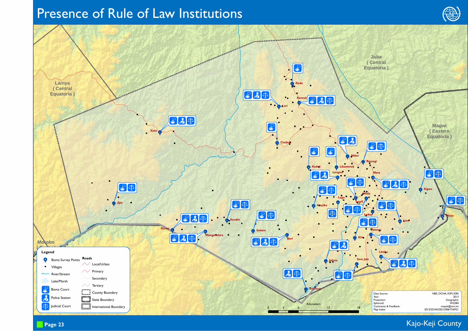
Presence of Rule of Law Institutions
Kajo-Keji County
(rq
Boma Court
Police Station
Judicial Court
Page 23
Data Source:Year:Projection:Spheroid:Comments & Feedback:Map Index:
NBS, OCHA, IOM, ESRI2013
GeographicWGS84
[email protected]/SS/VAS/S01C006/THM210 6 12 183
Kilometers

99
9
9
9
99
9
9
9
9
9
99
9
99
9 9
99
9
9
9
9 9 9
9
99
9
Morobo( Central
Equatoria )
Lainya( Central
Equatoria )
Juba( Central
Equatoria )
Magwi( Eastern
Equatoria )
MoijoLimi
Kigwo
Leikor
Sera Jale
KiriPamoju
Litoba
Logili
Bamurye
Wudu
Jalinio
KinyibaLogu
Bori
LikamerokKudajiLongira
Mere
MikerRomogi
Kala
Ajio
Kendiri
KerwaMangalatore
Sokare
Ciaderu
KansukLori
Rodo
UGANDA
hh
D h
h
h w
h
h w
h
h w
h
h w
h w
h w
u h w
u h w
hh
h
h
D hhh
u h wh
h w
z h w h
h w
h
h
D h w
Legend9 Boma Survey Points
VillagesRiver/StreamLake/Marsh
RoadsLocal/UrbanPrimarySecondaryTertiaryCounty BoundaryState BoundaryInternational Boundary
Kajo-Keji County
Duzhw
Armed ConflictDrought
Flood
HungerEpidemics
External Threats, Violations and Risks
Page 24
Data Source:Year:Projection:Spheroid:Comments & Feedback:Map Index:
NBS, OCHA, IOM, ESRI2013
GeographicWGS84
[email protected]/SS/VAS/S01C006/THM22
External Threats
0 6 12 183Kilometers
99
9
9
9
99
9
9
9
9
9
99
9
99
9 9
99
9
9
9
9 9 9
9
99
9
Morobo( Central
Equatoria )
Lainya( Central
Equatoria )
Juba( Central
Equatoria )
Magwi( Eastern
Equatoria )
MoijoLimi
Kigwo
Leikor
Sera Jale
Kiri
Pamoju
Litoba
Logili
Bamurye
Wudu
Jalinio
KinyibaLogu
Bori
LikamerokKudaji
LongiraMere
Miker
Romogi
Kala
Ajio
Kendiri
KerwaMangalatore
Sokare
Ciaderu
KansukLori
Rodo
UGANDA
D $ % W I U
D $ W I U
D $ % W I U
I U
$ % W I U
D $ % W I U
D $ % W I U
D $ % W
$ W I U
D $ % W I U
D $ W I
$ W I U
D $ W I U
D $ W IW I U
D $ % W
D $ % W I U
$ W$ % W I U
$ W I U
D $ % W I U
D $ % W I U
D $ % W I U$ % W I
D $ % W
Legend9 Boma Survey Points
VillagesRiver/StreamLake/Marsh
RoadsLocal/UrbanPrimarySecondaryTertiaryCounty BoundaryState BoundaryInternational Boundary
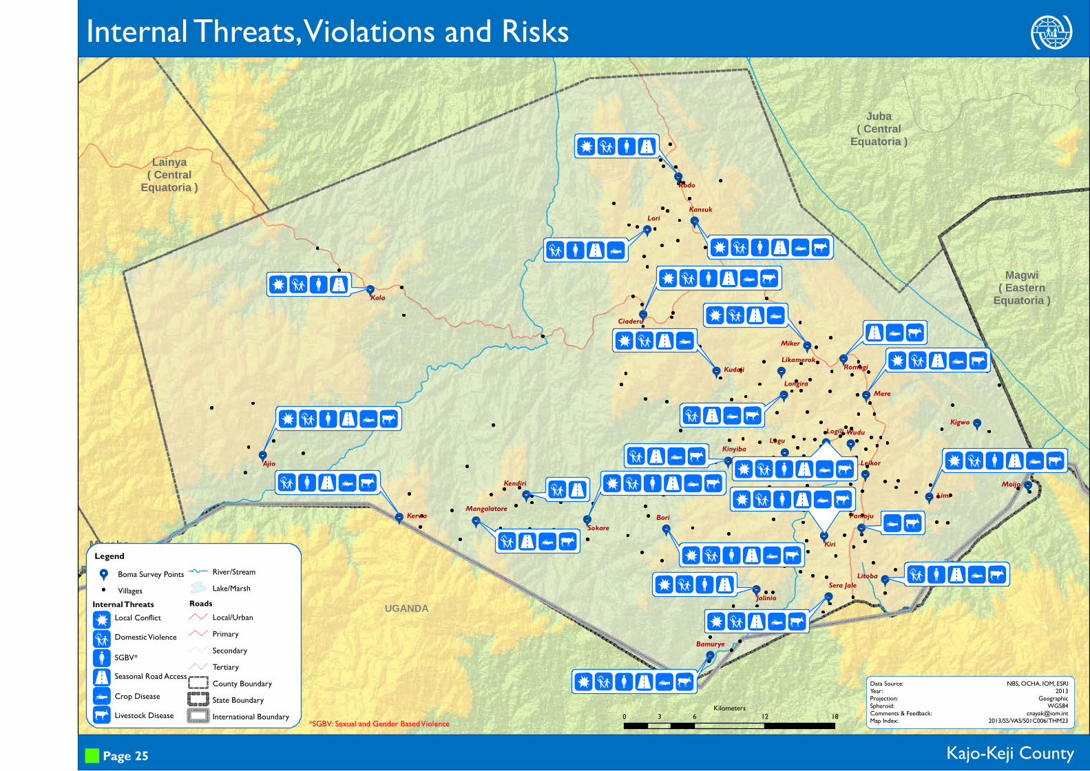
Kajo-Keji County
D$%WIU
Local Conflict
Domestic Violence
SGBV*Seasonal Road Access
Crop Disease
Livestock Disease
Internal Threats, Violations and Risks
Page 25
Data Source:Year:Projection:Spheroid:Comments & Feedback:Map Index:
NBS, OCHA, IOM, ESRI2013
GeographicWGS84
[email protected]/SS/VAS/S01C006/THM23
Internal Threats
*SGBV: Sexual and Gender Based Violence 0 6 12 183Kilometers

This page is intentionally left blank