coachcoppbvw.weebly.comcoachcoppbvw.weebly.com/.../citiesandurbanlandusepro… · Web viewWorld...
3
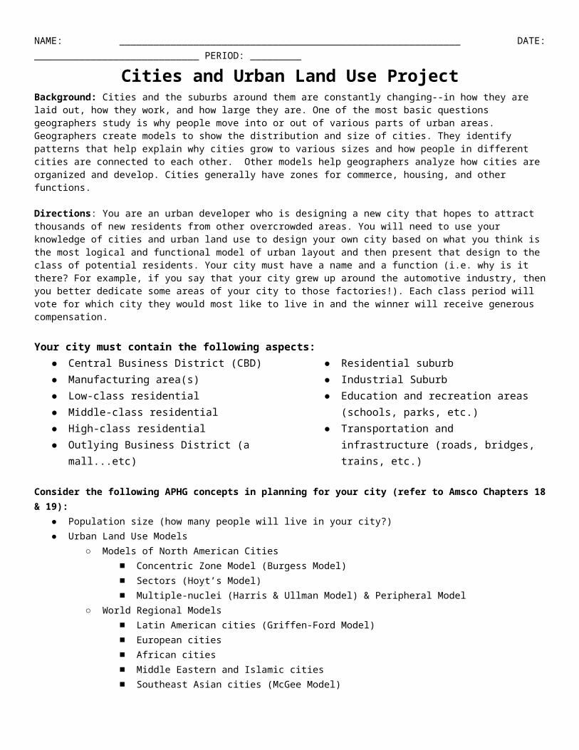
NAME: ____________________________________________________________ DATE: _____________________________ PERIOD: _________ Cities and Urban Land Use Project Background: Cities and the suburbs around them are constantly changing--in how they are laid out, how they work, and how large they are. One of the most basic questions geographers study is why people move into or out of various parts of urban areas. Geographers create models to show the distribution and size of cities. They identify patterns that help explain why cities grow to various sizes and how people in different cities are connected to each other. Other models help geographers analyze how cities are organized and develop. Cities generally have zones for commerce, housing, and other functions. Directions: You are an urban developer who is designing a new city that hopes to attract thousands of new residents from other overcrowded areas. You will need to use your knowledge of cities and urban land use to design your own city based on what you think is the most logical and functional model of urban layout and then present that design to the class of potential residents. Your city must have a name and a function (i.e. why is it there? For example, if you say that your city grew up around the automotive industry, then you better dedicate some areas of your city to those factories!). Each class period will vote for which city they would most like to live in and the winner will receive generous compensation. Your city must contain the following aspects: ● Central Business District (CBD) ● Manufacturing area(s) ● Low‐class residential ● Middle‐class residential ● High‐class residential ● Outlying Business District (a mall...etc) ● Residential suburb ● Industrial Suburb ● Education and recreation areas (schools, parks, etc.) ● Transportation and infrastructure (roads, bridges, trains, etc.) Consider the following APHG concepts in planning for your city (refer to Amsco Chapters 18 & 19): ● Population size (how many people will live in your city?) ● Urban Land Use Models ○ Models of North American Cities ■ Concentric Zone Model (Burgess Model) ■ Sectors (Hoyt’s Model) ■ Multiple-nuclei (Harris & Ullman Model) & Peripheral Model ○ World Regional Models ■ Latin American cities (Griffen-Ford Model) ■ European cities ■ African cities ■ Middle Eastern and Islamic cities ■ Southeast Asian cities (McGee Model)
Transcript of coachcoppbvw.weebly.comcoachcoppbvw.weebly.com/.../citiesandurbanlandusepro… · Web viewWorld...
NAME: ____________________________________________________________ DATE: _____________________________ PERIOD: _________
Cities and Urban Land Use ProjectBackground: Cities and the suburbs around them are constantly changing--in how they are laid out, how they work, and how large they are. One of the most basic questions geographers study is why people move into or out of various parts of urban areas. Geographers create models to show the distribution and size of cities. They identify patterns that help explain why cities grow to various sizes and how people in different cities are connected to each other. Other models help geographers analyze how cities are organized and develop. Cities generally have zones for commerce, housing, and other functions.
Directions: You are an urban developer who is designing a new city that hopes to attract thousands of new residents from other overcrowded areas. You will need to use your knowledge of cities and urban land use to design your own city based on what you think is the most logical and functional model of urban layout and then present that design to the class of potential residents. Your city must have a name and a function (i.e. why is it there? For example, if you say that your city grew up around the automotive industry, then you better dedicate some areas of your city to those factories!). Each class period will vote for which city they would most like to live in and the winner will receive generous compensation.
Your city must contain the following aspects:● Central Business District (CBD)● Manufacturing area(s)● Low‐class residential● Middle‐class residential● High‐class residential● Outlying Business District (a mall...etc)
● Residential suburb● Industrial Suburb● Education and recreation areas (schools,
parks, etc.)● Transportation and infrastructure
(roads, bridges, trains, etc.)
Consider the following APHG concepts in planning for your city (refer to Amsco Chapters 18 & 19):
● Population size (how many people will live in your city?)● Urban Land Use Models
○ Models of North American Cities ■ Concentric Zone Model (Burgess Model)■ Sectors (Hoyt’s Model)■ Multiple-nuclei (Harris & Ullman Model) & Peripheral Model
○ World Regional Models■ Latin American cities (Griffen-Ford Model)■ European cities■ African cities■ Middle Eastern and Islamic cities■ Southeast Asian cities (McGee Model)
Final Products & Assessments
Finished Product... Assessed with...
Due...
Poster with the design/blueprint of your city clearly labeled and colored C2
Wednesday, 3/29Short sales pitch group presentation of your city, its design
and key features C1
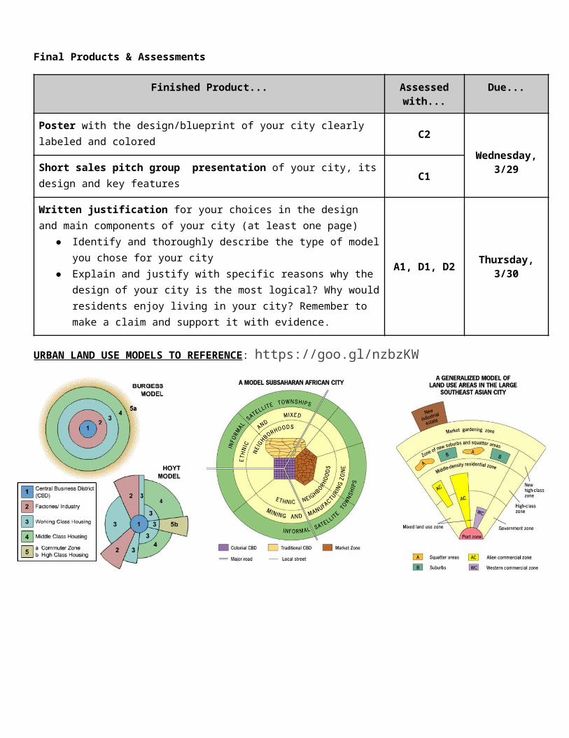
Written justification for your choices in the design and main components of your city (at least one page)
● Identify and thoroughly describe the type of model you chose for your city
● Explain and justify with specific reasons why the design of your city is the most logical? Why would residents enjoy living in your city? Remember to make a claim and support it with evidence.
A1, D1, D2 Thursday, 3/30
URBAN LAND USE MODELS TO REFERENCE: https://goo.gl/nzbzKW
Eastern European City Model Western European City Model0