VIDEO SURVEY FOR THE SOUND OF ISLAY CABLE ROUTE 1... · VIDEO SURVEY FOR THE SOUND OF ISLAY CABLE...
70
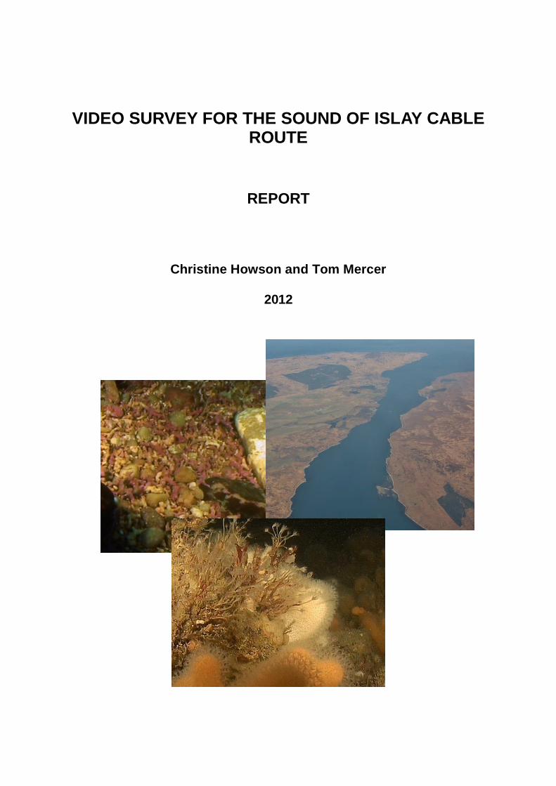
VIDEO SURVEY FOR THE SOUND OF ISLAY CABLE ROUTE REPORT Christine Howson and Tom Mercer 2012
Transcript of VIDEO SURVEY FOR THE SOUND OF ISLAY CABLE ROUTE 1... · VIDEO SURVEY FOR THE SOUND OF ISLAY CABLE...
VIDEO SURVEY FOR THE SOUND OF ISLAY CABLE ROUTE
REPORT
Christine Howson and Tom Mercer
2012

i
Video Survey for the Sound of Islay Cable Route.
Client
ScottishPower Renewables Contractor Aquatic Survey & Monitoring Ltd.
Rowangate 5 Whitfield Brow Bollihope Frosterley Co. Durham DL13 2SZ Primary Author Christine Howson Tel. +44 1875 613256
ii
Contents 1 Introduction .................................................................................................................. 1 2 Methods ........................................................................................................................ 1
2.1 Environmental conditions ........................................................................................ 1 2.2 Survey strategy ....................................................................................................... 2 2.3 Field methods ......................................................................................................... 4 2.4 Equipment............................................................................................................... 4 2.5 Data handling and analysis ..................................................................................... 5
3 Results .......................................................................................................................... 5 4 Description of the area .............................................................................................. 19
4.1 Habitat .................................................................................................................. 19 4.2 Biotopes ................................................................................................................ 19
5 Discussion .................................................................................................................. 25 5.1 Conservation interest ............................................................................................ 25
6 Conclusions ............................................................................................................... 27 7 References .................................................................................................................. 28 Appendix 1 Log of video positions ............................................................................................... 29 Appendix 2 Species recorded from video .................................................................................... 66
1
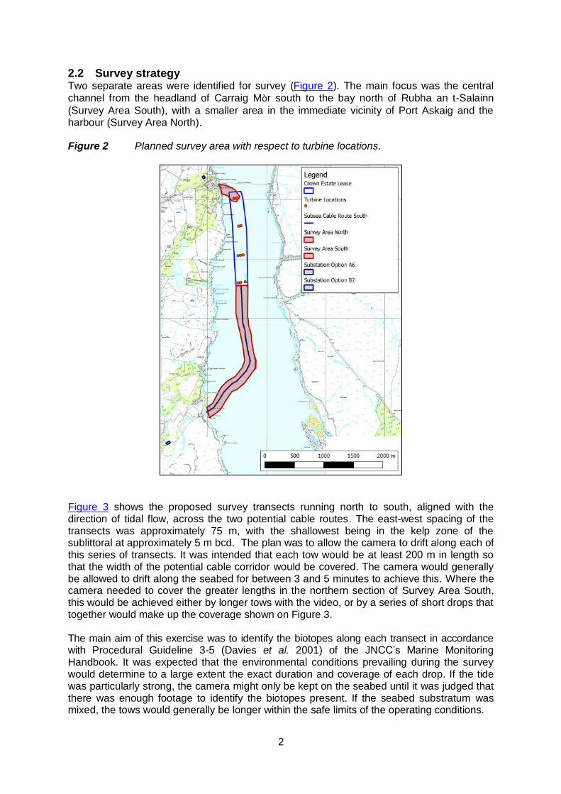
1 INTRODUCTION The strong tides that run through the Sound of Islay, the narrow rocky channel separating Islay from Jura, make it an attractive location for tidal energy turbines. The possibility of a tidal power installation has been under consideration for some years and a number of surveys have been carried out for various stages of the project. Aquatic Survey and Monitoring Ltd (ASML) were contracted in 2011 by ScottishPower Renewables to carry out a further survey of the seabed in the area proposed for cable routes (Figure 1). This report presents the results of the video survey which was carried out during December 2011 and March 2012. Figure 1 General location. Survey area lies within red line
2 METHODS
2.1 Environmental conditions The Sound of Islay runs for approximately 21 km from north west to south east but is only 1.4 km wide at its narrowest point at Port Askaig. The configuration of the Sound means that it is scoured by tides of up to 5 knots but it is very sheltered from wave action, unless winds are from the north west or south east. The deepest part of the central channel, an area of 50 to 60 m depth, extends from the narrow point at Port Askaig south for about 1.5 km. The seabed in the main, steep-sided channel is predominantly rock, boulder or cobble with some sediment in shallow embayments along the channel sides.
2
2.2 Survey strategy Two separate areas were identified for survey (Figure 2). The main focus was the central
channel from the headland of Carraig Mòr south to the bay north of Rubha an t-Salainn
(Survey Area South), with a smaller area in the immediate vicinity of Port Askaig and the harbour (Survey Area North). Figure 2 Planned survey area with respect to turbine locations.
Figure 3 shows the proposed survey transects running north to south, aligned with the direction of tidal flow, across the two potential cable routes. The east-west spacing of the transects was approximately 75 m, with the shallowest being in the kelp zone of the sublittoral at approximately 5 m bcd. The plan was to allow the camera to drift along each of this series of transects. It was intended that each tow would be at least 200 m in length so that the width of the potential cable corridor would be covered. The camera would generally be allowed to drift along the seabed for between 3 and 5 minutes to achieve this. Where the camera needed to cover the greater lengths in the northern section of Survey Area South, this would be achieved either by longer tows with the video, or by a series of short drops that together would make up the coverage shown on Figure 3. The main aim of this exercise was to identify the biotopes along each transect in accordance with Procedural Guideline 3-5 (Davies et al. 2001) of the JNCC’s Marine Monitoring Handbook. It was expected that the environmental conditions prevailing during the survey would determine to a large extent the exact duration and coverage of each drop. If the tide was particularly strong, the camera might only be kept on the seabed until it was judged that there was enough footage to identify the biotopes present. If the seabed substratum was mixed, the tows would generally be longer within the safe limits of the operating conditions.
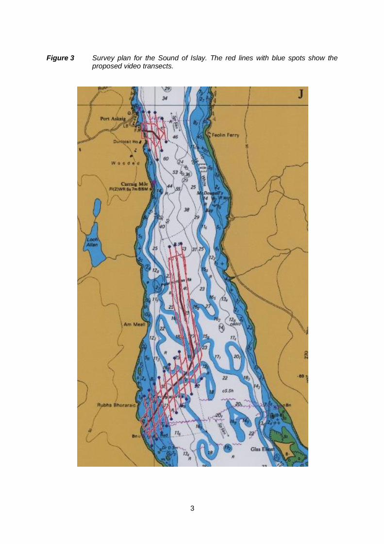
3
Figure 3 Survey plan for the Sound of Islay. The red lines with blue spots show the
proposed video transects.

4
2.3 Field methods Field work was carried out over two periods of neap tides, 5th December 2011 and 15th – 17th March 2012 by Tom Mercer and Christine Howson of ASML and Colin Campbell of Campbell Marine Contracts. The survey was based at Port Askaig using the RIB Shannick (Plate 1). Problems with the power supply to the camera system during the first mobilisation during December 2011 meant that the survey had to be curtailed and rescheduled for spring 2012. Whilst the camera was deployed on the seabed, one surveyor made hand-written records of the station code, GPS locations (start and end), waypoint numbers, drop times and brief notes of the visible habitat, species and any other notable features. A second surveyor controlled the umbilical for the camera on the seabed. Plate 1 The survey vessel RIB Shannick moored at Port Askaig and leaving at dusk
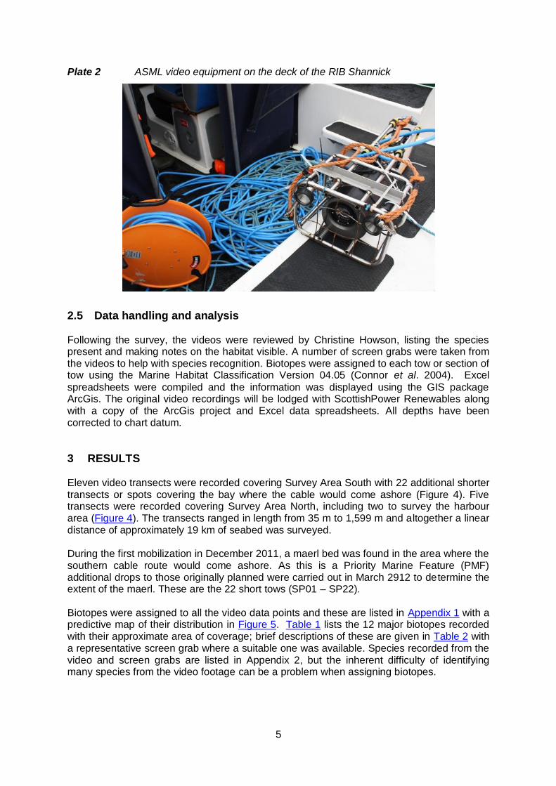
2.4 Equipment The ASML video system is a Sony HDRXR200VE digital video camera in an aluminium housing rated to 130 m (Plate 2). The use of a 110 m multi-core umbilical allows the system (camera and lights) to be controlled from the surface. The camera itself films the seabed from a position resting on the bottom, if conditions allow, or drifting just above the seabed with the person controlling the cable lifting the camera when obstructions appear on the surface screen. The digital video footage was relayed to the surface via the umbilical where it was viewed and recorded on a Sony mini digital VCR (GV-D1000E). The surface control box provided the remote control facilities over the camera, the surface video recorder and the lights. The lights were powered by an independent surface 110 v system generator.
A back up video system was hired from Seatronics in Aberdeen for the March 2012 survey but was not deployed.
Position fixing and depth recording were carried out by Colin Campbell using a Garmin GPSMAP 551s fitted with a Garmin 50/200 kHz dual frequency transom mount transducer (depth), and an external Garmin GPS antenna, model GA29 (position). Positions were recorded to WGS 84 datum.
5
Plate 2 ASML video equipment on the deck of the RIB Shannick
2.5 Data handling and analysis Following the survey, the videos were reviewed by Christine Howson, listing the species present and making notes on the habitat visible. A number of screen grabs were taken from the videos to help with species recognition. Biotopes were assigned to each tow or section of tow using the Marine Habitat Classification Version 04.05 (Connor et al. 2004). Excel
spreadsheets were compiled and the information was displayed using the GIS package ArcGis. The original video recordings will be lodged with ScottishPower Renewables along with a copy of the ArcGis project and Excel data spreadsheets. All depths have been corrected to chart datum.
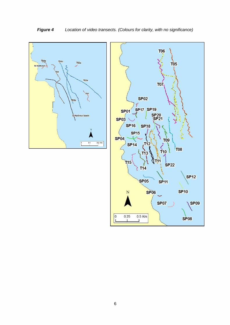
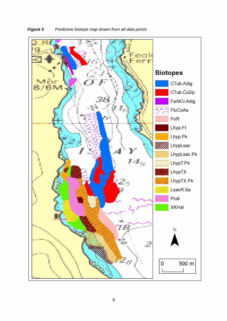
3 RESULTS Eleven video transects were recorded covering Survey Area South with 22 additional shorter transects or spots covering the bay where the cable would come ashore (Figure 4). Five transects were recorded covering Survey Area North, including two to survey the harbour area (Figure 4). The transects ranged in length from 35 m to 1,599 m and altogether a linear distance of approximately 19 km of seabed was surveyed. During the first mobilization in December 2011, a maerl bed was found in the area where the southern cable route would come ashore. As this is a Priority Marine Feature (PMF) additional drops to those originally planned were carried out in March 2912 to determine the extent of the maerl. These are the 22 short tows (SP01 – SP22). Biotopes were assigned to all the video data points and these are listed in Appendix 1 with a predictive map of their distribution in Figure 5. Table 1 lists the 12 major biotopes recorded with their approximate area of coverage; brief descriptions of these are given in Table 2 with a representative screen grab where a suitable one was available. Species recorded from the video and screen grabs are listed in Appendix 2, but the inherent difficulty of identifying many species from the video footage can be a problem when assigning biotopes.
6
Figure 4 Location of video transects. (Colours for clarity, with no significance)

7
Table 1 Major biotopes recorded from the video with their approximate area of
coverage
Biotope Area (km2)
IR.MIR.KR.LhypTX ( incl. Pk) 0.334
CR.HCR.FaT.CTub.Adig 0.311
CR.HCR.XFa.FluCoAs 0.226
CR.HCR.FaT.CTub.CuSp 0.204
IR.LIR.K.LhypLsac ( incl. Pk) 0.193
SS.SMp.Mrl.Pcal 0.129
IR.HIR.KSed.XKHal 0.096
IR.HIR.KFaR.FoR 0.069
SS.SMp.KSwSS.LsacR.Sa 0.058
IR.MIR.KR.Lhyp (.Ft & .Pk) 0.035
IR.MIR.KR.LhypT.Pk 0.027
CR.MCR.EcCr.FaAlCr.Adig 0.012
8
Figure 5 Predictive biotope map drawn from all data points
9
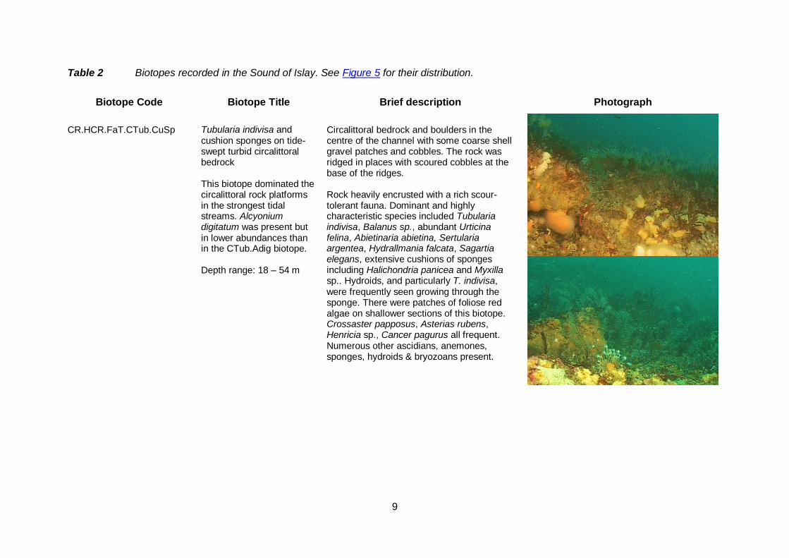
Table 2 Biotopes recorded in the Sound of Islay. See Figure 5 for their distribution.
Biotope Code Biotope Title Brief description Photograph
CR.HCR.FaT.CTub.CuSp
Tubularia indivisa and cushion sponges on tide-swept turbid circalittoral bedrock
Circalittoral bedrock and boulders in the centre of the channel with some coarse shell gravel patches and cobbles. The rock was ridged in places with scoured cobbles at the base of the ridges. Rock heavily encrusted with a rich scour-tolerant fauna. Dominant and highly characteristic species included Tubularia indivisa, Balanus sp., abundant Urticina felina, Abietinaria abietina, Sertularia argentea, Hydrallmania falcata, Sagartia elegans, extensive cushions of sponges including Halichondria panicea and Myxilla sp.. Hydroids, and particularly T. indivisa, were frequently seen growing through the sponge. There were patches of foliose red algae on shallower sections of this biotope. Crossaster papposus, Asterias rubens, Henricia sp., Cancer pagurus all frequent. Numerous other ascidians, anemones, sponges, hydroids & bryozoans present.
This biotope dominated the circalittoral rock platforms in the strongest tidal streams. Alcyonium digitatum was present but in lower abundances than in the CTub.Adig biotope. Depth range: 18 – 54 m
10
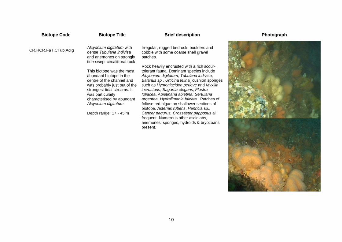
Biotope Code Biotope Title Brief description Photograph
CR.HCR.FaT.CTub.Adig
Alcyonium digitatum with dense Tubularia indivisa and anemones on strongly tide-swept circalittoral rock
Irregular, rugged bedrock, boulders and cobble with some coarse shell gravel patches. Rock heavily encrusted with a rich scour-tolerant fauna. Dominant species include Alcyonium digitatum, Tubularia indivisa, Balanus sp., Urticina felina¸ cushion sponges such as Hymeniacidon perleve and Myxilla incrustans, Sagartia elegans, Flustra foliacea, Abietinaria abietina, Sertularia argentea, Hydrallmania falcata. Patches of foliose red algae on shallower sections of biotope. Asterias rubens, Henricia sp., Cancer pagurus, Crossaster papposus all frequent. Numerous other ascidians, anemones, sponges, hydroids & bryozoans present.
This biotope was the most abundant biotope in the centre of the channel and was probably just out of the strongest tidal streams. It was particularly characterised by abundant Alcyonium digitatum. Depth range: 17 - 45 m
11
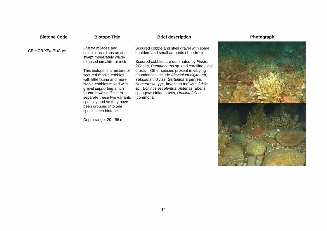
Biotope Code Biotope Title Brief description Photograph
CR.HCR.XFa.FluCoAs
Flustra foliacea and colonial ascidians on tide-swept moderately wave-exposed circalittoral rock
Scoured cobble and shell gravel with some boulders and small amounts of bedrock. Scoured cobbles are dominated by Flustra foliacea, Pomatoceros sp. and coralline algal crusts. Other species present in varying abundances include Alcyonium digitatum, Tubularia indivisa, Sertularia argentea, Nemertesia spp., bryozoan turf with Crisia sp., Echinus esculentus, Asterias rubens, sponge/ascidian crusts, Urticina felina (common).
This biotope is a mixture of scoured mobile cobbles with little fauna and more stable cobbles mixed with gravel supporting a rich fauna. It was difficult to separate these two variants spatially and so they have been grouped into one species rich biotope. Depth range: 20 - 56 m
12
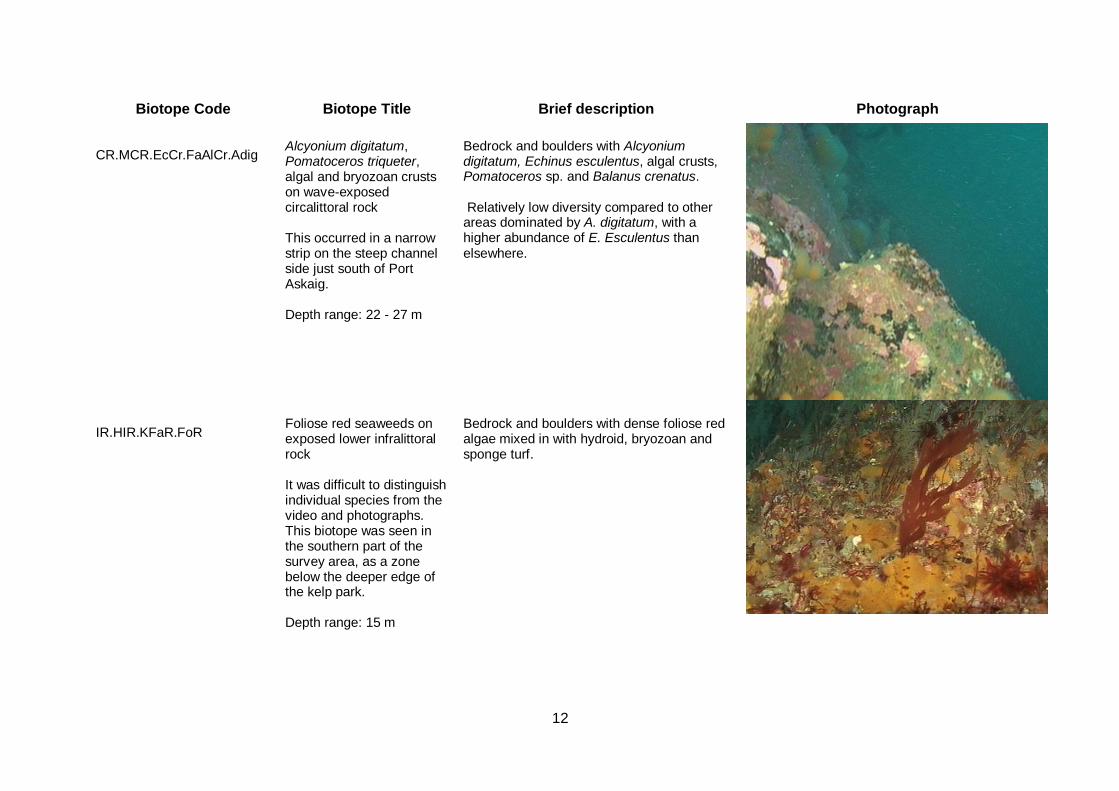
Biotope Code Biotope Title Brief description Photograph
CR.MCR.EcCr.FaAlCr.Adig
Alcyonium digitatum, Pomatoceros triqueter, algal and bryozoan crusts on wave-exposed circalittoral rock This occurred in a narrow strip on the steep channel side just south of Port Askaig. Depth range: 22 - 27 m
Bedrock and boulders with Alcyonium digitatum, Echinus esculentus, algal crusts, Pomatoceros sp. and Balanus crenatus. Relatively low diversity compared to other areas dominated by A. digitatum, with a higher abundance of E. Esculentus than elsewhere.
IR.HIR.KFaR.FoR
Foliose red seaweeds on exposed lower infralittoral rock
Bedrock and boulders with dense foliose red algae mixed in with hydroid, bryozoan and sponge turf.
It was difficult to distinguish individual species from the video and photographs. This biotope was seen in the southern part of the survey area, as a zone below the deeper edge of the kelp park. Depth range: 15 m
13
Biotope Code Biotope Title Brief description Photograph
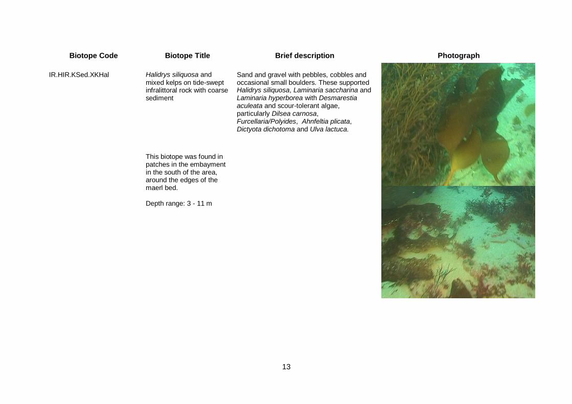
IR.HIR.KSed.XKHal
Halidrys siliquosa and mixed kelps on tide-swept infralittoral rock with coarse sediment
Sand and gravel with pebbles, cobbles and occasional small boulders. These supported Halidrys siliquosa, Laminaria saccharina and Laminaria hyperborea with Desmarestia aculeata and scour-tolerant algae, particularly Dilsea carnosa, Furcellaria/Polyides, Ahnfeltia plicata, Dictyota dichotoma and Ulva lactuca.
This biotope was found in patches in the embayment in the south of the area, around the edges of the maerl bed. Depth range: 3 - 11 m
14
Biotope Code Biotope Title Brief description Photograph
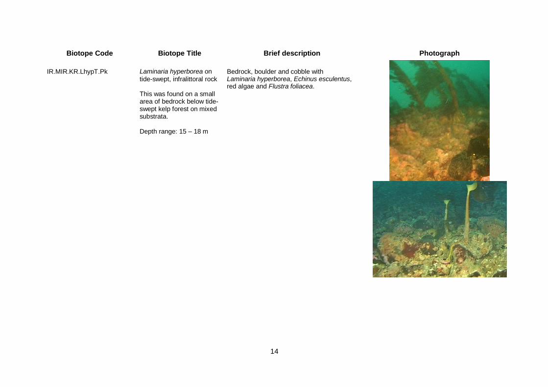
IR.MIR.KR.LhypT.Pk
Laminaria hyperborea on tide-swept, infralittoral rock This was found on a small area of bedrock below tide-swept kelp forest on mixed substrata. Depth range: 15 – 18 m
Bedrock, boulder and cobble with Laminaria hyperborea, Echinus esculentus, red algae and Flustra foliacea.
15
Biotope Code Biotope Title Brief description Photograph
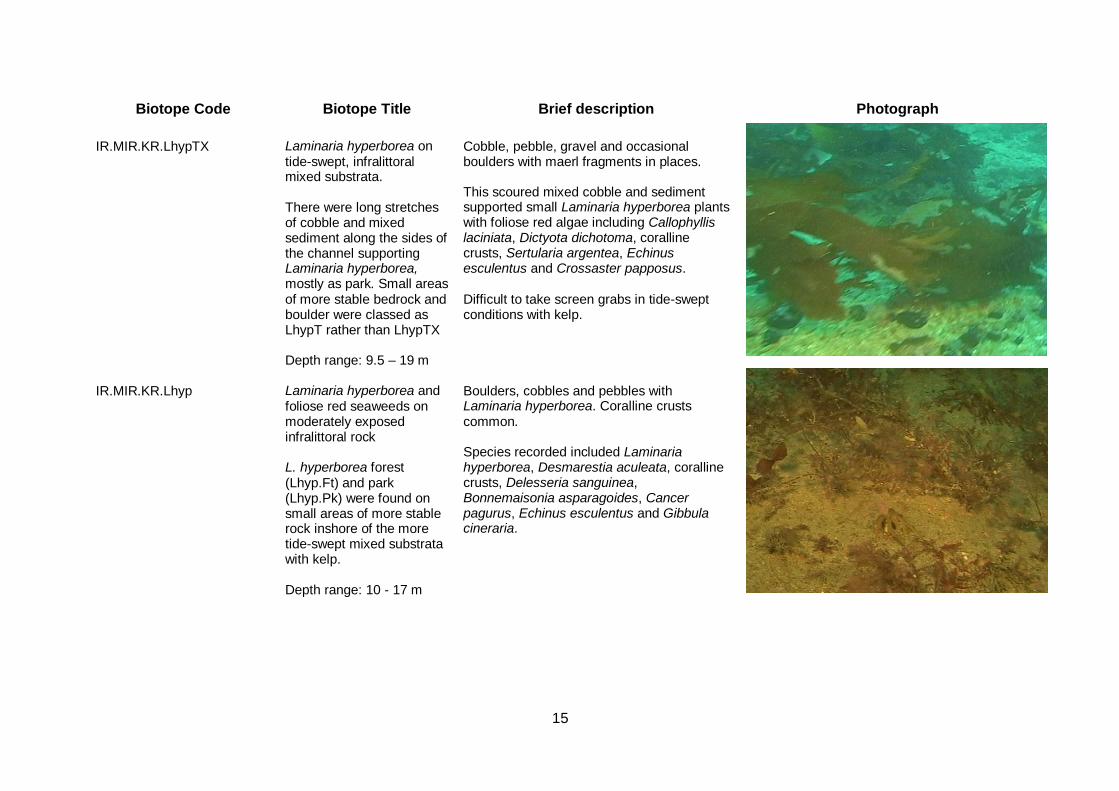
IR.MIR.KR.LhypTX
Laminaria hyperborea on tide-swept, infralittoral mixed substrata. There were long stretches of cobble and mixed sediment along the sides of the channel supporting Laminaria hyperborea, mostly as park. Small areas of more stable bedrock and boulder were classed as LhypT rather than LhypTX Depth range: 9.5 – 19 m
Cobble, pebble, gravel and occasional boulders with maerl fragments in places. This scoured mixed cobble and sediment supported small Laminaria hyperborea plants with foliose red algae including Callophyllis laciniata, Dictyota dichotoma, coralline crusts, Sertularia argentea, Echinus esculentus and Crossaster papposus. Difficult to take screen grabs in tide-swept conditions with kelp.
IR.MIR.KR.Lhyp
Laminaria hyperborea and foliose red seaweeds on moderately exposed infralittoral rock L. hyperborea forest (Lhyp.Ft) and park (Lhyp.Pk) were found on small areas of more stable rock inshore of the more tide-swept mixed substrata with kelp. Depth range: 10 - 17 m
Boulders, cobbles and pebbles with Laminaria hyperborea. Coralline crusts common. Species recorded included Laminaria hyperborea, Desmarestia aculeata, coralline crusts, Delesseria sanguinea, Bonnemaisonia asparagoides, Cancer pagurus, Echinus esculentus and Gibbula cineraria.
16
Biotope Code Biotope Title Brief description Photograph
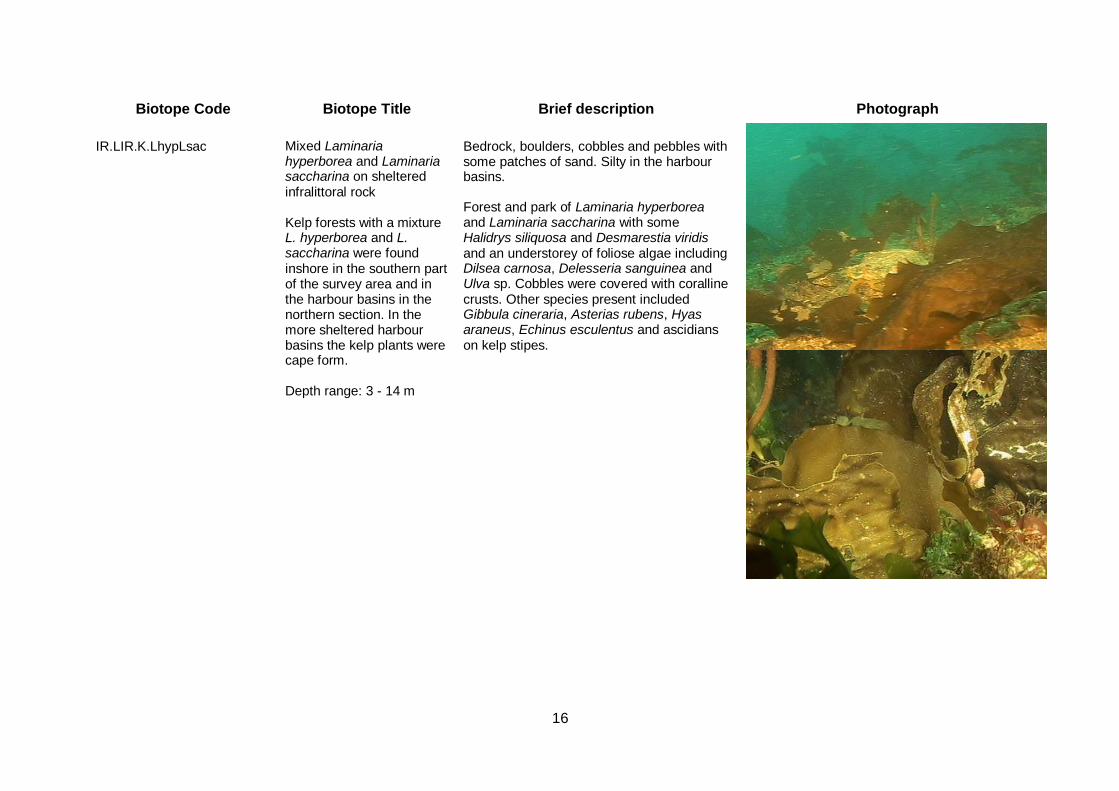
IR.LIR.K.LhypLsac
Mixed Laminaria hyperborea and Laminaria saccharina on sheltered infralittoral rock Kelp forests with a mixture L. hyperborea and L. saccharina were found inshore in the southern part of the survey area and in the harbour basins in the northern section. In the more sheltered harbour basins the kelp plants were cape form. Depth range: 3 - 14 m
Bedrock, boulders, cobbles and pebbles with some patches of sand. Silty in the harbour basins. Forest and park of Laminaria hyperborea and Laminaria saccharina with some Halidrys siliquosa and Desmarestia viridis and an understorey of foliose algae including Dilsea carnosa, Delesseria sanguinea and Ulva sp. Cobbles were covered with coralline crusts. Other species present included Gibbula cineraria, Asterias rubens, Hyas araneus, Echinus esculentus and ascidians on kelp stipes.
17
Biotope Code Biotope Title Brief description Photograph
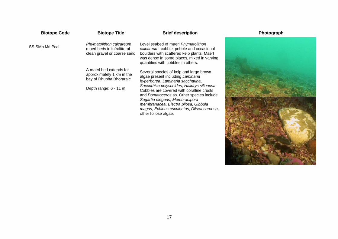
SS.SMp.Mrl.Pcal
Phymatolithon calcareum maerl beds in infralittoral clean gravel or coarse sand
Level seabed of maerl Phymatolithon calcareum, cobble, pebble and occasional boulders with scattered kelp plants. Maerl was dense in some places, mixed in varying quantities with cobbles in others. Several species of kelp and large brown algae present including Laminaria hyperborea, Laminaria saccharina, Saccorhiza polyschides, Halidrys siliquosa. Cobbles are covered with coralline crusts and Pomatoceros sp. Other species include Sagartia elegans, Membranipora membranacea, Electra pilosa, Gibbula magus, Echinus esculentus, Dilsea carnosa, other foliose algae.
A maerl bed extends for approximately 1 km in the bay of Rhubha Bhoraraic. Depth range: 6 - 11 m
18
Biotope Code Biotope Title Brief description Photograph
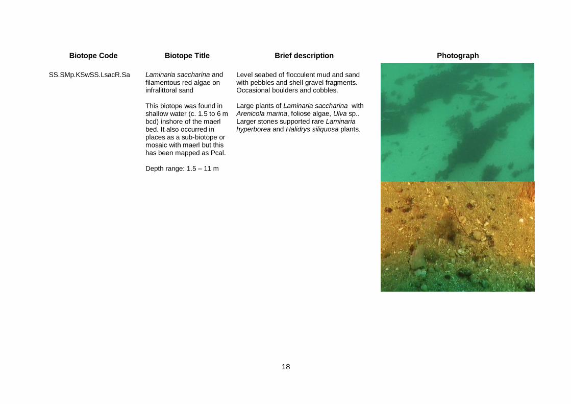
SS.SMp.KSwSS.LsacR.Sa
Laminaria saccharina and filamentous red algae on infralittoral sand This biotope was found in shallow water (c. 1.5 to 6 m bcd) inshore of the maerl bed. It also occurred in places as a sub-biotope or mosaic with maerl but this has been mapped as Pcal. Depth range: 1.5 – 11 m
Level seabed of flocculent mud and sand with pebbles and shell gravel fragments. Occasional boulders and cobbles. Large plants of Laminaria saccharina with Arenicola marina, foliose algae, Ulva sp.. Larger stones supported rare Laminaria hyperborea and Halidrys siliquosa plants.

19
4 DESCRIPTION OF THE AREA
4.1 Habitat The Sound of Islay is approximately 1.4 km wide at its narrowest point at Port Askaig, the northern limit of the survey area. The deepest part of the central channel, an area of 50 to 60 m depth, extends from this narrow point south for about 1.5 km, and this deep basin is the proposed location of the tidal turbines. There is a narrow, shallow shelf along both sides of much of the Sound, with the seabed dropping steeply to the deeper central channel. The shelf is broader in embayments such as that where the cable may come ashore. The seabed over most of the central survey area where the current speeds are highest consisted of rugged bedrock and boulders interspersed with areas of rounded, mobile cobbles, many of which were very bare. A number of low ridges were apparent on the video; these had large numbers of crevices, fissures and small overhangs, providing a variety of microhabitats for the fauna. This seabed topography in the centre of the Sound, where the current speeds are greatest (up to 5 knots), can be expected to create localised areas of shelter behind and below the rock ridges whereas the tops of the ridges are exposed to the strongest currents. The shallower shelf at the southern edge of the survey area was out of the very fastest tidal streams. This shelf consisted primarily of coarse sand and gravel with cobbles and boulders, with a large area of maerl. Close inshore there was an area of finer sand. The seabed in the vicinity of the harbour at Port Askaig consisted of silty mixed cobbles, boulders and sediment with some harbour debris apparent.
4.2 Biotopes
The communities present in the area are all characteristic of current swept sounds. Bedrock was the largest habitat by area within the Sound and was heavily encrusted with low-lying fauna. Particular species were patchy in their distribution, which was probably an effect of localised variation in current strength. Three major circalittoral biotopes were identified: CR.HCR.FaT.CTub.CuSp; CR.HCR.FaT.CTub.Adig; CR.HCR.XFa.FluCoAs. There was considerable overlap in their distribution and features, with similar species present in each but in differing abundance. They were separated on gross features. FaT.CTub.CuSp was dominated by cushion sponges and hydroids whilst Alcyonium digitatum was particularly
abundant in FaT.CTub.Adig. XFa.FluCoAs was found predominantly on cobbles.
In the areas of strongest current, such as the higher parts of the ridges, the hydroids Tubularia indivisa, Sertularia argentea and Abietinaria abietina and cushion sponges including Halichondria panicea, Esperiopsis fucorum and Myxilla sp. were abundant, with hydroids often growing through the sponges (Plate 3). Dead men’s fingers Alcyonium digitatum were present but in low abundance whereas in places the dahlia anemone Urticina felina was superabundant (Plate 4). These current-swept bedrock communities appeared to have a rich associated fauna of anemones (Sagartia elegans, Actinothoe sphyrodeta), hydroids including Hydrallmania falcata and Halecium spp., the barnacle Balanus crenatus, other sponges such as Pachymatisma johnstonia, ascidians which could not be identified from the video and bryozoans notably Flustra foliacea and Alcyonidium diaphanum. Mobile species included the dog whelk Nucella lapillus, often seen in deeper tidal rapids, the edible crab Cancer pagurus and the starfish Henricia sp. and Asterias rubens.
Vertical faces with fissures and overhangs greatly increased the diversity of the bedrock and it was clear that there were additional ascidians, sponges, bryozoans and anemones on these. Although only a small number of species could be identified from the video, it was felt
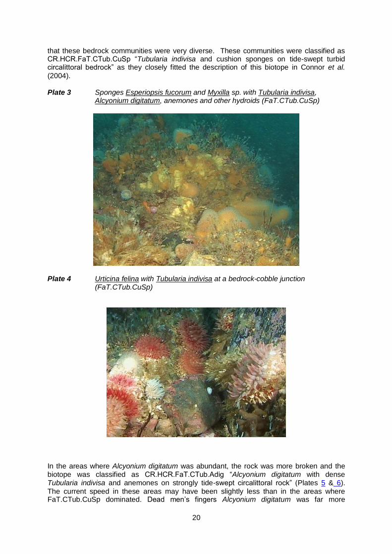
20
that these bedrock communities were very diverse. These communities were classified as CR.HCR.FaT.CTub.CuSp “Tubularia indivisa and cushion sponges on tide-swept turbid circalittoral bedrock” as they closely fitted the description of this biotope in Connor et al.
(2004). Plate 3 Sponges Esperiopsis fucorum and Myxilla sp. with Tubularia indivisa,
Alcyonium digitatum, anemones and other hydroids (FaT.CTub.CuSp)
Plate 4 Urticina felina with Tubularia indivisa at a bedrock-cobble junction
(FaT.CTub.CuSp)
In the areas where Alcyonium digitatum was abundant, the rock was more broken and the biotope was classified as CR.HCR.FaT.CTub.Adig “Alcyonium digitatum with dense Tubularia indivisa and anemones on strongly tide-swept circalittoral rock” (Plates 5 & 6).
The current speed in these areas may have been slightly less than in the areas where FaT.CTub.CuSp dominated. Dead men’s fingers Alcyonium digitatum was far more
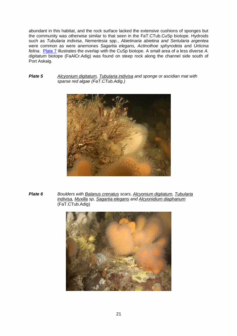
21
abundant in this habitat, and the rock surface lacked the extensive cushions of sponges but the community was otherwise similar to that seen in the FaT.CTub.CuSp biotope. Hydroids such as Tubularia indivisa, Nemertesia spp., Abietinaria abietina and Sertularia argentea were common as were anemones Sagartia elegans, Actinothoe sphyrodeta and Urticina felina. Plate 7 illustrates the overlap with the CuSp biotope. A small area of a less diverse A. digitatum biotope (FaAlCr.Adig) was found on steep rock along the channel side south of Port Askaig. Plate 5 Alcyonium digitatum, Tubularia indivisa and sponge or ascidian mat with
sparse red algae (FaT.CTub.Adig.)
Plate 6 Boulders with Balanus crenatus scars, Alcyonium digitatum, Tubularia
indivisa, Myxilla sp, Sagartia elegans and Alcyonidium diaphanum
(FaT.CTub.Adig)

22
Plate 7 Irregular bedrock with Alcyonium digitatum, Flustra foliacea, Hydrallmania falcata, Sagartia elegans and sponge/hydroid/bryozoan turf (FaT.CTub.Adig).
Smooth, rounded mixed boulders and cobbles with pockets of coarse gravel had sediment scoured communities with the bryozoan Flustra foliacea dominant and hydroid/bryozoan turf abundant. Other species were similar to those found in the other rocky biotopes in the area (Plate 8). These were classed as CR.HCR.XFa.FluCoAs “Flustra foliacea and colonial
ascidians on tide-swept moderately wave-exposed circalittoral rock”. Ascidian crusts were not conspicuous but the community was generally too diverse and tide-swept to warrant classification as any other Flustra biotope. However there were stretches of the seabed with very clean cobbles with little fauna (Plate 9); these created a mosaic with the Flustra biotope,
also a cobble habitat, and it was not possible to map them separately. These patches were considered to be a highly scoured and impoverished variant of the FluCoAs biotope and so have been included in this biotope for mapping purposes. This patchiness is typical of tide-swept seabed environments. Plate 8 Cobbles and gravel with Flustra foliacea, mixed hydroids and bryozoans and
Urticina felina (XFa.FluCoAs).
23
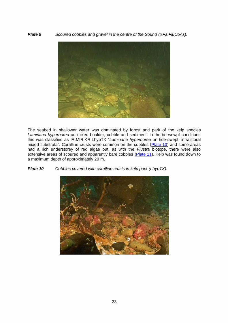
Plate 9 Scoured cobbles and gravel in the centre of the Sound (XFa.FluCoAs).
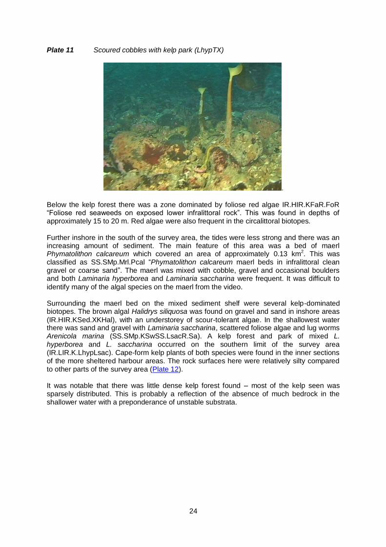
The seabed in shallower water was dominated by forest and park of the kelp species Laminaria hyperborea on mixed boulder, cobble and sediment. In the tidesewpt conditions this was classified as IR.MIR.KR.LhypTX “Laminaria hyperborea on tide-swept, infralittoral
mixed substrata”. Coralline crusts were common on the cobbles (Plate 10) and some areas had a rich understorey of red algae but, as with the Flustra biotope, there were also
extensive areas of scoured and apparently bare cobbles (Plate 11). Kelp was found down to a maximum depth of approximately 20 m. Plate 10 Cobbles covered with coralline crusts in kelp park (LhypTX).
24
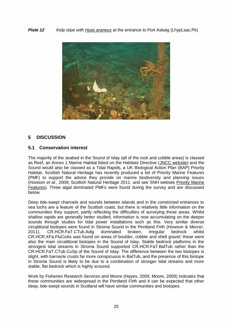
Plate 11 Scoured cobbles with kelp park (LhypTX)
.
Below the kelp forest there was a zone dominated by foliose red algae IR.HIR.KFaR.FoR “Foliose red seaweeds on exposed lower infralittoral rock”. This was found in depths of approximately 15 to 20 m. Red algae were also frequent in the circalittoral biotopes. Further inshore in the south of the survey area, the tides were less strong and there was an increasing amount of sediment. The main feature of this area was a bed of maerl Phymatolithon calcareum which covered an area of approximately 0.13 km2. This was classified as SS.SMp.Mrl.Pcal “Phymatolithon calcareum maerl beds in infralittoral clean gravel or coarse sand”. The maerl was mixed with cobble, gravel and occasional boulders and both Laminaria hyperborea and Laminaria saccharina were frequent. It was difficult to
identify many of the algal species on the maerl from the video. Surrounding the maerl bed on the mixed sediment shelf were several kelp-dominated biotopes. The brown algal Halidrys siliquosa was found on gravel and sand in inshore areas
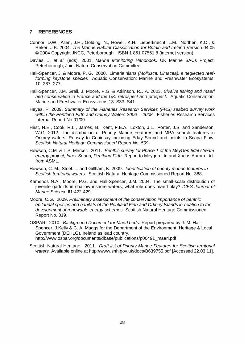
(IR.HIR.KSed.XKHal), with an understorey of scour-tolerant algae. In the shallowest water there was sand and gravel with Laminaria saccharina, scattered foliose algae and lug worms Arenicola marina (SS.SMp.KSwSS.LsacR.Sa). A kelp forest and park of mixed L. hyperborea and L. saccharina occurred on the southern limit of the survey area (IR.LIR.K.LhypLsac). Cape-form kelp plants of both species were found in the inner sections of the more sheltered harbour areas. The rock surfaces here were relatively silty compared to other parts of the survey area (Plate 12). It was notable that there was little dense kelp forest found – most of the kelp seen was sparsely distributed. This is probably a reflection of the absence of much bedrock in the shallower water with a preponderance of unstable substrata.
25
Plate 12 Kelp stipe with Hyas araneus at the entrance to Port Askaig (LhypLsac.Pk)
5 DISCUSSION
5.1 Conservation interest The majority of the seabed in the Sound of Islay (all of the rock and cobble areas) is classed as Reef, an Annex 1 Marine Habitat listed on the Habitats Directive (JNCC website) and the Sound would also be classed as a Tidal Rapids, a UK Biological Action Plan (BAP) Priority Habitat. Scottish Natural Heritage has recently produced a list of Priority Marine Features (PMF) to support the advice they provide on marine biodiversity and planning issues (Howson et al., 2009; Scottish Natural Heritage 2011; and see SNH website Priority Marine
Features). Three algal dominated PMFs were found during the survey and are discussed below. Deep tide-swept channels and sounds between islands and in the constricted entrances to sea lochs are a feature of the Scottish coast, but there is relatively little information on the communities they support, partly reflecting the difficulties of surveying these areas. Whilst shallow rapids are generally better studied, information is now accumulating on the deeper sounds through studies for tidal power installations such as this. Very similar diverse circalittoral biotopes were found in Stroma Sound in the Pentland Firth (Howson & Mercer, 2011). CR.HCR.FaT.CTub.Adig dominated broken, irregular bedrock whilst CR.HCR.XFa.FluCoAs was found on areas of boulder, cobble and shell gravel; these were also the main circalittoral biotopes in the Sound of Islay. Stable bedrock platforms in the strongest tidal streams in Stroma Sound supported CR.HCR.FaT.BalTub rather than the CR.HCR.FaT.CTub.CuSp of the Sound of Islay. The difference between the two biotopes is slight, with barnacle crusts far more conspicuous in BalTub, and the presence of this biotope in Stroma Sound is likely to be due to a combination of stronger tidal streams and more stable, flat bedrock which is highly scoured. Work by Fisheries Research Services and Moore (Hayes, 2009; Moore, 2009) indicates that these communities are widespread in the Pentland Firth and it can be expected that other deep, tide-swept sounds in Scotland will have similar communities and biotopes.

26
There were several different infralittoral communities surveyed in the Sound of Islay, including three which are listed as PMFs by Howson et al. (2009). Of the PMFs recorded, tide-swept Laminaria hyperborea forest and park on mixed substrata (IR.MIR.KR.LhypTX)
covered the largest area. Although this biotope is often structurally complex and species rich (Howson et al., 2009), this did not appear to be the case in the Sound where much of the
cobble substratum was dominated by algal crusts and this particular example of the biotope would not seem to be of high conservation value. The maerl bed SS.SMp.Mrl.Pcal, another PMF, was relatively small, covering an area of approximately 0.13 km2. For comparison, Table 3 shows the estimated area for a number of maerl beds around Britain for which this information is readily available. Scotland has approximately 30% of the maerl beds in north-west Europe (OSPAR, 2010). These beds have a complex structure which supports species rich communities, including juvenile queen scallops, other juvenile invertebrates and gadoids (Kamenos et al., 2004), with many species
which live preferentially on maerl. They are fragile and easily damaged by traditional and hydraulic scallop dredging, extraction and pollution (Hall-Spencer & Moore, 2000; Hall-Spencer et al., 2003). Undredged maerl grounds can be of long-term benefit to fisheries,
acting as reproductive reservoirs for future generations of commercially important bivalve species. Remote video is not a suitable tool for assessment of the species richness of the maerl, as many of the species normally associated with the habitat are small or difficult to identify, and the survey was carried out in the winter and spring, before seasonal algal growth. Whilst maerl beds are of high intrinsic conservation value, no judgement can be made on the significance of this particular bed in terms of its species composition. However, beds of this size are not uncommon on the west coast of Scotland and it is probable that there are other similar beds in the vicinity.
Table 3 Extent of selected UK maerl beds compared with the bed surveyed in the Sound of Islay. (Information on other beds from Hirst et al., 2012).
Extent (best estimate
in km2)
Type of coast
Bed
12.88 Open Wide Firth and Kirkwall Bay, Orkney
9.07 Open Sound of Barra, Outer Hebrides
7 Open Antrim Coast, N. Ireland
4.26 Open Sound of Arisaig, west Scotland
3.71 Open Wyre and Rousay, Orkney
1.98 Open Gairsay, Orkney
1.75 Open Eday, Orkney
1.5 Estuary Milford Haven, Wales
0.48 Open Veantrow Bay, Orkney
0.46 Open Shapinsay, Orkney
0.12 Sealoch Badluarach, Little Loch Broom, north west Scotland
0.13 Sound Sound of Islay, Inner Hebrides (This survey)
The third PMF recorded in the area was Halidrys siliquosa and mixed kelps on tide-swept rock and sediment (IR.HIR.KSed.XKHal). This was found in three areas around the edge of the maerl bed and is likely to be more widespread in shallow water in the Sound; Howson et al. (2009) comment that it is probably under-recorded in Scotland. There appeared to be a
rich associated scour tolerant flora on the sand but it was difficult to identify algal species from the video (Plate 11)

27
Plate 11 Mixed kelps and Halidrys siliquosa with scour tolerant algae on sand (XKHal).
The inshore section of the southern survey area comprises a mosaic of these three tide-swept, algal dominated biotopes. Together with the sandier LsacR.Sa, which is not a PMF, they cover an area of approximately 0.52 km2 and fill most of the embayment. With a range of sediments from cobble to fine sand and the attenuation of the tidal stream into the embayment, this is potentially a species rich site of conservation interest. The resilience of this inshore area to the construction of a cable route would depend upon the precise route and landfall site of the cable. Given that the area is relatively small (Table 3) and that there are likely to be other similar suites of biotopes within the Sound of Islay and adjacent tide-swept areas, putting a cable through the site should be acceptable. With the strong tides through the sound, sedimentation is unlikely to be an issue. The major impact would be due to physical perturbation disrupting the integrity of the maerl bed and surrounding mixed sediments. A cable route through the northern or southern edge of the maerl bed would be preferable to one through the centre and the developer should seek to minimise the area of physical disturbance within the construction zone. The species observed were generally common and widespread. However, there should be a caveat that the species easiest to identify from video, in the absence of actual specimens, are normally well known and conspicuous; only a small portion of the flora and fauna will have been identified.
6 CONCLUSIONS The area surveyed in the Sound of Islay consists of strongly tide-swept bedrock, boulder and cobble through the centre of the Sound with a shallow shelf of mixed sediments in the embayment. The communities present are characteristic of scoured and tide-swept conditions. In the circalittoral zone between depths of 17 and 56 m they are dominated by sponges, hydroids including Tubularia indivisa, anemones and bryozoans, particularly Flustra foliacea. Whilst the communities appeared to be species-rich, they are typical of
those found on rock in other tide-swept sounds. The mixed sediments in shallow water supported a suite of algal dominated biotopes, three of which were Priority Marine Features. These included a maerl bed and this area is potentially very diverse and of conservation significance.
28
7 REFERENCES Connor, D.W., Allen, J.H., Golding, N., Howell, K.H., Lieberknecht, L.M., Northen, K.O., &
Reker, J.B. 2004. The Marine Habitat Classification for Britain and Ireland Version 04.05
© 2004 Copyright JNCC, Peterborough ISBN 1 861 07561 8 (internet version).
Davies, J. et al. (eds). 2001. Marine Monitoring Handbook. UK Marine SACs Project.
Peterborough, Joint Nature Conservation Committee.
Hall-Spencer, J. & Moore, P. G. 2000. Limaria hians (Mollusca: Limacea): a neglected reef-forming keystone species Aquatic Conservation: Marine and Freshwater Ecosystems,
10: 267–277.
Hall-Spencer, J.M, Grall, J, Moore, P.G. & Atkinson, R.J.A. 2003. Bivalve fishing and maerl bed conservation in France and the UK: retrospect and prospect. Aquatic Conservation: Marine and Freshwater Ecosystems 13: S33–S41.
Hayes, P. 2009. Summary of the Fisheries Research Services (FRS) seabed survey work within the Pentland Firth and Orkney Waters 2006 – 2008. Fisheries Research Services Internal Report No 01/09
Hirst, N.E., Cook, R.L., James, B., Kent, F.E.A., Loxton, J.L., Porter, J.S. and Sanderson, W.G. 2012. The distribution of Priority Marine Features and MPA search features in Orkney waters: Rousay to Copinsay including Eday Sound and points in Scapa Flow. Scottish Natural Heritage Commissioned Report No. 509.
Howson, C.M. & T.S. Mercer. 2011. Benthic survey for Phase 1 of the MeyGen tidal stream energy project, Inner Sound, Pentland Firth. Report to Meygen Ltd and Xodus Aurora Ltd. from ASML.
Howson, C. M., Steel. L. and Gillham, K. 2009. Identification of priority marine features in Scottish territorial waters. Scottish Natural Heritage Commissioned Report No. 388.
Kamenos N.A., Moore, P.G. and Hall-Spencer, J.M. 2004. The small-scale distribution of juvenile gadoids in shallow inshore waters; what role does maerl play? ICES Journal of Marine Science 61:422-429.
Moore, C.G. 2009. Preliminary assessment of the conservation importance of benthic epifaunal species and habitats of the Pentland Firth and Orkney Islands in relation to the development of renewable energy schemes. Scottish Natural Heritage Commissioned
Report No. 319.
OSPAR. 2010. Background Document for Maërl beds. Report prepared by J. M. Hall-
Spencer, J.Kelly & C. A. Maggs for the Department of the Environment, Heritage & Local Government (DEHLG), Ireland as lead country. http://www.ospar.org/documents/dbase/publications/p00491_maerl.pdf
Scottish Natural Heritage. 2011. Draft list of Priority Marine Features for Scottish territorial waters. Available online at http://www.snh.gov.uk/docs/B639755.pdf [Accessed 22.03.11].
29
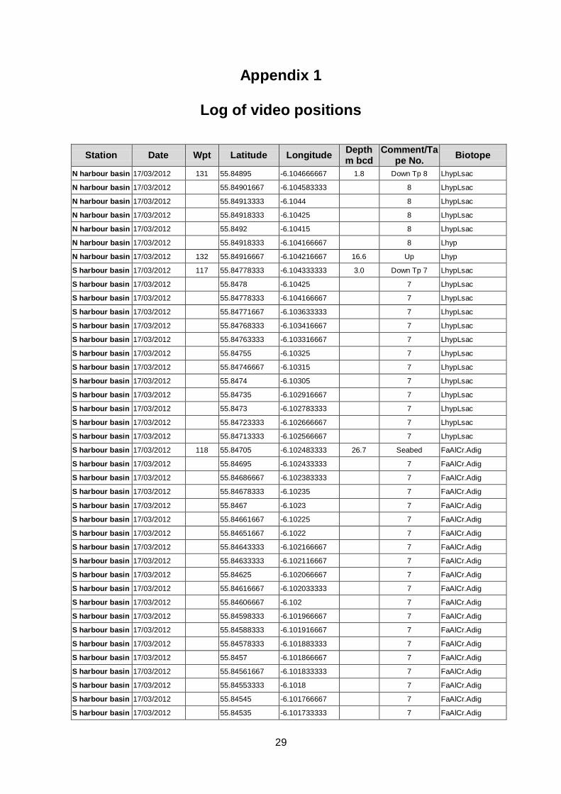
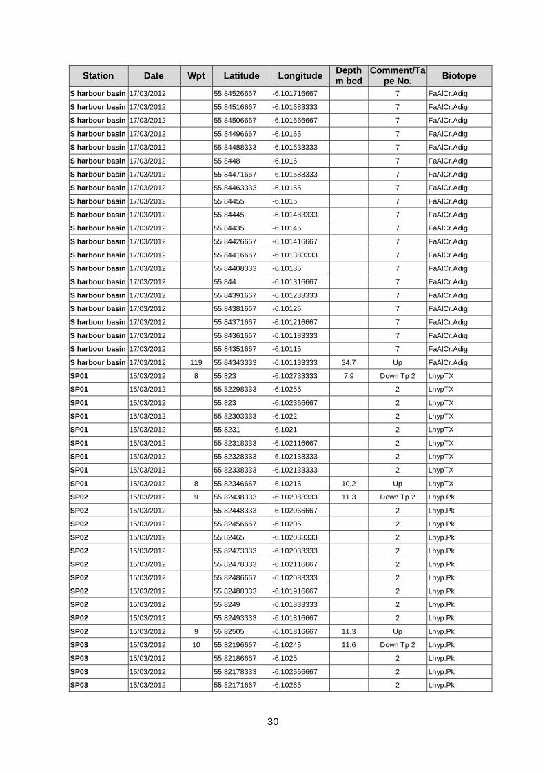
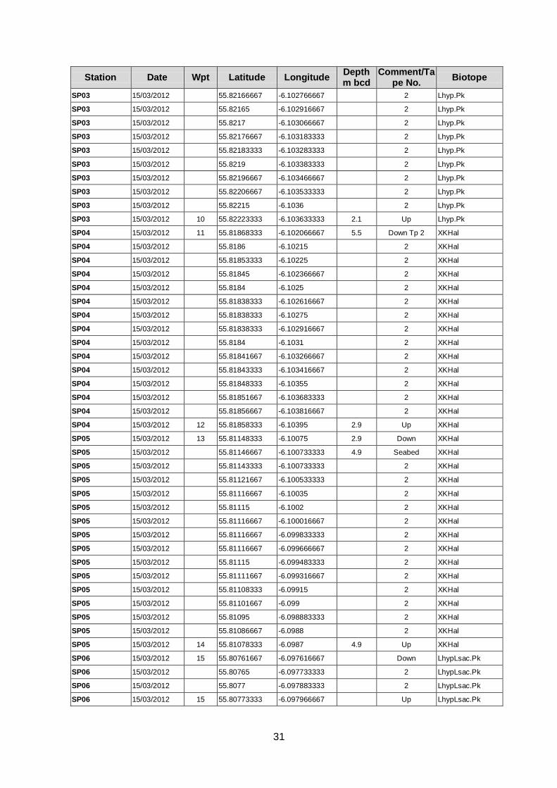
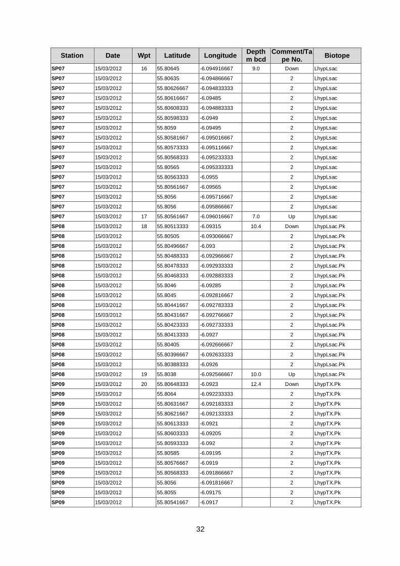
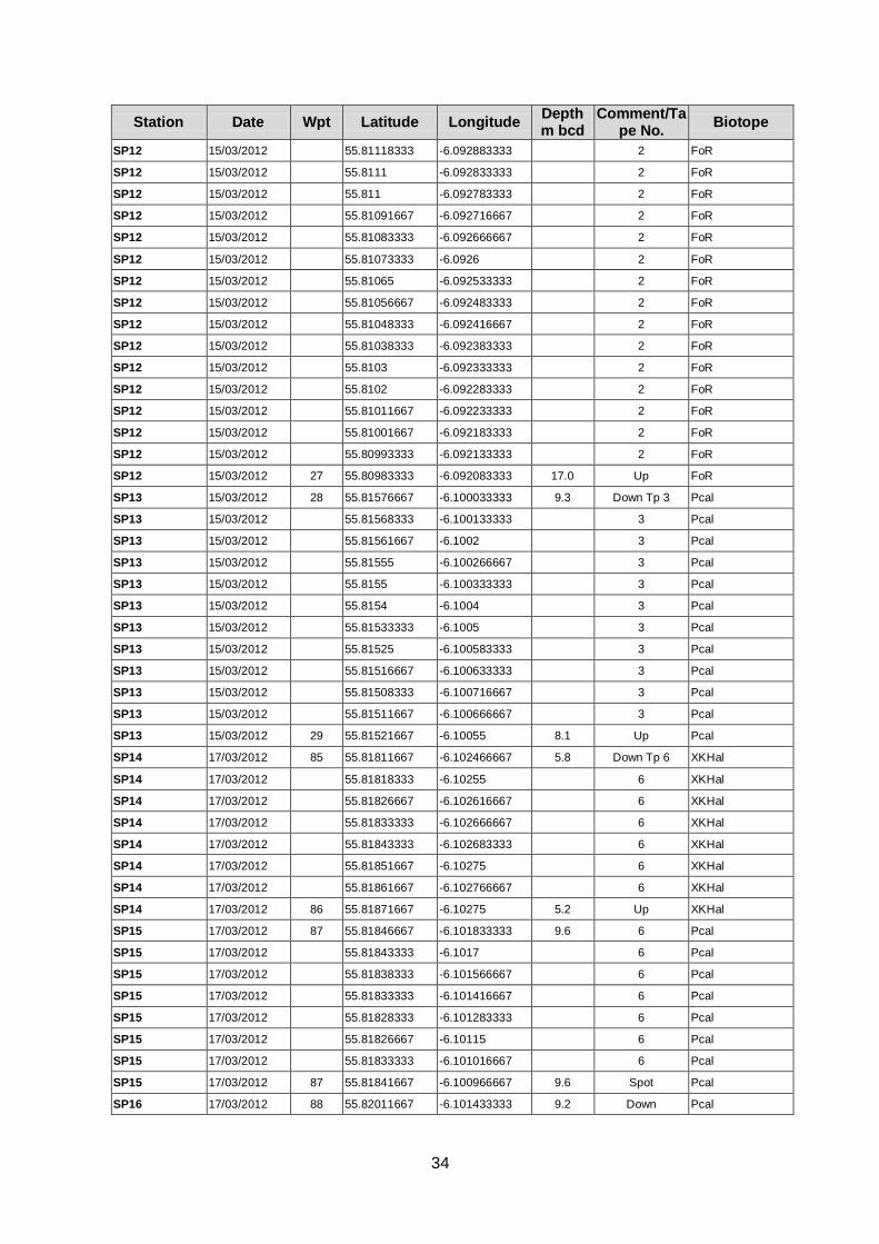
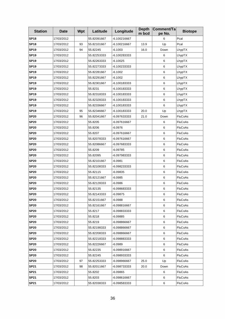
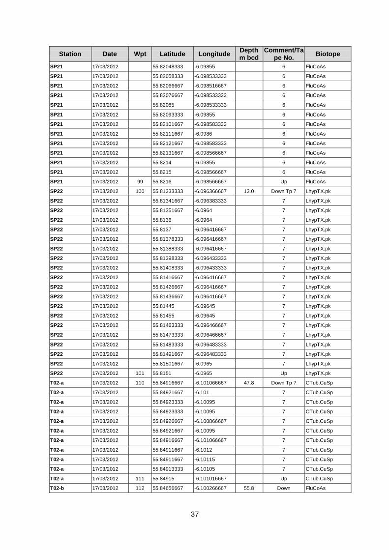
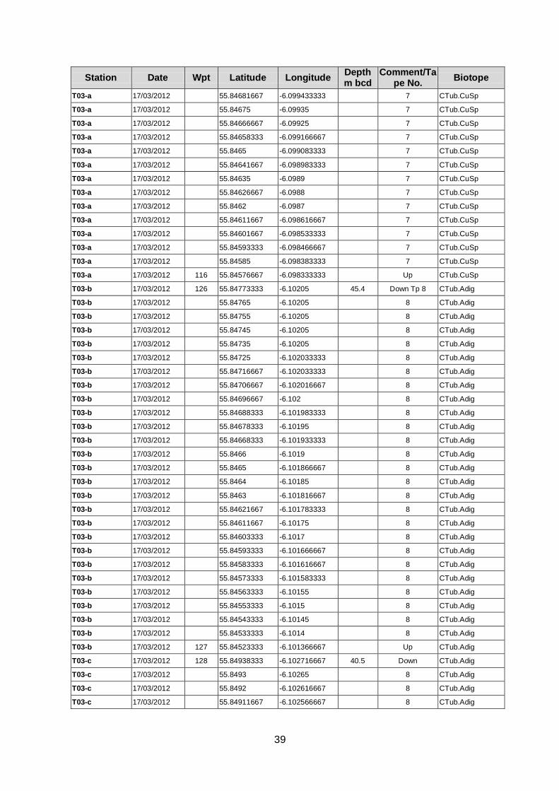
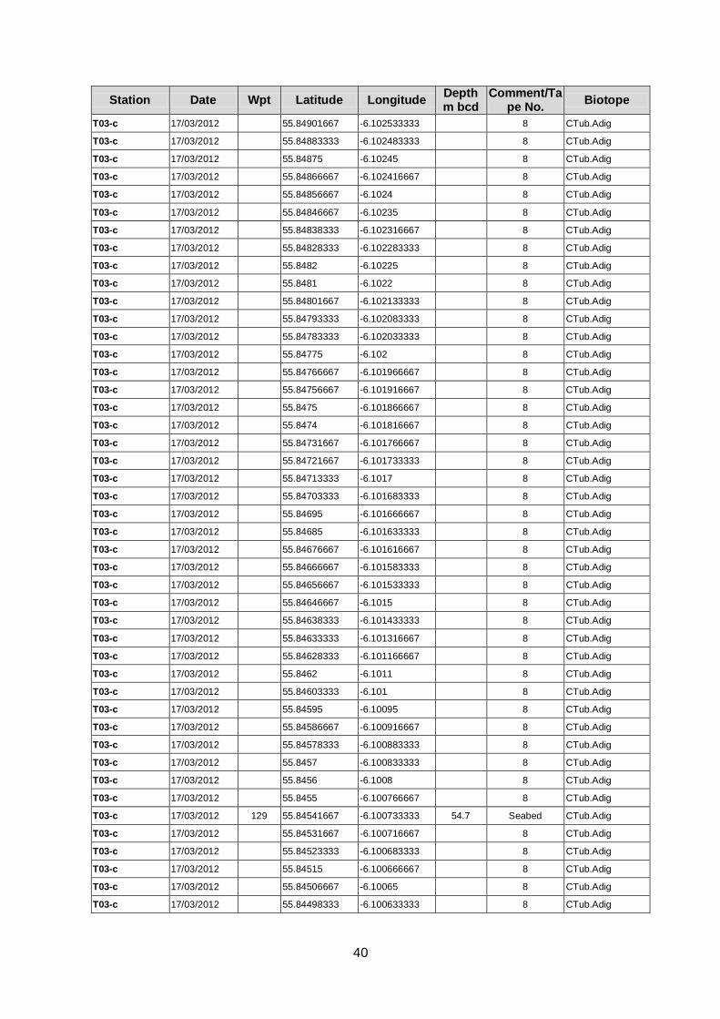
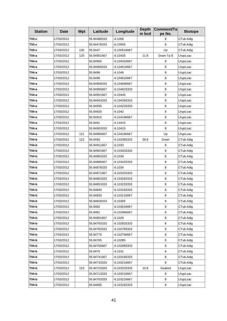
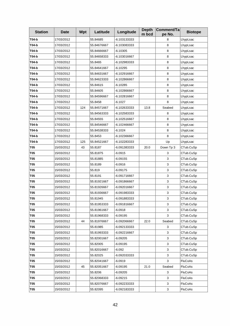
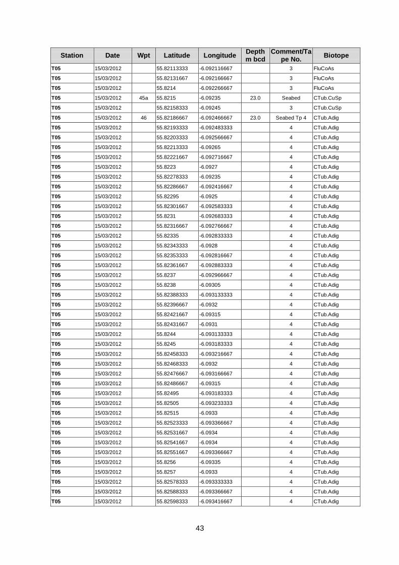
Appendix 1
Log of video positions
Station Date Wpt Latitude Longitude Depth m bcd
Comment/Tape No.
Biotope
N harbour basin 17/03/2012 131 55.84895 -6.104666667 1.8 Down Tp 8 LhypLsac
N harbour basin 17/03/2012 55.84901667 -6.104583333 8 LhypLsac
N harbour basin 17/03/2012 55.84913333 -6.1044 8 LhypLsac
N harbour basin 17/03/2012 55.84918333 -6.10425 8 LhypLsac
N harbour basin 17/03/2012 55.8492 -6.10415 8 LhypLsac
N harbour basin 17/03/2012 55.84918333 -6.104166667 8 Lhyp
N harbour basin 17/03/2012 132 55.84916667 -6.104216667 16.6 Up Lhyp
S harbour basin 17/03/2012 117 55.84778333 -6.104333333 3.0 Down Tp 7 LhypLsac
S harbour basin 17/03/2012 55.8478 -6.10425 7 LhypLsac
S harbour basin 17/03/2012 55.84778333 -6.104166667 7 LhypLsac
S harbour basin 17/03/2012 55.84771667 -6.103633333 7 LhypLsac
S harbour basin 17/03/2012 55.84768333 -6.103416667 7 LhypLsac
S harbour basin 17/03/2012 55.84763333 -6.103316667 7 LhypLsac
S harbour basin 17/03/2012 55.84755 -6.10325 7 LhypLsac
S harbour basin 17/03/2012 55.84746667 -6.10315 7 LhypLsac
S harbour basin 17/03/2012 55.8474 -6.10305 7 LhypLsac
S harbour basin 17/03/2012 55.84735 -6.102916667 7 LhypLsac
S harbour basin 17/03/2012 55.8473 -6.102783333 7 LhypLsac
S harbour basin 17/03/2012 55.84723333 -6.102666667 7 LhypLsac
S harbour basin 17/03/2012 55.84713333 -6.102566667 7 LhypLsac
S harbour basin 17/03/2012 118 55.84705 -6.102483333 26.7 Seabed FaAlCr.Adig
S harbour basin 17/03/2012 55.84695 -6.102433333 7 FaAlCr.Adig
S harbour basin 17/03/2012 55.84686667 -6.102383333 7 FaAlCr.Adig
S harbour basin 17/03/2012 55.84678333 -6.10235 7 FaAlCr.Adig
S harbour basin 17/03/2012 55.8467 -6.1023 7 FaAlCr.Adig
S harbour basin 17/03/2012 55.84661667 -6.10225 7 FaAlCr.Adig
S harbour basin 17/03/2012 55.84651667 -6.1022 7 FaAlCr.Adig
S harbour basin 17/03/2012 55.84643333 -6.102166667 7 FaAlCr.Adig
S harbour basin 17/03/2012 55.84633333 -6.102116667 7 FaAlCr.Adig
S harbour basin 17/03/2012 55.84625 -6.102066667 7 FaAlCr.Adig
S harbour basin 17/03/2012 55.84616667 -6.102033333 7 FaAlCr.Adig
S harbour basin 17/03/2012 55.84606667 -6.102 7 FaAlCr.Adig
S harbour basin 17/03/2012 55.84598333 -6.101966667 7 FaAlCr.Adig
S harbour basin 17/03/2012 55.84588333 -6.101916667 7 FaAlCr.Adig
S harbour basin 17/03/2012 55.84578333 -6.101883333 7 FaAlCr.Adig
S harbour basin 17/03/2012 55.8457 -6.101866667 7 FaAlCr.Adig
S harbour basin 17/03/2012 55.84561667 -6.101833333 7 FaAlCr.Adig
S harbour basin 17/03/2012 55.84553333 -6.1018 7 FaAlCr.Adig
S harbour basin 17/03/2012 55.84545 -6.101766667 7 FaAlCr.Adig
S harbour basin 17/03/2012 55.84535 -6.101733333 7 FaAlCr.Adig
30
Station Date Wpt Latitude Longitude Depth m bcd
Comment/Tape No.
Biotope
S harbour basin 17/03/2012 55.84526667 -6.101716667 7 FaAlCr.Adig
S harbour basin 17/03/2012 55.84516667 -6.101683333 7 FaAlCr.Adig
S harbour basin 17/03/2012 55.84506667 -6.101666667 7 FaAlCr.Adig
S harbour basin 17/03/2012 55.84496667 -6.10165 7 FaAlCr.Adig
S harbour basin 17/03/2012 55.84488333 -6.101633333 7 FaAlCr.Adig
S harbour basin 17/03/2012 55.8448 -6.1016 7 FaAlCr.Adig
S harbour basin 17/03/2012 55.84471667 -6.101583333 7 FaAlCr.Adig
S harbour basin 17/03/2012 55.84463333 -6.10155 7 FaAlCr.Adig
S harbour basin 17/03/2012 55.84455 -6.1015 7 FaAlCr.Adig
S harbour basin 17/03/2012 55.84445 -6.101483333 7 FaAlCr.Adig
S harbour basin 17/03/2012 55.84435 -6.10145 7 FaAlCr.Adig
S harbour basin 17/03/2012 55.84426667 -6.101416667 7 FaAlCr.Adig
S harbour basin 17/03/2012 55.84416667 -6.101383333 7 FaAlCr.Adig
S harbour basin 17/03/2012 55.84408333 -6.10135 7 FaAlCr.Adig
S harbour basin 17/03/2012 55.844 -6.101316667 7 FaAlCr.Adig
S harbour basin 17/03/2012 55.84391667 -6.101283333 7 FaAlCr.Adig
S harbour basin 17/03/2012 55.84381667 -6.10125 7 FaAlCr.Adig
S harbour basin 17/03/2012 55.84371667 -6.101216667 7 FaAlCr.Adig
S harbour basin 17/03/2012 55.84361667 -6.101183333 7 FaAlCr.Adig
S harbour basin 17/03/2012 55.84351667 -6.10115 7 FaAlCr.Adig
S harbour basin 17/03/2012 119 55.84343333 -6.101133333 34.7 Up FaAlCr.Adig
SP01 15/03/2012 8 55.823 -6.102733333 7.9 Down Tp 2 LhypTX
SP01 15/03/2012 55.82298333 -6.10255 2 LhypTX
SP01 15/03/2012 55.823 -6.102366667 2 LhypTX
SP01 15/03/2012 55.82303333 -6.1022 2 LhypTX
SP01 15/03/2012 55.8231 -6.1021 2 LhypTX
SP01 15/03/2012 55.82318333 -6.102116667 2 LhypTX
SP01 15/03/2012 55.82328333 -6.102133333 2 LhypTX
SP01 15/03/2012 55.82338333 -6.102133333 2 LhypTX
SP01 15/03/2012 8 55.82346667 -6.10215 10.2 Up LhypTX
SP02 15/03/2012 9 55.82438333 -6.102083333 11.3 Down Tp 2 Lhyp.Pk
SP02 15/03/2012 55.82448333 -6.102066667 2 Lhyp.Pk
SP02 15/03/2012 55.82456667 -6.10205 2 Lhyp.Pk
SP02 15/03/2012 55.82465 -6.102033333 2 Lhyp.Pk
SP02 15/03/2012 55.82473333 -6.102033333 2 Lhyp.Pk
SP02 15/03/2012 55.82478333 -6.102116667 2 Lhyp.Pk
SP02 15/03/2012 55.82486667 -6.102083333 2 Lhyp.Pk
SP02 15/03/2012 55.82488333 -6.101916667 2 Lhyp.Pk
SP02 15/03/2012 55.8249 -6.101833333 2 Lhyp.Pk
SP02 15/03/2012 55.82493333 -6.101816667 2 Lhyp.Pk
SP02 15/03/2012 9 55.82505 -6.101816667 11.3 Up Lhyp.Pk
SP03 15/03/2012 10 55.82196667 -6.10245 11.6 Down Tp 2 Lhyp.Pk
SP03 15/03/2012 55.82186667 -6.1025 2 Lhyp.Pk
SP03 15/03/2012 55.82178333 -6.102566667 2 Lhyp.Pk
SP03 15/03/2012 55.82171667 -6.10265 2 Lhyp.Pk
31
Station Date Wpt Latitude Longitude Depth m bcd
Comment/Tape No.
Biotope
SP03 15/03/2012 55.82166667 -6.102766667 2 Lhyp.Pk
SP03 15/03/2012 55.82165 -6.102916667 2 Lhyp.Pk
SP03 15/03/2012 55.8217 -6.103066667 2 Lhyp.Pk
SP03 15/03/2012 55.82176667 -6.103183333 2 Lhyp.Pk
SP03 15/03/2012 55.82183333 -6.103283333 2 Lhyp.Pk
SP03 15/03/2012 55.8219 -6.103383333 2 Lhyp.Pk
SP03 15/03/2012 55.82196667 -6.103466667 2 Lhyp.Pk
SP03 15/03/2012 55.82206667 -6.103533333 2 Lhyp.Pk
SP03 15/03/2012 55.82215 -6.1036 2 Lhyp.Pk
SP03 15/03/2012 10 55.82223333 -6.103633333 2.1 Up Lhyp.Pk
SP04 15/03/2012 11 55.81868333 -6.102066667 5.5 Down Tp 2 XKHal
SP04 15/03/2012 55.8186 -6.10215 2 XKHal
SP04 15/03/2012 55.81853333 -6.10225 2 XKHal
SP04 15/03/2012 55.81845 -6.102366667 2 XKHal
SP04 15/03/2012 55.8184 -6.1025 2 XKHal
SP04 15/03/2012 55.81838333 -6.102616667 2 XKHal
SP04 15/03/2012 55.81838333 -6.10275 2 XKHal
SP04 15/03/2012 55.81838333 -6.102916667 2 XKHal
SP04 15/03/2012 55.8184 -6.1031 2 XKHal
SP04 15/03/2012 55.81841667 -6.103266667 2 XKHal
SP04 15/03/2012 55.81843333 -6.103416667 2 XKHal
SP04 15/03/2012 55.81848333 -6.10355 2 XKHal
SP04 15/03/2012 55.81851667 -6.103683333 2 XKHal
SP04 15/03/2012 55.81856667 -6.103816667 2 XKHal
SP04 15/03/2012 12 55.81858333 -6.10395 2.9 Up XKHal
SP05 15/03/2012 13 55.81148333 -6.10075 2.9 Down XKHal
SP05 15/03/2012 55.81146667 -6.100733333 4.9 Seabed XKHal
SP05 15/03/2012 55.81143333 -6.100733333 2 XKHal
SP05 15/03/2012 55.81121667 -6.100533333 2 XKHal
SP05 15/03/2012 55.81116667 -6.10035 2 XKHal
SP05 15/03/2012 55.81115 -6.1002 2 XKHal
SP05 15/03/2012 55.81116667 -6.100016667 2 XKHal
SP05 15/03/2012 55.81116667 -6.099833333 2 XKHal
SP05 15/03/2012 55.81116667 -6.099666667 2 XKHal
SP05 15/03/2012 55.81115 -6.099483333 2 XKHal
SP05 15/03/2012 55.81111667 -6.099316667 2 XKHal
SP05 15/03/2012 55.81108333 -6.09915 2 XKHal
SP05 15/03/2012 55.81101667 -6.099 2 XKHal
SP05 15/03/2012 55.81095 -6.098883333 2 XKHal
SP05 15/03/2012 55.81086667 -6.0988 2 XKHal
SP05 15/03/2012 14 55.81078333 -6.0987 4.9 Up XKHal
SP06 15/03/2012 15 55.80761667 -6.097616667 Down LhypLsac.Pk
SP06 15/03/2012 55.80765 -6.097733333 2 LhypLsac.Pk
SP06 15/03/2012 55.8077 -6.097883333 2 LhypLsac.Pk
SP06 15/03/2012 15 55.80773333 -6.097966667 Up LhypLsac.Pk
32
Station Date Wpt Latitude Longitude Depth m bcd
Comment/Tape No.
Biotope
SP07 15/03/2012 16 55.80645 -6.094916667 9.0 Down LhypLsac
SP07 15/03/2012 55.80635 -6.094866667 2 LhypLsac
SP07 15/03/2012 55.80626667 -6.094833333 2 LhypLsac
SP07 15/03/2012 55.80616667 -6.09485 2 LhypLsac
SP07 15/03/2012 55.80608333 -6.094883333 2 LhypLsac
SP07 15/03/2012 55.80598333 -6.0949 2 LhypLsac
SP07 15/03/2012 55.8059 -6.09495 2 LhypLsac
SP07 15/03/2012 55.80581667 -6.095016667 2 LhypLsac
SP07 15/03/2012 55.80573333 -6.095116667 2 LhypLsac
SP07 15/03/2012 55.80568333 -6.095233333 2 LhypLsac
SP07 15/03/2012 55.80565 -6.095333333 2 LhypLsac
SP07 15/03/2012 55.80563333 -6.0955 2 LhypLsac
SP07 15/03/2012 55.80561667 -6.09565 2 LhypLsac
SP07 15/03/2012 55.8056 -6.095716667 2 LhypLsac
SP07 15/03/2012 55.8056 -6.095866667 2 LhypLsac
SP07 15/03/2012 17 55.80561667 -6.096016667 7.0 Up LhypLsac
SP08 15/03/2012 18 55.80513333 -6.09315 10.4 Down LhypLsac.Pk
SP08 15/03/2012 55.80505 -6.093066667 2 LhypLsac.Pk
SP08 15/03/2012 55.80496667 -6.093 2 LhypLsac.Pk
SP08 15/03/2012 55.80488333 -6.092966667 2 LhypLsac.Pk
SP08 15/03/2012 55.80478333 -6.092933333 2 LhypLsac.Pk
SP08 15/03/2012 55.80468333 -6.092883333 2 LhypLsac.Pk
SP08 15/03/2012 55.8046 -6.09285 2 LhypLsac.Pk
SP08 15/03/2012 55.8045 -6.092816667 2 LhypLsac.Pk
SP08 15/03/2012 55.80441667 -6.092783333 2 LhypLsac.Pk
SP08 15/03/2012 55.80431667 -6.092766667 2 LhypLsac.Pk
SP08 15/03/2012 55.80423333 -6.092733333 2 LhypLsac.Pk
SP08 15/03/2012 55.80413333 -6.0927 2 LhypLsac.Pk
SP08 15/03/2012 55.80405 -6.092666667 2 LhypLsac.Pk
SP08 15/03/2012 55.80396667 -6.092633333 2 LhypLsac.Pk
SP08 15/03/2012 55.80388333 -6.0926 2 LhypLsac.Pk
SP08 15/03/2012 19 55.8038 -6.092566667 10.0 Up LhypLsac.Pk
SP09 15/03/2012 20 55.80648333 -6.0923 12.4 Down LhypTX.Pk
SP09 15/03/2012 55.8064 -6.092233333 2 LhypTX.Pk
SP09 15/03/2012 55.80631667 -6.092183333 2 LhypTX.Pk
SP09 15/03/2012 55.80621667 -6.092133333 2 LhypTX.Pk
SP09 15/03/2012 55.80613333 -6.0921 2 LhypTX.Pk
SP09 15/03/2012 55.80603333 -6.09205 2 LhypTX.Pk
SP09 15/03/2012 55.80593333 -6.092 2 LhypTX.Pk
SP09 15/03/2012 55.80585 -6.09195 2 LhypTX.Pk
SP09 15/03/2012 55.80576667 -6.0919 2 LhypTX.Pk
SP09 15/03/2012 55.80568333 -6.091866667 2 LhypTX.Pk
SP09 15/03/2012 55.8056 -6.091816667 2 LhypTX.Pk
SP09 15/03/2012 55.8055 -6.09175 2 LhypTX.Pk
SP09 15/03/2012 55.80541667 -6.0917 2 LhypTX.Pk

33
Station Date Wpt Latitude Longitude Depth m bcd
Comment/Tape No.
Biotope
SP09 15/03/2012 55.80533333 -6.09165 2 LhypTX.Pk
SP09 15/03/2012 55.80523333 -6.0916 2 LhypTX.Pk
SP09 15/03/2012 55.80515 -6.09155 2 LhypTX.Pk
SP09 15/03/2012 55.80505 -6.091483333 2 LhypTX.Pk
SP09 15/03/2012 55.80496667 -6.091433333 2 LhypTX.Pk
SP09 15/03/2012 21 55.80488333 -6.09135 12.3 Up LhypTX.Pk
SP10 15/03/2012 22 55.81016667 -6.093833333 14.0 Down LhypTX.Pk
SP10 15/03/2012 55.81006667 -6.093766667 2 LhypTX.Pk
SP10 15/03/2012 55.80996667 -6.0937 2 LhypTX.Pk
SP10 15/03/2012 55.80988333 -6.093633333 2 LhypTX.Pk
SP10 15/03/2012 55.80978333 -6.093583333 2 LhypTX.Pk
SP10 15/03/2012 55.80968333 -6.093516667 2 LhypTX.Pk
SP10 15/03/2012 55.8096 -6.093466667 2 LhypTX.Pk
SP10 15/03/2012 55.8095 -6.093416667 2 LhypTX.Pk
SP10 15/03/2012 55.80941667 -6.093366667 2 LhypTX.Pk
SP10 15/03/2012 55.80933333 -6.093316667 2 LhypTX.Pk
SP10 15/03/2012 55.80925 -6.09325 2 LhypTX.Pk
SP10 15/03/2012 55.80916667 -6.093183333 2 LhypTX.Pk
SP10 15/03/2012 55.80908333 -6.093133333 2 LhypTX.Pk
SP10 15/03/2012 23 55.80898333 -6.093066667 14.0 Up LhypTX.Pk
SP11 15/03/2012 24 55.8121 -6.097983333 9.6 Down LhypTX
SP11 15/03/2012 55.81201667 -6.097916667 2 LhypTX
SP11 15/03/2012 55.81191667 -6.097866667 2 LhypTX
SP11 15/03/2012 55.81183333 -6.0978 2 LhypTX
SP11 15/03/2012 55.81175 -6.09775 2 LhypTX
SP11 15/03/2012 55.81165 -6.097683333 2 LhypTX
SP11 15/03/2012 55.81156667 -6.097633333 2 LhypTX
SP11 15/03/2012 55.81146667 -6.097566667 2 LhypTX
SP11 15/03/2012 55.81138333 -6.097516667 2 LhypTX
SP11 15/03/2012 55.8113 -6.097433333 2 LhypTX
SP11 15/03/2012 55.81121667 -6.097366667 2 LhypTX
SP11 15/03/2012 55.81113333 -6.0973 2 LhypTX
SP11 15/03/2012 55.81103333 -6.097233333 2 LhypTX
SP11 15/03/2012 55.81095 -6.097183333 2 LhypTX
SP11 15/03/2012 55.81086667 -6.097116667 2 LhypTX
SP11 15/03/2012 55.81076667 -6.09705 2 LhypTX
SP11 15/03/2012 55.81066667 -6.097 2 LhypTX
SP11 15/03/2012 55.81058333 -6.09695 2 LhypTX
SP11 15/03/2012 25 55.8105 -6.096883333 9.0 Up LhypTX
SP12 15/03/2012 26 55.81171667 -6.09315 15.0 Down FoR
SP12 15/03/2012 55.81163333 -6.0931 2 FoR
SP12 15/03/2012 55.81153333 -6.093066667 2 FoR
SP12 15/03/2012 55.81145 -6.093016667 2 FoR
SP12 15/03/2012 55.81136667 -6.092966667 2 FoR
SP12 15/03/2012 55.81128333 -6.092933333 2 FoR
34
Station Date Wpt Latitude Longitude Depth m bcd
Comment/Tape No.
Biotope
SP12 15/03/2012 55.81118333 -6.092883333 2 FoR
SP12 15/03/2012 55.8111 -6.092833333 2 FoR
SP12 15/03/2012 55.811 -6.092783333 2 FoR
SP12 15/03/2012 55.81091667 -6.092716667 2 FoR
SP12 15/03/2012 55.81083333 -6.092666667 2 FoR
SP12 15/03/2012 55.81073333 -6.0926 2 FoR
SP12 15/03/2012 55.81065 -6.092533333 2 FoR
SP12 15/03/2012 55.81056667 -6.092483333 2 FoR
SP12 15/03/2012 55.81048333 -6.092416667 2 FoR
SP12 15/03/2012 55.81038333 -6.092383333 2 FoR
SP12 15/03/2012 55.8103 -6.092333333 2 FoR
SP12 15/03/2012 55.8102 -6.092283333 2 FoR
SP12 15/03/2012 55.81011667 -6.092233333 2 FoR
SP12 15/03/2012 55.81001667 -6.092183333 2 FoR
SP12 15/03/2012 55.80993333 -6.092133333 2 FoR
SP12 15/03/2012 27 55.80983333 -6.092083333 17.0 Up FoR
SP13 15/03/2012 28 55.81576667 -6.100033333 9.3 Down Tp 3 Pcal
SP13 15/03/2012 55.81568333 -6.100133333 3 Pcal
SP13 15/03/2012 55.81561667 -6.1002 3 Pcal
SP13 15/03/2012 55.81555 -6.100266667 3 Pcal
SP13 15/03/2012 55.8155 -6.100333333 3 Pcal
SP13 15/03/2012 55.8154 -6.1004 3 Pcal
SP13 15/03/2012 55.81533333 -6.1005 3 Pcal
SP13 15/03/2012 55.81525 -6.100583333 3 Pcal
SP13 15/03/2012 55.81516667 -6.100633333 3 Pcal
SP13 15/03/2012 55.81508333 -6.100716667 3 Pcal
SP13 15/03/2012 55.81511667 -6.100666667 3 Pcal
SP13 15/03/2012 29 55.81521667 -6.10055 8.1 Up Pcal
SP14 17/03/2012 85 55.81811667 -6.102466667 5.8 Down Tp 6 XKHal
SP14 17/03/2012 55.81818333 -6.10255 6 XKHal
SP14 17/03/2012 55.81826667 -6.102616667 6 XKHal
SP14 17/03/2012 55.81833333 -6.102666667 6 XKHal
SP14 17/03/2012 55.81843333 -6.102683333 6 XKHal
SP14 17/03/2012 55.81851667 -6.10275 6 XKHal
SP14 17/03/2012 55.81861667 -6.102766667 6 XKHal
SP14 17/03/2012 86 55.81871667 -6.10275 5.2 Up XKHal
SP15 17/03/2012 87 55.81846667 -6.101833333 9.6 6 Pcal
SP15 17/03/2012 55.81843333 -6.1017 6 Pcal
SP15 17/03/2012 55.81838333 -6.101566667 6 Pcal
SP15 17/03/2012 55.81833333 -6.101416667 6 Pcal
SP15 17/03/2012 55.81828333 -6.101283333 6 Pcal
SP15 17/03/2012 55.81826667 -6.10115 6 Pcal
SP15 17/03/2012 55.81833333 -6.101016667 6 Pcal
SP15 17/03/2012 87 55.81841667 -6.100966667 9.6 Spot Pcal
SP16 17/03/2012 88 55.82011667 -6.101433333 9.2 Down Pcal

35
Station Date Wpt Latitude Longitude Depth m bcd
Comment/Tape No.
Biotope
SP16 17/03/2012 55.82021667 -6.101416667 6 Pcal
SP16 17/03/2012 55.8203 -6.101433333 6 Pcal
SP16 17/03/2012 55.82038333 -6.101533333 6 Pcal
SP16 17/03/2012 55.82046667 -6.101583333 6 Pcal
SP16 17/03/2012 55.82055 -6.101616667 6 Pcal
SP16 17/03/2012 55.82065 -6.10165 6 Pcal
SP16 17/03/2012 55.82073333 -6.101666667 6 Pcal
SP16 17/03/2012 55.82081667 -6.101666667 6 Pcal
SP16 17/03/2012 55.82091667 -6.101666667 6 Pcal
SP16 17/03/2012 55.821 -6.10165 6 Pcal
SP16 17/03/2012 55.82108333 -6.101683333 6 Pcal
SP16 17/03/2012 55.82116667 -6.1018 6 Pcal
SP16 17/03/2012 55.82121667 -6.101933333 6 Pcal
SP16 17/03/2012 55.8213 -6.102 6 Pcal
SP16 17/03/2012 55.8214 -6.102 6 Pcal
SP16 17/03/2012 55.82148333 -6.101983333 6 Pcal
SP16 17/03/2012 89 55.82158333 -6.101933333 9.8 Up Pcal
SP17 17/03/2012 90 55.8225 -6.102083333 10.7 Down XKHal
SP17 17/03/2012 55.82263333 -6.1022 6 XKHal
SP17 17/03/2012 55.82273333 -6.102216667 6 XKHal
SP17 17/03/2012 55.82281667 -6.102216667 6 XKHal
SP17 17/03/2012 55.82291667 -6.102166667 6 XKHal
SP17 17/03/2012 55.823 -6.102116667 6 XKHal
SP17 17/03/2012 55.8231 -6.102083333 6 XKHal
SP17 17/03/2012 55.8232 -6.102033333 6 XKHal
SP17 17/03/2012 91 55.82328333 -6.102 9.6 Up XKHal
SP18 17/03/2012 92 55.81916667 -6.100166667 11.3 Down Pcal
SP18 17/03/2012 55.81926667 -6.1001 6 Pcal
SP18 17/03/2012 55.81936667 -6.10005 6 Pcal
SP18 17/03/2012 55.81945 -6.100033333 6 Pcal
SP18 17/03/2012 55.81955 -6.100016667 6 Pcal
SP18 17/03/2012 55.81963333 -6.1 6 Pcal
SP18 17/03/2012 55.81971667 -6.099983333 6 Pcal
SP18 17/03/2012 55.8198 -6.099966667 6 Pcal
SP18 17/03/2012 55.8199 -6.099933333 6 Pcal
SP18 17/03/2012 55.82 -6.099916667 6 Pcal
SP18 17/03/2012 55.8201 -6.0999 6 Pcal
SP18 17/03/2012 55.82018333 -6.099883333 6 Pcal
SP18 17/03/2012 55.82028333 -6.099916667 6 Pcal
SP18 17/03/2012 55.82036667 -6.100016667 6 Pcal
SP18 17/03/2012 55.82043333 -6.100116667 6 Pcal
SP18 17/03/2012 55.82053333 -6.1002 6 Pcal
SP18 17/03/2012 55.82063333 -6.1002 6 Pcal
SP18 17/03/2012 55.82073333 -6.1002 6 Pcal
SP18 17/03/2012 55.82083333 -6.1002 6 Pcal
36
Station Date Wpt Latitude Longitude Depth m bcd
Comment/Tape No.
Biotope
SP18 17/03/2012 55.82091667 -6.100216667 6 Pcal
SP18 17/03/2012 93 55.82101667 -6.100216667 13.9 Up Pcal
SP19 17/03/2012 94 55.82245 -6.1003 16.0 Down LhypTX
SP19 17/03/2012 55.82253333 -6.100283333 6 LhypTX
SP19 17/03/2012 55.82263333 -6.10025 6 LhypTX
SP19 17/03/2012 55.82273333 -6.100233333 6 LhypTX
SP19 17/03/2012 55.82281667 -6.1002 6 LhypTX
SP19 17/03/2012 55.82291667 -6.1002 6 LhypTX
SP19 17/03/2012 55.82301667 -6.100183333 6 LhypTX
SP19 17/03/2012 55.8231 -6.100183333 6 LhypTX
SP19 17/03/2012 55.82318333 -6.100183333 6 LhypTX
SP19 17/03/2012 55.82328333 -6.100183333 6 LhypTX
SP19 17/03/2012 55.82336667 -6.100183333 6 LhypTX
SP19 17/03/2012 95 55.82346667 -6.100183333 20.0 Up LhypTX
SP20 17/03/2012 96 55.82041667 -6.097633333 21.0 Down FluCoAs
SP20 17/03/2012 55.8205 -6.097616667 6 FluCoAs
SP20 17/03/2012 55.8206 -6.0976 6 FluCoAs
SP20 17/03/2012 55.8207 -6.097616667 6 FluCoAs
SP20 17/03/2012 55.82078333 -6.097616667 6 FluCoAs
SP20 17/03/2012 55.82086667 -6.097683333 6 FluCoAs
SP20 17/03/2012 55.8209 -6.09785 6 FluCoAs
SP20 17/03/2012 55.82095 -6.097983333 6 FluCoAs
SP20 17/03/2012 55.82101667 -6.0981 6 FluCoAs
SP20 17/03/2012 55.82108333 -6.098233333 6 FluCoAs
SP20 17/03/2012 55.82115 -6.09835 6 FluCoAs
SP20 17/03/2012 55.82121667 -6.0985 6 FluCoAs
SP20 17/03/2012 55.82128333 -6.0986 6 FluCoAs
SP20 17/03/2012 55.82135 -6.098683333 6 FluCoAs
SP20 17/03/2012 55.82143333 -6.09875 6 FluCoAs
SP20 17/03/2012 55.82151667 -6.0988 6 FluCoAs
SP20 17/03/2012 55.82161667 -6.098816667 6 FluCoAs
SP20 17/03/2012 55.8217 -6.098833333 6 FluCoAs
SP20 17/03/2012 55.8218 -6.09885 6 FluCoAs
SP20 17/03/2012 55.8219 -6.098866667 6 FluCoAs
SP20 17/03/2012 55.82198333 -6.098866667 6 FluCoAs
SP20 17/03/2012 55.82208333 -6.098866667 6 FluCoAs
SP20 17/03/2012 55.82218333 -6.098883333 6 FluCoAs
SP20 17/03/2012 55.82226667 -6.0989 6 FluCoAs
SP20 17/03/2012 55.82235 -6.098916667 6 FluCoAs
SP20 17/03/2012 55.82245 -6.098933333 6 FluCoAs
SP20 17/03/2012 97 55.82253333 -6.098966667 25.0 Up FluCoAs
SP21 17/03/2012 98 55.82011667 -6.098733333 20.0 Down FluCoAs
SP21 17/03/2012 55.8202 -6.09865 6 FluCoAs
SP21 17/03/2012 55.8203 -6.098616667 6 FluCoAs
SP21 17/03/2012 55.82038333 -6.098583333 6 FluCoAs
37
Station Date Wpt Latitude Longitude Depth m bcd
Comment/Tape No.
Biotope
SP21 17/03/2012 55.82048333 -6.09855 6 FluCoAs
SP21 17/03/2012 55.82058333 -6.098533333 6 FluCoAs
SP21 17/03/2012 55.82066667 -6.098516667 6 FluCoAs
SP21 17/03/2012 55.82076667 -6.098533333 6 FluCoAs
SP21 17/03/2012 55.82085 -6.098533333 6 FluCoAs
SP21 17/03/2012 55.82093333 -6.09855 6 FluCoAs
SP21 17/03/2012 55.82101667 -6.098583333 6 FluCoAs
SP21 17/03/2012 55.82111667 -6.0986 6 FluCoAs
SP21 17/03/2012 55.82121667 -6.098583333 6 FluCoAs
SP21 17/03/2012 55.82131667 -6.098566667 6 FluCoAs
SP21 17/03/2012 55.8214 -6.09855 6 FluCoAs
SP21 17/03/2012 55.8215 -6.098566667 6 FluCoAs
SP21 17/03/2012 99 55.8216 -6.098566667 Up FluCoAs
SP22 17/03/2012 100 55.81333333 -6.096366667 13.0 Down Tp 7 LhypTX.pk
SP22 17/03/2012 55.81341667 -6.096383333 7 LhypTX.pk
SP22 17/03/2012 55.81351667 -6.0964 7 LhypTX.pk
SP22 17/03/2012 55.8136 -6.0964 7 LhypTX.pk
SP22 17/03/2012 55.8137 -6.096416667 7 LhypTX.pk
SP22 17/03/2012 55.81378333 -6.096416667 7 LhypTX.pk
SP22 17/03/2012 55.81388333 -6.096416667 7 LhypTX.pk
SP22 17/03/2012 55.81398333 -6.096433333 7 LhypTX.pk
SP22 17/03/2012 55.81408333 -6.096433333 7 LhypTX.pk
SP22 17/03/2012 55.81416667 -6.096416667 7 LhypTX.pk
SP22 17/03/2012 55.81426667 -6.096416667 7 LhypTX.pk
SP22 17/03/2012 55.81436667 -6.096416667 7 LhypTX.pk
SP22 17/03/2012 55.81445 -6.09645 7 LhypTX.pk
SP22 17/03/2012 55.81455 -6.09645 7 LhypTX.pk
SP22 17/03/2012 55.81463333 -6.096466667 7 LhypTX.pk
SP22 17/03/2012 55.81473333 -6.096466667 7 LhypTX.pk
SP22 17/03/2012 55.81483333 -6.096483333 7 LhypTX.pk
SP22 17/03/2012 55.81491667 -6.096483333 7 LhypTX.pk
SP22 17/03/2012 55.81501667 -6.0965 7 LhypTX.pk
SP22 17/03/2012 101 55.8151 -6.0965 Up LhypTX.pk
T02-a 17/03/2012 110 55.84916667 -6.101066667 47.8 Down Tp 7 CTub.CuSp
T02-a 17/03/2012 55.84921667 -6.101 7 CTub.CuSp
T02-a 17/03/2012 55.84923333 -6.10095 7 CTub.CuSp
T02-a 17/03/2012 55.84923333 -6.10095 7 CTub.CuSp
T02-a 17/03/2012 55.84926667 -6.100866667 7 CTub.CuSp
T02-a 17/03/2012 55.84921667 -6.10095 7 CTub.CuSp
T02-a 17/03/2012 55.84916667 -6.101066667 7 CTub.CuSp
T02-a 17/03/2012 55.84911667 -6.1012 7 CTub.CuSp
T02-a 17/03/2012 55.84911667 -6.10115 7 CTub.CuSp
T02-a 17/03/2012 55.84913333 -6.10105 7 CTub.CuSp
T02-a 17/03/2012 111 55.84915 -6.101016667 Up CTub.CuSp
T02-b 17/03/2012 112 55.84656667 -6.100266667 55.8 Down FluCoAs

38
Station Date Wpt Latitude Longitude Depth m bcd
Comment/Tape No.
Biotope
T02-b 17/03/2012 55.84655 -6.100266667 7 FluCoAs
T02-b 17/03/2012 55.84651667 -6.10025 7 FluCoAs
T02-b 17/03/2012 55.84625 -6.1 7 FluCoAs
T02-b 17/03/2012 55.84625 -6.099983333 7 FluCoAs
T02-b 17/03/2012 55.84623333 -6.09995 7 FluCoAs
T02-b 17/03/2012 55.84615 -6.099833333 7 FluCoAs
T02-b 17/03/2012 55.84601667 -6.099733333 7 FluCoAs
T02-b 17/03/2012 55.84583333 -6.099766667 7 FluCoAs
T02-b 17/03/2012 55.84573333 -6.099833333 7 FluCoAs
T02-b 17/03/2012 55.84566667 -6.099833333 7 FluCoAs
T02-b 17/03/2012 55.84563333 -6.099833333 7 FluCoAs
T02-b 17/03/2012 55.84561667 -6.099833333 7 FluCoAs
T02-b 17/03/2012 113 55.84545 -6.0996 Up FluCoAs
T03-a 17/03/2012 114 55.8492 -6.10205 48.2 Down FluCoAs
T03-a 17/03/2012 55.8491 -6.102083333 7 FluCoAs
T03-a 17/03/2012 55.849 -6.102 7 FluCoAs
T03-a 17/03/2012 55.84895 -6.102133333 7 FluCoAs
T03-a 17/03/2012 55.8489 -6.1022 7 FluCoAs
T03-a 17/03/2012 55.84881667 -6.1021 7 FluCoAs
T03-a 17/03/2012 55.84875 -6.101966667 7 FluCoAs
T03-a 17/03/2012 55.84865 -6.101916667 7 FluCoAs
T03-a 17/03/2012 55.84851667 -6.10205 7 FluCoAs
T03-a 17/03/2012 55.84835 -6.10195 7 FluCoAs
T03-a 17/03/2012 55.84828333 -6.10185 7 FluCoAs
T03-a 17/03/2012 55.84821667 -6.10175 7 FluCoAs
T03-a 17/03/2012 55.84813333 -6.101633333 7 CTub.CuSp
T03-a 17/03/2012 55.84806667 -6.101516667 7 CTub.CuSp
T03-a 17/03/2012 55.84801667 -6.1014 7 CTub.CuSp
T03-a 17/03/2012 55.84796667 -6.101283333 7 CTub.CuSp
T03-a 17/03/2012 55.8479 -6.101166667 7 CTub.CuSp
T03-a 17/03/2012 55.84783333 -6.10105 7 CTub.CuSp
T03-a 17/03/2012 55.84776667 -6.100933333 7 CTub.CuSp
T03-a 17/03/2012 55.84771667 -6.100816667 7 CTub.CuSp
T03-a 17/03/2012 55.84765 -6.100716667 7 CTub.CuSp
T03-a 17/03/2012 55.8476 -6.1006 7 CTub.CuSp
T03-a 17/03/2012 55.84753333 -6.100466667 7 CTub.CuSp
T03-a 17/03/2012 55.84746667 -6.100366667 7 CTub.CuSp
T03-a 17/03/2012 55.8474 -6.10025 7 CTub.CuSp
T03-a 17/03/2012 55.84733333 -6.100133333 7 CTub.CuSp
T03-a 17/03/2012 55.84726667 -6.100016667 7 CTub.CuSp
T03-a 17/03/2012 55.8472 -6.0999 7 CTub.CuSp
T03-a 17/03/2012 115 55.84711667 -6.0998 53.6 Seabed CTub.CuSp
T03-a 17/03/2012 55.84705 -6.099716667 7 CTub.CuSp
T03-a 17/03/2012 55.84698333 -6.099616667 7 CTub.CuSp
T03-a 17/03/2012 55.8469 -6.099533333 7 CTub.CuSp
39
Station Date Wpt Latitude Longitude Depth m bcd
Comment/Tape No.
Biotope
T03-a 17/03/2012 55.84681667 -6.099433333 7 CTub.CuSp
T03-a 17/03/2012 55.84675 -6.09935 7 CTub.CuSp
T03-a 17/03/2012 55.84666667 -6.09925 7 CTub.CuSp
T03-a 17/03/2012 55.84658333 -6.099166667 7 CTub.CuSp
T03-a 17/03/2012 55.8465 -6.099083333 7 CTub.CuSp
T03-a 17/03/2012 55.84641667 -6.098983333 7 CTub.CuSp
T03-a 17/03/2012 55.84635 -6.0989 7 CTub.CuSp
T03-a 17/03/2012 55.84626667 -6.0988 7 CTub.CuSp
T03-a 17/03/2012 55.8462 -6.0987 7 CTub.CuSp
T03-a 17/03/2012 55.84611667 -6.098616667 7 CTub.CuSp
T03-a 17/03/2012 55.84601667 -6.098533333 7 CTub.CuSp
T03-a 17/03/2012 55.84593333 -6.098466667 7 CTub.CuSp
T03-a 17/03/2012 55.84585 -6.098383333 7 CTub.CuSp
T03-a 17/03/2012 116 55.84576667 -6.098333333 Up CTub.CuSp
T03-b 17/03/2012 126 55.84773333 -6.10205 45.4 Down Tp 8 CTub.Adig
T03-b 17/03/2012 55.84765 -6.10205 8 CTub.Adig
T03-b 17/03/2012 55.84755 -6.10205 8 CTub.Adig
T03-b 17/03/2012 55.84745 -6.10205 8 CTub.Adig
T03-b 17/03/2012 55.84735 -6.10205 8 CTub.Adig
T03-b 17/03/2012 55.84725 -6.102033333 8 CTub.Adig
T03-b 17/03/2012 55.84716667 -6.102033333 8 CTub.Adig
T03-b 17/03/2012 55.84706667 -6.102016667 8 CTub.Adig
T03-b 17/03/2012 55.84696667 -6.102 8 CTub.Adig
T03-b 17/03/2012 55.84688333 -6.101983333 8 CTub.Adig
T03-b 17/03/2012 55.84678333 -6.10195 8 CTub.Adig
T03-b 17/03/2012 55.84668333 -6.101933333 8 CTub.Adig
T03-b 17/03/2012 55.8466 -6.1019 8 CTub.Adig
T03-b 17/03/2012 55.8465 -6.101866667 8 CTub.Adig
T03-b 17/03/2012 55.8464 -6.10185 8 CTub.Adig
T03-b 17/03/2012 55.8463 -6.101816667 8 CTub.Adig
T03-b 17/03/2012 55.84621667 -6.101783333 8 CTub.Adig
T03-b 17/03/2012 55.84611667 -6.10175 8 CTub.Adig
T03-b 17/03/2012 55.84603333 -6.1017 8 CTub.Adig
T03-b 17/03/2012 55.84593333 -6.101666667 8 CTub.Adig
T03-b 17/03/2012 55.84583333 -6.101616667 8 CTub.Adig
T03-b 17/03/2012 55.84573333 -6.101583333 8 CTub.Adig
T03-b 17/03/2012 55.84563333 -6.10155 8 CTub.Adig
T03-b 17/03/2012 55.84553333 -6.1015 8 CTub.Adig
T03-b 17/03/2012 55.84543333 -6.10145 8 CTub.Adig
T03-b 17/03/2012 55.84533333 -6.1014 8 CTub.Adig
T03-b 17/03/2012 127 55.84523333 -6.101366667 Up CTub.Adig
T03-c 17/03/2012 128 55.84938333 -6.102716667 40.5 Down CTub.Adig
T03-c 17/03/2012 55.8493 -6.10265 8 CTub.Adig
T03-c 17/03/2012 55.8492 -6.102616667 8 CTub.Adig
T03-c 17/03/2012 55.84911667 -6.102566667 8 CTub.Adig
40
Station Date Wpt Latitude Longitude Depth m bcd
Comment/Tape No.
Biotope
T03-c 17/03/2012 55.84901667 -6.102533333 8 CTub.Adig
T03-c 17/03/2012 55.84883333 -6.102483333 8 CTub.Adig
T03-c 17/03/2012 55.84875 -6.10245 8 CTub.Adig
T03-c 17/03/2012 55.84866667 -6.102416667 8 CTub.Adig
T03-c 17/03/2012 55.84856667 -6.1024 8 CTub.Adig
T03-c 17/03/2012 55.84846667 -6.10235 8 CTub.Adig
T03-c 17/03/2012 55.84838333 -6.102316667 8 CTub.Adig
T03-c 17/03/2012 55.84828333 -6.102283333 8 CTub.Adig
T03-c 17/03/2012 55.8482 -6.10225 8 CTub.Adig
T03-c 17/03/2012 55.8481 -6.1022 8 CTub.Adig
T03-c 17/03/2012 55.84801667 -6.102133333 8 CTub.Adig
T03-c 17/03/2012 55.84793333 -6.102083333 8 CTub.Adig
T03-c 17/03/2012 55.84783333 -6.102033333 8 CTub.Adig
T03-c 17/03/2012 55.84775 -6.102 8 CTub.Adig
T03-c 17/03/2012 55.84766667 -6.101966667 8 CTub.Adig
T03-c 17/03/2012 55.84756667 -6.101916667 8 CTub.Adig
T03-c 17/03/2012 55.8475 -6.101866667 8 CTub.Adig
T03-c 17/03/2012 55.8474 -6.101816667 8 CTub.Adig
T03-c 17/03/2012 55.84731667 -6.101766667 8 CTub.Adig
T03-c 17/03/2012 55.84721667 -6.101733333 8 CTub.Adig
T03-c 17/03/2012 55.84713333 -6.1017 8 CTub.Adig
T03-c 17/03/2012 55.84703333 -6.101683333 8 CTub.Adig
T03-c 17/03/2012 55.84695 -6.101666667 8 CTub.Adig
T03-c 17/03/2012 55.84685 -6.101633333 8 CTub.Adig
T03-c 17/03/2012 55.84676667 -6.101616667 8 CTub.Adig
T03-c 17/03/2012 55.84666667 -6.101583333 8 CTub.Adig
T03-c 17/03/2012 55.84656667 -6.101533333 8 CTub.Adig
T03-c 17/03/2012 55.84646667 -6.1015 8 CTub.Adig
T03-c 17/03/2012 55.84638333 -6.101433333 8 CTub.Adig
T03-c 17/03/2012 55.84633333 -6.101316667 8 CTub.Adig
T03-c 17/03/2012 55.84628333 -6.101166667 8 CTub.Adig
T03-c 17/03/2012 55.8462 -6.1011 8 CTub.Adig
T03-c 17/03/2012 55.84603333 -6.101 8 CTub.Adig
T03-c 17/03/2012 55.84595 -6.10095 8 CTub.Adig
T03-c 17/03/2012 55.84586667 -6.100916667 8 CTub.Adig
T03-c 17/03/2012 55.84578333 -6.100883333 8 CTub.Adig
T03-c 17/03/2012 55.8457 -6.100833333 8 CTub.Adig
T03-c 17/03/2012 55.8456 -6.1008 8 CTub.Adig
T03-c 17/03/2012 55.8455 -6.100766667 8 CTub.Adig
T03-c 17/03/2012 129 55.84541667 -6.100733333 54.7 Seabed CTub.Adig
T03-c 17/03/2012 55.84531667 -6.100716667 8 CTub.Adig
T03-c 17/03/2012 55.84523333 -6.100683333 8 CTub.Adig
T03-c 17/03/2012 55.84515 -6.100666667 8 CTub.Adig
T03-c 17/03/2012 55.84506667 -6.10065 8 CTub.Adig
T03-c 17/03/2012 55.84498333 -6.100633333 8 CTub.Adig
41
Station Date Wpt Latitude Longitude Depth m bcd
Comment/Tape No.
Biotope
T03-c 17/03/2012 55.84488333 -6.1006 8 CTub.Adig
T03-c 17/03/2012 55.84478333 -6.10055 8 CTub.Adig
T03-c 17/03/2012 130 55.8447 -6.100516667 Up CTub.Adig
T04-a 17/03/2012 120 55.84951667 -6.10435 11.8 Down Tp 8 LhypLsac
T04-a 17/03/2012 55.84955 -6.104416667 8 LhypLsac
T04-a 17/03/2012 55.84958333 -6.104516667 8 LhypLsac
T04-a 17/03/2012 55.8496 -6.1046 8 LhypLsac
T04-a 17/03/2012 55.8496 -6.104616667 8 LhypLsac
T04-a 17/03/2012 55.84958333 -6.104666667 8 LhypLsac
T04-a 17/03/2012 55.84956667 -6.104633333 8 LhypLsac
T04-a 17/03/2012 55.84951667 -6.10445 8 LhypLsac
T04-a 17/03/2012 55.84943333 -6.104283333 8 LhypLsac
T04-a 17/03/2012 55.84935 -6.104233333 8 LhypLsac
T04-a 17/03/2012 55.84925 -6.1042 8 LhypLsac
T04-a 17/03/2012 55.84915 -6.104166667 8 LhypLsac
T04-a 17/03/2012 55.8491 -6.10415 8 LhypLsac
T04-a 17/03/2012 55.84903333 -6.10415 8 LhypLsac
T04-a 17/03/2012 121 55.84896667 -6.104166667 Up LhypLsac
T04-b 17/03/2012 122 55.8492 -6.103383333 29.8 Down CTub.Adig
T04-b 17/03/2012 55.84911667 -6.1033 8 CTub.Adig
T04-b 17/03/2012 55.84901667 -6.103333333 8 CTub.Adig
T04-b 17/03/2012 55.84893333 -6.1034 8 CTub.Adig
T04-b 17/03/2012 55.84886667 -6.103433333 8 CTub.Adig
T04-b 17/03/2012 55.84878333 -6.1034 8 CTub.Adig
T04-b 17/03/2012 55.84871667 -6.103333333 8 CTub.Adig
T04-b 17/03/2012 55.84863333 -6.103283333 8 CTub.Adig
T04-b 17/03/2012 55.84853333 -6.103233333 8 CTub.Adig
T04-b 17/03/2012 55.84845 -6.103183333 8 CTub.Adig
T04-b 17/03/2012 55.84835 -6.103116667 8 CTub.Adig
T04-b 17/03/2012 55.84828333 -6.10305 8 CTub.Adig
T04-b 17/03/2012 55.8482 -6.103016667 8 CTub.Adig
T04-b 17/03/2012 55.8481 -6.102966667 8 CTub.Adig
T04-b 17/03/2012 55.84801667 -6.1029 8 CTub.Adig
T04-b 17/03/2012 55.84793333 -6.102833333 8 CTub.Adig
T04-b 17/03/2012 55.84783333 -6.102783333 8 CTub.Adig
T04-b 17/03/2012 55.84775 -6.102766667 8 CTub.Adig
T04-b 17/03/2012 55.84765 -6.10285 8 CTub.Adig
T04-b 17/03/2012 55.84756667 -6.102983333 8 CTub.Adig
T04-b 17/03/2012 55.8475 -6.1031 8 CTub.Adig
T04-b 17/03/2012 55.84741667 -6.103183333 8 CTub.Adig
T04-b 17/03/2012 55.84733333 -6.103216667 8 CTub.Adig
T04-b 17/03/2012 123 55.84723333 -6.103233333 10.8 Seabed LhypLsac
T04-b 17/03/2012 55.84713333 -6.103216667 8 LhypLsac
T04-b 17/03/2012 55.84703333 -6.103216667 8 LhypLsac
T04-b 17/03/2012 55.84695 -6.103183333 8 LhypLsac
42
Station Date Wpt Latitude Longitude Depth m bcd
Comment/Tape No.
Biotope
T04-b 17/03/2012 55.84685 -6.103133333 8 LhypLsac
T04-b 17/03/2012 55.84676667 -6.103083333 8 LhypLsac
T04-b 17/03/2012 55.84666667 -6.10305 8 LhypLsac
T04-b 17/03/2012 55.84658333 -6.103016667 8 LhypLsac
T04-b 17/03/2012 55.8465 -6.102983333 8 LhypLsac
T04-b 17/03/2012 55.84641667 -6.10295 8 LhypLsac
T04-b 17/03/2012 55.84631667 -6.102916667 8 LhypLsac
T04-b 17/03/2012 55.84623333 -6.102866667 8 LhypLsac
T04-b 17/03/2012 55.84615 -6.10285 8 LhypLsac
T04-b 17/03/2012 55.84605 -6.102866667 8 LhypLsac
T04-b 17/03/2012 55.84596667 -6.102816667 8 LhypLsac
T04-b 17/03/2012 55.8458 -6.1027 8 LhypLsac
T04-b 17/03/2012 124 55.84571667 -6.102633333 13.8 Seabed LhypLsac
T04-b 17/03/2012 55.84563333 -6.102583333 8 LhypLsac
T04-b 17/03/2012 55.84555 -6.102516667 8 LhypLsac
T04-b 17/03/2012 55.84546667 -6.102466667 8 LhypLsac
T04-b 17/03/2012 55.84538333 -6.1024 8 LhypLsac
T04-b 17/03/2012 55.8453 -6.102366667 8 LhypLsac
T04-b 17/03/2012 125 55.84521667 -6.102283333 Up LhypLsac
T05 15/03/2012 43 55.8187 -6.091383333 20.0 Down Tp 3 CTub.CuSp
T05 15/03/2012 55.81875 -6.0915 3 CTub.CuSp
T05 15/03/2012 55.81885 -6.09155 3 CTub.CuSp
T05 15/03/2012 55.8189 -6.0916 3 CTub.CuSp
T05 15/03/2012 55.819 -6.09175 3 CTub.CuSp
T05 15/03/2012 55.8191 -6.091716667 3 CTub.CuSp
T05 15/03/2012 55.81921667 -6.091866667 3 CTub.CuSp
T05 15/03/2012 55.81926667 -6.092016667 3 CTub.CuSp
T05 15/03/2012 55.81936667 -6.091983333 3 CTub.CuSp
T05 15/03/2012 55.81945 -6.091883333 3 CTub.CuSp
T05 15/03/2012 55.81953333 -6.091816667 3 CTub.CuSp
T05 15/03/2012 55.81961667 -6.0918 3 CTub.CuSp
T05 15/03/2012 55.81968333 -6.09195 3 CTub.CuSp
T05 15/03/2012 44 55.81976667 -6.092066667 22.0 Seabed CTub.CuSp
T05 15/03/2012 55.81985 -6.092133333 3 CTub.CuSp
T05 15/03/2012 55.81993333 -6.092216667 3 CTub.CuSp
T05 15/03/2012 55.82001667 -6.09205 3 CTub.CuSp
T05 15/03/2012 55.82005 -6.09195 3 CTub.CuSp
T05 15/03/2012 55.82016667 -6.092 3 CTub.CuSp
T05 15/03/2012 55.82025 -6.092033333 3 CTub.CuSp
T05 15/03/2012 55.82041667 -6.0919 3 FluCoAs
T05 15/03/2012 45 55.82051667 -6.09195 21.0 Seabed FluCoAs
T05 15/03/2012 55.8206 -6.09205 3 FluCoAs
T05 15/03/2012 55.82068333 -6.09215 3 FluCoAs
T05 15/03/2012 55.82076667 -6.092233333 3 FluCoAs
T05 15/03/2012 55.82095 -6.092183333 3 FluCoAs
43
Station Date Wpt Latitude Longitude Depth m bcd
Comment/Tape No.
Biotope
T05 15/03/2012 55.82113333 -6.092116667 3 FluCoAs
T05 15/03/2012 55.82131667 -6.092166667 3 FluCoAs
T05 15/03/2012 55.8214 -6.092266667 3 FluCoAs
T05 15/03/2012 45a 55.8215 -6.09235 23.0 Seabed CTub.CuSp
T05 15/03/2012 55.82158333 -6.09245 3 CTub.CuSp
T05 15/03/2012 46 55.82186667 -6.092466667 23.0 Seabed Tp 4 CTub.Adig
T05 15/03/2012 55.82193333 -6.092483333 4 CTub.Adig
T05 15/03/2012 55.82203333 -6.092566667 4 CTub.Adig
T05 15/03/2012 55.82213333 -6.09265 4 CTub.Adig
T05 15/03/2012 55.82221667 -6.092716667 4 CTub.Adig
T05 15/03/2012 55.8223 -6.0927 4 CTub.Adig
T05 15/03/2012 55.82278333 -6.09235 4 CTub.Adig
T05 15/03/2012 55.82286667 -6.092416667 4 CTub.Adig
T05 15/03/2012 55.82295 -6.0925 4 CTub.Adig
T05 15/03/2012 55.82301667 -6.092583333 4 CTub.Adig
T05 15/03/2012 55.8231 -6.092683333 4 CTub.Adig
T05 15/03/2012 55.82316667 -6.092766667 4 CTub.Adig
T05 15/03/2012 55.82335 -6.092833333 4 CTub.Adig
T05 15/03/2012 55.82343333 -6.0928 4 CTub.Adig
T05 15/03/2012 55.82353333 -6.092816667 4 CTub.Adig
T05 15/03/2012 55.82361667 -6.092883333 4 CTub.Adig
T05 15/03/2012 55.8237 -6.092966667 4 CTub.Adig
T05 15/03/2012 55.8238 -6.09305 4 CTub.Adig
T05 15/03/2012 55.82388333 -6.093133333 4 CTub.Adig
T05 15/03/2012 55.82396667 -6.0932 4 CTub.Adig
T05 15/03/2012 55.82421667 -6.09315 4 CTub.Adig
T05 15/03/2012 55.82431667 -6.0931 4 CTub.Adig
T05 15/03/2012 55.8244 -6.093133333 4 CTub.Adig
T05 15/03/2012 55.8245 -6.093183333 4 CTub.Adig
T05 15/03/2012 55.82458333 -6.093216667 4 CTub.Adig
T05 15/03/2012 55.82468333 -6.0932 4 CTub.Adig
T05 15/03/2012 55.82476667 -6.093166667 4 CTub.Adig
T05 15/03/2012 55.82486667 -6.09315 4 CTub.Adig
T05 15/03/2012 55.82495 -6.093183333 4 CTub.Adig
T05 15/03/2012 55.82505 -6.093233333 4 CTub.Adig
T05 15/03/2012 55.82515 -6.0933 4 CTub.Adig
T05 15/03/2012 55.82523333 -6.093366667 4 CTub.Adig
T05 15/03/2012 55.82531667 -6.0934 4 CTub.Adig
T05 15/03/2012 55.82541667 -6.0934 4 CTub.Adig
T05 15/03/2012 55.82551667 -6.093366667 4 CTub.Adig
T05 15/03/2012 55.8256 -6.09335 4 CTub.Adig
T05 15/03/2012 55.8257 -6.0933 4 CTub.Adig
T05 15/03/2012 55.82578333 -6.093333333 4 CTub.Adig
T05 15/03/2012 55.82588333 -6.093366667 4 CTub.Adig
T05 15/03/2012 55.82598333 -6.093416667 4 CTub.Adig
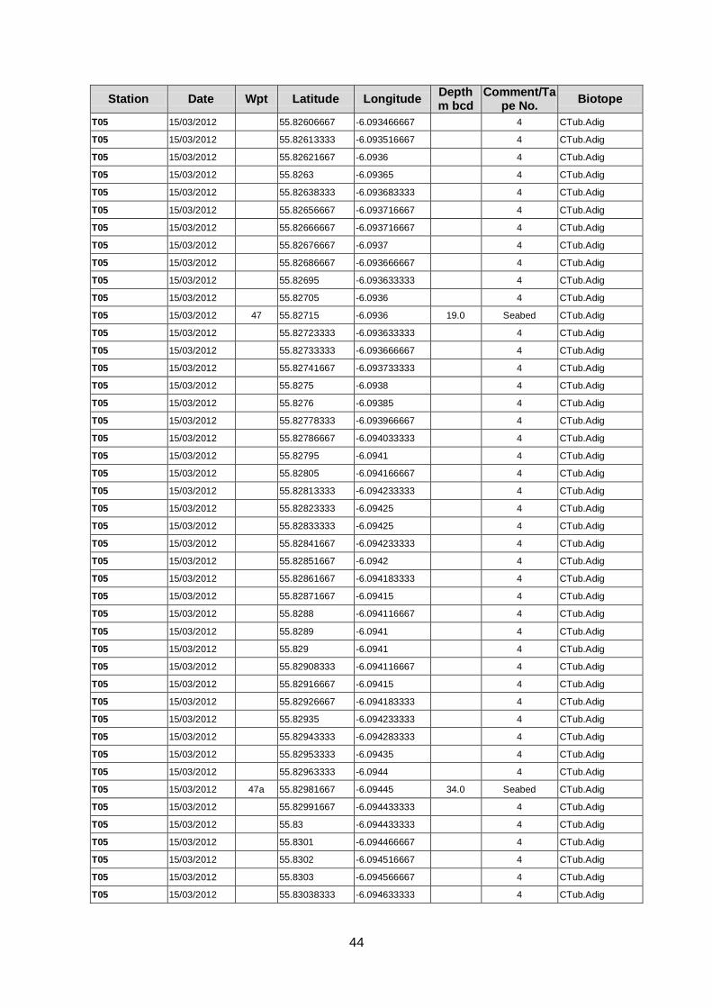
44
Station Date Wpt Latitude Longitude Depth m bcd
Comment/Tape No.
Biotope
T05 15/03/2012 55.82606667 -6.093466667 4 CTub.Adig
T05 15/03/2012 55.82613333 -6.093516667 4 CTub.Adig
T05 15/03/2012 55.82621667 -6.0936 4 CTub.Adig
T05 15/03/2012 55.8263 -6.09365 4 CTub.Adig
T05 15/03/2012 55.82638333 -6.093683333 4 CTub.Adig
T05 15/03/2012 55.82656667 -6.093716667 4 CTub.Adig
T05 15/03/2012 55.82666667 -6.093716667 4 CTub.Adig
T05 15/03/2012 55.82676667 -6.0937 4 CTub.Adig
T05 15/03/2012 55.82686667 -6.093666667 4 CTub.Adig
T05 15/03/2012 55.82695 -6.093633333 4 CTub.Adig
T05 15/03/2012 55.82705 -6.0936 4 CTub.Adig
T05 15/03/2012 47 55.82715 -6.0936 19.0 Seabed CTub.Adig
T05 15/03/2012 55.82723333 -6.093633333 4 CTub.Adig
T05 15/03/2012 55.82733333 -6.093666667 4 CTub.Adig
T05 15/03/2012 55.82741667 -6.093733333 4 CTub.Adig
T05 15/03/2012 55.8275 -6.0938 4 CTub.Adig
T05 15/03/2012 55.8276 -6.09385 4 CTub.Adig
T05 15/03/2012 55.82778333 -6.093966667 4 CTub.Adig
T05 15/03/2012 55.82786667 -6.094033333 4 CTub.Adig
T05 15/03/2012 55.82795 -6.0941 4 CTub.Adig
T05 15/03/2012 55.82805 -6.094166667 4 CTub.Adig
T05 15/03/2012 55.82813333 -6.094233333 4 CTub.Adig
T05 15/03/2012 55.82823333 -6.09425 4 CTub.Adig
T05 15/03/2012 55.82833333 -6.09425 4 CTub.Adig
T05 15/03/2012 55.82841667 -6.094233333 4 CTub.Adig
T05 15/03/2012 55.82851667 -6.0942 4 CTub.Adig
T05 15/03/2012 55.82861667 -6.094183333 4 CTub.Adig
T05 15/03/2012 55.82871667 -6.09415 4 CTub.Adig
T05 15/03/2012 55.8288 -6.094116667 4 CTub.Adig
T05 15/03/2012 55.8289 -6.0941 4 CTub.Adig
T05 15/03/2012 55.829 -6.0941 4 CTub.Adig
T05 15/03/2012 55.82908333 -6.094116667 4 CTub.Adig
T05 15/03/2012 55.82916667 -6.09415 4 CTub.Adig
T05 15/03/2012 55.82926667 -6.094183333 4 CTub.Adig
T05 15/03/2012 55.82935 -6.094233333 4 CTub.Adig
T05 15/03/2012 55.82943333 -6.094283333 4 CTub.Adig
T05 15/03/2012 55.82953333 -6.09435 4 CTub.Adig
T05 15/03/2012 55.82963333 -6.0944 4 CTub.Adig
T05 15/03/2012 47a 55.82981667 -6.09445 34.0 Seabed CTub.Adig
T05 15/03/2012 55.82991667 -6.094433333 4 CTub.Adig
T05 15/03/2012 55.83 -6.094433333 4 CTub.Adig
T05 15/03/2012 55.8301 -6.094466667 4 CTub.Adig
T05 15/03/2012 55.8302 -6.094516667 4 CTub.Adig
T05 15/03/2012 55.8303 -6.094566667 4 CTub.Adig
T05 15/03/2012 55.83038333 -6.094633333 4 CTub.Adig
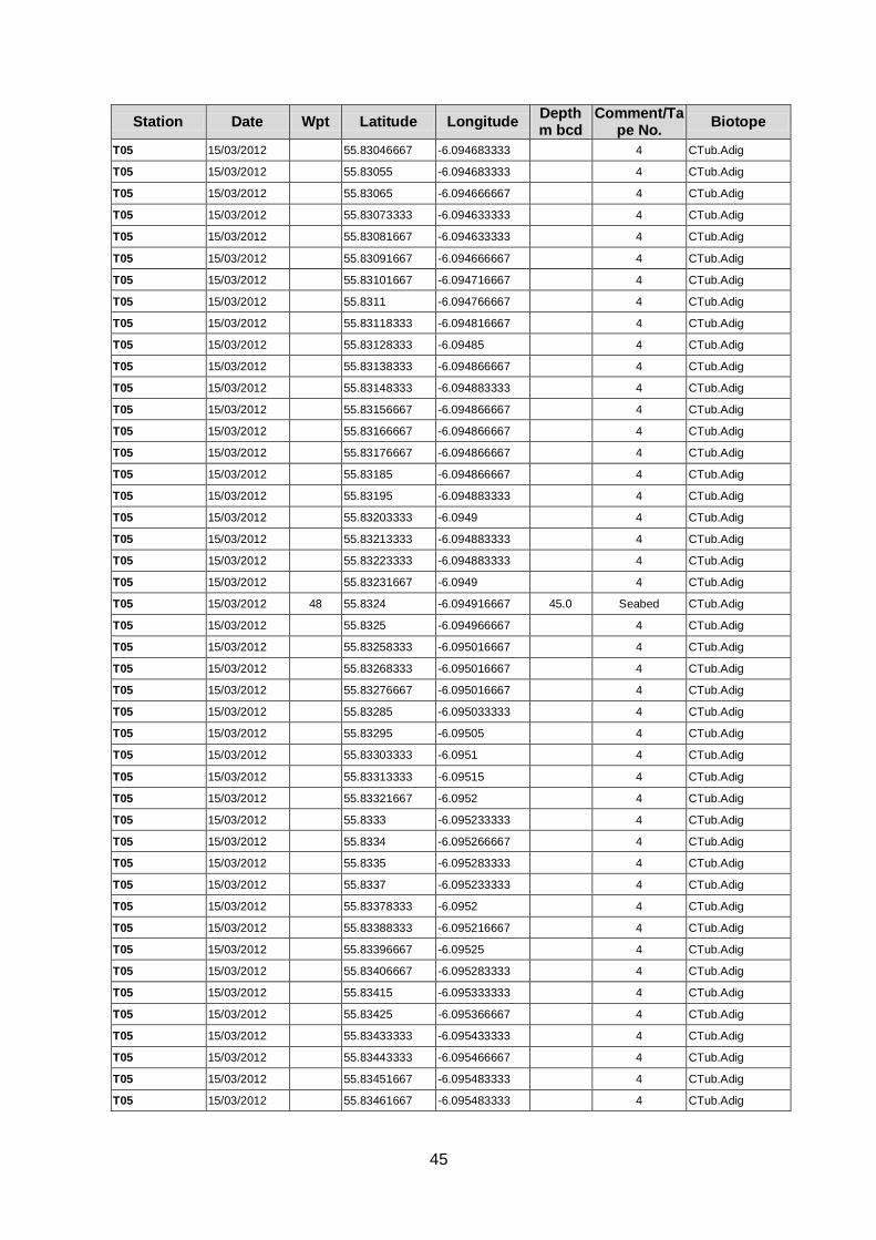
45
Station Date Wpt Latitude Longitude Depth m bcd
Comment/Tape No.
Biotope
T05 15/03/2012 55.83046667 -6.094683333 4 CTub.Adig
T05 15/03/2012 55.83055 -6.094683333 4 CTub.Adig
T05 15/03/2012 55.83065 -6.094666667 4 CTub.Adig
T05 15/03/2012 55.83073333 -6.094633333 4 CTub.Adig
T05 15/03/2012 55.83081667 -6.094633333 4 CTub.Adig
T05 15/03/2012 55.83091667 -6.094666667 4 CTub.Adig
T05 15/03/2012 55.83101667 -6.094716667 4 CTub.Adig
T05 15/03/2012 55.8311 -6.094766667 4 CTub.Adig
T05 15/03/2012 55.83118333 -6.094816667 4 CTub.Adig
T05 15/03/2012 55.83128333 -6.09485 4 CTub.Adig
T05 15/03/2012 55.83138333 -6.094866667 4 CTub.Adig
T05 15/03/2012 55.83148333 -6.094883333 4 CTub.Adig
T05 15/03/2012 55.83156667 -6.094866667 4 CTub.Adig
T05 15/03/2012 55.83166667 -6.094866667 4 CTub.Adig
T05 15/03/2012 55.83176667 -6.094866667 4 CTub.Adig
T05 15/03/2012 55.83185 -6.094866667 4 CTub.Adig
T05 15/03/2012 55.83195 -6.094883333 4 CTub.Adig
T05 15/03/2012 55.83203333 -6.0949 4 CTub.Adig
T05 15/03/2012 55.83213333 -6.094883333 4 CTub.Adig
T05 15/03/2012 55.83223333 -6.094883333 4 CTub.Adig
T05 15/03/2012 55.83231667 -6.0949 4 CTub.Adig
T05 15/03/2012 48 55.8324 -6.094916667 45.0 Seabed CTub.Adig
T05 15/03/2012 55.8325 -6.094966667 4 CTub.Adig
T05 15/03/2012 55.83258333 -6.095016667 4 CTub.Adig
T05 15/03/2012 55.83268333 -6.095016667 4 CTub.Adig
T05 15/03/2012 55.83276667 -6.095016667 4 CTub.Adig
T05 15/03/2012 55.83285 -6.095033333 4 CTub.Adig
T05 15/03/2012 55.83295 -6.09505 4 CTub.Adig
T05 15/03/2012 55.83303333 -6.0951 4 CTub.Adig
T05 15/03/2012 55.83313333 -6.09515 4 CTub.Adig
T05 15/03/2012 55.83321667 -6.0952 4 CTub.Adig
T05 15/03/2012 55.8333 -6.095233333 4 CTub.Adig
T05 15/03/2012 55.8334 -6.095266667 4 CTub.Adig
T05 15/03/2012 55.8335 -6.095283333 4 CTub.Adig
T05 15/03/2012 55.8337 -6.095233333 4 CTub.Adig
T05 15/03/2012 55.83378333 -6.0952 4 CTub.Adig
T05 15/03/2012 55.83388333 -6.095216667 4 CTub.Adig
T05 15/03/2012 55.83396667 -6.09525 4 CTub.Adig
T05 15/03/2012 55.83406667 -6.095283333 4 CTub.Adig
T05 15/03/2012 55.83415 -6.095333333 4 CTub.Adig
T05 15/03/2012 55.83425 -6.095366667 4 CTub.Adig
T05 15/03/2012 55.83433333 -6.095433333 4 CTub.Adig
T05 15/03/2012 55.83443333 -6.095466667 4 CTub.Adig
T05 15/03/2012 55.83451667 -6.095483333 4 CTub.Adig
T05 15/03/2012 55.83461667 -6.095483333 4 CTub.Adig
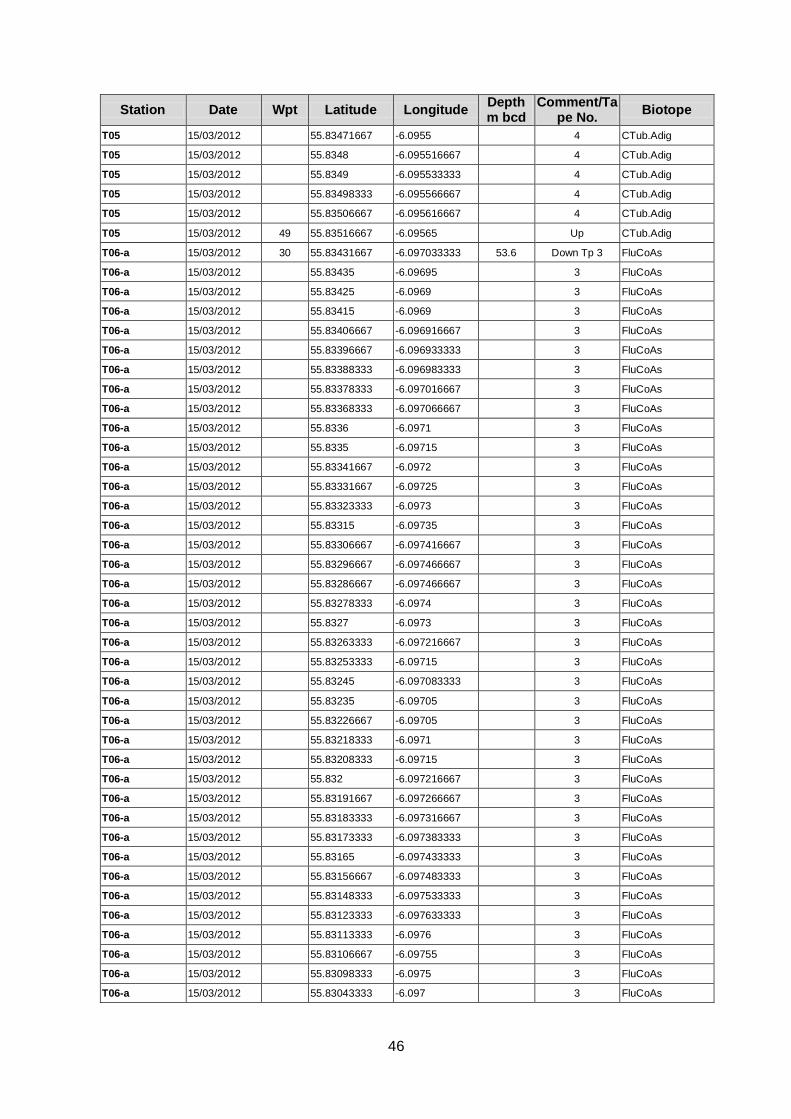
46
Station Date Wpt Latitude Longitude Depth m bcd
Comment/Tape No.
Biotope
T05 15/03/2012 55.83471667 -6.0955 4 CTub.Adig
T05 15/03/2012 55.8348 -6.095516667 4 CTub.Adig
T05 15/03/2012 55.8349 -6.095533333 4 CTub.Adig
T05 15/03/2012 55.83498333 -6.095566667 4 CTub.Adig
T05 15/03/2012 55.83506667 -6.095616667 4 CTub.Adig
T05 15/03/2012 49 55.83516667 -6.09565 Up CTub.Adig
T06-a 15/03/2012 30 55.83431667 -6.097033333 53.6 Down Tp 3 FluCoAs
T06-a 15/03/2012 55.83435 -6.09695 3 FluCoAs
T06-a 15/03/2012 55.83425 -6.0969 3 FluCoAs
T06-a 15/03/2012 55.83415 -6.0969 3 FluCoAs
T06-a 15/03/2012 55.83406667 -6.096916667 3 FluCoAs
T06-a 15/03/2012 55.83396667 -6.096933333 3 FluCoAs
T06-a 15/03/2012 55.83388333 -6.096983333 3 FluCoAs
T06-a 15/03/2012 55.83378333 -6.097016667 3 FluCoAs
T06-a 15/03/2012 55.83368333 -6.097066667 3 FluCoAs
T06-a 15/03/2012 55.8336 -6.0971 3 FluCoAs
T06-a 15/03/2012 55.8335 -6.09715 3 FluCoAs
T06-a 15/03/2012 55.83341667 -6.0972 3 FluCoAs
T06-a 15/03/2012 55.83331667 -6.09725 3 FluCoAs
T06-a 15/03/2012 55.83323333 -6.0973 3 FluCoAs
T06-a 15/03/2012 55.83315 -6.09735 3 FluCoAs
T06-a 15/03/2012 55.83306667 -6.097416667 3 FluCoAs
T06-a 15/03/2012 55.83296667 -6.097466667 3 FluCoAs
T06-a 15/03/2012 55.83286667 -6.097466667 3 FluCoAs
T06-a 15/03/2012 55.83278333 -6.0974 3 FluCoAs
T06-a 15/03/2012 55.8327 -6.0973 3 FluCoAs
T06-a 15/03/2012 55.83263333 -6.097216667 3 FluCoAs
T06-a 15/03/2012 55.83253333 -6.09715 3 FluCoAs
T06-a 15/03/2012 55.83245 -6.097083333 3 FluCoAs
T06-a 15/03/2012 55.83235 -6.09705 3 FluCoAs
T06-a 15/03/2012 55.83226667 -6.09705 3 FluCoAs
T06-a 15/03/2012 55.83218333 -6.0971 3 FluCoAs
T06-a 15/03/2012 55.83208333 -6.09715 3 FluCoAs
T06-a 15/03/2012 55.832 -6.097216667 3 FluCoAs
T06-a 15/03/2012 55.83191667 -6.097266667 3 FluCoAs
T06-a 15/03/2012 55.83183333 -6.097316667 3 FluCoAs
T06-a 15/03/2012 55.83173333 -6.097383333 3 FluCoAs
T06-a 15/03/2012 55.83165 -6.097433333 3 FluCoAs
T06-a 15/03/2012 55.83156667 -6.097483333 3 FluCoAs
T06-a 15/03/2012 55.83148333 -6.097533333 3 FluCoAs
T06-a 15/03/2012 55.83123333 -6.097633333 3 FluCoAs
T06-a 15/03/2012 55.83113333 -6.0976 3 FluCoAs
T06-a 15/03/2012 55.83106667 -6.09755 3 FluCoAs
T06-a 15/03/2012 55.83098333 -6.0975 3 FluCoAs
T06-a 15/03/2012 55.83043333 -6.097 3 FluCoAs
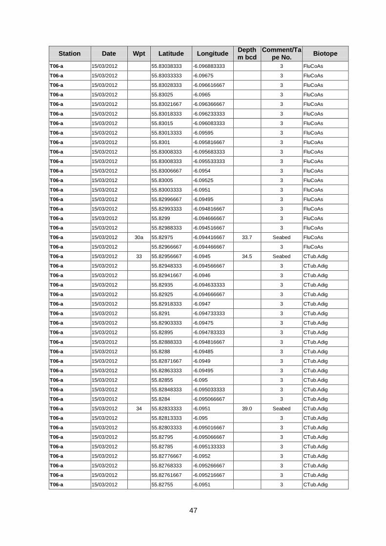
47
Station Date Wpt Latitude Longitude Depth m bcd
Comment/Tape No.
Biotope
T06-a 15/03/2012 55.83038333 -6.096883333 3 FluCoAs
T06-a 15/03/2012 55.83033333 -6.09675 3 FluCoAs
T06-a 15/03/2012 55.83028333 -6.096616667 3 FluCoAs
T06-a 15/03/2012 55.83025 -6.0965 3 FluCoAs
T06-a 15/03/2012 55.83021667 -6.096366667 3 FluCoAs
T06-a 15/03/2012 55.83018333 -6.096233333 3 FluCoAs
T06-a 15/03/2012 55.83015 -6.096083333 3 FluCoAs
T06-a 15/03/2012 55.83013333 -6.09595 3 FluCoAs
T06-a 15/03/2012 55.8301 -6.095816667 3 FluCoAs
T06-a 15/03/2012 55.83008333 -6.095683333 3 FluCoAs
T06-a 15/03/2012 55.83008333 -6.095533333 3 FluCoAs
T06-a 15/03/2012 55.83006667 -6.0954 3 FluCoAs
T06-a 15/03/2012 55.83005 -6.09525 3 FluCoAs
T06-a 15/03/2012 55.83003333 -6.0951 3 FluCoAs
T06-a 15/03/2012 55.82996667 -6.09495 3 FluCoAs
T06-a 15/03/2012 55.82993333 -6.094816667 3 FluCoAs
T06-a 15/03/2012 55.8299 -6.094666667 3 FluCoAs
T06-a 15/03/2012 55.82988333 -6.094516667 3 FluCoAs
T06-a 15/03/2012 30a 55.82975 -6.094416667 33.7 Seabed FluCoAs
T06-a 15/03/2012 55.82966667 -6.094466667 3 FluCoAs
T06-a 15/03/2012 33 55.82956667 -6.0945 34.5 Seabed CTub.Adig
T06-a 15/03/2012 55.82948333 -6.094566667 3 CTub.Adig
T06-a 15/03/2012 55.82941667 -6.0946 3 CTub.Adig
T06-a 15/03/2012 55.82935 -6.094633333 3 CTub.Adig
T06-a 15/03/2012 55.82925 -6.094666667 3 CTub.Adig
T06-a 15/03/2012 55.82918333 -6.0947 3 CTub.Adig
T06-a 15/03/2012 55.8291 -6.094733333 3 CTub.Adig
T06-a 15/03/2012 55.82903333 -6.09475 3 CTub.Adig
T06-a 15/03/2012 55.82895 -6.094783333 3 CTub.Adig
T06-a 15/03/2012 55.82888333 -6.094816667 3 CTub.Adig
T06-a 15/03/2012 55.8288 -6.09485 3 CTub.Adig
T06-a 15/03/2012 55.82871667 -6.0949 3 CTub.Adig
T06-a 15/03/2012 55.82863333 -6.09495 3 CTub.Adig
T06-a 15/03/2012 55.82855 -6.095 3 CTub.Adig
T06-a 15/03/2012 55.82848333 -6.095033333 3 CTub.Adig
T06-a 15/03/2012 55.8284 -6.095066667 3 CTub.Adig
T06-a 15/03/2012 34 55.82833333 -6.0951 39.0 Seabed CTub.Adig
T06-a 15/03/2012 55.82813333 -6.095 3 CTub.Adig
T06-a 15/03/2012 55.82803333 -6.095016667 3 CTub.Adig
T06-a 15/03/2012 55.82795 -6.095066667 3 CTub.Adig
T06-a 15/03/2012 55.82785 -6.095133333 3 CTub.Adig
T06-a 15/03/2012 55.82776667 -6.0952 3 CTub.Adig
T06-a 15/03/2012 55.82768333 -6.095266667 3 CTub.Adig
T06-a 15/03/2012 55.82761667 -6.095216667 3 CTub.Adig
T06-a 15/03/2012 55.82755 -6.0951 3 CTub.Adig
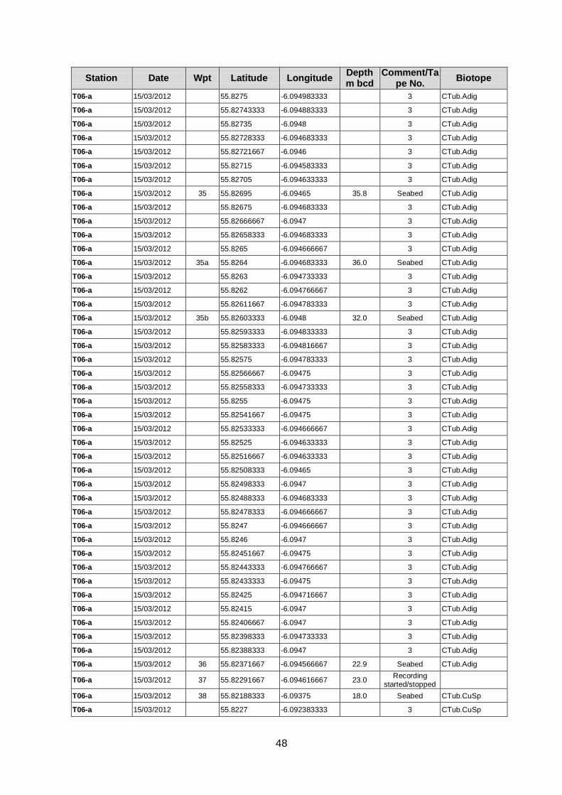
48
Station Date Wpt Latitude Longitude Depth m bcd
Comment/Tape No.
Biotope
T06-a 15/03/2012 55.8275 -6.094983333 3 CTub.Adig
T06-a 15/03/2012 55.82743333 -6.094883333 3 CTub.Adig
T06-a 15/03/2012 55.82735 -6.0948 3 CTub.Adig
T06-a 15/03/2012 55.82728333 -6.094683333 3 CTub.Adig
T06-a 15/03/2012 55.82721667 -6.0946 3 CTub.Adig
T06-a 15/03/2012 55.82715 -6.094583333 3 CTub.Adig
T06-a 15/03/2012 55.82705 -6.094633333 3 CTub.Adig
T06-a 15/03/2012 35 55.82695 -6.09465 35.8 Seabed CTub.Adig
T06-a 15/03/2012 55.82675 -6.094683333 3 CTub.Adig
T06-a 15/03/2012 55.82666667 -6.0947 3 CTub.Adig
T06-a 15/03/2012 55.82658333 -6.094683333 3 CTub.Adig
T06-a 15/03/2012 55.8265 -6.094666667 3 CTub.Adig
T06-a 15/03/2012 35a 55.8264 -6.094683333 36.0 Seabed CTub.Adig
T06-a 15/03/2012 55.8263 -6.094733333 3 CTub.Adig
T06-a 15/03/2012 55.8262 -6.094766667 3 CTub.Adig
T06-a 15/03/2012 55.82611667 -6.094783333 3 CTub.Adig
T06-a 15/03/2012 35b 55.82603333 -6.0948 32.0 Seabed CTub.Adig
T06-a 15/03/2012 55.82593333 -6.094833333 3 CTub.Adig
T06-a 15/03/2012 55.82583333 -6.094816667 3 CTub.Adig
T06-a 15/03/2012 55.82575 -6.094783333 3 CTub.Adig
T06-a 15/03/2012 55.82566667 -6.09475 3 CTub.Adig
T06-a 15/03/2012 55.82558333 -6.094733333 3 CTub.Adig
T06-a 15/03/2012 55.8255 -6.09475 3 CTub.Adig
T06-a 15/03/2012 55.82541667 -6.09475 3 CTub.Adig
T06-a 15/03/2012 55.82533333 -6.094666667 3 CTub.Adig
T06-a 15/03/2012 55.82525 -6.094633333 3 CTub.Adig
T06-a 15/03/2012 55.82516667 -6.094633333 3 CTub.Adig
T06-a 15/03/2012 55.82508333 -6.09465 3 CTub.Adig
T06-a 15/03/2012 55.82498333 -6.0947 3 CTub.Adig
T06-a 15/03/2012 55.82488333 -6.094683333 3 CTub.Adig
T06-a 15/03/2012 55.82478333 -6.094666667 3 CTub.Adig
T06-a 15/03/2012 55.8247 -6.094666667 3 CTub.Adig
T06-a 15/03/2012 55.8246 -6.0947 3 CTub.Adig
T06-a 15/03/2012 55.82451667 -6.09475 3 CTub.Adig
T06-a 15/03/2012 55.82443333 -6.094766667 3 CTub.Adig
T06-a 15/03/2012 55.82433333 -6.09475 3 CTub.Adig
T06-a 15/03/2012 55.82425 -6.094716667 3 CTub.Adig
T06-a 15/03/2012 55.82415 -6.0947 3 CTub.Adig
T06-a 15/03/2012 55.82406667 -6.0947 3 CTub.Adig
T06-a 15/03/2012 55.82398333 -6.094733333 3 CTub.Adig
T06-a 15/03/2012 55.82388333 -6.0947 3 CTub.Adig
T06-a 15/03/2012 36 55.82371667 -6.094566667 22.9 Seabed CTub.Adig
T06-a 15/03/2012 37 55.82291667 -6.094616667 23.0 Recording
started/stopped
T06-a 15/03/2012 38 55.82188333 -6.09375 18.0 Seabed CTub.CuSp
T06-a 15/03/2012 55.8227 -6.092383333 3 CTub.CuSp

49
Station Date Wpt Latitude Longitude Depth m bcd
Comment/Tape No.
Biotope
T06-a 15/03/2012 55.8228 -6.092383333 3 CTub.CuSp
T06-a 15/03/2012 55.82288333 -6.0924 3 CTub.CuSp
T06-a 15/03/2012 55.82296667 -6.092433333 3 CTub.CuSp
T06-a 15/03/2012 55.8229 -6.092533333 3 CTub.CuSp
T06-a 15/03/2012 55.82283333 -6.092616667 3 CTub.CuSp
T06-a 15/03/2012 55.82275 -6.0927 3 CTub.CuSp
T06-a 15/03/2012 55.82266667 -6.092733333 3 CTub.CuSp
T06-a 15/03/2012 55.82256667 -6.092683333 3 CTub.CuSp
T06-a 15/03/2012 55.82246667 -6.09265 3 CTub.CuSp
T06-a 15/03/2012 55.82238333 -6.092616667 3 CTub.CuSp
T06-a 15/03/2012 55.82233333 -6.092633333 3 CTub.CuSp
T06-a 15/03/2012 55.8223 -6.0927 3 CTub.CuSp
T06-a 15/03/2012 55.82216667 -6.092766667 3 CTub.CuSp
T06-a 15/03/2012 55.82206667 -6.092766667 3 CTub.CuSp
T06-a 15/03/2012 55.82196667 -6.09275 3 CTub.CuSp
T06-a 15/03/2012 55.82188333 -6.09275 3 CTub.CuSp
T06-a 15/03/2012 55.82185 -6.092783333 3 CTub.CuSp
T06-a 15/03/2012 55.82175 -6.092866667 3 CTub.CuSp
T06-a 15/03/2012 55.82163333 -6.0929 3 CTub.CuSp
T06-a 15/03/2012 55.82153333 -6.0929 3 CTub.CuSp
T06-a 15/03/2012 55.82146667 -6.09295 3 CTub.CuSp
T06-a 15/03/2012 39 55.82146667 -6.093 19.0 Seabed CTub.CuSp
T06-a 15/03/2012 55.82133333 -6.093083333 3 CTub.CuSp
T06-a 15/03/2012 55.82121667 -6.093066667 3 CTub.CuSp
T06-a 15/03/2012 55.82111667 -6.093033333 3 CTub.CuSp
T06-a 15/03/2012 55.82103333 -6.093 3 CTub.CuSp
T06-a 15/03/2012 55.82095 -6.093016667 3 CTub.CuSp
T06-a 15/03/2012 55.8209 -6.093066667 3 CTub.CuSp
T06-a 15/03/2012 55.82081667 -6.093166667 3 CTub.CuSp
T06-a 15/03/2012 55.82071667 -6.0932 3 CTub.CuSp
T06-a 15/03/2012 55.8206 -6.093216667 3 CTub.CuSp
T06-a 15/03/2012 55.82051667 -6.093216667 3 CTub.CuSp
T06-a 15/03/2012 55.82046667 -6.093266667 3 CTub.CuSp
T06-a 15/03/2012 55.82045 -6.093366667 3 CTub.CuSp
T06-a 15/03/2012 55.82023333 -6.09345 3 CTub.CuSp
T06-a 15/03/2012 55.82013333 -6.093433333 3 CTub.CuSp
T06-a 15/03/2012 55.82003333 -6.093416667 3 CTub.CuSp
T06-a 15/03/2012 55.81996667 -6.093416667 3 CTub.CuSp
T06-a 15/03/2012 40 55.81993333 -6.093466667 20.4 Seabed CTub.CuSp
T06-a 15/03/2012 55.81985 -6.093583333 3 CTub.CuSp
T06-a 15/03/2012 55.81975 -6.093583333 3 CTub.CuSp
T06-a 15/03/2012 55.81966667 -6.093533333 3 CTub.CuSp
T06-a 15/03/2012 55.81958333 -6.093483333 3 CTub.CuSp
T06-a 15/03/2012 55.81948333 -6.093416667 3 CTub.CuSp
T06-a 15/03/2012 55.8194 -6.09335 3 CTub.CuSp
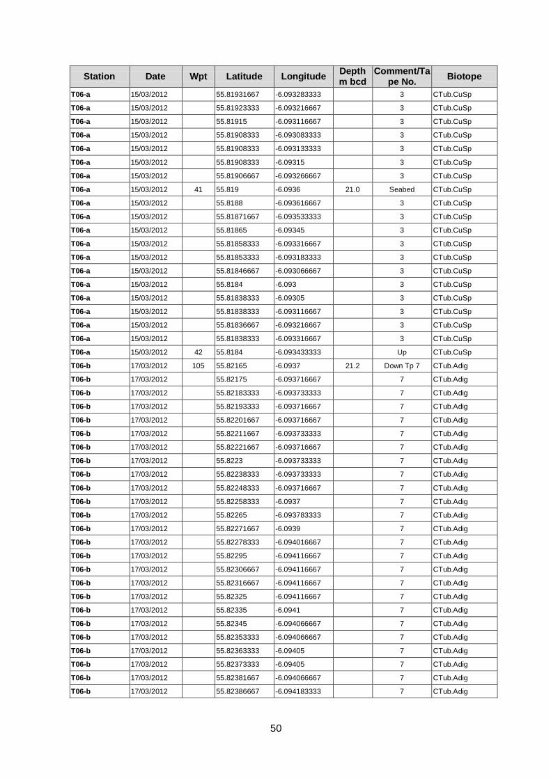
50
Station Date Wpt Latitude Longitude Depth m bcd
Comment/Tape No.
Biotope
T06-a 15/03/2012 55.81931667 -6.093283333 3 CTub.CuSp
T06-a 15/03/2012 55.81923333 -6.093216667 3 CTub.CuSp
T06-a 15/03/2012 55.81915 -6.093116667 3 CTub.CuSp
T06-a 15/03/2012 55.81908333 -6.093083333 3 CTub.CuSp
T06-a 15/03/2012 55.81908333 -6.093133333 3 CTub.CuSp
T06-a 15/03/2012 55.81908333 -6.09315 3 CTub.CuSp
T06-a 15/03/2012 55.81906667 -6.093266667 3 CTub.CuSp
T06-a 15/03/2012 41 55.819 -6.0936 21.0 Seabed CTub.CuSp
T06-a 15/03/2012 55.8188 -6.093616667 3 CTub.CuSp
T06-a 15/03/2012 55.81871667 -6.093533333 3 CTub.CuSp
T06-a 15/03/2012 55.81865 -6.09345 3 CTub.CuSp
T06-a 15/03/2012 55.81858333 -6.093316667 3 CTub.CuSp
T06-a 15/03/2012 55.81853333 -6.093183333 3 CTub.CuSp
T06-a 15/03/2012 55.81846667 -6.093066667 3 CTub.CuSp
T06-a 15/03/2012 55.8184 -6.093 3 CTub.CuSp
T06-a 15/03/2012 55.81838333 -6.09305 3 CTub.CuSp
T06-a 15/03/2012 55.81838333 -6.093116667 3 CTub.CuSp
T06-a 15/03/2012 55.81836667 -6.093216667 3 CTub.CuSp
T06-a 15/03/2012 55.81838333 -6.093316667 3 CTub.CuSp
T06-a 15/03/2012 42 55.8184 -6.093433333 Up CTub.CuSp
T06-b 17/03/2012 105 55.82165 -6.0937 21.2 Down Tp 7 CTub.Adig
T06-b 17/03/2012 55.82175 -6.093716667 7 CTub.Adig
T06-b 17/03/2012 55.82183333 -6.093733333 7 CTub.Adig
T06-b 17/03/2012 55.82193333 -6.093716667 7 CTub.Adig
T06-b 17/03/2012 55.82201667 -6.093716667 7 CTub.Adig
T06-b 17/03/2012 55.82211667 -6.093733333 7 CTub.Adig
T06-b 17/03/2012 55.82221667 -6.093716667 7 CTub.Adig
T06-b 17/03/2012 55.8223 -6.093733333 7 CTub.Adig
T06-b 17/03/2012 55.82238333 -6.093733333 7 CTub.Adig
T06-b 17/03/2012 55.82248333 -6.093716667 7 CTub.Adig
T06-b 17/03/2012 55.82258333 -6.0937 7 CTub.Adig
T06-b 17/03/2012 55.82265 -6.093783333 7 CTub.Adig
T06-b 17/03/2012 55.82271667 -6.0939 7 CTub.Adig
T06-b 17/03/2012 55.82278333 -6.094016667 7 CTub.Adig
T06-b 17/03/2012 55.82295 -6.094116667 7 CTub.Adig
T06-b 17/03/2012 55.82306667 -6.094116667 7 CTub.Adig
T06-b 17/03/2012 55.82316667 -6.094116667 7 CTub.Adig
T06-b 17/03/2012 55.82325 -6.094116667 7 CTub.Adig
T06-b 17/03/2012 55.82335 -6.0941 7 CTub.Adig
T06-b 17/03/2012 55.82345 -6.094066667 7 CTub.Adig
T06-b 17/03/2012 55.82353333 -6.094066667 7 CTub.Adig
T06-b 17/03/2012 55.82363333 -6.09405 7 CTub.Adig
T06-b 17/03/2012 55.82373333 -6.09405 7 CTub.Adig
T06-b 17/03/2012 55.82381667 -6.094066667 7 CTub.Adig
T06-b 17/03/2012 55.82386667 -6.094183333 7 CTub.Adig
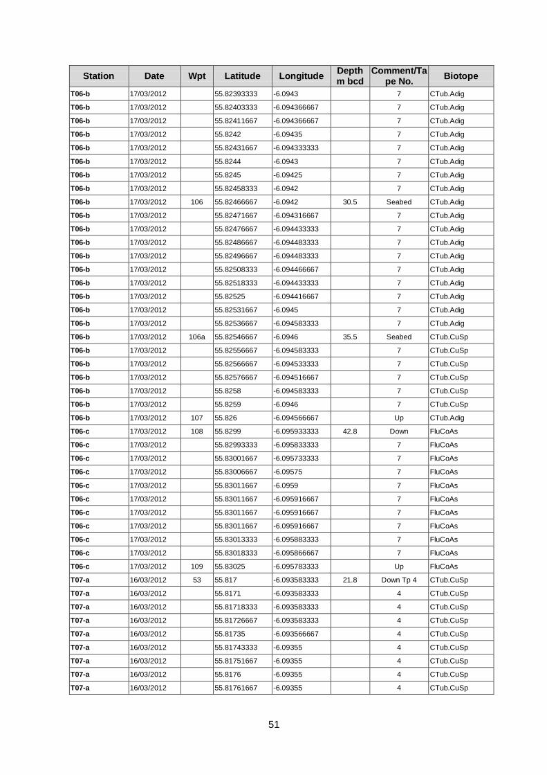
51
Station Date Wpt Latitude Longitude Depth m bcd
Comment/Tape No.
Biotope
T06-b 17/03/2012 55.82393333 -6.0943 7 CTub.Adig
T06-b 17/03/2012 55.82403333 -6.094366667 7 CTub.Adig
T06-b 17/03/2012 55.82411667 -6.094366667 7 CTub.Adig
T06-b 17/03/2012 55.8242 -6.09435 7 CTub.Adig
T06-b 17/03/2012 55.82431667 -6.094333333 7 CTub.Adig
T06-b 17/03/2012 55.8244 -6.0943 7 CTub.Adig
T06-b 17/03/2012 55.8245 -6.09425 7 CTub.Adig
T06-b 17/03/2012 55.82458333 -6.0942 7 CTub.Adig
T06-b 17/03/2012 106 55.82466667 -6.0942 30.5 Seabed CTub.Adig
T06-b 17/03/2012 55.82471667 -6.094316667 7 CTub.Adig
T06-b 17/03/2012 55.82476667 -6.094433333 7 CTub.Adig
T06-b 17/03/2012 55.82486667 -6.094483333 7 CTub.Adig
T06-b 17/03/2012 55.82496667 -6.094483333 7 CTub.Adig
T06-b 17/03/2012 55.82508333 -6.094466667 7 CTub.Adig
T06-b 17/03/2012 55.82518333 -6.094433333 7 CTub.Adig
T06-b 17/03/2012 55.82525 -6.094416667 7 CTub.Adig
T06-b 17/03/2012 55.82531667 -6.0945 7 CTub.Adig
T06-b 17/03/2012 55.82536667 -6.094583333 7 CTub.Adig
T06-b 17/03/2012 106a 55.82546667 -6.0946 35.5 Seabed CTub.CuSp
T06-b 17/03/2012 55.82556667 -6.094583333 7 CTub.CuSp
T06-b 17/03/2012 55.82566667 -6.094533333 7 CTub.CuSp
T06-b 17/03/2012 55.82576667 -6.094516667 7 CTub.CuSp
T06-b 17/03/2012 55.8258 -6.094583333 7 CTub.CuSp
T06-b 17/03/2012 55.8259 -6.0946 7 CTub.CuSp
T06-b 17/03/2012 107 55.826 -6.094566667 Up CTub.Adig
T06-c 17/03/2012 108 55.8299 -6.095933333 42.8 Down FluCoAs
T06-c 17/03/2012 55.82993333 -6.095833333 7 FluCoAs
T06-c 17/03/2012 55.83001667 -6.095733333 7 FluCoAs
T06-c 17/03/2012 55.83006667 -6.09575 7 FluCoAs
T06-c 17/03/2012 55.83011667 -6.0959 7 FluCoAs
T06-c 17/03/2012 55.83011667 -6.095916667 7 FluCoAs
T06-c 17/03/2012 55.83011667 -6.095916667 7 FluCoAs
T06-c 17/03/2012 55.83011667 -6.095916667 7 FluCoAs
T06-c 17/03/2012 55.83013333 -6.095883333 7 FluCoAs
T06-c 17/03/2012 55.83018333 -6.095866667 7 FluCoAs
T06-c 17/03/2012 109 55.83025 -6.095783333 Up FluCoAs
T07-a 16/03/2012 53 55.817 -6.093583333 21.8 Down Tp 4 CTub.CuSp
T07-a 16/03/2012 55.8171 -6.093583333 4 CTub.CuSp
T07-a 16/03/2012 55.81718333 -6.093583333 4 CTub.CuSp
T07-a 16/03/2012 55.81726667 -6.093583333 4 CTub.CuSp
T07-a 16/03/2012 55.81735 -6.093566667 4 CTub.CuSp
T07-a 16/03/2012 55.81743333 -6.09355 4 CTub.CuSp
T07-a 16/03/2012 55.81751667 -6.09355 4 CTub.CuSp
T07-a 16/03/2012 55.8176 -6.09355 4 CTub.CuSp
T07-a 16/03/2012 55.81761667 -6.09355 4 CTub.CuSp
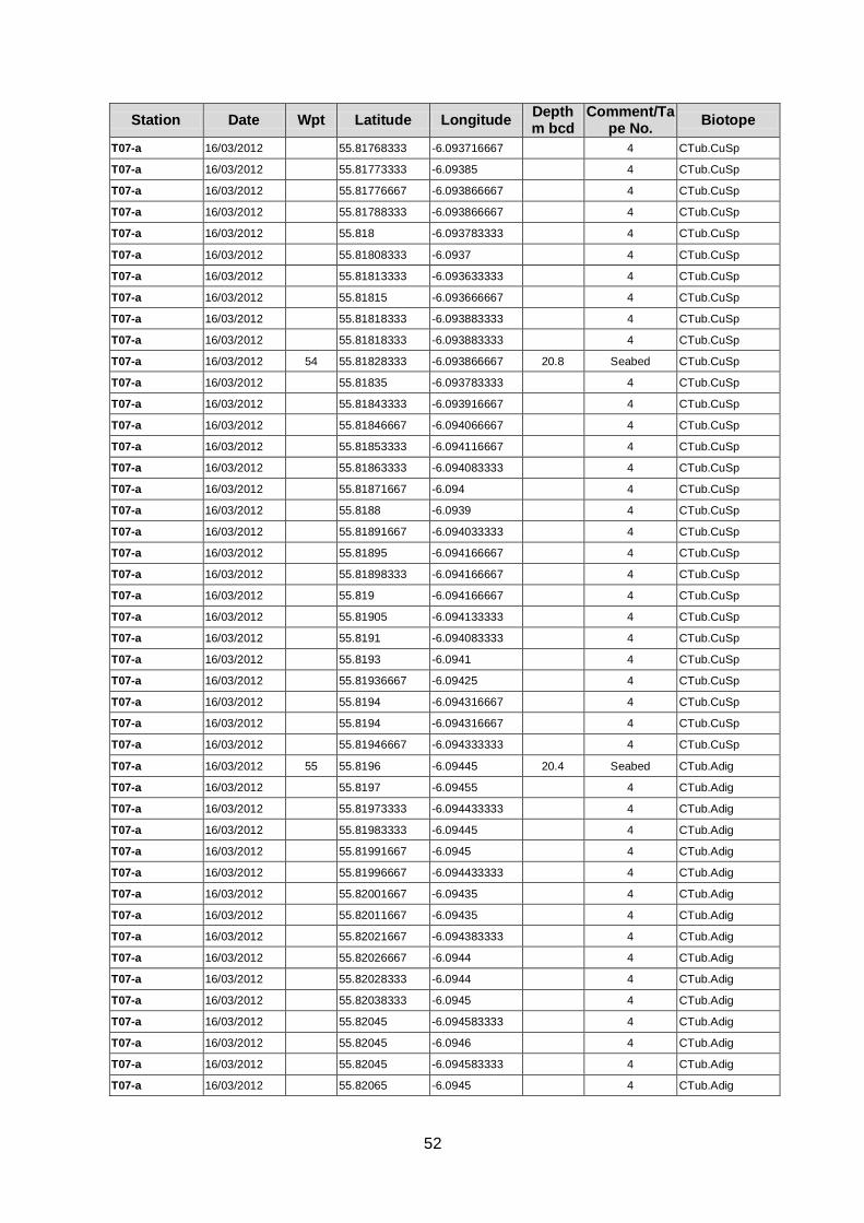
52
Station Date Wpt Latitude Longitude Depth m bcd
Comment/Tape No.
Biotope
T07-a 16/03/2012 55.81768333 -6.093716667 4 CTub.CuSp
T07-a 16/03/2012 55.81773333 -6.09385 4 CTub.CuSp
T07-a 16/03/2012 55.81776667 -6.093866667 4 CTub.CuSp
T07-a 16/03/2012 55.81788333 -6.093866667 4 CTub.CuSp
T07-a 16/03/2012 55.818 -6.093783333 4 CTub.CuSp
T07-a 16/03/2012 55.81808333 -6.0937 4 CTub.CuSp
T07-a 16/03/2012 55.81813333 -6.093633333 4 CTub.CuSp
T07-a 16/03/2012 55.81815 -6.093666667 4 CTub.CuSp
T07-a 16/03/2012 55.81818333 -6.093883333 4 CTub.CuSp
T07-a 16/03/2012 55.81818333 -6.093883333 4 CTub.CuSp
T07-a 16/03/2012 54 55.81828333 -6.093866667 20.8 Seabed CTub.CuSp
T07-a 16/03/2012 55.81835 -6.093783333 4 CTub.CuSp
T07-a 16/03/2012 55.81843333 -6.093916667 4 CTub.CuSp
T07-a 16/03/2012 55.81846667 -6.094066667 4 CTub.CuSp
T07-a 16/03/2012 55.81853333 -6.094116667 4 CTub.CuSp
T07-a 16/03/2012 55.81863333 -6.094083333 4 CTub.CuSp
T07-a 16/03/2012 55.81871667 -6.094 4 CTub.CuSp
T07-a 16/03/2012 55.8188 -6.0939 4 CTub.CuSp
T07-a 16/03/2012 55.81891667 -6.094033333 4 CTub.CuSp
T07-a 16/03/2012 55.81895 -6.094166667 4 CTub.CuSp
T07-a 16/03/2012 55.81898333 -6.094166667 4 CTub.CuSp
T07-a 16/03/2012 55.819 -6.094166667 4 CTub.CuSp
T07-a 16/03/2012 55.81905 -6.094133333 4 CTub.CuSp
T07-a 16/03/2012 55.8191 -6.094083333 4 CTub.CuSp
T07-a 16/03/2012 55.8193 -6.0941 4 CTub.CuSp
T07-a 16/03/2012 55.81936667 -6.09425 4 CTub.CuSp
T07-a 16/03/2012 55.8194 -6.094316667 4 CTub.CuSp
T07-a 16/03/2012 55.8194 -6.094316667 4 CTub.CuSp
T07-a 16/03/2012 55.81946667 -6.094333333 4 CTub.CuSp
T07-a 16/03/2012 55 55.8196 -6.09445 20.4 Seabed CTub.Adig
T07-a 16/03/2012 55.8197 -6.09455 4 CTub.Adig
T07-a 16/03/2012 55.81973333 -6.094433333 4 CTub.Adig
T07-a 16/03/2012 55.81983333 -6.09445 4 CTub.Adig
T07-a 16/03/2012 55.81991667 -6.0945 4 CTub.Adig
T07-a 16/03/2012 55.81996667 -6.094433333 4 CTub.Adig
T07-a 16/03/2012 55.82001667 -6.09435 4 CTub.Adig
T07-a 16/03/2012 55.82011667 -6.09435 4 CTub.Adig
T07-a 16/03/2012 55.82021667 -6.094383333 4 CTub.Adig
T07-a 16/03/2012 55.82026667 -6.0944 4 CTub.Adig
T07-a 16/03/2012 55.82028333 -6.0944 4 CTub.Adig
T07-a 16/03/2012 55.82038333 -6.0945 4 CTub.Adig
T07-a 16/03/2012 55.82045 -6.094583333 4 CTub.Adig
T07-a 16/03/2012 55.82045 -6.0946 4 CTub.Adig
T07-a 16/03/2012 55.82045 -6.094583333 4 CTub.Adig
T07-a 16/03/2012 55.82065 -6.0945 4 CTub.Adig
53
Station Date Wpt Latitude Longitude Depth m bcd
Comment/Tape No.
Biotope
T07-a 16/03/2012 55.82071667 -6.094633333 4 CTub.Adig
T07-a 16/03/2012 55.82073333 -6.094733333 4 CTub.Adig
T07-a 16/03/2012 55.82073333 -6.094733333 4 CTub.Adig
T07-a 16/03/2012 56 55.82075 -6.094716667 20.8 Seabed CTub.Adig
T07-a 16/03/2012 55.8208 -6.094466667 4 CTub.Adig
T07-a 16/03/2012 55.82086667 -6.094383333 4 CTub.Adig
T07-a 16/03/2012 55.82096667 -6.094416667 4 CTub.Adig
T07-a 16/03/2012 55.82106667 -6.0945 4 CTub.Adig
T07-a 16/03/2012 55.82115 -6.094616667 4 CTub.Adig
T07-a 16/03/2012 55.82121667 -6.094716667 4 CTub.Adig
T07-a 16/03/2012 55.82121667 -6.094733333 4 CTub.Adig
T07-a 16/03/2012 55.82121667 -6.094733333 4 CTub.Adig
T07-a 16/03/2012 55.8213 -6.09465 4 CTub.Adig
T07-a 16/03/2012 55.82135 -6.094716667 4 CTub.Adig
T07-a 16/03/2012 55.82136667 -6.094716667 Tp 4 end CTub.Adig
T07-a 16/03/2012 57 55.82133333 -6.0945 16.8 Blue water Tp 5
start CTub.Adig
T07-a 16/03/2012 55.82136667 -6.09445 5 CTub.Adig
T07-a 16/03/2012 55.82146667 -6.094466667 5 CTub.Adig
T07-a 16/03/2012 55.82153333 -6.094483333 5 CTub.Adig
T07-a 16/03/2012 55.82161667 -6.09455 5 CTub.Adig
T07-a 16/03/2012 55.8217 -6.094616667 5 CTub.Adig
T07-a 16/03/2012 55.82178333 -6.094666667 5 CTub.Adig
T07-a 16/03/2012 55.82186667 -6.094716667 5 CTub.Adig
T07-a 16/03/2012 55.82193333 -6.094833333 5 CTub.Adig
T07-a 16/03/2012 58 55.822 -6.094966667 18.8 Seabed CTub.Adig
T07-a 16/03/2012 55.822 -6.094966667 5 CTub.Adig
T07-a 16/03/2012 55.82195 -6.094866667 5 CTub.Adig
T07-a 16/03/2012 55.82193333 -6.09485 5 CTub.Adig
T07-a 16/03/2012 59 55.82193333 -6.094833333 Up CTub.Adig
T07-b 16/03/2012 60 55.82313333 -6.09515 18.8 Down CTub.CuSp
T07-b 16/03/2012 55.82303333 -6.09505 5 CTub.CuSp
T07-b 16/03/2012 55.82295 -6.095016667 5 CTub.CuSp
T07-b 16/03/2012 55.82286667 -6.094983333 5 CTub.CuSp
T07-b 16/03/2012 55.82276667 -6.094883333 5 CTub.CuSp
T07-b 16/03/2012 55.8227 -6.0948 5 CTub.CuSp
T07-b 16/03/2012 55.82263333 -6.094716667 5 CTub.CuSp
T07-b 16/03/2012 61 55.82256667 -6.09465 Up CTub.CuSp
T07-c 16/03/2012 62 55.82546667 -6.09595 18.8 Down CTub.CuSp
T07-c 16/03/2012 55.8254 -6.09585 5 CTub.CuSp
T07-c 16/03/2012 55.82533333 -6.095716667 5 CTub.CuSp
T07-c 16/03/2012 55.82526667 -6.095616667 5 CTub.CuSp
T07-c 16/03/2012 55.8252 -6.095516667 5 CTub.CuSp
T07-c 16/03/2012 55.82513333 -6.095416667 5 CTub.CuSp
T07-c 16/03/2012 55.82506667 -6.095333333 5 CTub.CuSp
T07-c 16/03/2012 55.825 -6.095233333 5 CTub.CuSp
54
Station Date Wpt Latitude Longitude Depth m bcd
Comment/Tape No.
Biotope
T07-c 16/03/2012 55.82491667 -6.09515 5 CTub.CuSp
T07-c 16/03/2012 55.82483333 -6.095066667 5 CTub.CuSp
T07-c 16/03/2012 55.82478333 -6.094966667 5 CTub.CuSp
T07-c 16/03/2012 55.8247 -6.094883333 5 CTub.CuSp
T07-c 16/03/2012 55.82461667 -6.094816667 5 CTub.CuSp
T07-c 16/03/2012 55.82453333 -6.094716667 5 CTub.CuSp
T07-c 16/03/2012 55.82445 -6.094666667 5 CTub.CuSp
T07-c 16/03/2012 63 55.82436667 -6.094616667 -1.2 Up CTub.CuSp
T07-d 16/03/2012 64 55.83326667 -6.09795 47.8 Down FluCoAs
T07-d 16/03/2012 55.83321667 -6.098 5 FluCoAs
T07-d 16/03/2012 55.83318333 -6.098 5 FluCoAs
T07-d 16/03/2012 55.8331 -6.097916667 5 FluCoAs
T07-d 16/03/2012 55.83301667 -6.0978 5 FluCoAs
T07-d 16/03/2012 55.83295 -6.097683333 5 FluCoAs
T07-d 16/03/2012 55.83286667 -6.097616667 5 FluCoAs
T07-d 16/03/2012 55.83281667 -6.097583333 5 FluCoAs
T07-d 16/03/2012 55.83273333 -6.097716667 5 FluCoAs
T07-d 16/03/2012 55.83265 -6.097833333 5 FluCoAs
T07-d 16/03/2012 55.83256667 -6.097916667 5 FluCoAs
T07-d 16/03/2012 55.8325 -6.097883333 5 FluCoAs
T07-d 16/03/2012 55.83241667 -6.0978 5 FluCoAs
T07-d 16/03/2012 55.83235 -6.0977 5 FluCoAs
T07-d 16/03/2012 55.83226667 -6.0976 5 FluCoAs
T07-d 16/03/2012 55.8322 -6.097516667 5 FluCoAs
T07-d 16/03/2012 55.83211667 -6.09745 5 FluCoAs
T07-d 16/03/2012 55.83203333 -6.09735 5 FluCoAs
T07-d 16/03/2012 55.83186667 -6.0975 5 FluCoAs
T07-d 16/03/2012 55.8318 -6.097583333 5 FluCoAs
T07-d 16/03/2012 55.83171667 -6.09765 5 FluCoAs
T07-d 16/03/2012 55.83161667 -6.097633333 5 FluCoAs
T07-d 16/03/2012 55.83155 -6.09755 5 FluCoAs
T07-d 16/03/2012 65 55.83146667 -6.097466667 46.4 Seabed FluCoAs
T07-d 16/03/2012 55.8314 -6.097366667 5 FluCoAs
T07-d 16/03/2012 55.83133333 -6.097283333 5 FluCoAs
T07-d 16/03/2012 66 55.83125 -6.0972 45.6 Seabed FluCoAs
T07-d 16/03/2012 55.83116667 -6.097133333 5 FluCoAs
T07-d 16/03/2012 55.83108333 -6.097183333 5 FluCoAs
T07-d 16/03/2012 55.83098333 -6.09725 5 FluCoAs
T07-d 16/03/2012 55.8309 -6.097316667 5 FluCoAs
T07-d 16/03/2012 55.83081667 -6.09735 5 FluCoAs
T07-d 16/03/2012 55.83073333 -6.097333333 5 FluCoAs
T07-d 16/03/2012 55.83065 -6.097283333 5 FluCoAs
T07-d 16/03/2012 55.83055 -6.097216667 5 FluCoAs
T07-d 16/03/2012 55.83046667 -6.097166667 5 FluCoAs
T07-d 16/03/2012 55.8304 -6.0971 5 FluCoAs
55
Station Date Wpt Latitude Longitude Depth m bcd
Comment/Tape No.
Biotope
T07-d 16/03/2012 55.8303 -6.09705 5 FluCoAs
T07-d 16/03/2012 55.83021667 -6.097016667 5 FluCoAs
T07-d 16/03/2012 55.83013333 -6.096983333 5 FluCoAs
T07-d 16/03/2012 55.83005 -6.096933333 5 FluCoAs
T07-d 16/03/2012 55.82996667 -6.096883333 5 FluCoAs
T07-d 16/03/2012 55.82988333 -6.096833333 5 FluCoAs
T07-d 16/03/2012 55.8298 -6.0968 5 FluCoAs
T07-d 16/03/2012 55.8297 -6.096766667 5 FluCoAs
T07-d 16/03/2012 55.82961667 -6.09675 5 FluCoAs
T07-d 16/03/2012 55.82953333 -6.096783333 5 FluCoAs
T07-d 16/03/2012 55.82928333 -6.09695 5 FluCoAs
T07-d 16/03/2012 55.82918333 -6.097016667 5 FluCoAs
T07-d 16/03/2012 55.8291 -6.09705 5 FluCoAs
T07-d 16/03/2012 55.829 -6.097066667 5 FluCoAs
T07-d 16/03/2012 55.82891667 -6.09705 5 FluCoAs
T07-d 16/03/2012 55.82881667 -6.097016667 5 FluCoAs
T07-d 16/03/2012 55.82871667 -6.096983333 5 FluCoAs
T07-d 16/03/2012 55.82863333 -6.096933333 5 FluCoAs
T07-d 16/03/2012 55.82855 -6.096883333 5 FluCoAs
T07-d 16/03/2012 55.82846667 -6.09685 5 FluCoAs
T07-d 16/03/2012 55.82838333 -6.096816667 5 FluCoAs
T07-d 16/03/2012 55.82828333 -6.096783333 5 FluCoAs
T07-d 16/03/2012 55.8282 -6.09675 5 FluCoAs
T07-d 16/03/2012 55.82811667 -6.096716667 5 FluCoAs
T07-d 16/03/2012 55.82801667 -6.0967 5 FluCoAs
T07-d 16/03/2012 55.82791667 -6.096683333 5 FluCoAs
T07-d 16/03/2012 55.82781667 -6.09665 5 FluCoAs
T07-d 16/03/2012 67 55.82773333 -6.0966 33.5 Seabed FluCoAs
T07-d 16/03/2012 55.82763333 -6.096583333 5 FluCoAs
T07-d 16/03/2012 55.82755 -6.09655 5 FluCoAs
T07-d 16/03/2012 55.82745 -6.096516667 5 FluCoAs
T07-d 16/03/2012 55.82735 -6.0965 5 FluCoAs
T07-d 16/03/2012 55.82726667 -6.0965 5 FluCoAs
T07-d 16/03/2012 55.82718333 -6.096466667 5 FluCoAs
T07-d 16/03/2012 55.82708333 -6.09645 5 FluCoAs
T07-d 16/03/2012 55.827 -6.096433333 5 FluCoAs
T07-d 16/03/2012 55.8269 -6.096383333 5 FluCoAs
T07-d 16/03/2012 55.82681667 -6.096366667 5 FluCoAs
T07-d 16/03/2012 55.82673333 -6.096333333 5 FluCoAs
T07-d 16/03/2012 55.82663333 -6.0963 5 FluCoAs
T07-d 16/03/2012 55.82653333 -6.096266667 5 FluCoAs
T07-d 16/03/2012 55.82643333 -6.096216667 5 FluCoAs
T07-d 16/03/2012 55.82635 -6.096183333 5 FluCoAs
T07-d 16/03/2012 55.82625 -6.096133333 5 FluCoAs
T07-d 16/03/2012 55.82616667 -6.0961 5 FluCoAs
56
Station Date Wpt Latitude Longitude Depth m bcd
Comment/Tape No.
Biotope
T07-d 16/03/2012 55.82606667 -6.096066667 5 FluCoAs
T07-d 16/03/2012 55.82598333 -6.096033333 5 FluCoAs
T07-d 16/03/2012 55.8259 -6.096016667 5 FluCoAs
T07-d 16/03/2012 55.8258 -6.095983333 5 FluCoAs
T07-d 16/03/2012 55.8257 -6.09595 5 FluCoAs
T07-d 16/03/2012 55.82561667 -6.095933333 5 FluCoAs
T07-d 16/03/2012 55.82551667 -6.0959 5 FluCoAs
T07-d 16/03/2012 68 55.82543333 -6.095883333 19.8 Seabed CTub.Adig
T07-d 16/03/2012 55.82533333 -6.095866667 5 CTub.Adig
T07-d 16/03/2012 55.82525 -6.095833333 5 CTub.Adig
T07-d 16/03/2012 55.82515 -6.095816667 5 CTub.Adig
T07-d 16/03/2012 55.82506667 -6.095766667 5 CTub.Adig
T07-d 16/03/2012 55.82496667 -6.09575 5 CTub.Adig
T07-d 16/03/2012 55.82488333 -6.095733333 5 CTub.Adig
T07-d 16/03/2012 55.82478333 -6.0957 5 CTub.Adig
T07-d 16/03/2012 69 55.82468333 -6.095666667 Up CTub.Adig
T08 17/03/2012 102 55.81646667 -6.09465 23.7 Down CTub.Adig
T08 17/03/2012 55.81656667 -6.094666667 7 CTub.Adig
T08 17/03/2012 55.81665 -6.094666667 7 CTub.Adig
T08 17/03/2012 55.81675 -6.094666667 7 CTub.Adig
T08 17/03/2012 55.81683333 -6.09465 7 CTub.Adig
T08 17/03/2012 55.81691667 -6.09465 7 CTub.Adig
T08 17/03/2012 55.81701667 -6.09465 7 CTub.Adig
T08 17/03/2012 55.8171 -6.094666667 7 CTub.Adig
T08 17/03/2012 55.81718333 -6.094683333 7 CTub.Adig
T08 17/03/2012 55.81728333 -6.0947 7 CTub.Adig
T08 17/03/2012 55.81736667 -6.094716667 7 CTub.Adig
T08 17/03/2012 55.81746667 -6.094733333 7 CTub.Adig
T08 17/03/2012 55.8177 -6.095 7 CTub.Adig
T08 17/03/2012 55.81788333 -6.0951 7 CTub.Adig
T08 17/03/2012 55.81796667 -6.095116667 7 CTub.Adig
T08 17/03/2012 55.81806667 -6.095133333 7 CTub.Adig
T08 17/03/2012 55.81816667 -6.09515 7 CTub.Adig
T08 17/03/2012 55.81826667 -6.09515 7 CTub.Adig
T08 17/03/2012 55.81836667 -6.095166667 7 CTub.Adig
T08 17/03/2012 55.81845 -6.095166667 7 CTub.Adig
T08 17/03/2012 55.81855 -6.095166667 7 CTub.Adig
T08 17/03/2012 55.81865 -6.09515 7 CTub.Adig
T08 17/03/2012 55.81873333 -6.09515 7 CTub.Adig
T08 17/03/2012 55.81883333 -6.09515 7 CTub.Adig
T08 17/03/2012 55.81893333 -6.09515 7 CTub.Adig
T08 17/03/2012 55.81903333 -6.095166667 7 CTub.Adig
T08 17/03/2012 55.81911667 -6.095166667 7 CTub.Adig
T08 17/03/2012 55.8192 -6.095216667 7 CTub.Adig
T08 17/03/2012 55.8193 -6.095333333 7 CTub.Adig
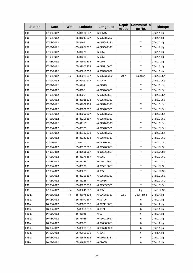
57
Station Date Wpt Latitude Longitude Depth m bcd
Comment/Tape No.
Biotope
T08 17/03/2012 55.81936667 -6.09545 7 CTub.Adig
T08 17/03/2012 55.81941667 -6.095583333 7 CTub.Adig
T08 17/03/2012 55.8196 -6.095683333 7 CTub.Adig
T08 17/03/2012 55.81966667 -6.095683333 7 CTub.Adig
T08 17/03/2012 55.81975 -6.0957 7 CTub.Adig
T08 17/03/2012 55.81985 -6.0957 7 CTub.Adig
T08 17/03/2012 55.81993333 -6.0957 7 CTub.Adig
T08 17/03/2012 55.82003333 -6.095716667 7 CTub.Adig
T08 17/03/2012 55.82013333 -6.095733333 7 CTub.Adig
T08 17/03/2012 103 55.82021667 -6.095733333 20.7 Seabed CTub.CuSp
T08 17/03/2012 55.82031667 -6.09575 7 CTub.CuSp
T08 17/03/2012 55.8204 -6.09575 7 CTub.CuSp
T08 17/03/2012 55.8205 -6.095766667 7 CTub.CuSp
T08 17/03/2012 55.8206 -6.095766667 7 CTub.CuSp
T08 17/03/2012 55.82068333 -6.095783333 7 CTub.CuSp
T08 17/03/2012 55.82078333 -6.095783333 7 CTub.CuSp
T08 17/03/2012 55.82086667 -6.095783333 7 CTub.CuSp
T08 17/03/2012 55.82096667 -6.095783333 7 CTub.CuSp
T08 17/03/2012 55.82106667 -6.095783333 7 CTub.CuSp
T08 17/03/2012 55.82115 -6.095783333 7 CTub.CuSp
T08 17/03/2012 55.82125 -6.095783333 7 CTub.CuSp
T08 17/03/2012 55.82133333 -6.095783333 7 CTub.CuSp
T08 17/03/2012 55.82143333 -6.095783333 7 CTub.CuSp
T08 17/03/2012 55.82155 -6.095766667 7 CTub.CuSp
T08 17/03/2012 55.82161667 -6.095766667 7 CTub.CuSp
T08 17/03/2012 55.82166667 -6.095866667 7 CTub.CuSp
T08 17/03/2012 55.82176667 -6.0959 7 CTub.CuSp
T08 17/03/2012 55.82185 -6.095916667 7 CTub.CuSp
T08 17/03/2012 55.82195 -6.095916667 7 CTub.CuSp
T08 17/03/2012 55.82205 -6.0959 7 CTub.CuSp
T08 17/03/2012 55.82216667 -6.095883333 7 CTub.CuSp
T08 17/03/2012 55.82225 -6.09585 7 CTub.CuSp
T08 17/03/2012 55.82233333 -6.095833333 7 CTub.CuSp
T08 17/03/2012 104 55.82241667 -6.0958 Up CTub.CuSp
T09-a 16/03/2012 74 55.82078333 -6.096983333 22.0 Down Tp 6 CTub.Adig
T09-a 16/03/2012 55.82071667 -6.09705 6 CTub.Adig
T09-a 16/03/2012 55.82061667 -6.097116667 6 CTub.Adig
T09-a 16/03/2012 55.82058333 -6.0971 6 CTub.Adig
T09-a 16/03/2012 55.82045 -6.097 6 CTub.Adig
T09-a 16/03/2012 55.82035 -6.096916667 6 CTub.Adig
T09-a 16/03/2012 55.82025 -6.096866667 6 CTub.Adig
T09-a 16/03/2012 55.82013333 -6.096783333 6 CTub.Adig
T09-a 16/03/2012 55.82008333 -6.0967 6 CTub.Adig
T09-a 16/03/2012 55.81998333 -6.096583333 6 CTub.Adig
T09-a 16/03/2012 55.81986667 -6.09655 6 CTub.Adig
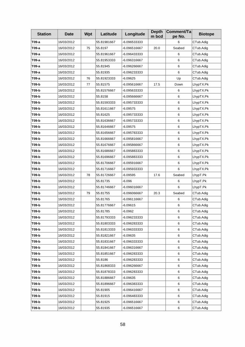
58
Station Date Wpt Latitude Longitude Depth m bcd
Comment/Tape No.
Biotope
T09-a 16/03/2012 55.81981667 -6.096533333 6 CTub.Adig
T09-a 16/03/2012 75 55.8197 -6.096516667 20.0 Seabed CTub.Adig
T09-a 16/03/2012 55.81961667 -6.096433333 6 CTub.Adig
T09-a 16/03/2012 55.81953333 -6.096316667 6 CTub.Adig
T09-a 16/03/2012 55.81945 -6.096266667 6 CTub.Adig
T09-a 16/03/2012 55.81935 -6.096233333 6 CTub.Adig
T09-a 16/03/2012 76 55.81923333 -6.09625 Up CTub.Adig
T09-b 16/03/2012 77 55.81575 -6.095616667 17.5 Down LhypTX.Pk
T09-b 16/03/2012 55.81576667 -6.095633333 6 LhypTX.Pk
T09-b 16/03/2012 55.8158 -6.095666667 6 LhypTX.Pk
T09-b 16/03/2012 55.81593333 -6.095733333 6 LhypTX.Pk
T09-b 16/03/2012 55.81611667 -6.09575 6 LhypTX.Pk
T09-b 16/03/2012 55.81625 -6.095733333 6 LhypTX.Pk
T09-b 16/03/2012 55.81636667 -6.095733333 6 LhypTX.Pk
T09-b 16/03/2012 55.81646667 -6.09575 6 LhypTX.Pk
T09-b 16/03/2012 55.81656667 -6.095783333 6 LhypTX.Pk
T09-b 16/03/2012 55.81666667 -6.095816667 6 LhypTX.Pk
T09-b 16/03/2012 55.81676667 -6.095866667 6 LhypTX.Pk
T09-b 16/03/2012 55.81686667 -6.095883333 6 LhypTX.Pk
T09-b 16/03/2012 55.81696667 -6.095883333 6 LhypTX.Pk
T09-b 16/03/2012 55.81706667 -6.095916667 6 LhypTX.Pk
T09-b 16/03/2012 55.81716667 -6.095933333 6 LhypTX.Pk
T09-b 16/03/2012 78 55.81726667 -6.09595 17.6 Seabed LhypT.Pk
T09-b 16/03/2012 55.81735 -6.096 6 LhypT.Pk
T09-b 16/03/2012 55.81746667 -6.096016667 6 LhypT.Pk
T09-b 16/03/2012 79 55.81755 -6.096066667 20.3 Seabed CTub.Adig
T09-b 16/03/2012 55.81765 -6.096116667 6 CTub.Adig
T09-b 16/03/2012 55.81776667 -6.09615 6 CTub.Adig
T09-b 16/03/2012 55.81785 -6.0962 6 CTub.Adig
T09-b 16/03/2012 55.81793333 -6.096233333 6 CTub.Adig
T09-b 16/03/2012 55.81803333 -6.096283333 6 CTub.Adig
T09-b 16/03/2012 55.81813333 -6.096333333 6 CTub.Adig
T09-b 16/03/2012 55.81821667 -6.09635 6 CTub.Adig
T09-b 16/03/2012 55.81831667 -6.096333333 6 CTub.Adig
T09-b 16/03/2012 55.81841667 -6.096316667 6 CTub.Adig
T09-b 16/03/2012 55.81851667 -6.096283333 6 CTub.Adig
T09-b 16/03/2012 55.8186 -6.096283333 6 CTub.Adig
T09-b 16/03/2012 55.81868333 -6.096266667 6 CTub.Adig
T09-b 16/03/2012 55.81878333 -6.096283333 6 CTub.Adig
T09-b 16/03/2012 55.81886667 -6.09635 6 CTub.Adig
T09-b 16/03/2012 55.81896667 -6.096383333 6 CTub.Adig
T09-b 16/03/2012 55.81905 -6.096416667 6 CTub.Adig
T09-b 16/03/2012 55.81915 -6.096483333 6 CTub.Adig
T09-b 16/03/2012 55.81925 -6.096516667 6 CTub.Adig
T09-b 16/03/2012 55.81935 -6.096516667 6 CTub.Adig

59
Station Date Wpt Latitude Longitude Depth m bcd
Comment/Tape No.
Biotope
T09-b 16/03/2012 55.81945 -6.09655 6 CTub.Adig
T09-b 16/03/2012 55.81953333 -6.096566667 6 CTub.Adig
T09-b 16/03/2012 55.81961667 -6.096566667 6 CTub.Adig
T09-b 16/03/2012 55.81971667 -6.0966 6 CTub.Adig
T09-b 16/03/2012 80 55.81981667 -6.0966 Up CTub.Adig
T10-a 16/03/2012 81 55.81513333 -6.09685 14.9 Down LhypT.Pk
T10-a 16/03/2012 55.81518333 -6.096716667 6 LhypT.Pk
T10-a 16/03/2012 55.81521667 -6.096583333 6 LhypT.Pk
T10-a 16/03/2012 55.8153 -6.0965 6 LhypT.Pk
T10-a 16/03/2012 55.81541667 -6.09655 6 LhypT.Pk
T10-a 16/03/2012 55.8155 -6.096616667 6 LhypT.Pk
T10-a 16/03/2012 55.8156 -6.096683333 6 LhypT.Pk
T10-a 16/03/2012 55.81568333 -6.096716667 6 LhypT.Pk
T10-a 16/03/2012 55.81576667 -6.096766667 6 LhypT.Pk
T10-a 16/03/2012 55.81585 -6.0968 6 LhypT.Pk
T10-a 16/03/2012 55.81595 -6.096866667 6 LhypT.Pk
T10-a 16/03/2012 55.81603333 -6.096933333 6 LhypT.Pk
T10-a 16/03/2012 55.81613333 -6.096983333 6 LhypT.Pk
T10-a 16/03/2012 55.81621667 -6.097033333 6 LhypT.Pk
T10-a 16/03/2012 55.81631667 -6.097083333 6 LhypT.Pk
T10-a 16/03/2012 55.81638333 -6.097166667 6 LhypT.Pk
T10-a 16/03/2012 55.81646667 -6.09725 6 LhypT.Pk
T10-a 16/03/2012 55.81655 -6.097316667 6 LhypT.Pk
T10-a 16/03/2012 55.81663333 -6.097383333 6 LhypT.Pk
T10-a 16/03/2012 55.81668333 -6.0974 6 LhypT.Pk
T10-a 16/03/2012 55.8168 -6.09735 6 LhypT.Pk
T10-a 16/03/2012 55.81688333 -6.097283333 6 LhypT.Pk
T10-a 16/03/2012 55.81696667 -6.0972 6 LhypT.Pk
T10-a 16/03/2012 55.81705 -6.097116667 6 LhypT.Pk
T10-a 16/03/2012 55.81713333 -6.097066667 6 LhypT.Pk
T10-a 16/03/2012 55.81723333 -6.097 6 LhypT.Pk
T10-a 16/03/2012 55.81733333 -6.09695 6 LhypT.Pk
T10-a 16/03/2012 55.8174 -6.096966667 6 LhypT.Pk
T10-a 16/03/2012 82 55.8175 -6.097016667 Up LhypT.Pk
T10-b 16/03/2012 83 55.81835 -6.0975 20.0 Down CTub.CuSp
T10-b 16/03/2012 55.81843333 -6.097516667 6 CTub.CuSp
T10-b 16/03/2012 55.81853333 -6.09755 6 CTub.CuSp
T10-b 16/03/2012 55.81863333 -6.097583333 6 CTub.CuSp
T10-b 16/03/2012 55.81873333 -6.0976 6 CTub.CuSp
T10-b 16/03/2012 55.81883333 -6.097633333 6 CTub.CuSp
T10-b 16/03/2012 55.8189 -6.0977 6 CTub.CuSp
T10-b 16/03/2012 55.81896667 -6.097816667 6 CTub.CuSp
T10-b 16/03/2012 55.81905 -6.097866667 6 CTub.CuSp
T10-b 16/03/2012 55.81915 -6.097833333 6 CTub.CuSp
T10-b 16/03/2012 55.81923333 -6.097766667 6 CTub.CuSp
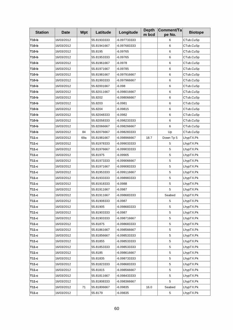
60
Station Date Wpt Latitude Longitude Depth m bcd
Comment/Tape No.
Biotope
T10-b 16/03/2012 55.81933333 -6.097733333 6 CTub.CuSp
T10-b 16/03/2012 55.81941667 -6.097683333 6 CTub.CuSp
T10-b 16/03/2012 55.8195 -6.09765 6 CTub.CuSp
T10-b 16/03/2012 55.81953333 -6.09765 6 CTub.CuSp
T10-b 16/03/2012 55.81961667 -6.0978 6 CTub.CuSp
T10-b 16/03/2012 55.81971667 -6.09785 6 CTub.CuSp
T10-b 16/03/2012 55.81981667 -6.097916667 6 CTub.CuSp
T10-b 16/03/2012 55.81993333 -6.097966667 6 CTub.CuSp
T10-b 16/03/2012 55.82001667 -6.098 6 CTub.CuSp
T10-b 16/03/2012 55.82011667 -6.098016667 6 CTub.CuSp
T10-b 16/03/2012 55.8202 -6.098066667 6 CTub.CuSp
T10-b 16/03/2012 55.8203 -6.0981 6 CTub.CuSp
T10-b 16/03/2012 55.8204 -6.09815 6 CTub.CuSp
T10-b 16/03/2012 55.82048333 -6.0982 6 CTub.CuSp
T10-b 16/03/2012 55.82058333 -6.098233333 6 CTub.CuSp
T10-b 16/03/2012 55.82066667 -6.098266667 6 CTub.CuSp
T10-b 16/03/2012 84 55.82076667 -6.098283333 Up CTub.CuSp
T11-c 16/03/2012 69a 55.81981667 -6.098966667 18.7 Down Tp 5 LhypTX.Pk
T11-c 16/03/2012 55.81978333 -6.099033333 5 LhypTX.Pk
T11-c 16/03/2012 55.81976667 -6.099033333 5 LhypTX.Pk
T11-c 16/03/2012 55.81975 -6.09905 5 LhypTX.Pk
T11-c 16/03/2012 55.81973333 -6.099066667 5 LhypTX.Pk
T11-c 16/03/2012 55.81971667 -6.099083333 5 LhypTX.Pk
T11-c 16/03/2012 55.81953333 -6.099116667 5 LhypTX.Pk
T11-c 16/03/2012 55.81933333 -6.098983333 5 LhypTX.Pk
T11-c 16/03/2012 55.81918333 -6.0988 5 LhypTX.Pk
T11-c 16/03/2012 55.81911667 -6.0987 5 LhypTX.Pk
T11-c 16/03/2012 55.81911667 -6.098683333 Seabed LhypTX.Pk
T11-c 16/03/2012 55.81908333 -6.0987 5 LhypTX.Pk
T11-c 16/03/2012 55.81905 -6.098683333 5 LhypTX.Pk
T11-c 16/03/2012 55.81903333 -6.0987 5 LhypTX.Pk
T11-c 16/03/2012 55.81903333 -6.098716667 5 LhypTX.Pk
T11-c 16/03/2012 55.81875 -6.098683333 5 LhypTX.Pk
T11-c 16/03/2012 55.81861667 -6.098566667 5 LhypTX.Pk
T11-c 16/03/2012 55.81856667 -6.098533333 5 LhypTX.Pk
T11-c 16/03/2012 55.81855 -6.098533333 5 LhypTX.Pk
T11-c 16/03/2012 55.81853333 -6.098533333 5 LhypTX.Pk
T11-c 16/03/2012 55.8185 -6.098616667 5 LhypTX.Pk
T11-c 16/03/2012 55.81835 -6.098733333 5 LhypTX.Pk
T11-c 16/03/2012 55.81823333 -6.098683333 5 LhypTX.Pk
T11-c 16/03/2012 55.81815 -6.098566667 5 LhypTX.Pk
T11-c 16/03/2012 55.81811667 -6.098433333 5 LhypTX.Pk
T11-c 16/03/2012 55.81808333 -6.098366667 5 LhypTX.Pk
T11-c 16/03/2012 71 55.81806667 -6.09835 16.0 Seabed LhypTX.Pk
T11-c 16/03/2012 55.8179 -6.09835 5 LhypTX.Pk
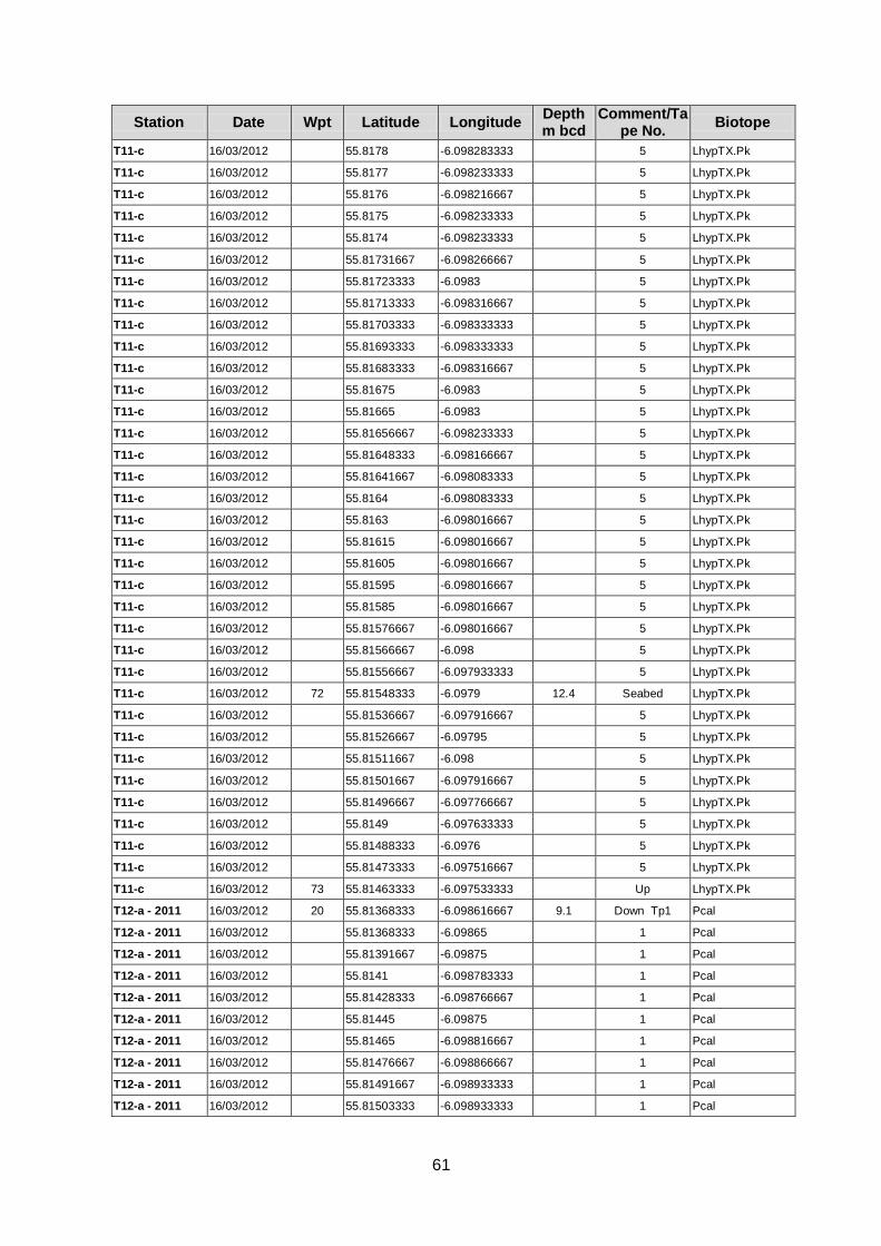
61
Station Date Wpt Latitude Longitude Depth m bcd
Comment/Tape No.
Biotope
T11-c 16/03/2012 55.8178 -6.098283333 5 LhypTX.Pk
T11-c 16/03/2012 55.8177 -6.098233333 5 LhypTX.Pk
T11-c 16/03/2012 55.8176 -6.098216667 5 LhypTX.Pk
T11-c 16/03/2012 55.8175 -6.098233333 5 LhypTX.Pk
T11-c 16/03/2012 55.8174 -6.098233333 5 LhypTX.Pk
T11-c 16/03/2012 55.81731667 -6.098266667 5 LhypTX.Pk
T11-c 16/03/2012 55.81723333 -6.0983 5 LhypTX.Pk
T11-c 16/03/2012 55.81713333 -6.098316667 5 LhypTX.Pk
T11-c 16/03/2012 55.81703333 -6.098333333 5 LhypTX.Pk
T11-c 16/03/2012 55.81693333 -6.098333333 5 LhypTX.Pk
T11-c 16/03/2012 55.81683333 -6.098316667 5 LhypTX.Pk
T11-c 16/03/2012 55.81675 -6.0983 5 LhypTX.Pk
T11-c 16/03/2012 55.81665 -6.0983 5 LhypTX.Pk
T11-c 16/03/2012 55.81656667 -6.098233333 5 LhypTX.Pk
T11-c 16/03/2012 55.81648333 -6.098166667 5 LhypTX.Pk
T11-c 16/03/2012 55.81641667 -6.098083333 5 LhypTX.Pk
T11-c 16/03/2012 55.8164 -6.098083333 5 LhypTX.Pk
T11-c 16/03/2012 55.8163 -6.098016667 5 LhypTX.Pk
T11-c 16/03/2012 55.81615 -6.098016667 5 LhypTX.Pk
T11-c 16/03/2012 55.81605 -6.098016667 5 LhypTX.Pk
T11-c 16/03/2012 55.81595 -6.098016667 5 LhypTX.Pk
T11-c 16/03/2012 55.81585 -6.098016667 5 LhypTX.Pk
T11-c 16/03/2012 55.81576667 -6.098016667 5 LhypTX.Pk
T11-c 16/03/2012 55.81566667 -6.098 5 LhypTX.Pk
T11-c 16/03/2012 55.81556667 -6.097933333 5 LhypTX.Pk
T11-c 16/03/2012 72 55.81548333 -6.0979 12.4 Seabed LhypTX.Pk
T11-c 16/03/2012 55.81536667 -6.097916667 5 LhypTX.Pk
T11-c 16/03/2012 55.81526667 -6.09795 5 LhypTX.Pk
T11-c 16/03/2012 55.81511667 -6.098 5 LhypTX.Pk
T11-c 16/03/2012 55.81501667 -6.097916667 5 LhypTX.Pk
T11-c 16/03/2012 55.81496667 -6.097766667 5 LhypTX.Pk
T11-c 16/03/2012 55.8149 -6.097633333 5 LhypTX.Pk
T11-c 16/03/2012 55.81488333 -6.0976 5 LhypTX.Pk
T11-c 16/03/2012 55.81473333 -6.097516667 5 LhypTX.Pk
T11-c 16/03/2012 73 55.81463333 -6.097533333 Up LhypTX.Pk
T12-a - 2011 16/03/2012 20 55.81368333 -6.098616667 9.1 Down Tp1 Pcal
T12-a - 2011 16/03/2012 55.81368333 -6.09865 1 Pcal
T12-a - 2011 16/03/2012 55.81391667 -6.09875 1 Pcal
T12-a - 2011 16/03/2012 55.8141 -6.098783333 1 Pcal
T12-a - 2011 16/03/2012 55.81428333 -6.098766667 1 Pcal
T12-a - 2011 16/03/2012 55.81445 -6.09875 1 Pcal
T12-a - 2011 16/03/2012 55.81465 -6.098816667 1 Pcal
T12-a - 2011 16/03/2012 55.81476667 -6.098866667 1 Pcal
T12-a - 2011 16/03/2012 55.81491667 -6.098933333 1 Pcal
T12-a - 2011 16/03/2012 55.81503333 -6.098933333 1 Pcal
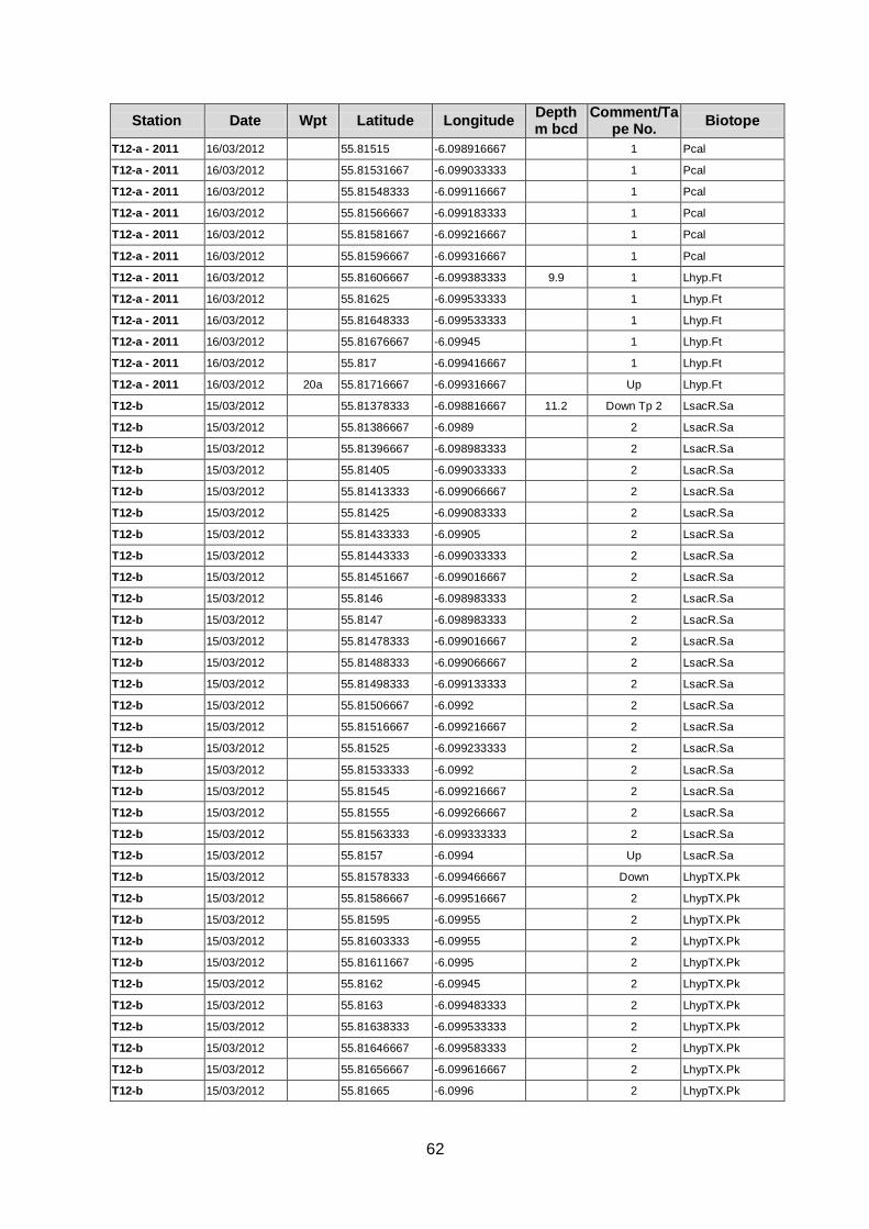
62
Station Date Wpt Latitude Longitude Depth m bcd
Comment/Tape No.
Biotope
T12-a - 2011 16/03/2012 55.81515 -6.098916667 1 Pcal
T12-a - 2011 16/03/2012 55.81531667 -6.099033333 1 Pcal
T12-a - 2011 16/03/2012 55.81548333 -6.099116667 1 Pcal
T12-a - 2011 16/03/2012 55.81566667 -6.099183333 1 Pcal
T12-a - 2011 16/03/2012 55.81581667 -6.099216667 1 Pcal
T12-a - 2011 16/03/2012 55.81596667 -6.099316667 1 Pcal
T12-a - 2011 16/03/2012 55.81606667 -6.099383333 9.9 1 Lhyp.Ft
T12-a - 2011 16/03/2012 55.81625 -6.099533333 1 Lhyp.Ft
T12-a - 2011 16/03/2012 55.81648333 -6.099533333 1 Lhyp.Ft
T12-a - 2011 16/03/2012 55.81676667 -6.09945 1 Lhyp.Ft
T12-a - 2011 16/03/2012 55.817 -6.099416667 1 Lhyp.Ft
T12-a - 2011 16/03/2012 20a 55.81716667 -6.099316667 Up Lhyp.Ft
T12-b 15/03/2012 55.81378333 -6.098816667 11.2 Down Tp 2 LsacR.Sa
T12-b 15/03/2012 55.81386667 -6.0989 2 LsacR.Sa
T12-b 15/03/2012 55.81396667 -6.098983333 2 LsacR.Sa
T12-b 15/03/2012 55.81405 -6.099033333 2 LsacR.Sa
T12-b 15/03/2012 55.81413333 -6.099066667 2 LsacR.Sa
T12-b 15/03/2012 55.81425 -6.099083333 2 LsacR.Sa
T12-b 15/03/2012 55.81433333 -6.09905 2 LsacR.Sa
T12-b 15/03/2012 55.81443333 -6.099033333 2 LsacR.Sa
T12-b 15/03/2012 55.81451667 -6.099016667 2 LsacR.Sa
T12-b 15/03/2012 55.8146 -6.098983333 2 LsacR.Sa
T12-b 15/03/2012 55.8147 -6.098983333 2 LsacR.Sa
T12-b 15/03/2012 55.81478333 -6.099016667 2 LsacR.Sa
T12-b 15/03/2012 55.81488333 -6.099066667 2 LsacR.Sa
T12-b 15/03/2012 55.81498333 -6.099133333 2 LsacR.Sa
T12-b 15/03/2012 55.81506667 -6.0992 2 LsacR.Sa
T12-b 15/03/2012 55.81516667 -6.099216667 2 LsacR.Sa
T12-b 15/03/2012 55.81525 -6.099233333 2 LsacR.Sa
T12-b 15/03/2012 55.81533333 -6.0992 2 LsacR.Sa
T12-b 15/03/2012 55.81545 -6.099216667 2 LsacR.Sa
T12-b 15/03/2012 55.81555 -6.099266667 2 LsacR.Sa
T12-b 15/03/2012 55.81563333 -6.099333333 2 LsacR.Sa
T12-b 15/03/2012 55.8157 -6.0994 Up LsacR.Sa
T12-b 15/03/2012 55.81578333 -6.099466667 Down LhypTX.Pk
T12-b 15/03/2012 55.81586667 -6.099516667 2 LhypTX.Pk
T12-b 15/03/2012 55.81595 -6.09955 2 LhypTX.Pk
T12-b 15/03/2012 55.81603333 -6.09955 2 LhypTX.Pk
T12-b 15/03/2012 55.81611667 -6.0995 2 LhypTX.Pk
T12-b 15/03/2012 55.8162 -6.09945 2 LhypTX.Pk
T12-b 15/03/2012 55.8163 -6.099483333 2 LhypTX.Pk
T12-b 15/03/2012 55.81638333 -6.099533333 2 LhypTX.Pk
T12-b 15/03/2012 55.81646667 -6.099583333 2 LhypTX.Pk
T12-b 15/03/2012 55.81656667 -6.099616667 2 LhypTX.Pk
T12-b 15/03/2012 55.81665 -6.0996 2 LhypTX.Pk

63
Station Date Wpt Latitude Longitude Depth m bcd
Comment/Tape No.
Biotope
T12-b 15/03/2012 55.81673333 -6.099566667 2 LhypTX.Pk
T12-b 15/03/2012 55.81681667 -6.09955 2 LhypTX.Pk
T12-b 15/03/2012 55.8169 -6.099583333 2 LhypTX.Pk
T12-b 15/03/2012 55.81698333 -6.099633333 2 LhypTX.Pk
T12-b 15/03/2012 55.81705 -6.0997 2 LhypTX.Pk
T12-b 15/03/2012 55.81715 -6.099766667 2 LhypTX.Pk
T12-b 15/03/2012 55.81723333 -6.099816667 2 LhypTX.Pk
T12-b 15/03/2012 55.81731667 -6.099883333 2 LhypTX.Pk
T12-b 15/03/2012 55.8174 -6.09995 2 LhypTX.Pk
T12-b 15/03/2012 55.81748333 -6.100033333 2 LhypTX.Pk
T12-b 15/03/2012 55.81753333 -6.100083333 2 LhypTX.Pk
T12-b 15/03/2012 55.81761667 -6.10005 2 LhypTX.Pk
T12-b 15/03/2012 55.8177 -6.099983333 2 LhypTX.Pk
T12-b 15/03/2012 55.8178 -6.099983333 2 LhypTX.Pk
T12-b 15/03/2012 55.8179 -6.100033333 2 LhypTX.Pk
T12-b 15/03/2012 55.81798333 -6.100066667 2 LhypTX.Pk
T12-b 15/03/2012 55.81806667 -6.100116667 2 LhypTX.Pk
T12-b 15/03/2012 55.81815 -6.100166667 2 LhypTX.Pk
T12-b 15/03/2012 55.81823333 -6.1002 2 LhypTX.Pk
T12-b 15/03/2012 55.81831667 -6.100216667 2 LhypTX.Pk
T12-b 15/03/2012 55.81841667 -6.1002 2 LhypTX.Pk
T12-b 15/03/2012 55.8185 -6.1002 2 LhypTX.Pk
T12-b 15/03/2012 55.81858333 -6.100183333 2 LhypTX.Pk
T12-b 15/03/2012 55.81868333 -6.100166667 2 LhypTX.Pk
T12-b 15/03/2012 55.81878333 -6.100183333 2 LhypTX.Pk
T12-b 15/03/2012 55.81886667 -6.100216667 2 LhypTX.Pk
T12-b 15/03/2012 55.81895 -6.100266667 2 LhypTX.Pk
T12-b 15/03/2012 55.81903333 -6.100333333 2 LhypTX.Pk
T12-b 15/03/2012 55.81913333 -6.100366667 2 LhypTX.Pk
T12-b 15/03/2012 55.81921667 -6.100366667 2 LhypTX.Pk
T12-b 15/03/2012 55.8193 -6.10035 10.2 Up LhypTX.Pk
T13 - 2011 05/12/2011 18 55.81361667 -6.099816667 7.5 Down Tp1 Pcal
T13 - 2011 05/12/2011 55.81383333 -6.099966667 1 Pcal
T13 - 2011 05/12/2011 55.8141 -6.100033333 1 Pcal
T13 - 2011 05/12/2011 55.8143 -6.100083333 1 Pcal
T13 - 2011 05/12/2011 55.81446667 -6.1001 1 Pcal
T13 - 2011 05/12/2011 55.81468333 -6.100116667 1 Pcal
T13 - 2011 05/12/2011 55.81481667 -6.100133333 1 Pcal
T13 - 2011 05/12/2011 55.81501667 -6.100183333 1 Pcal
T13 - 2011 05/12/2011 55.81518333 -6.1002 1 Pcal
T13 - 2011 05/12/2011 55.8153 -6.100233333 1 Pcal
T13 - 2011 05/12/2011 55.8155 -6.1002 1 Pcal
T13 - 2011 05/12/2011 55.81571667 -6.100233333 1 Pcal
T13 - 2011 05/12/2011 55.81586667 -6.10025 1 Pcal
T13 - 2011 05/12/2011 55.81608333 -6.10045 1 Pcal
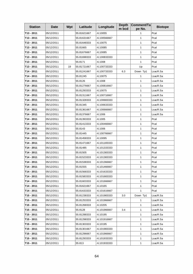
64
Station Date Wpt Latitude Longitude Depth m bcd
Comment/Tape No.
Biotope
T13 - 2011 05/12/2011 55.81621667 -6.10055 1 Pcal
T13 - 2011 05/12/2011 55.81631667 -6.100566667 1 Pcal
T13 - 2011 05/12/2011 55.81648333 -6.10075 1 Pcal
T13 - 2011 05/12/2011 55.81665 -6.10085 1 Pcal
T13 - 2011 05/12/2011 55.81676667 -6.10085 1 Pcal
T13 - 2011 05/12/2011 55.81698333 -6.100833333 1 Pcal
T13 - 2011 05/12/2011 55.8171 -6.1008 1 Pcal
T13 - 2011 05/12/2011 19 55.81721667 -6.100733333 Up Pcal
T14 - 2011 05/12/2011 55.81241667 -6.100733333 6.3 Down Tp1 LsacR.Sa
T14 - 2011 05/12/2011 55.81245 -6.10075 1 LsacR.Sa
T14 - 2011 05/12/2011 55.8126 -6.1008 1 LsacR.Sa
T14 - 2011 05/12/2011 55.81276667 -6.100816667 1 LsacR.Sa
T14 - 2011 05/12/2011 55.81293333 -6.10075 1 LsacR.Sa
T14 - 2011 05/12/2011 55.81311667 -6.100716667 1 LsacR.Sa
T14 - 2011 05/12/2011 55.81328333 -6.100683333 1 LsacR.Sa
T14 - 2011 05/12/2011 55.81345 -6.100633333 1 LsacR.Sa
T14 - 2011 05/12/2011 55.81361667 -6.100666667 1 LsacR.Sa
T14 - 2011 05/12/2011 55.81376667 -6.1006 1 LsacR.Sa
T14 - 2011 05/12/2011 55.81393333 -6.1005 1 Pcal
T14 - 2011 05/12/2011 55.81413333 -6.100466667 1 Pcal
T14 - 2011 05/12/2011 55.8143 -6.1006 1 Pcal
T14 - 2011 05/12/2011 55.81445 -6.100766667 1 Pcal
T14 - 2011 05/12/2011 55.81458333 -6.10095 1 Pcal
T14 - 2011 05/12/2011 55.81471667 -6.101183333 1 Pcal
T14 - 2011 05/12/2011 55.81485 -6.101333333 1 Pcal
T14 - 2011 05/12/2011 55.81505 -6.101383333 1 Pcal
T14 - 2011 05/12/2011 55.81523333 -6.101383333 1 Pcal
T14 - 2011 05/12/2011 55.81538333 -6.101366667 1 Pcal
T14 - 2011 05/12/2011 55.81555 -6.101466667 1 Pcal
T14 - 2011 05/12/2011 55.81568333 -6.101633333 1 Pcal
T14 - 2011 05/12/2011 55.81583333 -6.101683333 1 Pcal
T14 - 2011 05/12/2011 55.81603333 -6.101666667 1 Pcal
T14 - 2011 05/12/2011 55.81621667 -6.10165 1 Pcal
T14 - 2011 05/12/2011 55.81633333 -6.101616667 1 Pcal
T15 - 2011 05/12/2011 55.81238333 -6.101983333 3.0 Down Tp1 LsacR.Sa
T15 - 2011 05/12/2011 55.81253333 -6.101966667 1 LsacR.Sa
T15 - 2011 05/12/2011 55.81268333 -6.10205 1 LsacR.Sa
T15 - 2011 05/12/2011 55.8128 -6.101966667 3.4 1 LsacR.Sa
T15 - 2011 05/12/2011 55.81288333 -6.10195 1 LsacR.Sa
T15 - 2011 05/12/2011 55.81298333 -6.101916667 1 LsacR.Sa
T15 - 2011 05/12/2011 55.81303333 -6.10195 1 LsacR.Sa
T15 - 2011 05/12/2011 55.81301667 -6.101983333 1 LsacR.Sa
T15 - 2011 05/12/2011 55.81296667 -6.101966667 1 LsacR.Sa
T15 - 2011 05/12/2011 55.81293333 -6.101933333 1 LsacR.Sa
T15 - 2011 05/12/2011 55.813 -6.101933333 1 LsacR.Sa
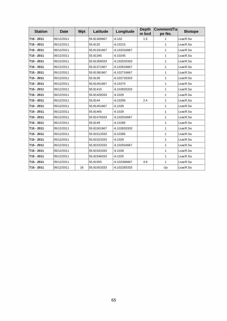
65
Station Date Wpt Latitude Longitude Depth m bcd
Comment/Tape No.
Biotope
T15 - 2011 05/12/2011 55.81306667 -6.102 1.5 1 LsacR.Sa
T15 - 2011 05/12/2011 55.8132 -6.10215 1 LsacR.Sa
T15 - 2011 05/12/2011 55.81331667 -6.102316667 1 LsacR.Sa
T15 - 2011 05/12/2011 55.81345 -6.10245 1 LsacR.Sa
T15 - 2011 05/12/2011 55.81358333 -6.102533333 1 LsacR.Sa
T15 - 2011 05/12/2011 55.81371667 -6.102616667 1 LsacR.Sa
T15 - 2011 05/12/2011 55.81381667 -6.102716667 1 LsacR.Sa
T15 - 2011 05/12/2011 55.8139 -6.102733333 1 LsacR.Sa
T15 - 2011 05/12/2011 55.81401667 -6.10275 1 LsacR.Sa
T15 - 2011 05/12/2011 55.81415 -6.102833333 1 LsacR.Sa
T15 - 2011 05/12/2011 55.81428333 -6.1029 1 LsacR.Sa
T15 - 2011 05/12/2011 55.8144 -6.10295 2.4 1 LsacR.Sa
T15 - 2011 05/12/2011 55.81451667 -6.1029 1 LsacR.Sa
T15 - 2011 05/12/2011 55.81465 -6.1029 1 LsacR.Sa
T15 - 2011 05/12/2011 55.81478333 -6.102916667 1 LsacR.Sa
T15 - 2011 05/12/2011 55.8149 -6.10285 1 LsacR.Sa
T15 - 2011 05/12/2011 55.81501667 -6.102833333 1 LsacR.Sa
T15 - 2011 05/12/2011 55.81513333 -6.10285 1 LsacR.Sa
T15 - 2011 05/12/2011 55.81523333 -6.1029 1 LsacR.Sa
T15 - 2011 05/12/2011 55.81533333 -6.102916667 1 LsacR.Sa
T15 - 2011 05/12/2011 55.81543333 -6.1028 1 LsacR.Sa
T15 - 2011 05/12/2011 55.81548333 -6.1025 1 LsacR.Sa
T15 - 2011 05/12/2011 55.81555 -6.102366667 4.9 1 LsacR.Sa
T15 - 2011 05/12/2011 16 55.81553333 -6.102283333 Up LsacR.Sa
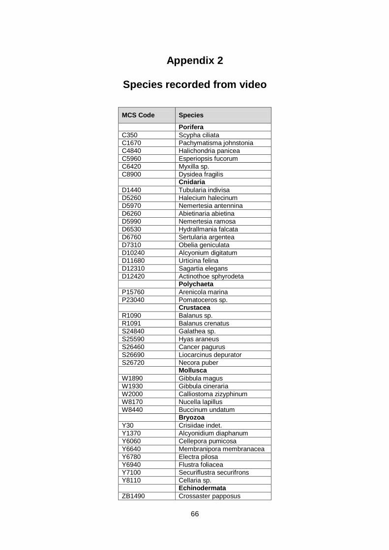
66
Appendix 2
Species recorded from video
MCS Code Species
Porifera
C350 Scypha ciliata
C1670 Pachymatisma johnstonia
C4840 Halichondria panicea
C5960 Esperiopsis fucorum
C6420 Myxilla sp.
C8900 Dysidea fragilis
Cnidaria
D1440 Tubularia indivisa
D5260 Halecium halecinum
D5970 Nemertesia antennina
D6260 Abietinaria abietina
D5990 Nemertesia ramosa
D6530 Hydrallmania falcata
D6760 Sertularia argentea
D7310 Obelia geniculata
D10240 Alcyonium digitatum
D11680 Urticina felina
D12310 Sagartia elegans
D12420 Actinothoe sphyrodeta
Polychaeta
P15760 Arenicola marina
P23040 Pomatoceros sp.
Crustacea
R1090 Balanus sp.
R1091 Balanus crenatus
S24840 Galathea sp.
S25590 Hyas araneus
S26460 Cancer pagurus
S26690 Liocarcinus depurator
S26720 Necora puber
Mollusca
W1890 Gibbula magus
W1930 Gibbula cineraria
W2000 Calliostoma zizyphinum
W8170 Nucella lapillus
W8440 Buccinum undatum
Bryozoa
Y30 Crisiidae indet.
Y1370 Alcyonidium diaphanum
Y6060 Cellepora pumicosa
Y6640 Membranipora membranacea
Y6780 Electra pilosa
Y6940 Flustra foliacea
Y7100 Securiflustra securifrons
Y8110 Cellaria sp.
Echinodermata
ZB1490 Crossaster papposus
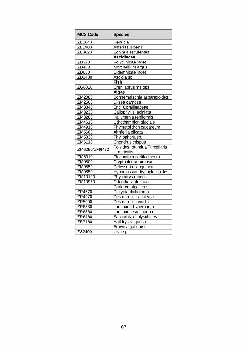
67
MCS Code Species
ZB1640 Henricia
ZB1900 Asterias rubens
ZB3620 Echinus esculentus
Ascidiacea
ZD320 Polyclinidae indet
ZD460 Morchellium argus
ZD680 Didemnidae indet
ZD1480 Ascidia sp.
Fish
ZG6010 Crenilabrus melops
Algae
ZM2080 Bonnemaisonia asparagoides
ZM2560 Dilsea carnosa
ZM3840 Enc. Corallinaceae
ZM3230 Callophyllis laciniata
ZM3280 Kallymenia reniformis
ZM4610 Lithothamnion glaciale
ZM4910 Phymatolithon calcareum
ZM5660 Ahnfeltia plicata
ZM5830 Phyllophora sp.
ZM6110 Chondrus crispus
ZM6250/ZM6430 Polyides rotundus/Furcellaria lumbricalis
ZM6310 Plocamium cartilagineum
ZM9500 Cryptopleura ramosa
ZM9550 Delesseria sanguinea
ZM9850 Hypoglossum hypoglossoides
ZM10120 Phycodrys rubens
ZM10970 Odonthalia dentata
Dark red algal crusts
ZR4570 Dictyota dichotoma
ZR4970 Desmarestia aculeata
ZR5000 Desmarestia viridis
ZR6330 Laminaria hyperborea
ZR6360 Laminaria saccharina
ZR6460 Saccorhiza polyschides
ZR7160 Halidrys siliquosa
Brown algal crusts
ZS2400 Ulva sp.