Victory Drive Historic Corridor Study - thempc.org · 1 Three historic neighborhood districts...
39
Appendix A-1 Phase 1 Summary Memorandum, Victory Drive Corridor Study Victory Drive Historic Corridor Study Commemorating the WWI Veterans And the Patriotic Fever of Savannah and Chatham County Prepared By: Heritage Smart, LLC. Mr. Jong Hyun Lim, Savannah, Georgia Prepared For: jB+a, inc. Atlanta & Savannah, Georgia March, 2014
Transcript of Victory Drive Historic Corridor Study - thempc.org · 1 Three historic neighborhood districts...

Appendix A-1 Phase 1 Summary Memorandum,
Victory Drive Corridor Study
Victory Drive Historic Corridor Study
Commemorating the WWI Veterans
And the Patriotic Fever of Savannah and Chatham County
Prepared By: Heritage Smart, LLC.
Mr. Jong Hyun Lim, Savannah, Georgia
Prepared For: jB+a, inc.
Atlanta & Savannah, Georgia
March, 2014
1
The Chatham County-Savannah Metropolitan Planning Commission (MPC) and Coastal Region Metropolitan Planning Organization (CORE MPO) are committed to the principle of affirmative action and prohibit discrimination against otherwise qualified persons on the basis of race, color, religion, national origin, age, physical or mental handicap, or disability, and where applicable, sex (including gender identity and expression), marital status, familial status, parental status, religion, sexual orientation, political beliefs, genetic information, reprisal, or because all or part of an individual's income is derived from any public assistance program in its recruitment, employment, facility and program accessibility or services. MPC and CORE MPO are committed to enforcing the provisions of the Civil Rights Act, Title VI, and all the related requirements mentioned above. CORE MPO is also committed to taking positive and realistic affirmative steps to ensure the protection of rights and opportunities for all persons affected by its plans and programs. The opinions, findings, and conclusions in this publication are those of the author(s) and not necessarily those of the Department of Transportation, State of Georgia, or the Federal Highway Administration. Prepared in cooperation with the Department of Transportation, Federal Highway Administration.
2
TABLE OF CONTENTS
I. Project Overview ............................................................................................................. 2
• Abstract
• Research Methods
• Definition of Study Area
II. Historic Overview .......................................................................................................... 5
• Estill Avenue and the Great Savannah Races
• Dale Avenue and the Million Dollar Highway
• Savannah’s Patriotic Thoroughfare
• Expansion and Redevelopment
• The Impact of Commercialization
• Recent Redevelopment
II. Significance of Victory Drive ........................................................................................ 18
• WWI Memorial Military Boulevard
• Historical Urban Landscape
IV. Conclusion ..................................................................................................................... 21
Bibliography ........................................................................................................................ 22
List of References ................................................................................................................ 24
Appendix .............................................................................................................................. 34
3
I. PROJECT OVERVIEW
Abstract
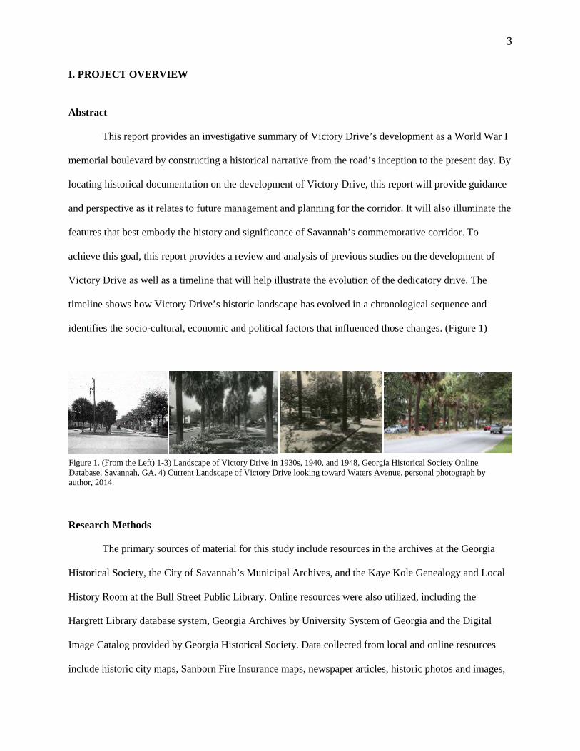
This report provides an investigative summary of Victory Drive’s development as a World War I
memorial boulevard by constructing a historical narrative from the road’s inception to the present day. By
locating historical documentation on the development of Victory Drive, this report will provide guidance
and perspective as it relates to future management and planning for the corridor. It will also illuminate the
features that best embody the history and significance of Savannah’s commemorative corridor. To
achieve this goal, this report provides a review and analysis of previous studies on the development of
Victory Drive as well as a timeline that will help illustrate the evolution of the dedicatory drive. The
timeline shows how Victory Drive’s historic landscape has evolved in a chronological sequence and
identifies the socio-cultural, economic and political factors that influenced those changes. (Figure 1)
Research Methods
The primary sources of material for this study include resources in the archives at the Georgia
Historical Society, the City of Savannah’s Municipal Archives, and the Kaye Kole Genealogy and Local
History Room at the Bull Street Public Library. Online resources were also utilized, including the
Hargrett Library database system, Georgia Archives by University System of Georgia and the Digital
Image Catalog provided by Georgia Historical Society. Data collected from local and online resources
include historic city maps, Sanborn Fire Insurance maps, newspaper articles, historic photos and images,
Figure 1. (From the Left) 1-3) Landscape of Victory Drive in 1930s, 1940, and 1948, Georgia Historical Society Online Database, Savannah, GA. 4) Current Landscape of Victory Drive looking toward Waters Avenue, personal photograph by author, 2014.
4
unpublished scripts and notes, postcard collections, and past reports. While most data aided in developing
the narrative of Victory Drive’s history, historic maps played an especially important role in establishing
Victory Drive’s boundaries, edges, extensions, visual points of interests and overall imageability. In
addition to the published and unpublished materials, on-site observations and photographic surveys were
conducted to define and document the current condition and existing landscape features of Victory Drive.
(See Appendix 1)
Definition of Study Area
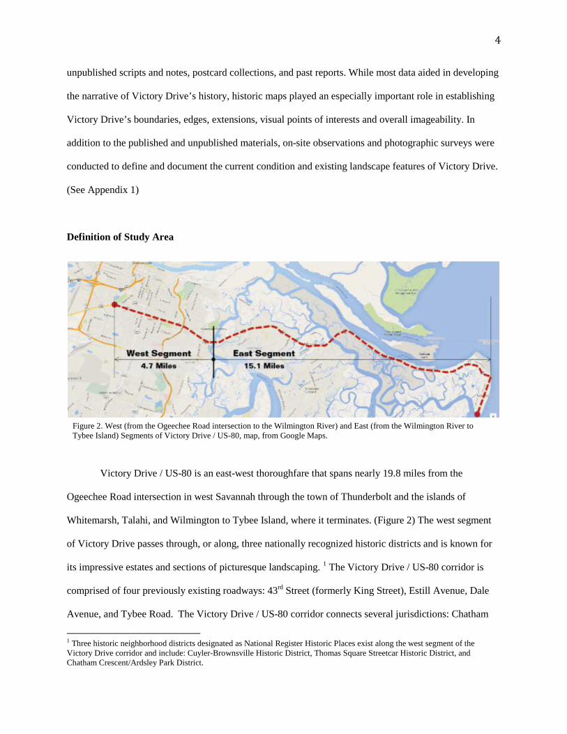
Victory Drive / US-80 is an east-west thoroughfare that spans nearly 19.8 miles from the
Ogeechee Road intersection in west Savannah through the town of Thunderbolt and the islands of
Whitemarsh, Talahi, and Wilmington to Tybee Island, where it terminates. (Figure 2) The west segment
of Victory Drive passes through, or along, three nationally recognized historic districts and is known for
its impressive estates and sections of picturesque landscaping. 1 The Victory Drive / US-80 corridor is
comprised of four previously existing roadways: 43rd Street (formerly King Street), Estill Avenue, Dale
Avenue, and Tybee Road. The Victory Drive / US-80 corridor connects several jurisdictions: Chatham
1 Three historic neighborhood districts designated as National Register Historic Places exist along the west segment of the Victory Drive corridor and include: Cuyler-Brownsville Historic District, Thomas Square Streetcar Historic District, and Chatham Crescent/Ardsley Park District.
Figure 2. West (from the Ogeechee Road intersection to the Wilmington River) and East (from the Wilmington River to Tybee Island) Segments of Victory Drive / US-80, map, from Google Maps.
5
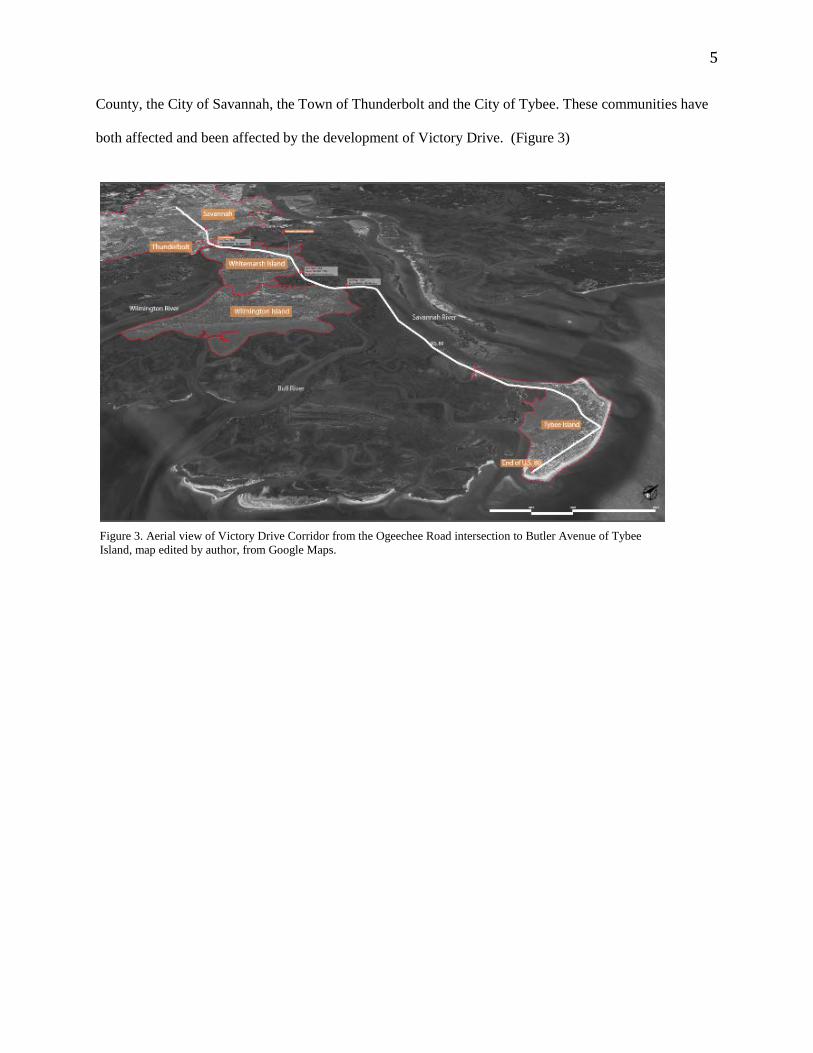
County, the City of Savannah, the Town of Thunderbolt and the City of Tybee. These communities have
both affected and been affected by the development of Victory Drive. (Figure 3)
Figure 3. Aerial view of Victory Drive Corridor from the Ogeechee Road intersection to Butler Avenue of Tybee Island, map edited by author, from Google Maps.
6
II. Historic Overview
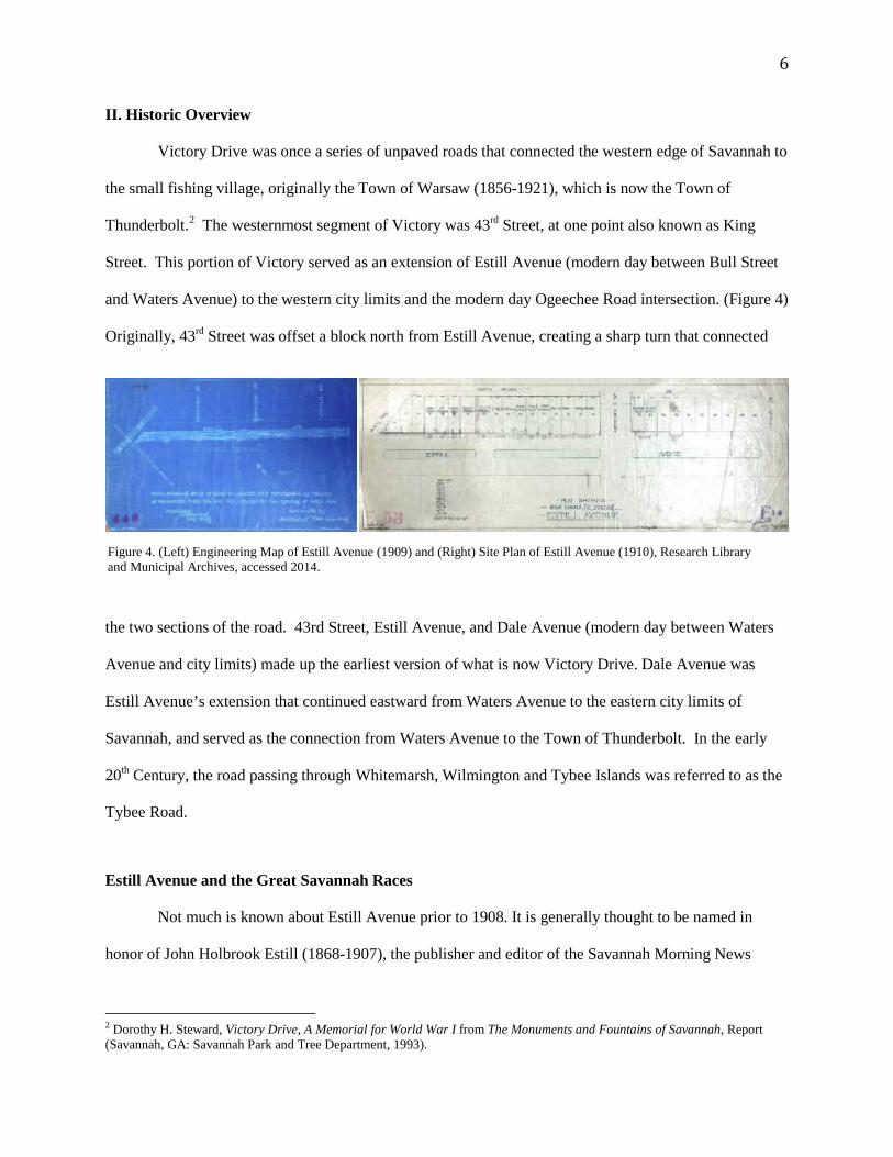
Victory Drive was once a series of unpaved roads that connected the western edge of Savannah to
the small fishing village, originally the Town of Warsaw (1856-1921), which is now the Town of
Thunderbolt.2 The westernmost segment of Victory was 43rd Street, at one point also known as King
Street. This portion of Victory served as an extension of Estill Avenue (modern day between Bull Street
and Waters Avenue) to the western city limits and the modern day Ogeechee Road intersection. (Figure 4)
Originally, 43rd Street was offset a block north from Estill Avenue, creating a sharp turn that connected
the two sections of the road. 43rd Street, Estill Avenue, and Dale Avenue (modern day between Waters
Avenue and city limits) made up the earliest version of what is now Victory Drive. Dale Avenue was
Estill Avenue’s extension that continued eastward from Waters Avenue to the eastern city limits of
Savannah, and served as the connection from Waters Avenue to the Town of Thunderbolt. In the early
20th Century, the road passing through Whitemarsh, Wilmington and Tybee Islands was referred to as the
Tybee Road.
Estill Avenue and the Great Savannah Races
Not much is known about Estill Avenue prior to 1908. It is generally thought to be named in
honor of John Holbrook Estill (1868-1907), the publisher and editor of the Savannah Morning News
2 Dorothy H. Steward, Victory Drive, A Memorial for World War I from The Monuments and Fountains of Savannah, Report (Savannah, GA: Savannah Park and Tree Department, 1993).
Figure 4. (Left) Engineering Map of Estill Avenue (1909) and (Right) Site Plan of Estill Avenue (1910), Research Library and Municipal Archives, accessed 2014.
7
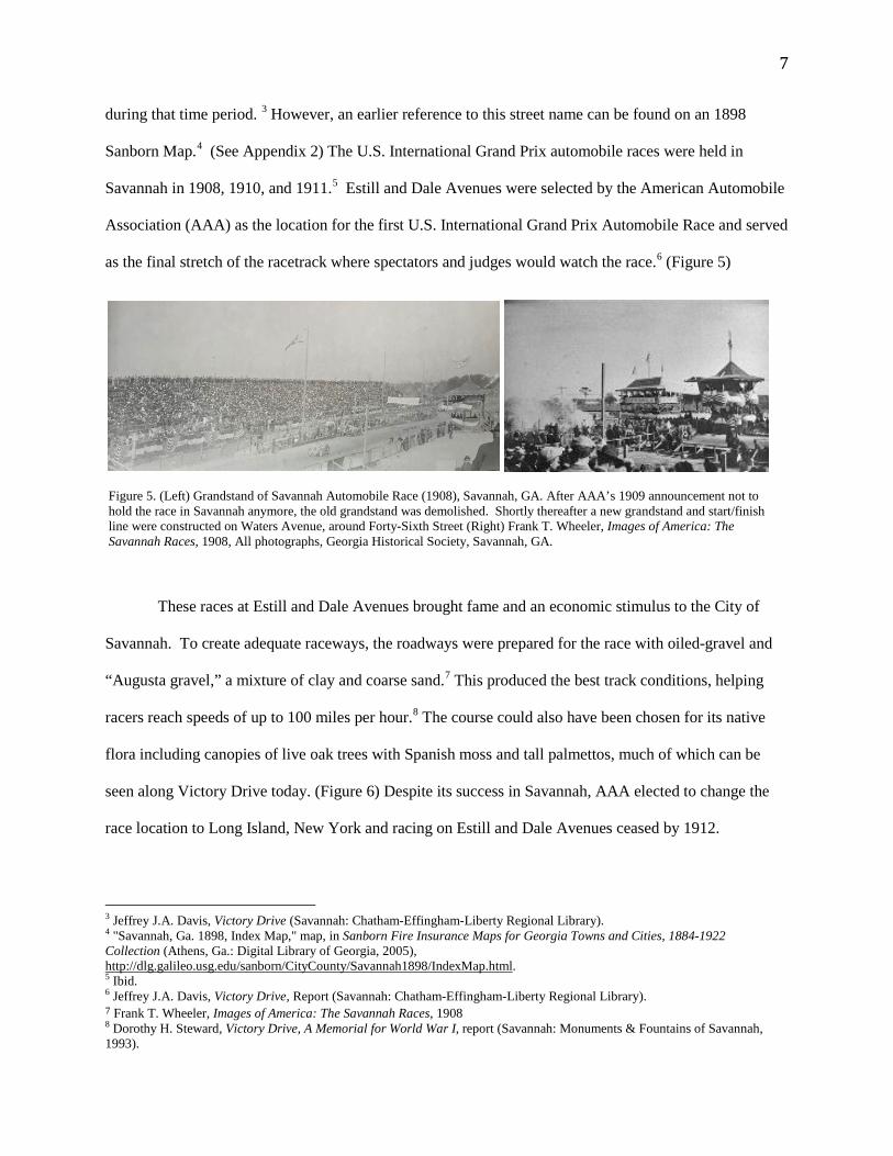
during that time period. 3 However, an earlier reference to this street name can be found on an 1898
Sanborn Map.4 (See Appendix 2) The U.S. International Grand Prix automobile races were held in
Savannah in 1908, 1910, and 1911.5 Estill and Dale Avenues were selected by the American Automobile
Association (AAA) as the location for the first U.S. International Grand Prix Automobile Race and served
as the final stretch of the racetrack where spectators and judges would watch the race.6 (Figure 5)
These races at Estill and Dale Avenues brought fame and an economic stimulus to the City of
Savannah. To create adequate raceways, the roadways were prepared for the race with oiled-gravel and
“Augusta gravel,” a mixture of clay and coarse sand.7 This produced the best track conditions, helping
racers reach speeds of up to 100 miles per hour.8 The course could also have been chosen for its native
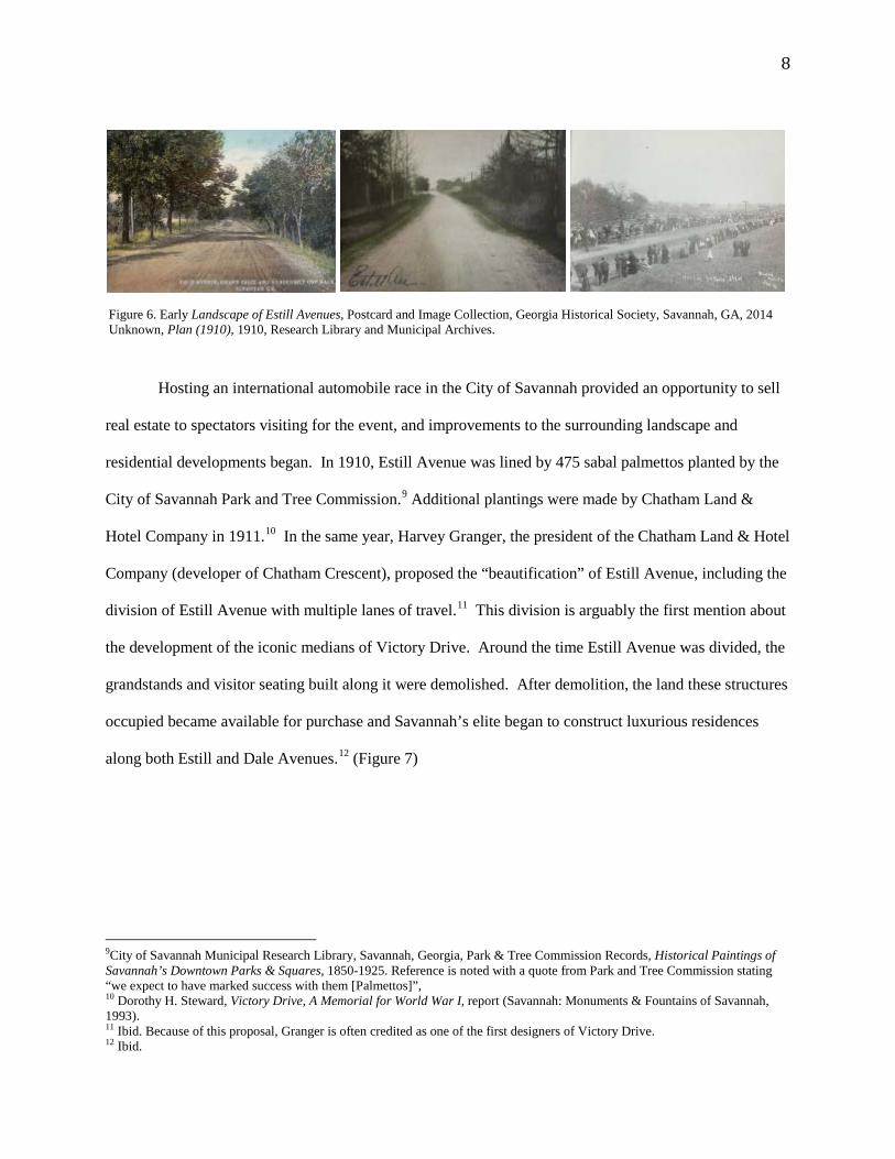
flora including canopies of live oak trees with Spanish moss and tall palmettos, much of which can be
seen along Victory Drive today. (Figure 6) Despite its success in Savannah, AAA elected to change the
race location to Long Island, New York and racing on Estill and Dale Avenues ceased by 1912.
3 Jeffrey J.A. Davis, Victory Drive (Savannah: Chatham-Effingham-Liberty Regional Library). 4 "Savannah, Ga. 1898, Index Map," map, in Sanborn Fire Insurance Maps for Georgia Towns and Cities, 1884-1922 Collection (Athens, Ga.: Digital Library of Georgia, 2005), http://dlg.galileo.usg.edu/sanborn/CityCounty/Savannah1898/IndexMap.html. 5 Ibid. 6 Jeffrey J.A. Davis, Victory Drive, Report (Savannah: Chatham-Effingham-Liberty Regional Library). 7 Frank T. Wheeler, Images of America: The Savannah Races, 1908 8 Dorothy H. Steward, Victory Drive, A Memorial for World War I, report (Savannah: Monuments & Fountains of Savannah, 1993).
Figure 5. (Left) Grandstand of Savannah Automobile Race (1908), Savannah, GA. After AAA’s 1909 announcement not to hold the race in Savannah anymore, the old grandstand was demolished. Shortly thereafter a new grandstand and start/finish line were constructed on Waters Avenue, around Forty-Sixth Street (Right) Frank T. Wheeler, Images of America: The Savannah Races, 1908, All photographs, Georgia Historical Society, Savannah, GA.
8
Hosting an international automobile race in the City of Savannah provided an opportunity to sell
real estate to spectators visiting for the event, and improvements to the surrounding landscape and
residential developments began. In 1910, Estill Avenue was lined by 475 sabal palmettos planted by the
City of Savannah Park and Tree Commission.9 Additional plantings were made by Chatham Land &
Hotel Company in 1911.10 In the same year, Harvey Granger, the president of the Chatham Land & Hotel
Company (developer of Chatham Crescent), proposed the “beautification” of Estill Avenue, including the
division of Estill Avenue with multiple lanes of travel.11 This division is arguably the first mention about
the development of the iconic medians of Victory Drive. Around the time Estill Avenue was divided, the
grandstands and visitor seating built along it were demolished. After demolition, the land these structures
occupied became available for purchase and Savannah’s elite began to construct luxurious residences
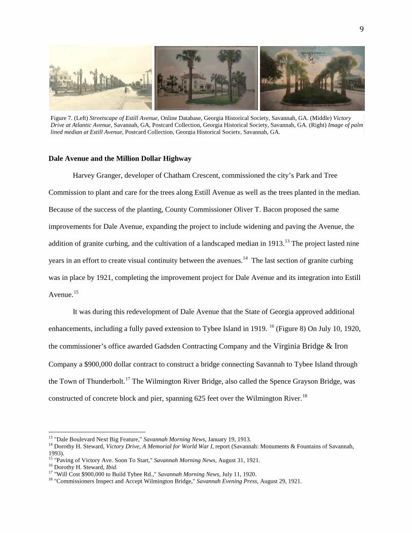
along both Estill and Dale Avenues.12 (Figure 7)
9City of Savannah Municipal Research Library, Savannah, Georgia, Park & Tree Commission Records, Historical Paintings of Savannah’s Downtown Parks & Squares, 1850-1925. Reference is noted with a quote from Park and Tree Commission stating “we expect to have marked success with them [Palmettos]”, 10 Dorothy H. Steward, Victory Drive, A Memorial for World War I, report (Savannah: Monuments & Fountains of Savannah, 1993). 11 Ibid. Because of this proposal, Granger is often credited as one of the first designers of Victory Drive. 12 Ibid.
Figure 6. Early Landscape of Estill Avenues, Postcard and Image Collection, Georgia Historical Society, Savannah, GA, 2014 Unknown, Plan (1910), 1910, Research Library and Municipal Archives.
9
Dale Avenue and the Million Dollar Highway
Harvey Granger, developer of Chatham Crescent, commissioned the city’s Park and Tree
Commission to plant and care for the trees along Estill Avenue as well as the trees planted in the median.
Because of the success of the planting, County Commissioner Oliver T. Bacon proposed the same
improvements for Dale Avenue, expanding the project to include widening and paving the Avenue, the
addition of granite curbing, and the cultivation of a landscaped median in 1913.13 The project lasted nine
years in an effort to create visual continuity between the avenues.14 The last section of granite curbing
was in place by 1921, completing the improvement project for Dale Avenue and its integration into Estill
Avenue.15
It was during this redevelopment of Dale Avenue that the State of Georgia approved additional
enhancements, including a fully paved extension to Tybee Island in 1919. 16 (Figure 8) On July 10, 1920,
the commissioner’s office awarded Gadsden Contracting Company and the Virginia Bridge & Iron
Company a $900,000 dollar contract to construct a bridge connecting Savannah to Tybee Island through
the Town of Thunderbolt.17 The Wilmington River Bridge, also called the Spence Grayson Bridge, was
constructed of concrete block and pier, spanning 625 feet over the Wilmington River.18
13 "Dale Boulevard Next Big Feature," Savannah Morning News, January 19, 1913. 14 Dorothy H. Steward, Victory Drive, A Memorial for World War I, report (Savannah: Monuments & Fountains of Savannah, 1993). 15 "Paving of Victory Ave. Soon To Start," Savannah Morning News, August 31, 1921. 16 Dorothy H. Steward, Ibid. 17 "Will Cost $900,000 to Build Tybee Rd.," Savannah Morning News, July 11, 1920. 18 "Commissioners Inspect and Accept Wilmington Bridge," Savannah Evening Press, August 29, 1921.
Figure 7. (Left) Streetscape of Estill Avenue, Online Database, Georgia Historical Society, Savannah, GA. (Middle) Victory Drive at Atlantic Avenue, Savannah, GA, Postcard Collection, Georgia Historical Society, Savannah, GA. (Right) Image of palm lined median at Estill Avenue, Postcard Collection, Georgia Historical Society, Savannah, GA.
10
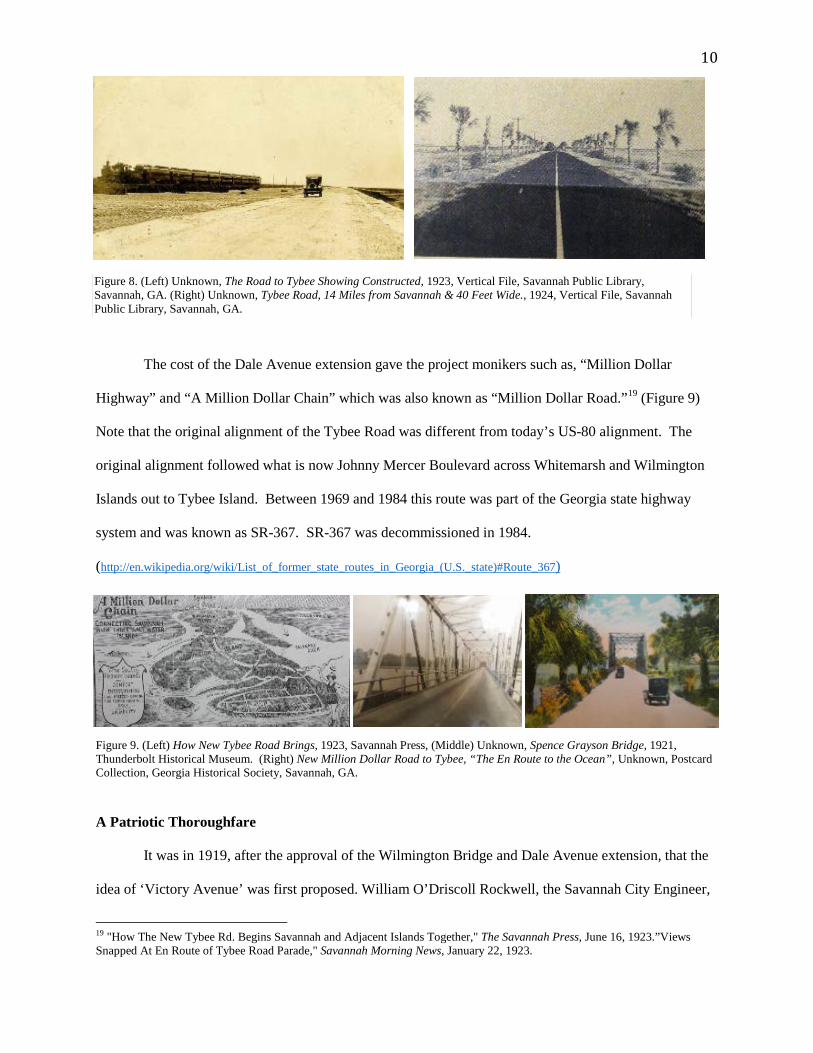
The cost of the Dale Avenue extension gave the project monikers such as, “Million Dollar
Highway” and “A Million Dollar Chain” which was also known as “Million Dollar Road.”19 (Figure 9)
Note that the original alignment of the Tybee Road was different from today’s US-80 alignment. The
original alignment followed what is now Johnny Mercer Boulevard across Whitemarsh and Wilmington
Islands out to Tybee Island. Between 1969 and 1984 this route was part of the Georgia state highway
system and was known as SR-367. SR-367 was decommissioned in 1984.
(http://en.wikipedia.org/wiki/List_of_former_state_routes_in_Georgia_(U.S._state)#Route_367)
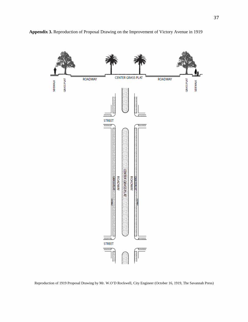
A Patriotic Thoroughfare
It was in 1919, after the approval of the Wilmington Bridge and Dale Avenue extension, that the
idea of ‘Victory Avenue’ was first proposed. William O’Driscoll Rockwell, the Savannah City Engineer,
19 "How The New Tybee Rd. Begins Savannah and Adjacent Islands Together," The Savannah Press, June 16, 1923.”Views Snapped At En Route of Tybee Road Parade," Savannah Morning News, January 22, 1923.
Figure 9. (Left) How New Tybee Road Brings, 1923, Savannah Press, (Middle) Unknown, Spence Grayson Bridge, 1921, Thunderbolt Historical Museum. (Right) New Million Dollar Road to Tybee, “The En Route to the Ocean”, Unknown, Postcard Collection, Georgia Historical Society, Savannah, GA.
Figure 8. (Left) Unknown, The Road to Tybee Showing Constructed, 1923, Vertical File, Savannah Public Library, Savannah, GA. (Right) Unknown, Tybee Road, 14 Miles from Savannah & 40 Feet Wide., 1924, Vertical File, Savannah Public Library, Savannah, GA.
11
presented the idea that the extension of Dale Avenue be dubbed “Victory Avenue” in memory of those
who served in the First World War (1914-1918). (See Appendix 3) In addition to the name, Rockwell
proposed planting 135 sabal palmettos along the existing palm-lined drive; each palm commemorating a
Chatham County resident who had fallen in the war. 20 Although Rockwell envisioned “Victory Avenue”
as the new name of the Dale Avenue extension project, it was “Victory Drive” that was adopted when the
project was officially dedicated in 1922.21 A petition was soon made for Estill Avenue to join with Dale
Avenue and be incorporated into the Victory Drive memorial.22 While it is uncertain when Estill Avenue
officially became part of Victory Drive, the first Savannah Supplement to Code to reference the new
name dates to 1936.23
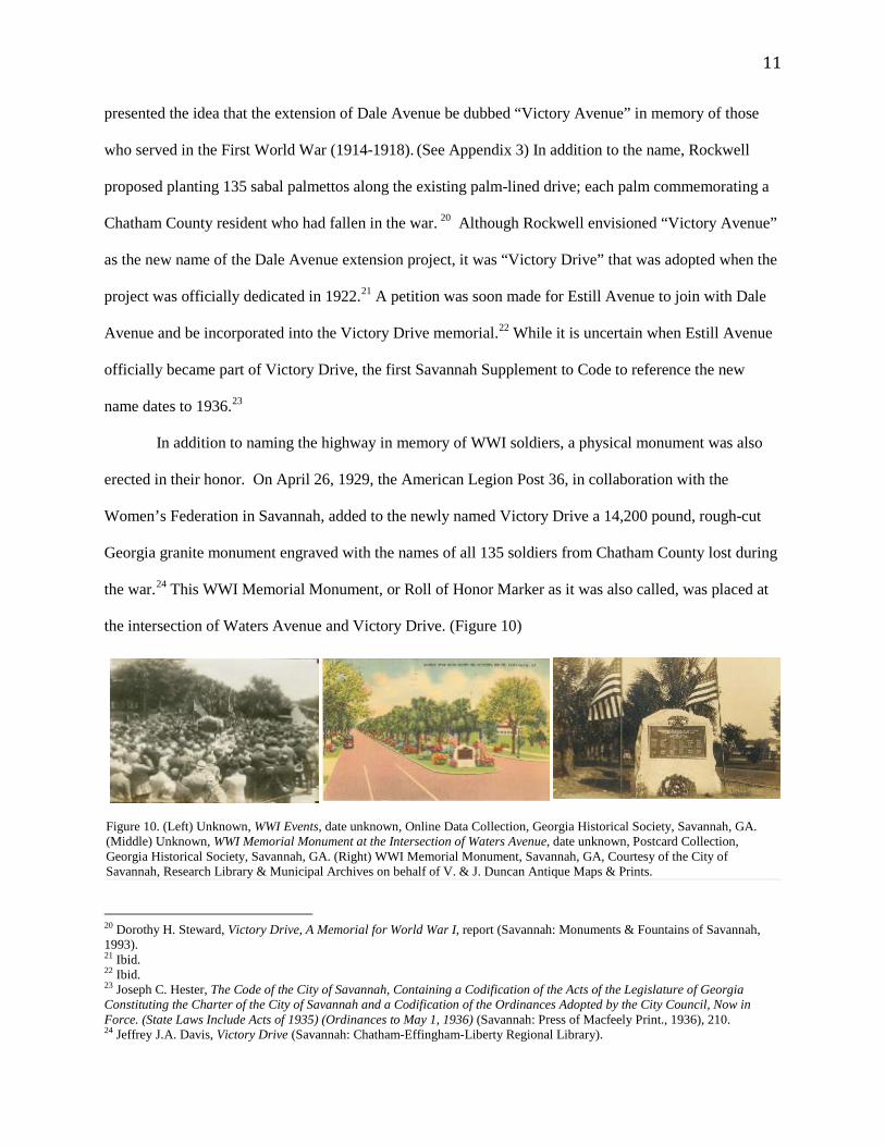
In addition to naming the highway in memory of WWI soldiers, a physical monument was also
erected in their honor. On April 26, 1929, the American Legion Post 36, in collaboration with the
Women’s Federation in Savannah, added to the newly named Victory Drive a 14,200 pound, rough-cut
Georgia granite monument engraved with the names of all 135 soldiers from Chatham County lost during
the war.24 This WWI Memorial Monument, or Roll of Honor Marker as it was also called, was placed at
the intersection of Waters Avenue and Victory Drive. (Figure 10)
20 Dorothy H. Steward, Victory Drive, A Memorial for World War I, report (Savannah: Monuments & Fountains of Savannah, 1993). 21 Ibid. 22 Ibid. 23 Joseph C. Hester, The Code of the City of Savannah, Containing a Codification of the Acts of the Legislature of Georgia Constituting the Charter of the City of Savannah and a Codification of the Ordinances Adopted by the City Council, Now in Force. (State Laws Include Acts of 1935) (Ordinances to May 1, 1936) (Savannah: Press of Macfeely Print., 1936), 210. 24 Jeffrey J.A. Davis, Victory Drive (Savannah: Chatham-Effingham-Liberty Regional Library).
Figure 10. (Left) Unknown, WWI Events, date unknown, Online Data Collection, Georgia Historical Society, Savannah, GA. (Middle) Unknown, WWI Memorial Monument at the Intersection of Waters Avenue, date unknown, Postcard Collection, Georgia Historical Society, Savannah, GA. (Right) WWI Memorial Monument, Savannah, GA, Courtesy of the City of Savannah, Research Library & Municipal Archives on behalf of V. & J. Duncan Antique Maps & Prints.
12
By 1929, Victory Drive boasted approximately 400 palmetto trees. In 1935, the Park and Tree
Commission planted an additional 317 palmettos at the cost of $2,219 along the historic corridor from
Bull Street to Hopkins Avenue.25 By 1950, 600 palmetto trees were in place.26 At the peak of plantings,
Victory Drive was said to be decorated with approximately 2,800 palmettos, thus causing some to claim
the corridor as “the longest avenue of palms in the nation.”27
Expansion and Redevelopment
Since its inception, Victory Drive has been subject to a series of events and phenomena that have
led to a depletion of some of its original historic and defining characteristics. An increase in automobile
traffic and adjacent commercial development were, and remain, the leading factors impacting the road
and its commemorative landscape.
In January of 1952, Tybee Road underwent improvements totaling $6,272,239, including the
construction of a new drawbridge to connect Victory Drive to Tybee Island via Thunderbolt.28 The
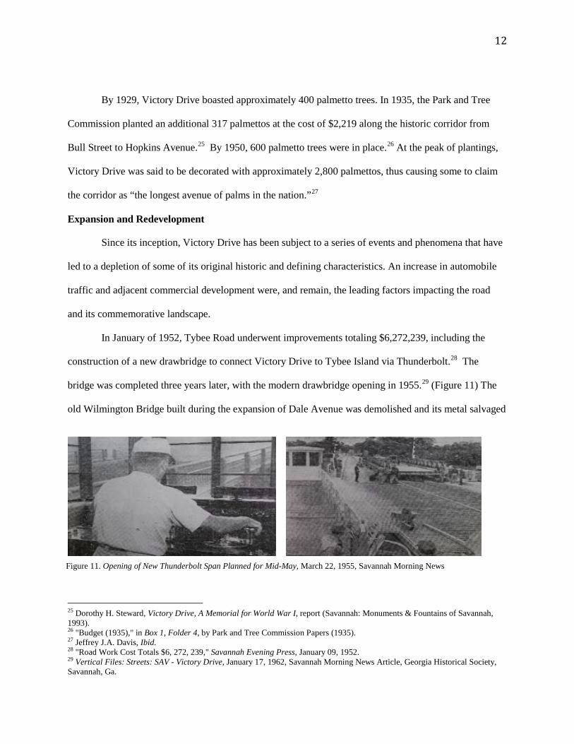
bridge was completed three years later, with the modern drawbridge opening in 1955.29 (Figure 11) The
old Wilmington Bridge built during the expansion of Dale Avenue was demolished and its metal salvaged
25 Dorothy H. Steward, Victory Drive, A Memorial for World War I, report (Savannah: Monuments & Fountains of Savannah, 1993). 26 "Budget (1935)," in Box 1, Folder 4, by Park and Tree Commission Papers (1935). 27 Jeffrey J.A. Davis, Ibid. 28 "Road Work Cost Totals $6, 272, 239," Savannah Evening Press, January 09, 1952. 29 Vertical Files: Streets: SAV - Victory Drive, January 17, 1962, Savannah Morning News Article, Georgia Historical Society, Savannah, Ga.
Figure 11. Opening of New Thunderbolt Span Planned for Mid-May, March 22, 1955, Savannah Morning News
13
and used for scrap metal.30
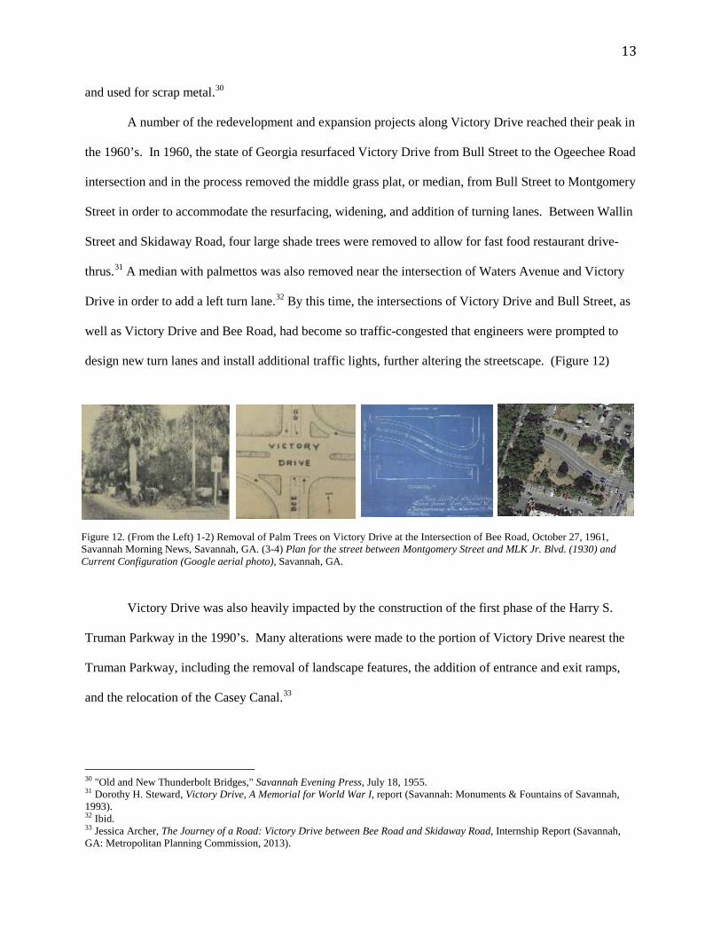
A number of the redevelopment and expansion projects along Victory Drive reached their peak in
the 1960’s. In 1960, the state of Georgia resurfaced Victory Drive from Bull Street to the Ogeechee Road
intersection and in the process removed the middle grass plat, or median, from Bull Street to Montgomery
Street in order to accommodate the resurfacing, widening, and addition of turning lanes. Between Wallin
Street and Skidaway Road, four large shade trees were removed to allow for fast food restaurant drive-
thrus.31 A median with palmettos was also removed near the intersection of Waters Avenue and Victory
Drive in order to add a left turn lane.32 By this time, the intersections of Victory Drive and Bull Street, as
well as Victory Drive and Bee Road, had become so traffic-congested that engineers were prompted to
design new turn lanes and install additional traffic lights, further altering the streetscape. (Figure 12)
Victory Drive was also heavily impacted by the construction of the first phase of the Harry S.
Truman Parkway in the 1990’s. Many alterations were made to the portion of Victory Drive nearest the
Truman Parkway, including the removal of landscape features, the addition of entrance and exit ramps,
and the relocation of the Casey Canal.33
30 "Old and New Thunderbolt Bridges," Savannah Evening Press, July 18, 1955. 31 Dorothy H. Steward, Victory Drive, A Memorial for World War I, report (Savannah: Monuments & Fountains of Savannah, 1993). 32 Ibid. 33 Jessica Archer, The Journey of a Road: Victory Drive between Bee Road and Skidaway Road, Internship Report (Savannah, GA: Metropolitan Planning Commission, 2013).
Figure 12. (From the Left) 1-2) Removal of Palm Trees on Victory Drive at the Intersection of Bee Road, October 27, 1961, Savannah Morning News, Savannah, GA. (3-4) Plan for the street between Montgomery Street and MLK Jr. Blvd. (1930) and Current Configuration (Google aerial photo), Savannah, GA.
14
Figure 13. Unknown, Landscape of Victory Drive after the Road Construction, 2004, The Savannah Morning News, Savannah, GA.
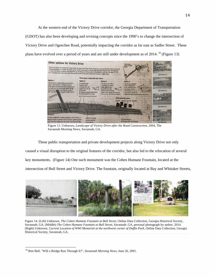
At the western end of the Victory Drive corridor, the Georgia Department of Transportation
(GDOT) has also been developing and revising concepts since the 1990’s to change the intersection of
Victory Drive and Ogeechee Road, potentially impacting the corridor as far east as Sadler Street. These
plans have evolved over a period of years and are still under development as of 2014. 34 (Figure 13)
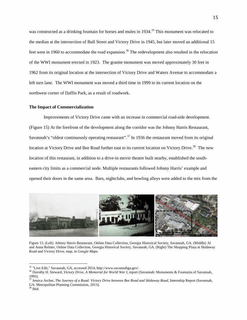
These public transportation and private development projects along Victory Drive not only
caused a visual disruption to the original features of the corridor, but also led to the relocation of several
key monuments. (Figure 14) One such monument was the Cohen Humane Fountain, located at the
intersection of Bull Street and Victory Drive. The fountain, originally located at Bay and Whitaker Streets,
34 Bret Bell, "Will a Bridge Run Through It?", Savannah Morning News, June 26, 2001.
Figure 14. (Left) Unknown, The Cohen Humane Fountain at Bull Street, Online Data Collection, Georgia Historical Society, Savannah, GA. (Middle) The Cohen Humane Fountain at Bull Street, Savannah, GA, personal photograph by author, 2014. (Right) Unknown, Current Location of WWI Memorial at the northwest corner of Daffin Park, Online Data Collection, Georgia Historical Society, Savannah, GA.
15
was constructed as a drinking fountain for horses and mules in 1934.35 This monument was relocated to
the median at the intersection of Bull Street and Victory Drive in 1945, but later moved an additional 15
feet west in 1960 to accommodate the road expansion.36 The redevelopment also resulted in the relocation
of the WWI monument erected in 1923. The granite monument was moved approximately 30 feet in
1962 from its original location at the intersection of Victory Drive and Waters Avenue to accommodate a
left turn lane. The WWI monument was moved a third time in 1999 to its current location on the
northwest corner of Daffin Park, as a result of roadwork.
The Impact of Commercialization
Improvements of Victory Drive came with an increase in commercial road-side development.
(Figure 15) At the forefront of the development along the corridor was the Johnny Harris Restaurant,
Savannah’s “oldest continuously operating restaurant”.37 In 1936 the restaurant moved from its original
location at Victory Drive and Bee Road further east to its current location on Victory Drive.38 The new
location of this restaurant, in addition to a drive-in movie theatre built nearby, established the south-
eastern city limits as a commercial node. Multiple restaurants followed Johnny Harris’ example and
opened their doors in the same area. Bars, nightclubs, and bowling alleys were added to the mix from the
35 "Live Edit," Savannah, GA, accessed 2014, http://www.savannahga.gov/. 36 Dorothy H. Steward, Victory Drive, A Memorial for World War I, report (Savannah: Monuments & Fountains of Savannah, 1993). 37 Jessica Archer, The Journey of a Road: Victory Drive between Bee Road and Skidaway Road, Internship Report (Savannah, GA: Metropolitan Planning Commission, 2013). 38 Ibid.
Figure 15. (Left) Johnny Harris Restaurant, Online Data Collection, Georgia Historical Society, Savannah, GA. (Middle) Al and Anna Relmer, Online Data Collection, Georgia Historical Society, Savannah, GA. (Right) The Shopping Plaza at Skidaway Road and Victory Drive, map, in Google Maps.
16
late 1930’s to the late 1950’s.39 This stretch of Victory Drive was ideal for commercial development as a
halfway point between downtown Savannah and the neighboring town of Thunderbolt. This location
continued to attract other industries such as the Dr. Pepper, Seven-Up, and Tru-Ade Bottling Company in
1941 and the Backus car dealership in 1955.40
By the early 1960’s, small shopping complexes and strip malls began developing along
Savannah’s Victory Drive. The Victory Drive Shopping Plaza, designed by Al and Anna Remler, was one
of the first commercial developments on the eastern portion of Victory Drive.41 The plaza was quickly
followed by the construction of a K-Mart store in 1962, which in turn prompted other competing chain
retailers to introduce franchise branches in the same area.42 In 1979, several new fast-food restaurants
were constructed on the north side of Victory Drive between Wallin Street and Skidaway Road.43
Recent Redevelopment Along Victory Drive
By the second half of the 20th century, Victory Drive, once renowned for having the longest row
of palms in the nation, had lost hundreds of the trees that had given the road its original commemorative
identity to both commercial development and roadwork projects.44 The loss of landscape features
eventually resulted in an effort to not only assess the damage, but reverse it and preserve the awareness of
the corridor’s history. In 1994, the City of Savannah began replacing palmetto trees along the corridor,
and the Park and Tree Commission replanted a palmetto for every missing or dead tree by 1998.45
As a result of these development impacts, the streetscape and overall legibility of the original
Victory Drive commemorative landscape exists in varying states of flux from the Ogeechee Road
intersection to Tybee Island. West of the Wilmington River, many of the oaks and palms remain along
portions of Victory Drive as visual reminders of Savannah’s commemorative efforts and a continued
39 Ibid. 40 Ibid. 41 Marcus Holland, "New Look for an Old Friend," Savannah Morning News, March 1, 2000. 42 Jessica Archer, The Journey of a Road: Victory Drive between Bee and Skidaway Road- A Historical Report for the Chatham County Metropolitan Planning Commission, Report (Savannah, GA: September 2013). 43 Ibid. 44 Ibid. 45 Jan Skutch, "Victory Drive Refurbished: Palmetto Trees Replaced for First Time in a Decade," Savannah Morning News, February 23, 1994.
17
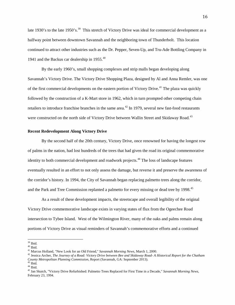
Figure 16. (Top-Left to Right) 1) View from the Ogeechee Road intersection looking east. 2) View from Bull Street looking toward Whitaker Street. 3) View from Waters Avenue looking east. (Bottom-Left to Right) 4) View from Skidaway Road looking toward Wallin Street 5) Landscape of Tybee Road 6) Streetscape of Butler Avenue, Tybee Island. All personal photographs by author, 2014.
commitment to the history and beauty of the city. The section of road from the Ogeechee Road
intersection to Martin Luther King, Jr. Boulevard has a very narrow median with one row of palmettos.
Crossing over Martin Luther King, Jr. Boulevard going east towards Bull Street, there is neither a median
nor palms.
From Bull Street continuing east, there is a canopy of shade trees along with a large median with
two rows of palmettos down each side for almost two miles. The canopies of shade trees are interrupted
however once one has crossed Victory Manor/Dixie Avenue. The combination of the Truman Parkway
and the concentration of commercial buildings in this area have resulted in a major gap in the historic live
oak canopy. Any shade-providing live oak trees are now few along this section of the corridor. (See
Appendix 4) However, the medians and the planted palmettos do continue through the center of the
corridor all the way to the Thunderbolt Bridge where a completely new landscape emerges. The extension
of Victory Drive, as US-80 / Tybee Road, from Thunderbolt to Tybee Island provides a contrast of the
natural marsh landscape against a modern steel and concrete roadway. (Figure 16)
18
Of the nearly 2,800 palmetto trees that once lined this famous palm and oak-lined drive, only a
few hundred have survived the changes made over the years to accommodate the increase in traffic and
commercial developments. Despite the changes, there are sections of the original design which remain
largely intact. However, there are also large sections of the corridor that have lost the integrity of the
original design. Fortunately, a variety of efforts have been made to retain awareness of Victory Drive’s
integral components, including the palmettos in the medians, the live oak framework and the various
monuments. The elements of the original commemorative landscape design, which established Victory
Drive as a historic pathway, should be preserved where they remain and be restored where they do not in
order to reestablish the visual impact, historical authenticity, and physical integrity of this significant
historic urban landscape.
19
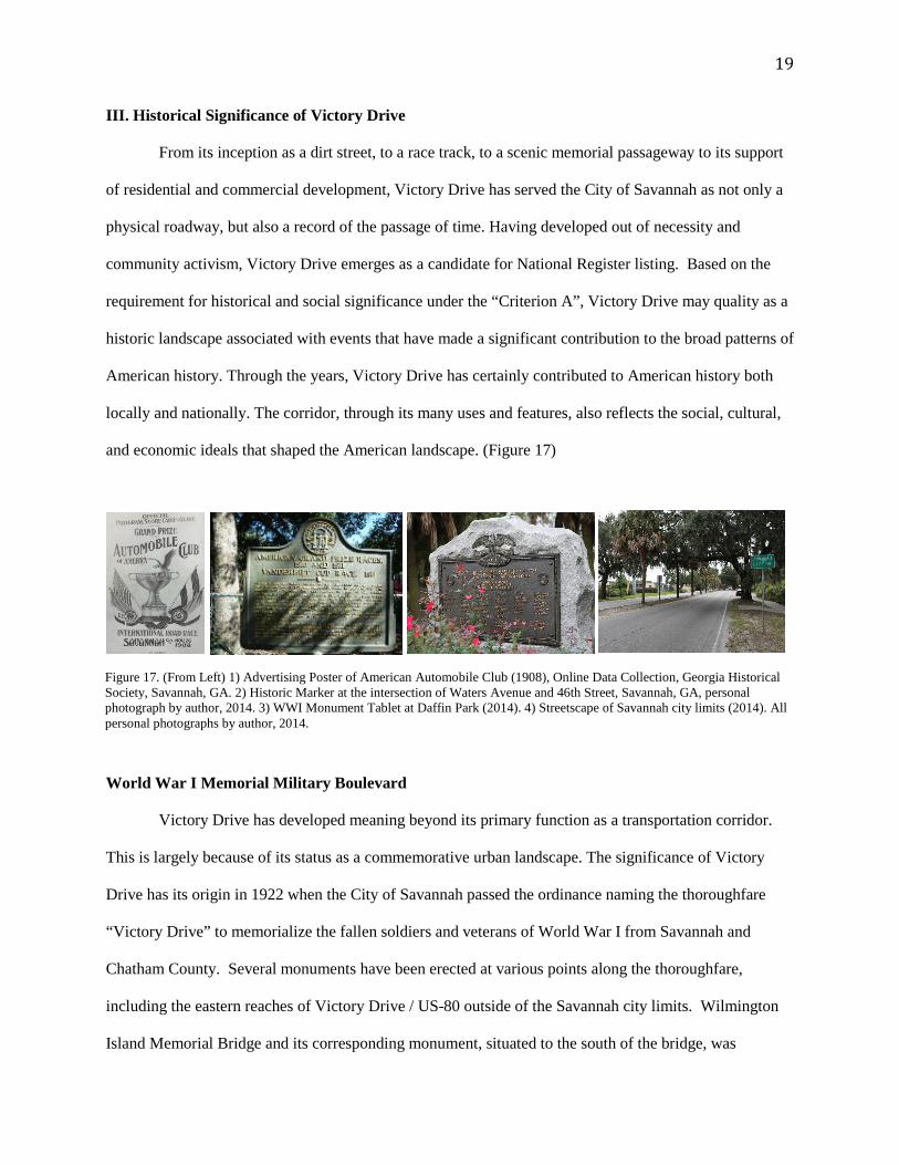
III. Historical Significance of Victory Drive
From its inception as a dirt street, to a race track, to a scenic memorial passageway to its support
of residential and commercial development, Victory Drive has served the City of Savannah as not only a
physical roadway, but also a record of the passage of time. Having developed out of necessity and
community activism, Victory Drive emerges as a candidate for National Register listing. Based on the
requirement for historical and social significance under the “Criterion A”, Victory Drive may quality as a
historic landscape associated with events that have made a significant contribution to the broad patterns of
American history. Through the years, Victory Drive has certainly contributed to American history both
locally and nationally. The corridor, through its many uses and features, also reflects the social, cultural,
and economic ideals that shaped the American landscape. (Figure 17)
World War I Memorial Military Boulevard
Victory Drive has developed meaning beyond its primary function as a transportation corridor.
This is largely because of its status as a commemorative urban landscape. The significance of Victory
Drive has its origin in 1922 when the City of Savannah passed the ordinance naming the thoroughfare
“Victory Drive” to memorialize the fallen soldiers and veterans of World War I from Savannah and
Chatham County. Several monuments have been erected at various points along the thoroughfare,
including the eastern reaches of Victory Drive / US-80 outside of the Savannah city limits. Wilmington
Island Memorial Bridge and its corresponding monument, situated to the south of the bridge, was
Figure 17. (From Left) 1) Advertising Poster of American Automobile Club (1908), Online Data Collection, Georgia Historical Society, Savannah, GA. 2) Historic Marker at the intersection of Waters Avenue and 46th Street, Savannah, GA, personal photograph by author, 2014. 3) WWI Monument Tablet at Daffin Park (2014). 4) Streetscape of Savannah city limits (2014). All personal photographs by author, 2014.
20
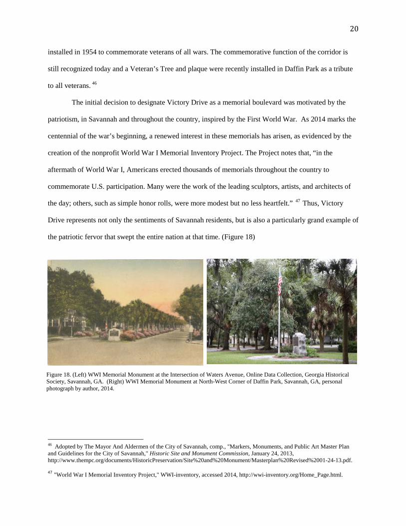
installed in 1954 to commemorate veterans of all wars. The commemorative function of the corridor is
still recognized today and a Veteran’s Tree and plaque were recently installed in Daffin Park as a tribute
to all veterans. 46
The initial decision to designate Victory Drive as a memorial boulevard was motivated by the
patriotism, in Savannah and throughout the country, inspired by the First World War. As 2014 marks the
centennial of the war’s beginning, a renewed interest in these memorials has arisen, as evidenced by the
creation of the nonprofit World War I Memorial Inventory Project. The Project notes that, “in the
aftermath of World War I, Americans erected thousands of memorials throughout the country to
commemorate U.S. participation. Many were the work of the leading sculptors, artists, and architects of
the day; others, such as simple honor rolls, were more modest but no less heartfelt.” 47 Thus, Victory
Drive represents not only the sentiments of Savannah residents, but is also a particularly grand example of
the patriotic fervor that swept the entire nation at that time. (Figure 18)
46 Adopted by The Mayor And Aldermen of the City of Savannah, comp., "Markers, Monuments, and Public Art Master Plan and Guidelines for the City of Savannah," Historic Site and Monument Commission, January 24, 2013, http://www.thempc.org/documents/HistoricPreservation/Site%20and%20Monument/Masterplan%20Revised%2001-24-13.pdf.
47 "World War I Memorial Inventory Project," WWI-inventory, accessed 2014, http://wwi-inventory.org/Home_Page.html.
Figure 18. (Left) WWI Memorial Monument at the Intersection of Waters Avenue, Online Data Collection, Georgia Historical Society, Savannah, GA. (Right) WWI Memorial Monument at North-West Corner of Daffin Park, Savannah, GA, personal photograph by author, 2014.
21
Historic Urban Landscape
The earliest information about Victory Drive dates to 1908 when the American Automobile
Association (AAA) hosted the United States’ first International Grand Prix Automobile Race on Estill
Avenue. Arguably, it was one of the finest automobile race tracks in the United States at that time. The
automobile races of Estill Avenue garnered international attention and acted as an economic and social
stimulus for the area before 1912.
In addition to this early history, the significance of Victory Drive is also linked to its contribution
as a template for urban landscape and street design. The Savannah Park and Tree Commission, through
the planting of palmettos in 1910 between Bull Street and Waters Avenue, became one of the most
significant contributors to Victory Drive’s unique development. Other prominent landscape features
include the azaleas planted inside the medians between the palmettos and the live oaks planted near the
outer edges of the road and on the front lawns of the adjacent homes, which provided a canopy of shade
to the section of Victory Drive between Bull Street and Waters Avenue. (Figure 19) The early planting of
palmetto trees, azaleas, and live oaks along the corridor as part of “beautification efforts” would impact
the city’s decision to designate the roadway as a WWI memorial. Victory Drive, despite all its hidden
history, remains recognizable because of its distinct urban form and signature landscape that have made it
a lasting focal point for the city.
Figure 19. Ken Jenkins, Landscape of Victory Drive, Savannah, GA., Postcard Collection, Georgia Historical Society, Savannah, GA.
22
IV. Conclusion
This report was created in an effort to better understand the history, evolution, and identifying
characteristics of the Victory Drive / US-80 Corridor. The study aims to contribute to the conversation of
how best to approach the future planning and management of Victory Drive as a commemorative corridor
that reflects local and national pride and remembrance, while remaining useful and functional as a modern
street. The continued loss of historic characteristics and defining landscape features along Victory Drive
remains a concern among local citizens as economic development continues along the corridor and traffic
and transportation pressures increase.
Although Victory Drive was once another local dirt road, it has evolved into a major arterial that
connects the City of Savannah to Tybee Island, both geographically and socially. Throughout its history,
Victory Drive has undergone many changes in design, name, and urban development. While evolution
and progress can be positive, they can also be detrimental to the character of an area if not thoughtfully
managed. It is possible to incorporate change while maintaining an area’s historic character. Preserving
iconic and defining features is the one of the best ways to ensure that historic significance is not lost, even
as urban landscapes adapt to different uses.
History has revealed that while the original idea behind the creation of Victory Drive rested firmly on
its identity as a war memorial, the function of the corridor has gradually evolved to accommodate a
modern lifestyle. Although some historic and landscape features have been lost along the corridor,
including a substantial number of palmettos, enough features remain in places to preserve, and perhaps
restore, some of Victory Drive’s historic, commemorative landscape without compromising the current
function of the corridor as a modern urban thoroughfare. Understanding Victory Drive as an historic
urban landscape of both local and national significance will aid the city in defining what is most
appropriate when developing plans to accommodate both the past and present along Victory Drive.
23
Bibliography
Book Georgia. City of Savannah. The Code of the City of Savannah. Compiled by Joseph C. Hester (Assistant City Attorney). By Authority of the Mayor and Aldermen of the City of Savannah. Savannah, GA: City of Savannah, 1936. Frank T.Wheeler. Images of America: The Savannah Races. 1908. Photographs, Georgia Historical Society, Savannah, GA. Collection Article "Budget (1935)." In Box 1, Folder 4, by Park and Tree Commission Papers. 1935. Journal Article Adopted By the Mayor and Aldermen of the City Of Savannah, comp. "Markers, Monuments, and Public Art Master Plan and Guidelines for the City of Savannah." Historic Site and Monument Commission, January 24, 2013. http://www.thempc.org/documents/HistoricPreservation/Site%20and%20Monument/Masterplan%20Revised%2001-24-13.pdf. Map|Chart "Savannah, Ga. 1898, Index Map." Map. In Sanborn Fire Insurance Maps for Georgia Towns and Cities, 1884-1922 Collection. Athens, Ga.: Digital Library of Georgia, 2005. http://dlg.galileo.usg.edu/sanborn/CityCounty/Savannah1898/IndexMap.html. Miscellaneous Supplement to Code of Savannah. Streets: SAV - Victory Drive. 1936. Vertical Files, Georgia Historical Society, Savannah, Ga. Page 210, Section 1421(b) Vertical Files: Streets: SAV - Victory Drive. January 17, 1962. Savannah Morning News Article, Georgia Historical Society, Savannah, Ga. Newspaper Article Bell, Bret. "Will a Bridge Run through It?" Savannah Morning News, June 26, 2001. "Commissioners Inspect and Accept Wilmington Bridge." Savannah Evening Press, August 29, 1921. "Dale Boulevard Next Big Feature." Savannah Morning News, January 19, 1913. Green, Rick. "The MPC: Plan Poses Trees Threat." Savannah Morning News, March 7, 1979. Holland, Marcus. "New Look for an Old Friend." Savannah Morning News, March 1, 2000.
24
"How The New Tybee Rd. Begins Savannah and Adjacent Islands Together." The Savannah Press, June 16, 1923. "Old and New Thunderbolt Bridges." Savannah Evening Press, July 18, 1955. "Paving of Victory Ave. Soon To Start." Savannah Morning News, August 31, 1921. "Road Work Cost Totals $6,272,239." Savannah Evening Press, January 09, 1952. Skutch, Jan. "Victory Drive Refurbished: Palmetto Trees Replaced for First Time in a Decade." Savannah Morning News, February 23, 1994. "Views Snapped At En Route of Tybee Road Parade." Savannah Morning News, January 22, 1923. "Will Cost $900,000 to Build Tybee Rd." Savannah Morning News, July 11, 1920. Pamphlet Davis, Jeffrey J.A. Victory Drive. Savannah: Chatham-Effingham-Liberty Regional Library. Report Archer, Jessica. The Journey of a Road: Victory Drive between Bee Road and Skidaway Road. Internship Report. Savannah, GA: Metropolitan Planning Commission, 2013. Steward, Dorothy H. Victory Drive, A Memorial for World War I. Report. Savannah: Monuments & Fountains of Savannah, 1993. Website "Johnny Harris Restaurant & Barbecue Sauce Co – Savannah GA." Johnny Harris Restaurant Barbecue Sauce Co Savannah GA. Accessed 2014. http://johnnyharris.com/history/. "Live Edit." Savannah, GA. Accessed 2014. http://www.savannahga.gov/. "World War I Memorial Inventory Project." WWI-inventory. Accessed 2014. http://wwi-inventory.org/Home_Page.html.
25
List of References
"16 U.S. Code § 470h–2 - Historic Properties Owned or Controlled by Federal Agencies." LII / Legal
Information Institute. Accessed 2014.
http://www.law.cornell.edu/uscode/html/uscode16/usc_sec_16_00000470---h002-.html.
1909 Mayor's Annual Report. Report. Savannah, GA: City of Savannah, 1909.
"1916 and 1937 Sanborn Insurance Company Maps." Map. In Georgia Historical Society.
1930 Plan for Meyers Park as Compared to Its Current Layout. 1930. Savannah, GA.
"$57,690 Be Spent on Victory Drive." Newspaper Unknown (Savannah, GA), August 21, 1932.
Adopted By The Mayor And Aldermen Of The City Of Savannah, comp. "Markers, Monuments, and
Public Art Master Plan and Guidelines For the City of Savannah." Historic Site and Monument
Commission, January 24, 2013.
http://www.thempc.org/documents/HistoricPreservation/Site%20and%20Monument/Masterplan%20Revi
sed%2001-24-13.pdf.
"Aerial View of Victory Drive from the Intersection of Ogeechee Rd. to Tybee Island." Map. Google
Maps. Accessed 2014.
Anderson, Gleanda. "Archived Maps of Victory Drive." E-mail to Various Correspondence. June 3, 1999.
Archer, Jessica. The Journey of a Road: Victory Drive between Bee Road and Skidaway Road. Internship
Report. Savannah, GA: Metropolitan Planning Commission, 2013.
"Area of Palm Removal near Truman Parkway." Map. In Google Maps. 2004.
Area of Palm removal near Truman Parkway, Savannah, GA. Personal photograph by author. 2014.
Atkinson, David S. The Code of the City of Savannah Containing a Codification of the Acts of the
Legislature of Georgia Constituting the Charter of the City of Savannah with the General State Laws
Affecting Municipal Corporations and a Codification of the Ordinances Adopted by the City Council,
Now in Force, with an Appendix Containing a Codification of the Laws of the City Court of Savannah, a
Codification of the Laws of the Municipal Court of Savannah, Annotated and a List of Local Laws
Enacted for Chatham County and the City of Savannah. (State Laws Include Acts of 1917.) (Ordinances
26
to July 3, 1918). Savannah, GA, 1918.
http://books.google.com/books?id=1YhCAQAAMAAJ&dq=J.+H.+ESTILL+estill+ave&source=gbs_nav
links_s.
"Automobile Race Course." Map. 2014.
"Bacon Predicts Future Development as Result of the Highway To Tybee." The Savannah Press, June 16,
1923.
"Baily Bridge to Be Complete This Afternoon." Savannah Morning News, April 11, 1957.
"Baily Bridge to Be Complete This Afternoon." Savannah Morning News, April 11, 1957.
Bell, Bret. "Will a Bridge Run through It?" Savannah Morning News, June 26, 2001.
"Bridge, Highway Work 50% Complete." Savannah Morning News, November 22, 1986.
"Budget (1935)." In Box 1, Folder 4, by Park and Tree Commission Papers. 1935.
Butler, Tom. "Bridge Comes Down." Savannah Evening Press, November 14, 1987.
"CHATHAM COUNTY HISTORIC PRESERVATION COMMISSION: REGULAR MEETING." June
4, 208. Accessed 2014. http://www.thempc.org/documents/CCHPC/Minutes/CCHPC MINUTES 06-04-
08.pdf.
Chatham Crescent Promotional Book. Butterscotch. 1911.
Georgia Historical Society Collection
"City Changes Name of Estill Avenue." Savannah Morning News (Savannah, GA), 1932.
The Cohen Humane Fountain at Bull Street. Online Data Collection, Georgia Historical Society,
Savannah, GA.
"Commemorative War Memorial That Extended from Ogeechee Road to Tybee Island." Map. 1930.
"Commissioners Inspect and Accept Wilmington Bridge." Savannah Evening Press, August 29, 1921.
Community Battles Government, Will a Bridge Run through It? 2001. The Savannah Morning News,
Savannah.
27
"A Contract in Civic Regard." Savannah Morning News, April 10, 1928.
Current Location of WWI Memorial. Online Data Collection, Georgia Historical Society, Savannah, GA.
"Current Path of Travel to Tybee Island." Map. 1955.
"CWIS -- National Historic Preservation Act, Section 106." CWIS -- National Historic Preservation Act,
Section 106. Accessed 2014. http://ceres.ca.gov/wetlands/permitting/nhpa.html.
"Dale Boulevard Next Big Feature." Savannah Morning News, January 19, 1913.
Darby, Betty. "$6.7 Million Thunderbolt Span Opens." Savannah Evening Press, August 28, 1987.
Davis, Jeffrey J.A. Victory Drive. Savannah: Chatham-Effingham-Liberty Regional Library.
East Victory near Daffin Park & 515 East Victory Drive. 1935. Savannah, GA.
"Estill Avenue." Savannah Morning News, March 21, 1922.
Evans, Art. "History of the United States Grand Prix - Race Profile, Photos." Sports Car Digest The
Sports Racing and Vintage Car Journal. May 09, 2012. Accessed Fall 2014.
http://www.sportscardigest.com/history-of-the-united-states-grand-prix/.
Finishing Touches. 1923. Savannah Press, Savannah.
Foltz. View of Tybee Road and Its Construction. April 9, 1922. The Savannah Morning News, Savannah,
GA.
"Forgotten Mother to Lay Corner Stone of Memorial." Savannah Morning News, May 30, 19--.
"43rd Street, Estill Avenue, and Dale Avenue Shown." Map. 1910.
Frank T.Wheeler. Images of America: The Savannah Races. 1908. Photographs, Georgia Historical
Society, Savannah, GA.
Georgia. City of Savannah. The Code of the City of Savannah. Compiled by Joseph C. Hester (Assistant
City Attorney). By Authority of the Mayor and Aldermen of the City of Savannah. Savannah, GA: City of
Savannah, 1936.
Google. "Home Depot Replaced K-Mart." Map. In Google Maps.
28
Green, Rick. "The MPC: Plan Poses Trees Threat." Savannah Morning News, March 7, 1979.
Green, Rick. "Trees on Victory Will Remain." Savannah Morning News, April 25, 1979.
Hester, Joseph C. The Code of the City of Savannah, Containing a Codification of the Acts of the
Legislature of Georgia Constituting the Charter of the City of Savannah and a Codification of the
Ordinances Adopted by the City Council, Now in Force. (State Laws Include Acts of 1935) (Ordinances
to May 1, 1936). Savannah: Press of Macfeely Print., 1936.
Historic Landscape View. 2004. Postcard Collection, Georgia Historical Society, Savannah, GA.
Historic Marker at the intersection of Waters Avenue and 46th Street, Savannah, GA. Personal
photograph by author. 2014.
"Historic Neighborhood Districts Designated as National Register Historic Places." Map. Savannah, GA,
2014.
Historical Paintings of Savannah’s Downtown Parks & Squares. 1850-1925. Park & Tree Commission
Records, City of Savannah Municipal Research Library, Savannah. 2004.
Holland, Marcus. "New Look for an Old Friend." Savannah Morning News, March 1, 2000.
"How Appropriate for Veterans' Day." 98.7 The River. Accessed March 4, 2013.
http://www.987theriver.com/pages/personality_markrobertson.html?article=10564483.
"How The New Tybee Rd. Begins Savannah and Adjacent Islands Together." The Savannah Press, June
16, 1923.
"Johnny Harris Restaurant & Barbecue Sauce Co – Savannah GA." Johnny Harris Restaurant Barbecue
Sauce Co Savannah GA. Accessed 2014. http://johnnyharris.com/history/.
Ken Jenkins. Landscape of Victory Drive. Savannah, GA.
Landscape Images of Chatham Crescent. Unknown. Postcard Collection, Georgia Historical Society,
Savannah.
Landscape of Estill and Dale Avenues. 2014. Postcard Collection, Georgia Historical Society, Savannah,
GA.
29
Landscape of Victory Drive after the Road Construction. 2004. The Savannah Morning News, Savannah.
"Large Portion of Road to Tybee Ready for Traffic." Savannah Morning News, April 3, 1922.
"Live Edit." Savannah, GA. Accessed 2014. http://www.savannahga.gov/.
MacDonell, Alexander Harrison. The Code of the City of Savannah Containing the Charters of the City of
Savannah and the Ordinances Adopted by the Mayor and Aldermen of the City of Savannah: (Georgia
Laws down to and including Acts of 1887): (ordinances down to and including July 11th, 1888).
Savannah: Savannah Times Pub., 1888.
http://books.google.com/books?id=S5NAAAAAYAAJ&printsec=frontcover&source=gbs_ge_summary_
r&cad=0#v=onepage&q&f=false.
MacDonell, Alexander Harrison. The Code of the City of Savannah of 1907 Containing the Charter of
City of Savannah with General State Laws Affecting Municipal Corporations, Also Ordinances Adopted
by the Mayor and Aldermen of the City of Savannah, Now of Force: With an Appendix Containing Laws
of the City Court of Savannah, a List of the Local Laws Heretofore Enacted for the City of Savannah and
the County of Chatham, and a List of Franchises and Privileges Granted by the City (Georgia Law down
to and including Acts of 1906), (ordinances down to and including December 1906), Copyrighted 1907.
Savannah, GA: Morning News Print, 1907. http://books.google.com/books?id=7L14vQp-R-
kC&dq=J.%20H.%20ESTILL%20estill%20ave&source=gbs_similarbooks.
"Make Estill Ave. Place of Beauty." Savannah Morning News, March 25, 1906.
Meeting Summary. June 28, n/a. Protecting the Trees and the Historic Nature of Victory Drive,
Metropolitan Planning Commission, Savannah, GA.
Merritt, Carole. Historic Black Resources: A Handbook for the Identification, Documentation, and
Evaluation of Historic African-American Properties in Georgia. Atlanta, GA: Atlanta: Historic
Preservation Section, Georgia Department of Natural Resources, 1984.
"Neighborhood Association along the Victory Drive Corridor." Map. Accessed 2014.
New Million Dollar Road to Tybee, “The En Route to the Ocean”. Unknown. Postcard Collection,
Georgia Historical Society, Savannah.
Northern Boundary of Cuyler Brownville Historic Neighborhood along Victory Drive, Savannah, GA.
Personal photograph by author. 2014.
30
"Old and New Thunderbolt Bridges." Savannah Evening Press, July 18, 1955.
Opening of New Thunderbolt Span Planned for Mid-May. March 22, 1955. Savannah Morning News,
Savannah, GA.
"Opening of New Thunderbolt Span Planned for Mid-May." Savannah Morning News, May 05, 1955.
Palm Trees before the Construction of Truman Parkway. February 23, 1994. Savannah Morning News,
Savannah, GA.
"Paving of Victory Ave. Soon To Start." Savannah Morning News, August 31, 1921.
Photograph by Foltz Studios. Victory Drive. Library & Archives – Photograph Collections, Record Series
1121-041, Box 1121-041-4, Folder 1, Item 2, City of Savannah, Research Library & Municipal Archives,
Savannah, GA.
Palm Lined Victory Drive. Postcard Collection, Georgia Historical Society, Savannah, GA.
Plan (1910). 1910. Research Library and Municipal Archives.
"Plan to Drop Name of Estill Opposed." Unknown (Savannah, GA), March 16, 1922.
"Proposed Map by the Metropolitan Planning Commission." Map. Accessed 2014.
Reiter, Beth. Memo. January 19, 1999. Additional Research Regarding Palms on Victory Drive,
Metropolitan Planning Commission, Savannah, GA.
Relocation of WWI Memorial. Online Data Collection, Georgia Historical Society, Savannah, GA.
Removal of Palm Trees on Victory Drive at the Intersection of Bee Road. October 27, 1961. Savannah
Morning News, Savannah, GA.
Research Library and Municipal Archives. "Engineering Map (1909)." Map. Accessed 2014.
The Road to Tybee Showing Constructed. 1923. Vertical File, Savannah Public Library, Savannah, GA.
"Road to Wilmington Island Open Soon." Savannah Morning News, March 3, 1922.
"Road Work Cost Totals $6,272,239." Savannah Evening Press, January 09, 1952.
31
"Roll of Honor Marker." Roll of Honor Marker. Accessed 2014.
http://www.hmdb.org/marker.asp?marker=55093.
Sanmann, Stefan, John Crowell, and Savannah House Publishers. Estill Avenue Was Renamed Victory
Drive as a Memorial to the Servicemen of World War I. Savannah Then and Now, Savannah, GA.
Savannah Evening Post. Streets: SAV - Victory Drive. May 10, 1990. Vertical Files, Georgia Historical
Society, Savannah, Ga.
"Savannah, Ga. 1898, Index Map." Map. In Sanborn Fire Insurance Maps for Georgia Towns and Cities,
1884-1922 Collection. Athens, Ga.: Digital Library of Georgia, 2005.
http://dlg.galileo.usg.edu/sanborn/CityCounty/Savannah1898/IndexMap.html.
Savannah Morning News. Streets: SAV - Victory Drive. April 21, 2003. Vertical Files, Georgia Historical
Society, Savannah, Ga.
Savannah Morning News. Streets: SAV - Victory Drive. April 6, 1922. Vertical Files, Georgia Historical
Society, Savannah, Ga.
Savannah Morning News. Streets: SAV - Victory Drive. April 9, 1922. Vertical Files, Georgia Historical
Society, Savannah, Ga.
Savannah Morning News. Streets: SAV - Victory Drive. August 31, 1921. Vertical Files, Georgia
Historical Society, Savannah, Ga.
Savannah Morning News. Streets: SAV - Victory Drive. June 6, 2001. Vertical Files, Georgia Historical
Society, Savannah, Ga.
Savannah Morning News. Streets: SAV - Victory Drive. March 1, 2000. Vertical Files, Georgia Historical
Society, Savannah, Ga.
Savannah Morning News. Streets: SAV - Victory Drive. May 3, 1922. Vertical Files, Georgia Historical
Society, Savannah, Ga.
Savannah Morning News. Streets: SAV - Victory Drive. November 27, 1927. Vertical Files, Georgia
Historical Society, Savannah, Ga.
Savannah Streets Names Changes. Typed Notes, Savannah Public Library, Savannah, GA.
32
"The Shopping Plaza on Skidaway and Victory." Map. In Google Maps.
Sketches of Victory Avenue. 1919. Vertical File, Bull Street Library.
"Sketches Showing Proposed Victory Avenue." The Savannah Morning Press, October 16, 1919.
Skutch, Jan. "Victory Drive Refurbished: Palmetto Trees Replaced for First Time in a Decade." Savannah
Morning News, February 23, 1994.
Spence Grayson Bridge. 1921. Thunderbolt Historical Museum.
Spracher, Luciana. "Assistance and Interview Request: Savannah Palms." E-mail to Sandy Truab. June 5,
2006.
"Start Work of Connecting Victory Ave. and Tybee Road." Savannah Morning News, January 05, 1922.
"State, Local Officials Gather for Bridge Opening." Savannah Evening Press, May 5, 1988.
Steward, Dorothy H. Victory Drive, A Memorial For World War I. Report. Savannah: Monuments &
Fountains of Savannah, 1993.
Stramm, Polly Powers. Sentimental Savannah: Reflections on a Southern City's past. Charleston, SC:
History Press, 2006.
Streetscape of Estill Avenue. Postcard Collection, Georgia Historical Society, Savannah, GA.
Supplement to Code of Savannah. Streets: SAV - Victory Drive. 1936. Vertical Files, Georgia Historical
Society, Savannah, Ga.
Page 210, Section 1421(b)
"Tablet Unveiling to Be Impressive." Newspaper Unknown, April 26, 1929.
The Thrill of Victory, or the Agony of the Feet. Savannah College of Art and Design: Historic
Preservation Vertical File.
The Thunderbolt Museum Society, Inc. The Thunderbolt Time Capsule 1 Number 4:1-4.
"Thunderbolt: New Bridge, Library on Way." Savannah Evening Press, February 8, 1987.
The Thunderbolt Time Capsule. The Thunderbolt Time Capsule 2 Number 1:1-3.
33
"Thunderbolt, Vets, Formally Open New Span."
"Trees on Victory Avenue Memorials to Men Meeting Death." The Savannah Press, March 25, 1906.
"Trees on Victory Will Remain: DOT." Savannah Morning News, March 15, 1979.
Turn on Tybee Road at Whitmarsh Island. 1923. Savannah Press, Savannah.
Turning Over Wilmington River Bridge to County. August 29, 1921. The Savannah Press, Savannah, GA.
Tybee Road, 14 Miles from Savannah & 40 Feet Wide. 1924. Vertical File, Savannah Public Library,
Savannah, GA.
"Unanimously Oppose Name of Victory Ave." Savannah Morning News, March 17, 1922.
Undated Handwritten Note. Streets: SAV - Victory Drive. Vertical Files, Georgia Historical Society,
Savannah, Ga.
"Untitled Letter." Daffin to Granger. May 17, 1912. Savannah, GA.
"Untitled Letter." Granger to The Park & Tree Commission. 1912. Savannah, GA.
Correspondence Dates: May 18, 1912; July 20, 1912; November 12, 1912
"Untitled." Savannah Morning News, January 5, 1922.
"Varnedoe Bridge Project Moving Along." Savannah Evening Press, November 11, 1988.
Vertical Files: Streets: SAV - Victory Drive. January 17, 1962. Savannah Morning News Article, Georgia
Historical Society, Savannah, Ga.
Vertical Files: Streets: SAV - Victory Drive. January 9, 1913. Savannah Morning News Article, Georgia
Historical Society, Savannah, Ga.
Victory Drive at Atlantic Avenue, Savannah, GA. Personal photograph by author. 2014.
Victory Drive at Habersham Street. 1948. Online Data Collection, Georgia Historical Society, Savannah,
GA.
"Victory Drive." E-mail to Luciana M. Sparacher.
Library Archives of Public Library at Bull Street
34
"Victory Drive from the Intersection of Ogeechee Rd. to Tybee Island." Map. Google Maps. Accessed
2014.
Victory Drive Landscape. Postcard Collection, Georgia Historical Society, Savannah, GA.
"Victory Drive Made Boulevard." Newspaper Unknown (Savannah, GA), date unknown.
View of Victory Drive, Which Is Lined with Palm Trees and Flowers. 1930. Savannah, GA.
"Views Snapped At En Route of Tybee Road Parade." Savannah Morning News, January 22, 1923.
"Vintage Travel Postcards: Savannah, Georgia." Vintage Travel Postcards: Savannah, Georgia. Accessed
March 4, 2014. http://vintagetravelpostcards.blogspot.com/2010/04/savannah-georgia_20.html.
"What Is Walkability?" Walk Score. Accessed March 6, 2014. http://www.walkscore.com/live-more/.
Wheeler, Frank T. The Savannah Races: Photographs from the Collection of the Georgia Historical
Society. Dover, NH: Arcadia Pub., 1998.
"Will Cost $900,000 To Build Tybee Rd." Savannah Morning News, July 11, 1920.
William L.Grayson Stadium. Online Data Collection, Georgia Historical Society, Savannah, GA.
World War I Memorial and Inscription Located at Daffin Park, Savannah, GA. Personal photograph by
author. 2014.
"World War I Memorial Inventory Project." WWI-inventory. Accessed 2014. http://wwi-
inventory.org/Home_Page.html.
WWI Events. Online Data Collection, Georgia Historical Society, Savannah, GA.

35
Appendix. 1. Analysis of Character Zones
Zone Section Condition
1 Ogeechee Road to MLK Architecture: Bungalow architecture (residential) Landscape: Includes Sabal Palmettos; No Live Oaks
2 MLK to Bull Street Architecture: Eclectic architecture ranging from Italianate to Victorian (residential); A major railroad crosses Victory Drive Landscape: Includes no defining landscape
3 Bull Street to Bee Road Architecture: Greek and Italianate architecture (residential)
Landscape: Includes Sabal Palmettos, Live Oaks & Indica Azaleas
4
Bee Road to Wilmington River
Architecture: Eclectic architecture (residential and commercial)
Landscape: Includes both Sabal Palmettos and Live Oaks; also includes Daffin Park, the largest recreational and public space along Victory Drive featuring a stadium and a manmade lake.
5 Wilmington River to Bull River
Architecture: Contemporary architecture (commercial) Landscape: Includes both Sabal Palmettos and Live Oaks
6 Bull River to Lazaretto Creek
Architecture: N/A
Landscape: Naturalizing, Saltwater Marsh Landscapes
7 Tybee Island Architecture: Diverse architecture (Transportation; highways and bridges spanning over marshland with access to occasional pockets of residential and commercial developments). Landscape: Includes palms, marsh grass, shrubs, beach grass and sand.
36
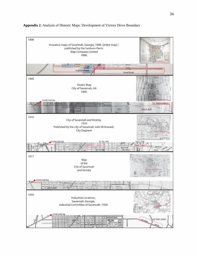
Appendix 2. Analysis of Historic Maps: Development of Victory Drive Boundary
37
Appendix 3. Reproduction of Proposal Drawing on the Improvement of Victory Avenue in 1919
Reproduction of 1919 Proposal Drawing by Mr. W.O’D Rockwell, City Engineer (October 16, 1919, The Savannah Press)

38
Appendix 4. Analysis of Victory Drive’s Median and Side Walks around Commercial Area
Bee Road
River Drive
Third Street
Limerick Street
Harry Truman parkway
Wallin Street
Bee Road
Third Street
Limerick Street
Wallin Street
Cross Street