Victorian Murray Darling Basin Environmenal Works … · Web viewThe Victorian Murray Darling Basin...
29
Victorian Murray Darling Basin Environmental Works and Measures Feasibility Program
Transcript of Victorian Murray Darling Basin Environmenal Works … · Web viewThe Victorian Murray Darling Basin...

Victorian Murray Darling Basin Environmental Works and Measures Feasibility Program
Final Report

Cover photo: Gunbower National Park, North Central Catchment Management Authority.
Published by the Victorian Government Department of Environment and Primary Industries Melbourne, August 2013.
© The State of Victoria Department of Environment and Primary Industries Melbourne 2013.This publication is copyright. No part may be reproduced by any process except in accordance with theprovisions of the Copyright Act 1968.
Authorised by the Victorian Government, 8 Nicholson Street, East Melbourne.
ISBN 978-1-74287-912-3 (pdf)
For more information contact the DEPI Project Manager for SDL Works and Measures on (03) 9637 8478.
DisclaimerThis publication may be of assistance to you but the State of Victoria and its employees do not guarantee that the publication is without flaw of any kind or is wholly appropriate for your particular purposes and therefore disclaims all liability for any error, loss or other consequence which may arise from you relying on any information in this publication.
AccessibilityIf you would like to receive this publication in an accessible format, such as large print or audio, please telephone 136 186, or email [email protected]
Deaf, hearing impaired or speech impaired? Call us via the National Relay Service on 133 677 or visitwww.relayservice.com.au
ContentsIntroduction 4
Conduct of the Program 4
Benefits 5
Outcomes 5
Next Steps 6
Sub-project Summaries 8
Program Part 1 – SDL Offset Sub-projects 8Program Part 2 - Community Engagement Sub-projects 16
Victorian Murray Darling Basin Environmental Works and Measures Feasibility Program 2011-13
Introduction The Victorian Murray Darling Basin Environmental Works and Measures Feasibility Program has been undertaken as part of the Basin Plan Sustainable Diversion Limit (SDL) adjustment mechanism. The Basin Plan sets out volumetric sustainable diversion limits for the Basin. These are limits on the amount of water that can be taken from Basin water resources. Limits will allow more water to return to and support the environmental needs of the Basin’s river, floodplain, wetland and groundwater systems. The adjustment mechanism process aims to develop offset projects that will decrease the amount of water to be recovered for the environment, by using water more efficiently.
Funded by the Commonwealth Department of Sustainability, Environment, Water, Population and Community between 2011 and 2013, the Victorian program focused on how to deliver environmental outcomes using less water, or improve outcomes with the same amount of water. Structural works and measures were proposed as an important mechanism to provide improved outcomes because works can deliver and hold water in specifically targeted areas which would otherwise only receive inundation through more widespread, large flood events. This benefits the environment by allowing flood-dependent ecological processes to occur, in targeted areas of high environmental value, in the absence of natural river flows and floods. Therefore projects investigated through this program have potential to provide both specific benefits to select high value areas, and offsets to the SDL volumes given in the Murray Darling Basin Plan through a more efficient use of water.
The program was delivered in two parts: the SDL Offset sub-projects (part 1) and the Community Engagement sub-projects (part 2). The Department of Environment and Primary Industries (DEPI, formerly DSE) coordinated the program for Victoria. The Catchment Management Authorities (CMAs), as delivery partners to the state government, undertook individual sub-projects within their regions. A project control board consisting of DEPI and CMA representatives oversaw the program.
Conduct of the ProgramPart 1 of the program consisted of delivering investigations for existing sub-projects across two CMA regions (Mallee and North Central). Sub-projects consisted of studies and designs for works to improve environmental outcomes at large Murray floodplain areas or key River Red Gum forests. As important ecological sites in each region, these projects all had existing feasibility studies looking into the use of works to provide efficient watering for environmental outcomes. Therefore concept designs, or supporting technical investigations, were progressed with the funding available for each sub-project.
Part 2 of the program consisted of a community engagement process to identify additional projects that could provide SDL offsets. Four Basin CMAs (Mallee, North Central, Goulburn Broken, and North East) each undertook their own targeted engagement process, and developed a list of priority works projects with potential for SDL offsets. DEPI and the CMAs developed and used selection criteria with which to create a shortlist for the state. Four projects were selected, one from each CMA, and these were progressed to the next relevant stage for the project (ranging from feasibility study through to detailed design).
5
Victorian Murray Darling Basin Environmental Works and Measures Feasibility Program 2011-13
BenefitsThe program overall provided a strong context to progress many pre-existing works and measures projects in northern Victoria that have high potential for both large environmental benefit and water efficiencies. Several sites had limited funding from The Living Murray (TLM) program, and this new source of funds provides an avenue to extend TLM benefits to further areas (e.g. Lindsay Island, Hattah Lakes, Gunbower Forest). The program also provided the opportunity for targeted community and stakeholder engagement for environmental works projects. Further community engagement on the projects listed below will also occur as detailed infrastructure designs are completed over the next two years.
The sub-projects’ proposed works are likely to benefit a range of environmental assets, and were progressed to the stages as indicated in the below table (Table 1).
OutcomesThrough this program, environmental water options for twelve sub-projects were selected and/or developed to early (concept) or detailed infrastructure designs.
Of the four community priority sub-projects progressed, two are further upstream, and are of smaller scale than the downstream projects. These may not have been selected under SDL offset potential alone, but through this program, have been highlighted as significant projects for the Goulburn Broken and North East CMA regional communities. The North East sub-project also highlighted that water savings could be achieved under Basin Plan operations if sites that are inundated most of the time have infrastructure to keep flows out, to allow for a more natural wetting-drying regime. There are numerous such sites in the upper Murray.
The majority of sub-projects reflect a high potential for SDL offsets. Victoria did not provide the Commonwealth with specific water efficiency estimates or SDL offset capacity for the sites, as there are a number of uncertainties with regard to providing such estimates per site from use of works rather than increased river flows. At this stage, only a very simple approach could be used, which would result in a high level of uncertainty around the resultant figure.
Accordingly, at this stage information was provided on:
The river levels or flow rates which would be required to adequately water the site in the absence of works, including required frequency and the duration that the event needs to be maintained.
The river level or flow rates which would be required to adequately water the site using the proposed works, including frequency and duration.
The volume of environmental water which would be delivered to the site using the works.
This information is indicative of the potential for the works to generate a water saving, however do not provide an estimate of the actual saving.
An estimate of potential savings and SDL offsets will be provided when a) the MDBA establishes the method for calculating SDL offsets throughout the Southern Connected
Basin, as required by the Basin Plan (expected by late 2013); and
6

Victorian Murray Darling Basin Environmental Works and Measures Feasibility Program 2011-13
b) more accurate figures for individual projects become available through modelling and detailed designs to be completed through next stages of the SDL adjustment process (Business Case Development).
It should be noted the actual water saving potential from any individual structural work is not necessarily a good indication of what will be realised by a whole package of works. The interactions between projects can be quite complex and are all but impossible to predict. They can only be calculated by including all proposed offsets in a single modelling run; however this cannot be undertaken until MDBA complete the SDL adjustment mechanism, and all projects are progressed to a stage where the benefits of infrastructure can be modelled. This modelling is expected to be undertaken in 2015.
Next StepsThe Victorian environmental works sub-projects will undertake assessment through the next two phases of the SDL adjustment mechanism, to determine their relative degree of benefit, and whether continued progression as an SDL offset project is considered worthwhile. Project Feasibility Cases will be submitted before the end of 2013 for the first such assessment. For those that progress, Business Cases will be developed for assessment and consideration under the mechanism by mid-2015.
7
Victorian Murray Darling Basin Environmental Works and Measures Feasibility Program 2011-13
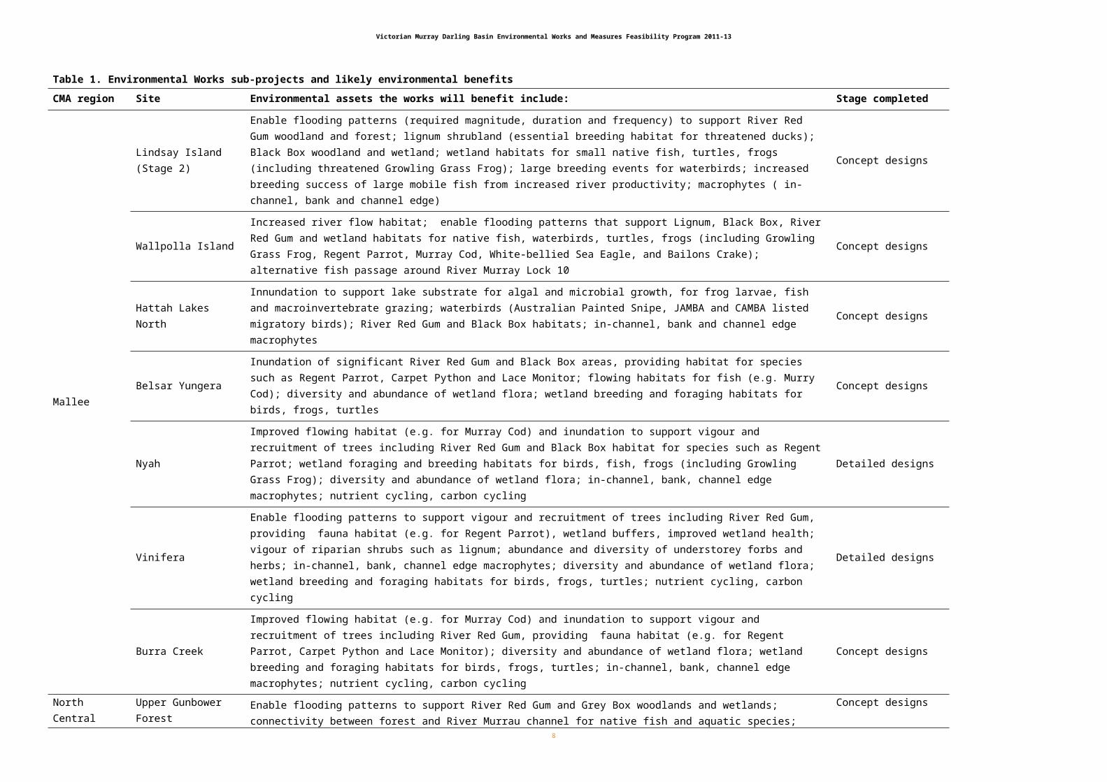
Table 1. Environmental Works sub-projects and likely environmental benefits
CMA region Site Environmental assets the works will benefit include: Stage completed
Mallee
Lindsay Island(Stage 2)
Enable flooding patterns (required magnitude, duration and frequency) to support River Red Gum woodland and forest; lignum shrubland (essential breeding habitat for threatened ducks); Black Box woodland and wetland; wetland habitats for small native fish, turtles, frogs (including threatened Growling Grass Frog); large breeding events for waterbirds; increased breeding success of large mobile fish from increased river productivity; macrophytes ( in-channel, bank and channel edge)
Concept designs
Wallpolla IslandIncreased river flow habitat; enable flooding patterns that support Lignum, Black Box, River Red Gum and wetland habitats for native fish, waterbirds, turtles, frogs (including Growling Grass Frog, Regent Parrot, Murray Cod, White-bellied Sea Eagle, and Bailons Crake); alternative fish passage around River Murray Lock 10
Concept designs
Hattah Lakes NorthInnundation to support lake substrate for algal and microbial growth, for frog larvae, fish and macroinvertebrate grazing; waterbirds (Australian Painted Snipe, JAMBA and CAMBA listed migratory birds); River Red Gum and Black Box habitats; in-channel, bank and channel edge macrophytes
Concept designs
Belsar YungeraInundation of significant River Red Gum and Black Box areas, providing habitat for species such as Regent Parrot, Carpet Python and Lace Monitor; flowing habitats for fish (e.g. Murry Cod); diversity and abundance of wetland flora; wetland breeding and foraging habitats for birds, frogs, turtles
Concept designs
Nyah Improved flowing habitat (e.g. for Murray Cod) and inundation to support vigour and recruitment of trees including River Red Gum and Black Box habitat for species such as Regent Parrot; wetland foraging and breeding habitats for birds, fish, frogs (including Growling Grass Frog); diversity and abundance of wetland flora; in-channel, bank, channel edge macrophytes; nutrient cycling, carbon cycling
Detailed designs
Vinifera
Enable flooding patterns to support vigour and recruitment of trees including River Red Gum, providing fauna habitat (e.g. for Regent Parrot), wetland buffers, improved wetland health; vigour of riparian shrubs such as lignum; abundance and diversity of understorey forbs and herbs; in-channel, bank, channel edge macrophytes; diversity and abundance of wetland flora; wetland breeding and foraging habitats for birds, frogs, turtles; nutrient cycling, carbon cycling
Detailed designs
Burra CreekImproved flowing habitat (e.g. for Murray Cod) and inundation to support vigour and recruitment of trees including River Red Gum, providing fauna habitat (e.g. for Regent Parrot, Carpet Python and Lace Monitor); diversity and abundance of wetland flora; wetland breeding and foraging habitats for birds, frogs, turtles; in-channel, bank, channel edge macrophytes; nutrient cycling, carbon cycling
Concept designs
North Central
Upper Gunbower ForestEnable flooding patterns to support River Red Gum and Grey Box woodlands and wetlands; connectivity between forest and River Murrau channel for native fish and aquatic species; waterbird breeding events, including increased feeding resources in wetlands; abundance and diversity of frog populations; diversity and abundance of wetland flora; wetland breeding and foraging habitats for birds, frogs, turtles
Concept designs
Guttrum ForestEnable flooding patterns to support River Red Gum forest and floodplain; habitat for colonial nesting waterbirds; closed reed bed, open water, and marsh vegetation for bird habitat; wetland habitats for other fauna foraging and breeding, including Growling Grass Frog
Concept designs
Benwell ForestEnable flooding patterns to support River Red Gum forest and floodplain ecosystems; important forest and wetland habitat for birds; wetland habitats for other fauna foraging and breeding, including Growling Grass Frog
Concept designs
Goulburn Broken Gaynor’s SwampEnable flooding patterns to support River Red Gum habitat; threatened native fish and birds; critical breeding habitat for Brolga, Royal Spoonbill, Eastern Great Egret; habitat for JAMBA, CAMBA, ROKAMBA migratory birds
Detailed designs
Noth East St Leonard’s WetlandEnable wetting-drying patterns (more natural hydrological regime) to support River Red Gum and Silver Wattle forest; habitat for vulnerable Musk Duck, Australasian Shoveler, endangered Growling Grass Frog
Feasibility Study
8

Victorian Murray Darling Basin Environmental Works and Measures Feasibility Program 2011-13
Sub-project SummariesProgram Part 1 – SDL Offset Sub-projects
Sub-project 1: Watering the Lindsay Island floodplainThis sub-project has progressed concept designs and associated studies such as salinity, geotechnical and cultural heritage for Stage 2 of the Lindsay Island project, significantly adding to the Stage 1 project initiated under The Living Murray program. Stage 2 proposes the construction of a large weir and several smaller works measures to improve inundation regimes for over 5,000 hectares including large areas of river red gum floodplain.
Lindsay Island is located in far north western Victoria and lies within the Murray Sunset National Park. The area included in this study incorporates Lindsay Island as well as the fringing floodplain located immediately to the south of the Lindsay River. This southern floodplain area includes the ecologically significant waterbody of Lake Wallawalla. The total study area covers an area of about 20,000 ha.
The Lindsay Island floodplain covers an area of 15,000 ha to the south of the Murray River, between Locks 8 and 6. The Lindsay River is an anabranch of the River Murray and provides a southern boundary to Lindsay Island. The Mullaroo Creek is a second anabranch which bisects the island, providing a secondary interconnection between the River Murray and the Lindsay River.
The Lindsay River extends approximately 52 km from one length to the other. The Mullaroo Creek extends approximately 19 km. The confluence with the Mullaroo Creek is approximately 17 km from the downstream end, and the branch off to Lake Wallawalla is about 31 km from the downstream end.
Lock 7 is located about 15 km downstream of the eastern end of the Island. The normal operating level of the Lock 7 weir pool is 22.1 mAHD, which can be maintained for river flows up to about 20,000 ML/d. River flows which exceed approximately 25,000 ML/d exceed the top of pier level (23.35 mAHD) on the weir structure. The 1956 flood resulted in a water level of approximately 26.35 mAHD (River Murray Water, 1975). Water levels in the Lock 7 weir pool directly influence the floodplain connectivity throughout Lindsay Island, particularly via the two main anabranches, these being the Lindsay River and Mullaroo Creek.
The Lindsay Island floodplain is relatively flat, dissected by a network of anabranches and small creeks with areas of permanent and ephemeral wetlands. An overview of the key ecological, cultural heritage and social values is provided in table 2 below.
9
Victorian Murray Darling Basin Environmental Works and Measures Feasibility Program 2011-13
Table 2. Key Values of Lindsay Island
Key Values Details
Fauna The Island is known to support species that are significant at national, state and regional levels (SKM and Roberts, 2003).
Flora The floodplain communities range through River Red Gum, Black Box, lignum shrubland and chenopod grasslands (MDBC, 2006).
Cultural There are numerous registered sites of cultural heritage significance. Shell middens, hearths and scar trees found throughput the Park reveal much about the lifestyle and rich culture of the people who inhabited this area.
Social Lindsay Island is part of the Murray-Sunset National Park which is enjoyed for recreation activities such as camping, fishing, four wheel driving and canoeing.
Economic The anabranches of Lindsay Island are used for irrigation, stock and domestic extraction (MDBC, 2006).
This study has investigated potential management options for restoring water regimes to the Lindsay Island floodplain, particularly those that will work in with and complement works currently being constructed under ‘Lindsay Island Stage 1’ for the Living Murray initiative. The study builds upon a range of previous investigations which have been undertaken over the last 10 to 15 years, providing a holistic and integrated assessment of water management opportunities. The study identified and evaluated opportunities for large scale and integrated water management works and measures, prioritised these works, and developed concept designs to inform project costs and other potential future project delivery requirements. The study incorporated preliminary salinity, cultural and European heritage investigations.
A regulator and associated works near the Berribee Homestead aim to achieve wide spread inundation across the mid to upper area of the Lindsay Island floodplain, inclusive of the Lake Wallawalla area. The target inundation level is 23.2 mAHD. The works have been designed to enable watering of the floodplain under low River Murray flow conditions (<10,000 ML/d), as well as providing the ability to increase inundation frequencies and durations under mid range River Murray flow conditions (10,000 to 80,000 ML/d). For flows beyond 80,000 ML/d, the Berribee Regulator will be configured to allow unimpeded natural inundation of the Island.
The selected location for these works has been informed by preliminary ground truthing, bathymetric survey and geotechnical investigations. Further consideration of the local flora, fauna and cultural heritage as well as requirements during construction is required prior to the final site selection.
Inundation of the Lindsay Island floodplain is achieved through the co-ordinated operation of the Lock 7 weir pool level and the proposed Berribee Regulator structure. The actual mode of operation will be dependent on the River Murray flow rate and the target inundation level, however the watering concept being proposed requires the Lock 7 weir pool to be temporarily raised by up to 1.1 m to provide the head required to achieve inundation of the floodplain.
The associated works comprises five minor structures which are required to prevent breakouts and thus enabling an inundation level of 23.2 m AHD to be achieved within the targeted area of inundation within the upper Lindsay Island floodplain. The structures in these locations have been designed to allow flood
10
Victorian Murray Darling Basin Environmental Works and Measures Feasibility Program 2011-13
waters to be released to the breakout areas, if required, providing secondary watering benefits to additional areas of the lower Lindsay Island floodplain.
A range of complementary works have been identified across the Lindsay Island floodplain targeting areas which cannot be directly inundated through the operation of the Berribee Regulator. The high priority secondary options target high value areas of the floodplain. The works which have been identified offer the greatest potential to achieve a mosaic of hydrological regimes and habitat types across the entire Lindsay Island and adjacent floodplain areas.
Final calculation of water savings from the project will be undertaken in conjunction with the Murray Darling Basin Authority using an approved methodology developed under the Basin Plan.
Sub-project 2: Watering the Wallpolla Island floodplainThe Wallpolla Island sub-project developed concept designs for pumps, regulating and holding structures proposed to improve inundation regimes of over 4,000 hectares of floodplain, including river red gum communities and wetlands, as well as increasing flowing habitat by 50 kilometres.
Wallpolla Island is part of the larger Chowilla Floodplain Icon Site identified under The Living Murray (TLM) Initiative of the Murray Darling Basin Authority. Wallpolla Island contains a mosaic of floodplain vegetation with Black Box being one of the more dominant vegetation communities. Black Box vegetation communities require flooding at least once every 10 years, and on average 2 to 3 times per decade. Flow regulation on the Murray River has reduced the occurrence and duration of flooding through Wallpolla Island and as a result there has been a decline in the condition of the Black Box vegetation communities through the area.
The Mallee CMA has investigated water management options for Wallpolla Island that are based on significant spread of flow events to extend to the majority of the floodplain if required. This is based on the use of track raising and the use of regulators with pumping used to compliment flow events if necessary.
Based on information provided in the Basin Plan, it is estimated that the Murray River reach encompassing Wallpolla Island could receive a 70,000 ML/day flow. This has been derived from the Chowilla Hydrologic Indicator Site, for which the Basin Plan outlines an 80,000 ML/day flow. It is assumed that 10,000 ML/day of the flow will be derived from Lake Victoria which is downstream of Wallpolla Island, thereby equating to 70,000 ML/day flow at Wallpolla Island. However this flow rate will inundate less than 3 per cent of the Black Box vegetation community on Wallpolla Island. In the absence of additional works and measures to increase the occurrence and extent of inundation, it is expected that over 97% of the Black Box vegetation communities on Wallpolla Island will continue to decline and be at risk of loss.
A set of preferred water management options were selected in consultation with stakeholders that best met agreed water management objectives for the Wallpolla area, with objectives being:
The watering of vegetation communities within the Wallpolla Island area with particular emphasis on Black Box vegetation community.
The integration of watering arrangements and outcomes with NSW and the Basin Plan. The optimisation of costs by achieving the greatest watering of target vegetation communities for least
o capital cost
11

Victorian Murray Darling Basin Environmental Works and Measures Feasibility Program 2011-13
o operation costo water use.
The avoidance and minimisation of impacts on existing and proposed land uses includingo Proposed National Parkso Private land.
The avoidance and minimisation of impacts on existing vegetation, instream ecology, and sites of cultural significance.
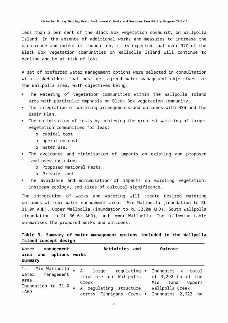
The integration of works and watering will create desired watering outcomes at four water management areas: Mid Wallpolla (inundation to RL 31.0m AHD), Upper Wallpolla (inundation to RL 32.0m AHD), South Wallpolla (inundation to RL 30.6m AHD), and Lower Wallpolla. The following table summarises the proposed works and outcomes.
Table 3. Summary of water management options included in the Wallpolla Island concept design
Water management area and options summary
Activities and works Outcome
1. Mid Wallpolla water management area. Inundation to 31.0 mAHD.
A large regulating structure on Wallpolla Creek
A regulating structure across Finnigans Creek at diffluence with Murray River
10 new minor regulating structures within Wallpolla floodplain
10km of track raising across the Wallpolla floodplain
Inundates a total of 3,292 ha of the Mid (and Upper) Wallpolla Creek.
Inundates 2,622 ha that is not inundated with 70 GL/day flow
1,271 ha of Black Box woodlands inundated (1,206 ha of which would not be inundated by a 70 GL/day flow)
Requires 29.9 GL of water
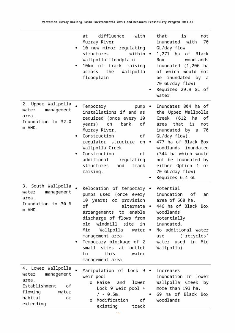
2. Upper Wallpolla water management area.Inundation to 32.0 m AHD.
Temporary pump installations if and as required (once every 10 years) on bank of Murray River.
Construction of regulator structure on Wallpolla Creek.
Construction of additional regulating structures and track raising.
Inundates 804 ha of the Upper Wallpolla Creek (612 ha of area that is not inundated by a 70 GL/day flow).
477 ha of Black Box woodlands inundated (344 ha which would not be inundated by either Option 1 or 70 GL/day flow)
Requires 6.4 GL
3. South Wallpolla water management area.Inundation to 30.6 m AHD.
Relocation of temporary pumps used (once every 10 years) or provision of alternate arrangements to enable discharge of flows from old windmill site in Mid Wallpolla water management area.
Temporary blockage of 2 small sites at outlet to this water
Potential inundation of an area of 668 ha.
446 ha of Black Box woodlands potentially inundated.
No additional water use (‘recycles’ water used in Mid Wallpolla).
12

Victorian Murray Darling Basin Environmental Works and Measures Feasibility Program 2011-13
management area.
4. Lower Wallpolla water management area.Establishment of flowing water habitat or extending backwater inundation.
Manipulation of Lock 9 weir poolo Raise and lower Lock 9
weir pool + / - 0.5m.o Modification of existing
track raising and minor regulating structures controlling outflows from the Murray River.
o Project subject to current investigation by NSW.
Installation of additional outlet structure associated with Mid Wallpolla water management area.
Increases inundation in lower Wallpolla Creek by more than 193 ha.
69 ha of Black Box woodlands inundated.
Increases flowing water habitats.
Provides for NSW floodplain watering.
No additional water use.
Much of the water used at Mid Wallpolla and Upper Wallpolla will return to the River Murray or Wallpolla Creek upon release, and be available for other uses downstream.
It is expected that the combination of the 70,000 ML/day releases expected under Basin Plan River Murray flows, and the proposed works options in this study, would provide watering to approximately 40% (2,199 ha) of the Black Box vegetation community in the Wallpolla area.
Sub-project 3: Watering the Northern Hattah Lakes (Chalka Creek North)This sub-project has completed concept designs to improve watering of the northern Hattah Lakes complex, building on to large scale works currently being completed for the complex under The Living Murray Initiative. Thus study has proposed environmental regulators, road raisings, and temporary pumping to provide ecological benefits to between 600 and 1200 hectares, depending on the final options selected for construction.
The Hattah Lakes wetland system is located about 100 km south-east of Mildura, within the Hattah-Kulkyne National Park. The system comprises approximately 20 lakes, which receive water from the River Murray via Chalka Creek. Inundation of the Lakes system commences via the southern branch of Chalka Creek once the flow in the River Murray reaches 36,700 ML/d at Euston, with some lakes requiring significantly higher flows to fill. The interaction between the River Murray and the Lakes is complex and dynamic due to the relatively flat hydraulic grades. Under various flow conditions the lakes system can be filled simultaneously via the flow paths along Chalka Creek South and Chalka Creek North.
Within the lakes system, numerous environmental values exist including a well-established and significant community of Black Box, all of which rely on the flooding of this area for sustained periods of time with frequencies ranging from annual watering up to frequencies of 1 in 10 to 20 years.
The effects of river regulation and extractions, combined with prolonged drought conditions have resulted in a significant reduction in the magnitude, frequency and duration of flood flows which interact with the wetland complex, impacting upon the ecological values of the Hattah Lakes ecosystem.
13
Victorian Murray Darling Basin Environmental Works and Measures Feasibility Program 2011-13
Environmental works are currently being constructed in the Hattah Lakes complex funded under The Living Murray Program. The works provide the ability to implement managed watering events across 70% of the Park area. The works are due for completion in 2013.
The Mallee CMA has investigated options for additional works across selected areas of the Hattah-Kulkyne National Park. The aim of this project is to extend the benefits achieved by the current works through the construction of strategically positioned flow control structures within the Hattah-Kulkyne National Park. Options have been considered and concept designs developed that include environmental regulators, road raisings, and temporary pumping. Three specific areas have been identified by Mallee CMA for inundation and flow control, and taken to concept design stage:
Area 1: Additional inundation of the Chalka Creek North floodplain, particularly the area north of Oateys Regulator. The proposed works include three structures: an environmental regulator on Chalka Creek North, and two ancillary structures to enable the inundation of up to 420 ha of the lower floodplain.
Area 2: Additional inundation of the floodplain north of the Bitterang Levee (current Living Murray works), potentially through to Lake Boolca and the Dry Lakes. The proposed works include three structures and/or pumping, subject to the outcomes from preliminary hydraulic modelling of the Dry Lakes area.
Area 3: Isolation of Lake Bitterang, if watering events via Oateys Regulator cause changes to vegetation communities. If deemed necessary, one regulator would be constructed on the channel from Chalk Creek North to the Lake.
Final calculation of water savings from the project will be undertaken in conjunction with the Murray Darling Basin Authority using an approved methodology developed under the Basin Plan.
Sub-projects 4-6: Watering river red gum sites along the MurrayThis group of sub-projects was funded specifically to assist protection of recently declared River Red Gum Parks along the River Murray. It encompasses several Victorian sites between Echuca and the South Australian border. Each has undertaken feasibility investigations and/or or concept designs for using structural works for delivery of environmental water.
Regulation of the River Murray and its tributaries has altered the natural frequency, duration, magnitude and timing of River Murray flows, which has detrimentally impacted the health of River red Gum communities along the River Murray. The Mallee and North Central CMAs have identified five sites (Nyah and Vinifera Floodplains, Burra Creek, and Guttrum and Benwell Forests) suffering adverse ecological impacts from an inappropriate water regime as priorities for this sub-project. Investigations or designs have been developed in order to inform reinstatement of an appropriate water regime.
The Nyah and Vinifera Floodplains lie 30 km north-west of Swan Hill, and include the Nyah Vinifera Park, which were formed for protection of river red gums. Environmental values for the Nyah and Vinifera Floodplains include a diverse range of water dependent flora and fauna species including some listed under state, national and international treaties, conventions, Acts and initiatives. The area also contains a number of depleted and vulnerable water dependent ecological vegetation classes and wetlands. The site has significant social values for the local community and the local indigenous community has strong connections to the area.
14
Victorian Murray Darling Basin Environmental Works and Measures Feasibility Program 2011-13
The Floodplains are currently unable to retain environmental water to a high enough level for inundation. Infrastructure was proposed for the site in a 2012 Environmental Water Management Plan, to increase the extent of floodplain which could be watered. Through this current Program, the CMA has been able to investigate water management options for the floodplains based on pumped supply of water to the floodplain, or being able to retain natural flood events. Concept and detailed design drawings were developed for options, which now require close consultation with landholders and stakeholders.
The volume of water required for inundation of Vinifera is approximately 2,740 ML which will water 340 ha. Proposed structures to provide for this include regulators, box culverts, stop boards and a combination gate to enable watering events, and release of water at acceptable rates.
At Nyah, two water management areas were identified, Nyah North and Nyah South. At Nyah North, the volume of water required for inundation is approximately 2,797 ML, which will water 476 ha. A regulator and box culverts are proposed to enable watering events, and stop boards and a combination gate proposed to allow for release of water. The watering of Nyah South is proposed through upgrading an existing road crossing and culvert. Approximately 200 ML would be used to inundate 60 ha.
Potential water efficiencies of these works will be undertaken in conjunction with the Murray Darling Basin Authority using an approved methodology developed under the Basin Plan.
The Burra Creek is crown land reserve adjacent to Macredie Island - an area of approximately 900 ha of Victorian River Murray floodplain, 50km north west of Swan Hill. The northern half is bounded by forested public land (Burra Forest) while the southern half is bounded by private agricultural land. Burra Creek has been modified extensively and now features several blockages constructed to enable the storage of pumped River Murray water for irrigation supply. As a result, some sections of the creek have permanent or semi-permanent water while other sections rarely receive water. Under natural flooding regimes pre regulation, the creek would have received flows from the Murray River, filling wetlands and inundating the floodplain on a regular basis. The natural vegetation includes River Red Gum forest lining the creek and Black Box woodlands with Tangled Lignum understorey on the floodplain.
A feasibility study was undertaken for the site by the Mallee CMA which established that while environmental works and measures should focus on watering River Red Gum communities, opportunities for Black Box and lignum should also be considered.
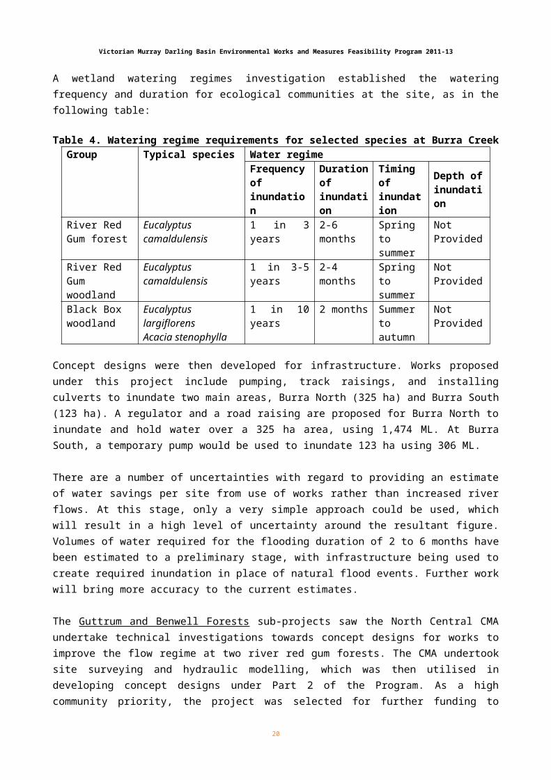
A wetland watering regimes investigation established the watering frequency and duration for ecological communities at the site, as in the following table:
Table 4. Watering regime requirements for selected species at Burra CreekGroup Typical species Water regime
Frequency ofinundation
Duration ofinundation
Timing ofinundation
Depth ofinundation
River RedGum forest
Eucalyptuscamaldulensis
1 in 3 years 2-6 months Spring tosummer
Not Provided
River RedGum woodland
Eucalyptuscamaldulensis
1 in 3-5 years 2-4 months Spring tosummer
Not Provided
15
Victorian Murray Darling Basin Environmental Works and Measures Feasibility Program 2011-13
Black Boxwoodland
Eucalyptus largiflorensAcacia stenophylla
1 in 10 years 2 months Summer toautumn
Not Provided
Concept designs were then developed for infrastructure. Works proposed under this project include pumping, track raisings, and installing culverts to inundate two main areas, Burra North (325 ha) and Burra South (123 ha). A regulator and a road raising are proposed for Burra North to inundate and hold water over a 325 ha area, using 1,474 ML. At Burra South, a temporary pump would be used to inundate 123 ha using 306 ML.
There are a number of uncertainties with regard to providing an estimate of water savings per site from use of works rather than increased river flows. At this stage, only a very simple approach could be used, which will result in a high level of uncertainty around the resultant figure. Volumes of water required for the flooding duration of 2 to 6 months have been estimated to a preliminary stage, with infrastructure being used to create required inundation in place of natural flood events. Further work will bring more accuracy to the current estimates. The Guttrum and Benwell Forests sub-projects saw the North Central CMA undertake technical investigations towards concept designs for works to improve the flow regime at two river red gum forests. The CMA undertook site surveying and hydraulic modelling, which was then utilised in developing concept designs under Part 2 of the Program. As a high community priority, the project was selected for further funding to undertake more detailed work under Part 2 of the Program (see sub-projects 9-10 below).
Sub-Project 7: Watering black box wetlands in Gunbower Forest National ParkThis sub-project has developed concept design options for infrastructure works to facilitate controlled flooding of the Gunbower National Park in the North Central CMA region. The objective of the proposed flood enhancement works is to achieve better environmental outcomes using less water. The project builds on to works currently being undertaken in the lower forest through the Living Murray Initiative.
Gunbower Forest spans 20,000 ha along the Murray River floodplain, near Cohuna and downstream of Echuca. It is an internationally important wetland and includes one of the most significant remaining areas of River Red Gun forest in Australia. It is also Australia’s largest inland island, bounded by the Murray to the north and Gunbower Creek to the south.
The forest is home to many endangered plants and animals, such as the Giant Banjo Frog and Intermediate Egret. It contains numerous sites of Aboriginal and post-settlement cultural heritage. These sites indicate people’s strong connection to the forest, both historically and today.
The health of the forest depends on regular flooding. River regulation for water supply has resulted in reduced frequency, duration and magnitude of flooding, particularly in the winter/spring period.
Through this program, the North Central CMA has investigated and developed options for the forest improvements in Gunbower National Park. The planned operation of the proposed flood enhancement works aims to achieve similar or better environmental outcomes using less water than previously estimated in planning processes, such as the Murray Darling Basin Plan.
16
Victorian Murray Darling Basin Environmental Works and Measures Feasibility Program 2011-13
The project’s main objective is to provide a more natural flooding regime to Gunbower Forest. The Gunbower National Park Flood Enhancement project will enhance the flooding of Gunbower Forest by supplying environmental water to the national park between Torrumbarry Weir and the Broken Axle Creek, a tributary of Spur Creek, near Munzel Corner. The flood enhancement works for Gunbower National Park will achieve the objective by enabling an inflow rate of up to 800 megalitres per day (ML/day).
Over the previous 12 months various packages of work were undertaken to increase knowledge and understanding of the Gunbower National Park and to contribute to the development of options for flood enhancement works. These works have included the building and calibrating of hydraulic models; soils investigations; geotechnical investigations; and concept design development of options for works. Some of the future flood enhancement work options are required to connect the Torrumbarry Weir pool to the Gunbower National Park and reinstate through flow within the upper forest.
The Gunbower National Park project has recently been provided with additional funding by the Australian Government. Subject to further assessment the project may proceed to produce detailed designs and ensure planning approvals are substantially complete by June 2015.
A key component of the next phases is to engage and consult with the community. Stakeholders have been involved in the development of options and significant additional engagement will occur with the relevant government department and approval authorities as well as the community.
The works associated with these projects are not yet selected for construction. The earliest construction will commence is mid 2016. Subject to further funding and progressing of the project, there will be ample time through the next phases of the SDL projects to thoroughly consult with interested parties.
Program Part 2 - Community Engagement Sub-projects
Sub-project 8: Belsar YungeraThis sub-project is a high community priority, and has developed functional designs for a ‘three-tiered’ approach to environmental watering, consisting of a primary option to target widespread flooding across much of the floodplain, secondary options which focus on improving the efficiency of flow being distributed across the floodplain, and further works targeting specific areas for additional flooding opportunities. Over 2,200 hectares of River Red Gum forest is expected to benefit from the proposed works.
Belsar and Yungera Islands are located approximately 30 km upstream of the Euston Weir near Robinvale in Victoria. These islands are formed from anabranches of the River Murray on the south side of the state border, and Narcooyia, Bonyaricall and Yungera Creeks help to define these islands.
Mallee CMA undertook a large study to investigate inundating this extensive (>2,000 ha) floodplain complex. Water savings for this site are derived from targeted flooding of a high value area using structures to divert and hold water. Under normal operations (without works), the area would only inundate from large, extended overbank flows in the Murray River. Flooding is required around once in three years, and
17
Victorian Murray Darling Basin Environmental Works and Measures Feasibility Program 2011-13
the structures will be used to replicate flood flows of at least 120,000 ML/d, using around 5,000 ML/d of passing flows diverted from the Murray by pump.
This is a significant River Red Gum and Black Box area that supports the vulnerable Regent Parrot, plus numerous other flora and fauna species listed as threatened under Victoria’s Flora and Fauna Guarantee Act 1998. The project has high potential water savings, and community and environmental value or benefit. Funding for this project will be used to undertake hydraulic modelling and concept designs.
Belsar and (to a lesser extent) Yungera Islands are influenced by the operation of the Euston Weir. The flow regime of Narcooyia and Bonyaricall Creeks has also been altered by the use of these waterways to maintain a supply of irrigation water to landholders in the area. Due to these influences, the flow patterns of Narcooyia, Bonyaricall, and Yungera Creeks have been significantly altered from those that were naturally occurring prior to river regulation. Furthermore, the current flooding patterns across the Belsar Yungera Floodplain Complex are not sufficient to meet the needs of ecosystems supporting the flora and fauna on the islands, which is evident from the tree condition in the mid to lower Narcooyia Creek Valley. These ecosystems also include Lakes Powell and Carpul, which rely on medium to high flows across Belsar Island to become inundated from natural flooding.
Investigations were undertaken by the CMA to identify a range of water management options to establish the key issues impacting the floodplain and reintroduction of an appropriate water regime to the Belsar Yungera Floodplain Complex. Functional designs were developed for the site that include a primary option to target widespread flooding across much of the floodplain, and secondary options which focus on improving the efficiency of flow being distributed across the floodplain, as well as targeting specific areas for additional flooding opportunities. The combination of the primary and secondary options provides a ‘three tiered’ flooding system and flow efficiency works, and relies entirely on pumped-in flows, possibly in addition to a natural flood if the timing is convenient.
Complementing the water management options were a series of on-ground investigations including surveying, geotechnical works, flora and fauna surveys, and cultural heritage to provide site design parameters and focus on impacts of works at the larger structure sites.
Final calculation of water savings from the project will be undertaken in conjunction with the Murray Darling Basin Authority using an approved methodology developed under the Basin Plan.
Sub-projects 9-10: Guttrum and Benwell Forests This sub-project developed concept designs for infrastructure to facilitate controlled flooding of two ecologically high value forests in the North Central CMA region. A range of technical investigations were undertaken to inform the concept designs for regulators and works at existing inlet and outlet channels to the forests, and connections with the Torrumbarry Irrigation Area. Benefits of the project include targeted watering and protection of over 1,500 hectares of significant River Red Gum communities.
Guttrum (1,151 ha) and Benwell (561 ha) State Forests are River Red Gum forests situated on the Murray River floodplain downstream of Koondrook. These floodplain ecosystems rely on flooding to maintain healthy communities. The forests are part of the mid-Murray River Red Gum forests and immediately downstream of the 17,600 ha Gunbower State Forest and the 32,000 ha Koondrook-Perricoota State Forest. They are also opposite the 3,100 ha Campbells Island State Forest located in NSW.
18
Victorian Murray Darling Basin Environmental Works and Measures Feasibility Program 2011-13
Guttrum and Benwell State Forests are managed by the Department of Environment and Primary Industries (DEPI). They are important for conservation, and available for timber harvesting, cattle grazing, dispersed camping, horse riding and firewood collection. Sand quarries are present in both forests. Agriculture (irrigated agriculture most dominant) and the environment closely connect in this region to achieve positive outcomes.
The Guttrum and Benwell forests are important components of the mid-Murray River Red Gum forests, which include sites recognised under the Ramsar convention. Both forests contribute habitat for vulnerable bird species which nest in River Red Gums at the western edge of Guttrum State Forest and at the southern edge of Benwell State Forest (DSE 2002). Reed Bed Swamp in Guttrum State Forest has provided extensive closed reed beds which, together with open water and marsh vegetation, have provided habitat for a wide range of birds. Many of the bird species reported from previous surveys have conservation significance at the state and national level.
River regulation has resulted in reductions in frequency, duration, and magnitude of flooding, particularly in the biologically important winter /spring period. It has been identified that options are required to improve the watering regime for the forests.
The objective for the sites is to provide a more natural flooding regime that will improve the environmental health of the forests. Options have been identified to achieve this objective, and concern construction of infrastructure (works and measures) to allow the delivery of environmental water to meet the shortfall of the flooding regimes. Such works aim to provide environmental benefit with the least amount of water possible.
Through this program, various packages of work were undertaken to increase knowledge of the forests and to contribute to the development of flood enhancement work options. This included topographic surveying; the building and calibrating of hydraulic models; soils investigations; ecological justification studies; and development of concept designs for infrastructure options.
A number of options for infrastructure to contribute to the flooding enhancement of the forests were developed. Identified works will be used to inform future selection of a preferred works package for the forests. Works primarily include new infrastructure, including flow control regulators and associated works within existing inlet/outlet channels along the banks of the Murray River and connections to the adjacent Torrumbarry Irrigation Area (No. 4 Channel) to control water in and out of each forest. Options have been developed based on the hydraulic conditions and ecological objectives for each forest.
The Guttrum and Benwell State Forests project has received additional funding from the Australian Government to develop the project further. Subject to further assessment the project may proceed to produce detailed designs and ensure planning approvals are substantially complete by June 2015.
A key component of the next phase is to engage and consult with the community. Stakeholders have been involved in the development of options and significant additional engagement will occur with the relevant government department and approval authorities as well as the community.
19
Victorian Murray Darling Basin Environmental Works and Measures Feasibility Program 2011-13
The works associated with these projects are not yet selected for construction. The earliest construction will commence is mid 2016. Subject to further funding and progressing of the project, there will be ample time through the next phases of the SDL projects to thoroughly consult with interested parties.
Sub-project 11: Gaynor’s Swamp This sub-project was pursued as a strong community priority project. Further upstream on the River Murray than the sub-projects above, this is a 303 hectare wetland site of high ecological value. The sub-project revised previous concept designs, undertook geotechnical investigations and hydraulic modelling, and completed detailed designs. Detailed designs for environmental watering infrastructure were prepared through this Program, and include a regulator in Cornella Creek and culverts in the Gaynor Swamp isolation bank.
Gaynor’s Swamp is a high value wetland of 303 ha in the Shepparton Irrigation Region, and 50km south west of Shepparton. The wetland forms part of the Wallenjoe Wetlands, listed on a Directory of Important Wetlands in Australia. The site is valued for its waterbird habitat, supporting thousands of waterbirds when it holds water, including international migratory species and the threatened Brolga. The wetland is connected to Cornella Creek (a wetland of bioregional significance) which provides important aquatic habitat for waterbirds and a number of native fish species – Australian smelt, Flat-headed gudgeon, Murray-Darling Rainbowfish, Southern pygmy perch and Flat-headed galaxid.
Through the Community Engagement phase of the Program, the site was identified as a high priority for infrastructure works to facilitate the delivery and management of environmental water to improve the wetland’s water regime.
Funds through this program were used to revise previous concept designs, undertake geotechnical investigations and hydraulic modelling, and complete detailed designs.
Gaynor Swamp predominately receives water when Lake Cooper fills and backs water up the Cornella Creek. Under natural conditions the wetland would have received water from the Cornella Creek 1 in every 3 years on average. However Lake Cooper is managed to control water levels within a range that balances flooding concerns, salinity and recreational needs. The wetland’s hydrology has been significantly modified through a combination of land forming, irrigation and regulation of the Cornella Creek, resulting in periods of prolonged inundation, high salinity, and more recently, periods of prolonged dry. This has altered the diversity and structure of the wetland’s vegetation communities, and led to River Red Gums deaths.
An earlier scoping study from 2010 identified that the most effective means of delivering the required environmental water to Gaynors Swamp was from the Waranga Main Channel (WMC) at Colbinabbin via the Cornella Creek. The study also identified that a diversion structure in Cornella Creek is required to raise the water level and direct it into Gaynor’s Swamp, and a second structure is needed through the isolation bank to provide sufficient conveyance into the swamp. There is an existing structure at the isolation bank, which is effective for controlling water levels but is undersized.
The design methodology undertaken through this Program consisted of two phases, concept design and detailed design. This concluded that the most feasible works for the site include a regulator on Cornella Creek at the entrance of Lake Cooper, culverts through the isolation bank at Gaynors Swamp, and a raised walkway for operational and pedestrian access. The regulating structure on Cornella Creek would allow
20

Victorian Murray Darling Basin Environmental Works and Measures Feasibility Program 2011-13
water levels in the Creek to be raised to 105.0 AHD and have the same flow capacity as the existing opening to minimise the impact on natural flood levels.
Infrastructure was refined from the concept stage to the detailed design stage in consultation with a project steering group with representatives from government agencies, interest groups and local landholders.
When complete, these works will inundate approximately 250 ha (82%) of the wetland to various depths up to 500 mm. Deliveries of up to 300 ML/d down the Cornella Creek for 5-7 days will fill the wetland to the desired height of 105.0 m AHD.
Sub-project 12: St Leonards WetlandThe St Leonards sub-project differs from those above in that it primarily aims to dry a high value site that receives too much water from regulated flows. Although only 6 hectares in size, it is one of many sites below Lake Hume that receive too much water at the wrong time of the year. The project was selected through part 2 of the Program for a feasibility study due to its high environmental and community values, and potential for water savings. Works proposed are a regulator to exclude high summer flows from the site.
St Leonards Wetland is situated on the River Murray floodplain near the township of Rutherglen. The wetting - drying cycle of this wetland is controlled by releases from Lake Hume and the subsequent river levels in the Murray system. This wetland experiences near permanent inundation due to the connectivity having been seasonally shifted by river regulation.
The site is of bioregional significance, and provides habitat for River Red Gum and Silver Wattle forest, state-listed vulnerable Musk Duck, Australasian Shoveler, and endangered Growling Grass Frog. A CAMBA conservation status also exists at the site for White-bellied Sea Eagle.
It is proposed that a regulating structure be installed to exclude high summer flows and re-instate a drying regime to the wetland. This would aim to improve the current environmental condition of the wetland, whilst also generating water savings.
There are two siting options for installing a regulating structure at St Leonards Wetland. The cost estimates for installing these are similar, however more detailed investigation is required to determine which option is more suitable. Both options also require a bank to exclude water to a height of 131 m AHD. This height has been calculated to exclude flows of up to 25,000ML/d, which is the current maximum that can be released from Lake Hume. Flows above this level would top the structure(s), as well as entering the wetland through other flow paths during flood conditions.
There is further work and investigations that are required before a detailed design should be undertaken. These include a Geotechnical Investigation, a Groundwater Permeability Assessment, Cultural Heritage Assessments, and an Environmental and Offsets Assessment.
21
Victorian Murray Darling Basin Environmental Works and Measures Feasibility Program 2011-13
Local engagement with community groups and the adjacent winery has been on-going. We are seeking their continued support in the project and envisage the site could be used for education purposes to showcase the benefit of returning seasonality to the watering regime.
22