
Verification of data in GIS Management System for State ...
7
TS02I - State Land Management, 6063 1/7 Dorota LATOS, Marcin LATOS, Marcin GALUSZKIEWICZ, Pawel KAMIŃSKI, Poland Verification of data in GIS Management System for State Real Estate FIG Working Week 2012 Knowing to manage the territory, protect the environment, evaluate the cultural heritage Rome, Italy, 6-10 May 2012 Verification of data in GIS Management System for State Real Estate Dorota LATOS, Marcin LATOS, Marcin GALUSZKIEWICZ, Pawel KAMIŃSKI, Poland Key words: verification, data, management system, real estate At present, GIS is being used in all fields of economic activity and administration. Its functionality combines spatial object, described by various attributes, with its location in geographical space. The superiority of GIS technology lies in its spatial, qualitative and quantitative ability, all in one and consistent with each other. Many people have recognized the value of GIS solutions, and used them on a daily basis. Therefore, the number of GIS users grows year by year. One of many possible applications of GIS is the management system for real estate. The authors of the paper work on a prototype of GIS management system for the State’s immovable (called the SZaNP System, for Police own real estate). This system requires combining data from many sources: local data that was used before the SZaNP implementation (i.e. MS Excell files), the Land Administration System data (i.e. the data concerning a parcel or a building, the owner and property rights) as well as the data concerning the costs of real estate management (in a form of indicative figures and values in relation to months and years). As it is commonly known – the most important component of any GIS system is data. If quality of data (precision, completeness, timeliness) does not meet the requirements, there is high level of risk that the results given by the system will not be acceptable. Therefore in every GIS implementation data has to be cross-checked and carefully examined before and after loading to a data server. Verification of the data is especially crucial when data is gathered from many different origins of various formats. With SZaNP System it was planned to verify data twice. The first verification took place before loading data to the system. It was mainly the field control where the gathered data was checked against its completeness. Additionally, geodetic surveys were carried out and final data became spatially enhanced. The second data verification should be performed after migration to the data server. This time the main focus of inspection should refer to the data structure correctness: geodatabase records and relationships should be checked, only then the most important and critical deficiencies might be reported.
Transcript of Verification of data in GIS Management System for State ...
TS02I - State Land Management, 6063 1/7 Dorota LATOS, Marcin LATOS, Marcin GAŁUSZKIEWICZ, Paweł KAMIŃSKI, Poland Verification of data in GIS Management System for State Real Estate FIG Working Week 2012 Knowing to manage the territory, protect the environment, evaluate the cultural heritage Rome, Italy, 6-10 May 2012
Verification of data in GIS Management System for State Real Estate
Dorota LATOS, Marcin LATOS, Marcin GAŁUSZKIEWICZ, P aweł KAMI ŃSKI, Poland
Key words: verification, data, management system, real estate At present, GIS is being used in all fields of economic activity and administration. Its functionality combines spatial object, described by various attributes, with its location in geographical space. The superiority of GIS technology lies in its spatial, qualitative and quantitative ability, all in one and consistent with each other. Many people have recognized the value of GIS solutions, and used them on a daily basis. Therefore, the number of GIS users grows year by year. One of many possible applications of GIS is the management system for real estate. The authors of the paper work on a prototype of GIS management system for the State’s immovable (called the SZaNP System, for Police own real estate). This system requires combining data from many sources: local data that was used before the SZaNP implementation (i.e. MS Excell files), the Land Administration System data (i.e. the data concerning a parcel or a building, the owner and property rights) as well as the data concerning the costs of real estate management (in a form of indicative figures and values in relation to months and years). As it is commonly known – the most important component of any GIS system is data. If quality of data (precision, completeness, timeliness) does not meet the requirements, there is high level of risk that the results given by the system will not be acceptable. Therefore in every GIS implementation data has to be cross-checked and carefully examined before and after loading to a data server. Verification of the data is especially crucial when data is gathered from many different origins of various formats. With SZaNP System it was planned to verify data twice. The first verification took place before loading data to the system. It was mainly the field control where the gathered data was checked against its completeness. Additionally, geodetic surveys were carried out and final data became spatially enhanced. The second data verification should be performed after migration to the data server. This time the main focus of inspection should refer to the data structure correctness: geodatabase records and relationships should be checked, only then the most important and critical deficiencies might be reported.
TS02I - State Land Management, 6063 2/7 Dorota LATOS, Marcin LATOS, Marcin GAŁUSZKIEWICZ, Paweł KAMIŃSKI, Poland Verification of data in GIS Management System for State Real Estate FIG Working Week 2012 Knowing to manage the territory, protect the environment, evaluate the cultural heritage Rome, Italy, 6-10 May 2012
Verification of data in GIS Management System for State Real Estate
Dorota LATOS, Marcin LATOS, Marcin GAŁUSZKIEWICZ, P aweł KAMI ŃSKI, Poland
1. INTRODUCTION
In the process of making GIS management system for real estates a very important role is paid to the aspect of data. Data forms the basis of the system. Reports, analysis any calculations are possible due to data processing. Determination of data sources is a crucial part also the unification and verification. The article will explain the process of data verification. The process itself can be understood in either of two ways: as an internal control of data coherence (database verification) and as the check for the actual state (field verification) using global positioning system (GPS) receivers. The purpose of the verification was to deliver the data which was accurately georeferenced, contained complete attribute tables and proper topology, only than the data could be used. 2. FIELD VERIFICATION ASSUMPTIONS
The main source of information about a real estate is the data concerning the objects on it. Valuable information relates to types of the buildings, area they occupy, the expenditures and other features. Key condition for data management is topology. The SZaNP system anticipates the visualisation of the data as well as the results of analysis in graphic form – i.e maps (ortophotomaps, and information maps). The main element of the verification (considering the system’s structure) is a building (a record in the data base) on a particular parcel. The main assumptions of the verification are:
• 98 real estates were field verified. The files received form the Police departments included 203 buildings. Properties, chosen at random, had various property rights (70% in permanent management, 30 % dependent possession)
• the chosen objects were to be located evenly on a voivodeship area • there should be at least a few objects of official use
• the objects for verification should be buildings and parcels • field verification should include various object types (gas station, offices)
• land survey concerned precise localisation of the buildings and parcels [4] 3. THE USED DATA For the purpose of the verification the authors used the data gathered in the Excell files, received from the Police departments and data from the State’s committee of Land and Cartography as well as the data from www.geoportal.gov.pl ; www.igeomap.pl.
TS02I - State Land Management, 6063 3/7 Dorota LATOS, Marcin LATOS, Marcin GAŁUSZKIEWICZ, Paweł KAMIŃSKI, Poland Verification of data in GIS Management System for State Real Estate FIG Working Week 2012 Knowing to manage the territory, protect the environment, evaluate the cultural heritage Rome, Italy, 6-10 May 2012
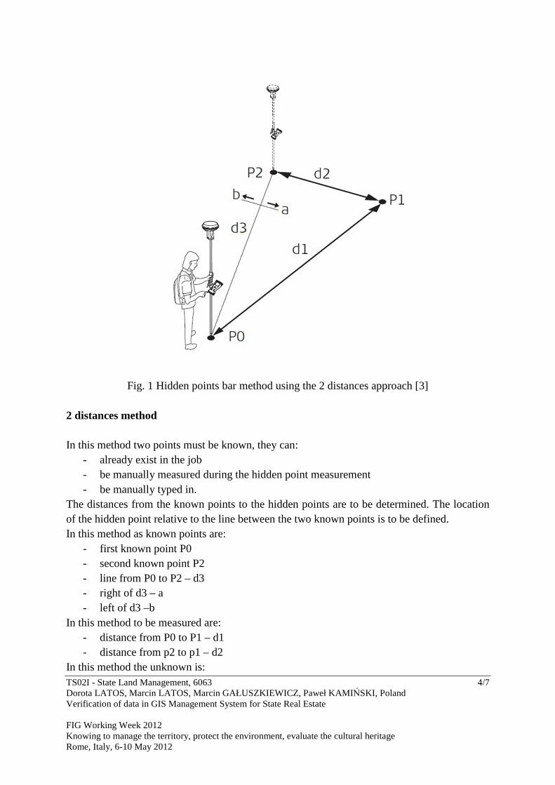
4. SURVEYING METHODS One of the land surveying methods is GNSS RTK. GNSS RTK surveying was done using the ASG-EUPOS reference stations. ASG-EUPOS is a multifunctional satellite positioning system based on ground network of GNSS reference stations. ASG-EUPOS is a part of European system EUPOS. The system consists of 98 permanent stations evenly distributed over the area of Poland, located in scientific institutions or in Geodetic and Cartographic Inventory Departments. Mean distance between the stations is 70 km. ASG-EUPOS is fully operational since June 2008. [1] However, this surveying method is less efficient in case of poor satellite visibility. During the field verification many objects were impossible to be surveyed through GNSS RTK technology. Generally, in visibly restricted areas hidden points bar method is applied. Special advantages of the method are that the target point does not have to be visible from the measurement instruments. The method concerns the use of points of known coordinates (auxiliary points) and calculating distances or the slant angles. The surveying was done using Lecia Viva GNSS and laser range finder Leica Disto a5. Leica Viva GNSS instrument enables measuring:
- the distance and the bearing - 2 bearings - 2 distances - chainage and offset - backwards bearing and distance
To measure the building corners 2 distances method was used, as presented in figure 1.
TS02I - State Land Management, 6063 4/7 Dorota LATOS, Marcin LATOS, Marcin GAŁUSZKIEWICZ, Paweł KAMIŃSKI, Poland Verification of data in GIS Management System for State Real Estate FIG Working Week 2012 Knowing to manage the territory, protect the environment, evaluate the cultural heritage Rome, Italy, 6-10 May 2012
Fig. 1 Hidden points bar method using the 2 distances approach [3] 2 distances method In this method two points must be known, they can:
- already exist in the job - be manually measured during the hidden point measurement - be manually typed in.
The distances from the known points to the hidden points are to be determined. The location of the hidden point relative to the line between the two known points is to be defined. In this method as known points are:
- first known point P0 - second known point P2 - line from P0 to P2 – d3 - right of d3 – a - left of d3 –b
In this method to be measured are: - distance from P0 to P1 – d1 - distance from p2 to p1 – d2
In this method the unknown is:
TS02I - State Land Management, 6063 5/7 Dorota LATOS, Marcin LATOS, Marcin GAŁUSZKIEWICZ, Paweł KAMIŃSKI, Poland Verification of data in GIS Management System for State Real Estate FIG Working Week 2012 Knowing to manage the territory, protect the environment, evaluate the cultural heritage Rome, Italy, 6-10 May 2012
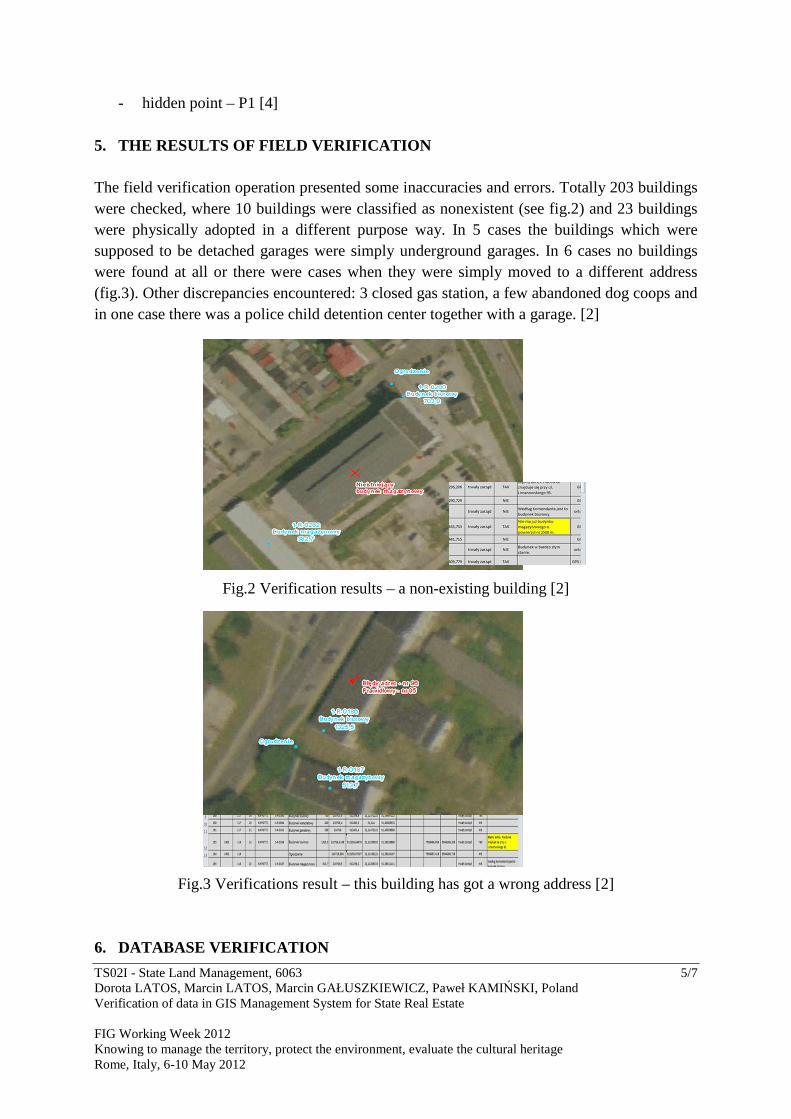
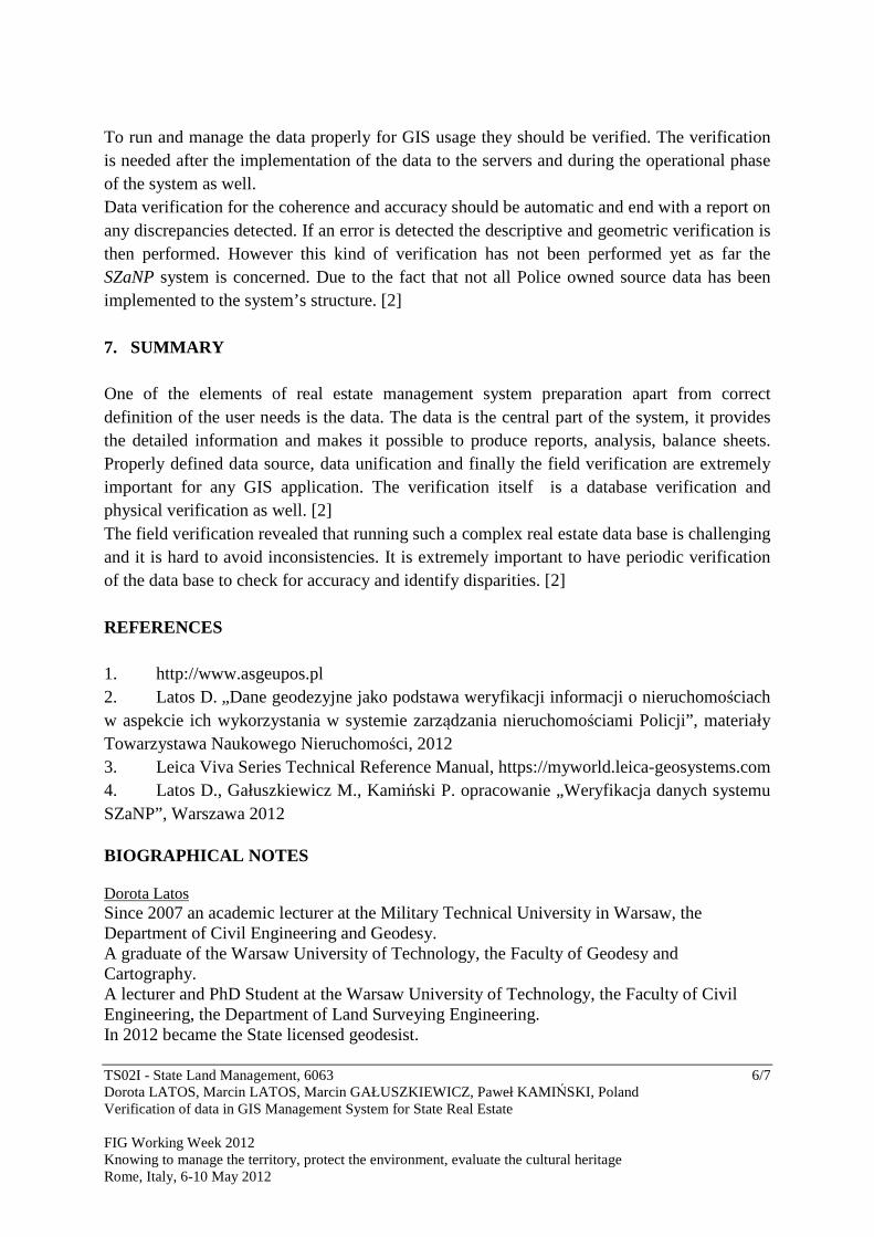
- hidden point – P1 [4] 5. THE RESULTS OF FIELD VERIFICATION The field verification operation presented some inaccuracies and errors. Totally 203 buildings were checked, where 10 buildings were classified as nonexistent (see fig.2) and 23 buildings were physically adopted in a different purpose way. In 5 cases the buildings which were supposed to be detached garages were simply underground garages. In 6 cases no buildings were found at all or there were cases when they were simply moved to a different address (fig.3). Other discrepancies encountered: 3 closed gas station, a few abandoned dog coops and in one case there was a police child detention center together with a garage. [2]
Fig.2 Verification results – a non-existing building [2]
Fig.3 Verifications result – this building has got a wrong address [2] 6. DATABASE VERIFICATION
TS02I - State Land Management, 6063 6/7 Dorota LATOS, Marcin LATOS, Marcin GAŁUSZKIEWICZ, Paweł KAMIŃSKI, Poland Verification of data in GIS Management System for State Real Estate FIG Working Week 2012 Knowing to manage the territory, protect the environment, evaluate the cultural heritage Rome, Italy, 6-10 May 2012
To run and manage the data properly for GIS usage they should be verified. The verification is needed after the implementation of the data to the servers and during the operational phase of the system as well. Data verification for the coherence and accuracy should be automatic and end with a report on any discrepancies detected. If an error is detected the descriptive and geometric verification is then performed. However this kind of verification has not been performed yet as far the SZaNP system is concerned. Due to the fact that not all Police owned source data has been implemented to the system’s structure. [2] 7. SUMMARY One of the elements of real estate management system preparation apart from correct definition of the user needs is the data. The data is the central part of the system, it provides the detailed information and makes it possible to produce reports, analysis, balance sheets. Properly defined data source, data unification and finally the field verification are extremely important for any GIS application. The verification itself is a database verification and physical verification as well. [2] The field verification revealed that running such a complex real estate data base is challenging and it is hard to avoid inconsistencies. It is extremely important to have periodic verification of the data base to check for accuracy and identify disparities. [2] REFERENCES 1. http://www.asgeupos.pl 2. Latos D. „Dane geodezyjne jako podstawa weryfikacji informacji o nieruchomościach w aspekcie ich wykorzystania w systemie zarządzania nieruchomościami Policji”, materiały Towarzystawa Naukowego Nieruchomości, 2012 3. Leica Viva Series Technical Reference Manual, https://myworld.leica-geosystems.com 4. Latos D., Gałuszkiewicz M., Kamiński P. opracowanie „Weryfikacja danych systemu SZaNP”, Warszawa 2012 BIOGRAPHICAL NOTES Dorota Latos Since 2007 an academic lecturer at the Military Technical University in Warsaw, the Department of Civil Engineering and Geodesy. A graduate of the Warsaw University of Technology, the Faculty of Geodesy and Cartography. A lecturer and PhD Student at the Warsaw University of Technology, the Faculty of Civil Engineering, the Department of Land Surveying Engineering. In 2012 became the State licensed geodesist.

TS02I - State Land Management, 6063 7/7 Dorota LATOS, Marcin LATOS, Marcin GAŁUSZKIEWICZ, Paweł KAMIŃSKI, Poland Verification of data in GIS Management System for State Real Estate FIG Working Week 2012 Knowing to manage the territory, protect the environment, evaluate the cultural heritage Rome, Italy, 6-10 May 2012
CONTACTS MSc. Dorota Latos Military University of Technology Faculty of Civil Engineering and Geodesy 2 S.Kaliskiego Street 00-908 Warsaw Poland Tel: +48-22-6837887 Fax: +48-22-6839569 Email: [email protected]


