Verges Et Al 2007 Pampeanas Precordi
22
Crustal wedging triggering recent deformation in the Andean thrust front between 31 S and 33 S: Sierras Pampeanas-Precordillera interaction J. V er ge ´ s, 1 V. A. Ramos, 2 A. Meigs, 3 E. Cristallini, 2 F. H. Bettini, 4 and J. M. Corte ´ s 2 Received 13 January 2006; revised 16 October 2006; accepted 15 November 2006; published 1 March 2007. [1] We document a new model of crustal structure of the Andean front in Argentina where numerous historic earthquakes destroyed the cities of Mendoza in 1861 ( M s = 7) and San Juan in 1944 ( M w = 7.0). The Cerro Salinas anticline is formed above the west directed Cerro Salinas thrust. An east facing monocline with an amplitude of about 2 km folds the Cerro Salinas thrust and overlying Neogene succession. This monocline is formed above a blind crustal thrust in the basement. Its dip of 14 west is inferred from fold geometry. This thick-skinned east directed blind thrust and the thin-skinned west directed Cerro Salinas thrust define a tectonic wedge; the wedge tip occurs at a depth of 5.4 km. Growth of the monocline after 8.5 Ma is revealed on multichannel seismic (MSC) profile 31017 (Repsol-YPF). Rates of Cerro Salinas thrust displacement are of the order of 1 mm/yr, whereas vertical uplift of 0.45 mm/yr results from the combined displacement on the Cerro Salinas thrust and growth of east facing monocline. The lateral extent of the east directed crustal blind ramp corresponds with the along-strike extent of the Eastern Precordillera. When combined with the low displacement rate, a long earthquake recurrence interval is implied. Smaller magnitude earthquakes, however, indicate that segments of the blind thrust ramps ruptured in historic events. If all the segments of the blind thrust ruptured together the fault area is 7000 km 2 and could produce a M w 7.7 earthquake. The crustal wedge model provides new constraints on the origin and potential size of earthquakes that threaten the densely populated region. Citation: Verge ´s, J., V. A. Ramos, A. Meigs, E. Cristallini, F. H. Bettini, and J. M. Corte ´s (2007), Crustal wedging triggering recent deformation in the Andean thrust front between 31 S and 33 S: Sierras Pampeanas-Precordillera interaction, J. Geophys. Res. , 112, B03S15, doi:10.1029/2006JB004287. 1. Introduc tion [2] Act ive deformation alo ng the front of the Ande s in Argentina between 30 30 0 S and 32 30 0 S is characterized by the interaction between thin-skinned and thick thrust fault domains [ Jordan and Allmendinger , 1986]. Major structural provinces are the west directed Sierras Pampeanas to the east, the west directed Eastern Precordillera in the center, and the east direc ted Centr al Preco rdill era thin-ski nned thrust belt to the west (Figure 1). Structures inherited from Paleo zoic and older times are preserved in the crust beneath this frontal part of the Andes [e.g., Cominguez and Ramos, 1991; Astini et al., 1995]. [3] Basemen t-inv olved struct ures of the Sierra s Pampea- nas formed above the southern part of the flat subduction segment Nazc a pla te [ Isacks et al., 198 2; Jor dan et al. , 1983; Smalley and Isacks, 1987] (inset in Figure 1). Onset of flat slab subduction is indicated by deformation in the Sierras Pampeanas and cessation of vol canic acti vit y between latitudes 27 S and 33 S after 7 Ma [e.g., Kay and Abbru zzi , 1996]. Both the thin-skinne d Precordiller a and thick-skinned Sierras Pampeanas structures between the city of San Juan in the north and the city of Mendoza in the sout h show evidence of acti ve deformation, includi ng widespread deformation of Quaternary deposits and recent devastating earthquakes [Costa and Vita-Finzi, 1996; Costa et al., 1999, 2000] (Figure 1). The city of Mendoz a (pr esently with 1,025,000 inhabit ants ) was dest royed in 1861 by a M s = 7 ear thquake [ Instituto Nacional de Preve ncio ´n Sı ´smica (INPRES), 1995] and the city of San Juan (presently with 350,000 inhabitants) was also ruined in 1944 by an earthquake of M w = 7.0 [Castellanos , 1944; Groeber , 194 4; Alva rad o and Bec k , 2006]. The seismi c hazard in this segment of the front of the Andes is still significant as demonstrated by recent important earthquakes with M s over 7.0 damaging the city of Caucete in 1977 JOURNAL OF GEOPHYSICAL RESEARCH, VOL. 112, B03S15, doi:10.1029/2006JB004287, 2007 Click Here for Full A rticle 1 Group of Dynamic s of the Lithos phere, Instit ute of Earth Scienc es ‘ ‘Jaume Almera’ ’, Conse jo Super ior de Inves tigac iones Cient ı ´ficas, Barcelona, Spain. 2 Laboratorio de Tecto ´nica Andina, Departamento de Ciencias G eolo ´- gicas , Univer sidad de Buenos Aires, Buenos Aires , Argent ina. 3 Depa rtment of Geos cie nces , Oregon Sta te Univ ers ity , Corv all is, Oregon, USA. 4 Repsol-YPF, Buenos Aires, Argentina. Copyri ght 2007 by the American Geophysic al Union. 0148-0227/07/2006JB004287$09.00 B03S15 1 of 22
-
Upload
acosta-gerardo -
Category
Documents
-
view
215 -
download
0
Transcript of Verges Et Al 2007 Pampeanas Precordi

7/27/2019 Verges Et Al 2007 Pampeanas Precordi
http://slidepdf.com/reader/full/verges-et-al-2007-pampeanas-precordi 1/22
Crustal wedging triggering recent deformation in the Andean
thrust front between 31S and 33S:
Sierras Pampeanas-Precordillera interaction
J. Verges,1 V. A. Ramos,2 A. Meigs,3 E. Cristallini,2 F. H. Bettini,4 and J. M. Cortes2
Received 13 January 2006; revised 16 October 2006; accepted 15 November 2006; published 1 March 2007.
[1] We document a new model of crustal structure of the Andean front in Argentina wherenumerous historic earthquakes destroyed the cities of Mendoza in 1861 ( M
s = 7) and
San Juan in 1944 ( M w
= 7.0). The Cerro Salinas anticline is formed above the west directed Cerro Salinas thrust. An east facing monocline with an amplitude of about 2 kmfolds the Cerro Salinas thrust and overlying Neogene succession. This monocline isformed above a blind crustal thrust in the basement. Its dip of 14 west is inferred fromfold geometry. This thick-skinned east directed blind thrust and the thin-skinned west directed Cerro Salinas thrust define a tectonic wedge; the wedge tip occurs at a depth of 5.4 km. Growth of the monocline after 8.5 Ma is revealed on multichannel seismic
(MSC) profile 31017 (Repsol-YPF). Rates of Cerro Salinas thrust displacement are of theorder of 1 mm/yr, whereas vertical uplift of 0.45 mm/yr results from the combineddisplacement on the Cerro Salinas thrust and growth of east facing monocline. The lateralextent of the east directed crustal blind ramp corresponds with the along-strike extent of the Eastern Precordillera. When combined with the low displacement rate, a longearthquake recurrence interval is implied. Smaller magnitude earthquakes, however,indicate that segments of the blind thrust ramps ruptured in historic events. If all thesegments of the blind thrust ruptured together the fault area is 7000 km2 and could produce a M
w 7.7 earthquake. The crustal wedge model provides new constraints on the
origin and potential size of earthquakes that threaten the densely populated region.
Citation: Verges, J., V. A. Ramos, A. Meigs, E. Cristallini, F. H. Bettini, and J. M. Cortes (2007), Crustal wedging triggering recent
deformation in the Andean thrust front between 31S and 33S: Sierras Pampeanas-Precordillera interaction, J. Geophys. Res., 112,
B03S15, doi:10.1029/2006JB004287.
1. Introduction
[2] Active deformation along the front of the Andes inArgentina between 30300S and 32300S is characterized bythe interaction between thin-skinned and thick thrust fault domains [ Jordan and Allmendinger , 1986]. Major structural
provinces are the west directed Sierras Pampeanas to theeast, the west directed Eastern Precordillera in the center,and the east directed Central Precordillera thin-skinnedthrust belt to the west (Figure 1). Structures inherited fromPaleozoic and older times are preserved in the crust beneaththis frontal part of the Andes [e.g., Cominguez and Ramos,
1991; Astini et al., 1995].
[3] Basement-involved structures of the Sierras Pampea-nas formed above the southern part of the flat subductionsegment Nazca plate [ Isacks et al., 1982; Jordan et al.,1983; Smalley and Isacks, 1987] (inset in Figure 1). Onset of flat slab subduction is indicated by deformation in theSierras Pampeanas and cessation of volcanic activity
between latitudes 27S and 33S after 7 Ma [e.g., Kayand Abbruzzi, 1996]. Both the thin-skinned Precordilleraand thick-skinned Sierras Pampeanas structures between thecity of San Juan in the north and the city of Mendoza in thesouth show evidence of active deformation, includingwidespread deformation of Quaternary deposits and recent
devastating earthquakes [Costa and Vita-Finzi, 1996; Costaet al., 1999, 2000] (Figure 1). The city of Mendoza(presently with 1,025,000 inhabitants) was destroyed in1861 by a M s = 7 earthquake [ Instituto Nacional de
Prevencion Sısmica (INPRES), 1995] and the city of SanJuan (presently with 350,000 inhabitants) was also ruined in1944 by an earthquake of M w = 7.0 [Castellanos, 1944;Groeber , 1944; Alvarado and Beck , 2006]. The seismichazard in this segment of the front of the Andes is stillsignificant as demonstrated by recent important earthquakeswith M s over 7.0 damaging the city of Caucete in 1977
JOURNAL OF GEOPHYSICAL RESEARCH, VOL. 112, B03S15, doi:10.1029/2006JB004287, 2007Click Here
for
Full A rticle
1Group of Dynamics of the Lithosphere, Institute of Earth Sciences‘‘Jaume Almera’’, Consejo Superior de Investigaciones Cientıficas,Barcelona, Spain.
2Laboratorio de Tectonica Andina, Departamento de Ciencias G eolo-gicas, Universidad de Buenos Aires, Buenos Aires, Argentina.
3Department of Geosciences, Oregon State University, Corvallis,Oregon, USA.
4Repsol-YPF, Buenos Aires, Argentina.
Copyright 2007 by the American Geophysical Union.0148-0227/07/2006JB004287$09.00
B03S15 1 of 22

7/27/2019 Verges Et Al 2007 Pampeanas Precordi
http://slidepdf.com/reader/full/verges-et-al-2007-pampeanas-precordi 2/22
Figure 1. Tectonic map of the front of the Andes between latitudes 30S and 33S showing theinteractions between west directed Sierras Pampeanas and Eastern Precordillera and east directed CentralPrecordillera tectonic domains. Location of cross sections, seismic lines, regional profiles, and the map of Figure 2 are shown. The inset map shows the Sierras Pampeanas in black formed between 27S and 33Sabove a flat subduction segment. Black and white arrows are the relative convergence rates (in mm/yr)following NUVEL-1 [ DeMets et al., 1990] and GPS data [ Kendrick et al., 1999].
B03S15 VERGES ET AL.: CRUSTAL WEDGE AND ACTIVE ANDES FRONT
2 of 22
B03S15

7/27/2019 Verges Et Al 2007 Pampeanas Precordi
http://slidepdf.com/reader/full/verges-et-al-2007-pampeanas-precordi 3/22
( M s
= 7.4) and 1978 [e.g., INPRES , 1982; Kadinsky-Cade et al., 1985].
[4] Although the Precordillera and Sierras Pampeanas boundary has been the focus of several studies, the crustal-scale structure is still controversial due to the lack of available subsurface information. The Cerro Salinas, inter-
preted as the southernmost outcrop of the Western SierrasPampeanas, displays excellent surface outcrops for both
Neogene and Quat ernary depo sits as well as old, but relatively good, seismic coverage provided by Repsol-YPFcompany. The study of this region is thus of great interest tounravel the structure of this complex region.
[5] We integrate in this work surface and subsurfacegeology together with geomorphology around the CerroSalinas anticline. The interpretation of seismic lines, theanalysis of growth strata patterns within the upper part of the Neogene infill of the proximal Jocolı foreland basin, andinterpretation of deformed geomorphic surfaces are com-
bined (1) to characterize the shallow and deep structure of the southernmost end of the Eastern Precordillera (latitude32S); (2) to constrain the timing of tectonic shortening;(3) to characterize interaction between the Sierras Pampeanas
and the Precordillera; and (4) to develop a regional modelfor crustal deformation and seismogenic sources along a200-km-long segment of the front of the Andes between thecities of San Juan and Mendoza. Our new model for crustalstructure fits well with a large number of geological andgeomorphic observables and provides a new perspective onthe origin and potential size of earthquakes that threaten thisdensely populated region of western Argentina.
2. Western Sierras Pampeanas andPrecordillera Structure
[6] The Cenozoic structure of the front of the Andes between the cities of San Juan and Mendoza (30300S and
32300S) comprises two opposed thrust systems [e.g., Ramos, 1988]. The Western Sierras Pampeanas and theEastern Precordillera are underlain by west directed thrust systems whereas the Central Precordillera shows east di-rected thrusting (Figure 1) [ Figueroa and Ferraris, 1989;von Gosen, 1992; Ramos et al., 1997]. The Eastern Pre-cordillera dies to the north of 30300S and beneath the east directed Central Precordillera at 32300S to the south at Sierra de las Penas front [Costa et al., 2000] (Figure 1). TheSierras Pampeanas between 30S and 32S are defined bythe Sierra de Valle Fertil to the east, the Sierra de Pie dePalo, and by a succession of relatively small hills aligned
NNE-SSW, including the Cerro Barbosa and Cerro Valdivia(Figure 1).
[7] Late Cenozoic deformation across Sierras Pampeanas,Eastern Precordillera and Central Precordillera is wellknown. This Cenozoic deformation overprints a record a
prolonged Paleozoic collisional characterized by the com- plex accretion of different terranes preserved below anunconformity at the base of the Neogene foreland basindeposits [e.g., Furque and Cuerda, 1979; Ramos, 1988].Reactivation of these older structures and their control of the Tertiary deformation is now being studied in more detail[e.g., Alonso et al., 2005; Pinan-Llamas and Simpson,2006]. From Cambrian to Late Ordovician times the oceaniclithosphere at the eastern margin of the Precordillera terrane
subducted to the east beneath Gondwana deforming itsmargin by west directed tectonic imbricates involving both
basement and cover rocks that formed a foredeep basinthickening to the east [e.g., Astini et al., 1995]. A flip in thesubduction direction from east to west took place at LateOrdovician times with the subduction of the western bound-ary of the Precordillera terrane, which produced an east directed thrust system mostly involving Silurian and Devo-
nian deep marine flysch deposits filling a foredeep basinthat thickened to the west [Gonzalez Bonorino, 1973].
[8] The west directed thrust imbricate system is wellrecognized in the Sierra de Pie de Palo where different tectonic slices carrying Grenvillian age basement and low-grade Neoproterozoic metamorphic cover rocks show a topto the west motion on top of each other [Galindo et al.,2004]. These imbricates overthrust Cambrian carbonates of the Caucete Group above the basal Pirquitas thrust exposedalong the western flank of the Sierra de Pie de Palo. Thisthrust may represent the western boundary of the SierrasPampeanas during Early Paleozoic times [Galindo et al.,2004]. Deformation in the Paleozoic collisional systemmigrated to the west [e.g., Vujovich and Ramos, 1994;
Pankhurst et al., 1998; Ramos et al., 1998; Ramos and Vujovich, 2000]. Structures related with these imbricatethrust systems are unconformably overlain by Carbonifer-ous continental deposits [ Ramos et al., 1986; Ramos and Vujovich, 2000]. Crustal structure established in the Paleo-zoic therefore exerts a strong control on the present inter-action between the thin-skinned Andean thrust front on thewest and structures in the east in the Eastern Precordilleraand Sierras Pampeanas that involve Early Paleozoic andolder rocks.
3. Cerro Salinas Anticline
[9] Eastern Precordilleran structures occur in a narrow
belt 200 km long extending from San Juan on the north tothe north of Mendoza on the south (Figures 1 and 2). CerroSalinas, the southernmost thrust sheet of the Eastern Pre-cordillera, is a relatively small hill mostly formed by theresistant outcrops of Late Proterozoic-Cambrian rocks.These comprise thin marbles and schists of the CauceteGroup, with total structural thickness of 500 m, whichwere tectonically repeated by west directed imbricate thrustsduring the Paleozoic [Cominguez and Ramos, 1991](Figure 3b). The basal thrust of these imbricates is difficult to observe in the field but appears to cut gently folded
Neogene strata along the western front of the Cerro Salinas[Cominguez and Ramos, 1991]. A highly asymmetric west verging anticline characterizes Neogene strata along strike
to the south of the Cerro Salinas (Figure 2). The 45, west dipping forelimb is narrow whereas the backlimb is morethan 6 km wide and dips between 23 and 30 to the east (Figure 3c). Thickness of the exposed Neogene section inthe backlimb of the anticline is 1850 m. This Neogenesequence onlaps the Paleozoic imbricates on the east side of Cerro Salinas, which indicates that a paleotopographic highexisted prior to Neogene deposition. To the east and southof the Cerro Salinas, folded and thrusted Quaternary terra-ces are preserved and help to unravel the character of recent deformation. Clearly the Paleozoic faults were reactivated in
B03S15 VERGES ET AL.: CRUSTAL WEDGE AND ACTIVE ANDES FRONT
3 of 22
B03S15

7/27/2019 Verges Et Al 2007 Pampeanas Precordi
http://slidepdf.com/reader/full/verges-et-al-2007-pampeanas-precordi 4/22
Figure 2. Tectonic and geomorphic map of the west Sierras Pampeanas-Precordillera interaction at Cerro Salinas with location of seismic profiles and exploratory oil wells (labeled as W-A, W-B, andW-C). See the locations of satellite images in Figures 3a and 7a. MCS profile 31017 continues 9 km to theeast across the undeformed Jocolı foreland basin. An interpretation of MCS profile 5377 across theMontecitos anticline is shown in Figure 9. The rivers flow from west to east over large alluvial fans.
B03S15 VERGES ET AL.: CRUSTAL WEDGE AND ACTIVE ANDES FRONT
4 of 22
B03S15

7/27/2019 Verges Et Al 2007 Pampeanas Precordi
http://slidepdf.com/reader/full/verges-et-al-2007-pampeanas-precordi 5/22
the Neogene and shortening on them continues to the present.
[10] Folded and faulted Quaternary terraces demonstratethat the scale of the active Cerro Salinas anticline is muchlarger than implied by the relatively limited outcrop belt of the rocks of the Caucete Group (Figures 3c and 3d). Wedescribe in the following section the geomorphology aroundthe Cerro Salinas anticline and its structure through acombination of surface and subsurface data, with emphasison the surface expression of folding around and south of theCerro Salinas, which is more clearly expressed than it is to
the north of it. The northern continuation of the CerroSalinas anticline, more than 40 km along strike, is affected
by NNE-SSW to N-S trending faults that parallel the Sierrade Pedernal to the west [e.g., Ramos et al., 1997] (Figure 2).
3.1. Geomorphology of the Cerro Salinas Anticline
[11] The geomorphic expression of growing anticlines isrecorded in the fluvial system of foreland basins [e.g.,
Burbank et al., 1996; Burbank and Anderson, 2001]. Thisis noticed in both old Quaternary gravel terraces as have
been well preserved in folds developed along both flanks of
Figure 3. (a) Combined satellite image and geomorphologic map of the Cerro Salinas anticline showingthe geometry and extent of folded and thrusted Quaternary terraces (Q t1 to Qt3). Small boxes show the
position of the photographs in Figures 3b, 3c, and 3d. (b) View of the eastern backlimb of the CerroSalinas imbricates with Quaternary gravel terraces Qt1 and Qt2 extending to the east along mainstreamA2. (c) W-E view of the thrust faults that are parallel to bedding at the backlimb of the Cerro Salinas.(d) E-W view (opposite than previous picture) of one of these thrusts to show its 12–14 m displacement (the arrow above the thrust is 2.5 m long).
B03S15 VERGES ET AL.: CRUSTAL WEDGE AND ACTIVE ANDES FRONT
5 of 22
B03S15

7/27/2019 Verges Et Al 2007 Pampeanas Precordi
http://slidepdf.com/reader/full/verges-et-al-2007-pampeanas-precordi 6/22
the Tianshan Range in China [e.g., Avouac et al., 1993; Molnar et al., 1994; Hubert-Ferrari et al., 2007], as well asin the more recent arrangement of the fluvial network.3.1.1. Quaternary Alluvial Gravel Terraces
[12] The geomorphic expression of the N-S trendingCerro Salinas anticline is 12–15 km long with a maximumwidth of 5 km (Figures 2 and 3a). Neogene red beds andoverlying Quaternary terraces are uplifted above the modern
regional alluvial river system, which flows from the hinter-land in the west to the Jocolı foreland basin in the east.Although the anticline is doubly plunging, the anticlinaltermination is clear in the south but obscure in the north(Figures 2 and 3a).
[13] Three principal flights of Quaternary terraces (Qt 1 toQt 3), etched into basement and Neogene cover rocks, outcropin the region of the Cerro Salinas anticline (Figures 3aand 3b). Gravels overlying the terrace surfaces show ageneral east to SE direction of paleoflow similar to themodern alluvial drainage network. An individual terrace ismarked by an erosional surface into bedrock (a strath) at the
base and an overlying cap of gravel with variable thickness.[14] The uppermost, oldest terrace level (Qt 1) shows the
thickest gravel cap with a maximum thickness of 17 m. Itsstrath is elevated 22.5 m above the modern river channel(Figure 3). This oldest terrace is mostly preserved in theeastern side of the Cerro Salinas hill where it has beenshielded from erosion. The strath of the intermediate terracelevel Qt 2 is inset into older terrace Qt 1 and elevated about 15 m above the present river channel. It represents the most continuous surface across the Cerro Salinas anticline andthus used as a marker for recent deformation. Gravelthickness is of few meters. The preserved top of thelowermost terrace level (Qt 3) is elevated about 5 m abovethe present fluvial network and shows a very discontinuousoutcrop along the major fluvial valleys.
[15] Qt 2 terrace is continuous from the forelimb of theCerro Salinas anticline on the west to its backlimb on theeast and covers a large area of the anticline to the south of the Cerro Salinas hill (Figure 3a). A detailed topographic
profile was constructed, using GPS, along this transverse tothe strike of the Cerro Salinas anticline axial trace along thesouth side of stream 2; the gradient of which is of about 1
(Figure 4a). At the structural level of Qt 2 the fold geometryis a highly asymmetric west verging anticline with a 130-mwestern limb that dips 10 to the west, and a >3000-m-wideeast flank with a very gentle 1 dip to the east. At the easternend of Qt 2 a lower terrace, probably corresponding to Qt 3,can be continued for another 2000 m eastward with thesame 1E dip. About 600 m to the west of where moreresistant upper Pliocene conglomerates of the MogotesFormation [Yrigoyen, 1993] are exposed in a series of topographic ridges, the inclination of this lower terracedecreases abruptly to only 0.4 to the east (Figure 3a).The present river network also decreases its gradient to 0.4at about the same position and is inset into white, finegrained playa lake deposits for a distance of 5 kmeastward of the Mogotes Formation hogback (Figure 4a).Both the terrace and modern channels inclinations areconsistent with detailed topographic profiles along a num-
ber of seismic lines across the study area.[16] A well-preserved and extensive Quaternary terrace
delineates the southern termination of the south plunging
Cerro Salinas anticline (Figure 3a). This terrace is lower andless dissected than Qt 2, which implies that it is younger andtentatively correlated with Qt 3. Although difficult to dem-onstrate on the basis of strath elevation and terrace preser-vation, a younger age for this terrace would be consistent with the younger growth of the Cerro Salinas anticlinetoward the south.
[17] Three west directed thrust faults cut terraces Qt 1 and
Qt 2 in the backlimb of the Cerro Salinas anticline (Figures 3cand 3d). These faults are east dipping and parallel to the
Neogene bedding. Displacement along fault planes is aslarge as 10–14 m (Figure 3d). These faults are concen-trated in the eastern side of the Cerro Salinas hill and die out to the south, as they do not cut the well-preserved strath at the base of Qt 2 along the south side of stream 2 (Figure 3a).Scarp heights across the faults are several meters high anddisplay relatively straight traces.
[18] Similar N-S trending scarps have been documentedalong the backlimb of other thrust sheets in the EasternPrecordillera along the Sierra de Pedernal, Sierra de Zondaand Sierra Villicum [e.g., Uliarte et al., 1987, Martos, 1993,1995; Krugh, 2003; Meigs et al., 2007] (Figures 1 and 2).
The fact that these faults are parallel to bedding in Neogene bedrock indicates they are flexural slip faultscaused by folding [Yeats, 1986; Meyer et al., 1998; Meigset al., 2007].3.1.2. Drainage System Across the Anticline
[19] The drainage system along the front of the EasternPrecordillera in the study area can be subdivided into threemain reaches from upstream to downstream. The riversgenerally have their headwaters to the west of both Sierrade Pedernal and Sierra de las Penas and cross the ranges innarrow, steep-sided gorges (Figure 2). Well-developed allu-vial fans form at the outlet of these gorges. Primary streamsemerging from the range front (labels A and B in Figure 2)
branch to the east into multiple channels delineating theactive alluvial fans. Fan surface slope decreases fromdepositional angles of about 2–3 in the proximal parts to1 in distal areas across the Cerro Salinas anticline. Thesesecondary streams gradually pass into playa lakes in theforeland to the east, which have depositional slopes of 0.4 or less.
[20] All the major channels cross the southern terminationof the Sierra de Pedernal and the Cerro Salinas anticline asthey flow eastward to the modern foreland (Figure 2).Primary stream A flows through a water gap at the southernend of the Sierra de Pedernal and continues to the east asthree secondary streams (A1 to A3 in Figure 3a). Secondarystreams A1 and A2 cut relatively straight across the CerroSalinas anticline, to the north and south of the Cerro Salinashill, respectively. Secondary stream A3, in contrast, isdeflected about 2 km to the south along the western surfaceexpression of the Cerro Salinas anticline before crossing it (Figure 3a). A second primary stream, stream B to the south(Figure 2), flows in a structural and topographic gap
between the Sierra de Pedernal and the south end of theSierra de las Penas. Stream B is diverted to the south around
both the southern terminations of the Sierra de Pedernal andthe Cerro Salinas (Figure 2). Primary stream B is deflectedabout 2.5 km southward around the southern termination of the Cerro Salinas anticline (Figure 3a). All streams crossingthe Cerro Salinas anticline are incised into bedrock.
B03S15 VERGES ET AL.: CRUSTAL WEDGE AND ACTIVE ANDES FRONT
6 of 22
B03S15

7/27/2019 Verges Et Al 2007 Pampeanas Precordi
http://slidepdf.com/reader/full/verges-et-al-2007-pampeanas-precordi 7/22
[21] The uplifted position of the Quaternary gravel terra-ces and the fact they are folded and thrusted indicate theCerro Salinas anticline is actively growing. The southwarddeflections of secondary stream A3 and primary stream B at the western boundary of the Cerro Salinas anticline suggest that emergence of the anticline at the surface due to lateral
propagation is ongoing. The location of the change of slopefrom >1 to 0.4 of the rivers crossing the Cerro Salinasanticline (stream A2), which occurs to the east of theMogotes ridge (Figure 4a), and the point at which the
primary stream B turns to the east, which occurs south of the Mogotes ridge (Figure 3a), indicate that affect on the
surface of the Cerro Salinas anticline is greater than theregion of uplifted Quaternary terraces and exposed bedrock.The corresponding decrease of topographic relief, relativeterrace age, and structural relief southward along the CerroSalinas anticline together with the deflection of the southernriver channels around the anticline are indicative of activesouthward propagation of the anticline.
3.2. Structure of the Cerro Salinas Anticline
[22] A number of multichannel seismic lines (MCS)developed by YPF during the early 1980s and three explor-atory wells constrain the structure and growth history of the
Figure 4. (a) E-W topographic profile of the folded Quaternary terrace Qt2 along the south side of themainstream A2 (see location in Figure 3a). Terrace Qt2 shows an asymmetric anticline, which is locatedon top of the Neogene anticline, although it has a different shape. The abrupt change in slope of bothQuaternary terrace and modern river channel has been interpreted as corresponding to the pregrowth andgrowth strata boundary in the Neogene strata. (b) Combined cross section using field data and linedrawing along MCS profile 5367 (see location in Figure 2). The Cerro Salinas thrust separates a hangingwall flat from a footwall ramp. The growth syncline to the east marks the boundary with the undeformedforeland basin.
B03S15 VERGES ET AL.: CRUSTAL WEDGE AND ACTIVE ANDES FRONT
7 of 22
B03S15

7/27/2019 Verges Et Al 2007 Pampeanas Precordi
http://slidepdf.com/reader/full/verges-et-al-2007-pampeanas-precordi 8/22
Cerro Salinas anticline (Figure 2) [ Figueroa and Ferraris,1989]. We combine field geology and interpretation of MCS
profiles to define the structure across the Cerro Salinasanticline. Two profiles demonstrate that the Cerro Salinasanticline developed in the hanging wall of a thin-skinnedthrust ramp and reveal the anticlinal growth history in growthstrata: MCS profiles 5367 and 31017 across the central andsouthern segments of the anticline, respectively (Figure 2).
Three exploration wells are incorporated into the sections andinterpretations (W-A, W-B, and W-C in Figure 2) [ Figueroaand Ferraris, 1989]. Exploratory well B is short, located inthe crest of the Cerro Salinas anticline has been projected into
profile 5367. Exploratory wells A and C have been projectedinto seismic line 31017 in the hanging wall of the Sierra de lasPenas and in the eastern limb of the Cerro Salinas anticline,respectively.3.2.1. Central Segment of the Cerro Salinas AnticlineAlong MCS Profile 5367
[23] MCS profile 5367 in the central part of the anticlineroughly parallels both continuous Neogene strata outcropsalong A2 stream channel and the Qt 2 profile (Figure 4a).The Cerro Salinas hill constitutes the western end of this
cross section (Figure 4b). The hill consists of a stack of imbricated thrust sheets involving Proterozoic strata and hasa maximum structural thickness of about 500 m. Individualeast dipping thrusts separating the tectonic slices imbricatesfrom the main basal thrust (SW segment of thrusts) to the
NE where is covered by Neogene red beds [Cominguez and Ramos, 1991]. This internal arrangement is similar to theobserved structure of Sierra de Pedernal, Sierra de Zondaand Sierra Villicum (Figure 1).
[24] In the Cerro Salinas, Neogene red beds onlap thestack of Paleozoic thrust imbricates indicating that thrustswere emplaced and formed a moderate paleotopography,with a maximum relief of a few hundred meters, prior to theonset of deposition in the Neogene Jocolı foreland basin.Two main units comprise the Neogene deposits in the
backlimb of the Cerro Salinas anticline. The lower part of the Neogene sequence is 1700 m thick and is dominated
by red shales, fine-grained sandstones and uncommon thinconglomeratic layers corresponding to the Marino Forma-tion (Figure 4b). Dip of this part of the Neogene successionis relatively constant and to the east (Figure 4b), andchanges systematically from a shallow 15 east dip to aconstant dip of 25 east from west to east, respectively.Above these red beds, a sequence of conglomerates, theMogotes Formation forms a hogback that outlines the
backlimb of the Cerro Salinas anticline on both easternand southern boundaries (Figure 3a). Mogotes conglomer-ates dip 15 east and rest unconformably over the lower
Neogene succession.[25] Field relationships suggest that the Cerro Salinas
thrust, the basal thrust of the imbricate system, cuts Neo-gene deposits in the footwall. There is no west dippingforelimb preserved in the hanging wall of the Cerro Salinasthrust in this transect. The Cerro Salinas thrust can be tracedalong strike to secondary stream A2 (Figure 3a). South of that point an anticlinal axial trace continues along strike tothe south. The Cerro Salinas anticline is asymmetric, with awestern limb expressed in both the dips of Neogene strata(45W) and Quaternary terraces (10W). These west dip-
ping units are part of the very narrow (100 m) forelimb.The eastern, backlimb dip is fairly homogeneous.
[26] Structural geometry as revealed by MCS profile5367 fits well with the structural geometry delineated fromfield data. The profile shows a well imaged Cerro Salinasthrust and a thick group of hanging wall reflectors that
parallel the Cerro Salinas thrust. These reflectors project updip to the 25 east dipping lower Neogene succession
(Figure 4b). Parallel reflectors in the lower Neogene suc-cession indicate that it is part of the pregrowth stratigraphicsuccession (i.e., there is no thickness change across strike).The parallel geometry of the Cerro Salinas thrust and the
Neogene succession above it indicates that the hanging wallcorresponds to a flat with a 25 east dip. Exploratory wellB encountered late Cambrian-Early Paleozoic imbricates at a depth of 800 m in the hanging wall of the Cerro Salinasthrust [ Figueroa and Ferraris, 1989] (Figure 4b). In thefootwall of the Cerro Salinas thrust there are a group of short and bright reflectors dipping 18 to the east that arecut by the fault plane. These reflectors are interpreted as part of the footwall ramp in the Neogene strata. The close
proximity of the hanging wall flat reflectors and the
footwall ramp reflectors supports the interpretation of thin-skinned thrusting for the Cerro Salinas [Verges et al.,2002]. This east dipping footwall ramp continues to a depthof about 3250 m below sea level (bsl) where it changes tosubhorizontal delineating a syncline (Figure 4b). In thissyncline the lowermost unit is formed by 2100 m of
pregrowth Neogene strata marked by a fairly constant thickness. Above these pregrowth strata are 1800 m of strata that shows a significant decrease in thickness to thewest of the syncline axial surface that separates the back-limb of the Cerro Salinas anticline and the undeformedforeland strata (Figure 4b). This wedge-shaped geometry ischaracteristic of sediment deposited above a growing syn-cline (so-called growth strata).
[27] The Cerro Salinas growth syncline shows two up-ward convergent axial surfaces (Figure 4b). We employ theterminology of growth folding of Suppe et al. [1992] todescribe the nature of these two axial traces. An axial tracemarking a change from constant to decreasing thickness istermed a growth axial surface. No change in stratal thick-ness, in contrast, is characteristic of an active axial surface.A triangular region, a growth triangle, is described by thetwo axial traces. The eastern of the two axial tracesseparates flat-lying Neogene strata from east dipping stratain both the pregrowth and growth stratal packages, neither of which change thickness across the axis. The eastern axisis therefore an active axial trace, which dips steeply towardthe west in the pregrowth unit and increases dip to sub-vertical in the growth strata unit. A second axial surface tothe west is apparently restricted to the growth strata andmarks a change in dip from moderately to gently east dipping from east to west, respectively. Although the pre-growth unit apparently thins from 2100 m at depth to1700 m to the west, it is unclear whether this thinning isassociated with the growth axis. The growth axial surface,less clearly defined, dips 28 to the west. Growth stratadisplay progressive thinning both within the growth triangleand to the west of the growth axial surface (Figure 4b).These stratal characteristics are typical of combined kink
B03S15 VERGES ET AL.: CRUSTAL WEDGE AND ACTIVE ANDES FRONT
8 of 22
B03S15

7/27/2019 Verges Et Al 2007 Pampeanas Precordi
http://slidepdf.com/reader/full/verges-et-al-2007-pampeanas-precordi 9/22
band migration and limb rotation mechanisms of foldingand are discussed in a subsequent section.
[28] The minimum amount of the Cerro Salinas thrust displacement in this transect is 6 km to the well-definedfootwall ramp reflectors and 9.5 km to the inferred base of the footwall ramp where it intersects the active axial surfaceof the growth syncline (Figure 4b). During thrust displace-ment, strata in the hanging wall experienced a minimum
vertical uplift of about 4 km. To the west of Cerro Salinas, Neogene deposits located in the basin between the CerroSalinas thrust and the Precordillera are relatively unde-formed, but the base of the Neogene is located at about 1800 m below the present topography and thus elevatedwith respect the same contact in the Jocolı Basin to the east (Figure 4b). If we assume that the base of the Neogenedeposits was at the same level in hanging wall and footwall
before thrusting, we must conclude that the footwall beneaththe Cerro Salinas thrust has been uplifted by 2.2 km duringshortening. This regional footwall uplift, however, cannot
be attributed to the west directed thin-skinned thrusting of the Cerro Salinas thrust and must be related with a deeper thrust in the basement.
3.2.2. Southern Termination of the Cerro SalinasAnticline Along MCS Profile 31017 and Its AssociatedGrowth Strata
[29] MCS profile 31017 crosses the south terminationCerro Salinas and the Sierra de las Penas front. Bothstructures are exceptionally well imaged beneath the mod-ern alluvial surface, as is the associated growth syncline tothe east (Figure 2). The profile, converted to depth byCominguez and Ramos [1991], imaged the buried geometryof the Cerro Salinas anticline across its south termination(Figure 5). These data, when tied to exploratory well C
provides constraints on the timing of Cerro Salinas anticli-nal growth.
[30] The Central Precordillera thrust front outcrops alongthe Sierra de las Penas above the las Penas thrust (Figure 5)[Costa et al., 2000]. This emergent thrust is well imaged inthe seismic line at depth. It dips an average of 20 to thewest or W-SW with a similar disposition of the front southward at the latitude of the city of Mendoza [ Bettini,1980]. At the surface, the las Penas thrust carries highlydeformed Tertiary red beds above little deformed Quater-nary alluvial gravels outcropping at the las Penas river outlet (Figure 2). Exploration well A, on the hanging wallof the Sierra de las Penas, crossed the las Penas thrust at about 900 m below the surface and more than 2200 m of Tertiary rocks in its footwall. Footwall structure comprises asymmetric anticline (Figure 5). Below these slightly foldedTertiary deposits, a relatively thin Triassic unit constitutesthe lower part of the las Penas footwall section. TheseTriassic strata correspond to the eastern pinch out of athicker Triassic basin (the buried Cuyo Basin to the south),which is partly involved in the Precordillera thrusting andexposed in thrust sheets in the Sierra de las Penas to thewest (Figure 2).
[31] The Tertiary deposits in the footwall of the las Penasthrust constitute a 12- to 13-km-wide basin confined be-tween the Precordillera and the Cerro Salinas (Figure 5).Two small folds showing opposite vergence deform theseTertiary deposits. A western anticline is located beneath thelas Penas thrust whereas the eastern anticline is developed
above a detachment thrust in the Cerro Salinas thrust footwall. The base of the Tertiary deposits is located at adepth of 3900 m below the present surface showing aregional dip of about 1 – 2 toward the east, dip whichincreases to about 14 east beneath the Cerro Salinas thrust.This segment of the foreland basin defined the western edgeof the Jocolı foreland basin prior to growth and emergenceof the Cerro Salinas thrust.
[32] An open fold characterizes the Cerro Salinas anti-cline on the profile and is about 5 km in width, symmetric,and is in the hanging wall of the east dipping and west directed Cerro Salinas thrust (Figure 5). The Cerro Salinasthrust has a complex geometry changing from dipping 18 – 24 east below the Cerro Salinas anticline to 45 east in itsdeeper segment. The footwall geometry shows a low-angleramp for the shallower segment of the thrust and a high-angle ramp for its deeper segment. The hanging wallgeometry has a flat geometry, except where it cuts theforelimb of the Cerro Salinas anticline. Two east dippingsteep thrusts with relatively small displacement complicatethe geometry of the Cerro Salinas hanging wall anticline(Figure 5). Although the footwall of the Cerro Salinas thrust
is not well imaged in this profile, the flat geometry of itshanging wall fits with a thrust detached below, but parallelto, the base of the Tertiary succession [Verges et al., 2002].
[33] The Cerro Salinas thrust sheet, including the5500-m-thick Neogene succession, defines a monoclinein this seismic line. A pregrowth and growth subdivision of the Neogene strata is indicated by thickness variations andreflector geometry between Cerro Salinas and the westernedge of the Jocolı Basin (Figure 5). A lower 2200-m-thick
pregrowth unit and an upper 3300-m-thick growth unit can be differentiated across the east facing monocline. The upper part of the Neogene sequence was crossed by exploratorywell C located to the SSE of the south termination of theCerro Salinas anticline near the small village of El Ramblon(Figure 2). The projection of this well onto the line of thesection is not straightforward due to along-strike changes of the structure. We used the syncline axial trace as a frame of reference to project the well parallel to the syncline axialtrace onto the profile, because the axial trace is laterallycontinuous in the field and in the subsurface. Well C
perforated 3076 m of Tertiary strata and ended in volcanicash-rich deposits. These volcanic ashes were interpreted as‘‘Tobas grises superiores’’ [ Figueroa and Ferraris, 1989],although there is no direct age control for these in the studyarea. The projection of the well data into the section indicatesthat the ash-rich beds are located very close to the contact
between the pregrowth and growth units. The pregrowth unit is not exposed in this transect, but correlates with thesuccession of reddish mudstones and fine-grained sand-stones with rare conglomerates exposed at the top of MCS
profile 5367 (Figure 4).[34] The growth syncline on MCS 31017 shows curved-
hinge zones and subparallel axial surfaces dipping steeply tothe west in the pregrowth unit (Figure 5). In the growth unit,the orientation of the syncline active axial surface is similar to the one in the pregrowth unit. The growth axial surface isgentler in the growth strata (35W) than in the pregrowthstrata (62W) and converges upward with the active axialsurface defining a growth triangle. The depositional thin-ning of the growth strata unit toward the crest of the
B03S15 VERGES ET AL.: CRUSTAL WEDGE AND ACTIVE ANDES FRONT
9 of 22
B03S15

7/27/2019 Verges Et Al 2007 Pampeanas Precordi
http://slidepdf.com/reader/full/verges-et-al-2007-pampeanas-precordi 10/22
F i g u r e 5 .
I n t e r p r e t a t i o n b a s e d o n d e p t h c o n v e r t e d M C S p r o f i l e 3 1 0 1 7 c r o s s i n g t h e s
o u t h t e r m i n a t i o n o f t h e C e r r o S a l i n a s
a n t i c l i n e ( s e e l o c a t i o n i n F i g u r e 2 ) . W e i n t e r p r e t t h e p r e s e n c e o f t h e C a u c e t e G r o u p l o c a t e d a t t h e b a s a l p a r t o f t h e C e r r o
S a l i n a s t h
r u s t a s i n M C S p r o f i l e 5 3 6 7 i n F i g u r e
4 b .
T h e w e s t d i r e c t e d t h r u s t i n t h e f o o t w a l l o f t h e C e r r o S a l i n a s t h r u s t i s a
s t r u c t u r e
i n t h e E a s t e r n P r e c o r d i l l e r a .
B03S15 VERGES ET AL.: CRUSTAL WEDGE AND ACTIVE ANDES FRONT
10 of 22
B03S15

7/27/2019 Verges Et Al 2007 Pampeanas Precordi
http://slidepdf.com/reader/full/verges-et-al-2007-pampeanas-precordi 11/22
anticline is progressive in both the growth triangle domainand to the west of the growth axial surface. This is acharacteristic also documented across the central segment of the anticline along MCS profile 5367 (Figure 4).
[35] There are an increasing number of both field andsubsurface examples of growth synclines that show curved-hinge zones and progressive thinning within the growthtriangle [e.g., Ford et al., 1997; Suppe et al., 1997]. Some of these examples have been modeled using wide hinge zones
bounded by a pair of axial surfaces separated about few tensto one hundred meters [e.g., Novoa et al., 2000; Hubbert-
Ferrari et al., 2005]. In the case of the growth synclinelinked to the Cerro Salinas anticline we propose a combinedmechanism of growth via limb rotation and kink bandmigration. The mechanisms operate contemporaneouslydue to coupled displacement of the Cerro Salinas thrustsfootwall monocline growth [e.g., Marrett and Bentham,1997].
[36] Displacement along the Cerro Salinas thrust is about 7–7.5 km whereas the uplift of rocks in the hanging wallabove the thrust is of 3.8 km. Part of that uplift is associated
with thrust duplication by the Cerro Salinas thrust and part is related to uplift of the footwall monocline.
[37] The base of the Neogene sequence between the CerroSalinas thrust and the las Penas thrust is 1.8-km shallower than it is in beneath the undeformed Jocolı foreland basin tothe east, similarly to more to the north along MCS profile5367 (Figure 5). At the scale of the Cerro Salinas anticline,however, the base of the Neogene sequence in the core of the growth syncline is 1.7 km deeper than along MCS
profile 5367. Thus the depth to the base of the Neogene beneath the Jocolı basin and the footwall of the CerroSalinas thrust is 1.9 ± 0.2 km deeper than along the northern
profile crossing the center of the anticline (MCS 5367,Figure 4), indicating the southern plunge of the monoclineas well.
4. Tectonic Wedge Model for Crustal StructureBeneath the Cerro Salinas
[38] In this section we construct a crustal-scale model that integrates field observations and fault-related fold models to
Figure 6. Crustal cross section along MCS profile 31017 to show the tectonic wedge geometry inferred
from upper crustal structure. The east directed and low-angle blind fore thrust at depth explains themonocline to the east of the Cerro Salinas thrust. Paleozoic structural grain is depicted beneath the JocolıBasin and is a widely developed fabric in the crust beneath the Sierras Pampeanas domain.
B03S15 VERGES ET AL.: CRUSTAL WEDGE AND ACTIVE ANDES FRONT
11 of 22
B03S15

7/27/2019 Verges Et Al 2007 Pampeanas Precordi
http://slidepdf.com/reader/full/verges-et-al-2007-pampeanas-precordi 12/22
provide at least a consistent geometry for the proposedstructure in an area where no deeper structural constrains areavailable (Figure 6). Key observations that must be recon-ciled in this structural model include (1) the west directedCerro Salinas thrust is thin skinned; (2) the Cerro Salinasthrust soles into a basal detachment in Late Proterozoic-Cambrian strata [Verges et al., 2002]; (3) the base of the
Neogene sequence is 2 km shallower between to the west
of Cerro Salinas than beneath the Jocolı Basin to the east;(4) the east facing Cerro Salinas monocline is defined by the
bending of the Neogene succession and Cerro Salinas thrust above a deeper structure that shows 14 east of forelimbdip; (5) the Neogene succession is composed of pregrowthand growth units that record the growth of the monoclineand, to a lesser extent, the Cerro Salinas hanging wallanticline; and (6) the growth unit defines a growth trianglein which the active axial surface coincides with the base of the footwall ramp of the Cerro Salinas thrust.
[39] Our proposed model for the Cerro Salinas at depthconsists of a tectonic wedge, defined as by Shaw et al.[2005], in which the lower fore thrust is east directed anddetached at depth within the basement. The Cerro Salinas
thrust is the west directed thin-skinned back thrust. Thesetwo conjugate thrusts merge at the tip of the tectonic wedgelocated at the lower part of the active axial surface of thegrowing monocline and Cerro Salinas thrust intersection(Figure 6). A change in angle from subhorizontal to 14 east of the base of the Neogene marks the position of the west dipping axial surface that bounds the fore thrust hangingwall ramp to the west. This axial surface is nearly parallel tothe active axial surface in the growth syncline about 8.6 kmto the east. Forelimb of the wedge-top fold (14 east) belowthe Cerro Salinas back thrust is used to interpret the angle of the fore thrust at depth from the fold bend fault modeldescribed by Suppe [1983]. The position of the two axialtraces together with the 14 east forelimb dip of the hangingwall fold indicate the fore thrust ramp dips 14 west [Suppe,1983]. Uplift above the crest of the basement wedgeexplains the 2 km difference in elevation of the foreland
basin strata west of the Cerro Salinas thrust relative to the base of equivalent strata in the Jocolı basin to the east.
[40] Depth converted MCS profile 31017 shows that the crust beneath the detachment in the Late Proterozoic-Cambrian strata is highly reflective basement and has a verydistinctive structural fabric [Cominguez and Ramos, 1991](Figure 6). This strongly imbricated crust is defined by twosets of planar to sigmoidal reflectors dipping 40 towardthe east, interpreted as thrusts soling out in a major Proterozoic thrust detachment at 1 8 k m o f d ep th(17 km bsl) with a second and deeper detachment levelimaged at a depth of 30 km [Cominguez and Ramos,1991]. The detachment level at about 18 km of depth hasapparently been reactivated during Tertiary-to-present short-ening as indicated by earthquake focal mechanisms that show clusters of earthquakes located at 17–19 km of depth[e.g., Smalley and Isacks, 1990; Smalley et al., 1993]. Tothe east of the Cerro Salinas, however, reactivation of thePaleozoic structural grain is modest and the base of the Neogene succession only shows very subtle folding.To the north, in contrast, thrusting associated with reacti-vated basement faults deforms the upper crustal rocks aswell as the Neogene succession in the Sierra de Pie de Palo
[ Ramos and Vujovich, 2000], and the Bermejo Basin[ Zapata and Allmendinger , 1996a].
[41] Across the Sierra de Valle Fertil to the east of theJocolı Basin, two deep seismic reflection profiles show thegeometry of the range at depth [Snyder et al., 1990](Figure 1). The range front thrust, which corresponds to amajor early Paleozoic suture zone between the Cuyaniaterrane and the Gondwana protomargin, is blind along the
south line (line 1 in Figure 1) and emergent along the northline (line 2 in Figure 1). In both lines the hanging walldisplays a flat fault geometry whereas the footwall is a thrust ramp. This ramp dips about 20–25 to the east and extendsto a depth of 9–11 km, which is interpreted as the depth of the detachment [Snyder et al., 1990]. A second detachment level at a depth of 15 – 20 km is suggested on the basis of foldand fault geometry. The cumulative Cenozoic offset for theValle Fertil thrust is 13 km [Snyder et al., 1990].
[42] The crust in this part of the Andes at latitude 32S isabout 40 km thick [Cominguez and Ramos, 1991; Introcasoet al., 1992; Gimenez et al., 2000; Tassara, 2005]. If thesecrustal thickness estimates are robust, the fact that the depthdistribution of earthquakes is concentrated between 20 and
30 km with a maximum depth at 35–40 km [Smalley and Isacks, 1990] suggests that the crust between 30 and 0 kmdeforms by brittle failure and from 30 km to the Moho bymixed brittle and plastic deformation. The crustal wedge
beneath the front of the Precordillera would occur entirelyabove this transition because it probably extends no deeper than 18 km depth.
5. Timing and Shortening Rate of Cerro Salinas Wedge Emplacement
[43] Growth strata linked to the Cerro Salinas tectonicwedge provide constraints on the timing of basement-involved shortening in the Andean foreland. A key to
constraining the onset of basement deformation are thevolcanic ash-rich deposits drilled in well C near el Ramblonat a depth of 3076 m interpreted as Tobas grises superiores.These deposits correspond to the youngest ash depositswithin this segment of the Andean foreland (Figure 2). Theyoungest volcanic layers equivalent to the Tobas grisessuperiores intercalate in the Neogene foreland basin sequen-ces to the north and south of the study area. In the south, a1700-m-thick Neogene succession outcrops around the laPilona anticline and was deposited from 15.7 to 8.4 Ma (seelocation to the SW of Mendoza in Figure 1) [ Irigoyen et al.,2000]. The Tobas de Angostura Formation outcrops in theupper part of the succession and the volcanic ashes therehave been dated as 8.64 ± 0.17 Ma [ Irigoyen et al., 1999]. Inthe Albarracın basin, to the west of San Juan, the youngest volcanic ashes are 8.3 ± 0.5Ma [Verges et al., 2001].
[44] Using these ages for the last ash deposition in thestudy region, we conclude that the volcanic rocks encoun-tered near the bottom of well C are likely of 8.5 Ma.Shortening and folding related with the Cerro Salinastectonic wedge thus initiated after 8.5 Ma (late Tortonian)given that the bottom of well C is near the base of growthstrata. An average rate of sediment accumulation of 0.39 mm/yr (3300 m/8.5 Ma) for the growth unit is implied
by this age. Use of growth strata accumulation rates toextrapolate an age for the base of the pregrowth succession
B03S15 VERGES ET AL.: CRUSTAL WEDGE AND ACTIVE ANDES FRONT
12 of 22
B03S15

7/27/2019 Verges Et Al 2007 Pampeanas Precordi
http://slidepdf.com/reader/full/verges-et-al-2007-pampeanas-precordi 13/22
is speculative because accumulation rates increase system-atically between the early and late stages of foreland infilling(compiled by Verges et al. [2001]) but would give aminimum age of 14 Ma for the base of the Neogenesection. In the La Pilona anticline and the Albarracın basinthe base of the Neogene succession is exposed and ranges inage from 16 to 18 Ma, which therefore implies that the baseof the Neogene succession in the study area is possiblysimilar in age.
[45] Assuming an age of 8.5 Ma for the initiation of theCerro Salinas tectonic wedge, the rate of displacement alongthe low-angle basement fore thrust is of about 1.0 mm/yr (8.7 km/8.5 Ma), which is slightly higher than for the CerroSalinas thin-skinned back thrust along the same MCS
profile 31017 (almost 0.9 mm/yr). Horizontal shorteningrate is also 1 mm/yr. The rate of uplift of the Cerro Salinashanging wall thrust is 0.45 mm/yr (3.8 km/8.5 Ma).
6. Discussion
6.1. Regional Extent of the Cerro Salinas DeepStructure: Sierra de las Penas and Sierra de Pie de Palo
[46] We document in this section the lateral extent of thedeep structure beneath the Cerro Salinas: to the south alongthe Montecitos anticline and Sierra de las Penas and to thenorth along the Sierra de Pie de Palo.
6.1.1. Montecitos Anticline and the las Penas Front[47] The southern continuation of the Cerro Salinas
structure is imaged in seismic line 5377 crossing theMontecitos anticline [Costa et al., 2000] (Figure 7a).Montecitos is a 5.5-km-long, 2-km-wide, symmetric, double
plunging anticline that shows no trace of thrusting at surface. Growth strata are exposed in both flanks, includingthe upper Pliocene Mogotes Formation in the upper part of the exposed section [Costa et al., 2000].
[48] The geometry of the Montecitos anticline at depth isnot well imaged in any of the seismic lines. However, inMCS profile 5377 (see its position in Figure 2), theMontecitos anticline is located in the hanging wall of agently east dipping thrust ramp. Neogene strata in the
hanging wall show a flat geometry, parallel to the thrust plane, comparable to the ones displayed in MCS profiles5367 and 31017 across the Cerro Salinas anticline (Figures 4and 5). Although the seismic line looses its quality upsection, the east dipping hanging wall flat appears toconnect to the Montecitos anticline near the surface indi-cating that the anticline formed above and related with thewest directed propagation of a blind thrust at depth. Fol-lowing this interpretation, the Montecitos anticline and itsassociated Miocene and Pliocene growth strata is likely thealong-strike equivalent and southern continuation of theCerro Salinas anticline. Accordingly, the Montecitos anti-
Figure 7. (a) Satellite image showing the Montecitos anticline and the front of the Precordillera at Sierra de las Penas. Small box shows the position of Figures 7b and 7c. (b) View to the south of the front of the las Penas from the northern bank of the las Penas River. The thrust juxtaposes highly foldedTertiary red beds against undeformed Quaternary fluvial deposits. (c) View of the southern bank of the lasPenas River showing the frontal thrust in detail.
B03S15 VERGES ET AL.: CRUSTAL WEDGE AND ACTIVE ANDES FRONT
13 of 22
B03S15

7/27/2019 Verges Et Al 2007 Pampeanas Precordi
http://slidepdf.com/reader/full/verges-et-al-2007-pampeanas-precordi 14/22
cline is located above the southern continuation of the west directed back thrust that constitutes the upper conjugatethrust of the crustal tectonic wedge defined in the CerroSalinas transect.
[49] The Montecitos anticline plunges to the SSW be-neath the NNW-SSE trending las Penas frontal thrust [Costaet al., 2000] (Figures 7a and 7b). This thrust front is youngand presently active as documented by the array of east directed thrusts cutting recent and very little deformedhorizontal Quaternary proximal alluvial terraces at the
western boundary of the foreland basin [Cortes and Costa,1996; Costa et al., 2000] (Figure 7c). This Precordillerafront overthrusts the southern continuation of the Monteci-tos anticline and associated west directed blind thrust.6.1.2. Sierra de Pie de Palo Structure
[50] The Sierra de Pie de Palo is one of the most spectacular uplifted blocks in the Sierras Pampeanas be-cause of its dome geometry and high elevation (3162 m)(Figure 8a). Its structural relief is still more impressive,
particularly across the north boundary, where the relief
Figure 8. (a) Oblique view of the study area along the front of the Andes at the latitude of the Sierra dePie de Palo (from NASA WorldWind version 1.3, http://worldwind.arc.nasa.gov). Location of cross
sections A–D in Figure 10 are located. (b) Aerial view of the eastern flank of the Sierra de Pie de Palo.
B03S15 VERGES ET AL.: CRUSTAL WEDGE AND ACTIVE ANDES FRONT
14 of 22
B03S15

7/27/2019 Verges Et Al 2007 Pampeanas Precordi
http://slidepdf.com/reader/full/verges-et-al-2007-pampeanas-precordi 15/22
F i g u r e 9 .
C r o s s s e c t i o n a c r o s s S i e r r a d e P i e d
e P a l o b a s e d o n t h e w o r k b y v o n G o s e n [ 1 9 9 2 ] , R a m o s e t a l . [ 2 0 0 2 ] , a n d
M e i g s e t a l . [ 2 0 0 7 ] . T h e s e i s m i c i t y b e n e a t h t h e P r e c o r d i l l e r a a n d P i e d e P a l o i s f r o m S
m a l l e y e t a l . [ 1 9 9 3 ] a n d R a m o s e t a l .
[ 2 0 0 2 ] , r e s p e c t i v e l y .
B03S15 VERGES ET AL.: CRUSTAL WEDGE AND ACTIVE ANDES FRONT
15 of 22
B03S15

7/27/2019 Verges Et Al 2007 Pampeanas Precordi
http://slidepdf.com/reader/full/verges-et-al-2007-pampeanas-precordi 16/22
between the top of the sierra and the bottom of the Bermejoforeland basin is more than 10 km [e.g., Zapata and
Allmendinger , 1996b; Zapata, 1997; Ramos and Vujovich,2000]. We discuss a regional section from the front of theCentral Precordillera along the San Juan River to the easternside of the Sierra de Pie de Palo in order to compare thecrustal structure of the Eastern Precordillera in the northwith the crustal structure to the south across Cerro Salinas.
Although the cross section that parallels the San Juan River is well exposed, it is not constrained with reflection seismicdata. The cross section in this paper was developed fromnew field data, existing maps, and reinterpretation of
previously published cross sections [von Gosen, 1992; Ramos and Vujovich, 2000; Verges et al., 2001; Ramos et al., 2002; Meigs et al., 2007] (Figure 9).
[51] The Central Precordillera consists of an imbricatethrust system that detaches at Silurian-lower Devonianrocks and at a deeper level along the base of the Cambro-Ordovician limestones [von Gosen, 1992; Ragona et al.,1995; Ramos and Vujovich, 2000] (Figure 9). Near the front of the Precordillera thrust system the Silurian-lower Devo-nian detachment is located at about 4 km below sea level
[Verges et al., 2001]. The front of the Central Precordillerais represented by a hanging wall anticline cored by Devo-nian turbidites. The forelimb of the anticline is unconform-ably covered by the Neogene succession of the UllumBasin. Several hundreds of meters of Quaternary alluvialinfill were drilled by water wells in the center of the Ullum
basin above the Neogene (see section of Colombo et al.[2000]). The Sierra de Villicum at the eastern side of theUllum Basin consists of a Paleozoic imbricate thrust systemduplicating Cambro-Ordovician limestones that is reacti-vated and cuts Neogene red beds. Its basal thrust placeslower Paleozoic strata in thrust contact with the Neogenesequence of the Ullum Basin. The west directed thrust onthe west side of the Sierra de Villicum has been interpretedas an east dipping thrust that roots into the basement [e.g.,
Ramos and Vujovich, 2000; Cristallini and Ramos, 2000;Siame et al., 2002]. Bedding in the Paleozoic sequence andthe thrust fault have the same dip, which strongly suggeststhat the thrust system is thin skinned and detached near the
base of the Cambro-Ordovician strata [e.g., Krugh, 2003; Meigs et al., 2007].
[52] Microseismicity recorded beneath the Sierra de Vil-licum [ Regnier et al., 1992; Smalley et al., 1993] suggestsactive faulting between 5 and 35 km at depth with a principal
plane striking N45E and dipping about 35 NW. Focalmechanisms indicate active reverse faulting [ Kadinsky-Cadeet al., 1985; Smalley et al., 1993]. The fault plane has been
projected onto the cross section as described by Meigs et al.[2007] (Figure 9). Field observations show that the Sierra deVillicum thrust sheet, like the Cerro Salinas thrust sheet, isrefolded by an east facing monocline, which is interpreted toreflect the forelimb of an east directed basement wedge at depth. Slip transfer from the basement fault to one or severalof the faults within the Villicum thrust system accommo-dates emplacement of the wedge to the east. The relation
between the basement thrust, the Sierra de Villicum thrust system, and surface ruptures associated with the 1944 SanJuan earthquake are described by Krugh [2003] and Meigset al. [2007]. A recent analysis recalculated the focalmechanisms for the 1944 San Juan earthquake as well as
for the one in 1952, concluding that these earthquakesoccurred at depths of 11 and 12 km, respectively [ Alvaradoand Beck , 2006].
[53] Sierra de Pie de Palo, to the east of the Sierra deVillicum, is a Proterozoic- and Paleozoic-cored massif that requires a different interpretation of crustal structure [e.g.,Cristallini et al., 2004]. The Sierra de Pie de Palo shows arounded topography exposing a well-preserved regional
pre-Neogene peneplain at the top of basement. Its shallowstructure corresponds to an antiformal culmination that
plunges north and south. The dome is slightly asymmetricwith a shorter and steeper east flank (Figures 8a and 8b).Tertiary basins onlap both the east and west sides of thesierra. Although not directly constrained by subsurface data,the base of the Neogene in both basins is at a similar depth.Key observations and assumptions required to define thedeep structure of the Sierra de Pie de Palo therefore include(1) the sierra is almost symmetric with very long and gentleflanks; (2) Neogene basins flank the sierra in east and west;(3) there is no major thrust reaching the surface on either flank and, if the sierra formed above a thrust, it must be
blind [ Ramos and Vujovich, 2000]; (4) the structural relief
of about 10 km, observed across its northern termination,corresponds to the thickness of the hanging wall abovethe blind thrust; (5) the pre-Neogene peneplain as well as thedistribution of detailed microseismicity recorded after theCaucete 1977 event constrain the thrust geometry at depth(based on work by Ramos and Vujovich [2000]); and (6) theinherited west directed structural grain that characterizes theProterozoic middle crustal levels of the Western SierrasPampeanas controls the active thrusts [e.g., Cominguez and Ramos, 1991; Zapata and Allmendinger , 1996b;
Zapata, 1998].[54] A fault bend fold model [Suppe, 1983] is used to
define the geometry of the Pie de Palo thrust at depth(Figure 6). A good fit with shallow structure is accom-
plished by using a long thrust ramp with sigmoidal geom-etry that has a low angle in its lower and upper segmentsand higher angle in the central segment. This west directedthrust ramp would sole out to the east at 19 km of depth.The ramp geometry fits the geometry of the Paleozoicimbricate thrusts observed in MCS profile 31017 as well[Cominguez and Ramos, 1991]. Given the location andorientation of proposed thrust ramp at depth, the hangingwall is about 11 km thick beneath the Pie de Palo culmi-nation and is consistent with the maximum structural relief across the northern end of the sierra. Thrust displacement is30 km and the thrust tip is interpreted to connect to theVillicum thrust system beneath the Tulum Basin (Figure 9).The transfer of such a large amount of shortening into thethin-skinned Villicum basal thrust implies a greater amount of shortening in the Sierra de Villicum than is implied in our section. If the onset of thrusting in the Neogene occurred at 8.5 Ma as it did at Cerro Salinas, a 3.5 mm/yr of displacement along the Pie de Palo thrust fault is implied.This shortening rate is consistent with the shorteningestimates of 2.6–4.6 mm/yr for the Sierra de Villicum
basement monocline [Siame et al., 2005; Meigs et al.,2007], with the present GPS-derived velocities calculated
between the Eastern Precordillera and Sierra de Pie de Palo[ Brooks et al., 2003] but are higher, although of the sameorder of magnitude, than calculated shortening rates for last
B03S15 VERGES ET AL.: CRUSTAL WEDGE AND ACTIVE ANDES FRONT
16 of 22
B03S15

7/27/2019 Verges Et Al 2007 Pampeanas Precordi
http://slidepdf.com/reader/full/verges-et-al-2007-pampeanas-precordi 17/22
20 kyr using Quaternary faulted deposits nearby theVillicum front [Siame et al., 2002]. If the Pie de Palo thrust is a reactivation of an inherited thrust, this rate is amaximum given that an unknown amount of the 30 km
displacement may have accumulated during Paleozoicshortening.
6.2. Precordillera and Sierras Pampeanas Interplay
[55] The interactions between the Precordillera and theSierras Pampeanas in the study region have been discussed
previously [e.g., Jordan and Allmendinger , 1986; Figueroaand Ferraris, 1989; Cominguez and Ramos, 1991; Ramos et al., 2002; Cristallini et al., 2004] and are revised in the light of the new data presented in this paper. Our model for thecrustal structure is in agreement with previous interpreta-tions at the scale of the frontal Andes, models which involveopposing thrust ramps detaching at different crustal levels
[e.g., Smalley et al., 1993; Allmendinger and Zapata, 1996].Four different schematic cross sections illustrate the pro-
posed structure along Andean thrust front in the boundaryregion between the Precordillera and the Western Sierras
Pampeanas (Figure 10). These sections indicate that theregional structural style is characterized by thin-skinnedthrusting in the Eastern Precordillera that is the surfacemanifestation of basement thrust and tectonic wedge em-
placement at depth.[56] In the north at 30190S, a transect across the Bermejo
Basin based on good seismic images permitted the geometryof the thrust system to the north of the Sierra de Pie de Paloto be characterized in detail (Figure 10a). This section, from
Zapata [1998], shows an incipient west directed structurelocated at a depth of about 18 km, which deforms LateProterozoic and Lower Paleozoic rocks as well as the
Neogene foreland strata. This structure cuts through 8 –
Figure 10. Four schematic crustal cross sections showing the relationships as well as their variation between the opposed thrust systems along the N-S strike of the principal structures. These transects arelocated in (a) the front of the Sierra de Valle Fertil across the Bermejo Basin (section A along seismic line9051 described by Zapata [1998]), (b) the Sierra de Pie de Palo, (c) the Cerro Salinas, and (d) the Sierrade las Penas.
B03S15 VERGES ET AL.: CRUSTAL WEDGE AND ACTIVE ANDES FRONT
17 of 22
B03S15
7/27/2019 Verges Et Al 2007 Pampeanas Precordi
http://slidepdf.com/reader/full/verges-et-al-2007-pampeanas-precordi 18/22
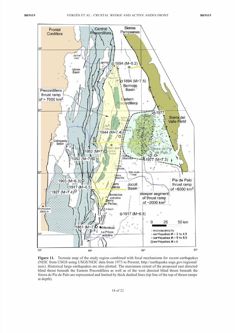
Figure 11. Tectonic map of the study region combined with focal mechanisms for recent earthquakes(NEIC from USGS using USGS/NEIC data from 1973 to Present; http://earthquake.usgs.gov/regional/ neic). Historical large earthquakes are also plotted. The maximum extent of the proposed east directed
blind thrust beneath the Eastern Precordillera as well as of the west directed blind thrust beneath theSierra de Pie de Palo are represented and limited by thick dashed lines (tip line of the top of thrust rampsat depth).
B03S15 VERGES ET AL.: CRUSTAL WEDGE AND ACTIVE ANDES FRONT
18 of 22
B03S15

7/27/2019 Verges Et Al 2007 Pampeanas Precordi
http://slidepdf.com/reader/full/verges-et-al-2007-pampeanas-precordi 19/22
9 km of pre-Neogene rocks and corresponds to the northerncontinuation of the Sierra de Pie de Palo. It is inferred torepresent a reactivation of an older structural grain.
[57] At the latitude of Sierra de Pie de Palo (31310S) theeast directed wedge fore thrust beneath Sierra de Villicummerges upward with the detachment at the base of the LateProterozoic-Cambrian limestones but displays little dis-
placement (Figure 10b). The Sierra de Pie de Palo uplift,
in contrast, is primarily produced by the west directedtectonic duplication of the uppermost 11-km-thick imbri-cated basement rocks. In detail, the Pie de Palo is inferred to
be underlain by an east dipping ramp that soles out at 19 km of depth and merges upward with the shallower detachment at the base of the Late Proterozoic-Cambrianlimestones. The 30 km of displacement to the west istransferred in this model to the thin-skinned Sierra deVillicum thrust system.
[58] Along strike to the south, structure beneath the CerroSalinas (32140S) also consists of a tectonic wedge deducedfrom the uplift of a large portion of the foreland in thefootwall of the active Precordilleran thrust front (Figure 10c).The west dipping blind fore thrust, which dips 14 west,
merges upward with a regional detachment level along the base of the Late Proterozoic-Cambrian strata of the CauceteGroup. At the wedge tip, an east dipping back thrust emplacesthe tectonic slices of the Caucete Group over Neogene strata.An incipient anticline in the footwall of the Cerro Salinasthrust might represent the southern end of the EasternPrecordillera ranges. Toward the east of the section, theSierra de Valle Fertil detaches at mid crustal levels alongtwo detachments at about 9–11 km and 15–20 km at depth.
[59] Near the southern termination of the Eastern Precor-dillera at 32250S, the tectonic wedge model is still valid,
but the west directed back thrust and associated Montecitosanticline are cut by the active thin-skinned thrust front of theCentral Precordillera at the Sierra de las Penas (Figure 10d).To the east, the Sierra de Valle Fertil thrust has lessdisplacement as suggested by the southward lowering of topographic relief.
[60 ] Two major blind and opposed crustal rampscorresponding to the fore thrust of the tectonic wedge inthe west and to the west directed Pie de Palo thrust to theeast dominate the crustal structure in the boundary region
between the thin-skinned Precordillera and thick-skinnedSierras Pampeanas structural provinces. The fore thrust ramp is apparently continuous along the length of theEastern Precordillera. An area of 7000 km2 for this inferredramp is estimated from the length of the tip line along strikeand the downdip limit of the ramp at depth below the CentralPrecordillera (Figure 11). The westward extent of the pro-
posed east directed blind fore thrust beneath the Ullum Basinand Eastern Precordillera is unknown. Thrust ramps cuttingdown a large portion of the crust or even the entire crust aresupported by regional cross sections [ Ramos et al., 2004]and by deep seismic lines across the northernmost Andes inArgentina where a crustal ramp is interpreted to extend intothe lower crust [ Allmendinger and Zapata, 2000]. Post-late
Neogene uplift along the San Juan River of 1500 m since7.1 Ma with an average rate of 0.22 mm/yr [Verges et al.,2001] implies that the fore thrust ramp may continue at depth
beneath the Central Precordillera (Figure 11). The Pie dePalo west directed blind back thrust is also large and
covers a total area of about 6000 km2. Roughly 33% of that area (2000 km2) is accounted for by the steepsegment of the ramp below the eastern flank of the sierra(Figure 11).
6.3. Precordillera-Sierras Pampeanas CrustalBoundary and Its Seismogenic Implications
[61] The boundary between the Precordillera and the
Sierras Pampeanas is dominated by blind thrust faults that likely extend to depth of 20 km or more and which arecapable of producing large earthquakes. Historic earth-quakes in the study region, however, produced minor,relatively small surface ruptures on secondary faults [ Meigset al., 2007]. Within the study region, most of these surfaceruptures are interpreted as flexural slip faults. Bedding
parallel flexural slip formed by both coseismic and post-seismic motion as documented in the La Laja area where30 cm of this movement was produced along a period of weeks after the main earthquake [Castellanos, 1944;Groeber , 1944]. Surface deformation is apparently domi-nated by folding [ Kadinsky-Cade et al., 1985; Krugh, 2003;
Meigs et al., 2007] similar to other well-documented blind
thrust earthquakes such as those in the Los Angeles Basin[e.g., Yeats and Huftile, 1995; Shaw and Suppe, 1996; Pratt et al., 2002].
[62] We thus propose that historical earthquakes devas-tating large regions of the study area occurred by thecoseismic slip on these blind thrusts by the rupture of relatively large fault segments in the basement. Using thesize of these events, it is possible to calculate the area of therupture of the faults using empirical relationships for thrustsdeveloped by Wells and Coppersmith [1994]. The 1944 LaLaja event with M
w = 7.0 [ Alvarado and Beck , 2006] and
thus the area of rupture is about 900 km2. The 1952 seismicevent to the south of the city of San Juan with M = 6.8[ Alvarado and Beck , 2006] possibly ruptured about 550 km2.
These rupture areas at depth are compatible with the thrust fault areas of the west dipping fore thrust. The relativelysmall area of these ruptures compared with the assumedtotal area for this ramp implies either (1) that the ramp isnot a continuous plane and consists of discrete segments or (2) that the seismic events ruptured small patches or seg-ments of a single continuous thrust ramp. Although therelatively scattered distribution of deep seismicity supportsthe model of discrete thrust ramps, which is also implied bythe complex tectonic grain inherited from the Paleozoicdeformation, a very large earthquake with a magnitude of about 7.7 would result from rupturing a single ramp alongthe length of the Eastern Precordillera. The 1977 Cauceteevent ( M = 7.4 [ Kadinsky-Cade et al., 1985]) requires a
rupture area of about 2600 km2, which fits well with the proposed area for the steeper central segment of the west directed thrust ramp located beneath the eastern side of theSierra de Pie de Palo (Figure 11). This result also agreesreasonably well with the observed area distribution of theaftershocks documented after the 1977 Caucete earthquake[Smalley et al., 1993].
[63] Combining long-term fault displacement rates, po-tential rupture areas, and the assumption that most of thisdisplacement is released during large earthquakes it is
possible to calculate earthquake recurrence intervals [Shawand Suppe, 1996]. Because our long-term fault slip rates are
B03S15 VERGES ET AL.: CRUSTAL WEDGE AND ACTIVE ANDES FRONT
19 of 22
B03S15

7/27/2019 Verges Et Al 2007 Pampeanas Precordi
http://slidepdf.com/reader/full/verges-et-al-2007-pampeanas-precordi 20/22
small, the estimated recurrence intervals are relatively long.The east verging blind fore thrust rate of displacement at Cerro Salinas thrust is 1 mm/yr, which suggests that recurrence interval ranges from about 1100 yr for earth-quakes of M = 7 to about 2000 years for M = 7.4. For theSierra de Pie de Palo thrust, where long-term rates are of 3.5 mm/yr, the recurrence interval for a characteristic M =7.4 earthquake like the Caucete event in 1977 is of less than
600 years if we assume that deformation started at 8.5 Malike in the Cerro Salinas example (30 km/8.5 Ma). If that rate is too high because some of the shortening accumulatedin the Paleozoic, the recurrence interval would be longer and more consistent with the 1000 year recurrence inter-val estimated by Kadinsky-Cade et al. [1985].
[64] In conclusion, the large blind crustal ramps docu-mented in this work represent a potential source of seismicrisk capable of generating large earthquakes, which willdamage the cities of San Juan and Mendoza as they have inthe past. The low rates of tectonic shortening accommo-dated by these structures in the last 8.5 Myr indicate that relatively long intervals (thousands of years) separateseismic events. This inference is supported by one of the
few trench studies of an active secondary fault in theEastern Precordillera, the Marquezado Fault to the northof Cerro Salinas, in the backlimb of the west directedZonda thrust, which shows that the last faulting event occurred before 2505 ± 160 years, using 14C technique[ INPRES , 1982].
7. Conclusions
[65] Integrated surface, subsurface, and geomorphic stud-ies are required to constrain the tectonic structure of activemountain fronts where blind thrust faulting predominates,such as is the case of the 200-km-long front of the Andes
between the densely populated cities of San Juan and
Mendoza in Argentina. To define the deep structure alongthe boundary region between the Precordillera and theSierras Pampeanas thick-skinned province, we combinedsurficial studies with interpretation of industry seismic linesto construct an integrated and quantified model of crustalarchitecture. This method has been applied to the CerroSalinas at the south termination of the Eastern Precordilleraand then extended to the north and south to characterize theregional structure and its seismogenic potential.
[66] The Cerro Salinas surficial structure consists of ananticline defined by both Neogene red beds and foldedQuaternary fluvial terraces developed on the hanging wallof the west directed Cerro Salinas thrust. This thin-skinnedthrust detached at the base of the 500-m-thick imbricated
Proterozoic carbonates and shales of the Cerro Salinas hill.The recent uplift along this fold is recorded by a set of uplifted, folded and thrusted Quaternary fluvial terraces (Qt1
to Qt3) and by the deflection of the modern fluvial network flowing across the anticline. Displacement of the CerroSalinas thrust is of 7–9 km. The Cerro Salinas thrust andthe western sector of the Jocolı Basin Neogene succession isfolded by an east directed monocline, which is well imagedin the southern termination of the Cerro Salinas anticlinealong MCS profile 31017.
[67] A 5.5-km-thick Neogene sequence folded by themonocline consists of about 2.2 km of pregrowth and
3.3 km of growth strata. The growth syncline shows agrowth triangle with the active axial surface pinned in thesyncline axis and a growth axial surface located in the
backlimb of the Cerro Salinas anticline. Growth strata thinin both the growth triangle and toward the crest of theanticline suggesting a hybrid kinematic fold evolution char-acterized by both kink band migration and limb rotation.
[68] The deep structure beneath the Cerro Salinas mono-
cline is interpreted as a tectonic wedge delineated at depth by a low-angle, east directed blind fore thrust ramp with adip of 14. This blind fore thrust connects at its tip with theCerro Salinas thrust, which constitutes the back thrust of thetectonic wedge. Uplift and frontal folding of the fore thrust
produced the 2 km regional uplift observed of the hangingwall to the west of the Cerro Salinas.
[69] An age of 8.5 Ma for the initiation of the CerroSalinas tectonic wedge has been determined with theregional dating of the Tobas grises superiores encounterednear the boundary between the pregrowth and growth strataunits. This age indicates that rates of shortening are rela-tively low (1 mm/yr) for the Cerro Salinas structure. Therate of uplift of the hanging wall of the Cerro Salinas thrust
integrating back thrust thrust displacement and monoclinaluplift above the fore thrust of 0.45 mm/yr.
[70] The Montecitos anticline represents the southerncontinuation of the Cerro Salinas anticline, which is over-thrust by the Central Precordillera at the active las Penasthrust front. The northern continuation of the Eastern Pre-cordillera tectonic wedge is located beneath the EasternPrecordillera at the Sierra de Villicum. The Sierra de Pie dePalo formed above a thick-skinned west directed blind thrust that detaches at a depth of 17 km in an intracrustal detach-ment. This west directed back thrust has a total displacement of 30 km that is transferred updip to a thin-skinned thrust along the basal decollement of the Eastern Precordillera.
[71] The potential seismic hazard of the blind thrustsrepresented by the tectonic wedge beneath the front of theAndes between the densely populated cities of San Juan andMendoza in Argentina is high because these thrust ramps, if continuous, can rupture an area as large as 7000 km2
producing an earthquake with a maximum M w
of 7.7. ThePie de Palo blind back thrust area is 6000 km2, althoughthe steep segment of the ramp below the eastern flank of thesierra amounts for about 2000 km2. Fault area of the M =7.4 Caucete event was probably not much larger than2000 km2. The low rate of thrust slip documented fromgeological observations implies long intervals of earthquakerecurrence for the basement thrusts documented in thisstudy.
[72] Acknowledgments. This is a contribution of Group of Dynamicsof the Lithosphere (GDL). We thank Repsol-YPF S.A. for providing uswith the seismic lines and for the permission to publish parts of them. Thiswork has been partially supported by 99AR0010 CSIC-CONICET project and Grups de Recerca Consolidats (II Pla de Recerca de Catalunya) Projects1997 SGR 00020. A.J.M. was supported by U.S. NSF grants EAR-0232603and EAR-0409443 and a Research Equipment Reserve Fund grant fromOregon State University. The 2DMove software from Midland Valley has
been used to identify the best fit for the crustal ramp. We are indebted toTibor Dunai for analyzing the samples for cosmogenics nuclides from theCerro Salinas terraces with poor dating results. We also thank Rick Allmendinger for providing the nice satellite images that have been partiallyreproduced in Figures 3 and 7. We finally thank reviewers Jerome v an der Woerd, Gerard Herail, and Jean-Philippe Avouac for their interestingcomments that helped to improve the paper.
B03S15 VERGES ET AL.: CRUSTAL WEDGE AND ACTIVE ANDES FRONT
20 of 22
B03S15

7/27/2019 Verges Et Al 2007 Pampeanas Precordi
http://slidepdf.com/reader/full/verges-et-al-2007-pampeanas-precordi 21/22
ReferencesAllmendinger, R. W., and T. R. Zapata (1996), Imaging the Andean
structure of the Eastern Cordillera on reprocessed YPF seismic reflec-tion data paper presented at XIII Congreso Geologico Argentino y IIICongreso de Exploracion de Hidrocarburos, Univ. de Buenos Aires,Buenos Aires.
Allmendinger, R. W., and T. R. Zapata (2000), The footwall ramp of theSubandean decollement, northernmost Argentina, from extended correla-tion of seismic reflection data, Tectonophysics, 321, 37–55.
Alonso, J. L. , L. R. Rodrıquez-Fernandez, J. Garcıa-Sansegundo,
N. Hered ia, P. Faria s, and J. Galla stegu i (200 5), Gond wani c andAndean structure in the Argentine central Precordillera: The Rıo SanJuan section revisited paper presented at 6th International Symposiumon Andean Geodynamics (ISAG 2005, Barcelona), Universitat Barcelona,Barcelona, Spain.
Alvarado, P., and S. Beck (2006), Source characterization of the San Juan(Argentina) crustal earthquakes of 15 January 1944( M
w 7.0) and 11 June
1952 ( M w
6.8), Earth Planet. Sci. Lett., 243, 409– 423.Astini, R. A., J. L. Benedetto, and N. E. Vaccari (1995), The early Paleozoic
evolution of the Argentine Precordillera as a Laurentian rifted, drifted,and collided terrane: A geodynamic model, Geol. Soc. Am. Bull., 107 ,253–273.
Avouac, J.-P., P. Tapponnier, M. Bai, H. You, and G. Wang (1993), Activethrusting and folding along the northern Tien Shan and late Cenozoicrotation of the Tarim relative to Dzungaria and Kazakhstan, J. Geophys.
Res., 98, 6755–6804.Bettini, F. H. (1980), Nuevos conceptos tectonicos del centro y bo rde
occidental de la cuenca Cuyana, Asoc. Geol. Argent. Rev., XXXV , 579–
581.Brooks, B. A., M. Bevis, R. Smalley Jr., E. Kendrick, R. Manceda,
E. Laurıa, R. Maturana, and M. Araujo (2003), Crustal motion in theSouthern Andes (26 – 36S): Do the Andes behave like a microplate?,Geochem. Geophys. Geosyst., 4(10), 1085, doi:10.1029/2003GC000505.
Burbank, D., A. Meigs, and N. Brozovic (1996), Interactions of growingfolds and coeval depositional systems, Basin Res., 8, 199– 224.
Burbank, D. W., and R. S. Anderson (2001), Tectonic Geomorphology,274 pp., Blackwell Sci., Malden, Mass.
Castellanos, A. (1944), Anotaciones preliminares con motivo de unavisita a la ciudad de San Juan a proposito del terremoto del 15 deenero de 1944, Publ. 21, Inst. de Fis. y Geol., Univ. del Litoral,Rosario, Argentina.
Colombo, F., P. Busquets, E. Ramos-Guerrero, J. Verges, and D . Ragona(2000), Quaternary alluvial terraces in an active tectonic region: TheSan Juan River Valley, Andean Ranges, San Juan Province, Argentina,
J. South Am. Earth Sci., 13, 611–626.Cominguez, A. H., and V. A. Ramos (1991), La Estructura Profunda entre
Precordillera y Sierras Pampeanas de la Argentina: Evidencias de laSısmica de Reflexion Profunda, Rev. Geol. Chile, 18, 3–14.
Cortes, J. M., and C. H. Costa (1996), Tectonica cuaternaria en la desem- bocadur a del rıo de las Penas, borde oriental de la Precordillera deMendoza paper presented at XIII Congreso Geologico Argentino y IIICongreso de Exploracion de Hidrocarburos.
Costa, C. H., and C. Vita-Finzi (1996), Late Holocene faulting in the south-east Sierras Pampeanas of Argentina, Geology, 24, 1127–1130.
Costa, C., T. K. Rockwell, J. D. Paredes, and C. E. Gardini (1999), Qua-ternary deformations and seismic hazard at the Andean orogenic front (31 – 33, Argentina): A paleoseismological perspective paper presentedat Fourth ISAG, Universitaet Goettingen, Goettingen, Germany.
Costa, C. H., C. E. Gardini, H. Diederix, and J. M. Cortes (2000), TheAndean orogenic front at Sierra de las Penas-Las Higueras, Mendoza,Argentina, J. S. Am. Earth Sci., 13, 287– 292.
Cristallini, E. O., and V. A. Ramos (2000), Thick-skinned and thin-skinnedthrusting in the La Ramada fold and thrust belt: Crustal evolution of theHigh Andes of San Juan, Argentina (32SL), Tectonophysics, 317 , 205–
235.Cristallini, E. O., A. H. Com yı nguez, V. A. Ramos, and E. D. Mercerat
(2004), Basement double-wedge thrusting in the northern Sierras Pam- peanas of Argentina (27S)-Constraints from deep seismic reflection, inThrust Tectonics and Hydrocarbon Systems, edited by K. R. McClay,
AAPG Mem., 82, 65–90.DeMets, C., R. G. Gordon, D. F. Argus, and S. Stein (1990), Current plate
motions, Geophys. J. Int., 101, 425– 478.Figueroa, D. E., and O. R. Ferraris (1989), Estructura del Margen Oriental
de la Precordillera Mendocina-Sanjuanina, Primer Congreso Nacional deExploracion de Hidrocarburos Mar del Plata, Univ. de Buenos Aires,Buenos Aires.
Ford, M., E. A. Williams, A. Artoni, J. Verges, and S. Hardy (1997),Progressive evolution of a fault-related fold pair from growth strata geo-metries, Sant Llorenc de Morunys, SE Pyrenees, J. Struct. Geol., 19,413–441.
Furque, G., and A. Cuerda (1979), Precordillera de La Rioja, San Juan yMendoza: Cordob a, Academia Nacional de Ciencias Cordoba paper pre-sented at 2nd Simposio de Geologıa Regional Argentina, Acad. Nac. deCien. Cordoba, Cordoba, Argentina.
Galindo, C., C. Casquet, C. Rapela, R. J. Pankhurst, E. Baldo, andJ. Saavedra (2004), Sr, C and O isotope geochemistry and stratigraphy of Precambrian and lower Paleozoic carbonate sequences from the WesternSierras Pampeanas of Argentina: Tectonic implications, Precambrian
Res., 131, 55–71.Gimenez, M. E., M. P. Martınez, and A. Introcaso (2000), A crustal model
based m ainly on gravity data in the area between the Bermejo Basin andthe Sierras de Valle Fertil, Argentina, J. South Am. Earth Sci., 13, 275– 286.
Gonzalez Bonorino, G. (1973), Sedimentologıa de la Formacion Punta Negra y algunas consideraciones sobre la geologıa regional de la Pre-cordillera de San Juan y Mendoza, Asoc. Geol. Argent. Rev., 30, 223– 246.
Groeber, P. (1944), Movimientos tectonicos contemporaneos y un nuevotipo de dislocaciones, Not. Museo La Plata, 9, 363– 375.
Hubert-Ferrari, A., J. Suppe, X. Wang, and C. Z. Jia (2005), Yakeng de-tachment fold, South Tianshan, China, in Seismic Interpretation of Con-tractional Fault-related Folds, AAPG Seismic Atlas, edited by J. Shaw,C. Connors, and J. Suppe, pp. 110 – 113, Am. Assoc. of Pet. Geol., Tulsa,Okla.
Hubert-Ferrari, A., J. Suppe, R. Gonzalez-Mieres, and X. Wang (2007),Mechanisms of active folding of the landscape (southern Tian Shan,China), J. Geophys. Res., doi:10.1029/2006JB004362, in press.
Instituto Nacional de Prevencion Sısmica (INPRES) (1982), MicrozonacionSısmica del Valle de Tulum - Provincia de San Juan, Informe TecnicoGeneral, vol. 1 –3.
Instituto Nacional de Prevencion Sısmica (INPRES) (1995), Microzonifica-cion Sısmica del Gran Mendoza. R esumen Ejecutivo, pub licacion tecni-ca, 283 pp., San Juan, Argentina.
Introcaso, A., M. C. Pacino, and H. Fraga (1992), Gravity, isostasy andAndean crustal shortening between latitudes 30 and 35S, Tectonophy-
sics, 205, 31–48.Irigoyen, M. V., M. E. Villeneuve, and F. Quigg (1999), Calibration of
a Neogene magnestostratigraphy by 40Ar-39Ar geochronology: The fore-land basin strata of northern Mendoza Province, Argentina, in Radiogenic
Age Isotopic Studies, Current Research 1999-F , Rep. 12, pp. 27–41,Geol. Surv. of Can., Ottawa, Ont.
Irigoyen, M. V., K. L. Buchan, and R. L. Brown (2000), Magnetostratigra- phy of Neogene Andean foreland-basin strata, latitude 33S, MendozaProvince, Argentina, Geol. Soc. Am. Bull., 112, 803– 816.
Isacks, B., T. Jordan, R. W. Allmendinger, and V. A. Ramos (1982), Lasegmentacion tectonica de los Andes Centrales y su relacion con la placade Nazca subductada, Vth Congreso Latinoamericano de Geologı a, Univ.de Buenos Aires, Buenos Aires.
Jordan, T. E., and R. W. Allmendinger (1986), The Sierras Pampeanas of Argentina: A modern analogue of Rocky Mountain foreland deformation,
Am. J. Sci., 286 , 737– 764.Jordan, T. E., B. Isacks, R. W. Allmendinger, I. A. Brewer, V. Ramos, and
C. J. Ando (1983), Andean tectonics related to geometry of subducted Nazca Plate, Geol. Soc. Am. Bull., 94, 341– 361.
Kadinsky-Cade, K., R. Reilinger, and B. Isacks (1985), Surface deforma-tions associated with the November 23, 1977, Caucete, Argentina, earth-quake sequence, J. Geophys. Res., 90, 12,691– 12,700.
Kay, S. M., and J. M. Abbruzzi (1996), Magmatic evidence for Neogenelithospheric evolution of the central Andean ‘‘flat-slab’’ between 30Sand 32S, Tectonophysics, 259, 15–28.
Kendrick, E. C., M. Bevis, R. F. Smalley Jr., O. Cifuentes, and F. Galban(1999), Current rates of convergence across the central Andes: Estimatesfrom continuous GPS observations, Geophys. Res. Lett., 26 , 541– 544.
Krugh, W. C. (2003), Fold growth due to kink-band migration in repeatedearthquakes, Sierra de Villicum, San Juan, Argentina., Master’s thesis,54 pp., Oregon State Univ., Corvallis.
Marrett, R., and P. A. Bentham (1997), Geometric analysis of hybrid fault- propagation/detachment folds, J. Struct. Geol., 19, 243– 248.
Martos, L. M. (1993), Evidencias de actividad tectonica en el Pleistocenosuperior-Holoceno, Quebrada del Molino, Pocito, San Juan, Argentina
paper presented at Cong reso Geologico Argentino, Con gr. Geol. Argent.,Buenos Aires.
Martos, L. M. (19 95), Analisis morfo-estructural d e la faja piedemontanaoriental de las sierras deMarquesado, Chica de Zonda y Pedernal: Suaplicacion para prevenir riesgos geologicos: Provincia de San Juan,Ph.D. thesis, 554 pp., Univ. Nac. de San Juan, San Juan, Argentina.
Meigs, A., W. C. Krugh, C. Schiffman, J. Verges, and V. Ramos (20 07),Refolding of thin-skinned thrust sheets by active basement-involvedthrust faults in the eastern Precordillera of western Argentina, in Andean
Neotectonics, edited by C. Costa, Rev. Asoc. Geol. Argent., in press.
B03S15 VERGES ET AL.: CRUSTAL WEDGE AND ACTIVE ANDES FRONT
21 of 22
B03S15

7/27/2019 Verges Et Al 2007 Pampeanas Precordi
http://slidepdf.com/reader/full/verges-et-al-2007-pampeanas-precordi 22/22
Meyer, B., P. Tapponnier, L. Bourjot, F. Metivier, Y. Gaudemer, G. Peltzer,G. Shummin, and C. Zhitai (1998), Crustal thickening in Gansu-Qinghai,lithospheric mantle subduction, and oblique, strike-slip controlled growthof the Tibet Plateau, Geophys. J. Int., 135, 1–47.
Molnar, P., E. T. Brown, B. C. Burchfiel, Q. Deng, X. Feng, J. Li, G. M.Raisbeck, J. Shi, Z. Wu, F. Yiou, and H. You (1994), Quaternary climatechange and the formation of river terraces across growing anticlines onthe north flank of the Tien Shan, China, J. Geol., 102, 583– 602.
Novoa, E., J. Suppe, and J. H. Shaw (2000), Inclined-shear restoration of growth folds, AAPG Bull., 84, 787– 804.
Pankhurst, R. J., C. W. Rapela, J. Saavedra, E. Baldo, J. Dahlquist, I. Pascua,and C. M. Fanning (1998), The Famatinian magmatic arc in the centralSierras Pampeanas, in The Proto-Andean Margin of Gondwana, edited byR. J. Pankhurst and C. W. Rapela, Geol. Soc. Spec. Publ., 142, 343–368.
Pinan-Llamas, A., and C. Simpson (2006), Deformation o f Gon dwana mar-gin turbidites during the Pampean orogeny, north-central Argentina,Geol. Soc. Am. Bull., 118, 1270–1270, doi:10.1130/B25915.1.
Pratt, T. L., J. H. Shaw, J. F. Dolan, S. A. Christofferson, R. A. Williams,J. K. Odum, and A. Plesch (2002), Shallow seismic imaging of foldsabove the Puente Hills blind-thrust fault, Los Angeles, California, Geo-
phys. Res. Lett., 29(9), 1304, doi:10.1029/2001GL014313.Ragona, D., G. Anselmi, P. Gonzalez, and G. Vujovich (1995), Mapa
geologico de la Provincia de San Juan, Republica Argentina, scale1/500,000, Secret. de Miner., Dir. Nac. del Serv. Geol., Buenos Aires.
Ramos, V. A. (1988), The Tectonics of the Central Andes; 30 to 33 Slatitude, in Processes in Continental Lithospheric Deformation, edited byS. P. Clark, J. B. Clark Burchfiel, and J. Suppe, pp. 31 – 54, Geol. Soc. of Am., Boulder, Colo.
Ramos, V. A., and G. Vujovich (2000), Hoja Geologica San Juan, Serv.Geol. Min. Argent. Bol., 245, 1–82.
Ramos, V. A., T. E. Jordan, R. W. Allmendinger, C. Mpodozis, S. M. Kay,J. M. Cortes, and M. A. Palma (1986), Paleozoic terranes o f the centralArgentine-Chilean Andes, Tectonics, 5, 855– 880.
Ramos, V. A., M. Cegarra, G. Lo Forte, and A. Comı nguez (1997), El frenteorogenico en las Sierras de Pedernal (San Juan, Argentina): Su migraciona traves de los depositos sinorogenicos paper presented at Simposio FinalProyecto IGCP 345 Evolucion Litosferica de los Andes, An tofagasta,Chile.
Ramos, V. A., R. D. Dallmeyer, and G. I. Vujovich (1998), Time constraintson the early Paleozoic docking of the Precordillera, central Argentina, inThe Proto-Andean Margin of Gondwana, edited by R. J. Pankhurst andC. W. Rapela, Geol. Soc. Spec. Publ., 142, 143– 158.
Ramos, V. A., E. O. Cristallini, and D . J. Perez (2 002), The Pampean flat-slab of the central Andes, J. South Am. Earth Sci., 15, 59–78.
Ramos, V. A., T. Zapata, E. Cristallini, and A. Introcaso (2004), TheAndean thrust system—Latitudinal variations in structural styles andorogenic shortening, in Thrust Tectonics and Hydrocarbon Systems, edi-ted by K. R. McClay, AAPG Mem., 82, 30–50.
Regnier,M., J.-L.Chatelain, R. F.Smalley Jr., J. Ming Chiu, and B. L. Isacks(1992),Seismotectonic of theSierra Piede Palo, a basement block uplift inthe Andean foreland, Argentina, Bull. Seismol. Soc. Am., 82, 2549– 2571.
Shaw, J., C. Connors, and J. Suppe (2005), Seismic Interpretation of Con-tractional fault-Related Folds, AAPG Seismic Atlas, Stud. Geol., vol. 53,
pp. 1 – 156, Am. Assoc. of Pet. Geol., Tulsa, O kla.Shaw, J. H., and J. Suppe (1996), Earthquake hazards of active blind-thrust
under the central Los Angeles basin, California, J. Geophys. Res., 101,8623–8642.
Siame, L., O. Bellier, M. Sebrier, D. Bourles, P. Leturmy, M. Perez, andM. Araujo (2002), Seismic hazard reappraisal from combined structuralgeology, geomorphology and cosmic ray exposure dating analyses: TheEastern Precordillera thrust system (NW Argentina), Geophys. J. Int.,150, 241– 260, doi:210.1046/j.1385-1246X. 2002.01701.x.
Siame, L. L., O. Bellier, M. Sebrier, and M. Araujo (2005), Deformation partitioning in flat subduction setting: Case of the Andean foreland of western Argentina (28S–33S), Tectonics, 24, TC5003, doi:10.1029/ 2005TC001787.
Smalley, R. F., Jr., and B. L. Isacks (1987), A high resolution local network study of the Nazca Plate Wadati-Benioff zone under western Argentina,
J. Geophys. Res., 92, 13,903–913,913.Smalley, R. F., Jr., and B. L. Isacks (1990), Seismotectonics of thin- and
thick-skinned deformation in the Andean Foreland from local network data: Evidence for a seismogenic lower crust, J. Geophys. Res., 95,12,487–12,498.
Smalley, R. J., J. Pujol, M. Regnier, J.-M. Chiu, J.-L. Chatelain, B. L.Isacks, M. Araujo, and N. Puebla (1993), Basement seismicity beneaththe Andean Precordillera thin-skinned thrust belt and implications for crustal and lithospheric behavior, Tectonics, 12, 63–76.
Snyder, D. B., V. A. Ramos, and R. W. Allmendinger (1990), Thick-skinned deformation observed on deep seismic reflection profiles in wes-tern Argentina, Tectonics, 9, 773– 788.
Suppe, J. (1983), Geometry and kinematics of fault-bend folding, Am. J. Sci., 283, 684– 721.
Suppe, J., G. T. Chou, and S. C. Hook (1992), Rates of folding and faulting
determined from growth strata, in Thrust Tectonics, edited by K. R.McClay, pp. 105–121, CRC Press, Boca Raton, Fla.Suppe, J., F. Sabat, J. A. Munoz, J. Poblet, E. Roca, and J. Verges (1997),
Bed-by-bed fold growth by kink-band migration: Sant Llorenc deMorunys, eastern Pyrenees, J. Struct. Geol., 19, 443– 461.
Tassara, A. (2005),Interaction between the Nazcaand SouthAmerican platesand formation of the Altiplano– Puna plateau: Review of a flexural analy-sis along the Andean margin (15 – 34S), Tectonophysics, 399, 39–57.
Uliarte, E., H. Bastıas, and L. Ruzycki (1987), Morfologıa y neotectonicaen el Cerro La Chilca, Pedernal, Provincia de San Juan, Argentina paper
presented at X Congreso Geolog ico Argentino, Univ. Nac. de Tucuman,San Miguel de Tucuman, Argentina.
Verges, J., E. Ramos-Guerrero, D. Seward, P. Busquets, and F. Colombo(2001), Miocene sedimentary and tectonic evolution of the Andean Pre-cordillera at 31S, Argentina, J. S. Am. Earth Sci., 14(7), 735–750.
Verges, J., V. Ramos, F. H. Bettini, A. Meigs, E. Cristallini, A. L. Cortes,and T. Dunai (2002), Geometrıa y edad del anticlinal fallado de CerroSalinas, in Actas del XV Congreso Geologico Argentino, El Calafate[CD-ROM], edited by N. Cabaleri et al., paper 358, Congr. Geol. Argent.,El Calafate, Argentina.
von Gosen, W. (1992), Structural evolution of the Argentine Precordillera:The Rio San Juan section, J. Struct. Geol., 14, 643– 667.
Vujovich, G., and V. Ramos (1 994), La faja de An gaco y su relacion con lasSierras Pampeanas Occidentales paper presented at 7th Congreso Geolo-gico Chileno, Univ. de Concepcion , Concepcion, Chile.
Wells, D. L., and K. J. Coppersmith (1994), New empirical relationshipsamong magnitude, rupture length, rupture width, rupture area, and sur-face displacement, Bull. Seismol. Soc. Am., 84, 974–1002.
Yeats, R. S. (1986), Active faults related to folding, in Active Tectonics,edited by R. E. Wallace, pp. 63 – 79, Natl. Acad. Press, Washington, D. C.
Yeats, R. S., and G. J. Huftile (1995), The Oak Ridge faults system and the1994 Northridge earthquake, Nature, 373, 418– 420.
Yrigoyen, M. R. (199 3), Los depositos sinorogenicos terciarios, in Geolo-gıa y recursos naturales de la provincia de Mendoza, in XII CongresoGeologico Argentino y II Congreso de Exploracion de Hidrocarburos,edited by V. A. Ramos, pp. 123–148, Congr. Geol. Argent., BuenosAires.
Zapata, T. (1997), Geometria y Evolucion de la Estructura Cortical de laPrecordillera Oriental y Valle del Bermejo a los 30 de Latitud Sur, Bol.
Inf. Petrol., 49, 84–104.Zapata, T. R. (1998), Crustal structure of the Andean thrust front at 30(S
latitude from shallow and deep seismic reflection profiles, Argentina, J. S. Am. Earth Sci., 11, 131– 151.
Zapata, T. R., and R. W. Allmendinger (1996a), Growth stratal records of instantaneous and progressive limb rotation in the Precordillera thrust belt and Bermejo basin, Argentina, Tectonics, 15, 1065–1083.
Zapata, T. R., and R. W. Allmendinger (1996b), Thrust-front zone of thePrecordillera, Argentina: A thick-skinned triangle zone, AAPG Bull., 80,359–381.
F. H. Bettini, Repsol-YPF, Av. Pte. Roque Saen z Pena 777, 1035 BuenosAires, Argentina. ([email protected])
J. M. Cortes, E. Cristallini, and V. A. Ramos, Laboratorio de Tecton ica
Andina, Departamento de Ciencias Geologicas, Universidad de BuenosAires, 1428 Buenos Aires, Argentina. ([email protected])
A. Meigs, Department of Geosciences, Oregon State University,Corvallis, OR 97331, USA. ([email protected])
J. Verges, Group of Dynamics of the Lithosphere (GDL), Institute of Earth Sciences ‘‘Jaume Almera’’, CSIC, E-08028 Barcelona, Spain.([email protected])
B03S15 VERGES ET AL.: CRUSTAL WEDGE AND ACTIVE ANDES FRONT B03S15