VER VallEy WalK 4 - River Ver · To Hemel Hempstead To St Albans START REDBOURN, SOUTH VER VallEy...
3
Start and finish: Redbourn Common Full circular walk: 6 miles (9.7 km) - About 3 hours Short circular walk: 5 miles (8 km) - About 2.5 hours REDBOURN, SOUTH Teas, buns, pints and pies: Redbourn Common: The Cricketers and The Holly Bush (Church End) Public Houses Redbourn High Street: The Bull and The George Public Houses plus general stores, coffee shop and sandwich bars. Redbournbury Mill: Bakery and light refreshments open on selected dates. www.redbournmill.co.uk How to get there: By road: Redbourn is approx. 3 miles from Harpenden, 4 miles from St Albans and 5 miles from Hemel Hempstead. Leave Junction 9 of the M1 and take the A5183 (direction Herts Showground), turn right at the St Albans roundabout. There is public car parking at The Common. By public transport: Redbourn is served regularly by buses from St Albans and Dunstable. For details contact Intalink Traveline on 0871 200 2233 or visit www.intalink.org.uk Parts of this walk can be muddy or wet underfoot. www.riverver.co.uk This is one of a series of 8 circular walks on the River Ver and part of the 17 mile long linear, River Ver Trail. You can also use the OS Explorer Map 182 to find your way around the Valley. For lots more photos, memories, information and copies of the other walks go to www.riverver.co.uk Front cover photo: Redbournbury Mill. Photos: Countryside Management Service, Ver Valley Society, St Albans Camera Club. © 2011 Countryside Management Service, except mapping. All rights reserved. If you would like this leaflet produced in large print, please contact the Countryside Management Service on southwest. [email protected] Tel: 01462 459395 The Countryside Management Service works with communities in Hertfordshire to help them care for and enjoy the environment. For information on further opportunities to enjoy Hertfordshire countryside, including Health Walks, visit www.hertslink.org/cms Explore the beautiful rolling countryside of this river valley VER VALLEY WALK 4 The Redbournbury Walk
Transcript of VER VallEy WalK 4 - River Ver · To Hemel Hempstead To St Albans START REDBOURN, SOUTH VER VallEy...

Start and finish: Redbourn CommonFull circular walk: 6 miles (9.7 km) - About 3 hoursShort circular walk: 5 miles (8 km) - About 2.5 hours
REDBOURN, SOUTH
Teas, buns, pints and pies:Redbourn Common: The Cricketers and The Holly Bush (Church End) Public HousesRedbourn High Street: The Bull and The George Public Houses plus general stores, coffee shop and sandwich bars.Redbournbury Mill: Bakery and light refreshments open on selected dates. www.redbournmill.co.uk
How to get there:By road: Redbourn is approx. 3 miles from Harpenden, 4 miles from St Albans and 5 miles from Hemel Hempstead. Leave Junction 9 of the M1 and take the A5183 (direction Herts Showground), turn right at the St Albans roundabout. There is public car parking at The Common.
By public transport: Redbourn is served regularly by buses from St Albans and Dunstable. For details contact Intalink Traveline on 0871 200 2233 or visit www.intalink.org.uk
Parts of this walk can be muddy or wet underfoot.
www.riverver.co.uk
This is one of a series of 8 circular walks on the River Ver and part of the 17 mile long linear, River Ver Trail. You can also use the OS Explorer Map 182 to find your way around the Valley. For lots more photos, memories, information and copies of the other walks go to www.riverver.co.uk
Front cover photo: Redbournbury Mill.Photos: Countryside Management Service, Ver Valley Society, St Albans Camera Club. © 2011 Countryside Management Service, except mapping. All rights reserved.
If you would like this leaflet produced in large print, please contact the Countryside Management Service on [email protected] Tel: 01462 459395
The Countryside Management Service works with communities in Hertfordshire to help them care for and enjoy the environment. For information on further opportunities to enjoy Hertfordshire countryside, including Health Walks, visit www.hertslink.org/cms
Explore the beautiful rolling countryside of this river valley
VER VallEy WalK 4The Redbournbury Walk
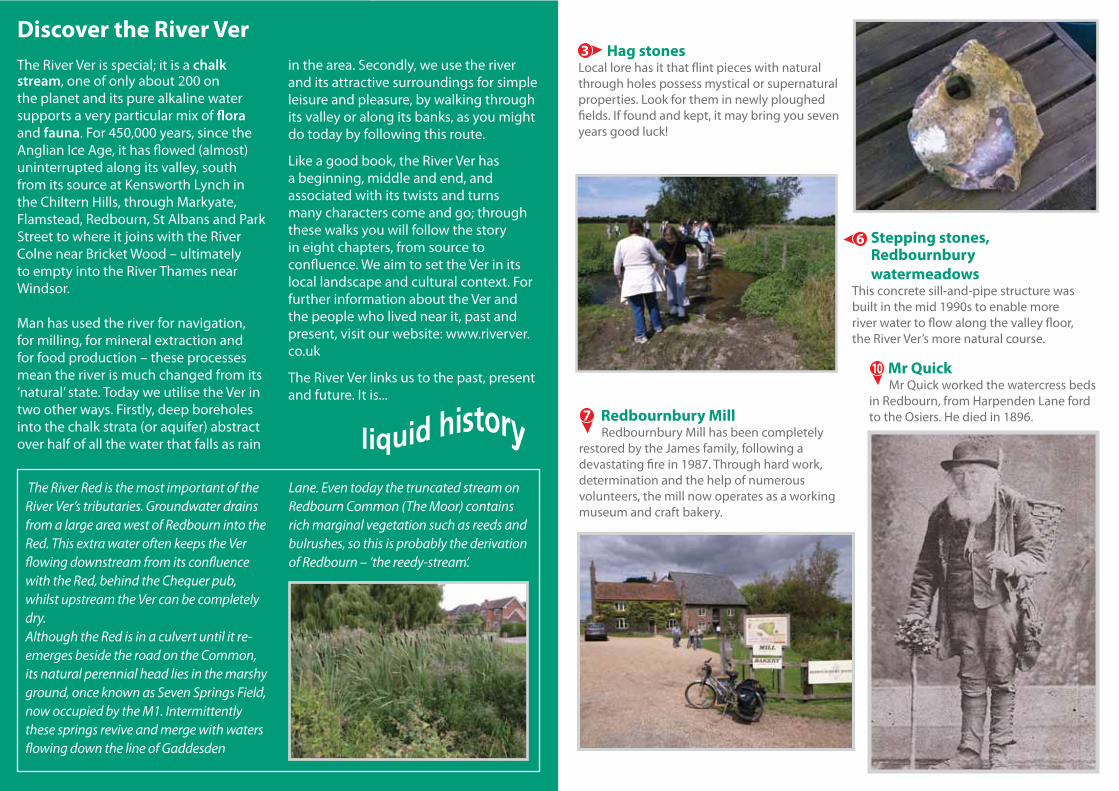
Discover the River VerThe River Ver is special; it is a chalk stream, one of only about 200 on the planet and its pure alkaline water supports a very particular mix of flora and fauna. For 450,000 years, since the Anglian Ice Age, it has flowed (almost) uninterrupted along its valley, south from its source at Kensworth Lynch in the Chiltern Hills, through Markyate, Flamstead, Redbourn, St Albans and Park Street to where it joins with the River Colne near Bricket Wood – ultimately to empty into the River Thames near Windsor.
Man has used the river for navigation, for milling, for mineral extraction and for food production – these processes mean the river is much changed from its ‘natural’ state. Today we utilise the Ver in two other ways. Firstly, deep boreholes into the chalk strata (or aquifer) abstract over half of all the water that falls as rain
in the area. Secondly, we use the river and its attractive surroundings for simple leisure and pleasure, by walking through its valley or along its banks, as you might do today by following this route.
Like a good book, the River Ver has a beginning, middle and end, and associated with its twists and turns many characters come and go; through these walks you will follow the story in eight chapters, from source to confluence. We aim to set the Ver in its local landscape and cultural context. For further information about the Ver and the people who lived near it, past and present, visit our website: www.riverver.co.uk
The River Ver links us to the past, present and future. It is...
The River Red is the most important of the River Ver’s tributaries. Groundwater drains from a large area west of Redbourn into the Red. This extra water often keeps the Ver flowing downstream from its confluence with the Red, behind the Chequer pub, whilst upstream the Ver can be completely dry.Although the Red is in a culvert until it re-emerges beside the road on the Common, its natural perennial head lies in the marshy ground, once known as Seven Springs Field, now occupied by the M1. Intermittently these springs revive and merge with waters flowing down the line of Gaddesden
Lane. Even today the truncated stream on Redbourn Common (The Moor) contains rich marginal vegetation such as reeds and bulrushes, so this is probably the derivation of Redbourn – ‘the reedy-stream’.
Stepping stones, Redbournbury watermeadows
This concrete sill-and-pipe structure was built in the mid 1990s to enable more river water to flow along the valley floor, the River Ver’s more natural course.
6
Mr Quick Mr Quick worked the watercress beds in Redbourn, from Harpenden Lane ford to the Osiers. He died in 1896.
10
Hag stonesLocal lore has it that flint pieces with natural through holes possess mystical or supernatural properties. Look for them in newly ploughed fields. If found and kept, it may bring you seven years good luck!
3
Redbournbury Mill Redbournbury Mill has been completely restored by the James family, following a devastating fire in 1987. Through hard work, determination and the help of numerous volunteers, the mill now operates as a working museum and craft bakery.
7

To Hemel
Hempstead
To St Albans
START
REDBOURN, SOUTH
VER VallEy WalK 4The Redbournbury Walk
1
2 8
9
10
From the Cricket Clubhouse on Redbourn Common cross Hemel Hempstead Road and Chequer Lane to follow the grassy path down the slope past the old school, to the footbridge over the River Red and The Moor .
Keep ahead, cross the Nickey Line (footpath and cycle track) and descend the steps to the southern bypass.
Cross and continue south, through arable fields; there is a steep ascent across the third field, up to the far corner where the path meets Beaumont Hall Lane. Take in the fine views back towards Redbourn and the Ver Valley .
When the track forks at New Cottage, keep left into a quiet ‘green’ lane . At Hill Farm Lane, turn right, walk on past Hill Farm and Bohemia, and at the far end of the Paddock take the left path, to join Punch Bowl Lane. Turn left.
Cross Watling Street (A5183) - the ancient Roman road between London and Chester - Behind the old Punch Bowl Inn, cross the arable field and watermeadow to the stepping-stones and footbridge crossing the River Ver .
You may wish to take a short detour here to Redbournbury Mill (working museum and bakery) or go this way to follow the shorter circular route, follow the River Ver Trail waymarks back to the Common. Otherwise continue on the east side of the river. You may spot a Kingfisher from June onwards. At the fishing club entrance (former watercress beds), turn right to Hammondsend Wood and Farm.
Beyond the old farmhouse - look out for barn owls - pass through a kissing-gate, left, to cross a small paddock to another kissing-gate; keep left through a small copse at the golf-course margin, then along the fence line. The path turns right at a tee (‘Ramblers Risk’!), then left into another copse.
Emerging from this, pass through a hedge-line; cross the arable field to descend into the valley. Cross the bypass , from the Nickey Line climb the steps and take the path to meet the river at Waterend Lane ford .
Continue and cross Redbourn High Street to the alleyway opposite, and back to the Common and its avenue of lime trees.
12
3
4
56
7
8
910
KEyVer Valley Walk 4 uses rights of way to link to the River Ver Trail to enable you to explore the river valley in bite size sections.
Short Cut
WaymarkingFollow these waymarks on your way around the route.
Ver Valley View
Public Footpath
Public Bridleway
Take care when crossing main roads
Nature notes
4
M E T R E S0 250 500 750 1000
0 . 5 M I L E
3
5 6
7
4
11
11
© Crown copyright and database rights 2011 Ordnance Survey 100019606