Vegetation Map of the Rocking M Ranch Wildlife ... MAP OF THE ROCKING M RANCH WILDLIFE CONSERVATION...
65
VEGETATION MAP OF THE ROCKING M RANCH WILDLIFE CONSERVATION EASEMENT, WASHINGTON COUNTY, IDAHO Steven K. Rust Michael Mancuso Christopher J. Murphy P. Robin Jones December 2000 Conservation Data Center Idaho Department of Fish and Game 600 South Walnut, P.O. Box 25 Boise, Idaho 83707 Rodney Sando, Director Cooperative Challenge Cost-Share Project Idaho Department of Fish and Game USDI Bureau of Land Management, Lower Snake River District
Transcript of Vegetation Map of the Rocking M Ranch Wildlife ... MAP OF THE ROCKING M RANCH WILDLIFE CONSERVATION...

VEGETATION MAP OF THE ROCKING M RANCHWILDLIFE CONSERVATION EASEMENT,WASHINGTON COUNTY, IDAHO
Steven K. RustMichael MancusoChristopher J. MurphyP. Robin Jones
December 2000
Conservation Data CenterIdaho Department of Fish and Game600 South Walnut, P.O. Box 25Boise, Idaho 83707
Rodney Sando, Director
Cooperative Challenge Cost-Share ProjectIdaho Department of Fish and GameUSDI Bureau of Land Management, Lower Snake River
District

ii

iii
TABLE OF CONTENTS
INTRODUCTION . . . . . . . . . . . . . . . . . . . . . . . . . . . . . . . . . . . . . . . . . . 1
STUDY AREA . . . . . . . . . . . . . . . . . . . . . . . . . . . . . . . . . . . . . . . . . . . . 1
METHODS . . . . . . . . . . . . . . . . . . . . . . . . . . . . . . . . . . . . . . . . . . . . . . . 5
RESULTS . . . . . . . . . . . . . . . . . . . . . . . . . . . . . . . . . . . . . . . . . . . . . . . . 5
VEGETATION DESCRIPTION . . . . . . . . . . . . . . . . . . . . . . . . . . . . . . . 13Agropyron spicatum-Poa secunda . . . . . . . . . . . . . . . . . . . . . . . . . 13Festuca idahoensis-Agropyron spicatum . . . . . . . . . . . . . . . . . . . . 14Festuca idahoensis-Koleria cristata . . . . . . . . . . . . . . . . . . . . . . . . 16Artemisia rigida/Poa secunda . . . . . . . . . . . . . . . . . . . . . . . . . . . . 18Artemisia tridentata tridentata/Agropyron spicatum . . . . . . . . . . . . 18Artemisia tridentata tridentata/Festuca idahoensis . . . . . . . . . . . . 18Artemisia tridentata tridentata/Elymus cinereus . . . . . . . . . . . . . . . 19Artemisia tridentata vaseyana-Symphoricarpos oreophylus/
Agropyron spicatum. . . . . . . . . . . . . . . . . . . . . . . . . . . . . . . . . . . . . . . . . . . . . . . . 20
Artemisia tridentata vaseyana-Symphoricarpos oreophylus/Festucaidahoensis
. . . . . . . . . . . . . . . . . . . . . . . . . . . . . . . . . . . . . . . . . . . . . . . . 21Artemisia tridentata vaseyana/Agropyron spicatum . . . . . . . . . . . . 21Artemisia tridentata vaseyana/Festuca idahoensis . . . . . . . . . . . . 21Artemisia tridentata xericensis/Agropyron spicatum . . . . . . . . . . . 22Artemisia tridentata xericensis/Festuca idahoensis . . . . . . . . . . . . 22Purshia tridentata/Agropyron spicatum . . . . . . . . . . . . . . . . . . . . . 22Purshia tridentata/Festuca idahoensis . . . . . . . . . . . . . . . . . . . . . . 23Other plant communities . . . . . . . . . . . . . . . . . . . . . . . . . . . . . . . . 24
CONCLUSIONS AND MANAGEMENT RECOMMENDATIONS . . . . . 25
LITERATURE CITED . . . . . . . . . . . . . . . . . . . . . . . . . . . . . . . . . . . . . . 26
APPENDIX 1. Ecological condition classes . . . . . . . . . . . . . . . . . . . . 31
APPENDIX 2. Vegetation summary . . . . . . . . . . . . . . . . . . . . . . . . . . 32
APPENDIX 3. Stand synthesis tables . . . . . . . . . . . . . . . . . . . . . . . . . 36
APPENDIX 4. Plant species list . . . . . . . . . . . . . . . . . . . . . . . . . . . . . 56

iv

Page 1
INTRODUCTION
In 1996 Idaho Department of Fish and Game (IDF&G) acquired wildlife conservation easements onRocking M Ranch. IDF&G manages the 16,900 acre conservation area cooperatively with the Bureau ofLand Management (BLM). In the 1995 - 1997 field seasons vegetation mapping projects occurred on theIDF&G conservation easement lands (Mancuso 1995 and 1997). The objectives of this study are to (1)extend the vegetation map to cover Bureau lands, (2) assist in the classification and description of thevegetation within the area, and (3) provide recommendations for the conservation of wildlife habitats withinthe conservation easement area.
Vegetation within the Rocking M Ranch conservation easement area is mapped at the 1:24,000 scaleusing attributes of natural potential vegetation, cover type, and ecological condition. The vegetationmapping product consists of a relational spatial database as well as the printed maps produced from thedigital data. The classification and description of composition and ecological condition of vegetationlocated within the easement area is supported by information gathered at ecological reference areaswithin the upper Hells Canyon region. A crosswalk summary between alternative vegetation classificationsystems that apply to the study area is provided.
STUDY AREA
Location--The study occurs within two geographical areas: (1) Rocking M Ranch Wildlife ConservationEasement Area (henceforth referred to as the Rocking M Ranch study area, the conservation easementarea, or simply the study area) and (2) the upper Hells Canyon region - the area from which referenceinformation concerning the conservation easement area is drawn.
The Rocking M Ranch Wildlife Conservation Easement Area is located approximately 26 miles northwestof Weiser, in Washington County, Idaho (Figure 1). The Conservation Easement Area includes bothprivate land and public land managed by the Bureau of Land Management (BLM). In 1996, IdahoDepartment of Fish and Game acquired wildlife conservation easements on private land within the area. The 16,900 acre Conservation Easement Area is managed cooperatively by the Department and BLM.The study area includes large portions of the Raft, Dennett, Sumac, Wolf, Trail, Rock, and Perkins creekdrainages on the west slope of the Hitt Mountains.
Access to the Rocking M Ranch study area is via the Henley Basin Road (also called the Rock CreekRoad) north from Weiser, to Brownlee Reservoir, and continuing north along the Reservoir. The road toMineral provides access to the 4-wheel drive spur roads leading into the North Fork Dennett Creek andMiddle Fork Dennett Creek drainages. Public access to Raft Creek past the Mountain Man Lodge hasbeen acquired as part of the Conservation Easement agreement. Access to the general area is alsopossible from the east via the Adams Creek road (USFS roads #025) on the Payette National Forest. TheAdams Creek road joins USFS road #010, which leads to the steep, 4-wheel drive road down to Mineral,near the open pit gypsum mine. The Mann Creek Road, off of Highway 95, provides access to the AdamsCreek road.
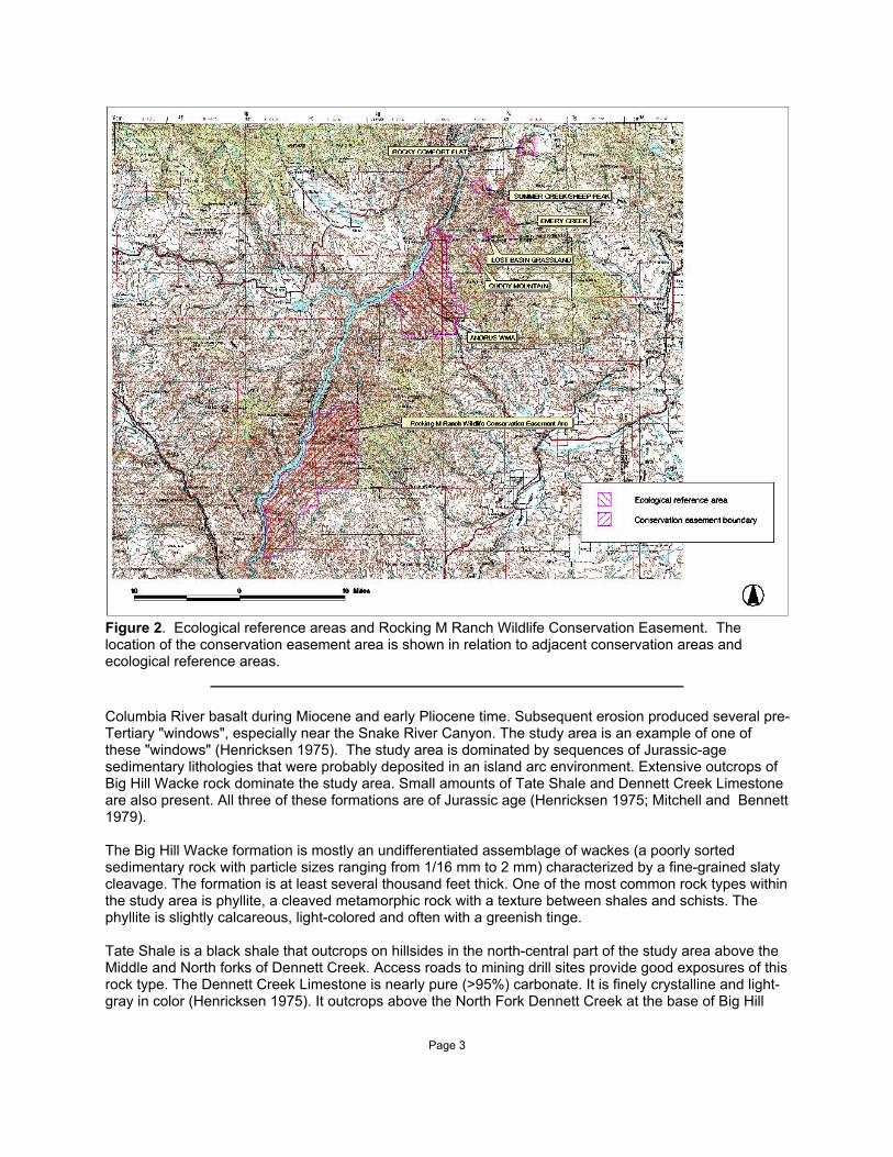
Reference information concerning the easement area was collected at the following ecological referenceareas located in the upper Hells Canyon region: Emery Creek Research Natural Area (RNA), Lost BasinGrassland RNA, Cuddy Mountain RNA, Rocky Comfort Flat RNA, Summer Creek RNA, and AndrusWildlife Management Area (Figure 2). Detailed descriptions of these sites is provided as follows: EmeryCreek RNA, Lichthardt and Rust (1994a); Lost Basin Grassland RNA, Lichthardt and Rust (1994b) andCaicco and Wellner (1983); Cuddy Mountain RNA, Lichthardt and Rust (1994c); Rocky Comfort Flat RNA,Wellner and Moseley (1992); Summer Creek RNA, Moseley (1998); and Andrus Wildlife ManagementArea, Mancuso and Moseley (1995). The following discussion concerning physical setting, geology, soils,climate, and vegetation focuses on the conservation easement area.

Page 2
Figure 1. Rocking M Ranch Wildlife Conservation Easement. The location of the conservation easementis shown with respect to towns and important geographical features.
Physical setting--The study area is located along the steep western flank of the Hitt Mountains. Upperelevations form a major share of the headwaters for Raft, Dennett, Sumac, Wolf, Trail, Rock, and Perkinscreeks, which drain westward through the study area into the Snake River (Brownlee Reservoir). Thedissected topography is characterized by a series of moderately-sloping, west to southwest-trendingprimary ridges dividing the three drainages, and associated north and south-trending steep spur ridges, allwith steep sideslopes descending to the narrow stream corridors below. Areas of gentle, bench-liketopography occasionally interrupt the steep slopes, or are found along the stream corridors. Elevationswithin the study area range from approximately 5880 to 2077 feet.
Ross and Savage (1967) place the Rocking M Ranch study area within the Wallowa-Seven Devils Sectionof the Columbia Intermontane Province. It is part of the Seven Devils Unit of the Columbia Division inErtter and Moseley's (1992) classification of Idaho floristic regions. The study area is considered part ofthe Blue Mountain Section of the Middle Rocky Mountain Province by McNab and Avers (1994).
Geology--The Rocking M Ranch study area is located on the western flanks of the Hitt Mountains. The HittMountains lie within an area characterized by north-northwest trending faults and anticlinal uplifts. Severalfaults are located proximate to the study area. There is no evidence of glaciation in the area.
The pre-Tertiary basement rocks of eastern Oregon and western Idaho were covered by flows of
Page 3
Figure 2. Ecological reference areas and Rocking M Ranch Wildlife Conservation Easement. Thelocation of the conservation easement area is shown in relation to adjacent conservation areas andecological reference areas.
Columbia River basalt during Miocene and early Pliocene time. Subsequent erosion produced several pre-Tertiary "windows", especially near the Snake River Canyon. The study area is an example of one ofthese "windows" (Henricksen 1975). The study area is dominated by sequences of Jurassic-agesedimentary lithologies that were probably deposited in an island arc environment. Extensive outcrops ofBig Hill Wacke rock dominate the study area. Small amounts of Tate Shale and Dennett Creek Limestoneare also present. All three of these formations are of Jurassic age (Henricksen 1975; Mitchell and Bennett1979).
The Big Hill Wacke formation is mostly an undifferentiated assemblage of wackes (a poorly sortedsedimentary rock with particle sizes ranging from 1/16 mm to 2 mm) characterized by a fine-grained slatycleavage. The formation is at least several thousand feet thick. One of the most common rock types withinthe study area is phyllite, a cleaved metamorphic rock with a texture between shales and schists. Thephyllite is slightly calcareous, light-colored and often with a greenish tinge.
Tate Shale is a black shale that outcrops on hillsides in the north-central part of the study area above theMiddle and North forks of Dennett Creek. Access roads to mining drill sites provide good exposures of thisrock type. The Dennett Creek Limestone is nearly pure (>95%) carbonate. It is finely crystalline and light-gray in color (Henricksen 1975). It outcrops above the North Fork Dennett Creek at the base of Big Hill

Page 4
within the study area. Unconsolidated Quaternary-age alluvium fills the stream channels and also occursas terraced deposits in a few places.
Portions of the study area are located within the Mineral-Iron Mountain Mining District. Evidence of pastmining for copper, lead and silver surrounds the site of Mineral, within the Dennett Creek drainage. Anopen-pit gypsum mine is also present. This mine is presently inactive.
Soils--Soils in the study area are derived from metamorphosed sedimentary rocks, and to a lesser extentfrom basalt. Oldsferry shaly loam is the major soil unit on the extensive, steep south-facing slopes withinthe study area. It is a moderately deep, well-drained, shaly-loam textured soil, with very rapid runoff andsevere to very severe water erosion hazard properties. The Meland-Riggins complex soil type is lesscommon on south-facing slopes. It is characterized by a stony loam upper and clay loam lower profile, iswell-drained, and ranges from shallow to moderately deep. Northerly slopes are dominated by theDeMasters loam soil type. This is a deep, well-drained, dark loam soil and has very rapid water runoff andsevere water erosion hazard properties. To a lesser extent, north-facing slopes contain the Gross silt loamsoil type. This is a moderately deep, well-drained, silty loam-textured soil (Natural ResourcesConservation Service 1995).
Climate--From late fall to early spring the climate of west-central Idaho is typically influenced by cool andmoist Pacific marine air. Periodically this westerly flow is interrupted by outbreaks of cold, dry continentalair from the north. During the summer months, a Pacific high pressure system dominates weatherpatterns, resulting in minimal precipitation and more continental climatic conditions overall (Ross andSavage 1967). The BLM maintains a rain gauge near Mineral. Precipitation averaged 14.2 inches between1987 and 1994, with a high of 21.1 inches in 1993 (149% of average) and a low of 8.8 inches in 1992(62% of average) (Bureau of Land Management 1995). Weather data from Weiser, Idaho, 26 miles to thesouth gives general climate trends for the area. At Weiser, 49% of the average annual precipitation fallsduring the November through January winter months. There is a spike of increased precipitation duringJune before the dry summer months begin, when only 14% of the average annual precipitation falls fromJuly through October. The average annual temperature at Weiser is 54.2 F, with December the coldest0
and July the warmest months of the year (Johnson 1981). Average temperatures at the study area arelower compared to Weiser, and upper elevations have higher annual precipitation than at Mineral.
Vegetation--The steep and dissected topography of the Rocking M Ranch study area is typical of the HellsCanyon region in west-central Idaho. In the Snake River Canyon system, aspect is the dominant featurecontrolling environmental parameters such as length of season of available water and soil type. As aresult, vegetation patterns in the study area often closely correlate to changes in aspect. Agropyronspicatum-dominated grassland associations, or degraded versions defined by invasive annual grasses arecommon on south-facing slopes. More mesic aspects support Festuca idahoensis-dominated plantassociations in areas of steep topography. Mid-slope benches, upper slope bowls and other places ofmoderate topography usually support Artemisia tridentata vaseyana-dominated associations. Artemisiatridentata xericensis-dominated plant associations are often present in lower and toe slope positions.Broad riparian bottomlands and lower slope benchs support Artemisia tridentata tridentata plantassociations. Purshia tridentata plant associations are more restricted within the study area and occur onsubstrates other than the phyllitic rock. Bands of deciduous shrubs occur in draws that regularly dissectthe slopes. Riparian zones are characterized by mixed deciduous shrub communities along middle andlower stream segments, and aspen-dominated vegetation along their upper reaches. Conifer standsdominated by Pseudotsuga menziesii are small within the study area and are restricted to steep, north-facing upper slopes. Several stands have been logged recently. Conifer forests are extensive on nearbyPayette National Forest land. Open stands of Juniperus occidentalis occur south- and north-facing slopesabove Mineral.
The understory of grassland, sagebrush and bitterbrush communities are susceptible to disturbance andsubsequent weed invasion, such as the annual brome (Bromus spp.) grasses. To varying degrees,extensive areas are now dominated by weedy species and plant communities in better than mid-seral

Page 5
condition are uncommon in the study area. This is largely the result of cumulative effects of livestockgrazing, the introduction of exotic species, and wildfire. On a more restricted, local scale, past mining andlogging operations have also influenced the condition of vegetation within the study area.
Cyclical wildfire is an important natural element of the Hells Canyon ecosystem. On many sites theresilience of the vegetation to natural disturbance agents has, however, been reduced by livestockgrazing. In recent decades fire has contributed to the conversion of high quality native steppe and shrub-steppe vegetation to exotic annual grass-dominated vegetation.
METHODS
Ecological point observation and plot data was collected to describe the distribution, composition andstructure of the vegetation. Point observation data was intended to rapidly accumulate a large number ofgeographically referenced points where knowledge of the vegetation is linked to base information availableto assist with mapping the vegetation (e.g., simple environmental data such as elevation and slope aspectand gradient). On a walking route through the a selected area for study, data on the plant associationpresent, stand level ecological condition and seral status, and the physical environment are repeatedlycollected. New data is collected as a new plant association is encountered or with any significant changein the environmental parameters (slope, aspect, elevation), structural condition, seral status, or ecologicalcondition. Ecological condition ranks are described in Appendix 1.
Composition and structure data were be collected on 0.1 acre plots using the methods of Bourgeron et al.(1991) and USDA Forest Service (1992). Multivariate analytical techniques (Hill 1979a; Hill 1979b; TerBraak 1991) are employed in the description of plant community composition and structure and theassessment of environmental factors and ecological processes.
Ecological descriptions of sagebrush shrub and grassland natural plant community occurrences areidentified through observations drawn from visits to designated reference areas (RNA/ACEC’s) onCascade Resource Area which encompass vegetation similar to that in the conservation easement area,as well as observations drawn from the conservation easement area itself.
Vegetation mapping units are delineated and described within the study area on the basis of potentialnatural vegetation, current vegetative cover, and ecological condition. Vegetation mapping units wereidentified through a combination of aerial photography interpretation and ecological land unit modeling(Anderson et al. 1998). Stands were delineated and digitized in IDF&G geographical information system(GIS) at a scale of 1:24,000. Raster data analyses were conducted with 30 x 30 meter pixels.
RESULTS
Plant associations and cover types identified in the study area are summarized in Table 1. A crosswalkfrom these communities to Natural Resources Conservation Service range sites observed in the area byGibbs and Franzen (1999) is provided in Table 2. The vegetation of the Rocking M Ranch WildlifeConservation Easement Area is mapped using 25 potential natural and 30 existing vegetation mappingunits. Figures 3, 4, and 5 display potential natural vegetation, existing vegetation, and ecologicalcondition, respectively. The area of each plant association occurring within the study area is summarizedby current covertype and ecological condition in Appendix 2. Detailed descriptions of the most abundantplant associations follow in the next section. Detailed environmental and composition data is summarizedin Appendix 3. The synthesis tables located in Appendix 3 are a primary source for much of thediscussion that follows in the next section. The tables will not, however, be repeated referenced.
Plant species observed in the study area are listed in Appendix 4.

Page 6
Figure 3. Potential natural vegetation of the Rocking M Ranch Wildlife Conservation Easement Area. Codes for the vegetation mapping units are defined in Table 1.

Page 7
Figure 4. Existing vegetative cover of Rocking M Ranch Wildlife Conservation Easement Area.

Page 8
Figure 5. Ecological condition of vegetation within the Rocking M Wildlife Conservaton Easement Area. Condition ranks are defined in Table x.

Page 9
Table 1. Plant associations and plant association groups identified in the Rocking M Ranch WildlifeConservation Area. a) Plant association map codes (as they appear in Figures 1 - 3) are list with theplant association name and primary reference. b) Plant association group map codes are listed with theplant association group name, the included plant associations, and the association primary references.
a)Plant Association Code Plant Association Name Primary Reference
ACGL Acer glabrum none
AGSP-POSE/BASA Agropyron spicatum-Poa secunda/Balsamorhiza sagittata Johnson and Simon 1987
ARRI/POSE Artemisia rigida/Poa secunda Johnson and Simon 1987
ARTRT/AGSP Artemisia tridentata tridentata/Agropyron spicatum Hironaka et al. 1983
ARTRT/ELCI Artemisia tridentata tridentata/Elymus cinereus Hironaka et al. 1983
ARTRT/FEID Artemisia tridentata tridentata/Festuca idahoensis Hironaka et al. 1983
ARTRV-SYOR/AGSP Artemisia tridentata vaseyana-Symphoricarpos Hironaka et al. 1983oreophilus/Agropyron spicatum
ARTRV-SYOR/FEID Artemisia tridentata vaseyana-Symphoricarpos Hironaka et al. 1983oreophilus/Festuca idahoensis
ARTRV/AGSP Artemisia tridentata vaseyana/Agropyron spicatum Hironaka et al. 1983
ARTRV/FEID Artemisia tridentata vaseyana/Festuca idahoensis Hironaka et al. 1983
ARTRX/AGSP Artemisia tridentata xericensis/Agropyron spicatum Hironaka et al. 1983
ARTRX/FEID Artemisia tridentata xericensis/Festuca idahoensis Hironaka et al. 1983
ERCO Eriogonum compositum
FEID-AGSP, BASA Festuca idahoensis-Agropyron spicatum, Balsamhoriza Johnson and Simon 1987sagittatum
FEID-AGSP, LUSE Festuca idahoensis-Agropyron spicatum, Lupinus sericeus Johnson and Simon 1987
FEID-KOCR Festuca idahoensis-Koleria cristata Johnson and Simon 1987
POTR/AMAL-SYOR/TALL Populus tremuloides/Amelanchier alnifolia-Symphoricarpos Mueggler 1988FORB oreophilus/Tall Forb
PREM Prunus emarginata none
PUTR/AGSP Purshia tridentata/Agropyron spicatum Johnson and Simon 1987
PUTR/FEID Purshia tridentata/Festuca idahoensis Johnson and Simon 1987

Page 10
Table 1 (continued)b)
Plant Association Group Plant Association Group Included Plant Communities and Primary ReferenceCode Name Plant Associations
Canyon Riparian WG Canyon Riparian WG Alnus rhombifolia/Philadelphus Miller 1976lewisii
Betula occidentalis/Mesic forb Padgett et al. 1989
Crataegus douglasii/Rosa woodsii Kovalchik 1987
Populus trichocarpa/Rosa woodsii Asherin and Orme 1978
Salix lasiolepis/Barren Padgett et al. 1989
Salix lasiolepis/Mesic forb Moseley 1999
Salix lutea/Poa pratensis Moseley 1999
JUOC Woodland WG Juniperus occidentalis Juniperus occidentalis/Agropyron Dealy 1975Woodland WG spicatum
Juniperus occidentalis/Festuca Dealy 1975idahoensis
PSME Forest WG Pseudotsuga menziesii Pseudotsuga menziesii/Physocarpus Steele et al. 1981Forest WG malvaceus
Pseudotsuga menziesii/ Steele et al. 1981Symphoricarpos oreophilus
PSME-ACGL WG Pseudotsuga menziesii- Acer glabrum noneAcer glabrum WG
Pseudotsuga menziesii/Physocarpus Steele et al. 1981malvaceus
Pseudotsuga menziesii/ Steele et al. 1981Symphoricarpos oreophilus

Page 11
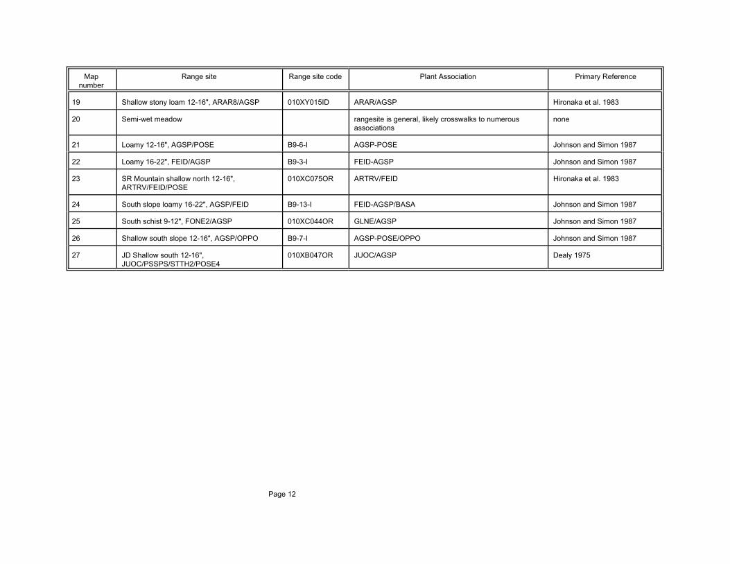
Table 2. Crosswalk between range sites identified as occurring within the study area and plant associations reported for the area. The mapnumber, range site, and range site code identified for the study area by Gibbs and Franzen (1999) are listed with the comparable potential naturalvegetation plant association and the associated primary reference.
Map Range site Range site code Plant Association Primary Referencenumber
1 North slope loamy 12-16", FEID/KOCR B9-5-I FEID-KOCR, low Johnson and Simon 1987
2 North slope 16-22", SYAL/FEID/AGSP B9-2-I SYAL-ROSA Johnson and Simon 1987
3 Shrubby north 15 +", PHMA/SYAL 009XY060OR PHMA-SYAL Johnson and Simon 1987
4 South slope loamy 12-16", AGSP/POSE B9-12-I AGSP-POSE Johnson and Simon 1987
5 High mountain south 16-20", 010XC050OR ARTRV-SYOR/AGSP Hironaka et al. 1983ARTRV/ERIOG/AGSP/STIPA
6 Loamy 12-16", ARTRX/AGSP 010XY007ID ARTRX/AGSP Hironaka et al. 1983
7 Loamy 16-20", PUTR2/FEID 010XY003ID PUTR/FEID Johnson and Simon 1987
8 Loamy bottom, ELCI2 010XY005OR ARTRT/ELCI Hironaka et al. 1983
9 North slope loamy 12-16", ARTRX/AGSP 010XY010ID ARTRX/FEID Hironaka et al. 1983
10 North slope loamy 16-22", ARVA2/FEID 010XY005ID ARTRV/FEID Hironaka et al. 1983
11 Shallow south stony 12-16", ARTRX/AGSP B10-16-I ARTRX/AGSP Hironaka et al. 1983
12 Shallow south schist 9-12", FONE2/AGSP 010XC052OR GLNE/AGSP Johnson and Simon 1987
13 Shrubby mountain north 16-20", 010XC067OR ARTRV-SYOR/FEID Hironaka et al. 1983AMAL/ARTRV/FEID
14 South slope loamy 12-16", ARTRX/AGSP 010XY019ID ARTRX/AGSP Hironaka et al. 1983
15 Very shallow 12-20", ARRI2/POSE 010XY002ID ARRI/POSE Johnson and Simon 1987
16 Douglas fir/mountain snowberry, PSME/SYOR E43A-1-I PSME/SYOR Steele et al. 1981
17 Rock outcrop none none
18 Aspen Populus tremuloides/Amelanchier Mueggler 1988alnifolia-Symphoricarpos oreophilus/Tall Forb
Map Range site Range site code Plant Association Primary Referencenumber
Page 12
19 Shallow stony loam 12-16", ARAR8/AGSP 010XY015ID ARAR/AGSP Hironaka et al. 1983
20 Semi-wet meadow rangesite is general, likely crosswalks to numerous noneassociations
21 Loamy 12-16", AGSP/POSE B9-6-I AGSP-POSE Johnson and Simon 1987
22 Loamy 16-22", FEID/AGSP B9-3-I FEID-AGSP Johnson and Simon 1987
23 SR Mountain shallow north 12-16", 010XC075OR ARTRV/FEID Hironaka et al. 1983ARTRV/FEID/POSE
24 South slope loamy 16-22", AGSP/FEID B9-13-I FEID-AGSP/BASA Johnson and Simon 1987
25 South schist 9-12", FONE2/AGSP 010XC044OR GLNE/AGSP Johnson and Simon 1987
26 Shallow south slope 12-16", AGSP/OPPO B9-7-I AGSP-POSE/OPPO Johnson and Simon 1987
27 JD Shallow south 12-16", 010XB047OR JUOC/AGSP Dealy 1975JUOC/PSSPS/STTH2/POSE4

Page 13
VEGETATION DESCRIPTION
Grassland Vegetation
Agropyron spicatum-Poa secunda Plant Assocations
Distribution--Agropyron spicatum-Poa secunda plant assocations are described from sites located inthe Hells Canyon, Wallowa and Blue mountains, Columbia River Basin, and western Montana (Johnsonand Simon 1987; Johnson and Clausnitzer 1991; Tisdale 1986; Meuggler and Stewart 1980; Daubenmire1970; Mueggler and Harris 1969). Johnson and Simon (1987) describe numerous Agropyron spicatum-Poa secunda communities for the Hells Canyon region. Tisdale (1986), in comparison, discribes only onefor his Hells Canyon study area. In an effort the reconcile this classification conundrum, Rust (1997)proposed two associations with six variants (or phases). This trend appears to characterize data from thisstudy as well. Two major associations, Agropyron spicatum-Poa secunda (AGSP-POSE) and Agropyronspicatum-Poa secunda/Balsamorhiza sagittata (AGSP-POSE/BASA), appear to characterize thecompositional loci of high variability in composition along an environmental gradient of moisture availabilityassociated with elevation, aspect, slope gradient, and soil texture. Agropyron spicatum-Poa secunda plantassociations occur throughout the easement area. Stands were sampled at Upper Rock Creek, UpperWolf Creek, Perkins Creek, Thorn Spring Creek, Trail Creek, McCord Butte, Rocky Comfort Flat,West/Middle Ridge, Upper Flat Creek, Spring Creek, Cuddy Mountain, Emery Creek, Summer Creek, andKleinschmidt Grade. Though distinct Agropyron spicatum-Poa secunda plant associations appear tooccur within the study area, all stands are mapped as Agropyron spicatum-Poa secunda/Balsamorhizasagitatta and are not treated as a plant association group (Table 1).
Vegetation--Agropyron spicatum-Poa secunda communities are characterized by a relatively open, tallbunchgrass canopy dominated by Agropyron spicatum. Agropyron spicatum is abundant, occurring with40 - 60 and 20 - 30 percent cover in stands grouped as AGSP-POSE/BASA and AGSP-POSE,respectively. Poa secunda is consistently present but typically is only common to well represented. Annual bromes (Bromus brizaeformis, Bromus japonicus, and Bromus tectorum) and Poa bulbosa areoften present and may occur with abundance in degraded stands. In AGSP-POSE/BASA associatedherbaceous species include Balsamorhiza sagittata, Lupinus spp., Crepis accuminata, Allium acuminatum,Achillea millefolium, and Epilobium paniculatum. Common herbaceous species associated with AGSP-POSE are Balsamorhiza sagittata, Penstemon deustus, and Collomia grandiflora.
Environment--The AGSP-POSE/BASA and AGSP-POSE associations occur in upper-slope toridgetop positions on major ridge systems within the study area. Soils on these steep, hot, dry sites arevery gravelly, cobbly colluvium which is often raveling. The associations are weakly differentiated on thebasis of elevation, slope configuration, and parent material. AGSP-POSE/BASA tends to occur onbasaltparent materials, at higher elevation (3700 - 5100 feet) compared to AGSP/POSE, and with straight slopeconfiguration. AGSP-POSE tends to occur on metamorphic parent material, at lower elevation (2900 -4500 feet), and with convex slope configurations. Festuca idahaoensis plant associations are adjacent onadjacent and opposing north-facing slopes.
Conservation and management considerations--Agropyron spicatum is considered one of the mostimportant forage species for wildlife and livestock, though it is not the most highly preferred species (Sours1983; Zlatnik 1999). Agropyron spicatum is moderately grazing tolerant only during seasonal periodswhen it is not growing. It is extremely sensitive to defoliation (by herbivory or fire) during the activegrowing season (Blaisdell and Pechanec 1949; Britton et al. 1990; McLean and Wikeem 1985). Agropyron spicatum is considered a grazing decreaser. Heavy grazing results in stand degradation andmortality of individual bunchgrass plants.
AGSP-POSE/BASA and AGSP-POSE are relatively resistant to fire. Seasonal timing, however, largelydetermines the affect of fire. Agropyron spicatum has coarse stems and little leafy material. In the

Page 14
dormant period dry leaf material and stems burn rapidly and little heat is transferred down toward the leafmeristem located at the soil surface. Agropyron spicatum plant associations are most severely affected byfire that occurs during the growing season, prior to dormancy (Zamora 1989).
Cummulative effects of fire and livestock grazing are significant. Stands of Agropyron spicatum exposedto fire and subsequent grazing show higher bunchgrass mortality and lower productivity and reproductionthan stands that are exposed only to fire. Cattle often congregate on recently burned stands as Agropyronspicatum regrowth is highly palatable and preferred forage (Bunting et al. 1998; Moomaw 1956; Strang1989).
The response of AGSP-POSE/BASA and AGSP-POSE to disturbance is influenced by the presence ofannual grass species. The early spring growth phenology of Bromus tectorum and Elymuscaput-medusea confers these species a competitive advantage over Agropyron spicatum in seedlingestablishment. These exotic annual grass species are able to germinate and initiate root growth at coolersoil temperatures and continue to grow throughout winter. In spring the annual species are able tocompetitively capture soil surface moisture before initiation of significant root growth has occurred inAgropyron spicatum (Harris 1967). Increased abundance of annual grass species leads to theaccumulation of fine fuels, which results in more frequent fire and the subsequent reduction in abundanceof Agropyron spicatum (Peters and Bunting 1994; Whisenant 1990). This spiraling decline related to theinvasion of annual grass species has contributed to widespread loss of the quality and distribution ofAgropyron spicatum plant associations.
Festuca idahoensis-Agropyron spicatum, Balsamhoriza sagittata (FEID-AGSP, BASA) and Festucaidahoensis-Agropyron spicatum, Lupinus (FEID-AGSP, LUPINUS)
Distribution--The Festuca idahoensis-Agropyron spicatum plant association is described from siteslocated in the northern portion of the Blue Mountains, the northeastern portion of the Wallowa Mountains,Hells Canyon and southwestern Montana (Johnson and Simon 1987; Johnson and Clausnitzer 1991;Tisdale 1986; Meuggler and Stewart 1980). Johnson and Simon (1987) differentiate FEID-AGSP/BASAand FEID-AGSP/LUSE from sites within the northeastern portion of the Wallowa Mountains and HellsCanyon. The associations are among the most abundant bunchgrass associations within the WallowaMountains and Hells Canyon. This differentiation is also apparent in our data from the upper Hells Canyonregion except the Lupinus species is not always Lupinus sericea. For the purposes of this discussion, thecommunities are tentatively differentiated here as phases rather then plant associations.
The association occurs throughout the easement area. Stands of the association were sampled at BentonCreek, Cuddy Mountain, Emery Creek, Lower Wolf Creek, Rocky Comfort Flat, Spring Creek, SummerCreek, Trail Creek, Upper Flat Creek, and West/Middle Ridge.
Vegetation--The grassland vegetation is co-dominated by Festuca idahoensis and Agropyronspicatum. These species form a relatively dense bunchgrass canopy (32 - 62 percent cover). Poasecunda is consistently present in the understory. Festuca idahoensis is typically more abundant in theLupinus phase. Important forbs of the Balsamorhiza sagittata phase are Sedum stenopetalum,Eriophyllum lanatum, Castilleja spp., Allium acuminatum, Calochortus spp., Achillea millefolium,Balsamorhiza sagittata, Crepis accuminatum, and Lupinus species. Achillea millefolium, Balsamorhizasagittata, Crepis acuminata, Arabis spp., Arnica sororia, Astragalus purshii, Collinsia parviflora, Eriogonumheracleoides, Lithospermum ruderale, Lupinus sericeus, and Senecio integerrimus are importantherbaceous associates of the Lupinus phase (Appendix 3).
Bromus tectorum and Bromus brizaeformis are present in both communities with degraded conditions. Bromus japonicus appears to have a greater affinity for the Lupinus phase. Sedum stenopetalum,Eriophyllum lanatum, Castilleja spp. decrease with degradation in the Balsamorhiza phase whileTragopogon dubius, Epilobium paniculatum, Collomia grandiflora, and Lactuca serriola increase (Appendix

Page 15
3). In the Lupinus phase Arabis spp., Arnica sororia, Eriogonum heracleoides, and Senecio integerrimusare decreasers while Tragopogon dubius, Epilobium paniculatum, Clarkia pulchella, and Lomatiumtriternatum increase in abundance with poorer condition (Table x).
Factors that contribute to the increased abundance of exotic plant species appear to be confounded withbasic environmental factors. Lower elevation FEID-AGSP stands tend to occur on steeper slopes. Theapparent correlation between increased number and abundance of exotic species with the increasedabundance of Festuca idahoensis and Agropyron spicatum suggests that lower elevation, more steeplysloped, and perhaps more productive, sites are more susceptible to invasion by exotic species. These lowelevation sites are also more heavily utilized by livestock as they occur in closer proximity to water.
Environment--The association occurs on steep to moderately steep, west-southwest- to east-southeast-facing, well drained slopes on mid- to upper-slope positions of upper breakland and lowermountain ridges. The association most frequently occurs on convex topographical surfaces at elevationsranging from 2700 to 6200 feet. Higher elevation stands tend to occur on more gentle slopes. TheBalsamorhiza phase typically occurs on northeast- to east-facing slopes while the Lupinus phase occurson northwest- to west-facing slopes. Purshia tridentata/Agropyron spicatum, Artemisia rigida, andAgropyron spicatum lithosolic communities are often adjacent in upslope positions. Pseudotsugameziesii/Physocarpus malvaceus, Artemisia tridentata vaseyana, Physocarpus malvaceus, or Agropyronspicatum-Poa secunda associations are often adjacent downslope.
Conservation and management considerations--Native grasslands such as FEID-AGSP areapparently highly stable, as is evidenced by abrupt and well-defined ecotones with forest and shrublands(Tisdale 1986). The dominant bunchgrasses within the association, however, show differing levels oftolerance to fire disturbance. Agropyron spicatum is considered tolerant of fire. In the dormant period dryleaf material and stems burn rapidly and little heat is transferred downward into the leaf meristem locatedat the soil surface. Agropyron spicatum is sensitive to burns that occur during the growing season prior tothe onset of dormancy (Zamora 1989; Zlatnik 1999). Festuca idahoensis, however, is generallyconsidered fire-sensitive. Dried foliage arranged in a dense, fine-leaved tuft may continue to smolder for aconsiderable period after the initial fire front has passed (Bradley 1986; Wright and Klemmedson 1965). Festuca idahoensis can be severely damaged by summer and fall fires; recovery may require severaldecades (Antos et al. 1983; Conrad and Poulton 1966; Harniss and Murray 1973). Festuca idahoensisappears to be least damaged by fires that occur in early spring. In spring cool, moist soil may provideprotection from fire damage and promote regrowth (Bradley 1986).
Tisdale (1986) argues that current composition or distribution of FEID-AGSP stands are not significantlyaffected by fire. Johnson and Simon (1987), however, found that native perennial forbs and both exoticand native annuals (such as Balsamorhiza sagittata, Lupinus spp., Achillea millefolium, and Lactucaserriola) increase after fire.
Festuca idahoensis and Agropyron spicatum are highly palatable and important forage species forlivestock and wildlife. Excessive utilization of FEID-AGSP stands results in a decline in abundance ofthese highly vulnerable and palatable native perennials and an increase in exotic annual species,especially Bromus species (Tisdale 1986). With moderate grazing impact Festuca idahoensis declines incover and constancy while Agropyron spicatum and Poa secunda increase. High grazing intensity resultsin decreased Agropyron spicatum abundance, increased bare ground and gravel exposure, andsubsequent invasion by annual Bromus species (Johnson and Simon 1987). Native perennial forbs(especially Lupinus, Balsamorhiza sagittata, and other unpalatable species) respond to livestock grazingwith initial increases, followed by decreases in abundance on degraded sites dominated by annual exoticgrass species (Johnson and Simon 1987; Tisdale 1986). Overgrazing, especially on ridgetops, willincrease wind and water caused soil erosion due to lack of vegetative and microbiotic crust cover. As aresult, spring soil moisture decreases. In these conditions Festuca idahoensis often will not persistleading to a droughtier site and greater abundance of Agropyron spicatum (Johnson and Simon 1987).

Page 16
Early season livestock grazing may damage FEID-AGSP associations for several reasons. Trampling bylivestock is most severe during early season with saturated soil conditions. Early season livestock useoften results in soil compaction and uprooting of bunchgrasses and other native perennial plants. Earlygrazing Festuca idahoensis and Agropyron spicatum reduces seed formation and plant vigor. Repeatedearly season grazing eventual results in perennial bunchgrass mortality (Johnson and Simon 1987).
The distribution of grazing is typically uneven in the steep terrain characteristic of the canyon grasslands.Livestock often concentrate on more gradual slopes, flats, and on areas closer to water. This often resultsin over-utilization in late spring and early summer during peak growth periods (Tisdale 1986). The impactsof livestock grazing may be compounded by wild ungulate use. Deer and elk use of FEID-AGSP is highand, when combined with cattle grazing, can lead to over utilization, especially during simultaneous use inwinter (Johnson and Simon 1987).
Festuca idahoensis, and to a lesser extent Agropyron spicatum, require maintenance of the surface areabetween individual bunchgrasses, especially with sufficient cover of microbiotic crust to help maintain soilmoisture (Johnson and Simon 1987). Festuca idahoensis and Agropyron spicatum are sensitive todefoliation (by herbivory or fire) during the active growing season. Prescribed fire may increase diversityand grass production though it should occur in spring when soil moisture is higher or in late fall of dryyears (Bradley 1986). Livestock grazing during flowering and seed forming periods of native perennialgrasses should be avoided. Proper management of spring sheep grazing on degraded sites can helpcontrol weeds, reduce Balsamorhiza sagittata, and reduce annual Bromus species. On steeper slopessheep may cause less damage than cattle, however, sheep grazing during early spring is damaging toFestuca idahoensis because it is the preferred forage (Johnson and Simon 1987).
Festuca idahoensis-Koleria cristata (FEID-KOCR) Plant Associations
Distribution--This regional endemic plant association is known only from the Wallowa, Seven Devils,and western Salmon River mountains and Hells Canyon (a range of less than 10,000 square miles). Theassociation is described by Johnson and Simon (1987), Tisdale (1986), Campbell (1962), Mueggler andHarris (1969) and Poulton (1955) from sites on canyon and mountain slopes of the lower Snake Riverdrainage. Johnson and Simon (1987) recognize four Festuca idahoensis-Koleria cristata plantassociations from sites in the northeast Wallowa Mountains and Hells Canyon. Our data supportrecognition of three of these four plant associations (FEID-KOCR, Ridgetop; FEID-KOCR, High; and FEID-KOCR, Low) within the upper Hells Canyon area. Stands within the Rocking M Ranch are all consideredFEID-KOCR, High, though they are identified simply as FEID-KOCR in Figures 3 and 4, Table 1, andAppendix 2.
Vegetation--FEID-KOCR plant associations are characterized by a dense sward of bunchgrass and arich assemblage of forbs. Total perennial grass cover typically ranges for 60 to 70 percent. Festucaidahoensis is usually abundant. Agropyron spicatum is often the co-dominant bunch grass, though thepresence of Koleria cristata on these sites is indicative of more mesic environments, compared to adjacentFestuca idahoensis/Agropyron spicatum stands. Consistent associated forbs include Brodiaea douglasii,Frasera albicaulis, Castilleja hispida, Hieracium albertinum, and Arnica sororia (Johnson and Simon1987).
FEID-KOCR, Ridgetop; FEID-KOCR, High; and FEID-KOCR, Low stands observed in the upper HellsCanyon region appear similar to those described by Johnson and Simon (1987) primarily on the basis ofpatterns in environmental distribution. There are, however, significant differences in the speciescomposition of these associations. This may be due to the differences in seral status or the distributionand relative abundance of key species within the range of the associations. Common forbs of upper HellsCanyon FEID-KOCR, High stands are: Achillea millefolium, Crepis acuminata, Senecio integerrimus,Calochortus eurycarpus, Clarkia pulchella, Crepis modocensis, Eriogonum heracleoides, and Lupinuslaxiflorus. Herbaceous species characteristic of the more xeric FEID-KOCR, Low stands include:

Page 17
Balsamorhiza sagittata, Castilleja spp., Collomia grandiflora, Epilobium paniculatum, Lithospermumruderale, Myosotis micrantha, and Polygonum douglasii. Arnica sororia, Eriogonum heracleoides, andBrodiaea douglasii are common herbaceous associates of FEID-KOCR, Ridgetop stands observed in theupper Hells Canyon region.
Environment--FEID-KOCR associations occur on relatively deep loessal soils that overlay a range ofdifferent rock types. The association includes the most productive grassland stands in the Blue Mountainsecoregional section. Stands of FEID-KOCR, Ridgetop occur on gentle to moderately steep, west- tonortheast-facing slopes in ridgetop and upper-slope positions. The microtopographical configuration isusually convex, but may also be straight or concave. The elevation of stands ranges from 4500 to 6300feet. The FEID-KOCR, High association occurs on moderately steep to steep west- to north-facing slopesin mid- to upper-slope positions at 4500 to 5600 feet elevation. Stands of FEID-KOCR, Low occur onsteep northeast- to northwest-facing slopes in lower- to upper-slope positions at 2960 to 5000 feetelevation. Factors of slope aspect and elevation interact in a compensatory manner. Higher elevationstands of FEID-KOCR, Low occur on more southwesterly aspects; the lowest elevation stands occur onnortherly aspects.
Conservation and management considerations--Koelaria cristata often shows little affect or increaseswith fire disturbance. Similar to Agropyron spicatum, the dried coarse foliage of the low-growingbunchgrass species burns rapidly with little heat transfer down toward leaf meristem tissues located at orjust below the soil surface (Tirmenstein 1987). The effect of fire on Koelaria cristata is related to theseason of the fire. The species is least effected by early spring and fall burns. It is most effected by latespring and summer fire events (Britton et al. 1990; Volland and Dell 1981; Wright and Bailey 1980). Festuca idahoensis, however, is generally considered fire-sensitive. Dried foliage arranged in a dense,fine-leaved tuft may continue to smolder for a considerable period after an initial fire front has passed(Bradley 1986; Wright and Klemmedson 1965). Festuca idahoensis can be severely damaged by summerand fall fires; recovery may require several decades (Antos et al. 1983; Conrad and Poulton 1966; Harnissand Murray 1973). Festuca idahoensis appears to be least damaged by fires that occur in early spring. Inspring cool, moist soil may provide protection from fire damage and promote regrowth (Bradley 1986). Fire disturbance in FEID-KOCR plant associations may result in increased abundance of Koelaria cristataand decreased abundance of Festuca idahoensis. The lengthy recovery period of Festuca idahoensismay also contribute to increased abundance of Poa pratensis and Balsamorhiza sagittata following firedisturbance (Johnson and Simon 1987; Tisdale 1986). Higher moisture levels characteristic of north-facing slopes, especially at higher elevations, has probably limited the occurrence of fire on many FEID-KOCR sites.
The greatest concerns regarding the maintenance of quality FEID-KOCR habitats are the intensity andtiming of grazing by livestock. With excessive grazing (at all elevations) Festuca idahoensis and(eventually) Koelaria cristata are eliminated and replaced by exotic annual Bromus species, annual andperennial forbs, Poa secunda, and Poa pratensis (Johnson and Simon 1987). On shallow ridgetop soilsless palatable native perennial species (such as Poa secunda, Danthonia unispicata, and various forbs)may increase with excessive utilization (Johnson and Simon 1987). Grazing disturbance of sites with deepsoil, benches, and gentle ground (at all elevations) results in the initial increase of native forbs, Koelariacristata, Poa pratensis, Poa bulbosa, and annual Bromus species while Festuca idahoensis and oftenAgropyron spicatum decline. On lower elevation sites Agropyron spicatum may increase with degradationas competition is reduced and sites become droughtier due to loss of vegetative and microbiotic crustcover (Johnson and Simon 1987).
Stands of FEID-KOCR located on steep slopes are very unstable and often slump. Occurrences on gentleslopes and ridgetops are most heavily utilized and impacted by both livestock and elk. While sheep showpreference for Festuca idahoensis, cattle and elk prefer Agropyron spicatum. Trampling impacts (trailing,soil compaction, erosion, and plant uprooting) can be high (especially on steep slopes) throughout thespring and early summer because soil moisture lingers later on Festuca idahoensis-Koelaria cristata sites. Noxious weeds, usually Hypericum perforatum, can become dominant on degraded sites at all elevations

Page 18
and difficult to eradicate (Johnson and Simon 1987).
Most grassland vegetation benefits from natural levels of disturbance. Periodic grazing or fire cancontribute to the maintenance of plant vigor. Maintenance of healthy FEID-KOCR occurrences requiresthat livestock grazing not occur until perennial bunchgrass species have produced mature seeds (Johnsonand Simon 1987). The seasonal timing of the occurrence of fire is also critical.
Festuca idahoensis-dominated plant associations are susceptible to invasion by more fire resistantspecies such as Poa pratensis. Fires that occur during the wet, dormant season (November throughMarch) result in the least impact as plant moisture is high enough to protect sensitive root crowns. Prescribed fire has been used effectively to increase vegetative diversity for wildlife and decrease theabundance of undesirable perennial forbs such as Grindelia species (Johnson and Simon 1987).
Shrubland Vegetation
Artemisia rigida/Poa secunda (ARRI/POSE)
Distribution--The association is described by Johnson and Clausnitzer (1991), Johnson and Simon(1987), Hall (1973), Tisdale (1986), Hironaka et al. (1983), and Daubenmire (1970) from stands located inthe Blue and Wallowa mountains, Hells Canyon, and the Columbia River plateau. The moderatelyabundant association occurs in relatively small stands on dispersed basalt ridgetops and lithosolic sites. Many ARRI/POSE stands may represent degraded FEID-KOCR or FEID-AGSP sites.
Vegetation--The sparse, dwarf-shrub vegetation is dominated by Artemisia rigida. Poa secunda andDanthonia unispicata are the principal understory grass species. Sitanion hystrix is a consistent associatein stands of the upper Hells Canyon region. Agropyron spicatum may also be present, but is usually notcommon. Sedum stenopetalum, Polygonum douglasii, Balsamorhiza incana, Allium acuminatum,Lomatium macrocarpum, Trifolium macrocephalum, Lomatium triternatum, and Sisyrinchium inflatum arecommonly associated herbaceous species.
Environment--The association is restricted to shallow, basalt lithosolic soils. ARRI/POSE stands occuron exposed, gently sloped ridgetops and dissected plateaus with convex or straight microtopographicconfiguration at 3500 to 5500 feet elevation.
Conservation and management considerations--Artemisia rigida is highly palatable to wildlife andlivestock. The shrub is heavily utilized by deer and elk in winter. Shallow soils on rocky ARRI/POSE sitesare subject to frost heaving and boiling. When soil moisture is high, trampling damage is often severe. Due to low abundance and discontinuous nature of fuels fire usually does not carry through ARRI/POSEstands ((Hironaka et al. 1983; Hickerson 1986; Johnson and Simon 1987).
Artemisia tridentata tridentata/Agropyron spicatum (ARTRT/AGSP) and Artemisia tridentatatridentata/Festuca idahoensis (ARTRT/FEID)
Distribution--The plant associations are described from sites in the mountains of northern Nevada andthe Snake River Plain of Idaho (Nelson and Jensen 1987; Hironaka et al. 1983). Artemisia tridentatastands sampled by Daubenmire (1970) are now considered to be dominated by Artemisia tridentatawyomingensis. The extent of Artemisia tridentata tridentata associations has severely declined due to theconversion of deep, fertile floodplain soils to cultivation. Relatively few high quality stands of theassociations are currently known.
Vegetation--The decline in the extent and quality of these associations pre-dated descriptive work onthe sagebrush ecosystems (Hironaka et al. 1983). There is little to no documentation of pristine stand

Page 19
composition and structure. Hironaka et al. (1983) report that the composition and structure of thesestands was nearly identical to that of Artemisia tridentata wyomingensis/Agropyron spicatum. In Artemisiatridentata/Agropyron stands observed by (now considered primarily ssp. wyomingensis) Daubenmire(1970), the shrub canopy is open, ranging from 9 to 26 percent cover. Perennial grass cover is abundantwith Agropyron spicatum and Poa secunda co-dominant. Stipa commata is often also present. Principalherbaceous associates include Antenaria dimorpha, Brodiaea douglasii, Calochortus macrocarpus,Lithofragma bulbifera, and Lomatium triternatum. Plant interspaces are occupied by a continuouscryptogamic crust.
Late-seral, high quality Artemisia tridentata tridentata/Festuca idahoensis stands are open. The Artemisiatridentata tridentata ranges from 8 to 25 percent cover. Understory bunchgrasses are very abundant. Thecombined cover of the co-dominant species, Agropyron spicatum, Festuca idahoensis and Poa secunda,ranges from 75 to (greater than) 100 percent. Important forbs include Achillea millefolium, Erigeronpumilus, Lithospermum ruderale, Lomatium macrocarpum, and Lomatium triternatum.
Environment--Artemisia tridentata tridentata/Agropyron spicatum is indicative of relatively deep, fertilefloodplain and colluvial soils. Stands occur on lower to mid-slope positions on moderately steep to gentleslopes on all slope aspects, at 2200 to 3800 feet elevation.
Stands of Artemisia tridentata tridentata/Festuca idahoensis occur on moderately steep to steep north-facing convex or concave slopes in mid- to lower-slope positions at 2500 to 3200 feet elevation. In thesouthern portion of the range the association is reported from 5000 to 7000 feet elevation. Soils are deepgravelly silt loam.
Conservation and management considerations--Artemisia tridentata tridentata provides importanthiding and thermal cover and nesting habitat for wildlife. Artemisia tridentata tridentata plant associationsprovide important winter range for mule deer. The species is typically killed by fire. Artemisia tridentatatridentata can, however, quickly become re-established by seed from adjacent stands. With theoccurrence of repeated and extensive fire events, and the invasion of exotic grass species, naturalregeneration of Artemisia tridentata tridentata is significantly inhibited (Britton and Clark 1985; Bunting etal. 1987; Humphrey 1984; Rosentreter and Jorgensen 1986; Tirmenstein 1999).
Extensive areas of ARTRT/AGSP potential natural vegetation on Rocking M Ranch are currently annualgrassland. These areas require aggressive management for the re-establishment of Artemisia tridentatatridentata and associated native perennial bunchgrasses. Artemisia tridentata tridentata is successfully re-established by broadcast seed, drilling, or with the use of transplant stock (Shaw and Monsen 1990). Theuse of regional indigenous plant materials from similar site conditions appears important (Meyer andMonsen 1992). Successful re-establishment of Artemisia tridentata tridentata is also dependent on theavailability of mycorrhizal fungal associates, which may be absent on sites that have been converted toannual grassland for prolonged periods (Rosentreter and Jorgensen 1986).
Stands of ARTRT/AGSP and ARTRT/FEID are typically restricted to draws that are often subjected toconcentrated excessive utilization by livestock for grazing, loafing, and trailing. Exotic annual grassspecies are often well represented to abundant in the understory. These stands are highly vulnerable toconversion to annual grassland following fire (Pechanec et al. 1954; West and Hassan 1985).
Artemisia tridentata tridentata/Elymus cinereus (ARTRT/ELCI)
Distribution--The plant association is reported as occurring is Colorado, Wyoming, Nevada, Idaho,Oregon, and possibly Wyoming (Hironaka et al. 1983; Bourgeron and Engelking 1994; Weixelman et al.1996). The association is thought to have been widespread prior to European settlement. Currently standsare small and fragmented and typically encompass less than five acres. A few stands are reported that areup to 40 acres (Jankovsky-Jones 1998).

Page 20
Vegetation--Artemisia tridentata tridentata dominates the shrub layer and a mixture of graminoids andforbs dominate the herbaceous layer in stands of high ecological condition. Elymus cinereus is usually themost abundant understory species, sometimes reaching near 100 percent cover. Artemisia tridentatatridentata typically occurs with an open canopy, ranging from 10-50 percent cover. Crysothamnus spp.usually occurs with low abundance in high quality stands. Graminoid species are usually abundant; totalcover can be as high as 70 percent. Elymus cinereus often contributes to most of the graminoid cover.The total cover of forb is generally between 5 and 20 percent (Weixelman et al. 1996 as cited by Moseley1998).
Environment--The plant association is often the zone of transition between drier upland associationsand the wetter riparian associations. The association is most often found in areas of deep alluvialdeposition on gentle to moderately steep valley bottoms, stream terraces, and toeslopes at 2500 to 4500feet elevation. Seasonal flooding on these sites is rare.
Conservation and management considerations--Much of the discussion regarding the conservationand management of ARTRT/AGSP and ARTRT/FEID (above) also applies to ARTRT/ELCI sites. Incontrast to Artemisia tridentata tridentata, Elymus cinereus is considered highly resistant to fire. Drycoarse leaves and stems burn rapidly and insulate basal leaf meristems from prolonged heating (Bunting1985; McMurray 1987; Wright 1985). Elymus cinereus is an important seral component is standsdisturbed by fire (Humphrey 1984). In remnant ARTRT/ELCI stands subjected to intensive livestockgrazing residual Elymus cinereus is often restricted to the protective cover of Artemisia tridentatatridentata. Following fire distrubance these plants are susceptible to over utilization by livestock (Perryand Chapman 1975).
Elymus cinereus provides excellent cover, nesting, and bedding habitats for upland birds, small mammals,and big game (Sours 1983). The perennial grass is attractive as forage for cattle, deer, and elk in springand fall (Wasser 1982). Elymus cinereus, however, is highly susceptible to damage from spring grazingand heavy utilization during the growing season (Krall et al. 1971; Perry and Chapman 1975; Roundy et al.1983). Krall et al. (1971) and Roundy et al. (1983) recommend restricting livestock use in Elymuscinereus to fall and winter.
Elymus cinereus is recognized for its value in riparian restoration. The species is strongly competitive andmay effectively suppress undesirable, exotic species such as Onopordum acanthium (Scotch thistle)(McMurray 1987; Monsen 1983).
Artemisia tridentata vaseyana-Symphoricarpos oreophylus/Agropyron spicatum(ARTRV-SYOR/AGSP)
Distribution--The plant association is described by Hironaka et al. (1983), Tueller and Eckert(1987), and Nelson and Jensen (1987) for stands located in southern Idaho and northern Nevada. Theassociation occurs with moderate to low abundance in dispersed patches within the Northwest Basin andRange, east into the Overthrust Mountains, and north into the Idaho Batholith and Beaverhead Mountainsecoregional sections. Few stands of the association were identified within the study area.
Vegetation--The plant association is characterized by a dense shrub canopy of Artemisiatridentata vaseyana and Symphoricarpos oreophilus. A suite of other mountain shrub species such asPrunus virginiana, Amelanchier alnifolia, or Ribes cereum are often also present. Purshia tridentata isoften abundant. In upper Hells Canyon Artemisia tridentata vaseyana and Symphoricarpos oreophilus areabundant; only trace amounts of Prunus emarginata and Rosa nutkana are present. Agropyron spicatum,Bromus carinatus, Melica bulbosa, and Stipa occidentalis are the principal grass species (occurring with atotal cover of 25 percent). Herbaceous associates include: Eriogonum heracleoides, Lupinus sericeus,Achillea millefolium, and Balsamorhiza sagittata.

Page 21
Environment--The association typically occurs near the upper elevational limit of Artemisiatridentata vaseyana. Stands occur on steep, southwest- to northwest-facing slopes in mid-slope positionsat 4400 to 8500 feet elevation.
Artemisia tridentata vaseyana-Symphoricarpos oreophylus/Festuca idahoensis(ARTRV-SYOR/FEID)
Distribution--The plant association is described by Hironaka et al. (1983) and Tueller and Eckert(1987) for sites located in southern Idaho and northern Nevada. The association is moderately abundantin dispersed patches within the Northwest Basin and Range, Overthrust Mountains, Idaho Batholith, andBeaverhead Mountains ecoregional sections.
Vegetation--The plant association is characterized by an open shrub canopy of Artemisiatridentata vaseyana and Symphoricarpos oreophylus. Understory grass and forb species are abundantand contribute greater vegetative cover then the shrub overstory. Principal grass species are Festucaidahoensis, Agropyron spicatum, Koeleria cristata, and Poa secunda. Eriogonum heracleoides, Achilleamillefolium, Calochortus eurycarpus, Crepis acuminata, Lupinus laxiflorus, and Balsamorhiza sagittata areassociated herbaceous species.
Environment--The association occurs on moderate to steep west- to north-facing slopes in mid-slope to ridgetop positions at 3700 to 5300 feet elevation. Stands frequently occupy convex sites.
Artemisia tridentata vaseyana/Agropyron spicatum (ARTRV/AGSP) and Artemisia tridentatavaseyana/Festuca idahoensis (ARTRV/FEID)
Distribution--These widespread plant associations occur in numerous relatively small stands in thefoothills and lower mountain slopes of the Rocky Mountains, northern Great Basin, and upper HellsCanyon. The associations are described from sites in Colorado, Montana, Nevada, and Idaho (Muegglerand Stuart 1980; Cooper et al. 1995; Hironaka et al. 1983; Lewis 1975; Jensen et al. 1988; Baker andKennedy 1985).
Vegetation--The shrubland ARTRV/AGSP vegetation is dominated by Artemisia tridentatavaseyana. Purshia tridentata is often well represented to abundant. Associated forbs include Eriogonumheracleoides, Balsamorhiza sagittata, Lupinus caudatus, Lithosperma ruderale, and Achillea millifolium.
Artemisia tridentata vaseyana forms relatively open canopy in ARTRV/FEID stands (approximately 42percent cover). Festuca idahoensis is the dominant understory grass species and occurs with a meanabundance of 40 percent cover. Agropyron spicatum and Poa secunda are commonly associated. Koeleria cristata and Sitanion hystrix may also be present. The mean total abundance of grass species instands that are in excellent condition is approximately 50 percent cover. Commonly associated forbsinclude Arenaria aculeata, Crepis acuminata, Erysimum asperum, Phlox hoodii, Antennaria microphylla,Eriogonum heracleoides, Lupinus spp., and Achillea millefolium. Herbaceous species typically occur withrelatively moderate abundance, contributing approximately 20 percent total cover.
Environment--The ARTRV/AGSP plant association occurs in the warmest and driest sitesoccupied by Artemisia tridentata vaseyana. Stands occur on middle and upper canyon slopes with convexmicrotopography on steep southwest- to northwest-facing slopes in mid- to upper-slope positions at 2600to 4750 feet elevation. Stands with a more southerly aspect tend to occur with convex microtopographyon more gentle slopes. Over the entire range, the association occurs on a variety of different parentmaterials. Within the upper Hells Canyon area stands occur principally on undifferentiated Columbia Riverbasalts.

Page 22
The ARTRV/FEID plant association occurs on more cool and mesic sites than ARTRV/AGSP. In theupper Hells Canyon region stands occur on middle and upper canyon slopes with both convex andconcave microtopography on moderate to steep west-northwest- to east-northeast-facing slopes in mid- toupper-slope positions at 3000 to 6000 feet elevation. Higher elevation stands (6000 to 8000 feet) tend tooccur on gentle, south-facing slopes. The association occurs on a variety of different parent materials. Within the upper Hells Canyon area stands occur principally on undifferentiated Columbia River basalts.
Conservation and management considerations--Artemisa tridentata vaseyana provides importantwinter forage of relatively high nutritive value for both wild ungulates and livestock. Dense stands ofARTRV/AGSP and ARTRV/FEID provide important summer, winter, and spring-fall habitat for mule deer(Hironaka et al. 1983; Bradley 1986). The south-facing slopes of ARTRV/AGSP provide important winterrange for deer and elk. Spring grazing of these sites by livestock does not allow Agropyron spicatumsufficient recovery prior to the growing season and may contribute to its decline. Steep slopedARTRV/AGSP and ARTRV/FEID sites are vulnerable to soil displacement and livestock tramplingimpacts.
Artemisa tridentata vaseyana is highly susceptible to fire mortality. The response of stands ofARTRV/AGSP or ARTRV/FEID is reflective of the response of dominant understory perennial bunchgrassspecies and dependent on the timing of the fire event, the abundance and vigor of these species, and theabundance of exotic annual grass species. Re-establishment of Artemisia tridentata vaseyana occursthrough the introduction of seed from adjacent stands and germination of seed stored in the soil surfacehorizons. Artemisia tridentata vaseyana germination is apparently stimulated by heat (Mueggler 1956;Hironaka et al. 1983; Bradley 1986; Johnson and Simon 1987).
Artemisia tridentata xericensis/Agropyron spicatum (ARTRX/AGSP) and Artemisia tridentataxericensis/Festuca idahoensis (ARTRX/FEID)
Distribution--The plant associations are described by Hironaka et al. (1983) for sites within centralsouthwest Idaho (Elmore, Ada, Boise, Gem, Payette, and Washington counties). The associations occurwith low to moderate abundance.
Vegetation--Artemisia tridentata xericensis dominates the shrubland canopy. Most standspossess a relatively open shrub canopy. Purshia tridenata, Chrysothamnus nauseosus, andChrysothamnus viscidiflorus are commonly associated. Agropyron spicatum is the principal grass speciesin ARTRX/AGSP stands. In ARTRX/FEID Festuca idahoensis is present. In the one ARTRX/FEID standsampled, perennial bunchgrass abundance was 90 percent cover. Agropyron spicatum and Festucaidahoensis contributed 50 and 40 percent cover respectively. Associated herbaceous species includeAchillea millefolium, Balsamorhiza sagittata, Brodiaea douglasii, Crepis acuminata, Epilobiumpaniculatum, Erigeron corymbosus, Hieracium albertinum, Lomatium triternatum, and Lupinus spp.
Environment--The associations occur in a relatively narrow environmental zone including sitesbelow 4500 feet elevation that receive 12 inches or greater precipitation per year and with relatively warmsummer air temperatures. ARTRX/AGSP stands observed in the study area occur on gentle to steepnortheast- to east-facing and west- to northwest-facing slopes at 2500 to 4500 feet elevation. ARTRX/FEID stands were observed at 2500 to 3500 feet elevation on gentle to steep northwest- tonortheast-facing slopes with concave microtopography. Both plant associations typically occur on lower tomiddle canyon slopes in mid- to upper-slope positions.
Purshia tridentata/Agropyron spicatum (PUTR/AGSP)
Distribution--Purshia tridentata/Agropyron spicatum is described for sites on the eastern foothillsof the Cascade Range, southern portions of the Ochoco, Blue and Wallowa mountains, and the foothills of

Page 23
the Bitterroot Valley (Daubenmire 1970; Hall 1973; Johnson and Simon 1987; Hironaka et al. 1983;Mueggler and Stewart 1980). The widespread plant association occurs in relatively small, dispersedstands.
Vegetation--In the upper Hells Canyon stands Purshia tridentata forms an open (9 percent cover),medium to tall shrub canopy. Other shrub species are usually not abundant; Glossopetalon nevadense isfrquently present. Agropyron spicatum is well represented to abundant in the understory. Poa secunda isusually present; Stipa comata and Stipa thurberiana may also be present. Total grass cover isapproximately 16 percent. Typically associated forbs include Achillea millefolium, Balsamorhiza sagittata,Eriophyllum lanatum, Penstemon deustus, Chaenactis douglasii, Descurainia richardsonii, Epilobiumpaniculatum, Galium multiflorum, Lactuca serriola, Lomatium dissectum, Phacelia hastata, Phacelialinearis, and Tonella floribunda. Total forb cover is approximately 13 percent.
Environment--In the upper Hells Canyon region the plant association occurs on steep south- tosouthwest-facing slopes at 2750 to 4000 feet elevation. These convex sites occur on middle and uppercanyon slopes in mid-slope positions. Stands occur primarily on basalt parent materials.
Conservation and management considerations--Fire, excessive utilization by livestock and wildungulates, and the compounding affects of exotic annual grass species are concerns for the maintenanceof quality stands of the PUTR/AGSP association. Purshia tridentata is very susceptible to fire mortality;little sprouting after fire is observed in the region (Blaisdell 1950; Clark et al. 1982; Scholten 1983; Nosteand Bushey 1987; Zlatnik 1999). Agropyron spicatum usually recovers from all but the hottest burns(Johnson and Simon 1987). Agropyron spicatum will decline in abundance with overgrazing by livestockwhile less desirable native perennials (Poa secunda, Balsamorhiza sagittata, and Lomatium species),annual Bromus species, bare ground, rock, and gravel increase in abundance (Johnson and Simon 1987).
Mule deer and elk rely heavily on the availability of Purshia tridentata for fall and winter forage. Cattle andsheep prefer Purshia tridentata in summer and fall when it is most vulnerable (Johnson and Simon 1987;Hironaka et al. 1983; Shaw and Monson 1983). Under heavy browsing pressure Purshia tridentata actsas a decreaser (Zacek et al. 1977; Monsen1987). Repeated browsing in excess of 60 percent foliarremoval by mule deer and elk may result in reduced Purshia tridentata cover (Hironaka et al. 1983). Muledeer and cattle compete for Purshia tridentata in late summer, fall, and winter (Clements and Young1997). Trampling by livestock on steep slopes can be damaging to both Purshia tridentata seedlingsurvival and understory species due to physical displacement of plants and soil.
Purshia tridentata/Festuca idahoensis ( PUTR/FEID)
Distribution--Purshia tridentata/Festuca idahoensis is described for sites on the eastern foothills ofthe Cascade Range, portions of the Ochoco, Blue and Wallowa mountains, and the foothills of theBitterroot Valley (Daubenmire 1970; Hall 1973; Johnson and Simon 1987; Johnson and Clausnitzer 1991;Hironaka et al. 1983; Mueggler and Stewart 1980). The wide-ranging plant association occurs in relativelysmall, dispersed stands. The PUTR/FEID-AGSP plant association identified by Johnson and Simon(1987) and Johnson and Clausnitzer (1991) is considered synonymous to PUTR/FEID. The Purshiatridentata-Agropyron-Festuca association described by Hall (1973) is assumed to contain PUTR/FEID.
Vegetation--Purshia tridentata forms an open canopy. The average shrub canopy cover isapproximately 27 percent. Understory bunch grass species are abundant; the sum cover is approximately50 percent. While Agropyron spicatum is often most abundant, the plant association is destinguished bythe presence of Festuca idahoensis which is usually common to well represented. Poa secunda iscommon to well represented. Herbaceous associates include Balsamorhiza sagittata, Achillea millefolium,Lupinus spp., Penstemon glandulosus, Calochortus eurycarpus, Comandra umbellata, Lithospermumruderale, and Lomatium dissectum.

Page 24
Environment--In the upper Hells Canyon region stands occur on steep northwest- to northeast-facing slopes in mid- to upper-slope positions on lower canyon side slopes at 3100 to 3800 feet elevation. Sites are typically convex to straight. Stands occur primarily on meta-sedimentary wackes. Artemisiatridentata- and Physocarpus malvaceous-dominated plant associations are often adjacent in downslopepositions. PUTR/AGSP may be adjacent on more southerly aspects.
Conservation and management considerations--Fire, poorly timed livestock grazing, andexcessive use by both livestock and wild ungulates are management issues regarding the PUTR/FEIDassociation. Purshia tridentata is usually killed by fire and Festuca idahoensis is susceptible to damagefrom late summer or fall burns when plant and soil moisture conditions are low (Johnson and Simon 1987;Tisdale 1986). When the PUTR/FEID association is overgrazed, Festuca idahoensis is eliminated andBromus tectorum eventually dominates the understory (Daubenmire 1970). As degradation occurs,Purshia tridentata, Festuca idahoensis, Agropyron spicatum, and moss cover decrease while Poasecunda, Stipa occidentalis, native perennial forbs (e.g. Balsamorhiza sagittata, Penstemon deustus, andLomatium dissectum), Bromus species, native annuals (e.g. Clarkia pulchella, Galium aparine, Collinsiaparviflora, and Epilobium paniculatum), gravel, and bare ground increase (Johnson and Simon 1987;Daubenmire 1970). Heavy use by elk and deer, especially on winter range, will result in reduced Purshiatridentata cover, poor seedling survival, and an older age class stand. In addition, cattle and sheep willalso browse it, especially in late summer and fall when it is most vulnerable (Johnson and Simon 1987;Hironaka et al. 1983). Repeated browsing of 60 percent foliar removal during winter may cause adecrease in Purshia tridentata, though early grazing will allow for it to recover during the growing season(Hironaka et al. 1983).
Trampling caused by early season livestock grazing on steep slopes can impact both Purshia tridentataand Festuca idahoensis. Damage is most severe during early season with saturated soil conditions andresults in compaction and uprooting of bunchgrasses, Purshia tridentata seedlings, and other nativeperennial plants. Early grazing also reduces Festuca idahoensis seed formation and, with continuedgrazing over several years, contributes to losses in plant viability (Johnson and Simon 1987).
Other plant communities
A number of important plant communities that occur within the study area are not discussed in detail here. Plant communities grouped as the Canyon Riparian Working Group (Table 1) are described by Moseley(1999) and will be treated in a forthcoming guide to the riparian vegetation of southwestern Idaho. TheAcer glabrum and Prunus emarginata plant communities (or dominance types) are frequently observed(often from a distance) in the upper portion of drainages within the study area. The communities were notsampled and no references concerning their classification were located in the literature.
Juniperus occidentalis and Pseudotsuga menziesii associations within the area are described by Dealy(1975) and Steele et al. (1981). Work reported here did not focus on these forest and woodlandcommunites as they are relatively minor or occur on private land (within the perimeter of the area) that isexcluded from conservation easement management.
One stand of the community identified as Eriogonum compositum was sampled in the study area. Dataare summarized in Appendix 3. This distinctive plant association is restricted to steep, south-facingphyllite scree slopes common on lower-slope breaklands within the study area.
Three stands tentatively classified as Artemisia rigida/Festuca idahoensis were sampled. Stands occur inridgetop and upper-slope positions on steep west- to north-facing slopes. Shallow, gravelly colluvium mayoccur with bedrock outcrops; cobbles and stones are abundant. Open Artemisia rigida occurs with traceamounts of Artemisia tridentata xericensis or Purshia tridentata. Festuca idahoensis and Poa secunda arewell represented; Agropyron spicatum is common. A number of herbaceous species are observed inthese stands (Appendix 3), particularly, Sedum stenopetalum, Eriogonum umbellatum, Eriogonum

Page 25
strictum, Penstemon gairdneri, Erigeron bloomeri, and Allium accuminatum. Stands observed are bothhighly stabilized (with abundant biotic crust cover) and naturally prone to soil erosion. Elk and deer sign iscommon. Livestock access is typically restricted by steep, rocky terrain. Johnson and Simon (1987)suggest relic cover of Festuca idahoensis or Agropyron spicatum with Artemisia rigida indicate a degradedcondition. This did not appear to be the case for two stands sampled; elk use is relatively intense on thethird.
CONCLUSIONS AND MANAGEMENT RECOMMENDATIONS
The objectives of this study are to develop a comprehensive vegetation map for the conservationeasement area, to assist in the classification and description of the vegetation within the area, and providerecommendations for the conservation of wildlife habitats within the easement area. The potential naturalvegetation, existing vegetative cover, and ecological condition of the vegetation within the study area ismapped at the scale of 1:24,000. The distribution, composition, physical environment, and conservationand management concerns of major components of the vegetation are described.
Primary management objectives for the area are to maintain and restore the availability and quality ofwildlife habitats. Habitats located on steep, upper-slope positions within the conservation easement arelargely in a high quality, representative condition. Important components of the vegetation are, however,susceptible to degradation based on the seasonal timing and intensity of fire disturbance and livestockuse. Critical lower-slope, valley bottom, and stream side wildlife habitats within the study area have beenheavily impacted by the cumulative effects of livestock grazing, exotic species introductions, and firedisturbance. Conservation management strategies need to focus on (1) significant reduction of thenumber of livestock, and the seasons of livestock use, within the area, (2) fire prevention, (3) directmitigation and restoration of degraded habitats, and (4) a monitoring and evaluation system.
Livestock use is the principle ecological mechanism to begin downward trends in vegetative condition andthe quality of wildlife habitats. The number and season of livestock use within the conservation easementarea must be reduced from customary levels in order to simultaneously maintain existing high qualityhabitat conditions while also restoring those habitats that are degraded.
Native perennial bunchgrass species, Elymus cinereus, Festuca idahoensis, Poa secunda, Koleriacristata, and Agropyron spicatum, are key components of the shrubland and grassland ecosystems of thearea. These species provide important wildlife habitat and commercial resource values. The long lived,deep rooted perennial bunchgrass species native to the area also serve a keystone role in themaintenance of ecosystem stability and resilience to disturbance events and environmental change. Loseof the abundance and vigor of bunchgrass triggers the raveling (perhaps eventually irreversible) decay ofecosystem integrity, and the capability of these sites to produce wildlife habitat and commercial resourcevalues. In order to maintain and enhance quality wildlife habitats and commercial resource valuesmanagement must result in significant and prolonged gains in the distribution and abundance ofbunchgrass. The priority may be restoration of the frequency and cover of Elymus cinereus within thehistoric distribution of Artemisia tridentata tridentata/Elymus cinereus.
Adoptive management is an approach that involves the ordered steps of planning, implementing,monitoring, and evaluating. In this cyclical approach monitoring and evaluation are key links to theachievement of management objectives. A monitoring system should be established within theconservation easement that allows the referential power, for example, of paired sampling designs. Thecapability to identify critical causal relationships between patterns in resource utilization and vegetationcomposition and structure, the quality of wildlife habitats, and the maintenance of biological diversity willrequire access to strictly controlled reference conditions. A well planned system of fenced livestockexclosures of sufficient number and size to represent long-term reference ecological conditions of themajor plant associations on the Rocking M Ranch Wildlife Conservation Easement Area should beidentified and constructed.

Page 26
LITERATURE CITED
Anderson, M. G., M. D. Merrill, and F. B. Biasi. 1998. Connecticut River watershed. Ecological communities and neotropicalmigrant birds. Eastern Conservation Science, Boston Satellite Office, The Nature Conservancy, Boston. 56 pp.
Antos, J. A., B. McCune, and C. Bara. 1983. The effect of fire on an ungrazed western Montana grassland. American MidlandNaturalist 110(2): 354-364.
Asherin, D. A., and M. L. Orme. Inventory of riparian habitats and associated wildlife along Dworshak Reservoir and lowerClearwater River. Idaho Cooperative Wildlife Research Unit; College of Forestry, Wildlife and Range Sciences; Universityof Idaho, Moscow. 477 pp.
Baker, W. L. and S. C. Kennedy. 1985. Presettlement vegetation of part of northwestern Moffat County, Colorado, described fromremnants. Great Basin Naturalist 45:747-777.
Blaisdell, J. P. 1950. Effects of controlled burning on bitterbrush on the upper Snake River plain. Res. Pap. No. 20. U.S. Departmentof Agriculture, Forest Service, Intermountain Forest and Range Experiment Station, Ogden. 3 pp.
Blaisdell, J. P. and J. F. Pechanec. 1949. Effects of herbage removal at various dates on vigor of bluebunch wheatgrass andarrowleaf balsamroot. Ecology 30(3): 298-305.
Bourgeron, P. S., R. L. DeVelice, L. D. Engelking, G. Jones and E. Muldavin. 1991. WHTF site and community survey manual. Version 92B. Western Heritage Task Force, Boulder. 24 p.
Bourgeron, P. S., and L. D. Engelking, editors. 1994. A preliminary vegetation classification of the Western United States.Unpublished report prepared by the Western Heritage Task Force for The Nature Conservancy, Boulder, CO. Not paged.
Bradley, A. 1986. Artemisia tridentata ssp. vaseyana. In: U.S. Department of Agriculture, Forest Service, Rocky Mountain ResearchStation, Fire Sciences Laboratory (2000, July). Fire Effects Information System, [Online]. Available:http://www.fs.fed.us/database/feis/
Bradley, A. 1986. Festuca idahoensis. In: U.S. Department of Agriculture, Forest Service, Rocky Mountain Research Station, FireSciences Laboratory (2000, July). Fire Effects Information System, [Online]. Available: http://www.fs.fed.us/database/feis/
Britton, C. M. and R. G. Clark. 1985. Effects of fire on sagebrush and bitterbrush. In: Sanders, K. and J. Durham, eds. Rangelandfire effects: a symposium: Proceedings of the symposium; 1984 November 27-29; Boise, ID. U.S. Department of theInterior, Bureau of Land Management, Idaho State Office, Boise.
Britton, C. M., G. R. McPherson, and F. A. Sneva. 1990. Effects of burning and clipping on five bunchgrasses in eastern Oregon.The Great Basin Naturalist 50(2): 115-120.
Bunting, S. C., R. Robberecht, and G. E. Defosse. 1998. Length and timing of grazing on postburn productivity of two bunchgrassesin an Idaho experimental range. International Journal of Wildland Fire 8(1): 15-20.
Bunting, S. C., B. M. Kilgore, and C. L. Bushey. 1987. Guidelines for prescribed burning sagebrush-grass rangelands in the northernGreat Basin. Gen. Tech. Rep. INT-231. U.S. Department of Agriculture, Forest Service, Intermountain Research Station,Ogden. 33 pp.
Bunting, S. C. 1985. Fire in sagebrush-grass ecosystems: successional changes. In: Sanders, K. and J. Durham, eds. Rangelandfire effects: a symposium: Proceedings of the symposium; 1984 November 27-29; Boise, ID. U.S. Department of theInterior, Bureau of Land Management, Idaho State Office, Boise.
Bureau of Land Management. 1995. Unpublished weather data on file at: Bureau of Land Management, Lower Snake District Office,Boise, ID.
Caicco, S. L., and C. A. Wellner. 1983. Research Natural Area recommendation for Lost Basin Grassland, BLM, Boise District ID.Idaho Natural Areas Coordinating Committee mimeo rept. 11 pp.
Campbell, J. 1962. Grasslands of the Snake River drainage in northern Idaho and adjacent Washington. M.S. Thesis, University ofIdaho, Moscow. 86 p.
Clark, R. J., C. M. Britton, and F. A. Sneva. 1982. Mortality of bitterbrush after burning and clipping in eastern Oregon. Journal ofRange Management 35(6): 711-714.
Conrad, C. E. and C. E. Poulton. 1966. Effect of a wildfire on Idaho fescue and bluebunch wheatgrass. Journal of RangeManagement 19(3): 138-141.
Page 27
Cooper, S. V., P. Lesica, R. L. DeVelice, and J. T. McGarvey. 1995. Classification of southwestern Montana plant communities withemphasis on those of Dillon Resource Area, Bureau of Land Management. Montana Natural Heritage Program, Helena,Montana. 152 pp.
Daubenmire, R. 1970. Steppe vegetation of Washington. Technical Bulletin 62. Pullman, WA: Washington Agricultural ExperimentStation. 131 p.
Dealy, J. E. 1975. Ecology of curl-leaf mahogany (Cercocarpus ledifolius Nutt.) in Oregon and adjacent areas. Unpublisheddissertation, Oregon State University, Corvallis. 168 pp.
Ertter, B., and B. Moseley. 1992. Floristic regions of Idaho. Journal of the Idaho Academy of Science 28(2):57-70.
Gibbs, J. and D. Franzen. 1999. Range site map and associated data for Rocking M Conservation Easement Area. Unpublisheddocument prepared for USDI Bureau of Land Management, Lower Snake River District.
Hall, F.C. 1973. Plant communities of the Blue Mountains of Oregon. R6-ECOL-79-001. USDA, Forest Service, Pacific NorthwestRegion, Portland OR.
Harniss, R. O. and R. B. Murray. 1973. 30 years of vegetal change following burning of sagebrush-grass range. Journal of RangeManagement 26(5): 322-325.
Harris, G. A. 1967. Some competitive relationships between Agropyron spicatum and Bromus tectorum. Ecological Monographs37(2): 89-111.
Henricksen, T.A. 1975. Geology and mineral deposits of the Mineral-Iron Mountain District, Washington County, Idaho, and of ametallized zone in western Idaho and eastern Oregon. Ph.D. dissertation, Oregon State University, Corvallis. 202 p., plusappendices.
Hickerson, Jody. 1986. Artemisia rigida. In: U.S. Department of Agriculture, Forest Service, Rocky Mountain Research Station, FireSciences Laboratory (2000, July). Fire Effects Information System, [Online]. Available: http://www.fs.fed.us/database/feis/
Hill, M. O. 1979a. DECORANA - a FORTRAN program for detrended correspondence analysis and reciprocal averaging. Ecologyand Systematics, Cornell University, Ithaca.
Hill, M. O. 1979a. TWINSPAN - a FORTRAN program for arranging multivariate data in an ordered two-way table by classificationof individuals and attributes. Ecology and Systematics, Cornell University, Ithaca.
Hironaka, M., M.A. Fosberg, and A.H. Winward. 1983. Sagebrush-grass habitat types of southern Idaho. Bulletin No. 35. Forest,Wildlife and Range Experiment Station, University of Idaho, Moscow. 44 p.
Hitchcock, C.L., and A. Cronquist. 1973. Flora of the Pacific Northwest. University of Washington Press, Seattle, WA. 730 p.
Humphrey, L. D. 1984. Patterns and mechanisms of plant succession after fire on Artemisia-grass sites in southeastern Idaho.Vegetatio 57: 91-101.
Jankovsky-Jones, M. 1998. Conservation strategy for wetlands in east-central Idaho. Unpublished report prepared with funding fromthe United States Environmental Protection Agency through Section 104(b) (3) of the Clean Water Act. 26 pp. plusappendices.
Jensen, M.E., L.S. Peck, and M.V. Wilson. 1988. A sagebrush community type classification for mountainous northeastern Nevadarangelands. Great Basin Naturalist 48(4):422-433.
Johnson, C.G., and S.A. Simon. 1987. Plant associations of the Wallowa-Snake Province. R6-ECOL-TP-255A-86. USDA, ForestService, Pacific Northwest Region,Wallowa-Whitman National Forest, Baker City, OR. 399 p., plus appendices.
Johnson, C.G., and R.R. Clausnitzer. 1992. Plant associations of the Blue and Ochoco Mountains. R6-ECOL-TP-036-92. USDA,Forest Service, Pacific Northwest Region. 164 p., plus appendices.
Johnson, F.D. 1981. Idaho: climate/vegetation life zone data. Forestry, Wildlife and Range Science Experiment Station, Univ. ofIdaho, Moscow.
Kovalchik, B. L. 1987. Riparian Zone Associations: Deschutes, Ochoco, Fremont, and Winema National Forests. USDA ForestService, Region 6 Ecology Technical Paper 279-87. Pacific Northwest Region, Portland, OR. 171 pp.
Krall, J. L., J. R. Stroh, C. S. Cooper, and S. R. Chapman. 1971. Effect of time and extent of harvesting basin wildrye. Journal ofRange Management 24(6): 414-418.
Lewis, M. E. 1975. Plant communities of the Jarbidge Mountain Complex, Humboldt National Forest. Unpublished report compiled

Page 28
for the USDA Forest Service, Intermountain Region. 22 pp.
Lichthardt, J., and S. Rust. 1994a. Establishment record for Emery Creek Research Natural Area within Payette National Forest,Adams County, Idaho. Unpublished report prepared for the U.S. Forest Service Intermountain Research Station, Ogden,UT. 17 pp. plus appendices and maps.
Lichthardt, J., and S. Rust. 1994b. Establishment record for Lost Basin Grassland Research Natural Area within Payette NationalForest, Adams County, Idaho. Unpublished report prepared for the U.S. Forest Service Intermountain Research Station,Ogden, UT. 16 pp. plus appendices and maps.
Lichthardt, J., and S. Rust. 1994c. Establishment record for Cuddy Mountain Research Natural Area within Payette National Forest,Washington County, Idaho. Unpublished report prepared for the U.S. Forest Service Intermountain Research Station,Ogden, UT. 18 pp. plus appendices and maps.
Mancuso, M. 1995. A vegetation map of the Rocking M Ranch, Upper Dennett Creek/Raft Creek Wildlife Conservation EasementArea, Washington, County, Idaho. Conservation Data Center, Idaho Department of Fish and Game. 38 pp. plusappendices.
Mancuso, M. 1997. A vegetation map of the Rocking M Ranch, Lower Raft Creek, Black Canyon-Tartar Gulch, and Upper WolfCreek Wildlife Conservation Easement Areas, Washington County, Idaho. Conservation Data Center, Idaho Departmentof Fish and Game.
Mancuso, M., and R. Moseley. 1995. A vegetation map for Brownlee Wildlife Management Area, Washington County, Idaho.Unpublished report on file at: Idaho Department of Fish and Game, Boise, ID. 72 p., plus appendices.
McLean, A. and S. Wikeem. 1985. Influence of season and intensity of defoliation on bluebunch wheatgrass survival and vigor insouthern British Columbia. Journal of Range Management 38(1): 21-26.
McMurray, N. E. 1987. Leymus cinereus. In: U.S. Department of Agriculture, Forest Service, Rocky Mountain Research Station, FireSciences Laboratory (2000, July). Fire Effects Information System, [Online]. Available: http://www.fs.fed.us/database/feis/
McNab, W.H., and P.E. Avers. 1994, compilers. Ecological subregions of the United States: Section descriptions. AdministrativePublication WO-WSA-5. U.S.D.A., Forest Service, Ecosystem Management, Washington, DC. 267 p.
Meyer, S. E. and S. B. Monsen. 1992. Big sagebrush germination patterns: Subspecies and population differences. Journal ofRange Management 45(1): 87-93.
Miller, T. B. 1976. Ecology of riparian communities dominated by white alder in western Idaho. Unpublished thesis, University ofIdaho, Moscow. 154 pp.
Mitchell, V.E., and E.H. Bennett, compilers. 1979. Geologic map of the Baker quadrangle, Idaho (scale 1:250,000). Idaho Bureau ofMines and Geology, Moscow.
Monsen, S. B. 1983. Plants for revegetation of riparian sites within the Intermountain region. In: Monsen, S. B. and N. Shaw,compilers. Managing Intermountain rangelands--improvement of range and wildlife habitats: Proceedings of symposia;1981 September 15-17; Twin Falls, ID; 1982 June 22-24; Elko, NV. Gen. Tech. Rep. INT-157. U.S. Department ofAgriculture, Forest Service, Intermountain Forest and Range Experiment Station, Ogden.
Moomaw, J. C. 1956. Some effects of grazing and fire on vegetation in the Columbia Basin region, Washington. Unpublisheddissertation. State College of Washington, Pullman. 87 pp.
Moseley, R. K. 1998. Riparian and wetland community inventory of 14 reference areas in southwestern Idaho. Conservation DataCenter, Idaho Department of Fish and Game, Technical bulletin no. 98-5, prepared for Lower Snake River District, Bureauof Land Management. Order no. 1422-D010-P97-0116. 52 pp. plus appendices.
Moseley, R. K. 1999. Riparian inventory and proper functioning condition assessment of the Rocking M Wildlife ConservationEasement Area. Idaho Department of Fish and Game, unpublished report prepared for the Lower Snake River District,Bureau of Land Management. Order No. 1422D910A50202 (Task Order No. 17). 10 pp. plus tables and appendices.
Mueggler, W.F. 1988. Aspen community types of the Intermountain Region. Gen. Tech. Rep. INT-250. USDA, Forest Service,Intermountain Research Station, Ogden, UT. 135 p.
Mueggler, W. F., and C. A. Harris. 1969. Some vegetation and soil characteristics of mountain grasslands in central Idaho. Ecology50(4): 671-678.
Mueggler, W.F. and W. L. Stewart. 1980. Grassland and shrubland habitat types of western Montana. Gen. Tech. Rep. INT-66.USDA, Forest Service, Intermountain Forest and Range Experiment Station, Ogden, UT. 154 p.
Page 29
Natural Resources Conservation Service. 1995. Soil survey for Adams and Washington counties, Idaho. Weiser, ID. Draft 1995.
Nelson, L., and M. Jensen. 1987. Sagebrush-grass community types of the Humbolt National Forest. USDA Forest Service, HumboltNational Forest, Elko, NV. 54 p., plus appendices.
Noste, N. V. and C. L. Bushey. 1987. Fire response of shrubs of dry forest habitat types in Montana and Idaho. Gen. Tech. Rep.INT-239. U.S. Department of Agriculture, Forest Service, Intermountain Research Station, Ogden. 22 pp.
Padgett, W. G., A. P. Youngblood, and A. H. Winward. 1989. Riparian community type classification of Utah and southeasternIdaho. USDA Forest Service R4-Ecol-89-01. Intermountain Region, Ogden, UT. 191 pp.
Pechanec, J. F., G. Stewart, and J. P. Blaisdell. 1954. Sagebrush burning good and bad. Farmers' Bulletin No. 1948. U.S.Department of Agriculture, Washington, DC . 34 pp.
Perry, L. J. and S. R. Chapman. 1975. Effects of clipping on dry matter yields of basin wildrye. Journal of Range Management 28(4):271-274.
Peters, E. F. and S. C. Bunting. 1994. Fire conditions pre- and postoccurrence of annual grasses on the Snake River Plain. In:Monsen, S. B. and S. G. Kitchen, compilers. Proceedings--ecology and management of annual rangelands; 1992 May 18-22; Boise, ID. Gen. Tech. Rep. INT-GTR-313. U.S. Department of Agriculture, Forest Service, Intermountain ResearchStation, Ogden.
Poulton, C.E. 1955. Ecology of the non-forested vegetation in Umatilla and Morrow counties, Oregon. Unpublished dissertation,State College of Washington, Pullman. 166 pp.
Rosentreter, R. and R. Jorgensen. 1986. Restoring winter game ranges in southern Idaho. Tech. Bull. 86-3. U.S. Department of theInterior, Bureau of Land Management, Idaho State Office, Boise. 26 p.
Ross, S.H., and C.N. Savage. 1967. Idaho earth science: geology, fossils, climate, water, and soils. Idaho Bureau of Mines andGeology, Earth Science Series No. 1, Moscow, ID. 271 p.
Roundy, B. A., G. J. Cluff, J. A. Young, and R. A. Evans. 1983. Treatment of inland saltgrass and greasewood sites to improveforage production. In: Monsen, S. B. and N. Shaw, compilers. Managing Intermountain rangelands--improvement of rangeand wildlife habitats: Proceedings of symposia; 1981 September 15-17; Twin Falls, ID; 1982 June 22-24; Elko, NV. Gen.Tech. Rep. INT-157. U.S. Department of Agriculture, Forest Service, Intermountain Forest and Range Experiment Station,Ogden.
Rust, S. K. 1997. Community concepts and applications for conservation. Unpublished report prepared for USDA Forest ServiceNorthern Region, Intermountain Region and Intermountain Research Station. Conservation Data Center, IdahoDepartment of Fish and Game, Boise. 67 pp.
Scholten, G. C. 1983. Bitterbrush management on the Boise Wildlife Management Area. In: Tiedemann, A. R. and K. L. Johnson,compilers. Proceedings--research and management of bitterbrush and cliffrose in western North America; 1982 April 13-15; Salt Lake City, UT. Gen. Tech. Rep. INT-152. U.S. Department of Agriculture, Forest Service, Intermountain Forestand Range Experiment Station, Ogden.
Shaw, N. L. and S. B. Monsen. 1983. Phenology and growth habits of nine antelope bitterbrush, desert bitterbrush, Stansburycliffrose, and Apache-plume accessions. In: Tiedemann, A. R. and K. L. Johnson, compilers. Proceedings--research andmanagement of bitterbrush and cliffrose in western North America; 1982 April 13-15; Salt Lake City, UT. Gen. Tech. Rep.INT-152. U.S. Department of Agriculture, Forest Service, Intermountain Forest and Range Experiment Station, Ogden.
Shaw, N. L. and S. B. Monsen. 1990. Use of sagebrush for improvement of wildlife habitat. In: Fisser, H. G., ed. Wyomingshrublands: Aspen, sagebrush and wildlife management: Proceedings, 17th Wyoming shrub ecology workshop; 1988June 21-22; Jackson, WY. Wyoming Shrub Ecology Workshop, University of Wyoming, Department of RangeManagement, Laramie.
Sours, J. M. 1983. Characteristics and uses of important grasses for arid western rangelands. In: Monsen, S. B., N. Shaw,compilers. Managing Intermountain rangelands--improvement of range and wildlife habitats: Proceedings of a symposia;1981 September 15-17; Twin Falls, ID; 1982 June 22-24; Elko, NV. Gen. Tech. Rep. INT-157. U.S. Department ofAgriculture, Forest Service, Intermountain Forest and Range Experiment Station Ogden, UT.
Steele, R., R.D. Pfister, R.A. Ryker, and J.A. Kittams. 1981. Forest habitat types of central Idaho. Gen. Tech. Rep. INT-114. USDA,Forest Service, Intermountain Forest and Range Experiment Station, Ogden, UT. 138 p.
Strang, Roy M. 1989. Impacts of fire on herbaceous vegetation. In: Baumgartner, D. M., D. W. Breuer, B. A. Zamora, and others,compilers. Prescribed fire in the Intermountain region: Symposium proceedings; 1986 March 3-5; Spokane, WA.Washington State University, Cooperative Extension, Pullman.

Page 30
Ter Braak, C. J. F. 1991. CANOCO - a FORTRAN program for canonical correspondence analysis, principal components analysis,and redundancy analysis (version 3.12). IWIS-TNA, Wageningen, The Netherlands.
Tirmenstein, D. 1987. Koeleria macrantha. In: U.S. Department of Agriculture, Forest Service, Rocky Mountain Research Station,Fire Sciences Laboratory (2000, July). Fire Effects Information System, [Online]. Available:http://www.fs.fed.us/database/feis/
Tirmenstein, D. 1999. Artemisia tridentata spp. tridentata (revised from McMurray, Nancy E. March 1989 and Bradley, Anne, 1986).In: U.S. Department of Agriculture, Forest Service, Rocky Mountain Research Station, Fire Sciences Laboratory (2000,July). Fire Effects Information System, [Online]. Available: http://www.fs.fed.us/database/feis/
Tisdale, E.W. 1986. Canyon grasslands and associated shrublands of west-central Idaho and adjacent areas. Bulletin No. 40.Forest, Wildlife and Range Experiment Station, University of Idaho, Moscow. 42 p.
Tueller, P. T., and R. E. Eckert, Jr. 1987. Big sagebrush (Artemisia tridentata vaseyana) and longleaf snowberry (Symphoricarposoreophilus) plant associations in northeastern Nevada. Great Basin Naturalist 47(1): 117-131.
USDA Forest Service. 1992. Ecosystem Inventory and Analysis Guide (7/92). Northern Region, Missoula, MT.
Volland, L. A. and J. D. Dell. 1981. Fire effects on Pacific Northwest forest and range vegetation. U.S. Department of Agriculture,Forest Service, Pacific Northwest Region, Range Management and Aviation and Fire Management, Portland. 23 p.
Wasser, C. H. 1982. Ecology and culture of selected species useful in revegetating disturbed lands in the West. FWS/OBS-82/56.U.S. Department of the Interior, Fish and Wildlife Service, Office of Biological Services, Western Energy and Land UseTeam, Washington, DC. 347 pp.
Weixelman, D. A., D. C. Zamudio, and K. A. Zamudio. 1996. Central Nevada Riparian Field Guide. USDA Forest Service,Intermountain Region, R4-ECOL-96-01. 90 pp. plus appendices.
Wellner, C. A., and R. K. Moseley. 1992. Establishment record for Rocky Comfort Flat Research Natural Area within PayetteNational Forest, Adams County, Idaho. USDA Forest Service. 20 pp. plus appendices.
West, N. E. and M. A. Hassan. 1985. Recovery of sagebrush-grass vegetation following wildfire. Journal of Range Management38(2): 131-134.
Whisenant, S. G. 1990. Changing fire frequencies on Idaho's Snake River Plains: ecological and management implications. In:Mcarthur, E. D., E. M. Romney, S. D. Smith, and P. T. Tueller, compilers. Proceedings--symposium on cheatgrassinvasion, shrub die-off, and other aspects of shrub biology and management; 1989 April 5-7; Las Vegas, NV. Gen. Tech.Rep. INT-276. U.S. Department of Agriculture, Forest Service, Intermountain Research Station, Ogden.
Wright, H. A. 1985. Effects of fire on grasses and forbs in sagebrush-grass communities. In: Sanders, K. and J. Durham, eds.Rangeland fire effects: a symposium: Proceedings of the symposium; 1984 November 27-29; Boise, ID. U.S. Departmentof the Interior, Bureau of Land Management, Idaho State Office, Boise.
Wright, H. A. and A. W. Bailey. 1980. Fire ecology and prescribed burning in the Great Plains--a research review. Gen. Tech. Rep.INT-77. U.S. Department of Agriculture, Forest Service, Intermountain Forest and Range Experiment Station, Ogden. 60p.
Wright, H. A. and J. O. Klemmedson. 1965. Effect of fire on bunchgrasses of the sagebrush-grass region in southern Idaho.Ecology. 46(5): 680-688.
Zamora, B. A. 1989. Tiller characteristics of bluebunch wheatgrass during the first growing season after fall burning. In:Baumgartner, D. M., D. W. Breuer, B. A. Zamora, and others, compilers. Prescribed fire in the Intermountain region:Symposium proceedings; 1986 March 3-5; Spokane, WA. Washington State University, Cooperative Extension, Pullman.
Zlatnik, E. 1999. Pseudoroegneria spicata (revised from Bradley, Anne. August 1986). In: U.S. Department of Agriculture, ForestService, Rocky Mountain Research Station, Fire Sciences Laboratory (2000, July). Fire Effects Information System,[Online]. Available: http://www.fs.fed.us/database/feis/
Zlatnik, E. 1999. Purshia tridentata (revised from Bradley, Anne. 1987). In: U.S. Department of Agriculture, Forest Service, RockyMountain Research Station, Fire Sciences Laboratory (2000, July). Fire Effects Information System, [Online]. Available:http://www.fs.fed.us/database/feis/

Page 31
APPENDIX 1. Ecological condition classes.
A Pristine condition. Evidence of post-industrial human-caused disturbance isabsent. Exotic species are absent.
B Little evidence of post-industrial human-caused disturbance is present. Standcomposition and structure is predominantly natural. Exotic species are onlycommon (< one percent cover).
C Post-industrial human-caused disturbance is apparent. Stand composition andstructure is altered. Exotic species are well represented to abundant (5 - 25percent cover).
D Evidence of post-industrial human-caused disturbance is prevalent. Standcomposition and structure is altered. Native species are present, but are in perilof loss. Increasers dominate the stand. Invader species are a significantcompositional component.
F Native stand composition, structure, and function are significantly altered. Re-establishment of native stand composition, structure, and function will requirelarge energy inputs.

Page 32
APPENDIX 2. Vegetation summary. The area of each plant association with the Rocking M RanchWildlife Conservation Easement area is summarized by covertype and ecological condition.
Association Covertype Condition class Acres
ACGL ACGL AB 103.6
B 1.5
BC 0.2
CD 1.5
AGSP-POSE/BASA AGSP-POSE/BASA AB 1239.3
B 3056.5
BC 954.0
C 28.2
CD 10.0
Annual grassland CD 92.5
D 336.4
ARRI/POSE ARRI/POSE AB 69.3
B 3.3
BC 287.7
C 1.1
CD 4.0
Annual grassland CD 38.6
D 42.6
ARTRT/AGSP ARTRT/AGSP AB 138.3
B 18.6
BC 195.2
C 44.9
ARTRT/BROMUS C 151.6
CD 6.4
Annual grassland CD 1121.2
D 400.5
ARTRT/ELCI ARTRT/BROMUS CD 1.7
ARTRT/ELCI AB 57.8
B 26.9
BC 24.0
C 0.4
Annual grassland CD 236.6
D 87.3
ARTRT/FEID ARTRT/BROMUS C 40.4
ARTRT/FEID AB 496.1
B 0.2
BC 52.7
Annual grassland CD 3.3

Association Covertype Condition class Acres
Page 33
D 41.8
ARTRV-SYOR/AGSP ARTRV-SYOR/AGSP AB 62.2
B 0.2
BC 4.4
Annual grassland CD 28.6
ARTRV-SYOR/FEID ARTRV-SYOR/FEID AB 279.0
B 9.5
BC 6.0
CD 0.8
Annual grassland CD 40.2
ARTRV/AGSP ARTRV/AGSP AB 1329.6
B 908.6
BC 1635.9
C 58.4
ARTRV/BROMUS CD 12.6
Annual grassland CD 651.8
D 212.3
ARTRV/FEID ARTRV/BROMUS CD 26.2
ARTRV/FEID AB 2578.6
B 64.7
BC 1497.5
C 0.2
Annual grassland CD 360.7
D 48.9
ARTRX/AGSP ARTRX/AGSP AB 1612.9
B 1859.8
BC 1574.0
C 90.9
ARTRX/BROMUS C 747.6
CD 8.0
Annual grassland CD 446.7
D 909.3
ARTRX/FEID ARTRX/BROMUS C 48.9
CD 18.4
ARTRX/FEID AB 883.1
B 8.0
BC 907.3
C 137.2
Annual grassland CD 389.6
D 197.7

Association Covertype Condition class Acres
Page 34
Canyon Riparian WG Canyon Riparian WG AB 557.7
B 400.0
BC 97.8
C 144.1
CD 571.7
D 84.2
ERCO Annual grassland D 28.9
ERCO AB 4.6
B 138.1
BC 7.3
C 0.4
FEID-AGSP, BASA Annual grassland CD 9.3
D 24.0
FEID-AGSP, BASA AB 934.0
B 5.1
BC 226.8
C 6.0
FEID-AGSP, LUSE Annual grassland CD 70.5
D 13.6
FEID-AGSP, LUSE AB 2233.9
B 13.3
BC 418.0
C 4.0
CD 1.3
FEID-KOCR Annual grassland CD 7.3
FEID-KOCR AB 535.0
B 1.7
BC 90.7
JUOC Woodland WG JUOC Woodland WG AB 31.5
B 46.0
BC 0.2
POTR/AMAL-SYOR/TALL FORB POTR/AMAL-SYOR/TALL FORB AB 12.0
B 1.5
BC 0.2
CD 46.9
PREM Annual grassland CD 22.2
PREM AB 15.3
B 73.3
BC 0.4

Association Covertype Condition class Acres
Page 35
PSME Forest WG PSME Forest WG AB 257.3
B 30.9
BC 185.9
C 198.5
CD 75.3
PSME-ACGL WG PSME-ACGL WG AB 218.8
BC 2.0
CD 1.1
PUTR/AGSP Annual grassland CD 86.2
D 79.8
PUTR/AGSP AB 107.4
B 858.6
BC 316.0
C 2.8
PUTR/BROMUS CD 1.7
PUTR/FEID Annual grassland D 4.2
PUTR/FEID AB 108.3
B 1.3
BC 40.4
C 2.0

Page 36
APPENDIX 3. Stand synthesis tables for associations. Mean values (and standard deviation, “S.D.”) forenvironmental (range is given for aspect) and substrate attributes and plant species constancy (percentfrequency, abbreviated “CON”) and characteristic cover (the mean cover of occurrences, abbreviated“CHAR”) are listed for major plant associations within the Rocking M Ranch study area. Capital lettersfollowing the plant association code refer to the ecological condition of the stands sampled. Mosses andlichens were consistently identified on a subset of plots, thus constancy values are not shown. Theabsence of composition data for moss and lichen species does not indicate the no species were observed.
Page Locations
AGSP-POSE/BASA . . . . . . . . . . . . . . . . . . . . . . . . . . . . . . . . . 37AGSP-POSE . . . . . . . . . . . . . . . . . . . . . . . . . . . . . . . . . . . . . . 37ARRI/POSE . . . . . . . . . . . . . . . . . . . . . . . . . . . . . . . . . . . . . . . 39ARRI/FEID . . . . . . . . . . . . . . . . . . . . . . . . . . . . . . . . . . . . . . . . 39ERCO . . . . . . . . . . . . . . . . . . . . . . . . . . . . . . . . . . . . . . . . . . . 39ARTRV/FEID . . . . . . . . . . . . . . . . . . . . . . . . . . . . . . . . . . . . . . 41FEID-AGSP, BASA . . . . . . . . . . . . . . . . . . . . . . . . . . . . . . . . . 43FEID-AGSP, LUPINUS . . . . . . . . . . . . . . . . . . . . . . . . . . . . . . 46FEID-KOCR, High . . . . . . . . . . . . . . . . . . . . . . . . . . . . . . . . . . 48FEID-KOCR, Low . . . . . . . . . . . . . . . . . . . . . . . . . . . . . . . . . . 50FEID-KOCR, Ridgetop . . . . . . . . . . . . . . . . . . . . . . . . . . . . . . 52PUTR/AGSP . . . . . . . . . . . . . . . . . . . . . . . . . . . . . . . . . . . . . . 54PUTR/FEID . . . . . . . . . . . . . . . . . . . . . . . . . . . . . . . . . . . . . . . 54

Page 37
AGSP-POSE/BASA B AGSP-POSE B AGSP-POSE/BASA C 2 Plots 8 Plots 4 Plots Environment MEAN S.D. MEAN S.D. MEAN S.D.
Slope 59.0 5.7 64.4 3.0 46.3 13.0Aspect S - W SW - W SW - W Elevation 3810.0 975.8 3741.3 636.1 4735.0 471.8N horizon 15.0 14.1 11.6 16.6 11.5 8.2E horizon 23.0 1.4 30.1 13.7 15.8 9.0S horizon 1.0 1.4 12.0 8.8 4.8 4.5W horizon 1.5 2.1 1.4 1.5 7.5 7.6
Substrate (cover)Bedrock 0.0 0.0 0.5 1.1 0.0 0.0Boulder 0.1 0.1 1.1 1.7 0.0 0.1Cobble 5.0 0.0 8.9 7.3 19.3 21.2Stone 0.1 0.1 2.3 2.4 1.0 2.0Gravel 25.0 21.2 23.4 13.7 8.8 4.8Soil 17.5 10.6 16.5 10.8 20.0 15.8Litter 42.0 31.1 30.0 16.3 34.3 19.1Moss 0.6 0.6 1.4 1.7 2.0 2.3Lichen 0.1 0.0 0.1 0.1 0.0 0.0
Species CON CHAR CON CHAR CON CHAR
Grasses, sedges and rushesAgropyron spicatum 100.0 27.5 100.0 42.5 100.0 33.8Bromus brizaeformis . . 75.0 0.3 75.0 3.3Bromus japonicus . . 62.5 0.8 25.0 5.0Bromus tectorum 50.0 2.0 75.0 0.7 75.0 0.7Festuca idahoensis . . 12.5 1.0 75.0 0.1Festuca octoflora 50.0 1.0 . . . .Poa bulbosa 100.0 1.0 12.5 1.0 25.0 4.0Poa secunda 100.0 3.5 100.0 5.1 100.0 6.8Stipa thurberiana . . . . 25.0 0.5
HerbsAchillea millefolium 50.0 0.1 50.0 0.5 75.0 0.4Agoseris glauca 50.0 0.1 . . . .Agoseris grandiflora . . 37.5 0.1 . .Agoseris spp. . . 12.5 0.1 . .Allium acuminatum 50.0 0.1 62.5 0.7 50.0 0.1Alyssum desertorum . . 12.5 0.1 . .Amsinckia spp. . . 25.0 0.1 . .Apocynum androsaemifolium 50.0 25.0 . . . .Arenaria serpyllifolia . . 12.5 0.1 . .Arabis sparsiflora . . 12.5 0.1 . .Astragalus conjunctus . . 12.5 0.1 . .Astragalus cusickii 50.0 0.5 . . . .Astragalus inflexus . . 12.5 0.1 . .Astragalus purshii . . . . 75.0 0.7Astragalus vallaris 50.0 0.1 25.0 0.1 25.0 0.1Balsamorhiza sagittata 50.0 1.0 100.0 8.1 100.0 11.3Blepharipappus scaber . . 37.5 0.1 . .Brodiaea douglasii . . 12.5 0.1 . .Castilleja spp. . . . . 25.0 0.1Chaenactis douglasii 100.0 0.1 12.5 0.1 25.0 0.1Cirsium canovirens 100.0 0.1 . . 25.0 0.1Cirsium utahense . . 12.5 0.1 . .Clarkia pulchella . . 50.0 0.3 25.0 0.1Collomia grandiflora 50.0 0.1 50.0 0.1 100.0 0.1Collinsia parviflora . . 50.0 0.3 25.0 0.1Crepis acuminata . . 25.0 4.5 50.0 1.5Crepis spp. . . 37.5 0.1 25.0 0.1Cruciferae spp. . . . . 50.0 1.0Cryptantha spp. . . 12.5 0.1 25.0 0.1Descurainia richardsonii . . 12.5 0.1 . .Draba verna . . 12.5 0.1 . .Epilobium paniculatum 50.0 0.1 62.5 0.3 50.0 0.1Erigeron chrysopsidis . . . . 50.0 1.5Eriophyllum lanatum . . 50.0 0.6 25.0 0.1

Page 38
Eremocarpus setigerus . . 12.5 0.1 . .Eriastrum sparsiflorum . . . . 25.0 2.0Eriogonum umbellatum . . 12.5 0.1 25.0 0.1Euphorbia glyptosperma . . 12.5 0.1 . .Galium spp. . . 12.5 0.1 . .Galium multiflorum . . 37.5 0.4 . .Haplopappus radiatus . . 12.5 0.1 . .Holosteum umbellatum . . 25.0 0.1 . .Lactuca serriola . . 62.5 0.1 25.0 0.1Lewisia rediviva . . . . 25.0 0.1Lithophragma parviflora . . 12.5 0.1 . .Lithospermum ruderale . . 37.5 0.4 50.0 0.1Lomatium dissectum 50.0 0.1 50.0 0.5 25.0 0.1Lomatium grayi . . 37.5 1.4 75.0 0.1Lomatium macrocarpum . . 12.5 0.1 . .Lomatium spp. 50.0 3.0 37.5 0.7 . .Lomatium triternatum 50.0 0.1 . . 50.0 0.1Lupinus laxiflorus . . 12.5 1.0 . .Lupinus spp. . . 75.0 1.4 100.0 2.0Lupinus sericeus 50.0 0.1 . . . .Mentzelia albicaulis . . 12.5 0.1 . .Mimulus cusickii . . 25.0 0.1 . .Microsteris gracilis . . 25.0 0.1 . .Myosotis micrantha . . 25.0 0.1 . .Penstemon deustus . . 62.5 2.0 75.0 5.7Penstemon gairdneri . . . . 50.0 0.1Penstemon venustus . . . . 25.0 0.1Phlox aculeata 50.0 0.1 . . . .Phacelia hastata 50.0 0.5 50.0 0.1 25.0 0.1Phlox hoodii . . . . 50.0 4.5Phacelia linearis . . 25.0 0.1 25.0 1.0Phlox longifolia 50.0 0.1 . . . .Phlox viscida . . 12.5 0.1 . .Plectritis macrocera . . 12.5 0.1 . .Plagiobothrys tenellus . . 12.5 0.1 . .Polygonum douglasii . . . . 25.0 0.1Scutellaria angustifolia . . 12.5 1.0 . .Sedum stenopetalum . . 12.5 0.1 . .Sisymbrium altissimum . . 12.5 0.1 . .Tonella floribunda . . 25.0 2.0 . .Tragopogon dubius 50.0 0.1 50.0 1.1 100.0 0.3Vaccaria segetalis . . 25.0 0.1 . .Verbascum blattaria . . 12.5 0.1 . .Viola spp. . . 12.5 0.1 . .Zigadenus venenosus 50.0 5.0 37.5 0.4 50.0 0.1
MossesTortula spp. . . 3.0 . .
ShrubsArtemisia tridentata vaseyana 50.0 0.1 12.5 0.1 . .Artemisia tridentata xericensis 50.0 0.1 . . . .Chrysothamnus nauseosus . . 12.5 0.1 . .Chrysothamnus viscidiflorus 50.0 0.1 . . 50.0 0.1Prunus virginiana . . 12.5 2.0 . .

Page 39
ARRI/POSE A ARRI/FEID B ERCO C 3 Plots 2 Plots 1 Plots Environment MEAN S.D. MEAN S.D. MEAN S.D.
Slope 40.3 27.8 4.0 0.0 54.0 0.0Aspect W - NW SW - NW SWElevation 3880.0 541.5 4490.0 0.0 2300.0 0.0N horizon 4.3 2.5 1.0 0.0 26.0 0.0E horizon 14.0 9.8 3.0 0.0 20.0 0.0S horizon 14.0 9.6 2.5 0.7 19.0 0.0W horizon 3.0 2.6 0.0 0.0 8.0 0.0
Substrate (cover)Bedrock 0.7 0.6 0.0 0.0 0.0 0.0Boulder 2.4 2.5 0.0 0.0 0.0 0.0Cobble 26.7 20.8 18.0 11.3 4.0 0.0Stone 14.3 14.0 0.5 0.7 0.0 0.0Gravel 10.7 9.0 13.0 2.8 70.0 0.0Soil 11.7 7.6 14.0 8.5 5.0 0.0Litter 13.3 8.1 3.0 1.4 19.0 0.0Moss 5.3 5.9 22.5 3.5 0.0 0.0Lichen 3.7 4.0 25.0 0.0 0.0 0.0
Species CON CHAR CON CHAR CON CHAR
Ferns and fern alliesCystopteris fragilis 33.3 0.1 . . . .Selaginella wallacei 33.3 15.0 . . . .
Grasses, sedges and rushesAgropyron spicatum 100.0 3.4 . . . .Bromus brizaeformis 66.7 1.0 . . . .Bromus tectorum 33.3 0.1 . . 100.0 5.0Danthonia unispicata 33.3 20.0 . . . .Festuca idahoensis 100.0 11.7 . . . .Poa bulbosa 33.3 0.1 . . 100.0 0.1Poa secunda 100.0 13.3 100.0 20.0 . .Sitanion hystrix 66.7 0.1 100.0 2.5 . .
HerbsAchillea millefolium 66.7 0.1 . . 100.0 0.1Agoseris spp. . . 100.0 0.6 . .Allium acuminatum 66.7 0.1 100.0 2.5 . .Allium brandegei . . 50.0 0.1 . .Antennaria dimorpha 33.3 0.1 . . . .Antennaria flagellaris . . 50.0 0.3 . .Arabis spp. . . . . 100.0 0.1Arabis microphylla 33.3 0.1 . . . .Asclepias cryptoceras . . . . 100.0 0.1Astragalus inflexus 33.3 0.1 . . . .Balsamorhiza incana . . 100.0 2.3 . .Balsamorhiza sagittata 66.7 0.6 . . . .Brodiaea douglasii 33.3 0.1 . . . .Calochortus eurycarpus 33.3 3.0 . . . .Camassia quamash 33.3 0.1 . . . .Castilleja rustica 33.3 0.1 100.0 1.0 . .Chaenactis douglasii . . . . 100.0 2.0Clarkia pulchella 66.7 0.1 . . . .Collomia grandiflora 33.3 0.1 . . 100.0 0.1Collinsia parviflora 33.3 0.1 . . . .Crepis modocensis . . 50.0 0.1 . .Cryptantha spp. 33.3 0.1 . . . .Delphinium spp. 33.3 0.1 . . 100.0 0.1Draba verna 33.3 0.1 . . 100.0 0.5Epilobium paniculatum 66.7 0.1 . . 100.0 0.1Erigeron bloomeri 66.7 2.0 . . . .Erigeron chrysopsidis 33.3 8.0 . . . .Eriogonum compositum . . . . 100.0 15.0Eriophyllum lanatum 33.3 0.1 . . . .Eriogonum sphaerocephalum . . 50.0 0.1 . .Eriogonum strictum 66.7 0.1 . . . .

Page 40
Eriogonum thymoides . . 50.0 0.1 . .Eriogonum umbellatum 66.7 0.1 . . . .Eriogonum vimineum . . . . 100.0 0.1Galium multiflorum 66.7 0.1 . . . .Holosteum umbellatum 66.7 0.1 . . . .Lactuca serriola 33.3 0.1 . . . .Lomatium dissectum 66.7 0.1 . . 100.0 0.5Lomatium grayi 33.3 1.0 . . . .Lomatium leptocarpum 66.7 0.6 . . . .Lomatium macrocarpum 66.7 0.6 100.0 12.5 . .Lomatium spp. 33.3 4.0 . . . .Lomatium nudicaule 33.3 4.0 . . . .Lomatium triternatum . . 100.0 2.5 . .Microsteris gracilis 66.7 0.1 . . . .Microseris troximoides 33.3 0.1 . . . .Myosotis micrantha 66.7 0.1 . . . .Orobanche fasciculata 33.3 0.1 . . . .Penstemon deustus 33.3 2.0 . . 100.0 0.8Penstemon gairdneri 66.7 0.1 50.0 0.3 . .Phacelia hastata . . . . 100.0 0.1Phlox viscida 33.3 1.0 . . . .Polygonum douglasii 33.3 0.1 100.0 5.0 . .Scutellaria angustifolia 33.3 0.1 . . 100.0 0.1Sedum lanceolatum 33.3 0.1 . . . .Sedum stenopetalum 100.0 4.4 100.0 10.0 . .Silene antirrhina 33.3 0.1 . . . .Sisyrinchium inflatum 33.3 1.0 100.0 0.6 . .Tonella floribunda 33.3 0.1 . . . .Tragopogon dubius 66.7 0.1 . . 100.0 0.1Trifolium macrocephalum . . 50.0 5.0 . .Vaccaria segetalis . . . . 100.0 0.1Zigadenus venenosus 33.3 1.0 . . . .
LichensCladonia spp. 2.0 11.0 .Collema spp. 0.1 3.5 .Dermatocarpon miniatum . 6.0 .Peltigera canina . 3.0 .Peltigera spp. 1.0 4.0 .Psora spp. 0.1 . .Psora tuckermanii . 2.0 .
MossesBryum caespiticium . 1.0 .Encalypta spp. . 3.0 .Encalypta vulgaris 0.1 . .Homulothecium nevadensa . 0.1 .Pteridium spp. 0.1 . .Tortula ruralis 2.0 19.0 .
ShrubsArtemisia rigida 100.0 11.3 100.0 27.5 . .Artemisia tridentata xericensis 33.3 0.1 . . . .Purshia tridentata 33.3 0.1 . . 100.0 1.0

Page 41
ARTRV/FEID B ARTRV/FEID A 2 Plots 3 Plots Environment MEAN S.D. MEAN S.D.
Slope 47.5 3.5 30.7 23.4Aspect ALL ALLElevation 5460.0 198.0 4403.3 317.9N horizon 0.5 0.7 1.3 1.2E horizon 10.5 10.6 2.7 1.2S horizon 15.0 7.1 11.3 9.0W horizon 0.5 0.7 1.0 1.7
Substrate (cover)Bedrock 0.0 0.0 0.0 0.0Boulder 0.0 0.0 0.3 0.6Cobble 0.1 0.1 0.7 1.1Stone 0.0 0.0 0.7 1.2Gravel 2.0 1.4 0.4 0.6Soil 1.5 0.7 5.0 4.4Litter 59.0 5.7 59.0 2.6Moss 12.5 10.6 3.3 2.1Lichen 5.0 7.1 0.7 1.1
Species CON CHAR CON CHAR
Grasses, sedges and rushesAgropyron spicatum 50.0 7.0 100.0 24.7Bromus brizaeformis . . 33.3 0.1Bromus carinatus . . 33.3 5.0Bromus japonicus . . 33.3 2.0Bromus tectorum . . 33.3 0.1Festuca idahoensis 100.0 52.5 100.0 41.7Koeleria cristata 100.0 0.6 100.0 5.0Poa secunda 50.0 4.0 . .Stipa occidentalis . . 33.3 0.1
HerbsAchillea millefolium 100.0 1.5 100.0 2.3Agoseris glauca 50.0 0.1 33.3 0.1Agoseris spp. 50.0 0.1 33.3 0.1Anaphalis margaritacea . . 33.3 0.1Antennaria microphylla 100.0 3.0 . .Arabis spp. 50.0 0.1 33.3 0.2Artemisia ludoviciana 50.0 0.1 . .Arnica sororia 100.0 1.5 33.3 8.0Astragalus purshii 50.0 0.1 . .Balsamorhiza sagittata 50.0 0.1 . .Besseya rubra . . 66.7 0.6Brodiaea douglasii 50.0 0.1 33.3 0.1Castilleja applegatei . . 33.3 4.0Calochortus elegans 50.0 0.1 . .Calochortus eurycarpus 50.0 0.1 100.0 1.5Castilleja oresbia . . 66.7 0.1Castilleja spp. 100.0 4.5 100.0 2.4Clarkia pulchella . . 33.3 0.1Collomia grandiflora . . 66.7 0.6Collomia linearis . . 33.3 0.1Collinsia parviflora . . 66.7 0.1Crepis acuminata 100.0 1.3 100.0 0.7Crepis modocensis . . 33.3 1.0Cryptantha spp. . . 33.3 0.2Epilobium paniculatum . . 66.7 0.6Erysimum asperum 100.0 0.1 33.3 0.1Erigeron chrysopsidis 50.0 0.5 . .Eriogonum heracleoides 100.0 5.0 66.7 2.3Erigeron pumilus . . 66.7 0.1Eriogonum umbellatum 50.0 0.1 . .Galium boreale 50.0 0.1 . .Galium triflorum . . 33.3 1.0Geum triflorum . . 33.3 5.0Helianthella uniflora . . 33.3 20.0

Page 42
Hieracium albertinum 50.0 0.1 100.0 2.0Lactuca serriola . . 33.3 0.1Lithospermum arvense . . 33.3 0.1Lithospermum ruderale . . 33.3 0.1Lomatium foeniculaceum 50.0 0.1 . .Lomatium spp. . . 33.3 2.0Lomatium nudicaule . . 33.3 4.0Lupinus laxiflorus . . 33.3 12.0Lupinus spp. 50.0 7.0 66.7 0.6Lupinus sericeus 50.0 3.0 . .Montia perfoliata . . 33.3 0.1Penstemon spp. . . 66.7 0.3Phlox aculeata 50.0 1.0 . .Phacelia hastata . . 33.3 0.1Phacelia linearis 50.0 0.1 . .Phlox longifolia 50.0 0.1 . .Polygonum douglasii . . 33.3 0.1Potentilla gracilis . . 33.3 0.1Polygonum polygaloides . . 33.3 0.1Senecio integerrimus . . 33.3 0.1Sedum lanceolatum 50.0 2.0 . .Silene douglasii 50.0 0.1 . .Silene oregana . . 33.3 4.0Taraxacum officinale . . 33.3 0.1Tragopogon dubius 100.0 0.1 100.0 0.1Viola spp. . . 33.3 0.1Wyethia amplexicaulis . . 33.3 2.0
LichensCladonia spp. . 0.1Peltigera spp. . 0.1
MossesBryum spp. . 0.1Encalypta spp. . 0.1Tortula spp. . 4.0
ShrubsArtemisia tridentata vaseyana 100.0 47.5 100.0 21.7Chrysothamnus nauseosus 100.0 0.1 33.3 0.1Chrysothamnus viscidiflorus 100.0 2.0 66.7 0.5Prunus virginiana . . 33.3 0.1Tetradymia spp. 50.0 0.1 . .

Page 43
FEID-AGSP, BASA B FEID-AGSP, BASA A FEID-AGSP, BASA C 2 Plots 12 Plots 7 Plots Environment MEAN S.D. MEAN S.D. MEAN S.D.
Slope 42.5 3.5 60.4 12.0 67.4 7.2Aspect W - NE W - NE W - NEElevation 3884.0 719.8 4559.6 923.6 4275.7 1120.9N horizon 2.0 0.0 5.4 8.2 9.6 9.6E horizon 3.0 1.4 16.7 12.2 11.0 7.0S horizon 12.5 2.1 11.3 11.6 12.3 8.7W horizon 11.5 9.2 6.4 8.4 19.7 12.6
Substrate (cover)Bedrock 0.0 0.0 0.1 0.3 0.3 0.5Boulder 0.0 0.0 0.1 0.3 0.2 0.4Cobble 5.5 6.4 5.8 7.0 14.0 13.8Stone 3.0 2.8 0.9 1.1 1.7 1.7Gravel 2.5 3.5 12.0 9.9 9.1 8.6Soil 12.5 3.5 14.5 6.6 11.0 7.2Litter 47.5 17.7 34.2 13.2 25.6 13.5Moss 4.5 0.7 9.5 6.7 9.0 8.5Lichen 1.6 2.1 1.9 3.2 5.3 7.7
Species CON CHAR CON CHAR CON CHAR
Ferns and fern alliesCystopteris fragilis . . 8.3 0.1 . .Selaginella wallacei . . 16.7 1.0 . .
Grasses, sedges and rushesAgropyron spicatum 100.0 25.0 100.0 24.1 100.0 32.9Bromus brizaeformis . . 66.7 0.3 71.4 2.0Bromus japonicus . . 41.7 1.1 28.6 1.0Bromus tectorum . . 25.0 1.0 57.1 1.0Elymus caput-medusae . . 8.3 0.1 . .Festuca idahoensis 100.0 32.5 100.0 32.3 100.0 27.9Koeleria cristata . . 16.7 0.1 14.3 0.1Melica bulbosa . . 16.7 0.1 . .Poa bulbosa . . 25.0 2.0 42.9 4.3Poa secunda 100.0 2.5 100.0 4.1 85.7 6.0Stipa occidentalis . . . . 14.3 0.1
HerbsAchillea millefolium 100.0 0.6 66.7 0.8 85.7 0.5Agoseris grandiflora . . 8.3 0.1 14.3 1.0Agoseris spp. . . . . 14.3 0.1Agoseris retrorsa 50.0 0.1 . . 14.3 0.1Allium acuminatum 50.0 1.0 33.3 0.5 42.9 0.4Alyssum desertorum . . 8.3 3.0 . .Allium tolmiei . . 8.3 0.1 . .Amsinckia spp. . . 8.3 0.1 . .Antennaria dimorpha . . 16.7 0.1 . .Antennaria microphylla 50.0 2.0 . . . .Arabis spp. 50.0 0.1 8.3 0.1 14.3 0.1Arenaria aculeata . . 8.3 0.1 . .Arabis holboellii . . 8.3 0.1 . .Arnica sororia . . 25.0 0.1 14.3 0.1Arabis sparsiflora . . 8.3 0.1 14.3 0.1Arabis suffrutescens . . 16.7 0.1 14.3 0.1Astragalus conjunctus . . 8.3 2.0 . .Astragalus inflexus . . 16.7 0.1 . .Astragalus purshii . . 16.7 0.1 . .Astragalus vallaris . . 8.3 0.1 . .Balsamorhiza incana 50.0 1.0 8.3 0.1 . .Balsamorhiza sagittata 100.0 11.0 100.0 9.1 100.0 6.6Blepharipappus scaber . . 25.0 0.4 14.3 1.0Brodiaea douglasii . . 8.3 0.1 14.3 0.1Calochortus eurycarpus 100.0 1.0 16.7 0.1 14.3 0.1Calochortus spp. . . 8.3 0.1 28.6 0.1Calochortus macrocarpus . . 8.3 0.1 14.3 0.1Camelina microcarpa . . 8.3 0.1 . .
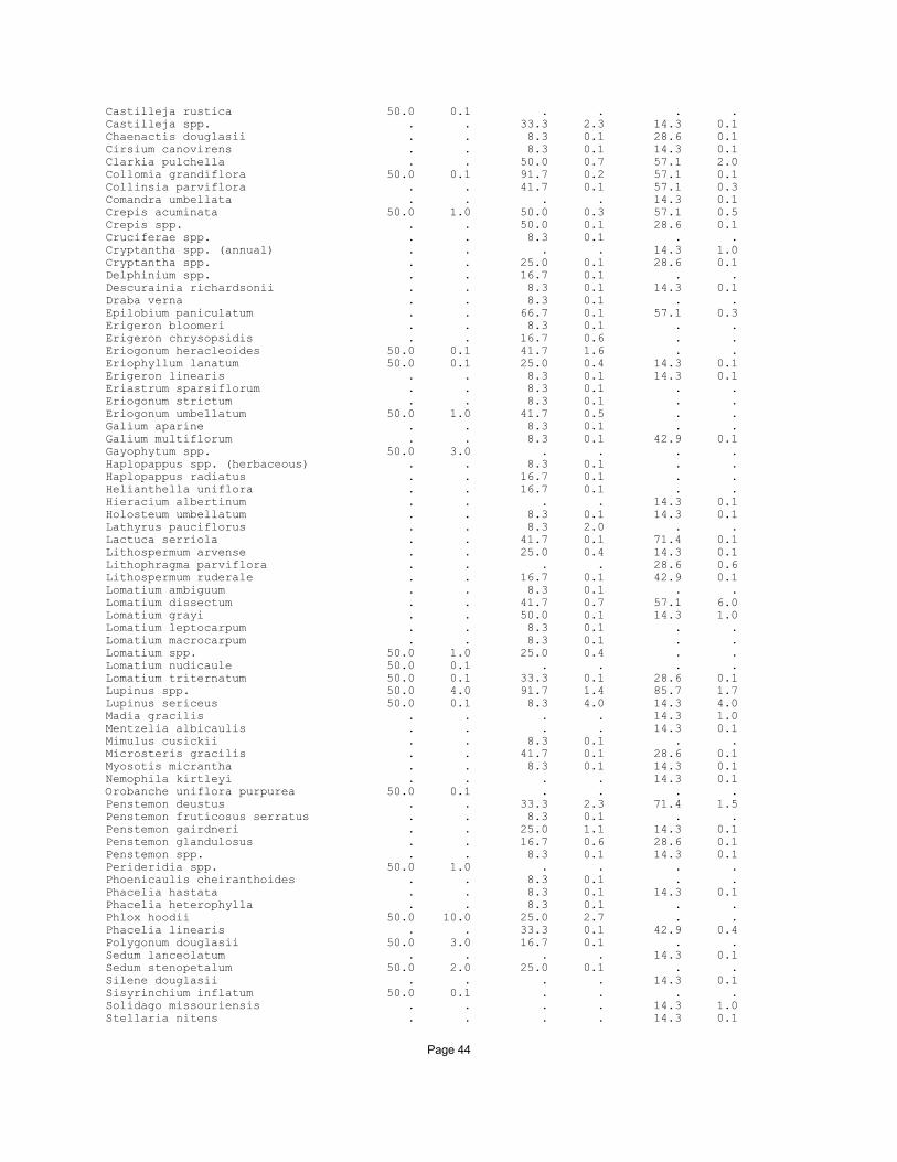
Page 44
Castilleja rustica 50.0 0.1 . . . .Castilleja spp. . . 33.3 2.3 14.3 0.1Chaenactis douglasii . . 8.3 0.1 28.6 0.1Cirsium canovirens . . 8.3 0.1 14.3 0.1Clarkia pulchella . . 50.0 0.7 57.1 2.0Collomia grandiflora 50.0 0.1 91.7 0.2 57.1 0.1Collinsia parviflora . . 41.7 0.1 57.1 0.3Comandra umbellata . . . . 14.3 0.1Crepis acuminata 50.0 1.0 50.0 0.3 57.1 0.5Crepis spp. . . 50.0 0.1 28.6 0.1Cruciferae spp. . . 8.3 0.1 . .Cryptantha spp. (annual) . . . . 14.3 1.0Cryptantha spp. . . 25.0 0.1 28.6 0.1Delphinium spp. . . 16.7 0.1 . .Descurainia richardsonii . . 8.3 0.1 14.3 0.1Draba verna . . 8.3 0.1 . .Epilobium paniculatum . . 66.7 0.1 57.1 0.3Erigeron bloomeri . . 8.3 0.1 . .Erigeron chrysopsidis . . 16.7 0.6 . .Eriogonum heracleoides 50.0 0.1 41.7 1.6 . .Eriophyllum lanatum 50.0 0.1 25.0 0.4 14.3 0.1Erigeron linearis . . 8.3 0.1 14.3 0.1Eriastrum sparsiflorum . . 8.3 0.1 . .Eriogonum strictum . . 8.3 0.1 . .Eriogonum umbellatum 50.0 1.0 41.7 0.5 . .Galium aparine . . 8.3 0.1 . .Galium multiflorum . . 8.3 0.1 42.9 0.1Gayophytum spp. 50.0 3.0 . . . .Haplopappus spp. (herbaceous) . . 8.3 0.1 . .Haplopappus radiatus . . 16.7 0.1 . .Helianthella uniflora . . 16.7 0.1 . .Hieracium albertinum . . . . 14.3 0.1Holosteum umbellatum . . 8.3 0.1 14.3 0.1Lathyrus pauciflorus . . 8.3 2.0 . .Lactuca serriola . . 41.7 0.1 71.4 0.1Lithospermum arvense . . 25.0 0.4 14.3 0.1Lithophragma parviflora . . . . 28.6 0.6Lithospermum ruderale . . 16.7 0.1 42.9 0.1Lomatium ambiguum . . 8.3 0.1 . .Lomatium dissectum . . 41.7 0.7 57.1 6.0Lomatium grayi . . 50.0 0.1 14.3 1.0Lomatium leptocarpum . . 8.3 0.1 . .Lomatium macrocarpum . . 8.3 0.1 . .Lomatium spp. 50.0 1.0 25.0 0.4 . .Lomatium nudicaule 50.0 0.1 . . . .Lomatium triternatum 50.0 0.1 33.3 0.1 28.6 0.1Lupinus spp. 50.0 4.0 91.7 1.4 85.7 1.7Lupinus sericeus 50.0 0.1 8.3 4.0 14.3 4.0Madia gracilis . . . . 14.3 1.0Mentzelia albicaulis . . . . 14.3 0.1Mimulus cusickii . . 8.3 0.1 . .Microsteris gracilis . . 41.7 0.1 28.6 0.1Myosotis micrantha . . 8.3 0.1 14.3 0.1Nemophila kirtleyi . . . . 14.3 0.1Orobanche uniflora purpurea 50.0 0.1 . . . .Penstemon deustus . . 33.3 2.3 71.4 1.5Penstemon fruticosus serratus . . 8.3 0.1 . .Penstemon gairdneri . . 25.0 1.1 14.3 0.1Penstemon glandulosus . . 16.7 0.6 28.6 0.1Penstemon spp. . . 8.3 0.1 14.3 0.1Perideridia spp. 50.0 1.0 . . . .Phoenicaulis cheiranthoides . . 8.3 0.1 . .Phacelia hastata . . 8.3 0.1 14.3 0.1Phacelia heterophylla . . 8.3 0.1 . .Phlox hoodii 50.0 10.0 25.0 2.7 . .Phacelia linearis . . 33.3 0.1 42.9 0.4Polygonum douglasii 50.0 3.0 16.7 0.1 . .Sedum lanceolatum . . . . 14.3 0.1Sedum stenopetalum 50.0 2.0 25.0 0.1 . .Silene douglasii . . . . 14.3 0.1Sisyrinchium inflatum 50.0 0.1 . . . .Solidago missouriensis . . . . 14.3 1.0Stellaria nitens . . . . 14.3 0.1

Page 45
Tonella floribunda . . 25.0 0.1 42.9 0.1Tragopogon dubius 50.0 0.1 83.3 0.3 71.4 3.6Trifolium macrocephalum 50.0 3.0 . . . .Zigadenus venenosus . . 16.7 0.6 . .
LichensCladonia spp. 1.0 . .Collema spp. 1.0 . .Peltigera spp. 1.0 . .
MossesEncalypta vulgaris 2.0 . .Tortula ruralis 0.1 . .
ShrubsArtemisia rigida 50.0 1.0 16.7 0.1 . .Artemisia tridentata vaseyana . . . . 14.3 0.1Artemisia tridentata wyomingensis . . 8.3 0.1 . .Chrysothamnus nauseosus . . 8.3 2.0 42.9 0.2Chrysothamnus viscidiflorus . . 25.0 0.4 . .Glossopetalon nevadense . . 8.3 0.1 14.3 1.0Prunus virginiana . . 8.3 1.0 . .Rosa woodsii . . 8.3 0.1 . .Sambucus cerulea . . 8.3 1.0 . .Symphoricarpos albus . . 16.7 0.1 . .Symphoricarpos oreophilus . . 8.3 0.1 . .

Page 46
FEID-AGSP, LUPINUS B FEID-AGSP, LUPINUS A 3 Plots 7 Plots Environment MEAN S.D. MEAN S.D.
Slope 50.7 19.0 51.9 18.2Aspect W - E W - EElevation 4885.0 1539.3 3960.7 542.0N horizon 1.0 1.0 2.0 4.0E horizon 7.0 3.5 10.4 7.1S horizon 17.0 17.6 11.9 7.5W horizon 11.7 10.1 9.0 12.8
Substrate (cover)Bedrock 0.0 0.0 0.0 0.0Boulder 0.0 0.0 0.0 0.0Cobble 0.0 0.1 5.7 8.7Stone 0.0 0.0 5.2 9.5Gravel 14.7 15.0 4.6 2.9Soil 10.3 9.5 10.6 7.9Litter 37.0 6.9 35.7 15.2Moss 15.3 21.5 10.7 7.6Lichen 2.7 3.8 6.6 10.5
Species CON CHAR CON CHAR
Grasses, sedges and rushesAgropyron spicatum 100.0 19.0 100.0 24.3Bromus brizaeformis . . 57.1 0.6Bromus japonicus 33.3 0.1 57.1 0.3Bromus tectorum . . 42.9 0.1Elymus caput-medusae . . 14.3 0.1Festuca idahoensis 100.0 38.3 100.0 37.9Festuca microstachys . . 14.3 0.1Poa bulbosa 33.3 0.1 . .Poa secunda 66.7 2.8 100.0 2.7
HerbsAchillea millefolium 100.0 2.0 85.7 0.6Agoseris glauca 33.3 0.1 . .Agoseris grandiflora . . 14.3 0.1Agoseris spp. 33.3 0.1 . .Allium acuminatum 33.3 0.1 14.3 0.1Antennaria dimorpha 33.3 0.1 . .Arabis spp. 33.3 0.1 14.3 0.1Arnica sororia 33.3 0.5 14.3 0.1Astragalus purshii 66.7 0.1 28.6 0.1Aster spp. . . 14.3 0.1Balsamorhiza incana . . 42.9 7.0Balsamorhiza sagittata 100.0 7.3 71.4 1.6Besseya rubra . . 14.3 0.1Blepharipappus scaber . . 14.3 0.1Calochortus eurycarpus . . 28.6 0.1Calochortus spp. . . 14.3 0.1Castilleja rustica . . 14.3 0.1Castilleja spp. . . 14.3 0.1Cirsium canovirens . . 14.3 0.1Clarkia pulchella 33.3 0.1 57.1 0.6Collomia grandiflora 33.3 0.1 28.6 0.1Collinsia parviflora 66.7 0.1 57.1 0.1Crepis acuminata 100.0 1.7 57.1 1.0Crepis spp. . . 14.3 1.0Epilobium paniculatum . . 57.1 0.1Erigeron chrysopsidis 33.3 0.1 . .Erigeron corymbosus 33.3 0.1 . .Eriogonum heracleoides 66.7 1.5 . .Eriophyllum lanatum 33.3 0.1 . .Galium multiflorum . . 14.3 2.0Galium triflorum 33.3 0.1 . .Gayophytum spp. . . 14.3 0.1Haplopappus radiatus 33.3 2.0 . .Habenaria unalascensis . . 14.3 0.1

Page 47
Hieracium albertinum . . 14.3 0.1Holosteum umbellatum . . 42.9 0.4Lactuca serriola . . 28.6 0.1Lesquerella spp. 33.3 0.1 . .Lithophragma parviflora . . 14.3 0.1Lithospermum ruderale 66.7 0.1 28.6 0.1Lomatium dissectum . . 85.7 0.3Lomatium foeniculaceum 33.3 0.1 . .Lomatium grayi . . 42.9 0.1Lomatium macrocarpum . . 14.3 0.1Lomatium spp. 33.3 0.1 . .Lomatium triternatum 33.3 0.1 57.1 1.0Lupinus spp. 33.3 5.0 100.0 6.4Lupinus sericeus 66.7 5.5 . .Microsteris gracilis . . 28.6 0.1Myosotis micrantha . . 42.9 0.7Penstemon deustus 33.3 0.1 14.3 0.1Penstemon gairdneri . . 14.3 0.1Penstemon glandulosus 33.3 1.0 . .Penstemon spp. . . 14.3 0.1Phlox aculeata 33.3 0.1 . .Phlox hoodii . . 28.6 0.6Phacelia linearis . . 28.6 0.6Phlox longifolia 33.3 0.1 . .Plectritis macrocera . . 14.3 0.1Senecio integerrimus 66.7 0.1 . .Sedum lanceolatum . . 14.3 0.1Stellaria nitens . . 28.6 0.1Tonella floribunda . . 14.3 0.1Tragopogon dubius 33.3 0.1 85.7 0.4
ShrubsAmelanchier alnifolia 33.3 0.5 . .Artemisia rigida . . 28.6 0.1Artemisia tridentata vaseyana 33.3 0.1 . .Chrysothamnus nauseosus 33.3 3.0 14.3 0.1Chrysothamnus viscidiflorus 66.7 0.3 28.6 0.1Tetradymia spp. 33.3 0.1 14.3 0.5

Page 48
FEID-KOCR, High B FEID-KOCR, High A FEID-KOCR, High C 1 Plots 2 Plots 1 Plots Environment MEAN S.D. MEAN S.D. MEAN S.D.
Slope 60.0 0.0 19.0 15.6 8.0 0.0Aspect W - N W - N W - NElevation 5440.0 0.0 5075.0 742.5 4460.0 0.0N horizon 0.0 0.0 1.0 0.0 2.0 0.0E horizon 12.0 0.0 3.5 2.1 4.0 0.0S horizon 26.0 0.0 9.5 6.4 4.0 0.0W horizon 0.0 0.0 1.5 0.7 3.0 0.0
Substrate (cover)Bedrock 1.0 0.0 0.0 0.0 0.0 0.0Boulder 0.0 0.0 0.0 0.0 0.0 0.0Cobble 0.1 0.0 0.1 0.1 5.0 0.0Stone 0.0 0.0 0.0 0.0 1.0 0.0Gravel 5.0 0.0 7.6 10.5 5.0 0.0Soil 3.0 0.0 2.8 3.2 10.0 0.0Litter 76.0 0.0 63.0 17.0 39.0 0.0Moss 0.1 0.0 1.0 1.3 6.0 0.0Lichen 0.1 0.0 1.0 1.3 4.0 0.0
Species CON CHAR CON CHAR CON CHAR
Grasses, sedges and rushesAgropyron spicatum 100.0 10.0 100.0 20.0 100.0 40.0Bromus mollis . . 50.0 2.0 . .Carex hoodii 100.0 2.0 . . . .Festuca idahoensis 100.0 3.0 100.0 42.5 100.0 40.0Koeleria cristata 100.0 3.0 100.0 1.0 100.0 10.0Melica bulbosa 100.0 20.0 50.0 10.0 . .Poa bulbosa 100.0 0.1 50.0 0.1 . .Poa secunda 100.0 1.0 50.0 4.0 . .
HerbsAchillea millefolium 100.0 1.0 100.0 5.0 100.0 2.0Agoseris glauca 100.0 0.1 . . . .Agoseris spp. . . . . 100.0 0.1Allium acuminatum . . . . 100.0 0.1Antennaria dimorpha . . 50.0 0.1 . .Antennaria microphylla 100.0 1.0 . . 100.0 1.0Arabis spp. . . 50.0 0.1 . .Arnica sororia . . 100.0 2.8 100.0 4.0Astragalus purshii . . 50.0 0.5 . .Balsamorhiza sagittata . . 50.0 1.0 . .Besseya rubra . . 50.0 5.0 100.0 1.0Brodiaea douglasii . . 50.0 0.1 100.0 0.1Calochortus elegans 100.0 0.1 . . . .Calochortus eurycarpus 100.0 1.0 50.0 0.1 100.0 1.0Castilleja oresbia . . . . 100.0 0.1Castilleja spp. . . 50.0 5.0 . .Castilleja miniata . . . . 100.0 0.1Clarkia pulchella . . 50.0 0.1 . .Collomia grandiflora 100.0 0.1 50.0 0.1 . .Collomia linearis . . 50.0 0.1 . .Crepis acuminata 100.0 0.1 50.0 0.5 100.0 1.0Crepis modocensis . . 50.0 0.1 100.0 0.1Erigeron chrysopsidis . . 50.0 1.0 . .Erigeron corymbosus 100.0 0.1 . . . .Eriogonum heracleoides 100.0 4.0 100.0 2.0 100.0 2.0Frasera albicaulis . . . . 100.0 5.0Geum triflorum 100.0 0.1 50.0 1.0 . .Helianthella uniflora 100.0 20.0 . . . .Hieracium albertinum 100.0 3.0 . . . .Lomatium dissectum . . . . 100.0 0.5Lomatium foeniculaceum . . 50.0 0.1 . .Lomatium triternatum 100.0 0.1 50.0 0.5 . .Lupinus laxiflorus . . 50.0 15.0 . .Lupinus sericeus 100.0 10.0 50.0 7.0 100.0 2.0Navarretia breweri . . 50.0 0.1 . .

Page 49
Orthocarpus tenuifolius . . . . 100.0 0.1Penstemon gairdneri . . . . 100.0 1.0Phlox aculeata . . 50.0 4.0 . .Phacelia linearis . . 50.0 0.1 . .Phlox longifolia . . 50.0 0.1 . .Phlox viscida . . . . 100.0 0.1Polygonum douglasii . . 50.0 0.1 . .Polygonum polygaloides 100.0 0.1 . . . .Potentilla spp. 100.0 2.0 50.0 4.0 . .Senecio integerrimus 100.0 0.5 50.0 0.1 . .Sedum stenopetalum . . 50.0 0.1 . .Silene douglasii 100.0 0.1 . . . .Sidalcea oregana . . 50.0 1.0 100.0 0.1Solidago missouriensis . . . . 100.0 1.0Tragopogon dubius . . 100.0 0.1 100.0 0.1Viola purpurea 100.0 0.1 . . . .Zigadenus venenosus . . . . 100.0 0.1
LichensCladonia spp. . 0.1 3.0Collema spp. . . 1.0Peltigera spp. . . 2.0Psora tuckermanii . . 0.1
MossesBryum spp. . 0.1 1.0Homulothecium nevadensa . 0.1 .Tortula spp. . 0.1 5.0
ShrubsArtemisia rigida . . 50.0 0.1 . .Artemisia tridentata vaseyana 100.0 0.1 . . 100.0 0.1Chrysothamnus nauseosus 100.0 0.1 50.0 1.0 . .Chrysothamnus viscidiflorus . . 50.0 3.0 . .Rosa nutkana 100.0 0.1 . . . .Tetradymia spp. . . 50.0 0.1 . .

Page 50
FEID-KOCR, Low B FEID-KOCR, Low A FEID-KOCR, Low C 1 Plots 4 Plots 1 Plots Environment MEAN S.D. MEAN S.D. MEAN S.D.
Slope 26.0 0.0 47.3 18.3 19.0 0.0Aspect N - E N - E N - EElevation 6430.0 0.0 3827.5 688.0 5560.0 0.0N horizon 0.0 0.0 4.8 3.1 2.0 0.0E horizon 16.0 0.0 14.5 8.9 10.0 0.0S horizon 5.0 0.0 14.3 9.2 4.0 0.0W horizon 0.0 0.0 7.0 8.2 11.0 0.0
Substrate (cover)Bedrock 0.1 0.0 0.0 0.1 0.1 0.0Boulder 0.1 0.0 0.1 0.1 0.1 0.0Cobble 5.0 0.0 1.5 1.3 2.0 0.0Stone 8.0 0.0 0.5 0.6 5.0 0.0Gravel 8.0 0.0 7.5 8.4 15.0 0.0Soil 4.0 0.0 9.3 1.5 12.0 0.0Litter 40.0 0.0 31.5 13.6 5.0 0.0Moss 10.0 0.0 14.5 5.3 30.0 0.0Lichen 5.0 0.0 10.0 7.1 0.0 0.0
Species CON CHAR CON CHAR CON CHAR
Ferns and fern alliesCystopteris fragilis . . 50.0 0.6 . .
Grasses, sedges and rushesAgropyron spicatum 100.0 10.0 100.0 17.5 100.0 2.0Bromus brizaeformis . . 100.0 0.6 . .Bromus japonicus . . 75.0 0.1 . .Bromus tectorum . . 50.0 0.1 100.0 0.1Carex geyeri . . 25.0 0.1 . .Festuca idahoensis 100.0 50.0 100.0 42.5 100.0 60.0Koeleria cristata 100.0 5.0 100.0 7.3 100.0 0.1Poa bulbosa . . 25.0 0.1 . .Poa secunda 100.0 2.0 100.0 3.5 100.0 2.0
HerbsAchillea millefolium 100.0 1.0 100.0 0.5 100.0 0.1Agoseris grandiflora . . . . 100.0 0.1Agastache urticifolia . . 50.0 0.1 . .Allium acuminatum 100.0 0.1 25.0 0.1 100.0 0.1Alyssum desertorum . . 25.0 0.1 100.0 0.1Antennaria luzuloides . . 25.0 1.0 . .Arabis spp. 100.0 0.1 . . . .Arabis divaricarpa . . 25.0 1.0 . .Arabis glabra . . 25.0 0.1 . .Arabis holboellii . . . . 100.0 0.1Arenaria serpyllifolia . . 50.0 1.0 . .Arnica sororia 100.0 0.5 25.0 0.1 . .Arabis sparsiflora . . 25.0 0.1 . .Astragalus inflexus . . . . 100.0 0.1Aster spp. 100.0 0.5 . . . .Balsamorhiza sagittata 100.0 7.0 100.0 9.8 100.0 4.0Besseya rubra . . 25.0 0.1 . .Brodiaea douglasii 100.0 0.1 25.0 0.1 . .Calochortus eurycarpus . . 25.0 0.1 . .Castilleja spp. 100.0 0.1 100.0 0.8 . .Clarkia pulchella . . 50.0 0.1 . .Collomia grandiflora 100.0 0.1 75.0 0.1 100.0 0.1Collomia linearis . . 25.0 0.1 . .Collinsia parviflora . . 50.0 0.1 100.0 0.1Crepis acuminata 100.0 0.1 25.0 1.0 . .Crepis spp. . . 50.0 0.1 100.0 0.1Cruciferae spp. . . 25.0 0.1 . .Draba verna . . 25.0 0.1 . .Epilobium paniculatum . . 100.0 0.1 . .Erigeron chrysopsidis 100.0 0.1 . . . .Erythronium grandiflorum . . 25.0 0.1 . .

Page 51
Eriogonum heracleoides 100.0 2.0 50.0 2.5 100.0 0.1Eriogonum strictum strictum . . . . 100.0 0.1Galium multiflorum . . 25.0 0.1 . .Geum triflorum . . 50.0 0.6 . .Haplopappus lanuginosus . . . . 100.0 1.0Haplopappus radiatus . . . . 100.0 0.1Helianthella uniflora 100.0 0.1 50.0 1.0 . .Hieracium albertinum . . 75.0 0.1 . .Lathyrus pauciflorus . . 25.0 0.1 . .Lactuca serriola . . 50.0 0.1 . .Lithospermum ruderale 100.0 0.1 75.0 1.7 . .Lomatium grayi . . . . 100.0 0.1Lomatium leptocarpum . . . . 100.0 0.1Lomatium macrocarpum . . . . 100.0 0.1Lomatium spp. 100.0 0.1 25.0 0.1 . .Lomatium triternatum . . 50.0 0.1 100.0 0.1Lupinus spp. 100.0 1.0 75.0 0.1 100.0 2.0Lupinus sericeus . . . . 100.0 0.1Microsteris gracilis . . 50.0 0.1 100.0 0.1Myosotis micrantha . . 75.0 0.4 100.0 0.1Penstemon deustus . . 25.0 0.1 . .Penstemon glandulosus . . 50.0 0.6 . .Phoenicaulis cheiranthoides . . . . 100.0 0.1Phlox hoodii . . . . 100.0 7.0Phacelia linearis . . . . 100.0 0.1Plagiobothrys tenellus . . 25.0 0.1 . .Polygonum douglasii . . 75.0 0.1 100.0 0.1Senecio canus . . 50.0 0.1 . .Sedum stenopetalum . . 50.0 0.6 . .Silene antirrhina . . 50.0 0.1 . .Silene douglasii 100.0 0.1 25.0 0.1 . .Silene oregana . . 25.0 1.0 . .Stellaria nitens . . 25.0 0.1 . .Taraxacum officinale . . 25.0 0.1 . .Tragopogon dubius 100.0 0.1 75.0 0.4 100.0 6.0
ShrubsArtemisia rigida . . 25.0 0.1 100.0 0.1Chrysothamnus nauseosus . . . . 100.0 0.1Chrysothamnus viscidiflorus . . 25.0 0.1 100.0 0.1Physocarpus malvaceus . . 50.0 1.0 . .Prunus virginiana 100.0 0.1 . . . .Spiraea betulifolia . . 75.0 4.4 . .Symphoricarpos albus . . 50.0 1.5 . .

Page 52
FEID-KOCR, Ridgetop B FEID-KOCR, Ridgetop A 4 Plots 2 Plots Environment MEAN S.D. MEAN S.D.
Slope 29.0 16.9 42.5 6.4Aspect W - NW W - NWElevation 5810.0 853.6 5050.0 636.4N horizon 2.5 4.4 2.0 1.4E horizon 12.8 8.4 13.5 4.9S horizon 2.8 1.7 17.5 2.1W horizon 0.3 0.5 1.0 1.4
Substrate (cover)Bedrock 0.0 0.0 0.5 0.7Boulder 0.0 0.0 0.5 0.7Cobble 0.0 0.0 2.5 3.5Stone 0.0 0.0 3.5 4.9Gravel 3.0 2.4 1.5 2.1Soil 5.5 3.3 5.0 0.0Litter 59.3 7.4 25.0 14.1Moss 4.3 4.3 26.0 1.4Lichen 2.5 3.7 3.0 2.8
Species CON CHAR CON CHAR
Grasses, sedges and rushesAgropyron dasystachyum . . 50.0 0.1Agropyron spicatum 100.0 14.8 100.0 5.5Bromus brizaeformis . . 50.0 0.1Bromus carinatus 50.0 0.6 . .Bromus inermis . . 50.0 1.0Bromus japonicus . . 100.0 0.1Carex geyeri . . 50.0 1.0Carex spp. . . 50.0 0.1Festuca idahoensis 100.0 38.8 100.0 57.5Koeleria cristata 100.0 15.0 100.0 6.5Poa bulbosa . . 50.0 1.0Poa pratensis . . 50.0 0.1Poa secunda 50.0 2.0 100.0 0.1Stipa occidentalis . . 50.0 0.1
HerbsAchillea millefolium 100.0 1.1 100.0 1.0Agastache urticifolia 50.0 1.3 . .Allium acuminatum . . 100.0 0.1Antennaria luzuloides . . 50.0 1.0Antennaria microphylla 50.0 1.5 50.0 1.0Arabis spp. 25.0 0.1 50.0 0.1Arnica sororia 100.0 2.1 100.0 2.5Arabis sparsiflora . . 50.0 0.1Aster perelegans . . 50.0 1.0Balsamorhiza sagittata 50.0 0.6 100.0 0.6Besseya rubra . . 50.0 0.1Brodiaea douglasii 100.0 1.5 50.0 0.1Calochortus eurycarpus 25.0 1.0 50.0 1.0Castilleja rustica 25.0 0.1 . .Castilleja spp. 25.0 1.0 100.0 0.1Clarkia pulchella 50.0 0.1 50.0 2.0Collomia grandiflora 50.0 0.1 100.0 0.6Collinsia parviflora 50.0 0.1 50.0 0.1Crepis acuminata 100.0 0.3 . .Crepis spp. . . 100.0 0.6Crepis modocensis 25.0 0.3 . .Cuscuta spp. . . 50.0 0.1Erigeron chrysopsidis 25.0 1.0 . .Eriogonum heracleoides 100.0 10.3 100.0 9.0Eriogonum strictum strictum . . 50.0 0.1Galium multiflorum . . 50.0 0.1Galium triflorum 50.0 0.1 . .Geum triflorum 25.0 1.0 100.0 0.1Haplopappus lanuginosus . . 50.0 1.0

Page 53
Hackelia micrantha 25.0 2.0 . .Heuchera cylindrica . . 50.0 0.1Helianthella uniflora 25.0 0.1 50.0 1.0Hieracium albertinum 25.0 0.1 100.0 0.1Lepidium perfoliatum 25.0 0.1 . .Lomatium macrocarpum . . 50.0 0.1Lomatium spp. 25.0 2.0 50.0 0.1Lomatium nudicaule 25.0 0.5 . .Lomatium triternatum . . 50.0 0.1Lupinus spp. 75.0 2.2 50.0 1.0Madia gracilis 25.0 0.1 . .Microsteris gracilis . . 50.0 0.1Myosotis micrantha . . 100.0 0.1Orthocarpus tenuifolius . . 50.0 2.0Phoenicaulis cheiranthoides . . 50.0 0.1Phacelia hastata 25.0 1.0 . .Phacelia heterophylla 25.0 0.1 . .Phlox hoodii . . 50.0 5.0Polygonum douglasii 50.0 0.6 50.0 0.1Potentilla glandulosa . . 50.0 0.1Senecio integerrimus 25.0 0.1 . .Sedum lanceolatum . . 50.0 0.1Sedum stenopetalum 25.0 0.1 100.0 1.5Silene antirrhina . . 50.0 0.1Silene douglasii 25.0 2.0 100.0 1.0Sidalcea oregana 25.0 1.0 . .Stellaria nitens . . 50.0 0.1Tragopogon dubius 100.0 0.1 100.0 0.6
LichensCladonia fimbriata 5.0 .Collema spp. 1.0 .Peltigera rufescens 2.0 .
MossesBryum caespiticium 0.8 .Tortula ruralis 0.3 .
ShrubsArtemisia rigida 25.0 0.1 50.0 0.1Artemisia tridentata vaseyana . . 50.0 0.1Chrysothamnus nauseosus . . 50.0 0.1Chrysothamnus viscidiflorus . . 50.0 0.1Prunus virginiana 25.0 0.5 . .

Page 54
PUTR/AGSP C PUTR/AGSP B PUTR/FEID B 3 Plots 3 Plots 4 Plots Environment MEAN S.D. MEAN S.D. MEAN S.D.
Slope 68.7 9.0 62.0 5.6 58.0 5.4Aspect SW SW NEElevation 3776.7 522.7 3823.3 307.3 3373.8 316.6N horizon 16.0 3.5 14.7 10.6 3.3 1.7E horizon 29.0 6.2 20.7 4.9 16.3 15.1S horizon 13.0 9.0 15.7 5.0 28.0 19.9W horizon 4.7 7.2 8.7 15.0 17.3 8.8
Substrate (cover)Bedrock 5.3 4.5 4.3 4.9 0.3 0.5Boulder 1.0 0.0 1.7 2.1 0.4 0.5Cobble 5.0 4.6 9.0 9.6 3.5 2.3Stone 3.7 3.8 4.7 6.4 2.8 2.6Gravel 33.3 20.8 25.0 8.7 10.0 10.8Soil 24.0 10.4 24.0 14.4 10.0 5.8Litter 10.3 9.5 15.0 5.0 49.3 17.3Moss 7.7 10.7 1.7 0.6 6.0 3.9Lichen 0.1 0.1 0.1 0.0 0.6 0.9
Species CON CHAR CON CHAR CON CHAR
Ferns and fern alliesCystopteris fragilis 33.3 0.1 . . 25.0 0.1Selaginella wallacei 33.3 2.0 . . 25.0 0.1
Grasses, sedges and rushesAgropyron spicatum 100.0 23.0 100.0 20.7 100.0 31.8Bromus brizaeformis 100.0 0.1 100.0 7.3 25.0 1.0Bromus japonicus 33.3 0.1 33.3 0.1 100.0 0.3Bromus tectorum 100.0 0.7 100.0 3.0 25.0 2.0Danthonia unispicata 33.3 0.1 . . . .Festuca idahoensis 33.3 1.0 . . 100.0 15.8Koeleria cristata . . . . 25.0 0.1Poa bulbosa . . . . 50.0 2.0Poa secunda 100.0 1.0 100.0 3.0 100.0 2.8Stipa comata . . 33.3 0.1 . .Stipa thurberiana 33.3 0.1 . . . .
HerbsAchillea millefolium 66.7 0.1 100.0 0.4 100.0 0.5Agoseris spp. 33.3 0.1 . . . .Agoseris retrorsa . . . . 25.0 0.1Allium acuminatum . . 33.3 0.1 . .Amsinckia retrorsa . . 33.3 0.1 . .Amsinckia spp. 33.3 0.1 . . . .Arabis microphylla 33.3 0.1 . . . .Arabis sparsiflora 33.3 0.1 66.7 0.1 . .Arabis suffrutescens 33.3 0.1 33.3 0.1 . .Astragalus inflexus . . 33.3 0.1 . .Astragalus purshii . . . . 25.0 0.1Balsamorhiza incana 33.3 0.1 . . . .Balsamorhiza sagittata 100.0 4.0 100.0 4.0 100.0 10.8Calochortus eurycarpus . . . . 50.0 0.1Calochortus macrocarpus 33.3 0.1 . . . .Camelina microcarpa 33.3 0.1 33.3 0.1 . .Chaenactis douglasii 66.7 0.1 66.7 0.1 . .Cirsium canovirens 33.3 0.1 33.3 0.1 . .Cirsium utahense 33.3 0.1 33.3 0.1 . .Clarkia pulchella 66.7 1.5 66.7 0.1 25.0 1.0Collomia grandiflora . . 66.7 0.1 25.0 0.1Collinsia parviflora 33.3 0.1 66.7 0.6 25.0 0.1Comandra umbellata . . . . 50.0 0.1Crepis acuminata 33.3 1.0 . . 25.0 1.0Crepis spp. 33.3 0.1 33.3 0.1 . .Cryptantha spp. (annual) 33.3 0.1 33.3 0.1 . .Cryptantha spp. (perennial) 33.3 1.0 33.3 0.1 . .Cryptantha spp. 33.3 0.1 33.3 1.0 . .

Page 55
Delphinium spp. 66.7 0.1 . . 25.0 0.1Descurainia richardsonii 66.7 0.1 66.7 0.1 . .Draba verna . . 33.3 0.1 25.0 0.1Epilobium paniculatum 33.3 0.1 100.0 0.4 25.0 0.1Erigeron bloomeri 33.3 0.1 . . . .Eriogonum compositum 33.3 0.1 66.7 2.5 . .Eriogonum heracleoides 33.3 0.1 . . 25.0 4.0Eriophyllum lanatum 100.0 1.4 100.0 0.7 25.0 0.1Eriogonum strictum proliferum . . . . 25.0 0.1Eriogonum strictum strictum 33.3 0.1 . . . .Eriogonum umbellatum . . 33.3 0.1 25.0 0.1Galium aparine 33.3 0.1 33.3 0.1 25.0 0.1Galium spp. . . . . 25.0 0.1Galium multiflorum 66.7 0.6 66.7 0.1 25.0 0.1Galium triflorum 33.3 0.1 . . . .Gayophytum spp. 33.3 0.1 . . . .Haplopappus radiatus . . . . 25.0 0.1Holosteum umbellatum 33.3 0.1 33.3 0.1 25.0 0.1Lactuca serriola 33.3 0.1 100.0 0.1 . .Lithophragma bulbifera . . . . 25.0 0.1Lithospermum ruderale . . . . 50.0 0.1Lomatium dissectum 66.7 3.0 100.0 1.1 50.0 0.1Lomatium grayi 66.7 0.6 33.3 5.0 . .Lomatium triternatum . . . . 25.0 0.1Lupinus spp. 33.3 1.0 . . 75.0 0.7Mentzelia albicaulis . . 66.7 0.1 . .Mimulus cusickii 33.3 0.1 66.7 0.1 . .Microsteris gracilis 33.3 0.1 33.3 0.1 25.0 0.1Mimulus nanus . . 33.3 0.1 . .Myosotis micrantha . . 33.3 0.1 25.0 0.1Onopordum acanthium . . 33.3 0.1 . .Orobanche fasciculata 33.3 0.1 33.3 0.1 . .Penstemon deustus 100.0 2.3 100.0 4.0 . .Penstemon glandulosus 33.3 1.0 . . 75.0 0.4Phlox aculeata . . . . 25.0 1.0Phacelia hastata 66.7 0.1 66.7 0.1 . .Phacelia heterophylla . . 33.3 0.1 25.0 0.1Phacelia linearis 100.0 0.1 66.7 0.1 25.0 1.0Physaria oregana 66.7 0.6 33.3 0.1 . .Phlox viscida . . . . 25.0 0.5Plectritis macrocera . . . . 25.0 0.1Polygonum douglasii . . . . 25.0 0.1Potentilla glandulosa . . 33.3 0.1 . .Scutellaria angustifolia . . 33.3 0.1 . .Sedum lanceolatum 33.3 0.1 . . . .Sedum stenopetalum 33.3 0.1 . . 25.0 0.1Silene douglasii . . . . 25.0 0.1Stephanomeria tenuifolia 33.3 0.1 . . . .Tonella floribunda 100.0 0.7 66.7 0.1 . .Tragopogon dubius 33.3 0.1 100.0 0.1 50.0 0.1Vaccaria segetalis 33.3 1.0 33.3 0.1 . .Zigadenus venenosus 33.3 0.1 . . . .
LichensCladonia spp. 0.1 . .
MossesHomulothecium nevadensa 0.1 . .Tortula ruralis 40.0 . .
ShrubsAmelanchier alnifolia 33.3 0.1 . . 50.0 0.1Artemisia tridentata 33.3 0.1 . . . .Artemisia tridentata xericensis . . . . 50.0 1.0Berberis repens . . . . 25.0 1.0Chrysothamnus nauseosus . . . . 25.0 0.1Chrysothamnus viscidiflorus . . . . 25.0 0.1Glossopetalon nevadense 66.7 7.5 33.3 2.0 . .Physocarpus malvaceus . . . . 25.0 0.1Purshia tridentata 100.0 5.3 100.0 11.0 100.0 26.3Sambucus cerulea . . . . 25.0 0.1

Page 56
APPENDIX 4. Plant species list. Vascular plant species observed in Rocking M Ranch ConservationEasement Area are listed alphabetically by life form. This list is a compendium of species observed duringseveral field seasons on Rocking M Ranch. Plant species observed in 1995 (Mancuso 1995), 1997 (thisstudy) and 1998 (reported by Moseley 1999) are included. Nomenclature follows Hitchcock and Cronquist(1973).
Species Common Name
TreesAlnus rhombifolia white alderBetula occidentalis water birchCeltis reticulata netleaf hackberryJuniperus occidentalis western juniperMalus pumila common appleMorus alba white mulberryPinus ponderosa ponderosa pinePopulus tremuloides quacking aspenPopulus trichocarpa black cottonwoodPrunus armencia apricotPseudotsuga menziesii Douglas-firRobinia pseudo-acacia black locustSalix babylonica weeping willowSalix rigida Watson's willow
ShrubsAcer glabrum Rocky Mtn. mapleAlnus incana thinleaf alderAmelanchier alnifolia serviceberryArtemisia tridentata tridentata basin big sagebrushArtemisia tridentata vaseyana mountain big sagebrushAtriplex spinosa spiny hopsageChrysothamnus nauseosus gray rabbitbrushChrysothamnus viscidiflorus green rabbitbrushCornus stolonifera red-osier dogwoodCrataegus columbiana Columbia hawthornCrataegus douglasii black hawthornCrataegus douglasii douglasii black hawthornIliamna rivularis streambank globemallowPhiladelphus lewisii syringaPhysocarpus malvaceus mallow ninebarkPrunus emarginata bitter cherryPrunus virginiana chokecherryPurshia tridentata bitterbrushRhus glabra smooth sumacRibes aureum golden currantRibes cereum squaw currantRibes niveum snow gooseberryRosa woodsii ultramontana Wood's roseRosa woodsii var. ultramontana Wood's roseRubus leucodermis blackcapSalix exigua coyote willowSalix lasiandra Pacific willowSalix lasiolepis arroyo willowSalix lutea yellow willow

Page 57
Salix scouleriana Scouler's willowSambucus cerulea blue elderberrySpiraea betulifolia shiny-leaf spiraeaSymphoricarpos albus common snowberrySymphoricarpos oreophilus mountain snowberry
HerbsAchillea millefolium common yarrowAconitum columbianum Columbia monkshoodAgastache urticifolia nettle-leaf horse-mintAgoseris glauca pale agoserisAgoseris grandiflora large-flowered agoserisAllium acuminatum tapertip onionAlyssum desertorum desert alyssumAmaranthus albus prostrate pigweedAmaranthus retroflexus redroot amaranthAmsinckia retrorsa rigid fiddleneckAmsinckia tessellata tessellate fiddleneckAngelica arguta sharptooth angelicaAntennaria microphylla rosy pussy-toesAnthriscus scandicina chervilApocynum androsaemifolium spreading dogbaneAquilegia formosa red columbineArabis glabra towermustardArabis hirsuta hairy rockcressArctium minus burdockArenaria macrophylla big-leaf sandwortArnica cordifolia heart-leaved arnicaArnica sororia twin arnicaArtemisia biennis biennial wormwoodArtemisia dracunculus dragon sagewortArtemisia ludoviciana Louisiana mugwortAsclepias cryptoceras Humbolt milkweedAsclepias speciosa showy milkweedAsperugo procumbens madwortAstragalus cusickii cusickii Cusick's milkvetchAstragalus inflexus hairy milkvetchAstragalus lentiginosus freckled milkvetchAstragalus vallaris Snake Canyon milkvetchBalsamorhiza sagittata arrowleaf balsamrootBidens frondosa leafy beggar-ticksBlepharipappus scaber blepharipappusBrodiaea douglasii Douglas' brodiaeaCalochortus eurycarpus big pod mariposa lilyCalochortus macrocarpus macrocarpus green-band mariposa lilyCamelina microcarpa hairy falseflaxCapsella bursa-pastoris shepherds purseCastilleja hispida harsh paintbrushCentaurea maculosa spotted knapweedCerastium viscosum sticky chickweedChaenactis douglasii false yarrowChenopodium album lambsquarterChichorium intybus chicoryChorispora tenella blue mustard

Page 58
Circaea alpina enchanter's nightshadeCirsium arvense Canada thistleCirsium canovirens gray-green thistleCirsium vulgare bull thistleClarkia pulchella deer hornClematis ligusticifolia western clematisCollinsia parviflora blue-eyed MaryCollomia grandiflora large-flowered collomiaCollomia linearis narrow-leaf collomiaComandra umbellata pallida pale bastard toad-flaxConium maculatum poison-hemlockConvolvulus arvensis field bindweedConzya canadensis horseweedCrepis acuminata long leaved hawksbeardCryptantha affinis slender cryptanthaCryptantha intermedia common cryptanthaCryptantha interrupta bristly cryptanthaCuscuta approximata clustered dodderCysopteris fragilis brittle bladder-fernDelphinium nuttallianum Nutthall's larkspurDelphinium occidentale western larkspurDescurania pinnata western tansymustardDescurania richardsonii tansymustardDisporum trachycarpum Sierra fairy-bellDraba verna spring whitlow-grassEpilobium angustifolium fireweedEpilobium densiflorum dense spike-primroseEpilobium glandulosum American willow-herbEpilobium paniculatum tall annual willow-herbEpilobium watsonii Watson's willow-herbErigeron chrysopsidis austiniae dwarf yellow fleabaneErigeron linearis desert yellow daisyErigeron pumilus shaggy fleabaneErigeron sp fleabaneEriogonum compositum northern buckwheatEriogonum heracleoides Wyeth's buckwheatEriogonum sphaerocephalum sphaerocephalum rock buckwheatEriogonum strictum strict buckwheatEriogonum vimineum vimineum broom buckwheatErodium cicutarium filareeErysimum asperum rough wallflowerErysium asperum rough wallflowerEuclidium syriacum euclidiumEuphorbia serpyllifolia thyme-leaved spurgeGalium aparine goose-grass cleaversGalium multiflorum shrubby bedstrawGalium trifidum small bedstrawGalium triflorum sweetscented bedstrawGeranium viscosissimum sticky geraniumGeum triflorum prairie smokeGnaphalium palustre lowland cudweedGrindelia squarrosa curly-gup gumweedHackelia micrantha blue stickseedHaplopappus lanuginosus lanuginosus woolly goldenweed

Page 59
Haplopappus radiatus Snake River goldenweedHelianthella uniflora douglasii Rocky Mtn. helianthellaHelianthus annuus common sunflowerHieracium albertinum western hawkweedHydrophyllum capitatum waterleaf woolly breechesLactuca serriola prickly lettuceLemna sp. duckweedLepidium latifolium broad-leaved peppergrassLepidium perfoliatum clasping pepperweedLewisia rediviva bitterrootLithophragma parviflora small flowered prairie starLithospermum arvense corn gromwellLithospermum ruderale wayside gromwellLomatium dissectum multifidum fern-leaved desert-parsleyLomatium grayi Gray's lomatiumLomatium macrocarpum large-fruit desert parsleyLupinus laxiflorus spurred lupineLupinus sericeus silky lupineMadia gracilis slender tarweedMalva neglecta poverty weedMedicago lupulina black medicMedicago sativa alfalfaMelilotus alba white sweet-cloverMelilotus officinalis yellow sweet-cloverMentha arvense field mintMentzelia albicaulis white-stemmed mentzeliaMentzelia laevicaulis blazing-starMertensia ciliata streamside bluebellMimulus cusickii Cusick's monkeyflowerMimulus guttatus yellow monkeyflowerMimulus guttatus guttatus yellow monkeyflowerMontia perfoliata miner's lettuceNemophila breviflora Great Basin nemophilaNemophila kirtleyi Snake River Canyon nemophilaNepeta cataria catnipOenothera caespitosa desert evening-primroseOenothera hookeri Hooker's evening-primroseOenothera strigosa common evening-primroseOnopordum acanthium Scotch thistleOsmorhiza chilensis mountain sweet-cicelyParietaria pensylvanica pellitoryPenstemon deustus hot rock penstemonPenstemon glandulosus sticky penstemonPenstemon venustus Blue Mtn. penstemonPenstemon wilcoxii Wilcox's penstemonPhacelia hastata silverleaf phaceliaPhacelia heterophylla varileaf phaceliaPhacelia linearis threadleaf phaceliaPhacelia procera tall phaceliaPhlox hoodii Hood's phloxPhlox longifolia long-leaved phloxPhlox viscida sticky phloxPhysaria oregana Oregon twinpodPlantago major common plantain

Page 60
Plantago patagonica Indian-wheatPolygonum aviculare prostrate knotweedPolygonum convolutus dullseedPolygonum douglasii Douglas' knotweedPotentilla gracilis slender cinquefoilRanunculus cymbalaria shore buttercupRanunculus inamoenus unlovely buttercupRanunculus scelcratus multifidus celeryleaved buttercupRanunculus uncinatus little buttercupRhus radicans poison ivyRorippa nasturium-aquaticum water-cressRorippa sp. cressRumex crispus curly dockRumex obtusifolius bitterdockRumex salicifolius willow dockScutellaria angustifolia narrow-leaved skullcapSedum lanceolatum lanceleaved sedumSenecio integerrimus western groundselSenecio serra tall butterweedSenecio streptanthifolius Rocky Mtn. butterweedSilene menziesii Menzies sileneSilene sp. catchflySisymbrium altissimum tumbling mustardSmilacina stellata star-flowered solomon-plumeSolanum dulcamara bittersweetSolidago canadensis Canada goldenrodSolidago gigantea smooth goldenrodSolidago occidentalis western goldenrodSonchus asper prickly sow-thistleStanleya viridiflora perennial stanleyaStellaria media chickweedStellaria sp. chickweedTaraxacum officinale common dandelionTetradymia canescens spineless horse-brushThalictrum occidentale western meadowrueThlaspi arvense field pennycressTonella floribunda large-flowered tonellaTragopogon dubius yellow salsifyTribulus terrestris puncture vineTrifolium repens white cloverTrillium ovatum western trilliumTrillium petiolatum purple trilliumUrtica dioica stinging nettleVaccaria segetalis cowcockleVerbascum blattaria moth mulleinVerbascum thapsus flannel mulleinVerbena bracteata bracted verbenaVeronica anagallis-aquatica water pimpernelVeronica arvensis common speedwellVeronica biloba bilobed speedwellViola glabella stream violotViola nuttallii Nutthall?s violetViola orbiculata round-leaved violetXanthium strumarium common cocklebur
Page 61
Grasses, Sedges, and RushesAgropyron smithii western wheatgrassAgropyron spicatum bluebunch wheatgrassAgrostis exarata spike bentgrassAgrostis stolonifera redtop bentgrassBromus brizaeformis rattlesnake bromeBromus carinatus mountain bromeBromus inermis smooth bromeBromus japonicus Japanese bromeBromus mollis soft bromeBromus sterils barren bromeBromus tectorum cheatgrassCalamagrostis rubescens pinegrassCarex athrostachya slenderbeak sedgeCarex backii Backs sedgeCarex geyeri elk sedgeCarex hoodii Hood's sedgeCarex microptera small-winged sedgeCatabrosa aquatica brookgrassDeschampsia elongata slender hairgrassEchinochloa crusgalli large barnyard-grassEleocharis palustris common spike-rushElymus caput-medusea medusahead ryeElymus cinereus basin wildryeElymus cinerus basin wildryeElymus glaucus blue wildryeFestuca idahoensis Idaho fescueGlyceria elata tall mannagrassGlyceria striata fowl mannagrassHordeum jubatum foxtail barleyJuncus bufonius toad rushJuncus ensifolius dagger-leaf rushJuncus tenuis slender rushJuncus torreyi Torrey?s rushKoeleria cristata prairie junegrassLeersia oryzoides cutgrassMelica bulbosa oniongrassPaspalum distichum knotgrassPhleum pratense common timothyPoa bulbosa bulbous bluegrassPoa compressa Canada bluegrassPoa pratensis Kentucky bluegrassPoa sandbergii Sandberg's bluegrassPolypogon monspeliensis rabbitfoot polypogonPuccinelia pauciflora weak alkaligrassSitanion hystrix squirrel-tailStipa occidentalis western needlegrass
Ferns and Fern AlliesEquisetum hyemale common horsetailEquisetum laevigatum smooth horsetail