VEGETATION COMMUNITY ACRE(S) - … · EXISTING HABITAT/VEGETATION COMMUNITIES ON SITE ... Diegan...
17
Biological Technical Report for the Valiano Project / IPQ-08 / February 18, 2015 9 Table 2 EXISTING HABITAT/VEGETATION COMMUNITIES ON SITE VEGETATION COMMUNITY* ACRE(S)** Southern Riparian Forest (61300) 2.50 Southern Riparian Woodland - including disturbed (62000) 0.29 Southern Willow Scrub (63320) 0.15 Mule Fat Scrub (63310) 0.02 Freshwater Marsh (52400) 0.12 Herbaceous Wetland (52510) 0.35 Disturbed Wetland (11200) 0.13 Open Water/Pond (64140) 0.51 Tamarisk Scrub (63810) 0.04 Coast Live Oak Woodland - including disturbed (71160) 11.7 Diegan Coastal Sage Scrub - including disturbed (32500) 1.8 Southern Mixed Chaparral - including disturbed (37121) 8.0 Eucalyptus Forest (79100) 7.2 Eucalyptus Woodland (79100) 3.5 Non-native Grassland (42200) 63.9 Non-native Vegetation (11000) 1.5 Orchard (18100) 100.2 Intensive Agriculture (18200) 8.8 Extensive Agriculture (18300) 21.3 Disturbed Habitat (11300) 2.4 Developed Land (12000) 4.1 TOTAL 238.8 * Vegetation categories and numerical codes are from Holland (1986) and Oberbauer (2008). ** Upland habitats are rounded to the nearest 0.1 acre, while wetland habitats are rounded to the nearest 0.01; thus, totals reflect rounding. Southern Riparian Forest and Woodland Southern riparian forests and woodlands are comprised of winter-deciduous trees that require water near the soil surface. Willow cottonwood (Populus sp.) and western sycamore (Platanus racemosa) form a dense medium height woodland or forest in moist canyons and drainage bottoms. Associated understory species include mule fat (Baccharis salicifolia), stinging nettle (Urtica dioica ssp. holosericea), and wild grape (Vitis girdiana). The differences between woodlands and forests are physiognomic rather than compositional. Woodlands have less canopy cover than forests. In forests, the canopies of individual tree species do overlap so that a canopy cover exceeding 100 percent may occur in the upper tree stratum. In woodlands, there may be large canopy gaps within the upper tree stratum.
Transcript of VEGETATION COMMUNITY ACRE(S) - … · EXISTING HABITAT/VEGETATION COMMUNITIES ON SITE ... Diegan...

Biological Technical Report for the Valiano Project / IPQ-08 / February 18, 2015 9
Table 2 EXISTING HABITAT/VEGETATION COMMUNITIES ON SITE
VEGETATION COMMUNITY* ACRE(S)**
Southern Riparian Forest (61300) 2.50 Southern Riparian Woodland - including disturbed (62000) 0.29 Southern Willow Scrub (63320) 0.15 Mule Fat Scrub (63310) 0.02 Freshwater Marsh (52400) 0.12 Herbaceous Wetland (52510) 0.35 Disturbed Wetland (11200) 0.13 Open Water/Pond (64140) 0.51 Tamarisk Scrub (63810) 0.04 Coast Live Oak Woodland - including disturbed (71160) 11.7 Diegan Coastal Sage Scrub - including disturbed (32500) 1.8 Southern Mixed Chaparral - including disturbed (37121) 8.0 Eucalyptus Forest (79100) 7.2 Eucalyptus Woodland (79100) 3.5 Non-native Grassland (42200) 63.9 Non-native Vegetation (11000) 1.5 Orchard (18100) 100.2 Intensive Agriculture (18200) 8.8 Extensive Agriculture (18300) 21.3 Disturbed Habitat (11300) 2.4 Developed Land (12000) 4.1
TOTAL 238.8 * Vegetation categories and numerical codes are from Holland (1986) and Oberbauer (2008). ** Upland habitats are rounded to the nearest 0.1 acre, while wetland habitats are rounded to the nearest 0.01;
thus, totals reflect rounding.
Southern Riparian Forest and Woodland Southern riparian forests and woodlands are comprised of winter-deciduous trees that require water near the soil surface. Willow cottonwood (Populus sp.) and western sycamore (Platanus racemosa) form a dense medium height woodland or forest in moist canyons and drainage bottoms. Associated understory species include mule fat (Baccharis salicifolia), stinging nettle (Urtica dioica ssp. holosericea), and wild grape (Vitis girdiana). The differences between woodlands and forests are physiognomic rather than compositional. Woodlands have less canopy cover than forests. In forests, the canopies of individual tree species do overlap so that a canopy cover exceeding 100 percent may occur in the upper tree stratum. In woodlands, there may be large canopy gaps within the upper tree stratum.

Biological Technical Report for the Valiano Project / IPQ-08 / February 18, 2015 10
Species in these vegetation communities within the Project site include arroyo willow (Salix lasiolepis), black willow (Salix gooddingii), mule fat, and western sycamore. Non-native species are also present, including Mexican fan palm (Washingtonia robusta), giant reed (Arundo donax), and eucalyptus (Eucalyptus sp.). Areas with an abundance of non-native species are mapped as a disturbed phase of this habitat. Southern riparian forest and southern riparian woodland on site are CDFW habitat and RPO wetland but not USACE jurisdictional. Further discussion is provided below in Section 1.4.7. A total of 2.50 acres of southern riparian forest is present in the central portion of the site along a drainage that flows from the west to the east to Surrey Lane (Table 2, Figure 6a). A total of 0.29 acre of southern riparian woodland, including 0.05 acre that are disturbed, is present along the drainage course in the southeastern corner of the site (Figures 6a and 6b). Southern Willow Scrub Southern willow scrub consists of dense, broadleaved, winter-deciduous stands of trees dominated by shrubby willows in association with mule fat, and scattered emergent cottonwood and western sycamores. This vegetation community occurs on loose, sandy or fine, gravelly alluvium deposited near stream channels during flood flows. Frequent flooding maintains this early seral community, preventing succession to a riparian woodland or forest (Holland 1986). In the absence of periodic flooding, this early seral type would be succeeded by southern cottonwood or western sycamore riparian forest. On site, this habitat type is composed of arroyo willow and mule fat and some scattered Mexican fan palms. A total of 0.15 acres of southern willow scrub is present in 6 locations along drainage courses and as small, isolated stands in the southern, central, and northern portions of the site (Table 2, Figure 6a). The majority of southern willow scrub on site is CDFW jurisdictional and RPO wetland. Further discussion is provided below in Section 1.4.7. Mule Fat Scrub Mule fat scrub is a stunted, shrubby riparian scrub community dominated by mule fat and interspersed with small willows. This vegetation community occurs along intermittent stream channels with a fairly coarse substrate and moderate depth to the water table. This community may be maintained by frequent flooding, the absence of which would lead to a cottonwood or sycamore dominated riparian woodland or forest (Holland 1986). In other places, the limited hydrology may be unsuitable for anything more mesic than mule fat scrub. The latter is the likely explanation for the mule fat scrub occurring on site. A few small patches of monotypic mule fat stands occur near the southern property boundary, comprising 0.02 acre (Table 2, Figure 6a). These stands are not associated with any observed surface hydrology, but are located peripherally along a drainage course. They are thought to be the result of and sustained by artificial hydrology (i.e., runoff from agricultural irrigation). Mule fat scrub on site is CDFW jurisdictional and RPO wetland.

Biological Technical Report for the Valiano Project / IPQ-08 / February 18, 2015 11
Freshwater Marsh Coastal and valley freshwater marsh is dominated by perennial, emergent monocots, 5 to 13 feet tall, forming incomplete to completely closed canopies. This vegetation type occurs along the coast and in coastal valleys near river mouths and around the margins of lakes and springs, and freshwater or brackish marshes. These areas are semi- or permanently flooded yet lack a significant current (Holland 1986). Dominant species include cattails (Typha sp.) and bulrushes (Schoenoplectus sp.), along with umbrella sedges (Cyperus sp.), rushes (Juncus sp.), and spike-sedge (Eleocharis sp.). Species in this vegetation community within the property include southern cattail (Typha domingensis). A total of 0.12 acre of this vegetation type occurs along some of the larger drainages (Table 2, Figures 6a and 6b). Freshwater marsh on site is under the jurisdiction of the USACE and CDFW, and is considered RPO wetland. Herbaceous Wetland Herbaceous wetland is a low-growing, herbaceous community that is dominated by a variety of native wetland species. It typically occurs in seasonally wet areas with heavy soils. Dominant species usually include wrinkled rush (Juncus rugulosus), toad rush (Juncus bufonius), and wetland grasses. Other common species of this habitat include cocklebur (Xanthium strumarium) and western goldenrod (Euthamia occidentalis). Herbaceous wetland on the Project site is dominated by wrinkled rush, Mexican rush (Juncus mexicanus), saltgrass (Distichlis spicata), and western ragweed (Ambrosia psilostachya). A total of 0.35 acre of herbaceous wetland is present on site (Table 2, Figures 6a and 6b). The majority of herbaceous wetland on site is under the jurisdiction of the USACE and CDFW and is considered RPO wetland. Further discussion is provided below in Section 1.4.7. Disturbed Wetland This vegetation community is dominated by exotic wetland species that invade areas that have been previously disturbed or undergone periodic disturbances. These non-natives become established more readily following natural or human-induced habitat disturbance than the native wetland flora. Characteristic species of disturbed wetlands include bristly ox-tongue (Helminthotheca echioides), cocklebur, and dock (Rumex spp.). The dominant species in this community on site include annual beard grass (Polypogon monspeliensis) and Mexican fan palm, along with a low cover of native wetland species. A total of 0.13 acre of disturbed wetland occurs on site consisting of a small, 0.08-acre area north of Mt. Whitney Road and a 0.05-acre area along a drainage in the northernmost portion of the site (Table 2, Figure 6a). Disturbed wetland on site is under the jurisdiction of the CDFW, and portions are considered RPO wetland, further discussed below in Section 1.4.7.

Biological Technical Report for the Valiano Project / IPQ-08 / February 18, 2015 12
Open Water/Pond A freshwater pond is present in the southeastern portion of the Project site, comprising 0.51 acre (Table 2, Figure 6b). The pond is an impoundment of WUS/streambed and is, therefore, USACE and CDFW jurisdictional. This feature is also RPO wetland. The adjacent equestrian center does not supplement the pond with imported water. Tamarisk Scrub Tamarisk scrub is typically comprised of shrubs and/or small trees of exotic tamarisk species (Tamarix spp.), but may also contain willows (Salix spp.), salt bushes (Atriplex spp.), catclaw acacia (Acacia greggii), and saltgrass. This habitat typically occurs along intermittent streams in areas where high evaporation rates increase the salinity level of the soil. Tamarisk is a phreatophyte, a plant that can obtain water from an underground water table. Because of its deep root system and high transpiration rates, tamarisk can substantially lower the water table to below the root zone of native species, thereby competitively excluding them. As a prolific seeder, it may rapidly displace native species within a drainage course (Holland 1986). Species in this vegetation community within the proposed Project site include mostly monotypic stands of tamarisk. The 0.04 acre of tamarisk scrub that is present on site (Table 2, Figure 6a) is not USACE or CDFW jurisdictional based on its landscape position, which is on a hillside and not part of any drainage. It is also not RPO wetland. Coast Live Oak Woodland (including disturbed) Coast live oak woodland is an open to dense evergreen woodland or forest community, dominated by coast live oak (Quercus agrifolia), that may reach a height of 35 to 80 feet. The shrub layer consists of toyon (Heteromeles arbutifolia), blue elderberry (Sambucus nigra ssp. caerulea), spreading snowberry (Symphoricarpus mollis), fuchsia-flowered gooseberry (Ribes speciosum), and poison oak (Toxicodendron diversilobum). A dense herbaceous understory is dominated by miner’s lettuce (Claytonia perfoliata var. perfoliata) and chickweed (Stellaria media). This community occurs along the coastal foothills of the Peninsular Ranges, typically on north-facing slopes and shaded ravines (Holland 1986). Coast live oak woodland can be further described as either open (72261) or dense (72262). A total of 11.7 acres of coast live oak woodland, including 4.1 acres that are disturbed, is present in the central and southeastern portions of the site (Table 2, Figures 6a and 6b). Diegan Coastal Sage Scrub (including disturbed) Coastal sage scrub is one of the two major shrub types that occur in southern California, occupying xeric sites characterized by shallow soils (the other is chaparral). Four distinct coastal sage scrub geographical associations (northern, central, Venturan, and Diegan) are recognized along the California coast. Despite the fact that it has been greatly reduced from its historical distribution (Oberbauer 1991), the Diegan association is the dominant coastal sage scrub in coastal southern California from Los Angeles to Baja California, Mexico (Holland 1986).

Biological Technical Report for the Valiano Project / IPQ-08 / February 18, 2015 13
Diegan coastal sage scrub was listed as the third most extensive vegetation community in the County in 1965 (CDFW 1965). Oberbauer (1979) and Oberbauer and Vanderwier (1991) suggest that nearly 72 percent of the County’s original sage scrub habitat has been destroyed or modified, primarily a result of urban expansion. Diegan coastal sage scrub may be dominated by a variety of species depending upon soil type, slope, and aspect. Typical species found within Diegan coastal sage scrub include California sagebrush (Artemisia californica), California buckwheat (Eriogonum fasciculatum ssp. fasciculatum), laurel sumac (Malosma laurina), and black sage (Salvia mellifera). Diegan coastal sage scrub (including disturbed) is considered a sensitive habitat by the USFWS, CDFW, and the County, and is given the highest inventory priority in the CNDDB. This habitat type can support a number of federally and state listed and rare plants, as well as several bird, reptile, and insect species that are also federally listed, including the coastal California gnatcatcher. A total of 1.8 acres of Diegan coastal sage scrub are present, with the majority occurring in the north-central portion of the site (Table 2, Figures 6a and 6b). Southern Mixed Chaparral (including disturbed) Southern mixed chaparral is comprised of broad-leaved sclerophyllous shrubs that can reach 6 to 10 feet in height and form dense often nearly impenetrable stands with poorly developed understories. In this mixed chaparral, the shrubs are generally tall and deep rooted, with a well developed soil litter layer, high canopy coverage, low light levels within the canopy, and lower soil temperatures (Keeley and Keeley 1988). This vegetation community occurs on dry, rocky, often steep north-facing slopes with little soil. As conditions become more mesic, broad-leaved sclerophyllous shrubs that resprout from underground root crowns become dominant. Depending upon relative proximity to the coast, southern mixed chaparral is dominated by chamise (Adenostoma fasciculatum), mission manzanita (Xylococcus bicolor), coast white lilac (Ceanothus verrucosus), Ramona lilac (Ceanothus tomentosus), white-stem wild-lilac (Ceanothus leucodermis), big-berry manzanita (Arctostaphylos glauca), and scrub oak (Quercus dumosa). This vegetation community provides important habitat for wide-ranging species such as mule deer (Odocoileus hemionus) and mountain lion (Felis concolor). This vegetation community is considered sensitive. A total of 8.0 acres of granitic southern mixed chaparral occurs within the northwestern corner of the Project site, as well as along the western border near the center of the site and just north of Mt. Whitney Road (Table 2, Figures 6a and 6b). Eucalyptus Forest and Woodland The eucalyptus forest present on site has an overstory dominated by red gum (Eucalyptus camaldulensis) in association with Mexican fan palm. This community supports a sparsely vegetated understory that includes numerous upland species such as Bermuda grass (Cynodon dactylon), smilo grass (Stipa miliaceum), bristly ox-tongue, salt heliotrope (Heliotropium

Biological Technical Report for the Valiano Project / IPQ-08 / February 18, 2015 14
curassavicum), western ragweed, and coast live oak, as well as scattered wetland species such as Mexican fan palm and hastate orache (Atriplex prostrata). Hydric soils and wetland hydrology indicators were absent. This community is not under the jurisdiction of the USACE or CDFW, and it is not RPO wetland. Red gum is a non-native species that is commonly found in disturbed areas; it is also widely cultivated in California and is the most widely planted species of eucalyptus (Hickman, ed. 1993). In some cases on site, a eucalyptus forest overstory contains an herbaceous wetland understory; the latter of which is USACE and CDFW jurisdictional and RPO wetland. Eucalyptus woodland occurs as a few scattered stands of eucalyptus in the southern portion of the Project site. Other species observed in this habitat include lemonadeberry (Rhus integrifolia), Peruvian pepper tree (Schinus molle), and Brazilian pepper tree (Schinus terebinthifolius). A total of 7.2 acres of eucalyptus forest and 3.5 acres of eucalyptus woodland are present along the drainage course in the southeastern portion of the site as well as in the northwestern corner of the site (Table 2, Figures 6a and 6b). Non-native Grassland Non-native grassland is a dense to sparse cover of annual grasses, often associated with native annual forbs. This association occurs on gradual slopes with deep, fine-textured, usually clay soils. Most of the introduced annual species that comprise non-native grassland originated from the Mediterranean region of Europe, an area with a climate similar to that in California and a long history of agriculture. These 2 factors have contributed to the successful invasion and establishment of these species and the replacement of native grasslands by annual-dominated non-native grassland (Jackson 1985). Non-native grassland covers 63.9 acres on site, primarily in the eastern half of the central portion of the site (Table 2, Figures 6a and 6b) with characteristic species consisting of oats (Avena sp.), ripgut grass (Bromus diandrus), red brome (Bromus madritensis), soft chess (Bromus hordaceus), western ragweed, Italian ryegrass (Festuca perennis), barley (Hordeum sp.), and black mustard (Brassica nigra). Portions of grassland habitat on site are dominated by non-native broadleaf species rather than grasses, including species such as black mustard and cheeseweed (Malva parviflora). Non-native Vegetation Non-native vegetation is a category describing stands of naturalized trees and shrubs (e.g., acacia [Acacia sp.], peppertree [Schinus sp.]), many of which are also used in landscaping. A total of 1.5 acres of non-native vegetation is present as landscaping around an existing house in the southeastern portion of the site as well as a small stand in the northwestern corner of the site and other small, scattered stands (Table 2, Figures 6a and 6b).

Biological Technical Report for the Valiano Project / IPQ-08 / February 18, 2015 15
Orchard Orchards are active, intensive agricultural uses. Orchards on site are primarily avocado, although a few citrus trees also are present. A total of 100.2 acres of orchard is present in hills along the western half of the site (Table 2, Figure 6a). Intensive Agriculture Intensive agriculture includes dairies, nurseries, and chicken ranches. An equestrian center in the southeastern corner of the site constitutes 8.8 acres of intensive agriculture (Table 2, Figure 6b). Extensive Agriculture Extensive agriculture includes fields, pastures, and row crops. A total of 21.3 acres of extensive agriculture, in the form of pastures for the equestrian center, is present in the southeastern corner of the site (Table 2, Figures 6a and 6b). Disturbed Habitat Disturbed habitat includes land cleared of vegetation (e.g., dirt roads), land containing a preponderance of non-native plant species such as ornamentals or ruderal exotic species that take advantage of disturbance (previously cleared or abandoned landscaping), or land showing signs of past or present animal usage that removes any capability of providing viable habitat. Disturbed habitat totals 2.4 acres on site (Table 2, Figures 6a and 6b) and is comprised of an unvegetated horse corral, bare dirt areas surrounding existing development, and previously disturbed soils supporting only non-native forbs such as cheeseweed, black mustard, and dwarf nettle (Urtica urens). These areas occur only in the southwest corner of the site and constitute poor quality habitat. Developed Land Developed land exists where permanent structures and/or pavement has been placed (preventing the growth of vegetation) or where landscaping is clearly tended and maintained. Within the Project site, 4.1 acres of developed land includes one single-family residence near the western end of Eden Valley Lane, a single-family residence in the southeastern corner of the site, a landscaped area on the western border of the equestrian center, and a portion of a paved road in the northern portion of the site (Table 2, Figures 6a and 6b). 1.4.3 Flora HELIX observed a total of 187 plant species within the Project site during surveys to date, of which 94 (50 percent) are non-native species (Appendix A). The predominance of non-native species is indicative of the fact that most of the site is in active agricultural use or contains non-native grasslands.

Biological Technical Report for the Valiano Project / IPQ-08 / February 18, 2015 16
1.4.4 Fauna A total of 91 animal species have been observed or otherwise detected on site during biological surveys, including 11 invertebrates, 1 amphibian, 4 reptile, 65 bird, and 10 mammal species (Appendix B). 1.4.5 Sensitive Plant Species Sensitive species are those considered unusual or limited in that they are: (1) only found in the San Diego region; (2) a local representative of a species or association of species not otherwise found in the region; or (3) severely depleted within their ranges or within the region. A rare plant survey was conducted on May 2, 2013. Rare plant species also were looked for opportunistically during other surveys. No rare plants were observed on site. Sensitive Plants with Potential to Occur Sensitive plant species with potential to occur on site are included in Appendix C (alphabetically by scientific name). Refer to Appendix E for an explanation of status codes. None of the plant species with potential to occur on site listed in Appendix C has a high potential. No sensitive plant species has been observed on site. Sensitive plant species reported by the CNDDB (2015) in the vicinity include Del Mar manzanita (Arctostaphylos grandulosa ssp. crassifolia) and San Diego thorn-mint (Acanthomintha ilicifolia). Del Mar manzanita occurs within maritime chaparral. Since that vegetation community is not present, its potential to occur on site is very low. San Diego thorn-mint occurs on friable clay soils, often in open areas within grasslands. Since clay soils are not present on site, its potential to occur is very low. 1.4.6 Sensitive Wildlife Species Ten sensitive animal species (Cooper’s hawk [Accipiter cooperii], grasshopper sparrow [Ammodramus savannarum], red-shouldered hawk [Buteo lineatus], turkey vulture [Cathartes aura], northern harrier [Circus cyaneus], white-tailed kite [Elanus leucurus], prairie falcon [Falco mexicanus], southern mule deer [Odocoileus hemionus fuliginata], yellow warbler [Setophaga petechia], and western bluebird [Sialia mexicana]) were observed or otherwise detected on site (Figures 6a and 6b) and are further discussed below. Cooper’s hawk (Accipiter cooperii) Status: --/WL; County Group 1 Distribution: Occurs year-round throughout San Diego County’s coastal slope where stands of trees are present Habitat(s): Oak groves, mature riparian woodlands, and eucalyptus stands or other mature forests Status on site: One individual observed on multiple days in riparian forest and oak woodland habitats in the northeastern portion of the site.
Biological Technical Report for the Valiano Project / IPQ-08 / February 18, 2015 17
Grasshopper sparrow (Ammodramus savannarum) Status: --/SSC; County Group 1 Distribution: Scattered in small numbers throughout San Diego County year-round Habitat(s): Grassland Status on site: One individual observed in grassland in the south-central portion of the site. Red-shouldered hawk (Buteo lineatus) Status: --/--; County Group 1 Distribution: In San Diego County, observed throughout coastal slope Habitat(s): Riparian woodland, oak woodland, orchards, eucalyptus groves, or other areas with tall trees Status on site: Observed flying over the northwest and southern portion of the site Turkey vulture (Cathartes aura) Status: --/--; County Group 1 Distribution: Observed throughout San Diego County with the exception of extreme coastal San Diego where development is heaviest Habitat(s): Foraging habitat includes most open habitats with breeding occurring in crevices among boulders Status on site: One individual observed soaring over grassland in the northeastern portion of the site. Northern harrier (Circus cyaneus) Status: --/SSC; County Group 1 Distribution: In San Diego County, distribution primarily scattered throughout lowlands but can also be observed in foothills, mountains, and desert Habitat(s): Open grassland and marsh Status on site: At least two individuals (male and female) were observed foraging over grassland in the east-central portion of the site. White-tailed kite (Elanus leucurus) Status: --/Fully Protected; County Group 1 Distribution: Primarily occurs throughout coastal slopes of San Diego County Habitat(s): Riparian woodlands and oak or sycamore groves adjacent to grassland Status on site: One individual observed foraging over grassland in the northeastern portion of the site, as well as perching in southern riparian forest. Prairie falcon (Falco mexicanus) Status: BCC/WL; County Group 1 Distribution: Observed year-round in San Diego County but more commonly during winter Habitat(s): Nesting occurs on cliff or bluff ledges or occasionally in old hawk or raven nests; foraging occurs in grassland or desert habitats Status on site: One individual was observed perching on a fence post in the southern portion of the site. This individual was observed on a single day and the species was not observed again during subsequent surveys.

Biological Technical Report for the Valiano Project / IPQ-08 / February 18, 2015 18
Southern mule deer (Odocoileus hemionus fuliginata) Listing: --/--; County Group 2 Distribution: Southern Riverside County (Tahquitz Valley), south on the coastal slope to the vicinity of San Quintin, Baja California, Mexico. Habitat: Coastal sage scrub, riparian and montane forests, chaparral, grasslands, croplands, and open areas if there is at least some scrub cover present. Crepuscular activity and movements are along routes that provide the greatest amount of protective cover. Status on site: Two individuals (male and female) were observed in the northwestern portion of the site within the avocado orchard. It is assumed that the deer came on site from the west, as this is the only side of the site that connects to off-site native habitat, and the deer were observed heading east down the hillside in the northwest corner of the site toward on site grassland. Large mammal bedding sites (presumably those of deer) were noted in the northern portion of the site near the creek. Yellow warbler (Setophaga petechia) Status: --/SSC; County Group 2 Distribution: Observed throughout much of San Diego County during the breeding season with rare sightings in winter Habitat(s): Riparian woodland Status on site: At least one individual was observed on the Project site by County staff on March 11, 2013. Western bluebird (Sialia mexicana) Status: --/--; County Group 2 Distribution: Occurs throughout much of San Diego County, but concentrated in foothills and mountains Habitat(s): Montane coniferous and oak woodlands, as well as urban areas with mature trees and wide lawns Status on site: One pair of individuals was observed perching on the fence line bordering the northeastern portion of the site. The Project site does not contain any designated Critical Habitat for any federally listed species. The nearest Critical Habitat is designated for the coastal California gnatcatcher and is approximately 1 mile to the west (Figure 7). Sensitive Animals with Potential to Occur Sensitive animal species present on site or with potential to occur on site are included in Appendix D. The species are grouped into invertebrates and vertebrates (amphibians, reptiles, birds, and mammals) and alphabetized by scientific name. Refer to Appendix E for an explanation of status codes. The California horned lark (Eremophila alpestris actia) and San Diego black-tailed jackrabbit (Lepus californicus bennettii) have high potential to occur on site. Focused surveys conducted in 2013 for coastal California gnatcatcher and least Bell’s vireo were negative (Konecny Biological Services 2013 [Appendix F]).

Project Boundary
A̧
Coun
try C
lub D
rive
East Barham Drive
Kauana Loa DriveCi
traca
doPa
rkway
Mission Road
Not a Part
Figure 7VALIANO
Coastal California Gnatcatcher Critical HabitatI:\PRO
JECT
S\I\IP
Q\IPQ
-08_V
alian
o\Map
\BIO
\BTR
\Fig7
_Criti
calHa
bitat.
mxd
IPQ-08
03/0
5/14 -
RK
0 2,000FeetN

Biological Technical Report for the Valiano Project / IPQ-08 / February 18, 2015 19
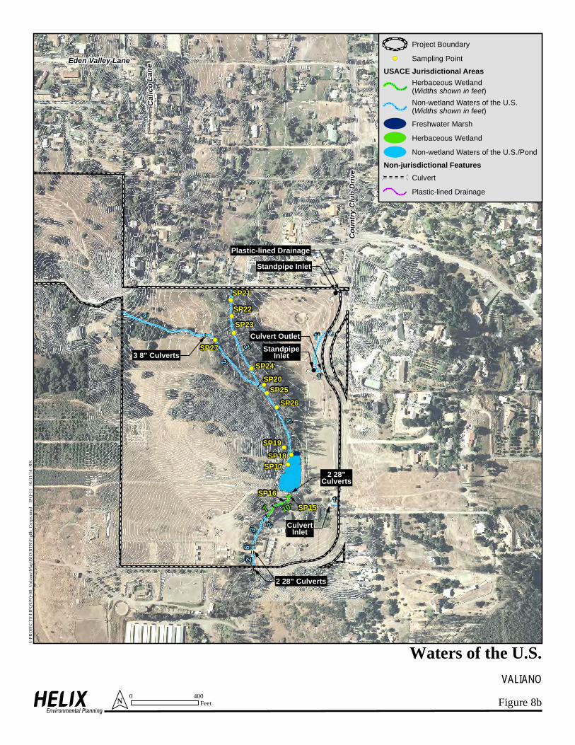
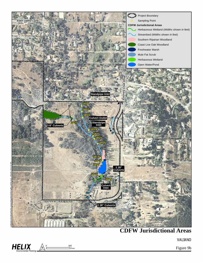
1.4.7 Wetlands/Jurisdictional Waters A total of 1.64 acres of WUS (USACE jurisdictional areas) is present on the Project site, including 0.45 acre of wetlands and 1.19 acres of non-wetland WUS consisting of 0.51 acre of open water/pond and 0.68 acre of streambed/drainage (Figures 8a and 8b; Table 3).
Table 3 EXISTING WATERS OF THE U.S.
HABITAT AREA1 (acres)
WETLANDS Freshwater Marsh 0.12 Herbaceous Wetland 0.33 NON-WETLAND WUS
Open Water/Pond 0.51 Non-wetland Waters of the U.S./Streambed 0.68
TOTAL 1.64 1Rounded to nearest one-hundredth.
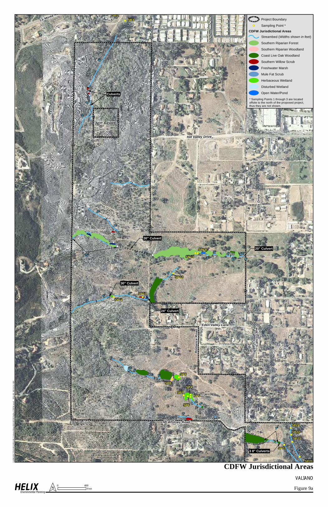
CDFW jurisdictional areas present on the Project site total 7.05 acres, comprised of 5.65 acres of vegetated habitat and 1.40 acres of open water/pond and streambed (Figures 9a and 9b, Table 4).
Table 4 EXISTING CDFW JURISDICTIONAL AREAS
HABITAT AREA1 (acres)
Coast Live Oak Woodland 2.05 Disturbed Wetland 0.13 Freshwater Marsh 0.12 Herbaceous Wetland 0.41 Mule Fat Scrub 0.02 Open Water/Pond 0.51 Southern Riparian Forest 2.50 Southern Riparian Woodland 0.29 Southern Willow Scrub 0.13 Streambed 0.89
TOTAL 7.05 1Rounded to nearest one-hundredth.

Biological Technical Report for the Valiano Project / IPQ-08 / February 18, 2015 20
San Diego County RPO wetlands on site total 3.99 acres (Table 5; Figures 10a and 10b). A total of 3.06 acres of on-site areas was considered to fall under CDFW jurisdiction but not qualify as RPO wetlands, including 2.05 acre of coast live oak woodland, 0.89 acre of non-vegetated streambed, 0.08 acre of disturbed wetland, 0.02 acre of herbaceous wetland, and 0.02 acre of southern willow scrub. These areas are further discussed below and shown on Figure 10a. Jurisdictional delineation data forms are included as Appendix G.
Table 5 EXISTING RPO WETLANDS
HABITAT AREA1 (acres)
Freshwater Marsh 0.12 Herbaceous Wetland 0.39 Mule Fat Scrub 0.02 Open Water/Pond 0.51 Southern Riparian Forest 2.50 Southern Riparian Woodland 0.29 Southern Willow Scrub 0.11 Disturbed Wetland 0.05
TOTAL 3.99 1Rounded to nearest one-hundredth.
Streambeds on site do not qualify as RPO wetlands because they do not support hydrophytic vegetation, do not have hydric soil, and do not have a non-soil substratum. These areas are regulated as non-wetland WUS by the USACE and streambed by CDFW. Coast live oak woodland on site does not qualify as RPO wetland as the habitat is dominated by coast live oak, an upland-rated species, and the understory does not support a predominance of hydrophytic vegetation. These areas also do not contain hydric soils. Running water is occasionally present in these locations as a result of runoff from upstream agricultural operations but has not resulted in the formation of hydric soils or the dominance of hydrophytic vegetation in this habitat. Coast live oak woodland on site does not meet RPO wetland criteria. A total of 0.08 acre of disturbed wetland occurring on site in Neighborhood 2 (Area A on Figures 10a and 14a) is a human-induced wetland area resulting from upstream and adjacent irrigated orchards and is small and isolated from other wetland areas, has negligible biological functions, is not a vernal pool, and does not support wetland-dependent sensitive species. The unvegetated channel running through this area contains the same soils as the adjacent upland habitat. As such, this area does not meet RPO wetland criteria A total of 0.02 acre of herbaceous wetland occurring around Sampling Point 11 in Neighborhood 4 (Area B on Figures 10a and 14a) was not considered to meet RPO wetland criteria as it is a

!(!(!(!(
!(!(
!(!(
!(
!(!(
!(
!(
!(
!(
!(
!(
!(
9
9
9
9
9
99
9
9 9
9 99
99
9
Culverts
30" Culvert
30" Culvert
24" Culvert
20" Culvert
3 8" Culverts
NOT A PART
Calic
o Lan
e
Eden Valley Lane
Mt Whitney Road
Roma
nce R
oad
Milpa
s Driv
e
Hill Valley Drive
SP9
SP8
SP7
SP6
SP11SP10
SP4
SP5
SP12
SP13SP14
SP21SP22SP23
SP27
SP24
6'
8'
3'
4'
1'
2'
5'
1'
5'
3'
2'
4'
2'
2'
3'
1'
1'
2'
3' 2'
3'
8'
1'
1'
1'
3'
2'
3'
15'25'6'
* Sampling Points 1 through 3 are locatedoffsite to the north of the proposed project,thus they are not shown.
Figure 8aVALIANO
Waters of the U.S.
Project Boundary
!( Sampling Point *
USACE Jurisdictional Areas
!
!!
!
! !
Herbaceous Wetland(Widths shown in feet)
!
!!
!
! !
Non-wetland Waters of the U.S.(Widths shown in feet)Freshwater Marsh
Herbaceous Wetland
Non-wetland Waters of the U.S./Pond
Non-jurisdictional Features
9
99
9 Culvert
I:\PRO
JECT
S\I\IP
Q\IPQ
-08_V
alian
o\Map
\BIO
\BTR
\Fig8
a_Co
rps.m
xd
IPQ-11
08/1
4/14 -
RK
0 400FeetN
!(
!(
!(
!(
!(
!(
!(
!(
!(
!(
!(
!(
!(
!(
9 99
9
9 99 9
9 99 9
1'
1'
1'
3 8" Culverts
Calic
o Lan
eEden Valley Lane
Coun
try C
lub D
rive
SP20
SP21SP22SP23
SP27
SP24
SP25SP26
3'4'
2'
Plastic-lined Drainage
2 28"Culverts
2 28" Culverts
SP18SP19
SP17
SP16SP15
4'
10'
2'3'2'
6'7'
Culvert OutletStandpipeInlet
Standpipe Inlet
CulvertInlet
Figure 8bVALIANO
Waters of the U.S.
Project Boundary
!( Sampling Point
USACE Jurisdictional Areas
!
!!
!
! !
Herbaceous Wetland(Widths shown in feet)
!
!!
!
! !
Non-wetland Waters of the U.S.(Widths shown in feet)Freshwater Marsh
Herbaceous Wetland
Non-wetland Waters of the U.S./Pond
Non-jurisdictional Features
9
99
9 Culvert
Plastic-lined Drainage
I:\PRO
JECT
S\I\IP
Q\IPQ
-08_V
alian
o\Map
\BIO
\BTR
\Fig8
b_Co
rps.m
xd
IPQ-11
10/3
1/14 -
RK
0 400FeetN
9
9
9
9
9
99
9
9 9
9 9
9
99
9
!!
!!
!!
!!
!!
!!
!!
!!
!!
!!
!!
!!
!!
!!
!!
!!
!!
!
!
!!
!!
!!
!!
!!
!!
! !
!! ! !
! !
!!
! !
!!
! !
! !! !
!!
!!
!!
!!
!!
!!
!!
!!
!!
!!
!!
!!
!!
! ! !!!
! !
!!
! !
!!
!!
!!
!
!
!
!!
!!
!!
!!
!!
!
!!!!!
!!
!!
!
!
!
!
!!
!!
!!
!!
!!
!!
!!
!
!
!!
!!
!!
!!
!!
!!
!!
!!
!!
!!
!!
!!
!!
!!
!!
!!
!!
!
!
!!
!!!!!!!
!!!
!!
!
!!
!!
!!
!
! !
!!
!!
! !
!!
!!
!!
! !!
!
!!
!!
! !
!!
! !
! !
!
!
!
! !! ! ! !
! !! !
!!
! ! ! !
! !
! !
! ! !!
!
!
!!
!!
!
!!
!!
!(!(!(!(
!(!(
!(!(
!(
!(
!(
!(!(
!(
!(
!(
!(
!(
!(
!(
!(
!(
NOT A PART
Hill Valley Drive
Culverts
30" Culvert
30" Culvert
24" Culvert
20" Culvert
3 8" Culverts
Calic
o Lan
e
Eden Valley Lane
Mt Whitney Road
Roma
nce R
oad
Milpa
s Driv
e
La Moree RoadSP3
SP2
SP9
SP8
SP7
SP6
SP11SP10
SP4
SP5
SP12
SP13SP14
SP20
6'
15'
4'
7'
3'
3'
12'
2'
5'
3'
4'
4'
4'
5'
2'
3'
2'
5'
5'
15'
1'
2'
2'
4'
3'
8'3' 4'
3'5'
SP27
SP23SP22SP21
Figure 9aVALIANO
CDFW Jurisdictional Areas
Project Boundary
!( Sampling Point *
CDFW Jurisdictional Areas
!
!!
!
! !Streambed (Widths shown in feet)Southern Riparian Forest
Southern Riparian Woodland
Coast Live Oak Woodland
Southern Willow Scrub
Freshwater Marsh
Mule Fat Scrub
Herbaceous Wetland
Disturbed Wetland
Open Water/Pond
I:\PRO
JECT
S\I\IP
Q\IPQ
-08_V
alian
o\Map
\BIO
\BTR
\Fig9
a_CD
FW.m
xd
IPQ-08
08/1
4/14 -
RK
0 400FeetN
* Sampling Points 1 through 3 are locatedoffsite to the north of the proposed project,thus they are not shown.
9 99
9
9 99 9
9 99 9
!!
!!
!!
!!
!!
!!
!!
!!
!!
!!
!!
!
!
!
!!
!!
!!
!!
!!
!!
!!
!!
!!
!!
!!
!!
!!
!!
!!
!!
!!
!!
! ! ! !
!!
!!
!!
!!
!
!
!!
!!
!!
!!
!!
!!
!
!
! !
!!
!
!!
!!
!!
! !! !!
!
!(
!(
!(
!(
!(
!(
!(
!(
!(
!(
!(
!(
!(
!(
3 8" Culverts
Calic
o Lan
eEden Valley Lane
Coun
try C
lub D
rive
SP20
4'
7'
3'
2 28"Culverts
2 28" Culverts
SP18SP19
SP17
SP16SP15
7'
14'
3'5'6'
8'7'
Culvert OutletStandpipeInlet
Standpipe Inlet
CulvertInlet
3'
1'
3'
SP27
SP26SP25
SP24
SP23SP22SP21
Figure 9bVALIANO
CDFW Jurisdictional Areas
Project Boundary
!( Sampling Point
CDFW Jurisdictional Areas
!
!!
!
! !Herbaceous Wetland (Widths shown in feet)
!
!!
!
! !Streambed (Widths shown in feet)Southern Riparian Woodland
Coast Live Oak Woodland
Freshwater Marsh
Mule Fat Scrub
Herbaceous Wetland
Open Water/Pond
I:\PRO
JECT
S\I\IP
Q\IPQ
-08_V
alian
o\Map
\BIO
\BTR
\Fig9
b_CD
FW.m
xd
IPQ-08
10/3
1/14 -
RK
0 400FeetN