Vegetation communities of Valles Caldera National Preserve
118
A Vegetation Survey and Preliminary Ecological Assessment of Valles Caldera National Preserve, New Mexico 2003
Transcript of Vegetation communities of Valles Caldera National Preserve

A Vegetation Survey and Preliminary Ecological Assessment of Valles Caldera National Preserve, New Mexico
2003

A Vegetation Survey and Preliminary Ecological Assessment of
Valles Caldera National Preserve, New Mexico1
Esteban Muldavin and Phil Tonne __________________________________________________________________________
SUMMARY
With the acquisition of the Valles Caldera National Preserve (VCNP) has come the need
for comprehensive biological inventories to support sound natural resources management. Fundamental components of this effort are the development of a vegetation map and associated vegetation community classification, and a preliminary assessment of the condition and regional status of these communities. Accordingly, we conducted an initial vegetation survey to help characterize the range of variation and condition among the preserve’s ecosystems and to provide a foundation for the development of a high-resolution vegetation map to be used in planning and management. In 2001, we established 100 vegetation plots in the preserve’s forests and grasslands that have detailed species inventories, site and tree stand characterizations, and repeat photo points. In this first year, sampling was focused on describing reference conditions in stands that had the fewest impacts from past logging and grazing or those with special biological elements. Data from these plots were used to develop a vegetation classification that conforms to the National Vegetation Classification system standards. The classification serves as an organizing tool for information on the preserve’s ecosystems and for defining map units for a vegetation map to be developed in succeeding years.
We identified and described 65 plant associations that encompass high elevation sub-alpine forests, down through mixed conifer to open foothill pine woodlands, and from high montane grasslands to valley floor wetlands. This makes VCNP one the most diverse sites in the Southern Rocky Mountains Ecoregion (southern Wyoming to northern New Mexico). The montane grasslands and wetlands of the preserve are of particular importance because they are considered part of an ecosystem type that is threatened and declining on a global basis due to the impacts of grazing and development. The estimated 26,000 acres of montane grasslands along with the 1,650 acres of wetlands on the preserve represent some of the largest and highest quality occurrences in terms of ecological function and biodiversity within the ecoregion, and they potentially represent a 20% increase in acreage of montane grasslands and wetlands under protection in parks and preserves. Although of relatively high quality, long-term cattle and sheep grazing has left an imprint on these communities in terms of declines in native bunchgrasses and increases in exotic or undesirable species. These effects are further confounded by the presence of sizable elk populations on the preserve. Furthermore, past grazing impacts are also thought to be responsible for declines in aquatic habitat and the cold-water fishery within the preserve. Given this complexity, the implementation and maintenance of a scientific monitoring program that addresses the interactions among grazers and ecological processes such as fire and flooding, is critical to the restoration and long-term sustainability of these grassland and associated aquatic ecosystems.
i
1 Final report submitted in partial fulfillment of Cooperative Agreement No. 01CRAG0014 between the University of New Mexico and the U.S. Geological Survey, Biological Resources Division.

With respect to forests, the VCNP was subject to extensive timber harvest during the twentieth century—approximately 40,000 acres out of the 65,000 was either selectively harvested or clear-cut between 1930 and 2000. This has left a legacy of second-growth forests with a mix of altered stand conditions and an extensive logging road network with its implications for degraded hydrological regimes and erosion hazards. Yet, the remaining 25,000 acres of virgin forest still represent the some the largest and best occurrences left in the Jemez Mountains, particularly those on Redondo Peak and in the Sierra del los Valles along the eastern boundary of the preserve. These stands and associated rocky talus slopes are also home to several sensitive species including the Jemez Mountains salamander (Plethodon neomexicanus), Goat Peak pika (Ochotona princeps nigrescens), and the northern goshawk (Accipiter gentiles), and Sapello Canyon larkspur (Delphinium sapellonis). In addition, these remaining virgin forests lie in the upper watersheds of the East Fork of the Jemez River and San Antonio Creek, which form the core of the cold-watery fishery for the preserve. Accordingly, an East Fork- San Antonio Upper Watershed Protection Zone is suggested as a special management area where livestock grazing and logging would be excluded and restoration implemented scientifically on a landscape scale to improve downstream riparian wetland and aquatic conditions. In addition, the zone would secure habitat for several sensitive species and hence help avoid future conflicts in their management. We would also suggest a special management area for the Alamo Canyon wetland complex on the west side of the preserve. The primary feature of this complex is a large grassy montane fen known as “Alamo Bog” that is unique in the Southern Rocky Mountain region. Unlike other fens in the region, this one is highly acidic as a result of sulfuric acid inputs from underlying warm springs and, over the course of 9,000-plus years, it has accumulated more than 12 feet of organic peat intermixed with sediments. In addition, the wetland complex also contains a bog birch (Betula glandulosa) community that is found nowhere else in New Mexico. Overall, this highly acidic and deep fen along with the bog birch make up a globally rare ecosystem type that is worthy of special management attention.
Redondo Peak is both sacred to the native people of the region and the heart of a preserve now belonging to the American people. While the enabling legislation for the VCNP set aside the lands above 10,000 ft for protection, to effectively manage this landscape for its cultural and biological values requires that the entire slope of the mountain be considered. We therefore suggest a Redondo Peak Reserve that encompasses the lower slopes of the mountain so that management, particularly of fire, can be implemented in a meaningful landscape context to ensure the long-term sustainability of the forests, montane grasslands, rare species, and the associated cultural resources of the mountain.
Overall, we suggest that management of the natural resources of the preserve would be
best addressed through an ecosystem approach that recognizes the role humans play in balancing biodiversity protection with sustainable resource extraction along with recreational and scenic values. We recommend a strategy that focuses on watersheds and the reestablishment of landscape-level processes such as appropriate fire regimes and levels of grazing in a way that will ensure long-term sustainability of productivity and biodiversity.
ii

TABLE OF CONTENTS
Introduction..................................................................................................................................... 1 Acknowledgements......................................................................................................................... 1 Study Area ...................................................................................................................................... 2
Location and History................................................................................................................... 2 Landscape and Climate ............................................................................................................... 4 Geology....................................................................................................................................... 5 Soils............................................................................................................................................. 6 Flora and Fauna Studies............................................................................................................ 11
Methods......................................................................................................................................... 11 Field Sampling .......................................................................................................................... 11 Analysis..................................................................................................................................... 16
Results........................................................................................................................................... 18 A Vegetation Survey of the Valles Caldera National Preserve ................................................ 18
Forest, Woodland, and Shrubland Communities .................................................................. 22 Spruce-Fir Forests............................................................................................................. 23 Quaking Aspen Forests ..................................................................................................... 26 Mixed Conifer Forest........................................................................................................ 27 Ponderosa Pine Forests and Woodlands ........................................................................... 31 Pinyon-Juniper Woodland ................................................................................................ 32 Montane Shrublands ......................................................................................................... 32 Montane Riparian Forests and Shrublands ....................................................................... 34
Grasslands and Wetlands ...................................................................................................... 35 Montane Grasslands.......................................................................................................... 35 Montane Wet Meadows and Wetlands ............................................................................. 37
Plants and Animals of Note ...................................................................................................... 39 Rare Species.......................................................................................................................... 39 Other Animals and Plants of Interest .................................................................................... 41
Preliminary Ecological Assessment.......................................................................................... 42 Forests and Woodlands ......................................................................................................... 42 Grasslands ............................................................................................................................. 51 Wet Meadows and Wetlands ................................................................................................ 56 Montane riparian forests and shrublands .............................................................................. 58
Potential Special Management Areas ....................................................................................... 59 Alamo Canyon Wetland Complex ........................................................................................ 59 Jemez - San Antonio Upper Watershed Protection Zone ..................................................... 62 Redondo Peak Reserve ......................................................................................................... 63
Discussion..................................................................................................................................... 65 References..................................................................................................................................... 66 Appendix A. Data forms Appendix B. Plant species list Appendix C. Plot list Appendix D Vegetation summary tables
iii

LIST OF FIGURES
Figure 1. Valles Caldera National Preserve (VCNP) study area. .................................................. 3 Figure 2. Looking south from Pajarito Mountain over Valle Grande with the Sierra de los Valles
of the caldera rim to the left and Redondo Peak to the right. ................................................. 4 Figure 3. Miocene to Holocene volcanic fields and the Jemez lineament...................................... 5 Figure 4. Geology of the Valles Caldera National Preserve as mapped by Smith et al. (1970).. .. 7 Figure 5. Generalized soils map of the Valles Caldera National Preserve. ................................... 9 Figure 6. Distribution of 2001 vegetation plots within watershed sampling zones..................... 13 Figure 7. False-color infrared 1991 aerial photography from the National Aerial Photography
Program (NAPP) at approximately 1:24,000 scale............................................................... 15 Figure 8. The Valle Grande presents the typical landscape of the VCNP where grasslands
dominate the lower alluvial slopes and valley floor, while various forest types cloak the surrounding volcanic hills and mountains. ........................................................................... 18
Figure 9. The typical distribution of forest zones in the VCNP as shown along the northern rim of Valle San Antonio. ........................................................................................................... 22
Figure 10. An example of the Corkbark Fir/Wortleberry PA along the northern caldera rim near Garita gate............................................................................................................................. 23
Figure 11. An example of the Engelmann Spruce/Forest Fleabane PA along the caldera rim north of Pajarito Mountain.................................................................................................... 25
Figure 12. Young aspen stand in the northwestern corner of preserve........................................ 26 Figure 13. A White Fir-Douglas-fir/Forest Fleabane PA in Deer Canyon in the southwest corner
of the preserve....................................................................................................................... 27 Figure 14. Douglas-fir/Rocky Mountain Maple PA along the boulder strewn slopes of the San
Antonio Rim.......................................................................................................................... 29 Figure 15. Limber Pine/Common Juniper PA on the eastern slope of Cerro del Medio............. 29 Figure 16. An example of a relatively young blue spruce fringe forest bordering montane
grasslands in Valle San Antonio (left photo). Right photo from inside the same stand shows the sparse understory as a function of the dense canopy. .................................................... 30
Figure 17. The multi-age structure of trees is apparent in this stand of the Ponderosa Pine/Arizona Fescue PA located along the lower-slope of the Valle San Antonio rim. ...... 31
Figure 18. The Gambel Oak/Sun Sedge PA is common on southwesterly slopes of Freelove Canyon. ................................................................................................................................. 33
Figure 19. Blue Spruce/Thinleaf Alder/ Fendler's Waterleaf PA along La Jara Creek. ............. 34 Figure 20. The Bog Birch/Water Sedge/Club Moss PA in the Alamo Canyon fen complex. ... 34 Figure 21. In the valles of the VCNP, Arizona fescue commonly dominates the upper slopes,
while pine dropseed and Arizona fescue often codominate the lower slopes and terraces . 35 Figure 22. Thurber fescue and Parry’s oatgrass typically dominate the higher interior montane
valleys such as this one in Canada Bonita along the eastern rim of the VCNP.................... 35 Figure 23. The complexity of wet meadows and wetlands is evident in this view across the Valle
Grande................................................................................................................................... 37 Figure 24. A typical wet meadow/wetland along San Antonio Creek represented here by the
Tufted Hairgrass -Northwest Territory Sedge Association. ............................................... 38 Figure 25. Sapello Canyon larkspur (Delphinium sapellonis).................................................... 39 Figure 26. West slope of Pajarito Mountain. ............................................................................... 42 Figure 27. Looking south over the Jemez River valley from Redondo Border........................... 42
iv
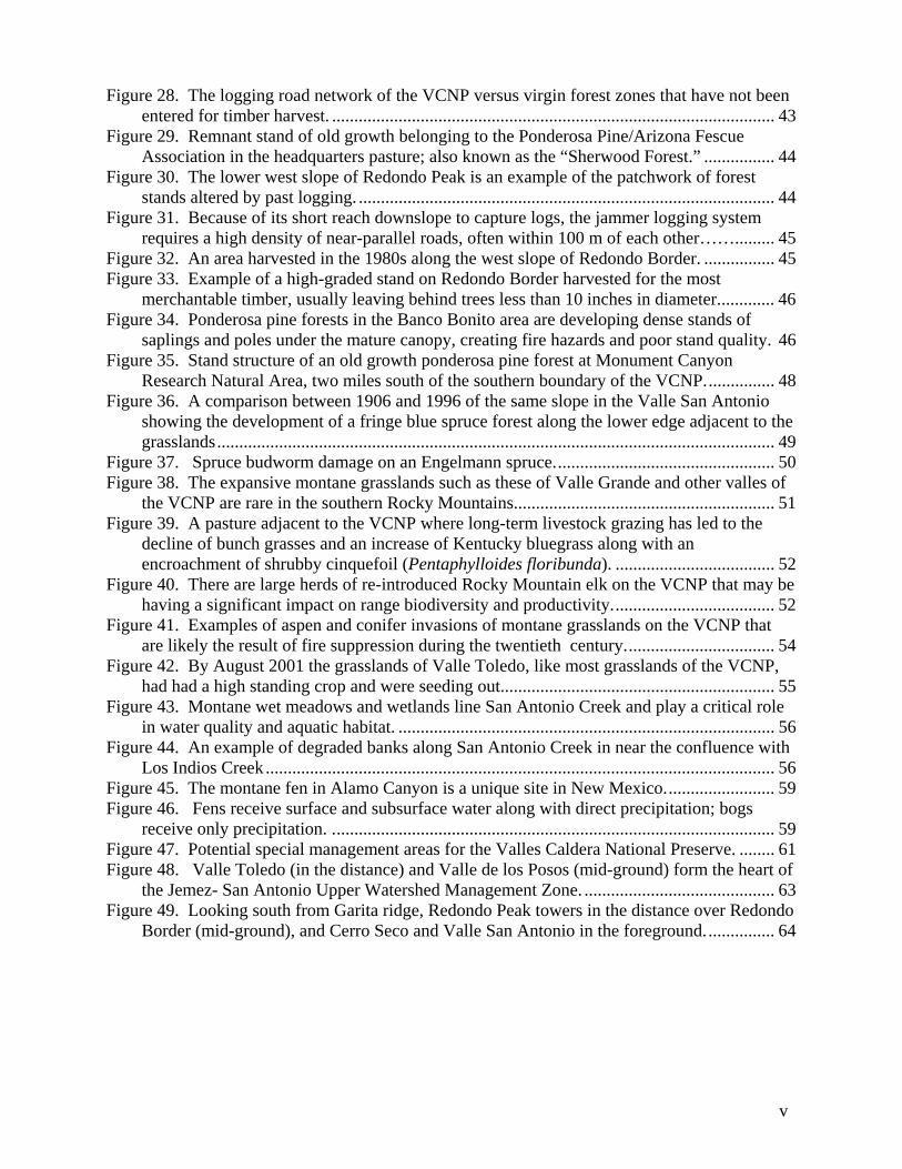
Figure 28. The logging road network of the VCNP versus virgin forest zones that have not been entered for timber harvest. .................................................................................................... 43
Figure 29. Remnant stand of old growth belonging to the Ponderosa Pine/Arizona Fescue Association in the headquarters pasture; also known as the “Sherwood Forest.” ................ 44
Figure 30. The lower west slope of Redondo Peak is an example of the patchwork of forest stands altered by past logging. .............................................................................................. 44
Figure 31. Because of its short reach downslope to capture logs, the jammer logging system requires a high density of near-parallel roads, often within 100 m of each other……......... 45
Figure 32. An area harvested in the 1980s along the west slope of Redondo Border. ................ 45 Figure 33. Example of a high-graded stand on Redondo Border harvested for the most
merchantable timber, usually leaving behind trees less than 10 inches in diameter............. 46 Figure 34. Ponderosa pine forests in the Banco Bonito area are developing dense stands of
saplings and poles under the mature canopy, creating fire hazards and poor stand quality. 46 Figure 35. Stand structure of an old growth ponderosa pine forest at Monument Canyon
Research Natural Area, two miles south of the southern boundary of the VCNP................ 48 Figure 36. A comparison between 1906 and 1996 of the same slope in the Valle San Antonio
showing the development of a fringe blue spruce forest along the lower edge adjacent to the grasslands.............................................................................................................................. 49
Figure 37. Spruce budworm damage on an Engelmann spruce.................................................. 50 Figure 38. The expansive montane grasslands such as these of Valle Grande and other valles of
the VCNP are rare in the southern Rocky Mountains........................................................... 51 Figure 39. A pasture adjacent to the VCNP where long-term livestock grazing has led to the
decline of bunch grasses and an increase of Kentucky bluegrass along with an encroachment of shrubby cinquefoil (Pentaphylloides floribunda). .................................... 52
Figure 40. There are large herds of re-introduced Rocky Mountain elk on the VCNP that may be having a significant impact on range biodiversity and productivity..................................... 52
Figure 41. Examples of aspen and conifer invasions of montane grasslands on the VCNP that are likely the result of fire suppression during the twentieth century.................................. 54
Figure 42. By August 2001 the grasslands of Valle Toledo, like most grasslands of the VCNP, had had a high standing crop and were seeding out.............................................................. 55
Figure 43. Montane wet meadows and wetlands line San Antonio Creek and play a critical role in water quality and aquatic habitat. ..................................................................................... 56
Figure 44. An example of degraded banks along San Antonio Creek in near the confluence with Los Indios Creek ................................................................................................................... 56
Figure 45. The montane fen in Alamo Canyon is a unique site in New Mexico......................... 59 Figure 46. Fens receive surface and subsurface water along with direct precipitation; bogs
receive only precipitation. .................................................................................................... 59 Figure 47. Potential special management areas for the Valles Caldera National Preserve. ........ 61 Figure 48. Valle Toledo (in the distance) and Valle de los Posos (mid-ground) form the heart of
the Jemez- San Antonio Upper Watershed Management Zone. ........................................... 63 Figure 49. Looking south from Garita ridge, Redondo Peak towers in the distance over Redondo
Border (mid-ground), and Cerro Seco and Valle San Antonio in the foreground................ 64
v

LIST OF TABLES Table 1. Monthly Climate Summary for Los Alamos (Station 295084) based on a period of
record from 2/ 1/1942 to 12/31/2001. ..................................................................................... 5 Table 2. Geologic map units of Smith et al. (1970) that occur on the Valles Caldera National
Preserve................................................................................................................................... 8 Table 3. Soil Map Units of the Valles Caldera Nation Preserve as defined and mapped by the
Natural Resources Conservation Service as part of the Soil Survey of Sandoval County. .. 10 Table 4. Modified Domin-Krajina Vegetation Cover Scale from Mueller-Dombois................. 14 Table 5. U.S. National Vegetation Classification physiognomic-floristic hierarchy for terrestrial
vegetation (Grossman et al. 1998) with a supplemental Alliance Group level. ................... 14 Table 6. A preliminary vegetation classification for the Valles Caldera National Preserve. ...... 18 Table 7. Species of note for the Valles Caldera National Preserve that are either known from the
preserve or in the surrounding mountains. .......................................................................... 40
vi

INTRODUCTION
With establishment of the Valles Caldera National Preserve in 2000, 90,000 acres of picturesque land rich in natural resources and biodiversity came under ownership of the American people. With acquisition has come the responsibility for wise management to ensure long-term sustainability of the preserves ecosystems. As a step towards this, inventories of the preserve's animal, plant, timber, and range resources, and an assessment of their status are needed. Accordingly, we present a vegetation survey that characterizes the range of variation among the preserve's ecosystems and that provides the initial groundwork for the future development of a high-resolution vegetation map. An additional goal was to highlight the outstanding ecological attributes of the preserve along with some of the biological management issues that will likely need to be addressed in the natural resources planning process.
The vegetation survey was conducted during the summer of 2001 and was centered on
establishing 100 detailed vegetation plots across the range of the preserve’s vegetation communities. Based on these plots, a preliminary vegetation classification was constructed that contains information on community species composition, abundance, and site characteristics. This classification will serve as the framework for the development a vegetation map to be built from aerial photography and satellite imagery in the second year of the project. The classification also conforms to national vegetation classification and mapping standards. This has allowed us to effectively access information from a variety of databases and literature sources about the ecology and distribution of the component communities. Using this information, we present here an overview of the vegetation pattern and ecology of the preserve along with a preliminary assessment of ecological conditions and biodiversity status (rarity) in a regional and national (and sometimes international) context. In addition, we have identified for consideration a set of special management areas that focus on sites that support species or communities of special interest, or that address the protection and restoration of ecological processes necessary for sustaining biological resources within the preserve. Our overall objective has been to provide fundamental information for effective natural resources management in a watershed and ecosystem context, and to complement and support other biological and natural resources inventories and studies.
ACKNOWLEDGEMENTS
Funding was provided by a grant from the Valles Caldera National Preserve through the USGS Biological Resources Division, Fort Collins Science Center. Dedicated fieldwork on the behalf of Amanda Browder, Yvonne Chauvin, and Jackie Smith made the project possible. Rebecca Keeshen provided editorial assistance, and Teri Neville GIS support. Cover photo is of the Valle Grande from the preserve headquarters taken in August 2001.
Photographs. Phil Tonne: Figures 8, 10, 13, 14, 15, 16, 17, 18, 20, 21, 24, 37, 41 a & c, and 42 ; Esteban
Muldavin: cover photo, 9, 11, 12 ,22, 23, 26, 27, 30, 32, 38, 39, 40, 41b, 43, 48, 49; Tom. Swetnam: 34, 44, and 45; Yvonne Chauvin: 19 and 33; Elizabeth Milford 29, and J. Stewart (NM Rare Plant Council): 25.
1

2
STUDY AREA
Location and History The Valles Caldera National Preserve (VCNP) lies in north-central New Mexico in the
heart of the Jemez Mountains (Figure 1). It is bounded primarily by Santa Fe National Forest lands with smaller units of Bandelier National Monument and Santa Clara Pueblo along its eastern flank. The preserve encompasses most the original Baca Location No. 1 land grant except for the peripheral areas owned by the U.S. Forest Service (USFS), Bandelier NM and Santa Clara Pueblo. The acreage is approximately 89,000 acres (36,000 ha).
A report on the Baca compiled by the USFS (1993) provides extensive details about the
history (through 1993) and resources of the preserve. Briefly, the Baca Location No. 1 was established as part of a land exchange in the 1860’s between the U.S. government and the Baca family for lands near Las Vegas, NM. At the turn of the century, the parcel began to change hands and eventually was acquired in 1926 by Frank Bond, an Española, NM merchant and sheep rancher. He grazed sheep on the land until the 1940’s, when a cattle operation was phased in. At the same time, major timber harvests were begun in the 1930’s by New Mexico Timber Company, who had held a 99-year lease on the timber rights since 1918. Frank Bond died in 1945, but the land was managed by his descendants until 1962, when Pat Dunigan, a Texas oilman, purchased the parcel. Dunigan and his co-investors purchased the ranch with the intention of investigating its geothermal potential for electrical power. Between 1972 and 1982, geothermal leases were issued to Union Geothermal of California and upwards of 40 wells were drilled, mostly in the Alamo Creek and Redondo Creek drainages. The ranch continued to have a livestock operation, but with much lower numbers (4,000 to 6,000 head versus 12,000). Timber harvests continued until 1972 when Pat Dunigan was able to acquire the remaining timber rights from New Mexico Timber Company (following a protracted legal battle). Logging was discontinued up until Pat Dunigan’s death in 1980. In the ensuing 20 years land was managed by his heirs and logging resumed along with a large livestock operation.
In April 2000, Congress passed the Valles Caldera Preservation Act (Public Law 106-
248) that allowed the purchase of the land for public use. There were five purposes stipulated in the act that will have a direct impact on how the land will be managed for generations to come: 1) to authorize Federal acquisition of the Baca ranch; 2) to protect and preserve for future generations the scientific, scenic, historic, and natural values of the Baca ranch, including rivers and ecosystems and archaeological, geological, and cultural resources; 3) to provide opportunities for public recreation; 4) to establish a demonstration area for an experimental management regime adapted to this unique property which incorporates elements of public and private administration in order to promote long term financial sustainability consistent with the other purposes enumerated in this subsection; and 5) to provide for sustained yield management of the Baca ranch for timber production and domesticated livestock grazing insofar as is consistent with the other purposes stated herein

3
USFS
USFS Jemez
VCNP HQ
Bandelier N.M.
LAN
USFS Jemez R.D.
Santa Clara Pueblo
Figure 1. Valles Caldera National Preserve (VCNP) encompasses most of former Baca Location No. 1 except for areas that were distributed to Bandelier National Monument, Santa Clara Pueblo and the Coyote District of the Santa Fe National Forest.

Landscape and Climate
The dramatic landscape of the Valles Caldera National Preserve is derived from the
remnants of a series of volcanic eruptions from 1,600,000 to 60,000 years ago that left behind a caldera rim of mountains that ring the preserve and several volcanic cones and domes that dominate the center (Figure 2). The intervening valleys, or in Spanish, “valles” formed after an ancient caldera lake was breached and drained. There is a 3,250-foot difference in elevation across the preserve with the lowest point at about 7,930 ft (2,440 m), near the mouth of El Cajete Canyon in the southwestern corner of the preserve. The highest point is Redondo Peak at 11,254 ft (3,430 m), with the mountains of the caldera rim averaging over 10,000 ft (3,000 m). The intervening valles range from about 8,400 ft (2,560 m) to 9,000 ft (7,740 m).
Since there are no official weather stations on or near the VCNP, the best available
climate information comes from Los Alamos at 7,360 ft (2,243 m) (Table 1). The regional climate is considered semi-arid continental with the majority (60%) of the precipitation coming in the summer months in the form of convectional “monsoon” storms. The winter precipitation is primarily from snow. This overall climate scenario is modified by the high elevations and topographic variability within the VCNP. For example, the 18.4 in (46.7 cm) mean annual precipitation (MAP) reported for Los Alamos is estimated to increase to over 35 in (90 cm) at the caldera rim (Allen 1989), and snow accumulation, while minimal at Los Alamos, can be significant within the valle/mountain landscape of the preserve. Similarly, temperatures at the highest elevations of the VCNP may be anywhere from 25 to 35° F (15 to 20° C) colder than Los Alamos, and the valles are likely to be between 10 and 15° F (5 to 8° C) colder. The effect of cold-air drainage into the valle bottoms may also drive temperatures down even further.
4
Figure 2. Looking south from Pajarito Mountain over Valle Grande with the Sierra de los Valles of the caldera rim to the left and Redondo Peak, a volcanic dome, in the distance to the right.

Table 1. Monthly Climate Summary for Los Alamos (Station 295084) based on a period of record from 2/1/1942 to 12/31/2001.
Jan Feb Mar Apr May Jun Jul Aug Sep Oct Nov Dec AnnualAverage Max. Temperature (F) 39.5 43.5 49.6 58.6 67.7 77.9 80.5 77.7 72.4 61.7 48.8 40.9 59.9 Average Min. Temperature (F) 18.4 21.8 26.8 33.8 42.7 51.8 55.5 53.9 48.0 37.7 26.8 19.8 36.4 Average Total Precipitation (in.) 0.88 0.73 1.08 0.99 1.25 1.38 3.05 3.77 1.81 1.54 0.94 0.97 18.39 Average Total Snowfall (in.) 12.1 9.1 10.3 4.8 0.6 0.0 0.0 0.0 0.0 2.2 4.9 11.2 55.2 Average Snow Depth (in.) 3 2 1 0 0 0 0 0 0 0 0 2 1
The Jemez Mountains are considered part of the Southern Rocky Mountains Ecoregion
by Neely et al. (2001), which approximates the Southern Rocky Mountain Steppe--Open Woodland--Coniferous Forest--Alpine Meadow Province in Bailey’s (1995) ecoregion classification used by the U.S. Forest Service. Alternatively, it is considered part of the Southern Rockies Ecoregion in Omernik’s (1987) classification developed for the Environmental Protection Agency. For our purposes here, we have adopted the Southern Rocky Mountains Ecoregion term and delineation used by Neely et al. (2001).
Geology The Jemez Mountains lie at the intersection of the Jemez lineament and the Rio Grande rift (Figure 3). The Jemez lineament is a chain of volcanic centers extending from Arizona to Colorado, and the Rio Grande rift is a crack in the earth’s crust extending from the Rocky Mountains of central Colorado to Chihuahua, Mexico. This geologic interface was the site of a series of volcanic events related to tectonic movements, including two massive explosions leading to the formation of the Toledo and Valles Calderas at 1.61 and 1.23 million years ago, respectively (Spell et al. 1993). The Toledo eruption ejected an estimated 396 km3 of rock and ash, while the Valles eruption produced about 292 km3. By comparison, Mt. Saint Helens erupted 25 km3 and Krakatoa 18 km3 of new material.
VCNP
Figure 3. Miocene to Holocene volcanic fields and the Jemez lineament: 1. Springerville; 2. Zuni-Bandera 3; Mount Taylor; 4. Jemez Mountains; 5. Taos; 6. Ocate; and 7. Raton-Clayton (from Ander et al. (1981).
The remnant caldera rim is comprised of a chain of peaks and domes that include the
Sierra del los Valles along the eastern flank of the preserve and Cerro de la Garita along the northeasterly boundary (Figure 4). The mountains are primarily made up of Otowi (Qbo) and
5

Tshirege members (Qbt) of the Bandelier Tuff, Cerro Toledo Rhyolite (Qct), the Tischcoma formation (Tt), and the Paliza Canyon Formation (Tpa) (Table 2). The Bandelier Tuff was deposited in a sheet 30 to 900 ft (9 to 275 m) thick in the Jemez Mountains and beyond, forming the upper walls of San Diego Canyon, and dominating the geology of Bandelier National Monument to the southeast of the preserve.
Within the caldera rim, the formation of the prominent landforms was primarily by
resurgence of the caldera floor and intrusion through faults. The more recent Valles eruption was followed by the collapse of the caldera, and subsequently by the formation of multiple intra-cauldron lakes (Gardner et al. 1996), and now represented by Tuffaceous Lake Sediments (Qls). There was a later resurgence of the caldera floor that formed the classic domal uplift of Redondo Peak (Qbt). A series of rhyolitic domes resulted when molten rock squeezed up through faults in a regular sequence along the ring fracture that had formed during the caldera collapse (Valle Grande Member – Qvvf). Eight domes were formed between 1.1 and 0.5 million years ago: Cerro del Medio (the oldest), Cerro La Jara, Cerros del Abrigo, Cerro Santa Rosa, Cerro San Luis, Cerro Seco, San Antonio Mountain, and South Mountain (the youngest). The most recent events were the El Cajete pumice (Qvec) eruption and the Banco Bonito (Qvbb) obsidian flow, both occurring within the last 60,000 years. The slopes of the valles are dominated by older quaternary alluvial fan (Qf) deposits from the surrounding mountains forming alluvial fans and fan piedmonts that lead down to recent alluvial fill (Qal) in the valley bottoms. The drainages of San Antonio Creek and the East Fork of the Jemez River come together at the head of San Diego Canyon, and San Diego Canyon represents the only drainage outlet from the Valles Caldera. The head of this canyon occurs at the lowest lip of the caldera rim and is thought to represent the point where the caldera was breached because of overflow from a lake generated by displacement of a growing resurgent dome of Redondo Peak (Smith and Bailey 1963). There is evidence for this in the lake sediments that thin against the resurgent dome and are associated with hydromagmatic tuffs (Gardner et al. 1996).
Soils The soils to some degree mirror the geology of the VCNP (Figure 5). There are some 20 soil series that are components of 19 soil mapping units that have been mapped for the preserve as part of the Natural Resources Conservation Service, Sandoval County Soil Survey (Table 3). The soils fall into two large groups: forest and grassland soils. The forest soils are primarily mountain soils (Andisols, Alfisol and Inceptisol soil orders) and are derived from the volcanic rocks and gravel (rhyolites and andesites, with some dacites and latites, tuffs and pumices) along with some windblown deposition. These soils tend to be very rocky with loamy textures in the matrix. The grassland soils are mostly Mollisols that have developed in the volcanic alluvium of the alluvial fans and piedmonts, or in recent water-deposited sediments of the valley bottoms. They are usually deeper and have rich organic material accumulations in the top layers along with fine textures and little rock accumulation.
6

7
USFS CoyoteR.D.
Santa Clara Pueblo
USFS Jemez R.D.
VCNP HQ LANL
Bandelier N.M.
USFS Jemez R.D.
Figure 4. Geology of the Valles Caldera National Preserve as mapped by Smith et al. (1970). See Table 2 for map unit descriptions.

Table 2. Geologic map units of Smith et al. (1970) that occur on the Valles Caldera National Preserve (see Figure 4 for map). Map Unit
Map Unit Name Description
Qvbb Banco Bonito Member (100-500 ft). Thick flow of porphyritic obsidian containing phenocrysts of quartz, sanidine, plagioclase, biotite, hornblende, and pyroxene.
Qal Alluvium (0-100(?) ft). Silt, sand, and gravel; mainly deposits of recent streams. Qf Fan Deposits (0-100(?) ft). Coarse sand and gravel; mainly deposits of transient streams with steep
gradients. Qbo Otowi Member (0-600+ ft). Nonwelded to densely welded ash-flow deposits, characteristically
containing abundant accidental lithic inclusions. As mapped includes 0-30 ft of basal, bedded, air-fall pumice. (Guaje Pumice Bed).
Qct Cerro Toledo Rhyolite Volcanic domes; mainly gray lithoidal rhyolite, commonly lithophysal, and subordinate obsidian, containing small sanidine and rare quartz phenocrysts.
Qctt Cerro Toledo Rhyolite Rhyolite tuffs and tuff braccias (0-200+ ft); includes hoy avalanche deposits from Rabbit Mountain center.
Qls Tuffaceous Lake Sediments
(0-100+ ft). Thin-bedded clay, silt, and sand deposited in lakes within the Valles Caldera; commonly contain fossil leaf and other plant remains; interbedded with tuffs of the Valle Grande Member of the Valles Rhyolite.
Qvvf Valle Grande Member (volc.domes and flows)
Volcanic domes and flows (200-2,500 ft). Predominantly porphyritic rhyolites containing major phenocrysts of quartz and sanidine with lesser plagioclase, biotite, hornblende, and pyroxene.
Qvvt Valle Grande Member (tuffs)
Bedded rhyolite tuffs and tuff breccias (0-500(?) ft).
Qvdc Deer Canyon Member Rhyolite dome-flow, associated breccias, and bedded tuffs (25-100ft). Predominantly coarsely porphyritic lithoidal rhyolite typically containing abundant phenocrysts of sanidine and bi-pyramidal quartz.
Qcf Caldera Fill (0-2,500 + ft) coarse breccia, gravel, sand and silt deposited within the Valles Caldera. Predominantly volcanic detritus but locally contains large blocks of Paleozoic limestone and red sandstone. Some coarse breccia units represent landslide deposits from the caldera walls. Includes early-formed caldera lake sediments and some pyroclastic deposits.
Qbt Tshirege Member (50-900+ ft). Nonwelded to densely welded ash flow deposits, characteristically containing sparse to abundant cognate inclusions of hornblende-rich quartz-latite pumice, and sparse accidental lithic inclusions. As mapped includes 3-12 ft of basal, bedded, air-fall pumice. (Tsankawi Pumice Bed).
Tt Tschicoma Formation (0-3,000+ ft). Predominately coarsely porphyritic dacite, rhyodacite, and quartz latite containing pyroxene, hornblende, biotite, plagioclase, and occasionally quartz phenocrysts. Thick massive flows and domes. Associated pyroclastics mapped as part of the Puye Formation.
Tpa Paliza Canyon Formation (andesitic)
Mainly hypersthene-augite andesites and subordinate olivine-bearing basaltic andesites. Flows, flow breccias, tuff breccias, and dikes, undivided (0-2,000 ft). As mapped includes some gravels of the Cochiti Formation.
Tab Abiquiu Tuff of Smith (0-1,200+ ft). Mainly white to light-gray tuffaceous sand and conglomerate; includes basal gravel member (60-300 ft), composed of Precambrian crystalline rock types, and a thin (5-25 ft) chert bed (Pedernal Chert Member of Church and Hack, 1939). The Abiquiu west of La Grulla Plateau consists only of the basal gravel and chert. Includes tuffaceous sediments of questionable correlation at the mouth of Santa Fe Creek Canyon.
8

Valles Caldera National PreserveGeneralized Soils
Watersheds
Gravel RoadsNM 4
Administrative Units
1 0 1 2 Miles
2 0 2 4 Kilometers
215
12488283503
71 7274 7582 8385 86 87
215301302304308311
Forest Soils Grassland Soils
Figure 5. Generalized soils map of the Valles Caldera National Preserve based on the Natural Resources Conservation Service Soil Survey for Sandoval County (NRCS no date). See Table 3 for soil map unit
ions. descript
9

Table 3. Soil Map Units of the Valles Caldera Nation Preserve as defined and mapped by the Natural Resources Conservation Service as part of the Soil Survey of Sandoval County. MU
# Map Unit Name Soil Series Soil Taxonomic Classification FOREST SOILS 71 Palon cobbly sandy loam, 15 to 35 percent slopes Palon Psammentic eutroboralfs, loamy-skeletal, mixed 72 Palon very cobbly sandy loam, 35 to 65 percent slopes Palon Psammentic eutroboralfs, loamy-skeletal, mixed 74 Origo-Pavo association, 5 to 35 percent slopes Origo Psammentic cryoboralfs, loamy-skeletal, mixed Pavo Cryic paleborolls, fine-loamy, mixed 75 Origo very cobbly sandy loam, 35 to 65 percent slopes Origo Psammentic cryoboralfs, loamy-skeletal, mixed 82 Calaveras loam, 15 to 35 percent slopes Calaveras Dystric eutrochrepts, loamy-skeletal, mixed, frigid 83 Calaveras-Rubble Land association, 35 to 60 percent slopes Calaveras Dystric eutrochrepts, loamy-skeletal, mixed, frigid Rubble Land 85 Redondo coarse sandy loam, 15 to 35 percent slopes Redondo Typic cryoboralfs, loamy-skeletal, mixed 86 Redondo cobbly coarse sandy loam, 35 to 80 percent slopes Redondo Typic cryoboralfs, loamy-skeletal, mixed 87 Redondo-Rubble Land association, 35 to 80 percent slopes Redondo Typic cryoboralfs, loamy-skeletal, mixed Rubble Land 88 Totavi-Jemez-Rock Outcrop association, 0 to 15 percent slopes Jemez Mollic eutroboralfs, fine-loamy, mixed Rock Outcrop Totavi Vitrandic haploborolls, ashy 124 Rock Outcrop Rock Outcrop 283 Mirand-Alanos complex, 5 to 40 percent slopes Alanos Typic eutroboralfs, clayey-skeletal, mixed Mirand Mollic eutroboralfs, fine, mixed 503 Cajete-Cypher association, 8 to 50 percent slopes Cajete Mollic vitrandepts, ashy-skeletal, frigid
Cypher Lithic ustochrepts, loamy-skeletal, mixed, frigid GRASSLAND SOILS 215 Ess-Rock Outcrop complex, 5 to 45 percent slopes Ess Argic cryoborolls, loamy-skeletal, mixed Rock Outcrop 301 Vastine-Jarola silt loams, 0 to 5 percent slopes Jarola Typic argialbolls, fine-loamy, mixed, frigid
Vastine Typic endoaquolls, fine-loamy over sandy or
sandy-skeletal, mixed, frigid 302 Tranquilar-Jarmillo complex, 1 to 8 percent slopes Jarmillo Pachic haploborolls, coarse-loamy, mixed
Tranquilar Typic argialbolls, very-fine, montmorillonitic, frigid
304 Cosey-Jarmillo association, 2 to 20 percent slopes Cosey Typic paleborolls, loamy-skeletal, mixed Jarmillo Pachic haploborolls, coarse-loamy, mixed 308 Cajete gravelly loam, 0 to 8 percent slopes Cajete Mollic vitrandepts, ashy-skeletal, frigid 311 Cosey-Tranquilar-Calaveras association, 5 to 20 percent slopes Calaveras Dystric eutrochrepts, loamy-skeletal, mixed, frigid
Cosey Typic paleborolls, loamy-skeletal, mixed
Tranquilar Typic argialbolls, very-fine, montmorillonitic, frigid
10
Flora and Fauna Studies
Because the VCNP had been privately held for so long, there have been very few biological surveys up until the present. Osborn (1996) conducted a comparative floristic study between Redondo Peak and Mount Taylor that included a plant species list and brief descriptions of the major vegetation zones. Whitford and Ludwig (1975) conducted a detailed inventory of the Redondo Peak area as part of a survey during the geothermal exploration days of the Baca. They presented a vegetation classification and vegetation map of spruce-fir, mixed conifer and grasslands types. They documented eight plant associations (habitat types) with plot data that have been integrated into the VCNP vegetation classification and database (see Table 6). They also conducted mammal, amphibian and bird surveys and provided an analysis of conditions during that period in the Baca’s history.
The USFS (1993), in its report on the potential government purchase of the Baca,
provided a broad overview of the natural resources as well as the history and the economics of the site. Based on forest inventories from the early 1980’s, they estimated that of the 94,812 acres then in the Baca, about 25% or 24,000 acres (9,700 ha) were in grassland, 70% or 65,000 acres were in forest(ponderosa pine at 7,700 acres (7,150 ha); spruce-fir at 12,100 acres (4,900 ha); and mixed conifer at 35,700 acres (14,500 ha)). Only 1% of the landscape was in aspen. The remaining 5% was ascribed to rock outcrop, rubble fields and scrub. At that time, they estimated that nearly 60% of the forest lands had been logged. With acquisition, new surveys and ecological studies among several animal and plant groups have been initiated by several organizations. See the VCNP web site for information on specific studies (http://www.vallescaldera.gov/).
METHODS
Field Sampling Vegetation sampling was designed to capture as wide a variety of vegetation types as possible within the limited time frame available for sampling (July 15 to September 15, 2001). The goal was to establish 100 plots among both forest and grassland communities with a concentration on describing reference conditions with minimal disturbances from logging and grazing (in subsequent years, sampling will be targeted at post-logging communities for mapping purposes). To help in planning and for optimizing the distribution of sample points, the preserve was delineated into a set of operational sampling zones that roughly follow major watershed boundaries (Figure 6). Because of the current emphasis on grassland and wetland management at the preserve, 60% of the plots were allocated to grasslands and wetlands, and the remaining 40% to forest and woodlands.
11

We used 1991 color infrared stereo aerial photography as an aid in establishing plot locations in areas of low disturbance, and homogenous vegetation and habitat (Figure 7). Plots were established in large stands of vegetation representative of the typical vegetation at a site. Plots were generally 400 m2 and square, but occasionally other sizes were used to fit the structure of a community, especially along drainages where vegetation stands conform to the channel shape. A list of all vascular plant species, stratified by lifeform (tree, shrub, subshrub, grass and forb layers) was compiled and cover estimated for each species using a modified Domin-Krajina Scale (Table 4). See Appendix A for examples of sampling forms. In addition, the NMNHP field survey handbook is provided in the Data Addendum.
Plant voucher specimens were collected to confirm field identifications as necessary and are
housed at the University of New Mexico Herbarium. Specimens were identified to lowest level possible given the material at hand and names assigned according to the PLANTS database (USDA-NRCS 2002). A species list derived from the plot data is provided in Appendix B. Discrepancies in names between our list and those of Ron Hartman’s concurrent botanical survey have been noted based on his preliminary report provided to the VCNP.
Site attributes included slope percent, aspect, slope shape, surface rock type, and ground
cover (percent rock, gravel, bare soil and litter), along with detailed narratives on species composition and site conditions. On forest plots, the largest trees of the dominant species were radial increment cored where possible to determine approximate ages of establishment (cores were taken only from Douglas-fir, ponderosa pine, limber pine, blue spruce and Engelmann spruce and are archived at NMNHP). Cored trees were also measured for height and diameter at core height and breast height (DBH). Within each plot, all trees were counted in two-inch-diameter classes up to 20 inches. Above 20 inches, individual trees were measured for their DBH. Trees below 2 inches were also broken into two height classes: those above breast height and those below (see forms in Appendix A).
All plots were monumented in the center with one-meter-long iron rebar stakes and tagged
with oblong durable aluminum tags with the plot number, project and date etched on each and then attached with 1.5 mm iron wire. For aesthetic reasons, the stakes in grasslands were pounded down to nearly ground level. Those in forest plots extend at least 0.5 m above the ground and are covered with a meter of white PVC pipe to make them more easily visible under forest conditions. A list of all plots, their location and vegetation classification is provided in Appendix C.
All vegetation, tree and site data were entered into a Microsoft Access 2000 database and
quality controlled through error checking computer routines and manual read-backs. The complete records for all plots are provided in the Data Addendum. Each record contains the comprehensive documentation of the plot location, dimensions, vegetation composition, tree stand structure, site characteristics, vegetation classification, and photo points. In addition, the computerized ASCII dataset and database are provided on a separate data CD.
12

13
Santa Clara
Toledo San Antonio
San Luis Canyons
JaramilloRincon
Valle Grande Redondo
El Cajete Bandelier
Figure 6. Distribution of vegetation plots established in 2000 per watershed sampling zones. See Data Addendum for exact plot locations and how they are classified. Base: Thematic Mapper (TM) imagery
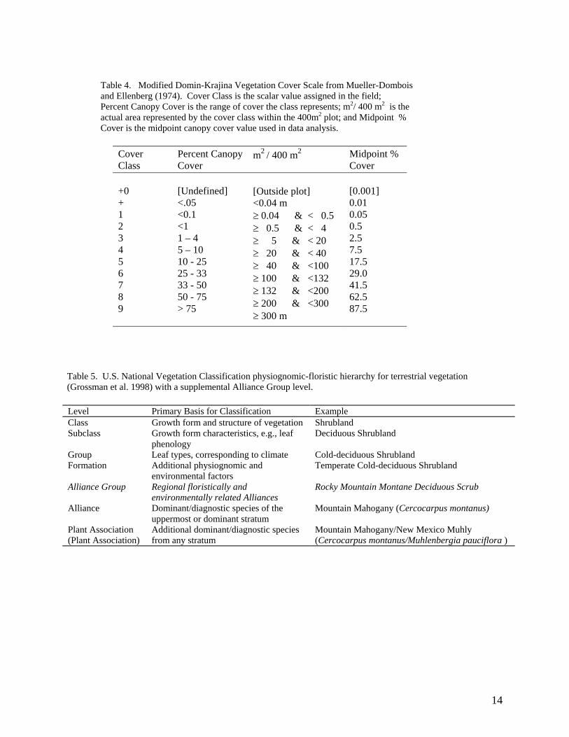
Table 4. Modified Domin-Krajina Vegetation Cover Scale from Mueller-Dombois and Ellenberg (1974). Cover Class is the scalar value assigned in the field; Percent Canopy Cover is the range of cover the class represents; m2/ 400 m2 is the actual area represented by the cover class within the 400m2 plot; and Midpoint % Cover is the midpoint canopy cover value used in data analysis.
Cover Class
Percent Canopy Cover
m2 / 400 m2
Midpoint % Cover
+0 + 1 2 3 4 5 6 7 8 9
[Undefined]
<.05 <0.1 <1 1 – 4 5 – 10 10 - 25 25 - 33 33 - 50 50 - 75 > 75
[Outside plot] <0.04 m ≥ 0.04 & < 0.5 ≥ 0.5 & < 4 ≥ 5 & < 20 ≥ 20 & < 40 ≥ 40 & <100 ≥ 100 & <132 ≥ 132 & <200 ≥ 200 & <300 ≥ 300 m
[0.001]
0.01 0.05 0.5 2.5 7.5 17.5 29.0 41.5 62.5 87.5
Table 5. U.S. National Vegetation Classification physiognomic-floristic hierarchy for terrestrial vegetation (Grossman et al. 1998) with a supplemental Alliance Group level. Level Primary Basis for Classification Example Class Growth form and structure of vegetation Shrubland Subclass Growth form characteristics, e.g., leaf
phenology Deciduous Shrubland
Group Leaf types, corresponding to climate Cold-deciduous Shrubland Formation Additional physiognomic and
environmental factors Temperate Cold-deciduous Shrubland
Alliance Group Regional floristically and environmentally related Alliances
Rocky Mountain Montane Deciduous Scrub
Alliance Dominant/diagnostic species of the uppermost or dominant stratum
Mountain Mahogany (Cercocarpus montanus)
Plant Association (Plant Association)
Additional dominant/diagnostic species from any stratum
Mountain Mahogany/New Mexico Muhly (Cercocarpus montanus/Muhlenbergia pauciflora )
14

Cerro Grande
Pajarito Mt
Old Growth
Logged
Logged
Old Growth
Dry Grassland
Wet
land
Cerro de Medio
Cerro Grande
Pajarito Mt
Old Growth
Logged
Logged
Old Growth
Dry Grassland
Wet
land
Cerro de Medio
Cerro Grande
Pajarito Mt
Old Growth
Logged
Logged
Old Growth
Dry Grassland
Wet
land
Cerro Grande
Pajarito Mt
Cerro Grande
Pajarito Mt
Old Growth
Logged
Logged
Old Growth
Dry Grassland
Wet
land
Cerro de Medio Cerro de Medio
_______________________________________________________________________________
Figure 7. False-color infrared 1991 aerial photography from the National Aerial Photography Program (NAPP) at approximately 1:24,000 scale was used to map out broad vegetation types and conditions on the VCNP and to help design the sampling strategy.
For each plot, a site-quality assessment form was filled out that numerically scored an
occurrence on a set of stand and landscape factors that include among others: exotic species encroachment; stand structure modifications due to logging, browsing or fire, etc.; erosion hazards; fire and hydrological regime alterations; stream channel degradation; landscape fragmentation and road impacts. Scores range between 1.0 and 4.0, where 4.0 is a very high quality site that has received minimum human-caused impacts. A score around 3.0 is a good site that will require mostly passive management to improve quality. Stands around 2.0 are significantly altered and will likely need active management to improve conditions. Scores below 2.0 are sites that have undergone significant degradation and are not restorable without intensive management (see Appendix A for an example of the field form).
.
15
Repeat photo points were established on all of the forest plots and approximately half of the grassland sites (all plots have at least one reference photograph, barring exposure problems). At each photo point, four photographs were taken from a tripod over the rebar monument in each of the major slope directions (upslope, downslope, and across the slope in each direction). The compass direction and focal length of each shot was logged for future reference. Most photographs were taken on Ektachrome 200 slide film. All slides have been annotated and are provided in the Data Addendum along with a list of photopoint GPS locations and associated photopoint data. All original photopoint slides are provided in the Data Addendum, and a subset were scanned as image .jpeg files and placed on a separate data CD along with a selection of landscape and other shots of interest.
Analysis
To develop a preliminary classification of vegetation communities on the VCNP, the plot
data was subjected to multivariate cluster analysis (Ludwig and Reynolds 1988) and standard tabular comparison techniques (Mueller-Dombois and Ellenberg 1974). The cluster analysis was performed using SAS (1990) CLUSTER procedure using the flexible-beta strategy with the beta coefficient set at –0.25. All species were used, and abundance scalar values were converted to percent cover mid-point values. The resulting classification dendrograms are provided in the Data Addendum. The dendrograms provided the foundation for the vegetation classification that was then refined by tabular comparison where plots were grouped into vegetation units following the hierarchy and protocols of the International Classification of Ecological Communities and U.S. National Vegetation Classification System (Grossman et al. 1998), which is the U.S. geographic data standard (Table 5). In general, each plot was classified into an Alliance based on dominant or indicator species, and then to a particular Plant Association (PA) based on codominance and/or other groups of differential species. Phases of associations were assigned as necessary to further define the character of the plant community.
Since the National Vegetation Classification (NVC) is intended to be part of a universal international system, it, by design, lacks regional categories such as "Spruce-Fir Zone " or "Rocky Mountain Montane Coniferous Forest," which are part of regional and state classifications such as Brown et al. (1998), Dick-Peddie (1993) or the U.S. Fish and Wildlife Gap Analysis Project classification for New Mexico (Thompson et al. 1996). These regional "biomes" or "zones" are essentially floristically based and can be very useful for general analysis and planning. They conceptually reflect regional knowledge of broad vegetation types and serve as effective categories for communication among scientists, managers and the public in the Southwest. NMNHP, as part of the development of the statewide New Mexico Plant Community Classification, has incorporated the regional biome concept as a supplemental "Alliance Group" level in Table 5 between the Formation and Alliance of the NVC. It is based on the Gap classification Level IV with some modifications, which in turn draws upon Dick-Peddie (1993) and Brown et al. (1998). Plant Associations are the fundamental unit of classification. Ecologists use the concept of plant association to help describe and recognize patterns in the way vegetation occurs in the landscape. By grouping land areas based on the ability to support similar associations, general management observations and recommendations can be made for each grouping. In the past 30
16

years, resource managers have found that the classification of vegetation into plant associations has provided insight and ability to predict vegetation changes in response to various disturbance processes. In addition, plant associations are used to define mapping unit components in the mapping process—providing the information link between vegetation spatial distribution and its ecology.
With respect to the ecological assessment, we conducted a regional analysis of ecosystem rarity using databases from the Natural Heritage Network (or NatureServe) along with information from literature sources, particularly the U.S. Forest Service habitat type papers. The heritage network under NatureServe evaluates status of biological elements, either species or natural communities, using a ranking system that considers rarity, vulnerability and imperilment (Grossman et al. 1998). The ranking system is used by all network data centers including the New Mexico Natural Heritage Program (NMNHP), as well as by various government agencies and other organizations to support the planning of conservation strategies.
Each plant association on the VCNP has a global and state status rank. Global element
ranks are based on factors such as rarity; quality, condition and viability; size; and identifiable threats that face the community. Each element is assigned a single global (G) rank to indicate its relative degree of imperilment on a five-point scale (e.g., 1 = critically imperiled because of extreme rarity, 5 = demonstrably secure). The primary criteria for ranking community elements is the number of occurrences (the number of known distinct localities) and extant acreage. Also of importance are the size of the geographic range, trends in distribution, and the number of already protected occurrences. However, the emphasis remains on the number of occurrences, such that ranks are, in effect, an index of known biological rarity. State ranks are similar, but the evaluation is based on ranges and distributions within New Mexico.
In addition, using individual element rarity ranks to evaluate the importance of various
natural communities and species occurrences on the VCNP, we utilized a suite of information on species and ecosystem rarity as developed as part of a multi-agency ecological assessment of the Southern Rocky Mountains Ecoregion led by The Nature Conservancy (Neely et al. 2001). This assessment included information not only on the status of individual species and natural communities, but also on their distribution and level of protection within particular sites in the region. The data was generated from expert workshops, inventories and landscape-scale models in cooperation with the U.S. Forest Service, Bureau of Land Management, Colorado Division of Wildlife, Colorado Natural Heritage Program, Natural Resource Ecology Laboratory, New Mexico Natural Heritage Program, and Wyoming Natural Diversity Data Base. We addressed local conditions using the site quality ranks scored for each plot (described above in Field Methods), geographic information system (GIS) analysis and mapping. Using aerial photo interpretation we mapped out the amount of logged versus unlogged forest habitat (Figure 7), and we used available GIS layers such as the road grid and installations to evaluate the degree of landscape fragmentation in a given watershed.
17

RESULTS
A Vegetation Survey of the Valles Caldera National Preserve When compared to other high elevation sites of the southern Rocky Mountains and Colorado Plateau, the vegetation of the VCNP is diverse. In the first year of sampling on the preserve, we described 65 plant associations (PAs) that range from high elevation sub-alpine forests to foothill open pine woodlands, and from high montane grasslands to valley floor wetlands. Thirty-one of these are provisional associations that have not been described elsewhere (any association documented by less than five plots is considered provisional). Based on information from surrounding areas (USFS 1997; DeVelice et al. 1986), there are potentially upwards of 100 plant associations that may occur on the preserve. Hence, the vegetation classification presented here should be considered preliminary pending additional sampling in the second year of the project. Currently, most of the plant associations are documented with anywhere from one to six plots, and these provide the foundation for our understanding the ecology and status of these communities on the preserve (see the Data Addendum for detailed quantitative data on individual plant associations). In the following we summarize the information on composition, structure and environments of these communities in two main sections: 1) forests and woodlands of the mountain slopes, and 2) grasslands and herbaceous wetlands of the valles (Figure 8).
Figure 8. The Valle Grande presents the typical landscape of the VCNP where grasslands dominate the lower alluvial slopes and valley floor, while various forest types cloak the surrounding volcanic hills and mountains.
18

Table 6. A preliminary vegetation classification for the Valles Caldera National Preserve. Only the alliance groups, alliances and plant associations (Pas) are shown from the National Vegetation Classification hierarchy (see Table 5 for definitions). Provisional types known only from the VCNP are indicated with a “§”, while an “*” refers to those associations described by Whitford and Ludwig (1975), but have not been confirmed again on the VCNP. All other associations have been previously described elsewhere and are part of the National Vegetation Classification (Anderson et al.1998). Species codes for the associations are provided in brackets followed by the common name. ______________________________________________________________________________ FORESTS, WOODLANDS, AND SHRUBLANDS Rocky Mountain Spruce-Fir Forest Abies lasiocarpa Alliance (Subalpine Fir) Abies lasiocarpa/Vaccinium myrtillus PA [ABILAS/VACMYR] (Subalpine Fir/Whortleberry) Picea engelmannii Alliance (Engelmann Spruce) Picea engelmannii/Carex foenea PA [PICENG/CARFOE] (Engelmann Spruce/Dryspike Sedge) Picea engelmannii/Danthonia parryi PA [PICENG/DANPAR] (Engelmann Spruce/Parry Danthonia) Picea engelmannii/Erigeron eximius PA [PICENG/ERIEXI] (Engelmann Spruce/Sprucefir Fleabane) * Picea engelmannii/Moss PA [PICENG/Moss] (Engelmann Spruce/Moss) * Picea engelmannii/Vaccinium myrtillus PA [PICENG/VACMYR] (Engelmann Spruce /Whortleberry) Rocky Mountain Mixed Conifer Forest Abies concolor Alliance (White Fir) Abies concolor/Jamesia americana PA [ABICON/JAMAME] (White Fir/Cliffbush) Abies concolor/Vaccinium myrtillus PA [ABICON/VACMYR] (White Fir/Whortleberry)
Abies concolor-Pseudotsuga menziesii/Acer glabrum PA [ABICON-PSEMEN/ACEGLA] (White Fir- Douglas-fir/ Rocky Mountain Maple)
* Abies concolor-Pseudotsuga menziesii/Bromus ciliatus PA [ABICON-PSEMEN/BROCIL] (White Fir- Douglas-fir/Fringed Brome)
§ Abies concolor-Pseudotsuga menziesii/Festuca Thurberi PA [ABICON-PSEMEN/FESTHU (White Fir- Douglas-fir/Thurber fescue
Abies concolor-Pseudotsuga menziesii/Juniperus communis PA [ABICON-PSEMEN/JUNCOM] (White Fir- Douglas-fir/Common Juniper)
Abies concolor-Pseudotsuga menziesii/Mahonia repens PA [ABICON-PSEMEN/MAHREP] (White Fir- Douglas-fir/ Oregongrape)
* Abies concolor-Pseudotsuga menziesii/Quercus gambelii PA [ABICON-PSEMEN/QUEGAM] (White Fir- Douglas-fir/ Gambel Oak)
Abies concolor–Populus tremuloides Alliance (White Fir- Quaking Aspen) § Abies concolor-Populus tremuloides/Acer glabrum PA [ABICON-POPTRE/ACEGLA] (White Fir-
Quaking Aspen/Rocky Mountain Maple) Picea pungens Alliance (Blue Spruce) Picea pungens/Carex foenea PA [PICPUN/CARFOE] (Blue Spruce/Dryspike Sedge) Picea pungens/Erigeron eximius PA [PICPUN/ERIEXI] (Blue Spruce/Sprucefir Fleabane) Pseudotsuga menziesii Alliance (Douglas-fir) Pseudotsuga menziesii/Acer glabrum PA [PSEMEN/ACEGLA] (Douglas-fir/Rocky Mountain Maple) Pseudotsuga menziesii/Jamesia americana PA [PSEMEN/JAMAME] (Douglas-fir/Cliffbush) Pseudotsuga menziesii/Mahonia repens PA [PSEMEN/MAHREP] (Douglas-fir/Oregongrape)
Pseudotsuga menziesii-Pinus flexilis/Trisetum spicatum PA [PSEMEN-PINFLE/TRISPIM] (Douglas-fir- Limber Pine/ Rocky Mountain Trisetum)
§ Pseudotsuga menziesii/Vaccinium myrtillus [PSEMEN/VACMYR] (Douglas-fir/Whortleberry ) Pinus flexilis Alliance (Limber Pine)
Pinus flexilis /Juniperus communis PA [PINFLE/JUNCOM] (Limber Pine/Common Juniper) Rocky Mountain Aspen Forest Populus tremuloides Alliance (Quaking Aspen) Populus tremuloides/Festuca thurberi PA [POPTRE/FESTHU] (Quaking Aspen/Thurber Fescue) Populus tremuloides/Thalictrum fendleri PA [POPTRE/THAFEN] (Quaking Aspen/Fendler Meadowrue)
19

Table 6 (continued). A preliminary vegetation classification for the Valles Caldera National Preserve. Rocky Mountain Montane Riparian Woodland Picea pungens Temporarily Flooded Alliance (Blue Spruce)
§ Picea pungens/Alnus incana/Hydrophyllum fendleri PA [PICPUN-ALNINC/HYDFEN] (Blue Spruce-Thinleaf Alder/Fendler Waterleaf]
* Picea pungens/Alnus incana/Poa pratensis PA [PICPUN-ALNINC/POAPRA] (Blue Spruce-Thinleaf Alder/Kentucky Bluegrass]
Rocky Mountain Ponderosa Pine Forest and Woodland Pinus ponderosa Alliance (Ponderosa Pine)
§ Pinus ponderosa/Danthonia parryi PA [PINPON/DANPAR] (Ponderosa Pine/Parry Danthonia) Pinus ponderosa/Festuca arizonica PA [PINPON/FESARI] (Ponderosa Pine/Arizona Fescue) Pinus ponderosa/Juniperus communis PA [PINPON/JUNCOM] (Ponderosa Pine/Common Juniper ) Pinus ponderosa/Quercus gambelii/Arizona Fescue PA [PINPON/QUEGAM/FESARI] (Ponderosa Pine/
Gambel Oak/Arizona fescue) Pinus ponderosa/Ribes leptanthum/ Carex inops ssp. heliophila PA [PINPON/RIBLEP/CARINOH]
(Ponderosa Pine/Trumpet Gooseberry/Sun Sedge)
Rocky Mountain Pinyon-Juniper Woodland Pinus edulis Alliance (Pinyon Pine) Pinus edulis/Quercus gambelii PA [PINEDU/QUEGAM] (Pinyon Pine/Gambel Oak) Rocky Mountain Montane Shrubland Quercus gambelii Alliance (Gambel Oak) Quercus gambelii/Carex inops ssp. heliophila PA [QUEGAM/CARINOH] (Gambel Oak/Sun Sedge) § Quercus gambelii/Holodiscus dumosus PA [QUEGAM/HOLDUM] (Gambel Oak/Rockspirea) § Quercus gambelii/Poa pratensis PA [QUEGAM/POAPRA] (Gambel Oak/Kentucky Bluegrass) Quercus gambelii/Robinia neomexicana PA [QUEGAM/ROBNEO] (Gambel Oak/New Mexico Locust) Rocky Mountain Montane Riparian Shrubland Betula glandulosa Seasonally Flooded Alliance (Bog Birch)
§ Betula glandulosa/Carex aquatilis/ Lycopodium annotinum PA [BETGLA/CARAQU/LYCANN] (Bog Birch/Water Sedge/Stiff Clubmoss)
GRASSLANDS and WETLANDS Rocky Mountain Montane Grasslands Blepharoneuron tricholepis Alliance (Pine Dropseed) § Blepharoneuron tricholepis-Juncus balticus PA [BLETRI-JUNBAL] (Pine Dropseed-Baltic Rush)
§ Blepharoneuron tricholepis-Koeleria macrantha PA [BLETRI-KOEMAC] (Pine Dropseed-Prairie Junegrass
§ Blepharoneuron tricholepis-Muhlenbergia montana PA [ BLETRI-MUHMON] (Pine Dropseed- Mountain Muhly)
§ Blepharoneuron tricholepis-Muhlenbergia wrightii PA [BLETRI-MUHMON] (Pine Dropseed-Mountain Muhly)
Danthonia parryi Alliance (Parry Danthonia) § Danthonia parryi- Festuca arizonica PA [DANPAR-FESARI] (Parry Danthonia-Arizona fescue) § Danthonia parryi- Festuca thurberi PA [ DANPAR-FESTHU] (Parry Danthonia -Thurber fescue)
§ Danthonia parryi- Poa pratensis-Potentilla hippiana PA [ DANPAR-POAPRA-POTHIP] (Parry Danthonia-Kentucky Bluegrass-Woolly Cinquefoil)
20
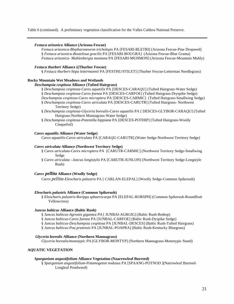
Table 6 (continued). A preliminary vegetation classification for the Valles Caldera National Preserve. Festuca arizonica Alliance (Arizona Fescue) Festuca arizonica-Blepharoneuron tricholepis PA [FESARI-BLETRI] (Arizona Fescue-Pine Dropseed) § Festuca arizonica-Bouteloua gracilis PA [FESARI-BOUGRA] (Arizona Fescue-Blue Grama) Festuca arizonica- Muhlenbergia montana PA [FESARI-MUHMON] (Arizona Fescue-Mountain Muhly) Festuca thurberi Alliance ((Thurber Fescue) § Festuca thurberi-Stipa lettermannii PA [FESTHU/STILET] (Thurber Fescue-Letterman Needlegrass) Rocky Mountain Wet Meadows and Wetlands Deschampsia cespitosa Alliance (Tufted Hairgrass) § Deschampsia cespitosa-Carex aquatilis PA [DESCES-CARAQU] (Tufted Hairgrass-Water Sedge) § Deschampsia cespitosa-Carex foenea PA [DESCES-CARFOE] (Tufted Hairgrass-Dryspike Sedge) Deschampsia cespitosa-Carex microptera PA [DESCES-CARMIC] (Tufted Hairgrass-Smallwing Sedge)
§ Deschampsia cespitosa-Carex utriculata PA [DESCES-CARUTR] (Tufted Hairgrass- Northwest Territory Sedge)
§ Deschampsia cespitosa-Glyceria borealis-Carex aquatilis PA [ DESCES-GLYBOR-CARAQU] (Tufted Hairgrass-Northern Mannagrass-Water Sedge)
§ Deschampsia cespitosa-Potentilla hippiana PA [DESCES-POTHIP] (Tufted Hairgrass-Woolly Cinquefoil)
Carex aquatilis Alliance (Water Sedge) Carex aquatilis-Carex utriculata PA [CARAQU-CARUTR] (Water Sedge-Northwest Territory Sedge) Carex utriculata Alliance (Northwest Territory Sedge)
§ Carex utriculata-Carex microptera PA [CARUTR-CARMIC] (Northwest Territory Sedge-Smallwing Sedge
§ Carex utriculata –Juncus longistylis PA [CARUTR-JUNLON] (Northwest Territory Sedge-Longstyle Rush)
Carex pellita Alliance (Woolly Sedge) Carex pellita-Eleocharis palustris PA [ CARLAN-ELEPAL] (Woolly Sedge-Common Spikerush) Eleocharis palustris Alliance (Common Spikerush)
§ Eleocharis palustris-Rorippa sphaerocarpa PA [ELEPAL-RORSPH] (Common Spikerush-Roundfruit Yellowcress)
Juncus balticus Alliance (Baltic Rush) § Juncus balticus-Agrostis gigantea PA [ JUNBAl-AGRGIG] (Baltic Rush-Redtop) § Juncus balticus-Carex foenea PA [JUNBAL-CARFOE] (Baltic Rush-Dyspike Sedge) § Juncus balticus-Deschampsia cespitosa PA [JUNBAL-DESCES] (Baltic Rush-Tufted Hairgrass) § Juncus balticus-Poa pratensis PA [JUNBAL-POAPRA] (Baltic Rush-Kentucky Bluegrass) Glyceria borealis Alliance (Northern Mannagrass) Glyceria borealis/monotypic PA [GLYBOR-MONTYP] (Northern Mannagrass-Monotypic Stand) AQUATIC VEGETATION Sparganium angustifolium Alliance Vegetation (Naarrowleaf Burreed)
§ Sparganium angustifolium-Potamogeton nodosus PA [SPAANG-POTNOD ](Narrowleaf Burreed- Longleaf Pondweed)
21

Forest, Woodland, and Shrubland Communities The forests and woodlands of the VCNP can be categorized into three broad zones that traverse the elevation gradient of the mountain slopes (Figure 9). At the highest elevations (9,000 to 11,250 ft; 2,740 m to 3,430 m) are spruce-fir forests dominated by Engelmann spruce (Picea engelmannii) and corkbark fir (Abies lasiocarpa var. arizonica). Mixed Conifer forests are generally found below 10,000 ft (3,050 m) and are usually codominated by a combination of firs and pines: Douglas-fir (Pseudotsuga menziesii), white fir (Abies concolor), blue spruce (Picea pungens), southwestern whitepine (Pinus strobiformis), limber pine (Pinus flexilis), and ponderosa pine (Pinus ponderosa). Sites that have been burned or logged within the spruce-fir or mixed conifer zones are often dominated by aspen, or, on warmer sites, Gambel oak (Quercus gambelii) scrub. On warmer aspects below 9,000 ft, mixed conifer gives way to ponderosa pine forests and woodlands that commonly border the grasslands of the valles. There are also small occurrences of pinyon pine (Pinus edulis) woodlands within the ponderosa pine zone. _____________________________________________________________________________
Aspen Spruce-Fir
Montane Scrub
Mixed Conifer
Ponderosa Pine
Figure 9. The typical distribution of forest zones in the VCNP as shown along the northern rim of Valle San o. Antoni
22

Spruce-Fir Forests Spruce-fir forests are a major element in the VCNP forest ecosystem; they cloak much of the upper slopes and ridgelines along the caldera rim and on Redondo Peak. This very cold forest type is also referred to as Rocky Mountain Subalpine Conifer Forest (Brown et al. 1998; Dick-Peddie1993; Thompson et al. 1996), and is primarily found on the Origo and Redondo soils (see Table 3 and Figure 5). Either Engelmann spruce and/or corkbark fir can dominate, typically forming dense closed canopies with shady understories (Figure 10). Both species are widely distributed throughout the mountains of the western United States and Canada, but on the VCNP they are near their southern limit, with only a handful of sites occurring further south in New Mexico and Arizona (corkbark is actually a southern variant of subalpine fir and is known only from the Southwest). Of the two trees, Engelmann spruce is the longer-lived species, and in general reaches maturity at between 250 and 300 years, with individuals known to live as long as 500 to 600 years. In “old-growth” stands of the VCNP, the oldest trees so far measured were between 185 and 200 years, and had heights approaching 115 ft (35 m) and diameters over 28 in (73 cm).
Figure 10. An example of the Corkbark Fir/Wortleberry PA along the northern caldera rim near Garita gate. Both corkbark fir and Engelmann spruce occur in the canopy, but corkbark fir dominates the reproduction. Note the accumulation of woody debris after more than 200 years without fire.
Corkbark fir is shorter-lived (250 to 300 years maximum) and tends to be restricted to
more mesic and colder sites. Hence, corkbark fir is less common on the VCNP than Engelmann spruce, but it can still be the dominant or codominant in some stands because of differences in seedling establishment and shade tolerance between the two species. For optimal germination and establishment, Engelmann spruce requires a mineral seedbed or shallow duff layer, and light to moderate shade—conditions found most commonly after a fire or other disturbance. In contrast, corkbark fir seedlings can become established on a continuing basis without disturbance in heavy shade on a variety of substrates, including mineral soils, duff, litter and logs (although mineral seedbeds and light duff layers are also the most favorable). As a result, corkbark fir seedling and saplings often outnumber spruce in older, low-disturbance stands. They are also more shade tolerant, which allows them to persist for longer periods in the understory while waiting for an opportunity to grow into the canopy as overstory trees die (corkbark fir saplings can be over 50 years old and still be no taller than three feet (1 m)). Once “released” from the shady conditions, firs can grow into canopy gaps to reach heights around 100 ft (30 m). Yet, they are prone to disease and pests and seldom live beyond 250 years (the oldest tree sampled so far on the VCNP was approximately 125 years old and 90 ft (27 m) tall)2.
23
2 For more information on these species see: http://www.fs.fed.us/database/feis/plants/tree/

Neither tree is fire resistant; both are generally killed in fires, even by low-intensity ones.
But this trait is in keeping with the pre-settlement fire regimes where stand replacement fires occur at relatively long intervals of anywhere from 30 to 250 years or more (Kipfmueller and Baker 2000; Abolt 1997; Arno 1980; Touchan et al. 1996; Grissino-Mayer et al. 1995). Unlike lower elevation forests, the impact of fire suppression has apparently been minimal in some spruce-fir sites, particularly at high elevations (Bogan et al. 1998; Sherriff et al. 2001), or the fire regime is just beginning to extend beyond the historical range of variability after 100 years of suppression (Abolt 1997; Kipfmueller and Baker 2000). The long return intervals between fires are primarily a function of increased moisture at high elevations that naturally suppresses fire. This leads to slow accumulation of high fuel loads and fuel beds that tend to be irregular, with large amounts of needle litter accumulating under the narrow crowned trees. This combination of long-term fuel accumulation and heterogeneous fuel patterns tends to promote highly destructive stand-destroying fires. These concentrated, slow-burning fuels usually produce flames high enough to reach the low-growing, lichen-draped branches and start crown fires. Although these are commonly whole-tree crown fires, surface fires can also cause high mortality as they burn slowly through the fine fuels that collect at the base of mature trees and girdle their thin-barked boles (Bradley et al. 1992).
The occasional mature tree that survives fire in a moist protected pocket and trees adjacent to burned areas provide seeds to colonize burned sites. Given the right combination of available seed, moisture and somewhat protected seedbeds, Engelmann spruces or corkbark firs may immediately reproduce prolifically and develop more or less even-aged, tall conifer stands within 100 years following fires (unless aspen take over the site first). On drier sites at lower elevations, fire frequencies tend to increase and both Engelmann spruce and corkbark fir become less prevalent and are replaced by more fire-adapted species such as Douglas-fir, limber pine or southwestern white pine along with aspens as the forests grade into the mixed conifer zone (Arno 1980).
Wildlife, particularly large ungulates such as elk and deer, are known to use the spruce-fir
zone in the southern Rockies extensively for both forage and cover (Alexander 1987), but information on such activity is limited on the VCNP. According to Whitford and Ludwig (1975), elk, particularly bull elk, used the higher elevations of Redondo Peak for summer browse and grazing. Krantz (2002) reported that elk browse was extensive throughout the forests of the VCNP in 2001, but specific use in the spruce-fir zone was unclear.
Six plant associations have been identified among spruce-fir forests on the VCNP, five of
which belong to the Engelmann Spruce Alliance (see Table 6). This alliance is defined not only by the dominance of Engelmann spruce in the canopy but also by strong reproduction in the understory (Figure 11). Corkbark fir is usually a minor element or absent. In contrast, in the Corkbark Fir Alliance (represented by one association on the VCNP), corkbark fir either dominates the canopy or codominates it with Engelmann spruce along with having abundant and successful reproduction (Figure 10).
Among the five Engelmann spruce plant associations (PA), the Engelmann Spruce/Parry’s Oatgrass PA was found in the most exposed conditions on northerly slopes and ridges on the borders with montane meadows at elevations above 10,000 ft (3,000 m). This
24

association is characterized by an open canopy of Engelmann spruce and scattered limber pine, and a grassy understory dominated by Parry’s oatgrass (Danthonia parryi) with occasional bunches of Thurber fescue (Festuca thurberi) and Arizona fescue (Festuca arizonica). There was also an assortment of forbs (15 species) commonly associated with montane meadows. This association may represent the invasion of montane grasslands by spruce as a function of fire suppression during the twentieth century (Allen 1989). Dyer and Moffett (1999), using historical photography, reported a similar invasion of spruce-fir in high elevation grasslands on Sierra Blanca in south-central New Mexico. This association has not been reported elsewhere in the Southwest, and it may be transitory pending reestablishment of natural fire regimes on the VCNP.
Also occurring on the ridges and upper slopes was the Engelmann Spruce/Dryspike
Sedge PA, which is characterized by a moderately closed canopy of mixed-aged spruces; corkbark fir is absent. The understory is relatively low in cover (7 to 10%), mesic and dominated by dryspike sedge (Carex foenea) and an assortment of forbs, many of which are more prevalent in adjoining forest associations. Although this association might be found near montane meadows, the understory composition and the presence of Engelmann spruces in many size classes in a closed canopy suggests that this does not likely represent an invasion of montane meadows, and it is likely that it occurs on a forest soil type (an Alfisol) such as the Redondo soil series. Whitford and Ludwig (1975) reported an Engelmann Spruce/Moss PA from the upper elevations of Redondo Peak that is a similar closed canopy forest, but the understory was very depauperate with a scattering of grasses and forbs.
The most common spruce-fir associations on the VCNP are the Engelmann Spruce/Forest Fleabane PA, Engelmann Spruce/Whortleberry PA and Corkbark Fir/Whortleberry PA. The latter two occur primarily on upper slopes and drier sites. The understory is distinctly dominated by the low-lying subshrub whortleberry (Vaccinium myrtillus), with only a few scattered forbs or grasses. The Engelmann Spruce/Forest Fleabane PA is usually found on lower slopes under more mesic conditions that lead to the development of a richer herbaceous layer that often exceeds 30% cover, while shrub cover is minimal. Forest fleabane (Erigeron eximius) is usually the dominant forb, but it is the overall rich complement of mesic forbs that is characteristic, e.g., strawberry (Fragaria vesca), Canadian white violet (Viola canadensis), fringed brome (Bromus ciliatus), and northern bedstraw (Galium boreale). All three of these associations are widely distributed in the Southwest and into the southern Rocky Mountains (Moir and Ludwig 1979; DeVelice et al. 1986; Fitzhugh et al. 1987; Muldavin et al. 1996).
Figure 11. An example of the Engelmann Spruce/Forest Fleabane PA along the caldera rim north of Pajarito Mountain. Spruce dominates the reproduction and canopy.
25

Quaking Aspen Forests
Quaking aspen (Populus tremuloides) is a major successional species following fire in spruce-fir and mixed conifer forests (Figure 12). Aspen is a clonal species that most commonly reproduces by root sprouting. Following fires (and other disturbances such as logging), aspens can vigorously resprout and can come to dominate a site for decades, even centuries (Bradley et al. 1992). Aspen regeneration is particularly strong on severely burned sites, but may be controlled to some degree by preferential elk and deer browsing in those areas (Bailey and Witham 2002). Although some aspen forests are known to be self-perpetuating, conifers will typically regain a site in the absence of fire and with adequate conifer seed sources (DeVelice et al. 1986).
We have described two associations of the Quaking
Aspen Alliance from the upper elevations of the VCNP (>8,900 ft; 2,700 m). The Aspen/Meadow Rue PA is the most common and is characterized by closed canopies of aspen with few, if any, conifers codominating. The understory is typically a luxuriant herbaceous cover represented by a wide variety of mesic forbs and grasses such as meadow rue (Thalictrum fendleri), stickywilly bedstraw (Galium aparine), strawberry, violet, geranium (Geranium richardsonii, G. caespitosum), deer sedge (Carex rossii), and fringed brome (Bromus ciliatus). Kentucky bluegrass (Poa pratensis), an exotic and invasive rhizomatous grass species, can dominate the understory. A Kentucky Bluegrass Phase of the association has been described where the Kentucky bluegrass exceeds 25% cover (it can exceed 60%). This association has been reported widely in the Rocky Mountains from Canada to the Southwest. Mueggler and Campbell (1986) suggest that bluegrass-dominated types are some of the poorest among aspen communities in terms of wildlife habitat because of low plant species diversity.
Figure 12. Young aspen stand in the northwestern corner of preserve. Note the marks from elk chewing on the lower portions of the trucks.
In contrast, the Quaking Aspen/Thurber Fescue PA is dominated by native grasses and
sedges including Thurber fescue, fringed brome, junegrass (Koeleria micrantha), and dryspike sedge (Carex foenea). Forb richness is lower than in the previous association and more representative of meadows with species such as vetch (Vicia americana), pea (Lathyrus spp.), and bluebell bellflower (Campanula rotundifolia). As Allen (1984) and Karmarkova et al. (1988) have pointed out, the understory composition suggests that this aspen association may represent an invasion of a montane meadow grassland by trees (our sample stand graded into montane meadow at the top of the slope and is analyzed in detail by Allen (1984)). Although relatively uncommon, this association has been reported elsewhere in Colorado (Hess and Alexander 1986; Karmarkova et al. 1988).
26

Mixed Conifer Forest
The middle elevations of the VCNP are dominated by mixed conifer forests composed of various admixtures of conifers (Douglas-fir, white fir, blue spruce, southwestern white pine, limber pine, and ponderosa pine) along with scattered aspens. This forest type is also referred to as Rocky Mountain Upper Montane Conifer Forest (Brown et al. 1998; Dick-Peddie1993; Thompson et al. 1996). On the VCNP, mixed conifer forests primarily occur on rocky soils of the Palon, Pavo, Origo and Calaveras soil series.
Which tree species will dominate a stand
is a function of site conditions and disturbance history (particularly fire). Cooler, more mesic sites tend to be dominated by white fir and blue spruce. White fir and blue spruce are similar to corkbark fir and Engelmann spruce in that they are extremely shade tolerant, but intolerant of fire. In contrast, Douglas-fir is less shade tolerant, but has a greater fire resistance and drought tolerance. Hence, it tends to be favored over white fir or blue spruce on drier sites with the potential for higher fire frequency. But with the cessation of natural fire during the twentieth century, both white fir and blue spruce have become more prevalent, sometimes dominating sites that would normally support Douglas-fir or even pines for the long term. Ponderosa pine, with its shade intolerance and the highest fire resistance of the group, is typically an early successional species following fire in the mixed conifer forests. Later, as the ponderosas mature, the Douglas-firs will replace them in the canopy. Sometimes, however, they become established at the same time and codominate the regenerating forest. Without fire and with adequate seed sources, blue spruce and white fir will eventually replace both Douglas-fir and ponderosa, particularly on the more mesic sites (where fire is less likely). Southwestern white pine or limber pine are found scattered throughout the mixed conifer zone, but they seldom dominate except on very dry, rocky sites.
Figure 13. A White Fir-Douglas-fir/Forest Fleabane PA in Deer Canyon in the southwest corner of the preserve.
We have classified the mixed conifer communities of the VCNP into three forest
alliances (White Fir, Douglas-fir, Blue Spruce) and one woodland alliance (Limber Pine) based on canopy dominance and tree reproduction status in the understory (Table 2). Associations clearly dominated by one tree species, both in the canopy and in the reproduction, are put into
27

the respective tree Alliance. In addition, we have identified a White Fir – Quaking Aspen Alliance where conifers and the broadleaf deciduous trees codominate.
The White Fir Alliance is either dominated by white fir or codominated by white fir and
Douglas-fir (as indicated in the association name) with both species actively reproducing in the understory (Figure 13). Although less shade tolerant than white fir, Douglas-fir is the longer lived of the two, which may be partly responsible for the dynamic balance between the two in stands (on the VCNP the oldest white fir we measured was approximately 160 years and the oldest Douglas-fir 225 years). Blue spruce is an occasional sub-canopy associate, but seldom a codominant. Ponderosa pine can be present, but usually only as old and large individuals left from an earlier stage of forest development. The alliance extends from about 8,800 ft (2,700 m) to 9,880 ft (3,000 m).
Eight associations have so far been identified for the White Fir Alliance with a variety of
understories and canopy structures. The White Fir/Forest Fleabane (Abies concolor/Erigeron eximius) PA has a rich and often luxurious undergrowth dominated by mesic forbs and grasses that include, beside forest fleabane, woodland strawberry, Canadian white violet, fringed brome, and Ross sedge. Sites are typically cool, northerly mid to lower slopes down to elevations of 8,800 ft (2,700 m). In drier upper slope positions this association grades into those dominated by shrubs and subshrubs. Specifically, the White Fir/Whortleberry Association PA dominated by subshrubs such as whortleberry and myrtle boxleaf (Paxistima myrsinites), and the White Fir-Douglas-fir/Common Juniper PA dominated by taller shrubs such as common juniper (Juniperus communis), and mountain ninebark (Physocarpus monogynus). Alternatively, these upslope sites can be dominated by the White Fir-Douglas-fir/Creeping Barberry PA where both shrub and herbaceous cover are minimal. This association is typified by scattered individuals of creeping barberry (Mahonia repens) and myrtle boxleaf, and a low overall species richness. The sparse understory may result from a combination of dense overstory canopies and dry shallow soils. In contrast, the White Fir-Douglas-fir/Thurber Fescue PA has a distinctive grassy understory similar to the montane grasslands on which it is known to border.
On the steepest mid slopes of the caldera the terrain often becomes a jumble of boulders
and cobbles reflecting relatively stable, overgrown talus slopes or rock fields (felsenmeers). Cool sites, such as north-facing draws and slopes, commonly support the White Fir-Quaking Aspen/Rocky Mountain Maple PA. Fivepetal cliffbush (Jamesia americana), Rocky Mountain maple (Acer glabrum) typically dominate a conspicuous tall shrub layer that can have additional shrubs such as rockspirea (Holodiscus dumosus), trumpet gooseberry (Ribes leptanthum), gooseberry currant (Ribes montigenum), whortleleaf snowberry (Symphoricarpos oreophilus), and Fendler's brickellbush (Brickellia fendleri). We have also identified a White Fir-Quaking Aspen/Rocky Mountain Maple PA in similar habitats but where quaking aspen and white fir codominate in the canopy (technically this association is part of the White Fir-Quaking Aspen Alliance). The aspens are typically large, mature individuals of 100 years or more, and are likely remnants from a period when aspens dominated the site following a fire (or logging). Whitford and Ludwig (1975) also identified a White Fir-Douglas-fir/Gambel Oak Association of north-facing lower slopes of Valle Seco that had a significant quaking aspen component.
28

29
In the Douglas-fir Alliance, white-fir is absent or is represented by only seedlings and saplings (typically in cooler microsites within stands). Among the five plant associations we have identified for the Douglas-fir Alliance, four have close analogs in the White Fir Alliance: the Douglas-fir/Rocky Mountain Maple PA, Douglas-fir/Five-petal Cliffbush PA, Douglas-fir/Creeping Barberry, and Douglas-fir/ Whortleberry PA (Figure 14). The main difference is the lack of white fir in the canopy and perhaps a tendency for somewhat warmer site conditions. In addition, we have identified a Douglas-fir-Limber Pine/Rocky Mountain Trisetum Association of high exposed ridgelines (>9500 ft; 2,930 m). Under these dry conditions, the canopies are moderately open (50%), and the understory is typically grassy and dominated by Rocky Mountain trisetum (Trisetum montanum), deer sedge (Carex rossii), and fringed brome (Bromus ciliatus), along with a scattering of forbs.
Figure 14. Douglas-fir/Rocky Mountain Maple PA along the boulder strewn slopes of the San Antonio Rim.
On the driest and rockiest ridgeline
sites Douglas-fir drops out, leading to the relatively uncommon situation where limber pine dominates an open woodlands (Figure 15). We have so far identified one association from the Limber Pine Alliance—the Limber Pine/Common Juniper PA, which has a similar herbaceous layer to the Douglas-fir-Limber Pine/Rocky Mountain trisetum PA but with a shrub layer dominated by common juniper. Southwestern white pine (Pinus strobiformis) is closely related to limber pine and the Jemez Mountains mark the transition zone between the two species. Hence, southwestern white pine, a somewhat taller tree, may replace limber pine in some stands on the preserve.
Figure 15. Limber Pine/Common Juniper PA on the eastern slope of Cerro del Medio.

The Blue Spruce Alliance, although relatively common on the VCNP, is usually restricted to northern exposures of lower slopes and along the edges of the grasslands. We have identified two associations: the forb-rich Blue Spruce/Forest Fleabane PA and the graminoid-dominated Blue Spruce/Dryspike Sedge PA. Although both of these associations can form mature stands on mesic lower mountain slope sites, they occur most commonly as dense-canopied “blue spruce fringes” along the borders of the VCNP valle grasslands (Figure 16). These fringes are narrow (<30 m wide) and, perhaps because of moisture conditions and the heavier clay mollisol soils of the grasslands, do not seem to be significantly actively encroaching further into the valle grasslands (in contrast to ponderosa pine woodlands—see woodland ecological assessment below). Whitford and Ludwig (1975) also identified a Blue Spruce-Douglas-fir/Sparse PA of lower mountain slopes.
Figure 16. An example of a relatively young blue spruce fringe forest bordering montane grasslands in Valle San Antonio (left photo). Right photo from inside the same stand shows the sparse understory as a function of the dense canopy.
30

Ponderosa Pine Forests and Woodlands Ponderosa pine forests and woodlands represent the lowest and warmest zone of the
forests on the VCNP. Ponderosa pine (Pinus ponderosa var. scopulorum) is a fire and drought tolerant tree represented by the three-needled Southwestern race on the VCNP. While the species and race are known to reach heights of over 150 ft (45 m) and ages up to 742 years (Swetnam and Brown1992), the trees tend to decline after 350 years (Moir and Dieterich1988). On the VCNP, the tallest trees measured so far were about 100 ft (30 m) and about 200 years old (see Data Addendum).
Fire has played an important role in
shaping the structure and composition of ponderosa pine forests and woodlands. Because ponderosa pine is highly fire tolerant (Bradley et al. 1992) and drought tolerant, it often occupies sites that are drier and that have higher natural fire frequencies than those of the mixed conifer zone (DeVelice et al. 1986; Allen and Peet 1990; Touchan et al. 1996). In the past, low-intensity fires would burn through ponderosa pine stands every 8 to 15 years, removing competing understory vegetation and woody debris (Weaver 1951; Cooper 1960; Mehl 1992; Swetnam and Baisan 1996; Touchan et al. 1996). Savanna woodlands with their high grass cover were likely to have the most frequent ground fires, while forests tend to occur on steeper, rocky slopes with less “fine fuels,” hence fire return intervals were likely longer. After fires, the shade-intolerant seedlings become established in open areas, usually in pulses correlated to favorable precipitation years (Mast et al 1997; Mast el al. 1998; Savage et al. 1995). The other conifers (white fir, Douglas-fir, etc.) are less drought and fire tolerant and at a disadvantage on these sites. Hence, either they fail to become established or are removed by subsequent surface fires, leading to forest stands dominated by ponderosa (with even-aged tree groups embedded in the stands depending on recruitment pulses).
Figure 17. The multi-age structure of trees is apparent in this stand of the Ponderosa Pine/Arizona Fescue PA located along the lower-slope of the Valle San Antonio rim.
We have identified five associations from the Ponderosa Pine Alliance that occur along
lower mountain slopes and at the interface to valle grasslands (Figure 17). The Ponderosa Pine/Parry’s Oatgrass PA and Ponderosa Pine/Arizona Fescue PA are open forests and woodlands with grassy understories dominated by either Parry’s oatgrass or Arizona fescue along with Thurber fescue, prairie junegrass, and Kentucky bluegrass. There is also a variable complement of grassland-related forbs such as bluebell bellflower (Campanula rotundifolia), Fendler's sandwort (Arenaria fendleri), Rocky Mountain iris (Iris missouriensis), hairy goldenaster (Heterotheca villosa), yarrow (Achillea millefolium) and nodding onion (Allium cernuum). Shrubs are minor or absent.
31

The Ponderosa Pine/Trumpet Gooseberry/Sun Sedge PA occurs further upslope and has a similar complement of grassland forbs and grasses, but it also has a conspicuous shrub element dominated by trumpet gooseberry, and Woods' rose (Rosa woodsii). The herbaceous layer is dominated by sun sedge (Carex inops ssp. heliophila) and Kentucky bluegrass. This association has not been reported elsewhere.
The Ponderosa Pine/Common Juniper PA represents a transition from ponderosa pine to
the mixed conifer zones and is known from the lower toe slopes of Redondo Peak. While the canopy is dominated by ponderosa pine, there is little ponderosa reproduction. Instead, white fir, Douglas-fir, and blue spruce are prevalent, suggesting that fire suppression is once again leading to the slow transformation of a ponderosa pine woodland to a mixed conifer forest. Common juniper is well represented and characteristic in the shrub layer (in some cases it may be more abundant due to fire suppression). There are still several grassland forbs in the understory such as bluebell bellflower, Rocky Mountain iris, and yarrow, but grassland dominants such as Parry’s oatgrass and Arizona fescue are absent. This association is not widely reported in New Mexico and is more common in the northern Rockies (Anderson et al. 1998).
In contrast to the previous two associations, the Ponderosa Pine/Gambel Oak/Arizona
Fescue PA is not linked directly to valle grasslands. Rather, it occurs along slopes of the southern flank of Redondo Peak and Redondo Border and in the rolling terrain of Banco Bonito (and occasionally along the caldera rim). Whitford and Ludwig (1975) were the first to describe this association on the VCNP and they noted that the Gambel oak (Quercus gambelii) shrub component seemed underrepresented relative to other sites in the Southwest. Arizona fescue is also poorly represented, but both the low cover of Gambel oak and fescue may be due to increased tree canopy due to fire suppression or simply the dryness of the sites. It is particularly in this association that fire suppression has led to increased densities of younger ponderosa pines, forming dense “dog-hair” stands that significantly increase the hazard of crown fires (see Preliminary Ecological Assessment-Forest and Woodlands below). Pinyon-Juniper Woodland There are isolated occurrences of pinyon-juniper woodland represented by the Pinyon Pine Alliance in the southwest quadrant of the preserve. Pinyon woodlands are at their upper elevation limits on the VCNP, and are likely to be found only in small pockets on dry southerly slopes and rock outcrops. We identified a Pinyon Pine/Gambel Oak Association in Freelove Canyon on a steep, severely eroding south-facing slope at about 8,400 ft (2,590 m). The canopies of both pinyon and Gambel oak were low and there were only a few scattered grasses and forbs. Although rare on the VCNP, this type is common elsewhere in the Jemez Mountains and the Southwest. Montane Shrublands
The upland montane shrublands of the VCNP are represented by the four associations
from the Gambel Oak Alliance that are commonly associated with post-fire or logging of ponderosa, Douglas-fir or white fir forests (Bradley et al. 1992). This is particularly true for the Gambel Oak-New Mexico Locust PA that is known from lower-elevation (8,500 ft; 2,625 m)
32

southerly slopes in the canyon country of the southwest quadrant of the preserve. Both Gambel oak and New Mexico locust (Robinia neomexicana) resprout after moderate to severe fires and are clonal species that can be long-lived on a site. Shrub cover can approach 100% and also include common chokecherry (Prunus virginiana) and gooseberry currant. With the dense shrub cover, the herbaceous layer is sparse and low in diversity.
The Gambel Oak/Sun Sedge PA has a
more open shrub canopy and a grassy understory dominated by more relatively xeric species such as sun sedge along with mountain muhly (Muhlenbergia montana) and blue grama (Bouteloua gracilis). It occupies exposed southern aspects of upper slope and ridge line positions—drier and warmer conditions that favor scrub species such as mountain mahogany (Cercocarpus montanus) and cacti such as kingcup cactus (Echinocereus triglochidiatus). On the VCNP, it is known from Freelove Canyon at about 8,300 ft (2,560 m) and has not been previously reported in New Mexico (but it is known from Colorado).
Figure 18. The Gambel Oak/Sun Sedge PA is common on southwesterly slopes of Freelove Canyon.
The Gambel Oak/Kentucky Bluegrass PA is a similar, but more mesic, grass-dominated
type. It has been found in Alamo Canyon on southerly slopes at around 8,750 ft (2,00 m). The grass layer is dominated by Kentucky bluegrass with an assortment of other mesic species such as fringed brome, prairie junegrass, and slender wheatgrass (Elymus trachycaulus). The prevalence of the exotic Kentucky bluegrass suggests possible grazing impacts in the past. The forb component is also well represented by many species that are common in mixed conifer and ponderosa pine forests, e.g., Fendler's meadowrue, pineywoods geranium and alpine false springparsley (Pseudocymopterus montanus). This association has not been described elsewhere.
The Gambel Oak/Rockspirea Association is known from higher elevations of the caldera
rim country of Valle San Antonio (9,400 ft; 2,900 m). It is a shrubby analog of the White Fir or Douglas-fir/Cliffbush associations and occurs on stabilized rocky scree slopes and rock outcrops. Along with rockspirea there is a variety of shrubs that include cliffbush, wax currant (Ribes cereum), mountain mahogany, and Fendler's brickellbush. It also has not been previously described.
33
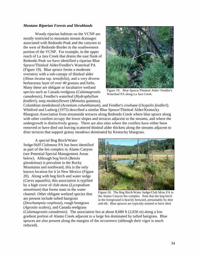
Montane Riparian Forests and Shrublands
Woody riparian habitats on the VCNP are mostly restricted to mountain stream drainages associated with Redondo Peak and the canyons to the west of Redondo Border in the southwestern portion of the VCNP. For example, in the upper reach of La Jara Creek that drains the east flank of Redondo Peak we have identified a riparian Blue Spruce/Thinleaf Alder/Fendler's Waterleaf PA (Figure 19). Blue spruce forms a moderate overstory with a sub-canopy of thinleaf alder (Alnus incana ssp. tenuifolia), and a very diverse herbaceous layer of over 40 grasses and forbs. Many these are obligate or facultative wetland species such as Canada reedgrass (Calamagrostis canadensis), Fendler's waterleaf (Hydrophyllum fendleri), seep monkeyflower (Mimulus guttatus), Columbian monkshood (Aconitum columbianum), and Fendler's cowbane (Oxypolis fendleri). Whitford and Ludwig (1975) described a similar Blue Spruce/Thinleaf Alder/Kentucky Bluegrass Association from streamside terraces along Redondo Creek where blue spruce along with other conifers occupy the lower slopes and terraces adjacent to the streams, and where the undergrowth is distinctively grassy. There are also sites where the conifers have either been removed or have died out leaving scattered thinleaf alder thickets along the streams adjacent to drier terraces that support grassy meadows dominated by Kentucky bluegrass.
Figure 19. Blue Spruce/Thinleaf Alder/ Fendler's Waterleaf PA along La Jara Creek.
A special Bog Birch/Water Sedge/Stiff Clubmoss PA has been identified as part of the fen complex in Alamo Canyon (see Potential Special Management Areas below). Although bog birch (Betula glandulosa) is prevalent in the Rocky Mountains and northward, this is the only known location for it in New Mexico (Figure 20). Along with bog birch and water sedge (Carex aquatilis), this association is typified by a high cover of club moss (Lycopodium annotinum) that forms mats in the water channel. Other obligate wetland species that are present include tufted hairgrass (Deschampsia cespitosa), rough bentgrass (Agrostis scabra), and Canada reedgrass (Calamagrostis canadensis). The association lies at about 8,680 ft (2,650 m) along a low gradient portion of Alamo Creek adjacent to a large fen dominated by tufted hairgrass. Blue spruces are also present along the margins of the occurrence (although their vigor is much reduced).
Figure 20. The Bog Birch/Water Sedge/Club Moss PA in the Alamo Canyon fen complex. Note that the bog birch in the foreground is heavily browsed, presumably by deer and elk. Blue spruces are typically stunted or have died.
34

Grasslands and Wetlands The grasslands of the VCNP fall into two broad categories: 1) Montane Valley Grasslands dominated by upland grasses and forbs; and 2) Montane Wet Meadows and Wetlands of valley bottoms dominated by facultative and obligate wetland grass and grass-like (graminoid) species. Montane Grasslands
Montane Valley Grasslands make up the majority of the grasslands on the VCNP, covering over 26,000 acres (10,500 ha) and dominating the expansive lower elevation valles (Figure 21). They are also found at higher elevations along the caldera rim and in small interior mountain valleys (Figure 22). Despite their seemingly high abundance on the VCNP, montane grasslands are relatively uncommon in New Mexico. Other than in the Jemez Mountains, they are found only at the highest elevations of the Sangre de Cristo Mountains along with scattered occurrences in the Sacramento Mountains and in the Gila (Potter and Foxx 1981; Baker 1983; Allen 1984; Dick-Peddie 1993; Moir 1967).
On the VCNP we have identified five
Montane Grassland alliances based on relative dominance, i.e., the Parry’s Oatgrass, Thurber Fescue, Arizona Fescue, Pine Dropseed (Blepharoneuron tricholepis), and Kentucky Bluegrass Alliances. Besides the dominant grasses, these alliances are typified by the presence of meadow species such as Fendler's sandwort, bluebell bellflower, Parry's bellflower (Campanula parryi), yarrow, beautiful fleabane (Erigeron formosissimus), heartleaf buttercup (Ranunculus cardiophyllus), yellow owlclover (Orthocarpus luteus), woolly cinquefoil (Potentilla hippiana), and Rocky Mountain iris. Overall, they are highly diverse communities, with over 125 species of grasses and forbs recorded so far on the VCNP (see Appendix D).
Figure 21. In the valles of the VCNP, Arizona fescue commonly dominates the upper slopes, while pine dropseed and Arizona fescue often codominate the lower slopes and terraces (foreground).
Figure 22. Thurber fescue and Parry’s oatgrass typically dominate the higher interior montane valleys such as this one in Canada Bonita along the eastern rim of the VCNP.
35
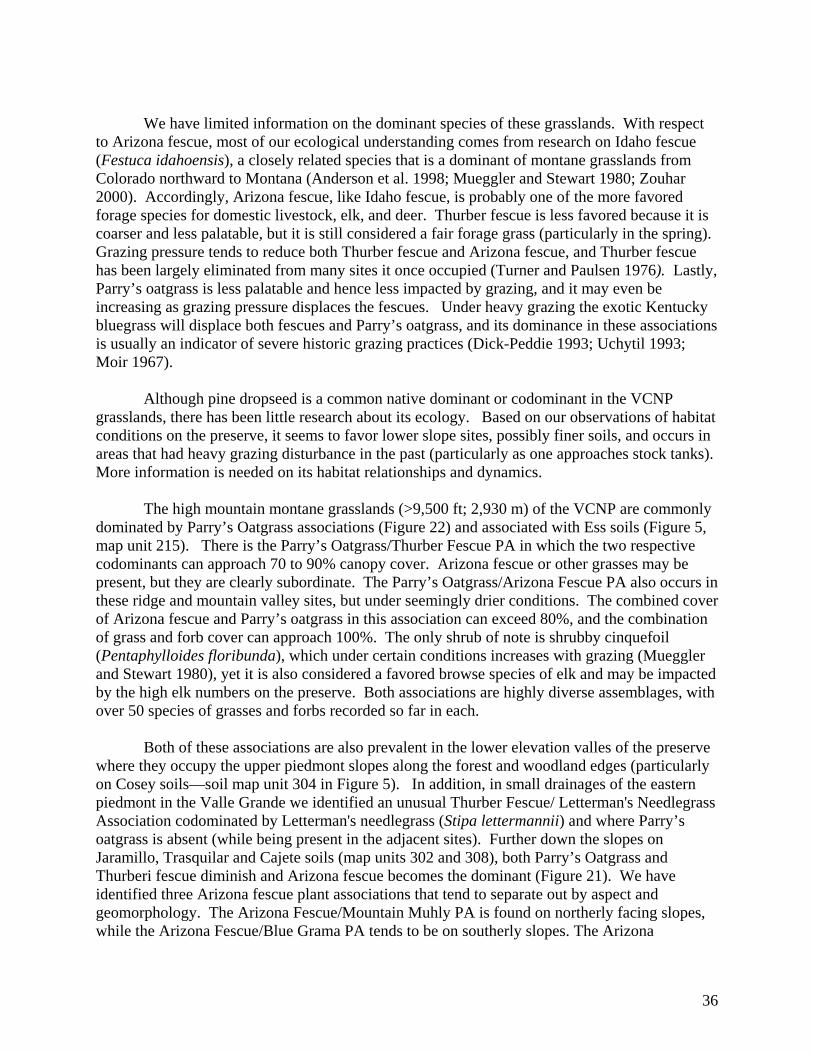
We have limited information on the dominant species of these grasslands. With respect
to Arizona fescue, most of our ecological understanding comes from research on Idaho fescue (Festuca idahoensis), a closely related species that is a dominant of montane grasslands from Colorado northward to Montana (Anderson et al. 1998; Mueggler and Stewart 1980; Zouhar 2000). Accordingly, Arizona fescue, like Idaho fescue, is probably one of the more favored forage species for domestic livestock, elk, and deer. Thurber fescue is less favored because it is coarser and less palatable, but it is still considered a fair forage grass (particularly in the spring). Grazing pressure tends to reduce both Thurber fescue and Arizona fescue, and Thurber fescue has been largely eliminated from many sites it once occupied (Turner and Paulsen 1976). Lastly, Parry’s oatgrass is less palatable and hence less impacted by grazing, and it may even be increasing as grazing pressure displaces the fescues. Under heavy grazing the exotic Kentucky bluegrass will displace both fescues and Parry’s oatgrass, and its dominance in these associations is usually an indicator of severe historic grazing practices (Dick-Peddie 1993; Uchytil 1993; Moir 1967).
Although pine dropseed is a common native dominant or codominant in the VCNP
grasslands, there has been little research about its ecology. Based on our observations of habitat conditions on the preserve, it seems to favor lower slope sites, possibly finer soils, and occurs in areas that had heavy grazing disturbance in the past (particularly as one approaches stock tanks). More information is needed on its habitat relationships and dynamics.
The high mountain montane grasslands (>9,500 ft; 2,930 m) of the VCNP are commonly dominated by Parry’s Oatgrass associations (Figure 22) and associated with Ess soils (Figure 5, map unit 215). There is the Parry’s Oatgrass/Thurber Fescue PA in which the two respective codominants can approach 70 to 90% canopy cover. Arizona fescue or other grasses may be present, but they are clearly subordinate. The Parry’s Oatgrass/Arizona Fescue PA also occurs in these ridge and mountain valley sites, but under seemingly drier conditions. The combined cover of Arizona fescue and Parry’s oatgrass in this association can exceed 80%, and the combination of grass and forb cover can approach 100%. The only shrub of note is shrubby cinquefoil (Pentaphylloides floribunda), which under certain conditions increases with grazing (Mueggler and Stewart 1980), yet it is also considered a favored browse species of elk and may be impacted by the high elk numbers on the preserve. Both associations are highly diverse assemblages, with over 50 species of grasses and forbs recorded so far in each.
Both of these associations are also prevalent in the lower elevation valles of the preserve
where they occupy the upper piedmont slopes along the forest and woodland edges (particularly on Cosey soils—soil map unit 304 in Figure 5). In addition, in small drainages of the eastern piedmont in the Valle Grande we identified an unusual Thurber Fescue/ Letterman's Needlegrass Association codominated by Letterman's needlegrass (Stipa lettermannii) and where Parry’s oatgrass is absent (while being present in the adjacent sites). Further down the slopes on Jaramillo, Trasquilar and Cajete soils (map units 302 and 308), both Parry’s Oatgrass and Thurberi fescue diminish and Arizona fescue becomes the dominant (Figure 21). We have identified three Arizona fescue plant associations that tend to separate out by aspect and geomorphology. The Arizona Fescue/Mountain Muhly PA is found on northerly facing slopes, while the Arizona Fescue/Blue Grama PA tends to be on southerly slopes. The Arizona
36

Fescue/Pine Dropseed PA occurs along the lower piedmont slopes and on the mid-valley benches and terraces where it often grades into pine dropseed-dominated types. It is here that pine dropseed associations often prevail (Pine Dropseed/June Grass, Pine Dropseed/Mountain Muhly, and Pine Dropseed/Spike Muhly associations). The benches or terraces (remnants of ancient alluvial fans, stream terraces, and lake bed sediments) lie just above the valley floor and represent both the lowest topographic position of the upland grasslands and where Montane Valley Grasslands meet Montane Graminoid Wet Meadows and Wetlands that occur on the current floodplain of the valley floor (see below). For several of the above associations we have identified Kentucky bluegrass phases where bluegrass reaches anywhere from 10 to 50% cover, suggesting significant impacts from past livestock grazing. We have a Kentucky Bluegrass/Woolly Cinquefoil PA of benches and valley bottom terraces where almost all native grass species are absent or uncommon. Kentucky bluegrass also appears to be particularly abundant in pine dropseed types, further supporting the concept that pine dropseed may be a co-increaser with Kentucky bluegrass with grazing (alternatively, abundant pine dropseed may represent an intermediate recovery phase following severe grazing). Montane Wet Meadows and Wetlands
Montane Wet Meadows and Wetlands occur throughout the lowland valleys (Figure 23), commonly adjacent to perennial streams of the valley bottoms (Figure 24), but also along seeps, springs and creeks in the uplands. These diverse communities—142 species have been recorded so far—are dominated by facultative and obligate wetland graminoid species, mostly sedges (Carex sp.) and rushes (Juncus sp.). We have identified 15 obligate and 13 facultative wetland species as defined by the national wetlands species list (U.S. Fish and Wildlife Service 1988). In addition, most of these communities are on sites subject to periodic flooding, or where the soils can become saturated at some point during the year in most years (most of the wet meadows and wetlands are associated with hydric Vastine soils—soils map unit 301). Accordingly, these communities would likely be considered jurisdictional wetlands under federal rules (Federal Interagency Committee for Wetland Delineation 1989). Woody perennial species such as willows, alders and water birch are absent or very rare. Whether this is a function of hydrological and soil conditions or past overgrazing is an open question. These wet meadows correspond to the Sedge Wet Meadows of Whitford and Ludwig (1975) and Montane Meadows of Barnes (2002).
Figure 23. The complexity of wet meadows and wetlands is evident in this view across the Valle Grande. Each color represents a different wetland species dominant.
37

38
We have classified these wet meadows into 17 plant associations among eight Wet Meadow and Wetland alliances based on dominance and indicator value. The alliances are Tufted Hairgrass (Deschampsia cespitosa), Northwest Territory Sedge (Carex utriculata), Water Sedge (Carex aquatilis), Woolly Sedge (Carex pellita), Common Spikerush (Eleocharis palustris), Baltic Rush (Juncus balticus), Northern Mannagrass (Glyceria borealis), and Kentucky Bluegrass.
Northwest Territory sedge, water
sedge, woolly sedge, and smallwing sedge (Carex microptera) are a set of similar species that form an operational functional group of tall coarse sedges growing near or adjacent to the stream channels and springs of the VCNP. They are difficult to differentiate morphologically (except when flowering) and their habitat seems similar: frequently flooded sites with saturated or near saturated soils. They typically form dense, sometimes wide bands of 10 m or more along perennial channels. They are important to stream function because they serve to stabilize the banks and shade the channel.
Figure 24. A typical wet meadow/wetland along San Antonio Creek represented here by the Tufted Hairgrass -Northwest Territory Sedge Association. Note the lack of woody riparian species.
Spikerush-dominated communities typically occur in close association with sedge
communities, but along low bars and beaches within the active channels and at the interiors of spring wetlands. In contrast, Baltic rush and tufted hairgrass associations are typically found away from the channel on slightly higher ground than either the sedges or spikerushes (although sometimes these can also be found directly adjacent to the active channel). Overbank flooding still can occur but not necessarily on an annual basis, and ground water and snowmelt may be more important, leaving soils saturated for long periods with standing water at or near the surface. Grazing may favor Baltic rush over tufted hairgrass, and with overuse, wet meadows can shift to the exotic Kentucky bluegrass and a mixture of exotic and/or weedy forbs. Accordingly, we have identified a Kentucky Bluegrass Alliance, and in many cases we have identified a separate Kentucky Bluegrass Phase for associations that have been subject to long-term grazing.
Northern mannagrass communities are associated with shallow pond and lake edges, and
in the case of the VCNP, stock tanks. Northern mannagrass is a native, perennial, hydrophytic grass of cold temperate climates. Soils remain saturated during the growing season, but can dry out late in the season (Muldavin et al. 2000)
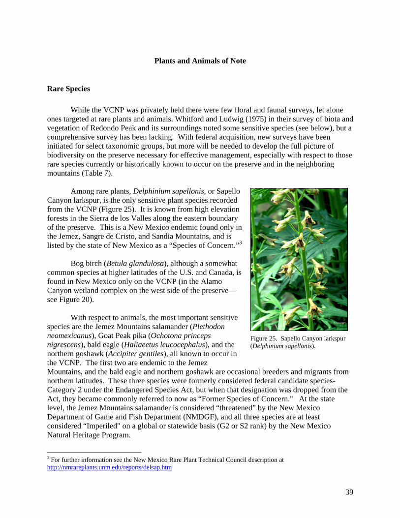
Plants and Animals of Note
Rare Species While the VCNP was privately held there were few floral and faunal surveys, let alone
ones targeted at rare plants and animals. Whitford and Ludwig (1975) in their survey of biota and vegetation of Redondo Peak and its surroundings noted some sensitive species (see below), but a comprehensive survey has been lacking. With federal acquisition, new surveys have been initiated for select taxonomic groups, but more will be needed to develop the full picture of biodiversity on the preserve necessary for effective management, especially with respect to those rare species currently or historically known to occur on the preserve and in the neighboring mountains (Table 7).
Among rare plants, Delphinium sapellonis, or Sapello
Canyon larkspur, is the only sensitive plant species recorded from the VCNP (Figure 25). It is known from high elevation forests in the Sierra de los Valles along the eastern boundary of the preserve. This is a New Mexico endemic found only in the Jemez, Sangre de Cristo, and Sandia Mountains, and is listed by the state of New Mexico as a “Species of Concern.”3
Bog birch (Betula glandulosa), although a somewhat common species at higher latitudes of the U.S. and Canada, is found in New Mexico only on the VCNP (in the Alamo Canyon wetland complex on the west side of the preserve— see Figure 20).
With respect to animals, the most important sensitive species are the Jemez Mountains salamander (Plethodon neomexicanus), Goat Peak pika (Ochotona princeps nigrescens), bald eagle (Haliaeetus leucocephalus), and the northern goshawk (Accipiter gentiles), all known to occur in the VCNP. The first two are endemic to the Jemez Mountains, and the bald eagle and northern goshawk are occasional breeders and migrants from northern latitudes. These three species were formerly considered federal candidate species-Category 2 under the Endangered Species Act, but when that designation was dropped from the Act, they became commonly referred to now as “Former Species of Concern." At the state level, the Jemez Mountains salamander is considered “threatened” by the New Mexico Department of Game and Fish Department (NMDGF), and all three species are at least considered “Imperiled" on a global or statewide basis (G2 or S2 rank) by the New Mexico Natural Heritage Program.
Figure 25. Sapello Canyon larkspur (Delphinium sapellonis).
39
3 For further information see the New Mexico Rare Plant Technical Council description at http://nmrareplants.unm.edu/reports/delsap.htm
Table 7. Species of note for the Valles Caldera National Preserve that are either known from the preserve or in the surrounding mountains. ESA = Endangered Species Act status where FSOC refers to former species of concern or Category 2 species. SEN. or T or E refers to Sensitive, Threatened or Endangered designations of the US Forest Service and the New Mexico Department of Game and Fish. G-rank and S-rank refer to the New Mexico Natural Heritage Program (NMNHP) rarity rankings (see Methods).
Common Name Scientific Name VCNP ESA USFS State NMNHPG-rank
NMNHPS-rank
American marten Martes americana Sen. T G4G5 S2 Bald eagle Heliaeetus leucocephalus X T T G4 S1B,S3NBig free-tailed bat Nyctinomops macrotis FSOC Sen. G5 S2 Black swift Cypseloides niger Sen. G4 S1B,S2NBoreal owl Aegolius funereus Sen. T G5 S1B,S1NGoat peak pika Ochotona princeps nigrescens X FSOC Sen. Sen. G5T1 S1? Jemez Mountains salamander
Plethodon neomexicanus X FSOC Sen. T G2 S2
Mexican spotted owl Strix occidentalis lucida T Sen. G3 S2 Northern leopard frog Rana pipiens X Sen. G5 S4 Northern goshawk Accipiter gentiles X FSOC Sen. Sen. G5 S2B,S2NPeregrine falcon Falco peregrinus X Sen. T G4 S2 Preble's shrew Sorex preblei G4 S1 Rio Grande chub Gila Pandora Sen. G3 S3 Rio Grande cutthroat trout Oncorhynchus clarki virginalis X Sen. Sen. G4T3 S2 Rio Grande sucker Catostomus plebeius Sen. G3G4 SE3 Spotted bat Euderma maculatum FSOC Sen. T G4 S3 Wrinkled marshsnail Stagnicola caperata Sen. E G5 S1?
The endemic Jemez Mountains salamander occupies moist mixed conifer and spruce-fir
forest habitats of low disturbance. Typically, these forests have developed on the old, stabilized talus slopes or rock fields (felsenmeers) associated with volcanic cones and the caldera rim. The salamanders live underground, beneath rocks and among the woody debris of the forest floor. The main threats to the species are logging and road building which disrupt the structure of the talus slope habitat. In addition, with the shady canopy gone following logging (or large stand replacement fires), sites dry out, possibly leading to adverse changes in habitat. On the VCNP there are several records from interior mountains as well as along the rim (Whitford and Ludwig 1975; Bruce Christman, NMDGF pers. com.). Based on the historic record, the VCNP harbors the center of distribution for the species (NM Endemic Salamander Team 2000). New surveys by the NMDGF are underway to determine the current distribution of the species and to further evaluate its habitat needs.
The Goat Peak pika is also known from the high-elevation felsenmeer slopes of the
VCNP (usually above 10,000 ft; 3,000 m). This subspecies of the American pika is known only from the Jemez Mountains and has the center of its distribution on the VCNP and neighboring mountains to the north. Pikas directly inhabit the rock fields and adjacent forest edges (Halfner and Sullivan 1995).
40

Northern goshawks are typically winter migrants from northern latitudes, but are occasionally known to nest in high elevation forest in New Mexico and Arizona. All indications are that this is a declining species that has been significantly impacted by timber harvest and riparian area degradation (see Kennedy 1997 and Reynolds 1992 for an in-depth analysis). On the VCNP, two northern goshawks were sighted in 2002 along the northern rim of the caldera by NMNHP staff. Although no nest was located, they may possibly be nesting in the area. They are likely taking advantage of the remaining virgin mixed conifer and spruce-fir forest habitats of the VCNP to forage and possibly breed. In addition, migrating bald eagles use VCNP, especially before streams freeze (Johnson 2002).
There are several other species of note that were either historically present on the
preserve or are currently found there or in the surrounding mountains. These species are listed in Table 7 and further information about them along with the Jemez Mountains salamander, Goat Peak pika and northern goshawk can be found at: NMDGF BISON-M web site at http://www.cmiweb.org/states/ New Mexico Natural Heritage Program at http://nmnhp.unm.edu/. NatureServe at http://www.natureserve.org/explorer/.
Other Animals and Plants of Interest
Active Gunnisons prairie dog (Cynomys gunnisonii) towns were common throughout the valle grasslands of the preserve. Some towns had been abandoned, possibly from historical control practices or sylvatic plague, while others were active and appeared to be growing. Prairie dogs are considered a “keystone” or “critical-link” species in montane grasslands because the heterogeneity and associated biodiversity they bring to the landscape mosaic. They not only provide habitat for other species but are also a major prey species. Hence, aggressive control measures in the past have lead to disruption of ecosystem processes and trophic relationships. Control measures have also been so successful regionally that prairie dogs are now considered to be in decline and in need of special management attention to conserve colonies where possible (and avoid listing as a federal T & E species).
Beavers (Castor canadensis) are another keystone species that were present until recently
on the VCNP, with old beaver dams known on Indian Creek, Sulfur Creek, and the west side of Redondo Peak. These animals play an important role in the stream systems they inhabit, both in terms of vegetation dynamics and stream morphology. Beaver dams trap sediment and reduce stream turbidity while creating important fish habitat and actually enhancing riparian vegetation over the long term (Simino 2001). But trapping during the nineteenth and into the twentieth century led to significant declines in the state. In the 1930s, when it was realized that beavers were vital components of proper watershed management, live trapping and restocking of the animals began, with a concerted effort by NMDGF between 1947 and 1958 (Berghofer 1967). With respect to the VCNP, Simino recommended that beavers be reintroduced into the preserve’s streams as part of an effort to restore the riparian zones, enhance stream functioning and improve fish habitat.
We have compiled an informal checklist of birds based on sightings by Jackie Smith,
orthnithologist with the NMNHP, during the vegetation survey. The list is provided in the Data Addendum.
41

Preliminary Ecological Assessment
Forests and Woodlands
Outstanding Features
Although nearly 40,000 of the VCNP’s 65,000 acres of forested lands have been harvested for timber in one form or another over the past 100 years, the remaining 25,000 acres of virgin forest still represent some of the largest and best occurrences left in the Jemez Mountains (Figure 28). The largest stands are in the Sierra de los Valles that lie along the eastern rim of the caldera from Cerro Grande to just north of Pipeline Road (zones 8a, b, & c; Figure 28). These stands are also adjacent to other old growth stands on U.S. Forest Service lands to the east between the VCNP and Los Alamos, and together they represent the largest contiguous block of virgin forest remaining in the Jemez Mountains (despite the losses that occurred in the May 2000 Cerro Grande Fire). Among these stands are found the range of forest communities known to the VCNP—ponderosa pine to mixed conifer to spruce-fir along with aspen groves (Figure 26). In addition, there are relatively intact high montane grasslands and meadows found within the forest matrix (e.g., Canada Bonito, a USFS Research Natural Area that is partially on the VCNP (see Figure 22).
Figure 26. West slope of Pajarito Mountain; only the lower ponderosa pine forest have been entered for timber harvest. Aspens at mid-slope are over 255 years old (Margolis et al. 2001). Note the spread of ponderosa pine into the upper Valle Grande.
Along the western boundary in the
“canyons” area, the watersheds of Mormon Canyon, Deer, Free Love, and Alamo canyons, and the southern end of Redondo Border are largely intact (Zone 3). They support a mosaic of mixed conifer and ponderosa pine forests, aspen glades, and montane scrub (Figure 27). Near the summit of Redondo Peak some large stands of old growth Engelmann Spruce-Corkbark Fir forest remain, but logged areas are interspersed among undisturbed sites (Zone 4). Similarly, on San Antonio Mountain (Zone 2) some extensive stands of mixed conifer forests remain abutting the clear-cuts.
Figure 27. Looking south over the Jemez River valley from Redondo Border. The nearby north slopes of mostly virgin forests are those of Mormon and Deer Canyon. The foreground is a recently burned patch of Gambel oak that is resprouting.
42

1 0 1 2 Miles
2 0 2 4 Kilometers
Valles Caldera National Preserve
Road Network and Virgin Forest Zones
WatershedsAdministrative Units
Dirt RoadsGravel RoadsNM 4
Virgin Forest Zones
16 15
14
13
12b 12a
11
10
9
7
6
5b 5a
3c
4
3b
3a
8c
8b
8a
1
2b 2a
Figure 28. The logging road network of the VCNP versus virgin forest zones that have not been entered for timber harvest. See text for zone descriptions.
43

One of the larger occurrences of virgin mixed conifer forest on the VCNP occurs at mid elevations along the north rim of Valle San Antonio (Zone 1; see Figure 9). These mostly Douglas-fir-dominated stands are found on the steepest and rockiest slopes where logging was not mechanically feasible (nor economical). Similarly, there are remnant stands of old growth on other steep, inaccessible slopes such as along the southeast face of Cerro del Medio (Zone 9), the slopes (but not the top) of South Mountain (Zone 6), and along the mid-slopes of the eastern flank of Redondo Peak (Zone 5).
There are other smaller remnant patches on Cerro Seco (Zone 16), Cerro San Luis (Zone
15), Cerro Trasquilar (Zones 13 &14), in the Upper reaches of Rito de los Indios (Zone 12), Sierra de Toledo (Zone 11), Cerros de los Posos (Zone 10), and on the southeast slope of Rabbit Mountain (Zone 7). Most of these stands were not harvested because they were either too young at the time or had tree species compositions of low economic value (white fir, spruce, subalpine fir, limber pine and southwestern white pine).
In contrast, because of their
accessibility along lower slopes, almost all of the ponderosa pine forests and woodlands on the VCNP were either selectively or clear-cut logged. The best example of a remnant old ponderosa pine stand is found in the headquarters pasture of Valle Grande (Figure 29). Currently called the “History Grove,” this open stand was protected from harvest by previous owners for aesthetic reasons. Surprisingly, even in its altered state, such an old growth pine stand is a rarity today in the Jemez Mountains.
Figure 29. Remnant stand of old growth belonging to the Ponderosa Pine/Arizona Fescue Association in the headquarters pasture; also known as the “Sherwood Forest.”
Management Issues
The primary issues with respect to
forests and woodlands of VCNP concern the impacts of logging activities and fire suppression during the twentieth century on forest health. The logging history of VCNP has altered the stand structure and successional sequences in the mixed conifer forest (Figure 30). In the early period of logging (pre-1963), most of the ponderosa pine forests and much of the accessible mixed conifer forest type was selectively cut for Douglas-fir and
44
Figure 30. The lower west slope of Redondo Peak is an example of the patchwork of forest stands altered by past logging.

ponderosa pine, i.e., “high graded” for the most merchantable timber at the time (see USFS 1993). As a result, many of the stands were left dominated by less desirable timber species such as white fir and limber pine, and aspen commonly grew into the gaps left by the removed trees (although younger “leave-tree” Douglas-fir could also infill). This has led to extensive areas of modified forest stands with various admixtures of conifer species and aspen in various stages of development along with some unusual understory compositions and structures.
In a middle period from 1963
to 1972 timber harvest was primarily by clear-cutting, using a jammer logging system that requires building a high-density road system to access the trees (Figure 31). The jammer method is considered a poor logging practice because it results in the highest level of road disturbance and fragmentation of any logging system and, as Stone (1973) suggests, roads may contribute greater than 90 percent of the sedimentation problems associated with logging operations. As result, a dense network of logging roads was installed over much of Redondo Border, the northern end of Redondo Peak, Cerro del Medio, Cerros del Abrigo, Sierra de Toledo, and Cerros de los Posos. This has significantly altered the hydrological patterns of these mountains, and likely continues to be a source of soil erosion and low productivity today (the roads themselves have little or no vegetation or conifer regeneration).
Figure 31. Because of its short reach downslope to capture logs, the jammer logging system requires a high density of near-parallel roads, often within 100 m of each other. [Drawing: OSHA 2002]
While the effects on sites
selectively logged earlier in the twentieth century are beginning to be ameliorated as these stands develop closed canopies, such is not the case for the middle period. The high-density network of roads established during the 1960s have broken the forests up into narrow, linear patches that has led to increased tree windthrow and dieoff from exposure, and altered natural fire patterns. Post-logging vegetation ranges from open fields and shrublands (Figure 32) to fragmented stands of aspen, white fir and southwestern white pine along with scattered ponderosa and Douglas-fir
Figure 32. An area harvested in the 1980s along the west slope of Redondo Border.
45

“leave” trees (Figure 33). As a side bar, conifer reproduction is often poor, and seedling stock plantings may be required to restore these forests (aerial seeding at this late date is unlikely to be successful). The fragmentation has also likely affected wildlife habitat quality through loss of forage and cover and modified migration patterns.
Apparently, no logging occurred
during the later portion of the tenure of James P. Dunigan from ca. 1970 to 1980 — allowing for some watershed stabilization (USFS 1993). But following his death in 1980, logging resumed up until government acquisition in 2000. During this last period much of San Antonio Mountain, Cerro del Seco, Cerro de San Luis, Cerros del los Trasquilar and portions of Redondo Border and Redondo Peak were harvested by selective and clear-cutting methods using the old logging roads and adding new ones. The last harvest occurred on South Mountain just before government acquisition, fragmenting one of the largest remaining stands of old growth on the VCNP.
Figure 33. Example of a high-graded stand on Redondo Border harvested for the most merchantable timber, usually leaving behind trees less than 10 inches in diameter.
A limited rehabilitation of the logging road system should be considered to encourage
conifer regeneration on the roads themselves and to control erosion in some areas. The caveat is that manipulating some roads may do more harm than good, i.e., many roads, while lacking conifers, are relatively stable and “fixing” them may cause more erosion than if they were left alone. Hence, any rehabilitation plan should be supported by detailed upland hydrological and soils studies, as well as biological analysis to target desired future conditions for restored areas. The other major issue in forest health of the VCNP is fire suppression during the twentieth century. As Keane et al. (2002) have noted, fire suppression has had pervasive impact on ecosystem processes and biodiversity in the Rocky Mountains, and VCNP forest communities are no exception. Fire has effectively been shut out of the VCNP since the early twentieth century, which in turn has led to altered stand structures and shifts in the landscape mosaic. The most conspicuous pattern is the development of dense “dog hair” stands of reproducing ponderosa pine that occur in the forests along the southern boundary of the preserve (Figure 34). Although we have no direct studies from the VCNP, data from the nearby USFS Monument Canyon Research
Figure 34. Ponderosa pine forests in the Banco Bonito area are developing dense stands of saplings and poles under the mature canopy, creating fire hazards and poor stand quality.
46

Natural Area (two miles to the south of the VCNP boundary) can provide some insight into how stand structures of ponderosa pine forests in the area have changed as a function of fire suppression. The Monument Canyon RNA supports an old growth ponderosa pine forest characterized by scattered large and old overstory ponderosa trees with thickets of sapling pines in the understory. An analysis of the age structure of the stand indicates that most of the young ponderosas were established during the early part of the twentieth century following the last spreading surface fire in 1892 (Figure 35). The high degree of recruitment during this period has led to ponderosa pine densities estimated at nearly 6,000 stems/ha (2,428/ac), well beyond what would be expected if there had at least been some reoccurring fire in the stand during the last 100 years. Such densities in the understory coupled with litter fuel buildups have led to the increased number of crown fires in ponderosa (Bogan et al. 1998), culminating in the Cerro Grande Fire of 2000 on the eastern boundary of the preserve. Conditions like these are common in the Banco Bonita area in the southwestern corner of the VCNP (even though much of this area was logged early on from 1930 to 1950). Hence, there is a need for restoration to lower densities to reduce fire hazard, improve stand vigor, and enrich overall biodiversity (Allen et al. 2002). This could be done either through mechanical thinning or prescribed burns, but care must be taken that the entry into the stands does not accelerate erosion, and that some reproduction is left behind to ensure the development of a multiple-aged stand structure through time.
The lack of fire appears to also be responsible for expansion of ponderosa pine into the valle grasslands (Allen 1989) (see Figure 26). Mast et al. (1997) found that moderate cattle grazing combined with fire exclusion has favored interior ponderosa pine seedling establishment on ponderosa pine/grassland ecotonal communities of the Colorado Front Range. Before fire exclusion, frequent fire likely excluded the majority of ponderosa pine seedlings at the ecotonal boundary (Allen 1989). Now on the VCNP, trees at the back of the stands against the hills can be 200 years or older while those at the front are less than 50 years. Additional studies on stand structure and fire history are needed to further help inform the management prescriptions for these communities.
The impact of fire suppression continues into the mixed conifer forest communities, but it is not as extreme. Prior to settlement, the fire regime was likely a mixture of small patch crown fires along with surface fires that were started locally by lightning or that may have swept up from the ponderosa pine belt (Touchan et al. 1996). This led to a heterogeneous forest patch mosaic mediated by differences in local moisture and fuel conditions found in a complex mountain landscape. With fire suppression, forest stands have become more homogenous as they mature and differences in structure among stands has lessened with time. This increases the potential for large crown fires as fuels build up, which in turn brings further uniformity to the forest in an ever increasing cycle of departure from normal and a movement away from the small patch mosaic. But unlike ponderosa pine forests, understory densities of reproducing conifers are lower and less of a concern with respect to fuel hazard. However, their densities in the Douglas-fir and white fir stands of the VCNP are probably still higher today than they would be without suppression.
47
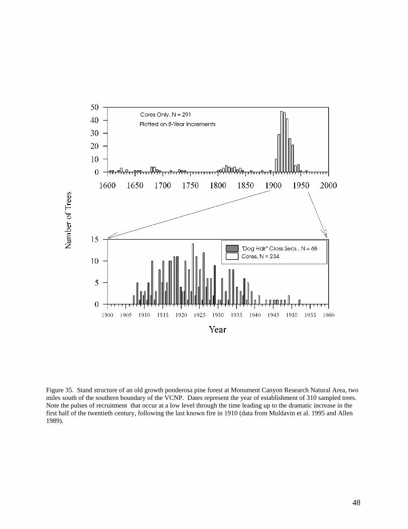
Figure 35. Stand structure of an old growth ponderosa pine forest at Monument Canyon Research Natural Area, two miles south of the southern boundary of the VCNP. Dates represent the year of establishment of 310 sampled trees. Note the pulses of recruitment that occur at a low level through the time leading up to the dramatic increase in the first half of the twentieth century, following the last known fire in 1910 (data from Muldavin et al. 1995 and Allen 1989).
48
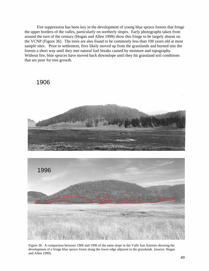
Fire suppression has been key in the development of young blue spruce forests that fringe the upper borders of the valles, particularly on northerly slopes. Early photographs taken from around the turn of the century (Hogan and Allen 1999) show this fringe to be largely absent on the VCNP (Figure 36). The trees are also found to be commonly less than 100 years old at most sample sites. Prior to settlement, fires likely moved up from the grasslands and burned into the forests a short way until they met natural fuel breaks caused by moisture and topography. Without fire, blue spruces have moved back downslope until they hit grassland soil conditions that are poor for tree growth.
49
1906
1996
Figure 36. A comparison between 1906 and 1996 of the same slope in the Valle San Antonio showing the development of a fringe blue spruce forest along the lower edge adjacent to the grasslands (source: Hogan and Allen 1999).
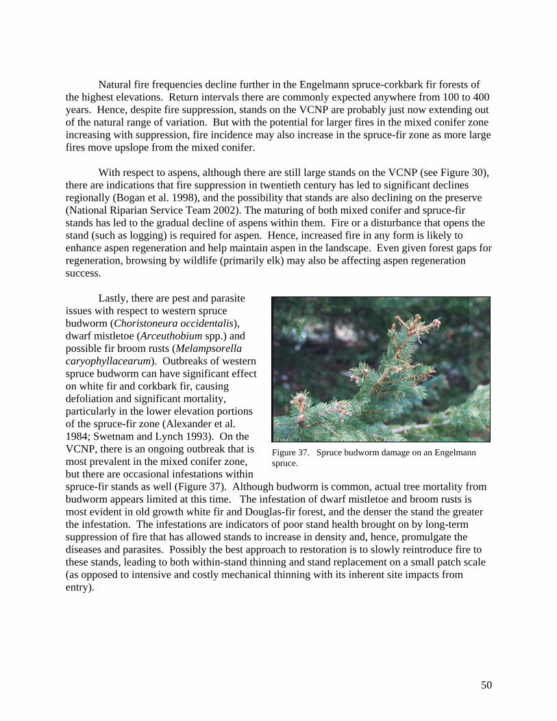
Natural fire frequencies decline further in the Engelmann spruce-corkbark fir forests of
the highest elevations. Return intervals there are commonly expected anywhere from 100 to 400 years. Hence, despite fire suppression, stands on the VCNP are probably just now extending out of the natural range of variation. But with the potential for larger fires in the mixed conifer zone increasing with suppression, fire incidence may also increase in the spruce-fir zone as more large fires move upslope from the mixed conifer.
With respect to aspens, although there are still large stands on the VCNP (see Figure 30),
there are indications that fire suppression in twentieth century has led to significant declines regionally (Bogan et al. 1998), and the possibility that stands are also declining on the preserve (National Riparian Service Team 2002). The maturing of both mixed conifer and spruce-fir stands has led to the gradual decline of aspens within them. Fire or a disturbance that opens the stand (such as logging) is required for aspen. Hence, increased fire in any form is likely to enhance aspen regeneration and help maintain aspen in the landscape. Even given forest gaps for regeneration, browsing by wildlife (primarily elk) may also be affecting aspen regeneration success.
Lastly, there are pest and parasite issues with respect to western spruce budworm (Choristoneura occidentalis), dwarf mistletoe (Arceuthobium spp.) and possible fir broom rusts (Melampsorella caryophyllacearum). Outbreaks of western spruce budworm can have significant effect on white fir and corkbark fir, causing defoliation and significant mortality, particularly in the lower elevation portions of the spruce-fir zone (Alexander et al. 1984; Swetnam and Lynch 1993). On the VCNP, there is an ongoing outbreak that is most prevalent in the mixed conifer zone, but there are occasional infestations within spruce-fir stands as well (Figure 37). Although budworm is common, actual tree mortality from budworm appears limited at this time. The infestation of dwarf mistletoe and broom rusts is most evident in old growth white fir and Douglas-fir forest, and the denser the stand the greater the infestation. The infestations are indicators of poor stand health brought on by long-term suppression of fire that has allowed stands to increase in density and, hence, promulgate the diseases and parasites. Possibly the best approach to restoration is to slowly reintroduce fire to these stands, leading to both within-stand thinning and stand replacement on a small patch scale (as opposed to intensive and costly mechanical thinning with its inherent site impacts from entry).
Figure 37. Spruce budworm damage on an Engelmann spruce.
50
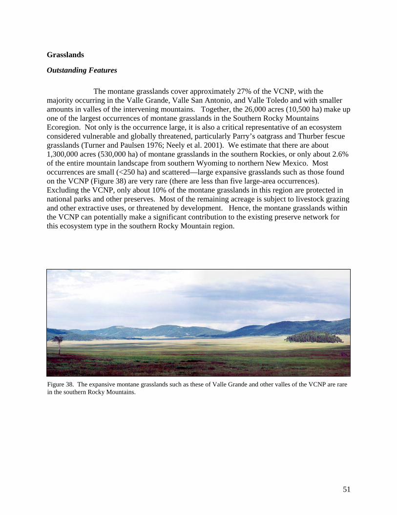
Grasslands
Outstanding Features
The montane grasslands cover approximately 27% of the VCNP, with the majority occurring in the Valle Grande, Valle San Antonio, and Valle Toledo and with smaller amounts in valles of the intervening mountains. Together, the 26,000 acres (10,500 ha) make up one of the largest occurrences of montane grasslands in the Southern Rocky Mountains Ecoregion. Not only is the occurrence large, it is also a critical representative of an ecosystem considered vulnerable and globally threatened, particularly Parry’s oatgrass and Thurber fescue grasslands (Turner and Paulsen 1976; Neely et al. 2001). We estimate that there are about 1,300,000 acres (530,000 ha) of montane grasslands in the southern Rockies, or only about 2.6% of the entire mountain landscape from southern Wyoming to northern New Mexico. Most occurrences are small (<250 ha) and scattered—large expansive grasslands such as those found on the VCNP (Figure 38) are very rare (there are less than five large-area occurrences). Excluding the VCNP, only about 10% of the montane grasslands in this region are protected in national parks and other preserves. Most of the remaining acreage is subject to livestock grazing and other extractive uses, or threatened by development. Hence, the montane grasslands within the VCNP can potentially make a significant contribution to the existing preserve network for this ecosystem type in the southern Rocky Mountain region.
Figure 38. The expansive montane grasslands such as these of Valle Grande and other valles of the VCNP are rare in the southern Rocky Mountains.
51

Management Issues
On the VCNP, we think that montane grasslands have undergone significant modifications due to grazing. Our analysis suggests that in the course of nearly continuous grazing during the past 100 plus years, native grass species have been slowly replaced by exotic Kentucky bluegrass along with several exotic and weedy forbs. Under heavy grazing the exotic Kentucky bluegrass will displace both fescues and Parry’s oatgrass, and its dominance is usually an indicator of intensive grazing practices (Dick-Peddie 1993; Uchytil 1993; Moir 1967). Although it is highly palatable, Kentucky bluegrass it is not as productive when compared to native grasses (it is often semi-dormant during the summer months and sensitive to drought conditions). But since it is both rhizomatus and a heavy seeder, it is an aggressive invader of rangelands and difficult to eradicate once established. Daubenmire (1970) referred to Kentucky bluegrass-dominated sites as stable "zootic climaxes" that result from long-term heavy grazing (Figure 39). The result is grasslands that have lower grass diversity and a forb component of low palatability.
Figure 39. A pasture adjacent to the VCNP where long-term livestock grazing has led to the decline of bunch grasses and an increase of Kentucky bluegrass along with an encroachment of shrubby cinquefoil (Pentaphylloides floribunda).
Much of the shift in species
composition may be the residual effect of heavy sheep grazing in the late nineteenth and early twentieth centuries. To add to the complexity, Valle Grande has historically been one of the main summer ranges for elk in the Jemez Mountains, and large herds have been using these upland grasslands since the late 1970s, even during mild winters such as in 2002 (Figure 40). The past and current effects of elk are unclear. Although there are no data, it has been suggested that elk and livestock together may have contributed to range degradation in Valle Grande, such as the shift away from Arizona and Thurber fescues to Kentucky bluegrass, and the increased abundance of pine dropseed. Furthermore, and more importantly, elk may be responsible for limiting shrubby cinquefoil (Pentaphylloides floribunda) encroachment, a species known to increase with livestock grazing under certain conditions (Mueggler and Stewart 1980). On the VCNP, it appears to be a favored browse species for elk and, when compared to pastures heavily
Figure 40. There are large herds of re-introduced Rocky Mountain elk on the VCNP that may be having a significant impact on range biodiversity and productivity.
52

grazed by livestock on neighboring properties, may be impacted by the high elk numbers on the preserve.
Historic grazing impacts vary across the preserve depending on pasture type, size, and water source distribution. For example, since Valle Grande housed the livestock operation headquarters, there were several pastures dedicated as holding pastures that likely received more impacts than more distant pastures in other valles. One pasture in the northwest portion of Valle Grande was divided into numerous small paddocks and dedicated to horses, leading to increased impacts due to high intensity grazing in small areas. While there are several springs on the slopes of Valle Grande, the East Fork of the Jemez and Jaramillo Creek remain the primary water sources. Hence, impacts tend to increase towards the stream channels with a shift towards Kentucky blue grass and weedy forb dominance. There is a similar pattern in Valle San Antonio and Valle Toledo where San Antonio Creek served as a locus for historic livestock concentrations. In the smaller valles (Valle de los Posos, Valle Jaramillo, Valle Santa Rosa and Valle Seco), historic grazing impacts tend to be concentrated near stock tanks, small watering holes, and springs. Grazing pressure on the lower elevation valle rangelands may have been alleviated by dispersed grazing in forests and woodlands, and in open logged areas of mountains (with unknown effects on forest diversity and productivity). The high mountain meadows of the rim, ridges and mountain tops have perhaps had the fewest grazing impacts from cattle in recent decades due to limited water availability, although earlier grazing by large numbers of sheep may have been significant (Allen 1989).
Overall, these globally significant grasslands carry a strong imprint of past livestock use
and are in need of rehabilitation. There is evidence from the Sangre de Cristo Mountains that montane fescue grasslands can recover when rested from livestock, but that Kentucky bluegrass usually remains in the inter-bunch spaces, and in many cases it remains the long-term dominant or codominant (Dick-Peddie 1993). Fire may have some potential to aid restoration, but current research suggests that it needs to be applied with caution. The VCNP grasslands were subject to management burns during the past owner’s tenure to improve range conditions, but there is no direct data on the positive or negative effects of the burning program, and such burns were discontinued. Whether burning might favor or harm Arizona fescue, Thurber fescue and other native bunch grasses over Kentucky bluegrass appears to be dependent on season and intensity of fire. Although there is no direct information on Arizona fescue, research on Idaho fescue suggests that light fires are not likely harm Arizona fescue and may promote tillering (Robberecht et al. 1995). Singer and Harter (1996) report enhanced productivity for Idaho fescue after the Yellowstone fires of 1988. But in other studies, hot fires have resulted in high mortality and reports that up to 25 years were needed for recovery (Zouhar 2000). Fire can be used to either enhance or control Kentucky bluegrass, depending on the season of burn. Late spring burns at the peak of standing biomass appear to significantly reduce bluegrass abundance (Uchytil 1993), but the burns must be hot enough to penetrate the soil and reach the rhizomes. Fire is also less effective as a control in lowland moist areas, and when applied during the dormant season may enhance the Kentucky bluegrass (apparently fire has little effect on the mature dormant plants and encourages propagation by seed). The limited research on Thurber fescue suggests it may respond positively to burn treatments, by both by tillering and seedling establishment (Paulsen 1970; McMurray 1987).
53

In another context, fire may be critical in preventing tree and shrub invasion of grasslands (Allen 1989). Trees and shrubs are normally absent or minor in montane grasslands, but with fire suppression and intensive livestock grazing during the twentieth century there has been a slow invasion by conifers or aspens into once open grasslands in the VCNP and the surrounding mountains (Figure 41). In the high mountain meadows, once open grasslands are now dotted with ponderosa pine, fir or aspen. On some southerly slopes of the valles, ponderosa pine is invading and creating open “woodland savannas” (see Figure 26). Similarly, blue spruce fringe forests have formed along the northerly upper edges, all within the last 100 years of fire suppression (see Figure 36). Bogan et al. (1998) suggest that careful livestock management (including the exclusion of sheep), and the restoration of a natural fire regime can significantly improve range condition in these montane grasslands. In contrast, Dyer and Moffett (1999) suggest that climate change, not fire suppression and grazing, has driven the encroachment of trees. In the midst of this conundrum (is it fire, is it climate), Jonathon Coop (2001) is investigating the competitive interactions and physical controls in this ecotone between forests and grasslands on the VCNP, and ultimately may be able to provide additional insights that will aid management.
b) Douglas-fir and ponderosa pine establishment on Pajarito Mt.
a) Aspen encroachment in Deer Canyon.
c) Ponderosa pine invasion in Valle Toledo.
54
Figure 41. Examples of aspen and conifer invasions of montane grasslands on the VCNP that are likely the result of fire suppression during the twentieth century.
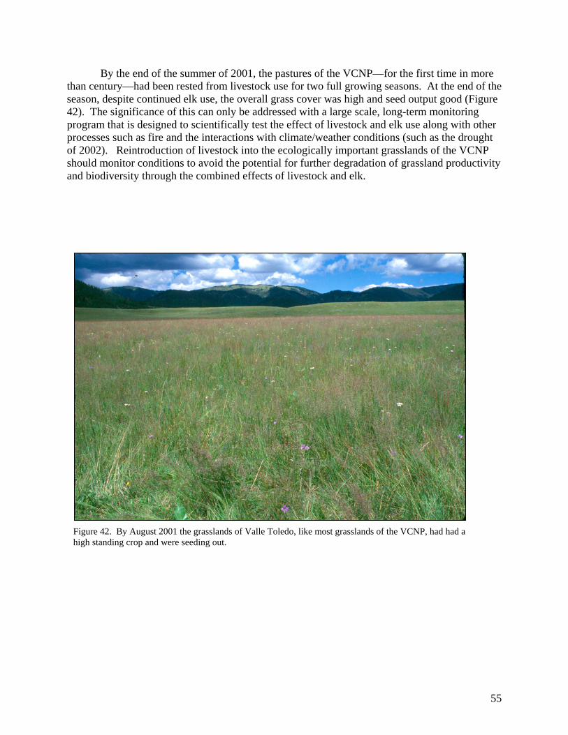
By the end of the summer of 2001, the pastures of the VCNP—for the first time in more than century—had been rested from livestock use for two full growing seasons. At the end of the season, despite continued elk use, the overall grass cover was high and seed output good (Figure 42). The significance of this can only be addressed with a large scale, long-term monitoring program that is designed to scientifically test the effect of livestock and elk use along with other processes such as fire and the interactions with climate/weather conditions (such as the drought of 2002). Reintroduction of livestock into the ecologically important grasslands of the VCNP should monitor conditions to avoid the potential for further degradation of grassland productivity and biodiversity through the combined effects of livestock and elk.
Figure 42. By August 2001 the grasslands of Valle Toledo, like most grasslands of the VCNP, had had a high standing crop and were seeding out.
55
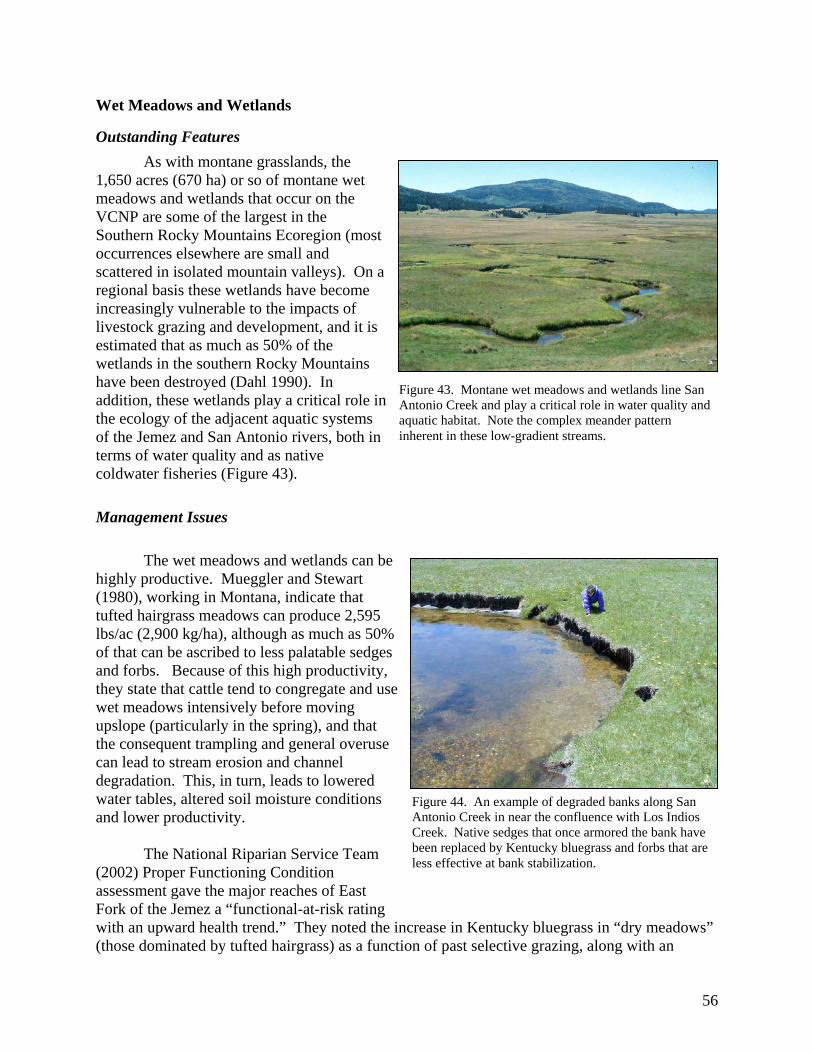
Wet Meadows and Wetlands
Outstanding Features As with montane grasslands, the
1,650 acres (670 ha) or so of montane wet meadows and wetlands that occur on the VCNP are some of the largest in the Southern Rocky Mountains Ecoregion (most occurrences elsewhere are small and scattered in isolated mountain valleys). On a regional basis these wetlands have become increasingly vulnerable to the impacts of livestock grazing and development, and it is estimated that as much as 50% of the wetlands in the southern Rocky Mountains have been destroyed (Dahl 1990). In addition, these wetlands play a critical role in the ecology of the adjacent aquatic systems of the Jemez and San Antonio rivers, both in terms of water quality and as native coldwater fisheries (Figure 43).
Figure 43. Montane wet meadows and wetlands line San Antonio Creek and play a critical role in water quality and aquatic habitat. Note the complex meander pattern inherent in these low-gradient streams.
Management Issues
The wet meadows and wetlands can be highly productive. Mueggler and Stewart (1980), working in Montana, indicate that tufted hairgrass meadows can produce 2,595 lbs/ac (2,900 kg/ha), although as much as 50% of that can be ascribed to less palatable sedges and forbs. Because of this high productivity, they state that cattle tend to congregate and use wet meadows intensively before moving upslope (particularly in the spring), and that the consequent trampling and general overuse can lead to stream erosion and channel degradation. This, in turn, leads to lowered water tables, altered soil moisture conditions and lower productivity.
The National Riparian Service Team (2002) Proper Functioning Condition assessment gave the major reaches of East Fork of the Jemez a “functional-at-risk rating with an upward health trend.” They noted the increase in Kentucky bluegrass in “dry meadows” (those dominated by tufted hairgrass) as a function of past selective grazing, along with an
Figure 44. An example of degraded banks along San Antonio Creek in near the confluence with Los Indios Creek. Native sedges that once armored the bank have been replaced by Kentucky bluegrass and forbs that are less effective at bank stabilization.
56

increase in other upland graminoid species that point to a drying trend among wetland types. Yet, they feel that these lowland wetland systems have enough attributes in place whereby recovery is possible under proper management.
These wetland systems are integral to adjacent stream function and biodiversity and
hence, how the wetlands are managed has direct implications for aquatic habitat and the establishment and maintenance of a native coldwater fishery. For example, Simino (2001) in his evaluation of Rio Grande cutthroat trout habitat in the East Fork in Valle Grande indicated several important conditions for trout that were tied to wetland function. He separated the East Fork into two reaches: Reach 7, below the confluence with Jaramillo Creek to the VCNP boundary, and Reach 8, above the confluence to the end of surface waters at the springs at the upper end of valley. The reaches were characterized as low-gradient meadow systems with a severely limited pool versus riffle habitat (only 1 to 5% pool as opposed to a desired 30%) and diminished undercut banks critical to trout habitat. They concluded the reaches had been severely impacted by past livestock that had lead to eroded banks, widening of the stream channel, excessive deposition of sand and silt, and lack of pool versus riffle habitat and undercut banks (Figure 44). In addition, the New Mexico Environment Department found that Reach 7 exceeded allowable water quality standards for a cold-water fishery on several dates during 2001 (temperatures, pH levels, and fecal coliform counts). The implication is that past livestock use has lowered water quality in the reach. Overall, Simino (2001) rated the reaches with respect to Rio Grande cutthroat habitat as “not properly functioning” for all attributes except pool quality, and, in Reach 8, pool quality and width-to-depth ratio.
To help improve the function of these systems, Simino (2001) recommended that woody riparian vegetation be established to help stabilize banks and decrease water temperatures. This recommendation was based on what is known about other high elevation meadow systems in the southern Rocky Mountains where woody shrubs often line stream banks. But at this time, we have found no evidence, past or present, of willow, alder, or birch along any of the open valle stream systems (we did find Bebb willow in a wetland area of southeastern area of Valle Seco, around an old cienega in the northwestern corner of the VCNP, in the headwaters of the Jaramillo Creek, along Redondo Creek, and in Sulphur Canyon, but these are more like montane woody riparian systems rather than the wet meadows and stream-associated wetlands of the larger valles). This suggests that woody shrub species may never have been a significant element of these systems, possibly because of soil conditions or the gradient of the streams, and is keeping with the conclusions of the National Riparian Service Team (2002). Hence, the introduction of woody species to enhance stream bank stability and other stream functions should be considered with caution, and more research is needed to ensure success. But controlling livestock access and use of the wetlands is very important for improving water quality, preventing further destruction of banks and stabilizing the system in a way that will lead to a stream channel morphology more conducive to sustaining a native cold-water fishery.
Because they have been heavily used by livestock, the wet meadow systems have a high
degree of exotic plant species encroachment, particularly Kentucky bluegrass and weedy forbs (Barnes 2002). Since native sedges and rushes act as very effective bank stabilizers and filters for enhanced water quality, they are preferable for improvement of the adjacent aquatic system. Hence, Simino (2001) recommended a prescribed burn program to help favor natives in the system. As with montane grasslands, a well-designed research and monitoring program with
57

large livestock and elk exclosures will be needed to determine the best approach for improving wetland composition and function.
Montane riparian forests and shrublands
Outstanding features The montane riparian zones of the VCNP are also special habitats of high diversity and
importance for water quality. On a regional basis they occupy less than 1% of the Southern Rocky Mountain landscape, and they are considered rare and globally threatened (Neely et al. 2001; Anderson et al. 1998). Upper La Jara Creek in particular supports a species-rich and productive riparian zone dominated by thinleaf alder and blue spruce (see Figure 19). This is in part because past management wanted to ensure protection of the headquarters water by limiting logging and livestock grazing in the watershed. Other stream systems of the preserve also support shrubby riparian communities, but these have been variously impacted by livestock, elk browsing, and logging (Redondo Creek, Sulphur Creek, Rito de los Indios, and upper Jaramillo Creek).
Management concerns
The primary ecological management issues revolve around protection of water quality and quantity, and the enhancement of these sites for their intrinsic biodiversity values and importance to wildlife. Most of the streamside riparian zones (other than upper La Jara) are in need of restoration to increase function and reestablish riparian vegetation (National Riparian Service Team 2002). Bebb willow populations are being browsed into extirpation everywhere except perhaps along Redondo Creek, where the largest population is currently found. In keeping with the National Riparian Service Team (2002) recommendations, we suggest that good livestock and wildlife management is the key to recovery. Any future management plans should address protections for these riparian communities from livestock use and elk browsing, and consider logging road restoration options to reduce sediment loads and reestablish the original drainage patterns.
58

Potential Special Management Areas
Alamo Canyon Wetland Complex An area of special interest is the wetland complex that occurs in the bottom of Alamo
Canyon on the western side of the preserve (Figure 45). Although locally called Alamo Bog, this site is technically a fen because it is dominated by grasses and sedges (tufted hair grass and water sedge); bogs are typically dominated by Sphagnum moss (present in Alamo Canyon, but uncommon). Fens are also fed by ground water (warm springs in this case) and runon from surrounding slopes (Figure 46) while bogs receive inputs of water and nutrients only from precipitation (hence, bogs tend to become convex in shape as they develop vertically and can only receive precipitation rather than runon from a surrounding slopes or groundwater). Regardless, both fens and bogs are saturated with water throughout the year with water at or near the surface. As a result, they develop deep organic layers of peat as production exceeds decomposition under the waterlogged conditions. Because production can be significantly lower when compared to other ecosystems, fens and bogs can take centuries, even millennia to develop. In the case of Alamo Canyon, the peat ranges from six to 16 ft (2 to 5 m) deep in some locations, suggesting that the fen complex is ancient (an initial carbon-14 date gives an approximate calendar age of 9,000 years at 493 cm). An additional feature of the fen is its high acidity (2.0 to 4.0 pH) resulting from the influx of sulfuric acid from the underlying and adjacent warm springs (Goff and Janik 2002). Besides the grass- and sedge-dominated fen communities, a small portion of the complex also supports a Bog Birch/Water Sedge/Club Moss Association that is found nowhere else in New Mexico (see Figure 20).
Figure 45. The montane fen in Alamo Canyon is a unique site in New Mexico.
Figure 46. Fens receive surface and subsurface water along with direct precipitation; bogs receive only precipitation. Fens have both surface and subsurface outflows while bogs have only subsurface outflow directly to groundwater (drawing from Welsh 1995).
59

The Alamo Canyon wetland complex is unique among bogs and fens in the Southern Rocky Mountains and possibly elsewhere. The high acidity driven by warm springs coupled with long-term hydrological stability and water saturation, are unusual conditions not commonly found together, and which have likely led to the large peat accumulations in the fen. The closest examples of something similar are found in Yellowstone National Park, although the dynamic geothermal systems in the park often prevent the stability needed to develop fens (Jennifer Whipple pers. com.). Furthermore, fens in general are considered rare throughout the Southern Rocky Mountains Ecoregion, and they tend to be more compositionally variable than their more northern boreal cousins. In Colorado, they are found only in a few isolated small areas, notably South Park, Mount Evans, Grand Mesa, Iron Creek, and High Creek (Neely et al. 2001), and hence, the Alamo Canyon fen may represent the furthest southern occurrence of this uncommon ecosystem type. This regional rarity is compounded by significant declines worldwide of fens and bogs due to draining, fuel use, and cropping. This has led to multinational government efforts to preserve and protect them (USA, Canada, UK, and the European Union), and the Alamo Canyon complex provides an opportunity for the VCNP to participate in that initiative.
Beyond their biological uniqueness, fens and bogs often contain an unparalleled record of our past. A rich archive of information on vegetation, fire and climate lies preserved in bogs (through pollen, plants, charcoal, and occasional human implements and remains) that has the capacity to expand our understanding of people, culture, and ecological change far back into prehistory (Brunner-Jass 1999).
To help ensure the continued integrity of the fen complex, the provisional boundary of the special management area has been delineated to encompass most of the immediate surrounding watershed (Figure 47, Area A). Careful management at a watershed level will be necessary to maintain the unique hydrological regime that sustains the fen. In the past, the site has been affected not only by livestock use and timber harvesting, but also geothermal exploration. There were several “wellpad” platforms excavated in the canyon during the 1970s that were then abandoned with limited reclamation. Some of these pads are still contributing sediments to the fen, and because the hydrological patterns have been altered, they are causing erosion in the canyon and affecting fen stability. Regardless of causes, there is a large erosional headcut in the middle portion of the complex that is in need of immediate management action to prevent further degradation of the fen system. Also, the rare bog birch community has been adversely affected by elk browsing (see Figure 25), and will likely require an elk-proof exclosure to help maintain the community in the bog complex.
60

Figure 47. Potential special management areas for the Valles Caldera National Preserve.
61
Jemez - San Antonio Upper Watershed Protection Zone
Stable upper watershed conditions are critical for restoring and enhancing downstream riparian zones and aquatic ecosystems, particularly the cold-water fishery. Slope stability is usually increased by adding vegetation cover, which in turn reduces sedimentation and nutrient loads that adversely affect stream channel morphology and water quality. In contrast, extensive timber harvests no doubt lead to increased stream sedimentation, and grazing also makes a contribution by increasing exposed soil and subsequent erosion (Turner and Dortignac 1954). The legacy of past forest practices and grazing on the VCNP can still be seen in the East Fork of the Jemez River and San Antonio Creek where there has been excessive sand and silt deposition, increased channel incision and bank erosion, and a dramatic loss of pool-riffle habitat, all leading to significant impacts on the cold-water fishery (Simino 2001).
As a first step in addressing the issue of enhancing conditions for these drainages, a
Jemez – San Antonio Upper Watershed Protection Zone could be established that would include the headwaters of the East Fork of the Jemez River and San Antonio Creek in the upper Valle Grande and Valle Toledo, respectively (Figure 47 – Area B and Figure 48). Within this zone timber harvest and livestock grazing would be excluded to allow the watersheds to recover. Besides leading to reduced impacts on downstream aquatic and riparian/wetland systems, the zone would provide an opportunity to reestablish natural ecosystem processes on a limited experimental basis, both in the grasslands and forests. For example, while much of the Pajarito rim country of the upper Valle Grande remains virgin forest, similar rim country in Valle Toledo was extensively logged. Road and forest rehabilitation projects could be initiated there and compared against the “control” of the more intact Upper Valle watershed — allowing for a real measure of success that might not be afforded elsewhere in the preserve. Similarly, with resting the grasslands comes the opportunity to evaluate recovery in terms of exotic encroachment and productivity in a setting where natural processes such as fire can be reintroduced at a landscape scale. In effect, such a watershed protection zone would not only lead to enhanced conditions for a major portion of the preserve, it would also play a role in fulfilling the science mandate in the enabling legislation for the preserve. A collateral benefit of an upper watershed protection zone would be the preservation and enhancement of habitats for several federal and state sensitive species known to the VCNP. The virgin forests and associated rocklands (felsenmeers) found along the rim country of the zone are prime habitats for the Jemez Mountain salamander and Goat Peak pika, and potentially the northern goshawk. In addition, the grasslands of the valles are important to Gunnison’s prairie dog, since their populations are significantly declining elsewhere within their range. The establishment of an upper watershed protection zone would be a step towards the long-term preservation of these species, and the avoidance of future conflicts over threatened and endangered species.
62
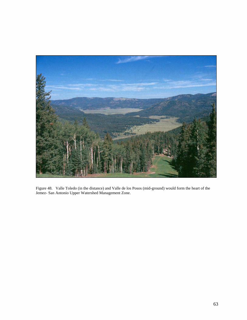
63
Figure 48. Valle Toledo (in the distance) and Valle de los Posos (mid-ground) would form the heart of the Jemez- San Antonio Upper Watershed Management Zone.

Redondo Peak Reserve
Redondo Peak is held sacred by the people of Walatowa and other local Native Americans and is a place requiring special management consideration (Figure 49). Hence, the enabling legislation of the VCNP specifically set aside the area on Redondo Peak above 10,000 ft for preserving the natural, cultural, religious, and historic resources on the mountain. While the 10,000 ft designation was an efficient way to demarcate the core of this site for legislative purposes, from an ecosystem perspective, the peak must include a wider area to ensure effective management at a landscape scale (Figure 47). Specifically, the patterns and processes of the lower elevations of the mountain cannot be divorced from what goes on at the summit, particularly with respect to fire (but also seed dispersal, wildlife movements, and the effects of fragmentation on forest health). Accordingly, we suggest delineation of a “reserve” area around the mountain that encompasses not only the high subalpine forest and montane grasslands but also the aspen and mixed conifer forests, and the montane shrublands of lower elevations along with the extensive rock fields or felsenmeers that make up the landscape mosaic of the mountain. At the same time, this suggested boundary captures the major hydrological features of the mountain, particularly the headwaters of La Jara Creek—the headquarters water supply, and similarly, much of the Redondo Creek watershed drinking supply. Through this landscape approach, management initiatives could effectively be applied to ensure the preservation of both the cultural heritage and biodiversity values of the mountain.
Figure 49. Looking south from Garita ridge, Redondo Peak towers in the distance over Redondo Border (mid-ground), and Cerro Seco and Valle San Antonio in the foreground.
64

DISCUSSION
There were two goals set for this project in its first year. One was to develop a vegetation
community classification of the VCNP as a foundation for subsequent vegetation mapping and biological inventories, and the other was to provide an ecological assessment as a preamble for the development of an integrated natural resources management plan for the preserve. With respect to the former, using the data from 100 vegetation plots gathered during the summer of 2001, we have presented a broad outline of the vegetation pattern and ecology of the VCNP. The objective in 2003 is to build a high-resolution vegetation map that fully characterizes this pattern to aid future management prescriptions. The vegetation map will be based on the vegetation classification presented here and will be developed from high-resolution 1:12,000 scale aerial color photography in combination with satellite imagery. It will also be coordinated with vegetation maps being produced for the Bandelier National Monument, Los Alamos National Laboratory and the intervening USFS lands. We hope that such a unified vegetation approach will not only provide a landscape context for the VCNP, but also that it will foster interagency cooperation on natural resources management in general.
It is evident that the VCNP supports large occurrences of communities known for their
rarity in the southern Rocky Mountain region—particularly montane grasslands and wetlands. In addition, the preserve contains some the largest tracts of virgin forest remaining in the Jemez Mountains, and is home to several rare species. Our intent in the ecological assessment was to not only point out these outstanding features of the preserve, but to also draw attention to some of the management issues that will need to be addressed in the planning process. The heterogeneity of the post-harvest landscape and the impacts of past grazing pose challenges that we suggest would be best met through an ecosystem approach that recognizes the role humans play in balancing biodiversity protection with sustainable resource extraction along with recreational and scenic values. We would recommend a strategy based on watershed protection that focuses on the services provided by the ecosystem to maintain productivity and health within a given landscape and to the downsteam users, particularly aquatic ecosystems. Through the reestablishment of ecosystem-level processes such as appropriate fire regimes and levels of grazing, coupled with an understanding of how water and nutrients flow, the long-term sustainability of the VCNP ecosystems can be ensured and appreciated by many generations to come.
65

REFERENCES
Abolt, R.A.P. 1997. Fire histories of upper elevation forests in the Gila Wilderness, New Mexico
via fire scar and stand age structure analysis. M.S. Thesis. University of Arizona. 119p.
Alexander, Robert R. 1987. Ecology, silviculture, and management of the Engelmann spruce-subalpine fir type in the central and southern Rocky Mountains. Agric. Handb. 659. Department of Agriculture, Forest Service. Washington, DC: U.S. 144 p.
Alexander, R. R, R.C. Shearer, W.D. Shepperd. 1984. Silvical characteristics of subalpine fir.
Gen. Tech. Rep. RM-115. U.S. D.A., Forest Service, Rocky Mountain Forest and Range Experiment Station, Fort Collins, CO. 29 p
Allen, C.D. 1984. Montane grasslands in the landscape of the Jemez Mountains, New Mexico.
M.S. Thesis. University of Wisconsin, Madison. 189 p. Allen, C.D. 1989. Changes in the landscape of the Jemez Mountains, New Mexico. Ph.D.
Dissertation. University of California at Berkeley. 346 p. Allen, C.D. 1998. A ponderosa pine natural area reveals its secrets. Pp 551-552 in: Mac, M.J.,
P.A. Opler, and P.E. Pucket Haeker, and P.D. Doran, editors. Status and trends of the Nations biological resources. Vol. 1. U.S. Department of the Interior, U.S. Geological Survey, Reston, VA. 1-436 pp.
Allen, C.D., M. Savage, D.A. Falk, K.F. Suckling, T.W. Swetnam, T. Schulke, P.B. Stacey, P.
Morgan, M. Hoffman, and J.Klingel. 2002. Ecological restoration of Southwestern ponderosa pine ecosystems: A broad perspective. Ecological Applications 12(5):1418-1433.
Allen, R. B and R.K. Peet. 1990. Gradient analysis of forests of the Sangre de Cristo Range,
Colorado. Canadian Journal of Botany. 68: 193-201. Ander, M.E., G. Heiken, J. Eichelberger, A.W. Laughlin, and S. Husetis. 1981. Geological and
geophysical investigations of the Zuni volcanic field, New Mexico: Los Alamos National Lab. Report LA-8827-MS, Los Alamos, New Mexico, 39 p.
Anderson, M., P. Bourgeron, M.T. Bryer, R.Crawford, L. Engelking, D. Faber-Langendoen, M.
Gallyoun, K. Gooodin, D.H. Grossman, S. Landaal, K. Metzler, K.D. Patterson, M. Reid, L. Sneddon & A.S. Weakley 1998. Vol. II. International Classification of Ecological Communities: terrestrial vegetation of the United States. The Nature Conservancy, Arlington, VA.
Arno, S. F. 1980. Forest fire history in the northern Rockies. Journal of Forestry. 78(8): 460-465.
66

Bailey, J.K. and T.G. Witham. 2002. Interactions among fire, aspen, and elk affect insect diversity: reversal of a community response. Ecology, 83(6): 1701-1712.
Bailey, R. 1995. Description of the Ecoregions of the United States. USDA Forest Service. Misc.
Publication No. 1391. Baker, W. L. 1983. Alpine vegetation of Wheeler Peak, New Mexico, USA: gradient analysis,
classification, and biogeography. Artic and Alpine Research 15: 223-240. Barnes, W.S. 2002. Rangeland monitoring baseline report. Unpublished final report on file at
U.S. Geological Survey, Jemez Mts. Field Station. 20 p. Berghofer, C. 1967. Protected furbearers. in: New Mexico Wildlife Management. New Mexico
Game and Fish Department, Santa Fe, NM. 250p. Bogan, M.A., C.D. Allen, E.H. Muldavin, S.P. Platania, J.N. Stuart, G.H. Farley, P. Mehlhop,
and J. Belnap. 1998. Southwest. Pages 543-581 in: Mac, M.J., P.A. Opler, and P.E. Pucket Haeker, and P.D. Doran, editors. Status and trends of the Nations biological resources. Vol. 1. U.S. Department of the Interior, U.S. Geological Survey, Reston, VA. 1-436 pp.
Bradley, A.F., N.V. Noste, and W.C. Fischer. 1992. Fire ecology of Forests and Woodlands in
Utah. Gen. Tech. Rep. INT-287. U.S. Department of Agriculture, Forest Service, Intermountain Research Station. Ogden, UT: 128 p.
Brown, D. E., F. Reichenbacher, and S. E. Franson. 1998. A classification of North American
biotic communities. University of Utah Press, Salt Lake City. Brunner-Jass, R.M. 1999. Fire Occurrence and Paleoecology at Alamo Bog and Chihuahueños
Bog, Jemez Mountains, New Mexico, USA. M.S. Thesis. Northern Arizona University. 140p.
Coop, J.D. 2001. Research on the Environmental Determinants of a Montane Forest-Grassland
Ecotone in the Valles Caldera National Preserve. Progress report to Valles Caldera National Preserve. Department of Botany, University of Wisconsin, Madison WI.
Cooper, C.F. 1960. Changes in vegetation, structure and growth in southwestern ponderosa pine
forests since white settlement. Ecol. Mon. 30:129-164. Dahl, T.E. 1990. Wetlands Losses in the United States 1780’s to 1980’s. U.S. Department of
Interior, Fish and Wildlife Service, Washington, D.C. 21 pp. Daubenmire, R. 1970. Steppe vegetation of Washington. Technical Bulletin 62. Pullman, WA:
Washington State University, College of Agriculture, Washington Agricultural Experiment Station. 131 p.
67

DeVelice, R. L., J.A. Ludwig, W.H. Moir, F. Ronco, Jr. 1986. A classification of forest habitat types of northern New Mexico and southern Colorado. Gen. Tech. Rep. RM-131. U.S.D.A. Forest Service, Rocky Mountain Forest and Range Experiment Station. Fort Collins, CO. 59 p.
Dick-Peddie, W. A., W. H. Moir, and R. Spellenberg. 1993. New Mexico Vegetation, Past,
Present, and Future. University of New Mexico Press. Dyer J.M. and K.E. Moffett. 1999. Meadow invasion from high-elevation spruce-fir forest in
south-central New Mexico. Southwestern Naturalist 44(4):444-456. Federal Interagency Committee For Wetland Delineation. 1989. Federal Manual for Identifying
and Delineating Jurisdictional Wetlands. U.S. Army Corps of Engineers, U.S. Environmental Protection Agency, U.S. Fish and Wildlife Service, and U.S.D.A. Soil Conservation Service, Washington, D.C. Cooperative Technical Publication. 76 pp. Plus Appendices.
Fitzhugh, E.L., W.H. Moir, J.A. Ludwig, and F. Ronco, Jr. 1987. Forest habitat types in the
Apache, Gila, and part of the Cibola National Forests, Arizona and New Mexico. General Technical Report RM-GTR-145, USDA Forest Service, Rocky Mountain Forest Experiment Station, Fort Collins, CO.
Gardner, J. N., and Goff, F., 1996, Geology of the northern Valles Caldera and Toledo
embayment. Pp. 225-230 In: New Mexico Geological Society Guidebook 47. Goff, F., and C.J. Janik. 2002. Gas geochemistry of the Valle caldera region, NM and
comparisons with gasses at Yellowstone, Long Valley and other geothermal systems. Volcanology and Geothermal Research 116:299-323.
Grissino-Mayer, H.D., C.H. Baisan, and T.W. Swetnam. 1995. Fire history in the Pinaleno
Mountains of southeastern Arizona: Effects of human-related disturbances. Pp 339-407 in: Debano, L.F. G.J. Gottfried, R.H. Hamre, C.B. Edminster, P.F. Ffolliott, and A. Ortega-Rubio (eds.). Biodiversity and Management of the Madrean Archipelago. General Technical Report RM-GTR-264, USDA Forest Service, Rocky Mountain Forest Experiment Station, Fort Collins, CO.
Grossman, D.H., D. Faber-Langendoen, A.S. Weakley, M. Anderson, P. Bourgeron, R.
Crawford, K. Goodin, S. Landaal, M. Metzler, K. Patterson, M. Pyne, M. Reid, and L. Sneddon. 1998. Vol. I. International Classification of Ecological Communities: terrestrial vegetation of the United States. The Nature Conservancy, Arlington, VA.
Halfner, D.J., and R.M. Sullivan. 1995. Historical and ecological biogeography of Nearctic pikas
(Lagomorpha: Ochotonidae). Journal of Mammalogy 76(2):302-321.
68

Hess, K. and R. Alexander. 1986. Forest vegetation of the Arapaho and Roosevelt National Forests in central Colorado: a habitat type classification. Res. Pap. RM-266, U.S.D.A., Forest Service, Rocky Mountain Forest and Range Experiment Station, Fort Collins CO. Station. 48 p.
Hogan, J., and C.D. Allen. 1999. Historic Rephotography and Landscape Change in the Jemez
Mountains, New Mexico. Unpublished report on file at USGS Jemez Mts. Field Station. 15 p. + 64 photographs + electronic catalog.
Johnson, T.H. 2001. Raptor surveys in the Valles Caldera National Preserve. 12 p. Unpublished
report on file at USGS Jemez Mts. Field Station. 20 p. Keene, R.E., K.C. Ryan, T.T. Veblen, C.D. Allen, J. Logan, and B Hawkes. 2002. Cascading
effects of fire exclusion in the Rocky Mountain ecosystems,: a literature review. Gen. Tech. Report RMRS-GTR-91. USDA Forest Service, Rocky Mountain Research Station, Fort Collins CO. 24 p.
Karmarkova, V., Ronert R. Alexander, and Barry C. Johnston. Forest vegetation of the Gunnison
and parts of the Uncompahgre National Forests: A preliminary habitat type classification. 1988. General Technical Report RM-163. USDA Forest Service, Rocky Mountain Forest and Range Experiment Station, Fort Collins, CO
Kipfmueller, K. F. and W.L. Baker. 2000. A fire history of a subalpine forest in south-eastern
Wyoming, USA. J. of Biogeography 27(1):71-85. Krantz, D. K. 2002. Browsing inventory, elk observations, and other wildlife observations on
the Valles Caldera National Preserve. Unpublished report on file at USGS Jemez Mts. Field Station.
Ludwig, J.A. and J.F. Reynolds. 1988. Statistical Ecology: A Primer on Methods and
Computing. J. Wiley and Sons, NY. 337p. Margolis, E.Q., C. Baisan, and T.W. Swetnam. 2001. Investigating the potential for
dendrochronological reconstruction of tent caterpillar outbreaks in aspen stands of the Jemez Mts., New Mexico. Unpublished final report on file at USGS Jemez Mts. Field Station. 20 p.
Mast, Joy Nystrom, T.T. Veblen, and M.E. Hodgson, 1997. Tree invasion within a
pine/grassland ecotone: an approach with historic aerial photography and GIS modeling. Forest Ecology and Management. 93: 181-194.
Mast, J. Nystrom, T. T. Veblen, and Y.B. Linhart. 1998. Disturbance and climatic influences on
age structure of ponderosa pine at the pine/grassland ecotone, Colorado Front Range. Journal of Biogeography. 25: 743-755.
69

McMurray, N. E. 1987. Festuca thurberi. U.S. D.A., Forest Service, Rocky Mountain Research Station, Fire Sciences Laboratory. Fire Effects Information System, [Online]. Available:http://www.fs.fed.us/database/feis/ [11/01/02].
Mehl, M.S. 1992. Old-growth descriptions for the major forest cover types in the Rocky
Mountain region. Pp 106-120 In: Kaufmann M.R., W.H. Moir, R.L. Bassett, Technical Coordinators. Old-growth forests in the southwest and Rocky Mountain regions. Proceedings of a workshop; Mar 9-1992 Mar 13; Portal, Arizona. USDA Forest Service, General Technical Report RM-213. Rocky Mountain Forest and Range Experiment Station, Fort Collins, CO.
Moir, W. H. 1967. The subalpine tall grass, Festuca thurberi, community of Sierra Blanca, New
Mexico. Southwestern Naturalist. 12(3):321-328. Moir, W. H. and J.H. Dieterich. 1988. Old-growth ponderosa pine from succession in pine-
bunchgrass forests in Arizona and New Mexico. Natural Areas Journal. 8(1): 17-24. [6781]
Moir, W. H. and J.A. Ludwig. 1979. A classification of spruce-fir and mixed conifer habitat
types of Arizona and New Mexico. Res. Pap. RM-207. U.S. Department of Agriculture, Forest Service, Rocky Mountain Forest and Range Experiment Station. Fort Collins, CO. 47 p.
Mueggler, W. F and W.L. Stewart. 1980. Grassland and shrubland habitat types of western
Montana. Gen. Tech. Rep. INT-66. U.S.D.A., Forest Service, Intermountain Forest and Range Experiment Station, Ogden, UT. 154 p.
Mueggler, W. F and R.B. Campbell, Jr. 1986. Aspen community types of Utah. Res. Pap. INT-
362. Ogden, UT. U.S.D.A., Forest Service, Intermountain Forest and Range Experiment Station, Ogden, UT. 69 p.
Mueller-Dombois, D. and H. Ellenberg. 1974. Aims and Methods of Vegetation Ecology. J.
Wiley and Sons, NY. 547p. Muldavin, E. H., T.W. Swetnam, and M. Stuever. 1995. Age structure and density of old growth
ponderosa pine forests in relation to changes in fire regime and climate fluctuations. Supplement to the bulletin of the Ecological Society of America. 76(3): 368.
Muldavin, E.H., R.L. DeVelice and F. Ronco, Jr. 1996. Forest habitat types southern Arizona
and portions of the Colorado Plateau. USDA Forest Service Gen. Tech. Rep. RM-GTR-287. Rocky Mountain Forest and Range Experimental Station, Fort Collins, CO.
Muldavin, E., P. Durkin, M. Bradley, M Stuever, and P. Mehlhop. 2000. Handbook of Wetland
Vegetation Communities. Vol. 1. New Mexico Natural Heritage Program, University of New Mexico.
70

Neely, B., P. Comer, C. Moritz, M. Lammert, R. Rondeau, C. Pague, G. Bell, H. Copeland, J. Humke, S. Spackman, T. Schulz, D. Theobald, and L. Valutis. 2001. Southern Rocky Mountains: An Ecoregional Assessment and Conservation Blueprint. The Nature Conservancy, Boulder CO.
New Mexico Endemic Salamander Team. 2000. Cooperative Management Plan for the Jemez
Mountains Salamander (Plethodon neomexicanus). U.S. Fish and Wildlife Service, Albuquerque, NM. 72 p.
Omernik, J.M. 1987. Ecoregions of the conterminous United States. Map (scale 1:7,500,000).
Annals of the Association of American Geographers 77(1):118-125. Osborn, N.L. A comparative floristic study of Mount Taylor and Redondo Peak, New Mexico.
Ph.D. Dissertation. Univ. of New Mexico, Albuquerque, NM. OSHA. 2002. Technical links: logging. Occupational Safety & Health Administration,
Washington, DC, [Online]. Available at http://www.osha-slc.gov/SLTC/logging/index.html. [11/01/02].
Paulsen, Harold A., Jr. 1970. The ecological response of species in a Thurber fescue community
to manipulative treatments. Ph.D. Dissertation. Colorado State University. Fort Collins, CO. 145 p.
Pickford, G. D. and E.H. Ried. Guides to determine range condition and proper use of mountain
meadows in eastern Oregon. 1942. Research Report No. 3. USDA Forest Service Pacific Northwest Forest and Range Experiment Station, Portland, OR.
Potter, L.D., and T.S. Foxx. 1981. Vegetational mapping and fire history of Cerro Grande
Accession, Bandelier National Monument. Unpublished report on file at Bandelier National Monument, New Mexico. 92 p.
Reynolds, R. T., R. T. Graham, M. H. Reiser, R. L. Bassett, P. L. Kennedy, D. A. Boyce, Jr., G.
Goodwin, R. Smith, and E. L. Fisher. 1992. Management Recommendations for the Northern Goshawk in the Southwestern United States. USDA Forest Service General Technical Report RM-217. Fort Collins, Colorado.
Robberecht, R. and G. Defosse. 1995. The relative sensitivity of two bunchgrass species to fire.
International Journal of Wildland Fire. 5(3):127-134.
SAS Institute Inc. 1989. SAS/STAT User's Guide, Version 6, Fourth Edition. SAS Institute Inc., Cary, NC.
Savage, M., P, M. Brown, and J. Feddema. 1996. The role of climate in a pine forest
regeneration pulse in the southwestern United States. Ecoscience 3:310-318.
71

Sherriff R.L., T.T. Veblen T.T. ,and J.S. Sibold J.S. 2001. Fire history in high elevation subalpine forests in the Colorado Front Range. Ecoscience 8(3):369-380.
Simino, J. 2001. East Fork Jemez River Stream Inventory Report. Santa Fe National Forest.
Santa Fe, NM. Singer, F. J., M.K. Harter. 1996. Comparative effects of elk herbivory and 1988 fires on northern
Yellowstone National Park grasslands. Ecological Applications. 6(1): 185-199. Smith, R. L. and R.A. Bailey. Resurgent cauldrons. 1963. Pp 613-662 in: Coats, R. R., R.L. Hay,
and C.A. Anderson (eds.). Studies in volcanology. Geological Society of America Memoir No: 116.
Smith, R. L., R.A. Bailey, and C.S. Ross. Geological Map of the Jemez Mountains, New Mexico. 1970. U.S. Geological Survey. Miscellaneous Investigation Series I-571.
Spell, T.L., Kyle, P.R., Thirlwall, M.F., and Campbell, A., 1993, Isotopic and geochemical
constraints on the origin and evolution of postcollapse rhyolites in the Valles Caldera, New Mexico. Journal of Geophysical Research. 98:723-739.
Swetnam, T. W. and C. H. Baisan 1996. Historical fire regime patterns in the southwestern
United States since AD 1700. Pp.11-32 In: Managing Piñon-Juniper Ecosystems for Sustainability and Social Needs: Proceedings of the Second La Mesa Fire Symposium March 29-31, 1994, Los Alamos, NM.. General Technical Report. RM-GTR-286. Fort Collins, Co: U.S. Department of Agriculture, Forest Service, Rocky Mountain Forest and Range Experiment Station. 169 p.
Swetnam, T. W and P. Brown. 1992. Oldest known conifers in the southwestern United States:
temporal and spatial patterns of maximum age. Pp 24-38 In: Kaufmann, Merrill R.; Moir, W. H.; Bassett, Richard L., technical coordinators. Old-growth forests in the Southwest and Rocky Mountain regions: Proceedings of a workshop; 1992 March 9-13; Portal, AZ. Gen. Tech. Rep. RM-213. U.S.D.A., Forest Service, Rocky Mountain Forest and Range Experiment Station, Fort Collins, CO.
Swetnam, T.W. and A.M. Lynch. 1993. Multicentury, regional-scale patterns of western spruce
budworm outbreaks. Ecological Monographs, 63(4):399-424. Thompson, B. C., P. J. Christ, E. Muldavin, J.S. Prioe-Magee, R.A. Deitner, and D.L. Garber.
1996. Examining natural floral heritage and management for biological diversity in New Mexico using gap analysis. New Mexico Journal of Science 36:327-354.
Touchan, R., C.D. Allen, and T.W. Swetnam. 1996. Fire history and climatic patterns in
ponderosa pine and mixed conifer forest of the Jemez Mountains, northern New Mexico. In: C.D. Allen (ed.). Fire Effects in Southwestern Forest: Proceeding of the Second La Mesa Fire Symposium, Los Alamos, New Mexico. USDA Forest Service Rocky Mountain Forest and Range Experiment Station, Fort Collins, CO. 215 p.
72

Turner, G.T. and E.J. Dortignac. 1954. Infiltration, erosion and herbage production of some mountain grasslands in western Colorado. J. of Forestry 52:858-860.
Turner, G. T. and H.A. Paulsen, Jr. 1976. Management of mountain grasslands in the Central
Rockies: the status of our knowledge. Res. Pap. RM-161. U.S.D.A., Forest Service, Rocky Mountain Forest and Range Experiment Station, Fort Collins CO. 24 p.
Uchytil, R. J. 1993. Poa pratensis. U.S. D.A., Forest Service, Rocky Mountain Research Station,
Fire Sciences Laboratory. Fire Effects Information System, [Online]. Available:http://www.fs.fed.us/database/feis/ [11/01/02].
USDA, NRCS. 2002. The PLANTS Database, Version 3.5 [Online]. National Plant Data Center,
Baton Rouge, LA Available at http://plants.usda.gov. [11/01/02]. USFS. 1993. Report on the study of the Baca Location No.1. Santa Fe National Forest, Santa Fe,
NM. USFS. 1997. Plant associations of New Mexico. Edition 3. USDA Forest Service Southwestern
Region, Albuquerque, NM. 291 p. US Fish and Wildlife Service. 1988. National list of vascular plant species that occur in
wetlands. US Fish & Wildlife Service Biological Report 88. Weaver, H. 1951. Fire as an ecological factor in southwestern ponderosa pine forests. J. of
Forestry 49:93-98. Welsch, D. J. 1995. Functions, Benefits and the Use of Forested Wetlands: Best Management
Practices. U.S. Dept. of Agriculture, Forest Service, Natural Resources Conservation Service. U.S. Army Corps of Engineers, U.S. Environmental Protection Agency, U.S. Dept. of the Interior, Fish and Wildlife Service.
Whitford, W.B. and J. Ludwig. 1975. The biota of Redondo Creek, Redondo Peak, Redondo
Border, Alamo Canyon, Valle Seco and San Luis Creek areas of the Baca Ranch, Sandoval County, New Mexico. Final report to Union Oil Company Geothermal Division. Whitford Ecological Consultants, Las Cruces, NM. 140 p.
Zouhar, K. L. 2000. Festuca idahoensis. U.S. D.A., Forest Service, Rocky Mountain Research
Station, Fire Sciences Laboratory. Fire Effects Information System, [Online]. Available:http://www.fs.fed.us/database/feis/ [11/01/02].
73

Appendix A
Field Forms
Examples follow of the field data sheets used for the Valles Caldera National Preserve Ecological Survey. These include the plot description, floristics, point intercept, and tree inventory forms along with the ecological assessment form used to evaluate conditions with a stand and the surrounding landscape. See the Methods section in the report for applications. In addition, the New Mexico Natural Heritage Program Field Vegetation Survey Manual is included in Data Addendum and contains the specific protocols for sampling.
A-1

NMNHP VEGETATION SURVEY—GENERAL PLOT DESCRIPTION FORM 2 (MAY 2002)
PLOT ID___________PLOT TYPE______PROJECT______________Subproject ______________ MO___DAY___YEAR_____ EO/PA_______________________________________________________________________________________________________ EO/PA Comment______________________________________________________________________________________________ _____________________________________________________________________________________________________________ SURVEY SITE_______________________________________ SURVEYORS____________________________________________ LOCATION/DIRECTIONS_____________________________________________________________________________________ _____________________________________________________________________________________________________________ COUNTY______ NM/____ MAP NAME___________________ QUADCODE _ - _ MARGNUM___ 10,10 __,__ _ _ _ _ _ _ GPS Unit_________________ GPS File_____________ UTM:EASTING _ _ _ _ _ _ NORTHING _ _ _ _ _ _ _ PREC_____m Zone_____ Datum: NAD27 /WGS84; Other___________________ T ____ R____ S ____ 4/S _____ 4/S ____
Mapping:__________________________________________________________________________________________________ PLOTDIM(M)L/R ____W ____ Comments:_______________________________________________________________________
Monument/:_______________________________________________________________________________________________ Photo Pt:____________________________________________________________________________________/Cam Ht_______
PP1: AZM_____FocLen____ Com________________________ PP5: AZM_____FocLen____ Com_________________________ PP2: AZM_____FocLen____ Com________________________ PP6: AZM_____FocLen____ Com_________________________ PP3: AZM_____FocLen____ Com________________________ PP7: AZM_____FocLen____ Com_________________________ PP4: AZM_____FocLen____ Com________________________ PP8: AZM_____FocLen____ Com_________________________ Other Site Photos/com:_________________________________________________________________________________________ _____________________________________________________________________________________________________________ ELEV _________ ft. SLOPE _______% ASPECT________ SLOPE SHAPE___________________________________/______ LANDFORM:_________________________________________________________________________________/ __ __ __ __ __ __ Landform/Geology/Soil Comment________________________________________________________________________________ SURFACE ROCK TYPE_____________________________________________________________________________/__________ Surface Soil Texture/Color____________________________________ Soil Taxon/Map Unit_______________________________ VEG/SITE SUMMARY:________________________________________________________________________________________ _____________________________________________________________________________________________________________ _____________________________________________________________________________________________________________ _____________________________________________________________________________________________________________ _____________________________________________________________________________________________________________ _____________________________________________________________________________________________________________ _____________________________________________________________________________________________________________ _____________________________________________________________________________________________________________ _____________________________________________________________________________________________________________ Adjacent Communities:_________________________________________________________________________________________ _____________________________________________________________________________________________________________ _____________________________________________________________________________________________________________ Condition (Disturbance/Fragmentation):__________________________________________________________________________ _____________________________________________________________________________________________________________ _____________________________________________________________________________________________________________ _____________________________________________________________________________________________________________ Disease:______________________________________________________________________________________________________ _____________________________________________________________________________________________________________ Animal Use Evidence:__________________________________________________________________________________________ _____________________________________________________________________________________________________________ _____EO Size HA AC Ground Estimate Mapped Estimate Comments:______________________________________ _____EO Condition, Comments:_________________________________________________________________________________ _____EO Landscape Context, Comments:_________________________________________________________________________ _____EO RANK Field/ Office Assignment / EO Assessment Form Completed Management/Conservation/Other Comments:______________________________________________________________________ _____________________________________________________________________________________________________________ __________________________________________________________________________________________________________________________________________________________________________________________________________________________ _____________________________________________________________________________________________________________ _____________________________________________________________________________________________________________ Forms: Floristics Trees Soils Quadrats Point/Line Intercept Site Evaluation (July 2002)
A-2
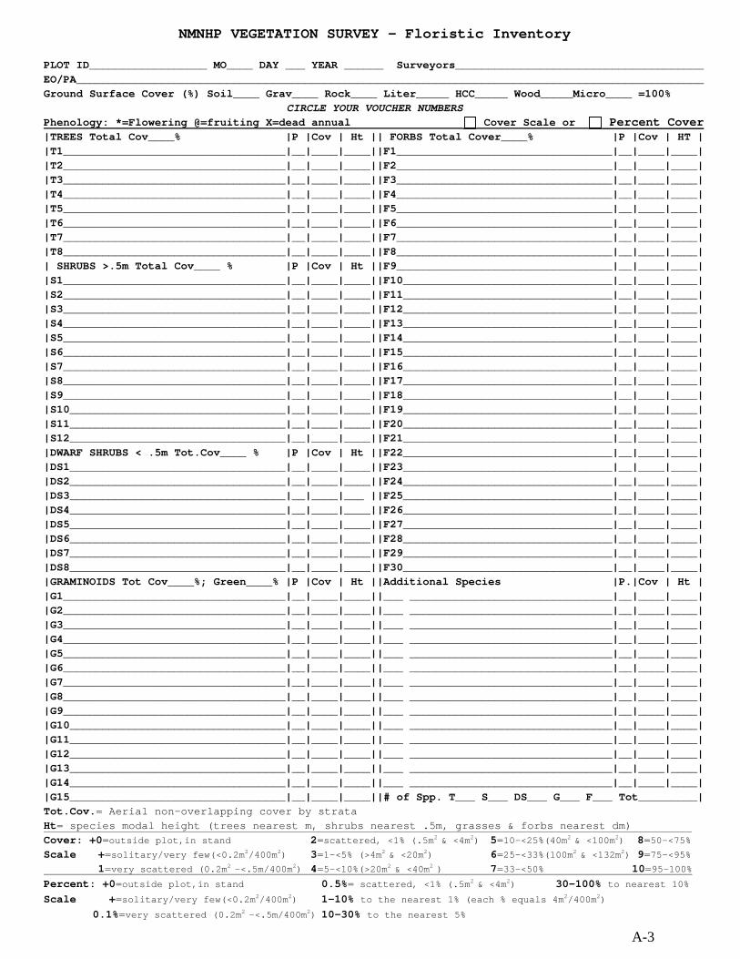
NMNHP VEGETATION SURVEY - Floristic Inventory PLOT ID__________________ MO____ DAY ___ YEAR ______ Surveyors______________________________________ EO/PA________________________________________________________________________________________________ Ground Surface Cover (%) Soil____ Grav____ Rock____ Liter_____ HCC_____ Wood_____Micro____ =100%
CIRCLE YOUR VOUCHER NUMBERS Phenology: *=Flowering @=fruiting X=dead annual Cover Scale or Percent Cover |TREES Total Cov____% |P |Cov | Ht || FORBS Total Cover____% |P |Cov | HT | |T1__________________________________|__|____|____||F1_________________________________|__|____|____| |T2__________________________________|__|____|____||F2_________________________________|__|____|____| |T3__________________________________|__|____|____||F3_________________________________|__|____|____| |T4__________________________________|__|____|____||F4_________________________________|__|____|____| |T5__________________________________|__|____|____||F5_________________________________|__|____|____| |T6__________________________________|__|____|____||F6_________________________________|__|____|____| |T7__________________________________|__|____|____||F7_________________________________|__|____|____| |T8__________________________________|__|____|____||F8_________________________________|__|____|____| | SHRUBS >.5m Total Cov____ % |P |Cov | Ht ||F9_________________________________|__|____|____| |S1__________________________________|__|____|____||F10________________________________|__|____|____| |S2__________________________________|__|____|____||F11________________________________|__|____|____| |S3__________________________________|__|____|____||F12________________________________|__|____|____| |S4__________________________________|__|____|____||F13________________________________|__|____|____| |S5__________________________________|__|____|____||F14________________________________|__|____|____| |S6__________________________________|__|____|____||F15________________________________|__|____|____| |S7__________________________________|__|____|____||F16________________________________|__|____|____| |S8__________________________________|__|____|____||F17________________________________|__|____|____| |S9__________________________________|__|____|____||F18________________________________|__|____|____| |S10_________________________________|__|____|____||F19________________________________|__|____|____| |S11_________________________________|__|____|____||F20________________________________|__|____|____| |S12_________________________________|__|____|____||F21________________________________|__|____|____| |DWARF SHRUBS < .5m Tot.Cov____ % |P |Cov | Ht ||F22________________________________|__|____|____| |DS1_________________________________|__|____|____||F23________________________________|__|____|____| |DS2_________________________________|__|____|____||F24________________________________|__|____|____| |DS3_________________________________|__|____|___ ||F25________________________________|__|____|____| |DS4_________________________________|__|____|____||F26________________________________|__|____|____| |DS5_________________________________|__|____|____||F27________________________________|__|____|____| |DS6_________________________________|__|____|____||F28________________________________|__|____|____| |DS7_________________________________|__|____|____||F29________________________________|__|____|____| |DS8_________________________________|__|____|____||F30________________________________|__|____|____| |GRAMINOIDS Tot Cov____%; Green____% |P |Cov | Ht ||Additional Species |P.|Cov | Ht | |G1__________________________________|__|____|____||___ _______________________________|__|____|____| |G2__________________________________|__|____|____||___ _______________________________|__|____|____| |G3__________________________________|__|____|____||___ _______________________________|__|____|____| |G4__________________________________|__|____|____||___ _______________________________|__|____|____| |G5__________________________________|__|____|____||___ _______________________________|__|____|____| |G6__________________________________|__|____|____||___ _______________________________|__|____|____| |G7__________________________________|__|____|____||___ _______________________________|__|____|____| |G8__________________________________|__|____|____||___ _______________________________|__|____|____| |G9__________________________________|__|____|____||___ _______________________________|__|____|____| |G10_________________________________|__|____|____||___ _______________________________|__|____|____| |G11_________________________________|__|____|____||___ _______________________________|__|____|____| |G12_________________________________|__|____|____||___ _______________________________|__|____|____| |G13_________________________________|__|____|____||___ _______________________________|__|____|____| |G14_________________________________|__|____|____||___ _______________________________|__|____|____| |G15_________________________________|__|____|____||# of Spp. T___ S___ DS___ G___ F___ Tot_________| Tot.Cov.= Aerial non-overlapping cover by strata Ht= species modal height (trees nearest m, shrubs nearest .5m, grasses & forbs nearest dm) Cover: +0=outside plot,in stand 2=scattered, <1% (.5m2 & <4m2) 5=10-<25%(40m2 & <100m2) 8=50-<75% Scale +=solitary/very few(<0.2m2/400m2) 3=1-<5% (>4m2 & <20m2) 6=25-<33%(100m2 & <132m2) 9=75-<95% 1=very scattered (0.2m2 -<.5m/400m2) 4=5-<10%(>20m2 & <40m2 ) 7=33-<50% 10=95-100% Percent: +0=outside plot,in stand 0.5%= scattered, <1% (.5m2 & <4m2) 30-100% to nearest 10% Scale +=solitary/very few(<0.2m2/400m2) 1-10% to the nearest 1% (each % equals 4m2/400m2) 0.1%=very scattered (0.2m2 -<.5m/400m2) 10-30% to the nearest 5%
A-3

NMNHP Vegetation Survey - Transect Point Intercept Form PLOTID__________________________ Surveyors __________________Date___________________ Line Length__________ Total # of Pts/Line __________________ Read Interval __________________ Reader: Reader: SUMMARY Line 1 – Start Pt: Line 2 – Start Pt:
Code Canopy Top K
Basal K
Canopy Top K
Basal K
Tot Canopy
% Canopy
Tot BA
% BA
LITTER
WOOD
MICROPHY
SOIL
GRAVEL
ROCK
TOTAL
A-4

Plot
#__
____
____
____
Dat
e
Val
les C
alde
ra N
atio
nal P
rese
rve
Tre
e In
vent
ory
Form
Spec
ies
Cod
e 0-
2”
<4.5
’ 0-
2”
>4.5
’ 2-
4”
4-
6”6-
8”8-
10”
10-1
2”12
-14”
14-1
6”16
-18”
18-2
0”>2
0”
Stum
p Sn
ag
Tree
Sp
ecie
s D
BH
D
CH
Cor
eA
ge
Tree
H
eigh
t C
omm
ent
Tree
Spec
ies
DB
H
D
CH
Cor
eA
ge
Tree
H
eigh
t C
omm
ent
A-5

Element Occurrence Condition Evaluation -- NMNHP JULY 2001 PLOT ID __________________ Survey Site Name____________________________Dates_________________ Evaluator ___________________________ Evaluation Time Brief (<5 min) Moderate (5-30 min) In depth Condition NA A Rank B Rank C Rank D Rank
Succession Stage Old Growth Late Seral Mid Seral Early Seral Microphytic Crusts
Well-established in protected areas and intersspaces
Present in protected areas; minor in interspaces
Disrupted; found only in protected areas
Severely disrupted; absent or rare.
Herbaceous Litter Status
Significant, even accumulation over multiple growing seasons; multiple stages of decomposition (>4cm)
Moderate, patchy accumulation; most stages of decomposition present (2-4 cm)
Litter largely absent; majority of litter depth and % cover attributed to dead basal vegetation (1-2 cm)
Absent or fould only the lee of obstructions (<1cm)
Erosion Minimal; no excessive soil movement or litter movement; erosion features rare or absent.
Slight; flow patterns stable; rills muted; active pedestals uncommon; vegetation present to stabilize slopes.
Moderate; surface flw cuts common and interconnected; rills distinct; active pedestals with occasional exposed roots
Severe; surface flw patterns extensive and unstable; rills well-defined; pedestals and exposed plant roots common; active down cutting.
Streambank Conditions
Streambanks well-vegetated and stable.
Streambanks mostly vegetated and stable.
Many streambanks unstable and poorly vegetated.
Most streambanks unstable and poorly-vegetated.
Comments:
Logging History None second growth >100 yrs
50-100 yrs ago Date________________
25- 50 years ago Date____________________
<25 years ago Date____________________
Logging Tytpe None Light Selective (5-25% removal)
Moderate Selective 25%-50% 50%-75%
Shelterwood/clearcut (>75% removal)
Logging Method None Helicopter High-Lead Tractor Forest Fire Fuel loads
Light fuel loads; little or no fire potential.
Greater than normal fuel loads; possible fire potential.
Moderate fuel loads representing a definite fire potential.
Excessive fuel loads, catastrophic element-removing fire likely.
Fire Evidence Recent fire evidence (<10 Yr)
fire evidence (10-50 yr) fire evidence (50 yr-100 yr) fire evidence (>100 years) No fire Evidence
Comments:
Agriculture Untilled Very old field (>100 yr) Old Field (10-100 yr) Recent (<10 yr) Livestock Use None Light; 5-25% cropping;
no trails; little sign Moderate 25%- 75% cropping;
Some trails present; some sign Heavy >75% cropping; many
trails; heavy sign Comments:
Wildlife Use None Light; 5-25% cropping; no trails; little sign
Moderate Some trails present; some sign 25%- 50% cropping
50-75 cropping
Heavy >75% cropping; many trails; heavy sign
Praire Dogs Towns
Very large active town Moderate, active town Small active town No town or inactive
Comments:
Parasites and Disease
No detrimental parasitic species or evidence of disease.
Few scattered parasites, limited disease indications.
Moderate parasite infestation or disease indications.
Intense parasite infestation or disease indications
Comments:
Vehicle Use (Incl. ORVs)
None – no roads Little use –roads and trails unused
moderate – active roads and trails Heavy - many active roads and trails
Comments:
Contaminants No effects from toxic contaminants
Contaminants known to be or have been present, but effects appear minimal.
Contaminants known in the occurrence, with minor effects on species diversity, use and management .
Contaminants known in the occurrence, significant effect on species diversity, and major effects on use and management .
Comments:
A-6
APPENDIX B
Plant Species List
Plant species found on the VCNP as part of the vegetation survey by the NMNHP in 2001 and 2002. The two tables that follow are the same except for th eordering of species. Table B-1 is ordered by liform category then by scientific name. Table B-2 is ordered by lifeform then common name. Lifeform categories are: 1 = trees greater than 3 m; 2 = tall shrubs 0.5 to 3 m; 2.5 = woody sub-shrubs less than 0.5 m; 3 = grasses and graminoids (rushes, sedges, etc.), and 4 = herbaceous forbs. The scientific, common and family names, and wetland status follow the conventions of the USDA-NRCS (2003) PLANTS database as accessed on line at http://plants.usda.gov on February 8, 2003. “Species code” refers to the NMNHP seven-letter acronym in its database, and “Kartesz Symbol” refers to the five-letter acronym in the PLANTS database. “H” indicates if the species is referenced on the Hartman (2002) checklist for the VCNP. The “Comments” primarily refer to differences from Hartman (2002).
B-1

App
endi
x B
Tabl
e B
-1.
Plan
t spe
cies
foun
d on
the
VC
NP
as p
art o
f the
veg
etat
ion
surv
ey b
y th
e N
MN
HP
in 2
001
and
2002
ord
ered
by
lifef
orm
and
scie
ntifi
c na
me.
LF
Spe
cies
Nam
e C
OM
NA
ME
Fam
ily
Wet
land
Sta
tus
Spec
ies C
odeK
arte
sz S
ymbo
l H
Com
men
ts
1 A
bies
con
colo
r w
hite
fir
Pina
ceae
N
I (FA
C)
AB
ICO
N
AB
CO
x
1
Abi
es la
sioc
arpa
var
. ariz
onic
a su
balp
ine
fir
Pina
ceae
FA
CU
+ A
BIL
ASA
A
BLA
A
x H
artm
an u
ses:
Abi
es a
rizon
ica
1
Ace
r gla
brum
R
ocky
Mou
ntai
n m
aple
Ace
race
ae
FAC
(FA
CW
) A
CEG
LA
AC
GL
x H
artm
an sp
ecifi
es: v
ar. g
labr
um
1 A
lnus
inca
na ss
p. te
nuifo
lia
thin
leaf
ald
erB
etul
acea
e
NI (
OB
L)A
LNIN
CT
ALI
NT
x H
artm
an u
ses:
Aln
us in
cana
var
. occ
iden
talis
1
Juni
peru
s mon
ospe
rma
ones
eed
juni
per
Cup
ress
acea
e N
I (U
PL)
JUN
MO
N
JUM
O
1Ju
nipe
rus s
copu
loru
mR
ocky
Mou
ntai
n ju
nipe
r C
upre
ssac
eae
NI (
UPL
) JU
NSC
O
JUSC
2 x
1
Pice
a en
gelm
anni
i En
gelm
ann'
s spr
uce
Pina
ceae
FA
C-
PIC
ENG
PI
EN
x H
artm
an sp
ecifi
es: v
ar. e
ngel
man
nii
1 Pi
cea
pung
ens
blue
spru
ce
Pina
ceae
FA
C
PIC
PUN
PI
PU
x
1 Pi
nus e
dulis
pi
nyon
pin
e Pi
nace
ae
NI (
UPL
) PI
NED
U
PIED
x
1
Pinu
s fle
xilis
lim
ber p
ine
Pina
ceae
PIN
FLE
PIFL
2 x
1
Pinu
s pon
dero
sa
pond
eros
a pi
ne
Pina
ceae
N
I (FA
CU
) PI
NPO
N
PIPO
x
Har
tman
spec
ifies
: var
. sco
pulo
rum
1
Popu
lus t
rem
uloi
des
quak
ing
aspe
n Sa
licac
eae
FAC
U (F
AC
) PO
PTR
E PO
TR5
x
1 Ps
eudo
tsug
a m
enzi
esii
Dou
glas
fir
Pina
ceae
N
I (FA
C)
PSEM
EN
PSM
E x
Har
tman
spec
ifies
: var
. gla
uca
1
Que
rcus
gam
belii
G
ambe
l's o
ak
Faga
ceae
N
I (U
PL)
QU
EGA
M
QU
GA
x
1
Rob
inia
neo
mex
ican
a N
ew M
exic
o lo
cust
Fa
bace
ae
NI (
FAC
U)
RO
BN
EO
RO
NE
x H
artm
an sp
ecifi
es: v
ar. n
eom
exic
ana
2 A
mel
anch
ier p
umila
dw
arf s
ervi
cebe
rry
Ros
acea
e
AM
EPU
M
AM
PU5
x H
artm
an u
ses:
Am
elan
chie
r aln
ifolia
var
. pum
ila
2 B
erbe
ris fe
ndle
ri C
olor
ado
barb
erry
B
erbe
ridac
eae
BER
FEN
B
EFE
x
2B
ricke
llia
calif
orni
caC
alifo
rnia
bric
kellb
ush
Ast
erac
eae
FAC
U+
BR
ICA
LB
RC
A3
x 2
Bric
kelli
a fe
ndle
ri Fe
ndle
r's b
ricke
llbus
h A
ster
acea
e
BR
IFEN
B
RFE
x
2
Cea
noth
us fe
ndle
ri Fe
ndle
r's c
eano
thus
R
ham
nace
ae
NI (
UPL
) C
EAFE
N
CEF
E x
2
Cer
coca
rpus
mon
tanu
s m
ount
ain
mah
ogan
y R
osac
eae
NI (
UPL
) C
ERM
ON
C
EMO
2
2
Hol
odis
cus d
umos
us
rock
spire
a R
osac
eae
NI (
UPL
) H
OLD
UM
H
OD
U
x H
artm
an sp
ecifi
es: v
ar. d
umos
us
2 Ja
mes
ia a
mer
ican
a cl
iffbu
sh
Hyd
rang
eace
ae
JA
MA
ME
JAA
M
x H
artm
an sp
ecifi
es: v
ar. a
mer
ican
a 2
Juni
peru
s com
mun
is
com
mon
juni
per
Cup
ress
acea
e N
I (U
PL)
JUN
CO
M
JUC
O6
x H
artm
an sp
ecifi
es: v
ar. d
epre
ssa
2
Loni
cera
invo
lucr
ata
twin
berr
y ho
neys
uckl
e
Cap
rifol
iace
ae
FA
CU
(FA
CW
)
LON
INV
LO
IN5
2Pe
ntap
hyllo
ides
flor
ibun
dash
rubb
y ci
nque
foil
Ros
acea
eFA
CW
-PE
NFL
OPE
FL15
x H
artm
an u
ses:
Pot
entil
la fr
utic
osa
2 Ph
ilade
lphu
s mic
roph
yllu
s lit
tlele
af m
ocko
rang
e H
ydra
ngea
ceae
PH
IMIC
PH
MI4
x
2
Phys
ocar
pus m
onog
ynus
m
ount
ain
nine
bark
Ros
acea
eFA
CU
PHY
MO
N
PHM
O4
x 2
Prun
us v
irgin
iana
co
mm
on c
hoke
cher
ry
Ros
acea
e FA
C (F
AC
W)
PRU
VIR
PR
VI
x H
artm
an sp
ecifi
es: v
ar. m
elan
ocar
pa
2 R
ibes
cer
eum
w
ax c
urra
nt
Gro
ssul
aria
ceae
N
I (FA
C)
RIB
CER
R
ICE
x
2 R
ibes
lept
anth
um
trum
pet g
oose
berr
y G
ross
ular
iace
ae
NI (
FAC
) R
IBLE
P R
ILE
x
2 R
osa
woo
dsii
Woo
ds' r
ose
Ros
acea
e
RO
SWO
O
RO
WO
Har
tman
has
Ros
a nu
tkan
a (n
ot a
syno
nym
) 2
Rub
us id
aeus
R
ed R
aspb
erry
Ros
acea
e
RU
BID
A
RU
ID
x
2R
ubus
par
viflo
rus
thim
bleb
erry
Ros
acea
e N
I (FA
C)
RU
BPA
R
RU
PA
x
2 Sa
lix b
ebbi
ana
Beb
b w
illow
Sa
licac
eae
FAC
W
SALB
EB
SAB
E2
x
B-2

App
endi
x B
Tabl
e B
-1.
Plan
t spe
cies
foun
d on
the
VC
NP
as p
art o
f the
veg
etat
ion
surv
ey b
y th
e N
MN
HP
in 2
001
and
2002
ord
ered
by
lifef
orm
and
scie
ntifi
c na
me.
LF
Spe
cies
Nam
e C
OM
NA
ME
Fam
ily
Wet
land
Sta
tus
Spec
ies C
odeK
arte
sz S
ymbo
l H
Com
men
ts
2 Sa
mbu
cus r
acem
osa
scar
let e
lder
berr
y C
aprif
olia
ceae
FA
CU
(FA
CW
)SA
MR
AC
SA
RA
2 x
Har
tman
spec
ifies
: var
. mic
robo
trys
2 Sh
ephe
rdia
can
aden
sis
russ
et b
uffa
lobe
rry
Elae
agna
ceae
SHEC
AN
SH
CA
2
Sym
phor
icar
pos o
reop
hilu
sw
hortl
elea
f sno
wbe
rry
Cap
rifol
iace
ae
NI (
UPL
) SY
MO
RE
SYO
R2
2 Y
ucca
bac
cata
ba
nana
yuc
ca
Aga
vace
ae
Y
UC
BA
C
YU
BA
x
2.
5 A
rcto
stap
hylo
s uva
-urs
i ki
nnik
inni
ck
Eric
acea
e
AR
CU
VA
A
RU
V
x H
artm
an sp
ecifi
es: v
ar. a
deno
trich
a
2.5
Arte
mis
ia fr
igid
a fr
inge
d sa
gew
ort
Ast
erac
eae
NI (
FAC
U)
AR
TFR
I A
RFR
4 x
2.
5 B
etul
a pu
mila
var
. gla
ndul
ifera
bo
g bi
rch
Bet
ulac
eae
B
ETG
LA
BEP
UG
Har
tman
has
Bet
ula
occi
dent
alis
(no
t a sy
nony
m)
2.5
Echi
noce
reus
coc
cine
us
scar
let h
edge
hog
cact
us
Cac
tace
ae
EC
HC
OC
EC
CO
5
2.
5 Ec
hino
cere
us tr
iglo
chid
iatu
s ki
ngcu
p ca
ctus
C
acta
ceae
ECH
TRI
ECTR
2.
5 Es
coba
ria tu
berc
ulos
a w
hite
colu
mn
foxt
ail
cact
us
Cac
tace
ae
ES
CTU
B
ESTU
NM
NH
P vo
uche
r bei
ng c
onfir
med
2.5
Het
erot
heca
vill
osa
hairy
gol
dena
ster
A
ster
acea
e
HET
VIL
H
EVI4
x
Har
tman
spec
ifies
: var
. nan
a 2.
5 M
ahon
ia re
pens
O
rego
ngra
pe
Ber
berid
acea
e N
I (U
PL)
MA
HR
EP
MA
RE1
1 x
2.
5 Pa
xist
ima
myr
sini
tes
myr
tle b
oxle
af
Cel
astra
ceae
N
I (FA
CU
) PA
XM
YR
PA
MY
x
2.
5 Py
rola
chl
oran
tha
gree
nflo
wer
ed
win
terg
reen
Py
rola
ceae
PYR
CH
L PY
CH
x
Har
tman
use
s Eric
acea
e
2.5
Vac
cini
um m
yrtil
lus
who
rtleb
erry
Er
icac
eae
V
AC
MY
R
VA
MY
2 x
3
Agr
ostis
gig
ante
a re
dtop
Po
acea
e FA
CW
+ A
GR
GIG
A
GG
I2
3 A
gros
tis sc
abra
ro
ugh
bent
gras
s Po
acea
e
AG
RSC
A
AG
SC5
x H
artm
an sp
ecifi
es: v
ar. s
cabr
a 3
Alo
pecu
rus a
equa
lis
shor
taw
n fo
xtai
l Po
acea
e O
BL
ALO
AEQ
A
LAE
x H
artm
an sp
ecifi
es: v
ar. a
equa
lis
3B
leph
aron
euro
n tri
chol
epis
pi
ne d
rops
eed
Poac
eae
B
LETR
I B
LTR
x
3
Bou
telo
ua g
raci
lis
blue
gra
ma
Poac
eae
NI (
UPL
) B
OU
GR
A
BO
GR
2 x
Har
tman
spec
ifies
: var
. gra
cilis
3 B
rom
us a
nom
alus
no
ddin
g br
ome
Poac
eae
B
RO
AN
O
BR
AN
x
3
Bro
mus
car
inat
us
Cal
iforn
ia b
rom
e Po
acea
e N
I (FA
CU
)
BR
OC
AR
B
RC
A5
x
3 B
rom
us c
iliat
us
frin
ged
brom
ePo
acea
eFA
CB
RO
CIL
B
RC
I2x
3 C
alam
agro
stis
can
aden
sis
Can
ada
reed
gras
s Po
acea
e O
BL
CA
LCA
N
CA
CA
4 x
Har
tman
spec
ifies
: var
. can
aden
sis
3 C
alam
agro
stis
stric
ta
slim
stem
reed
gras
s Po
acea
e
CA
LSTR
C
AST
36
N
MN
HP
vouc
her b
eing
con
firm
ed
3 C
alam
agro
stis
stric
ta v
ar.
inex
pans
a no
rther
n re
edgr
ass
Poac
eae
C
ALS
TRI
NM
NH
P vo
uche
r bei
ng c
onfir
med
3 C
arex
aqu
atili
s w
ater
sedg
e C
yper
acea
e O
BL
CA
RA
QU
C
AA
Q
x H
artm
an sp
ecifi
es: v
ar. a
quat
ilis
3 C
arex
foen
ea
drys
pike
sedg
e C
yper
acea
e N
I (FA
CW
) C
AR
FOE
x
Har
tman
spec
ifies
: var
. foe
nea
3
Car
ex g
eoph
ila
Whi
te M
ount
ain
sedg
e C
yper
acea
eN
I (FA
CW
)C
AR
GEO
CA
GE
x3
Car
ex in
ops s
sp. h
elio
phila
su
n se
dge
Cyp
erac
eae
C
AR
INO
H
CA
INH
2 x
Har
tman
use
s: C
arex
pen
sylv
anic
a va
r. di
gyna
3 C
arex
lanu
gino
sa
woo
lly se
dge
Cyp
erac
eae
OB
LC
AR
LAN
CA
LA30
x3
Car
ex m
icro
pter
a sm
allw
ing
sedg
e C
yper
acea
eFA
CW
CA
RM
ICC
AM
I7x
Har
tman
spec
ifies
: var
. mic
ropt
era
3 C
arex
obt
usat
a ob
tuse
sedg
e C
yper
acea
e
CA
RO
BT
CA
OB
4
3
Car
ex o
ccid
enta
lis
wes
tern
sedg
e C
yper
acea
e N
I (FA
CW
) C
AR
OC
C
CA
OC
2 x
B-3

App
endi
x B
Tabl
e B
-1.
Plan
t spe
cies
foun
d on
the
VC
NP
as p
art o
f the
veg
etat
ion
surv
ey b
y th
e N
MN
HP
in 2
001
and
2002
ord
ered
by
lifef
orm
and
scie
ntifi
c na
me.
LF
Spe
cies
Nam
e C
OM
NA
ME
Fam
ily
Wet
land
Sta
tus
Spec
ies C
odeK
arte
sz S
ymbo
l H
Com
men
ts
3 C
arex
ross
ii R
oss'
sedg
e C
yper
acea
e
CA
RR
OS
CA
RO
5
3
Car
ex ro
stra
ta
beak
ed se
dge
Cyp
erac
eae
OB
L C
AR
RO
S2
CA
RO
6
3
Car
ex u
tricu
lata
N
orth
wes
t Ter
ritor
y se
dge
Cyp
erac
eae
C
AR
UTR
C
AU
T x
3 C
inna
latif
olia
dr
oopi
ng w
oodr
eed
Poac
eae
C
INLA
T C
ILA
2 x
3
Cyp
erus
fend
leria
nus
Fend
ler's
flat
sedg
e
Cyp
erac
eae
FAC
CY
PFEN
CY
FE2
x 3
Dan
thon
ia p
arry
i Pa
rry'
s Dan
thon
ia
Poac
eae
D
AN
PAR
D
APA
2 x
3
Des
cham
psia
ces
pito
sa
tufte
d ha
irgra
ssPo
acea
eFA
CW
-D
ESC
ES
DEC
Ex
3 El
eoch
aris
aci
cula
ris
need
le sp
iker
ush
Cyp
erac
eae
EL
EAC
I EL
AC
x
3
Eleo
char
is p
alus
tris
com
mon
spik
erus
hC
yper
acea
eO
BL
ELEP
AL
ELPA
3x
3 El
eoch
aris
qui
nque
flora
fe
wflo
wer
spik
erus
h C
yper
acea
e
ELEQ
UI
ELQ
U2
3 El
ymus
ely
moi
des
bottl
ebru
sh sq
uirr
elta
il Po
acea
e N
I (FA
CU
) EL
YEL
Y
ELEL
5 x
Har
tman
spec
ifies
: var
. bre
vifo
lius a
nd v
ar. e
lym
oide
s 3
Elym
us tr
achy
caul
us
slen
der w
heat
gras
s Po
acea
e FA
C
ELY
TRA
EL
TR7
x H
artm
an sp
ecifi
es: v
ar. t
rach
ycau
lus
3 El
ymus
trac
hyca
ulus
ssp.
su
bsec
undu
s be
arde
d w
heat
gras
s Po
acea
e
ELY
TRA
S EL
TRS
x H
artm
an u
ses:
E. t
rach
ycau
lus v
ar. a
ndin
us
3 El
ymus
x p
seud
orep
ens
fals
e qu
ackg
rass
Po
acea
e N
I (FA
C)
ELY
PSE
ELPS
3
Fest
uca
ariz
onic
a A
rizon
a fe
scue
Po
acea
e N
I (FA
CU
) FE
SAR
I FE
AR
2 x
3
Fest
uca
idah
oens
is
Idah
o fe
scue
Po
acea
e
FESI
DA
FE
ID
x H
artm
an sp
ecifi
es: v
ar. i
daho
ensi
s 3
Fest
uca
soro
ria
ravi
ne fe
scue
Po
acea
e
FESS
OR
FE
SO
x
3 Fe
stuc
a th
urbe
ri Th
urbe
r's fe
scue
Po
acea
e
FEST
HU
FE
TH
x
3G
lyce
ria b
orea
lisno
rther
n m
anna
gras
s
Poac
eae
OB
LG
LYB
OR
GLB
Ox
3 H
orde
um b
rach
yant
heru
m
mea
dow
bar
ley
Poac
eae
FAC
*H
OR
BR
A
HO
BR
2x
3 H
orde
um ju
batu
m
foxt
ail b
arle
y Po
acea
e N
I (FA
C)
HO
RJU
B
HO
JU
x
3 Ju
ncus
bal
ticus
B
altic
rush
Ju
ncac
eae
OB
L JU
NB
AL
JUB
A
x H
artm
an u
ses:
Junc
us a
rctic
us v
ar. b
altic
us
3 Ju
ncus
dud
leyi
sl
ende
r rus
h Ju
ncac
eae
FAC
W-
JUN
DU
D
JUD
U2
x
3 Ju
ncus
ens
ifoliu
s sw
ordl
eaf r
ush
Junc
acea
e
JUN
ENS
JUEN
x
Har
tman
spec
ifies
: var
. mon
tanu
s 3
Junc
us in
terio
r in
land
rush
Ju
ncac
eae
JU
NIN
T JU
IN2
x
3 Ju
ncus
long
isty
lis
long
styl
e ru
sh
Junc
acea
e FA
CW
JU
NLO
N
JULO
x
3
Koe
leria
mac
rant
ha
prai
rie ju
negr
ass
Poac
eae
NI (
UPL
) K
OEM
AC
K
OM
A
x
3 Ly
curu
s set
osus
br
istly
wol
fsta
il Po
acea
e
LYC
SET
LYSE
3
NM
NH
P vo
uche
r bei
ng c
onfir
med
3
Mel
ica
porte
ri Po
rter's
mel
icgr
ass
Poac
eae
NI (
UPL
) M
ELPO
R
MEP
O
x
3 M
uhle
nber
gia
andi
na
foxt
ail m
uhly
Po
acea
e
MU
HA
ND
M
UA
N
3 M
uhle
nber
gia
filifo
rmis
pu
llup
muh
ly
Poac
eae
M
UH
FIL
3
Muh
lenb
ergi
a m
onta
na
mou
ntai
n m
uhly
Po
acea
e
MU
HM
ON
M
UM
O
x
3 M
uhle
nber
gia
richa
rdso
nis
Mat
muh
ly
Poac
eae
M
UH
RIC
M
UR
I x
3
Muh
lenb
ergi
a w
right
ii sp
ike
muh
ly
Poac
eae
M
UH
WR
I M
UW
R
x
3 O
ryzo
psis
asp
erifo
lia
roug
hlea
f ric
egra
ss
Poac
eae
O
RY
ASP
O
RA
S x
B-4

App
endi
x B
Tabl
e B
-1.
Plan
t spe
cies
foun
d on
the
VC
NP
as p
art o
f the
veg
etat
ion
surv
ey b
y th
e N
MN
HP
in 2
001
and
2002
ord
ered
by
lifef
orm
and
scie
ntifi
c na
me.
LF
Spe
cies
Nam
e C
OM
NA
ME
Fam
ily
Wet
land
Sta
tus
Spec
ies C
odeK
arte
sz S
ymbo
l H
Com
men
ts
3 O
ryzo
psis
hym
enoi
des
Indi
an ri
cegr
ass
Poac
eae
FAC
U-
OR
YH
YM
O
RH
Y
N
MN
HP
vouc
her b
eing
con
firm
ed
3 Pa
scop
yrum
smith
ii w
este
rn w
heat
gras
s Po
acea
e N
I (FA
CU
) PA
SSM
I PA
SM
x H
artm
an u
se: E
lym
us sm
ithii
3
Phle
um a
lpin
um
alpi
ne ti
mot
hy
Poac
eae
PH
LALP
PH
AL2
x
Har
tman
spec
ifies
: var
. alp
inum
3
Phle
um p
rate
nse
timot
hyPo
acea
eFA
CU
PHLP
RA
PH
PR3
x H
artm
an sp
ecifi
es: v
ar. p
rate
nse
3 Po
a co
mpr
essa
C
anad
a bl
uegr
ass
Poac
eae
FAC
U
POA
CO
M
POC
O
x
3Po
a fe
ndle
riana
mut
tong
rass
Poac
eae
NI (
FAC
U)
POA
FEN
PO
FE
x
3 Po
a pa
lust
ris
fow
l blu
egra
ss
Poac
eae
FAC
PO
APA
L PO
PA2
x
3 Po
a pr
aten
sis
Ken
tuck
y bl
uegr
ass
Poac
eae
FAC
UPO
APR
APO
PRx
3 Sc
hiza
chyr
ium
scop
ariu
m
little
blu
este
m
Poac
eae
FAC
U
SCH
SCO
SC
SC
x H
artm
an sp
ecifi
es: v
ar. s
copa
rium
3
Stip
a le
tterm
anni
i Le
tterm
an's
need
legr
ass
Poac
eae
NI (
UPL
) ST
ILET
ST
LE4
x
3 To
rrey
ochl
oa p
allid
a va
r. pa
ucifl
ora
pale
fals
e m
anna
gras
s Po
acea
e
TOR
PALP
TO
PAP3
x
3Tr
iglo
chin
pal
ustre
mar
sh a
rrow
gras
s Ju
ncag
inac
eae
OB
L TR
IPA
L TR
PA6
3 Tr
iset
um m
onta
num
R
ocky
Mou
ntai
n tri
setu
mPo
acea
e
TRIM
ON
TR
MO
5 x
Har
tman
spec
ifies
: var
. mon
tanu
m
4 A
chill
ea m
illef
oliu
m
com
mon
yar
row
A
ster
acea
e FA
CU
A
CH
MIL
A
CM
I2
x H
artm
an sp
cifie
s: v
ar. l
anul
osa
4 A
chill
ea m
illef
oliu
m v
ar.
occi
dent
alis
ya
rrow
A
ster
acea
e FA
CU
A
CH
MIL
O
AC
MIO
4 A
coni
tum
col
umbi
anum
C
olum
bian
mon
ksho
od
Ran
uncu
lace
ae
FAC
W
AC
OC
OL
AC
CO
4 x
Har
tman
spec
ifies
: var
. col
umbi
anum
4
Act
aea
rubr
a re
d ba
nebe
rry
Ran
uncu
lace
aeFA
CW
AC
TRU
BA
CR
U2
x4
Ago
seris
aur
antic
a or
ange
ago
seris
A
ster
acea
e
AG
OA
UR
A
GA
U2
x
4 A
llium
cer
nuum
no
ddin
g on
ion
Lilia
ceae
N
I (FA
CU
) A
LLC
ER
ALC
E2
x
4 A
llium
cer
nuum
var
. ne
omex
ican
um
New
Mex
ican
nod
ding
on
ion
Lilia
ceae
ALL
CER
N
ALC
EN
4 A
llium
gey
eri
Gey
er's
onio
n Li
liace
ae
NI (
FAC
U)
ALL
GEY
A
LGE
x H
artm
an sp
ecifi
es: v
ar. g
eyer
i 4
Am
aran
thus
hyb
ridus
sl
im a
mar
anth
Am
aran
thac
eae
AM
AH
YB
AM
HY
x4
And
rosa
ce se
pten
trion
alis
pygm
yflo
wer
rock
jasm
ine
Prim
ulac
eae
A
ND
SEP
AN
SE4
x
4 A
nten
naria
par
vifo
lia
smal
lleaf
pus
syto
es
Ast
erac
eae
NI (
UPL
) A
NTP
AR
A
NPA
4 x
4
Aqu
ilegi
a co
erul
ea
Col
orad
o co
lum
bine
R
anun
cula
ceae
FA
CW
- A
QU
CO
E A
QC
O
x H
artm
an sp
ecifi
es: v
ar. c
oeru
lea
4
Aqu
ilegi
a el
egan
tula
w
este
rn re
d co
lum
bine
R
anun
cula
ceae
A
QU
ELE
AQ
EL
x
4 A
rabi
s dru
mm
ondi
i D
rum
mon
d's r
ockc
ress
Bra
ssic
acea
eFA
CU
AR
AD
RU
AR
DR
x4
Ara
bis h
irsut
a ha
iry ro
ckcr
ess
Bra
ssic
acea
e
AR
AH
IR
AR
HI
4 A
rabi
s hirs
uta
var.
pycn
ocar
pa
crea
mflo
wer
rock
cres
s B
rass
icac
eae
A
RA
HIR
P A
RH
IP
x
4 A
rabi
s per
enna
ns
pere
nnia
l roc
kcre
ss
Bra
ssic
acea
e
AR
APE
R
AR
PE2
x
4A
rena
ria fe
ndle
riFe
ndle
r's sa
ndw
ort
Car
yoph
ylla
ceae
AR
EFEN
A
RFE
3
4
Are
naria
fend
leri
var.
fend
leri
Fe
ndle
r's sa
ndw
ort
Car
yoph
ylla
ceae
AR
EFEN
F A
RFE
F3
x
4A
rena
ria la
nugi
nosa
spre
adin
g sa
ndw
ort
Car
yoph
ylla
ceae
FA
CU
,FA
C
AR
ELA
N
AR
LA4
B-5
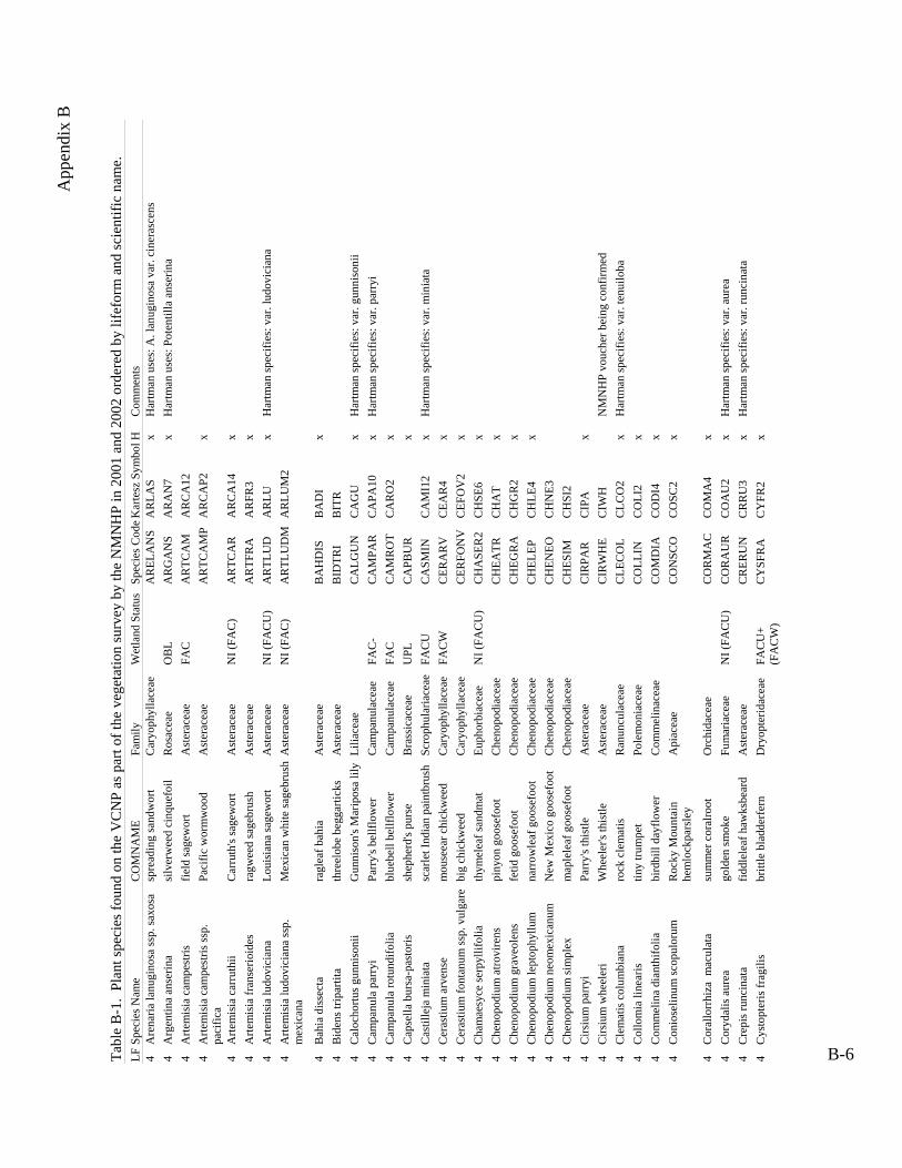
App
endi
x B
Tabl
e B
-1.
Plan
t spe
cies
foun
d on
the
VC
NP
as p
art o
f the
veg
etat
ion
surv
ey b
y th
e N
MN
HP
in 2
001
and
2002
ord
ered
by
lifef
orm
and
scie
ntifi
c na
me.
LF
Spe
cies
Nam
e C
OM
NA
ME
Fam
ily
Wet
land
Sta
tus
Spec
ies C
odeK
arte
sz S
ymbo
l H
Com
men
ts
4 A
rena
ria la
nugi
nosa
ssp.
saxo
sa
spre
adin
g sa
ndw
ort
C
aryo
phyl
lace
ae
AR
ELA
NS
AR
LAS
xH
artm
an u
ses:
A. l
anug
inos
a va
r. ci
nera
scen
s 4
Arg
entin
a an
serin
asi
lver
wee
d ci
nque
foil
Ros
acea
eO
BL
AR
GA
NS
AR
AN
7x
Har
tman
use
s: P
oten
tilla
ans
erin
a 4
Arte
mis
ia c
ampe
stris
fie
ld sa
gew
ort
Ast
erac
eae
FAC
A
RTC
AM
A
RC
A12
4
Arte
mis
ia c
ampe
stris
ssp.
pa
cific
a Pa
cific
wor
mw
ood
Ast
erac
eae
A
RTC
AM
P A
RC
AP2
x
4 A
rtem
isia
car
ruth
ii C
arru
th's
sage
wor
t A
ster
acea
e N
I (FA
C)
AR
TCA
R
AR
CA
14
x
4 A
rtem
isia
fran
serio
ides
ra
gwee
d sa
gebr
ush
Ast
erac
eae
A
RTF
RA
A
RFR
3 x
4
Arte
mis
ia lu
dovi
cian
a Lo
uisi
ana
sage
wor
t A
ster
acea
e N
I (FA
CU
) A
RTL
UD
A
RLU
x
Har
tman
spec
ifies
: var
. lud
ovic
iana
4
Arte
mis
ia lu
dovi
cian
a ss
p.
mex
ican
a M
exic
an w
hite
sage
brus
hA
ster
acea
e N
I (FA
C)
AR
TLU
DM
A
RLU
M2
4 B
ahia
dis
sect
a ra
glea
f bah
ia
Ast
erac
eae
B
AH
DIS
B
AD
I x
4
Bid
ens t
ripar
tita
thre
elob
e be
ggar
ticks
A
ster
acea
e
BID
TRI
BIT
R
4 C
aloc
hortu
s gun
niso
nii
Gun
niso
n's M
arip
osa
lily
Lilia
ceae
CA
LGU
N
CA
GU
x
Har
tman
spec
ifies
: var
. gun
niso
nii
4 C
ampa
nula
par
ryi
Parr
y's b
ellfl
ower
C
ampa
nula
ceae
FA
C-
CA
MPA
R
CA
PA10
x
Har
tman
spec
ifies
: var
. par
ryi
4
Cam
panu
la ro
tund
ifolia
bl
uebe
ll be
llflo
wer
Cam
panu
lace
ae
FAC
CA
MR
OT
CA
RO
2x
4C
apse
lla b
ursa
-pas
toris
shep
herd
's pu
rse
Bra
ssic
acea
e U
PL
CA
PBU
R
x
4
Cas
tille
ja m
inia
ta
scar
let I
ndia
n pa
intb
rush
Sc
roph
ular
iace
ae
FAC
U
CA
SMIN
C
AM
I12
x H
artm
an sp
ecifi
es: v
ar. m
inia
ta
4 C
eras
tium
arv
ense
m
ouse
ear c
hick
wee
d C
aryo
phyl
lace
aeFA
CW
CER
AR
VC
EAR
4x
4
Cer
astiu
m fo
ntan
um ss
p. v
ulga
re b
ig c
hick
wee
d C
aryo
phyl
lace
ae
C
ERFO
NV
C
EFO
V2
x
4 C
ham
aesy
ce se
rpyl
lifol
ia
thym
elea
f san
dmat
Eu
phor
biac
eae
NI (
FAC
U)
CH
ASE
R2
CH
SE6
x
4 C
heno
podi
um a
trovi
rens
pi
nyon
goo
sefo
ot
C
heno
podi
acea
e
CH
EATR
C
HA
T x
4
Che
nopo
dium
gra
veol
ens
fetid
goo
sefo
otC
heno
podi
acea
eC
HEG
RA
CH
GR
2x
4 C
heno
podi
um le
ptop
hyllu
m
narr
owle
af g
oose
foot
C
heno
podi
acea
e
CH
ELEP
C
HLE
4 x
4
Che
nopo
dium
neo
mex
ican
um
New
Mex
ico
goos
efoo
t C
heno
podi
acea
e
CH
ENEO
C
HN
E3
4 C
heno
podi
um si
mpl
ex
map
lele
af g
oose
foot
C
heno
podi
acea
e
CH
ESIM
C
HSI
2
4
Cirs
ium
par
ryi
Parr
y's t
hist
le
Ast
erac
eae
C
IRPA
R
CIP
A
x
4 C
irsiu
m w
heel
eri
Whe
eler
's th
istle
A
ster
acea
e
CIR
WH
EC
IWH
NM
NH
P vo
uche
r bei
ng c
onfir
med
4
Cle
mat
is c
olum
bian
a ro
ck c
lem
atis
R
anun
cula
ceae
CLE
CO
L C
LCO
2 x
Har
tman
spec
ifies
: var
. ten
uilo
ba
4 C
ollo
mia
line
aris
tin
y tru
mpe
t Po
lem
onia
ceae
CO
LLIN
C
OLI
2 x
4
Com
mel
ina
dian
thifo
lia
bird
bill
dayf
low
er
Com
mel
inac
eae
C
OM
DIA
C
OD
I4
x
4 C
onio
selin
um sc
opul
orum
R
ocky
Mou
ntai
n he
mlo
ckpa
rsle
y A
piac
eae
C
ON
SCO
C
OSC
2 x
4 C
oral
lorr
hiza
mac
ulat
a su
mm
er c
oral
root
O
rchi
dace
ae
C
OR
MA
C
CO
MA
4 x
4
Cor
ydal
is a
urea
go
lden
smok
e Fu
mar
iace
ae
NI (
FAC
U)
CO
RA
UR
C
OA
U2
x H
artm
an sp
ecifi
es: v
ar. a
urea
4
Cre
pis r
unci
nata
fid
dlel
eaf h
awks
bear
d
Ast
erac
eae
C
RER
UN
C
RR
U3
x H
artm
an sp
ecifi
es: v
ar. r
unci
nata
4 C
ysto
pter
is fr
agili
s br
ittle
bla
dder
fern
Dry
opte
ridac
eae
FAC
U+
(FA
CW
) C
YSF
RA
CY
FR2
x
B-6
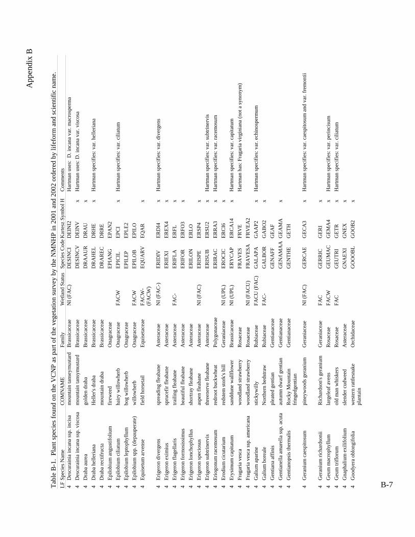
App
endi
x B
Tabl
e B
-1.
Plan
t spe
cies
foun
d on
the
VC
NP
as p
art o
f the
veg
etat
ion
surv
ey b
y th
e N
MN
HP
in 2
001
and
2002
ord
ered
by
lifef
orm
and
scie
ntifi
c na
me.
LF
Spe
cies
Nam
e C
OM
NA
ME
Fam
ily
Wet
land
Sta
tus
Spec
ies C
odeK
arte
sz S
ymbo
l H
Com
men
ts
4 D
escu
rain
ia in
cana
ssp.
inci
sa
mou
ntai
n ta
nsey
mus
tard
B
rass
icac
eae
NI (
FAC
) D
ESIN
CI
DEI
NI2
Har
tman
use
s: D
. inc
ana
var.
mac
rosp
erm
a
4 D
escu
rain
ia in
cana
ssp.
vis
cosa
m
ount
ain
tans
ymus
tard
B
rass
icac
eae
D
ESIN
CV
D
EIN
V
x H
artm
an u
ses:
D. i
ncan
a va
r. vi
scos
a
4 D
raba
aur
ea
gold
en d
raba
B
rass
icac
eae
D
RA
AU
R
DR
AU
x
4
Dra
ba h
elle
riana
H
elle
r's d
raba
B
rass
icac
eae
D
RA
HEL
D
RH
E x
Har
tman
spec
ifies
: var
. hel
leria
na
4 D
raba
rect
ifruc
ta
mou
ntai
n dr
aba
Bra
ssic
acea
e
DR
AR
EC
DR
RE
4
Epilo
bium
ang
ustif
oliu
mfir
ewee
dO
nagr
acea
e
EPIA
NG
EP
AN
2
4
Epilo
bium
cili
atum
ha
iry w
illow
herb
O
nagr
acea
e FA
CW
EP
ICIL
EP
CI
x H
artm
an sp
ecifi
es: v
ar. c
iliat
um
4 Ep
ilobi
um le
ptop
hyllu
m
bog
will
owhe
rb
Ona
grac
eae
EP
ILEP
EP
LE2
4 Ep
ilobi
um sp
p. (d
epau
pera
te)
will
owhe
rb
Ona
grac
eae
FAC
W
EPIL
OB
EP
ILO
4
Equi
setu
m a
rven
sefie
ld h
orse
tail
Equi
seta
ceae
FA
CW
-(F
AC
W)
EQU
AR
VEQ
AR
x
4 Er
iger
on d
iver
gens
sp
read
ing
fleab
ane
Ast
erac
eae
NI (
FAC
-)
ERID
IV
ERD
I4
x H
artm
an sp
ecifi
es: v
ar. d
iver
gens
4
Erig
eron
exi
miu
s sp
ruce
fir fl
eaba
ne
Ast
erac
eae
ER
IEX
I ER
EX4
x
4 Er
iger
on fl
agel
laris
tra
iling
flea
bane
Ast
erac
eae
FAC
-ER
IFLA
ER
FLx
4 Er
iger
on fo
rmos
issi
mus
be
autif
ul fl
eaba
ne
Ast
erac
eae
ER
IFO
R
ERFO
3 x
4
Erig
eron
lonc
hoph
yllu
s sh
ortra
y fle
aban
e A
ster
acea
e
ERIL
ON
ER
LO
4 Er
iger
on sp
ecio
sus
aspe
n fle
aban
e A
ster
acea
e N
I (FA
C)
ER
ISPE
ER
SP4
x
4 Er
iger
on su
btrin
ervi
s th
reen
erve
flea
bane
Ast
erac
eae
ERIS
UB
ERSU
2x
Har
tman
spec
ifies
: var
. sub
trine
rvis
4
Erio
gonu
m ra
cem
osum
re
droo
t buc
kwhe
at
Poly
gona
ceae
ERIR
AC
ER
RA
3 x
Har
tman
spec
ifies
: var
. rac
emos
um
4 Er
odiu
m c
icut
ariu
m
reds
tem
stor
k's b
ill
Ger
ania
ceae
N
I (U
PL)
ERO
CIC
ER
CI6
x
4
Erys
imum
cap
itatu
m
sand
dune
wal
lflow
er
Bra
ssic
acea
e N
I (U
PL)
ERY
CA
P ER
CA
14
x H
artm
an sp
ecifi
es: v
ar. c
apita
tum
4
Frag
aria
ves
ca
woo
dlan
d st
raw
berr
y R
osac
eae
FR
AV
ES
FRV
E
Har
tman
has
: Fra
garia
virg
inia
na (n
ot a
syno
nym
) 4
Frag
aria
ves
ca ss
p. a
mer
ican
a w
oodl
and
stra
wbe
rry
Ros
acea
e N
I (FA
CU
) FR
AV
ESA
FR
VEA
2
4
Gal
ium
apa
rine
stic
kyw
illy
Rub
iace
ae
FAC
U (F
AC
) G
ALA
PA
GA
AP2
x
Har
tman
spec
ifies
: var
. ech
inos
perm
um
4 G
aliu
m b
orea
le
Nor
ther
n be
dstra
w
Rub
iace
ae
FAC
- G
ALB
OR
G
AB
O2
x
4 G
entia
na a
ffin
is
plea
ted
gent
ian
Gen
tiana
ceae
GEN
AFF
G
EAF
4 G
entia
nella
am
arel
la ss
p. a
cuta
au
tum
n dw
arf g
entia
n G
entia
nace
ae
G
ENA
MA
AG
EAM
A
x
4 G
entia
nops
is th
erm
alis
R
ocky
Mou
ntai
n fr
inge
dgen
tian
Gen
tiana
ceae
GEN
THE
GET
H
4 G
eran
ium
cae
spito
sum
pi
neyw
oods
ger
aniu
m
Ger
ania
ceae
N
I (FA
C)
GER
CA
EG
ECA
3x
Har
tman
spec
ifies
: var
. cae
spito
sum
and
var
. fre
mon
tii
4 G
eran
ium
rich
ards
onii
Ric
hard
son'
s ger
aniu
mG
eran
iace
aeFA
CG
ERR
ICG
ERI
x4
Geu
m m
acro
phyl
lum
la
rgel
eaf a
vens
R
osac
eae
FAC
W
GEU
MA
C
GEM
A4
x H
artm
an sp
ecifi
es: v
ar. p
erin
cisu
m
4 G
eum
trifl
orum
ol
d m
an w
hisk
ers
Ros
acea
e FA
C
GEU
TRI
GET
R
x H
artm
an sp
ecifi
es: v
ar. c
iliat
um
4 G
naph
aliu
m e
xilif
oliu
m
slen
der c
udw
eed
Ast
erac
eae
G
NA
EXI
GN
EX
x
4 G
oody
era
oblo
ngifo
lia
wes
tern
rattl
esna
ke
plan
tain
O
rchi
dace
ae
G
OO
OB
L G
OO
B2
x
B-7

App
endi
x B
Tabl
e B
-1.
Plan
t spe
cies
foun
d on
the
VC
NP
as p
art o
f the
veg
etat
ion
surv
ey b
y th
e N
MN
HP
in 2
001
and
2002
ord
ered
by
lifef
orm
and
scie
ntifi
c na
me.
LF
Spe
cies
Nam
e C
OM
NA
ME
Fam
ily
Wet
land
Sta
tus
Spec
ies C
odeK
arte
sz S
ymbo
l H
Com
men
ts
4 G
oody
era
repe
ns
less
er ra
ttles
nake
pla
ntai
nO
rchi
dace
ae
G
OO
REP
G
OR
E2
x
4 H
elio
mer
is m
ultif
lora
sh
owy
gold
eney
e A
ster
acea
e N
I (U
PL)
HEL
MU
L H
EMU
3 x
Har
tman
use
s: V
igui
era
mul
tiflo
ra v
ar. m
ultif
lora
4
Hie
raci
um fe
ndle
ri ye
llow
haw
kwee
d A
ster
acea
e
HIE
FEN
H
IFE
x H
artm
an sp
ecifi
es: v
ar. f
endl
eri
4 H
umul
us lu
pulu
s var
. ne
omex
ican
us
com
mon
hop
C
anna
bace
ae
H
UM
LUPN
H
ULU
N
x
4 H
ydro
phyl
lum
fend
leri
Fend
ler's
wat
erle
af
H
ydro
phyl
lace
ae
FAC
W
HY
DFE
N
HY
FE
x H
artm
an sp
ecifi
es: v
ar. f
endl
eri
4
Hym
enop
appu
s new
berr
yiN
ewbe
rry'
shy
men
opap
pus
Ast
erac
eae
H
YM
NEW
H
YN
E x
4H
ymen
oxys
h
oope
sii
Ora
nge
snee
zew
eed
Ast
erac
eae
FAC
+ H
YM
HO
O
HY
HO
x
4 H
ymen
oxys
rich
ards
onii
ping
ue h
ymen
oxys
A
ster
acea
e N
I (U
PL)
HY
MR
IC
HY
RI
x H
artm
an sp
ecifi
es: v
ar. f
lorib
unda
4
Hyp
eric
um sc
oule
ri Sc
oule
r's S
t. Jo
hnsw
ort
Clu
siac
eae
NI (
FAC
) H
YPS
CO
H
YSC
5
4
Hyp
eric
um sc
oule
ri ss
p.
norto
niae
N
orto
n's S
t. Jo
hnsw
ort
Clu
siac
eae
H
YPS
CO
N
HY
SCN
4 Ip
omop
sis a
ggre
gata
sk
yroc
ket g
ilia
Pole
mon
iace
ae
NI (
FAC
U)
IPO
AG
G
IPA
G
x H
artm
an sp
ecifi
es: s
ubsp
. for
mos
issi
ma
4
Iris
mis
sour
iens
is
Roc
ky M
ount
ain
iris
Irid
acea
e FA
CW
IR
IMIS
IR
MI
x
4 La
ctuc
a se
rrio
la
pric
kly
lettu
ce
Ast
erac
eae
FAC
LA
CSE
R
LASE
x
4
Lapp
ula
occi
dent
alis
fla
tspi
ne st
icks
eed
Bor
agin
acea
e N
I (U
PL)
LAPO
CC
LA
OC
3 x
4
Lepi
dium
den
siflo
rum
co
mm
on p
eppe
rwee
d B
rass
icac
eae
LE
PDEN
LE
DE
4Le
pidi
um ra
mos
issi
mum
man
ybra
nche
dpe
pper
wee
d B
rass
icac
eae
LE
PRA
M
LER
A2
x H
artm
an sp
ecifi
es: v
ar. b
ourg
eaua
num
4 Li
num
lew
isii
prai
rie fl
ax
Lina
ceae
LIN
LEW
LI
LE3
x H
artm
an sp
ecifi
es: v
ar. l
ewis
ii 4
Lith
ospe
rmum
mul
tiflo
rum
m
anyf
low
ered
gro
mw
ell
Bor
agin
acea
e N
I (U
PL)
LITM
UL
LIM
U3
x
4 Lo
tus w
right
ii W
right
's de
erve
tch
Faba
ceae
N
I (FA
CU
) LO
TWR
I LO
WR
x
4
Lupi
nus a
rgen
teus
si
lver
y lu
pine
Faba
ceae
UPL
LUPA
RG
LU
AR
3x
Har
tman
spec
ifies
: var
. arg
ophy
llus a
nd v
ar. f
ulvo
mac
ulat
us
4 Ly
copo
dium
ann
otin
um
club
mos
s Ly
copo
diac
eae
LY
CA
NN
LY
AN
2
4
Mad
ia g
lom
erat
a m
ount
ain
tarw
eed
Ast
erac
eae
M
AD
GLO
M
AG
L2
x
4 M
aian
them
um ra
cem
osum
ssp.
am
plex
icau
le
feat
hery
fals
e So
lom
on's
seal
Li
liace
aeFA
CU
-(F
AC
W)
MA
IRA
CA
MA
RA
Ax
4 M
aian
them
um st
ella
tum
st
arry
fals
e So
lom
on's
seal
Li
liace
ae
FAC
U (F
AC
W)
MA
ISTE
M
AST
4
4 M
atric
aria
dis
coid
ea
disc
may
wee
d A
ster
acea
e
MA
TDIS
M
AD
I6
4 M
enth
a ar
vens
is
wild
min
t La
mia
ceae
FA
CW
M
ENA
RV
M
EAR
4 x
4
Mer
tens
ia fr
anci
scan
a Fr
anci
scan
blu
ebel
lsB
orag
inac
eae
FAC
WM
ERFR
AM
EFR
2x
4 M
erte
nsia
lanc
eola
ta
prai
rie b
lueb
ells
B
orag
inac
eae
M
ERLA
N
MEL
A3
x
4 M
imul
us g
utta
tus
seep
mon
keyf
low
er
Scro
phul
aria
ceae
O
BL
MIM
GU
T M
IGU
x
Har
tman
spec
ifies
: var
. gut
tatu
s 4
Mira
bilis
dec
ipie
ns
broa
dlea
f fou
r o'cl
ock
Nyc
tagi
nace
ae
M
IRD
EC
MID
E5
N
MN
HP
vouc
her b
eing
con
firm
ed
B-8
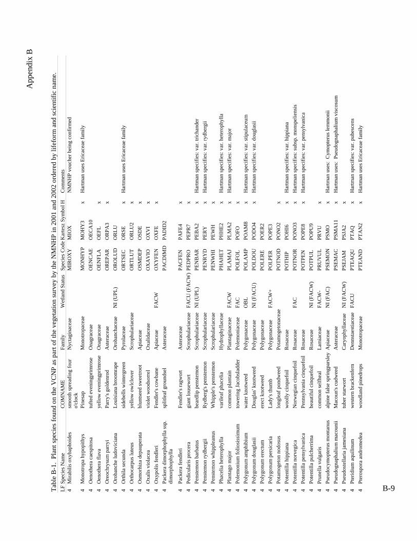
App
endi
x B
Tabl
e B
-1.
Plan
t spe
cies
foun
d on
the
VC
NP
as p
art o
f the
veg
etat
ion
surv
ey b
y th
e N
MN
HP
in 2
001
and
2002
ord
ered
by
lifef
orm
and
scie
ntifi
c na
me.
LF
Spe
cies
Nam
e C
OM
NA
ME
Fam
ily
Wet
land
Sta
tus
Spec
ies C
odeK
arte
sz S
ymbo
l H
Com
men
ts
4 M
irabi
lis o
xyba
phoi
des
smoo
th sp
read
ing
four
o'
cloc
k N
ycta
gina
ceae
MIR
OX
Y
MIO
X
N
MN
HP
vouc
her b
eing
con
firm
ed
4
Pe
nste
mon
rydb
ergi
i
Mon
otro
pa h
ypop
ithys
Pine
sap
Mon
otro
pace
ae
M
ON
HY
P M
OH
Y3
x H
artm
an u
ses E
ricac
eae
fam
ily
4 O
enot
hera
cae
spito
sa
tufte
d ev
enin
gprim
rose
O
nagr
acea
e
OEN
CA
E O
ECA
10
4 O
enot
hera
flav
a ye
llow
eve
ning
prim
rose
O
nagr
acea
e
OEN
FLA
O
EFL
x
4 O
reoc
hrys
um p
arry
i Pa
rry'
s gol
denr
od
Ast
erac
eae
O
REP
AR
O
RPA
3 x
4
Oro
banc
he lu
dovi
cian
aLo
uisi
ana
broo
mra
pe
Oro
banc
hace
ae
NI (
UPL
) O
RO
LUD
O
RLU
4
Orth
ila se
cund
a si
debe
lls w
inte
rgre
en
Pyro
lace
ae
O
RTS
EC
OR
SE
x H
artm
an u
ses E
ricac
eae
fam
ily
4 O
rthoc
arpu
s lut
eus
yello
w o
wlc
love
r Sc
roph
ular
iace
ae
O
RTL
UT
OR
LU2
x
4 O
smor
hiza
dep
aupe
rata
bl
unts
eed
swee
troot
A
piac
eae
O
SMD
EP
OSD
E x
4
Oxa
lis v
iola
cea
viol
et w
oods
orre
l O
xalid
acea
e
OX
AV
IO
OX
VI
x
4 O
xypo
lis fe
ndle
ri Fe
ndle
r's c
owba
neA
piac
eae
FAC
WO
XY
FEN
O
XFE
x 4
Pack
era
dim
orph
ophy
lla ss
p.
dim
orph
ophy
lla
split
leaf
gro
unds
el
Ast
erac
eae
PA
CD
IMD
PA
DID
2
4 Pa
cker
a fe
ndle
ri Fe
ndle
r's ra
gwor
t A
ster
acea
e
PAC
FEN
PA
FE4
x
4 Pe
dicu
laris
pro
cera
gi
ant l
ouse
wor
t Sc
roph
ular
iace
ae
FAC
U (F
AC
W)
PE
DPR
O
PEPR
7 x
4
Pens
tem
on b
arba
tus
bear
dlip
pen
stem
onSc
roph
ular
iace
ae
NI (
UPL
)PE
NB
AR
PEB
A2
x H
artm
an sp
ecifi
es: v
ar. t
richa
nder
4
Ryd
berg
's pe
nste
mon
Sc
roph
ular
iace
ae
PE
NR
YD
PE
RY
x
Har
tman
spec
ifies
: var
. ryd
berg
ii 4
Pens
tem
on w
hipp
lean
us
Whi
pple
's pe
nste
mon
Sc
roph
ular
iace
ae
PE
NW
HI
PEW
H
x
4 Ph
acel
ia h
eter
ophy
lla
varil
eaf p
hace
lia
Hyd
roph
ylla
ceae
PHA
HET
PH
HE2
x
Har
tman
spec
ifies
: var
. het
erop
hylla
4
Plan
tago
maj
or
com
mon
pla
ntai
n Pl
anta
gina
ceae
FA
CW
PLA
MA
J PL
MA
2 x
Har
tman
spec
ifies
: var
. maj
or
4
Pole
mon
ium
folio
siss
imum
to
wer
ing
Jaco
bsla
dder
Pole
mon
iace
aeFA
CPO
LFO
LPO
FOx
4 Po
lygo
num
am
phib
ium
w
ater
kno
twee
d Po
lygo
nace
ae
OB
L PO
LAM
P PO
AM
8 x
Har
tman
spec
ifies
: var
. stip
ulac
eum
4
Poly
gonu
m d
ougl
asii
Dou
glas
' kno
twee
d Po
lygo
nace
ae
NI (
FAC
U)
POLD
OU
PO
DO
4 x
Har
tman
spec
ifies
: var
. dou
glas
ii 4
Poly
gonu
m e
rect
um
erec
t kno
twee
d Po
lygo
nace
ae
PO
LER
E PO
ER2
4 Po
lygo
num
per
sica
ria
Lady
's th
umb
Poly
gona
ceae
FA
CW
+ PO
LPER
PO
PE3
4 Po
tam
oget
on n
odos
us
long
leaf
pon
dwee
d Po
tam
oget
onac
eae
PO
TNO
D
PON
O2
x
4 Po
tent
illa
hipp
iana
w
oolly
cin
quef
oil
Ros
acea
e
POTH
IP
POH
I6
x H
artm
an sp
ecifi
es: v
ar. h
ippi
ana
4 Po
tent
illa
norv
egic
a N
orw
egia
n ci
nque
foil
Ros
acea
e FA
C
POTN
OR
PO
NO
3 x
Har
tman
spec
ifies
: sub
sp. m
onsp
elie
nsis
4
Pote
ntill
a pe
nsyl
vani
ca
Penn
sylv
ania
cin
quef
oil
Ros
acea
e
POTP
EN
POPE
8 x
Har
tman
spec
ifies
: var
. pen
sylv
anic
a 4
Pote
ntill
a pu
lche
rrim
a be
autif
ul c
inqu
efoi
l R
osac
eae
NI (
FAC
W)
POTP
UL
POPU
9
4
Prun
ella
vul
garis
co
mm
on se
lfhea
l La
mia
ceae
FA
CW
- PR
UV
UL
PRV
U
x
4 Ps
eudo
cym
opte
rus m
onta
nus
alpi
ne fa
lse
sprin
gpar
sley
Api
acea
e N
I (FA
C)
PSEM
ON
PS
MO
x
Har
tman
use
s: C
ymop
teru
s lem
mon
ii 4
Pseu
dogn
apha
lium
mac
ouni
i M
acou
n's c
udw
eed
Ast
erac
eae
PS
EMA
C
PSM
A11
x
Har
tman
use
s: P
seud
ogna
phal
ium
vis
cosu
m
4 Ps
eudo
stel
laria
jam
esia
na
tube
r sta
rwor
t C
aryo
phyl
lace
ae
NI (
FAC
W)
PSEJ
AM
PS
JA2
x
4 Pt
erid
ium
aqu
ilinu
m
wes
tern
bra
cken
fern
D
enns
taes
tiace
ae
FAC
U
PTEA
QU
PT
AQ
x
Har
tman
spec
ifies
: var
. pub
esce
ns
4Pt
eros
pora
and
rom
edea
woo
dlan
d pi
nedr
ops
Mon
otro
pace
ae
PT
EAN
D
PTA
N2
x H
artm
an u
ses E
ricac
eae
fam
ily
B-9

App
endi
x B
Tabl
e B
-1.
Plan
t spe
cies
foun
d on
the
VC
NP
as p
art o
f the
veg
etat
ion
surv
ey b
y th
e N
MN
HP
in 2
001
and
2002
ord
ered
by
lifef
orm
and
scie
ntifi
c na
me.
LF
Spe
cies
Nam
e C
OM
NA
ME
Fam
ily
Wet
land
Sta
tus
Spec
ies C
odeK
arte
sz S
ymbo
l H
Com
men
ts
4 R
anun
culu
s car
diop
hyllu
s he
artle
af b
utte
rcup
R
anun
cula
ceae
O
BL
RA
NC
AR
R
AC
A4
x
4 R
anun
culu
s lon
giro
stris
lo
ngbe
ak b
utte
rcup
R
anun
cula
ceae
RA
NLO
N
RA
LO2
4 R
anun
culu
s spp
. (de
paup
erat
e)
butte
rcup
R
anun
cula
ceae
FA
CW
R
AN
UN
C
RA
NU
N
4 R
orip
pa c
urvi
pes
blun
tleaf
yel
low
cres
s B
rass
icac
eae
R
OR
CU
R
RO
CU
2
4
Ror
ippa
nas
turti
um-a
quat
icum
w
ater
cres
s B
rass
icac
eae
OB
L R
OR
NA
S R
ON
A2
4 R
orip
pa sp
haer
ocar
pa
roun
dfru
it ye
llow
cres
s
Bra
ssic
acea
eO
BL
RO
RSP
HR
OSP
4x
4 R
udbe
ckia
hirt
a bl
ack-
eyed
Sus
an
Ast
erac
eae
FAC
U
RU
DH
IR
RU
HI2
x
Har
tman
spec
ifies
: var
. pul
cher
rima
4
Rud
beck
ia la
cini
ata
cutle
af c
onef
low
er
Ast
erac
eae
FAC
W-
(FA
CW
) R
UD
LAC
R
ULA
3 x
Har
tman
spec
ifies
: var
. am
pla
4 R
umex
ace
tose
lla
com
mon
shee
p so
rrel
Po
lygo
nace
ae
FAC
W
RU
MA
CE
RU
AC
3 x
4
Rum
ex c
rispu
s cu
rly d
ock
Poly
gona
ceae
FAC
W R
UM
CR
IR
UC
Rx
4 Sa
gitta
ria c
unea
ta
arum
leaf
arr
owhe
adA
lism
atac
eae
OB
L
SAG
CU
NSA
CU
x4
Saxi
frag
a rh
ombo
idea
di
amon
dlea
f sax
ifrag
eSa
xifr
agac
eae
SAX
RH
OSA
RH
2x
4 Sc
utel
laria
dru
mm
ondi
i D
rum
mon
d's s
kullc
ap
Lam
iace
ae
SC
UD
RU
SC
DR
2
4
Sene
cio
atra
tus
tall
blac
ktip
ragw
ort
Ast
erac
eae
SE
NA
TR
SEA
T x
4
Sene
cio
bigl
oviii
no
ddin
g ra
gwor
t A
ster
acea
e N
I (U
PL)
SEN
BIG
SE
BI2
x
Har
tman
spec
ifies
: var
. big
elov
ii an
d va
r. ha
lli
4 Se
neci
o er
emop
hilu
s de
sert
grou
ndse
l A
ster
acea
e
SEN
ERE
SEER
2 x
Har
tman
spec
ifies
: var
. kin
gii
4 Se
neci
o w
ooto
nii
Woo
ton'
s rag
wor
t A
ster
acea
e N
I (FA
C)
SEN
WO
O
SEW
O
x
4 Si
dala
cea
cand
ida
whi
te c
heck
erm
allo
w
Mal
vace
ae
FAC
(FA
CW
) SI
DC
AN
SI
CA
3 x
Har
tman
spec
ifies
: var
. can
dida
4
Sile
ne d
rum
mon
dii
Dru
mm
ond'
s cam
pion
C
aryo
phyl
lace
ae
SI
LDR
U
SID
R
x H
artm
an sp
ecifi
es: v
ar. d
rum
mon
dii
4 Si
lene
scou
leri
Scou
ler's
cam
pion
C
aryo
phyl
lace
ae
SI
LSC
O
SISC
P
4
Sile
ne sc
oule
ri ss
p. p
ringl
ei
Prin
gle's
cam
pion
C
aryo
phyl
lace
ae
NI (
FAC
W)
SILS
CO
P SI
SCP
x
4 Si
syrin
chiu
m m
onta
num
m
ount
ain
blue
-eye
d gr
ass
Ir
idac
eae
FAC
W
SI
SMO
N
SIM
O2
x
4 So
lidag
o m
isso
urie
nsis
M
isso
uri g
olde
nrod
Ast
erac
eae
SOLM
ISSO
MI2
N
MN
HP
vouc
her b
eing
con
firm
ed
4 So
nchu
s asp
er
spin
y so
wth
istle
A
ster
acea
e N
I (FA
CW
) SO
NA
SP
SOA
S
NM
NH
P vo
uche
r bei
ng c
onfir
med
; Har
tman
has
S. a
rven
sis
(not
a sy
nony
m)
4 Sp
arga
nium
ang
ustif
oliu
m
narr
owle
af b
urre
ed
Spar
gani
acea
e
SPA
AN
G
SPA
N2
x
4 Sp
irant
hes r
oman
zoff
iana
ho
oded
ladi
es tr
esse
s O
rchi
dace
ae
OB
L SP
IRO
M
SPR
O
4 St
ella
ria lo
ngifo
lia
long
leaf
star
wor
t C
aryo
phyl
lace
ae
FAC
(FA
CW
) ST
ELO
N1
STLO
x
4
Sym
phyo
trich
um a
scen
dens
wes
tern
ast
er
Ast
erac
eae
SY
MA
SC
SYA
S3
x H
artm
an u
ses:
Ast
er a
scen
dens
4
Sym
phyo
trich
um fa
lcat
um v
ar.
com
mut
atum
C
lust
er a
ster
A
ster
acea
e
SYM
FALC
SY
FAC
4 Sy
mph
yotri
chum
laev
e va
r. ge
yeri
Gey
er's
aste
r A
ster
acea
e
SYM
LAEG
SY
LAG
Har
tman
use
: Ast
er la
evis
var
. lae
vis
4 Ta
raxa
cum
off
icin
ale
com
mon
dan
delio
n A
ster
acea
eFA
CU
TAR
OFF
TAO
Fx
Har
tman
has
: Tar
axac
um la
evig
atum
(not
a sy
nony
m)
4 Th
alic
trum
fend
leri
Fend
ler's
mea
dow
rue
Ran
uncu
lace
aeFA
CU
-TH
AFE
NTH
FEx
B-10

App
endi
x B
Tabl
e B
-1.
Plan
t spe
cies
foun
d on
the
VC
NP
as p
art o
f the
veg
etat
ion
surv
ey b
y th
e N
MN
HP
in 2
001
and
2002
ord
ered
by
lifef
orm
and
scie
ntifi
c na
me.
LF
Spe
cies
Nam
e C
OM
NA
ME
Fam
ily
Wet
land
Sta
tus
Spec
ies C
odeK
arte
sz S
ymbo
l H
Com
men
ts
4 Th
erm
opsi
s mon
tana
var
. m
onta
na
mou
ntai
n go
lden
bann
er
Faba
ceae
THEM
ON
MTH
MO
M3
x
4 Tr
agop
ogon
dub
ius
yello
w sa
lsify
A
ster
acea
e
TRA
DU
BTR
DU
x4
Trifo
lium
repe
ns
whi
te c
love
r Fa
bace
ae
NI (
FAC
) TR
IREP
TR
RE3
x
4
Trifo
lium
wor
msk
iold
ii co
ws c
love
r Fa
bace
ae
TR
IWO
R
TRW
O
x H
artm
an sp
ecifi
es: v
ar. a
rizon
icum
4
Urti
ca d
ioic
a st
ingi
ng n
ettle
U
rtica
ceae
N
I (FA
CW
) U
RTD
IO
UR
DI
x H
artm
an sp
ecifi
es: v
ar. p
roce
ra
4 V
erba
scum
thap
sus
com
mon
mul
lein
Sc
roph
ular
iace
ae
NI (
FAC
)
VER
THA
V
ETH
x
4
Ver
onic
a am
eric
ana
Am
eric
an sp
eedw
ell
Scro
phul
aria
ceae
OB
LV
ERA
ME
VEA
M2
x
4 V
eron
ica
pere
grin
a ss
p.
xala
pens
is
hairy
pur
slan
e sp
eedw
ell
Scro
phul
aria
ceae
VER
PER
X
VEP
EX2
x
4 V
icia
am
eric
ana
amer
ican
vet
ch
Faba
ceae
N
I (FA
CW
) V
ICA
ME
VIA
M
x H
artm
an sp
ecifi
es: v
ar. a
mer
ican
a an
d va
r. m
inor
4
Vio
la c
anad
ensi
s C
anad
ian
whi
te v
iole
t V
iola
ceae
N
I (FA
CW
) V
IOC
AN
V
ICA
4 x
4
Woo
dsia
ore
gana
O
rego
n w
oods
ia
Dry
opte
ridac
eae
W
OO
OR
E W
OO
R
x H
artm
an sp
ecifi
es: v
ar. c
athc
artia
na
4 Zi
gade
nus e
lega
ns
mou
ntai
n de
athc
amas
Li
liace
ae
ZI
GEL
E ZI
EL2
x
B-11

App
endi
x B
Tabl
e B
-2.
Plan
t spe
cies
foun
d on
the
VC
NP
as p
art o
f the
veg
etat
ion
surv
ey b
y th
e N
MN
HP
in 2
001
and
2002
ord
ered
by
lifef
orm
and
com
mon
nam
e.
LF C
OM
NA
ME
Spec
ies N
ame
Fam
ily
Wet
land
Sta
tus
Spec
ies C
odeK
arte
sz
Sym
bol
H
C
omm
ents
1 bl
ue sp
ruce
Pi
cea
pung
ens
Pina
ceae
FA
C
PIC
PUN
PI
PU
x
1 D
ougl
as fi
r Ps
eudo
tsug
a m
enzi
esii
Pina
ceae
N
I (FA
C)
PSEM
EN
PSM
E x
Har
tman
spec
ifies
: var
. gla
uca
1
Enge
lman
n's s
pruc
e Pi
cea
enge
lman
nii
Pina
ceae
FA
C-
PIC
ENG
PI
EN
x H
artm
an sp
ecifi
es: v
ar. e
ngel
man
nii
1 G
ambe
l's o
ak
Que
rcus
gam
belii
Fa
gace
ae
NI (
UPL
) Q
UEG
AM
Q
UG
A
x
1 lim
ber p
ine
Pinu
s fle
xilis
Pi
nace
ae
PI
NFL
E PI
FL2
x
1 N
ew M
exic
o lo
cust
R
obin
ia n
eom
exic
ana
Faba
ceae
N
I (FA
CU
) R
OB
NEO
R
ON
E x
Har
tman
spec
ifies
: var
. neo
mex
ican
a 1
ones
eed
juni
per
Juni
peru
s mon
ospe
rma
Cup
ress
acea
e N
I (U
PL)
JUN
MO
N
JUM
O
1 pi
nyon
pin
e Pi
nus e
dulis
Pi
nace
ae
NI (
UPL
) PI
NED
U
PIED
x
1
pond
eros
a pi
ne
Pinu
s pon
dero
sa
Pina
ceae
N
I (FA
CU
) PI
NPO
N
PIPO
x
Har
tman
spec
ifies
: var
. sco
pulo
rum
1
quak
ing
aspe
n Po
pulu
s tre
mul
oide
s Sa
licac
eae
FAC
U (F
AC
) PO
PTR
E PO
TR5
x
1 R
ocky
Mou
ntai
n ju
nipe
r Ju
nipe
rus s
copu
loru
m
Cup
ress
acea
e N
I (U
PL)
JUN
SCO
JU
SC2
x
1 R
ocky
Mou
ntai
n m
aple
A
cer g
labr
um
Ace
race
ae
FAC
(FA
CW
) A
CEG
LA
AC
GL
x H
artm
an sp
ecifi
es: v
ar. g
labr
um
1
suba
lpin
e fir
Abi
es la
sioc
arpa
var
. ar
izon
ica
Pina
ceae
FA
CU
+ A
BIL
ASA
A
BLA
A
x H
artm
an u
ses:
Abi
es a
rizon
ica
1th
inle
af a
lder
Aln
us in
cana
ssp.
te
nuifo
lia
Bet
ulac
eae
NI(
OB
L)
ALN
INC
T A
LIN
T x
Har
tman
use
s: A
lnus
inca
na v
ar. o
ccid
enta
lis
1 w
hite
fir
Abi
es c
onco
lor
Pina
ceae
N
I (FA
C)
AB
ICO
N
AB
CO
x
2
bana
na y
ucca
Y
ucca
bac
cata
A
gava
ceae
YU
CB
AC
Y
UB
A
x
2 B
ebb
will
ow
Salix
beb
bian
a Sa
licac
eae
FAC
W
SALB
EB
SAB
E2
x
2C
alifo
rnia
bric
kellb
ush
Bric
kelli
a ca
lifor
nica
A
ster
acea
e FA
CU
+ B
RIC
AL
BR
CA
3 x
2
cliff
bush
Ja
mes
ia a
mer
ican
a H
ydra
ngea
ceae
JAM
AM
E JA
AM
x
Har
tman
spec
ifies
: var
. am
eric
ana
2 C
olor
ado
barb
erry
B
erbe
ris fe
ndle
ri B
erbe
ridac
eae
B
ERFE
N
BEF
E x
2
com
mon
cho
kech
erry
Pr
unus
virg
inia
na
Ros
acea
e FA
C (F
AC
W)
PRU
VIR
PR
VI
x H
artm
an sp
ecifi
es: v
ar. m
elan
ocar
pa
2 co
mm
on ju
nipe
r Ju
nipe
rus c
omm
unis
C
upre
ssac
eae
NI (
UPL
) JU
NC
OM
JU
CO
6 x
Har
tman
spec
ifies
: var
. dep
ress
a
2 dw
arf s
ervi
cebe
rry
Am
elan
chie
r pum
ila
Ros
acea
e
AM
EPU
M
AM
PU5
x H
artm
an u
ses:
Am
elan
chie
r aln
ifolia
var
. pum
ila
2 Fe
ndle
r's b
ricke
llbus
h B
ricke
llia
fend
leri
Ast
erac
eae
B
RIF
EN
BR
FE
x
2 Fe
ndle
r's c
eano
thus
C
eano
thus
fend
leri
Rha
mna
ceae
NI (
UPL
)C
EAFE
NC
EFE
x
2lit
tlele
af m
ocko
rang
ePh
ilade
lphu
s m
icro
phyl
lus
Hyd
rang
eace
ae
PH
IMIC
PH
MI4
x
2
mou
ntai
n m
ahog
any
Cer
coca
rpus
mon
tanu
s R
osac
eae
NI (
UPL
) C
ERM
ON
C
EMO
2
2
mou
ntai
n ni
neba
rk
Phys
ocar
pus m
onog
ynus
Ros
acea
eFA
CU
PHY
MO
NPH
MO
4x
2
Red
Ras
pber
ry
Rub
us id
aeus
R
osac
eae
R
UB
IDA
R
UID
x
2
rock
spire
a H
olod
iscu
s dum
osus
R
osac
eae
NI (
UPL
) H
OLD
UM
H
OD
U
x H
artm
an sp
ecifi
es: v
ar. d
umos
us
2 ru
sset
buf
falo
berr
y Sh
ephe
rdia
can
aden
sis
Elae
agna
ceae
SHEC
AN
SH
CA
2
scar
let e
lder
berr
y Sa
mbu
cus r
acem
osa
Cap
rifol
iace
ae
FAC
U (F
AC
W)S
AM
RA
C
SAR
A2
x H
artm
an sp
ecifi
es: v
ar. m
icro
botry
s 2
shru
bby
cinq
uefo
ilPe
ntap
hyllo
ides
Ros
acea
eFA
CW
-PE
NFL
O
PEFL
15x
Har
tman
use
s: P
oten
tilla
frut
icos
a
B-12

App
endi
x B
Tabl
e B
-2.
Plan
t spe
cies
foun
d on
the
VC
NP
as p
art o
f the
veg
etat
ion
surv
ey b
y th
e N
MN
HP
in 2
001
and
2002
ord
ered
by
lifef
orm
and
com
mon
nam
e.
LF C
OM
NA
ME
Spec
ies N
ame
Fam
ily
Wet
land
Sta
tus
Spec
ies C
odeK
arte
sz
Sym
bol
H
Com
men
ts
florib
unda
2
thim
bleb
erry
Rub
us p
arvi
floru
sR
osac
eae
NI (
FAC
) R
UB
PAR
R
UPA
x
2
trum
pet g
oose
berr
y R
ibes
lept
anth
um
Gro
ssul
aria
ceae
N
I (FA
C)
RIB
LEP
RIL
E x
2
twin
berr
y ho
neys
uckl
e Lo
nice
ra in
volu
crat
a C
aprif
olia
ceae
FA
CU
(FA
CW
)LO
NIN
V
LOIN
5
2
wax
cur
rant
R
ibes
cer
eum
G
ross
ular
iace
ae
NI (
FAC
) R
IBC
ER
RIC
E x
2w
hortl
elea
f sno
wbe
rry
Sym
phor
icar
pos
oreo
philu
s C
aprif
olia
ceae
N
I (U
PL)
SYM
OR
E SY
OR
2
2
Woo
ds' r
ose
Ros
a w
oods
ii R
osac
eae
R
OSW
OO
R
OW
O
H
artm
an h
as R
osa
nutk
ana
(not
a sy
nony
m)
2.5
bog
birc
h B
etul
a pu
mila
var
. gl
andu
lifer
a B
etul
acea
e
BET
GLA
B
EPU
G
H
artm
an h
as B
etul
a oc
cide
ntal
is (
not a
syno
nym
) 2.
5 fr
inge
d sa
gew
ort
Arte
mis
ia fr
igid
a A
ster
acea
e N
I (FA
CU
) A
RTF
RI
AR
FR4
x
2.5
gree
nflo
wer
ed w
inte
rgre
en
Pyro
la c
hlor
anth
a Py
rola
ceae
PYR
CH
L PY
CH
x
Har
tman
use
s Eric
acea
e 2.
5 ha
iry g
olde
nast
er
Het
erot
heca
vill
osa
Ast
erac
eae
H
ETV
IL
HEV
I4
x H
artm
an sp
ecifi
es: v
ar. n
ana
2.5
king
cup
cact
us
Echi
noce
reus
tri
gloc
hidi
atus
Cac
tace
ae
ECH
TRI
ECTR
2.
5 ki
nnik
inni
ck
Arc
tost
aphy
los u
va-u
rsi
Eric
acea
e
AR
CU
VA
A
RU
V
x H
artm
an sp
ecifi
es: v
ar. a
deno
trich
a
2.5
myr
tle b
oxle
af
Paxi
stim
a m
yrsi
nite
s C
elas
trace
ae
NI (
FAC
U)
PAX
MY
R
PAM
Y
x
2.5
Ore
gong
rape
M
ahon
ia re
pens
B
erbe
ridac
eae
NI (
UPL
) M
AH
REP
M
AR
E11
x
2.5
scar
let h
edge
hog
cact
us
Echi
noce
reus
coc
cine
us
Cac
tace
ae
EC
HC
OC
EC
CO
5
2.
5 w
hite
colu
mn
foxt
ail c
actu
s Es
coba
ria tu
berc
ulos
a C
acta
ceae
ESC
TUB
ES
TU
N
MN
HP
vouc
her b
eing
con
firm
ed
2.5
who
rtleb
erry
V
acci
nium
myr
tillu
s Er
icac
eae
V
AC
MY
R
VA
MY
2 x
3
alpi
ne ti
mot
hy
Phle
um a
lpin
um
Poac
eae
PH
LALP
PH
AL2
x
Har
tman
spec
ifies
: var
. alp
inum
3 A
rizon
a fe
scue
Fe
stuc
a ar
izon
ica
Poac
eae
NI (
FAC
U)
FESA
RI
FEA
R2
x
3 B
altic
rush
Ju
ncus
bal
ticus
Ju
ncac
eae
OB
L JU
NB
AL
JUB
A
x H
artm
an u
ses:
Junc
us a
rctic
us v
ar. b
altic
us
3 be
aked
sedg
e C
arex
rost
rata
C
yper
acea
e O
BL
CA
RR
OS2
C
AR
O6
3be
arde
d w
heat
gras
sEl
ymus
trac
hyca
ulus
ssp.
su
bsec
undu
s Po
acea
eEL
YTR
AS
ELTR
Sx
Har
tman
use
s: E
. tra
chyc
aulu
s var
. and
inus
3
blue
gra
ma
Bou
telo
ua g
raci
lis
Poac
eae
NI (
UPL
) B
OU
GR
A
BO
GR
2 x
Har
tman
spec
ifies
: var
. gra
cilis
3 bo
ttleb
rush
squi
rrel
tail
Elym
us e
lym
oide
s Po
acea
e N
I (FA
CU
) EL
YEL
Y
ELEL
5 x
Har
tman
spec
ifies
: var
. bre
vifo
lius a
nd v
ar. e
lym
oide
s 3
bris
tly w
olfs
tail
Lycu
rus s
etos
us
Poac
eae
LY
CSE
T LY
SE3
N
MN
HP
vouc
her b
eing
con
firm
ed
3 C
alifo
rnia
bro
me
Bro
mus
car
inat
us
Poac
eae
NI (
FAC
U)
BR
OC
AR
B
RC
A5
x
3 C
anad
a bl
uegr
ass
Poa
com
pres
sa
Poac
eae
FAC
U
POA
CO
M
POC
O
x
3 C
anad
a re
edgr
ass
Cal
amag
rost
is c
anad
ensi
sPo
acea
e O
BL
CA
LCA
N
CA
CA
4 x
Har
tman
spec
ifies
: var
. can
aden
sis
3 co
mm
on sp
iker
ush
Eleo
char
is p
alus
tris
Cyp
erac
eae
OB
LEL
EPA
LEL
PA3
x3
droo
ping
woo
dree
d C
inna
latif
olia
Po
acea
e
CIN
LAT
CIL
A2
x
3 dr
yspi
ke se
dge
Car
ex fo
enea
C
yper
acea
e N
I (FA
CW
) C
AR
FOE
x
Har
tman
spec
ifies
: var
. foe
nea
3 fa
lse
quac
kgra
ss
Elym
us x
pse
udor
epen
s Po
acea
e N
I (FA
C)
ELY
PSE
ELPS
B-13

App
endi
x B
Tabl
e B
-2.
Plan
t spe
cies
foun
d on
the
VC
NP
as p
art o
f the
veg
etat
ion
surv
ey b
y th
e N
MN
HP
in 2
001
and
2002
ord
ered
by
lifef
orm
and
com
mon
nam
e.
LF C
OM
NA
ME
Spec
ies N
ame
Fam
ily
Wet
land
Sta
tus
Spec
ies C
odeK
arte
sz
Sym
bol
H
Com
men
ts
3 Fe
ndle
r's fl
atse
dge
Cyp
erus
fend
leria
nus
Cyp
erac
eae
FAC
CY
PFEN
CY
FE2
x3
few
flow
er sp
iker
ush
Eleo
char
is q
uinq
ueflo
ra
Cyp
erac
eae
EL
EQU
I EL
QU
2
3
fow
l blu
egra
ss
Poa
palu
stris
Po
acea
e FA
C
POA
PAL
POPA
2 x
3
foxt
ail b
arle
y H
orde
um ju
batu
m
Poac
eae
NI (
FAC
) H
OR
JUB
H
OJU
x
3
foxt
ail m
uhly
M
uhle
nber
gia
andi
na
Poac
eae
M
UH
AN
D
MU
AN
3
frin
ged
brom
e B
rom
us c
iliat
us
Poac
eae
FAC
BR
OC
IL
BR
CI2
x 3
Idah
o fe
scue
Fe
stuc
a id
ahoe
nsis
Po
acea
e
FESI
DA
FE
ID
x H
artm
an sp
ecifi
es: v
ar. i
daho
ensi
s 3
Indi
an ri
cegr
ass
Ory
zops
is h
ymen
oide
s Po
acea
e FA
CU
- O
RY
HY
M
OR
HY
NM
NH
P vo
uche
r bei
ng c
onfir
med
3
inla
nd ru
sh
Junc
us in
terio
r Ju
ncac
eae
JU
NIN
T JU
IN2
x
3 K
entu
cky
blue
gras
s Po
a pr
aten
sis
Poac
eae
FAC
UPO
APR
A
POPR
x3
Lette
rman
's ne
edle
gras
s St
ipa
lette
rman
nii
Poac
eae
NI (
UPL
) ST
ILET
ST
LE4
x
3 lit
tle b
lues
tem
Sc
hiza
chyr
ium
scop
ariu
mPo
acea
e FA
CU
SC
HSC
O
SCSC
x
Har
tman
spec
ifies
: var
. sco
pariu
m
3 lo
ngst
yle
rush
Ju
ncus
long
isty
lis
Junc
acea
e FA
CW
JU
NLO
N
JULO
x
3m
arsh
arr
owgr
ass
Trig
loch
in p
alus
tre
mar
sh a
rrow
gras
s Ju
ncag
inac
eae
OB
L TR
IPA
L TR
PA6
3M
at m
uhly
Muh
lenb
ergi
a ric
hard
soni
s Po
acea
e
MU
HR
IC
MU
RI
x
3m
eado
w b
arle
yH
orde
um
brac
hyan
ther
umPo
acea
eFA
C*
HO
RB
RA
H
OB
R2
x 3
mou
ntai
n m
uhly
Muh
lenb
ergi
a m
onta
na
Po
acea
e
MU
HM
ON
MU
MO
x
3m
utto
ngra
ssPo
a fe
ndle
riana
Poac
eae
NI (
FAC
U)
POA
FEN
POFE
x3
need
le sp
iker
ush
Eleo
char
is a
cicu
laris
C
yper
acea
e
ELEA
CI
ELA
C
x
3 no
ddin
g br
ome
Bro
mus
ano
mal
us
Poac
eae
B
RO
AN
O
BR
AN
x
3
north
ern
man
nagr
ass
Gly
ceria
bor
ealis
Po
acea
e O
BL
GLY
BO
R
GLB
O
x
3no
rther
n re
edgr
ass
Cal
amag
rost
is st
ricta
var
. in
expa
nsa
Poac
eae
C
ALS
TRI
NM
NH
P vo
uche
r bei
ng c
onfir
med
3
Nor
thw
est T
errit
ory
sedg
e C
arex
utri
cula
ta
Cyp
erac
eae
C
AR
UTR
C
AU
T x
3
obtu
se se
dge
Car
ex o
btus
ata
Cyp
erac
eae
C
AR
OB
T C
AO
B4
3 pa
le fa
lse
man
nagr
ass
Torr
eyoc
hloa
pal
lida
var.
pauc
iflor
a Po
acea
e
TOR
PALP
TO
PAP3
x
3
Parr
y's D
anth
onia
D
anth
onia
par
ryi
Poac
eae
D
AN
PAR
D
APA
2 x
3pi
ne d
rops
eed
Ble
phar
oneu
ron
trich
olep
is
Poac
eae
B
LETR
I B
LTR
x
3
Porte
r's m
elic
gras
s M
elic
a po
rteri
Poac
eae
NI (
UPL
) M
ELPO
R
MEP
O
x
3 pr
airie
june
gras
s K
oele
ria m
acra
ntha
Po
acea
e N
I (U
PL)
KO
EMA
C
KO
MA
x
3
pullu
p m
uhly
M
uhle
nber
gia
filifo
rmis
Po
acea
e
MU
HFI
L
3 ra
vine
fesc
ue
Fest
uca
soro
ria
Poac
eae
FE
SSO
R
FESO
x
B-14
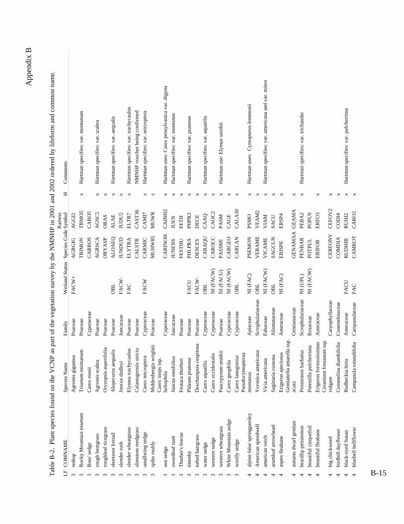
App
endi
x B
Tabl
e B
-2.
Plan
t spe
cies
foun
d on
the
VC
NP
as p
art o
f the
veg
etat
ion
surv
ey b
y th
e N
MN
HP
in 2
001
and
2002
ord
ered
by
lifef
orm
and
com
mon
nam
e.
LF C
OM
NA
ME
Spec
ies N
ame
Fam
ily
Wet
land
Sta
tus
Spec
ies C
odeK
arte
sz
Sym
bol
H
Com
men
ts
3 re
dtop
A
gros
tis g
igan
tea
Poac
eae
FAC
W+
AG
GI2
3
Roc
ky M
ount
ain
trise
tum
Tr
iset
um m
onta
num
Po
acea
e
TRM
O5
x H
artm
an sp
ecifi
es: v
ar. m
onta
num
3
Ros
s' se
dge
Car
ex ro
ssii
Cyp
erac
eae
C
AR
O5
3 ro
ugh
bent
gras
s A
gros
tis sc
abra
Po
acea
e
AG
SC5
x H
artm
an sp
ecifi
es: v
ar. s
cabr
a 3
roug
hlea
f ric
egra
ss
Ory
zops
is a
sper
ifolia
Po
acea
e
OR
AS
x
3 sh
orta
wn
foxt
ail
Alo
pecu
rus a
equa
lis
Poac
eae
OB
L A
LAE
x H
artm
an sp
ecifi
es: v
ar. a
equa
lis
3 sl
ende
r rus
h Ju
ncus
dud
leyi
Ju
ncac
eae
FAC
W-
JUD
U2
x
3 sl
ende
r whe
atgr
ass
Elym
us tr
achy
caul
us
Poac
eae
FAC
EL
TR7
x H
artm
an sp
ecifi
es: v
ar. t
rach
ycau
lus
3 sl
imst
em re
edgr
ass
Cal
amag
rost
is st
ricta
Po
acea
e
C
AST
36
NM
NH
P vo
uche
r bei
ng c
onfir
med
3
smal
lwin
g se
dge
Car
ex m
icro
pter
a C
yper
acea
eFA
CW
CA
MI7
xH
artm
an sp
ecifi
es: v
ar. m
icro
pter
a 3
spik
e m
uhly
M
uhle
nber
gia
wrig
htii
Poac
eae
M
UW
R
x
3su
n se
dge
Car
ex in
ops s
sp.
helio
phila
C
yper
acea
e
CA
INH
2 x
Har
tman
use
s: C
arex
pen
sylv
anic
a va
r. di
gyna
3
swor
dlea
f rus
h Ju
ncus
ens
ifoliu
s Ju
ncac
eae
JU
EN
x H
artm
an sp
ecifi
es: v
ar. m
onta
nus
3 Th
urbe
r's fe
scue
Fest
uca
thur
beri
Poac
eae
FE
TH
x
3tim
othy
Phle
um p
rate
nse
Poac
eae
FAC
UPH
PR3
x H
artm
an sp
ecifi
es: v
ar. p
rate
nse
3
tufte
d ha
irgra
ss
Des
cham
psia
ces
pito
saPo
acea
eFA
CW
-D
ECE
x3
wat
er se
dge
Car
ex a
quat
ilis
Cyp
erac
eae
OB
L C
AA
Q
x H
artm
an sp
ecifi
es: v
ar. a
quat
ilis
3 w
este
rn se
dge
Car
ex o
ccid
enta
lis
Cyp
erac
eae
NI (
FAC
W)
CA
OC
2 x
3
wes
tern
whe
atgr
ass
Pasc
opyr
um sm
ithii
Poac
eae
NI (
FAC
U)
PASM
x
Har
tman
use
: Ely
mus
smith
ii
3 W
hite
Mou
ntai
n se
dge
Car
ex g
eoph
ila
Cyp
erac
eae
NI (
FAC
W)
C
AG
E x
3
woo
lly se
dge
Car
ex la
nugi
nosa
C
yper
acea
eO
BL
C
ALA
30x
4 al
pine
fals
e sp
ringp
arsl
ey
Pseu
docy
mop
teru
s m
onta
nus
Api
acea
e N
I (FA
C)
PS
MO
x
Har
tman
use
s: C
ymop
teru
s lem
mon
ii
4 A
mer
ican
spee
dwel
l V
eron
ica
amer
ican
a Sc
roph
ular
iace
aeO
BL
VEA
M2
x
4 am
eric
an v
etch
V
icia
am
eric
ana
Faba
ceae
N
I (FA
CW
)
VIA
M
x H
artm
an sp
ecifi
es: v
ar. a
mer
ican
a an
d va
r. m
inor
4 ar
umle
af a
rrow
head
Sa
gitta
ria c
unea
taA
lism
atac
eae
OB
L
SAC
Ux
4 as
pen
fleab
ane
Erig
eron
spec
iosu
s A
ster
acea
e N
I (FA
C)
ERSP
4 x
4 au
tum
n dw
arf g
entia
n G
entia
nella
am
arel
la ss
p.
acut
a G
entia
nace
ae
G
EAM
A
x
4 be
ardl
ip p
enst
emon
Pe
nste
mon
bar
batu
sSc
roph
ular
iace
ae
NI (
UPL
)PE
BA
2x
Har
tman
spec
ifies
: var
. tric
hand
er
4 be
autif
ul c
inqu
efoi
l Po
tent
illa
pulc
herr
ima
Ros
acea
e N
I (FA
CW
) PO
PU9
4 be
autif
ul fl
eaba
ne
Erig
eron
form
osis
sim
us
Ast
erac
eae
ER
FO3
x
4bi
g ch
ickw
eed
Cer
astiu
m fo
ntan
um ss
p.
vulg
are
Car
yoph
ylla
ceae
CEF
OV
2 x
4
bird
bill
dayf
low
er
Com
mel
ina
dian
thifo
lia
Com
mel
inac
eae
C
OD
I4
x
4 bl
ack-
eyed
Sus
an
Rud
beck
ia h
irta
Ast
erac
eae
FAC
U
RU
HI2
x
Har
tman
spec
ifies
: var
. pul
cher
rima
4
blue
bell
bellf
low
er
Cam
panu
la ro
tund
ifolia
Cam
panu
lace
aeFA
CC
AR
O2
x
AG
RG
IG
TRIM
ON
C
AR
RO
S A
GR
SCA
O
RY
ASP
A
LOA
EQ
JUN
DU
D
ELY
TRA
CA
LSTR
CA
RM
ICM
UH
WR
I
CA
RIN
OH
JU
NEN
S FE
STH
U
PHLP
RA
D
ESC
ESC
AR
AQ
U
CA
RO
CC
PA
SSM
I C
AR
GEO
C
AR
LAN
PSEM
ON
V
ERA
ME
VIC
AM
E SA
GC
UN
ERIS
PE
GEN
AM
AA
PEN
BA
RPO
TPU
L ER
IFO
R
CER
FON
V
CO
MD
IA
RU
DH
IR
CA
MR
OT
B-15

App
endi
x B
Tabl
e B
-2.
Plan
t spe
cies
foun
d on
the
VC
NP
as p
art o
f the
veg
etat
ion
surv
ey b
y th
e N
MN
HP
in 2
001
and
2002
ord
ered
by
lifef
orm
and
com
mon
nam
e.
LF C
OM
NA
ME
Spec
ies N
ame
Fam
ily
Wet
land
Sta
tus
Spec
ies C
odeK
arte
sz
Sym
bol
H
Com
men
ts
4 bl
untle
af y
ello
wcr
ess
Ror
ippa
cur
vipe
s B
rass
icac
eae
R
OC
U2
4 bl
unts
eed
swee
troot
O
smor
hiza
dep
aupe
rata
A
piac
eae
O
SDE
x
4 bo
g w
illow
herb
Ep
ilobi
um le
ptop
hyllu
m
Ona
grac
eae
EP
LE2
4
britt
le b
ladd
erfe
rnC
ysto
pter
is fr
agili
s D
ryop
terid
acea
e FA
CU
+ (F
AC
W)
CY
FR2
x4
broa
dlea
f fou
r o'cl
ock
Mira
bilis
dec
ipie
ns
Nyc
tagi
nace
ae
M
IDE5
NM
NH
P vo
uche
r bei
ng c
onfir
med
4bu
tterc
upR
anun
culu
s spp
. (d
epau
pera
te)
Ran
uncu
lace
ae
FAC
W
RA
NU
N
4 C
anad
ian
whi
te v
iole
t V
iola
can
aden
sis
Vio
lace
ae
NI (
FAC
W)
VIC
A4
x
4 C
arru
th's
sage
wor
t A
rtem
isia
car
ruth
ii A
ster
acea
e N
I (FA
C)
AR
CA
14
x
4 cl
ubm
oss
Lyco
podi
um a
nnot
inum
Ly
copo
diac
eae
LY
AN
2
4C
lust
er a
ster
Sym
phyo
trich
um
falc
atum
var
. co
mm
utat
um
Ast
erac
eae
SY
FAC
4
Col
orad
o co
lum
bine
A
quile
gia
coer
ulea
R
anun
cula
ceae
FA
CW
- A
QC
O
x H
artm
an sp
ecifi
es: v
ar. c
oeru
lea
4
Col
umbi
an m
onks
hood
A
coni
tum
col
umbi
anum
R
anun
cula
ceae
FA
CW
A
CC
O4
x H
artm
an sp
ecifi
es: v
ar. c
olum
bian
um
4 co
mm
on d
ande
lion
Tara
xacu
m o
ffic
inal
e A
ster
acea
eFA
CU
TAO
Fx
Har
tman
has
: Tar
axac
um la
evig
atum
(not
a sy
nony
m)
4co
mm
on h
opH
umul
us lu
pulu
s var
. ne
omex
ican
us
Can
naba
ceae
HU
LUN
x
4
com
mon
mul
lein
V
erba
scum
thap
sus
Scro
phul
aria
ceae
N
I (FA
C)
VET
H
x
4 co
mm
on p
eppe
rwee
d Le
pidi
um d
ensi
floru
m
Bra
ssic
acea
e
LED
E
4
com
mon
pla
ntai
n Pl
anta
go m
ajor
Pl
anta
gina
ceae
FA
CW
PL
MA
2 x
Har
tman
spec
ifies
: var
. maj
or
4 co
mm
on se
lfhea
l Pr
unel
la v
ulga
ris
Lam
iace
ae
FAC
W-
PRV
U
x
4 co
mm
on sh
eep
sorr
el
Rum
ex a
ceto
sella
Po
lygo
nace
ae
FAC
W
RU
AC
3 x
4
com
mon
yar
row
A
chill
ea m
illef
oliu
m
Ast
erac
eae
FAC
U
AC
MI2
x
Har
tman
spci
fies:
var
. lan
ulos
a 4
cow
s clo
ver
Trifo
lium
wor
msk
iold
ii Fa
bace
ae
TR
WO
x
Har
tman
spec
ifies
: var
. ariz
onic
um
4cr
eam
flow
er ro
ckcr
ess
Ara
bis h
irsut
a va
r. py
cnoc
arpa
B
rass
icac
eae
A
RH
IP
x
4 cu
rly d
ock
Rum
ex c
rispu
s Po
lygo
nace
aeFA
CW
RU
CR
x
4 cu
tleaf
con
eflo
wer
R
udbe
ckia
laci
niat
a A
ster
acea
e FA
CW
- (F
AC
W)
RU
LA3
x H
artm
an sp
ecifi
es: v
ar. a
mpl
a
4 de
sert
grou
ndse
l Se
neci
o er
emop
hilu
s A
ster
acea
e
SEER
2 x
Har
tman
spec
ifies
: var
. kin
gii
4di
amon
dlea
f sax
ifrag
eSa
xifr
aga
rhom
boid
ea
Saxi
frag
acea
e
SAR
H2
x
4 di
sc m
ayw
eed
Mat
ricar
ia d
isco
idea
A
ster
acea
e
MA
DI6
4
Dou
glas
' kno
twee
d Po
lygo
num
dou
glas
ii Po
lygo
nace
ae
NI (
FAC
U)
POD
O4
x H
artm
an sp
ecifi
es: v
ar. d
ougl
asii
4 D
rum
mon
d's c
ampi
on
Sile
ne d
rum
mon
dii
Car
yoph
ylla
ceae
SI
DR
x
Har
tman
spec
ifies
: var
. dru
mm
ondi
i
4 D
rum
mon
d's r
ockc
ress
A
rabi
s dru
mm
ondi
iB
rass
icac
eae
FAC
U
AR
DR
x4
Dru
mm
ond'
s sku
llcap
Sc
utel
laria
dru
mm
ondi
i La
mia
ceae
SCD
R2
RO
RC
UR
O
SMD
EP
EPIL
EP
CY
SFR
AM
IRD
EC
RA
NU
NC
V
IOC
AN
A
RTC
AR
LY
CA
NN
SYM
FALC
A
QU
CO
E A
CO
CO
L TA
RO
FF
HU
MLU
PN
VER
THA
LE
PDEN
PL
AM
AJ
PRU
VU
L R
UM
AC
E A
CH
MIL
TR
IWO
R
AR
AH
IRP
RU
MC
RI
RU
DLA
C
SEN
ERE
SAX
RH
O
MA
TDIS
PO
LDO
U
SILD
RU
A
RA
DR
USC
UD
RU
B-16

App
endi
x B
Tabl
e B
-2.
Plan
t spe
cies
foun
d on
the
VC
NP
as p
art o
f the
veg
etat
ion
surv
ey b
y th
e N
MN
HP
in 2
001
and
2002
ord
ered
by
lifef
orm
and
com
mon
nam
e.
LF C
OM
NA
ME
Spec
ies N
ame
Fam
ily
Wet
land
Sta
tus
Spec
ies C
odeK
arte
sz
Sym
bol
H
C
omm
ents
4 er
ect k
notw
eed
Poly
gonu
m e
rect
um
Poly
gona
ceae
POLE
RE
POER
2
4 fe
athe
ry fa
lse
Solo
mon
's se
al
Mai
anth
emum
ra
cem
osum
ssp.
am
plex
icau
le
Lilia
ceae
FA
CU
- (F
AC
W)
MA
IRA
CA
x
MA
RA
Ax
4
Fend
ler's
cow
bane
O
xypo
lis fe
ndle
riA
piac
eae
FAC
WO
XY
FEN
O
XFE
x 4
Fend
ler's
mea
dow
rue
Thal
ictru
m fe
ndle
riR
anun
cula
ceae
FAC
U-
THA
FEN
THFE
x4
Fend
ler's
ragw
ort
Pack
era
fend
leri
Ast
erac
eae
PA
CFE
N
PAFE
4 x
4
Fend
ler's
sand
wor
tA
rena
ria fe
ndle
ri C
aryo
phyl
lace
ae
A
REF
EN
AR
FE3
4Fe
ndle
r's sa
ndw
ort
Are
naria
fend
leri
var.
fend
leri
Car
yoph
ylla
ceae
AR
EFEN
F A
RFE
F3
x
4
Fend
ler's
wat
erle
af
Hyd
roph
yllu
m fe
ndle
riH
ydro
phyl
lace
aeFA
CW
HY
DFE
NH
YFE
xH
artm
an sp
ecifi
es: v
ar. f
endl
eri
4 fe
tid g
oose
foot
C
heno
podi
um g
rave
olen
sC
heno
podi
acea
e
CH
EGR
A
CH
GR
2 x
4
fiddl
elea
f haw
ksbe
ard
Cre
pis r
unci
nata
A
ster
acea
e
CR
ERU
N
CR
RU
3 x
Har
tman
spec
ifies
: var
. run
cina
ta
4fie
ld h
orse
tail
Equi
setu
m a
rven
se
Equi
seta
ceae
FA
CW
- (F
AC
W)
EQU
AR
V
EQA
Rx
4 fie
ld sa
gew
ort
Arte
mis
ia c
ampe
stris
A
ster
acea
e FA
C
AR
TCA
M
AR
CA
12
4fir
ewee
dEp
ilobi
um a
ngus
tifol
ium
Ona
grac
eae
EP
IAN
G
EPA
N2
4 fla
tspi
ne st
icks
eed
Lapp
ula
occi
dent
alis
B
orag
inac
eae
NI (
UPL
) LA
POC
C
LAO
C3
x
4 Fr
anci
scan
blu
ebel
ls
Mer
tens
ia fr
anci
scan
aB
orag
inac
eae
FAC
WM
ERFR
AM
EFR
2x
4G
eyer
's as
ter
Sym
phyo
trich
um la
eve
var.
geye
ri A
ster
acea
e
SYM
LAEG
SY
LAG
Har
tman
use
: Ast
er la
evis
var
. lae
vis
4 G
eyer
's on
ion
Alli
um g
eyer
i Li
liace
ae
NI (
FAC
U)
ALL
GEY
A
LGE
x H
artm
an sp
ecifi
es: v
ar. g
eyer
i 4
gian
t lou
sew
ort
Pedi
cula
ris p
roce
ra
Scro
phul
aria
ceae
FA
CU
(FA
CW
)PED
PRO
PE
PR7
x
4 go
lden
dra
ba
Dra
ba a
urea
B
rass
icac
eae
D
RA
AU
R
DR
AU
x
4
gold
en sm
oke
Cor
ydal
is a
urea
Fu
mar
iace
ae
NI (
FAC
U)
CO
RA
UR
C
OA
U2
x H
artm
an sp
ecifi
es: v
ar. a
urea
4
Gun
niso
n's M
arip
osa
lily
Cal
ocho
rtus g
unni
soni
i Li
liace
ae
C
ALG
UN
C
AG
U
x H
artm
an sp
ecifi
es: v
ar. g
unni
soni
i
4 ha
iry p
ursl
ane
spee
dwel
l V
eron
ica
pere
grin
a ss
p.
xala
pens
is
Scro
phul
aria
ceae
VER
PER
X
VEP
EX2
x
4 ha
iry ro
ckcr
ess
Ara
bis h
irsut
a B
rass
icac
eae
A
RA
HIR
A
RH
I
4
hairy
will
owhe
rb
Epilo
bium
cili
atum
O
nagr
acea
e FA
CW
EP
ICIL
EP
CI
Har
tman
spec
ifies
: var
. cili
atum
4
hear
tleaf
but
terc
up
Ran
uncu
lus c
ardi
ophy
llusR
anun
cula
ceae
OB
LR
AN
CA
RR
AC
A4
x4
Hel
ler's
dra
ba
Dra
ba h
elle
riana
B
rass
icac
eae
D
RA
HEL
D
RH
E x
Har
tman
spec
ifies
: var
. hel
leria
na
4 ho
oded
ladi
es tr
esse
s Sp
irant
hes r
oman
zoff
iana
Orc
hida
ceae
O
BL
SPIR
OM
SP
RO
4
Lady
's th
umb
Poly
gonu
m p
ersi
caria
Po
lygo
nace
ae
FAC
W+
POLP
ER
POPE
3
4
larg
elea
f ave
ns
Geu
m m
acro
phyl
lum
R
osac
eae
FAC
W
GEU
MA
C
GEM
A4
x H
artm
an sp
ecifi
es: v
ar. p
erin
cisu
m
4 le
sser
rattl
esna
ke p
lant
ain
Goo
dyer
a re
pens
O
rchi
dace
ae
G
OO
REP
G
OR
E2
x
4 lo
ngbe
ak b
utte
rcup
R
anun
culu
s lon
giro
stris
R
anun
cula
ceae
RA
NLO
N
RA
LO2
4 lo
ngle
af p
ondw
eed
Pota
mog
eton
nod
osus
Po
tam
oget
onac
eae
PO
TNO
D
PON
O2
x
B-17

App
endi
x B
Tabl
e B
-2.
Plan
t spe
cies
foun
d on
the
VC
NP
as p
art o
f the
veg
etat
ion
surv
ey b
y th
e N
MN
HP
in 2
001
and
2002
ord
ered
by
lifef
orm
and
com
mon
nam
e.
LF C
OM
NA
ME
Spec
ies N
ame
Fam
ily
Wet
land
Sta
tus
Spec
ies C
odeK
arte
sz
Sym
bol
H
C
omm
ents
4 lo
ngle
af st
arw
ort
Stel
laria
long
ifolia
C
aryo
phyl
lace
ae
FAC
(FA
CW
) ST
ELO
N1
STLO
x
4
Loui
sian
a br
oom
rape
Oro
banc
he lu
dovi
cian
a O
roba
ncha
ceae
N
I (U
PL)
OR
OLU
D
OR
LU
4 Lo
uisi
ana
sage
wor
t A
rtem
isia
ludo
vici
ana
Ast
erac
eae
NI (
FAC
U)
AR
TLU
D
AR
LU
x H
artm
an sp
ecifi
es: v
ar. l
udov
icia
na
4M
acou
n's c
udw
eed
Pseu
dogn
apha
lium
m
acou
nii
Ast
erac
eae
PSEM
AC
PS
MA
11x
Har
tman
use
s: P
seud
ogna
phal
ium
vis
cosu
m
4 m
anyb
ranc
hed
pepp
erw
eed
Lepi
dium
ram
osis
sim
um
Bra
ssic
acea
e
LEPR
AM
LE
RA
2 x
Har
tman
spec
ifies
: var
. bou
rgea
uanu
m
4m
anyf
low
ered
gro
mw
ell
Lith
ospe
rmum
m
ultif
loru
m
Bor
agin
acea
e N
I (U
PL)
LITM
UL
LIM
U3
x
4 m
aple
leaf
goo
sefo
ot
Che
nopo
dium
sim
plex
C
heno
podi
acea
e
CH
ESIM
C
HSI
2
4 M
exic
an w
hite
sage
brus
h A
rtem
isia
ludo
vici
ana
ssp.
mex
ican
a A
ster
acea
e N
I (FA
C)
A
RTL
UD
M
A
RLU
M2
4 M
isso
uri g
olde
nrod
So
lidag
o m
isso
urie
nsis
Ast
erac
eae
SOLM
ISSO
MI2
N
MN
HP
vouc
her b
eing
con
firm
ed
4
mou
ntai
n bl
ue-e
yed
gras
s Si
syrin
chiu
m m
onta
num
Irid
acea
eFA
CW
SISM
ON
SIM
O2
x
4 m
ount
ain
deat
hcam
as
Ziga
denu
s ele
gans
Li
liace
ae
ZI
GEL
E ZI
EL2
x
4 m
ount
ain
drab
a D
raba
rect
ifruc
ta
Bra
ssic
acea
e
DR
AR
EC
DR
RE
4m
ount
ain
gold
enba
nner
Ther
mop
sis m
onta
na v
ar.
mon
tana
Fa
bace
ae
TH
EMO
NM
THM
OM
3 x
4m
ount
ain
tans
eym
usta
rdD
escu
rain
ia in
cana
ssp.
in
cisa
B
rass
icac
eae
NI (
FAC
) D
ESIN
CI
DEI
NI2
Har
tman
use
s: D
. inc
ana
var.
mac
rosp
erm
a
4m
ount
ain
tans
ymus
tard
Des
cura
inia
inca
na ss
p.
visc
osa
Bra
ssic
acea
eD
ESIN
CV
D
EIN
Vx
Har
tman
use
s: D
. inc
ana
var.
visc
osa
4
mou
ntai
n ta
rwee
d M
adia
glo
mer
ata
Ast
erac
eae
M
AD
GLO
M
AG
L2
x
4 m
ouse
ear c
hick
wee
d C
eras
tium
arv
ense
C
aryo
phyl
lace
aeFA
CW
CER
AR
VC
EAR
4x
4na
rrow
leaf
bur
reed
Spar
gani
um
angu
stifo
lium
Sp
arga
niac
eae
SP
AA
NG
SP
AN
2 x
4na
rrow
leaf
goo
sefo
otC
heno
podi
um
lept
ophy
llum
C
heno
podi
acea
e
CH
ELEP
C
HLE
4 x
4 N
ew M
exic
an n
oddi
ng o
nion
A
llium
cer
nuum
var
. ne
omex
ican
um
Lilia
ceae
ALL
CER
N
ALC
EN
4 N
ew M
exic
o go
osef
oot
Che
nopo
dium
ne
omex
ican
um
Che
nopo
diac
eae
C
HEN
EO
CH
NE3
4N
ewbe
rry'
s hym
enop
appu
sH
ymen
opap
pus
new
berr
yi
Ast
erac
eae
H
YM
NEW
H
YN
E x
4
nodd
ing
onio
n A
llium
cer
nuum
Li
liace
ae
NI (
FAC
U)
ALL
CER
ALC
E2x
4 no
ddin
g ra
gwor
t Se
neci
o bi
glov
iii
Ast
erac
eae
NI (
UPL
) SE
NB
IG
SEB
I2
x H
artm
an sp
ecifi
es: v
ar. b
igel
ovii
and
var.
halli
4
Nor
ther
n be
dstra
w
Gal
ium
bor
eale
R
ubia
ceae
FA
C-
GA
LBO
R
GA
BO
2 x
4 N
orto
n's S
t. Jo
hnsw
ort
Hyp
eric
um sc
oule
ri ss
p.
norto
niae
C
lusi
acea
e
HY
PSC
ON
H
YSC
N
4 N
orw
egia
n ci
nque
foil
Pote
ntill
a no
rveg
ica
Ros
acea
e FA
C
POTN
OR
PO
NO
3 x
Har
tman
spec
ifies
: sub
sp. m
onsp
elie
nsis
4
old
man
whi
sker
s G
eum
trifl
orum
R
osac
eae
FAC
G
EUTR
I G
ETR
x
Har
tman
spec
ifies
: var
. cili
atum
B-18
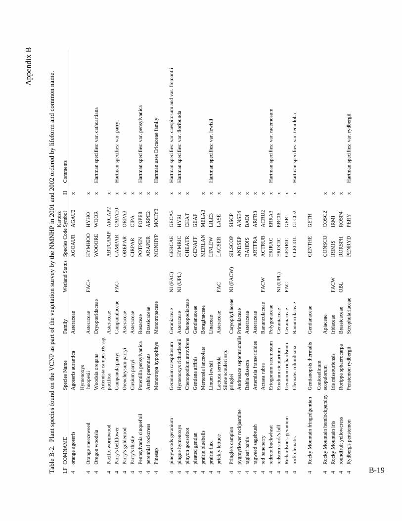
App
endi
x B
Tabl
e B
-2.
Plan
t spe
cies
foun
d on
the
VC
NP
as p
art o
f the
veg
etat
ion
surv
ey b
y th
e N
MN
HP
in 2
001
and
2002
ord
ered
by
lifef
orm
and
com
mon
nam
e.
LF C
OM
NA
ME
Spec
ies N
ame
Fam
ily
Wet
land
Sta
tus
Spec
ies C
odeK
arte
sz
Sym
bol
H
C
omm
ents
4 or
ange
ago
seris
A
gose
ris a
uran
tica
Ast
erac
eae
A
GO
AU
R
AG
AU
2 x
4
Ora
nge
snee
zew
eed
Hym
enox
ys
hoo
pesi
i A
ster
acea
eFA
C+
HY
MH
OO
H
YH
Ox
4 O
rego
n w
oods
ia
Woo
dsia
ore
gana
D
ryop
terid
acea
e
WO
OO
RE
WO
OR
x
Har
tman
spec
ifies
: var
. cat
hcar
tiana
4Pa
cific
wor
mw
ood
Arte
mis
ia c
ampe
stris
ssp.
pa
cific
a A
ster
acea
e
AR
TCA
MP
AR
CA
P2
x
4 Pa
rry'
s bel
lflow
er
Cam
panu
la p
arry
i C
ampa
nula
ceae
FA
C-
CA
MPA
R
CA
PA10
x
Har
tman
spec
ifies
: var
. par
ryi
4 Pa
rry'
s gol
denr
od
Ore
ochr
ysum
par
ryi
Ast
erac
eae
O
REP
AR
O
RPA
3 x
4
Parr
y's t
hist
le
Cirs
ium
par
ryi
Ast
erac
eae
C
IRPA
R
CIP
A
x
4 Pe
nnsy
lvan
ia c
inqu
efoi
l Po
tent
illa
pens
ylva
nica
R
osac
eae
PO
TPEN
PO
PE8
x H
artm
an sp
ecifi
es: v
ar. p
ensy
lvan
ica
4 pe
renn
ial r
ockc
ress
Ara
bis p
eren
nans
B
rass
icac
eae
A
RA
PER
A
RPE
2 x
4
Pine
sap
Mon
otro
pa h
ypop
ithys
Mon
otro
pace
ae
M
ON
HY
P M
OH
Y3
x H
artm
an u
ses E
ricac
eae
fam
ily
4 pi
neyw
oods
ger
aniu
m
Ger
aniu
m c
aesp
itosu
m
Ger
ania
ceae
N
I (FA
C)
GER
CA
EG
ECA
3x
Har
tman
spec
ifies
: var
. cae
spito
sum
and
var
. fre
mon
tii
4 pi
ngue
hym
enox
ys
Hym
enox
ys ri
char
dson
ii A
ster
acea
e N
I (U
PL)
HY
MR
IC
HY
RI
x H
artm
an sp
ecifi
es: v
ar. f
lorib
unda
4
piny
on g
oose
foot
Che
nopo
dium
atro
vire
ns
Che
nopo
diac
eae
C
HEA
TR
CH
AT
x
4 pl
eate
d ge
ntia
n G
entia
na a
ffin
is
Gen
tiana
ceae
GEN
AFF
G
EAF
4 pr
airie
blu
ebel
ls
Mer
tens
ia la
nceo
lata
B
orag
inac
eae
M
ERLA
N
MEL
A3
x
4 pr
airie
flax
Li
num
lew
isii
Lina
ceae
LIN
LEW
LI
LE3
x H
artm
an sp
ecifi
es: v
ar. l
ewis
ii 4
pric
kly
lettu
ce
Lact
uca
serr
iola
A
ster
acea
e FA
C
LAC
SER
LA
SE
x
4Pr
ingl
e's c
ampi
onSi
lene
scou
leri
ssp.
pr
ingl
ei
Car
yoph
ylla
ceae
N
I (FA
CW
) SI
LSC
OP
SISC
P x
4
pygm
yflo
wer
rock
jasm
ine
And
rosa
ce se
pten
trion
alis
Prim
ulac
eae
AN
DSE
PA
NSE
4x
4 ra
glea
f bah
ia
Bah
ia d
isse
cta
Ast
erac
eae
B
AH
DIS
B
AD
I x
4
ragw
eed
sage
brus
h A
rtem
isia
fran
serio
ides
A
ster
acea
e
AR
TFR
A
AR
FR3
x
4 re
d ba
nebe
rry
Act
aea
rubr
a R
anun
cula
ceae
FAC
WA
CTR
UB
AC
RU
2x
4 re
droo
t buc
kwhe
at
Erio
gonu
m ra
cem
osum
Po
lygo
nace
ae
ER
IRA
C
ERR
A3
x H
artm
an sp
ecifi
es: v
ar. r
acem
osum
4
reds
tem
stor
k's b
ill
Erod
ium
cic
utar
ium
G
eran
iace
ae
NI (
UPL
) ER
OC
IC
ERC
I6
x
4 R
icha
rdso
n's g
eran
ium
G
eran
ium
rich
ards
onii
Ger
ania
ceae
FAC
GER
RIC
GER
Ix
4 ro
ck c
lem
atis
C
lem
atis
col
umbi
ana
Ran
uncu
lace
ae
C
LEC
OL
CLC
O2
x H
artm
an sp
ecifi
es: v
ar. t
enui
loba
4 R
ocky
Mou
ntai
n fr
inge
dgen
tian
Gen
tiano
psis
ther
mal
is
Gen
tiana
ceae
GEN
THE
GET
H
4 R
ocky
Mou
ntai
n he
mlo
ckpa
rsle
y C
onio
selin
um
scop
ulor
um
Api
acea
e
CO
NSC
O
CO
SC2
x
4 R
ocky
Mou
ntai
n iri
s Ir
is m
isso
urie
nsis
Ir
idac
eae
FAC
W
IR
IMIS
IR
MI
x
4 ro
undf
ruit
yello
wcr
ess
Ror
ippa
spha
eroc
arpa
Bra
ssic
acea
eO
BL
RO
RSP
HR
OSP
4x
4 R
ydbe
rg's
pens
tem
on
Pens
tem
on ry
dber
gii
Scro
phul
aria
ceae
PEN
RY
D
PER
Y
x H
artm
an sp
ecifi
es: v
ar. r
ydbe
rgii
B-19

App
endi
x B
Tabl
e B
-2.
Plan
t spe
cies
foun
d on
the
VC
NP
as p
art o
f the
veg
etat
ion
surv
ey b
y th
e N
MN
HP
in 2
001
and
2002
ord
ered
by
lifef
orm
and
com
mon
nam
e.
LF C
OM
NA
ME
Spec
ies N
ame
Fam
ily
Wet
land
Sta
tus
Spec
ies C
odeK
arte
sz
Sym
bol
H
C
omm
ents
4 sa
nddu
ne w
allfl
ower
Er
ysim
um c
apita
tum
B
rass
icac
eae
NI (
UPL
) ER
YC
AP
ERC
A14
x
Har
tman
spec
ifies
: var
. cap
itatu
m
4 sc
arle
t Ind
ian
pain
tbru
sh
Cas
tille
ja m
inia
ta
Scro
phul
aria
ceae
FA
CU
C
ASM
IN
CA
MI1
2 x
Har
tman
spec
ifies
: var
. min
iata
4 Sc
oule
r's c
ampi
on
Sile
ne sc
oule
ri C
aryo
phyl
lace
ae
SI
LSC
O
SISC
P
4
Scou
ler's
St.
John
swor
t H
yper
icum
scou
leri
Clu
siac
eae
NI (
FAC
) H
YPS
CO
H
YSC
5
4
seep
mon
keyf
low
er
Mim
ulus
gut
tatu
s Sc
roph
ular
iace
ae
OB
L M
IMG
UT
MIG
U
x H
artm
an sp
ecifi
es: v
ar. g
utta
tus
4 sh
ephe
rd's
purs
e C
apse
lla b
ursa
-pas
toris
B
rass
icac
eae
UPL
C
APB
UR
x
4 sh
ortra
y fle
aban
e Er
iger
on lo
ncho
phyl
lus
Ast
erac
eae
ER
ILO
N
ERLO
4
show
y go
lden
eye
Hel
iom
eris
mul
tiflo
ra
Ast
erac
eae
NI (
UPL
) H
ELM
UL
HEM
U3
x H
artm
an u
ses:
Vig
uier
a m
ultif
lora
var
. mul
tiflo
ra
4 si
debe
lls w
inte
rgre
en
Orth
ila se
cund
a Py
rola
ceae
OR
TSEC
O
RSE
x
Har
tman
use
s Eric
acea
e fa
mily
4
silv
erw
eed
cinq
uefo
il A
rgen
tina
anse
rina
Ros
acea
eO
BL
AR
GA
NS
AR
AN
7x
Har
tman
use
s: P
oten
tilla
ans
erin
a
4 si
lver
y lu
pine
Lu
pinu
s arg
ente
usFa
bace
aeU
PLLU
PAR
G
LUA
R3
x H
artm
an sp
ecifi
es: v
ar. a
rgop
hyllu
s and
var
. ful
vom
acul
atus
4
skyr
ocke
t gili
a Ip
omop
sis a
ggre
gata
Po
lem
onia
ceae
N
I (FA
CU
) IP
OA
GG
IP
AG
x
Har
tman
spec
ifies
: sub
sp. f
orm
osis
sim
a
4 sl
ende
r cud
wee
d G
naph
aliu
m e
xilif
oliu
m
Ast
erac
eae
G
NA
EXI
GN
EX
x
4 sl
im a
mar
anth
A
mar
anth
us h
ybrid
us
Am
aran
thac
eae
A
MA
HY
B
AM
HY
x
4
smal
lleaf
pus
syto
es
Ant
enna
ria p
arvi
folia
A
ster
acea
e N
I (U
PL)
AN
TPA
R
AN
PA4
x
4 sm
ooth
spre
adin
g fo
ur o
'cloc
k M
irabi
lis o
xyba
phoi
des
Nyc
tagi
nace
ae
M
IRO
XY
M
IOX
NM
NH
P vo
uche
r bei
ng c
onfir
med
4 sp
iny
sow
this
tle
Sonc
hus a
sper
A
ster
acea
e N
I (FA
CW
) SO
NA
SP
SOA
S
NM
NH
P vo
uche
r bei
ng c
onfir
med
; Har
tman
has
S. a
rven
sis
(not
a sy
nony
m)
4sp
litle
af g
roun
dsel
Pack
era
dim
orph
ophy
lla
ssp.
dim
orph
ophy
lla
Ast
erac
eae
PA
CD
IMD
PA
DID
2
4
spre
adin
g fle
aban
e Er
iger
on d
iver
gens
A
ster
acea
e N
I (FA
C-)
ER
IDIV
ER
DI4
x
Har
tman
spec
ifies
: var
. div
erge
ns
4sp
read
ing
sand
wor
tA
rena
ria la
nugi
nosa
C
aryo
phyl
lace
ae
FAC
U,F
AC
A
REL
AN
A
RLA
4
4sp
read
ing
sand
wor
tA
rena
ria la
nugi
nosa
ssp.
sa
xosa
C
aryo
phyl
lace
ae
A
REL
AN
S A
RLA
S x
Har
tman
use
s: A
. lan
ugin
osa
var.
cine
rasc
ens
4 sp
ruce
fir fl
eaba
ne
Erig
eron
exi
miu
s A
ster
acea
e
ERIE
XI
EREX
4 x
4
star
ry fa
lse
Solo
mon
's se
al
Mai
anth
emum
stel
latu
m
Lilia
ceae
FA
CU
(FA
CW
)MA
ISTE
M
AST
4
4
stic
kyw
illy
Gal
ium
apa
rine
Rub
iace
ae
FAC
U (F
AC
) G
ALA
PA
GA
AP2
x
Har
tman
spec
ifies
: var
. ech
inos
perm
um
4 st
ingi
ng n
ettle
U
rtica
dio
ica
Urti
cace
ae
NI (
FAC
W)
UR
TDIO
U
RD
I x
Har
tman
spec
ifies
: var
. pro
cera
4
sum
mer
cor
alro
ot
Cor
allo
rrhi
za m
acul
ata
Orc
hida
ceae
CO
RM
AC
C
OM
A4
x
4 ta
ll bl
ackt
ip ra
gwor
t Se
neci
o at
ratu
sA
ster
acea
eSE
NA
TRSE
AT
x4
thre
elob
e be
ggar
ticks
B
iden
s trip
artit
a A
ster
acea
e
BID
TRI
BIT
R
4 th
reen
erve
flea
bane
Er
iger
on su
btrin
ervi
s A
ster
acea
e
ERIS
UB
ER
SU2
x H
artm
an sp
ecifi
es: v
ar. s
ubtri
nerv
is
4 th
ymel
eaf s
andm
at
Cha
mae
syce
serp
yllif
olia
Euph
orbi
acea
e N
I (FA
CU
) C
HA
SER
2 C
HSE
6 x
4
tiny
trum
pet
Col
lom
ia li
near
is
Pole
mon
iace
ae
C
OLL
IN
CO
LI2
x
4to
wer
ing
Jaco
bsla
dder
Pole
mon
ium
fo
liosi
ssim
umPo
lem
onia
ceae
FA
CPO
LFO
L PO
FOx
B-20

App
endi
x B
Tabl
e B
-2.
Plan
t spe
cies
foun
d on
the
VC
NP
as p
art o
f the
veg
etat
ion
surv
ey b
y th
e N
MN
HP
in 2
001
and
2002
ord
ered
by
lifef
orm
and
com
mon
nam
e.
LF C
OM
NA
ME
Spec
ies N
ame
Fam
ily
Wet
land
Sta
tus
Spec
ies C
odeK
arte
sz
Sym
bol
H
Com
men
ts4
traili
ng fl
eaba
ne
Erig
eron
flag
ella
risA
ster
acea
eFA
C-
ERIF
LAER
FLx
4 tu
ber s
tarw
ort
Pseu
dost
ella
ria ja
mes
iana
Car
yoph
ylla
ceae
N
I (FA
CW
) PS
EJA
M
PSJA
2 x
4
tufte
d ev
enin
gprim
rose
O
enot
hera
cae
spito
sa
Ona
grac
eae
O
ENC
AE
OEC
A10
4
varil
eaf p
hace
lia
Phac
elia
het
erop
hylla
H
ydro
phyl
lace
ae
PH
AH
ET
PHH
E2
x H
artm
an sp
ecifi
es: v
ar. h
eter
ophy
lla
4 vi
olet
woo
dsor
rel
Oxa
lis v
iola
cea
Oxa
lidac
eae
O
XA
VIO
O
XV
I x
4
wat
er k
notw
eed
Poly
gonu
m a
mph
ibiu
m
Poly
gona
ceae
O
BL
POLA
MP
POA
M8
x H
artm
an sp
ecifi
es: v
ar. s
tipul
aceu
m
4
wat
ercr
ess
Ror
ippa
nas
turti
um-
aqua
ticum
B
rass
icac
eae
OB
L R
OR
NA
S R
ON
A2
4w
este
rn a
ster
Sym
phyo
trich
um
asce
nden
s A
ster
acea
e
SYM
ASC
SY
AS3
x
Har
tman
use
s: A
ster
asc
ende
ns
4 w
este
rn b
rack
enfe
rn
Pter
idiu
m a
quili
num
D
enns
taes
tiace
ae
FAC
U
PTEA
QU
PT
AQ
x
Har
tman
spec
ifies
: var
. pub
esce
ns
4 w
este
rn ra
ttles
nake
pla
ntai
n G
oody
era
oblo
ngifo
lia
Orc
hida
ceae
GO
OO
BL
GO
OB
2 x
4
wes
tern
red
colu
mbi
ne
Aqu
ilegi
a el
egan
tula
R
anun
cula
ceae
AQ
UEL
E A
QEL
x
4
Whe
eler
's th
istle
C
irsiu
m w
heel
eri
Ast
erac
eae
C
IRW
HE
CIW
HN
MN
HP
vouc
her b
eing
con
firm
ed
4 W
hipp
le's
pens
tem
on
Pens
tem
on w
hipp
lean
us
Scro
phul
aria
ceae
PEN
WH
I PE
WH
x
4
whi
te c
heck
erm
allo
w
Sida
lace
a ca
ndid
a M
alva
ceae
FA
C (F
AC
W)
SID
CA
N
SIC
A3
x H
artm
an sp
ecifi
es: v
ar. c
andi
da
4 w
hite
clo
ver
Trifo
lium
repe
ns
Faba
ceae
N
I (FA
C)
TRIR
EP
TRR
E3
x
4 w
ild m
int
Men
tha
arve
nsis
La
mia
ceae
FA
CW
M
ENA
RV
M
EAR
4 x
4w
illow
herb
Epilo
bium
spp.
(d
epau
pera
te)
Ona
grac
eae
FAC
W
EPIL
OB
EP
ILO
4
woo
dlan
d pi
nedr
ops
Pter
ospo
ra a
ndro
med
ea
Mon
otro
pace
ae
PT
EAN
D
PTA
N2
x H
artm
an u
ses E
ricac
eae
fam
ily
4 w
oodl
and
stra
wbe
rry
Frag
aria
ves
ca
Ros
acea
e
FRA
VES
FR
VE
H
artm
an h
as: F
raga
ria v
irgin
iana
(not
a sy
nony
m)
4w
oodl
and
stra
wbe
rry
Frag
aria
ves
ca ss
p.
amer
ican
a R
osac
eae
NI (
FAC
U)
FRA
VES
A
FRV
EA2
4 w
oolly
cin
quef
oil
Pote
ntill
a hi
ppia
na
Ros
acea
e
POTH
IP
POH
I6
x H
artm
an sp
ecifi
es: v
ar. h
ippi
ana
4 W
ooto
n's r
agw
ort
Sene
cio
woo
toni
i A
ster
acea
e N
I (FA
C)
SEN
WO
O
SEW
O
x
4 W
right
's de
erve
tch
Lotu
s wrig
htii
Faba
ceae
N
I (FA
CU
) LO
TWR
I LO
WR
x
4ya
rrow
Ach
illea
mill
efol
ium
var
. oc
cide
ntal
is
Ast
erac
eae
FAC
U
AC
HM
ILO
A
CM
IO
4 ye
llow
eve
ning
prim
rose
O
enot
hera
flav
a O
nagr
acea
e
OEN
FLA
O
EFL
x
4 ye
llow
haw
kwee
d H
iera
cium
fend
leri
Ast
erac
eae
H
IEFE
N
HIF
E x
Har
tman
spec
ifies
: var
. fen
dler
i 4
yello
w o
wlc
love
r O
rthoc
arpu
s lut
eus
Scro
phul
aria
ceae
OR
TLU
T O
RLU
2 x
4
yello
w sa
lsify
Tr
agop
ogon
dub
ius
Ast
erac
eae
TR
AD
UB
TR
DU
x
B-21

APPENDIX C
Vegetation Plot List
Table C-1. Locations and vegetation classification for vegetation plots established in 2001 as part of the Valles Caldera National Preserve Ecological Survey. See Table 6 of report text for Alliances and Plant Associations (PA) that correspond to the codes.
Plot Number UTM Easting
UTM Northing Datum Alliance
Acronym PA1 Acronym
PA2 Acronym
Phase Acronym
01VC001 363694 3968586 NAD27 ABICON VACMYR PSEMEN 01VC002 363942 3969042 NAD27 FESARI MUHMON BOUGRA 01VC003 365284 3968141 NAD27 BLETRI KOEMAC 01VC004 365340 3968220 NAD27 JUNBAL DESCES POAPRA 01VC005 365923 3966903 NAD27 DANPAR POAPRA POTHIP 01VC006 362010 3970834 NAD27 ABICON PSEMEN ACEGLA 01VC007 362259 3970853 NAD27 ABICON PSEMEN FESTHU 01VC008 370668 3969326 NAD27 PICPUN ERIEXI PSEMEN 01VC009 361840 3970851 NAD27 PSEMEN VACMYR 01VC010 361822 3970928 NAD27 PICPUN ALNINC HYDFEN 01VC011 370912 3969231 NAD27 ABICON POPTRE ACEGLA JAMAME 01VC012 370780 3969382 NAD27 DANPAR FESTHU 01VC013 372337 3972428 NAD27 PSEMEN JAMAME 01VC014 372466 3972449 NAD27 PSEMEN ACEGLA 01VC015 372236 3972546 NAD27 POPTRE THAFEN POAPRA 01VC016 372132 3972500 NAD27 PINPON DANPAR POAPRA 01VC017 357547 3966619 NAD27 PINPON QUEGAM FESARI ROBNEO 01VC018 354993 3969134 NAD27 CARUTR CARMIC 01VC019 372204 3971609 NAD27 PINPON RIBLEP CARINOH 01VC020 369673 3969681 NAD27 CARUTR CARMIC 01VC021 368052 3978244 NAD27 PICPUN ERIEXI DANPAR 01VC022 372059 3976718 NAD27 PSEMEN MAHREP 01VC023 364800 398500 NAD27 PICENG DANPAR 01VC024 366083 3980751 NAD27 DANPAR FESARI BLETRI 01VC025 365964 3980854 NAD27 CARUTR CARMIC 01VC026 365256 3984716 NAD27 DANPAR FESARI 01VC027 365228 3984831 NAD27 PICENG CARFOE 01VC028 364848 3984671 NAD27 DANPAR FESTHU 01VC029 368196 3985222 NAD27 PICENG ERIEXI 01VC030 366811 3980290 NAD27 BLETRI JUNBAL 01VC031 362384 3981902 NAD27 JUNBAL POAPRA CAREX 01VC032 365169 3981048 NAD27 PICPUN CARFOE POAPRA 01VC033 366761 3980044 NAD27 CARUTR CARMIC 01VC034 361889 3981955 NAD27 FESARI BOUGRA POAPRA 01VC035 356875 3975429 NAD27 BETGLA CARAQU LYCANN 01VC036 356801 3975378 NAD27 DESCES CARAQU 01VC037 357716 3975620 NAD27 QUEGAM POAPRA 01VC038 357901 3975400 NAD27 POPTRE THAFEN PSEMEN 01VC039 357153 3985151 NAD27 PSEMEN MAHREP 01VC040 363055 3967053 NAD27 ABICON PSEMEN JUNCOM 01VC041 356990 3985054 NAD27 ABICON PSEMEN MAHREP 01VC042 356555 3970841 NAD27 PINPON DANPAR 01VC043 355328 3972899 NAD27 PSEMEN MAHREP
C-1
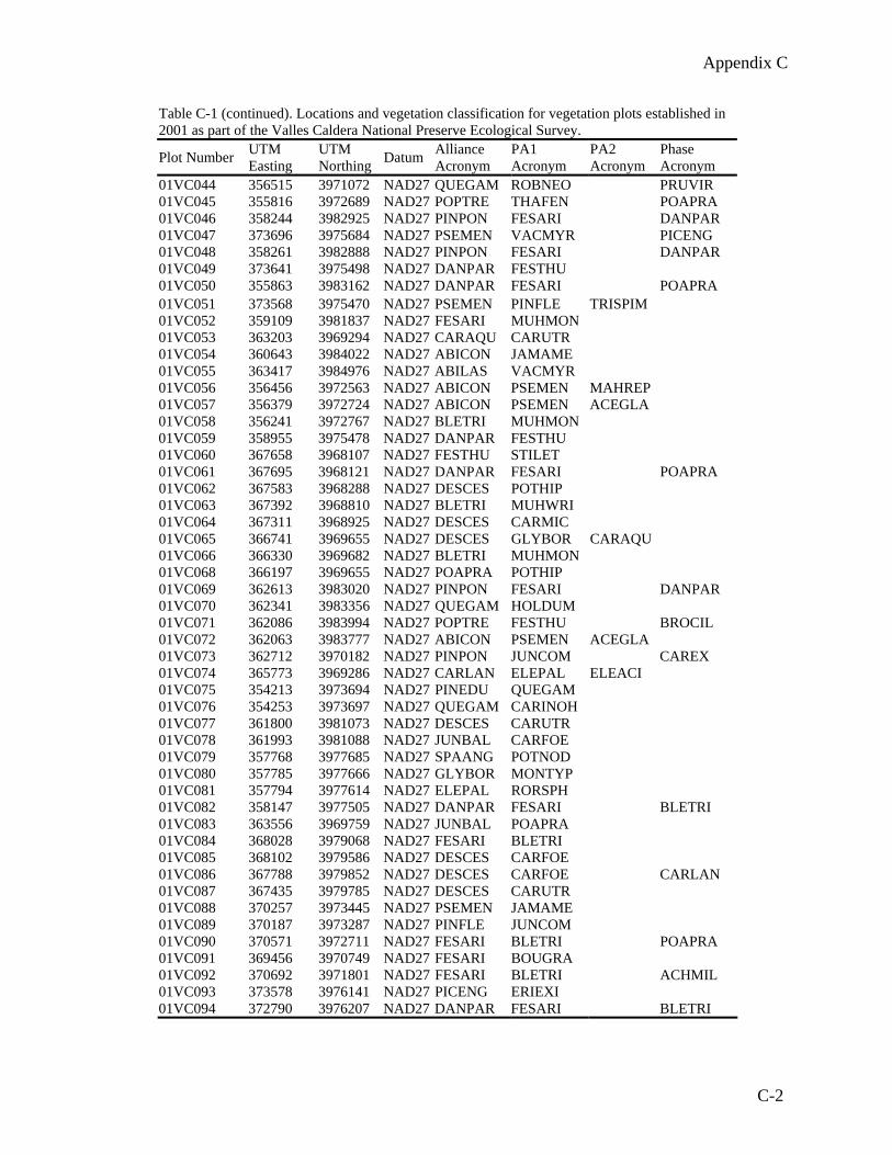
Appendix C
Table C-1 (continued). Locations and vegetation classification for vegetation plots established in 2001 as part of the Valles Caldera National Preserve Ecological Survey.
Plot Number UTM Easting
UTM Northing Datum Alliance
Acronym PA1 Acronym
PA2 Acronym
Phase Acronym
01VC044 356515 3971072 NAD27 QUEGAM ROBNEO PRUVIR 01VC045 355816 3972689 NAD27 POPTRE THAFEN POAPRA 01VC046 358244 3982925 NAD27 PINPON FESARI DANPAR 01VC047 373696 3975684 NAD27 PSEMEN VACMYR PICENG 01VC048 358261 3982888 NAD27 PINPON FESARI DANPAR 01VC049 373641 3975498 NAD27 DANPAR FESTHU 01VC050 355863 3983162 NAD27 DANPAR FESARI POAPRA 01VC051 373568 3975470 NAD27 PSEMEN PINFLE TRISPIM 01VC052 359109 3981837 NAD27 FESARI MUHMON 01VC053 363203 3969294 NAD27 CARAQU CARUTR 01VC054 360643 3984022 NAD27 ABICON JAMAME 01VC055 363417 3984976 NAD27 ABILAS VACMYR 01VC056 356456 3972563 NAD27 ABICON PSEMEN MAHREP 01VC057 356379 3972724 NAD27 ABICON PSEMEN ACEGLA 01VC058 356241 3972767 NAD27 BLETRI MUHMON 01VC059 358955 3975478 NAD27 DANPAR FESTHU 01VC060 367658 3968107 NAD27 FESTHU STILET 01VC061 367695 3968121 NAD27 DANPAR FESARI POAPRA 01VC062 367583 3968288 NAD27 DESCES POTHIP 01VC063 367392 3968810 NAD27 BLETRI MUHWRI 01VC064 367311 3968925 NAD27 DESCES CARMIC 01VC065 366741 3969655 NAD27 DESCES GLYBOR CARAQU 01VC066 366330 3969682 NAD27 BLETRI MUHMON 01VC068 366197 3969655 NAD27 POAPRA POTHIP 01VC069 362613 3983020 NAD27 PINPON FESARI DANPAR 01VC070 362341 3983356 NAD27 QUEGAM HOLDUM 01VC071 362086 3983994 NAD27 POPTRE FESTHU BROCIL 01VC072 362063 3983777 NAD27 ABICON PSEMEN ACEGLA 01VC073 362712 3970182 NAD27 PINPON JUNCOM CAREX 01VC074 365773 3969286 NAD27 CARLAN ELEPAL ELEACI 01VC075 354213 3973694 NAD27 PINEDU QUEGAM 01VC076 354253 3973697 NAD27 QUEGAM CARINOH 01VC077 361800 3981073 NAD27 DESCES CARUTR 01VC078 361993 3981088 NAD27 JUNBAL CARFOE 01VC079 357768 3977685 NAD27 SPAANG POTNOD 01VC080 357785 3977666 NAD27 GLYBOR MONTYP 01VC081 357794 3977614 NAD27 ELEPAL RORSPH 01VC082 358147 3977505 NAD27 DANPAR FESARI BLETRI 01VC083 363556 3969759 NAD27 JUNBAL POAPRA 01VC084 368028 3979068 NAD27 FESARI BLETRI 01VC085 368102 3979586 NAD27 DESCES CARFOE 01VC086 367788 3979852 NAD27 DESCES CARFOE CARLAN 01VC087 367435 3979785 NAD27 DESCES CARUTR 01VC088 370257 3973445 NAD27 PSEMEN JAMAME 01VC089 370187 3973287 NAD27 PINFLE JUNCOM 01VC090 370571 3972711 NAD27 FESARI BLETRI POAPRA 01VC091 369456 3970749 NAD27 FESARI BOUGRA 01VC092 370692 3971801 NAD27 FESARI BLETRI ACHMIL 01VC093 373578 3976141 NAD27 PICENG ERIEXI 01VC094 372790 3976207 NAD27 DANPAR FESARI BLETRI
C-2

Appendix C
Table C-1 (continued). Locations and vegetation classification for vegetation plots established in 2001 as part of the Valles Caldera National Preserve Ecological Survey.
Plot Number UTM Easting
UTM Northing Datum Alliance
Acronym PA1 Acronym
PA2 Acronym
Phase Acronym
01VC095 362981 3981683 NAD27 CARUTR JUNLON 01VC096 362981 3981683 NAD27 JUNBAl AGRGIG 01VC097 362993 3981667 NAD27 FESARI BLETRI POAPRA 01VC098 363000 3981612 NAD27 DANPAR FESARI BLETRI 01VC099 365794 3975166 NAD27 FESARI BOUGRA POAPRA 01VC100 366166 3974981 NAD27 ABICON ERIEXI
C-3

APPENDIX D -- VEGETATION SUMMARY TABLES
Table D-1. The most common species encountered in Montane Valley Grasslands during 2001 (>10% of the plots). N= number of plots out of 28; Avg Cov = average cover where present; Max Cov = maximum recorded cover.
LF Common Name Species Name Species Code N Avg
Cov Max Cov
Tree Pinus ponderosa ponderosa pine PINPON 3 0.001 0.001Shrub Pentaphylloides floribunda shrubby cinquefoil PENFLO 6 0.567 3.000 Artemisia frigida fringed sagewort ARTFRI 4 0.075 0.100Grass Agrostis scabra rough bentgrass AGRSCA 7 0.686 3.000 Blepharoneuron tricholepis pine dropseed BLETRI 23 14.826 62.000 Bouteloua gracilis blue grama BOUGRA 6 18.933 41.500 Bromus anomalus nodding brome BROANO 4 0.925 3.000 Bromus ciliatus fringed brome BROCIL 6 0.500 0.500 Carex foenea dryspike sedge CARFOE 7 3.286 17.500 Carex obtusata obtuse sedge CAROBT 3 4.500 7.500 Danthonia parryi Parry's Danthonia DANPAR 16 40.381 85.000 Elymus elymoides bottlebrush squirreltail ELYELY 16 1.238 7.500 Elymus trachycaulus slender wheatgrass ELYTRA 5 0.900 3.000 Festuca arizonica Arizona fescue FESARI 22 16.050 41.500 Festuca thurberi Thurber's fescue FESTHU 8 18.875 62.500 Juncus balticus Baltic rush JUNBAL 13 3.169 17.500 Koeleria macrantha prairie junegrass KOEMAC 18 3.165 13.000 Muhlenbergia montana mountain muhly MUHMON 16 8.100 62.500 Muhlenbergia wrightii spike muhly MUHWRI 4 1.900 4.000 Phleum pratense timothy PHLPRA 3 0.337 0.500 Poa pratensis Kentucky bluegrass POAPRA 17 13.942 97.500Forb Achillea millefolium common yarrow ACHMIL 28 4.712 17.500 Agoseris aurantica orange agoseris AGOAUR 12 0.185 0.500 Allium cernuum nodding onion ALLCER 3 0.070 0.100 Antennaria parvifolia smallleaf pussytoes ANTPAR 3 3.667 5.000 Antennaria spp. pussytoes ANTENN 17 4.476 17.500 Arenaria fendleri Fendler's sandwort AREFEN 13 3.931 17.500 Artemisia carruthii Carruth's sagewort ARTCAR 7 0.629 3.000 Artemisia ludoviciana Louisiana sagewort ARTLUD 6 1.200 3.000 Campanula parryi Parry's bellflower CAMPAR 3 0.037 0.100 Campanula rotundifolia bluebell bellflower CAMROT 20 0.420 3.000 Cerastium arvense mouseear chickweed CERARV 5 0.340 0.500 Chenopodium neomexicanum New Mexico goosefoot CHENEO 3 0.367 0.500 Erigeron flagellaris trailing fleabane ERIFLA 15 2.153 7.500 Erigeron formosissimus beautiful fleabane ERIFOR 19 2.134 17.500 Gentiana affinis pleated gentian GENAFF 10 0.210 0.500 Heterotheca villosa hairy goldenaster HETVIL 6 0.150 0.500 Hieracium spp. hawkweed HIERAC 3 1.200 3.000 Iris missouriensis Rocky Mountain iris IRIMIS 12 0.608 3.000 Polygonum douglasii Douglas' knotweed POLDOU 4 0.825 3.000 Potentilla hippiana woolly cinquefoil POTHIP 28 4.982 17.500 Potentilla pulcherrima beautiful cinquefoil POTPUL 4 0.300 0.500 Pseudocymopterus montanus alpine false springparsley PSEMON 6 0.135 0.500 Ranunculus cardiophyllus heartleaf buttercup RANCAR 13 0.855 3.000 Rumex acetosella common sheep sorrel RUMACE 4 1.025 3.000 Silene catchfly SILENE 4 0.100 0.100 Sisyrinchium montanum mountain blue-eyed grass SISMON 3 0.100 0.100 Symphyotrichum ascendens western aster SYMASC 3 1.067 3.000 Taraxacum officinale common dandelion TAROFF 25 2.040 7.500 Trifolium repens white clover TRIREP 5 3.800 7.500
D-1

APPENDIX D -- VEGETATION SUMMARY TABLES
Vicia americana american vetch VICAME 9 0.278 0.500Table D-2. The most common species encountered in Mixed Conifer Forests during 2001 (>10% of the plots). N= number of plots out of 25; Avg Cov = average cover where present; Max Cov = maximum recorded cover.
LF Common Name Species Name Species Code N Avg
Cov Max Cov
Tree Abies concolor white fir ABICON 16 14.322 50.000 Acer glabrum Rocky Mountain maple ACEGLA 9 3.600 15.000 Picea pungens blue spruce PICPUN 7 18.120 40.000 Pinus flexilis limber pine PINFLE 14 4.650 21.000 Pinus ponderosa ponderosa pine PINPON 8 6.375 15.000 Populus tremuloides quaking aspen POPTRE 16 3.215 15.000 Pseudotsuga menziesii Douglas fir PSEMEN 20 37.643 60.000 Robinia neomexicana New Mexico locust ROBNEO 4 0.300 0.500Shrub Holodiscus dumosus rockspirea HOLDUM 5 1.900 3.000 Jamesia americana cliffbush JAMAME 11 3.873 17.500 Juniperus communis common juniper JUNCOM 16 4.981 41.500 Physocarpus monogynus mountain ninebark PHYMON 5 2.900 7.500 Ribes leptanthum trumpet gooseberry RIBLEP 3 0.367 0.500 Rosa woodsii Woods' rose ROSWOO 11 0.355 1.000 Rubus parviflorus thimbleberry RUBPAR 10 0.461 3.000 Mahonia repens Oregongrape MAHREP 7 4.529 17.500 Paxistima myrsinites myrtle boxleaf PAXMYR 16 2.344 7.500 Vaccinium myrtillus whortleberry VACMYR 4 10.025 17.500Grass Agrostis scabra rough bentgrass AGRSCA 3 0.233 0.500 Bromus ciliatus fringed brome BROCIL 23 1.204 7.000 Carex spp. sedge CAREX 14 2.400 7.500 Carex foenea dryspike sedge CARFOE 3 0.367 0.500 Carex rostrata beaked sedge CARROS 7 1.100 3.000 Elymus trachycaulus slender wheatgrass ELYTRA 4 2.375 3.000 Festuca arizonica Arizona fescue FESARI 3 2.033 3.000 Festuca sororia ravine fescue FESSOR 4 1.650 3.000 Festuca thurberi Thurber's fescue FESTHU 5 4.400 15.000 Koeleria macrantha prairie junegrass KOEMAC 10 1.090 3.000 Melica porteri Porter's melicgrass MELPOR 3 0.367 0.500 Phleum pratense timothy PHLPRA 3 1.167 3.000 Poa pratensis Kentucky bluegrass POAPRA 6 4.033 17.500 Trisetum montanum Rocky Mountain trisetum TRIMON 11 1.600 3.000Forb Achillea millefolium common yarrow ACHMIL 4 0.400 0.500 Antennaria spp. pussytoes ANTENN 4 1.025 3.000 Aquilegia coerulea Colorado columbine AQUCOE 7 0.200 0.500 Artemisia franserioides ragweed sagebrush ARTFRA 16 1.106 3.000 Campanula rotundifolia bluebell bellflower CAMROT 5 0.080 0.100 Castilleja miniata scarlet Indian paintbrush CASMIN 3 0.067 0.100 Clematis columbiana rock clematis CLECOL 9 0.233 0.500 Draba aurea golden draba DRAAUR 8 0.088 0.100 Erigeron eximius sprucefir fleabane ERIEXI 8 4.950 17.500 Erigeron flagellaris trailing fleabane ERIFLA 3 0.367 0.500 Erigeron formosissimus beautiful fleabane ERIFOR 4 1.625 3.000 Erigeron subtrinervis threenerve fleabane ERISUB 3 0.367 0.500 Fragaria vesca woodland strawberry FRAVES 21 2.371 7.500 Galium aparine stickywilly GALAPA 7 0.373 0.500 Galium boreale Northern bedstraw GALBOR 5 0.840 3.000 Geranium richardsonii Richardson's geranium GERRIC 9 0.922 3.000 Goodyera oblongifolia western rattlesnake plantain GOOOBL 8 0.100 0.100 Goodyera repens lesser rattlesnake plantain GOOREP 4 0.100 0.100 Iris missouriensis Rocky Mountain iris IRIMIS 4 1.125 3.000
D-2
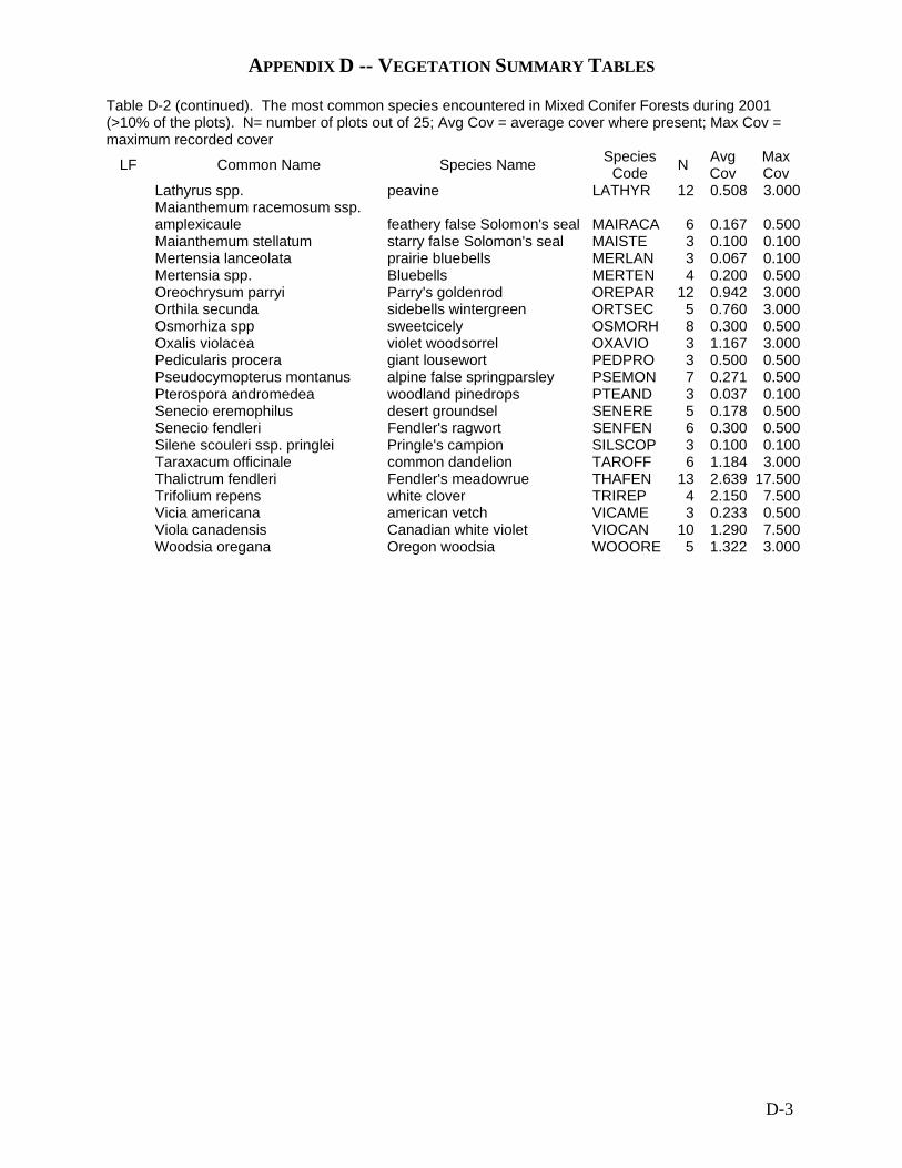
APPENDIX D -- VEGETATION SUMMARY TABLES
Table D-2 (continued). The most common species encountered in Mixed Conifer Forests during 2001 (>10% of the plots). N= number of plots out of 25; Avg Cov = average cover where present; Max Cov = maximum recorded cover
LF Common Name Species Name Species Code N Avg
Cov Max Cov
Lathyrus spp. peavine LATHYR 12 0.508 3.000
Maianthemum racemosum ssp. amplexicaule feathery false Solomon's seal MAIRACA 6 0.167 0.500
Maianthemum stellatum starry false Solomon's seal MAISTE 3 0.100 0.100 Mertensia lanceolata prairie bluebells MERLAN 3 0.067 0.100 Mertensia spp. Bluebells MERTEN 4 0.200 0.500 Oreochrysum parryi Parry's goldenrod OREPAR 12 0.942 3.000 Orthila secunda sidebells wintergreen ORTSEC 5 0.760 3.000 Osmorhiza spp sweetcicely OSMORH 8 0.300 0.500 Oxalis violacea violet woodsorrel OXAVIO 3 1.167 3.000 Pedicularis procera giant lousewort PEDPRO 3 0.500 0.500 Pseudocymopterus montanus alpine false springparsley PSEMON 7 0.271 0.500 Pterospora andromedea woodland pinedrops PTEAND 3 0.037 0.100 Senecio eremophilus desert groundsel SENERE 5 0.178 0.500 Senecio fendleri Fendler's ragwort SENFEN 6 0.300 0.500 Silene scouleri ssp. pringlei Pringle's campion SILSCOP 3 0.100 0.100 Taraxacum officinale common dandelion TAROFF 6 1.184 3.000 Thalictrum fendleri Fendler's meadowrue THAFEN 13 2.639 17.500 Trifolium repens white clover TRIREP 4 2.150 7.500 Vicia americana american vetch VICAME 3 0.233 0.500 Viola canadensis Canadian white violet VIOCAN 10 1.290 7.500 Woodsia oregana Oregon woodsia WOOORE 5 1.322 3.000
D-3

APPENDIX D -- VEGETATION SUMMARY TABLES
Table D-3. The most common species encountered in Spruce-Fir Forests during 2001 (>20% of the plots). N= number of plots out of 5; Avg Cov = average cover where present; Max Cov = maximum recorded cover.
LF Common Name Species Name Species Code N Avg
Cov Max Cov
1 Abies lasiocarpa subalpine fir ABILAS 1 40 401 Picea engelmannii Engelmann's spruce PICENG 5 9 151 Pinus flexilis limber pine PINFLE 2 3.85 7.51 Populus tremuloides quaking aspen POPTRE 2 0.001 0.0011 Pseudotsuga menziesii Douglas fir PSEMEN 2 7.75 82.5 Paxistima myrsinites myrtle boxleaf PAXMYR 3 1.2 32.5 Vaccinium myrtillus whortleberry VACMYR 2 9 17.53 Agrostis scabra rough bentgrass AGRSCA 2 0.0505 0.13 Bromus ciliatus fringed brome BROCIL 5 1.42 33 Carex spp. sedge CAREX 3 3 33 Danthonia parryi Parry's Danthonia DANPAR 2 22.25 41.53 Festuca thurberi Thurber's fescue FESTHU 2 3 33 Koeleria macrantha prairie junegrass KOEMAC 2 1.75 33 Trisetum montanum Rocky Mountain trisetum TRIMON 2 1.55 34 Achillea millefolium common yarrow ACHMIL 4 1.55 34 Artemisia franserioides ragweed sagebrush ARTFRA 2 0.1 0.14 Campanula rotundifolia bluebell bellflower CAMROT 2 0.3 0.54 Erigeron eximius sprucefir fleabane ERIEXI 2 17.5 17.54 Erigeron formosissimus beautiful fleabane ERIFOR 3 1.2 34 Fragaria vesca woodland strawberry FRAVESA 3 1.75 34 Galium boreale Northern bedstraw GALBOR 2 0.3 0.54 Geranium richardsonii Richardson's geranium GERRIC 3 0.5 0.54 Iris missouriensis Rocky Mountain iris IRIMIS 2 0.5 0.54 Lathyrus spp. peavine LATHYR 4 0.2 0.54 Orthila secunda sidebells wintergreen ORTSEC 2 1.55 34 Osmorhiza spp sweetcicely OSMORH 2 0.1 0.14 Potentilla hippiana woolly cinquefoil POTHIP 2 1.55 34 Pseudocymopterus montanus alpine false springparsley PSEMON 4 0.8 2.5 Silene scouleri ssp. pringlei Pringle's campion SILSCOP 2 0.1 0.14 Taraxacum officinale common dandelion TAROFF 2 0.3 0.54 Vicia americana american vetch VICAME 3 1.2 34 Viola canadensis Canadian white violet VIOCAN 2 0.3 0.5
D-4

APPENDIX D -- VEGETATION SUMMARY TABLES
Table D-4. The most common species encountered in Ponderosa and Pinyon-Juniper Woodlands during 2001 (>10% of the plots). N= number of plots out of 9; Avg Cov = average cover where present; Max Cov = maximum recorded cover.
LF Common Name Species Name Species Code N Avg
Cov Max Cov
`1 Abies concolor white fir ABICON 3 2.501 5.000 Pinus edulis pinyon pine PINEDU 1 5.000 5.0001 Pinus flexilis limber pine PINFLE 3 0.001 0.0011 Pseudotsuga menziesii Douglas fir PSEMEN 2 3.000 3.0001 Quercus gambelii Gambel's oak QUEGAM 3 1.067 3.0001 Robinia neomexicana New Mexico locust ROBNEO 2 1.550 3.0002 Juniperus communis common juniper JUNCOM 5 7.101 35.0002 Rosa woodsii Woods' rose ROSWOO 2 1.750 3.0003 Agrostis scabra rough bentgrass AGRSCA 2 0.100 0.1003 Bromus ciliatus fringed brome BROCIL 7 0.986 3.0003 Carex spp. sedge CAREX 6 10.500 41.5003 Carex rostrata beaked sedge CARROS 2 0.300 0.5003 Danthonia parryi Parry's Danthonia DANPAR 6 14.833 41.5003 Elymus elymoides bottlebrush squirreltail ELYELY 8 0.350 0.5003 Elymus x pseudorepens false quackgrass ELYPSE 3 1.200 3.0003 Festuca arizonica Arizona fescue FESARI 5 6.220 17.5003 Festuca thurberi Thurber's fescue FESTHU 2 1.750 3.0003 Koeleria macrantha prairie junegrass KOEMAC 6 1.267 3.0003 Muhlenbergia montana mountain muhly MUHMON 4 0.925 3.0003 Phleum pratense timothy PHLPRA 2 0.100 0.1003 Poa pratensis Kentucky bluegrass POAPRA 6 8.167 17.5004 Achillea millefolium common yarrow ACHMIL 6 1.750 3.0004 Allium cernuum nodding onion ALLCER 2 0.100 0.1004 Antennaria spp. pussytoes ANTENN 4 1.750 3.0004 Arenaria fendleri Fendler's sandwort AREFEN 2 0.100 0.1004 Artemisia carruthii Carruth's sagewort ARTCAR 2 0.300 0.5004 Artemisia ludoviciana Louisiana sagewort ARTLUD 2 0.300 0.5004 Campanula rotundifolia bluebell bellflower CAMROT 6 0.233 0.5004 Chenopodium neomexicanum New Mexico goosefoot CHENEO 3 0.233 0.5004 Erigeron flagellaris trailing fleabane ERIFLA 4 0.300 0.5004 Erigeron formosissimus beautiful fleabane ERIFOR 6 1.333 3.0004 Erigeron speciosus aspen fleabane ERISPE 2 0.051 0.1004 Fragaria spp Strawberry FRAGAR 2 1.750 3.0004 Geranium caespitosum pineywoods geranium GERCAE 2 0.051 0.1004 Geranium richardsonii Richardson's geranium GERRIC 3 1.333 3.0004 Heterotheca villosa hairy goldenaster HETVIL 2 0.300 0.5004 Iris missouriensis Rocky Mountain iris IRIMIS 4 0.400 0.5004 Lathyrus spp. peavine LATHYR 5 0.500 0.5004 Mertensia spp. Bluebells MERTEN 2 0.100 0.1004 Osmorhiza spp sweetcicely OSMORH 2 0.100 0.1004 Potentilla hippiana woolly cinquefoil POTHIP 6 1.200 3.0004 Pseudocymopterus montanus alpine false springparsley PSEMON 7 0.157 0.5004 Silene catchfly SILENE 2 0.100 0.1004 Symphyotrichum laeve var. geyeri Geyer's aster SYMLAEG 2 0.051 0.1004 Taraxacum officinale common dandelion TAROFF 5 4.320 17.5004 Thalictrum fendleri Fendler's meadowrue THAFEN 2 0.051 0.1004 Trifolium repens white clover TRIREP 3 2.167 3.0004 Vicia americana american vetch VICAME 3 0.367 0.500
D-5

APPENDIX D -- VEGETATION SUMMARY TABLES
Table D-5. The most common species encountered in Quaking Aspen Forests during 2001 (>20% of the plots). N= number of plots out of 4; Avg Cov = average cover where present; Max Cov = maximum recorded cover.
LF Common Name Species Name Species Code N Avg
Cov Max Cov
1 Abies concolor - adv regen white fir ABICON2 3 1.167 3.0001 Pinus flexilis limber pine PINFLE 2 0.500 1.0001 Pinus ponderosa ponderosa pine PINPON 2 8.750 10.0001 Populus tremuloides quaking aspen POPTRE 4 47.000 75.0001 Quercus gambelii Gambel's oak QUEGAM 2 0.001 0.0012 Holodiscus dumosus rockspirea HOLDUM 2 0.051 0.1002 Juniperus communis common juniper JUNCOM 2 9.000 17.5003 Bromus ciliatus fringed brome BROCIL 4 5.375 17.5003 Carex spp. sedge CAREX 4 4.625 7.5003 Elymus elymoides bottlebrush squirreltail ELYELY 2 0.100 0.1003 Elymus trachycaulus slender wheatgrass ELYTRA 2 1.750 3.0003 Festuca thurberi Thurber's fescue FESTHU 3 14.867 41.5003 Koeleria macrantha prairie junegrass KOEMAC 2 10.250 17.5003 Poa pratensis Kentucky bluegrass POAPRA 2 45.750 62.5004 Achillea millefolium common yarrow ACHMIL 4 3.000 3.0004 Allium cernuum nodding onion ALLCER 2 0.100 0.1004 Artemisia franserioides ragweed sagebrush ARTFRA 2 0.300 0.5004 Campanula rotundifolia bluebell bellflower CAMROT 3 0.367 0.5004 Erigeron subtrinervis threenerve fleabane ERISUB 2 0.100 0.1004 Galium aparine stickywilly GALAPA 4 2.775 7.5004 Geranium richardsonii Richardson's geranium GERRIC 2 1.750 3.0004 Lathyrus spp. peavine LATHYR 2 1.550 3.0004 Mertensia lanceolata prairie bluebells MERLAN 2 0.100 0.1004 Phacelia heterophylla varileaf phacelia PHAHET 2 0.100 0.1004 Pseudocymopterus montanus alpine false springparsley PSEMON 3 0.367 0.5004 Senecio eremophilus desert groundsel SENERE 3 0.067 0.1004 Taraxacum officinale common dandelion TAROFF 3 2.033 3.0004 Thalictrum fendleri Fendler's meadowrue THAFEN 3 1.333 3.0004 Trifolium repens white clover TRIREP 2 1.750 3.0004 Vicia americana american vetch VICAME 3 2.833 7.5004 Viola canadensis Canadian white violet VIOCAN 2 4.000 7.500
D-6

APPENDIX D -- VEGETATION SUMMARY TABLES
Table D-6. The most common species encountered in Montane Graminoid Wetlands during 2001 (>10% of the plots). N= number of plots out of 25; Avg Cov = average cover where present; Max Cov = maximum recorded cover. Wet Status= wetland status where OBL=obligate wetalnd species and FACW= facultative wetland species (can occasionally be found in non-wetland conditions)
LF Common Name Species Name Species Code N Avg
Cov Max Cov
Wet Status
Shrub Pentaphylloides floribunda shrubby cinquefoil PENFLO 9 1.222 7.500 FACW-Grass Agrostis scabra rough bentgrass AGRSCA 5 1.420 3.000 Alopecurus aequalis shortawn foxtail ALOAEQ 3 0.067 0.100 OBL Blepharoneuron tricholepis pine dropseed BLETRI 4 0.900 3.000 Calamagrostis stricta slimstem reedgrass CALSTR 3 1.067 3.000 Carex aquatilis water sedge CARAQU 3 33.500 41.500 OBL Carex foenea dryspike sedge CARFOE 5 28.400 62.500 Carex lanuginosa woolly sedge CARLAN 3 21.833 55.000 OBL Carex microptera smallwing sedge CARMIC 4 43.625 62.500 FACW Carex spp. sedge CAREX 8 27.138 85.000 Carex utriculata Northwest Territory sedge CARUTR 8 40.188 85.000 Deschampsia hairgrass DESCHA 5 16.220 41.500 Deschampsia cespitosa tufted hairgrass DESCES 10 25.000 85.000 FACW- Eleocharis acicularis needle spikerush ELEACI 2 10.050 20.000 Eleocharis palustris common spikerush ELEPAL 4 30.050 90.000 OBL Eleocharis spp. spikerush ELEOCH 2 2.750 5.000 Elymus trachycaulus slender wheatgrass ELYTRA 5 0.420 0.500 Glyceria borealis northern mannagrass GLYBOR 2 42.500 80.000 OBL Hordeum brachyantherum meadow barley HORBRA 2 0.300 0.500 Hordeum jubatum foxtail barley HORJUB 7 0.543 3.000 Juncus balticus Baltic rush JUNBAL 7 11.643 41.500 OBL Juncus longistylis longstyle rush JUNLON 5 1.420 3.000 FACW Juncus spp. Rush JUNCUS 2 41.500 41.500 Koeleria macrantha prairie junegrass KOEMAC 2 1.550 3.000 Lycurus setosus bristly wolfstail LYCSET 2 0.051 0.100 Muhlenbergia wrightii spike muhly MUHWRI 3 0.233 0.500 Phleum alpinum alpine timothy PHLALP 2 1.750 3.000 Phleum pratense timothy PHLPRA 13 2.831 17.500 Poa palustris fowl bluegrass POAPAL 4 3.500 7.500 Poa pratensis Kentucky bluegrass POAPRA 8 13.963 41.500 Forb Achillea millefolium common yarrow ACHMIL 13 4.410 7.500 Agoseris aurantica orange agoseris AGOAUR 6 0.150 0.500 Allium geyeri Geyer's onion ALLGEY 8 0.175 0.500 Argentina anserina silverweed cinquefoil ARGANS 13 4.277 17.500 OBL Campanula parryi Parry's bellflower CAMPAR 2 0.300 0.500 Cerastium arvense mouseear chickweed CERARV 2 0.300 0.500 FACW Cirsium parryi Parry's thistle CIRPAR 2 0.100 0.100
Conioselinum scopulorum Rocky Mt. hemlock parsley CONSCO 3 0.367 0.500
Crepis runcinata fiddleleaf hawksbeard CRERUN 4 0.175 0.500 Epilobium ciliatum hairy willowherb EPICIL 5 0.180 0.500 FACW Epilobium leptophyllum bog willowherb EPILEP 3 1.200 3.000 Equisetum arvense field horsetail EQUARV 2 0.100 0.100 FACW Erigeron formosissimus beautiful fleabane ERIFOR 4 2.150 7.500 Erigeron lonchophyllus shortray fleabane ERILON 4 0.900 3.000
Gentianopsis thermalis Rocky Mountain fringed gentian GENTHE 4 0.100 0.100
Gnaphalium exilifolium slender cudweed GNAEXI 4 0.100 0.100
Hypericum scouleri ssp. nortoniae Norton's St. Johnswort HYPSCON 4 1.550 3.000
Iris missouriensis Rocky Mountain iris IRIMIS 5 0.800 3.000 FACW
D-7

APPENDIX D -- VEGETATION SUMMARY TABLES
0.684
Table D-6 (continued). The most common species encountered in Montane Graminoid Wetlands during 2001 (>10% of the plots). N= number of plots out of 25; Avg Cov = average cover where present; Max Cov = maximum recorded cover. Wet Status= wetland status where OBL=obligate wetalnd species and FACW= facultative wetland species (can occasionally be found in non-wetland conditions)
LF Common Name Species Name Species Code N Avg
Cov Max Cov
Wet Status
Lemna spp. duckweed LEMNA 2 0.300 0.500 Mentha arvensis wild mint MENARV 5 0.220 0.500 FACW Orthocarpus luteus yellow owlclover ORTLUT 3 0.100 0.100 Polygonum amphibium water knotweed POLAMP 2 1.750 3.000 OBL Polygonum douglasii Douglas' knotweed POLDOU 2 0.051 0.100 Polygonum erectum erect knotweed POLERE 2 0.100 0.100 Potamogeton nodosus longleaf pondweed POTNOD 2 3.800 7.500 Potentilla hippiana woolly cinquefoil POTHIP 8 7.125 41.500 Potentilla pulcherrima beautiful cinquefoil POTPUL 2 0.300 0.500 Ranunculus cardiophyllus heartleaf buttercup RANCAR 6 3.000 OBL Rorippa sphaerocarpa roundfruit yellowcress RORSPH 3 0.200 0.500 OBL Rumex acetosella common sheep sorrel RUMACE 2 0.300 0.500 FACW Rumex crispus curly dock RUMCRI 4 0.100 0.100 FACW Sparganium angustifolium narrowleaf burreed SPAANG 2 37.000 69.000 Spiranthes romanzoffiana hooded ladies tresses SPIROM 3 0.100 0.100 OBL Symphyotrichum ascendens western aster SYMASC 8 0.550 3.000 Taraxacum officinale common dandelion TAROFF 10 3.640 17.500 Trifolium repens white clover TRIREP 12 3.713 17.500 Trifolium wormskioldii cows clover TRIWOR 3 0.233 0.500 Veronica americana American speedwell VERAME 2 0.051 0.100 OBL
Veronica peregrina ssp. xalapensis hairy purslane speedwell VERPERX 4 0.100 0.100
Vicia americana american vetch VICAME 2 0.051 0.100 Viola spp. Violet VIOLA 3 6.033 17.500 OBL
D-8