VALIDATION D’UN MODELE HYDRODYNAMIQUE … d’un modele hydrodynamique 2d pour etudier la...
8
VALIDATION D’UN MODELE HYDRODYNAMIQUE 2D POUR ETUDIER LA STRATEGIE DE DEPOT OPTIMALE DES PRODUITS DE DRAGAGE DANS L’ESCAUT OCCIDENTAL Stefaan IDES (1) , Yves PLANCKE (1) , Gwendy VOS (3) (1) Port of Antwerp - e-mail: [email protected] (2) Port of Antwerp / Flanders Hydraulics Research - e-mail: [email protected] (3) Flanders Hydraulics Research - e-mail: [email protected] Le Laboratoire de Recherches Hydrauliques de Flandres a étudié une nouvelle stratégie de dépôt des produits de dragage dans l’Escaut Occidental en combinant des mesures in situ avec des simulations numériques (modèle en 2 dimensions). Pour le câlage du modèle, un retour d’expérience et des informations étaient déjà disponibles, résultant des études précédentes. Le premier câlage a été fait sur les niveaux d’eau. La propagation de l’onde de marée a été calibrée en variant le coefficient de rugosité de Manning. Ensuite, les vitesses ont été ajustées en changeant principalement le coefficient de viscosité horizontale. Pour la zone intertidale, les cartes des écotopes ont été utilisées pour vérifier et ajuster encore mieux les champs des vitesses. Le modèle a été calibré dans la zone intertidale par ajustement des rugosités en fonction de la profondeur et en faisant varier les vitesses critiques séparant les zones à faible et à forte dynamique. La combinaison des mesures in situ, des modèles numériques 2D ainsi que de l’expérience de 2 tests de dépôts ont permis d’élaborer une stratégie optimale de dépôt des produits de dragage. MOTS CLEFS : Modélisation numérique, câlage d’un modèle hydrodynamique, l’Escaut Occidental Validation of a 2-dimensional hydrodynamic model within a study to propose the optimal disposal strategy in the Western Scheldt In order to work out a disposal strategy along sandbars in the Western Scheldt, Flanders Hydraulics Research conducted research combining field measurements and 2D high resolution numerical modelling. The Delft3D software was used for this. For the calibration of the numerical model, a lot of information and experience from previous modelling studies was available. In a first phase, the water levels in the model were calibrated by applying a space varying Manning bed roughness coefficient: in this way the propagation of the tidal wave between the different measurement stations could be adapted in the model. In a second phase, the focus of the calibration was on the flow velocities. The horizontal viscosity was used for this as the main parameter. For the intertidal area, the maps of ecotopes were used to calibrate the flow velocity. A depth depending bed roughness as well as the critical velocity between high and low dynamic intertidal areas were used for the calibration. Combining the in situ measurements, the calibrated numerical models and the experience from 2 in situ disposal tests, the engineers of Flanders Hydraulics Research succeeded in working out an optimal disposal strategy. KEY WORDS : Numerical modeling, hydrodynamics, model calibration, Western Scheldt I INTRODUCTION The Scheldt estuary is the maritime access to several ports in Flanders and the Netherlands, the largest being the Port of Antwerp, located at some 100 km from the open sea. The Western Scheldt – the part of the estuary between Vlissingen and the Dutch-Belgian border – is a typical multiple channel system, with the navigation route being mainly located in the ebb channel. Up-estuary the Dutch-Belgian border, the estuary evolves to a meandering single channel system. The main driving force from point of view of hydrodynamics is the tidal penetration from the North sea into the estuary: the tide penetrates up to Ghent (a distance of approximately 160 km from the mouth in the North sea) and is blocked there by a weir. The fresh water discharge is hydrodynamically less important, however it has an important influence on the salinity gradient along the estuary.
Transcript of VALIDATION D’UN MODELE HYDRODYNAMIQUE … d’un modele hydrodynamique 2d pour etudier la...

VALIDATION D’UN MODELE HYDRODYNAMIQUE 2D POUR ETUDIER LA STRATEGIE DE DEPOT OPTIMALE DES
PRODUITS DE DRAGAGE DANS L’ESCAUT OCCIDENTAL
Stefaan IDES(1), Yves PLANCKE (1), Gwendy VOS(3)
(1)Port of Antwerp - e-mail: [email protected]
(2)Port of Antwerp / Flanders Hydraulics Research - e-mail: [email protected] (3)Flanders Hydraulics Research - e-mail: [email protected]
Le Laboratoire de Recherches Hydrauliques de Flandres a étudié une nouvelle stratégie de dépôt des produits de dragage dans l’Escaut Occidental en combinant des mesures in situ avec des simulations numériques (modèle en 2 dimensions). Pour le câlage du modèle, un retour d’expérience et des informations étaient déjà disponibles, résultant des études précédentes. Le premier câlage a été fait sur les niveaux d’eau. La propagation de l’onde de marée a été calibrée en variant le coefficient de rugosité de Manning. Ensuite, les vitesses ont été ajustées en changeant principalement le coefficient de viscosité horizontale. Pour la zone intertidale, les cartes des écotopes ont été utilisées pour vérifier et ajuster encore mieux les champs des vitesses. Le modèle a été calibré dans la zone intertidale par ajustement des rugosités en fonction de la profondeur et en faisant varier les vitesses critiques séparant les zones à faible et à forte dynamique. La combinaison des mesures in situ, des modèles numériques 2D ainsi que de l’expérience de 2 tests de dépôts ont permis d’élaborer une stratégie optimale de dépôt des produits de dragage.
MOTS CLEFS : Modélisation numérique, câlage d’un modèle hydrodynamique, l’Escaut Occidental
Validation of a 2-dimensional hydrodynamic model within a study to
propose the optimal disposal strategy in the Western Scheldt In order to work out a disposal strategy along sandbars in the Western Scheldt, Flanders Hydraulics Research conducted research combining field measurements and 2D high resolution numerical modelling. The Delft3D software was used for this. For the calibration of the numerical model, a lot of information and experience from previous modelling studies was available. In a first phase, the water levels in the model were calibrated by applying a space varying Manning bed roughness coefficient: in this way the propagation of the tidal wave between the different measurement stations could be adapted in the model. In a second phase, the focus of the calibration was on the flow velocities. The horizontal viscosity was used for this as the main parameter. For the intertidal area, the maps of ecotopes were used to calibrate the flow velocity. A depth depending bed roughness as well as the critical velocity between high and low dynamic intertidal areas were used for the calibration. Combining the in situ measurements, the calibrated numerical models and the experience from 2 in situ disposal tests, the engineers of Flanders Hydraulics Research succeeded in working out an optimal disposal strategy.
KEY WORDS : Numerical modeling, hydrodynamics, model calibration, Western Scheldt
I INTRODUCTION
The Scheldt estuary is the maritime access to several ports in Flanders and the Netherlands, the largest being the Port of Antwerp, located at some 100 km from the open sea. The Western Scheldt – the part of the estuary between Vlissingen and the Dutch-Belgian border – is a typical multiple channel system, with the navigation route being mainly located in the ebb channel. Up-estuary the Dutch-Belgian border, the estuary evolves to a meandering single channel system. The main driving force from point of view of hydrodynamics is the tidal penetration from the North sea into the estuary: the tide penetrates up to Ghent (a distance of approximately 160 km from the mouth in the North sea) and is blocked there by a weir. The fresh water discharge is hydrodynamically less important, however it has an important influence on the salinity gradient along the estuary.

Figure 1: Overview of the present topo-bathymetry of the Western Scheldt (bathymetry expressed in meters below mean low spring water level). The black contours indicate the different disposal areas near sandbars studied in the environmental impact assessment. 0: sandbar of Walsoorden; 1: Rug van Baarland; 2: Hooge Platen North; 3: Hooge Platen West.
In 1999 Flanders and the Netherlands agreed to cooperate closely for managing the Scheldt estuary and set up a “Long Term Vision” (LTV), based on 3 pillars: safety against flooding, port accessibility and nature. Parallel to the LTV, the Antwerp Port Authority asked an international expert team (called Port of Antwerp Expert Team, or “PAET”) to investigate the possibilities of a further deepening of the navigation channel. The PAET proposed the idea of morphological management. As a pilot project they proposed to use dredged material to restore the western tip of the Walsoorden sandbar in the Western Scheldt [10,14]. This proposal would not only improve the distribution of the flood currents between the ebb and the flood channel, but would also create benefits for ecology. The feasibility of the Walsoorden pilot project was investigated by Flanders Hydraulics Research using in situ measurements, a physical scale model as well as numerical modelling [3]. Final proof of the feasibility of the morphological disposal near the Walsoorden sandbar was brought by 2 in situ disposal tests [4,7,11].
In the environmental impact assessment of a further deepening of the navigation channel of the Scheldt estuary, different scenarios were investigated for the Western Scheldt. The scenario in which the material from the capital dredging works was disposed near sandbars (i.e. morphological disposal as introduced by PAET) was the most favorable one: this strategy would not induce any negative effects, on the contrary it would create possibilities for the development of nature [2].
Where the environmental impact assessment investigated the overall effects of the channel enlargement (including disposal) on a large estuary wide scale, Flanders Hydraulics Research was asked to conduct research to optimize the disposal strategy near sandbars on a detailed and more practical level. In order to do so, Flanders Hydraulics Research used high resolution 2D hydrodynamic numerical models [5,7,8].
II CALIBRATION EXPERIENCE WITH NUMERICAL MODELS OF THE SCHELDT ESTUARY
In order to optimize the disposal strategy in the Western Scheldt, Flanders Hydraulics Research could rely on quite some experience concerning numerical modeling of the Scheldt estuary. Different models had been developed, from which a lot of useful information could be used. This chapter gives a short overview of the experience in model calibration used by Flanders Hydraulics Research to set up their numerical model.
II.1 Calibration on water levels
In the Scheldt estuary the evolution of the water level is continuously measured in different stations along the estuary. Along the tidal reach of the estuary, over 30 stations are recording the evolution of the water level with a high frequency. In [1] and [13] a special effort was undertaken to calibrate a numerical model of the Scheldt estuary for the water levels. The strategy used in both references is to compare the predicted water levels with the measured ones for many stations, the magnitude of the water level as well as the phase. Averaging the results over at least a spring-neap tide cycle results in general conclusions about the

propagation of the tidal wave through the estuary. This propagation speed was adapted according to the results of the comparison by simply changing the bed roughness – representing all energy losses in the flow – in between 2 water level stations. This iterative process resulted in a space varying bed roughness field, with the value of the bed roughness changing between different water level stations.
Figure 2: Resulting space varying Manning bed roughness value in the Scheldt estuary model after calibration on water levels according to [9]
In [9] another approach was used to calibrate a Scheldt model for water levels. Instead of comparing the simulated water levels with the measured ones, a harmonic analysis of both measured and simulated time series was performed. After this analysis the most important harmonic components for the Scheldt estuary – being the components M2, M4, M6 and S2 – were compared. Differences between model simulation and measurement for one of the components (or a relation between some of the components) gives an idea about which parameters in the numerical model have to be modified.
For the most up-estuary part, the grid resolution is often too coarse compared to the width of the estuary. As a consequence, the bathymetric schematization is sometimes not optimal, which causes a barrier for the tidal penetration. In [1] some special efforts were undertaken in order to improve the bathymetric schematization of the most upstream part of the estuary. The bathymetric schematization is of the uttermost importance: if this is not accurate enough, the tidal penetration will never be correct in the numerical model. In the past 2 years further adjustments on the grid and bathymetric schematization have been carried out resulting in improvement of the hydrodynamics (tidal penetration) in the up-estuary parts.
II.2 Calibration on discharges
In the Scheldt estuary, the total discharge through some cross sections is measured on a regular basis. In the Western Scheldt a distinction is made between the discharge through the ebb channel and the flood channel. These measurement data (evolution in time of discharge through channel) can be used to evaluate the simulated distribution of the total discharge through ebb and flood channel in the numerical models. If differences between model and reality exist, the distribution in the model can be adapted by changing the bed roughness – representing the total energy losses of the flow – in the ebb and/or the flood channel. This calibration process was carried out e.g. in [9] and [13].
II.3 Calibration on flow velocities
Flow velocity is a third important parameter for the hydrodynamics. However the amount of flow velocity data is rather limited in the Scheldt estuary. Within recent studies, extra attention was given to gather information on flow velocities. For the Walsoorden sandbar it was found that when the calibration of the tidal penetration and the discharges was carried out successfully, the flow velocities in the subtidal area are often quite well reproduced. In [16] a sensitivity analysis was carried out for different parameters (grid

resolution, boundary conditions, bed roughness formula, viscosity and diffusivity of the water, …) on the flow velocity in the subtidal area. For the intertidal area the situation is totally different. A main model parameter for a good reproduction of the flow velocities here – besides the schematization of the topo-bathymetry – is the local bed roughness. In [12] the idea was to assign a bed roughness to the intertidal area based on the geomorphological map of the Scheldt estuary. This map classifies the intertidal area in different zones, based on the bathymetric height, the grain size of the bed material and the occurrence of bed forms. A bed roughness predictor of Van Rijn [15] was used to assign an initial bed roughness value to every geomorphological class. By comparing the model results with the flow measurements in the intertidal area, the initial bed roughness as predicted by Van Rijn was adapted for some classes in order to improve the results. Where this strategy resulted in an improvement of the results in [12], in [13] there was no clear improvement between the model with uniform roughness for the intertidal areas and the model with the roughness based on the geomorphological classification.
Figure 3: Example of model calibration on discharges [9]
III OPTIMISING THE NEW DISPOSAL STRATEGY NEAR SANDBARS
In order to work out the disposal strategy near sandbars on a detailed and more practical level, Flanders Hydraulics Research combined 2 tools, analysis of field measurements and numerical hydrodynamic modeling. For the second part, Flanders Hydraulics Research calibrated and validated a 2D numerical model of the Scheldt estuary based on the existing experience as described in the previous chapter.
III.1 Description of the numerical model
For this study, within the Delft3D software a 2D hydrodynamic model was built, using a finite difference solver scheme. The Kustzuid grid [1] was used as a basis. As a downstream boundary the section Westkappele-Cadzand – located in the mouth area of the estuary – was chosen. Both in Westkappele as in Cadzand the water level data is recorded. These measurements are implied for the downstream water level boundary of the model. Upstream the model boundary was set at Gent, were the tidal influence is blocked by a weir. The upstream boundary condition imposed is the yearly averaged discharge at Gent. The tidal tributaries were not included in the model: they were taken into account as an extra discharge in the model. This leads to differences in the up-estuarine part of the model, but it is known from experience that the effect of this schematization in the Western Scheldt – the zone of interest for this research – has disappeared.
In order to have a model with an acceptable computation time, as well as a high resolution in the zone of interest, it was decided to use the domain decomposition (DD) technique: with this technique the computational grid of the zone of interest is coupled with the computational grid of the more upstream and more downstream part of the estuary which is coarser. For the zone of interest the grid was 3 times refined in both directions resulting in a grid resolution of approximately 30 to 70 m in the zone of interest. For each of the 3 sandbars along which a disposal area is located, a different DD model was set up. The measurements showed that the effect of the wind could be important for the intertidal area, this effect was also taken into account in the numerical model.

III.2 Model calibration
III.2.1 Water levels In a first step, each model was calibrated on water levels using the bed roughness (Manning formulation)
as the main calibration parameter. As a starting point, different roughness fields available from previous studies were used. The roughness field from [1] gave the best correspondence between model and measurements for the DD models that had been built. In order to improve the accuracy of the tidal propagation in the model, the bed roughness was adapted in between some water level stations. This was done in an iterative process, always comparing the output of the model with the measurements for different stations. This resulted in models with a high accuracy for tidal propagation: differences in water level were always smaller than 6 cm for the high waters and 4 cm for the low waters in the zone of interest. The shift in phase of the tidal penetration from the model to the measurements was always smaller than 4 minutes.
III.2.2 Flow velocities After calibration of the water levels, special attention was paid to the calibration of the flow velocities in
the model. Several flow measurements were carried out in order to be able to calibrate the model: • GPS float measurements along each sandbar during 6 tidal cycles which gave a good idea about
the flow patterns in the zone of interest. • Point measurements for a 4 week period which gave a good idea about the evolution over the
spring-neap tide cycle. As a calibration parameter, the horizontal viscosity was used: with this parameter the effect of subgrid
turbulence can be taken into account in the numerical model. It is up to the user to specify a value for this parameter, or in the software Delft3D the so called Horizontal Large Eddy Simulation model can also be used to calculate an appropriate value for this parameter. After the calibration it was concluded that the accuracy of the models for the velocity in the subtidal area is fairly good. Some differences still exist, mainly
for the period of slack water. Figure 4: Comparison of flow velocities between float measurements (red arrows) and model simulation (black arrows) at the sandbar Rug van Baarland. Left flood flow, right ebb flow. The color bar indicates the depth in meter below NAP.
Since the ecological most valuable areas are located in the intertidal zone (e.g. feeding and foraging function for birds), special attention was needed for these zones. As the number of locations with in-field measurements in these areas is limited, an extra parameter was taken into account: ecotopes. Ecotopes are zones which are classified on their ecological value, based on several criteria: topo-bathymetry, flow dynamics and bed forms, mud content of the soil, etc. One fundamental aspect in the definition of the

ecotopes is their dynamic character. Every ecotope is classified as either high or low dynamic. Where in situ this classification is related to the occurrence of bed forms, an approximation is possible based on the maximum flow velocities during a full tidal cycle. However no clear definition about the critical velocity is given. From the comparison of the predicted ecotopes (based on velocity patterns) from the numerical model on the one hand, and the information from the measured ecotopes on the other hand, it was concluded that differences existed.
Based on the knowledge that the velocity patterns on the intertidal area are quite sensitive to the local bed roughness, it was decided to change this parameter. By analogy with the geomorphological classification of [12] it was chosen to assign a depth variable bed roughness, with (Manning) bed roughness increasing with increasing height. The main idea behind this reasoning is that the intensity of vegetation – which gives an indication about the local flow resistance – increases with the bathymetric height. Good results with this strategy were obtained in [6]. A second calibration parameter was the critical velocity to determine the transition from low to high dynamic intertidal area: since the ecological classification of high or low dynamic area was going to be used to assess the different scenarios, this was a very important parameter as well. Different bed roughness relations with bathymetric depth were used, as well as different critical velocities in order to find the most appropriate value for both parameters. Based on the velocity measurements and the area and patterns of low dynamic intertidal area from the map of ecotopes, the best suitable bed roughness field and critical velocity were found. The calibration was focussed both on the spatial patterns of the ecotopes, as on the area of the low dynamic intertidal ecotopes.
Figure 5: Calibration of the model in the intertidal zone using ecotope classification. The green line indicates the intertidal area, the pink line indicates the low dynamic intertidal area according to the ecotope classification. The red area is the high dynamic area calculated by the model, the green area represents the low dynamic area calculated by the model. The 3 figures show the different results for different limit velocities.
With the calibrated models, a full spring-neap tide cycle of the present situation (i.e. without disposal) was calculated. The main idea was to give additional information – as well in space as in time – regarding the flow patterns near the future locations along sandbars. Using this additional information, a first strategy to dispose dredged material on the sandbars based on the in situ measurements alone was fine-tuned. This resulted in practical information for the disposal strategy being used for the model scenarios [7].
III.3 Model scenarios
In the model scenarios, the effect of the disposal of dredged material near sandbars was studied. Although these scenarios will not only have an effect on hydrodynamics but also on morphology, it was decided to use hydrodynamic models to study this effect. The reliability of the morphological numerical models is still not very high at present due to the lack of knowledge of the physical processes involved. Nonetheless the effect of morphologic evolutions was taken into account by expert judgement, partly based on the in situ measurements, the results of the hydrodynamic models as well as the experience with the 2 in situ disposal tests at the sandbar of Walsoorden.

Numerical scenarios were calculated for situations during the disposal near the sandbars (after 6, 12 and 24 months) as well as for the final situation after a period of 5 year. The topo-bathymetry of the sandbars was adapted, taking into account the disposed volumes and the morphological adaptations of the disposed volumes. The local bed roughness of the sandbars was adapted for each scenario according to the depth-dependent criterion that was found during the model calibration. Different scenarios were calculated for each situation, in order to find the optimal scenario considering the stability of the disposed material, morphologic evolutions as well as induced ecological benefits. From ecological point of view it was stated that the aim was to create as much low dynamic area as possible, by preference intertidal area but also shallow subtidal area. As a starting point for the scenarios, a preliminary strategy based on the field measurements and the numerical modelling results of the present situation was used. All of this resulted in practical guidelines for the in situ execution of the disposals [7].
IV CONCLUSIONS
In order to optimize the disposal strategy near sandbars in the Western Scheldt, Flanders Hydraulics Research conducted research combining in situ measurements, analysis of topo-bathymetric maps as well as high resolution 2D hydrodynamic models. The hydrodynamic models were calibrated using the in situ measurements, with a special attention on the reproduction of the flow velocities. In order to have more information to calibrate the models in the ecological important intertidal areas, data from the ecotope classification was used. This resulted in calibrated models with a good overall performance, although some minor deviations with reality still existed.
By the combination of in situ measurements, numerical modeling, experience from in situ disposal tests as well as expert judgement, the researchers succeeded in giving practical guidelines about how to dispose the dredged material near sandbars. To determine the most optimal disposal strategy, a stepwise approach was used: during every step in the research, a proposal about the disposal strategy was made based on the information available at that time. This learned the researchers which information was still missing to confirm their vision, information that could be gathered from the following step in the research. By the combination of the different tools as well as the stepwise approach that was used, the reliability of the final results could be increased.
V ACKNOWLEDGEMENTS
This research was funded by ProSes2010. A special acknowledgement to the people of the hydrometry department of Flanders Hydraulics Research and the crew of the vessels (Fleet) who assisted during the execution of the field measurements, which allowed us to calibrate and validate the numerical models. Finally we would like to acknowledge the Port of Antwerp Expert Team, and Mr. Jean Jacques Peters and Mr. Jean Cunge specially, for their input during the different steps of the research.
VI REFERENCES AND CITATIONS
[1] Coastal Division, Flemish Government (2005). - Evaluation of the hydraulic models for operation forecasting of the tide – Part 1: Evaluation on the basis of Dutch boundary conditions (in Dutch).
[2] Consortium Arcadis-Technum (2007). - Environmental impact assessment: main report - Enlargement of the navigation channel in the Lower Sea Scheldt and the Western Scheldt (in Dutch).
[3] Flanders Hydraulics Research (2003). - Model 678/1 Alternative dumping strategy Walsoorden. Results physical & numerical modeling.
[4] Flanders Hydraulics Research (2006). - Model 754/2C Alternative dumping strategy Western Scheldt. Evaluation of the in situ disposal test 2004 (in Dutch).
[5] Flanders Hydraulics Research (2008). - Western Scheldt – Research programme for the disposal near sandbars (in Dutch)
[6] Flanders Hydraulics Research (2008). - Model 791/06 Western Scheldt – Research disposal near sandbars – Numerical modeling (in Dutch)
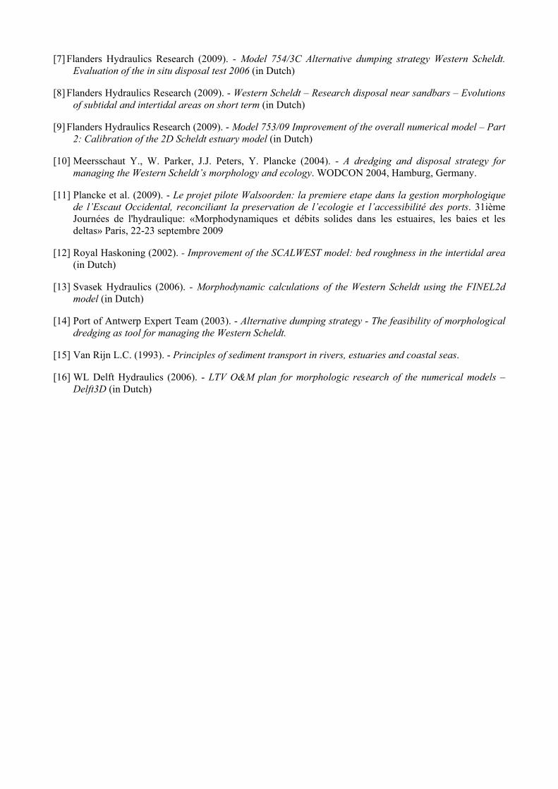
[7] Flanders Hydraulics Research (2009). - Model 754/3C Alternative dumping strategy Western Scheldt. Evaluation of the in situ disposal test 2006 (in Dutch)
[8] Flanders Hydraulics Research (2009). - Western Scheldt – Research disposal near sandbars – Evolutions of subtidal and intertidal areas on short term (in Dutch)
[9] Flanders Hydraulics Research (2009). - Model 753/09 Improvement of the overall numerical model – Part 2: Calibration of the 2D Scheldt estuary model (in Dutch)
[10] Meersschaut Y., W. Parker, J.J. Peters, Y. Plancke (2004). - A dredging and disposal strategy for managing the Western Scheldt’s morphology and ecology. WODCON 2004, Hamburg, Germany.
[11] Plancke et al. (2009). - Le projet pilote Walsoorden: la premiere etape dans la gestion morphologique de l’Escaut Occidental, reconciliant la preservation de l’ecologie et l’accessibilité des ports. 31ième Journées de l'hydraulique: «Morphodynamiques et débits solides dans les estuaires, les baies et les deltas» Paris, 22-23 septembre 2009
[12] Royal Haskoning (2002). - Improvement of the SCALWEST model: bed roughness in the intertidal area (in Dutch)
[13] Svasek Hydraulics (2006). - Morphodynamic calculations of the Western Scheldt using the FINEL2d model (in Dutch)
[14] Port of Antwerp Expert Team (2003). - Alternative dumping strategy - The feasibility of morphological dredging as tool for managing the Western Scheldt.
[15] Van Rijn L.C. (1993). - Principles of sediment transport in rivers, estuaries and coastal seas.
[16] WL Delft Hydraulics (2006). - LTV O&M plan for morphologic research of the numerical models – Delft3D (in Dutch)