“Using MODIS and POLDER data to develop a generalized approach for correction of the BRDF...
30
“Using MODIS and POLDER data to develop a generalized approach for correction of the BRDF effect” Eric F. Vermote, Christopher O. Justice Dept of Geography, UMCP Francois-Marie Breon Laboratoire des Sciences du Climat et de l’Environnement, Unité Mixte de Recherche CEA-CNRS-UVSQ ( This research is part of the NASA supported Land LTDR Project)
-
Upload
maximo-greenhow -
Category
Documents
-
view
216 -
download
0
Transcript of “Using MODIS and POLDER data to develop a generalized approach for correction of the BRDF...

“Using MODIS and POLDER data to develop a generalized approach for correction of the
BRDF effect”
Eric F. Vermote, Christopher O. JusticeDept of Geography, UMCP
Francois-Marie BreonLaboratoire des Sciences du Climat et de l’Environnement,
Unité Mixte de Recherche CEA-CNRS-UVSQ( This research is part of the NASA supported Land LTDR Project)

Introduction• The effect of surface anisotropy on remotely sensed satellite data has been
the subject of intensive research over the past 20 years The surface reflectance is described by the Bidirectional Reflectance Distribution Function (BRDF), which is a function of the sun zenith angle s, the view zenith angle v, and both azimuths s and v with respect to a reference direction. In practice, for most applications, the azimuth variations only depend on the relative azimuth=s-v.
Directional reflectance observed for an evergreen needle leaf forest from Schaaf et al.

The Polarization and Directionality of the Earth’s Reflectances results from POLDER
• Using multi-directional Parasol POLDER data at coarse resolution (6 km) over a large set of representative targets, POLDER showed that simple models with only 3 free parameters permit an accurate representation of the BRDFs. The best results (low RMS residuals) were obtained with the linear Ross-Li-HS model, a version of the Ross-Li model that accounts for the Hot-Spot process
The ability of simple, linear, models to reproduce the BRDF of natural targets opens the way for the correction of directional effects on reflectance time
series data (MODIS and AVHRR). However, the question remains as to the choice of the BRDF model, i.e. the determination of its free parameters.
s,v, k0 k1 F1 s,v , k2 F2 s,v,
k0 1k1
k0
F1 s,v, k2
k0
F2 s,v ,

The POLDER results toward a generic BRDF • Measurements from the Polarization and Directionality of the Earth’s
Reflectances (POLDER) BRDF database, have shown that it is possible to assume a typical BRDF signature on a biome basis and therefore apply a-priori correction of the BRDF effect. This approach has been applied successfully on wide-swath data from polar orbiting satellite systems (e.g. AVHRR)

Application to MODIS Surface Reflectance CMG daily data Time series (2000 to 2004) MODIS CMG daily Red and Nir reflectance data over a southern Africa Tropical Savanna site
2
21
)(
2
12
21
N
ni ydayday
dayday
yyy
yNoiseiii
ii
iii
Measure of Perturbation associated with the BRDF

A new approach to invert BRDF on times series
k0 k1 F1i k2 F2
i i i1N
2
s,v, k0 k1 F1 s,v , k2 F2 s,v,
k0 1k1
k0
F1 s,v, k2
k0
F2 s,v ,
Classic approach assumes the reflectance does not vary within the inversion time interval and BRDF correction minimizes the classic merit function
Our new approach allows the reflectance to vary slowly within the interval and minimization of a more complicated merit function
ti 1V F1
i R F2i
ti1
1V F1i1 R F2
i1
M i1 1VF1
i RF2i i 1VF1
i1 RF2i1 2
day i1 day i 1i1
N 1

The equation to be solved is still linear
iF1 iF1
i1
N 1
iF1 iF2
i1
N 1
iF1 iF2
i1
N 1
iF2 iF2
i1
N 1
V
R
i iF1
i1
N 1
i iF2
i1
N 1
id dayi1 dayi 1
i i1 i / id
iF1 i1F1i iF1
i1 / id
iF2 i1F2i iF2
i1 / id
with

Time series of normalized reflectance using the classical approach (tropical savanna)
,,,,1
0,0,450,0,451,,0,0,45
21
21
vsvsvs
N
FRFV
FRFV

Uncorrected Reflectance Data

Time series of normalized reflectance using the classical approach
N 45,0,0 s,v, 1V F1 45,0,0 R F2 45,0,0 1V F1 s,v, R F2 s,v,

Time-series of normalized reflectance using the new approach

Further improvements allow the V (volume parameter) and R (roughness parameter) to vary
as a function of NDVI
Red: band 2Blue: band 1
Improving Correction by Stratifying by Vegetation ‘Amount’ over Time

Results of final BRDF Correction
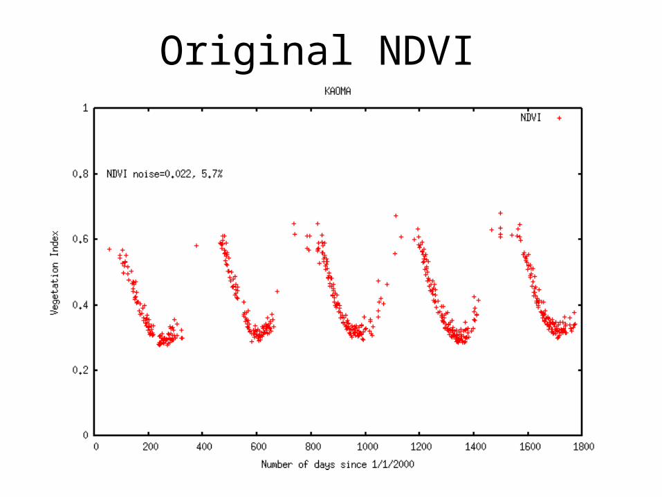
Original NDVI

NDVI computed from classical BRDF approach

NDVI computed from new BRDF inversion (V and R fixed)

NDVI computed from new BRDF inversion (V and R varies linearly with NDVI)

Results for various land covers
Savanna Evergreen
forest Deciduous
forest Broadleaf
crops Broadleaf
crops Raw data noise 0.019 (18.8%) 0.006 (33.6%) 0.011 (23.0%) 0.011 (12.6%) 0.016 (16.3%) Channel
1 Cor. Data noise 0.004 ( 3.4%) 0.002 (13.0%) 0.004 (10.0%) 0.005 ( 6.2%) 0.006 ( 7.3%) Raw data noise 0.040 (16.4%) 0.063 (20.6%) 0.043 (19.7%) 0.024 ( 9.4%) 0.043 (16.5%) Channel
2 Cor. Data noise 0.005 ( 2.4%) 0.007 ( 2.5%) 0.010 ( 4.5%) 0.011 ( 4.5%) 0.011 ( 4.6%) Raw data noise 0.019 ( 4.6%) 0.016 ( 1.8%) 0.017 ( 3.0%) 0.027 ( 5.6%) 0.026 ( 5.7%) NDVI Cor. Data noise 0.008 ( 2.3%) 0.012 ( 1.4%) 0.013 ( 2.3%) 0.012 ( 2.8%) 0.023 ( 5.3%)
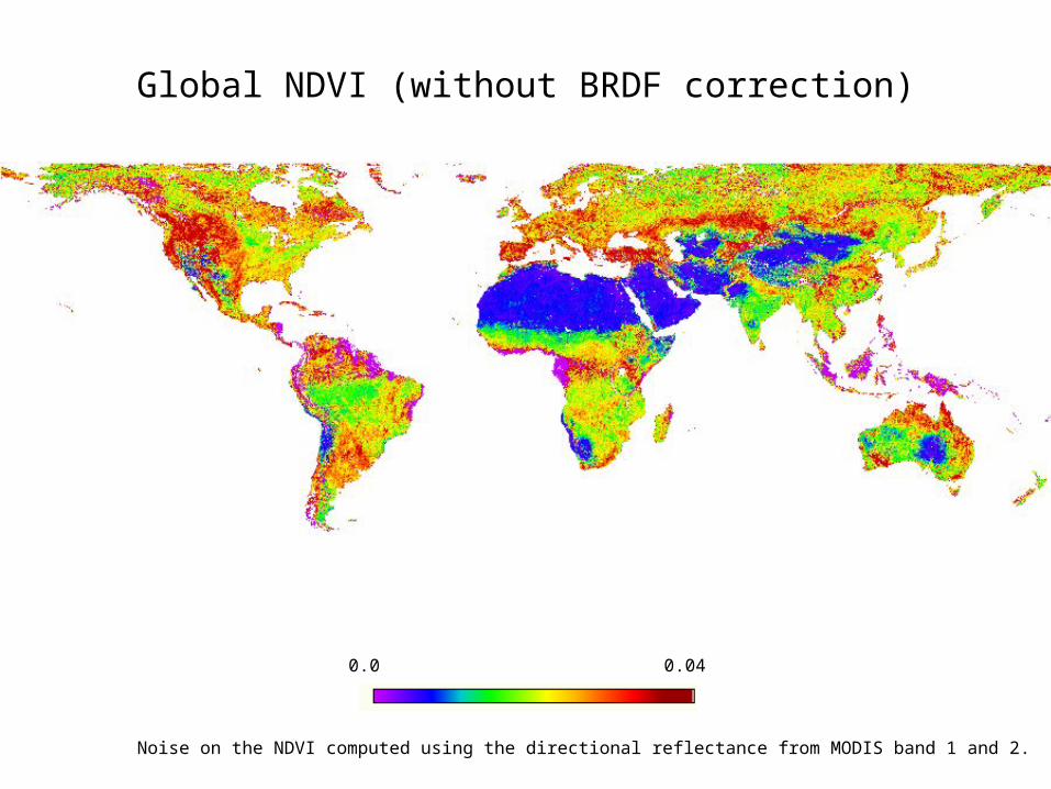
Global NDVI (without BRDF correction)
0.0 0.04
Noise on the NDVI computed using the directional reflectance from MODIS band 1 and 2.
0.0 0.04
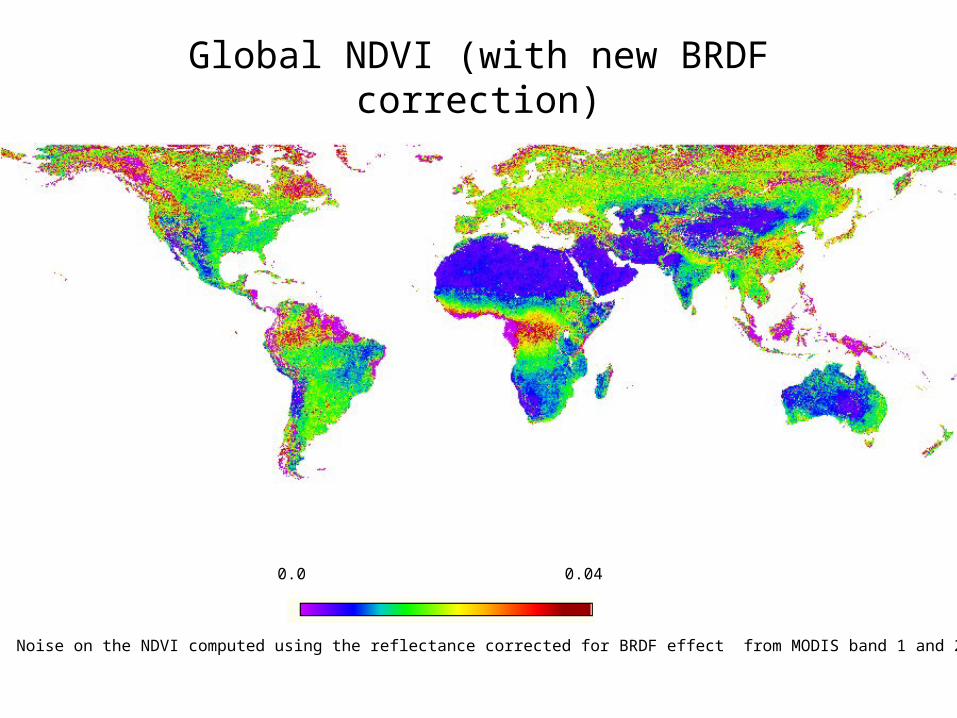
Noise on the NDVI computed using the reflectance corrected for BRDF effect from MODIS band 1 and 2
Global NDVI (with new BRDF correction)

Global reduction in NDVI noise
0.0 50%
NDVI Noise reduction in %.

Global map of R and V parameters at the peak NDVI
0.0 0.9
NDVI at the peak

V parameter at the peak NDVI
0.0 2.5

R parameter at the peak NDVI
-0.05 0.25

Sahara Desert Detail
Surface Reflectance (RGB)
Ahaggar Mtns
Tibesti Mtns
Air Mountains

Details over Sahara (Roughness)

The R parameter is related to aerodynamic surface roughness length (Marticonera et al. POLDER data)
0
0.05
0.1
0.15
0.2
0.25
0.0001 0.001 0.01 0.1 1
y = 0.22098 + 0.062443log(Z0) R= 0.80215
R p
ara
met
er
[uni
tless
]
Roughness length Z0 [cm]
We used the dataset of roughness length collected by Greeley et al. for Namibia, Death Valley and Lunar Lake U.S.A. and the dataset collected by Marticorena et al. for an arid surface in southern Tunisia.
Excluding sites with substantial vegetation cover, we compared the R parameter derived from this study to the aerodynamic roughness length Z0. The relationship derived is close to the one derived by Marticorena et al. i.e. (0.277+0.052log(Z0))

Details over Europe
(Roughness)
-0.05 0.25
R parameter
0 80%
% Tree coverHansen et al. (2002)

A Tale of Two Cities
R parameter
-0.05 0.25
Paris/Vermote
London/Justice
High Roughness Associated with Major Cities

Conclusions• A new approach has been developed and tested to
correct daily time-series of reflectance data for the BRDF effect (using a database of coefficient V and R that only depend on NDVI) (paper in preparation)
• The NDVI after the new BDRF correction is greatly improved (factor 2 reduction) for a large percentage of the land cover types as compared to non-corrected data
• Once the database (effectively a time varying map of R an V) is developed - the correction could be applied to other similar time-series data sets without deriving the BRDF
• The V and R coefficients themselves also could be used in other applications e.g. R could be used for Aerodynamic roughness and land cover characterization
• We intend to use the approach in the LTDR project to correct AVHRR and MODIS Surface Reflectance time series for the BRDF effect.