Using INSPIRE Data for Cartographic Purpose: The BaseMap ... · 27/05/2015 · .MAP .XLS...
27
the Competitiveness and Innovation framework Programme (CIP) ICT Policy Support Programme (PSP) Call 6 (Grant 325140) EUROPEAN LOCATION FRAMEWORK Presentation to: Author: Date: INSPIRE Conference 2015, Lisbon Anja Hopfstock, Dominique Laurent, Thomas Ellet von Brasch 27 th May 2015 27 May, 2015 Using INSPIRE Data for Cartographic Purpose: The BaseMap Experience
Transcript of Using INSPIRE Data for Cartographic Purpose: The BaseMap ... · 27/05/2015 · .MAP .XLS...

the Competitiveness and Innovation framework Programme (CIP) ICT Policy Support Programme (PSP) Call 6 (Grant 325140) EUROPEAN LOCATION FRAMEWORK
Presentation to:
Author:
Date:
INSPIRE Conference 2015, Lisbon
Anja Hopfstock, Dominique Laurent, Thomas Ellet von Brasch
27th May 2015
27 May, 2015
Using INSPIRE Data for Cartographic Purpose: The BaseMap Experience

the Competitiveness and Innovation framework Programme (CIP) ICT Policy Support Programme (PSP) Call 6 (Grant 325140) EUROPEAN LOCATION FRAMEWORK
Agenda
The Basemap idea
The Basemap model
Portrayal
How does it may look like?
Conclusions
27 May, 2015

the Competitiveness and Innovation framework Programme (CIP) ICT Policy Support Programme (PSP) Call 6 (Grant 325140) EUROPEAN LOCATION FRAMEWORK
Presentation to:
Author:
Date:
27 May, 2015
WP3 WP2 WP4 WP5 WP6 WP7 WP8 WP9
ELF Master
ELF Global
ELF Regional
250 builders
13 million euros 14 countries

the Competitiveness and Innovation framework Programme (CIP) ICT Policy Support Programme (PSP) Call 6 (Grant 325140) EUROPEAN LOCATION FRAMEWORK
The Basemap idea
27 May, 2015

the Competitiveness and Innovation framework Programme (CIP) ICT Policy Support Programme (PSP) Call 6 (Grant 325140) EUROPEAN LOCATION FRAMEWORK
Definition and main principles
a pyramid of digital maps displaying INSPIRE/ELF based data at different levels of zoom
Themes: Administrative Units, Buildings, Elevation, Hydrography, Land Cover, Transport Network and Geographical Names
Main use case: Background map for applications
Geographic extent : geographic Europe (oversea territories excluded)
CRS: pseudo Mercator (3857) and LAEA (3035)
Levels of zoom : from a standardized list (2K to 40M)
27 May, 2015

the Competitiveness and Innovation framework Programme (CIP) ICT Policy Support Programme (PSP) Call 6 (Grant 325140) EUROPEAN LOCATION FRAMEWORK
Service infrastructure
27 May, 2015
NATIONAL
DATA
EuroGeographics
DATA
NATIONAL
DATA
EUROPE NORWAY
NATIONAL
DATA
NATIONAL
DATA
WEB
WMTS

the Competitiveness and Innovation framework Programme (CIP) ICT Policy Support Programme (PSP) Call 6 (Grant 325140) EUROPEAN LOCATION FRAMEWORK
The Basemap model
27 May, 2015

the Competitiveness and Innovation framework Programme (CIP) ICT Policy Support Programme (PSP) Call 6 (Grant 325140) EUROPEAN LOCATION FRAMEWORK
ELF Basemap specification
Content of ELF Basemap
Themes
Feature types
Attributes used for selection/generalisation and portrayal
Simplification of ELF data model
Simple, flat structure
Only useful content for cartographic purposes
Common ELF-based terminology
SLD file
Standardized way to document portrayal rules
Layer name
Layer source
Scale range
Symbol to be applied
27 May, 2015
class RailwayNetwork
«featureType»
RailwayLink
+ geometry: GM_Curve
+ railwayType: RailwayTypeValue [0..1]
+ verticalPosition: VerticalPositionValue [0..1]
«codeList»
RailwayTypeValue
+ train
+ other
«codeList»
VerticalPositionValue
+ underGround
+ ongroundSurface or suspendedOrElevated
the Competitiveness and Innovation framework Programme (CIP) ICT Policy Support Programme (PSP) Call 6 (Grant 325140) EUROPEAN LOCATION FRAMEWORK
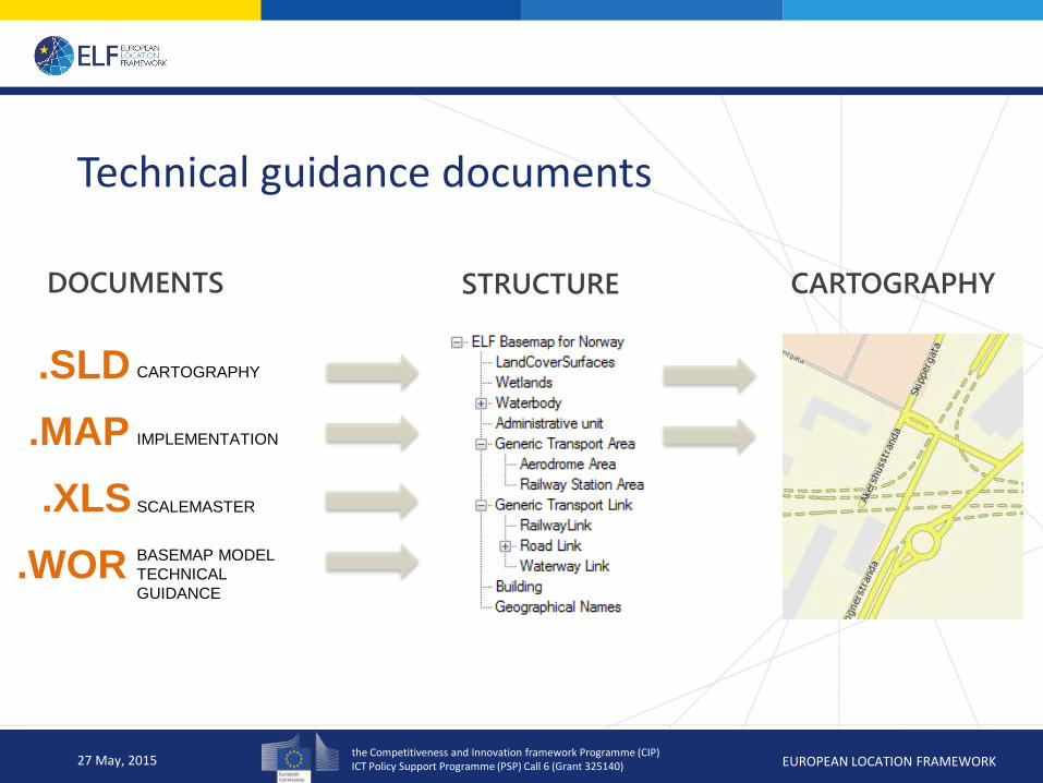
Technical guidance documents
27 May, 2015
.SLD
.MAP
.XLS
CARTOGRAPHY
IMPLEMENTATION
SCALEMASTER
BASEMAP MODEL
TECHNICAL
GUIDANCE
DOCUMENTS STRUCTURE CARTOGRAPHY
.WOR

the Competitiveness and Innovation framework Programme (CIP) ICT Policy Support Programme (PSP) Call 6 (Grant 325140) EUROPEAN LOCATION FRAMEWORK
Production Process
Options:
(1) Common process to flatten and simplify INSPIRE/ELF GML data
(2) Transformation of existing data to simplified profile of INSPIRE/ELF data model
(3) Use existing data and transformation/adaptation of SLD
27 May, 2015
NATIONAL
DATA
EUROPE
NATIONAL
DATA
NATIONAL
DATA
Advantages - Pragmatic approach - Contribute using
exisiting data/services
Drawbacks - No systematic use of
INSPIRE/ELF data - Heterogeneous
production process
the Competitiveness and Innovation framework Programme (CIP) ICT Policy Support Programme (PSP) Call 6 (Grant 325140) EUROPEAN LOCATION FRAMEWORK
Portrayal
27 May, 2015

the Competitiveness and Innovation framework Programme (CIP) ICT Policy Support Programme (PSP) Call 6 (Grant 325140) EUROPEAN LOCATION FRAMEWORK
General portrayal rules
Show only valid features
Consideration of temporal aspects, e.g. lifecycle information and conditionOfFacility: exclude „historical“ features or features „projected/underConstruction“
Sea area
Display as blue background
Geographical names
Limitation of number of names for the same feature (general up to 4 names, 2 street names)
Issue in countries with multiple languages
Use of vendor specific parameters allowed to improve portrayal
27 May, 2015
class NamedPlace
«featureType»
NamedPlace
+ geometry: GM_Point
+ type: TypeValue
+ name1: CharacterString
+ name2: CharacterString [0..1]
+ name3: CharacterString [0..1]
+ name4: CharacterString [0..1]
class RoadNetwork
«featureType»
RoadLink
+ geometry: GM_Curve
+ roadClass: RoadClassValue
+ verticalPosition: VerticalPositionValue [0..1]
+ streetName1: CharacterString [0..1]
+ streetName2: CharacterString [0..1]
+ nationalRoadCode: CharacterString

the Competitiveness and Innovation framework Programme (CIP) ICT Policy Support Programme (PSP) Call 6 (Grant 325140) EUROPEAN LOCATION FRAMEWORK
General portrayal rules
Elevation
Hillshading based on EuroGeographics EuroDEM dataset
Transport Network Properties
Simplified into attributes attached to features
Partly two attributes driving the selection and portrayal
European Road Classification based on combination of FormOfWay and FunctionalRoadClass
Settlements
Possibility for classification missing in INSPIRE GN::NamedPlace
based on EuroGeographics EuroRegionalMap dataset using population information
27 May, 2015
class RoadNetwork
«featureType»
RoadLink
+ geometry: GM_Curve
+ roadClass: RoadClassValue
+ verticalPosition: VerticalPositionValue [0..1]
+ streetName1: CharacterString [0..1]
+ streetName2: CharacterString [0..1]
+ nationalRoadCode: CharacterString
«codeList»
RoadClassValue
+ motorway
+ primaryRoad
+ secondaryRoad
+ tertiaryRoad
+ otherRoad
«codeList»
VerticalPositionValue
+ underGround
+ ongroundSurface or suspendedOrElevated

the Competitiveness and Innovation framework Programme (CIP) ICT Policy Support Programme (PSP) Call 6 (Grant 325140) EUROPEAN LOCATION FRAMEWORK
Geographical Names
27 May, 2015

the Competitiveness and Innovation framework Programme (CIP) ICT Policy Support Programme (PSP) Call 6 (Grant 325140) EUROPEAN LOCATION FRAMEWORK
Transport Network (1)
27 May, 2015
class AirTransport
«featureType»
RunwayArea
+ geometry: GM_Surface
«featureType»
AerodromeArea
+ geometry: GM_Surface

the Competitiveness and Innovation framework Programme (CIP) ICT Policy Support Programme (PSP) Call 6 (Grant 325140) EUROPEAN LOCATION FRAMEWORK
Example in urban areas (9K)
Transport Network (2)
27 May, 2015
Example in rural areas (4,5K) Example in urban area with street names (4,5K)

the Competitiveness and Innovation framework Programme (CIP) ICT Policy Support Programme (PSP) Call 6 (Grant 325140) EUROPEAN LOCATION FRAMEWORK
How does it may look like?
27 May, 2015

the Competitiveness and Innovation framework Programme (CIP) ICT Policy Support Programme (PSP) Call 6 (Grant 325140) EUROPEAN LOCATION FRAMEWORK
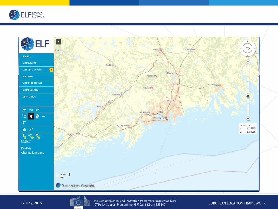
ELF Platform: Oskari
27 May, 2015
the Competitiveness and Innovation framework Programme (CIP) ICT Policy Support Programme (PSP) Call 6 (Grant 325140) EUROPEAN LOCATION FRAMEWORK
ELF Basemap (Regional)
27 May, 2015

the Competitiveness and Innovation framework Programme (CIP) ICT Policy Support Programme (PSP) Call 6 (Grant 325140) EUROPEAN LOCATION FRAMEWORK
ELF Basemap (Regional)
27 May, 2015

the Competitiveness and Innovation framework Programme (CIP) ICT Policy Support Programme (PSP) Call 6 (Grant 325140) EUROPEAN LOCATION FRAMEWORK
ELF Basemap (Master)
27 May, 2015

the Competitiveness and Innovation framework Programme (CIP) ICT Policy Support Programme (PSP) Call 6 (Grant 325140) EUROPEAN LOCATION FRAMEWORK
ELF Basemap (Master)
27 May, 2015

the Competitiveness and Innovation framework Programme (CIP) ICT Policy Support Programme (PSP) Call 6 (Grant 325140) EUROPEAN LOCATION FRAMEWORK
ELF Basemap (Master)
27 May, 2015

the Competitiveness and Innovation framework Programme (CIP) ICT Policy Support Programme (PSP) Call 6 (Grant 325140) EUROPEAN LOCATION FRAMEWORK
Conclusions
27 May, 2015

the Competitiveness and Innovation framework Programme (CIP) ICT Policy Support Programme (PSP) Call 6 (Grant 325140) EUROPEAN LOCATION FRAMEWORK
Challenges
Fitness-for-purpose of INSPIRE/ELF data for mapping
INSPIRE/ELF data model and format: complexity of data model (e.g. transport properties), missing classification information, overlaps between themes
heterogeneous data content: limited mandatory information, national classifications
Production process
Use of INSPIRE/ELF data
Use of existing data and/or services
Service infrastructure
Harvesting national WMS
Set up WMTS
Pilot Basemap for Nordic cluster (Norway, Sweden, Finland, Netherlands): Basemap with simple content to be used as background map
27 May, 2015

the Competitiveness and Innovation framework Programme (CIP) ICT Policy Support Programme (PSP) Call 6 (Grant 325140) EUROPEAN LOCATION FRAMEWORK
More information
27 May, 2015
www.elfproject.eu

the Competitiveness and Innovation framework Programme (CIP) ICT Policy Support Programme (PSP) Call 6 (Grant 325140) EUROPEAN LOCATION FRAMEWORK
From isolated components to integrated, cross-border seamless authoritative reference data …
Thank you!
27 May, 2015