USFS Land Acquisition Strategy South Carolina - America's
38
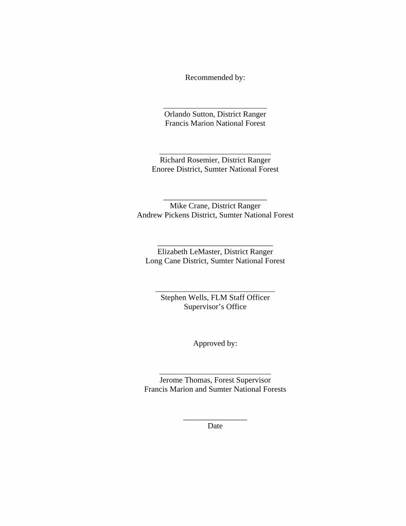
United States Department of Agriculture Forest Service Southern Region Land Ownership Adjustment Strategy Francis Marion and Sumter National Forests South Carolina June 2005 The U.S. Department of Agriculture (USDA) prohibits discrimination in all its programs and activities on the basis of race, color, national origin, sex, religion, age, disability, political beliefs, sexual orientation, or marital or family status. (Not all prohibited bases apply to all programs.) Persons with disabilities who require alternative means for communication of program information (Braille, large print, audiotape, etc.) should contact USDA's TARGET Center at (202) 720-2600 (voice and TDD). To file a complaint of discrimination, write USDA, Director, Office of Civil Rights, Room 326-W, Whitten Building, 1400 Independence Avenue, SW, Washington, D.C. 20250-9410 or call (202) 720- 5964 (voice and TDD). USDA is an equal opportunity provider and employer.
Transcript of USFS Land Acquisition Strategy South Carolina - America's
United States
Department of Agriculture Forest Service
Southern Region
Land Ownership Adjustment Str Francis Marion and Sumter
National Forests
Sou
June 2005 The U.S. Department of Agriculture (USDA) prohibits discrimination in all its pron the basis of race, color, national origin, sex, religion, age, disability, political borientation, or marital or family status. (Not all prohibited bases apply to all progdisabilities who require alternative means for communication of program informaprint, audiotape, etc.) should contact USDA's TARGET Center at (202) 720-2600 To file a complaint of discrimination, write USDA, Director, Office of Civil RighWhitten Building, 1400 Independence Avenue, SW, Washington, D.C. 20250-945964 (voice and TDD). USDA is an equal opportunity provider and employer.
ategy
th Carolina
ograms and activities eliefs, sexual
rams.) Persons with tion (Braille, large (voice and TDD).
ts, Room 326-W, 10 or call (202) 720-
Recommended by:
__________________________ Orlando Sutton, District Ranger Francis Marion National Forest
____________________________ Richard Rosemier, District Ranger
Enoree District, Sumter National Forest
__________________________ Mike Crane, District Ranger
Andrew Pickens District, Sumter National Forest
_____________________________ Elizabeth LeMaster, District Ranger
Long Cane District, Sumter National Forest
______________________________ Stephen Wells, FLM Staff Officer
Supervisor’s Office
Approved by:
____________________________ Jerome Thomas, Forest Supervisor
Francis Marion and Sumter National Forests
________________ Date
Table of Contents Page Introduction 1 History 1 Issues and Concerns 2 Forest Service Policy 3 Forest Plan Direction 4 Authorizing Legislation 5 Land Adjustment Strategies 7 Land Exchange Process 12 Summary 13 Contact Information 15 Glossary Appendix A Reason Codes/Criteria for Long Cane Ranger District Appendix A Sample Documents: Land Exchange Process Flow Chart Appendix B Secretary/Congressional Oversight Flow Chart Appendix B Agreement to Initiate Appendix B Implementation Schedule Appendix B Exchange Agreement Appendix B Maps Appendix C
Introduction Land ownership adjustment can be defined as “the process of changing ownership or jurisdiction of real property (lands and interests in lands).” The primary objective of land adjustment is to achieve the optimum land ownership pattern in the National Forest System that provides for resource use and protection to meet public needs. Adjustments can also be used to settle claims equitably and properly. Several methods of land ownership adjustment are commonly used by the Forest Service to carry out the land ownership adjustment program. These methods are authorized by congress and can be employed to adjust the National Forest System land base to achieve a desired future land pattern for the long term. These methods include:
Exchange between the federal government and a non-federal property; Purchase of property not in federal ownership; Donation of non-federal property; Interchange with the Department of Defense agencies, or between the Forest
Service and individuals under the Small Tracts Act; Sale of federal land; Condemn private property resulting in acquisition.
Forest Service policy and the forests’ Land and Resource Management Plans (Forest Plans) provide overall direction for land adjustment decisions on both the Francis Marion National Forest and the Sumter National Forest. This document is a guide or strategy for making land adjustment decisions on the forests and does not change goals, policy, or direction. It provides the rationale used to consider land adjustments and how that rationale relates directly to the Forest Plans. The Land Ownership Adjustment Strategy (LOAS) consists of narratives and maps. The narratives describe Forest Service policy, Forest Plan direction, and specific strategies for various land areas under consideration. The maps display the desired future condition of the national forests based on policy, direction, and strategies. The LOAS is needed to provide guidance to the forests’ land adjustment program to achieve the desired ownership pattern. The strategy will be used to make decisions on specific and various parcels to retain in federal ownership or to convey, and to acquire those lands or partial interests in lands needed for public purposes. In some cases unforeseen circumstances make it necessary to reevaluate the criteria used to determine land classification. Lands identified for acquisition, retention, or conveyance may be reclassified when overriding factors indicate a greater public good may be served. History In South Carolina, the purchase of land for forest reserves began as early as 1914. The bulk of the landholdings were acquired during the 1920s and 1930s, though the Francis Marion and Sumter National Forests were not established until 1936. Land adjustment by purchase and exchange continued sporadically during the next 30 years, and considerable
acreage was transferred from forest ownership to state and federal governments, schools, and other public entities to provide for the best management of the land areas involved. Land exchange played a large role in the land adjustment program of the 70s and 80s when a concentrated effort was made to consolidate landholdings within each national forest. Because of congressional, state, and conservation organization support, the Francis Marion and Sumter National Forests have obtained substantial Land and Water Conservation Fund (LWCF) allocations for land acquisition since the early 1990s. As a result, most recent land adjustments have been accomplished by purchases rather than by land exchanges. However, LWCF funding for land acquisition is unpredictable, and competition for these funds is fierce. Effective use of all tools available for land ownership adjustment will be required to work toward the desired future condition of the forests. Issues and Concerns Issues and concerns associated with national forest management and land ownership adjustment on the Francis Marion and Sumter National Forests follow.
Property values are escalating dramatically in some areas, especially in the
southern portion of the Francis Marion National Forest. Some areas are losing their “national forest character” (i.e., large tracks of
contiguous, forested lands). Development of private land adjacent to national forest land will affect the character and use of the national forests.
Local zoning regulations may contribute to the loss of forest character when intensive development of private land is allowed directly adjacent to the forest boundary.
Access to national forest land is becoming increasingly difficult to obtain. Conversion of land from industry ownership to smaller private holdings increases the complexity of acquiring permanent access through these lands. Private land owners often do not wish to convey permanent easements because of concerns about liability and trespass resulting from increased public access.
Encroachment and trespass are increasing problems. Numerous non-system roads within the forests are used to access private lands without benefit of an easement.
The land ownership pattern is inefficient and difficult to manage, especially on the Long Cane and Enoree Ranger Districts where fragmentation is greater.
Land exchanges may contribute to growth on newly created private lands, particularly near areas already developed.
Industrial land owners are selling large amounts of forested lands within the national forest proclamation boundary. These lands are at risk of being developed.
Development of private lands within the national forests boundaries is leading to fragmentation and the loss of important wildlife habitat.
Owning land adjacent to the national forest is seen as a benefit by private property owners, but development near the forest boundary makes it difficult to manage.
- 2 -
Safety is often an issue where homes are concentrated near areas designated for prescribed burning or timber management.
Increased road access and use leads to higher mortality among wildlife and can increase erosion and sedimentation of waterways.
Hydrology can be permanently altered by development, causing downstream impacts by sedimentation and erosion.
The purpose of this strategy is threefold.
Meet agency strategic goals and objectives, and those of the Forest Plans; To focus on the rationale used to determine suitability for acquisition and identify
lands for conveyance or retention; To make Forest Service goals and direction more visible to decision makers and
to the public. Forest Service Policy Forest Service policy for land ownership adjustment is found in the Forest Service Manual (FSM 5400). The objectives of the Forest Service land ownership adjustment program include the following:
Achieve the optimum land ownership pattern to provide for resource uses to meet the needs of the American people now and in the future;
Settle land title claims equitably and promptly, and avoid land use conflicts with non-federal landowners.
To meet these objectives, the Land Ownership Adjustment Strategy classifies lands for acquisition or conveyance to:
Give priority to consolidation of national forest lands within existing units; Acquire lands valuable for recreation, wildlife habitat, wilderness, and other
natural resource management purposes; Consolidate land ownership to improve operating efficiency; Acquire rights-of-way needed to ensure optimum protection and use of national
forest resources; Complete land-for-timber exchanges to consolidate national forest and private,
state, or local government land patterns; to permit needed urban or industrial expansion; or to make other adjustments in landownership that the Forest Service deems to be in the public interest;
Transfer and interchange land with other federal agencies to consolidate national forests and to clarify and reduce the cost of administration and protection, as well as to improve resource conservation production and utilization;
Exchange or otherwise dispose of lands from the National Forest System that have lost their national forest character or are no longer suitable for national forest purposes;
- 3 -
Provide communities with the opportunity to acquire National Forest System lands needed for expanding community purposes, where such conveyances are consistent with management objectives;
Reduce the need for and the number of rights-of-ways, both acquired and conveyed;
Reduce the miles of private/Forest Service property lines to reduce the miles of property boundary survey, posting and maintenance;
Reduce special use permit administration; Dispose of lands, especially near communities, that are encumbered with private
uses. Forest Plan Direction The Francis Marion and Sumter National Forests each have separate Forest Plans. The Francis Marion National Forest Plan was approved in 1995, and the Sumter National Forest Plan was approved in 2004. Forest Plan goals and objectives for land adjustments for each national forest follow. Francis Marion Forest Plan: Goal: Consolidate ownership through land adjustment to provide better potential for enhancing desired biological diversity, enhance recreational opportunities, maintain public access, and increase management efficiency. Standards and guidelines: FW-73 Disposal of tracts will be coordinated with resource management activities prior to disposal to assure the following are not being disposed of without adequate mitigation: a) high value wildlife and/or threatened, endangered or sensitive plant, aquatic and animal species habitat and unique and or aquatic endemic natural plant communities; b) significant historical or archeological sites; and c) wetlands and floodplains. FW-74 Acquire lands by purchase, exchange, donation or transfer that are high value for wildlife and fish, contain habitat for threatened, endangered and sensitive species of plants, animals, and invertebrates, contain outstanding examples of natural plant communities, have value for outdoor recreation purposes, provide efficiency in administration of the forest, include wetlands and floodplains or contain significant archeological or historical resources. FW-156 (Land Ownership and Adjustment) When compatible, manage new land acquisitions according to the adjacent or surrounding Management Areas. The determination of suitability of the acquired lands for the various uses, including timber production, will follow the Forest Plan direction for the applicable Management Areas. When not compatible, conduct an environmental analysis and prepare the appropriate decision document to amend the Forest Plan.
- 4 -
Sumter Forest Plan: Goal: Acquire non-federal lands through purchase, donation or exchange to improve management effectiveness, support specific resource management objectives and enhance public benefits. Standards and guidelines: FW- 98 Rights-of-way (ROW) will be acquired for existing and proposed National Forest System roads and trails. Temporary rights-of-way are acceptable if a permanent right-of-way cannot be obtained. FW- 99 When compatible, manage future acquired lands according to the management prescription direction within which the newly acquired lands are located. Other forest planning documents will be considered and may provide additional direction for specific lands adjustment activities. For example, the Facilities Master Plan considers land acquisition needed for administrative sites and other operational facilities, as well as structures recommended for decommission and/or disposal. Some districts have prepared a Roads Analysis plan, identifying access needs that may lead to acquisition of land or permanent easements. These various planning documents will be considered when implementing the LOAS. Authorizing Legislation There are numerous laws authorizing the purchase, exchange or conveyance of National Forest System lands. Both forests were established by presidential proclamation in 1936. Most National Forest System lands in the Francis Marion and Sumter were purchased under the authority of the Weeks Act of 1911. Some basic and appropriate authorities that may be used for purchase, exchange, or conveyance may be found in the following laws:
Organic Act Weeks Act General Exchange Act Federal Land Exchange Facilitation Act Bankhead-Jones Farm Tenant Act Forest Service Omnibus Act Wild and Scenic Rivers Act Forest and Rangeland Renewable Resources Act Federal Land Policy and Management Act Small Tracts Act Sisk Act Education Land Grant Act Pilot Conveyance (temporary authority)
- 5 -
The Land and Water Conservation Fund Act (LWCF) provides a major source of acquisition funds to the Forest Service. These funds may be used for the purchase of lands valuable for outdoor recreation or for the conservation of fish, wildlife, and plant species. South Carolina has been very successful in obtaining LWCF funding for purchases in recent years, however, reduced LWCF funding and flat budgets are anticipated for the foreseeable future. This will result in more land adjustments being accomplished through land exchange authorities, tripartite (land for timber exchanges), special legislation, and pilot conveyance authorities. The Small Tracts Act as originally enacted is narrowly defined, and the circumstances under which it can be used are very restrictive. Amending legislation has been introduced each of the past several years to give forests more authority to solve the many boundary problems that exist. Here are examples of the types of boundary problems.
Highway relocations have created uneconomic remnants of land that are difficult to manage.
Survey lines create similar land remnants along creeks, roadways, and other features.
Existing churches and cemeteries have outgrown their “footprint” and/or have an awkward ownership pattern within the forest boundary.
Small boundary adjustments improve management abilities and are in the public interest.
To date, the amendment has not passed, but if the Act is amended, the forests anticipate good use of this expanded authority. The Pilot Project Conveyance authority was first passed in 2002, and expires in 2008. This legislation was introduced as a temporary engineering initiative to address backlogged maintenance. It originally allowed the sale of land and buildings identified for disposal. It was limited to a specific number of projects nationwide. Funds generated could be used only for facility maintenance and rehabilitation. The authority was expanded in 2003 to include some sites for construction and land acquisition. In 2004 the Forest Service developed a legislative proposal for a permanent authority. When passed, this legislation will be another tool for land adjustment. Special Legislation has historically been one of the primary tools for the sale of specific properties. This is predominantly a disposal authority that involves introduction of legislation for one specific state by one of its representatives. The legislation identifies specific properties for sale or exchange, with the ability to retain the proceeds for use in additional land acquisitions. Several states in the southern region, including Virginia and Florida, have benefited from this legislation. South Carolina would also benefit by special legislation. Completing this LOAS will be instrumental in identifying specific tracts for disposal if legislation is passed. Land Adjustment Strategies
- 6 -

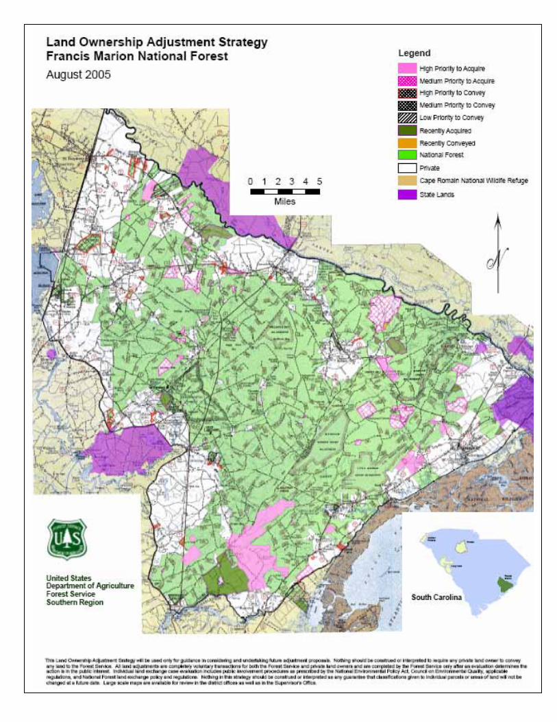
Each ranger district developed specific acquisition and conveyance strategies for areas of concern within the proclamation boundary. Non-federal lands identified for acquisition and national forest lands identified for conveyance are identified here and in Appendix B. These lands represent a long-range program of land ownership adjustment designed to accomplish some of the goals and objectives of the Forest Plans. To maintain a cost effective land ownership adjustment program, individual cases conforming to this strategy will be accepted and processed as funding and staffing allow. It should be noted that purchases and exchanges are entered into with willing landowners at appraised value in accordance with the uniform act. Proposals resulting in the greatest public benefit will be given the highest priority. Francis Marion National Forest – Witherbee/Wambaw Ranger District: The Francis Marion National Forest, in Charleston and Berkeley counties, has a consolidated ownership pattern with numerous large and small in-holdings, and some fragmentation of ownership around the forest’s perimeter. Encompassing almost 200,000 acres in a rapidly developing area, the Francis Marion is considered an urban forest. As such, developers, land owners and others in the real estate arena advertise in-holdings and tracts adjacent to national forest lands as a unique opportunity to live in a natural setting surrounded by the great outdoors. Both Charleston and Berkeley counties are in major development stages, and property values have escalated considerably over the past 5 years because of the availability of waterfront property and desirable school districts. This trend is expected to continue over the next 10 years. The forest is considered an easy commute to the Charleston Metropolitan area, and available large tracts of land are in high demand for development and subdivision. Increased demands are being made on the infrastructure needed to support this growth. There are increasing requests to expand roads and utilities (power, telephone, and gas). These actions pose a serious threat to national forest ownership and management, specifically for forest health, protection of threatened and endangered species, and multiple use-land management objectives. The areas listed below are identified for their specific development concerns; however, one large tract remains the highest priority. Known locally as Fairlawn Plantation, this 6500-acre property is easily distinguished as the single largest in holding remaining at the southern end of the forest. Highway 17 corridor is becoming more developed particularly around the towns of Awendaw and McClellanville. Adjacent national forest lands are becoming more difficult to manage. The demand for special-use authorizations to support private land development will increase. Some forest management activities, such as prescribed burning and timber harvest, will become difficult to implement because of opposition from neighbors. Forest lands will tend to lose their national forest character as the land is encumbered with special uses.
- 7 -
Highway 41 corridor is also being developed between Cainhoy and Huger. Numerous large private landholdings remain intact in this area, which has limited development thus far. However, a large timberland tract of nearly 4,500 acres was recently acquired for development despite the best efforts of conservation partners. Other areas are seeing increased pressure from development, although not as heavily as in the Highway 17 and 41 corridors. Population center distance and utility availability have also limited development in these areas. The following measures will be used as a guide in land ownership adjustment on the Francis Marion National Forest.
Reduce in holdings and perimeter fragmentation by acquiring non-federal lands as they become available.
Encourage conservation organizations, state, and local governments to acquire conservation easements on non-federal lands to limit development along the Highway 17 and 41 corridors and on key in holdings within the forest.
Convey isolated forest tracts, tracts heavily encumbered by land use authorizations, and tracts that will improve the efficiency of management by reducing the amount of property lines and corners to maintain.
Convey tracts that have lost their national forest character because of development on adjacent private lands.
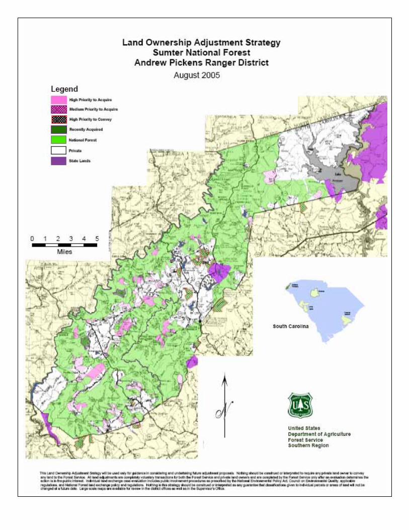
Sumter National Forest – Andrew Pickens Ranger District Mountain lands are becoming increasingly desirable for primary and secondary or vacation homes. Wealthy retirees are building new homes on lands immediately adjacent to the national forest. The Chattahoochee-Oconee National Forests in Georgia have already experienced heavy recreation-home development and land prices have escalated dramatically. This growth is spreading across the state line into South Carolina, and increasing land values are being reflected in the market. As areas develop, managing adjacent forest lands is becoming more difficult, and the demand for land use authorizations to support private land development is increasing. Some management, such as prescribed burning and timber harvest, will become difficult because of opposition from neighbors. Forest lands may lose their national forest character as the land is encumbered with special uses and area development on private land next to the forest property line. Chattooga River - The Chattooga Wild and Scenic River corridor makes up a quarter-mile wide strip of land along the western boundary of the district at the state line. The Chattooga River was designated a National Wild and Scenic River by Act of Congress in 1974, making it a high priority for acquisition. Since that time, many acres of available land within the corridor have been purchased with LWCF funding. The Chattooga River corridor purchase program has been consistently funded as a tri-state appropriation with Georgia and North Carolina. Many of the available lands have been acquired, and opportunities for acquisition have dwindled. In South Carolina, there are only five remaining private properties located directly on the Chattooga River.
- 8 -
Chauga River – The Chauga River has been designated as eligible for consideration as a wild and scenic river known locally as the “Little Chattooga” because the two rivers share many of the same values. A designated scenic area protects the future eligibility of the Chauga for wild and scenic consideration. The Chauga River watershed is also a municipal water source for the town of Westminster in Oconee County. Numerous parcels of various sizes are available for acquisition within this watershed, but funding is not currently available. General guidelines for land adjustments on the Andrew Pickens follow. Consolidate forest lands by acquiring non-federal lands to create more contiguous blocks of national forest.
Tracts within the Chattooga River watershed and, in particular, within the wild and scenic corridor of the Chattooga River should have the highest priorities for acquisition.
Tracts within the Chauga River watershed or important cultural resource values should have high priority considerations for acquisition.
Encourage conservation organizations and state and local governments to acquire conservation easements on non-federal lands to limit development.
Convey isolated forest tracts, tracts outside the proclamation boundary, tracts heavily encumbered by land use authorizations, and tracts that will improve the efficiency of management by reducing the amount of property lines and corners to maintain.
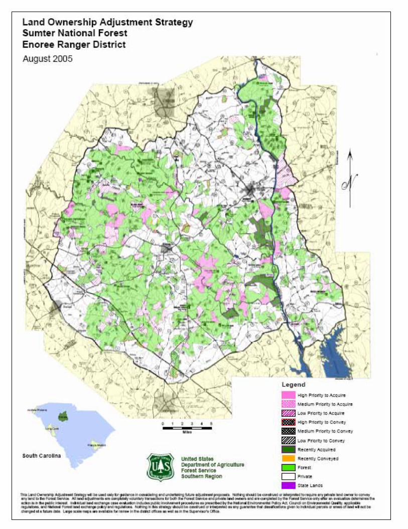
Sumter National Forest – Enoree Ranger District Specific acquisition and conveyance guidelines for the Enoree Ranger District were used to classify lands displayed in Appendix B. These guidelines follow. Acquisition Guidelines Tracts along the Broad, Enoree, and Tyger Rivers are priority for acquisition - national forest lands along these three rivers are scattered. In holdings or tracts that consolidate national forest and provide riparian habitat along these three rivers are the highest priority for acquisition. Consideration to other resources, particularly recreation and historic properties, will be considered. For example, a priority tract located on the western boundary of the district would provide canoe access to the Enoree River and is one of the district’s highest priorities. Acquiring priority lands along these three major rivers will protect water quality and provide large tracts of wildlife habitat. Conveyance Guidelines Isolated tracts south of I-26 are a priority for conveyance - These national forest lands are becoming increasingly encumbered by residential and commercial development that results from interstate access. This growth is spreading along the various interstates in
- 9 -
South Carolina, and increasing land values are being reflected in the market. Some forest management activities, such as prescribed burning and timber harvest, will become difficult because of opposition from neighbors. Other Isolated Tracts –Convey isolated forest tracts, tracts heavily encumbered by land use authorizations, and tracts that will improve the efficiency of management by reducing the amount of property lines and corners to maintain. As development increases, managing adjacent forest lands is becoming more difficult, and the demand for land use authorizations to support private land development is increasing. Forest lands may lose their national forest character as the land is encumbered with special uses and development on private land next to the forest property line. Conveyance of Small, Isolated Tracts Managing small, fragmented national forest tracts is difficult and inefficient. The land pattern has been fragmented, and land boundaries on the Enoree district need to be realigned. Numerous isolated, extremely small tracts of less than an acre have resulted from relocating state roads, specifically along SC Highway 66. There are two special use permits for mowing (Shouse and Cedar Springs Church). These tracts form the yard between the church buildings and SC Highway 66. These tracts have lost their national forest character and are uneconomic remnants. Along SC Highway 32, a land owner has proposed an exchange of a small acreage tract for a national forest tract of less than an acre. This proposal is clearly in the best interest of the national forest: the forest tract is an uneconomic remnant, and the private landowner’s property is a forested tract that would straighten out the national forest boundary. At least three churches have proposed small-acreage exchanges that would be in the best interest of the Forest Service (Flint Hill, Bethesda, and St. Matthews). These churches have a valid need to expand their buildings or parking lots. In some cases, special uses permits have been issued for parking lots and cemeteries.
Sumter National Forest – Long Cane Ranger District The Long Cane Ranger District has a complex, broken land ownership pattern. National forest land is intermingled with private land in many areas. Development on many private tracts and urban sprawl from the Augusta and North Augusta areas makes it difficult to manage these lands, and there is a steadily increasing need for special use authorizations. In areas adjacent to heavy development, some lands are losing their national forest character. Small isolated tracts of national forest land are difficult to manage. The goal is to reduce these scattered tracts of isolated land and consolidate other areas to create larger blocks of contiguous federal ownership, providing more effective land management. The strategy for keeping national forest character is more easily obtained and preserved on larger
- 10 -
tracts of national forest lands. Management of riparian and aquatic habitats is also a challenge with a broken ownership pattern; however, it is critical to manage and protect these watersheds. Acquisition of land along waterways that provides consolidation of ownership is the highest priority for the district. The Long Cane Ranger District has identified five general management unit areas for this strategy. (Please refer to maps in Appendix B for unit boundaries.) Parsons Mountain Unit, on the northern portion of the district, has both developed and dispersed recreation: two Off-Highway Vehicle (OHV) trails with trailheads, one designated horse trail system with a developed trailhead (Fell), three boat ramps along the backwaters of J. Strom Thurmond Lake (formally Clarks Hill Reservoir), and a scenic area containing the largest shagbark hickory in South Carolina. The botanical value within the scenic area would be enhanced if private lands were consolidated as national forest land, especially adjacent to Long Cane Creek. The recreational value within this unit is greater than the other designated units because of the diversity of opportunities within the existing land ownership pattern. Parsons Mountain Unit also contains all of the existing minerals interest on the district. Both recreational gold panning and permitted mineral prospecting takes place within this unit. Johns Creek Unit has known threatened and endangered species, and any land that would be consolidated along Johns Creek would help manage and enhance habitat for threatened and endangered species. At this time, no land has been identified for conveyance in this unit. Faulkner Mountain Unit was identified because it is geographically separated from other large consolidated land within the district. The objective within the Faulkner Mountain Unit is to consolidate existing federal lands and to improve management. The highest priority for the Faulkner Mountain Unit is to acquire lands along Little Mountain Creek. Once land acquisition begins in this unit, the district will be in a better position to prioritize specific options for this area. Historically, this area has had mineral interests, but nothing is currently active. Furys Ferry/Lick Fork Unit is located at the southern end of the district. This area has both developed and dispersed recreation, and currently has a proposed new 32-mile hiking/biking trail. It also has the only developed Forest Service boat landing on the Savannah River. A comprehensive vegetative management plan is currently under way for enhancing grassland savannah in the Lick Fork Lake area. The main thrust of this management prescription is to enhance wildlife habitat for early successional species, including quail. The Furys Ferry area is experiencing the greatest effects of urban sprawl from the greater Augusta urban area. Acquiring land in this area will improve management success and help preserve national forest character. This unit has known significant archeological sites. Should opportunity to convey lands in these stands be identified, thorough cultural review will be required. Stevens Creek Unit has developed hiking/biking trails, and the only designated canoe trail on the district. The riparian habitat contains known threatened and endangered
- 11 -
species along Wine Creek. Management for threatened and endangered species habitat is a priority, and land consolidation along the riparian corridors will improve the district’s ability to protect these areas. This unit has known significant archeological sites. Should opportunity to convey lands in these stands be identified, thorough cultural review will be required. Land Exchange Process All land exchange proposals begin with informal or exploratory discussions between the Forest Service and a proponent. These discussions guide the formulation of any proposal, and provide the proponent an opportunity to determine if an exchange proposal will conform to laws and regulations as well as Forest Service policy, Forest Plan direction, and the LOAS. The Forest Service is not required to exchange national forest land. Land exchanges are discretionary, voluntary real estate transactions between federal and non-federal parties. Unless and/or until the parties enter into a binding exchange agreement, either party may withdraw from and terminate an exchange proposal at any time during the initial process. The formal exchange process begins when both parties execute an Agreement to Initiate (ATI). This agreement sets in motion the process for evaluating an exchange proposal, and includes an implementation schedule. It does not bind either party to an exchange and should not be confused with an Exchange Agreement which is binding. Feasibility analysis is required for all exchange cases, and oversight is required for certain cases. The primary steps of the exchange process may be seen by reviewing the implementation schedule. (Sample agreements and the implementation schedule are provided in Appendix A.) All exchange proposals must comply with the National Environmental Policy Act (NEPA), which focuses on environmental analysis and public involvement. The Forest Service is responsible for this process. Decisions to proceed or not to proceed with an exchange are documented with a decision memo, decision notice, or record of decision. Exchange may be completed only after a determination is made that the public interest will be well served. The public interest determination is normally documented in the appropriate NEPA document. To determine that an exchange serves the public interest, the deciding officer must find that resource values and public objectives served by the non-federal lands or interests to be acquired must equal or exceed the resource values and public objectives served by the federal lands to be conveyed; and the intended use of the conveyed federal land will not substantially conflict with established management objectives on adjacent federal lands. Non-Conforming Proposals The land ownership pattern and land use adjacent to national forests can be very dynamic and unpredictable. The specific strategy for land ownership adjustment in an affected area may change as new opportunities and needs arise. In response to the dynamics of
- 12 -
land ownership and use, the desired future condition may change to meet current forest management objectives. Sometimes, more than one land ownership pattern scenario will meet the criteria and objectives, and one scenario may meet objectives and criteria better than others. The Forest Service may receive land exchange, purchase or donation proposals that do not conform to this strategy but appear to be in the public interest and comply with the Forest Plan goals and directions. These proposals may be given consideration based on their merits and whether or not they serve the public interest. Competing Land Exchange Proposals It is possible to receive land exchange proposals from more than one proponent involving some or all of the same national forest interests. Proposals such as these are considered competing proposals. Competing proposals may be eliminated by negotiations or discussions in the early part of the process. The proposal which results in the greatest public benefit will be given the most consideration. When one or more proposals exist, those proposals considered viable may be evaluated as different alternatives during the NEPA process. The responsible Forest Service official will determine which proposal results in the greatest public benefit. In some situations, market conditions, land values, or unique properties may require solicitation (advertising for proposals to exchange lands) in order to arrive at the greatest public benefit. This method may also evaluate different proposals as different alternatives during the NEPA process. Summary Some factors that influence the desirability of a particular ownership adjustment are not in the scope of this strategy. Managerial decisions to pursue a particular adjustment will be influenced by considerations such as the availability of funds, the availability of staff, and the opportunity to achieve economies of scale. Non-national Forest System lands classified for acquisition and National Forest System lands classified for conveyance in this strategy represent the long-range goal for the land ownership adjustment program on the Francis Marion and Sumter National Forests. Individual purchase, donation, sale, and exchange projects conforming to the classifications shown in the Appendix B will contribute toward achieving this long-range goal. This land ownership adjustment strategy will be used only for guidance in considering and undertaking future adjustment proposals. Nothing should be construed or interpreted to require any private land owner to convey any land to the Forest Service. All land adjustments are completely voluntary transactions for both the Forest Service and private land owners and are completed by the Forest Service only after an evaluation determines the action is in the public interest. Individual land exchange case evaluation includes public involvement procedures as prescribed by the National Environmental Policy Act,
- 13 -
Council on Environmental Quality applicable regulations, and National Forest land exchange policy and regulations. Nothing in this strategy should be interpreted as eliminating any future public involvement or input requirement for specific land adjustment proposals the Forest Service may undertake. Classification of certain lands may be changed by the Forest Service if the classification assigned is determined to be incorrect or inappropriate during public involvement and environmental strategy stages of future land ownership adjustment proposals. Management of the National Forest System is a dynamic process, often requiring future changes in present direction, emphasis, and decisions. Therefore, nothing in this strategy should be construed or interpreted as any guarantee that classifications given to individual parcels or areas of land will not be changed at a future date. It is especially important that owners or prospective owners of private land near or adjacent to national forest land classified for retention under this strategy understand. It is also important for those who deal with land sales or transfers between private parties to recognize the dynamics of land adjustment activities. The maps in Appendix B are to be used as a guide to administer the land adjustment program. Large-scale maps are available in the district offices as well as the Supervisor’s Office. Contact information follows.
- 14 -
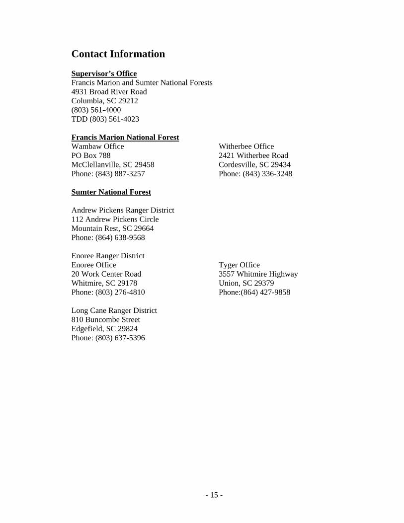
Contact Information Supervisor’s Office Francis Marion and Sumter National Forests 4931 Broad River Road Columbia, SC 29212 (803) 561-4000 TDD (803) 561-4023 Francis Marion National ForestWambaw Office PO Box 788 McClellanville, SC 29458 Phone: (843) 887-3257
Witherbee Office 2421 Witherbee Road Cordesville, SC 29434 Phone: (843) 336-3248
Sumter National Forest Andrew Pickens Ranger District 112 Andrew Pickens Circle Mountain Rest, SC 29664 Phone: (864) 638-9568
Enoree Ranger District Enoree Office 20 Work Center Road Whitmire, SC 29178 Phone: (803) 276-4810
Tyger Office 3557 Whitmire Highway Union, SC 29379 Phone:(864) 427-9858
Long Cane Ranger District 810 Buncombe Street Edgefield, SC 29824 Phone: (803) 637-5396
- 15 -

Appendix A
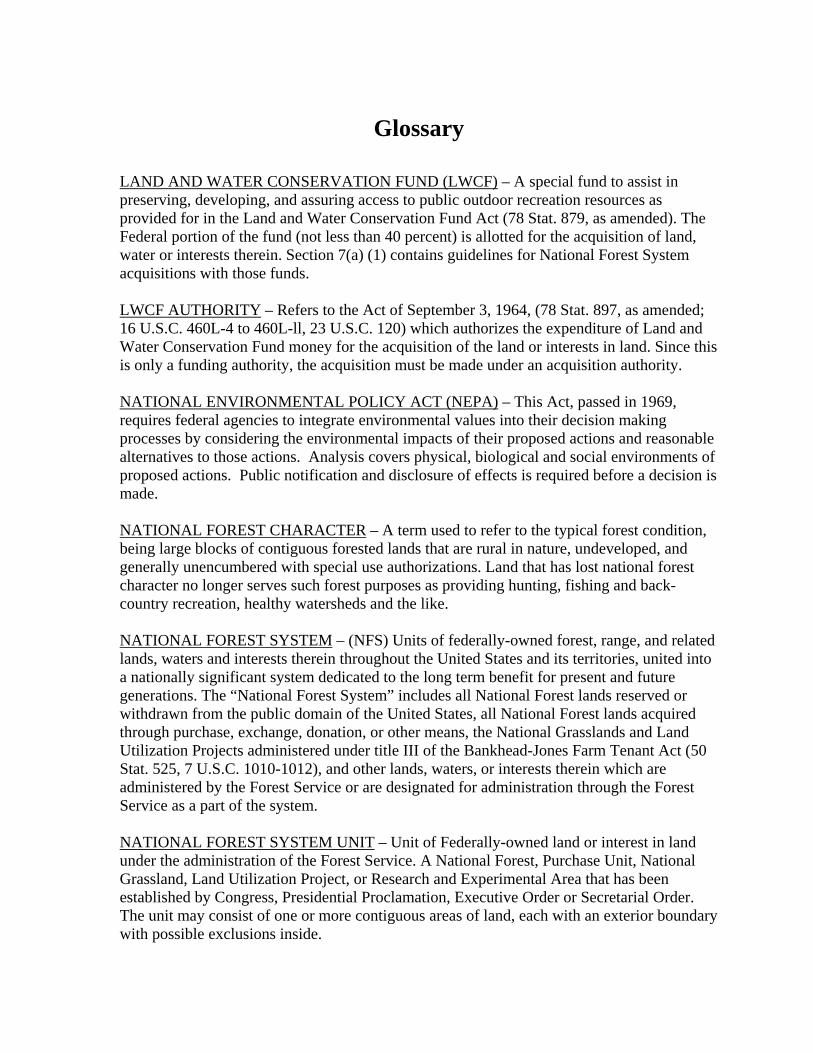
Glossary
LAND AND WATER CONSERVATION FUND (LWCF) – A special fund to assist in preserving, developing, and assuring access to public outdoor recreation resources as provided for in the Land and Water Conservation Fund Act (78 Stat. 879, as amended). The Federal portion of the fund (not less than 40 percent) is allotted for the acquisition of land, water or interests therein. Section 7(a) (1) contains guidelines for National Forest System acquisitions with those funds. LWCF AUTHORITY – Refers to the Act of September 3, 1964, (78 Stat. 897, as amended; 16 U.S.C. 460L-4 to 460L-ll, 23 U.S.C. 120) which authorizes the expenditure of Land and Water Conservation Fund money for the acquisition of the land or interests in land. Since this is only a funding authority, the acquisition must be made under an acquisition authority. NATIONAL ENVIRONMENTAL POLICY ACT (NEPA) – This Act, passed in 1969, requires federal agencies to integrate environmental values into their decision making processes by considering the environmental impacts of their proposed actions and reasonable alternatives to those actions. Analysis covers physical, biological and social environments of proposed actions. Public notification and disclosure of effects is required before a decision is made. NATIONAL FOREST CHARACTER – A term used to refer to the typical forest condition, being large blocks of contiguous forested lands that are rural in nature, undeveloped, and generally unencumbered with special use authorizations. Land that has lost national forest character no longer serves such forest purposes as providing hunting, fishing and back-country recreation, healthy watersheds and the like. NATIONAL FOREST SYSTEM – (NFS) Units of federally-owned forest, range, and related lands, waters and interests therein throughout the United States and its territories, united into a nationally significant system dedicated to the long term benefit for present and future generations. The “National Forest System” includes all National Forest lands reserved or withdrawn from the public domain of the United States, all National Forest lands acquired through purchase, exchange, donation, or other means, the National Grasslands and Land Utilization Projects administered under title III of the Bankhead-Jones Farm Tenant Act (50 Stat. 525, 7 U.S.C. 1010-1012), and other lands, waters, or interests therein which are administered by the Forest Service or are designated for administration through the Forest Service as a part of the system. NATIONAL FOREST SYSTEM UNIT – Unit of Federally-owned land or interest in land under the administration of the Forest Service. A National Forest, Purchase Unit, National Grassland, Land Utilization Project, or Research and Experimental Area that has been established by Congress, Presidential Proclamation, Executive Order or Secretarial Order. The unit may consist of one or more contiguous areas of land, each with an exterior boundary with possible exclusions inside.
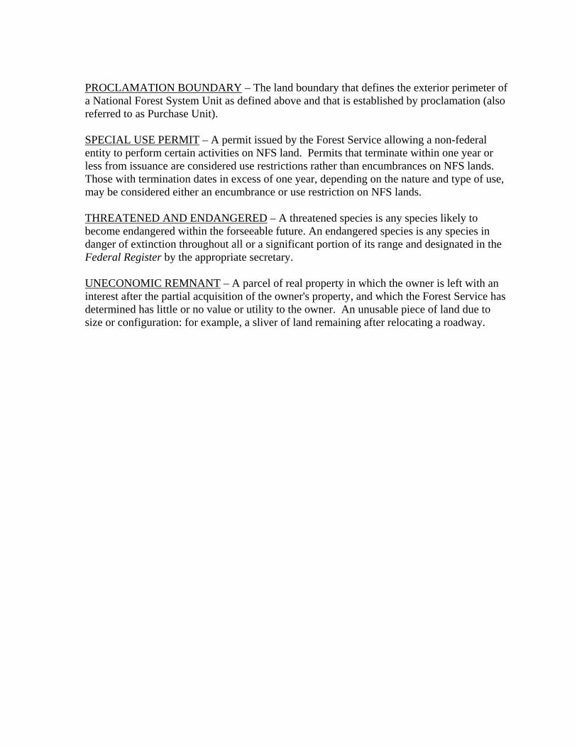
PROCLAMATION BOUNDARY – The land boundary that defines the exterior perimeter of a National Forest System Unit as defined above and that is established by proclamation (also referred to as Purchase Unit). SPECIAL USE PERMIT – A permit issued by the Forest Service allowing a non-federal entity to perform certain activities on NFS land. Permits that terminate within one year or less from issuance are considered use restrictions rather than encumbrances on NFS lands. Those with termination dates in excess of one year, depending on the nature and type of use, may be considered either an encumbrance or use restriction on NFS lands. THREATENED AND ENDANGERED – A threatened species is any species likely to become endangered within the forseeable future. An endangered species is any species in danger of extinction throughout all or a significant portion of its range and designated in the Federal Register by the appropriate secretary. UNECONOMIC REMNANT – A parcel of real property in which the owner is left with an interest after the partial acquisition of the owner's property, and which the Forest Service has determined has little or no value or utility to the owner. An unusable piece of land due to size or configuration: for example, a sliver of land remaining after relocating a roadway.
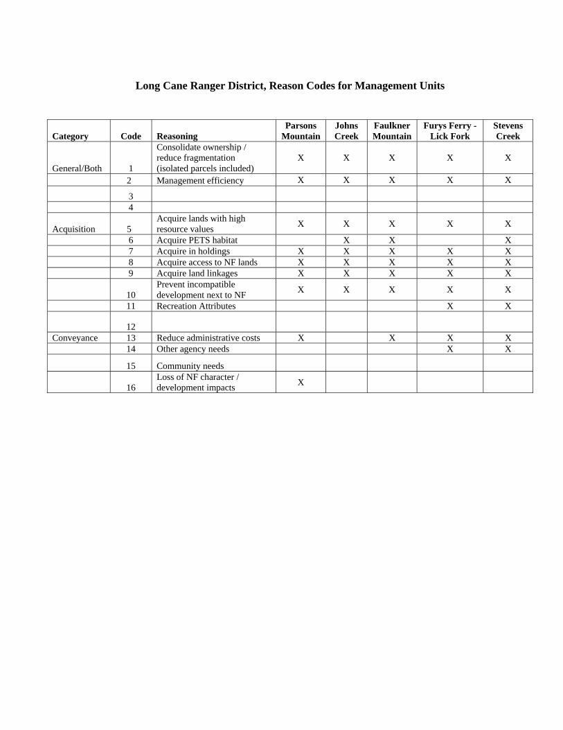
Long Cane Ranger District, Reason Codes for Management Units
Category Code Reasoning Parsons
Mountain Johns Creek
Faulkner Mountain
Furys Ferry - Lick Fork
Stevens Creek
General/Both 1
Consolidate ownership / reduce fragmentation (isolated parcels included)
X X X X X
2 Management efficiency X X X X X
3 4
Acquisition 5 Acquire lands with high resource values X X X X X
6 Acquire PETS habitat X X X 7 Acquire in holdings X X X X X 8 Acquire access to NF lands X X X X X 9 Acquire land linkages X X X X X
10 Prevent incompatible development next to NF X X X X X
11 Recreation Attributes X X
12
Conveyance 13 Reduce administrative costs X X X X 14 Other agency needs X X
15 Community needs
16 Loss of NF character / development impacts X

Appendix B
Sample Documents
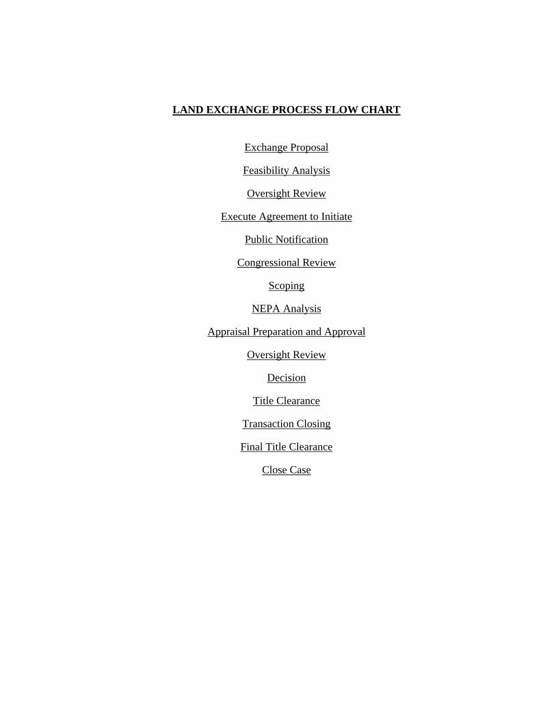
LAND EXCHANGE PROCESS FLOW CHART
Exchange Proposal
Feasibility Analysis
Oversight Review
Execute Agreement to Initiate
Public Notification
Congressional Review
Scoping
NEPA Analysis
Appraisal Preparation and Approval
Oversight Review
Decision
Title Clearance
Transaction Closing
Final Title Clearance
Close Case
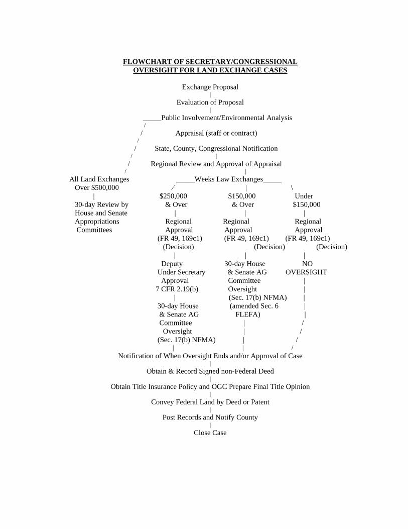
FLOWCHART OF SECRETARY/CONGRESSIONAL
OVERSIGHT FOR LAND EXCHANGE CASES
Exchange Proposal |
Evaluation of Proposal |
_____Public Involvement/Environmental Analysis / / Appraisal (staff or contract) / / State, County, Congressional Notification / | / Regional Review and Approval of Appraisal / | All Land Exchanges _____Weeks Law Exchanges_____ Over $500,000 ⁄ | \ | $250,000 $150,000 Under 30-day Review by & Over & Over $150,000 House and Senate | | | Appropriations Regional Regional Regional Committees Approval Approval Approval (FR 49, 169c1) (FR 49, 169c1) (FR 49, 169c1) (Decision) (Decision) (Decision) | | | Deputy 30-day House NO Under Secretary & Senate AG OVERSIGHT Approval Committee | 7 CFR 2.19(b) Oversight | | (Sec. 17(b) NFMA) | 30-day House (amended Sec. 6 | & Senate AG FLEFA) | Committee | / Oversight | / (Sec. 17(b) NFMA) | / | | /
Notification of When Oversight Ends and/or Approval of Case |
Obtain & Record Signed non-Federal Deed |
Obtain Title Insurance Policy and OGC Prepare Final Title Opinion |
Convey Federal Land by Deed or Patent |
Post Records and Notify County |
Close Case
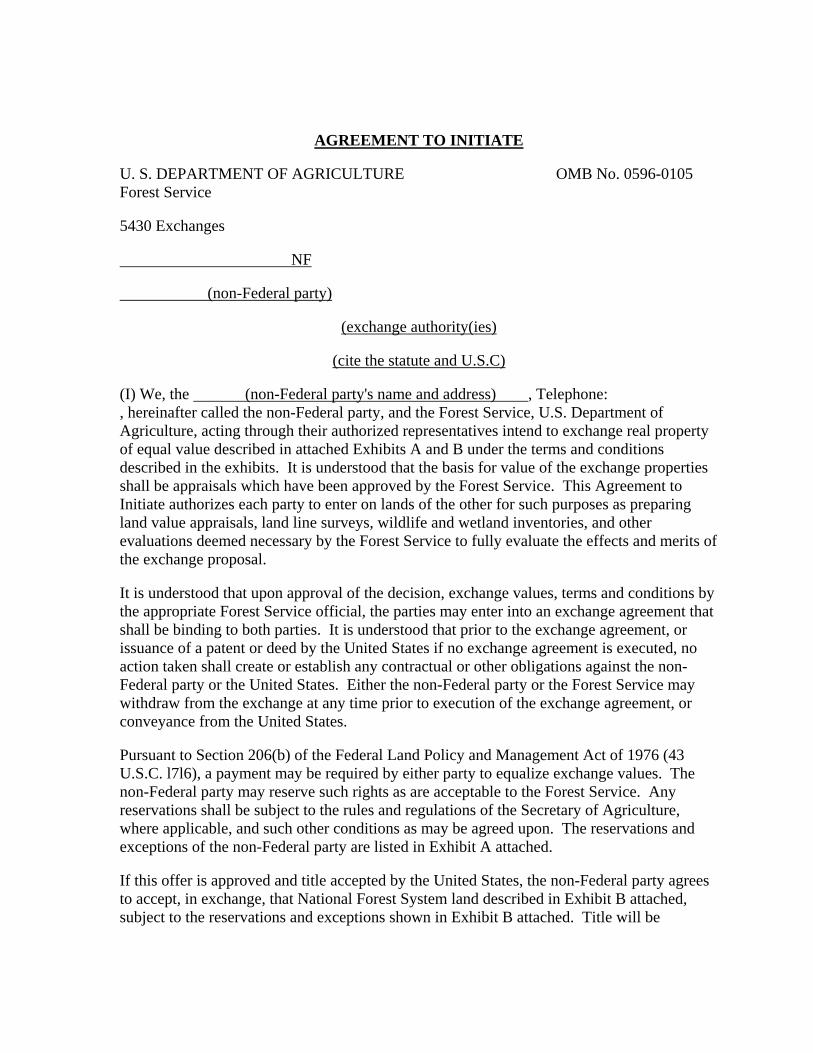
AGREEMENT TO INITIATE U. S. DEPARTMENT OF AGRICULTURE OMB No. 0596-0105 Forest Service 5430 Exchanges NF (non-Federal party)
(exchange authority(ies)
(cite the statute and U.S.C) (I) We, the (non-Federal party's name and address) , Telephone: , hereinafter called the non-Federal party, and the Forest Service, U.S. Department of Agriculture, acting through their authorized representatives intend to exchange real property of equal value described in attached Exhibits A and B under the terms and conditions described in the exhibits. It is understood that the basis for value of the exchange properties shall be appraisals which have been approved by the Forest Service. This Agreement to Initiate authorizes each party to enter on lands of the other for such purposes as preparing land value appraisals, land line surveys, wildlife and wetland inventories, and other evaluations deemed necessary by the Forest Service to fully evaluate the effects and merits of the exchange proposal. It is understood that upon approval of the decision, exchange values, terms and conditions by the appropriate Forest Service official, the parties may enter into an exchange agreement that shall be binding to both parties. It is understood that prior to the exchange agreement, or issuance of a patent or deed by the United States if no exchange agreement is executed, no action taken shall create or establish any contractual or other obligations against the non-Federal party or the United States. Either the non-Federal party or the Forest Service may withdraw from the exchange at any time prior to execution of the exchange agreement, or conveyance from the United States. Pursuant to Section 206(b) of the Federal Land Policy and Management Act of 1976 (43 U.S.C. l7l6), a payment may be required by either party to equalize exchange values. The non-Federal party may reserve such rights as are acceptable to the Forest Service. Any reservations shall be subject to the rules and regulations of the Secretary of Agriculture, where applicable, and such other conditions as may be agreed upon. The reservations and exceptions of the non-Federal party are listed in Exhibit A attached. If this offer is approved and title accepted by the United States, the non-Federal party agrees to accept, in exchange, that National Forest System land described in Exhibit B attached, subject to the reservations and exceptions shown in Exhibit B attached. Title will be
conveyed by Patent/Exchange Deed issued by the USDI-Bureau of Land Management/USDA-Forest Service. It will be the non-Federal party's responsibility to furnish a good and sufficient title to the property free from objectionable encumbrances. The non-Federal party will convey title by general warranty deed when notified to do so. A policy of title insurance satisfactory to the Office of the General Counsel of the Department of Agriculture will be prepared at the expense of the non-Federal party. The United States does not furnish title insurance for the property it conveys. No authorization for compensation for costs assumed pursuant to the provision of 36 CFR 254.7 is provided. The timeline for processing this proposal and the agreement on responsibility for costs on specific items (36 CFR 254.4(c)(6)) is provided for in Exhibit C (Implementation Schedule) and Exhibit D (Projected Costs and Allocation). If the non-Federal party is assigned the responsibility of providing appraisals for the Federal and/or non-Federal properties in the Implementation Schedule, execution of this agreement requires the non-Federal party to instruct the Forest Service-approved fee appraiser to simultaneously submit all appraisals to the Forest Service and the non-Federal party. A copy of this Agreement to Initiate may be provided to the appraiser of record and serve as written authorization by the appraiser's client to provide a copy of all appraisals to the Forest Service. Qualified tenants occupying the non-Federal lands affected by this proposal may be entitled to relocation benefits under 49 CFR 24.2. The non-Federal party agrees to formally notify the Forest Service of any tenants occupying the non-Federal land and provide the Forest Service documentation that the tenant has been notified of the proposed land exchange. Unless otherwise provided by law or regulation (49 CFR 24.101(a)(1)), relocation benefits are not applicable to owner-occupants involved in exchanges with the United States provided the owner-occupants are notified in writing that the non-Federal lands are being acquired by the United States on a voluntary basis. Therefore, this Agreement to Initiate serves as that notice and by signing the same, the owner-occupants agree that they are not entitled to relocation benefits. Each party to this agreement is responsible to provide the other documentation of the existence or non-existence of storage of hazardous substances stored on their respective lands for 1 year or more, or disposed of or released on said lands. If evidence of hazardous substances are found, either party may refuse, without liability, to complete the exchange. No member of Congress, or Resident Commissioner, shall be admitted to any share or part of this proposal or to any benefit that may arise therefrom unless it is made with a corporation for its general benefit (18 U.S.C. 43l, 433).
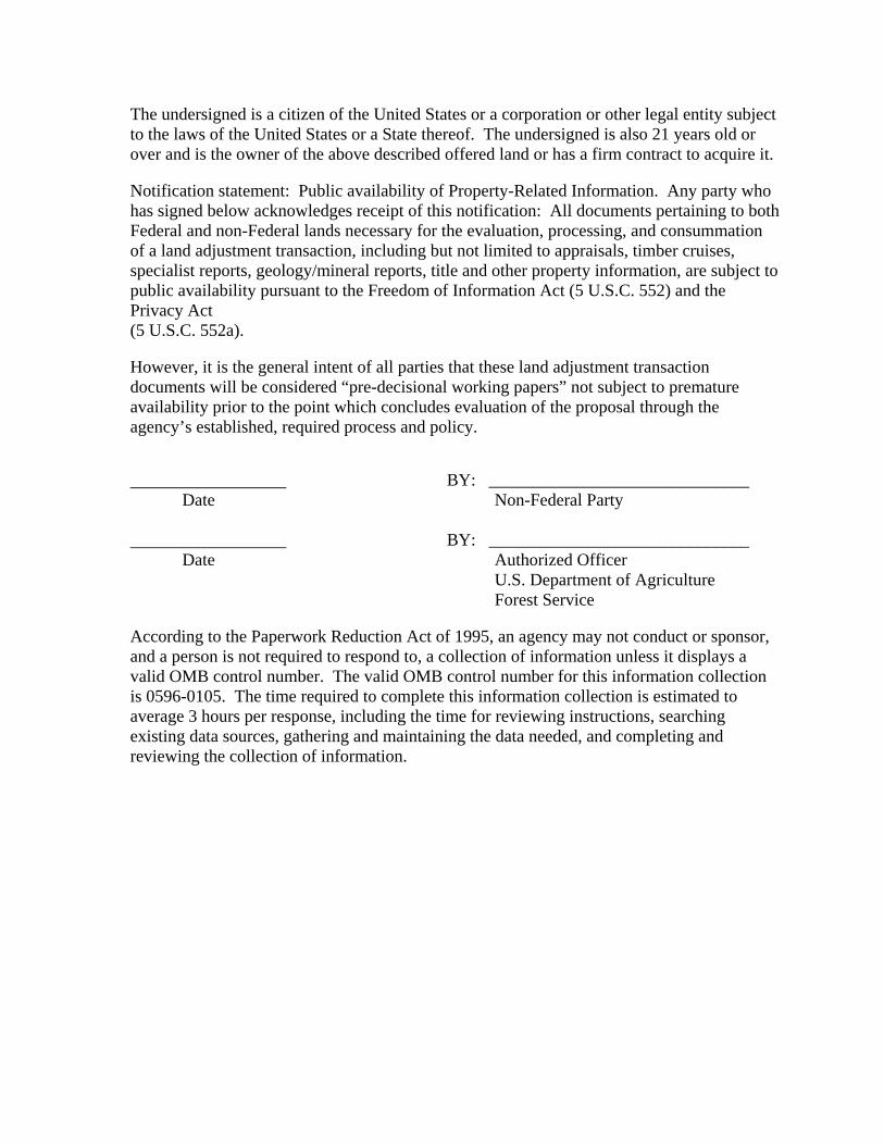
The undersigned is a citizen of the United States or a corporation or other legal entity subject to the laws of the United States or a State thereof. The undersigned is also 21 years old or over and is the owner of the above described offered land or has a firm contract to acquire it. Notification statement: Public availability of Property-Related Information. Any party who has signed below acknowledges receipt of this notification: All documents pertaining to both Federal and non-Federal lands necessary for the evaluation, processing, and consummation of a land adjustment transaction, including but not limited to appraisals, timber cruises, specialist reports, geology/mineral reports, title and other property information, are subject to public availability pursuant to the Freedom of Information Act (5 U.S.C. 552) and the Privacy Act (5 U.S.C. 552a). However, it is the general intent of all parties that these land adjustment transaction documents will be considered “pre-decisional working papers” not subject to premature availability prior to the point which concludes evaluation of the proposal through the agency’s established, required process and policy. BY: ______________________________ Date Non-Federal Party BY: ______________________________ Date Authorized Officer U.S. Department of Agriculture Forest Service According to the Paperwork Reduction Act of 1995, an agency may not conduct or sponsor, and a person is not required to respond to, a collection of information unless it displays a valid OMB control number. The valid OMB control number for this information collection is 0596-0105. The time required to complete this information collection is estimated to average 3 hours per response, including the time for reviewing instructions, searching existing data sources, gathering and maintaining the data needed, and completing and reviewing the collection of information.
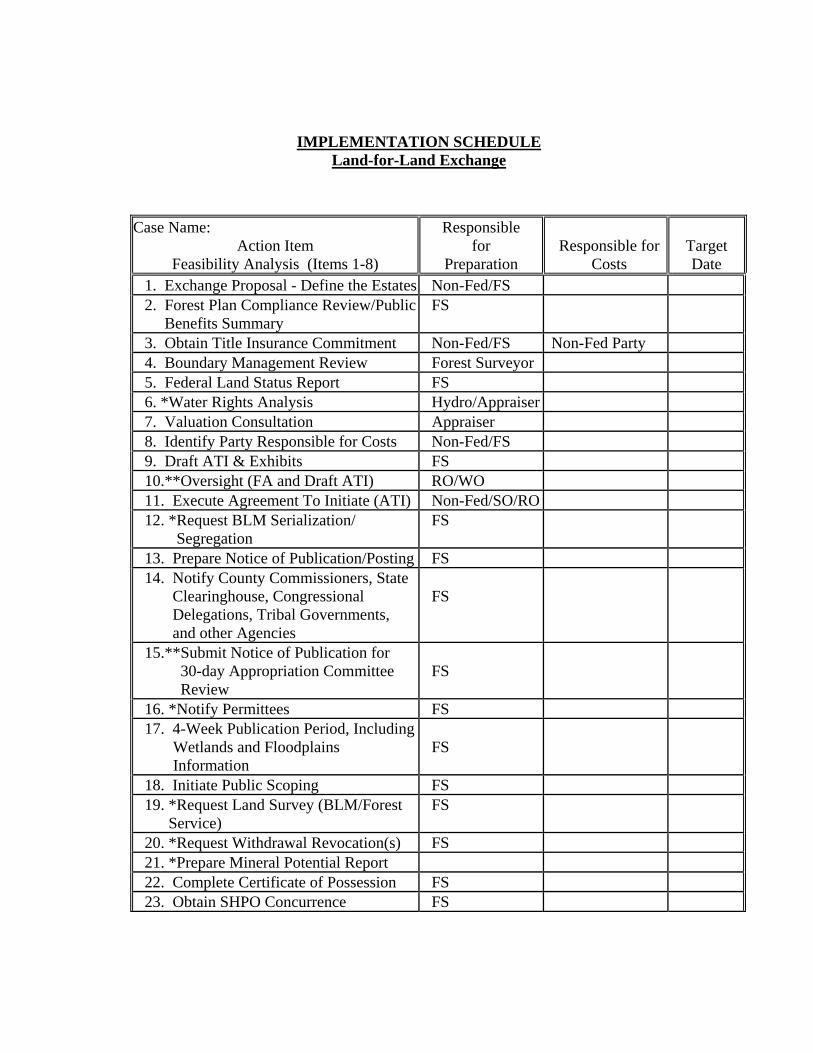
IMPLEMENTATION SCHEDULE Land-for-Land Exchange
Case Name: Action Item
Feasibility Analysis (Items 1-8)
Responsible for
Preparation
Responsible for
Costs
Target Date
1. Exchange Proposal - Define the Estates Non-Fed/FS 2. Forest Plan Compliance Review/Public Benefits Summary
FS
3. Obtain Title Insurance Commitment Non-Fed/FS Non-Fed Party 4. Boundary Management Review Forest Surveyor 5. Federal Land Status Report FS 6. *Water Rights Analysis Hydro/Appraiser 7. Valuation Consultation Appraiser 8. Identify Party Responsible for Costs Non-Fed/FS 9. Draft ATI & Exhibits FS 10.**Oversight (FA and Draft ATI) RO/WO 11. Execute Agreement To Initiate (ATI) Non-Fed/SO/RO 12. *Request BLM Serialization/ Segregation
FS
13. Prepare Notice of Publication/Posting FS 14. Notify County Commissioners, State Clearinghouse, Congressional Delegations, Tribal Governments, and other Agencies
FS
15.**Submit Notice of Publication for 30-day Appropriation Committee Review
FS
16. *Notify Permittees FS 17. 4-Week Publication Period, Including Wetlands and Floodplains Information
FS
18. Initiate Public Scoping FS 19. *Request Land Survey (BLM/Forest Service)
FS
20. *Request Withdrawal Revocation(s) FS 21. *Prepare Mineral Potential Report 22. Complete Certificate of Possession FS 23. Obtain SHPO Concurrence FS
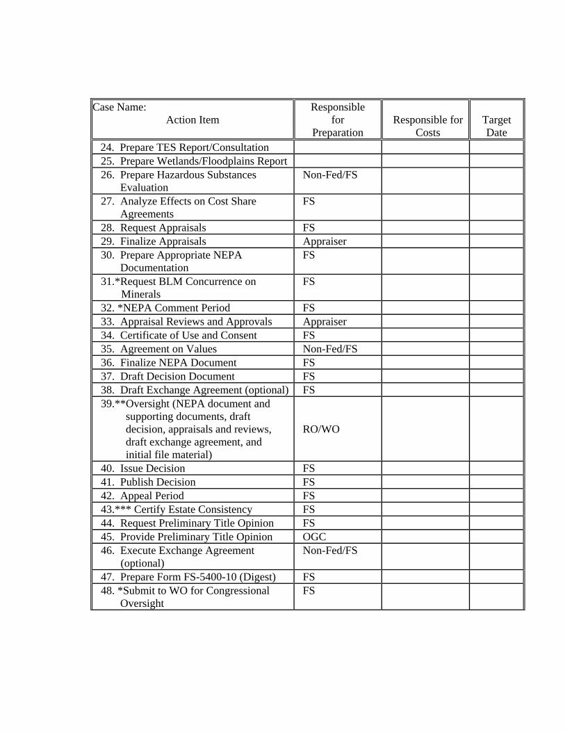
Case Name: Action Item
Responsible for
Preparation
Responsible for
Costs
Target Date
24. Prepare TES Report/Consultation 25. Prepare Wetlands/Floodplains Report 26. Prepare Hazardous Substances Evaluation
Non-Fed/FS
27. Analyze Effects on Cost Share Agreements
FS
28. Request Appraisals FS 29. Finalize Appraisals Appraiser 30. Prepare Appropriate NEPA Documentation
FS
31.*Request BLM Concurrence on Minerals
FS
32. *NEPA Comment Period FS 33. Appraisal Reviews and Approvals Appraiser 34. Certificate of Use and Consent FS 35. Agreement on Values Non-Fed/FS 36. Finalize NEPA Document FS 37. Draft Decision Document FS 38. Draft Exchange Agreement (optional) FS 39.**Oversight (NEPA document and supporting documents, draft decision, appraisals and reviews, draft exchange agreement, and initial file material)
RO/WO
40. Issue Decision FS 41. Publish Decision FS 42. Appeal Period FS 43.*** Certify Estate Consistency FS 44. Request Preliminary Title Opinion FS 45. Provide Preliminary Title Opinion OGC 46. Execute Exchange Agreement (optional)
Non-Fed/FS
47. Prepare Form FS-5400-10 (Digest) FS 48. *Submit to WO for Congressional Oversight
FS
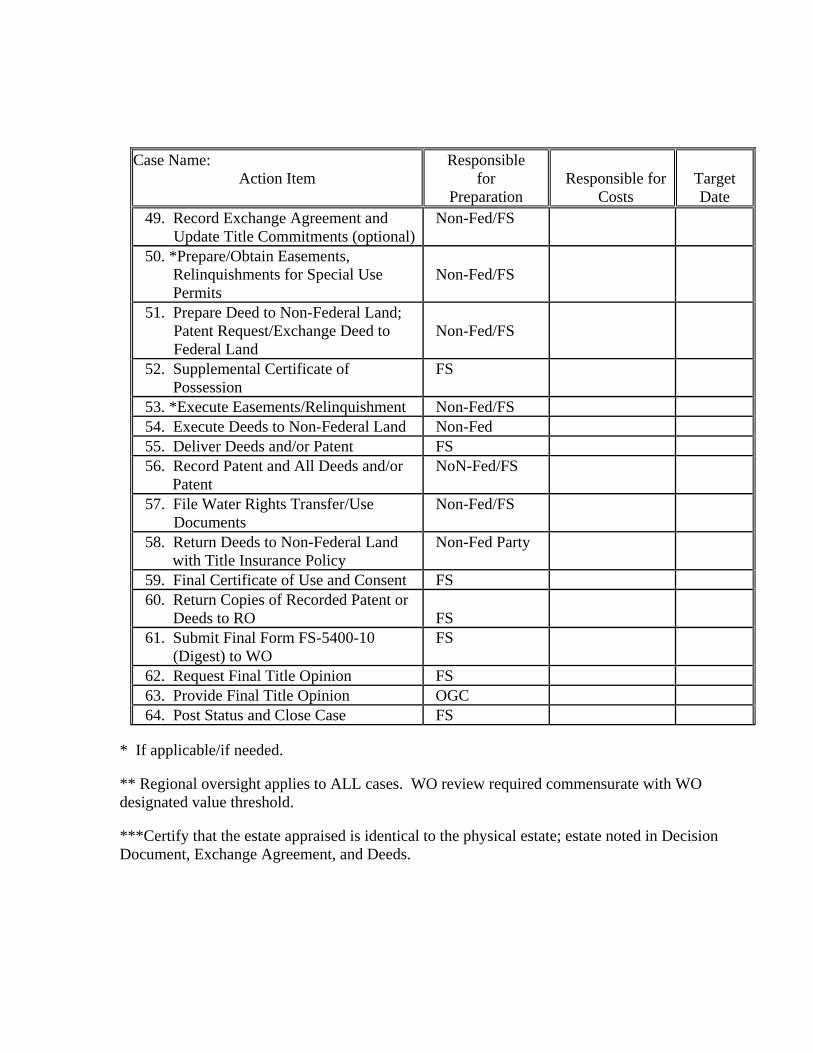
Case Name:
Action Item
Responsible for
Preparation
Responsible for
Costs
Target Date
49. Record Exchange Agreement and Update Title Commitments (optional)
Non-Fed/FS
50. *Prepare/Obtain Easements, Relinquishments for Special Use Permits
Non-Fed/FS
51. Prepare Deed to Non-Federal Land; Patent Request/Exchange Deed to Federal Land
Non-Fed/FS
52. Supplemental Certificate of Possession
FS
53. *Execute Easements/Relinquishment Non-Fed/FS 54. Execute Deeds to Non-Federal Land Non-Fed 55. Deliver Deeds and/or Patent FS 56. Record Patent and All Deeds and/or Patent
NoN-Fed/FS
57. File Water Rights Transfer/Use Documents
Non-Fed/FS
58. Return Deeds to Non-Federal Land with Title Insurance Policy
Non-Fed Party
59. Final Certificate of Use and Consent FS 60. Return Copies of Recorded Patent or Deeds to RO
FS
61. Submit Final Form FS-5400-10 (Digest) to WO
FS
62. Request Final Title Opinion FS 63. Provide Final Title Opinion OGC 64. Post Status and Close Case FS
* If applicable/if needed. ** Regional oversight applies to ALL cases. WO review required commensurate with WO designated value threshold. ***Certify that the estate appraised is identical to the physical estate; estate noted in Decision Document, Exchange Agreement, and Deeds.
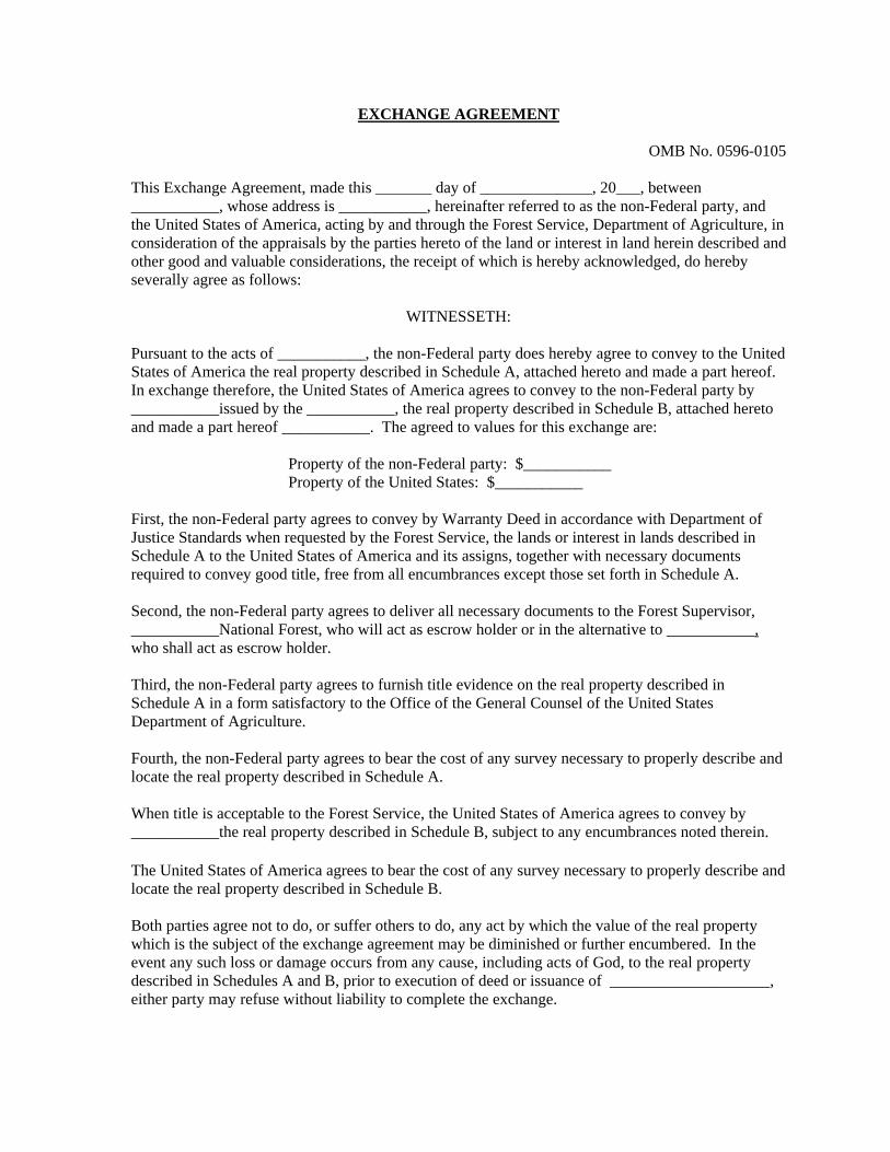
EXCHANGE AGREEMENT
OMB No. 0596-0105 This Exchange Agreement, made this _______ day of ______________, 20___, between ___________, whose address is ___________, hereinafter referred to as the non-Federal party, and the United States of America, acting by and through the Forest Service, Department of Agriculture, in consideration of the appraisals by the parties hereto of the land or interest in land herein described and other good and valuable considerations, the receipt of which is hereby acknowledged, do hereby severally agree as follows:
WITNESSETH: Pursuant to the acts of ___________, the non-Federal party does hereby agree to convey to the United States of America the real property described in Schedule A, attached hereto and made a part hereof. In exchange therefore, the United States of America agrees to convey to the non-Federal party by ___________issued by the ___________, the real property described in Schedule B, attached hereto and made a part hereof ___________. The agreed to values for this exchange are: Property of the non-Federal party: $___________ Property of the United States: $___________ First, the non-Federal party agrees to convey by Warranty Deed in accordance with Department of Justice Standards when requested by the Forest Service, the lands or interest in lands described in Schedule A to the United States of America and its assigns, together with necessary documents required to convey good title, free from all encumbrances except those set forth in Schedule A. Second, the non-Federal party agrees to deliver all necessary documents to the Forest Supervisor, ___________National Forest, who will act as escrow holder or in the alternative to ___________, who shall act as escrow holder. Third, the non-Federal party agrees to furnish title evidence on the real property described in Schedule A in a form satisfactory to the Office of the General Counsel of the United States Department of Agriculture. Fourth, the non-Federal party agrees to bear the cost of any survey necessary to properly describe and locate the real property described in Schedule A. When title is acceptable to the Forest Service, the United States of America agrees to convey by ___________the real property described in Schedule B, subject to any encumbrances noted therein. The United States of America agrees to bear the cost of any survey necessary to properly describe and locate the real property described in Schedule B. Both parties agree not to do, or suffer others to do, any act by which the value of the real property which is the subject of the exchange agreement may be diminished or further encumbered. In the event any such loss or damage occurs from any cause, including acts of God, to the real property described in Schedules A and B, prior to execution of deed or issuance of ____________________, either party may refuse without liability to complete the exchange.
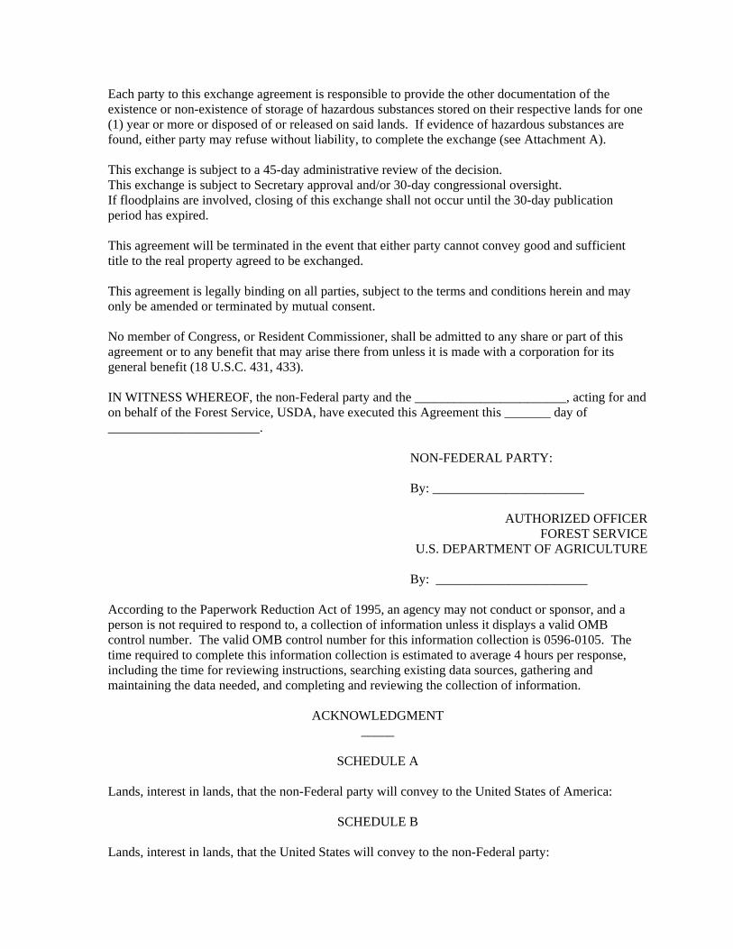
Each party to this exchange agreement is responsible to provide the other documentation of the existence or non-existence of storage of hazardous substances stored on their respective lands for one (1) year or more or disposed of or released on said lands. If evidence of hazardous substances are found, either party may refuse without liability, to complete the exchange (see Attachment A). This exchange is subject to a 45-day administrative review of the decision. This exchange is subject to Secretary approval and/or 30-day congressional oversight. If floodplains are involved, closing of this exchange shall not occur until the 30-day publication period has expired. This agreement will be terminated in the event that either party cannot convey good and sufficient title to the real property agreed to be exchanged. This agreement is legally binding on all parties, subject to the terms and conditions herein and may only be amended or terminated by mutual consent. No member of Congress, or Resident Commissioner, shall be admitted to any share or part of this agreement or to any benefit that may arise there from unless it is made with a corporation for its general benefit (18 U.S.C. 431, 433). IN WITNESS WHEREOF, the non-Federal party and the _______________________, acting for and on behalf of the Forest Service, USDA, have executed this Agreement this _______ day of _______________________. NON-FEDERAL PARTY: By: _______________________
AUTHORIZED OFFICER
FOREST SERVICE U.S. DEPARTMENT OF AGRICULTURE
By: _______________________ According to the Paperwork Reduction Act of 1995, an agency may not conduct or sponsor, and a person is not required to respond to, a collection of information unless it displays a valid OMB control number. The valid OMB control number for this information collection is 0596-0105. The time required to complete this information collection is estimated to average 4 hours per response, including the time for reviewing instructions, searching existing data sources, gathering and maintaining the data needed, and completing and reviewing the collection of information.
ACKNOWLEDGMENT _____
SCHEDULE A
Lands, interest in lands, that the non-Federal party will convey to the United States of America:
SCHEDULE B Lands, interest in lands, that the United States will convey to the non-Federal party:

Appendix C
Maps