
U.S.C.G. Merchant Marine Exam Mate Offshore Supply Vessels ...€¦ · Q211-Navigation General-Near...
17
National Maritime Center Serving Our Nation’s Mariners U.S.C.G. Merchant Marine Exam Mate Offshore Supply Vessels Q211 Navigation General – Near Coastal (Sample Examination) Page 1 of 17 Q211 Navigation General – Near Coastal 9/4/2019
Transcript of U.S.C.G. Merchant Marine Exam Mate Offshore Supply Vessels ...€¦ · Q211-Navigation General-Near...
National Maritime Center Serving Our Nation’s Mariners
U.S.C.G. Merchant Marine Exam
Mate Offshore Supply Vessels
Q211 Navigation General – Near Coastal
(Sample Examination)
Page 1 of 17 Q211 Navigation General – Near Coastal
9/4/2019
Q211-Navigation General-Near Coastal U.S.C.G. Merchant Marine Exam Mate Offshore Supply Vessels Illustrations: 2
Choose the best answer to the following Multiple Choice questions.
1. Which observation is NOT used in determining the wind direction?
• (A) Swells o (B) Whitecaps o (C) Waves o (D) Low clouds
If choice A is selected set score to 1.
2. Which is TRUE concerning the flow of air around an anticyclone in the Southern Hemisphere?
o (A) Air flows counterclockwise and inward o (B) Air flows in a clockwise and outward • (C) Air flows counterclockwise and outward o (D) Air flows clockwise and inward
If choice C is selected set score to 1.
3. A single line of position combined with a dead-reckoning position results in a(n) __________.
o (A) running fix o (B) fix o (C) assumed position • (D) estimated position
If choice D is selected set score to 1.
4. You are approaching Chatham Strait from the south in foggy weather. You have Coronation Island and Hazy Islands on the radar. Suddenly the radar malfunctions. You then resort to using whistle echoes to determine your distance off Coronation Island. Your stopwatch reads 16.3 seconds for the echo to be heard. How far are you off Coronation Island?
o (A) 1.0 mile • (B) 1.5 miles o (C) 2.0 miles o (D) 2.5 miles
If choice B is selected set score to 1.
5. A mooring buoy, if lighted, shows which color light?
o (A) Yellow • (B) White o (C) Any color except red or green o (D) Blue
If choice B is selected set score to 1.
Page 2 of 17 Q211 Navigation General – Near Coastal
9/4/2019
Q211-Navigation General-Near Coastal U.S.C.G. Merchant Marine Exam Mate Offshore Supply Vessels Illustrations: 2 6. Entering from seaward, what do triangular-shaped daymarks mark?
o (A) The centerline of the channel o (B) An obstruction where the preferred channel is to starboard • (C) The starboard side of the channel o (D) Any special purpose areas
If choice C is selected set score to 1.
7. The Light List shows that a navigational light has a nominal range of 15 miles and a height above water of 40 feet (12.2 meters). Your height of eye is 25 feet (7.6 meters) and the visibility is 5 miles. At about what range will you FIRST sight the light?
o (A) 6.2 miles • (B) 9.5 miles o (C) 12.9 miles o (D) 14.2 miles
If choice B is selected set score to 1.
8. Which fog is produced by warm moist air passing over a cold surface?
o (A) Conduction fog • (B) Advection fog o (C) Radiation fog o (D) Frontal fog
If choice B is selected set score to 1.
9. If your weather bulletin shows the center of a low pressure area to be 100 miles due east of your position, what winds can you expect in the Northern Hemisphere?
o (A) East to northeast o (B) East to southeast o (C) South to southeast • (D) North to northwest
If choice D is selected set score to 1.
10. You are underway on course 050°T and your maximum speed is 12 knots. The eye of a hurricane bears 120°T, 110 miles from your position. The hurricane is moving towards 285°T at 25 knots. If you maneuver at 12 knots to avoid the hurricane, what could be the maximum CPA?
• (A) 77 miles o (B) 82 miles o (C) 87 miles o (D) 93 miles
If choice A is selected set score to 1.
Page 3 of 17 Q211 Navigation General – Near Coastal
9/4/2019
Q211-Navigation General-Near Coastal U.S.C.G. Merchant Marine Exam Mate Offshore Supply Vessels Illustrations: 2 11. By what means are indications of the master gyrocompass sent to remote repeaters?
o (A) by azimuth motor o (B) by follow-up system o (C) by phantom element • (D) by transmitter
If choice D is selected set score to 1.
12. If a magnetic compass is not affected by any magnetic field other than the Earth's, which statement is TRUE?
o (A) Compass north will be true north. • (B) Compass error and variation are equal. o (C) Variation will equal deviation. o (D) There will be no compass error.
If choice B is selected set score to 1.
13. Which name is given to the pressure-sensitive element of an aneroid barometer?
o (A) Pressure bellows • (B) Sylphon cell o (C) Constant pressure capsule o (D) Column of mercury
If choice B is selected set score to 1.
14. Which is TRUE with reference to a lunar or tidal day?
o (A) A lunar or tidal day is about 10 minutes longer than the solar day • (B) A lunar or tidal day is about 50 minutes longer than the solar day o (C) A lunar or tidal day is about 50 minutes shorter than the solar day o (D) A lunar or tidal day is the same length as the solar day
If choice B is selected set score to 1.
15. Which term describes the temperature at which the air is saturated with water vapor and below which condensation of water vapor will occur?
• (A) Dew point o (B) Vapor point o (C) Precipitation point o (D) Absolute humidity
If choice A is selected set score to 1.
Page 4 of 17 Q211 Navigation General – Near Coastal
9/4/2019
Q211-Navigation General-Near Coastal U.S.C.G. Merchant Marine Exam Mate Offshore Supply Vessels Illustrations: 2 16. Which term is given to a light that has a light period shorter than its dark period?
• (A) Flashing o (B) Pulsating o (C) Alternating o (D) Occulting
If choice A is selected set score to 1.
17. Where would you find information concerning the duration of slack water?
o (A) Sailing Directions • (B) Tidal Current Tables o (C) Tide Tables o (D) American Practical Navigator
If choice B is selected set score to 1.
18. When your vessel is on the storm track but behind the storm's center the __________.
o (A) barometer rises o (B) wind direction remains steady o (C) wind speed decreases • (D) All of the above
If choice D is selected set score to 1.
19. What is a barometric pressure reading of 29.92 inches of mercury is equivalent to?
o (A) 76 centimeters of water o (B) 766 millimeters of mercury • (C) 1013.25 millibars o (D) 29.92 feet of water
If choice C is selected set score to 1.
20. Under the U.S. Aids to Navigation System, which category is a yellow buoy?
o (A) A junction buoy o (B) A cardinal mark o (C) A safe water buoy • (D) A special purpose mark
If choice D is selected set score to 1.
Page 5 of 17 Q211 Navigation General – Near Coastal
9/4/2019
Q211-Navigation General-Near Coastal U.S.C.G. Merchant Marine Exam Mate Offshore Supply Vessels Illustrations: 2
21. As you enter a channel from seaward in a U.S. port, which is TRUE of the numbers on the starboardside buoys?
o (A) They decrease and the buoys are blacko (B) They decrease and the buoys are red• (C) They increase and the buoys are redo (D) They increase and the buoys are green
If choice C is selected set score to 1.
22. What classification of tropical cyclone would have closed isobars, counter clockwise rotarycirculation, and sustained winds between 34 and 63 knots?
o (A) A hurricane• (B) A tropical stormo (C) A tropical disturbanceo (D) A tropical depression
If choice B is selected set score to 1.
23. Which condition(s) is(are) necessary for the formation of dew?
• (A) Clear skieso (B) A surface warmer than the dew point of the airo (C) Moderate windo (D) Available nuclei in the air
If choice A is selected set score to 1.
24. A line connecting all possible positions of your vessel at any given time is a __________.
o (A) latitude lineo (B) fixo (C) longitude line• (D) line of position
If choice D is selected set score to 1.
25. What is the approximate geographic range of Shinnecock Light, NY, if your height of eye is 24 feet(7.3 meters)? Refer to "Reprints from the LIGHT LISTS AND COAST PILOTS".
o (A) 8.7 nmo (B) 9.9 nmo (C) 14.4 nm• (D) 15.9 nm
If choice D is selected set score to 1.
Page 6 of 17 Q211 Navigation General – Near Coastal
9/4/2019
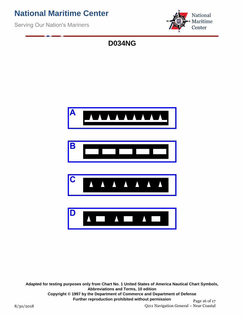
Q211-Navigation General-Near Coastal U.S.C.G. Merchant Marine Exam Mate Offshore Supply Vessels Illustrations: 2 26. Which item in illustration D034NG below shows an occulting light?
o (A) A • (B) B o (C) C o (D) D
If choice B is selected set score to 1.
27. Mean lower low water is the reference plane used for which measurements?
• (A) The soundings on the U.S. east and west coasts o (B) The heights above water for lights, mountains, etc. o (C) All vertical measurements o (D) The water depths on the U.S. east coast only
If choice A is selected set score to 1.
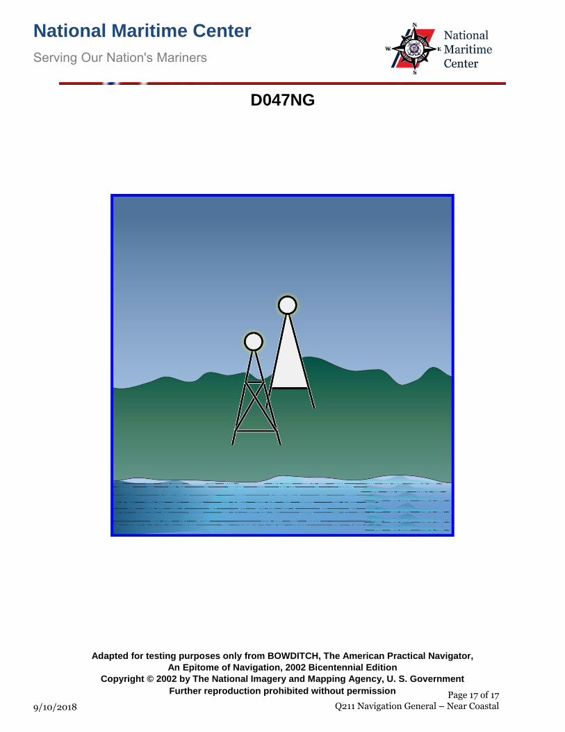
28. You are inbound in a channel marked by a range. The range line is 040° T. You are steering 036°T. The range is in sight as shown in illustration D047NG below, and is closing. Which action should you take?
o (A) Immediately alter course to 040° T. o (B) Immediately alter course to the right to bring the range in line. o (C) Continue on the present heading until the range is in line then alter course to the left. • (D) Continue on course until the range is closed, then alter course to the right.
If choice D is selected set score to 1.
29. In most cases, the direction of the apparent wind lies between the bow and which reference point?
o (A) The beam on the lee side o (B) The true north • (C) The direction of the true wind o (D) The beam on the windward side
If choice C is selected set score to 1.
30. You are approaching a sea buoy which emits a racon signal. This signal is most frequently triggered by which type of radar?
• (A) 3 cm o (B) 10 cm o (C) Both 3 cm and 10 cm o (D) Signal does not depend on radar type.
If choice A is selected set score to 1.
Page 7 of 17 Q211 Navigation General – Near Coastal
9/4/2019
Q211-Navigation General-Near Coastal U.S.C.G. Merchant Marine Exam Mate Offshore Supply Vessels Illustrations: 2 31. What is the purpose of the "set" hand on an aneroid barometer?
o (A) To adjust the barometer o (B) To provide a correction for height above sea level • (C) To indicate any change in the reading of the barometer o (D) To provide a correction for temperature changes
If choice C is selected set score to 1.
32. What does the description "Racon" beside an illustration on a chart mean?
o (A) A radar calibration beacon o (B) A radar conspicuous beacon • (C) A radar transponder beacon o (D) A circular radio beacon
If choice C is selected set score to 1.
33. Your vessel is on course 150°T, speed 17 knots. The apparent wind is from 40° off the starboard bow, speed 15 knots. What is the speed of the true wind?
o (A) 9.0 knots o (B) 10.2 knots • (C) 11.0 knots o (D) 12.0 knots
If choice C is selected set score to 1.
34. You are enroute to assist vessel A. Vessel A is underway at 6 knots on course 133°T, and bears 343°T at 92 miles from you. What is the course to steer at 9 knots to intercept vessel A?
o (A) 356° • (B) 003° o (C) 022° o (D) 038°
If choice B is selected set score to 1.
35. Which is TRUE when navigating a vessel?
o (A) You can always rely on a buoy to be on station o (B) You can always rely on a buoy to show proper light characteristics o (C) You should assume a wreck buoy is directly over the wreck • (D) You should never rely on a floating aid to maintain its exact position
If choice D is selected set score to 1.
Page 8 of 17 Q211 Navigation General – Near Coastal
9/4/2019
Q211-Navigation General-Near Coastal U.S.C.G. Merchant Marine Exam Mate Offshore Supply Vessels Illustrations: 2 36. You are enroute to assist vessel A. Vessel A is underway at 5 knots on course 063°T, and bears
136°T at 78 miles from you. What is the course to steer and running time at 13 knots to intercept vessel A?
o (A) 115°, 5h 45m o (B) 158°, 7h 20m • (C) 115°, 7h 20m o (D) 158°, 5h 45m
If choice C is selected set score to 1.
37. On a chart, the characteristic of the light on a lighthouse is shown as flashing white with a red sector. Which is TRUE of the red sector?
o (A) It serves no significant purpose • (B) It indicates a danger area o (C) It indicates the limits of the navigable channel o (D) It is used to identify the characteristics of the light
If choice B is selected set score to 1.
38. You are in a buoyed channel at night and pass a lighted buoy with an irregular characteristic. Who should you report this to?
o (A) The Corps of Engineers o (B) The National Ocean Service o (C) The harbor master • (D) The Coast Guard
If choice D is selected set score to 1.
39. You are on course 030°T. The relative bearing of a lighthouse is 45°. What is the true bearing?
o (A) 015° o (B) 345° • (C) 075° o (D) 255°
If choice C is selected set score to 1.
40. You are steaming southward along the west coast of the United States when you encounter a buoy showing a flashing red light. Which is TRUE concerning the buoy?
o (A) The buoy should be left on the vessel's starboard side • (B) The buoy should be left on the vessel's port side o (C) The buoy can be on either side well clear o (D) The buoy can remain on either side close aboard
If choice B is selected set score to 1.
Page 9 of 17 Q211 Navigation General – Near Coastal
9/4/2019
Q211-Navigation General-Near Coastal U.S.C.G. Merchant Marine Exam Mate Offshore Supply Vessels Illustrations: 2 41. How can the accuracy of an azimuth circle be checked?
o (A) sighting a terrestrial range in line and comparing the observed bearing against the charted bearing
o (B) ensuring that the alignment marks on the inner face of the circle are in line with those on the repeater on relative bearings of 000° and 090°
• (C) comparing observed azimuths at different altitudes with computed values at the times of observation to see if the difference is constant
o (D) aligning the relative bearing markings so that 000° is on the lubber's line and the line of sight passes over the center of the compass
If choice C is selected set score to 1.
42. While on a course of 192°T, a light bears 11° on the starboard bow at a distance of 12.7 miles. What course should you steer to pass 3 miles abeam of the light leaving it to starboard?
o (A) 173°T o (B) 185°T • (C) 189°T o (D) 167°T
If choice C is selected set score to 1.
43. The depth of water on a chart is indicated as 23 meters. What does that depth covert to?
o (A) 11.5 fathoms • (B) 12.6 fathoms o (C) 69.0 feet o (D) 78.6 feet
If choice B is selected set score to 1.
44. What does a barometer showing falling pressure indicate?
o (A) The approach of a high pressure system • (B) The approach of a low pressure system o (C) A low dew point o (D) A high dew point
If choice B is selected set score to 1.
45. You will be advised of any hazardous areas due to the fallout of a nuclear explosive by a message with which code word?
• (A) MERWARN o (B) FALLOUT o (C) NUCLEAR o (D) FALLWARN
If choice A is selected set score to 1.
Page 10 of 17 Q211 Navigation General – Near Coastal
9/4/2019
Q211-Navigation General-Near Coastal U.S.C.G. Merchant Marine Exam Mate Offshore Supply Vessels Illustrations: 2 46. The climate of the eastern Gulf coast __________.
o (A) is humid and subtropical throughout the year o (B) has a Mediterranean type of climate • (C) varies from warm to subtropical o (D) has an east coast marine type of climate
If choice C is selected set score to 1.
47. The apparent wind's speed can be zero, but only when two conditions are present. One condition is that the true __________.
o (A) wind's speed must be zero o (B) wind must be from dead ahead • (C) wind's speed equals the ship's speed o (D) wind must be on the beam
If choice C is selected set score to 1.
48. In which country would you expect the channels to be marked with the IALA-B Buoyage System?
• (A) Peru o (B) Saudi Arabia o (C) Morocco o (D) Poland
If choice A is selected set score to 1.
49. You are on course 251°pgc and 241° per magnetic compass, when you observe a range in line bearing 192°pgc. The chart indicates that the range is in line on a bearing of 194°T. The variation is 16°E. What is the deviation of the magnetic compass?
o (A) 2°E o (B) 2°W • (C) 4°W o (D) 10°W
If choice C is selected set score to 1.
50. As a Merchant Marine Officer you are expected to be able to do which of the following?
o (A) understand all broadcast weather warning information o (B) listen to weather forecasts on the radio while enroute o (C) obtain a weather forecast before setting out from port • (D) All of the above
If choice D is selected set score to 1.
Page 11 of 17 Q211 Navigation General – Near Coastal
9/4/2019
Q211-Navigation General-Near Coastal U.S.C.G. Merchant Marine Exam Mate Offshore Supply Vessels Illustrations: 2 51. Which is a characteristic of the weather preceding an approaching warm front?
o (A) Clearing skies o (B) Decreasing relative humidity o (C) Gusty winds • (D) Steadily falling barometric pressure
If choice D is selected set score to 1.
52. A tropical storm is a tropical cyclone that generates winds of which speed?
o (A) Between 64 and 75 knots o (B) Over 75 knots o (C) Between 20 and 33 knots • (D) Between 34 and 63 knots
If choice D is selected set score to 1.
53. You are steaming along the coast of Ireland in the Irish Sea. You sight a lighted buoy with a white flashing light showing a group of two flashes. The buoy indicates you should take which action?
o (A) You must pass north of the buoy • (B) You should pass well clear on either side of the buoy o (C) You must pass south of the buoy o (D) You must pass the buoy close to starboard
If choice B is selected set score to 1.
54. Which is the reference datum used in determining the heights of land features on most charts?
• (A) Mean high water o (B) Mean low water o (C) Mean sea level o (D) Half-tide level
If choice A is selected set score to 1.
55. When is an air mass termed "warm"?
o (A) If the mass is above 70°F o (B) If it originated in a high pressure area o (C) If it originated in a low pressure area • (D) If the ground over which it moves is cooler than the air
If choice D is selected set score to 1.
Page 12 of 17 Q211 Navigation General – Near Coastal
9/4/2019
Q211-Navigation General-Near Coastal U.S.C.G. Merchant Marine Exam Mate Offshore Supply Vessels Illustrations: 2 56. Which statement is TRUE concerning a Mercator projection?
o (A) The mileage between the meridians is increased as the latitude increases. o (B) Degrees of longitude decrease in length as latitude increases. • (C) The length of the meridians is increased to provide for equal expansion in all directions. o (D) The length of the meridians remains constant at all latitudes
If choice C is selected set score to 1.
57. What is the name of the region of high pressure extending around the Earth at about 35°N latitude?
o (A) The prevailing westerlies o (B) The doldrums • (C) The horse latitudes o (D) The troposphere
If choice C is selected set score to 1.
58. In which source could you find the number of a chart for a certain geographic area?
o (A) Chart No. 1 o (B) American Practical Navigator • (C) Catalog of Charts o (D) U.S. Coast Guard Light List
If choice C is selected set score to 1.
59. Which form of cloud that is often known as "mackerel sky" is generally associated with fair weather?
o (A) Cumulonimbus o (B) Stratus o (C) Nimbostratus • (D) Cirrocumulus
If choice D is selected set score to 1.
60. Where would you expect to find climatological and meteorological tables for the Gulf Coast area?
o (A) In any Coast Pilot volume o (B) In the publication entitled Radio Aids to Navigation o (C) Only at the National Weather Service office • (D) In the back of Coast Pilot #5
If choice D is selected set score to 1.
Page 13 of 17 Q211 Navigation General – Near Coastal
9/4/2019
Q211-Navigation General-Near Coastal U.S.C.G. Merchant Marine Exam Mate Offshore Supply Vessels Illustrations: 2 61. You are steering a southerly course, and you note that the chart predicts an easterly current. Without
considering wind, how may you allow for the set?
o (A) Decrease your speed o (B) Head your vessel slightly to the left o (C) Increase your speed • (D) Head your vessel slightly to the right
If choice D is selected set score to 1.
62. By convention, what color is the north seeking end of a compass' magnet?
o (A) Blue o (B) Black o (C) White • (D) Red
If choice D is selected set score to 1.
63. Swell is the rise and fall of the ocean's surface due to __________.
o (A) fetch • (B) distant winds o (C) the pull of the moon o (D) local storms
If choice B is selected set score to 1.
64. You are steering 287°T, and a light is picked up dead ahead at a distance of 19.4 miles at 0419. You change course to pass the light 4 miles off abeam to starboard. If you are making 13 knots, what is your ETA at the position 4 miles off the light?
o (A) 0550 o (B) 0544 • (C) 0547 o (D) 0541
If choice C is selected set score to 1.
65. Which is TRUE concerning the length of a wave?
o (A) It is measured from crest to trough o (B) It is the length of the wave's trough o (C) It is the length of the wave's crest • (D) It is measured from crest to crest
If choice D is selected set score to 1.
Page 14 of 17 Q211 Navigation General – Near Coastal
9/4/2019
Q211-Navigation General-Near Coastal U.S.C.G. Merchant Marine Exam Mate Offshore Supply Vessels Illustrations: 2
66. Lines drawn through points on the Earth having the same atmospheric pressure are known by whichterm?
o (A) Isothermalo (B) Millibarso (C) Seismics• (D) Isobars
If choice D is selected set score to 1.
67. You take a bearing of 176° of a lighthouse. Which bearing of another object would give the best fix?
• (A) 079°o (B) 151°o (C) 176°o (D) 292°
If choice A is selected set score to 1.
68. You have been observing your radar screen and notice that a contact on the screen has remained inthe same position, relative to you, for several minutes. Your vessel is making 10 knots through thewater. Which statement is TRUE?
o (A) The contact is dead in the water.• (B) The contact is on the same course and speed as your vessel.o (C) The contact is on a reciprocal course at the same speed as your vessel.o (D) The radar is showing false echoes and is probably defective.
If choice B is selected set score to 1.
69. Which of the following typically happens to the barometric pressure after a cold front passes?
o (A) Remains the same• (B) Rises, often quite rapidly, with clearing skieso (C) It fluctuateso (D) Remains the same, with clouds forming rapidly
If choice B is selected set score to 1.
70. You are sailing south on the Intracoastal Waterway (ICW) when you sight a red nun buoy with ayellow square painted on it. Which of the following is TRUE?
• (A) You should leave the buoy on your port hand.o (B) The yellow square is in error and it should be a yellow triangle.o (C) The yellow is retro-reflective material used to assist in sighting the buoy at night.o (D) This buoy marks the end of the ICW in that geographic area.
If choice A is selected set score to 1.
Page 15 of 17 Q211 Navigation General – Near Coastal
9/4/2019
National Maritime Center
Serving Our Nation's Mariners
8/30/2018
D034NG
Adapted for testing purposes only from Chart No. 1 United States of America Nautical Chart Symbols,
Abbreviations and Terms, 10 edition
Copyright © 1997 by the Department of Commerce and Department of Defense
Further reproduction prohibited without permission Page 16 of 17 Q211 Navigation General – Near Coastal
National Maritime Center
Serving Our Nation's Mariners
9/10/2018
D047NG
Adapted for testing purposes only from BOWDITCH, The American Practical Navigator,
An Epitome of Navigation, 2002 Bicentennial Edition
Copyright © 2002 by The National Imagery and Mapping Agency, U. S. Government
Further reproduction prohibited without permission Page 17 of 17 Q211 Navigation General – Near Coastal