U.S.C.G. Merchant Marine Exam Apprentice Mate Steersman ...€¦ · Q412 Navigation General-Near...
14
National Maritime Center Serving Our Nation’s Mariners U.S.C.G. Merchant Marine Exam Apprentice Mate Steersman Q412 Navigation General – Near Coastal (Sample Examination) Page 1 of 14 Q412 Navigation General – Near Coastal 9/10/2019
Transcript of U.S.C.G. Merchant Marine Exam Apprentice Mate Steersman ...€¦ · Q412 Navigation General-Near...

National Maritime Center Serving Our Nation’s Mariners
U.S.C.G. Merchant Marine Exam
Apprentice Mate Steersman
Q412 Navigation General – Near Coastal
(Sample Examination)
Page 1 of 14 Q412 Navigation General – Near Coastal
9/10/2019
Q412 Navigation General-Near Coastal U.S.C.G. Merchant Marine Exam Apprentice Mate Steersman Illustrations: 3
Choose the best answer to the following Multiple Choice Questions.
1. Which type of projection is used to make a Mercator chart?
o (A) Rectangular projection o (B) Simple conic projection • (C) Cylindrical projection o (D) Polyconic projection
If choice C is selected set score to 1.
2. In reading a weather map, what do closely spaced pressure gradient lines indicate?
o (A) A calm or light winds o (B) High overcast clouds o (C) Fog or steady rain • (D) High winds
If choice D is selected set score to 1.
3. You are in the Northern Hemisphere and a tropical wave is located 200 miles due east of your position. Where will the wave be located 12 hours later?
o (A) Farther away to the east o (B) In the same position o (C) Farther away to the west • (D) Nearby to the east
If choice D is selected set score to 1.
4. The total magnetic effects which cause deviation of a vessel's compass can be broken down into a series of components which are given which term?
o (A) Divisional parts o (B) Fractional parts • (C) Coefficients o (D) Equations
If choice C is selected set score to 1.
5. You are steering a southerly course, and you note that the chart predicts an easterly current. Without considering wind, how may you allow for the set?
• (A) Head your vessel slightly to the right o (B) Decrease your speed o (C) Increase your speed o (D) Head your vessel slightly to the left
If choice A is selected set score to 1.
Page 2 of 14 Q412 Navigation General – Near Coastal
9/10/2019

Q412 Navigation General-Near Coastal U.S.C.G. Merchant Marine Exam Apprentice Mate Steersman Illustrations: 3 6. While steering a course of 150°T, you wish to observe a body for a latitude check. What would the
azimuth have to be?
o (A) 150°T o (B) 090°T o (C) 240°T • (D) 000°T
If choice D is selected set score to 1.
7. What is the approximate geographic range of Shinnecock Light, NY, if your height of eye is 24 feet (7.3 meters)? Refer to "Reprints from the LIGHT LISTS AND COAST PILOTS".
o (A) 8.7 nm o (B) 9.9 nm o (C) 14.4 nm • (D) 15.9 nm
If choice D is selected set score to 1.
8. Which publication contains information on Naval Cooperation and Guidance for Shipping (NCAGS) in time of emergency or war?
o (A) Pub. 102, International Code of Signals • (B) Pub. 117, Radio Navigational Aids o (C) Appropriate volume of the Sailing Directions o (D) Light List
If choice B is selected set score to 1.
9. All aids to navigation listed in the Mississippi River System Light List are shown as miles from a reference point and on the __________.
• (A) left or right descending bank o (B) left or right ascending bank o (C) port or starboard side of the vessel o (D) east or west bank
If choice A is selected set score to 1.
10. Which publication would describe the explosive anchorages in the ports on the east coast of the United States?
• (A) Coast Pilot o (B) Pilot Rules for Inland Waters o (C) Sailing Directions o (D) Notice to Mariners
If choice A is selected set score to 1.
Page 3 of 14 Q412 Navigation General – Near Coastal
9/10/2019
Q412 Navigation General-Near Coastal U.S.C.G. Merchant Marine Exam Apprentice Mate Steersman Illustrations: 3 11. Your vessel is leaving New York harbor in dense fog. As the vessel slowly proceeds toward sea, you
sight a green can buoy on the starboard bow. Which action should you take?
o (A) Turn hard right to get back into the channel. • (B) Stand on, leaving the buoy to your starboard. o (C) Pass the buoy close to, leaving it to your port. o (D) Stop and fix your position.
If choice B is selected set score to 1.
12. Which wind is a strong, often violent, northerly wind occurring on the Pacific coast of Mexico, particularly during the colder months?
o (A) Papagayo • (B) Tehuantepecer o (C) Pampero o (D) Norther
If choice B is selected set score to 1.
13. The world is divided into NAVAREAS for the dissemination of important marine information. Which NAVAREAS include the U.S. coasts?
o (A) I and II • (B) IV and XII o (C) V and X o (D) VI and VII
If choice B is selected set score to 1.
14. The datum from which the predicted heights of tides are reckoned in the tide tables is the same as that used for the charts of the locality. The depression of the datum below mean sea level for Hampton Roads, Virginia is __________.
o (A) between 1.9 and 3.2 feet o (B) between -.7 and +.5 feet • (C) 1.2 feet o (D) 4.1 feet
If choice C is selected set score to 1.
15. Where are buoys and day beacons exhibiting a yellow triangle or square painted on them used?
• (A) Locations where the ICW and other waterways coincide o (B) On isolated stretches of the ICW to mark undredged areas o (C) In minor harbors where the controlling depth is 10 feet (3 meters) or less o (D) Only at particularly hazardous turns of the channel
If choice A is selected set score to 1.
Page 4 of 14 Q412 Navigation General – Near Coastal
9/10/2019

Q412 Navigation General-Near Coastal U.S.C.G. Merchant Marine Exam Apprentice Mate Steersman Illustrations: 3 16. Which buoy may be odd numbered?
o (A) Unlighted nun buoy • (B) Lighted green buoy o (C) Mid-channel buoy o (D) All of the above
If choice B is selected set score to 1.
17. When changing from a compass course to a true course, which should you apply?
o (A) A correction for the direction of current set • (B) Both variation and deviation o (C) Deviation only o (D) Variation only
If choice B is selected set score to 1.
18. Towing vessels of more than 39.4 feet in length must carry charts or maps __________.
o (A) of the current edition or currently corrected edition o (B) with enough detail to make safe navigation possible o (C) of the area to be navigated • (D) All of the above
If choice D is selected set score to 1.
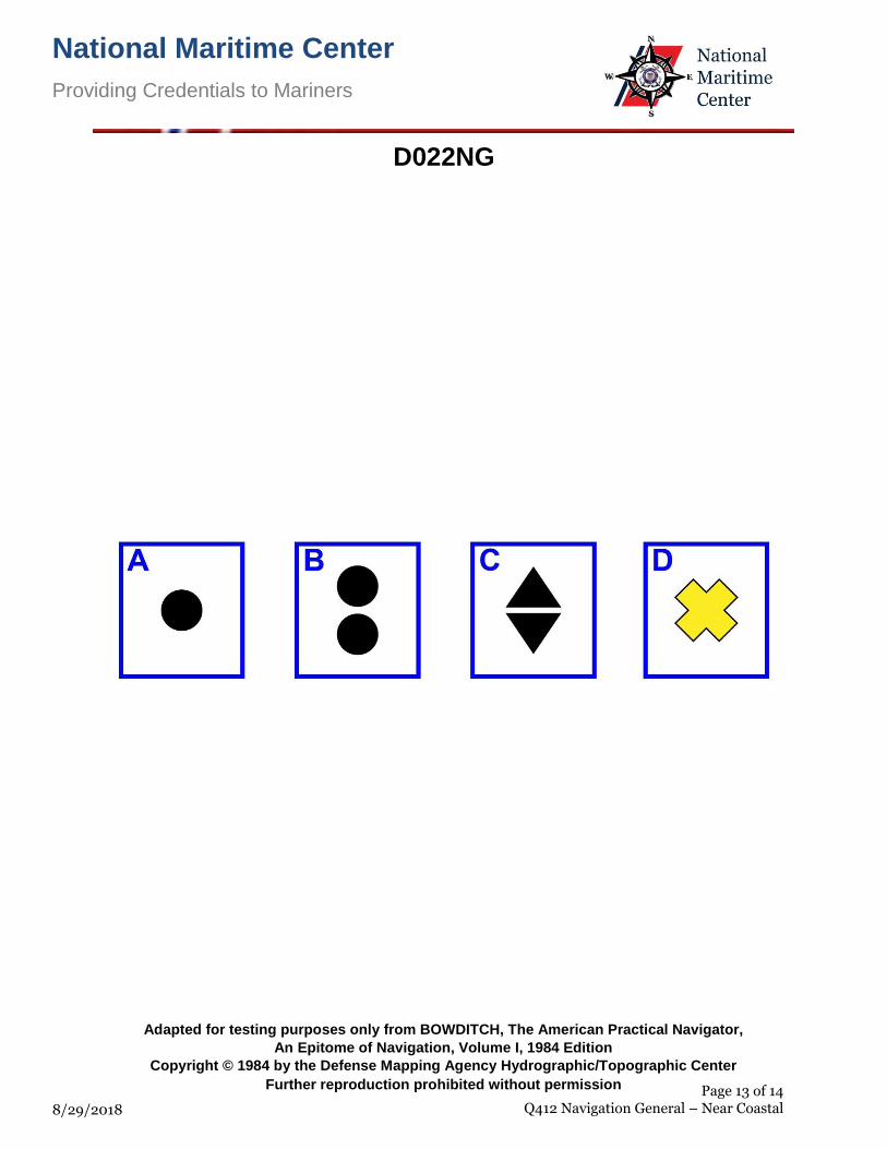
19. In both regions of the IALA buoyage system, which topmark shown in illustration D022NG below is used on a special mark?
o (A) A o (B) B o (C) C • (D) D
If choice D is selected set score to 1.
20. Which term is defines the ocean bottom that extends from the shoreline out to an area where there is a marked change in slope to a greater depth?
o (A) Offshore terrace o (B) Abyssal plain • (C) Continental shelf o (D) Borderland
If choice C is selected set score to 1.
Page 5 of 14 Q412 Navigation General – Near Coastal
9/10/2019

Q412 Navigation General-Near Coastal U.S.C.G. Merchant Marine Exam Apprentice Mate Steersman Illustrations: 3 21. Which is the FIRST indications a mariner will have of the approach of a warm front?
o (A) Low dark clouds with intermittent rain • (B) High clouds gradually followed by lower thicker clouds o (C) Fog caused by the warm air passing over the cooler water o (D) Large cumulonimbus clouds building up
If choice B is selected set score to 1.
22. Which publication indicates the HYDROLANTS or HYDROPACS issued since the previous working day?
• (A) Daily Memorandum o (B) Local Notice to Mariners o (C) Broadcast Notice to Mariners o (D) Summary of Corrections
If choice A is selected set score to 1.
23. You are steaming in the open ocean of the North Pacific between the Aleutian Chain and Hawaii. A warning broadcast indicates that an earthquake has occurred in the Aleutians and has generated a tsunami that is predicted to hit Hawaii. What action is necessary for the ship's safety?
o (A) Prepare for sudden, high-velocity wind gusts from rapidly changing directions. o (B) Securely stow all loose gear, check deck lashings, and prepare for extreme rolls. • (C) No special action as tsunamis are inconspicuous in the open ocean o (D) Calculate the tsunami's ETA at your position and turn to a course that will head into the
Tsunami.
If choice C is selected set score to 1.
24. Which is TRUE concerning privately maintained aids to navigation included in the Light List?
• (A) They must conform to the standards of the U.S. Aids to Navigation System o (B) Not permitted in or along first-class waterways and may be authorized for second- and third-
class waterways o (C) They must be conspicuously marked by a signboard with the words "PRIVATE AID" o (D) They are painted white and must use a white light if lighted
If choice A is selected set score to 1.
25. The climate of the northern Gulf coast __________.
• (A) is a warm marine type of climate o (B) varies from warm to subtropical o (C) has an east coast marine type of climate o (D) is humid and subtropical throughout the year
If choice A is selected set score to 1.
Page 6 of 14 Q412 Navigation General – Near Coastal
9/10/2019

Q412 Navigation General-Near Coastal U.S.C.G. Merchant Marine Exam Apprentice Mate Steersman Illustrations: 3 26. Which describes a line of position derived by radar range from an identified point on a coast?
o (A) A line parallel to the coast o (B) Straight line • (C) Arc o (D) Parabola
If choice C is selected set score to 1.
27. Your vessel is participating in the Voluntary Observing Ship Program. You are preparing WS Form B-80 as seen in illustration D041NG below. Three-quarters of the sky is covered with clouds, and the anemometer indicates that the apparent wind is from 226° relative at 17.7 knots. You are on course 020°T at 8 knots. How should you encode group Nddff?
• (A) 62324 o (B) 72318 o (C) 80208 o (D) 72218
If choice A is selected set score to 1.
28. Under the U.S. Aids to Navigation System, what does a lighted buoy with a spherical topmark mark indicate?
o (A) The position of underwater cables o (B) A hazard to navigation • (C) Safe water o (D) The port side of the channel
If choice C is selected set score to 1.
29. An ECDIS is required to display which information?
o (A) Waypoints o (B) Meteorological data o (C) Radar targets • (D) Soundings
If choice D is selected set score to 1.
30. Prevailing winds between 30°N and 60°N latitude are from which direction?
o (A) South o (B) North o (C) East • (D) West
If choice D is selected set score to 1.
Page 7 of 14 Q412 Navigation General – Near Coastal
9/10/2019

Q412 Navigation General-Near Coastal U.S.C.G. Merchant Marine Exam Apprentice Mate Steersman Illustrations: 3 31. Apparent wind speed blowing across your vessel while underway can be measured by which
instrument?
• (A) anemometer o (B) thermometer o (C) wind vane o (D) barometer
If choice A is selected set score to 1.
32. While steaming on course 280°T, you sight a buoy showing a very quick flashing (VQ) white light well to port. Maintaining course, you sight another buoy showing a quick flashing (Q) white light. How should you pass?
o (A) South of the buoy • (B) North of the buoy o (C) East of the buoy o (D) West of the buoy
If choice B is selected set score to 1.
33. Coral atolls, or a chain of islands at right angles to the radar beam, may show as a long line rather than as individual targets. What causes this distortion?
• (A) The effects of beam width o (B) The multiple-target resolution factor o (C) The pulse length of the radar o (D) Limitations on range resolution
If choice A is selected set score to 1.
34. Where is the navigable semicircle of a typhoon in the Southern Hemisphere located?
o (A) Ahead of the typhoon, measured from the storm's track to 90° on each side • (B) To the right of the storm's track o (C) To the left of the storm track o (D) Behind the typhoon, measured from 90° to 180°From each side of the storm's track
If choice B is selected set score to 1.
35. Which is TRUE concerning the dew point temperature?
o (A) It is always higher than the air temperature o (B) It is always lower than the air temperature o (C) It is equal to the difference between the wet and dry bulb temperatures • (D) It is the temperature at which the air is saturated with water vapor
If choice D is selected set score to 1.
Page 8 of 14 Q412 Navigation General – Near Coastal
9/10/2019

Q412 Navigation General-Near Coastal U.S.C.G. Merchant Marine Exam Apprentice Mate Steersman Illustrations: 3 36. Fog forms when which condition exists?
o (A) When the air is 90% water saturated o (B) When the air is 50% water saturated o (C) When the air temperature is greater than the dew point temperature • (D) When the air temperature is equal to, or below the dew point temperature
If choice D is selected set score to 1.
37. Which of the following statements is TRUE regarding automatic identification systems (AIS)?
o (A) AIS is always required to be operating if the vessel is within 100 nautical miles of the coastline.
• (B) The master may, at his/her discretion, turn off the AIS if he/she believes that it may compromise the safety or security of the vessel.
o (C) AIS is always required to be operating if the vessel is in or in the vicinity of a VTS area. o (D) Under no circumstances shall AIS be turned off while underway as this could endanger the
vessel and those around her.
If choice B is selected set score to 1.
38. What causes permanent magnetism on a vessel?
• (A) The earth's magnetic field affecting the ship's hard iron during construction o (B) The horizontal component of the earth's magnetic field acting on the horizontal soft iron o (C) The operation of electrical equipment and generators on board ship o (D) The vertical component of the earth's magnetic field acting on the vertical soft iron
If choice A is selected set score to 1.
39. When a low pressure area is approaching, which is generally TRUE of the weather?
• (A) The weather worsens o (B) The weather is unpredictable o (C) The weather improves o (D) The weather remains the same
If choice A is selected set score to 1.
40. The owner or Master of a towing vessel shall ensure that all tests and inspections of gear take place and are logged __________.
o (A) daily, at 1200 local zone time • (B) before embarking on a voyage of more than 24 hours o (C) on each watch, immediately before being relieved o (D) weekly, before 0000 Sunday
If choice B is selected set score to 1.
Page 9 of 14 Q412 Navigation General – Near Coastal
9/10/2019

Q412 Navigation General-Near Coastal U.S.C.G. Merchant Marine Exam Apprentice Mate Steersman Illustrations: 3 41. Automatic identification systems (AIS) are required to do which of the following?
o (A) provide safety-related information automatically to shore stations, other vessels and aircraft o (B) exchange safety-related information with shore-based facilities o (C) receive safety-related information automatically from similarly equipped vessels • (D) All of the above
If choice D is selected set score to 1.
42. What are the colors of a mid-channel daymark?
• (A) Red and white o (B) Green and white o (C) Black and red o (D) Green and red
If choice A is selected set score to 1.
43. A List of Lights entry (L Fl) is a single flashing light which shows a long flash of not less than which duration?
o (A) 1.0 second duration o (B) 1.5 seconds duration • (C) 2.0 seconds duration o (D) 3.0 seconds duration
If choice C is selected set score to 1.
44. The shoreline shown on nautical charts of areas affected by large tidal fluctuations is usually the line of mean __________.
• (A) high water o (B) low water o (C) tide level o (D) lower low water
If choice A is selected set score to 1.
45. Where will you find information about the duration of slack water?
o (A) American Practical Navigator o (B) Sailing Directions • (C) Tidal Current Tables o (D) Tide Tables
If choice C is selected set score to 1.
Page 10 of 14 Q412 Navigation General – Near Coastal
9/10/2019

Q412 Navigation General-Near Coastal U.S.C.G. Merchant Marine Exam Apprentice Mate Steersman Illustrations: 3
46. How many characters does the short text messaging feature of the automatic identification system(AIS) allows for?
o (A) 56 characterso (B) 64 characterso (C) 128 characters• (D) 158 characters
If choice D is selected set score to 1.
47. A Doppler log in the volume reverberation mode indicates __________.
o (A) speed being made goodo (B) the set of the currento (C) the depth of the water• (D) speed through the water
If choice D is selected set score to 1.
48. General information about the location, characteristics, facilities, and services for U.S. and foreignports may be obtained from which publication?
o (A) Coast Pilot• (B) World Port Indexo (C) Sailing Directionso (D) Distances Between Ports
If choice B is selected set score to 1.
49. Which is TRUE of an alternating light?
o (A) It marks an alternate lesser used channel• (B) It shows a light that changes coloro (C) It is used as a replacement for another lighto (D) It shows a light with varying lengths of the lighted period
If choice B is selected set score to 1.
50. Which statement concerning the chartlet seen in illustration D010NG below is TRUE? (Soundingsand heights are in meters)
o (A) Maury lightship is visible for 17 miles.• (B) There is a dangerous eddy southeast of Beito Island.o (C) The bottom to the south-southeast of the lightship is soft coral.o (D) There is a 12-meter deep hole west of Beito Island and inside the 5-meter line.
If choice B is selected set score to 1.
Page 11 of 14 Q412 Navigation General – Near Coastal
9/10/2019

National Maritime Center
Providing Credentials to Mariners
8/29/2018
D010NG
Adapted for testing purposes only from BOWDITCH, The American Practical Navigator,
An Epitome of Navigation, Volume I, 1984 Edition
Copyright © 1984 by the Defense Mapping Agency Hydrographic/Topographic Center
Further reproduction prohibited without permission Page 12 of 14 Q412 Navigation General – Near Coastal
National Maritime Center
Providing Credentials to Mariners
8/29/2018
D022NG
Adapted for testing purposes only from BOWDITCH, The American Practical Navigator,
An Epitome of Navigation, Volume I, 1984 Edition
Copyright © 1984 by the Defense Mapping Agency Hydrographic/Topographic Center
Further reproduction prohibited without permission Page 13 of 14 Q412 Navigation General – Near Coastal

National Maritime Center
Providing Credentials to Mariners
9/6/2018
D041NG
Adapted for testing purposes only from U.S. Department of Commerce
National Oceanic and Atmospheric Administration
National Weather Service
Further reproduction prohibited without permission Page 14 of 14 Q412 Navigation General – Near Coastal