U.S. NAVAL BASE, PEARL HARBOR, WATERFRONT FACILITIES...
27
U.S. NAVAL BASE, PEARL HARBOR, WATERFRONT FACILITIES Various Locations Throughout Base Pearl Harbor Honolulu County Hawaii PHOTOGRAPHS WRITTEN HISTORICAL DATA HISTORIC AMERICAN ENGINEERING RECORD National Park Service U.S. Department of the Interior Oakland, California HAER No. Hl-53 l l\: .. ',
Transcript of U.S. NAVAL BASE, PEARL HARBOR, WATERFRONT FACILITIES...

U.S. NAVAL BASE, PEARL HARBOR, WATERFRONT FACILITIES Various Locations Throughout Base Pearl Harbor Honolulu County Hawaii
PHOTOGRAPHS
WRITTEN HISTORICAL DATA
HISTORIC AMERICAN ENGINEERING RECORD National Park Service
U.S. Department of the Interior Oakland, California
HAER No. Hl-53
ll\: .. ',
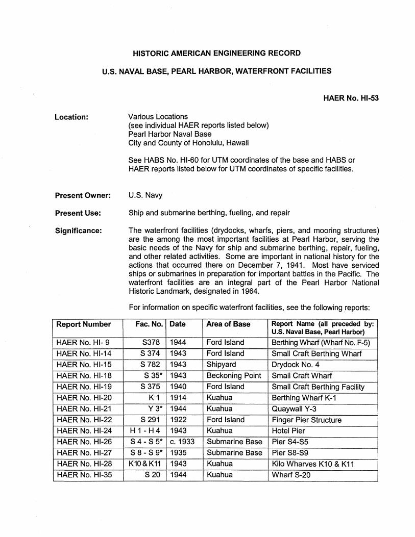
HISTORIC AMERICAN ENGINEERING RECORD
U.S. NAVAL BASE, PEARL HARBOR, WATERFRONT FACILITIES
Location:
Present Owner:
Present Use:
Significance:
Report Number
HAER No. HI- 9
HAER No. Hl-14
HAER No. Hl-15
HAER No. Hl-18
HAER No. Hl-19
HAER No. Hl-20
HAER No. Hl-21
HAER No. Hl-22
HAER No. Hl-24
HAER No. Hl-26
HAER No. Hl-27
HAER No. Hl-28
HAER No. Hl-35
Various Locations (see individual HAER reports listed below) Pearl Harbor Naval Base City and County of Honolulu, Hawaii
HAER No. Hl-53
See HABS No. Hl-60 for UTM coordinates of the base and HABS or HAER reports listed below for UTM coordinates of specific facilities.
U.S. Navy
Ship and submarine berthing, fueling, and repair
The waterfront facilities (drydocks, wharfs, piers, and mooring structures) are the among the most important facilities at Pearl Harbor, serving the basic needs of the Navy for ship and submarine berthing, repair, fueling, and other related activities. Some are important in national history for the actions that occurred there on December 7, 1941. Most have serviced ships or submarines in preparation for important battles in the Pacific. The waterfront facilities are an integral part of the Pearl Harbor National Historic Landmark, designated in 1964.
For information on specific waterfront facilities, see the following reports:
Fae. No. Date Area of Base Report Name (all preceded by: U.S. Naval Base, Pearl Harbor)
S378 1944 Ford Island Berthing Wharf (Wharf No. F-5)
S374 1943 Ford Island Small Craft Berthing Wharf
S 782 1943 Shipyard Drydock No. 4
S 35* 1943 Beckoning Point Small Craft Wharf
S375 1940 Ford Island Small Craft Berthing Facility
K1 1914 Kuahua Berthing Wharf K-1
Y3* 1944 Kuahua Quaywall Y-3
S 291 1922 Ford Island Finger Pier Structure H 1 -H 4 1943 Kuahua Hotel Pier
S 4- S 5* C. 1933 Submarine Base Pier S4-S5
S 8- S 9* 1935 Submarine Base Pier S8-S9
K10&K11 1943 Kuahua Kilo Wharves K1 O & K11
S20 1944 Kuahua Wharf S-20

U.S. NAVAL BASE, PEARL HARBOR, WATERFRONT FACILITIES HAER No. Hl-53 (Page 2)
HAER No. Hl-36 S 21 1944 Kuahua Wharf S-21
HAER No. Hl-37 S10-S14 1931 Submarine Base Berthing Wharves S10-S14
HAER No. Hl-38 S1 1942 Submarine Base Berthing Wharf S1
HAER No. H 1-39 S370 1941 Ford Island Boat Landing (Alpha Landing)
HAER No. Hl-40 822-826 1937-44 Naval Station Bravo Docks
HAER No. Hl-45 1192-1197 c. 1943 Submarine Base Small Craft Berthing Piers
HAER No. Hl-54 S 377* 1924 Ford Island Gasoline Wharf
HAER No. H 1-55 S649 before Pearl City Yacht Club Pier and Marine 1937 Peninsula Railways
HAER No. Hl-60 S372, 1943-45 Ford Island & WWII Ferry Landing Type 596*&597* Halawa Landings
HAER No. H 1-65 S779 1909-19 Shipyard Dry Dock No. 1 and Overview
HAER No. Hl-65A S780 1942 Shipyard Dry Dock No. 2
HAER No. Hl-658 S781 1942 Shipyard Dry Dock No. 3
HABS No. Hl-220 W1-W5 1932-43 West Loch Ammunition Wharf Type
HABS No. Hl-510 1461 1943 Shipyard Marine Railway No. 2, Crane Wharf
HABS No. Hl-513 sm 1943 Shipyard Marine Railway No. 2 HABS No. Hl-514 B1&N2 1923-24 Shipyard South Quay Wall & Small Boat
Landing
HABS No. Hl-515 GD1, 1942-44 Shipyard Approach Pier & Caisson GD2, Docking Wharf (at entrance of &N1 Dry Docks Nos. 1 & 2)
HABS No. Hl-516 GD3,GD4, 1942 Shipyard Pier and Quay Walls &GD5 (at entrance of Dry Docks Nos. 2 & 3)
HABS No. Hl-517 01 1915 Shipyard Coal Dock
HABS No. Hl-518 02&03 1944 Shipyard Dry Dock No. 4, East & West Quay Walls
* indicates demolished facilities
A few more HAER reports are also being prepared for other waterfront facilities but numbers have not been assigned yet.
Prepared by: Ann Yoklavich, Architectural Historian Mason Architects, Inc. 119 Merchant Street, Suite 501 Honolulu, HI 96813
Date of Final Report: April 2005

U.S. NAVAL BASE, PEARL HARBOR, WATERFRONT FACILITIES HAER No. Hl-53 (Page 3)
HISTORICAL INFORMATION
HISTORICAL CONTEXT OFWHARF DEVELOPMENT AT PEARL HARBOR
Note on terms used: This report covers all the facilities that serve ships or submarines, including drydocks, mooring structures, quays, and piers. In this report, the terms "wharf' or "dock" is used for any facility where a ship or submarine can tie up and load or unload. Therefore, those terms encompass quays, which are parallel to the shore, as well as piers, which project out into the water. "Bulkheads" are areas where the shoreline is shored up, but not necessarily suitable for tying up ships or submarines. A "berth" is a space for a ship or submarine to dock or anchor. So that term and "waterfront facilities" are more general and can include drydocks, mooring structures, quays, and piers.
Note on shoreline facilities not included in this report: The ferry landings in Pearl Harbor are discussed in HAER No. Hl-60, and so that information is not included in this report. Separate reports have been prepared to cover all the seaplane ramps on Ford Island, so they are also excluded.
Note on facility numbering: The Navy has assigned a separate facility number to every berthing space. This means that the repair basins, and the longer piers and quays, generally have multiple facility numbers. The only exception is Fae. S 1 on the Quarry Loch side of the Submarine Base. This long quay could not be given multiple numbers, without renumbering the numerous piers that had been built earlier. Since both sides of a pier are berthing places, they typically have two or four facility numbers, depending on their length. The piers with two berthing spaces are indicated by use of a slash between the berth numbers (e.g. Pier S15/S16 and Pier S16/S17).
Initial Waterfront Facilities
Waterfront facilities were among the first priorities in establishing the Naval Base at Pearl Harbor. Since the main functions of the base were stated to be ship repair and outfitting, the early necessities included a drydock, wharfs, and piers. The 1908 appropriations for the base allotted $2,000,000 for a drydock. Work started on the drydock in 1909 and was scheduled for completion in 1912. The construction period lengthened as increased dimensions and additional funds were· found necessary. In February 1913, the drydock was wrecked by hydrostatic pressures. After investigations, additional appropriations, and redesign, the drydock (Fae. S 779) was completed in August 1919.
In both the 1911 and 1912 appropriations for the base, $100,000 was allocated for waterfront development. Work started on a concrete wharf on Kuahua (Fae. K 1) in 1913, and was completed in 1914. Money was set aside for the coaling station and its wharf (Fae.01) in 1912 and 1913; work on them started in 1913, and was completed in 1915. In the 1913 appropriation act, $50,000 was also allocated for torpedo-boat slips. Historic photos show these were built of concrete on cylinder piles with wider cylinder ends. A 1916 map of the base shows three "torpedo piers" in the area where repair basins were later built.
Also shown on the 1916 map was the main wharf at the base, the 1010 wharf in the Shipyard area, called "ten-ten" because it was 1,010 feet long. It was built of heavily reinforced concrete and completed in 1918. This wharf (Fae. 82) was completely reconstructed in 1964-65, as Pearl Harbor's first pre-stressed concrete wharf (Honolulu Star Bulletin 1964 ).

U.S. NAVAL BASE, PEARL HARBOR, WATERFRONT FACILITIES HAER No. Hl-53 (Page 4)
A small boat landing (Fae. S 380) was built on Ford Island in 1914 by the U.S. Army. It was part of the improvements needed to build and supply Batteries Adair and Boyd on Ford Island. This pier originally was L-shaped with tram tracks on it. A comparison of a 1922 photo and the current appearance of this pier shows it has been reconstructed, but the date of that work is unknown.
Funds for two creosoted timber piers at Quarry Point for the submarine base were allocated in 1917. However, the submarine operations were not established at Quarry Point until February 1920 (de Yarmin 1984: 3).
Historic photos also show there were also four small wooden boat landings by the end of the decade. One of these was located near the coaling wharf, and others were located between the Hospital Reservation and Merry Loch.
Waterfront Facilities Built in the 1920s
The submarine base at Quarry Point was first developed in the 1920s. Two piers are visible at the end of the peninsula in 1923 photos, as well as a small pier and an L-shaped pier or causeway out to the USS Chicago on the Quarry Loch side of the submarine base peninsula. The Chicago (renamed the Alton in 1928), a submarine tender ship from 1919 to 1923, was converted in 1923 to a barracks ship (de Yarmin 1984: 10-11) and moored along the then irregular Quarry Loch shoreline of Quarry Point. In addition to the L-shape that provided access to the ship, another structure, triangular in section with cross bracing, connects the ship to the shore, perhaps carrying pipes and electrical conduits. By 1925 the small pier near the Chicago was gone, but there were two additional piers projecting from the end of the peninsula. All four piers (Fae. S 2/S 3, S 4 /S 5, S 6/S 7, and S 8/S 9) were replaced at various dates after their initial construction, in generally the same location and configuration and retaining the facility numbers. The evolution of these piers is discussed in following sections of this report. Historic photos show that at least 70 feet of the Submarine Base wharf along Magazine Loch was built by 1925. This wharf was either rebuilt or extended in the 1930s.
A small-boat pier was built on the northwest side of Ford Island, near Battery Boyd, in 1922 (Fae. S 291 ). The date and the location suggest it was built by the Army. The "sugar cube" lava rocks in the retaining wall at the shoreline and in the stub of the pier suggest it was built on the site of an earlier plantation waterfront structure. Early maps show a boat house over this pier, but this building was removed by 1953, and after this date maps show a pair of finger piers. It is not known if the pair of finger piers was original or if a second pier was built inside the first L-shaped pier sometime before the boat house was demolished. These finger piers were totally reconstructed about 1994.
Before the Naval Air Station was established on Ford Island· in 1923, the naval aviators had a temporary base at the Navy Yard Area. On a June 1920 map (U.S. Naval Station 1920), a small pier and two temporary canvas hangars existed where the 1930s repair basins were later built. Two other small piers are seen on this map.
On Ford Island a timber pier (not extant) was constructed near the main administration building, on the southeast side of the island, around 1922. By 1924 several finger piers had been erected near the timber pier. These piers were labeled as a boat house (which presumably was a structure built over some or all of them). That first boat house was replaced by another in 1936 (see Facility 44, HABS No. Hl-397) All of those waterfront facilities in that area of Ford Island

U.S. NAVAL BASE, PEARL HARBOR, WATERFRONT FACILITIES HAER No. Hl-53 (Page 5)
were demolished or moved about 1941 when the shoreline there was greatly changed by dredging and filling.
Major shoreline improvements were made to Merry Point in the early 1920s, when the distinctive triangular shape of this peninsula was created. Four berths (Fae. M 1 to M 4) lined Merry Point and were used as fueling wharfs. The dredged material was used to fill the peninsula. At Ford Island a T-shaped pier (Fae. S 377) extended out to deep water, to minimize the dredging there. The gasoline that was unloaded here was used for the Naval Air Station's planes. Pan-American Petroleum and Transport Co. (PAPTC} was responsible for the construction of these concrete fuel wharfs and of numerous steel fuel tanks on the main base and at Ford Island. Their payment was to be in the oil from the Naval Oil Reserves in California. The manner in which this contract had been made with PAPTC and a similar one with Mammoth Oil Co. for the Teapot Dome Naval Oil Reserve in Wyoming became the political scandal known as "Teapot Dome," a term as resonant of government corruption in its era, as the Watergate and other "gate" controversies are in ours. See HASS No. Hl-389 for further background on the Pearl Harbor connection to the Naval Oil Reserves scandal.
In 1922 the first marine railway at the Shipyard (Fae. S 776, not extant) was built (Pearl Harbor Naval Shipyard n.d.: 22). The main 1010 dock at the Shipyard (Fae. B 2) was extended at both ends in the 1920s. The south end of the quay is now designated Fae. B 1, and the north end, most of which is a pier, is numbered Fae. B 3/B 4. While the Navy database dates these facilities as 1927 and 1928, respectively, historic photos indicate both were completed by 1924. The total length of the main Shipyard wharf (including berths B 1, B 2, and B 3) was more than doubled, to approximately 2,060 feet, but the whole wharf is still called 1010.
A slip (Fae. B 5 and B 6) was created behind (east of) the pier portion of 1010 wharf (Fae. 83/84) about 1929. This slip is shown on the 1929 map and is seen in a 1931 photo, but dated in the Navy database as 1932. Its width was dictated by the marine railway, which was built earlier. Its 30'-35' depth was relatively shallow, but probably sufficient for most ships.
Waterfront Facilities Built in the 1930s
Longer and deeper berths were developed for repair slips in 1936-1937. The repair basin project in the 1930s constructed only the two longer basins (Fae. B 11 to B 21) and part of the quay along Southeast Loch (Fae. B 22). The other repair basin (Fae. B 7 to B 10) has an incorrect date in the Navy database, and was not built until World War II (see below). One part of the repair basin (Fae. B 11 / B 12) replaced one of the earlier torpedo boat piers. A stationary hammerhead crane, relocated from the Brooklyn Navy Yard, was erected on this new concrete pier portion of the repair basin. This 200-ton-capacity crane was used until 1980, when it was demolished.
At the Submarine Base in 1931, part of the shoreline along the Magazine Loch was straightened and rebuilt as a quay (Fae. S 10 - S 12). At least two of the four piers at the end of Quarry Point were reconstructed as concrete piers in the mid 1930s. Concrete quaywalls between Piers 1 and 4 were also built in this decade. Piers 2 and 4 (Fae. S 4/S 5 and S 8/S 9) were rebuilt in the same location and with very similar dimensions to the earlier piers with the same numbers. (Records on the rebuilding of Piers 1 and 3 have not been kept since they were demolished before 1981 and 1977, respectively.) Both Piers 2 and 4 were demolished in the 1990s, and the new, longer pier (numbered Fae. S 8/S 9) was built at a different angle, extending in a line from the quay on the Magazine Loch side of Quarry Point.

U.S. NAVAL BASE, PEARL HARBOR, WATERFRONT FACILITIES HAER No. Hl-53 (Page 6)
One wharf was built at West Loch in 1932 (Fae. W 2). It was built primarily for loading and unloading ammunition at this newly established ammunition depot location, but was also helpful in the construction of the depot. In 1943, this wharf was extended at both ends (Fae. W 1 and W 3) and another wharf (Fae. W 4 and W 5) built. However, those WWII West Loch waterfront facilities are dated 1932 in the Navy database.
Numerous moorings were built offshore of Ford Island, twelve off the southeast shoreline in 1935 and ten off the northwest shoreline about 1938. The offshore positions minimized dredging but did make access and loading/unloading of the ship more difficult. Each mooring pair was intended for a battleship or aircraft carrier. The distance between a pair is about 250 feet. The 1935 type were described in the caption of a photo (National Archives II):
These platforms are of the interrupted quay wall type with the top part constructed of concrete, box like, filled with sand and resting on concrete piles .... The design offered an interesting problem because it had to resist forces from a battleship under mooring conditions.
Heavy springs on the wood fenders were designed to absorb the shock of mooring. There were three types of platform sizes, and all the shapes were complex polygons, but somewhat like a half-hexagon on the side away from the ships.
The design of the moorings off the northwest side of Ford Island was different. Y&D Drawing No. 123821 shows the platforms were more rectangular, with one massive concrete bollard-like shape underneath, instead of numerous concrete piles. The spring fender system was similar. Eight of the moorings on the northwest side, and two on the southeast side of the island were incorporated into T-shaped piers during World War II. Five pairs remain, without fenders, as memorials to the December 7, 1941 attack. These mooring pairs are designated on maps as F2, F3, F6, F7, and F8. The F7 mooring pair is adjacent to the sunken USS Arizona. The moorings are no longer used by the Navy and are not in their facilities database.
Another facility not in the Navy database is an Army pier that the Navy had to rebuild in 1937, as a result of dredging the channel under a Navy contract (VanBrackle 1955: 3). This Army pier was at Fort Weaver, which is now part of the Navy's Iroquois Point housing area.
Waterfront Facilities Built 1940-1945
Most of the waterfront facilities at Pearl Harbor were constructed between 1940 and 1945. The entire Pacific fleet was ordered to remain at Pearl Harbor, after maneuvers there in the spring of 1940. It soon was clear that a great number of additional berthing spaces were required. After the Japanese attack on December 7, 1941, the pace of waterfront improvements increased. The attitude was "every available inch of shoreline must be used" for either docks or related services (Woodbury 1946: 340).
In five years almost the entire main base shoreline was reconfigured as drydocks, quays, and piers. Between the South Avenue boundary and Halawa Stream, the only shoreline that was not hardened was Hospital Point. Moreover, even this shoreline was altered by widening the main channel. Most of the waterfront facilities at Pearl Harbor in this period were built by the consortium of firms called Contractors Pacific Naval Air Bases (CPNAB). Despite the consortium's name their work obviously encompassed more than air bases.

U.S. NAVAL BASE, PEARL HARBOR, WATERFRONT FACILITIES HAER No. Hl-53 (Page 7)
One of the main members of the CPNAB consortium was Hawaiian Dredging Company. This firm had been responsible for most of the dredging at Pearl Harbor since the beginning of the century and it was· put in charge of much waterfront work, under the CPNAB contract and later under a separate contract. Although only 200,000 cubic yards of dredging near Ford Island had been listed in the original contract at Pearl Harbor, the amount "reached the almost incredible total of eighteen and a half million cubic yards by the end of 1943, involving sixty-six separate projects" (Weeber 1945). Almost half of this volume was removed from Middle Loch, where mooring spaces for numerous ships were provided. In addition, all the new waterfront facilities that were built required dredging alongside them to make them suitable for berthing.
Ford Island Waterfront Facilities
There were numerous waterfront projects at the Naval Air Station (NAS) on Ford Island, as well as extensive dredging around the island during the 1940-1945 period. Two of the earliest projects, in 1940-41, involved reconfiguration of the shoreline in the area near the new NAS Administration building (Fae. 77). The construction of a bulkhead (Fae. S 373), a quay (Fae. S369), and a small boat landing (Fae. S370) involved the demolition of the ca. 1922 wooden pier and relocation of the 1936 boat house. Additional slips for small boats (eventually designated as Fae. S 375) were also built in 1940, at the same time as the four finger piers under the relocated boathouse (Fae. 44). In 1943 a quay for small boats (Fae. S 374) involved hardening about a thousand feet of shoreline to the west of the boat house, and in 1945 additional finger piers (Fae. S 376) were built on the east side of the boat house. Five pairs of the 1930s moorings off Ford Island were incorporated into new wharfs. These were mostly used as aircraft carrier berths, whose necessity had been stressed in a 1940 memo (Almy et al. 1940). Each of the four moorings pairs (F 9, F 10, F 12, and F 13) on the northwest side of the island was incorporated into a T-shaped pier in 1943, and one pair on the southeast side of the island (F 5) was incorporated into such a pier in 1944. The piers on the northwest side of the island that had originally been labeled with the F 9 and F 10 mooring numbers were later given Facility numbers S 384 and S 383; they remain in their 1943 configuration. The two other T-shaped piers on that side (built on mooring pairs F 12 and F 13) were connected in 1945 and became Facility S 382. On the opposite side of the island the 1944 pier created on the F 5 moorings was numbered Facility S 378. It is extant; however, a portion has been removed to provide access to the new T-shaped pier, built outboard of the WWII one.
Shipyard Waterfront Facilities . To handle the increased small boat traffic to Ford Island, a new landing (Fae. S 773) was built in 1940 at the Shipyard/Hospital Point boundary, and called Landing C or Charlie Landing. The waterfront facilities added to the Shipyard in the 1940s included three additional drydocks, a second marine railway, and another repair basin, as well as small piers and quays adjacent to those facilities. New caissons were also required at each new drydock. Each caisson is:
a massive steel tank, heavily reinforced inside, almost entirely welded, sheathed with 2-1/2'' steel armor plate. It is ballasted to remain upright in water, and is equipped with impeller pumps for flooding compartments to adjust its depth of immersion, with balancing tanks at either end - and leveling indicators .... [T]he structure can be eased into position with most delicate precision. Rubbergasketed flanges, on three sides, snug-fit it [to the bottom and sides] (Pacific Bridge 1944: 83).

U.S. NAVAL BASE, PEARL HARBOR, WATERFRONT FACILITIES HAER No. Hl-53 (Page 8)
The need for additional drydocks at Pearl Harbor had been recognized since completion of Drydock No. 1 in 1919. Funding was not appropriated for three decades, however. The Navy's Bureau of Yards and Docks had plans ready. They wanted to build the drydocks in much less time than the six years that the reconstruction of Drydock No. 1 has consumed. The contract for two new drydocks called for another battleship and carrier drydock (Drydock No. 2), similar in length, but slightly wider and deeper, than Drydock No. 1 was, plus a smaller drydock for destroyers and submarines (Drydock No. 3). Innovative approaches were used to speed construction: both in the use of tremie concrete (concrete placed under water) for the floors, and in the design, such that the drydock floor acted "as a beam to transmit the upward pressure" to the side walls (Pacific Bridge Co., n.d.: 20). Because of its smaller dimensions, construction of the side walls of Drydock No. 3 could be built more easily, using sheet piling, inside of which wood forms were built, and concrete was then poured in those. Drydock No. 2 required the use of side wall cofferdam form units in order to pour the concrete in the dry (U.S. Navy Bureau of Yards & Docks, Vol. II 1947: 124). Pacific Bridge Company started construction on Drydocks Nos. 2 and 3 (Fae. S 780 and S 781) in December 1939. Drydock No. 2 was usably complete, and No. 3 was about 90% complete, when Oahu was attacked on December 7, 1941.
In 1940 when planning for the fourth drydock, naval officers debated over the size required. Another one as large as Drydock No. 2 was desired. The reasoning was that Drydock No. 3 was small; also, because of its limited depth, Drydock No. 1 should:
not be considered as more than a cruiser dock. One damaged vessel in No. 2 dock would place the yard without drydock resources for routine or emergency purposes for accommodating a capital ship. It is considered that a major base so far removed from other resources should have not less than two major dry docks (Almy et al. 1940).
Excavation of Drydock No. 4 (Fae. S 782) had just started before the Japanese attack; it was completed by 1943. This drydock, also constructed by Pacific Bridge Co., was built with the aid of the 350-foot-span gantry crane that had been erected over Drydocks Nos. 2 and 3. The gantry crane tracks were simply extended to the new location, so the crane did not have to be disassembled. Drydock No. 4 differed in two ways from Nos. 2 and 3. It was supported on wood pilings, which helped compact the underlying soil, rather than on steel pilings. The compacting of the soil aided in resisting the hydrostatic uplift problems encountered when building Drydocks Nos. 2 and 3. In addition, most of the walls, as well as the floor, of Drydock No. 4 were poured underwater, with only the top gallery section poured "dry" (above water). Drydock No. 4 was built near the old coaling basin and wharf (Fae. 0 1 ), and not in the vicinity of the other three drydocks. A floating drydock was already moored near Drydock No. 3. All of the drydocks were crucial facilities for repairing ships and submarines so they could be returned to battle during World War II in the Pacific.
Another important repair facility, for destroyers and submarines, was the second marine railway (Fae. S 777), built in 1943 just west of the floating drydock. Its steel members were salvaged from the coaling plant, whose trestling was partially dismantled to allow a bulk cement handling and storage plant to be erected (Gaffney 1941 ). The crane wharf alongside the second marine railway was also built in 1943.
The dimensions (in feet) of the four drydocks and this marine railway are given below. (Marine Railway No. 1 was demolished long ago and its dimensions are not known). Different sources give varying dimensions for these facilities, but these ones in the Navy database are useful for comparison purposes. They indicate the relative sizes of ships that could be accommodated in each.

Fae. No
S779
S780
S 781
S782
S777
U.S. NAVAL BASE, PEARL HARBOR, WATERFRONT FACILITIES HAER No. Hl-53 (Page 9)
Facility Name Length Width Depth
Drydock No. 1 1002 138 44 Drydock No. 2 1001 147 55 Drydock No. 3 498 104 30 Drydock No. 4 1089 155 59 Marine Railway No. 2 (cradle) 399 61 24
The coaling wharf (Fae. 0-1) was improved by Hawaiian Dredging during WWII, including a new approach ramp (Weeber 1944). The bulk cement handling plant was built on part of the coaling basin, but a portion of the coaling plant was kept functioning during the war for the few ships still burning coal in the 1940s.
There were several small piers and quays built in the Shipyard during World War II, mostly associated with the additional drydocks. These were given separate facility numbers, such as Fae. O 2 and O 3 which are the quays at the entrance to Drydock No. 4. Often these facilities are used for small boat landings and/or as docking places for the caissons. Fae. N 1 was constructed during WWII for the Drydock No. 1 caisson. A pier (Fae. GD 1/GD 2) and a quay (Fae. GD 3) were built at the mouth of Drydock No. 2. For Drydock No. 3 there is a similar short quay (Fae. GD 5), and a longer quay (Fae. GD 4), which is parallel to the length of the drydocks.
An additional repair basin was also built in the Shipyard during WWII, although all the repair basins are shown in the Navy database with 1930s dates. Drawings and photographs confirm that the last repair basin (Fae. B 7, B8, B9, and B 10) was built in 1943 and that it replaced the c. 1915 torpedo boat Piers No. 2 and 3. This extra repair basin, which has sides almost 700' in length, is shorter than the 1930s repair basins, but slightly longer than the c. 1929 101 O slip.
The East Quay, or Bravo Docks (Fae. B23 through B26), were built during WWII as an extension from Fae. B 22, which had been constructed as part of the 1930s Repair Basin project. These docks were built as supply unloading berths to release the "industrial berths in the Repair Basin" (Almy et al. 1940). The half of East Quay nearest to the Repair Basin (Fae. B23 and B24) was built in 1942 by Contractors Pacific Naval Air Bases. The half of the quay closest to Merry Point (Fae. B 25 and B 26) was not constructed until 1945. This half was probably built later because in the early 1940s there were ferry slips and a large enlisted men's landing located at this end of Merry Loch. When new ferry slips were built near Halawa Stream about 1945, the Bravo Docks could be extended. This part of the Bravo Docks was built by Hawaiian Dredging Company (n.d.: 22). The Bravo berths were numbered B 23 through B 25 during WWII and, sometime after 1951, the quay was renumbered twice, by assigning different lengths to each berth. Currently, Fae. B25 and B26 are 550' in length, with Fae. B25 assigned 600' of the quay, and Fae. B26 having the final 700'.
Submarine Base Waterfront Facilities
Submarine Base was also changed dramatically by World War II construction along its waterfront. Its deficiencies in berthing space were recognized in a 1940 memo about developments needed in the Fourteenth Naval District (Almy et al. 1940). Quays were built on both sides of the peninsula, along Quarry Loch (Fae. S 1) and the remainder of Magazine Loch (Fae. S 13 and S 14). Most of the work, until December 1943, was done by Contractors Pacific Naval Air Bases (CPNAB). After that date, construction was undertaken by the Navy

U.S. NAVAL BASE, PEARL HARBOR, WATERFRONT FACILITIES HAER No. Hl-53 (Page 10)
Construction Battalions (CBs or Seabees). The first CPNAB project at the Submarine Base was to extend the southern quay wall (Fae. S 1 ). A damaged Japanese midget submarine, from the December 7, 1941 attack, was recovered several months later and used as fill for Fae. S 1 (Contractors Pacific Naval Air Bases n.d.: A-621 ). Further work for CPNAB was authorized under the contract:
Because of the overhaul requirements of submarines already in the Pacific area, and because of the Navy's decision to assign to that theater a very large proportion of its growing submarine force, it was necessary that increased service facilities be provided at the Submarine Base (Contractors Pacific Naval Air Bases n.d.: A-619).
Most of these waterfront facilities were fully equipped with fuel, air, and water lines, so that moored submarines or the floating drydock could be provided with these utilities.
About 1942, the area at the end of Magazine Loch was entirely changed by dredging and filling, followed by the construction of two finger piers (Piers S 15/S 16 and S 16/S 17) and the first part of the quay wall along Kuahua peninsula (Fae. S 19). The whole area at the east end of Magazine Loch was "constructed over a swamp" (Contractors Pacific Naval Air Bases n.d.: A-621) to provide additional land for the Submarine Base. The fill had settled unevenly during construction, requiring redriving of about 50 piles, reconstructing of the electrical duct, and moving the proposed locations of buildings further from the piers.
About 1943, six small boat piers (Fae. 1192 - 1197) and a connecting wharf were built at the end of Quarry Loch. These replaced a temporary boat shed in this location, shown in a 1936 photo. In 1933 a memo from a Submarine Squadron Commander had noted the need for a boat shed, since the "Submarine Base has a greater number of boats and does more boating than any other activity in the District," and their boats were then difficult to keep water tight, since they were "lying in the hot sun all day'' (Osterhaus 1933). The 1942 drawing shows seven piers; however, only six were built. A wooden boathouse was originally built over the northern piers. This was replaced by a modern structure in 1977, when two of the piers were also lengthened.
Kuahua Waterfront Facilities
During World War II Kuahua Peninsula was created from Kuahua Island. The headquarters of the Naval Supply Depot (NSD) was established at Kuahua, on the site of the former Naval Magazine. While the early Naval Magazine at Kuahua had required only one small quay, the NSD had to supply all the ships and advance bases in the Pacific during WWII. The natural shoreline was entirely changed to a quay- and bulkhead-lined one. Facilities S 18 to S 21 lined most of the Magazine Loch side of the peninsula. On the opposite side of the peninsula the berthing spaces included K 3, K 5, K 6, K 9, K 10 and K 11. There was a collapse of the retaining wall during the construction of the Fae. K10-K11 wharf, so it was never extended to reach the bulkhead of Fae. K 12. The latter, like Facilities H 5 and H 6 near Halawa Stream, could only serve small boats due to the limited water depth adjacent to these quaywalls. During WWII, there were also two major piers constructed at Kuahua, one for general supplies (Fae. K 7 / K 8) and one for fuel (Fae. H 1, consisting of berths H 1, H 2, H 3, and H 4). All of those facilities were built of concrete, except K 3 and K 5, which had timber decks. The outer end of Kuahua Peninsula was lined with metal sheet piling in 1944 (Facilities Y 2 and Y 3). These bulkheads were used by yard craft. A small pier and boathouse that had been at the end of the peninsula

U.S. NAVAL BASE, PEARL HARBOR, WATERFRONT FACILITIES HAER No. Hl-53 (Page 11)
were rebuilt in a notch along the Magazine Loch side, between the concrete wharfs and the beginning of the sheet-pile quaywall.
Waterfront Facilities at West Loch and other Outlying Areas
Just as new waterfront facilities were required at Kuahua, four new berths were built at the Naval Magazine at West Loch during World War II, since this activity also had to supply all the ships and advance bases in the Pacific. Facilities W 1 and W 2 were extensions of the original 1932 wharf, and a new wharf with two berthing spaces (Fae. W 4 and W 5). The original wharf (Fae. W 2) also required repairs from the December 7, 1941 attack, because an aerial torpedo had entered under it and exploded. Contractors Pacific Naval Air Bases (n.d.: A-292) were responsible for the new construction and repair work on the West Loch wharfs. A small boat landing (a portion lower to the water with a ramp down to it) was built at the end of the Fae. W 1 extension. A boathouse with three small piers was shown on a drawing, at the end of the Fae. W 3 extension. If this structure was built, it was demolished by 1954. The railroad tracks were rerouted to run the whole length of both the extended wharf and new wharf. The same contractors also built a ferry landing at West Loch, but this was abandoned long ago.
During WWII there was a long, temporary wharf (Fae. W 6 to W 9) constructed to the south of the West Loch ammunition depot. This wharf was parallel to shore, but built out from it and reached by three causeways to bring it close to the dredged portion of the Pearl Harbor channel. This area, called the Advance Base Construction Depot, was used for storage of supplies for forward bases during WWII. The site was selected, and the wharf built, because of:
the vital need of open storage space accessible to water transportation. . . . In order to keep the narrow channel clear of docked ships, the wharfs were constructed as marginal piers set 250 feet back from the channel line - a procedure which necessitated dredging from the natural grade of minus 15 down to channel depth: minus 35 (Contractors Pacific Naval Air Bases n.d.: A-1175 to A-1176).
Several other outlying areas were developed during WWII around Pearl Harbor, and waterfront facilities were a critical component of some of these. For instance, Bishop Point was a parcel located near the mouth of the Pearl Harbor channel. It had been acquired by the Navy before 1914 for the construction of two land defense batteries. The guns had been removed by 1925, the batteries rendered obsolete by developments in large-caliber guns and defense strategies. When the Army built Hickam Field, they did not like having this Navy land in the midst of their shoreline. The Navy felt it was essential to their war plans. Major redevelopment at Bishop Point, including extensive fill, started in August 1940, and the area was used during World War II as a Section Base and Net Depot (Contractors Pacific Naval Air Bases n.d.: A-317 and A-309). The waterfront improvements included a quay wall with two piers (Fae. A 1 to A 7), to support the vessels based there, including mine sweepers and anti-torpedo net tenders. Because the antitorpedo net stretched across the Pearl Harbor channel, an annex to the Section Base was built opposite Bishop Point, at Iroquois Point. A marine railway was also built at Bishop Point, to allow the target barges to be pulled ashore for repairs. Only the sloping ramp of this marine railway remains.
The Pearl Harbor channel shoreline between Bishop Point and the Shipyard was used by the Navy during WWII. Along here a 2,200-foot timber wharf, a berth for a floating drydock, and a Destroyer Escort wharf was built (Fourteenth Naval District 1951 ). None of these remains.

U.S. NAVAL BASE, PEARL HARBOR, WATERFRONT FACILITIES HAER No. Hl-53 (Page 12)
The Aiea shoreline, north of Halawa Stream and below the Richardson Recreation Center, had several waterfront facilities built during WWII. Starting at the stream and moving north, these were fleet landings (small boat landings for ships moored offshore), two ferry slips, fuel barge berths, a pier with a shelter and boat house for Commander-in-Chief Pacific (CINCPAC), another pier called Richardson Landing, a garbage dock, a fire fighters' school pier, and another pier north of that one (Fourteenth Naval District 1946). The last pier became the CINPAC pier in the mid 1950s when a boathouse was added over it, and both have since been rebuilt. Except for this pier and boathouse, the other waterfront facilities are now gone. Portions of the shoreline have been rebuilt due to new waterfront facilities at the museums and the marina now in the area.
The Navy started to use portions of Pearl City Peninsula after the December 7, 1941 attack and acquired the entire peninsula after WWII. One of the waterfront facilities they acquired was the Pearl Harbor Yacht Club pier (Fae. S 649), which was built before 1937, although it is listed with a 1942 date, probably the acquisition date, in the Navy database. The Navy also took over the land and waterfront facilities leased by Pan American Airlines on Pearl City Peninsula. Maps from WWII show there were at least five piers on the western shore of the peninsula, which were used by the PAA seaplanes before the war (Fourteenth Naval District 1942). During the war the Naval Air Transport Service (NATS) was established, using and adding to the former PAA planes and staff. The only extant berthing facilities constructed for the Navy on Pearl City Peninsula during WWII are the four concrete aircraft carrier wharfs at the southern tip (Fae. V 1 to V 4). The first two were built under the CPNAB contract and the second by Hawaiian Dredging Company (n.d.: 11-12) under a separate contract. Before Fae. V 3 was built, there was a temporary Army-Navy aviation fuel pier at that location. Hawaiian Dredging also built a timber wharf farther north on the western side of Pearl City Peninsula, measuring about 400' x 30'. This wharf was removed sometime before 1975.
Waipio Peninsula had several different activities on it during WWII that required waterfront facilities. The Magnetic Survey Ranges were built at the tip of Waipio Point and at Beckoning Point on the eastern side of the peninsula. These were advanced, and secret, technology at that time. The facilities, constructed with underwater copper instrumentation, could measure magnetic fields and demagnetize ships to reduce the threats of magnetic mines. Only one mooring at the Beckoning Point deperming station is operational (Fae. S 9 includes the mooring dolphins and the catwalk alongside). The entire operation at Waipio Point was abandoned. There is still a small boat marine railway at Beckoning Point (Fae. S 28), but it does not appear operational. Two 1951 maps (Fourteenth Naval District 1951a & b) show the following waterfront facilities had also been built on Waipio Peninsula: a wooden pier for small boats at the Ship Salvage Base, several wood piling piers and docks at the Shipyard Annex Storage Area, and a beaching ramp for amphibious landing ships, originally part of the Amphibious Operating Base. Only the concrete ramp remains from the WWII period.
Waterfront Facilities Built after 1945 and Alterations to Earlier Facilities
After WWII there was a need for storing inactive ships, especially the floating drydocks that had been used all over the Pacific during the war. In the late 1940s, moorings were built off the eastern shore of Waipio Peninsula, along with transformer platforms (Fae. E 16 and others). The latter were necessary because electric current, to dry the air and the drying chemicals, was used to prevent rusting of the ships (Honolulu Star Bulletin 1949). Seawalls and piers were also built for the shoreline facilities, located near Waipio Peninsula Access Road.

U.S. NAVAL BASE, PEARL HARBOR, WATERFRONT FACILITIES HAER No. Hl-53 (Page 13)
In the Shipyard, the most interesting alteration to the waterfront facilities was the installation, in 1971, of an intermediate caisson seat in Drydock No. 2 (Fae. S 780). This allows dual use of the drydock.
At Kuahua Peninsula the WWII timber decks of Center Quay (Fae. K 3 and K 5) caught fire in an oil blaze (Honolulu Star Bulletin 1947) and were rebuilt in concrete in 1948. The WWII sheet pile quay walls at the end of the peninsula (Fae. Y 2 and Y 3) and the notch (with small pier and boathouse) were replaced by new concrete quays in the 1990s.
Another recent waterfront facility was constructed on Ford Island. In 1992 a large pier was built alongside the 1944 F 5 pier, and the new one kept the same designations (F 5 mooring and Fae. S 378). It was originally intended for an aircraft carrier to be based at Pearl Harbor, but currently the USS Missouri is moored here.
At the Submarine Base, the number of piers at the end of the peninsula was reduced to three by 1977 and to two by 1981. The last two piers were demolished in the 1990s and replaced by one new pier, designated S 8-9. It extends from the line of the S 10- S 14 wharf, and was completed in 1999.
SOURCES
A. DRAWINGS AND MAPS
Maps of various dates were most useful in tracing the evolution of the waterfront facilities at Pearl Harbor. The 1916, 1929, 1932, 1942, 1944, and 1951 maps of the main base and various maps of Ford Island and other outlying areas are listed in the bibliography. There are numerous drawings for specific waterfront facilities on microfiche cards at the Plan Files of Naval Facilities Engineering Command, Pacific, as well as a few "standard" plans for these types of structures. These are referenced in the HASS/HAER reports for individual facilities.
B. EARLY VIEWS
There are numerous aerial and facility-specific photographs of Pearl Harbor in the Still Photo section of National Archives II, College Park, Maryland. One of the Bureau of Yards & Docks record groups, RG 71 CA, has the most useful set of historic photos. The Hawaii State Archives, Admiral Furlong Collection and the Bishop Museum Archives also have historic aerial photos of Pearl Harbor. Some overall shots of Pearl Harbor at various dates are included with this report to illustrate the development of the waterfront facilities.
C. BIBLIOGRAPHY
Almy, E.D. Capt., Cmdr. J.J. Manning, and Lt. Cmdr. Philip Lemler 1940 Memo to the Secretary of the Navy, via the Commandant, Fourteenth Naval District,
dated 29 April 1940. In files of National Archives and Records Administration, San Bruno, RG 181, 14th ND District Staff Hdqtrs, General Correspondence [Formerly Classified] 1936-1944, Box 1, Folder 1-1(1) Developments.

U.S. NAVAL BASE, PEARL HARBOR, WATERFRONT FACILITIES HAER No. Hl-53 (Page 14)
Contractors Pacific Naval Air Bases n.d. Technical Report and Project History, Contracts NOy-3550 and NOy-4173, Pacific
Naval Air Bases. Microfiche of report at library of Naval Facilities Engineering Command, Pacific.
de Yarmin, Ray 1984 History of the Naval Submarine Base, Pearl Harbor, Hawaii. Typescript report
prepared by the Curator of the Pacific Submarine Museum.
Fourteenth Naval District 1929 Map of the Yard and Adjacent Units Showing Developments to June 30, 1929, with
notation "Plan Showing Outline and Location of Improvements Recommended in Annual Estimates for 1932, Submitted 1930." Drawing no. A-152, from National Archives, courtesy Earth Tech.
1932 Pearl Harbor, T.H., Showing Developments to June 30, 1932. Drawing no. 1-N1-110, from National Archives, courtesy Earth Tech.
1942 Pearl Harbor, Oahu, T.H., Pearl City Peninsula Carrier Mooring Layout & Dredging Plan. Drawing no. B-N22-326, on microfiche card in the Plan Files of Naval Facilities Engineering Command, Pacific.
1946 Pearl Harbor, T.H., Halawa and Aiea, Oahu, T.H. Showing Conditions on June 30, 1946. Drawing no. OA-N1-1488, from Jeffrey Dodge of Naval Facilities Engineering Command, Pacific.
1951 Pearl Harbor, Oahu, T.H., Showing Conditions on 30 June 1951. Map is Drawing no. I-N1-321 and Structure List is Drawing no. I-N1-322, from Jeffrey Dodge of Naval Facilities Engineering Command, Pacific.
1951a Map of Pearl Harbor Naval Shipyard; Shipyard Annex, Bishop Point; Shipyard Annex, Waipio Peninsula; Pearl Harbor, Oahu, T.H., Showing Conditions on 30 June 1951. Drawing no. I-N1-323, from Jeffrey Dodge of Naval Facilities Engineering Command, Pacific.
1951 b Map of Pearl Harbor Naval Shipyard Annex, Storage Area, Ship Salvage Area, U.S. Naval Degaussing Station Range Facility Area, Waipio Peninsula, Oahu, T.H., Showing Conditions on 30 June 1951. Drawing no. OA-N1-2203.
Gaffney, J.J. 1941 Memo to Commandant, Fourteenth Naval District from Supply Officer, J.J. Gaffney,
dated 15 November 1941. In files of National Archives and Records Administration, San Bruno, RG 181, 14th ND District Staff Hdqtrs, General Correspondence [Formerly Classified] 1936-1944, Box 1, Folder A1-1, Bishop Point, Beginning Aug. 4, 1936 to end of June 3, 1943.
Hawaiian Dredging Company, Limited n.d. Cost Plus-A-Fixed Fee Contract NOy 8511, Record Report, Midway Islands, Maui and
Oahu, Territory of Hawaii. Microfiche in the library of Naval Facilities Engineering Command, Pacific.

U.S. NAVAL BASE, PEARL HARBOR, WATERFRONT FACILITIES HAER No. Hl-53 (Page 15)
Historical Section, Fourteenth Naval District (1945] U.S. Naval Administration in World War II, Administrative History of the Fourteenth
Naval District and the Hawaiian Sea Frontier. Microfiche purchased from the Naval History Center and donated to the library of Naval Facilities Engineering Command, Pacific.
Honolulu Star Bulletin 1947 "King Docks Oil Blaze Reported," Honolulu Star Bulletin, Feb. 27, 1947, p. 1, c. 4.
1949 "Navy Building 'Mothball' Fleet of Small Vessels at Pearl Harbor," Honolulu Star Bulletin, March 9, 1949, p. 3, c. 3.
1964 "Pearl Harbor's First Prestressed Concrete Wharf," Honolulu Star Bulletin, July 22, 1964, p. 2, C. 1.
National Archives var. Historic photos, mostly in RG 71 CA, in Still Photo section of National Archives II,
College Park, Maryland.
Osterhaus, H.W. 1933 Memo to Commandant, Navy Yard, Pearl Harbor, dated 8 July 1933. In files of
National Archives and Records Administration, San Bruno, RG 181, 141h ND District Staff Hdqtrs, General Correspondence [Formerly Classified] 1936-1944, Box 1, Folder 1-1 (1) Developments.
Pacific Bridge Co. n.d. Technical Report and Project History, Contracts NOy-3825, for Construction of Dry
Docks No. 2 and 3 at U.S. Navy Yard, Pearl Harbor, T.H. Prepared for the Navy Department, Bureau of Yards and Docks. Microfiche of report at library of Naval Facilities Engineering Command, Pacific.
1944 Technical Report and Project History, Contracts NOy-5049, for Construction of Dry Dock and Power Plant, Moorings and Additional Facilities. Prepared for the Navy Department, Bureau of Yards and Docks. Microfiche of report at library of Naval Facilities Engineering Command, Pacific.
Pearl Harbor Naval Shipyard n.d. 75th Diamond Jubilee Anniversary, Pearl Harbor Naval Shipyard, A brief history of
Pearl Harbor in its relation to the U.S. Navy. Copy of brochure provided by Jeffrey Dodge, 51 pp.
U.S. Naval Station 1916 Pearl Harbor, T. H. Map of Yard to Accompany Fire Bill, Showing Water Mains,
Hydrants, & Valves. Dated Oct. 26, 1916. Drawing no. 0-40. Provided by Jeffrey Dodge, Naval Facilities Engineering Command, Pacific.
1920 Pearl Harbor, T. H. Map of Station Showing Improvements to June 20, 1920. Drawing no. A-71. Provided by Jeffrey Dodge, Naval Facilities Engineering Command, Pacific.

U.S. Navy
U.S. NAVAL BASE, PEARL HARBOR, WATERFRONT FACILITIES HAER No. Hl-53 (Page 16)
1966 Detailed Inventory of Naval Shore Facilities - Real Property, Station CNO, Pearl Harbor Hawaii. In library of Naval Facilities Engineering Command, Pacific. ,
U.S. Navy, Bureau of Yards and Docks 1947 Building the Navy's Bases in World War II: History of the Bureau of Yards and Docks
and the Civil Engineer Corps, 1940-1946. United States Printing Office: Washington, D.C. 2vols.
VanBrackle, Joseph 1955 Pearl Harbor from the First Mention of "Pearl Lochs" to its Present (1955) Day Usage.
Typescript compiled by Public Information Office, Fourteenth Naval District, in library of Naval Facilities Engineering Command, Pacific.
Weeber, C.F. 1944 Memo for All Concerned, dated June 22, 1944, regarding Contract NOy-8511. In
Walter F. Dillingham Papers, Box 33-7 at Bishop Museum Archives.
1945 Memo for W.F. Dillingham et al., dated March 6, 1945, with attached history of the dredging done under CPNAB contracts. In Walter F. Dillingham Papers, Box 33-7 at Bishop Museum Archives.
Woodbury, David 0. 1946 Builders for Battle: How the Pacific Naval Air Bases Were Constructed. E.P. Dutton
and Company, Inc.: New York.
D. LIKELY SOURCES NOT YET INVESTIGATED
National Archives II, Text and Cartographic sections, 8601 Adelphi Road, College Park, Maryland 20740, ph. (301) 713-6625.
National Archives, Pacific Sierra Region, 1000 Commodore Drive, San Bruno, California 94066, ph. (415) 876-9009.
Navy Historical Center, Washington Navy Yard, 805 Kidder Breese, S.E., Washington, D.C. 20734, ph. (202) 433-4131.
Port Hueneme NAVFAC Archives, 621 Pleasant Valley Road, Port Hueneme, California 93043, ph. (805) 982-5563.
PROJECT INFORMATION
Commander Navy Region (COMNAVREG) Hawaii has embarked on a program of documentation of historic properties within its area of responsibility, with the goal of recording historic information about each property or set of facilities. In order to establish the context of significance for this facility group, this overview report was prepared. This information will assist

U.S. NAVAL BASE, PEARL HARBOR, WATERFRONT FACILITIES HAER No. Hl-53 (Page 17)
COMNAVREG Hawaii in the appropriate management of these properties, be it routine repair and maintenance for continuing use, rehabilitation for continuing use / adaptive reuse, or demolition. This report was prepared under a Historic Preservation Services contract (N627 42-97-D-3502) awarded to AMEC Earth and Environmental, the prime contractor, by the U.S. Navy, Naval Facilities Engineering Command, Pacific. The contract was funded through the Cultural Resources Program of COMNAVREG Hawaii. The photographic documentation was undertaken by David Franzen, of Franzen Photography. Maps were made by Nestor Beltran of NAB Graphics. Ann Yoklavich of Mason Architects did the research and writing for this report.

U.S. NAVAL BASE, PEARL HARBOR, WATERFRONT FACILITIES HAER No. Hl-53 (Page 18)
KAUAI
-(1 NIIHAU OAHU
~-J---+----+---+a Hawaiian Islands (United states) -+
Kaena~ Point ' -............. ,
',,,,
', --', ' -- ' ---,;:-\ '
Kahuku Point
--------,\ I I \
\ \
\ \
\ \ l I
-----< / ---- \ ,-- -\/
', ,---~--- -- '\ '\
\
Q NO SCALE
\ _,
I I I I
Barbers Point
~ I
I
Pearl Harbor Area
---
\ I \
', ',,
\
,A\ / '\ -,
Diamond Head
Pacific Ocean
OAHU
I I
' , ___ '\

'
'
td' ' T
;ON
i
.,/~
~\
siP
-K
l,, ..
v-
' ~
'<
p,i\L f
\£~
D
<~:
,,, ,..
"-.,:
,, ?-
• ~\)
~ i
..\,
,,!\
"
\ ·~t{
r?.:·:~·-
// 0
_\ ~.
1·1·
. /:
I
'-,,
"'\
I
/ S
f-,-
__
_
! ~
\ '
. ./-
,...,,.
\ "
/ ',.
-c -·.'l
l·~ ' {
'i;; ·"';;~
~~
,~
'v
1
.•,
,.,~irE
J:t;n:,
,1C;;::-
.. ~
~ ,,
\:::-
-
?.
I>,
\,
J .. 0
\
"'
l ~
-{
>"P
J<
St'
«' 2
7'
• JM
SR
OV
EM
.NT
}
_TO
: ~H
.11,
MN
EL.
AM
O.
HA
R.8
0R
c . ·
:'r::Q
JlQ.!'
ITI.N
-1.1
.t,:-'
.&.S
TJ}!
\A.T
E_l~
i;)o,
oo~
. ·w
.r.,i
.;:Q
T1M
"2°f
;-~
~J~
-PR
Olp
~T
,I(
PL
AN
. .
•.
.SH
OWIN
G .O
YT1;
,IfE
i;,,L
P<!
.AT
l'O!f
IMP,
!iOV
F:)'!
\i;;li
TS R
,l;~Of
l,\\~/
jQi;D
IN
AN
/il)
At:
EST
IMA
TE
S fO
R:'1
93;
:SV
bMI T
TE
D
I93
0;
. •
SY
MB
OL
S
~\JI
LD
ING
S· C
0¥,P
LE
TE
D.
-. .
.
--.U
8U
ILP
!NG
-5·
VN
DI!'
!!. C
.ON
S~
VC
T(O
N.9
NA
VY
gE.
SER
.vA.
TioN
BO
VN
DA
R'I'
\:;-
::·_--
RA
ILR
OA
D T
RA
.CK
.5
-F
IRE
H
YD
RA
!'iT
S
-•
ELE
.<:.T
RtC
. U
GH
.TS
*
C.A
P.5
TA
MS
A
i D
R'!'
DO
CK
0
WA
iER
RE
SER
VO
IR l
i TA
NK
S
mm
O
tLR
ES
ER
.VO
IR/i
TA
NK
S
&B
!I
BU
OY
S
YA
RD
MO
NV
ME
;NT
5
AL
L T
RA
.C:K
S A
.Ri!J
:o-G
AV
G-E
E~
(!!P
TM
HO
TE
D
AT
CO
AL
INO
·PL
AH
T A
l'ID P
RY
DO
CK
.
F.0.
IN
D!C
A.TE
S f'U
ELO
lt. T
ANK.
E
LEV
. A
.TO
IL T
A.N
KS
RfF
EP
5T
05
0T
TD
Ji!O
l'TA
NK
T
l!.IA
H"G
UL.
O.T
!ON
5
TA
T!D
l'1
A
EL
EV
AT
ION
S
ME
AN
LO
W W
AT
ER
M
EA
N •
•.•
,. .
... .
.-IO
Q.O
I,
0:I.
S
99
,5
ER.
!02
.S
~HO
W [
U:V
AT
JOli
) Q
f(;l!
OL
fltO
'•(),_
f:~'{~
?':
' "~
i A
CR
EA
GE
' '·
· PE
ARL
i-iA
RBO_
R_ f'I
AVY.
-YM
~-D.-
641.!
Ut...C
R~
(IN
IZL
VD
l"N
G F
VE
'.LC
i!L
A.R
.EA
.S,
·--._
. ~.
svSN
).ARl
t'I_E·
BAS
_E.~
No .~
J>JM
·
-' IN
OV
STR
.JA
L A
~fA
.-}
:. :·
.-.
<f1
;..~~J
~~~~
~L~~
~T}•.
~---"t
s-4tR
zj ·1
WA
!Pto
P
O/M
T c
----
----
-·-S
O
ACR.
E.5
._
Nf;'~~
l·\}!X~
~~~}-.-
---.)09
_ (R~
.5 -
~
EX
TR
E,
E}f
f~E
C
ON
TO
\ C
,ON
T0U
R5
(N
SH
OW
DE
i>T
HS
aELO
WM
,..A
NLO
W W
AT
Ell
•C
NAV
Y "'fA
R.p
.PEA
"R..I.
J-\A
R~l
l, tM
. _
11-n
i-jif
\\lA
L. P
l~Tf
UCT
AP O
FTHE
YARD
A~o
MJA
.(EN'
J'\/NI
T.S
! '
• -5
HO
WJl
iG
-'
·/·
·..
. .D
:
DEVE
tOl',l:
t&l'!.I
.~ :~~
_31!n
~ ~Q
. 192
~.
~;;~~
:47~-4
\.
~ ;- ~ :::s -.,, I»
£!.
;:;: ;·
en I s: I»
"C a -::r 0 en CD
CJ'
C -· ;:::; I»
:::s
Q,
"E.
I»
:::s
:::s
CD
Q,
I»
CJ'
0 C -..a, :s co
C: !I> z ~ i!? m
l:; m
~ -a
i r- :c t m
0 J:J
i:~
m -I
;;
am
z ;;a
0
,,
• ;;a
:c
o
T"Z
U
I -I
w
.,,
'=ii~
I»
-
cc
C
CD
-I
-m
.!!
ti)

(Ot a6ed) t5i-lH "ON l:13VH S3l.ll110V:1 .LNOl:l:1}:13.LVM 'l:IOSWH 1}:1'9'3d '3SVS 1VAVN ·s·n

U.S. NAVAL BASE, PEARL HARBOR, WATERFRONT FACILITIES HAER No. Hl-53 (Page 21)
Waterfront Facilities - Shipyard Area
\ ~\\ "'1\ )\\\ ,.----- \1
i) /l
!/
1// !! {?
~J (/) (/) (/) (/)
Cl oOOO ~Nl"'l"<tz O'l O'l O'l O'l
w ----~ DIii

U.S. NAVAL BASE, PEARL HARBOR, WATERFRONT FACILITIES HAER No. Hl-53 (Page 22)
Waterfront Facilities - Naval Station to Kuahua Peninsula
Q NO SCALE
LEGEND D 1910s lllil 1920s • 1930s • 1940s
K-1 Rebuilt 1990s
g 0
Nf~e.f.:efn 1~88:d
Map2

(tz e6ed) tS·IH 'ON H3VH S31ll110V:1 lNOH:IH3lVM 'HOBHVH 1HV3d '3SVB 1VAVN ·s·n

U.S. NAVAL BASE, PEARL HARBOR, WATERFRONT FACILITIES HAER No. Hl-53 (Page 24)
Waterfront Facilities - Pearl City Peninsula and Beckoning Point
~'~"" ~k.f'C:.1,', r, __ --1tr .. ui r r::-,,;;; ··:--,, \'t=;;;:.i._ '>'!lI\ ,.:,-..:1.-1
=;-,; -
Beckoning Point
°''f " S-28 \~\
CD"'' -c-r-•---·-·iC --,~~ \ ~a,., ___ ,,,.--"=:,,. __ "\~~"' · ~11 7 '~~~\ /"~_\\' ' '\ ,,,~ z;> ~-
~ i~ r'v, ' -~iii ~" ·1\s..
Waipio "'-~~ Peninsula . i'\
: '1
0
I I ,., ).\V n,\\c'T.':)1 ';I ~at".i'j "i...!'aJ\\' (~ .. v -
CJ
S-9
Map4
------
\~\ \\
11 11 \, ·I /'\ I\ r \:
I ,I \ \\
---·-~. \ \\
I\
·1 I! I 11 .e
~ ; \ I
.c
f )I C,
't: C, .c 31: ... 1:
I I > E I=
LEGEND
-1930s -1940s
~ NO SCALE

U.S. NAVAL BASE, PEARL HARBOR, WATERFRONT FACILITIES HAER No. Hl-53 (Page 25)
Waterfront Facilities - West Loch
L O C H
I /,/;
1\ ~ ~Ye \,>~ ~ \\ W A I p I o p E N I N S U ~L A //~=:"j\) \1,. N. ~"' / ~ 1/ ~ \\ ,/ P'/ /fl
\\~1\. NO SCALE \ / f;/' (ii!'/!!
11\ \\ //;{; \'~ I 'II \\ _;:::::7~/ 11~ I 1,1 \ \ _ -;::> "'-:;-.> \ ·
1\
I i1/ \\_ =:.-:.,::------:.::::-~-7;_.--- '·\~· I 111 / _- --- _ / , \\
/ /,!' // ~ - y / \ \) /// r ,.,~~~"-==~=-~
1!/i 1111 1,1// '\.:___________ ! /,f ( /;r f!/ I /p /~ /fi' I / ///
I 1[ cf:// / - \ _; // 'I V/ I \ -_4 / 1[. />/ , ~~-r \ ~ ----~ ~ ,cc~! I LEGEND I
\~ A'/;/ 1 •1930s '¥£:/ -1940s {~I) WEST
a'~~~--~"""' ~ ' - - '-",, ~-' ---~ -""- \! W2 ;r--g~-.:,( :I -/ J; ...-_.,,.--\C -~---, \ s<:§.-_- ' (r
/ )\'_( \ --:-< · \ 111! ~ / ) _\_/,0~, \, Ii l\,i W3 ,./ ,. ,, '.:W\ ~ /ii 'i'i
V - "°' sp \ ;-h _, ·1.11 , .. ~ / \/rJ! "'!'Y"\.\\ .! , )\\ t\\ ,,,,,:ac°"'~~, ~ v \ s~-1
-~<:>-, ,-- / , \ , 1 \\1
·•~ ·- ' / ' p,/',,, / ' 'i'•i c U? >, \ (j'-, /V~ I .J, 11
~ft"3 \.\(~.}. )~~f\-~\Jl,,,;e-~ ).°'-JC-o:0/ ~~~y·· --~ -r-\/;::> ,"';:- \\\( ,~
' >< \\ ' . V " ,,, "" -::r;y- X Y./ N{'' i11 ~ VH r/V(( " '~ , '*' J;it \\ '\ 1 I, • ·~ 4 s~ "· ,, . I
'_,_I Ii ' ' · '\\ A ~ "\ o!e,,,_, ,? /
II i' I ,""'I // _l-~j N ~~~ '>'=---::~-;:.~-_: ::: " - ' I~ '"J' / ',,/' ,/ /) ~' ,"1.\_ "'-~'"'>',;;;,. . I is. . ' v ' -" 1 C/ I' 41 · .. ,, - • , · •
I //,~,/ ~ \/1 '1' ,~ .. rt I~.~-, ·~ .y"/ , .,r <" -« ·,..,. .#x , -~ -- --~ • Pc>·0
I ~ /'__--;:> ...... ~, '\ r~'.1 .. , ~-·?' -...., I. ,r 7 ,"fy // 1
7'' ~ / l /1-~ • "./( / ;., y, •• d • ,vi -, . ¥'\
.J;V7
' _.p ~~'", . ''~i \ t,# '\" '""K\ £, s:.,,1rr . :I . "" 1 , .L , JP , ' .,, A. I ,, ' , . ' V ,
11 ,,/-tsf-" L O C H '" / /f 'i ~\ '>-. -y'\'\\ (Jj, \~co",:, ' ~ s T ,\\ II ~ , 'l \ / ~\ / \,,'1l ,:7 W E · E • , ' " / \O / ' . ,, . " ,. M A G A j-, ,i{ · / .. ,,,,.,_,,,,, 1 \ \ NAVAL. 1. , -,s". ~ 111 \ '"'~{) ).\\)', \
i ·>,,,__] ' ~ w, •· , " j , l _/' '\/("" \ \fi \, .,,/'I , ,) r 'I, \ '!: /'I /'I\) \~ j V --y/ J\., ''\\ / ,;;P' /,"\ ,f '\ ' \\ ,,Y • /' ,, ' I\ "
// /, '\ / \ _,;::'" // \ /( I "\. ;?''\
,f
W5 ~;; -· -:::;-~--=G::3~
~
Maps

U.S. NAVAL BASE, PEARL HARBOR, WATERFRONT FACILITIES HAER No. Hl-53 (Page 26)
Waterfront Facilities - Pearl Harbor Entry Channel
\ "'\ . r..Lcl~ ,, ( ,..
)~ ""~:;ff/\\ (( ~~h \----~-~AIPlO J\ d'~) \
1 \ PENli~Lf'\ \\ \> 1\_\ \1 \\ } < '\ \1 W22 -~ \1 \\ (not in use) '"%~ 11\ \\ 11\l 1\ I
l,(\l,\\ . \1, 1ri.i
'
,, "1111 \\ \\ 1,.1 'i\ --===" -11 \c:c.> _, . '\::=~i~;J ~----~"---w--
Q NO SCALE
Map6
LEGEND
-1930s -1940s