U.S. ENVIRONMENTAL PROTECTION AGENCY POLLUTION/SITUATION ... · but will resume operations on...
16
Transcript of U.S. ENVIRONMENTAL PROTECTION AGENCY POLLUTION/SITUATION ... · but will resume operations on...


U.S. ENVIRONMENTAL PROTECTION AGENCY
POLLUTION/SITUATION REPORT
Kalamazoo River/Enbridge Spill - Removal POLREP-SITREP
UNITED STATES ENVIRONMENTAL PROTECTION AGENCY
Region V
Subject: SITREP #15
Kalamazoo River/Enbridge Spill
Z5JS
Marshall, MI
Latitude: 42.2395273 Longitude: -84.9662018
To: Richard Fuller, Kalamazoo County Sheriff’s Office
James Rutherford, Calhoun County Public Health
Durk Dunham, Calhoun County Emergency Management
F/LT Bonnie Kanicki Wilson, Michigan State Police, Emergency Mgt.
Gregory Danneffel, Michigan Department of Natural Resources

Page 2 of 15
Mike McKenzie, City of Battle Creek
Leon Zupan, Enbridge
Susan Hedman, U.S. EPA Regional Administrator
Rebecca Humphries, MDNRE
Jim Sygo, MDNRE
Connie Gibson, Calhoun County Sheriffs Office
Cheryl Vosburg, City of Marshall
David Chung, U.S. EPA
Jason El-Zein, U.S. EPA
Duty Officer, NRC
Michael Chezik, U.S. Department of Interior
Linda Nachowicz, U.S. EPA
OSLTF USCG, USCG
Jill Slaght, 7th District of Michigan
Ken Brock, 7th District of Michigan
Bruce Vanotteren, MDNRE
Brian Pierzina, PHMSA Central Region
Thomas Hemminger, USCG Grand Haven
Ronna Beckmann, U.S. EPA
CAPT Stephen Torpey, USCG
Scott Corbin, Allegan County EMA Director
From: Ralph Dollhopf, U.S. EPA Incident Commander
Stephen Wolfe, U.S. EPA On-Scene Coordinator
Jeffrey Kimble, U.S. EPA Deputy Incident Commander
Mark Durno, U.S. EPA Deputy Incident Commander
Date: 08/09/10
Reporting Period: 1900 hours 08/08/10 to 1900 hours 08/09/10
1. Introduction
1.1 Background
1.1.1 Site History
Background Information
Site Number: Z5JS Contract Number:
D.O. Number: Action Memo Date:
Response Authority: OPA Response Type: Emergency
Response Lead: PRP Incident Category: Removal Assessment
NPL Status: Non NPL Operable Unit:
Mobilization Date: 7/26/2010 Start Date: 7/26/2010
Demob Date: Completion Date:
CERCLIS ID: RCRIS ID:
ERNS No.: State Notification: FPN#: E10527 Reimbursable Account
Page 3 of 15
1.1.2 Incident Category
Emergency Response -- Pipeline Rupture
1.1.3 Site Description
A 30-inch pipeline ruptured, releasing crude oil (NRC report of 19,500 barrels) into a
culvert leading to Talmadge Creek. Talmadge Creek is a tributary to the Kalamazoo
River. The response site is along the Kalamazoo River running from Marshall, Michigan
to Battle Creek, Michigan. The Kalamazoo River is bordered by marshland and
developed properties for the approximate 30 mile stretch of the response site.
1.1.4 Preliminary Removal Assessment/Removal Site Inspection Results
Approximately 30 miles of the Kalamazoo River have been impacted. The Kalamazoo
River experienced flooding before and after the spill. The river levels have fallen and
stranded oil in some backwaters and wetlands. Talmadge Creek has been boomed off at
the confluence to the Kalamazoo River. Containment and absorbent boom has been
deployed along the Kalamazoo River and Talmadge Creek. Containment and absorbent
boom have also been deployed in Morrow Lake.
1.1.5 Enforcement Activities, Identity of Potentially Responsible Parties (PRPs)
Enbridge is the RP.
On July 27, 2010, EPA issued an Administrative Order under section 311(c) of the Clean
Water Act to Enbridge. Enbridge is actively addressing all the deliverables of the Order
including but not limited to: drafting an overall site work plan; health and safety plan;
and sampling and analysis plan.
1.2 Incident Objectives and Command Emphasis
Incident Objectives
1) Ensure health and safety of the public and response & recovery personnel.
2) Maintain the isolation of Talmadge Creek and Kalamazoo River from the source
area.
3) Contain and recover oil and contaminated vegetation in Talmadge Creek and
Kalamazoo River.
4) Maintain effective unified communications with cooperating & assisting agencies
and the public.
5) Perform remediation & restoration of all affected public & private areas of river
& river systems
6) Provide protection of environmentally and culturally sensitive areas including
wildlife and historic properties.

Page 4 of 15
7) Identify threatened species & continue to recover & rehabilitate injured wildlife.
8) Set up an effective claims process and information center in Marshall.
9) Maintain Joint Information Center function.
10) Establish a process to collect, coordinate, manage and communicate
environmental and public health data.
11) Obtain input from DNRE, NOAA, USGS, Calhoun County Health Dept. and local
agencies to help establish protocols to guide cleanup of environmentally impacted
areas.
Command Emphasis
1) Continue efforts to remove oil from pipeline release zone.
2) Enhance efforts for shore cleanup and sheen management including Ceresco
Dam.
3) Maintain continuous comprehensive on-water/analytical sheen monitoring,
investigation, reporting and recovery at Morrow Lake.
4) Monitor hotline and community outreach effectiveness.
5) Increase effectiveness of IAP briefing and use by Operations personnel.
6) Continue transition of EPA logistics/procurement functions to Enbridge.
7) Maintain Documentation Unit procedures.
8) Continue transition of IAP 204 development from EPA to Enbridge.
9) Review cleanup procedures sensitivities with MDNRE, with emphasis on
Talmadge Creek, to coordinate near term cleanup efforts.
1.3 Strategic Considerations
1) The Science Team and SCAT will work with Operations to ensure a good
progression of clean up recommendations for operational planning of bank and
floodplain cleanup activities in Division B and C.
2) Safety Officers will intensify oversight of Health and Safety practices in
accordance with the UC’s desire to increase operations in Division C.
2. Current Activities
2.1 Operations Section
2.1.1 Narrative
The response site extends from the pipeline break to the dam at the end of Morrow Lake
and has been geographically divided into five Divisions, A to E, with Division A starting
at the pipeline break and ending at Morrow Lake in Division E. The Divisions are split
into two Branches, with the East Branch covering Divisions A and B and The West
Branch covering Divisions C, D and E. The Divisions are further broken down into
Page 5 of 15
collection points that are denoted by division letter then collection point number (i.e. C3
refers to collection point three within Division C).
Rain and thunder/lightning caused safety stand downs and delays to all Operations today.
River Branch East- Divisions A
EPA
EPA ERT and START conducted air monitoring for VOCs, LEL and benzene all results
were within acceptable ranges. EPA ERT and START conducted turbidity monitoring in
Talmadge Creek. EPA observed continued work around the pipeline including:
dewatering operations, excavation of contaminated soil and chipping of oiled trees.
Enbridge
Enbridge conducted oil collection at the release site with vacuum tankers and removed
contaminated soil to containment and disposal site. Enbridge continued implementation
of the cut-out and repair plan and completed pipe investigation 50 feet upstream and
downstream of the cut points. Cleanup activities were conducted starting at Talmadge
Creek in Division A and working downstream, scraping oily vegetation and surface soils
with an excavator in accordance with SCAT recommendations. Enbridge began using a
wood chipper to chip oiled trees.
River Branch East- Divisions B
EPA
EPA conducted oversight on excavation of the banks of Talmadge Creek and transport of
contaminated soil to the staging area. Greater amounts of oil were observed in the water
downstream during bank excavation. EPA also observed skimming activities and made
recommendations to improve operations.
USCG conducted observations at all locations in Division B. Excavation continued along
the banks of Talmadge Creek. Sorbent boom was deployed in the river near the
excavated areas.
Enbridge
Enbridge continued oil collection at boom containment sites and replaced contaminated
boom as required. Crews worked on scraping oiled bank vegetation and soil on
Talmadge Creek in accordance with the SCAT recommendations. Enbridge met with
landowners to develop a process to allow work to continue on property downstream of 15
½ Mile Road.
The Shoreline Branch operations collected 7,510 gallons of oily water, 35 bags of debris,
and replaced sorbent boom.

Page 6 of 15
River Branch West- Division C
EPA
EPA conducted oversight activities at location C1.
USCG conducted observations at all C locations and observed vacuum trucks, skimming
operations and boom maintenance. In location C0, oil was bypassing the hard boom and
absorbent boom was deployed. Two oiled ducks were reported at location C5.
EPA contractors collected oil with vacuum trucks, replaced sorbent boom, and
maintained & decontaminated boom. In location C1, lily pads were cut in the river just
upstream of Ceresco Dam and vacuum trucks were used to remove both the lily pads and
oil.
EPA conducted a bathymetric survey of the Kalamazoo River between locations C2 and
C2.75.
Enbridge
Enbridge crews collected lily pads and pulled oiled vegetation and shoreline washing
with 16 boats in location C1.
Shoreline Branch crews collected and removed 185 bags of oiled debris and 1,300
gallons of oily water in location C1. In location C3, crews collected 2,800 gallons of oily
water. In location C4, 37 bags of oiled debris were collected, 80 feet of sorbent boom
were replaced and 300 feet of snare boom was deployed. In location C6, crews deployed
180 feet of sorbent boom and collected 16 bags of oily debris. Shoreline Branch crews
continued to make significant progress in the Baker Estate Trailer Park.
Enbridge adjusted boom near Ceresco Dam to create boom crossing points to eliminate
boom jumping in this area in anticipation of the increased boat operations.
SCAT
A SCAT Team completed assessment work on Area C5 and followed up to complete
cleanup recommendations on areas in Division C.
River Branch West- Division D
EPA
EPA contractors collected oil with vacuum trucks, replaced sorbent boom, and
maintained & decontaminated boom.

Page 7 of 15
EPA conducted oversight duties related to the boom operations taking place at boom
locations D.5, D1, D2, D2.5, D3, and D5.
EPA conducted air monitoring at boom locations D0.5, D1, D2, D2.5, D3, and D5. Air
monitoring results (benzene, H2S, VOC, CO, O2 and LEL) at each location were non-
detect or at low concentrations.
Enbridge
Enbridge adjusted booms to get better deflection near location D1. The skimmer was
collecting approximately 90% water. Horseshoe booms were removed at location D2.
Approximately 120 bags of oiled debris were collected from Division D during
operations. The Shoreline Branch operations collected 200 gallons of oily water, 10 bags
of debris, replaced sorbent boom and removed hard boom.
SCAT
A SCAT team assessed the reach from location D3 to location D0.5 on both banks of the
river.
River Branch West- Division E
EPA
EPA observed aeration at locations E1 and E3 and the installation of a new aerator at
Location E4.
EPA contractors re-positioned & maintained containment boom and replaced
contaminated sorbent boom near location E3.
Enbridge
In locations E1 and E3, Enbridge operated underwater aerators. Enbridge started to build
a new aerator at Location E4.
Morrow Lake Task Force
One area of sheen was observed at location E4 and pads were used to clean up the sheen.
SCAT
A SCAT team assessed the reach from location E4.5 upstream to location D5.
Branch Operations
Page 8 of 15
EPA, USCG and Enbridge Operations have a Monitoring Branch, Wildlife Branch and
Air Ops Branch that conduct activities in all the Divisions.
Monitoring Branch
EPA
The GLNPO MV MUD PUPPY has been non-operational since the morning of August 7,
but will resume operations on August 10, 2010.
A total of 64 air samples and 7 surface water samples were reported as being collected
during the August 8, 2010 sampling period and sent to the laboratory for analysis.
Enbridge
Focused programs have been implemented around the Baker Estates trailer park, the
Ceresco dam, Morrow Lake and the leak site. Enbridge forecasted to collect 37 surface
water samples, 25 potable water samples, 0 sediment samples, 16 24-hour grab air
samples, 5 air mini-summa samples, 2 air grab samples and 49 passive dosimeter
samples. Additionally, real-time monitoring for benzene and VOCs continued.
Wildlife Branch
USFWS worked with the Wildlife Branch to address wildlife impacts. The wildlife center
continued to receive many animals collected along the Kalamazoo River. To date there
are 171 animals in live care, the majority of which are Canada Geese and turtles. Twenty-
one turtles were released.
Air Ops Branch
One over flight was conducted, no observations to report. Flights were grounded for most
of the day due to the weather.
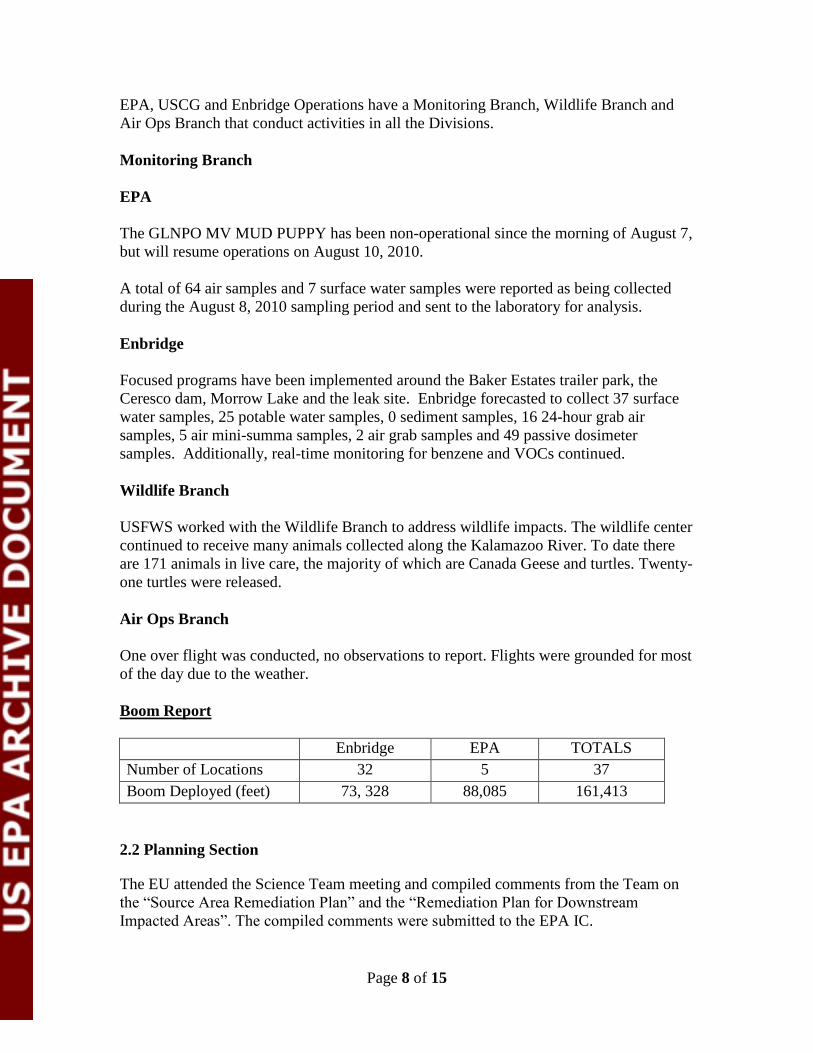
Boom Report
Enbridge EPA TOTALS
Number of Locations 32 5 37
Boom Deployed (feet) 73, 328 88,085 161,413
2.2 Planning Section
The EU attended the Science Team meeting and compiled comments from the Team on
the “Source Area Remediation Plan” and the “Remediation Plan for Downstream
Impacted Areas”. The compiled comments were submitted to the EPA IC.
Page 9 of 15
The SCAT Leader worked with Enbridge to generate draft guidance for vegetation
cutting and oiled debris removal from Division C. The guidance was shared with the
Science Team. Photos of the river showing examples of types of contamination were
provided by NOAA for use in preparation of Shoreline Treatment Recommendations
papers for Operations.
The SCAT Leader went on a boat tour of Division C with the Operations Planner,
Division C EPA OSC and EPA Oil Spill Response Expert to gain initial agreement on the
appropriate shoreline cleanup approach.
The DMU continued compiling data for SCAT operations and implementing QA/QC
procedures. The Data Management Team showcased the EPA Google Earth application
for public data dissemination at the Cooperating Agencies meeting.
GIS made cleanup grid maps for Operations working in Division C. GIS worked with
EPA DIC on presentation for public meeting in Battle Creek. GIS created maps that
identified SCAT data and sensitive areas that were provided by MDNRE as well as
provided maps to MDNRE to assist in their assessment of sensitive areas and oiled
wildlife.
The Resource Unit completed the IAP for the Operational Period from August 10-11,
2010.
2.2.1 Anticipated Activities for Next Reporting Period
In the next operational period, EPA anticipates performing the same activities as in the
previous operational period.
2.2.2 Issues
Three exposure units (4, 7, and 10) as designated in the Re-Occupancy Strategy were
identified within the evacuation zone that contain the majority of residences. Air
monitoring and sampling will focus on these areas following the Re-occupancy Decision
Tree approved by Unified Command on August 9, 2010. On August 8, 2010 air sample
results in exposure unit 7 exceeded the re-occupancy benzene criteria (6 ppb). Summa
24 hr samples were delayed by unfavorable weather conditions on August 9, 2010.
2.3 Logistics Section
Logistics presented the proposed Enbridge/EPA site layout plan for the new UCP
location at the old State Farm Site located at 820 Mann Road in Marshall, MI at the
Unified Command Objectives Meeting.
Logistics and Finance visited with Fort Custer and arranged for supplemental room
availability, the lodging is approximately 20 to 30 minutes from Marshall, MI. FACL
developed a private web site for responding personnel to obtain updates on hotel
availability.
Page 10 of 15
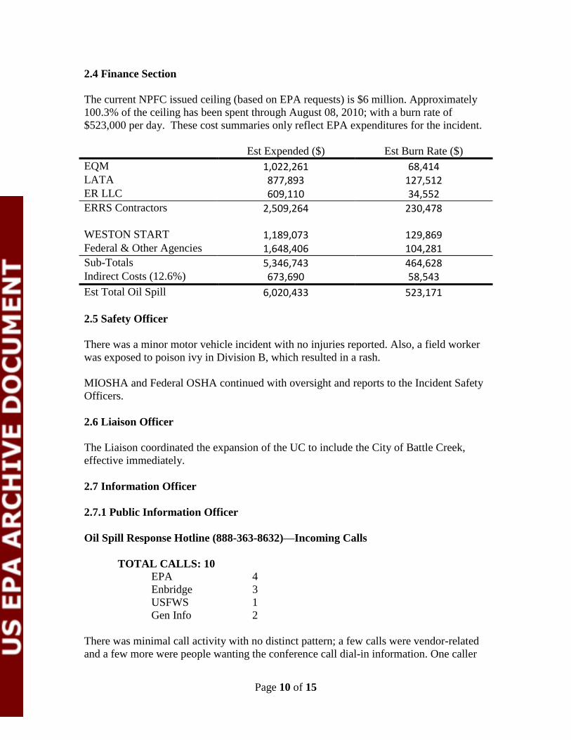
2.4 Finance Section
The current NPFC issued ceiling (based on EPA requests) is $6 million. Approximately
100.3% of the ceiling has been spent through August 08, 2010; with a burn rate of
$523,000 per day. These cost summaries only reflect EPA expenditures for the incident.
Est Expended ($) Est Burn Rate ($)
EQM 1,022,261 68,414
LATA 877,893 127,512
ER LLC 609,110 34,552
ERRS Contractors 2,509,264 230,478
WESTON START 1,189,073 129,869
Federal & Other Agencies 1,648,406 104,281
Sub-Totals 5,346,743 464,628
Indirect Costs (12.6%) 673,690 58,543
Est Total Oil Spill 6,020,433 523,171
2.5 Safety Officer
There was a minor motor vehicle incident with no injuries reported. Also, a field worker
was exposed to poison ivy in Division B, which resulted in a rash.
MIOSHA and Federal OSHA continued with oversight and reports to the Incident Safety
Officers.
2.6 Liaison Officer
The Liaison coordinated the expansion of the UC to include the City of Battle Creek,
effective immediately.
2.7 Information Officer
2.7.1 Public Information Officer
Oil Spill Response Hotline (888-363-8632)—Incoming Calls
TOTAL CALLS: 10
EPA 4
Enbridge 3
USFWS 1
Gen Info 2
There was minimal call activity with no distinct pattern; a few calls were vendor-related
and a few more were people wanting the conference call dial-in information. One caller

Page 11 of 15
requested information on a USFWS wildlife center tour, the remainder of calls were
“general media” related.
PIO Activities
An EPA DIC recorded a 7 min. segment for WJR Detroit Drive-Time radio this morning.
The JIC staff continued to answer the media hotline and monitor the media. Media
briefings will be suspended tomorrow due to a public meeting in Battle Creek. Beginning
Thursday, August 12, 2010 briefings will be held twice-weekly on Mondays and
Thursdays.
2.9 Response Actions to Date
Recovery of oil and contaminated soils continues in Division A and B. Containment
boom, sorbent boom, skimming equipment, vacuum trucks and other equipment have
been used to support oil collection and removal along Talmadge Creek and the
Kalamazoo River. Recovered material is being temporarily stored on-site. Tanker trucks
are transporting the material to a facility owned by the RP with available storage in
Griffith, Indiana.
EPA, ERT, START and RP contractors, with the support of the ERT Mobile Lab and MI
National Guard CST, have monitored and sampled air quality along the river and
throughout multiple residential areas. A heavy emphasis was placed on specific
monitoring for benzene as it is a recognized contaminant of concern for this response.
Water samples were collected for analysis from surface water, river and lake water
columns, and private drinking wells along the length of the impacted areas of the
Kalamazoo River. Water samples were also taken downstream of the Morrow Lake Dam.
Validated analytical sampling results are now being posted to the public incident website
(http://www.epa.gov/enbridgespill/data/datawater.html).
Enbridge removed the affected area of pipe, following the cut out/repair plan, and
completed a pipe investigation (50 feet upstream and downstream of the cut points) on
August 7, 2010.
The voluntary evacuation issued by CCPH in consultation with MDCH and ATSDR
remains in effect for several residences located immediately downstream of the spill site
along the Talmadge Creek, up to its confluence with the Kalamazoo River. This
voluntary evacuation was based on review of air monitoring results for benzene around
oil collection areas. A re-occupancy strategy for the evacuation zone has been drafted
and was presented to the Unified Command.
A Contingency Plan for Morrow Lake has been developed in case oil moves past the
lake.
Page 12 of 15
EU distributed copies of Enbridge plans to the Science Team for review. Plans included:
Sampling and Analysis Plan including figures, Remediation Plan for Downstream
Impacted Areas, Source Area Remediation Plan, and the Quality Assurance Project Plan.
3. Participating Entities
3.1 Unified Command
United States Environmental Protection
Agency
Michigan Department of Natural
Resources and Environment
Michigan State Police Emergency
Management Division
City of Battle Creek
Calhoun County Public Health
Department
Calhoun County Emergency
Management
Kalamazoo County Sheriff
Enbridge (Responsible Party)
3.2 Cooperating and Assisting Agencies
Cooperating Agencies
51st Civil Support Team Michigan
National Guard
Agency for Toxic Substances and
Disease Registry
Allegan County Emergency
Management
American Red Cross
Augusta Police Department
Calhoun Conservation District
Calhoun County
Calhoun County Treasurers Office
Calhoun Greenation District
City of Kalamazoo
City of Marshall
Federal Energy Regulatory Commission
Fredonia Township Fire Department
Kalamazoo County Office of Emergency
Management
Kalamazoo Public Safety
Kalamazoo Watershed Council
Marshall Township Government and
Fire Department
Marshall Police Department
Michigan Dept of Community Health
Michigan Dept of Agriculture
MIOSHA
NOAA
OSHA
Natural Resource Group
National Transportation Safety Board
Pipeline Hazardous Materials Safety
Administration
U.S. Coast Guard
US Department of the Interior US
Geological Survey
U.S. Department of Transportation
US Fish & Wildlife Service
Congressional Presence
State Representative Jase Bolger
State Representative Kate Segal
State Representative Ken Kurtz
State Representative Phil Browne
State Representative Phyllis Browne
State Representative Bob Geuctk
State Representative Tanya Schuitmaker
State Senator Mike Nofs

Page 13 of 15
U.S. Congressman Mark Schauer
U.S. Senator Carl Levin
U.S. Senator Stabenow
4. Personnel On Site
These numbers reflect all EPA numbers and On-River only for Enbridge.
Personnel
Numbers reported for
8/9/2010
Numbers reported for
8/8/2010
Enbridge 51 39
Enbridge Contractors 922 912
EPA 61 61
ERRS 108 112
MDNRE 27 *
CC Sheriff 13 12
Kalamazoo Sheriff 2 2
MI State Police 22 *
USCG 15 15
USFWS 11 12
START 60 54
Total 1292 1219 * = new reporting agency
5. Definition of Terms
ATSDR Agency for Toxic Substances and Disease Registry
CCPH Calhoun County Public Health
DIC Deputy Incident Commander
DMU Data Management Unit
DNRE Department of Natural Resources and Environment
EPA Environmental Protection Agency
ERT Emergency Response Team
EU Environmental Unit
FACL Facilities Unit Leader
GLNPO Great Lakes National Program Office
GPS Global Positioning System
HASP Health and Safety Plan
IAP Incident Action Plan
IC Incident Commander
IN Indiana
LEL Lower Explosive Limit
MDCH Michigan Department of Community Health
MDNRE Michigan Department of Natural Resources and Environment

Page 14 of 15
MI Michigan
MIOSHA Michigan Occupational Safety and Health Administration
NRC National Response Center
NOAA National Oceanic and Atmospheric Administration
NPFC National Pollution Fund Center
NTSB National Transportation Safety Board
OSHA Occupational Safety and Health Administration
OSC On-Scene Coordinator
PCB Polychlorinated Biphenyls
PHMSA Pipeline and Hazardous Materials Administration
PRP Potentially Responsible Party
QAPP Quality Assurance Project Plan
QA/QC Quality Assurance/ Quality Control
RP Responsible Party
SAP Sampling and Analysis Plan
SCAT Shoreline Contamination Assessment Team
START Superfund Technical Assessment and Response Team
UCP Unified Command Post
USCG United States Coast Guard
USDOT United States Department of Transportation
USFWS United States Fish and Wildlife Service
USGS United States Geological Survey
VOCs Volatile Organic Compounds
6.0 Source of Additional Information
6.1 Additional Information
For additional information please refer to http://www.epa.gov/enbridgespill.html. For
sampling analysis data, please see http://www.epa.gov/enbridgespill/data/datawater.html
6.2 Reporting Schedule
SITREPs have been created daily and will continue until the Unified Command
establishes a different reporting schedule.
7.0 Situational Reference Materials
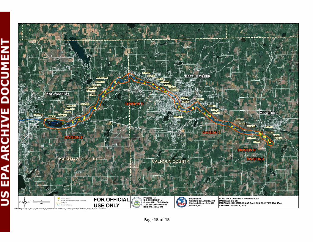
See attached “Boom Locations with Road Details” map for more information.
Page 15 of 15