US 130 NJ Turnpike Area Infrastructure Needs Analysis 130 - NJ Turnpike Area Infrastructure Needs...
76
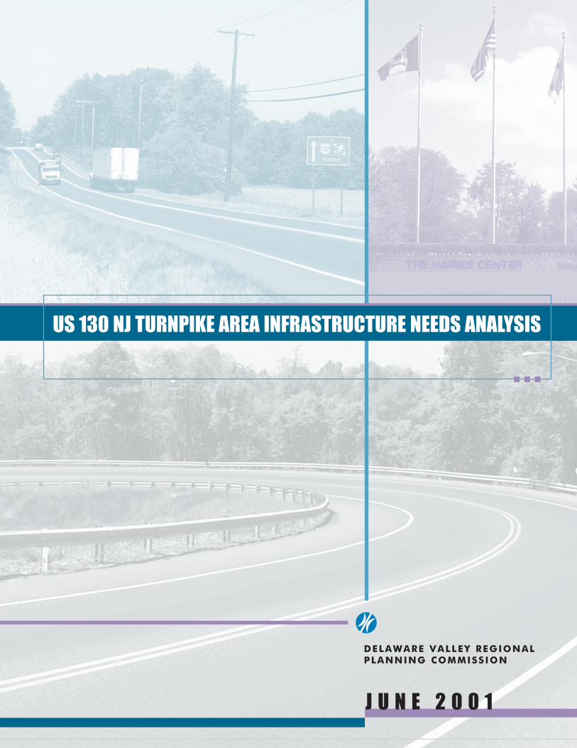
DELAWARE VALLEY REGIONAL PLANNING COMMISSION JUNE 2001 US 130 NJ TURNPIKE AREA INFRASTRUCTURE NEEDS ANALYSIS
Transcript of US 130 NJ Turnpike Area Infrastructure Needs Analysis 130 - NJ Turnpike Area Infrastructure Needs...
DELAWARE VALLEY REGIONAL PLANNING COMMISSION
J U N E 2 0 0 1
US 130 NJ TURNPIKE AREA INFRASTRUCTURE NEEDS ANALYSIS

������������� ����������� ������������������� ������
June, 2001
DELAWARE VALLEYREGIONAL PLANNING COMMISSION
Created in 1965, the Delaware Valley Regional Planning Commission (DVRPC) is aninterstate, intercounty and intercity agency that provides continuing, comprehensiveand coordinated planning to shape a vision for the future growth of the Delaware Valleyregion. The region includes Bucks, Chester, Delaware, and Montgomery counties, aswell as the City of Philadelphia, in Pennsylvania; and Burlington, Camden, Gloucesterand Mercer counties in New Jersey. DVRPC provides technical assistance andservices; conducts high priority studies that respond to the requests and demands ofmember state and local governments; fosters cooperation among various constituentsto forge a consensus on diverse regional issues; determines and meets the needs ofthe private sector; and practices public outreach efforts to promote two-waycommunication and public awareness of regional issues and the Commission.
Our logo is adapted from the official DVRPC seal, and is designed as a stylized imageof the Delaware Valley. The outer ring symbolizes the region as a whole, while thediagonal bar signifies the Delaware River. The two adjoining crescents represent theCommonwealth of Pennsylvania and the State of New Jersey.
DVRPC is funded by a variety of funding sources including federal grants from the U.S.Department of Transportation’s Federal Highway Administration (FHWA) and FederalTransit Administration (FTA), the Pennsylvania and New Jersey departments oftransportation, as well as by DVRPC’s state and local member governments. Theauthors, however, are solely responsible for its findings and conclusions, which may notrepresent the official views or policies of the funding agencies.
TABLE OF CONTENTS
I. EXECUTIVE SUMMARY . . . . . . . . . . . . . . . . . . . . . . . . . . . . . . . . . . . . . . . . . . . . . . 1
II. STUDY AREA DESCRIPTION . . . . . . . . . . . . . . . . . . . . . . . . . . . . . . . . . . . . . . . . . . 3
III. LAND USE . . . . . . . . . . . . . . . . . . . . . . . . . . . . . . . . . . . . . . . . . . . . . . . . . . . . . . . . . 3
IV. HIGHWAY NETWORK . . . . . . . . . . . . . . . . . . . . . . . . . . . . . . . . . . . . . . . . . . . . . . . . 3
V. TRAFFIC PATTERNS . . . . . . . . . . . . . . . . . . . . . . . . . . . . . . . . . . . . . . . . . . . . . . . 10
VI. RAIL SERVICE . . . . . . . . . . . . . . . . . . . . . . . . . . . . . . . . . . . . . . . . . . . . . . . . . . . . 15
VII. EXISTING TRIP GENERATORS . . . . . . . . . . . . . . . . . . . . . . . . . . . . . . . . . . . . . . 16
VIII. FUTURE TRIP GENERATORS . . . . . . . . . . . . . . . . . . . . . . . . . . . . . . . . . . . . . . . 17
IX. TRANSPORTATION PROBLEM LOCATIONS . . . . . . . . . . . . . . . . . . . . . . . . . . . . 19
1. Intersection of Neck Road and River Road . . . . . . . . . . . . . . . . . . . . . . . . . . . . 192. Intersection of Dulty’s Lane and Neck Road . . . . . . . . . . . . . . . . . . . . . . . . . . . 243. Jug handle on US 130 at Neck Road . . . . . . . . . . . . . . . . . . . . . . . . . . . . . . . . . 264. Intersection of Dulty’s Lane and US 130 . . . . . . . . . . . . . . . . . . . . . . . . . . . . . . 295. Exit-ramp from US 130 south to Cedar Lane (CR 659) . . . . . . . . . . . . . . . . . . . 326. US 130 at Florence-Columbus Road . . . . . . . . . . . . . . . . . . . . . . . . . . . . . . . . . 347. Intersection of Delaware Avenue and Station Road . . . . . . . . . . . . . . . . . . . 368. Florence-Columbus Road (CR 656) overpass at I-276 . . . . . . . . . . . . . . . . . . . 399. Areawide Improvement Options . . . . . . . . . . . . . . . . . . . . . . . . . . . . . . . . . . . . . 42
X. PLAN IMPLEMENTATION . . . . . . . . . . . . . . . . . . . . . . . . . . . . . . . . . . . . . . . . . . . . 45
LIST OF MAPS
1. Study Area with Existing and Proposed Development . . . . . . . . . . . . . . . . . . . . 5
2. Preliminary 2025 Land Use Plan . . . . . . . . . . . . . . . . . . . . . . . . . . . . . . . . . . . . . . 7
3. Percent Truck Volumes . . . . . . . . . . . . . . . . . . . . . . . . . . . . . . . . . . . . . . . . . . . . 11
4. 1999 and 2001 AADT per Location . . . . . . . . . . . . . . . . . . . . . . . . . . . . . . . . . . . 13
5. Recommended Improvements . . . . . . . . . . . . . . . . . . . . . . . . . . . . . . . . . . . . . . 21
TABLE OF CONTENTS (Continued)
FIGURES
1. Intersection of Neck Road (CR 658) and River Road (CR 656) . . . . . . . . . . 23
2. Intersection of Dulty’s Lane and Neck Road (CR 658) . . . . . . . . . . . . . . . . 25
3. Jug handle on US 130 at Neck Road . . . . . . . . . . . . . . . . . . . . . . . . . . . . . 28
4. Intersection of Dulty’s Lane and US 130 . . . . . . . . . . . . . . . . . . . . . . . . . . . 31
5. Exit-ramp from US 130 south to Cedar Lane (CR 659) . . . . . . . . . . . . . . . . 33
6. US 130 at Florence-Columbus Road . . . . . . . . . . . . . . . . . . . . . . . . . . . . . 35
7. Intersection of Delaware Avenue (656) and Station Road . . . . . . . . . . . . . . 38
8. Florence-Columbus Road (CR 656) overpass at I-276 . . . . . . . . . . . . . . . . 41
9. Areawide Improvement Options . . . . . . . . . . . . . . . . . . . . . . . . . . . . . . . . . 44
TABLES
1. Haines Industrial Center Proposed Development . . . . . . . . . . . . . . . . . . . . 18
2. US 130 - NJ Turnpike Area Transportation Improvements ImplementationMatrix . . . . . . . . . . . . . . . . . . . . . . . . . . . . . . . . . . . . . . . . . . . . . . . . . . . . . 48
APPENDIX
A. 2001 Vehicle Classification Counts . . . . . . . . . . . . . . . . . . . . . . . . . . . . . . . 51
US 130 - NJ Turnpike Area Infrastructure Needs Analysis Page 1
EXECUTIVE SUMMARYIn March 2000, the New Jersey Turnpike Authority completed a new interchange (6A)between US 130 and the New Jersey Turnpike Pennsylvania Extension in FlorenceTownship, Burlington County. This is a full service interchange which replaces the old Exit6A. An intent of this improvement was to remove heavy truck traffic from residential areasand to promote a more efficient system of interstate and intrastate goods movement.Improvement in local traffic circulation is also being accomplished by providing local trafficwith a more direct access to the Turnpike.
Prior to the completion of the new interchange, Exit 6A had only two traffic moves.Eastbound traffic from Pennsylvania could exit the Pennsylvania Extension on to US 130.Westbound local traffic could enter the Pennsylvania Extension to Pennsylvania via theDelaware River Turnpike Bridge. Westbound traffic on the Pennsylvania Extension werenot able to exit to US 130, and local traffic from communities such as western FlorenceTownship and Roebling Township, were not able to enter the Pennsylvania Extensioneastbound. All these moves are now possible with direct access to and from US 130.
In anticipation of the new interchange, several commercial and light industrialdevelopments were completed or are underway. Due to the large tracts of undevelopedland, there is great potential for additional development. These opportunities existprimarily at the 660 acre Haines Industrial Park currently being developed immediatelyadjacent to the interchange and on several hundred additional acres in the immediatevicinity. There are more opportunities for fast food, mini-mart and other commercialdevelopment along US 130 in addition to the existing strip commercial development.
The lack of a coordinated plan for the growth of this area has raised concerns among localand county representatives. The fact that the growth in this area is primarily being felt inmore than one municipality - Burlington Township and Florence Township - makes it moreimportant to coordinate this growth. Some of the primary concerns in this area include:inadequate linkages between the light industrial areas, the NJ Turnpike, I-295, US 130 andlocal roads; potential circulation problems between different sites; lack of a coordinatedinfrastructure - other than transportation; lack of coordination between affectedmunicipalities; and the interface between passenger cars on US 130, access to theSouthern New Jersey Light Rail Transit System (SNJLRTS) station at Haines IndustrialPark and the heavy truck traffic expected in the area.
The Delaware Valley Regional Planning Commission (DVRPC) was requested to assistin this effort by conducting a local impact analysis to determine the impact of the newinterchange on the surrounding area. The intent of this study is to develop a coordinatedplan to assess the infrastructure needs created by the growth in this area, while keepingin mind the existing light industrial facilities and residents. This growth must be harnessedand channeled in such a way so as to produce the greatest amount of positive economic
Page 2 US 130 - NJ Turnpike Area Infrastructure Needs Analysis
development without the negative side effects of congestion and environmentaldegradation. The following tasks were identified as integral to the completion of this study:
• Assess the potential for development on parcels not actively being discussed for development.
• Identify potential connections for internal circulation systems.• Recommend improvement concepts for linkages between developed areas and US
130, Interchange 6A, I-295 and local roads.• Evaluate access between the SNJLRTS station and US 130/new developments.
In an effort to fulfill these objectives, the study team held separate meetings with bothFlorence and Burlington townships to determine their concerns and plans for the future ofthis area. Municipal input, along with Burlington County’s vision, helped to identify acoordinated action plan for the study area.
This report documents the study recommendations for coordinating the transportation andcirculation infrastructure improvements in the study area. Recommendations are listed aseither short term or long term. Short term recommendations include those improvementsthat are not capital intensive such as better signage to improve traffic flow and safety, andintersection modifications to improve turn radius. Long term improvements recommendedinclude the construction of access roads to relieve congestion along specific highwaysegments, as well as the creation of ramps to improve circulation. An implementation planhas also been developed identifying the roles and responsibilities of various public andprivate entities.
US 130 - NJ Turnpike Area Infrastructure Needs Analysis Page 3
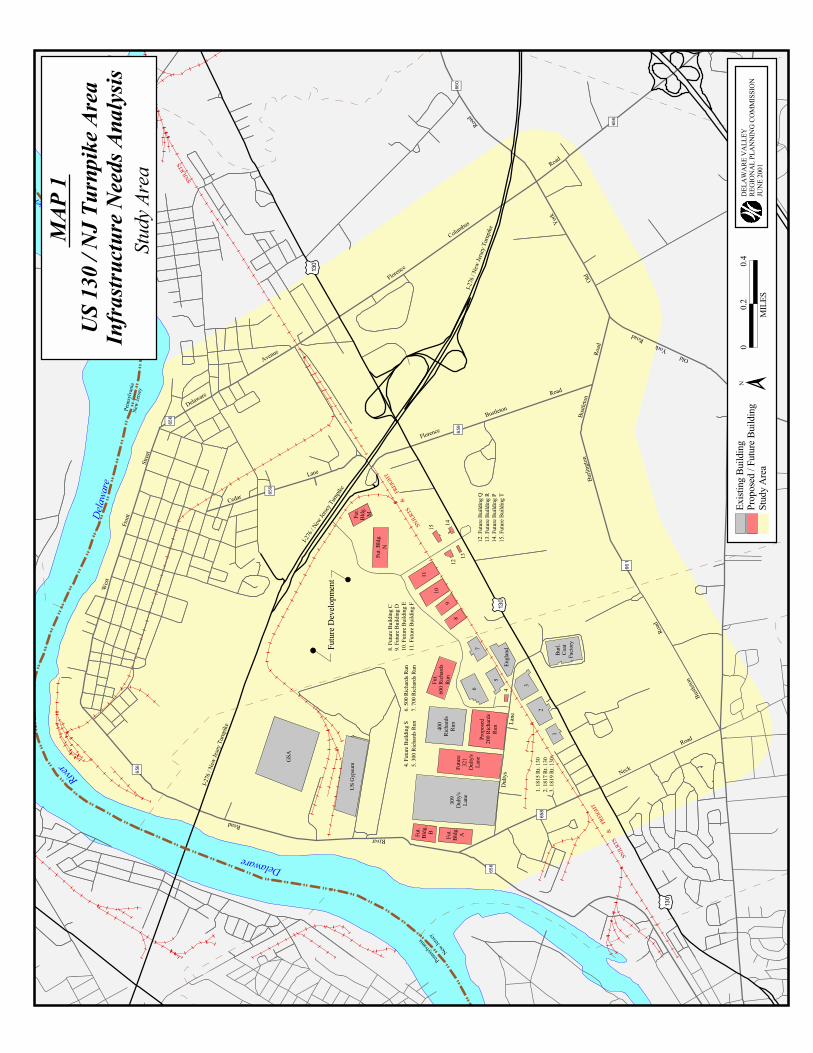
STUDY AREAThe study area is comprised of the area extending from CR 656 (DelawareAvenue/Florence-Columbus Road) in the north, Old York Road and Bustleton Road in theeast, Neck Road in the south, and River Road/West Front Street in the west. Thiscomprises an area of approximately 3,803 acres or 5.94 square miles. (See Map 1)
LAND USEThe study area encompasses a variety of land uses ranging from single family residentialto industrial and warehouse. The area to the east of US 130 is primarily agricultural, withlarge tracts of newly constructed single family homes and town houses. There are retailcommercial and manufacturing activities along the US 130 strip. The area to the south ofI-276 (New Jersey Turnpike Extension) and west of US 130 is primarily manufacturing andwarehouse. North of I-276 and west of US 130 is primarily single family residentialcomprising of a older housing stock in established communities, with manufacturing usesalong West Front Street.
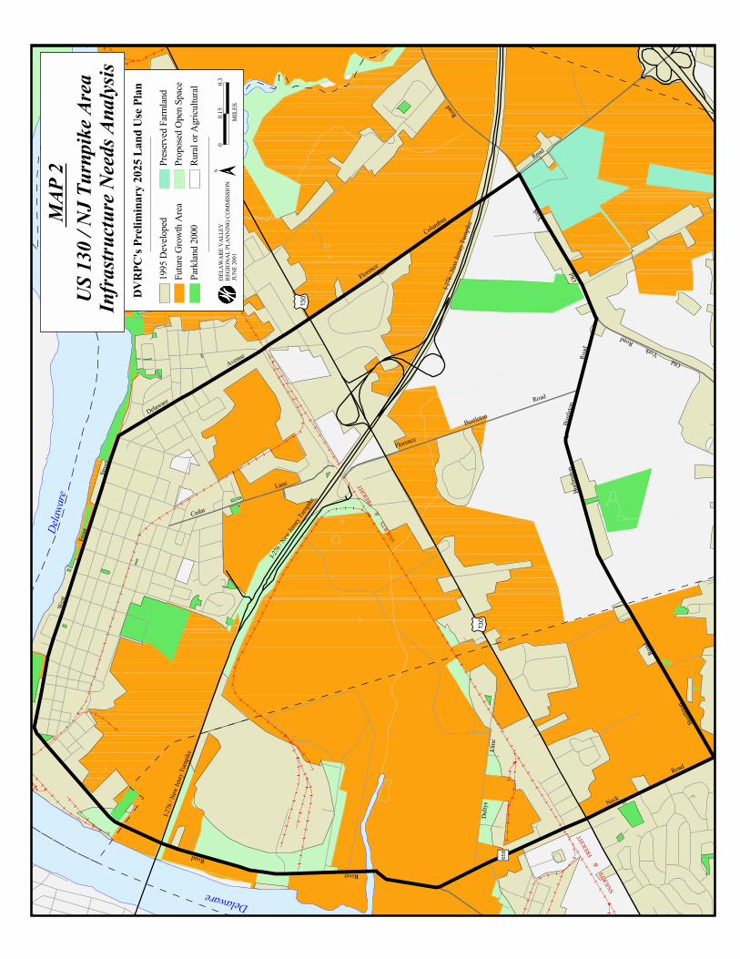
DVRPC’s preliminary 2025 land use plan for the region shows 46.7% or 1,775 acres of thestudy area earmarked as future growth area (See Map 2). With approximately 639 acresalready targeted for development by Whitesell Construction Company at the site of theHaines Industrial Center, 1,136 additional acres will be available for future growth. Anyincrease in land use activity will result in an increase in vehicular activity which will impactthe existing road network.
HIGHWAY NETWORKThe study area is traversed by a hierarchy of highways ranging from interstate highwaysto local roads. For the purpose of this study, traffic patterns will primarily be analyzed oncounty, state, and interstate highways. The impact on local roads will also be examinedin cases where there is, or is expected to be, a negative impact on existing traffic patternsand volumes due to current and future development.
The New Jersey Turnpike Pennsylvania Extension is the major interstate highway in thestudy area. It has a full interchange with US 130, permitting access to Pennsylvania andnorthern and southern New Jersey.
Interstate 295 is a north-south highway located to the east of the area. It extends from US1 in Mercer County in the north to Salem County in the south. Direct access is providedto the study area via Florence - Columbus Road.

SNJLR
TS
&
FREIG
HT
SNJLR
TSDelaware
River
Delaw
are
RiverI-2
76 / N
ew Je
sey Tu
rnpike
I-276
/ New
Jerse
y Turn
pike
I-276
/ New
Jerse
y Turn
pike
Burlin
gton
Bustl
eton
Road
Bustle
ton
Road
Old York
Road
Old
York
Road
West
Front
Street
Delaware
Avenue
Florence
C
olumbus
Road
Cedar
Lane
Florence
Bustleton
Road
River
Road
Dulty
sLa
ne
Neck
Road
8. Fu
ture B
uildin
g C9.
Futur
e Buil
ding D
10. F
uture
Build
ing E
11. F
uture
Build
ing F
Fut.
Bldg
.M
Fut. B
ldg.
N
GSA
US G
ypsu
m
Fut.
Bldg
.B Fut.
Bldg
.A
309
Dulty
'sLa
ne
400
Rich
ards
Run
Fut.
600 R
ichard
sRu
n
Engla
nd Burl.
Coat
Facto
ry
Penn
sylva
niaNe
w Jer
sey
Pennsy
lvania
New Jer
sey
%g656
%g660
%g661
%g659
%g659
%g656
%g656
%g656
( /130
( /130
( /130
%g658
Futur
e32
1Du
lty's
Lane
Prop
osed
200 R
ichard
sRu
n
3. 18
19 R
t. 130
2. 18
17 R
t. 130
1. 18
15 R
t. 130
1
2
3
5
67
89
10
11
4
1213
14
12. F
uture
Build
ing Q
13. F
uture
Build
ing R
14. F
uture
Build
ing P
15. F
uture
Build
ing T
4. Fu
ture B
uildin
g S5.
300 R
ichard
s Run
6. 50
0 Rich
ards R
un7.
700 R
ichard
s Run
Futur
e Dev
elopm
ent
15SNJLR
TS
& FR
EIGHT
Study
Area
US 13
0 / N
J Tur
npike
Area
Infra
struc
ture N
eeds
Ana
lysis
MAP
1
m w
Study
Area
Exist
ing B
uildin
gPr
opos
ed / F
uture
Build
ing0
0.20.4
MIL
ES
DELA
WAR
E VA
LLEY
REGI
ONAL
PLAN
NING
COM
MIS
SION
JUNE
2001
N

% g658 % g658
Road
Neck
Lane
Dulty
s
Road
River
Road
Bustleton
Florence
Lane
Cedar
Road
Florence
C
olumbus
Avenue
Delaware
Street
Front
West
Road
York
Old
Old York
Road
Road
Bustle
ton
Road
Bustl
eton
Burlin
gton
( /1 30
( /1 30
I-276
/ New
Jerse
y Turn
pike
I-276
/ New
Jerse
y Turn
pike
I-276
/ New
Jesey
Turnp
ike
Delaw
are
Rive
Delaware
SNJLR
TS
SNJLR
TS
& FR
EIGHT
SNJLR
TS
&
FREIG
HT
00.1
50.3
MIL
ES
DELA
WAR
E VA
LLEY
REGI
ONAL
PLAN
NING
COM
MIS
SION
JUNE
2001
Prop
osed
Ope
n Spa
cePr
eserve
d Farm
land
Parkl
and 2
000
Futur
e Grow
th Ar
ea19
95 D
evelo
ped
Rural
or A
gricu
ltural
DVRP
C's P
relim
inary
2025
Lan
d Use
Plan
US 13
0 / N
J Tur
npike
Area
Infra
struc
ture N
eeds
Ana
lysis
MAP
2 N
Page 8 US 130 - NJ Turnpike Area Infrastructure Needs Analysis
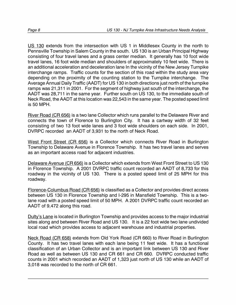
US 130 extends from the intersection with US 1 in Middlesex County in the north toPennsville Township in Salem County in the south. US 130 is an Urban Principal Highwayconsisting of four travel lanes and a grass center median. It generally has 10 foot widetravel lanes, 16 foot wide median and shoulders of approximately 10 feet wide. There isan additional acceleration and deceleration lane In the vicinity of the New Jersey Turnpikeinterchange ramps. Traffic counts for the section of this road within the study area varydepending on the proximity of the counting station to the Turnpike interchange. TheAverage Annual Daily Traffic (AADT) for US 130 in both directions just north of the turnpikeramps was 21,311 in 2001. For the segment of highway just south of the interchange, theAADT was 28,711 in the same year. Further south on US 130, to the immediate south ofNeck Road, the AADT at this location was 22,543 in the same year. The posted speed limitis 50 MPH.
River Road (CR 656) is a two lane Collector which runs parallel to the Delaware River andconnects the town of Florence to Burlington City. It has a cartway width of 32 feetconsisting of two 13 foot wide lanes and 3 foot wide shoulders on each side. In 2001,DVRPC recorded an AADT of 3,931 to the north of Neck Road.
West Front Street (CR 656) is a Collector which connects River Road in BurlingtonTownship to Delaware Avenue in Florence Township. It has two travel lanes and servesas an important access road for adjacent industries.
Delaware Avenue (CR 656) is a Collector which extends from West Front Street to US 130in Florence Township. A 2001 DVRPC traffic count recorded an AADT of 8,733 for thisroadway in the vicinity of US 130. There is a posted speed limit of 25 MPH for thisroadway.
Florence-Columbus Road (CR 656) is classified as a Collector and provides direct accessbetween US 130 in Florence Township and I-295 in Mansfield Township. This is a two-lane road with a posted speed limit of 50 MPH. A 2001 DVRPC traffic count recorded anAADT of 9,472 along this road.
Dulty’s Lane is located in Burlington Township and provides access to the major industrialsites along and between River Road and US 130. It is a 22 foot wide two lane undividedlocal road which provides access to adjacent warehouse and industrial properties.
Neck Road (CR 658) extends from Old York Road (CR 660) to River Road in BurlingtonCounty. It has two travel lanes with each lane being 11 feet wide. It has a functionalclassification of an Urban Collector and is an important link between US 130 and RiverRoad as well as between US 130 and CR 661 and CR 660. DVRPC conducted trafficcounts in 2001 which recorded an AADT of 1,323 just north of US 130 while an AADT of3,018 was recorded to the north of CR 661.
US 130 - NJ Turnpike Area Infrastructure Needs Analysis Page 9
Cedar Lane is a two lane local road that provides direct access to US 130 from residentialand industrial areas of Florence Township. A 2001 traffic count conducted by DVRPCrecorded an AADT of 4,155 for this road.
Florence-Bustleton Road (CR 659) is a two lane local road which extends from US 130 toCR 661. A 2001 DVRPC traffic count on this road recorded an AADT of 1,990. This is adecrease from a 1999 count which recorded an AADT of 4,196 vehicles. It should benoted that prior to the completion of the new Interchange 6A, this road provided directaccess for eastbound Turnpike traffic destined for I-295.
Old York Road (CR 660) is a two lane local road extending from Jacksonville Road inBurlington Township to US 206 in Bordentown. A 2001 DVRPC traffic count on Old YorkRoad in the vicinity of CR 656 recorded an AADT of 2,730.
Burlington-Bustleton Road (CR 661) is a two lane road connecting Neck Road with OldYork Road. A 2001 DVRPC traffic count on CR 661 in the vicinity of CR 659 recorded anAADT of 1,917 vehicles.
Page 10 US 130 - NJ Turnpike Area Infrastructure Needs Analysis
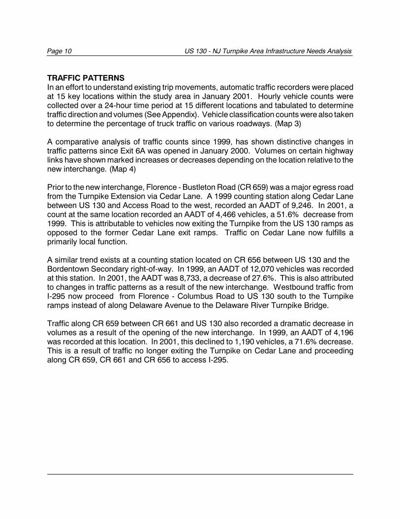
TRAFFIC PATTERNSIn an effort to understand existing trip movements, automatic traffic recorders were placedat 15 key locations within the study area in January 2001. Hourly vehicle counts werecollected over a 24-hour time period at 15 different locations and tabulated to determinetraffic direction and volumes (See Appendix). Vehicle classification counts were also takento determine the percentage of truck traffic on various roadways. (Map 3)
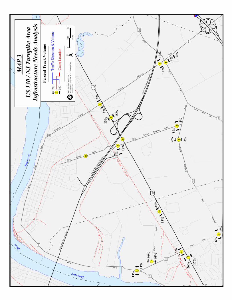
A comparative analysis of traffic counts since 1999, has shown distinctive changes intraffic patterns since Exit 6A was opened in January 2000. Volumes on certain highwaylinks have shown marked increases or decreases depending on the location relative to thenew interchange. (Map 4)
Prior to the new interchange, Florence - Bustleton Road (CR 659) was a major egress roadfrom the Turnpike Extension via Cedar Lane. A 1999 counting station along Cedar Lanebetween US 130 and Access Road to the west, recorded an AADT of 9,246. In 2001, acount at the same location recorded an AADT of 4,466 vehicles, a 51.6% decrease from1999. This is attributable to vehicles now exiting the Turnpike from the US 130 ramps asopposed to the former Cedar Lane exit ramps. Traffic on Cedar Lane now fulfills aprimarily local function.
A similar trend exists at a counting station located on CR 656 between US 130 and the Bordentown Secondary right-of-way. In 1999, an AADT of 12,070 vehicles was recordedat this station. In 2001, the AADT was 8,733, a decrease of 27.6%. This is also attributedto changes in traffic patterns as a result of the new interchange. Westbound traffic fromI-295 now proceed from Florence - Columbus Road to US 130 south to the Turnpikeramps instead of along Delaware Avenue to the Delaware River Turnpike Bridge.
Traffic along CR 659 between CR 661 and US 130 also recorded a dramatic decrease involumes as a result of the opening of the new interchange. In 1999, an AADT of 4,196was recorded at this location. In 2001, this declined to 1,190 vehicles, a 71.6% decrease.This is a result of traffic no longer exiting the Turnpike on Cedar Lane and proceedingalong CR 659, CR 661 and CR 656 to access I-295.
m w. - ,295
( /130
Road
Neck
Lane
Dulty
s
Road
River
Road
Bustleton
Florence
Lane
Cedar
Road
Florence
C
olumbus
Avenue
Delaware
Street
Front
West
Road
York
Old
Old York
Road
Road
Bustle
ton
Road
Bustl
eton
Burlin
gton
( /130
( /130
( /130
. - ,295
I-276
/ New
Jerse
y Turn
pike
I-276
/ New
Jerse
y Turn
pike
I-276
/ New
Jesey
Turnp
ike
River
Delaw
are
River
Delaware
SNJLR
TS
45
23
1
12
11
10
13
14
7
98
6
15
6%
7%13
%
15%
4%10%
10%
2%
8%
2%
16%
12%
5%
26% 17
%
5%1%
11%
13%
35%
34%
39%
40%
2%
6%
4%
% g658
% g656
% g656
% g656
% g659
% g659
%g661
% g660
% g660
% g656
SNJLR
TS
& FR
EIGHT
SNJLR
TS
& FR
EIGHT
Perc
ent T
ruck
Volu
me
DELA
WAR
E VA
LLEY
REGI
ONAL
PLAN
NING
COM
MIS
SION
JUNE
2001
00.1
50.3
MIL
ES
0
0% 0%Co
unt L
ocati
onTr
affic
Direc
tion &
Volu
me
US 13
0 / N
J Tur
npike
Area
Infra
struc
ture N
eeds
Ana
lysis
MAP
3 N

#
#
#
#
#
#
##
#
#
#
##
#
#
#
#
#
#
#
#
#%g658
( /130%g658 %g658 %g658
Road
Neck
Lane
Dulty
s
Road
River
Road
Bustleton
Florence
Lane
Cedar
Road
Florence
C
olumbus
Avenue
Delaware
Street
Front
West
Road
York
Old
Old York
RoadRo
ad
Bustle
ton
Road
Bustl
eton
Burlin
gton
( /130
( /130
( /130
I-276
/ New
Jerse
y Turn
pike
I-276
/ New
Jerse
y Turn
pike
I-276
/ New
Jesey
Turnp
ike
Rive
Delaw
are
River
Delaware
SNJLR
TS
1917
3018
2254
2
1324
894
1900
3931
4155
2131
1
8733
9472
2730
1990
2871
1
4196
1207
0
8395
2127
1
9246
2057
9
9740
4466
SNJLR
TS
& FR
EIGHT
SNJLR
TS
&
FREIG
HT
Traff
ic Co
unts
#19
99 A
ADT
#20
01 A
ADT
00.1
50.3
MIL
ES
DELA
WAR
E VA
LLEY
REGI
ONAL
PLAN
NING
COM
MIS
SION
JUNE
2001
US 13
0 / N
J Tur
npike
Area
Infra
struc
ture N
eeds
Ana
lysis
MAP
4
m w
N

US 130 - NJ Turnpike Area Infrastructure Needs Analysis Page 15
RAIL SERVICEThe Southern New Jersey Light Rail Transit System (SNJLRTS) is scheduled to providepassenger service between Camden and Trenton, along the Bordentown Secondary in theyear 2002. The Bordentown Secondary is a single track Class 1 freight railroad operatedby CONRAIL.
A Camden station will be located adjacent to the Walter Rand Transportation Center andwill provide both park-and-ride and transfer facilities. A Trenton station will serve as adestination for passengers working in Trenton or connecting with Northeast Corridor trainsand as an origin park and ride station. The 34 mile light rail line will provide rail serviceevery 15 minutes during the peak and 30 minutes off-peak.
A passenger station to serve the light rail transit will be constructed at a site adjacent tothe railroad south of Cedar Lane. The passenger station and Haines Industrial Center willbe accessible via a new access road.
While passenger service will reduce the overall Vehicle Miles Traveled (VMT) in the region,there will be an increase in vehicular activity in the immediately vicinity. To accommodatethe expected increase in traffic, vehicular access will have to be improved.
Site Access RoadA new access road to the site will be constructed at US 130, 3,200 feet south of CedarLane and to the north of Dulty’s Lane. The intersection of US 130 and this new accessroad will be signalized. Major improvements proposed for the area in and around the sitewill include grade crossing signals and gates. In an effort to reduce congestion and delayat the grade crossing, it is proposed that the light rail stop should be located away from thegrade crossing. This will permit through traffic on the access road when the train is in thestation.
The station will also be accessible via Richards Run in the south. Two park and ride lots,with a total capacity for 625 cars, will be constructed on the north and southbound side ofthe tracks. It is expected that by the year 2020, daily boardings at this station will be 920.
Currently, the number of freight trains using this track averages 5 or less trains per day,while the maximum speed allowed on this track is generally between 11 - 25 MPH. Thistrack will be upgraded to accommodate higher speed passenger service. Once passengerservice is initiated, freight service will be confined to the hours of 10:00 pm to 6:00 am,while passenger service will operate between the hours of 6:00 am and 10:00 pm,connecting the cities of Camden and Trenton.
Page 16 US 130 - NJ Turnpike Area Infrastructure Needs Analysis
EXISTING TRIP GENERATORSThe greatest concentration of trip generators within the study area is at, or within closeproximity to the Haines Industrial Center. The following is a brief description of the largerfacilities:
Burlington Coat FactoryBurlington Coat Factory is located on two sites within the study area. The first site whichis located at 1819 US 130, is only accessible from Dulty’s Lane. The second site, locatedat 1830 US 130, has its entrance directly across from Dulty’s Lane. It is expected that inthe near future, there will be expansion at this site to accommodate a 7,000 square footday care center.
C.R. England and Sons Inc.This is a major shipping company located at 403 Dulty’s Lane. It is anticipated that therewill be a building expansion at this site which will lead to increased truck activity in the nearfuture.
1815-1817 US 130These are two warehouse buildings with frontage on US 130 that is within the Whitesellcomplex.
100 and 300 Richards Run These are warehouses that are currently in operation. Richards Run is connected to US130 via Dulty’s Lane.
400 Richards RunThis a office/warehouse facility with an existing building area of 507,900 square feet, ofwhich 502,900 square feet is warehouse and 5,000 square feet is office use. Based on aTraffic Impact Study conducted for Whitesell Construction Company, this site is projectedto generate 89 AM peak hour trips (59 inbound and 30 outbound), and 82 PM peak hourtrips (26 inbound and 56 outbound).
309 Dulty’s LaneThis is the site of BJ’s, a major regional wholesale distributor. Based on the WhitesellTraffic Impact Study, this 633,836 square foot site is projected to generate 98 AM peakhour trips (48 in bound and 46 outbound), and 97 PM peak hour trips (34 inbound and 63outbound).
US 130 - NJ Turnpike Area Infrastructure Needs Analysis Page 17
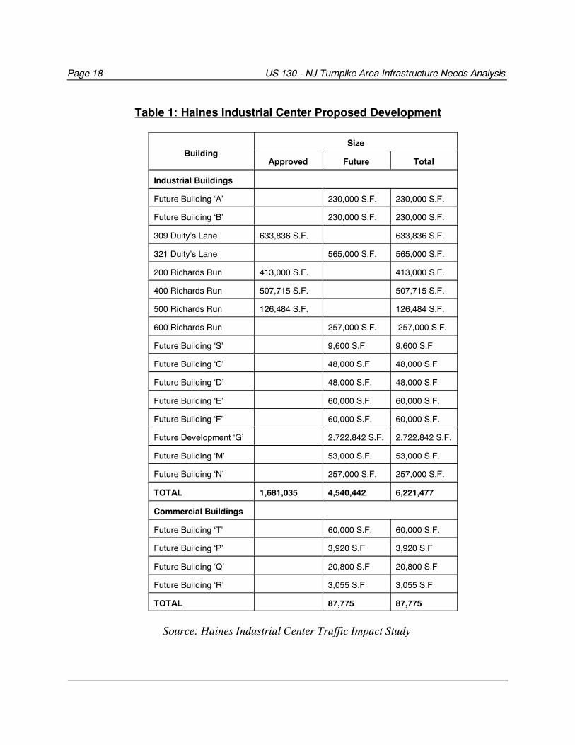
FUTURE TRIP GENERATORSThe Haines Industrial Center straddles both Burlington and Florence Townships. Whenfully built out, it is projected to have a total of 6,221,477 square feet of industrial buildingsand 87,775 square feet of commercial buildings (See Table 1). To date, four buildingstotaling 1,681,035 square feet have been approved for industrial use. A 100 room hoteland 27,775 square feet of retail space is proposed for the site, adjacent to a new accessroad to be located between Cedar Road and Dulty’s Lane.
Based on the November 2000 traffic impact study of the Haines Industrial Centerconducted for Whitesell, a total of 1,193 AM peak hour and 1,311 PM peak hour additionaltrips are expected to be generated when the site is fully built-out. This will necessitateimprovements to the road network to improve traffic circulation and accommodate theexpected growth in volume.
As Table 1 also illustrates, there are several buildings planned for the area that are yet tobe constructed. The projected trip generation for specific buildings was determined basedon the Whitesell Traffic Impact Study.
321 Dulty’s LaneOn this site, a 565,000 square foot industrial building will be constructed. Based on theWhitesell Traffic Impact Study, this site is projected to generate 99 AM peak hour trips (66inbound and 34 outbound), and 91 PM peak hour trips (29 inbound and 62 outbound).
200 Richards RunThis site is projected to house a 413,000 square foot industrial building. Based on theWhitesell Traffic Impact Study, it is projected to generate 73 AM peak hour trips (48inbound and 25 outbound), and 66 PM peak hour trips (21 inbound and 45 outbound).
500 Richards RunThis site is projected to house a 126,484 square foot building. Based on the WhitesellTraffic Impact Study, the site is projected to generate 22 AM peak hour trips (15 inboundand 8 outbound), and 20 PM peak hour trips (6 inbound and 14 outbound).
600 Richards RunThis site is projected to house a 257,000 square foot building. Based on the WhitesellTraffic Impact Study, the site is projected to generate 45 AM peak hour trips (30 inboundand 15 outbound), and 41 PM peak hour trips (13 inbound and 28 outbound).
Page 18 US 130 - NJ Turnpike Area Infrastructure Needs Analysis
Table 1: Haines Industrial Center Proposed Development
BuildingSize
Approved Future Total
Industrial Buildings
Future Building ‘A’ 230,000 S.F. 230,000 S.F.
Future Building ‘B’ 230,000 S.F. 230,000 S.F.
309 Dulty’s Lane 633,836 S.F. 633,836 S.F.
321 Dulty’s Lane 565,000 S.F. 565,000 S.F.
200 Richards Run 413,000 S.F. 413,000 S.F.
400 Richards Run 507,715 S.F. 507,715 S.F.
500 Richards Run 126,484 S.F. 126,484 S.F.
600 Richards Run 257,000 S.F. 257,000 S.F.
Future Building ‘S’ 9,600 S.F 9,600 S.F
Future Building ‘C’ 48,000 S.F 48,000 S.F
Future Building ‘D’ 48,000 S.F. 48,000 S.F
Future Building ‘E’ 60,000 S.F. 60,000 S.F.
Future Building ‘F’ 60,000 S.F. 60,000 S.F.
Future Development ‘G’ 2,722,842 S.F. 2,722,842 S.F.
Future Building ‘M’ 53,000 S.F. 53,000 S.F.
Future Building ‘N’ 257,000 S.F. 257,000 S.F.
TOTAL 1,681,035 4,540,442 6,221,477
Commercial Buildings
Future Building ‘T’ 60,000 S.F. 60,000 S.F.
Future Building ‘P’ 3,920 S.F 3,920 S.F
Future Building ‘Q’ 20,800 S.F 20,800 S.F
Future Building ‘R’ 3,055 S.F 3,055 S.F
TOTAL 87,775 87,775
Source: Haines Industrial Center Traffic Impact Study
US 130 - NJ Turnpike Area Infrastructure Needs Analysis Page 19
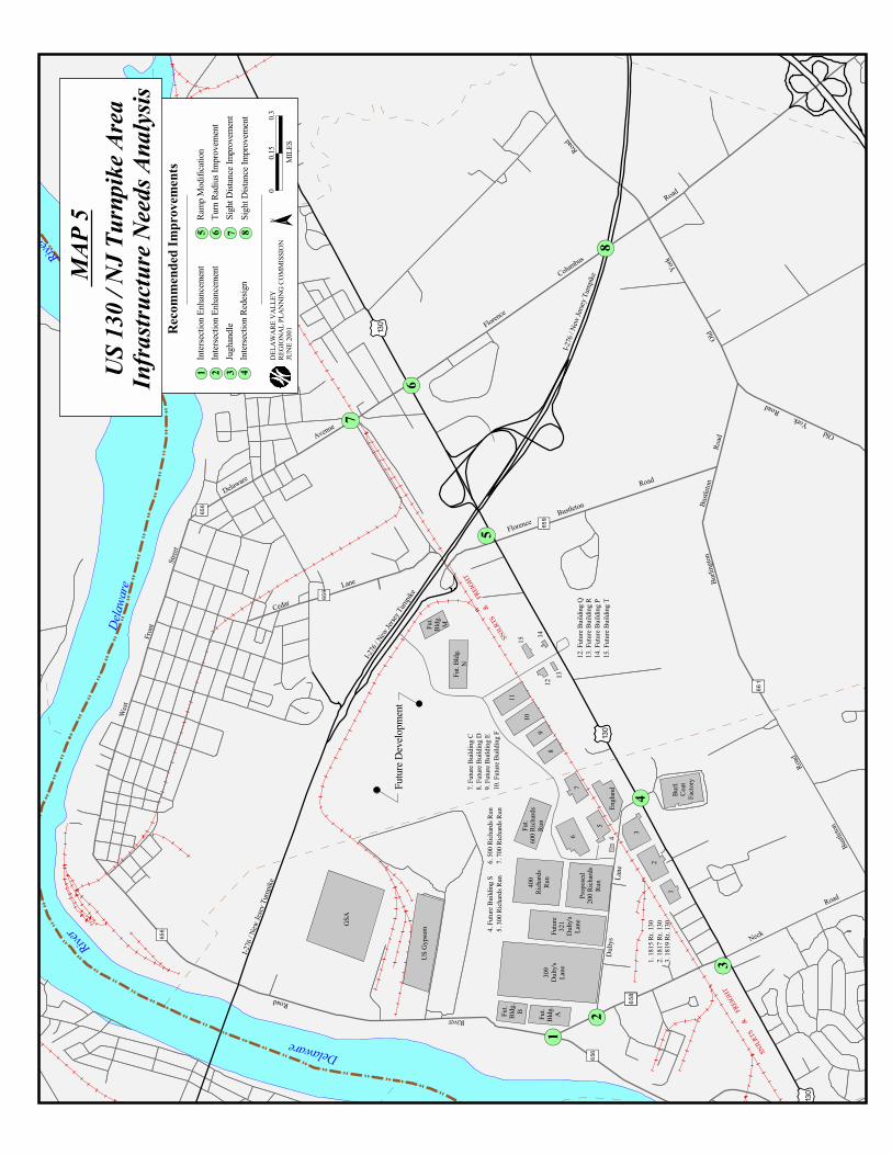
TRANSPORTATION PROBLEM LOCATIONS
Several key locations were studied to determine their suitability to accommodate theexpected increase in volumes due to the new interchange as well as to identify short andlong term solutions to improve safety and reduce congestion. (Map 5)
1. Intersection of Neck Road (CR 658 ) and River Road (CR 656)
Existing Conditions:
River Road is a two lane Collector facility that runs generally north-south parallel to theDelaware River between Burlington Township and Florence Township. The intersectionis controlled by a stop sign on River Road northbound. Each lane measures 13 feet inwidth and has a 3 foot shoulder. There is a posted speed limit of 40 MPH on River Roadnorth of the intersection with Neck Road and 50 MPH south of Neck Road. River Road isan important link because it connects to I-295 at interchange 52 and also intersects US130, serving as a truck route for the industries located along River Road and Dulty’s Lanein Burlington Township. A DVRPC 2001 traffic count on River Road just north of theintersection with Neck Road revealed an AADT of 3,931 vehicles. Of that number, 13percent of the traffic was trucks headed southbound, while 11 percent of the northboundtraffic was trucks.
Neck Road intersects River Road at an acute angle. This facility is an Urban Collectorwith a posted speed limit of 40 MPH. It has an average lane width of 11 feet and a 1 footshoulder on the eastbound lane and a 3 foot shoulder on the westbound lane for a totalcartway of 26 feet. This segment of Neck Road serves as a connector between River Roadand Dulty’s Lane carrying predominantly commercial traffic. The intersection of Neck Roadand Dulty’s Lane is of particular importance because Dulty’s Lane is the main access roadto the Whitesell Industrial Properties.
Identified Problems:
� Traffic on northbound River Road experiences compromised sight distance ofoncoming westbound Neck Road traffic due to the acute angle of the intersection. Afield observation revealed traffic proceeding approximately 40 feet beyond the stopsign into the intersection in order to see oncoming westbound Neck Road traffic. Thisaction places these vehicles in the path of southbound River Road traffic attemptingto turn left onto Neck Road.

m w
1
2
3
4
5
6
7
8
SNJLR
TS
Delaware
River
Delaw
are
River
I-276
/ New
Jesey
Turnp
ike
I-276
/ New
Jerse
y Turn
pike
I-276
/ New
Jerse
y Turn
pike
( /130
( /130
( /130
Burlin
gton
Bustl
eton
Road
Bustle
ton
Road
Old York
Road
Old
York
Road
West
Front
Street
Delaware
Avenue
Florence
C
olumbus
Road
Cedar
Lane
FlorenceBustleton
Road
River
Road
Dulty
sLa
ne
Neck
Road
% g658 % g658 % g658( /130
% g658
% g656
% g656
% g659
% g659
% g661
% g656
3
2
13.
1819
Rt. 1
302.
1817
Rt. 1
301.
1815
Rt. 1
30
Prop
osed
200 R
ichard
sRu
n
Futur
e32
1Du
lty's
Lane
Burl.
Coat
Facto
ry
Engla
nd
Fut.
600 R
ichard
sRu
n40
0Ri
chard
sRu
nFu
t.Bl
dg.
AFut.
Bldg
.B
US G
ypsu
m
GSA
Fut. B
ldg.
N
Fut.
Bldg
.M
7. Fu
ture B
uildin
g C8.
Futur
e Buil
ding D
9. Fu
ture B
uildin
g E10
. Futu
re Bu
ilding
F4.
Futur
e Buil
ding S
5. 30
0 Rich
ards R
un6.
500 R
ichard
s Run
7. 70
0 Rich
ards R
un
15. F
uture
Build
ing T
14. F
uture
Build
ing P
13. F
uture
Build
ing R
12. F
uture
Build
ing Q
14
1312
4
309
Dulty
'sLa
ne
11
109
8
76
5
Futur
e Dev
elopm
ent
15SNJLR
TS
& FR
EIGHT
SNJLR
TS
&
FREIG
HT
Reco
mmen
ded I
mpro
veme
nts
Inters
ectio
n Enh
ance
ment
1Int
ersec
tion E
nhan
ceme
nt2
Jugh
andle
3Int
ersec
tion R
edesi
gn4
Ramp
Mod
ifica
tion
5Tu
rn Ra
dius I
mprov
emen
t6
Sight
Dista
nce I
mprov
emen
t7
Sight
Dista
nce I
mprov
emen
t8
DELA
WAR
E VA
LLEY
REGI
ONAL
PLAN
NING
COM
MIS
SION
JUNE
2001
00.1
50.3
MIL
ES
N
MAP
5US
130 /
NJ T
urnp
ike A
reaIn
frastr
uctur
e Nee
ds A
nalys
is
Page 22 US 130 - NJ Turnpike Area Infrastructure Needs Analysis
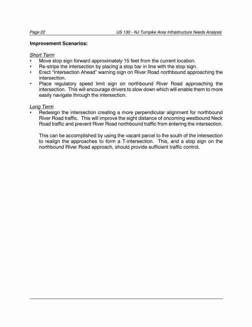
Improvement Scenarios:
Short Term• Move stop sign forward approximately 15 feet from the current location.• Re-stripe the intersection by placing a stop bar in line with the stop sign.• Erect “Intersection Ahead” warning sign on River Road northbound approaching the
intersection.• Place regulatory speed limit sign on northbound River Road approaching the
intersection. This will encourage drivers to slow down which will enable them to moreeasily navigate through the intersection.
Long Term• Redesign the intersection creating a more perpendicular alignment for northbound
River Road traffic. This will improve the sight distance of oncoming westbound NeckRoad traffic and prevent River Road northbound traffic from entering the intersection.
This can be accomplished by using the vacant parcel to the south of the intersectionto realign the approaches to form a T-intersection. This, and a stop sign on thenorthbound River Road approach, should provide sufficient traffic control.
US 130 - NJ Turnpike Area Infrastructure Needs Analysis Page 23
BurlingtonTownship
Delaware Valley Regional Planning CommissionJune 2001
Wooded Lot
Wooded Lot
Wooded Lot
Figure 1: Intersection of Neck Road (CR 658 ) and River Road (CR 656)
Page 24 US 130 - NJ Turnpike Area Infrastructure Needs Analysis
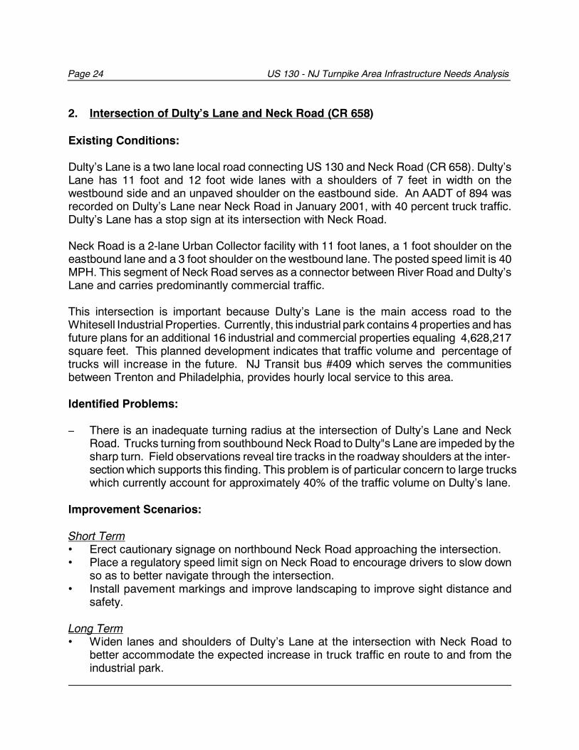
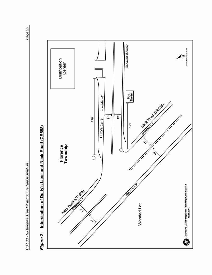
2. Intersection of Dulty’s Lane and Neck Road (CR 658)
Existing Conditions:
Dulty’s Lane is a two lane local road connecting US 130 and Neck Road (CR 658). Dulty’sLane has 11 foot and 12 foot wide lanes with a shoulders of 7 feet in width on thewestbound side and an unpaved shoulder on the eastbound side. An AADT of 894 wasrecorded on Dulty’s Lane near Neck Road in January 2001, with 40 percent truck traffic.Dulty’s Lane has a stop sign at its intersection with Neck Road.
Neck Road is a 2-lane Urban Collector facility with 11 foot lanes, a 1 foot shoulder on theeastbound lane and a 3 foot shoulder on the westbound lane. The posted speed limit is 40MPH. This segment of Neck Road serves as a connector between River Road and Dulty’sLane and carries predominantly commercial traffic.
This intersection is important because Dulty’s Lane is the main access road to theWhitesell Industrial Properties. Currently, this industrial park contains 4 properties and hasfuture plans for an additional 16 industrial and commercial properties equaling 4,628,217square feet. This planned development indicates that traffic volume and percentage oftrucks will increase in the future. NJ Transit bus #409 which serves the communitiesbetween Trenton and Philadelphia, provides hourly local service to this area.
Identified Problems:
� There is an inadequate turning radius at the intersection of Dulty’s Lane and NeckRoad. Trucks turning from southbound Neck Road to Dulty"s Lane are impeded by the sharp turn. Field observations reveal tire tracks in the roadway shoulders at the inter-section which supports this finding. This problem is of particular concern to large truckswhich currently account for approximately 40% of the traffic volume on Dulty’s lane.
Improvement Scenarios:
Short Term• Erect cautionary signage on northbound Neck Road approaching the intersection.• Place a regulatory speed limit sign on Neck Road to encourage drivers to slow down
so as to better navigate through the intersection.• Install pavement markings and improve landscaping to improve sight distance and
safety.
Long Term• Widen lanes and shoulders of Dulty’s Lane at the intersection with Neck Road to
better accommodate the expected increase in truck traffic en route to and from theindustrial park.
US
130
- N
J tu
rnpi
ke A
rea
Infr
astr
uctu
re N
eeds
Ana
lysi
s
Pag
e 25
Fig
ure
2:
Inte
rsec
tio
n o
f D
ult
y’s
Lan
e an
d N
eck
Ro
ad (
CR
658)
Page 26 US 130 - NJ Turnpike Area Infrastructure Needs Analysis
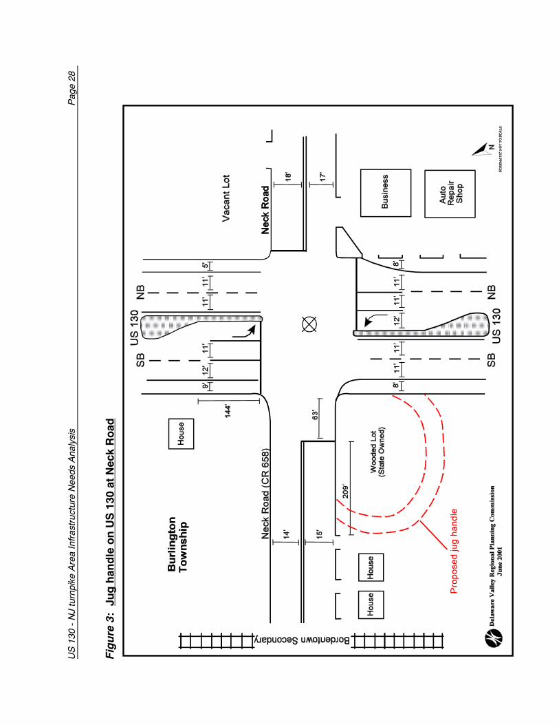
3. Jug handle on US 130 at Neck Road Mile Post: 48.3
Existing Conditions:
The intersection of Neck Road and US 130 is a four-way signalized intersection. There aretwo through lanes, one protected left turn lane and inside and outside shoulders in bothdirections on US 130 at this location. US 130 has a center median with an average widthof 16 feet which narrows approaching the traffic signals. Neck Road is generally 35 feetin width and has two travel lanes. The segment of Neck Road to the west of US 130 hasan eastbound travel lane of 12 feet in width and an eastbound shoulder that is four feetwide. The westbound lane is 14 feet wide at this location.
Three of the four corners in the immediate vicinity of this intersection are vacant parcels.The fourth corner (the nearside of US 130 northbound) is in commercial/office use. NeckRoad is primarily single family residential.
The speed limit on US 130 at Neck Road is 50 MPH. The posted speed limit on NeckRoad is 35 MPH.
Traffic counts taken on US 130 at this location in 1991 showed an AADT of approximately19,800. Traffic counts conducted in 2001 by DVRPC showed an increase in AADTvolumes to approximately 22,500, a 12% increase. Vehicle classification counts showsthat while 1,862 or 17% of northbound vehicles on US 130 were trucks, an even greaterpercentage, 2,864 or 26% of southbound vehicles using US 130 at this location weretrucks. This could be a result of the numerous trucks accessing the many warehouses inthe vicinity of Exit 6A.
Identified Problems:
Southbound truck traffic on US 130 whose trips originate south of Cedar Road are unableto make a U-Turn to travel north because of the absence of jug handles along US 130 inBurlington Township. Currently, southbound trucks travel south on US 130 to La GorceBoulevard near mile post 47.85, and turn around in the parking lot of the former La GorceShopping Center, before proceeding north. This maneuvering is a complicated and unsafemethod of turning around, which is even less desirable when navigated by large trucks.
There is therefore a need for a jug handle at the intersection of Neck Road and US 130 topermit southbound trucks to make a U-turn to US 130 north for access to the Turnpike andI-295.
Improvement Scenarios:
US 130 - NJ Turnpike Area Infrastructure Needs Analysis Page 27
Improvement Scenarios:
Short Term• There are no effective short term solutions which will significantly improve the current
traffic condition.
Long Term• There are vacant parcels on southbound US 130 at Neck Road which could
accommodate either a near-side or far-side jug handle. • There is a sign on the far-side lot at US 130 south and Neck Road which indicates that
the property is owned by the State of New Jersey. If this is the case, this propertywould be preferable not only because of minimal acquisition cost, but also becausebeing the larger of the two lots, greater design options would be available here for ajug handle than at the near-side lot.
• A far-side jug handle would permit stacking of a greater number of vehicles andprevent traffic backing up on US 130.
• This intersection may require some widening to improve the turn radius for trucksturning left from Neck Road to US 130 north.
• This property extends for approximately 272 feet westward along Neck Road from US130. The exit on Neck Road for the preferred jug handle could be at some point alongthis segment.
US
130
- N
J tu
rnpi
ke A
rea
Infr
astr
uctu
re N
eeds
Ana
lysi
s
Pag
e 28
Fig
ure
3:
Ju
g h
and
le o
n U
S 1
30 a
t N
eck
Ro
ad
US 130 - NJ Turnpike Area Infrastructure Needs Analysis Page 29
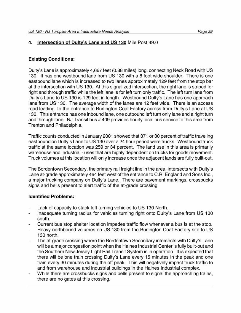
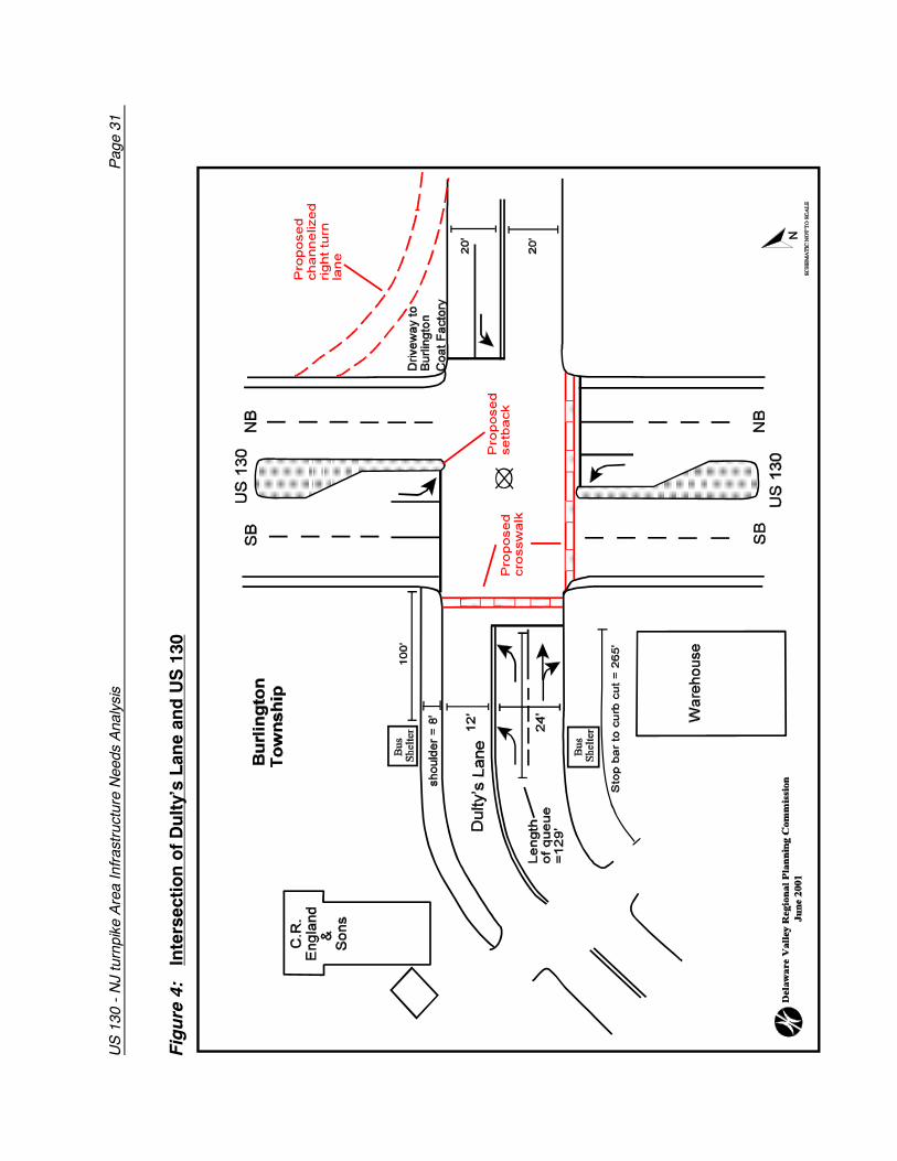
4. Intersection of Dulty’s Lane and US 130 Mile Post 49.0
Existing Conditions:
Dulty’s Lane is approximately 4,667 feet (0.88 miles) long, connecting Neck Road with US130. It has one westbound lane from US 130 with a 8 foot wide shoulder. There is oneeastbound lane which is increased to two lanes approximately 129 feet from the stop barat the intersection with US 130. At this signalized intersection, the right lane is striped forright and through traffic while the left lane is for left turn only traffic. The left turn lane fromDulty’s Lane to US 130 is 129 feet in length. Westbound Dulty’s Lane has one approachlane from US 130. The average width of the lanes are 12 feet wide. There is an accessroad leading to the entrance to Burlington Coat Factory across from Dulty’s Lane at US130. This entrance has one inbound lane, one outbound left turn only lane and a right turnand through lane. NJ Transit bus # 409 provides hourly local bus service to this area fromTrenton and Philadelphia.
Traffic counts conducted in January 2001 showed that 371 or 30 percent of traffic travelingeastbound on Dulty’s Lane to US 130 over a 24 hour period were trucks. Westbound trucktraffic at the same location was 259 or 34 percent. The land use in this area is primarilywarehouse and industrial - uses that are highly dependent on trucks for goods movement.Truck volumes at this location will only increase once the adjacent lands are fully built-out.
The Bordentown Secondary, the primary rail freight line in the area, intersects with Dulty’sLane at-grade approximately 464 feet west of the entrance to C.R. England and Sons Inc.,a major trucking company on Dulty’s Lane. There are pavement markings, crossbuckssigns and bells present to alert traffic of the at-grade crossing.
Identified Problems:
- Lack of capacity to stack left turning vehicles to US 130 North.- Inadequate turning radius for vehicles turning right onto Dulty’s Lane from US 130
south.- Current bus stop shelter location impedes traffic flow whenever a bus is at the stop.- Heavy northbound volumes on US 130 from the Burlington Coat Factory site to US
130 north.- The at-grade crossing where the Bordentown Secondary intersects with Dulty’s Lane
will be a major congestion point when the Haines Industrial Center is fully built-out andthe Southern New Jersey Light Rail Transit System is in operation. It is expected thatthere will be one train crossing Dulty’s Lane every 15 minutes in the peak and onetrain every 30 minutes during the off peak. This will negatively impact truck traffic toand from warehouse and industrial buildings in the Haines Industrial complex.
- While there are crossbucks signs and bells present to signal the approaching trains,there are no gates at this crossing.
Page 30 US 130 - NJ Turnpike Area Infrastructure Needs Analysis
- There is an absence of sidewalks connecting the bus stops to the area traveled bypedestrians.
- There is an absence of pedestrian crosswalks at this intersection. - Burlington Coat Factory access road currently has one lane to the site from the
intersection with US 130. Leaving the site, there is one left turn lane to US 130 south,and a through and right turn lane to Dulty’s Lane and US 130 north respectively. Thisconfiguration will be inadequate if as expected, expansion takes place at the site andmore trips are generated.
Improvement Scenarios:
Long Term• There are currently plans to widen Dulty’s Lane to and from US 130 intersection
extending approximately 100 feet from the intersection with US 130, to betteraccommodate truck traffic. The number of lanes would be increased to two eastboundleft turn lanes to accommodate the heavy volumes turning on northbound US 130towards the NJ Turnpike. There would also be one eastbound through and right turnlane to facilitate access to Burlington Coat factory as well as to permit access to US130 south.
• There is a proposal to move both bus stop shelters back by approximately 15 feetfurther away from the intersection of Dulty’s Lane and US 130. This will reduce theconflict between a parked bus and through traffic approaching the intersection.
• The entrance to C.R. England and Sons Inc. should be moved back further west alongDulty’s Lane to accommodate the proposed widening. The guard house should alsobe set back to eliminate the problem of container trucks impeding traffic along Dulty’sLane while they wait to access the site.
• The at-grade crossing at Dulty’s Lane by the Bordentown Secondary should beupgraded to include “Quad Gates”. These gates are equipped with barrier arms oneach side of the road on both sides of the track. This will permit the trains to clear theintersection at a greater speed, and minimize the time the street is closed. If standardgates are used, median barriers should be installed on both sides of the tracks,extending for approximately 50 feet, to discourage motorists from driving around thegates.
• Sidewalks are proposed extending on both sides of the road from the bus stops to theproposed pedestrian crosswalks at the intersection with US 130. By installing thesenew crosswalks, pedestrian traffic would be channeled across US 130 at the southernleg of the intersection. This would reduce vehicle/pedestrian conflicts with vehiclesturning left from Dulty’s Lane to US 130 north.
• It is recommended that a channelized right turn lane with an island be created fromthe Burlington Coat Factory access road to US 130 north. This should beapproximately 60 feet in length which would reduce conflict with left turning vehiclesfrom Dulty’ Lane and permit traffic to merge gradually.
• The center island on US 130 is proposed to be moved back along with the stop bar forsouthbound US 130 traffic. This will accommodate the expansion proposal for Dulty’sLane.
US
130
- N
J tu
rnpi
ke A
rea
Infr
astr
uctu
re N
eeds
Ana
lysi
s
Pag
e 31
Fig
ure
4:
In
ters
ecti
on
of
Du
lty’
s L
ane
and
US
130
Page 32 US 130 - NJ Turnpike Area Infrastructure Needs Analysis
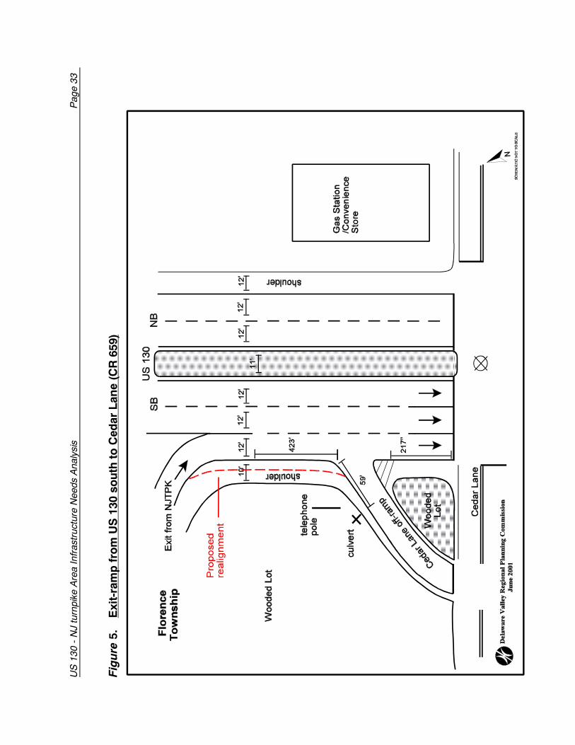
5. Exit-Ramp from US 130 south to Cedar Lane (CR 659)
Existing Conditions:
The area of concern is the exit ramp from US 130 south to Cedar Lane in FlorenceTownship. The distance between the I-276 westbound exit ramp and the ramp to theCedar Lane exit off US 130 south is approximately 423 feet. It is at this section that trafficexiting US 130 south and traffic entering US 130 south from the Turnpike Extensionexperiences a weave in movement. US 130 southbound at this point has three travel lanesand a shoulder. Two of the travel lanes are through lanes while the third is a decelerationlane for the Cedar Lane exit. The travel lanes are 12 feet in width each while the shoulderis 10 feet wide. The speed limit on US 130 at this point is 50 MPH.
A 1991 NJDOT traffic count at this location for both northbound and southbound traffic,recorded an AADT of 17,230. In January 2001, DVRPC conducted traffic counts at thesame location which recorded an AADT of 28,711, an increase of 67 percent over 10years. This increase is primarily due to the January 2000 completion of the full serviceinterchange which permits vehicular access to and from the NJ Turnpike extension to US130.
Identified Problems:
- There is a conflict between vehicles exiting the Turnpike ramp on to US 130 south andthose traveling south on US 130 that are exiting at Cedar Lane. Some vehicles arerequired to accelerate while others have to decelerate quickly from US 130 over ashort distance in order to navigate the exit ramp.
- The absence of guard rails to prevent vehicles from skidding off the Cedar Lane exitramp to the wooded area.
- A lack of adequate warning signs alerting motorists of the need to decelerate quicklywhen exiting US 130 south.
Improvement Scenarios:Short Term• Relocating the exit lane by using all or part of the shoulder at the Cedar Lane exit as
a travel lane. This would permit exiting vehicles to have a more gradual approach tothe exit by providing more weaving room.
• Erect guard rails with reflectors along the island to corral vehicles that skids off thepavement.
• Erecting a chevron alignment sign at the Cedar Lane exit would assist in emphasizingthe change in the horizontal alignment of the roadway. This would alert motorists ofthe need to reduce their speed.
US
130
- N
J tu
rnpi
ke A
rea
Infr
astr
uctu
re N
eeds
Ana
lysi
s
Pag
e 33
Fig
ure
5.
Exi
t-ra
mp
fro
m U
S 1
30 s
ou
th t
o C
edar
Lan
e (C
R 6
59)
Page 34 US 130 - NJ Turnpike Area Infrastructure Needs Analysis
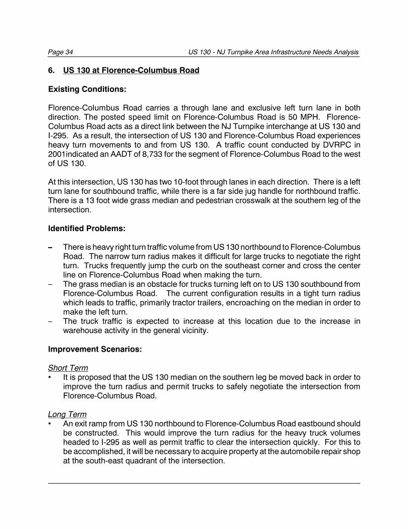
6. US 130 at Florence-Columbus Road
Existing Conditions:
Florence-Columbus Road carries a through lane and exclusive left turn lane in bothdirection. The posted speed limit on Florence-Columbus Road is 50 MPH. Florence-Columbus Road acts as a direct link between the NJ Turnpike interchange at US 130 andI-295. As a result, the intersection of US 130 and Florence-Columbus Road experiencesheavy turn movements to and from US 130. A traffic count conducted by DVRPC in2001indicated an AADT of 8,733 for the segment of Florence-Columbus Road to the westof US 130.
At this intersection, US 130 has two 10-foot through lanes in each direction. There is a leftturn lane for southbound traffic, while there is a far side jug handle for northbound traffic.There is a 13 foot wide grass median and pedestrian crosswalk at the southern leg of theintersection.
Identified Problems:
� There is heavy right turn traffic volume from US 130 northbound to Florence-ColumbusRoad. The narrow turn radius makes it difficult for large trucks to negotiate the rightturn. Trucks frequently jump the curb on the southeast corner and cross the centerline on Florence-Columbus Road when making the turn.
� The grass median is an obstacle for trucks turning left on to US 130 southbound fromFlorence-Columbus Road. The current configuration results in a tight turn radiuswhich leads to traffic, primarily tractor trailers, encroaching on the median in order tomake the left turn.
� The truck traffic is expected to increase at this location due to the increase inwarehouse activity in the general vicinity.
Improvement Scenarios:
Short Term • It is proposed that the US 130 median on the southern leg be moved back in order to
improve the turn radius and permit trucks to safely negotiate the intersection fromFlorence-Columbus Road.
Long Term• An exit ramp from US 130 northbound to Florence-Columbus Road eastbound should
be constructed. This would improve the turn radius for the heavy truck volumesheaded to I-295 as well as permit traffic to clear the intersection quickly. For this tobe accomplished, it will be necessary to acquire property at the automobile repair shopat the south-east quadrant of the intersection.
US
130
- N
J tu
rnpi
ke A
rea
Infr
astr
uctu
re N
eeds
Ana
lysi
s
Pag
e 35
Fig
ure
6:
US
130
at
Flo
ren
ce-C
olu
mb
us
Ro
ad
Page 36 US 130 - NJ Turnpike Area Infrastructure Needs Analysis
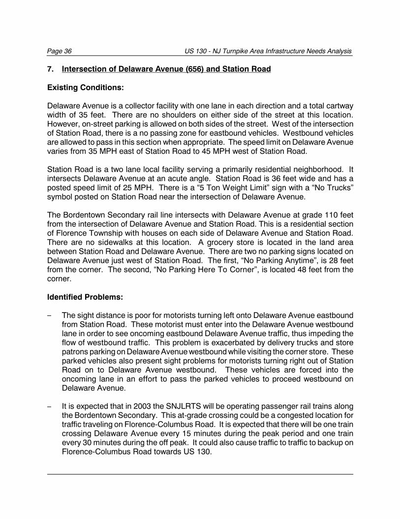
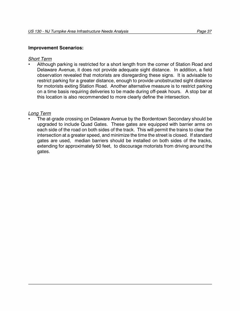
7. Intersection of Delaware Avenue (656) and Station Road
Existing Conditions:
Delaware Avenue is a collector facility with one lane in each direction and a total cartwaywidth of 35 feet. There are no shoulders on either side of the street at this location.However, on-street parking is allowed on both sides of the street. West of the intersectionof Station Road, there is a no passing zone for eastbound vehicles. Westbound vehiclesare allowed to pass in this section when appropriate. The speed limit on Delaware Avenuevaries from 35 MPH east of Station Road to 45 MPH west of Station Road.
Station Road is a two lane local facility serving a primarily residential neighborhood. Itintersects Delaware Avenue at an acute angle. Station Road is 36 feet wide and has aposted speed limit of 25 MPH. There is a “5 Ton Weight Limit” sign with a “No Trucks”symbol posted on Station Road near the intersection of Delaware Avenue.
The Bordentown Secondary rail line intersects with Delaware Avenue at grade 110 feetfrom the intersection of Delaware Avenue and Station Road. This is a residential sectionof Florence Township with houses on each side of Delaware Avenue and Station Road.There are no sidewalks at this location. A grocery store is located in the land areabetween Station Road and Delaware Avenue. There are two no parking signs located onDelaware Avenue just west of Station Road. The first, “No Parking Anytime”, is 28 feetfrom the corner. The second, “No Parking Here To Corner”, is located 48 feet from thecorner.
Identified Problems:
� The sight distance is poor for motorists turning left onto Delaware Avenue eastboundfrom Station Road. These motorist must enter into the Delaware Avenue westboundlane in order to see oncoming eastbound Delaware Avenue traffic, thus impeding theflow of westbound traffic. This problem is exacerbated by delivery trucks and storepatrons parking on Delaware Avenue westbound while visiting the corner store. Theseparked vehicles also present sight problems for motorists turning right out of StationRoad on to Delaware Avenue westbound. These vehicles are forced into theoncoming lane in an effort to pass the parked vehicles to proceed westbound onDelaware Avenue.
� It is expected that in 2003 the SNJLRTS will be operating passenger rail trains alongthe Bordentown Secondary. This at-grade crossing could be a congested location fortraffic traveling on Florence-Columbus Road. It is expected that there will be one traincrossing Delaware Avenue every 15 minutes during the peak period and one trainevery 30 minutes during the off peak. It could also cause traffic to traffic to backup onFlorence-Columbus Road towards US 130.
US 130 - NJ Turnpike Area Infrastructure Needs Analysis Page 37
Improvement Scenarios:
Short Term • Although parking is restricted for a short length from the corner of Station Road and
Delaware Avenue, it does not provide adequate sight distance. In addition, a fieldobservation revealed that motorists are disregarding these signs. It is advisable torestrict parking for a greater distance, enough to provide unobstructed sight distancefor motorists exiting Station Road. Another alternative measure is to restrict parkingon a time basis requiring deliveries to be made during off-peak hours. A stop bar atthis location is also recommended to more clearly define the intersection.
Long Term• The at-grade crossing on Delaware Avenue by the Bordentown Secondary should be
upgraded to include Quad Gates. These gates are equipped with barrier arms oneach side of the road on both sides of the track. This will permit the trains to clear theintersection at a greater speed, and minimize the time the street is closed. If standardgates are used, median barriers should be installed on both sides of the tracks,extending for approximately 50 feet, to discourage motorists from driving around thegates.
US
130
- N
J tu
rnpi
ke A
rea
Infr
astr
uctu
re N
eeds
Ana
lysi
s
Pag
e 38
Fig
ure
7:
In
ters
ecti
on
of
Del
awar
e A
ven
ue
(656
) an
d S
tati
on
Ro
ad
US 130 - NJ Turnpike Area Infrastructure Needs Analysis Page 39
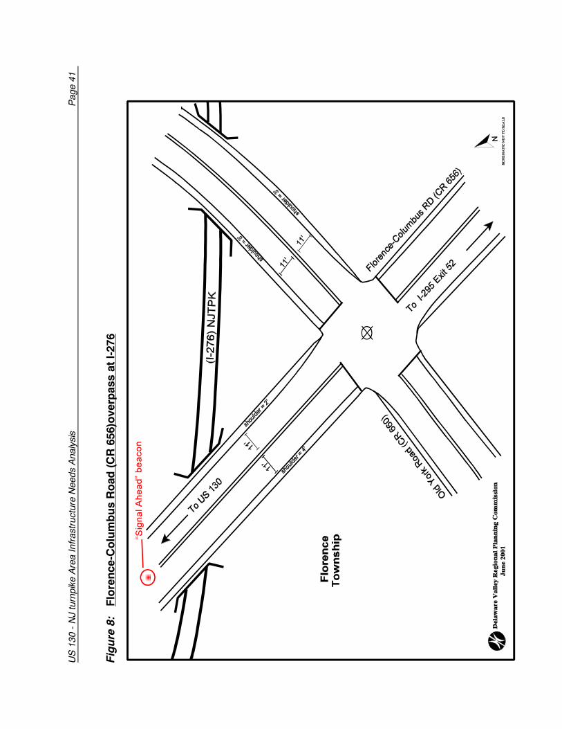
8. Florence-Columbus Road (CR 656)overpass at I-276
Existing Conditions:
This segment of Florence-Columbus Road (CR 656) extends from US 130 to theinterchange with I-295. The speed limit is 50 MPH between Old York Road and US 130.This is a two lane highway with 11 foot lanes and shoulders that are 2 and 4 feet wide.This is an important truck route for trucks destined to and from industrial parks inBurlington and Florence townships from I-295 and the New Jersey Turnpike Extension (I-276). CR 656 crosses over I-276 on a bridge. The cross section of the bridge consists ofan 11-foot lane, a 4-foot shoulder and a 3-foot sidewalk in each direction. There are nosidewalks along the remainder of the road.
A 2001 DVRPC traffic count on CR 656 approaching Old York Road revealed an AADTof 9,472. Upon closer examination, the vehicle classification counts revealed 10 percentof the traffic northbound were trucks while 11 percent of southbound were trucks.
Identified Problems:
- Traffic approaching the I-276 overpass eastbound on CR 656 have an obstructed viewof the traffic signal at Old York Road. This problem is exacerbated whenever vehiclesare stopped at the intersection because of a red signal. The obstructed view causedby the overpass gives motorists a short response time while approaching the Old YorkRoad intersection. Trucks, especially tractor trailers, require a longer stopping distancethan passenger cars and are particularly vulnerable in this situation. This isparticularly critical considering that approximately 10 percent of the vehicles using thisroad are trucks.
- In an effort to address this problem, a sign has been erected on the eastboundshoulder of the approach to the overpass to I-276 alerting motorist to exercise cautionwhile approaching the signalized intersection. This is intended to alert motorists of theproblem which becomes apparent approximately 0.1 mile from the crest of theoverpass, or 0.8 mile east of US 130.
Improvement Scenarios:
Short Term• By installing a hazard identification beacon with a flashing “Red Signal Ahead” warning
signal, motorists will be alerted of the need to reduce speed and be prepared to stopwith short notice. This beacon should be installed over the eastbound lane, on theapproach to the overpass. The beacon should be clearly visible for a distance of atleast 0.25 miles under normal atmospheric conditions. This beacon should beinterconnected with the traffic signal controller located at the intersection of CR 656
Page 40 US 130 - NJ Turnpike Area Infrastructure Needs Analysis
and Old York Road.• Florence-Columbus Road should at the least be upgraded to AASHTO (American
Association of State Highway and Transportation Officials) standards for lane andshoulder widths. These standards include 12-foot travel lanes and 8-foot shoulders.The traffic conditions should be monitored to determine the impacts of the newturnpike interchange and local development on this road.
US
130
- N
J tu
rnpi
ke A
rea
Infr
astr
uctu
re N
eeds
Ana
lysi
s
Pag
e 41
Fig
ure
8:
Flo
ren
ce-C
olu
mb
us
Ro
ad (
CR
656
)ove
rpas
s at
I-27
6
Page 42 US 130 - NJ Turnpike Area Infrastructure Needs Analysis
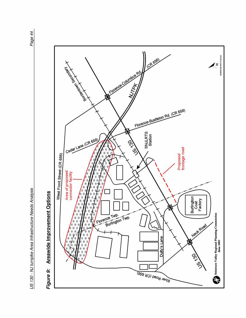
9. Areawide Improvement Options
Rationalizing Posted Speed Limits along CR 656
Identified Problems- The speed limit on the Delaware Avenue, Florence-Columbus Road section of CR 656
is inconsistent. The speed limit varies between 25 MPH, 35 MPH and 50 MPH atdifferent segments of the road over a short distance. These variations are a functionof adjacent land uses and road geometry.
Improvement Scenarios• The speed limit designation should be reduced from 50 MPH to a lesser speed, based
on accepted evaluation criteria established by the American Association for StateHighway Officials. Signing should be consistent with the manual on uniform trafficcontrol devices.
• With volumes expected to increase on this segment of roadway due to futuredevelopment, a reduction in speed at the higher designated speed limit would improvesafety.
Reducing Truck Volumes on Florence - Columbus Road
Identified Problems- Florence-Columbus Road between US 130 and I-295 is used as an access road by
most traffic in the study area destined for I-295 primarily because it is the most directroute. As a result, this 2-lane road is oftentimes encumbered with heavy truck volume.The traffic volumes and percent trucks will only increase over time as industrial andcommercial development in the area intensifies. This section of Florence-ColumbusRoad will therefore become functionally obsolete.
Improvement Scenarios• The alternative is to use directional signage to direct truck traffic to use US 130
northbound to Interchange 56 of I-295 in Bordentown, for northbound trucks.Southbound truck traffic could continue to use Interchange 52 of I-295 at Florence-Columbus Road. By reducing the truck volume on this road, safety will be enhanced.
• Interchange 56 in Bordentown has a ramp that is designed to facilitate easy accessby trucks from US 130 northbound. This is better designed to accommodate trucktraffic than Interchange 52 at Florence-Columbus Road.
US 130 - NJ Turnpike Area Infrastructure Needs Analysis Page 43
New Connection to River Road
Identified Problems- The most direct route to US 130 for truck traffic from industries along West Front
Street and parts of River Road is via Delaware Avenue. This is primarily a residentialstreet with trucks accounting for between 6-7% of the total volume. The negativeimpacts of truck traffic in residential areas ranges from safety to quality of life issues.
Improvement Scenarios• Construction of an extension of the site roadway proposed for the Haines Industrial
Center in the vicinity of Cedar Lane that would parallel the Turnpike extension andconnect to River Road (See Figure 9). This would permit truck traffic from Griffin Pipeand the industrial areas in the vicinity of River Road and West Front Street to accessUS 130 and the Turnpike without using Delaware Avenue. The result would be areduction in truck traffic in the residential area adjacent to Delaware Avenue.
• A connection would also be made to Cedar Lane, near the former ramp, to provide analternate access to US 130.
• This road would also be an alternative to Dulty’s Lane for vehicles entering and exitingthe site which would result in a reduction in traffic volumes and congestion at Dulty’sLane.
Reverse Frontage Road parallel to US 130
Identified Problems- There is a large tract of vacant property east of US 130 between Florence-
Bustleton Road and the entrance to Burlington Coat Factory that is undeveloped. Ifthis property is subdivided into individual lots with each having direct access to US130, the numerous entrances and exits will impede the smooth flow of traffic on US130.
Improvement Scenarios• By incorporating land adjacent to the Burlington Coat Factory parking lot, this would
permit the creation of a frontage road that would parallel US 130. This conceptshould be explored further as a way of providing access to adjacent undevelopedland, and reducing the need for multiple curb cuts on US 130.
• A frontage road would provide access to the interior of the property facilitating itsdevelopment. The commercially zoned area adjacent to US 130 would haveaccess to the frontage road as well as to US 130.
• By providing an alternative to multiple access to US 130, traffic will proceed withless impedance than if there were multiple driveways.
• NJ DOT should periodically monitor traffic flow on US 130 within the study area todetermine if the current capacity is adequate to provide an acceptable level ofservice.
US
130
- N
J tu
rnpi
ke A
rea
Infr
astr
uctu
re N
eeds
Ana
lysi
s
Pag
e 44
Fig
ure
9:
Are
awid
e Im
pro
vem
ent
Op
tio
ns
US 130 - NJ Turnpike Area Infrastructure Needs Analysis Page 45
PLAN IMPLEMENTATION
The US 130 - NJ Turnpike Area Infrastructure Needs Analysis can be used as a dynamiclong range tool for the systematic selection of projects to create a significantly improvedtransportation system within the study area. This document can serve as a punch list forthe government agencies with a stake in the implementation of improvements. Municipalgovernments are key players in this process. Even though a highway may be maintainedby the state or county, it is the welfare of the local residents which is affected the most.Safety and mobility benefits are felt more by those who use the highway frequently.Therefore, the local municipality should assure that the improvements are advancedexpediently by being involved in the process no matter which agency has a lead role.
CharacteristicsIn choosing which projects should advance first, stakeholders can be guided by theinformation presented in Table 2 (page 48) US 130 - NJ Turnpike Area TransportationImprovements Implementation Matrix. This easy to use matrix suggests the relativeimportance to stakeholders of the various attributes of each problem location. Eachimprovement scenario, identified is evaluated in terms of project priority, cost range andproject benefits. The stakeholders necessary to carry out the plan are also identified.
PriorityPriorities are estimated in terms of three categories: high, moderate and low. Priorities areassigned based on the perception of the extent of the problems they present drivers, withsafety being most important, but congestion (or time delay) and mobility also beingconsidered. A higher degree of priority is also assigned if there is an urgency to completethe improvement due to the imminent completion of a nearby major investment(development or transportation improvement). If there is concern that a section of right-of-way needed to complete an improvement is in danger of being developed or used foranother use, the priority to act on that improvement is also heightened. If a project isrelatively small scale and low cost, yet offers a projected high benefit, it also receives ahigher priority ranking.
Cost RangeCosts are also assigned to categories of high, moderate and low. High cost projectsusually involve a major commitment from one or more funding source, lengthy publicinvolvement and several years lead time in programming the required funds. They aretypically large scale, complex or multi-phased improvements and can entail theconstruction of new facilities. In general, a project in this category is estimated to costbetween $5 and $35 million, however some major projects have been known to cost in thehundreds of millions of dollars. An improvement estimated to have a moderate cost couldinvolve a major reconstruction of an intersection, construction of a short connector roador a widening of an existing road. In general, a project in this category is estimated to costbetween $2 and $5 million. Low cost projects can often be fast-tracked with maintenance,or pool funding. They are often operational type improvements at isolated locations and
Page 46 US 130 - NJ Turnpike Area Infrastructure Needs Analysis
typically cost less than $2 million. These cost ranges are generalized estimates and couldbe significantly changed for a specific location due to environmental, right-of-way or otherfactors uncovered during detailed design of the improvement.
BenefitsBenefits describe the kind of impact the improvement will yield, such as enhancing safety,lessening congestion, improving mobility or encouraging economic development.Economic development benefits are derived from a transportation improvement generallythrough an increase in the accessibility of affected individual properties or areas. Thestrategic location and magnitude of the improvement determines the extent of the benefitsreceived by the affected properties. The increased level of access to a property may makeit attractive enough to induce new commercial or residential development or entice existingland uses to expand. Increased accessibility can also have a positive effect on propertyvalues.
Roles of AgenciesIn terms of a hierarchy of agencies, the New Jersey Department of Transportation(NJDOT) is primary, both in terms of maintaining US 130 as well as providing much of thedesign, right-of-way and construction funding for major improvements. Municipalities makeland use decisions in the corridor, which ultimately affect traffic levels on US 130. Inaddition, many of the cross streets are designed, built and maintained by local and countygovernment, and these also impact how well US 130 functions. Lastly, developers actuallybuild the housing, commercial and industrial projects which generate the trips which mustbe accommodated by a publicly-owned transportation infrastructure. In addition, some thetransportation improvements themselves are designed and financed by developers.
New Jersey Department of TransportationNJDOT has jurisdiction over the state highways in the corridor. These include I-295 andUS 130. Improvements to these highways are typically financed by state and/or federalfunds. Occasionally, developer contributions are also a source of funding if the project hasspecial impact by a development. The State ultimately makes the decision on whatimprovements are done to their facilities but often coordinates with the county or localmunicipalities when the improvements include facilities under their jurisdiction.
Burlington CountyThe county has jurisdiction over a network of roads throughout the study area. In NewJersey, county roads are given 500, 600 or 700 route designations. There are several 600series routes within the study area: CR 656, CR 658, CR 659 and CR 661. Most of thecounty roads in the corridor serve as access roads into or across US 130. The primaryfunction of the county network is to serve medium range trips or to serve as feeders to thestate system. Improvements to county roads are financed by county dollars or whereeligible can they can receive federal or state funding. The county has the ultimate decisionconcerning improvements on county roads but typically coordinates with the municipalityin which the improvement is located.
US 130 - NJ Turnpike Area Infrastructure Needs Analysis Page 47
Metropolitan Planning Organization (MPO) DVRPC, serving as the MPO for this region, is required to coordinate a comprehensive andcontinuing transportation planning process. This process results in the development of aTransportation Improvement Program (TIP) which identifies all priority projects for whichfederal funds will be sought. The TIP represents a consensus among state and regionalofficials as to what regional improvements are to be made. In addition to the TIP, the MPOis required by federal legislation to develop a long range plan (LRP) to help direct region-wide transportation decision making over a period of at least 20 years. Long range plansdo not specify the design of actual projects. Rather, they identify future needs to addresstransportation deficiencies.
MunicipalitiesLocal governments not only have jurisdiction over their local road system they also controllocal land use decisions. The decisions made at the local level can effect the traffic onroads at all levels. Therefore, local officials must understand the traffic impacts whichcould be generated from a particular development and understand the synergy that existsbetween land use decisions and transportation improvements. Local officials need to beinvolved in the transportation planning process for all levels of transportationimprovements to make sure that the concerns of their residents are addressed and toassist in the problem identification and improvement recommendations. Municipal officialsneed to make use of the circulation element of their Master Plan to identify importantmissing links in their highway network and begin to preserve space for these links to bebuilt. The Master Plan is an important tool for municipalities to use in addressing theircirculation needs.
DevelopersAs properties are developed or redeveloped, the transportation needs of the properties canchange, sometimes drastically. Providing proper transportation access to a newdevelopment is often critical to the success of that development. Therefore, developersmust work with the transportation providers to assure that the necessary changes arebeneficial to both the development and the existing transportation infrastructure.Developers frequently design and construct improvements for traffic attributable to theirdevelopments or to provide enhanced access to their site.
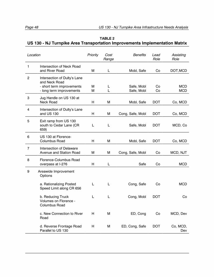
Page 48 US 130 - NJ Turnpike Area Infrastructure Needs Analysis
TABLE 2US 130 - NJ Turnpike Area Transportation Improvements Implementation Matrix
Location Priority CostRange
Benefits LeadRole
Assisting Role
1 Intersection of Neck Roadand River Road M L Mobl, Safe Co DOT,MCD
2 Intersection of Dulty’s Laneand Neck Road- short term improvements- long term improvements
MM
LL
Safe, MoblSafe, Mobl
CoCo
MCDMCD
3 Jug Handle on US 130 atNeck Road H M Mobl, Safe DOT Co, MCD
4 Intersection of Dulty’s Laneand US 130 H M Cong, Safe, Mobl DOT Co, MCD
5 Exit ramp from US 130south to Cedar Lane (CR659)
L L Safe, Mobl DOT MCD, Co
6 US 130 at Florence-Columbus Road H M Mobl, Safe DOT Co, MCD
7 Intersection of DelawareAvenue and Station Road M M Cong, Safe, Mobl Co MCD, NJT
8 Florence-Columbus Roadoverpass at I-276 H L Safe Co MCD
9 Areawide ImprovementOptions
a. Rationalizing PostedSpeed Limit along CR 656
b. Reducing TruckVolumes on Florence -Columbus Road
c. New Connection to RiverRoad
d. Reverse Frontage RoadParallel to US 130
L
L
H
H
L
L
M
M
Cong, Safe
Cong, Mobl
ED, Cong
ED, Cong, Safe
Co
DOT
Co
DOT
MCD
Co
MCD, Dev
Co, MCD,Dev
US 130 - NJ Turnpike Area Infrastructure Needs Analysis Page 49
Key:
Priority: H = High, M = Moderate, L = LowCost Range: H = High, M = Moderate, L = LowBenefits: Cong = Congestion, ED = Economic Development, Mobl = Mobility, Safe
= Safety, Role: MCD = municipality, Co = county, DOT = NJ Department of
Transportation, NJT = NJ Transit, Dev = Developers

APPENDIX
2001 Vehicle Classification Counts
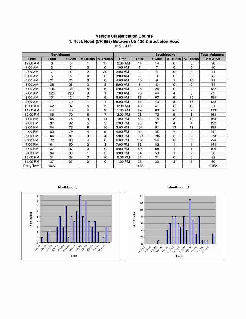
01/23/2001
Total VolumesTime Total # Cars # Trucks % Trucks Time Total # Cars # Trucks % Trucks NB & SB
12:00 AM 6 5 1 17 12:00 AM 14 14 0 0 201:00 AM 3 3 0 0 1:00 AM 7 7 0 0 102:00 AM 7 5 2 29 2:00 AM 4 4 0 0 113:00 AM 5 5 0 0 3:00 AM 3 3 0 0 84:00 AM 21 21 0 0 4:00 AM 10 9 1 10 315:00 AM 38 35 3 8 5:00 AM 6 6 0 0 446:00 AM 106 101 5 5 6:00 AM 26 26 0 0 1327:00 AM 223 220 3 1 7:00 AM 48 44 4 8 2718:00 AM 131 124 7 5 8:00 AM 63 57 6 10 1949:00 AM 71 70 1 1 9:00 AM 51 43 8 16 12210:00 AM 42 37 5 12 10:00 AM 49 41 8 16 9111:00 AM 44 40 4 9 11:00 AM 69 63 6 9 11312:00 PM 85 79 6 7 12:00 PM 78 73 5 6 1631:00 PM 85 76 9 11 1:00 PM 83 75 8 10 1682:00 PM 97 92 5 5 2:00 PM 95 91 4 4 1923:00 PM 84 76 8 10 3:00 PM 104 91 13 13 1884:00 PM 83 79 4 5 4:00 PM 164 157 7 4 2475:00 PM 84 81 3 4 5:00 PM 189 186 3 2 2736:00 PM 72 68 4 6 6:00 PM 152 144 8 5 2247:00 PM 61 59 2 3 7:00 PM 83 82 1 1 1448:00 PM 37 37 0 0 8:00 PM 69 68 1 1 1069:00 PM 34 33 1 3 9:00 PM 54 53 1 2 8810:00 PM 31 28 3 10 10:00 PM 31 31 0 0 6211:00 PM 27 27 0 0 11:00 PM 33 30 3 9 60
Daily Total 1477 1485 2962
Vehicle Classification Counts1. Neck Road (CR 658) Between US 130 & Bustleton Road
Northbound Southbound
Northbound Southbound
0
1
2
3
4
5
6
7
8
9
# o
f Tru
cks
12:0
0 AM
2:00
AM
4:00
AM
6:00
AM
8:00
AM
10:0
0 AM
12:0
0 PM
2:00
PM
4:00
PM
6:00
PM
8:00
PM
10:0
0 PM
Time
0
2
4
6
8
10
12
14
# o
f Tru
cks
12:0
0 AM
2:00
AM
4:00
AM
6:00
AM
8:00
AM
10:0
0 AM
12:0
0 PM
2:00
PM
4:00
PM
6:00
PM
8:00
PM
10:0
0 PM
Time
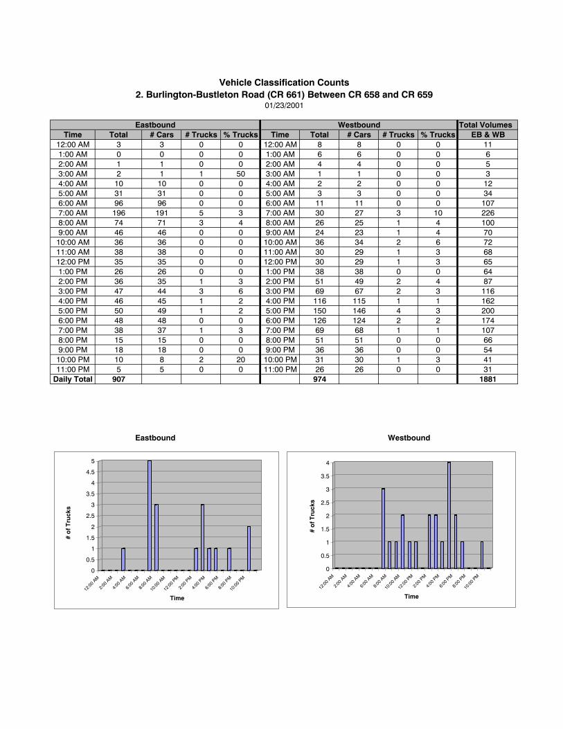
Total VolumesTime Total # Cars # Trucks % Trucks Time Total # Cars # Trucks % Trucks EB & WB
12:00 AM 3 3 0 0 12:00 AM 8 8 0 0 111:00 AM 0 0 0 0 1:00 AM 6 6 0 0 62:00 AM 1 1 0 0 2:00 AM 4 4 0 0 53:00 AM 2 1 1 50 3:00 AM 1 1 0 0 34:00 AM 10 10 0 0 4:00 AM 2 2 0 0 125:00 AM 31 31 0 0 5:00 AM 3 3 0 0 346:00 AM 96 96 0 0 6:00 AM 11 11 0 0 1077:00 AM 196 191 5 3 7:00 AM 30 27 3 10 2268:00 AM 74 71 3 4 8:00 AM 26 25 1 4 1009:00 AM 46 46 0 0 9:00 AM 24 23 1 4 7010:00 AM 36 36 0 0 10:00 AM 36 34 2 6 7211:00 AM 38 38 0 0 11:00 AM 30 29 1 3 6812:00 PM 35 35 0 0 12:00 PM 30 29 1 3 651:00 PM 26 26 0 0 1:00 PM 38 38 0 0 642:00 PM 36 35 1 3 2:00 PM 51 49 2 4 873:00 PM 47 44 3 6 3:00 PM 69 67 2 3 1164:00 PM 46 45 1 2 4:00 PM 116 115 1 1 1625:00 PM 50 49 1 2 5:00 PM 150 146 4 3 2006:00 PM 48 48 0 0 6:00 PM 126 124 2 2 1747:00 PM 38 37 1 3 7:00 PM 69 68 1 1 1078:00 PM 15 15 0 0 8:00 PM 51 51 0 0 669:00 PM 18 18 0 0 9:00 PM 36 36 0 0 5410:00 PM 10 8 2 20 10:00 PM 31 30 1 3 4111:00 PM 5 5 0 0 11:00 PM 26 26 0 0 31
Daily Total 907 974 1881
Eastbound Westbound
Vehicle Classification Counts2. Burlington-Bustleton Road (CR 661) Between CR 658 and CR 659
01/23/2001
Eastbound Westbound
0
0.5
1
1.5
2
2.5
3
3.5
4
4.5
5
# o
f Tru
cks
12:0
0 AM
2:00
AM
4:00
AM
6:00
AM
8:00
AM
10:0
0 AM
12:0
0 PM
2:00
PM
4:00
PM
6:00
PM
8:00
PM
10:0
0 PM
Time
0
0.5
1
1.5
2
2.5
3
3.5
4
# o
f Tru
cks
12:0
0 AM
2:00
AM
4:00
AM
6:00
AM
8:00
AM
10:0
0 AM
12:0
0 PM
2:00
PM
4:00
PM
6:00
PM
8:00
PM
10:0
0 PM
Time
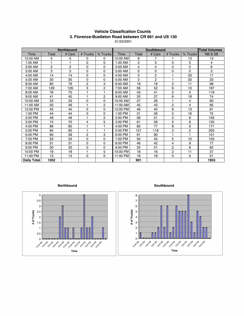
Total VolumesTime Total # Cars # Trucks % Trucks Time Total # Cars # Trucks % Trucks NB & SB
12:00 AM 5 5 0 0 12:00 AM 8 7 1 13 131:00 AM 1 1 0 0 1:00 AM 3 3 0 0 42:00 AM 2 2 0 0 2:00 AM 4 4 0 0 63:00 AM 3 3 0 0 3:00 AM 0 0 0 0 34:00 AM 14 14 0 0 4:00 AM 3 2 1 33 175:00 AM 30 30 0 0 5:00 AM 3 2 1 33 336:00 AM 80 78 2 3 6:00 AM 18 16 2 11 987:00 AM 129 126 3 2 7:00 AM 58 52 6 10 1878:00 AM 76 75 1 1 8:00 AM 43 41 2 5 1199:00 AM 41 40 1 2 9:00 AM 33 27 6 18 7410:00 AM 33 33 0 0 10:00 AM 27 26 1 4 6011:00 AM 50 49 1 2 11:00 AM 45 43 2 4 9512:00 PM 45 45 0 0 12:00 PM 46 40 6 13 911:00 PM 44 44 0 0 1:00 PM 31 26 5 16 752:00 PM 49 48 1 2 2:00 PM 56 51 5 9 1053:00 PM 74 70 4 5 3:00 PM 61 56 5 8 1354:00 PM 86 85 1 1 4:00 PM 85 77 8 9 1715:00 PM 84 83 1 1 5:00 PM 121 118 3 2 2056:00 PM 60 58 2 3 6:00 PM 91 90 1 1 1517:00 PM 53 53 0 0 7:00 PM 50 45 5 10 1038:00 PM 31 31 0 0 8:00 PM 46 42 4 9 779:00 PM 30 30 0 0 9:00 PM 33 31 2 6 6310:00 PM 19 18 1 5 10:00 PM 18 16 2 11 3711:00 PM 13 13 0 0 11:00 PM 18 18 0 0 31
Daily Total 1052 901 1953
Vehicle Classification Counts 3. Florence-Bustleton Road between CR 661 and US 130
01/23/2001
SouthboundNorthbound
Northbound Southbound
0
0.5
1
1.5
2
2.5
3
3.5
4
# o
f Tru
cks
12:0
0 AM
2:00
AM
4:00
AM
6:00
AM
8:00
AM
10:0
0 AM
12:0
0 PM
2:00
PM
4:00
PM
6:00
PM
8:00
PM
10:0
0 PM
Time
0
1
2
3
4
5
6
7
8
# o
f T
ruck
s
12:0
0 AM
2:00
AM
4:00
AM
6:00
AM
8:00
AM
10:0
0 AM
12:0
0 PM
2:00
PM
4:00
PM
6:00
PM
8:00
PM
10:0
0 PM
Time
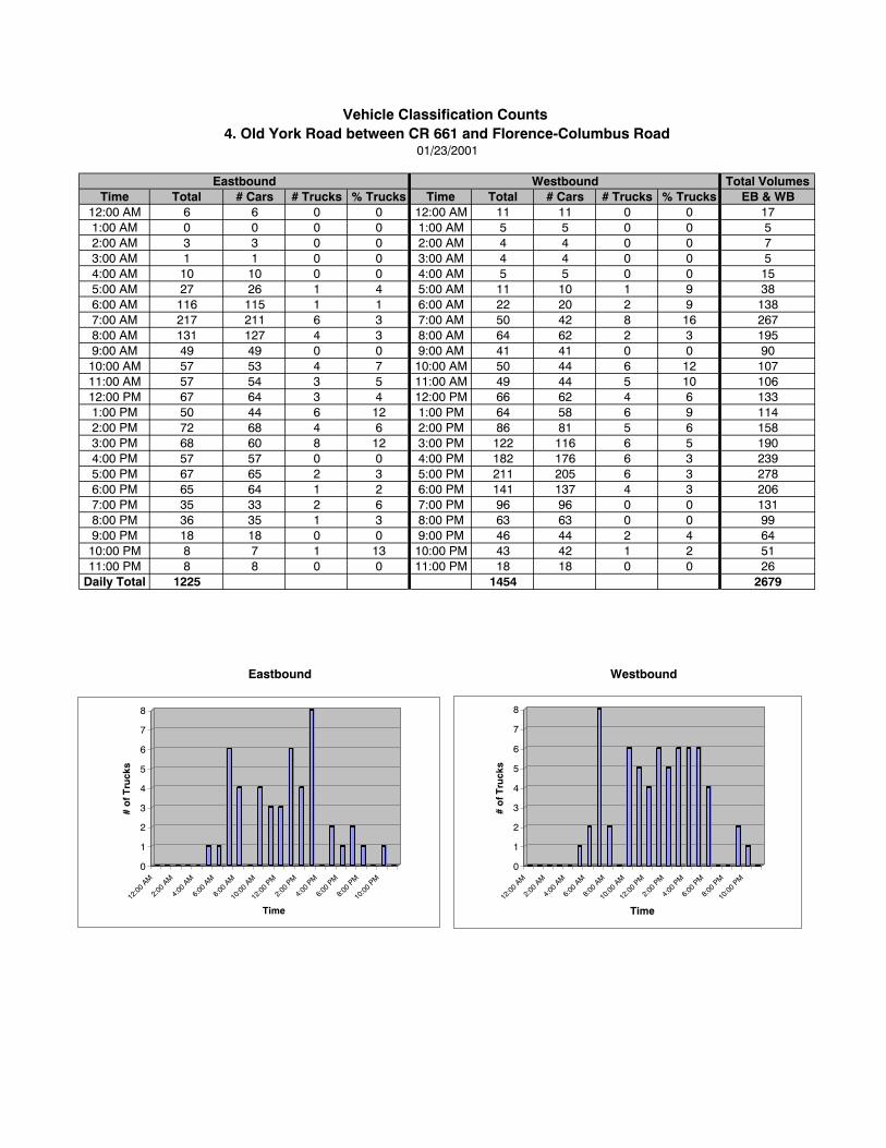
Total VolumesTime Total # Cars # Trucks % Trucks Time Total # Cars # Trucks % Trucks EB & WB
12:00 AM 6 6 0 0 12:00 AM 11 11 0 0 171:00 AM 0 0 0 0 1:00 AM 5 5 0 0 52:00 AM 3 3 0 0 2:00 AM 4 4 0 0 73:00 AM 1 1 0 0 3:00 AM 4 4 0 0 54:00 AM 10 10 0 0 4:00 AM 5 5 0 0 155:00 AM 27 26 1 4 5:00 AM 11 10 1 9 386:00 AM 116 115 1 1 6:00 AM 22 20 2 9 1387:00 AM 217 211 6 3 7:00 AM 50 42 8 16 2678:00 AM 131 127 4 3 8:00 AM 64 62 2 3 1959:00 AM 49 49 0 0 9:00 AM 41 41 0 0 9010:00 AM 57 53 4 7 10:00 AM 50 44 6 12 10711:00 AM 57 54 3 5 11:00 AM 49 44 5 10 10612:00 PM 67 64 3 4 12:00 PM 66 62 4 6 1331:00 PM 50 44 6 12 1:00 PM 64 58 6 9 1142:00 PM 72 68 4 6 2:00 PM 86 81 5 6 1583:00 PM 68 60 8 12 3:00 PM 122 116 6 5 1904:00 PM 57 57 0 0 4:00 PM 182 176 6 3 2395:00 PM 67 65 2 3 5:00 PM 211 205 6 3 2786:00 PM 65 64 1 2 6:00 PM 141 137 4 3 2067:00 PM 35 33 2 6 7:00 PM 96 96 0 0 1318:00 PM 36 35 1 3 8:00 PM 63 63 0 0 999:00 PM 18 18 0 0 9:00 PM 46 44 2 4 6410:00 PM 8 7 1 13 10:00 PM 43 42 1 2 5111:00 PM 8 8 0 0 11:00 PM 18 18 0 0 26
Daily Total 1225 1454 2679
Eastbound Westbound
Vehicle Classification Counts 4. Old York Road between CR 661 and Florence-Columbus Road
01/23/2001
Eastbound Westbound
0
1
2
3
4
5
6
7
8
# o
f Tru
cks
12:00
AM
2:00
AM
4:00
AM
6:00
AM
8:00
AM
10:00
AM
12:00
PM
2:00
PM
4:00
PM
6:00
PM
8:00
PM
10:00
PM
Time
0
1
2
3
4
5
6
7
8
# o
f Tru
cks
12:00
AM
2:00
AM
4:00
AM
6:00
AM
8:00
AM
10:00
AM
12:00
PM
2:00
PM
4:00
PM
6:00
PM
8:00
PM
10:00
PM
Time
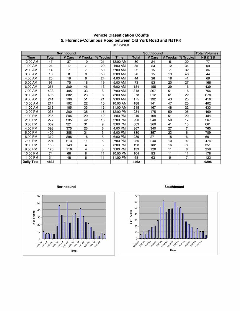
Total VolumesTime Total # Cars # Trucks % Trucks Time Total # Cars # Trucks % Trucks NB & SB
12:00 AM 47 37 10 21 12:00 AM 30 24 6 20 771:00 AM 24 17 7 29 1:00 AM 35 23 12 34 592:00 AM 14 7 7 50 2:00 AM 22 15 7 32 363:00 AM 16 8 8 50 3:00 AM 28 15 13 46 444:00 AM 25 19 6 24 4:00 AM 44 26 18 41 695:00 AM 93 75 18 19 5:00 AM 73 53 20 27 1666:00 AM 255 209 46 18 6:00 AM 184 155 29 16 4397:00 AM 438 405 33 8 7:00 AM 318 267 51 16 7568:00 AM 405 382 23 6 8:00 AM 273 212 61 22 6789:00 AM 241 190 51 21 9:00 AM 175 132 43 25 41610:00 AM 214 192 22 10 10:00 AM 188 141 47 25 40211:00 AM 218 185 33 15 11:00 AM 215 167 48 22 43312:00 PM 235 200 35 15 12:00 PM 234 175 59 25 4691:00 PM 235 206 29 12 1:00 PM 249 198 51 20 4842:00 PM 277 235 42 15 2:00 PM 290 240 50 17 5673:00 PM 352 321 31 9 3:00 PM 309 268 41 13 6614:00 PM 398 375 23 6 4:00 PM 367 340 27 7 7655:00 PM 409 388 21 5 5:00 PM 380 357 23 6 7896:00 PM 312 296 16 5 6:00 PM 289 271 18 6 6017:00 PM 224 213 11 5 7:00 PM 250 240 10 4 4748:00 PM 153 149 4 3 8:00 PM 198 182 16 8 3519:00 PM 120 116 4 3 9:00 PM 139 128 11 8 25910:00 PM 74 66 8 11 10:00 PM 104 93 11 11 17811:00 PM 54 48 6 11 11:00 PM 68 63 5 7 122
Daily Total 4833 4462 9295
Vehicle Classification Counts5. Florence-Columbus Road between Old York Road and NJTPK
01/23/2001
Northbound Southbound
Northbound Southbound
0
10
20
30
40
50
60
# o
f Tru
cks
12:0
0 AM
2:00
AM
4:00
AM
6:00
AM
8:00
AM
10:0
0 AM
12:0
0 PM
2:00
PM
4:00
PM
6:00
PM
8:00
PM
10:0
0 PM
Time
0
10
20
30
40
50
60
70
# o
f Tru
cks
12:0
0 AM
2:00
AM
4:00
AM
6:00
AM
8:00
AM
10:0
0 AM
12:0
0 PM
2:00
PM
4:00
PM
6:00
PM
8:00
PM
10:0
0 PM
Time
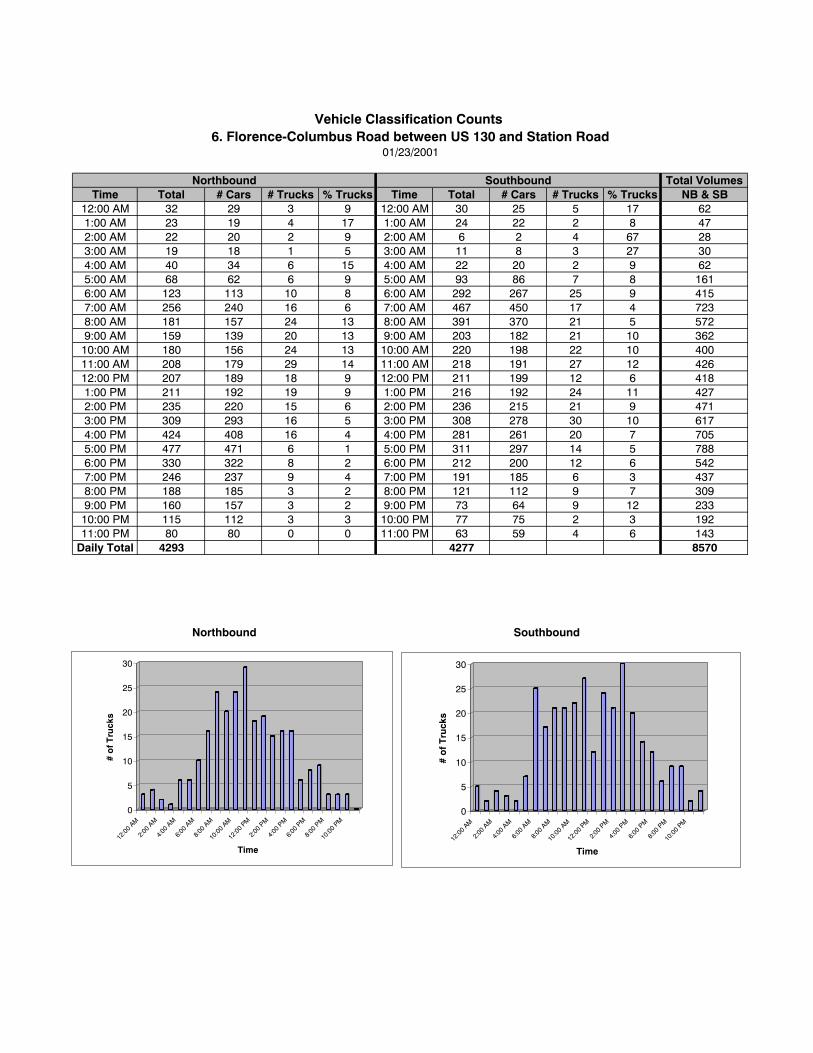
Total VolumesTime Total # Cars # Trucks % Trucks Time Total # Cars # Trucks % Trucks NB & SB
12:00 AM 32 29 3 9 12:00 AM 30 25 5 17 621:00 AM 23 19 4 17 1:00 AM 24 22 2 8 472:00 AM 22 20 2 9 2:00 AM 6 2 4 67 283:00 AM 19 18 1 5 3:00 AM 11 8 3 27 304:00 AM 40 34 6 15 4:00 AM 22 20 2 9 625:00 AM 68 62 6 9 5:00 AM 93 86 7 8 1616:00 AM 123 113 10 8 6:00 AM 292 267 25 9 4157:00 AM 256 240 16 6 7:00 AM 467 450 17 4 7238:00 AM 181 157 24 13 8:00 AM 391 370 21 5 5729:00 AM 159 139 20 13 9:00 AM 203 182 21 10 36210:00 AM 180 156 24 13 10:00 AM 220 198 22 10 40011:00 AM 208 179 29 14 11:00 AM 218 191 27 12 42612:00 PM 207 189 18 9 12:00 PM 211 199 12 6 4181:00 PM 211 192 19 9 1:00 PM 216 192 24 11 4272:00 PM 235 220 15 6 2:00 PM 236 215 21 9 4713:00 PM 309 293 16 5 3:00 PM 308 278 30 10 6174:00 PM 424 408 16 4 4:00 PM 281 261 20 7 7055:00 PM 477 471 6 1 5:00 PM 311 297 14 5 7886:00 PM 330 322 8 2 6:00 PM 212 200 12 6 5427:00 PM 246 237 9 4 7:00 PM 191 185 6 3 4378:00 PM 188 185 3 2 8:00 PM 121 112 9 7 3099:00 PM 160 157 3 2 9:00 PM 73 64 9 12 23310:00 PM 115 112 3 3 10:00 PM 77 75 2 3 19211:00 PM 80 80 0 0 11:00 PM 63 59 4 6 143
Daily Total 4293 4277 8570
Vehicle Classification Counts 6. Florence-Columbus Road between US 130 and Station Road
01/23/2001
Northbound Southbound
SouthboundNorthbound
0
5
10
15
20
25
30
# o
f Tru
cks
12:0
0 AM
2:00
AM
4:00
AM
6:00
AM
8:00
AM
10:0
0 AM
12:0
0 PM
2:00
PM
4:00
PM
6:00
PM
8:00
PM
10:0
0 PM
Time
0
5
10
15
20
25
30
# o
f T
ruck
s
12:0
0 AM
2:00
AM
4:00
AM
6:00
AM
8:00
AM
10:0
0 AM
12:0
0 PM
2:00
PM
4:00
PM
6:00
PM
8:00
PM
10:0
0 PM
Time
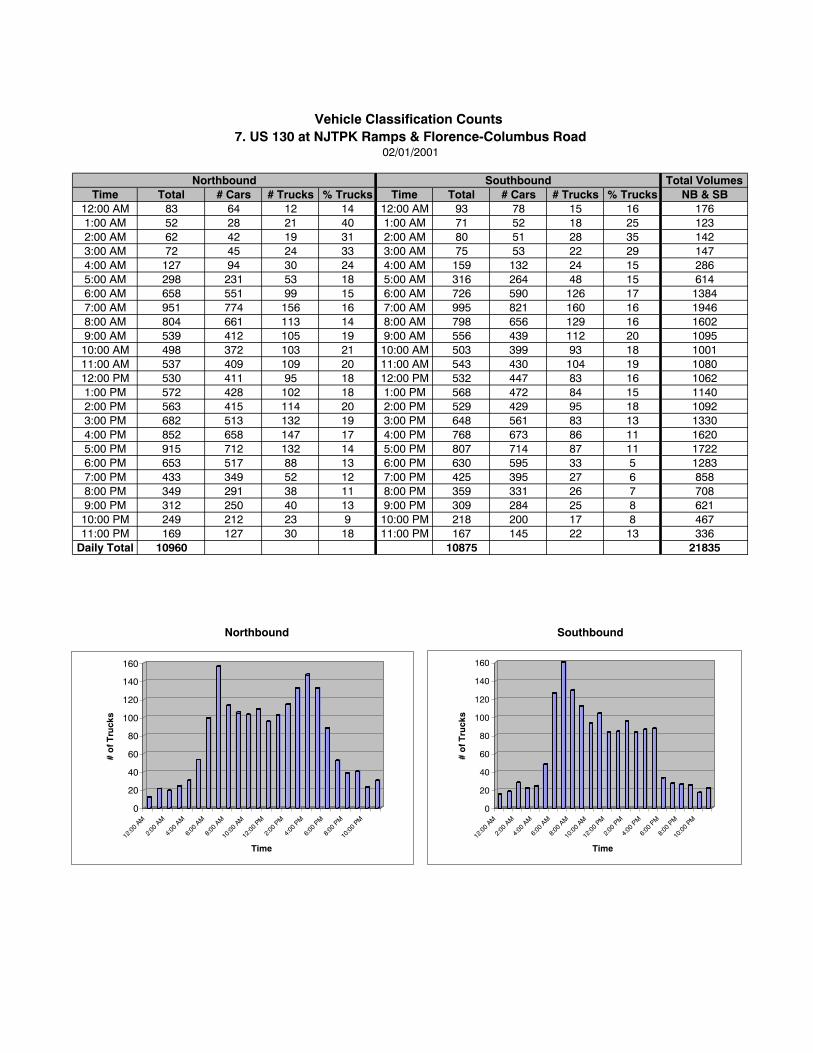
Total VolumesTime Total # Cars # Trucks % Trucks Time Total # Cars # Trucks % Trucks NB & SB
12:00 AM 83 64 12 14 12:00 AM 93 78 15 16 1761:00 AM 52 28 21 40 1:00 AM 71 52 18 25 1232:00 AM 62 42 19 31 2:00 AM 80 51 28 35 1423:00 AM 72 45 24 33 3:00 AM 75 53 22 29 1474:00 AM 127 94 30 24 4:00 AM 159 132 24 15 2865:00 AM 298 231 53 18 5:00 AM 316 264 48 15 6146:00 AM 658 551 99 15 6:00 AM 726 590 126 17 13847:00 AM 951 774 156 16 7:00 AM 995 821 160 16 19468:00 AM 804 661 113 14 8:00 AM 798 656 129 16 16029:00 AM 539 412 105 19 9:00 AM 556 439 112 20 109510:00 AM 498 372 103 21 10:00 AM 503 399 93 18 100111:00 AM 537 409 109 20 11:00 AM 543 430 104 19 108012:00 PM 530 411 95 18 12:00 PM 532 447 83 16 10621:00 PM 572 428 102 18 1:00 PM 568 472 84 15 11402:00 PM 563 415 114 20 2:00 PM 529 429 95 18 10923:00 PM 682 513 132 19 3:00 PM 648 561 83 13 13304:00 PM 852 658 147 17 4:00 PM 768 673 86 11 16205:00 PM 915 712 132 14 5:00 PM 807 714 87 11 17226:00 PM 653 517 88 13 6:00 PM 630 595 33 5 12837:00 PM 433 349 52 12 7:00 PM 425 395 27 6 8588:00 PM 349 291 38 11 8:00 PM 359 331 26 7 7089:00 PM 312 250 40 13 9:00 PM 309 284 25 8 62110:00 PM 249 212 23 9 10:00 PM 218 200 17 8 46711:00 PM 169 127 30 18 11:00 PM 167 145 22 13 336
Daily Total 10960 10875 21835
Vehicle Classification Counts 7. US 130 at NJTPK Ramps & Florence-Columbus Road
02/01/2001
Northbound Southbound
Northbound Southbound
0
20
40
60
80
100
120
140
160
# o
f Tru
cks
12:0
0 AM
2:00
AM
4:00
AM
6:00
AM
8:00
AM
10:0
0 AM
12:0
0 PM
2:00
PM
4:00
PM
6:00
PM
8:00
PM
10:0
0 PM
Time
0
20
40
60
80
100
120
140
160
# o
f Tru
cks
12:0
0 AM
2:00
AM
4:00
AM
6:00
AM
8:00
AM
10:0
0 AM
12:0
0 PM
2:00
PM
4:00
PM
6:00
PM
8:00
PM
10:0
0 PM
Time
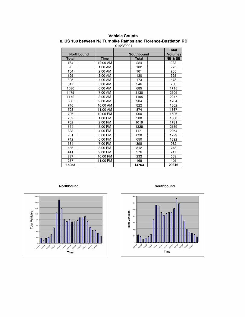
Total Southbound Volumes
Total Time Total NB & SB164 12:00 AM 224 38893 1:00 AM 182 275154 2:00 AM 101 255195 3:00 AM 130 325305 4:00 AM 173 478517 5:00 AM 246 7631030 6:00 AM 685 17151475 7:00 AM 1130 26051172 8:00 AM 1105 2277800 9:00 AM 904 1704740 10:00 AM 822 1562793 11:00 AM 874 1667726 12:00 PM 900 1626752 1:00 PM 908 1660762 2:00 PM 1019 1781864 3:00 PM 1325 2189883 4:00 PM 1171 2054901 5:00 PM 828 1729742 6:00 PM 650 1392534 7:00 PM 398 932436 8:00 PM 312 748441 9:00 PM 276 717337 10:00 PM 232 569237 11:00 PM 168 405
15053 14763 29816
Vehicle Counts 8. US 130 between NJ Turnpike Ramps and Florence-Bustleton RD
01/23/2001
Northbound
Northbound Southbound
0
200
400
600
800
1000
1200
1400
To
tal V
ehic
les
12:00
AM
2:00 A
M
4:00 A
M
6:00 A
M
8:00 A
M
10:00
AM
12:00
PM
2:00 P
M
4:00 P
M
6:00 P
M
8:00 P
M
10:00
PM
Time
0
200
400
600
800
1000
1200
1400
1600
To
tal V
ehic
les
12:00
AM
2:00 A
M
4:00 A
M
6:00 A
M
8:00 A
M
10:00
AM
12:00
PM
2:00 P
M
4:00 P
M
6:00 P
M
8:00 P
M
10:00
PM
Time
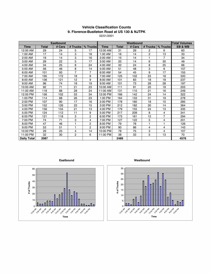
Total VolumesTime Total # Cars # Trucks % Trucks Time Total # Cars # Trucks % Trucks EB & WB
12:00 AM 29 24 5 17 12:00 AM 31 29 2 6 601:00 AM 17 14 3 18 1:00 AM 16 14 2 13 332:00 AM 19 14 3 16 2:00 AM 15 14 1 7 343:00 AM 29 22 5 17 3:00 AM 20 14 6 30 494:00 AM 34 25 8 24 4:00 AM 32 24 8 25 665:00 AM 56 46 8 14 5:00 AM 51 48 3 6 1076:00 AM 101 93 7 7 6:00 AM 54 45 9 17 1557:00 AM 195 172 18 9 7:00 AM 125 102 23 18 3208:00 AM 136 121 12 9 8:00 AM 101 83 18 18 2379:00 AM 96 74 18 19 9:00 AM 101 73 28 28 19710:00 AM 92 71 21 23 10:00 AM 111 91 20 18 20311:00 AM 118 88 28 24 11:00 AM 131 110 21 16 24912:00 PM 156 102 53 34 12:00 PM 166 142 24 14 3221:00 PM 114 88 26 23 1:00 PM 164 133 31 19 2782:00 PM 107 90 17 16 2:00 PM 178 160 18 10 2853:00 PM 152 126 23 15 3:00 PM 212 182 30 14 3644:00 PM 156 134 21 13 4:00 PM 179 155 24 13 3355:00 PM 124 112 11 9 5:00 PM 217 209 8 4 3416:00 PM 121 118 3 2 6:00 PM 173 161 12 7 2947:00 PM 74 71 3 4 7:00 PM 127 122 5 4 2018:00 PM 47 46 1 2 8:00 PM 79 78 1 1 1269:00 PM 53 51 1 2 9:00 PM 90 86 4 4 14310:00 PM 29 25 4 14 10:00 PM 78 75 3 4 10711:00 PM 32 30 2 6 11:00 PM 38 33 5 13 70
Daily Total 2087 2489 4576
Vehicle Classification Counts9. Florence-Bustleton Road at US 130 & NJTPK
02/01/2001
Eastbound Westbound
WestboundEastbound
0
10
20
30
40
50
60
# o
f Tru
cks
12:00
AM
2:00
AM
4:00
AM
6:00
AM
8:00
AM
10:00
AM
12:00
PM
2:00
PM
4:00
PM
6:00
PM
8:00
PM
10:00
PM
Time
0
5
10
15
20
25
30
35
# o
f Tru
cks
12:00
AM
2:00
AM
4:00
AM
6:00
AM
8:00
AM
10:00
AM
12:00
PM
2:00
PM
4:00
PM
6:00
PM
8:00
PM
10:00
PM
Time
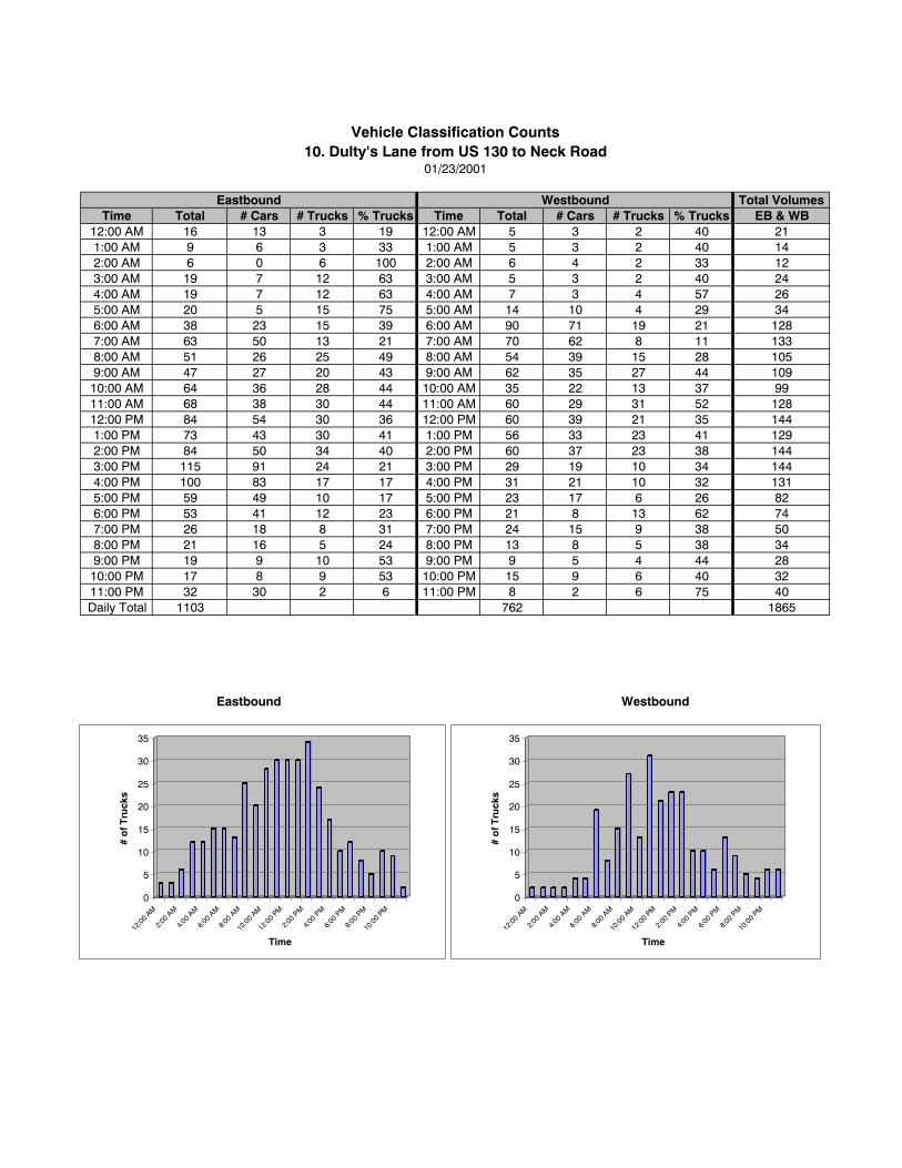
Total VolumesTime Total # Cars # Trucks % Trucks Time Total # Cars # Trucks % Trucks EB & WB
12:00 AM 16 13 3 19 12:00 AM 5 3 2 40 211:00 AM 9 6 3 33 1:00 AM 5 3 2 40 142:00 AM 6 0 6 100 2:00 AM 6 4 2 33 123:00 AM 19 7 12 63 3:00 AM 5 3 2 40 244:00 AM 19 7 12 63 4:00 AM 7 3 4 57 265:00 AM 20 5 15 75 5:00 AM 14 10 4 29 346:00 AM 38 23 15 39 6:00 AM 90 71 19 21 1287:00 AM 63 50 13 21 7:00 AM 70 62 8 11 1338:00 AM 51 26 25 49 8:00 AM 54 39 15 28 1059:00 AM 47 27 20 43 9:00 AM 62 35 27 44 10910:00 AM 64 36 28 44 10:00 AM 35 22 13 37 9911:00 AM 68 38 30 44 11:00 AM 60 29 31 52 12812:00 PM 84 54 30 36 12:00 PM 60 39 21 35 1441:00 PM 73 43 30 41 1:00 PM 56 33 23 41 1292:00 PM 84 50 34 40 2:00 PM 60 37 23 38 1443:00 PM 115 91 24 21 3:00 PM 29 19 10 34 1444:00 PM 100 83 17 17 4:00 PM 31 21 10 32 1315:00 PM 59 49 10 17 5:00 PM 23 17 6 26 826:00 PM 53 41 12 23 6:00 PM 21 8 13 62 747:00 PM 26 18 8 31 7:00 PM 24 15 9 38 508:00 PM 21 16 5 24 8:00 PM 13 8 5 38 349:00 PM 19 9 10 53 9:00 PM 9 5 4 44 2810:00 PM 17 8 9 53 10:00 PM 15 9 6 40 3211:00 PM 32 30 2 6 11:00 PM 8 2 6 75 40Daily Total 1103 762 1865
Vehicle Classification Counts10. Dulty's Lane from US 130 to Neck Road
01/23/2001
Eastbound Westbound
Eastbound Westbound
0
5
10
15
20
25
30
35
# o
f Tru
cks
12:0
0 AM
2:00
AM
4:00
AM
6:00
AM
8:00
AM
10:0
0 AM
12:0
0 PM
2:00
PM
4:00
PM
6:00
PM
8:00
PM
10:0
0 PM
Time
0
5
10
15
20
25
30
35
# o
f Tru
cks
12:0
0 AM
2:00
AM
4:00
AM
6:00
AM
8:00
AM
10:0
0 AM
12:0
0 PM
2:00
PM
4:00
PM
6:00
PM
8:00
PM
10:0
0 PM
Time
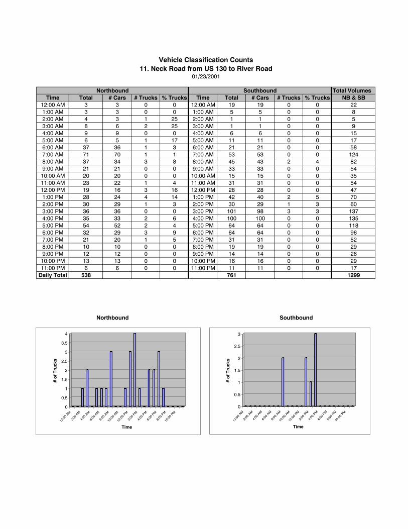
Total VolumesTime Total # Cars # Trucks % Trucks Time Total # Cars # Trucks % Trucks NB & SB
12:00 AM 3 3 0 0 12:00 AM 19 19 0 0 221:00 AM 3 3 0 0 1:00 AM 5 5 0 0 82:00 AM 4 3 1 25 2:00 AM 1 1 0 0 53:00 AM 8 6 2 25 3:00 AM 1 1 0 0 94:00 AM 9 9 0 0 4:00 AM 6 6 0 0 155:00 AM 6 5 1 17 5:00 AM 11 11 0 0 176:00 AM 37 36 1 3 6:00 AM 21 21 0 0 587:00 AM 71 70 1 1 7:00 AM 53 53 0 0 1248:00 AM 37 34 3 8 8:00 AM 45 43 2 4 829:00 AM 21 21 0 0 9:00 AM 33 33 0 0 5410:00 AM 20 20 0 0 10:00 AM 15 15 0 0 3511:00 AM 23 22 1 4 11:00 AM 31 31 0 0 5412:00 PM 19 16 3 16 12:00 PM 28 28 0 0 471:00 PM 28 24 4 14 1:00 PM 42 40 2 5 702:00 PM 30 29 1 3 2:00 PM 30 29 1 3 603:00 PM 36 36 0 0 3:00 PM 101 98 3 3 1374:00 PM 35 33 2 6 4:00 PM 100 100 0 0 1355:00 PM 54 52 2 4 5:00 PM 64 64 0 0 1186:00 PM 32 29 3 9 6:00 PM 64 64 0 0 967:00 PM 21 20 1 5 7:00 PM 31 31 0 0 528:00 PM 10 10 0 0 8:00 PM 19 19 0 0 299:00 PM 12 12 0 0 9:00 PM 14 14 0 0 2610:00 PM 13 13 0 0 10:00 PM 16 16 0 0 2911:00 PM 6 6 0 0 11:00 PM 11 11 0 0 17
Daily Total 538 761 1299
Vehicle Classification Counts11. Neck Road from US 130 to River Road
01/23/2001
Northbound Southbound
Northbound Southbound
0
0.5
1
1.5
2
2.5
3
3.5
4
# o
f Tru
cks
12:0
0 AM
2:00
AM
4:00
AM
6:00
AM
8:00
AM
10:0
0 AM
12:0
0 PM
2:00
PM
4:00
PM
6:00
PM
8:00
PM
10:0
0 PM
Time
0
0.5
1
1.5
2
2.5
3
# o
f Tru
cks
12:0
0 AM
2:00
AM
4:00
AM
6:00
AM
8:00
AM
10:0
0 AM
12:0
0 PM
2:00
PM
4:00
PM
6:00
PM
8:00
PM
10:0
0 PM
Time
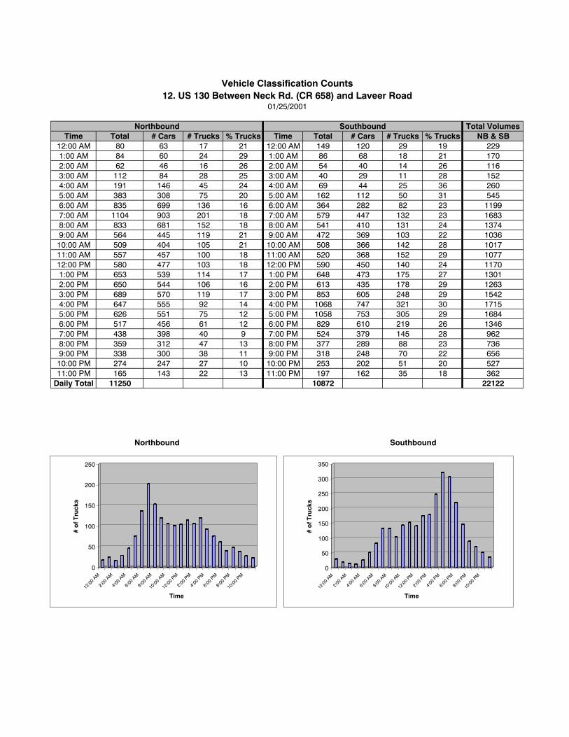
Total VolumesTime Total # Cars # Trucks % Trucks Time Total # Cars # Trucks % Trucks NB & SB
12:00 AM 80 63 17 21 12:00 AM 149 120 29 19 2291:00 AM 84 60 24 29 1:00 AM 86 68 18 21 1702:00 AM 62 46 16 26 2:00 AM 54 40 14 26 1163:00 AM 112 84 28 25 3:00 AM 40 29 11 28 1524:00 AM 191 146 45 24 4:00 AM 69 44 25 36 2605:00 AM 383 308 75 20 5:00 AM 162 112 50 31 5456:00 AM 835 699 136 16 6:00 AM 364 282 82 23 11997:00 AM 1104 903 201 18 7:00 AM 579 447 132 23 16838:00 AM 833 681 152 18 8:00 AM 541 410 131 24 13749:00 AM 564 445 119 21 9:00 AM 472 369 103 22 103610:00 AM 509 404 105 21 10:00 AM 508 366 142 28 101711:00 AM 557 457 100 18 11:00 AM 520 368 152 29 107712:00 PM 580 477 103 18 12:00 PM 590 450 140 24 11701:00 PM 653 539 114 17 1:00 PM 648 473 175 27 13012:00 PM 650 544 106 16 2:00 PM 613 435 178 29 12633:00 PM 689 570 119 17 3:00 PM 853 605 248 29 15424:00 PM 647 555 92 14 4:00 PM 1068 747 321 30 17155:00 PM 626 551 75 12 5:00 PM 1058 753 305 29 16846:00 PM 517 456 61 12 6:00 PM 829 610 219 26 13467:00 PM 438 398 40 9 7:00 PM 524 379 145 28 9628:00 PM 359 312 47 13 8:00 PM 377 289 88 23 7369:00 PM 338 300 38 11 9:00 PM 318 248 70 22 65610:00 PM 274 247 27 10 10:00 PM 253 202 51 20 52711:00 PM 165 143 22 13 11:00 PM 197 162 35 18 362
Daily Total 11250 10872 22122
Vehicle Classification Counts12. US 130 Between Neck Rd. (CR 658) and Laveer Road
01/25/2001
Northbound Southbound
Northbound Southbound
0
50
100
150
200
250
# o
f Tru
cks
12:00
AM
2:00
AM
4:00
AM
6:00
AM
8:00
AM
10:00
AM
12:00
PM
2:00
PM
4:00
PM
6:00
PM
8:00
PM
10:00
PM
Time
0
50
100
150
200
250
300
350
# o
f Tru
cks
12:0
0 AM
2:00
AM
4:00
AM
6:00
AM
8:00
AM
10:0
0 AM
12:0
0 PM
2:00
PM
4:00
PM
6:00
PM
8:00
PM
10:0
0 PM
Time
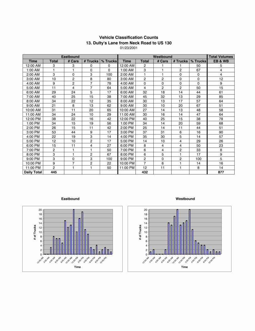
Total VolumesTime Total # Cars # Trucks % Trucks Time Total # Cars # Trucks % Trucks EB & WB
12:00 AM 3 3 0 0 12:00 AM 2 1 1 50 51:00 AM 1 1 0 0 1:00 AM 3 1 2 67 42:00 AM 3 0 3 100 2:00 AM 1 1 0 0 43:00 AM 10 2 8 80 3:00 AM 2 2 0 0 124:00 AM 9 2 7 78 4:00 AM 0 0 0 0 95:00 AM 11 4 7 64 5:00 AM 4 2 2 50 156:00 AM 29 24 5 17 6:00 AM 32 18 14 44 617:00 AM 40 25 15 38 7:00 AM 45 32 13 29 858:00 AM 34 22 12 35 8:00 AM 30 13 17 57 649:00 AM 21 8 13 62 9:00 AM 30 10 20 67 5110:00 AM 31 11 20 65 10:00 AM 27 14 13 48 5811:00 AM 34 24 10 29 11:00 AM 30 16 14 47 6412:00 PM 38 22 16 42 12:00 PM 40 25 15 38 781:00 PM 34 15 19 56 1:00 PM 34 14 20 59 682:00 PM 26 15 11 42 2:00 PM 25 14 11 44 513:00 PM 53 44 9 17 3:00 PM 37 31 6 16 904:00 PM 22 19 3 14 4:00 PM 35 30 5 14 575:00 PM 12 10 2 17 5:00 PM 14 10 4 29 266:00 PM 15 11 4 27 6:00 PM 8 4 4 50 237:00 PM 2 1 1 50 7:00 PM 6 4 2 33 88:00 PM 3 1 2 67 8:00 PM 6 5 1 17 99:00 PM 3 0 3 100 9:00 PM 2 0 2 100 510:00 PM 9 7 2 22 10:00 PM 7 6 1 14 1611:00 PM 2 1 1 50 11:00 PM 12 11 1 8 14
Daily Total 445 432 877
Eastbound Westbound
01/23/2001
Eastbound Westbound
Vehicle Classification Counts13. Dulty's Lane from Neck Road to US 130
0
2
4
6
8
10
12
14
16
18
20
# o
f Tru
cks
12:0
0 AM
2:00
AM
4:00
AM
6:00
AM
8:00
AM
10:0
0 AM
12:0
0 PM
2:00
PM
4:00
PM
6:00
PM
8:00
PM
10:0
0 PM
Time
0
2
4
6
8
10
12
14
16
18
20
# o
f Tru
cks
12:0
0 AM
2:00
AM
4:00
AM
6:00
AM
8:00
AM
10:0
0 AM
12:0
0 PM
2:00
PM
4:00
PM
6:00
PM
8:00
PM
10:0
0 PM
Time
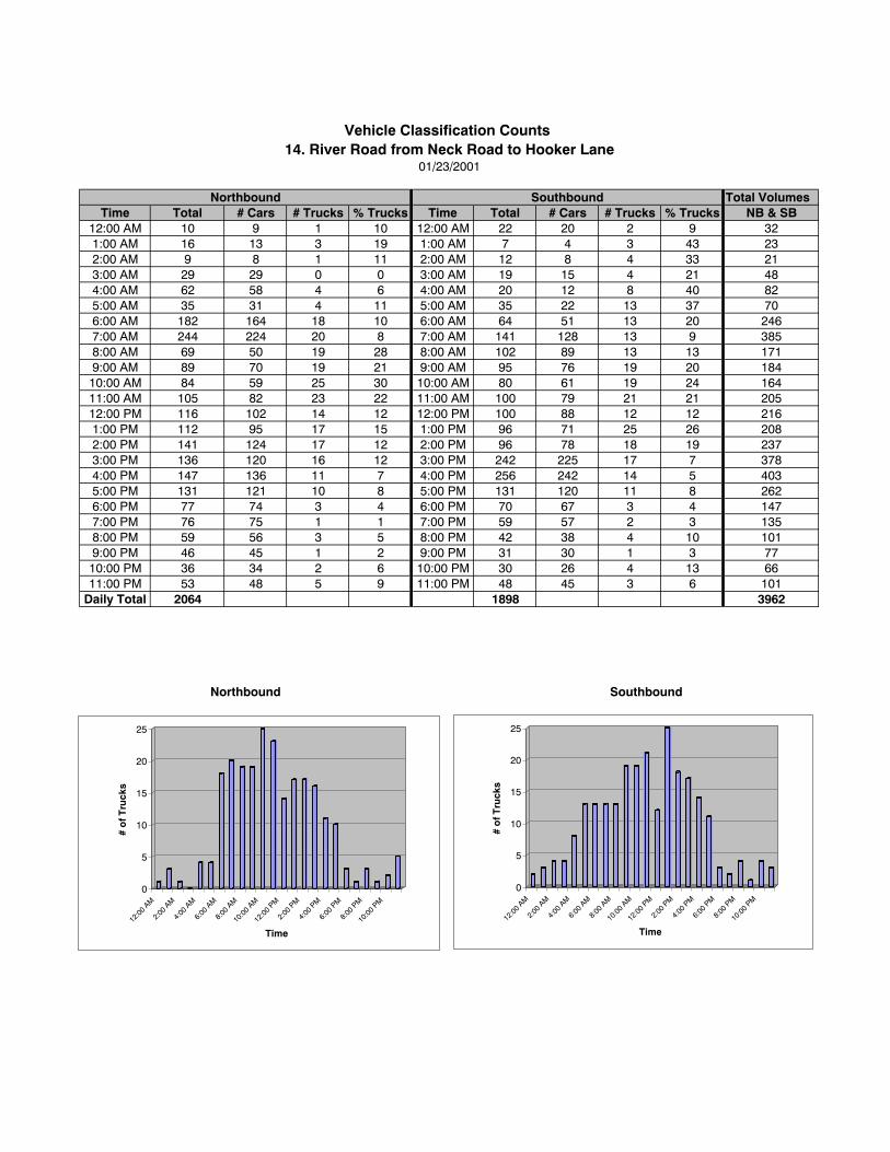
Total VolumesTime Total # Cars # Trucks % Trucks Time Total # Cars # Trucks % Trucks NB & SB
12:00 AM 10 9 1 10 12:00 AM 22 20 2 9 321:00 AM 16 13 3 19 1:00 AM 7 4 3 43 232:00 AM 9 8 1 11 2:00 AM 12 8 4 33 213:00 AM 29 29 0 0 3:00 AM 19 15 4 21 484:00 AM 62 58 4 6 4:00 AM 20 12 8 40 825:00 AM 35 31 4 11 5:00 AM 35 22 13 37 706:00 AM 182 164 18 10 6:00 AM 64 51 13 20 2467:00 AM 244 224 20 8 7:00 AM 141 128 13 9 3858:00 AM 69 50 19 28 8:00 AM 102 89 13 13 1719:00 AM 89 70 19 21 9:00 AM 95 76 19 20 18410:00 AM 84 59 25 30 10:00 AM 80 61 19 24 16411:00 AM 105 82 23 22 11:00 AM 100 79 21 21 20512:00 PM 116 102 14 12 12:00 PM 100 88 12 12 2161:00 PM 112 95 17 15 1:00 PM 96 71 25 26 2082:00 PM 141 124 17 12 2:00 PM 96 78 18 19 2373:00 PM 136 120 16 12 3:00 PM 242 225 17 7 3784:00 PM 147 136 11 7 4:00 PM 256 242 14 5 4035:00 PM 131 121 10 8 5:00 PM 131 120 11 8 2626:00 PM 77 74 3 4 6:00 PM 70 67 3 4 1477:00 PM 76 75 1 1 7:00 PM 59 57 2 3 1358:00 PM 59 56 3 5 8:00 PM 42 38 4 10 1019:00 PM 46 45 1 2 9:00 PM 31 30 1 3 7710:00 PM 36 34 2 6 10:00 PM 30 26 4 13 6611:00 PM 53 48 5 9 11:00 PM 48 45 3 6 101
Daily Total 2064 1898 3962
01/23/2001
Northbound Southbound
Northbound Southbound
Vehicle Classification Counts 14. River Road from Neck Road to Hooker Lane
0
5
10
15
20
25
# o
f Tru
cks
12:00
AM
2:00
AM
4:00
AM
6:00
AM
8:00
AM
10:00
AM
12:00
PM
2:00
PM
4:00
PM
6:00
PM
8:00
PM
10:00
PM
Time
0
5
10
15
20
25
# o
f Tru
cks
12:00
AM
2:00
AM
4:00
AM
6:00
AM
8:00
AM
10:00
AM
12:00
PM
2:00
PM
4:00
PM
6:00
PM
8:00
PM
10:00
PM
Time
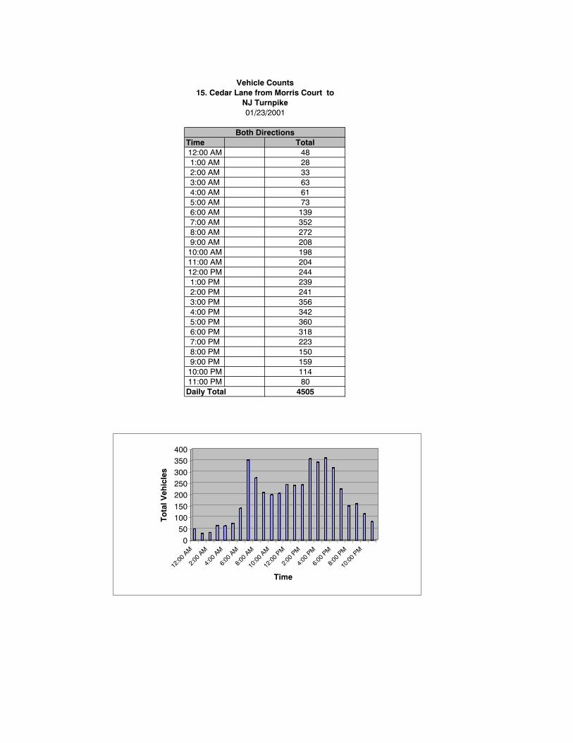
Time12:00 AM1:00 AM2:00 AM3:00 AM4:00 AM5:00 AM6:00 AM7:00 AM8:00 AM9:00 AM10:00 AM11:00 AM12:00 PM1:00 PM2:00 PM3:00 PM4:00 PM5:00 PM6:00 PM7:00 PM8:00 PM9:00 PM10:00 PM11:00 PMDaily Total
Total
Vehicle Counts15. Cedar Lane from Morris Court to
NJ Turnpike01/23/2001
Both Directions
63332848
3521397361
204198208272
450580114159150223318360342356241239244
0
50100150
200250300
350400
To
tal V
ehic
les
12:00
AM
2:00
AM
4:00
AM
6:00
AM
8:00
AM
10:00
AM
12:00
PM
2:00
PM
4:00
PM
6:00
PM
8:00
PM
10:00
PM
Time


Title of Report: US 130/NJ Turnpike Area Infrastructure Needs Analysis
Publication No.: 01019
Date Published: June 2001
Geographic Area Covered: The study area includes or is adjacent to the following Burlington County municipalities: Burlington Township, FlorenceTownship and Mansfield Township.
Key Words: traffic counts, classification counts, intersection analysis, improvement options, truck volumes, station access, tripgenerators, posted speed limit, at-grade crossing, sight distance, hazard identification beacon, speed limit, signalizedintersection
ABSTRACT:In March 2000, New Jersey Turnpike Authority completed a new interchange (6A) between US 130 and the New JerseyTurnpike Pennsylvania Extension in Florence Township, Burlington County. This is a full service interchange whichreplaces the old Exit 6A. There are large tracts of undeveloped land available for commercial and light industrialdevelopment within the vicinity of this interchange. These opportunities exist primarily at the 660 acre Haines IndustrialPark currently being developed immediately adjacent to the interchange and on several hundred additional acres in theimmediate vicinity. The Delaware Valley Regional Planning Commission was requested to assist in this effort inconducting a local impact analysis to determine the impact of the new interchange on traffic in the area. This activityfocused on developing a coordinated plan to assess the infrastructure needs created by the growth in this area. In aneffort to fulfill these objectives, the study team held separate meetings with both Florence and Burlington townships todetermine their concerns and plans for the future of this area. This, along with Burlington County’s vision, helped toidentify a coordinated action plan for the study area. This report documents the study recommendations for coordinatingthe transportation and circulation infrastructure improvements in the study area.
Delaware Valley Regional Planning Commission8th Floor — The Bourse Building111 South Independence Mall EastPhiladelphia, PA 19106-2582
Phone: 215-592-1800Fax: 215-592-9125Internet: www.dvrpc.org
Staff contacts: Direct phone: E-mail:Kevin Murphy, Project Planner 215-238-2864 [email protected] Anderson, Project Planner 215-238-2835 [email protected] Ward, Project Manager 215-238-2899 [email protected]
DELAWARE VALLEY REGIONAL PLANNING COMMISSION
J U N E 2 0 0 1
The Bourse Building, 8th Floor
111 South Independence Mall East
Philadelphia, PA 19106-2582
215.592.1800
www.dvrpc.org