
Urban Design Guidelines - Chesapeake, VirginiaUrban Design Guidelines The Urban Design Guidelines...
8
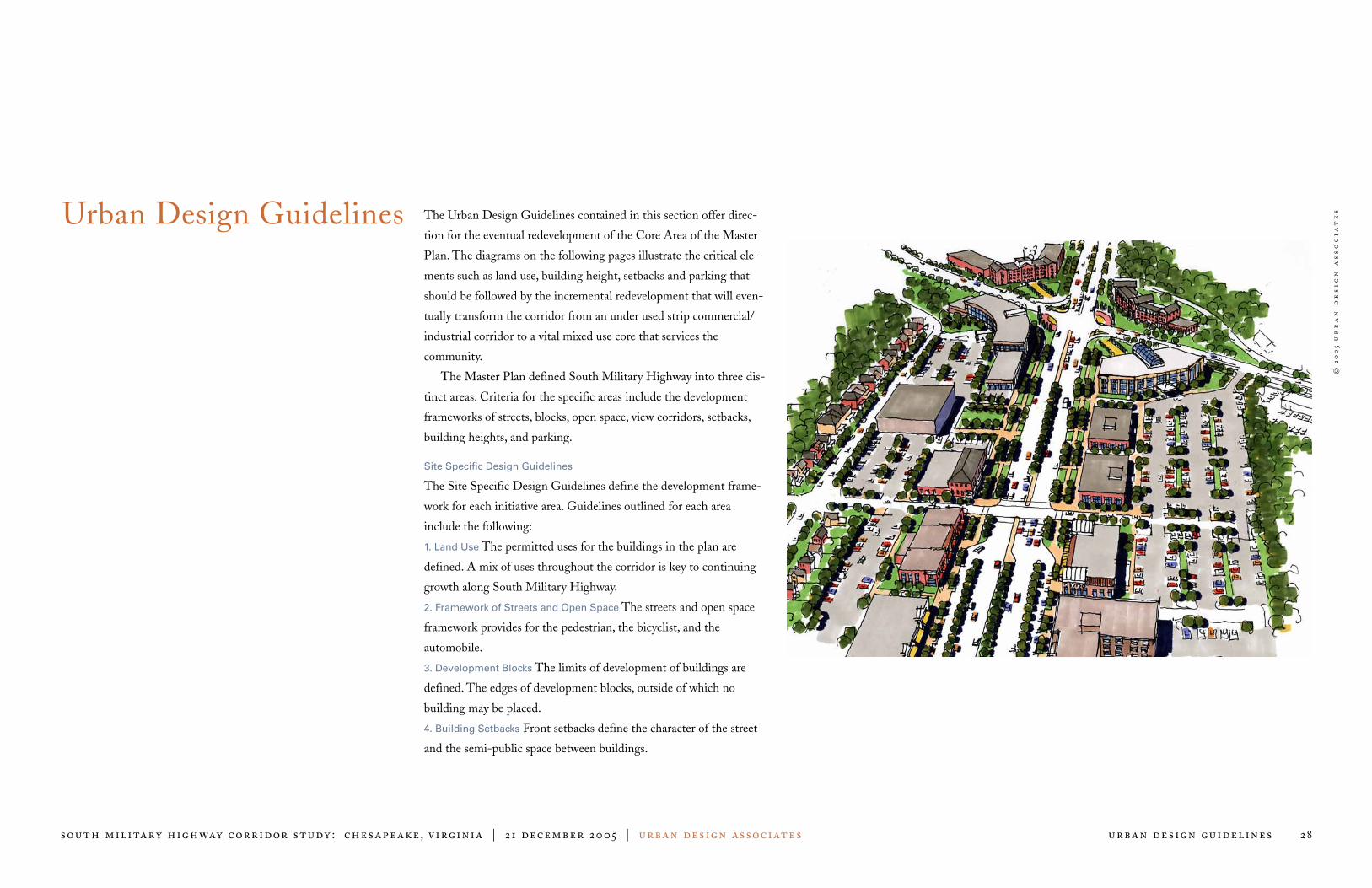
© 2005 urban design associates south military highway corridor study: chesapeake, virginia | 21 december 2005 | urban design associates urban design guidelines 28 Urban Design Guidelines The Urban Design Guidelines contained in this section offer direc- tion for the eventual redevelopment of the Core Area of the Master Plan. The diagrams on the following pages illustrate the critical ele- ments such as land use, building height, setbacks and parking that should be followed by the incremental redevelopment that will even- tually transform the corridor from an under used strip commercial/ industrial corridor to a vital mixed use core that services the community. The Master Plan defined South Military Highway into three dis- tinct areas. Criteria for the specific areas include the development frameworks of streets, blocks, open space, view corridors, setbacks, building heights, and parking. Site Specific Design Guidelines The Site Specific Design Guidelines define the development frame- work for each initiative area. Guidelines outlined for each area include the following: 1. Land Use The permitted uses for the buildings in the plan are defined. A mix of uses throughout the corridor is key to continuing growth along South Military Highway. 2. Framework of Streets and Open Space The streets and open space framework provides for the pedestrian, the bicyclist, and the automobile. 3. Development Blocks The limits of development of buildings are defined. The edges of development blocks, outside of which no building may be placed. 4. Building Setbacks Front setbacks define the character of the street and the semi-public space between buildings.
Transcript of Urban Design Guidelines - Chesapeake, VirginiaUrban Design Guidelines The Urban Design Guidelines...
©20
05
ur
ba
n d
es
ign
as
so
cia
te
s
south military highway corridor study : chesapeake, virginia | 21 december 2005 | urban design associates urban design guidelines 28
Urban Design Guidelines The Urban Design Guidelines contained in this section offer direc-
tion for the eventual redevelopment of the Core Area of the Master
Plan. The diagrams on the following pages illustrate the critical ele-
ments such as land use, building height, setbacks and parking that
should be followed by the incremental redevelopment that will even-
tually transform the corridor from an under used strip commercial/
industrial corridor to a vital mixed use core that services the
community.
The Master Plan defined South Military Highway into three dis-
tinct areas. Criteria for the specific areas include the development
frameworks of streets, blocks, open space, view corridors, setbacks,
building heights, and parking.
Site Specific Design Guidelines
The Site Specific Design Guidelines define the development frame-
work for each initiative area. Guidelines outlined for each area
include the following:
1. Land Use The permitted uses for the buildings in the plan are
defined. A mix of uses throughout the corridor is key to continuing
growth along South Military Highway.
2. Framework of Streets and Open Space The streets and open space
framework provides for the pedestrian, the bicyclist, and the
automobile.
3. Development Blocks The limits of development of buildings are
defined. The edges of development blocks, outside of which no
building may be placed.
4. Building Setbacks Front setbacks define the character of the street
and the semi-public space between buildings.
©20
05
ur
ba
n d
es
ign
as
so
cia
te
s
south military highway corridor study : chesapeake, virginia | 21 december 2005 | urban design associates urban design guidelines :land use
29
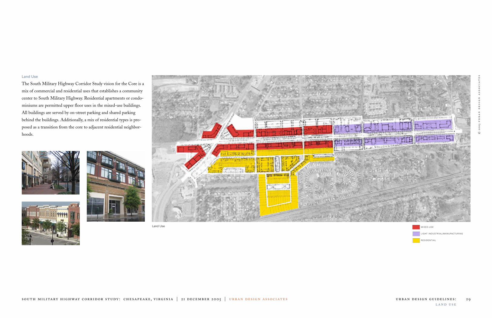
Land Use
The South Military Highway Corridor Study vision for the Core is a
mix of commercial and residential uses that establishes a community
center to South Military Highway. Residential apartments or condo-
miniums are permitted upper floor uses in the mixed-use buildings.
All buildings are served by on-street parking and shared parking
behind the buildings. Additionally, a mix of residential types is pro-
posed as a transition from the core to adjacent residential neighbor-
hoods.
Land Use MIXED-USE
LIGHT INDUSTRIAL/MANUFACTURING
RESIDENTIAL

©20
05
ur
ba
n d
es
ign
as
so
cia
te
s
south military highway corridor study : chesapeake, virginia | 21 december 2005 | urban design associates urban design guidelines :development blocks
30
Development Blocks
New streets and alleys are proposed to establish a regular block pat-
tern with multiple public access points to South Military Highway.
The organized development block pattern reduces curb cuts along
South Military Highway thereby enhancing the pedestrian
experience.
Development Blocks DEVELOPMENT BLOCKS
©20
05
ur
ba
n d
es
ign
as
so
cia
te
s
south military highway corridor study : chesapeake, virginia | 21 december 2005 | urban design associates urban design guidelines :parking
31
Parking
A variety of parking options are available. On-street parallel parking
is extremely important for the proposed retail uses. Two parking
streets are proposed to fulfill this need. Parking lots are required to be
placed at the rear of the development blocks. All parking lots are
required to be screened from the street with either buildings or land-
scaping, and shared parking lots should be accessed by side streets
and alleys.
Parking ON-STREET PARKING
SHARED COMMERCIAL PARKING
DEDICATED PARKING
©20
05
ur
ba
n d
es
ign
as
so
cia
te
s
south military highway corridor study : chesapeake, virginia | 21 december 2005 | urban design associates urban design guidelines :se tbacks
32
Setbacks
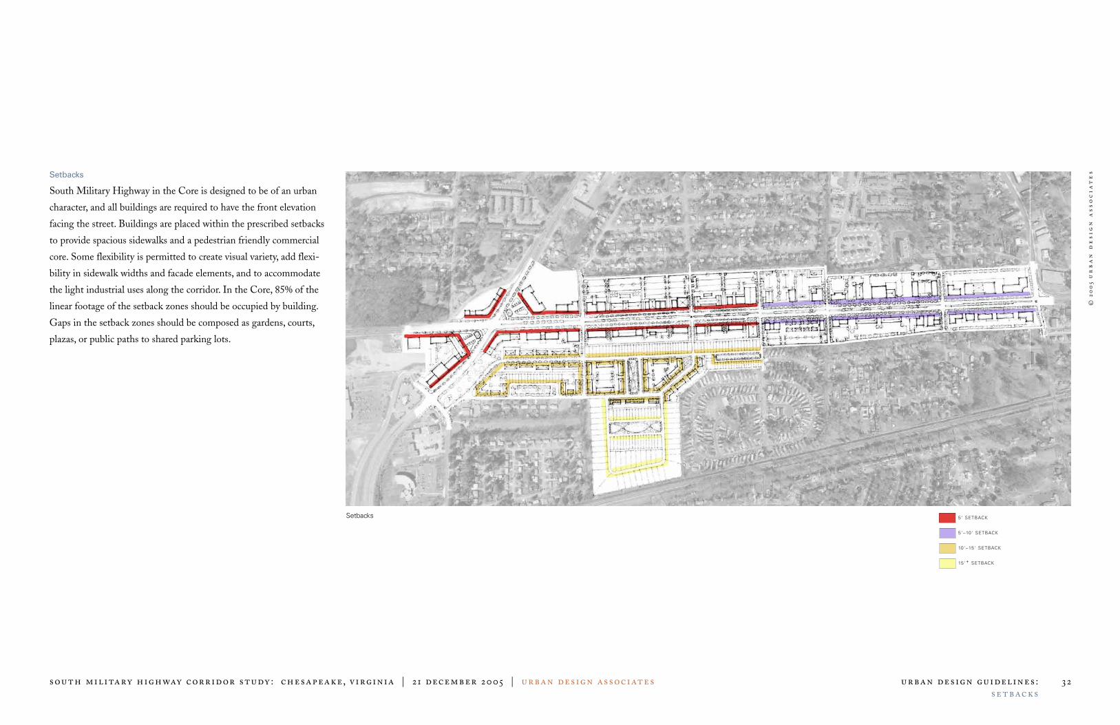
South Military Highway in the Core is designed to be of an urban
character, and all buildings are required to have the front elevation
facing the street. Buildings are placed within the prescribed setbacks
to provide spacious sidewalks and a pedestrian friendly commercial
core. Some flexibility is permitted to create visual variety, add flexi-
bility in sidewalk widths and facade elements, and to accommodate
the light industrial uses along the corridor. In the Core, 85% of the
linear footage of the setback zones should be occupied by building.
Gaps in the setback zones should be composed as gardens, courts,
plazas, or public paths to shared parking lots.
Setbacks 5' SETBACK
5'–10' SETBACK
10'–15' SETBACK
15'+ SETBACK
©20
05
ur
ba
n d
es
ign
as
so
cia
te
s
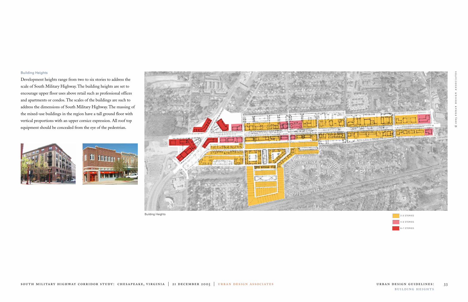
south military highway corridor study : chesapeake, virginia | 21 december 2005 | urban design associates urban design guidelines :building heights
33
Building Heights
Development heights range from two to six stories to address the
scale of South Military Highway. The building heights are set to
encourage upper floor uses above retail such as professional offices
and apartments or condos. The scales of the buildings are such to
address the dimensions of South Military Highway. The massing of
the mixed-use buildings in the region have a tall ground floor with
vertical proportions with an upper cornice expression. All roof top
equipment should be concealed from the eye of the pedestrian.
Building Heights 2–3 STORIES
4–5 STORIES
6–7 STORIES
©20
05
ur
ba
n d
es
ign
as
so
cia
te
s
south military highway corridor study : chesapeake, virginia | 21 december 2005 | urban design associates urban design guidelines :focal points and views
34
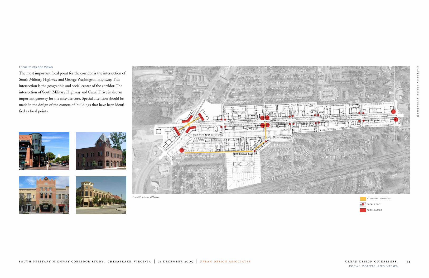
Focal Points and Views
The most important focal point for the corridor is the intersection of
South Military Highway and George Washington Highway. This
intersection is the geographic and social center of the corridor. The
intersection of South Military Highway and Canal Drive is also an
important gateway for the mix-use core. Special attention should be
made in the design of the corners of buildings that have been identi-
fied as focal points.
Focal Points and Views AXES/VIEW CORRIDORS
FOCAL POINT
FOCAL FACADE
©20
05
ur
ba
n d
es
ign
as
so
cia
te
s
south military highway corridor study : chesapeake, virginia | 21 december 2005 | urban design associates urban design guidelines :parks and open space
35
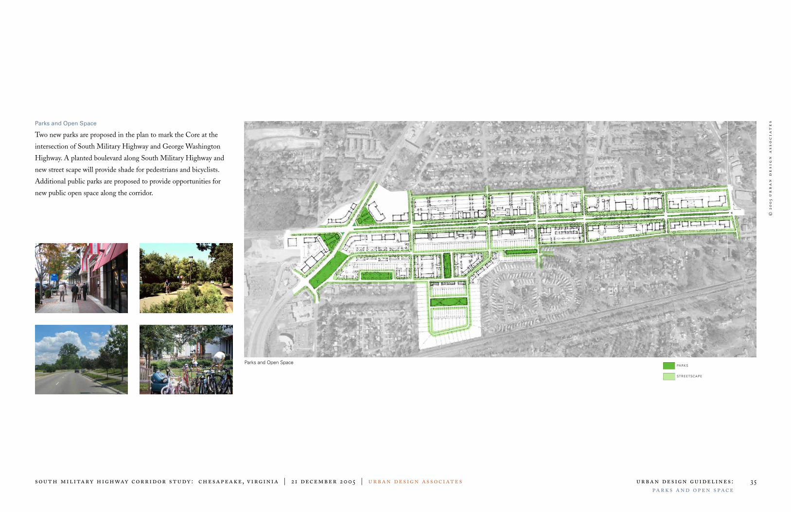
Parks and Open Space
Two new parks are proposed in the plan to mark the Core at the
intersection of South Military Highway and George Washington
Highway. A planted boulevard along South Military Highway and
new street scape will provide shade for pedestrians and bicyclists.
Additional public parks are proposed to provide opportunities for
new public open space along the corridor.
Parks and Open SpacePARKS
STREETSCAPE


