Upper Harbor Terminal Phase 1...
12
Upper Harbor Terminal Phase 1 Site Image Gallery -- Structures Aerial map showing structure locations (also see table listing structures by location; note that the office building in the lower left at the corner of Dowling and Washington is mislabeled on the map as #48 and should be #44) Information about the structures on the UHT site may be found in the following two reports: • Upper Mississippi Harbor Development Architectural/Historical Survey Report (2007) • Existing UHT Structures Study (2015)
Transcript of Upper Harbor Terminal Phase 1...
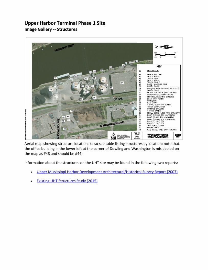
Upper Harbor Terminal Phase 1 Site Image Gallery -- Structures
Aerial map showing structure locations (also see table listing structures by location; note that the office building in the lower left at the corner of Dowling and Washington is mislabeled on the map as #48 and should be #44)
Information about the structures on the UHT site may be found in the following two reports:
• Upper Mississippi Harbor Development Architectural/Historical Survey Report (2007)
• Existing UHT Structures Study (2015)

Scanned construction drawings:
Paper copies of construction drawings for some, but not all, of the structures on the site are still in existence and have been scanned. Examples are shown below. (Note: These samples are not readable as shown below, but are more usable when viewed at full size. A copy will be provided to the selected Master Developer.)
Warehouse floor plan Warehouse elevations
12k dome (#64) and associated Site plan of grain bins, elevator (#59) and loadout shelter (#67) adjacent structures
Control building (#61) floor plan Office building (#44) floor plan

Map legend, grouped by location:
Structure # Structure name Parcel location 63 Small dome (1.8k ton capacity) 1 (SE corner)
49 North mooring cell 2 (adjacent to river, at Dowling) 64 Dome (12k ton capacity) 2 (N end) 50 North dock 2 (N end, along river edge) 69 Truck/rail dump 2 (N end, near W edge) 59 Grain bins (4), elevator tower 2 (middle) 62 Dust tanks (4) 2 (middle) 67 Loadout shelter 2 (S of 12 k dome, #64) 60 Truck dump/hoist 2 (middle, near river) 58 Rail dump 2 (middle, W edge) 61 Control building 2 (middle) 57 Conveyors 2 (middle) 51 Loading area mooring cells (3) 2 (in river) 56 Load-out tower 2 (middle, adjacent to river) 66 Dome (16k ton capacity) 2 (middle) 68 Loadout shelter 2 (between 8k and 16k domes, on S) 65 Dome (8k ton capacity) 2 (middle) 55 Shipping/receiving building 2 (N wall of warehouse) 54 Warehouse and loading docks 2 (S end) 52 South dock 2 (S end, along river edge)
53 Petroleum dock 5 (extending into river)
44 Office building 6 (NW corner) 45 Scale house 6 (N end) 46 Truck scale 6 (N end) 47 Scale house 6 (N end) 48 Truck scale 6 (N end) 72 Boiler shed 6 (N end, E side)

Domes (Parcels 1 and 2):
Looking east towards river at Dowling 1.8k ton dome viewed from southeast (river) entry to site, 1.8k ton dome (#63) to left
12k ton dome (#64)
Loadout structure (#67) on south side of 12k Interior of loadout structure (#67) ton dome (#64)

16k ton dome (#66) on left and 8k ton dome (#65) River side of loadout structure (#68) on right, with loadout structure (#68) between
Interior of largest dome (16k, #66), with SUV Interior of smallest dome (1.8k, #63), with SUV for scale for scale
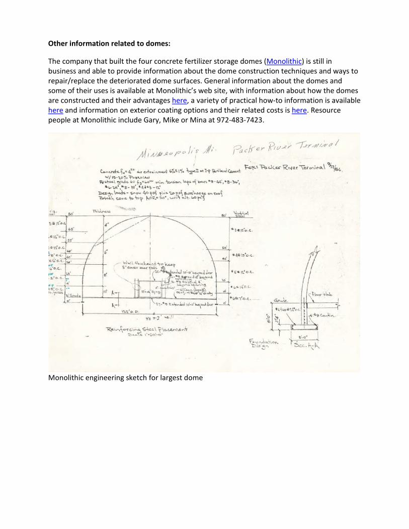
Other information related to domes:
The company that built the four concrete fertilizer storage domes (Monolithic) is still in business and able to provide information about the dome construction techniques and ways to repair/replace the deteriorated dome surfaces. General information about the domes and some of their uses is available at Monolithic’s web site, with information about how the domes are constructed and their advantages here, a variety of practical how-to information is available here and information on exterior coating options and their related costs is here. Resource people at Monolithic include Gary, Mike or Mina at 972-483-7423.
Monolithic engineering sketch for largest dome

Parcel 2:
Middle and northern portion of Parcel 2 (south of Dowling, between rail line and river) from across river. From left: 8k dome (#65), with 16k dome (#66) behind and loadout shelter (#68) between on left; grain elevator tower and silos (#59), surrounded by conveyors (#57); loadout shelter (#67) and associated 12k dome (#64); rip rap section of river edge, load-out tower (#56) and north dock (#50) in foreground
Looking northwest from location NE of warehouse: 8k ton dome (#65) on left, elevator tower and grain silos (#59) in middle surrounded by conveyors (#57), transmission line tower and load-out tower (#56) to right, with river edge on far right

Grain silo complex, conveyor system and dumps:
12k ton dome (#64) to left, with grain silos 8k ton dome (#65) to left, grain elevator and elevator (#59) in middle, looking south tower (#59) in middle, transmission tower
Two grain silos with elevator tower (#59), Control building (yellow) at left, with 16k ton dome (#66) behind to right viewed from river side
Rail dump (#58) to left, truck/rail dump Truck dump/hoist (#60) (#69) beyond, looking north

Grain elevator tower (#59) from SW Conveyor coming up from below-grade dump below rail dump (#58) to left in rear

Parcel 2 – Warehouse (#54)
Warehouse from across river; NE corner, with upriver (northern) side to right south dock (#52) in foreground Mezzanine office windows visible at corner
River edge and mooring cell (#51); with N & E SE corner of warehouse; loading dock on right; sides of warehouse; downtown skyline transmission line tower left of warehouse
Interior warehouse panorama, mezzanine office on left

Parcel 6:
Office building (#44) Washington Ave. facade Office building (#44) interior Dowling, looking Boiler shed (#72) and 12k dome (#64) behind
Original truck scale house (#45), viewed Newer scale house (#47), viewed from viewed looking towards Dowling from SW

River edge conditions:
South dock wall (#52) Rip rap section of river edge, mooring cell and
load-out tower (#56)
Load-out tower (#56) North dock (#50)
Sewer outfall at foot of Dowling River edge next to Parcel 1 and mooring cell (#49)