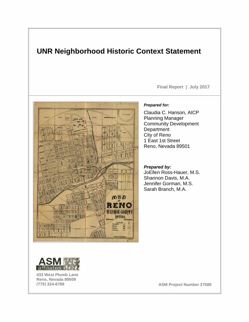
UNR Neighborhood Historic Context Statement
166
ASM Project Number 27580 Prepared for: Claudia C. Hanson, AICP Planning Manager Community Development Department City of Reno 1 East 1st Street Reno, Nevada 89501 Prepared by: JoEllen Ross-Hauer, M.S. Shannon Davis, M.A. Jennifer Gorman, M.S. Sarah Branch, M.A. UNR Neighborhood Historic Context Statement Final Report | July 2017 433 West Plumb Lane Reno, Nevada 89509 (775) 324-6789
Transcript of UNR Neighborhood Historic Context Statement
ASM Project Number 27580
Prepared for:
Claudia C. Hanson, AICPPlanning ManagerCommunity DevelopmentDepartmentCity of Reno1 East 1st StreetReno, Nevada 89501
Prepared by:JoEllen Ross-Hauer, M.S.Shannon Davis, M.A.Jennifer Gorman, M.S.Sarah Branch, M.A.
UNR Neighborhood Historic Context Statement
Final Report | July 2017
433 West Plumb LaneReno, Nevada 89509(775) 324-6789

UNR Neighborhood Historic Context Statement Prepared for: Claudia C. Hanson, AICP Planning Manager Community Development Department City of Reno 1 East 1st Street Reno, Nevada 89501 Prepared by: JoEllen Ross-Hauer, M.S. Shannon Davis, M.A. Jennifer Gorman, M.S. Sarah Branch, M.A. ASM Affiliates, Inc. 433 West Plumb Lane Reno, Nevada 89509 July 2017 PN 27580

The Historic Context Statement that is the subject of this investigation has been financed in whole or in part with federal funds from the National Park Service, U.S. Department of Interior, and administered by the State Historic Preservation Office. The contents and opinions, however, do not necessarily reflect the views or policies of the United States Department of the Interior or the State Historic Preservation Office. This program receives federal financial assistance for identification and protection of historic properties. Under Title VI of the Civil Rights Act of 1964, Section 504 of the Rehabilitation Act of 1973, and Age Discrimination Act of 1975, as amended, the U.S. Department of the Interior prohibits discrimination on the basis of race, color, national origin, disability or age in its federally assisted programs. If you believe you have been discriminated against in any program, activity, or facility as described above, or if you desire further information, please write to: Office of Equal Opportunity, National Park Service, 1849 C Street, NW, Washington, DC 20240.

Table of Contents
UNR Neighborhood Historic Context Statement i
TABLE OF CONTENTS Chapter Page SUMMARY ............................................................................................................ v
1.0 PROJECT OBJECTIVES ................................................................................ 1
2.0 METHODOLOGY ............................................................................................ 3
2.1 ELIGIBILITY CRITERIA ........................................................................................ 3 2.1.1 National Register of Historic Places Significance Criteria ............................. 3 2.1.2 City of Reno Register of Historic Places Significance Criteria ...................... 4 2.1.3 Integrity ........................................................................................................ 4
2.2 ARCHIVAL RESEARCH ....................................................................................... 5 2.3 RECONNAISSANCE SURVEY AND DATA ANALYSIS ........................................ 5 2.4 PROJECT PERSONNEL ...................................................................................... 6
3.0 HISTORIC CONTEXT STATEMENT .............................................................. 9
3.1 OVERVIEW OF RENO HISTORY ......................................................................... 9 3.1.1 Settlement and Nineteenth Century Development ........................................ 9 3.1.2 Early Twentieth-Century Development ........................................................13 3.1.3 Reno in the Post-World War II Era ..............................................................14
3.2 THEME 1: COMMUNITY DEVELOPMENT (1876-1970) ......................................15 3.2.1 Sub-theme: Establishment of the University Neighborhood (1876-1910s) ..16
Western Addition (1876) .......................................................................................16 Evans North Addition (1879-1910s) ......................................................................19 University Addition (1896-1917) ...........................................................................21 Hillside Cemetery .................................................................................................22 Ward’s Addition (1899) .........................................................................................23 Evans Northwest Addition (1906) .........................................................................23 Evans Northeast Addition (1906) ..........................................................................24 St. George Addition (1901-1930s) ........................................................................27 Anderson Addition (1902) .....................................................................................30 McKenna’s Addition (1907) ..................................................................................31 University Heights (1907-1920s) ..........................................................................31 Registration Requirements ...................................................................................32
3.2.2 Sub-theme: Early Twentieth-Century Development in the University Neighborhood (1910s-1930s) ......................................................................34
University Terrace (1916-1928) ............................................................................34 Duborg Tract, Campus Heights, Christensen’s and Edmonds Additions (1922-1928) .........................................................................................................35 Evans Vista (1928) ...............................................................................................37 Registration Requirements ...................................................................................39
3.2.3 Sub-theme: Mid-Twentieth Century Development in the University Neighborhood (1930s-1970) .......................................................................40
New Sunnyside Addition (1938-1945) ..................................................................40 University Heights (1941) .....................................................................................45 Washington Heights (1942) ..................................................................................45 Highland Terrace Housing Project (1944) .............................................................45 Miller and Pray Additions (1946)...........................................................................46 University Park (1948) ..........................................................................................46
Table of Contents
ii ASM Affiliates, Inc.
TABLE OF CONTENTS Chapter Page
Grand View Heights (1947) ..................................................................................46 Amphitheater 1 (1951) ..........................................................................................47 Amphitheater 2-6 (1954-1965) .............................................................................47 Reno Highlands (1953) ........................................................................................47 Reno Highlands 2 and 3 (1955-1957) ...................................................................47 Sterling Village 2 (1958) .......................................................................................47 Registration Requirements ...................................................................................49
3.3 THEME 2: FHA MINIMUM HOUSE AND SMALL HOUSE PROGRAM AND GI BILL (1936-1960).............................................................................................50 The GI Bill ............................................................................................................51 New Sunnyside ....................................................................................................52
3.3.1 Registration Requirements ..........................................................................52 3.4 THEME 3: EDUCATION (1886-1960s) ............................................................53
3.4.1 The University of Nevada, Reno .................................................................53 3.4.2 The Fraternity Movement at the University of Nevada, Reno ......................53 3.4.3 Registration Requirements ..........................................................................55
3.5 THEME 4: ARCHITECTURAL HISTORY .............................................................56 3.5.1 Character-Defining Features of Architectural Styles and Types
Present in the University Neighborhood ......................................................57 Second Empire Style ............................................................................................57 Queen Anne .........................................................................................................58 Front-Gable Type .................................................................................................59 Foursquare Type ..................................................................................................60 Craftsman ............................................................................................................61 Bungalow Type ....................................................................................................62 Spanish Colonial Revival Style .............................................................................63 Tudor Revival Style ..............................................................................................64 Colonial Revival Style ...........................................................................................65 Dutch Colonial Revival Style ................................................................................66 Minimal Traditional Type ......................................................................................67 Ranch Types ........................................................................................................68 FHA Minimum House Type ..................................................................................70 Two-Part Commercial Block Type ........................................................................71 One-Part Commercial Block Type ........................................................................72 Motel Type ...........................................................................................................73
3.5.2 Master Architects ........................................................................................74 Frederic J. DeLongchamps (1882-1969) ..............................................................74 George A. Ferris (1859-1948) and Lehman “Monk” Ferris (1893-1996) ................74 Edward S. Parsons (1907-1991) ..........................................................................74 Howard Henry Brandis (1912-1989) .....................................................................75 Milferd R. Wheeler (1904-1968) and Robert E. Gray ............................................75
3.5.3 Registration Requirements ...............................................................................76
4.0 RESULTS AND RECOMMENDATIONS ...................................................... 77
4.1 EVANS NORTH HISTORIC DISTRICT ................................................................79 4.2 NEW SUNNYSIDE HISTORIC DISTRICT ............................................................82
Table of Contents
UNR Neighborhood Historic Context Statement iii
TABLE OF CONTENTS Chapter Page
4.3 WASHINGTON HEIGHTS HISTORIC DISTRICT .................................................84 4.4 UNIVERSITY TERRACE HISTORIC DISTRICT ...................................................86
5.0 REFERENCES .............................................................................................. 89
6.0 OTHER SOURCES CONSULTED ................................................................ 97
APPENDICES ..................................................................................................... 99
APPENDIX A Subdivision Maps
APPENDIX B Survey Photos (included on DVD) and Reconnaissance Survey Photo Log
LIST OF FIGURES Page Figure 1. UNR Neighborhood Historic Context Statement Project Area Boundaries. ........................... vi Figure 2. Project Area Survey Map, with parcels shaded to reflect “year built” dates and
grid overlay corresponding to smaller detail survey maps. ................................................... 7 Figure 3. Detail survey maps, at a scale of 1:1000. .............................................................................. 8 Figure 4. Subdivisions within the UNR Neighborhood. ....................................................................... 11 Figure 5. Queen Anne style house in the Western Addition. .............................................................. 17 Figure 6. Gable-Front type residence in Western Addition. ................................................................ 17 Figure 7. Whitaker Academy building in Western Addition. ................................................................ 18 Figure 8. Whittaker Park, 1937. (University of Nevada, Reno Special Collections Library)................ 18 Figure 9. Home of John “Newt” Evans, ca. 1900-1909. ...................................................................... 20 Figure 10. Nevada State Journal, 11 October, 1895. ............................................................................ 20 Figure 11. "A Lesson from The Flood". Nevada State Journal 21 March, 1907. .................................. 22 Figure 12. 1918 Sanborn Map, N. Sierra Street. ................................................................................... 23 Figure 13. House built by James G. Scrugham in 1910 in Wards Addition. ......................................... 25 Figure 14. Craftsman style bungalows on W. 8th Street built between 1906 and 1918. ...................... 25 Figure 15. Evans Park, ca. 1930s. Photo Courtesy of UNR Special Collections Library. ..................... 26 Figure 16. Sigma Alpha Epsilon (SAE) House at 835 Evans Ave. ........................................................ 26 Figure 17. "Get a Lot from St. George". Nevada State Journal, 23 September, 1902. ......................... 27 Figure 18. Tudor Revival home in St. George addition. ........................................................................ 28 Figure 19. 1918 Sanborn showing the St. George Addition. ................................................................. 29 Figure 20. Graham Mansion, Ralston Street, built ca. 1933. ................................................................ 30 Figure 21. Duplex on W. 9th, built ca. 1913. ......................................................................................... 31 Figure 22. 1918 Sanborn showing McKenna’s Addition. ...................................................................... 32 Figure 23. Real estate ad for lots in several Reno neighborhoods, including University
Heights, Nevada State Journal, 9 March, 1915. .................................................................. 33 Figure 24. University Terrace home, Nevada State Journal, 4 May, 1930:14. ..................................... 35 Figure 25. Homes in the University Terrace Addition. Reno Evening Gazette, 14 April, 1926. ............ 36 Figure 26. Advertisement for Evans Vista, Nevada State Journal, 4 May, 1930:14. ............................ 37 Figure 27. Spanish Colonial Revival home in Evans Vista. .................................................................. 38 Figure 28. J. G. Pelter home. Reno Evening Gazette, 3 May, 1930:5. ................................................. 38 Figure 29. A group of new homes. Reno Evening Gazette, 26 April, 1930:5. ...................................... 39
Table of Contents
iv ASM Affiliates, Inc.
LIST OF FIGURES Page Figure 30. Nevada State Journal, 29 December, 1940, Newspaperarchive.com. ................................ 41 Figure 31. Nevada State Journal, 3 November, 1940, Newspaperarchive.com. .................................. 41 Figure 32. Nevada State Journal, 29 September, 1940, Newspaperarchive.com. ............................... 42 Figure 33. "Many Homes Built", Nevada State Journal, 8 September, 1940,
Newspaperarchive.com. ....................................................................................................... 44 Figure 34. 964 University Terrace. Nevada State Journal, 3 August, 1941,
Newspaperarchive.com. ....................................................................................................... 44 Figure 35. GI Homes built in Washington Heights. Nevada State Journal, 5 May, 1946:17. ............... 46 Figure 36. Reno Highlands, 2-Bedroom House Plan. Nevada State Journal, 4 February
1953:16................................................................................................................................. 48 Figure 37. Reno Highlands, 3-Bedroom House Plan. Nevada State Journal, 4 February
1953:16................................................................................................................................. 48 Figure 38. Lambda Chi Alpha House, 255 University Terrace, ca. 1920. ............................................. 54 Figure 39. Example of Second Empire style house in Sunnyside. ........................................................ 57 Figure 40. Example of a Queen Anne style residence in Evans North Addition. .................................. 58 Figure 41. Example of a Front-Gable type with Queen Anne stylistic elements in St. George
Addition................................................................................................................................. 59 Figure 42. Example of Four Square type of residential architecture in Anderson Addition................... 60 Figure 43. Example of an Asian-influenced Craftsman in Evans North Addition. ................................. 61 Figure 44. Example of a Bungalow with Craftsman style elements in Western Addition. ..................... 62 Figure 45. Example of Spanish Colonial Revival in University Terrace addition. ................................. 63 Figure 46. Example of Tudor Revival style in University Terrace addition. ........................................... 64 Figure 47. Example of Colonial Revival in McKenna Addition. ............................................................. 65 Figure 48. Example of Dutch Colonial in Evans North Addition, photograph by Emily Rogers,
Debbie Hinman, “Riegg House,” Reno Historical, accessed May 5, 2017, http://renohistorical.org/items/show/141. .............................................................................. 66
Figure 49. Example of a Minimal Traditional Home in Evans Vista. ..................................................... 67 Figure 50. Example of a Custom Ranch house located in the Amphitheater 2 subdivision. ................. 68 Figure 51. Example of an early Tract Ranch style home in Reno Highlands. ....................................... 69 Figure 52. Example of typical FHA-type single family residence in Washington Heights. .................... 70 Figure 53. Two-Part Block commercial building located on Ralston Street. ......................................... 71 Figure 54. One-Part Block commercial building located on East 9th Street. ........................................ 72 Figure 55. Typical Motel within project area, the Silver Dollar Motel, photo from Google
Street View. .......................................................................................................................... 73 Figure 56. Potentially Eligible Historic District boundaries. ................................................................... 78 Figure 57. Evans North Historic District boundaries. ............................................................................. 79 Figure 58. 1918 Sanborn map of Evans North Historic District, including all recommended
contributing resources built prior to 1918. ............................................................................ 80 Figure 59. New Sunnyside Historic District boundaries. ....................................................................... 82 Figure 60. Washington Heights Historic District boundaries. ................................................................ 84 Figure 61. University Terrace Historic District boundaries. ................................................................... 86
LIST OF TABLES Page Table 1. ASM Project Personnel .......................................................................................................... 6
Summary
UNR Neighborhood Historic Context Statement v
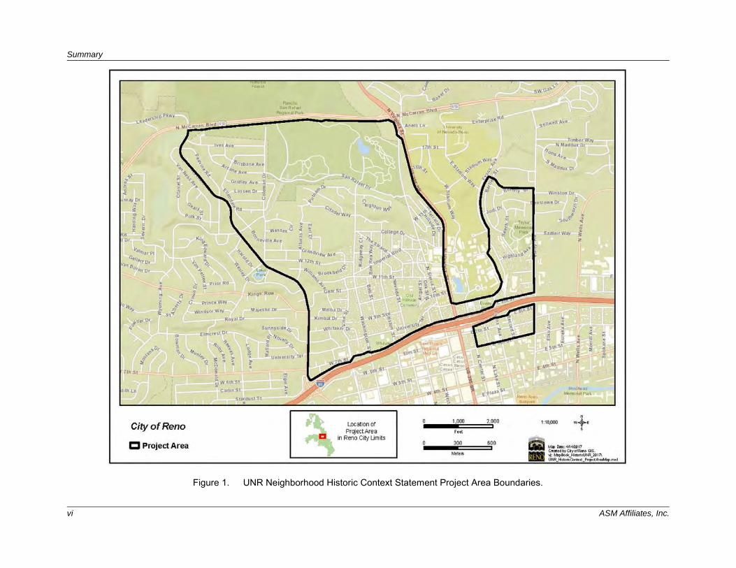
SUMMARY This report describes the goals, methods, and recommendations for the University of Nevada, Reno Historic Context Statement. The City of Reno (City) received a Certified Local Government grant from the Nevada State Historic Preservation Office (SHPO) to conduct this project. As part of the grant, the City was required to hire architectural historians and/or historians that meet the Secretary of the Interior’s Professional Qualification Standards. To that end, the City hired ASM Affiliates, Inc. (ASM) to conduct and prepare this historic context statement. The historic context was developed following guidance established for conducting historic resource surveys and evaluating historic resources by the Secretary of the Interior (SOI), National Register of Historic Places (NRHP), and SHPO. Its preparation has been consistent with the Secretary of the Interior's Standards and Guidelines for Archaeology and Historic Preservation, specifically the standards and guidelines pertaining to Identification, Evaluation, and Historical Documentation. It establishes an historic context for the area surrounding the University of Nevada, Reno (UNR) but excludes the university campus. The UNR campus was previously listed in the NRHP in 1987. The rough boundaries for the project area were McCarran Boulevard to the north, Keystone Avenue to the west, I-80 to the south, and Valley to the east (Figure 1). An historic context describes the significant broad patterns of development in an area that may be represented by historic properties. The development of historic contexts is the foundation for decisions about identification, evaluation, registration, and treatment of historic properties (NRHP 2002). This context outlines relevant themes, time periods, events, people, and architectural styles within the UNR area from which individual properties and historic districts can be evaluated. The historic context prepared for the project area is organized into four themes, specifically Community Development, FHA Minimum House and Small House Program & GI Bill, Education, and Architecture. The historic context also provides overviews of the many subdivisions or neighborhoods within the project area. A total of 1,759 parcels were identified during the reconnaissance survey as containing buildings constructed prior to 1970 (50 years old—roughly 60 percent of the 2,859 parcels within the project area). As a result of the reconnaissance survey and historic context statement, four historic districts have been identified as potentially eligible: Evans North, New Sunnyside, Washington Heights, and University Terrace. Future intensive survey and evaluation could identify individually eligible historic properties.
Summary
vi ASM Affiliates, Inc.
Figure 1. UNR Neighborhood Historic Context Statement Project Area Boundaries.
1.0 Project Objectives
UNR Neighborhood Historic Context Statement 1
1.0 PROJECT OBJECTIVES The City has seen an increased demand for infill development projects in the area surrounding UNR, particularly within the West University Neighborhood. Additionally, the City has adopted policies supporting the University’s efforts to move toward Downtown Reno, which has the potential to encourage further development surrounding the University. As such, City staff and the City of Reno Historical Resources Commission were interested in obtaining some knowledge of the historical context of the area surrounding the University. The City was particularly interested in the growth patterns of the surrounding neighborhoods over time and how that pattern impacted the current neighborhood structure. The City was also interested in examining the influences and consequences of the University’s growth on surrounding neighborhoods. This context will be used as a basis for future decision-making and community education.

2.0 Methodology
UNR Neighborhood Historic Context Statement 3
2.0 METHODOLOGY The SOI has issued the Secretary of the Interior’s Standards and Guidelines for Archeology and Historic Preservation [48 FR 44720–44726]) as guidance to ensure that the procedures for the identification and evaluation of historic resources are adequate and appropriate. The National Park Service has also produced a series of bulletins that provide guidance on historic preservation. The current study was conducted in compliance with the guidelines provided in SOI Standards for Preservation Planning, Identification, Evaluation and Registration, NRHP Bulletin 24: Guidelines for Local Surveys: A Basis for Preservation Planning, NRHP Bulletin 15: How to Apply the National Register Criteria for Evaluation, as well as the criteria for eligibility for the City of Reno Register of Historic Places as established in the City of Reno Historic Preservation Ordinance (Ordinance No. 4313 and 5729, and Title 18 of the local municipal code). For consistency with state and national processes for documenting historical resources, the cutoff date for buildings surveyed during this project was 1970, or slightly less than 50 years ago. Fifty years is the age threshold for eligibility established in the National Historic Preservation Act (NHPA) and the NRHP, and as such is generally the age cutoff for properties when conducting a survey.
2.1 ELIGIBILITY CRITERIA
2.1.1 National Register of Historic Places Significance Criteria Authorized by the National Historic Preservation Act of 1966, the National Park Service’s NRHP is part of a national program to coordinate and support public and private efforts to identify, evaluate, and protect America’s historic and archeological resources. The NRHP is the official list of the nation’s historic places worthy of preservation. The quality of significance in American history, architecture, archaeology, engineering, and culture is present in districts, sites, buildings, structures, and objects that possess integrity of location, design, setting, materials, workmanship, feeling, and association and
A. that are associated with events that have made a significant contribution to the broad patterns of our history; or
B. that are associated with the lives of persons significant in our past; or
C. that embody distinctive characteristics of a type, period, or method of construction, or that represent the work of a master, or that possess high artistic values, or that represent a significant and distinguishable entity whose components may lack individual distinction; or
D. that have yielded, or may be likely to yield, information important in prehistory or history. Ordinarily cemeteries, birthplaces, or graves of historical figures, properties owned by religious institutions or used for religious purposes, structures that have been moved from their original locations, reconstructed historic buildings, properties primarily commemorative in nature, and properties that have achieved significance within the past 50 years are not considered eligible for the NRHP. However, such properties will qualify if they are integral parts of districts that do meet the criteria or if they fall within the following categories:
a) a religious property deriving primary significance from architectural or artistic distinction or historical importance; or
2.0 Methodology
4 ASM Affiliates, Inc.
b) a building or structure removed from its original location but which is significant primarily for architectural value, or which is the surviving structure most importantly associated with a historic person or event; or
c) a birthplace or grave of a historical figure of outstanding importance if there is no appropriate site or building directly associated with his productive life; or
d) a cemetery which derives its primary significance from graves of persons of transcendent importance, from age, from distinctive design features, or from association with historic events; or
e) a reconstructed building when accurately executed in a suitable environment and presented in a dignified manner as part of a restoration master plan, and when no other building or structure with the same association has survived; or
f) a property primarily commemorative in intent, if design, age, tradition, or symbolic value has invested it with its own exceptional significance; or
g) a property achieving significance within the past 50 years if it is of exceptional importance.
2.1.2 City of Reno Register of Historic Places Significance Criteria The City of Reno’s Historical Resources Commission (HRC) created certain criteria for listing a property on the City of Reno Register of Historic Places (Local Register). These include the following considerations:
1. Is your property listed on the State or National Historic Register? 2. Is your property associated with historic people or events? 3. Does your property embody a certain architectural style? Is it valuable for the study
of a period, type, or method of construction? 4. Is your property the work of a master builder or architect? 5. Is your property a good example of a certain type of structure? 6. Is your property part of a larger group of properties that shows continuity or a
concentration of architectural or other cultural characteristics in an area?
2.1.3 Integrity In order to be eligible for listing in the NRHP and the Local Register, a property must retain sufficient integrity to convey its significance. The NRHP publication How to Apply the National Register Criteria for Evaluation, National Register Bulletin 15, establishes how to evaluate the integrity of a property: “Integrity is the ability of a property to convey its significance” (National Park Service, National Register of Historic Places 1991). The evaluation of integrity must be grounded in an understanding of a property’s physical features and how they relate to the concept of integrity. Determining which of these aspects are most important to a property requires knowing why, where, and when a property is significant. To retain historic integrity, a property must possess several, and usually most, aspects of integrity:
1. Location is the place where the historic property was constructed or the place where the historic event occurred.
2. Design is the combination of elements that create the form, plan, space, structure, and style of a property.
3. Setting is the physical environment of a historic property and refers to the character of the site and the relationship to surrounding features and open space. Setting often refers to the basic physical conditions under which a property was built and the functions it was
2.0 Methodology
UNR Neighborhood Historic Context Statement 5
intended to serve. These features can be either natural or manmade, including vegetation, paths, fences, and relationships between other features or open space.
4. Materials are the physical elements that were combined or deposited during a particular period or time, and in a particular pattern or configuration to form a historic property.
5. Workmanship is the physical evidence of crafts of a particular culture or people during any given period of history or prehistory and can be applied to the property as a whole, or to individual components.
6. Feeling is a property’s expression of the aesthetic or historic sense of a particular period of time. It results from the presence of physical features that, when taken together, convey the property’s historic character.
7. Association is the direct link between the important historic event or person and a historic property.
2.2 ARCHIVAL RESEARCH
ASM conducted archival research to develop the historical context statement for the area surrounding UNR. Decisions about the identification, evaluation, designation, and treatment of historic resources are most reliably made when the relationship of individual properties to other similar properties is understood. Information about historic resources representing aspects of history, architecture, archaeology, engineering, and culture must be collected and organized to define these relationships. This organizational framework is called a “historic context.” The historic context organizes information based on a cultural theme and its geographical and chronological limits. Contexts describe the significant broad patterns of development in an area that may be represented by historic resources. The development of historic contexts is the foundation for decisions about the identification, evaluation, designation, and treatment of historic resources. In developing the architectural history sections of the historic context statement, national, state, and local sources were drawn upon for the framework of architectural styles and property types. National references such as Virginia and Lee McAlester’s (2009) A Field Guide to American Houses and Rachel Carley’s (1997) The Visual Dictionary of American Domestic Architecture provided a national perspective, as did the NRHP bulletins How to Apply the National Register Criteria for Evaluation—How to Evaluate a Property within its Historic Context and Historic Residential Suburbs: Guidelines for Evaluation and Documentation for the National Register of Historic Place. ASM also referenced new guidance from the NRHP on property types/forms/plan and architectural styles that is currently in draft format (NRHP 2015). Several sources were used to conduct the archival research for this project. These included the University of Nevada, Reno Special Collections Library; the Nevada Historical Society; the Nevada State Historic Preservation Office; the Washoe County Assessor’s Office; the Sanborn fire insurance maps at the UNR Delamare Library website (http://www.delamare.unr.edu/maps/digitalcollections/nvmaps/sanborns/); a cursory review of select Polk’s City Directories; and the websites www.newspapers.com and Ancestry.com. ASM also utilized an historic context for this area of Reno previously developed by one of the report authors (Ross-Hauer 2010). The results of this research are presented in Section 3.0 Historic
Context Statement.
2.3 RECONNAISSANCE SURVEY AND DATA ANALYSIS
Concurrent with the development of the historic context, ASM collected information to help guide the reconnaissance survey. This reconnaissance survey approach is often referred to as a windshield survey, as surveys on this large scale are best conducted through the windshield of a moving car. Working with the
2.0 Methodology
6 ASM Affiliates, Inc.
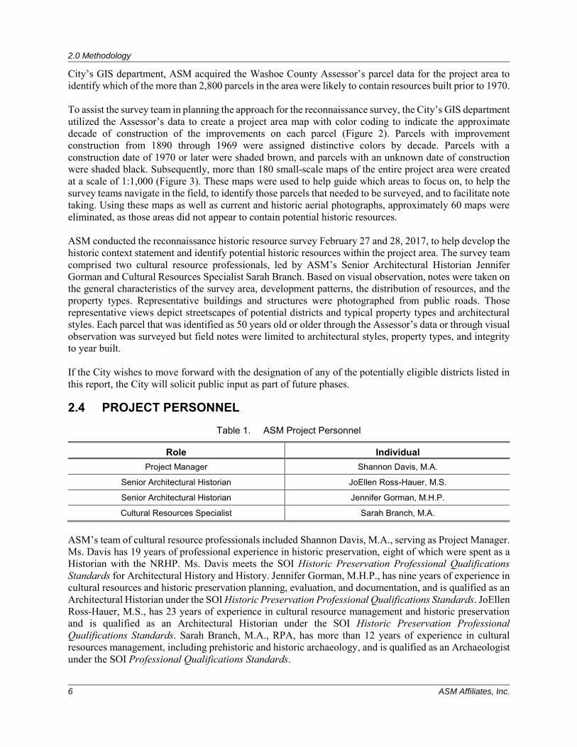
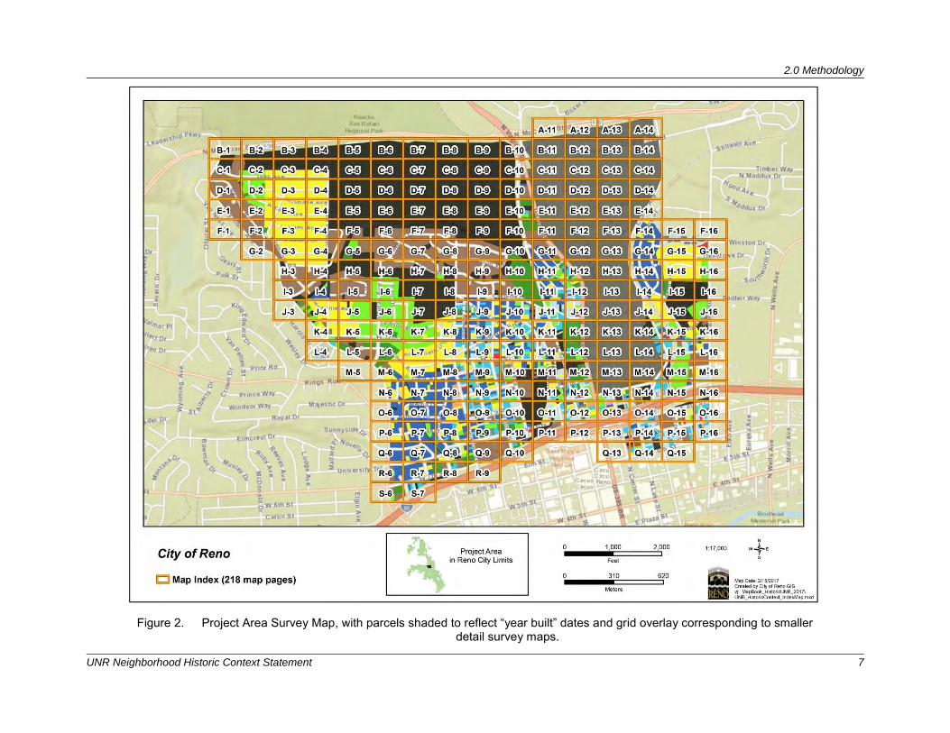
City’s GIS department, ASM acquired the Washoe County Assessor’s parcel data for the project area to identify which of the more than 2,800 parcels in the area were likely to contain resources built prior to 1970. To assist the survey team in planning the approach for the reconnaissance survey, the City’s GIS department utilized the Assessor’s data to create a project area map with color coding to indicate the approximate decade of construction of the improvements on each parcel (Figure 2). Parcels with improvement construction from 1890 through 1969 were assigned distinctive colors by decade. Parcels with a construction date of 1970 or later were shaded brown, and parcels with an unknown date of construction were shaded black. Subsequently, more than 180 small-scale maps of the entire project area were created at a scale of 1:1,000 (Figure 3). These maps were used to help guide which areas to focus on, to help the survey teams navigate in the field, to identify those parcels that needed to be surveyed, and to facilitate note taking. Using these maps as well as current and historic aerial photographs, approximately 60 maps were eliminated, as those areas did not appear to contain potential historic resources. ASM conducted the reconnaissance historic resource survey February 27 and 28, 2017, to help develop the historic context statement and identify potential historic resources within the project area. The survey team comprised two cultural resource professionals, led by ASM’s Senior Architectural Historian Jennifer Gorman and Cultural Resources Specialist Sarah Branch. Based on visual observation, notes were taken on the general characteristics of the survey area, development patterns, the distribution of resources, and the property types. Representative buildings and structures were photographed from public roads. Those representative views depict streetscapes of potential districts and typical property types and architectural styles. Each parcel that was identified as 50 years old or older through the Assessor’s data or through visual observation was surveyed but field notes were limited to architectural styles, property types, and integrity to year built. If the City wishes to move forward with the designation of any of the potentially eligible districts listed in this report, the City will solicit public input as part of future phases.
2.4 PROJECT PERSONNEL
Table 1. ASM Project Personnel
Role Individual Project Manager Shannon Davis, M.A.
Senior Architectural Historian JoEllen Ross-Hauer, M.S.
Senior Architectural Historian Jennifer Gorman, M.H.P.
Cultural Resources Specialist Sarah Branch, M.A.
ASM’s team of cultural resource professionals included Shannon Davis, M.A., serving as Project Manager. Ms. Davis has 19 years of professional experience in historic preservation, eight of which were spent as a Historian with the NRHP. Ms. Davis meets the SOI Historic Preservation Professional Qualifications Standards for Architectural History and History. Jennifer Gorman, M.H.P., has nine years of experience in cultural resources and historic preservation planning, evaluation, and documentation, and is qualified as an Architectural Historian under the SOI Historic Preservation Professional Qualifications Standards. JoEllen Ross-Hauer, M.S., has 23 years of experience in cultural resource management and historic preservation and is qualified as an Architectural Historian under the SOI Historic Preservation Professional Qualifications Standards. Sarah Branch, M.A., RPA, has more than 12 years of experience in cultural resources management, including prehistoric and historic archaeology, and is qualified as an Archaeologist under the SOI Professional Qualifications Standards.
2.0 Methodology
UNR Neighborhood Historic Context Statement 7
Figure 2. Project Area Survey Map, with parcels shaded to reflect “year built” dates and grid overlay corresponding to smaller detail survey maps.
2.0 Methodology
8 ASM Affiliates, Inc.
Figure 3. Detail survey maps, at a scale of 1:1000.
3.0 Historic Context Statement
UNR Neighborhood Historic Context Statement 9
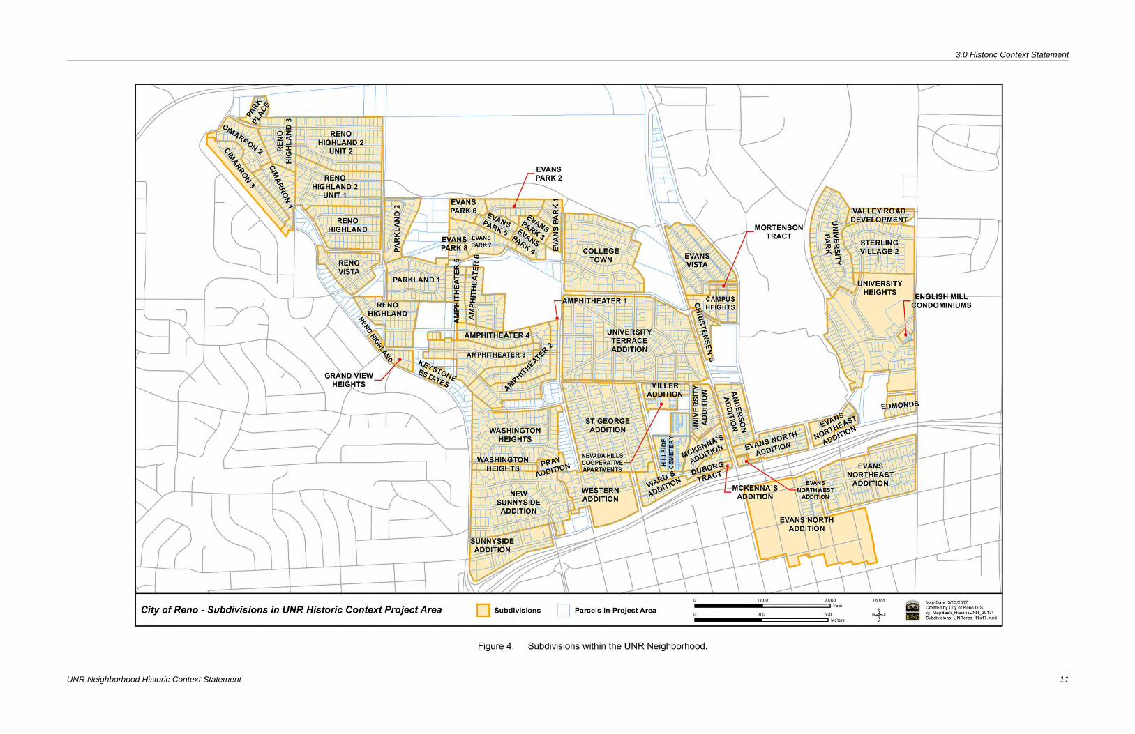
3.0 HISTORIC CONTEXT STATEMENT Following is the HCS for the University Neighborhood, those residential suburbs that were developed around UNR (see Figure 1). Multiple subdivisions were identified within the project area (Figure 4). The HCS includes four themes: Community Development, FHA Minimum House and Small House Program
& GI Bill, Education, and Architecture. Within the Community Development theme, three sub-themes have been identified: Establishment of the University Neighborhood (1876-1910s), Early Twentieth-Century Development in the University Neighborhood (1910s-1930s), and Mid-Twentieth Century Development in the University Neighborhood (1930s-1970). Each theme or sub-theme identifies potentially eligible property types and the framework for evaluating those property types within the theme or sub-theme (registration requirements). Select photographs have been included to illustrate typical examples of property types representing those themes. A variety of factors have affected the development of growth in Reno and the neighborhoods surrounding UNR. The following provides an overview of Reno from its founding in 1868 to the Post-War era. This is followed by a discussion of the four themes identified for this HCS, with a particular focus on the historic neighborhood surrounding UNR and their relation to dominant trends at the time.
3.1 OVERVIEW OF RENO HISTORY
3.1.1 Settlement and Nineteenth Century Development Reno was established because of its location at the eastern terminus of a transportation corridor through the Sierra Nevada Mountains and its access to the Comstock Lode silver mining district. The earliest non-Native American visitors to the Truckee Meadows included the Stephens-Townsend-Murphy wagon party in 1844 and the Donner Party in 1846 (Moreno 2015). While the success of the Stephens-Townsend-Murphy party led others to attempt the Truckee River, the tragedies that befell the Donner Party influenced an overall decrease in emigrant travel to California over the next two years (Moreno 2015:11). The discovery of gold in California in 1848 dramatically altered the perceived risk of the Truckee River route, and soon the Truckee Meadows became a busy cross-road; a role that only increased with the discovery of silver in 1859 in Virginia City. The first permanent settlement in what would become Reno also came in 1859 when Charles Fuller built a toll-bridge across the Truckee River, which, along with a log shelter for travelers, became known as Fuller’s Crossing (Land and Land 1995). In 1861, Myron C. Lake purchased Fuller’s toll bridge and operated the hotel, which he renamed the Lake House. Lake developed other businesses to enhance his operation, and with profits from his enterprise, purchased additional land surrounding his bridge. Until the arrival of the railroad, Reno was called Lake’s Crossing. Reno had its beginnings just as Nevada was officially becoming part of the United States. Nevada was recognized as a territory on March 2, 1861, less than six months before Lake purchased Fuller’s Crossing. The next year, the Nevada Territorial Legislature granted Lake a 10-year exclusive franchise, making his the only crossing at that location and providing a period of economic stability to his enterprise (Moreno 2015). The year 1862 also saw passage of three congressional measures that fundamentally affected the development of Nevada and the growth of Reno: the Homestead Act, the Morrill Land-Grant College Act, and the Pacific Railroad Act (Green 2015). The latter, in particular, became the driving force transforming Lake’s Crossing into Reno. The Pacific Railroad Act smoothed the way for the Union Pacific Railroad to build west from Omaha, Nebraska to meet the Central Pacific Railroad (CPRR) as it built east from Sacramento, California. In 1868, Myron Lake approached Charles Crocker, the construction superintendent for the CPRR, to build a depot at his crossing (Moreno 2015). Lake sold the railroad 160 acres for the depot on the agreement that they would have the land surveyed and subdivided, and would then deed half of the lots back to him (Myrick
3.0 Historic Context Statement
10 ASM Affiliates, Inc.
1962:13). The CPRR quickly accepted the deal, and in May of 1868, Lake’s Crossing officially became Reno. The early plat of the city of Reno was based on a gridiron pattern, surrounding the CPRR depot. The town grew quickly from there, and in 1871, the Washoe County seat was moved from Washoe City to Reno (Townley 1983:67). In 1872, Reno became an even more vital crossing point for the railroad as it connected with the Virginia and Truckee (V&T) Railroad, which carried silver from the Comstock Lode in Virginia City (Hulse 1998). The V&T Railroad, which ran from Carson City north along what are now Virginia and Holcomb streets, resulted in urban growth spreading south along that route. During this time, Reno was the state’s financial and industrial center, a bustling small metropolis with fashionable Victorian homes and consequential commercial and municipal buildings. In 1873 much of the commercial core burned, destroying 100 buildings (Moreno 2015:37). Reno was quick to rebuild, however, with efforts beginning the day after the fires. Lumber, supplies, and workmen began arriving almost immediately and within a short time, the town was again thriving (Nevada State Journal [NSJ] 21 May 1876). By 1879, Reno had 2,000 residents and a second “Great Fire” with which to contend, this time burning 350 structures and killing six people (Moreno 2015:37). As before, Reno quickly rebuilt and continued to develop into northern Nevada’s preeminent community. The Morrill Land-Grant College Act, passed in 1862, granted each state land on which to build a university or college and further contributed to the development and character of early Reno. The Nevada State University, as it was first known, was established in Elko in 1874, but was moved to Reno in 1885 after pressure from local leaders (Green 2015; Moreno 2015). During the late 1880s, however, the silver boom that had fueled much of the growth in northern Nevada ended, and a 20-year depression ensued. The population of the state dropped from 62,266 in 1880 to 42,335 in 1900 (Rowley 1984:22). However, since Reno was supported by the railroad, it did not feel the depression as severely as Virginia City and other places. Cattle and sheep ranching allowed the Truckee Meadows to thrive, with hay and alfalfa serving as important cash crops and providing the economic base for the area (Townley 1983:266).
3.0 Historic Context Statement
UNR Neighborhood Historic Context Statement 11
Figure 4. Subdivisions within the UNR Neighborhood.

3.0 Historic Context Statement
UNR Neighborhood Historic Context Statement 13
3.1.2 Early Twentieth-Century Development With the coming of the twentieth century, Reno began to change. Reno incorporated with a population of about 4,000 in 1903. Reno’s first significant building boom occurred between 1900 and 1910, primarily due to the mining activity in the southern Nevada towns of Goldfield and Tonopah. The town developed into a transportation hub and delivered agricultural and manufactured goods to these southern mining areas. Many of the high-profile mine owners’ families lived in Reno along with the laborers responsible for the manufactured goods. The year 1907 saw the greatest number of building permits issued in Reno, totaling $616,608; this was surpassed in 1922 with 231 permits valuing $729,010 in 1922 (NSJ 1 January 1924:8). In new construction, builders and architects concentrated on permanence and style. The arrival of figures like George Wingfield further influenced the development of Reno. Wingfield made a fortune in the Tonopah mining boom and by the 1920s, had become a political and economic force in Reno (Barber 2008; Harmon 2002). He invested heavily in Reno real estate, and his business endeavors included banks, hotels, gambling halls, and brothels. He was no stranger to gambling and drinking, and as a divorced man himself, recognized the role that profit from such endeavors could provide for Reno. As such, he used his significant financial clout to substantially influence city and state politics, resulting in Reno more completely embracing the industries of gambling, divorce, prostitution (at least officially) (Barber 2008). The business of sin turned out to be remarkably dependable (Harmon 1998). Though Nevada courts had established a six-month residency requirement for divorce without having to prove adultery as early as 1868, it wasn’t until the high-profile divorces of several New York socialites at the turn of the century that Reno’s divorce industry began in earnest (Land and Land 1995; Moreno 2015). Though the relatively lenient residency requirement applied to the entire state, Reno, in particular, reaped the benefits. With its proximity to the railroad, higher end hotels, restaurants, and other niceties, Reno became the city du jour for the social elite to end their marriages, and possible begin a new one (Barber 2008). In 1913, California added a one-year residency requirement for a divorce, prompting even more divorce seekers to relocate to the Silver State. A year later, under pressure from citizens who felt this new reputation risked Reno’s stability and respectability, and in recognition that many people left Nevada as soon as their divorce was final, the Nevada legislature extended the residency requirement to 12 months (Barber 2008). Almost immediately, Reno felt the economic sting, and in 1915, the six-month requirement was reinstated. In 1927, the Nevada legislature further shortened the residency period to three months (Harmon 1998). As the Great Depression began to take hold in 1931, Nevada saw an economic opportunity. The legislature revised its divorce law once again, shortening the residency requirement to six weeks, thereby opening the divorce floodgates. Between 1929 and 1939, more than 30,000 divorces were granted at the Washoe County Courthouse, and Reno became known as the divorce capital of the world (Harmon 1998). Partly because of the divorce trade, the 1920s and early 1930s were particularly prosperous years for Reno (Harmon 1998:86-89). During this time, the town experienced a significant growth spurt. In 1925, construction permits were issued exceeding $1,430,457. This growth peaked in 1929, when building permits totaled $2,111,275, but building permit activity did not fall below the $1 million level until 1932. Reno was able to thrive economically during the first few years of the Great Depression, supported in part by the divorce trade, but also by gambling. In 1931, along with reducing the divorce residency period to six weeks, the Nevada legislature fully legalized gambling, both of which contributed to a greater demand for housing in Reno. Between 1920 and 1940, Reno’s population grew from 12,016 to 21,317, an increase of 43 percent. The number of dwelling units grew as well, from 2,617 in 1920 to 7,309 in 1940, an increase of 64 percent (Harmon 1998:86-89).
3.0 Historic Context Statement
14 ASM Affiliates, Inc.
Neighborhoods in Reno were relatively high density, with more than eight houses per acre, laid out in rectangular blocks. In all but the newest subdivisions in the far northwest and the far southwest, the blocks were divided by alleys. Sidewalks were separated from the street by a 5-foot (ft.) parkway with street trees. Retail and commercial uses lined most of the larger streets. Duplexes and rental units facing the alley or over a garage were not uncommon in the neighborhoods. Commercial buildings were built to the sidewalk. Residences typically had a 10-ft. or even 15-ft. front yard. The presence of the streetcar in Reno from 1904 to 1927 also influenced the pattern of suburban growth. The first streetcar to operate in Nevada was operated by the Nevada Transit Company, predecessor to the Reno Traction Company (Myrick 1992:868). They operated the first street railways on November 20, 1904, until their closure in 1927. The lines ran from Reno to Sparks, with passengers travelling the route in about 10 minutes. The line was extended west along 4th Street from Lake to Sierra Street, and south on Sierra to 2nd Street (Myrick 1992:871). In November of 1906, an additional extension was constructed on the 2nd Street line from Sierra Street to Keystone, and in 1907 the lines were extended north up Sierra Street to the University of Nevada campus. Additionally, a streetcar line ran south on Plumas from California to Moana Hot Springs, operated by the Nevada Interurban Railway from 1907 until 1920 (Myrick 1992:872). The construction of these lines led to the rapid growth of the Reno and Sparks area, with several new additions constructed along the routes, including the Gilberts Addition, Arlington Heights, University Heights, and St. Georges Addition, to name a few. By the early twentieth century, the automobile began making an impact on the development of the region. The completion of the highways opened Nevada to the lucrative automobile tourism trade, and led to growth and development of communities along the highway routes. The area experienced its first major surge of traffic in 1915, as hundreds of motor tourists passed through on their way to attend the Panama Pacific Exhibition in San Francisco. In 1916, the Lincoln Highway was established to provide a continuous, improved highway from New York to San Francisco. The section through western Nevada was completed by 1921 and passed through Fallon, Sparks, and Reno (Harmon 2010). The highway split at Reno, with one branch running westward to Truckee along 4th Street and an alternate route extending south to Carson City (Franzwa and Petersen 2004). A second cross-country highway, the Victory Highway, was organized in 1921 to memorialize veterans of World War I (RTC 2016). After following a northerly route across Nevada, the Victory Highway route converged with the Lincoln Highway in Sparks. Renamed U.S. 40 in the late 1920s, the combined Lincoln Highway/Victory Highway/4th Street corridor became the primary east-west route through Reno. With the establishment of these cross-continental highways, easy automobile access to Reno’s casinos thrust gambling into the forefront of the local and state economy. Drawn by gambling, the ease of divorce and the area’s beautiful natural setting, automobile tourists flocked to Reno. Though Reno’s reputation had become inextricably tied to the business of “sin,” becoming less tied to the boom and bust cycles of mining and agriculture allowed Reno to become more economically successful and more stable than other communities in Nevada. With a relatively stable economy and the presence of prominent politicians, bankers, and lawyers, Reno in the early twentieth century had into a small but prosperous community (Harmon 2002).
3.1.3 Reno in the Post-World War II Era Learning that it could profit from sin was a significant revelation for Nevada. From the post-World War II (WWII) years on, it has staked its economic livelihood on casino gaming and tourism, both of which developed and flourished alongside the continuing divorce trade (Harmon 1998). Reno in the late 1940s and early 1950s continued to be a town of contradictions. The economic base depended largely on selling Reno as a cosmopolitan city with fashionable divorce ranches and access to year-round sports, and marketing gambling as a classy, respectable endeavor – or at least classier than what could be found in Las
3.0 Historic Context Statement
UNR Neighborhood Historic Context Statement 15
Vegas (Barber 2008). This contrasted with the experience of many Reno residents who saw their city as a small town that should be better known for its civic improvements, local events, and close community. Despite this contradiction, Reno and Sparks capitalized on its location halfway between Lake Tahoe and Pyramid Lake early in the post-war period. Reno’s proximity to a number of military bases and defense plants had already established a ready market for those seeking a weekend away, and the post-war period was no different (Moehring 2014). Because only one of these bases, the Reno Army Air Base (later called the Stead Air Force Base) was located near Reno (Hulse 2004:206), the city did not significantly profit from post-war and Cold War industries; however, the city did continue to draw business and tourism dollars from servicemen and women from the Hawthorne Ammunition Depot and Fallon Naval Air Station in Nevada, and Herlong Ordnance Depot in Northern California. Once automobile traffic became heavier after wartime gasoline rationing ended, the business community promoted the variety of winter sports, and several ski resorts became highly popular. This culminated in the staging of the winter games at nearby Squaw Valley in 1960, and the region enjoyed a new bonanza of tourists. With the expansion of the interstate freeway system across the Sierra Nevada and the construction of Reno International Airport in the late 1950s, and aggressive marketing efforts in the early 1960s, Reno and Sparks became seen as a year-round destination for tourists (Moehring 2014). Like many western cities, Reno experienced a major growth spurt following WWII. Population growth had been slow during the depression and the war. During the 1930s, Reno was still a small city of less than 19,000. By 1960, the population had more than doubled to 51,470. In Reno’s first post-war suburbs, the houses exhibited simple and box-like construction. However, as the boom gained momentum, larger and more elaborate houses, and the amenities that formerly were available only to the well-to-do, became hallmarks of the middle-class. New homes were constructed in record numbers. Development in Reno during the 1940s and 1950s was concentrated to the southeast along U.S. Highway 395 and east along what would become Interstate 80 (I-80), closing the gap between Reno and Sparks. Areas like Green Acre Heights, River Mount Park, Soddards Addition, Mill Street Addition, and Lake Park Heights were constructed immediately following the war, with numerous other subdivisions added from 1947-1950. A major change came to Reno in the 1960s with the construction of a new east-west Interstate. As Reno continued to rely on tourism and casino gambling, maintaining access by car, particularly over the steep Sierra Nevada passes, became a crucial concern. The construction of I-80 through Nevada promised an opportunity to expand access from Sacramento and the Bay Area, while also attracting large companies and developments to the Reno area (Moehring 2014:24). The selection of the route through Reno was delayed by controversy, with Nevada congressman Walter Baring originally advocating a route placed north of UNR, the Reno Gazette Journal advocating a route along Third Street, and the state highway department preferring a route between Seventh and Eighth streets (Moehring 2014:24-25). Due in part to strong public opposition to this latter corridor, the highway department eventually considered five routes: two to the north of Reno and three bisecting the city. Despite the earlier public outcry, the Seventh to Eighth street corridor was selected. It had the advantage of not bypassing the city entirely, but effectively isolated the University from the downtown commercial core ad required the destruction and removal of numerous historic homes and businesses, including many within some of Reno’s oldest neighborhoods. Construction on I-80 began in 1963 and the section from San Francisco to Reno was completed in 1968, with Keystone Avenue as the freeway terminus (Nevada State Journal [NSJ] 30 June 1964; NSJ 12 August 1968:9). The conflict over the route and the overall length of the planning process meant that the construction of I-80 through Reno was not completed until 1974 (Moehring 2014:25)
3.2 THEME 1: COMMUNITY DEVELOPMENT (1876-1970)
During the late nineteenth century, Reno’s core included an approximate 21-block area within the bounds of West and East streets, and the Truckee River and 4th Street. Most commercial buildings were located along Commercial Row and East 4th Street. Early residential growth in the area surrounding UNR began
3.0 Historic Context Statement
16 ASM Affiliates, Inc.
about the same time as the arrival of the V&T Railroad. Subdivisions or additions built around the University during this period include the Western Addition (1876), the Evans North Addition (1879), the University Addition (1895), and Ward’s Addition (1899). After the turn of the century, additions such as the St. George Addition (1901), Evans Northwest and Northeast Additions (1905-1906), the University Heights neighborhood, McKenna’s Addition (1907), and University Terrace (1906) began to be developed. The history of each of these early additions is outlined below, and boundaries for each addition are identified on Figure 4 with the original subdivision maps included in Appendix A.
3.2.1 Sub-theme: Establishment of the University Neighborhood (1876-1910s)
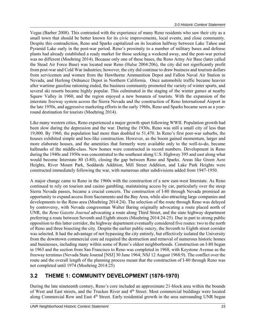
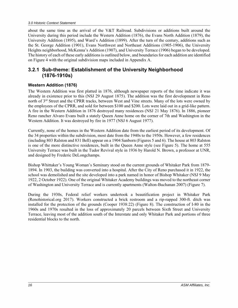
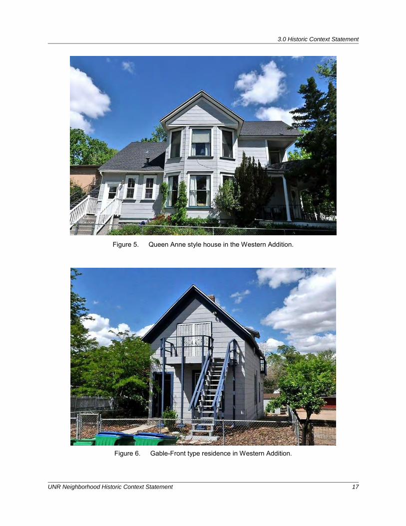
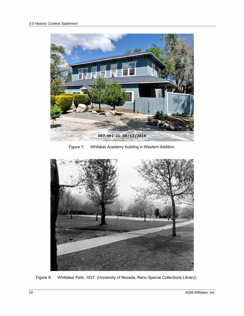
Western Addition (1876) The Western Addition was first platted in 1876, although newspaper reports of the time indicate it was already in existence prior to this (NSJ 29 August 1875). The addition was the first development in Reno north of 3rd Street and the CPRR tracks, between West and Vine streets. Many of the lots were owned by the employees of the CPRR, and sold for between $100 and $200. Lots were laid out in a grid-like pattern. A fire in the Western Addition in 1876 destroyed many residences (NSJ 21 May 1876). In 1886, pioneer Reno rancher Alvaro Evans built a stately Queen Anne home on the corner of 7th and Washington in the Western Addition. It was destroyed by fire in 1977 (NSJ 6 August 1977). Currently, none of the homes in the Western Addition date from the earliest period of its development. Of the 34 properties within the subdivision, most date from the 1940s to the 1950s. However, a few residences (including 803 Ralston and 831 Bell) appear on a 1904 Sanborn (Figures 5 and 6). The house at 803 Ralston is one of the more distinctive residences, built in the Queen Anne style (see Figure 5). The home at 555 University Terrace was built in the Tudor Revival style in 1936 by Harold N. Brown, a professor at UNR, and designed by Frederic DeLongchamps. Bishop Whittaker’s Young Woman’s Seminary stood on the current grounds of Whitaker Park from 1879-1894. In 1903, the building was converted into a hospital. After the City of Reno purchased it in 1922, the school was demolished and the site developed into a park named in honor of Bishop Whitaker (NSJ 9 May 1922, 2 October 1922). One of the original Whitaker Academy buildings was moved to the northeast corner of Washington and University Terrace and is currently apartments (Walton-Buchanan 2007) (Figure 7). During the 1930s, Federal relief workers undertook a beautification project in Whitaker Park (Renohistorical.org 2017). Workers constructed a brick restroom and a rip-rapped 300-ft. ditch was installed for the protection of the grounds (Cooper 1938:22) (Figure 8). The construction of I-80 in the 1960s and 1970s resulted in the loss of approximately 20 parcels between Sixth Street and University Terrace, leaving most of the addition south of the Interstate and only Whitaker Park and portions of three residential blocks to the north.
3.0 Historic Context Statement
UNR Neighborhood Historic Context Statement 17
Figure 5. Queen Anne style house in the Western Addition.
Figure 6. Gable-Front type residence in Western Addition.
3.0 Historic Context Statement
18 ASM Affiliates, Inc.
Figure 7. Whitaker Academy building in Western Addition.
Figure 8. Whittaker Park, 1937. (University of Nevada, Reno Special Collections Library).
3.0 Historic Context Statement
UNR Neighborhood Historic Context Statement 19
Evans North Addition (1879-1910s) The Evans North Addition, also known as Evans Addition, was one of the first residential neighborhoods in Reno, and was first platted in 1879. It extended from East Street (renamed Record Street and also the route of the Nevada-California-Oregon (N.C.O) Railroad) west to Sierra Street, and from 3rd Street north to 8th Street. The addition was developed by Alvaro and John Newton “Newt” Evans, two brothers from Defiance, Ohio. John Evans arrived in northeastern Nevada in 1850 after driving a herd of cattle from Ohio. Three of his brothers were already in California and Nevada. John, or Newt as he was sometimes called by his family, bought land in Long Valley, Lassen County, California, in partnership with his brothers Allen and Alvaro. Together they raised alfalfa and cattle, with Newt making several trips to the east to purchase additional livestock.
In 1876, the Evans brothers purchased land north of the town of Reno, at the foot of what was to become the University of Nevada, on Evans Avenue. The Evans brothers divided the land into 15 blocks, most of which were made up of 16 1/8-acre lots. In 1877, Alvaro Evans began advertising the sale of lots in the Evans North Addition for $169.00 (Reno Evening Gazette [REG] 31 January 1877).
Newt and his brothers eventually sold their Long Valley property and concentrated on building their holdings near Reno and on the Humboldt River, and on acquiring the Highland Ditch and its water rights. John N. Evans was instrumental in having the fledgling University of Nevada moved from Elko to Reno in 1885 and sold the state land upon which the campus was built. He was a director of the Bank of Nevada and Farmers’ and Merchants Bank and president of the University of Nevada Board of Regents. Newt Evans sold the land for the University of Nevada to the State when it was moved from Elko in 1885 (Hinman 2017).
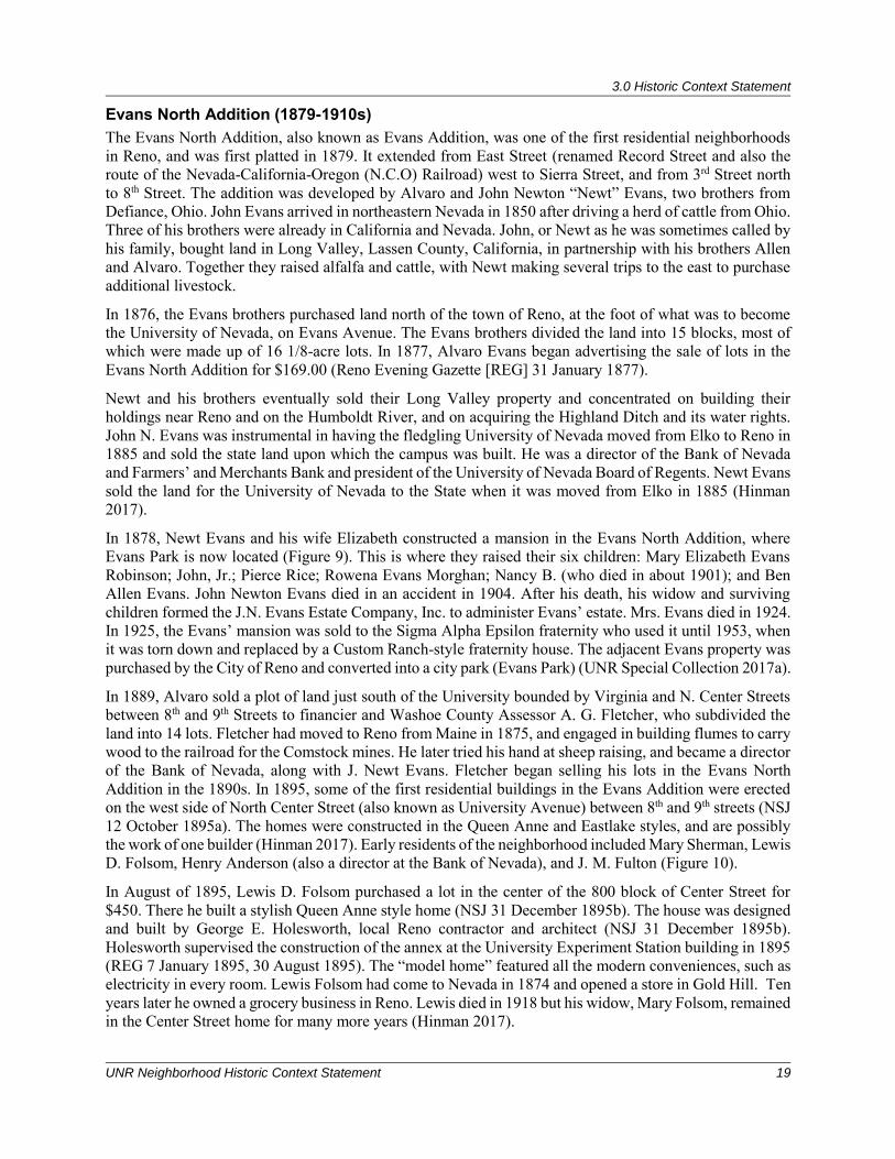
In 1878, Newt Evans and his wife Elizabeth constructed a mansion in the Evans North Addition, where Evans Park is now located (Figure 9). This is where they raised their six children: Mary Elizabeth Evans Robinson; John, Jr.; Pierce Rice; Rowena Evans Morghan; Nancy B. (who died in about 1901); and Ben Allen Evans. John Newton Evans died in an accident in 1904. After his death, his widow and surviving children formed the J.N. Evans Estate Company, Inc. to administer Evans’ estate. Mrs. Evans died in 1924. In 1925, the Evans’ mansion was sold to the Sigma Alpha Epsilon fraternity who used it until 1953, when it was torn down and replaced by a Custom Ranch-style fraternity house. The adjacent Evans property was purchased by the City of Reno and converted into a city park (Evans Park) (UNR Special Collection 2017a).
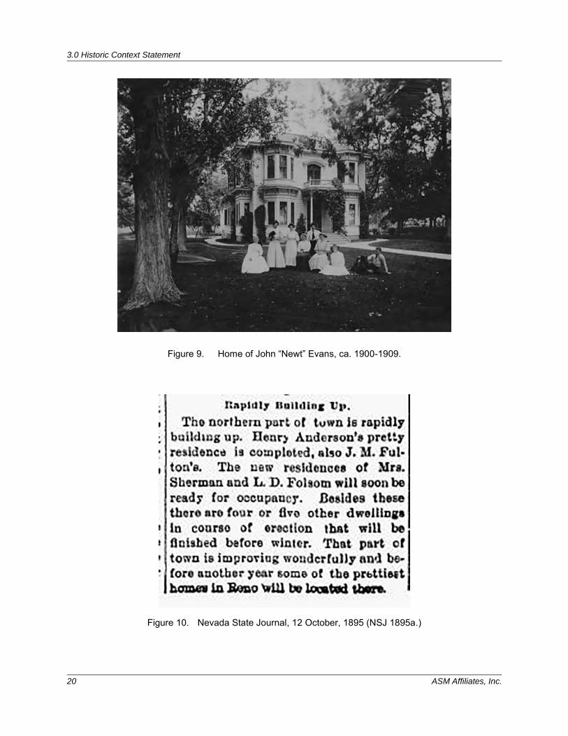
In 1889, Alvaro sold a plot of land just south of the University bounded by Virginia and N. Center Streets between 8th and 9th Streets to financier and Washoe County Assessor A. G. Fletcher, who subdivided the land into 14 lots. Fletcher had moved to Reno from Maine in 1875, and engaged in building flumes to carry wood to the railroad for the Comstock mines. He later tried his hand at sheep raising, and became a director of the Bank of Nevada, along with J. Newt Evans. Fletcher began selling his lots in the Evans North Addition in the 1890s. In 1895, some of the first residential buildings in the Evans Addition were erected on the west side of North Center Street (also known as University Avenue) between 8th and 9th streets (NSJ 12 October 1895a). The homes were constructed in the Queen Anne and Eastlake styles, and are possibly the work of one builder (Hinman 2017). Early residents of the neighborhood included Mary Sherman, Lewis D. Folsom, Henry Anderson (also a director at the Bank of Nevada), and J. M. Fulton (Figure 10).
In August of 1895, Lewis D. Folsom purchased a lot in the center of the 800 block of Center Street for $450. There he built a stylish Queen Anne style home (NSJ 31 December 1895b). The house was designed and built by George E. Holesworth, local Reno contractor and architect (NSJ 31 December 1895b). Holesworth supervised the construction of the annex at the University Experiment Station building in 1895 (REG 7 January 1895, 30 August 1895). The “model home” featured all the modern conveniences, such as electricity in every room. Lewis Folsom had come to Nevada in 1874 and opened a store in Gold Hill. Ten years later he owned a grocery business in Reno. Lewis died in 1918 but his widow, Mary Folsom, remained in the Center Street home for many more years (Hinman 2017).
3.0 Historic Context Statement
20 ASM Affiliates, Inc.
Figure 9. Home of John “Newt” Evans, ca. 1900-1909.
Figure 10. Nevada State Journal, 12 October, 1895 (NSJ 1895a.)
3.0 Historic Context Statement
UNR Neighborhood Historic Context Statement 21
In addition to Center Street, several homes were constructed on North Lake Street and E. 8th Street in the Evans North Addition during the early 1900s in the Queen Anne and Craftsman styles. Residents on this block of Lake Street included university professors, a former mayor, and prominent Nevada architect George A. Ferris (Reno Historical 2017). By the end of the nineteenth century, the Evans North neighborhood expanded to the south. Houses were primarily Foursquare, Queen Anne and bungalows. The first of these were constructed on N. Center and N. Lake Streets between 5th and 7th Streets. The 1906 Sanborn map shows several residences and tenements. Many of these have since been demolished and replaced with modern apartments; however, a few isolated homes are still extant. Notably, the two-story brick building at 708 N. Center was built ca. 1908 and housed the Sigma Alpha Epsilon (T.H.P.O.) fraternity from 1914-1917 (REG 6 January 1920:8). The residence was later converted into the “Meyer Apartments.” The Foursquare house at 606 N. Lake was built by T. E. Robb (contractor and builder in Reno) ca. 1908. It is similar in style to 629 Lake Street, built ca. 1911 by Mr. and Mrs. C.E. Miller. The house at 628 N. Lake was built ca. 1905 by John Sunderland, a prominent retailer in Reno. Evans North was truncated by the construction of I-80 between 1968 and 1973 (Hinman 2016). The construction of I-80 resulted in the auctioning and removal or demolition of several homes on Center, Lake, and Evans, between 7th and 8th Streets. The portion of Evans North south of I-80 has experienced a significant amount of infill of apartment buildings, casinos and motels from the mid- to late twentieth century. In addition, many of the homes south of I-80 retain poor integrity. The portion of Evans North of I-80, particularly along North Virginia and Sierra Streets have seen similar changes. Several motels were constructed on North Virginia between 8th and 9th Streets in the late 1950s-early 1960s, along with small restaurants, apartments, and other commercial properties. Two of these, the Coed Lodge and Tiny’s Motel (now the Sundance Motel), were built in anticipation of the construction of I-80. These motels were constructed in 1964 by prominent local contractor W. Stewart Dinwiddie. Born in Portland, Oregon, in 1915, Dinwiddie came to Reno in 1956. Some of the major building projects completed by his firm include the Royal Heights subdivision in Reno, the addition to the Starlight Bowling Alley, the Lamplighter Motel, and the Patio Motel. He was also the contractor for the Carson Mall (NSJ 21 September 1966:8). As a result, it is the earliest core of Evans North (the residential properties on Lake and Center streets) that comprise one of the few remaining enclaves of late nineteenth-early twentieth century homes in Reno.
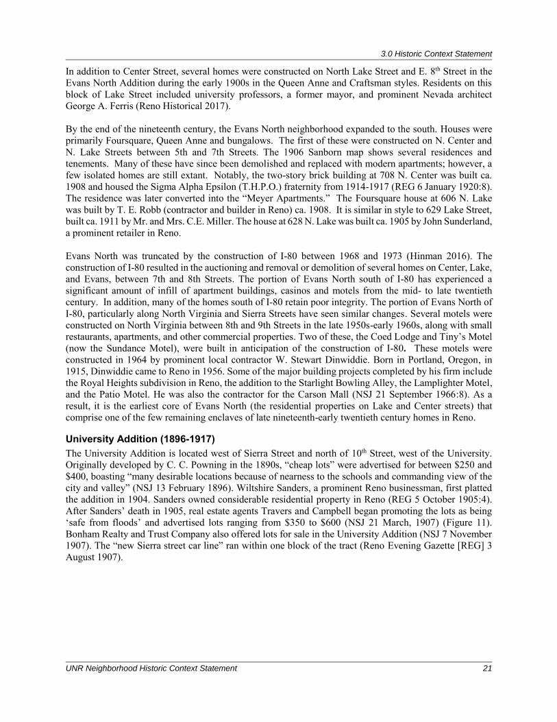
University Addition (1896-1917) The University Addition is located west of Sierra Street and north of 10th Street, west of the University. Originally developed by C. C. Powning in the 1890s, “cheap lots” were advertised for between $250 and $400, boasting “many desirable locations because of nearness to the schools and commanding view of the city and valley” (NSJ 13 February 1896). Wiltshire Sanders, a prominent Reno businessman, first platted the addition in 1904. Sanders owned considerable residential property in Reno (REG 5 October 1905:4). After Sanders’ death in 1905, real estate agents Travers and Campbell began promoting the lots as being ‘safe from floods’ and advertised lots ranging from $350 to $600 (NSJ 21 March, 1907) (Figure 11). Bonham Realty and Trust Company also offered lots for sale in the University Addition (NSJ 7 November 1907). The “new Sierra street car line” ran within one block of the tract (Reno Evening Gazette [REG] 3 August 1907).
3.0 Historic Context Statement
22 ASM Affiliates, Inc.
Figure 11. "A Lesson from The Flood". Nevada State Journal 21 March, 1907. The first houses in the addition were constructed in 1907 (REG 26 September 1907:5, 3 August 1907). Several of the original homes from this early period remain in this addition (115, 117 and 201 W. 10th; 1001, 1015, 1037, 1027 and 1049 N. Sierra Street), all of which were built ca. 1907-1917, and appear on the 1918 Sanborn (Figure 12). These are all small Queen Anne cottages, which appear to have been constructed by the same company, most likely by the Peck & Sample Company, who advertised several houses on N. Sierra Street in 1917 and built similar cottages in the Wells Addition (REG 15 January 1917). The Peck & Sample Company was incorporated in 1906 by F. J. Peck and S. M. Sample in Reno, Nevada (REG 1 December 1906:7). Peck and Sample were real estate agents active in Reno in the early 1900s.
Hillside Cemetery The Hillside Cemetery, located between 11th Street and University Terrace, dates to 1879. There are 1,434 burial plots in the cemetery, the final resting place of several of Reno’s early settlers and pioneers. These are segregated by religions, with separate areas for Jewish and Catholics internments, as well as for the Grand Army of the Republic, a Civil War memorial society (Walton-Buchanan 2007:70). Wiltshire Sanders, an undertaker in Reno and developer of the University Addition, opened the Hillside Cemetery (REG 5 October 1905:4). Nevada Developers, Inc. later purchased the cemetery, and W. E. Barnard planned to have it moved (REG 8 March 1928). The last recorded burial in the cemetery was in 1940. The City of Reno tried to take over control of the cemetery in 1973; however, this plan was thwarted by Sanders’ heirs who came forward in 1974 (RGJ 2 July 1982). In 1979, Hillside Cemetery was deeded to the University of Nevada, Reno, who sold it to John Lawton in 1996 for ten dollars. The cemetery has been the subject of much controversy for many years as to who owns it, who should maintain it, and whether the remains should be removed for land development (Walton-Buchanan 2007:70).
3.0 Historic Context Statement
UNR Neighborhood Historic Context Statement 23
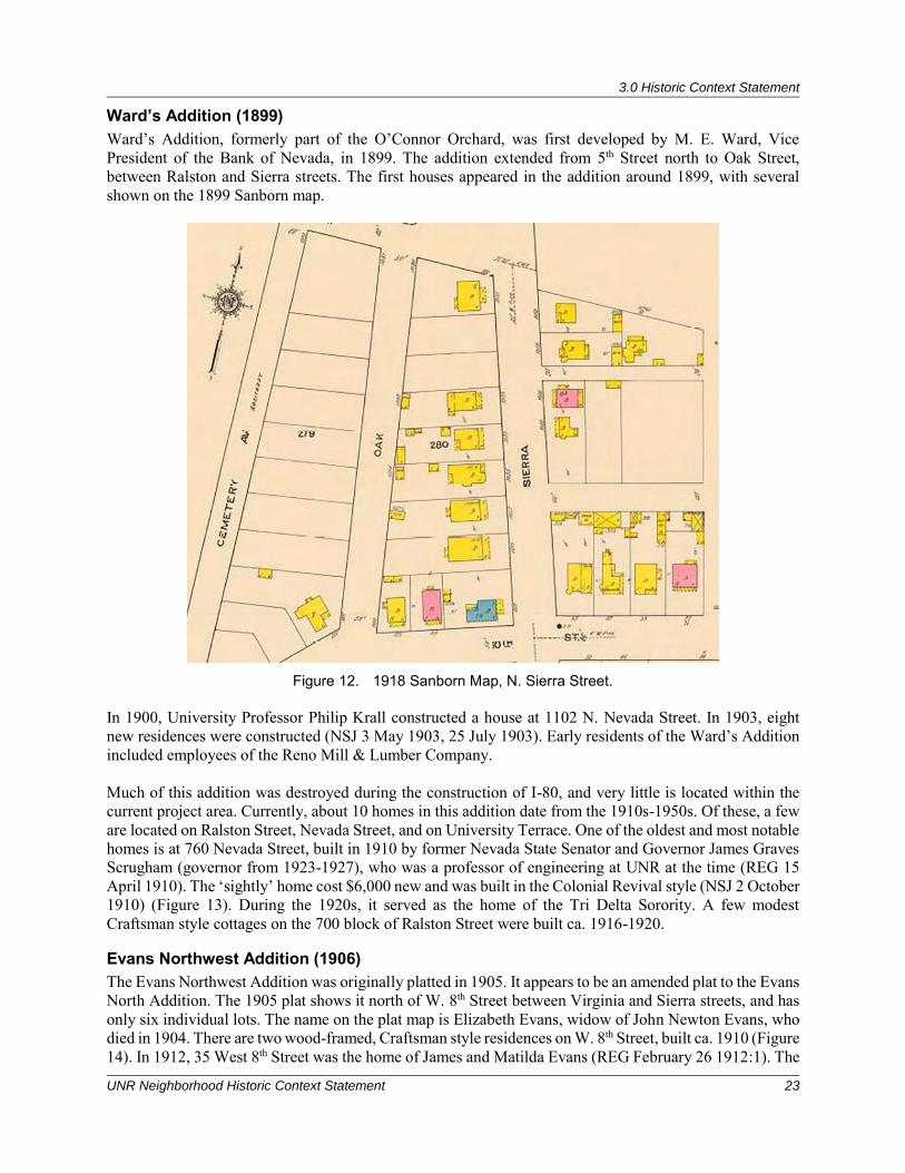
Ward’s Addition (1899) Ward’s Addition, formerly part of the O’Connor Orchard, was first developed by M. E. Ward, Vice President of the Bank of Nevada, in 1899. The addition extended from 5th Street north to Oak Street, between Ralston and Sierra streets. The first houses appeared in the addition around 1899, with several shown on the 1899 Sanborn map.
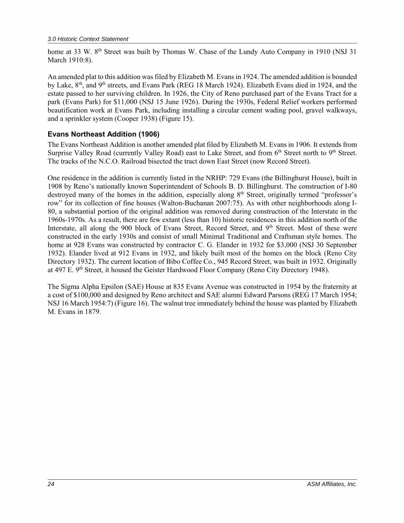
Figure 12. 1918 Sanborn Map, N. Sierra Street. In 1900, University Professor Philip Krall constructed a house at 1102 N. Nevada Street. In 1903, eight new residences were constructed (NSJ 3 May 1903, 25 July 1903). Early residents of the Ward’s Addition included employees of the Reno Mill & Lumber Company. Much of this addition was destroyed during the construction of I-80, and very little is located within the current project area. Currently, about 10 homes in this addition date from the 1910s-1950s. Of these, a few are located on Ralston Street, Nevada Street, and on University Terrace. One of the oldest and most notable homes is at 760 Nevada Street, built in 1910 by former Nevada State Senator and Governor James Graves Scrugham (governor from 1923-1927), who was a professor of engineering at UNR at the time (REG 15 April 1910). The ‘sightly’ home cost $6,000 new and was built in the Colonial Revival style (NSJ 2 October 1910) (Figure 13). During the 1920s, it served as the home of the Tri Delta Sorority. A few modest Craftsman style cottages on the 700 block of Ralston Street were built ca. 1916-1920.
Evans Northwest Addition (1906) The Evans Northwest Addition was originally platted in 1905. It appears to be an amended plat to the Evans North Addition. The 1905 plat shows it north of W. 8th Street between Virginia and Sierra streets, and has only six individual lots. The name on the plat map is Elizabeth Evans, widow of John Newton Evans, who died in 1904. There are two wood-framed, Craftsman style residences on W. 8th Street, built ca. 1910 (Figure 14). In 1912, 35 West 8th Street was the home of James and Matilda Evans (REG February 26 1912:1). The
3.0 Historic Context Statement
24 ASM Affiliates, Inc.
home at 33 W. 8th Street was built by Thomas W. Chase of the Lundy Auto Company in 1910 (NSJ 31 March 1910:8). An amended plat to this addition was filed by Elizabeth M. Evans in 1924. The amended addition is bounded by Lake, 8th, and 9th streets, and Evans Park (REG 18 March 1924). Elizabeth Evans died in 1924, and the estate passed to her surviving children. In 1926, the City of Reno purchased part of the Evans Tract for a park (Evans Park) for $11,000 (NSJ 15 June 1926). During the 1930s, Federal Relief workers performed beautification work at Evans Park, including installing a circular cement wading pool, gravel walkways, and a sprinkler system (Cooper 1938) (Figure 15).
Evans Northeast Addition (1906) The Evans Northeast Addition is another amended plat filed by Elizabeth M. Evans in 1906. It extends from Surprise Valley Road (currently Valley Road) east to Lake Street, and from 6th Street north to 9th Street. The tracks of the N.C.O. Railroad bisected the tract down East Street (now Record Street). One residence in the addition is currently listed in the NRHP: 729 Evans (the Billinghurst House), built in 1908 by Reno’s nationally known Superintendent of Schools B. D. Billinghurst. The construction of I-80 destroyed many of the homes in the addition, especially along 8th Street, originally termed “professor’s row” for its collection of fine houses (Walton-Buchanan 2007:75). As with other neighborhoods along I-80, a substantial portion of the original addition was removed during construction of the Interstate in the 1960s-1970s. As a result, there are few extant (less than 10) historic residences in this addition north of the Interstate, all along the 900 block of Evans Street, Record Street, and 9th Street. Most of these were constructed in the early 1930s and consist of small Minimal Traditional and Craftsman style homes. The home at 928 Evans was constructed by contractor C. G. Elander in 1932 for $3,000 (NSJ 30 September 1932). Elander lived at 912 Evans in 1932, and likely built most of the homes on the block (Reno City Directory 1932). The current location of Bibo Coffee Co., 945 Record Street, was built in 1932. Originally at 497 E. 9th Street, it housed the Geister Hardwood Floor Company (Reno City Directory 1948). The Sigma Alpha Epsilon (SAE) House at 835 Evans Avenue was constructed in 1954 by the fraternity at a cost of $100,000 and designed by Reno architect and SAE alumni Edward Parsons (REG 17 March 1954; NSJ 16 March 1954:7) (Figure 16). The walnut tree immediately behind the house was planted by Elizabeth M. Evans in 1879.
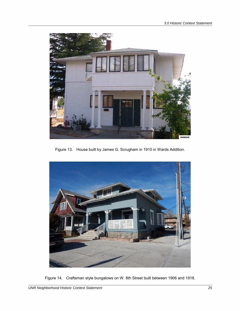
3.0 Historic Context Statement
UNR Neighborhood Historic Context Statement 25
Figure 13. House built by James G. Scrugham in 1910 in Wards Addition.
Figure 14. Craftsman style bungalows on W. 8th Street built between 1906 and 1918.
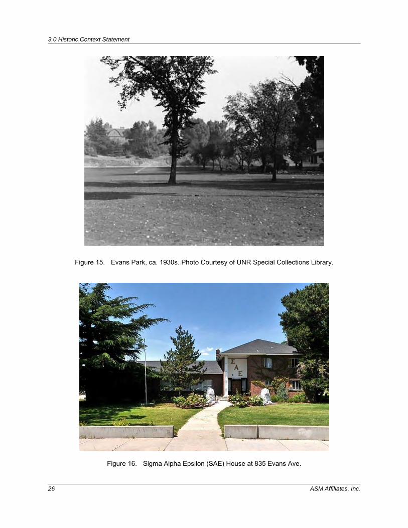
3.0 Historic Context Statement
26 ASM Affiliates, Inc.
Figure 15. Evans Park, ca. 1930s. Photo Courtesy of UNR Special Collections Library.
Figure 16. Sigma Alpha Epsilon (SAE) House at 835 Evans Ave.
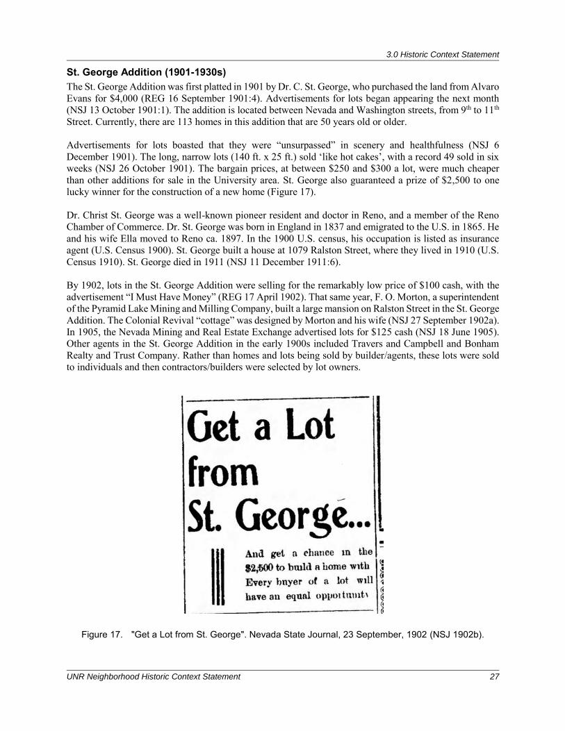
3.0 Historic Context Statement
UNR Neighborhood Historic Context Statement 27
St. George Addition (1901-1930s) The St. George Addition was first platted in 1901 by Dr. C. St. George, who purchased the land from Alvaro Evans for $4,000 (REG 16 September 1901:4). Advertisements for lots began appearing the next month (NSJ 13 October 1901:1). The addition is located between Nevada and Washington streets, from 9th to 11th Street. Currently, there are 113 homes in this addition that are 50 years old or older. Advertisements for lots boasted that they were “unsurpassed” in scenery and healthfulness (NSJ 6 December 1901). The long, narrow lots (140 ft. x 25 ft.) sold ‘like hot cakes’, with a record 49 sold in six weeks (NSJ 26 October 1901). The bargain prices, at between $250 and $300 a lot, were much cheaper than other additions for sale in the University area. St. George also guaranteed a prize of $2,500 to one lucky winner for the construction of a new home (Figure 17). Dr. Christ St. George was a well-known pioneer resident and doctor in Reno, and a member of the Reno Chamber of Commerce. Dr. St. George was born in England in 1837 and emigrated to the U.S. in 1865. He and his wife Ella moved to Reno ca. 1897. In the 1900 U.S. census, his occupation is listed as insurance agent (U.S. Census 1900). St. George built a house at 1079 Ralston Street, where they lived in 1910 (U.S. Census 1910). St. George died in 1911 (NSJ 11 December 1911:6). By 1902, lots in the St. George Addition were selling for the remarkably low price of $100 cash, with the advertisement “I Must Have Money” (REG 17 April 1902). That same year, F. O. Morton, a superintendent of the Pyramid Lake Mining and Milling Company, built a large mansion on Ralston Street in the St. George Addition. The Colonial Revival “cottage” was designed by Morton and his wife (NSJ 27 September 1902a). In 1905, the Nevada Mining and Real Estate Exchange advertised lots for $125 cash (NSJ 18 June 1905). Other agents in the St. George Addition in the early 1900s included Travers and Campbell and Bonham Realty and Trust Company. Rather than homes and lots being sold by builder/agents, these lots were sold to individuals and then contractors/builders were selected by lot owners.
Figure 17. "Get a Lot from St. George". Nevada State Journal, 23 September, 1902 (NSJ 1902b).
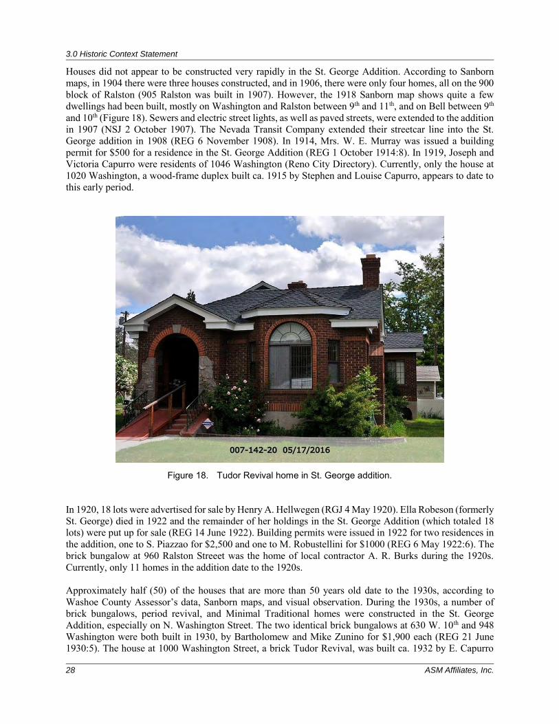
3.0 Historic Context Statement
28 ASM Affiliates, Inc.
Houses did not appear to be constructed very rapidly in the St. George Addition. According to Sanborn maps, in 1904 there were three houses constructed, and in 1906, there were only four homes, all on the 900 block of Ralston (905 Ralston was built in 1907). However, the 1918 Sanborn map shows quite a few dwellings had been built, mostly on Washington and Ralston between 9th and 11th, and on Bell between 9th and 10th (Figure 18). Sewers and electric street lights, as well as paved streets, were extended to the addition in 1907 (NSJ 2 October 1907). The Nevada Transit Company extended their streetcar line into the St. George addition in 1908 (REG 6 November 1908). In 1914, Mrs. W. E. Murray was issued a building permit for $500 for a residence in the St. George Addition (REG 1 October 1914:8). In 1919, Joseph and Victoria Capurro were residents of 1046 Washington (Reno City Directory). Currently, only the house at 1020 Washington, a wood-frame duplex built ca. 1915 by Stephen and Louise Capurro, appears to date to this early period.
Figure 18. Tudor Revival home in St. George addition. In 1920, 18 lots were advertised for sale by Henry A. Hellwegen (RGJ 4 May 1920). Ella Robeson (formerly St. George) died in 1922 and the remainder of her holdings in the St. George Addition (which totaled 18 lots) were put up for sale (REG 14 June 1922). Building permits were issued in 1922 for two residences in the addition, one to S. Piazzao for $2,500 and one to M. Robustellini for $1000 (REG 6 May 1922:6). The brick bungalow at 960 Ralston Streeet was the home of local contractor A. R. Burks during the 1920s. Currently, only 11 homes in the addition date to the 1920s. Approximately half (50) of the houses that are more than 50 years old date to the 1930s, according to Washoe County Assessor’s data, Sanborn maps, and visual observation. During the 1930s, a number of brick bungalows, period revival, and Minimal Traditional homes were constructed in the St. George Addition, especially on N. Washington Street. The two identical brick bungalows at 630 W. 10th and 948 Washington were both built in 1930, by Bartholomew and Mike Zunino for $1,900 each (REG 21 June 1930:5). The house at 1000 Washington Street, a brick Tudor Revival, was built ca. 1932 by E. Capurro
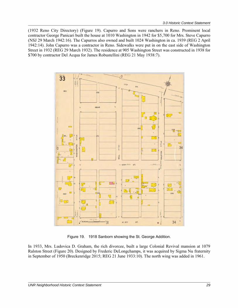
3.0 Historic Context Statement
UNR Neighborhood Historic Context Statement 29
(1932 Reno City Directory) (Figure 19). Capurro and Sons were ranchers in Reno. Prominent local contractor George Panicari built the house at 1010 Washington in 1942 for $5,700 for Mrs. Steve Capurro (NSJ 29 March 1942:16). The Capurros also owned and built 1024 Washington in ca. 1939 (REG 2 April 1942:14). John Capurro was a contractor in Reno. Sidewalks were put in on the east side of Washington Street in 1932 (REG 29 March 1932). The residence at 905 Washington Street was constructed in 1938 for $700 by contractor Del Acqua for James Robustellini (REG 21 May 1938:7).
Figure 19. 1918 Sanborn showing the St. George Addition. In 1933, Mrs. Ludovica D. Graham, the rich divorcee, built a large Colonial Revival mansion at 1079 Ralston Street (Figure 20). Designed by Frederic DeLongchamps, it was acquired by Sigma Nu fraternity in September of 1950 (Breckenridge 2015; REG 21 June 1933:10). The north wing was added in 1961.
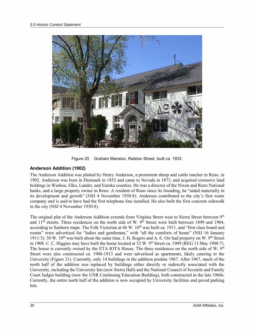
3.0 Historic Context Statement
30 ASM Affiliates, Inc.
Figure 20. Graham Mansion, Ralston Street, built ca. 1933.
Anderson Addition (1902) The Anderson Addition was platted by Henry Anderson, a prominent sheep and cattle rancher in Reno, in 1902. Anderson was born in Denmark in 1852 and came to Nevada in 1873, and acquired extensive land holdings in Washoe, Elko, Lander, and Eureka counties. He was a director of the Nixon and Reno National banks, and a large property owner in Reno. A resident of Reno since its founding, he “aided materially in its development and growth” (NSJ 4 November 1930:8). Anderson contributed to the city’s first water company and is said to have had the first telephone line installed. He also built the first concrete sidewalk in the city (NSJ 4 November 1930:8). The original plat of the Anderson Addition extends from Virginia Street west to Sierra Street between 9th and 11th streets. Three residences on the north side of W. 9th Street were built between 1899 and 1904, according to Sanborn maps. The Folk Victorian at 46 W. 10th was built ca. 1911, and “first class board and rooms” were advertised for “ladies and gentleman,” with “all the comforts of home” (NSJ 16 January 1911:3). 30 W. 10th was built about the same time. J. H. Rogers and A. E. Orr had property on W. 9th Street in 1908. C. C. Higgins may have built the home located at 52 W. 9th Street ca. 1909 (REG 13 May 1908:7). The house is currently owned by the ETA IOTA House. The three residences on the north side of W. 9th Street were also constructed ca. 1908-1913 and were advertised as apartments, likely catering to the University (Figure 21). Currently, only 14 buildings in the addition predate 1967. After 1967, much of the north half of the addition was replaced by buildings either directly or indirectly associated with the University, including the University Inn (now Sierra Hall) and the National Council of Juvenile and Family Court Judges building (now the UNR Continuing Education Building), both constructed in the late 1960s. Currently, the entire north half of the addition is now occupied by University facilities and paved parking lots.
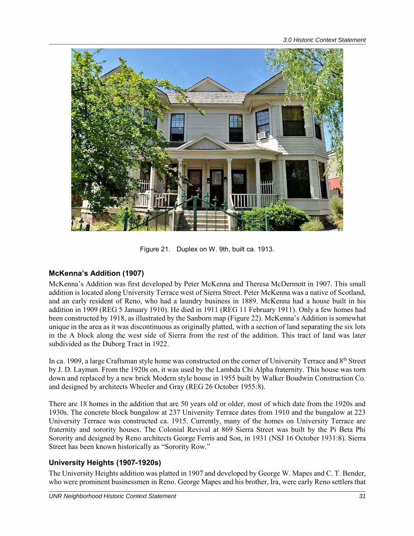
3.0 Historic Context Statement
UNR Neighborhood Historic Context Statement 31
Figure 21. Duplex on W. 9th, built ca. 1913.
McKenna’s Addition (1907) McKenna’s Addition was first developed by Peter McKenna and Theresa McDermott in 1907. This small addition is located along University Terrace west of Sierra Street. Peter McKenna was a native of Scotland, and an early resident of Reno, who had a laundry business in 1889. McKenna had a house built in his addition in 1909 (REG 5 January 1910). He died in 1911 (REG 11 February 1911). Only a few homes had been constructed by 1918, as illustrated by the Sanborn map (Figure 22). McKenna’s Addition is somewhat unique in the area as it was discontinuous as originally platted, with a section of land separating the six lots in the A block along the west side of Sierra from the rest of the addition. This tract of land was later subdivided as the Duborg Tract in 1922. In ca. 1909, a large Craftsman style home was constructed on the corner of University Terrace and 8th Street by J. D. Layman. From the 1920s on, it was used by the Lambda Chi Alpha fraternity. This house was torn down and replaced by a new brick Modern style house in 1955 built by Walker Boudwin Construction Co. and designed by architects Wheeler and Gray (REG 26 October 1955:8). There are 18 homes in the addition that are 50 years old or older, most of which date from the 1920s and 1930s. The concrete block bungalow at 237 University Terrace dates from 1910 and the bungalow at 223 University Terrace was constructed ca. 1915. Currently, many of the homes on University Terrace are fraternity and sorority houses. The Colonial Revival at 869 Sierra Street was built by the Pi Beta Phi Sorority and designed by Reno architects George Ferris and Son, in 1931 (NSJ 16 October 1931:8). Sierra Street has been known historically as “Sorority Row.”
University Heights (1907-1920s) The University Heights addition was platted in 1907 and developed by George W. Mapes and C. T. Bender, who were prominent businessmen in Reno. George Mapes and his brother, Ira, were early Reno settlers that
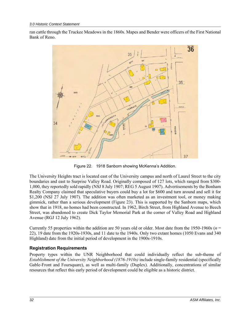
3.0 Historic Context Statement
32 ASM Affiliates, Inc.
ran cattle through the Truckee Meadows in the 1860s. Mapes and Bender were officers of the First National Bank of Reno.
Figure 22. 1918 Sanborn showing McKenna’s Addition. The University Heights tract is located east of the University campus and north of Laurel Street to the city boundaries and east to Surprise Valley Road. Originally composed of 127 lots, which ranged from $300-1,000, they reportedly sold rapidly (NSJ 8 July 1907; REG 5 August 1907). Advertisements by the Bonham Realty Company claimed that speculative buyers could buy a lot for $600 and turn around and sell it for $1,200 (NSJ 27 July 1907). The addition was often marketed as an investment tool, or money making gimmick, rather than a serious development (Figure 23). This is supported by the Sanborn maps, which show that in 1918, no homes had been constructed. In 1962, Birch Street, from Highland Avenue to Beech Street, was abandoned to create Dick Taylor Memorial Park at the corner of Valley Road and Highland Avenue (RGJ 12 July 1962). Currently 55 properties within the addition are 50 years old or older. Most date from the 1950-1960s (n = 22), 19 date from the 1920s-1930s, and 11 date to the 1940s. Only two extant homes (1050 Evans and 340 Highland) date from the initial period of development in the 1900s-1910s.
Registration Requirements Property types within the UNR Neighborhood that could individually reflect the sub-theme of Establishment of the University Neighborhood (1876-1910s) include single-family residential (specifically Gable-Front and Foursquare), as well as multi-family (Duplex). Additionally, concentrations of similar resources that reflect this early period of development could be eligible as a historic district.
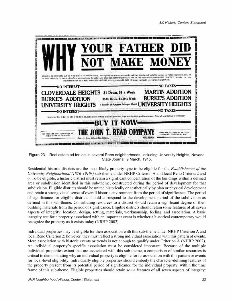
3.0 Historic Context Statement
UNR Neighborhood Historic Context Statement 33
Figure 23. Real estate ad for lots in several Reno neighborhoods, including University Heights, Nevada State Journal, 9 March, 1915.
Residential historic districts are the most likely property type to be eligible for the Establishment of the University Neighborhood (1876-1910s) sub-theme under NRHP Criterion A and local Reno Criteria 2 and 6. To be eligible, a historic district must retain a significant concentration of the buildings within a defined area or subdivision identified in this sub-theme, constructed during the period of development for that subdivision. Eligible districts should be united historically or aesthetically by plan or physical development and retain a strong visual sense of overall historic environment from the period of significance. The period of significance for eligible districts should correspond to the development period of the subdivision as defined in this sub-theme. Contributing resources to a district should retain a significant degree of their building materials from the period of significance. Eligible districts should retain some features of all seven aspects of integrity: location, design, setting, materials, workmanship, feeling, and association. A basic integrity test for a property associated with an important event is whether a historical contemporary would recognize the property as it exists today (NRHP 2002). Individual properties may be eligible for their association with this sub-theme under NRHP Criterion A and local Reno Criterion 2; however, they must reflect a strong individual association with this pattern of events. Mere association with historic events or trends is not enough to qualify under Criterion A (NHRP 2002). An individual property’s specific association must be considered important. Because of the multiple individual properties extant that are associated with this sub-theme, a comparison of similar resources is critical to demonstrating why an individual property is eligible for its association with this pattern or events for local-level eligibility. Individually eligible properties should embody the character-defining features of the property present from its potential period of significance for the individual property, within the time frame of this sub-theme. Eligible properties should retain some features of all seven aspects of integrity:
3.0 Historic Context Statement
34 ASM Affiliates, Inc.
location, design, setting, materials, workmanship, feeling, and association. A basic integrity test for a property associated with an important event is whether a historical contemporary would recognize the property as it exists today (NRHP 2002). Individual properties may be eligible for their association with this theme under NRHP Criterion B and local Reno Criterion 2. Properties will be individually eligible for their association with individuals who were influential in community development. Examples of such individuals associated with properties in the UNR project area include brothers Alvaro Evans, John Newton “Newt” Evans, Elizabeth Evans, and C. C. Powning, all of whom were instrumental in developing the neighborhoods south and west of the University. The period of significance for individual properties eligible under NRHP Criterion B and local Reno Criterion 2 will reflect that significant individual’s direct association with this property. To be eligible under this theme/criterion, a property must be associated with the significant person’s productive life, reflecting the time period when he or she achieved significance. Other extant properties with which the significant individual is associated should also be identified and considered in the evaluation. Eligible properties should retain some features of all seven aspects of integrity: location, design, setting, materials, workmanship, feeling, and association. A basic integrity test for a property associated with an important person is whether a historical contemporary would recognize the property as it exists today (NRHP 2002).
3.2.2 Sub-theme: Early Twentieth-Century Development in the University Neighborhood (1910s-1930s)
During this period, development surrounding the University became increasingly popular, and with the newly installed streetcar lines providing service to the University area, real estate was in high demand. Subdivisions of this era were designed with curvilinear streets and variation in lot sizes, rather than the typical grid pattern. No longer purely speculative operations, subdivisions of this period were designed by builder-developers, with the idea of creating a neighborhood of homes of similar styles, in a park like setting. Deed restrictions were put in place, and developers spent great sums of money to bring sewers, sidewalks, and electricity to their tracts. Additions in the area surrounding UNR during this period include University Terrace, the Duborg Tract, Campus Heights, and Evans Vista.
University Terrace (1916-1928) University Terrace was first platted in 1916 by the Reno Power, Light & Water Company. Incorporated in 1904, the Reno Power Light and Water Company obtained controlling interest in the Nevada Transit Co. in 1905 (Poor’s Railroad Manual Company 1915). The Nevada Transit Co. was instrumental in developing other housing tracts in Reno, such as the Burke and Wells Additions (REG 30 July 1904:5). In contrast to many of the additions previously discussed, the streets in the University Terrace Addition were curvilinear, rather than a simple grid. Bounded on the east by Sierra Street and the west by Washington Street between 11th and Terrace Way, it originally comprised 273 lots. Development in the addition was slow, and although several lots were sold and streets and sidewalks were constructed in 1916, homes had yet to be built in 1918, when the next Sanborn map was completed (REG 24 October 1916:8). In 1926, Howard H. McKissick sold 243 lots to former congressman Charles L. Richards (REG 2 April 1926:8). In 1928, Nevada Developers, Inc. purchased the property from Richards for a reported $37,000 (REG 8 March 1928). Nevada Developers, Inc. was a real estate development company in Reno headed by W. E. Barnard (REG 21 January 1930:10). Barnard claimed to have studied development in other western cities (San Francisco, Portland, Salt Lake, Phoenix, San Diego, Los Angeles), where he found that people were moving away from the “congested city centers and moving to the suburbs.” University Terrace was modeled after this trend, and was protected with a $3,500 building restriction. All the lots were sold within a year, many in the mining towns of Goldfield, Manhattan, Tonopah, and Silver Peak (NSJ 4 May 1930:14). The addition’s popularity was due to its proximity to the University, as well as the commanding view of
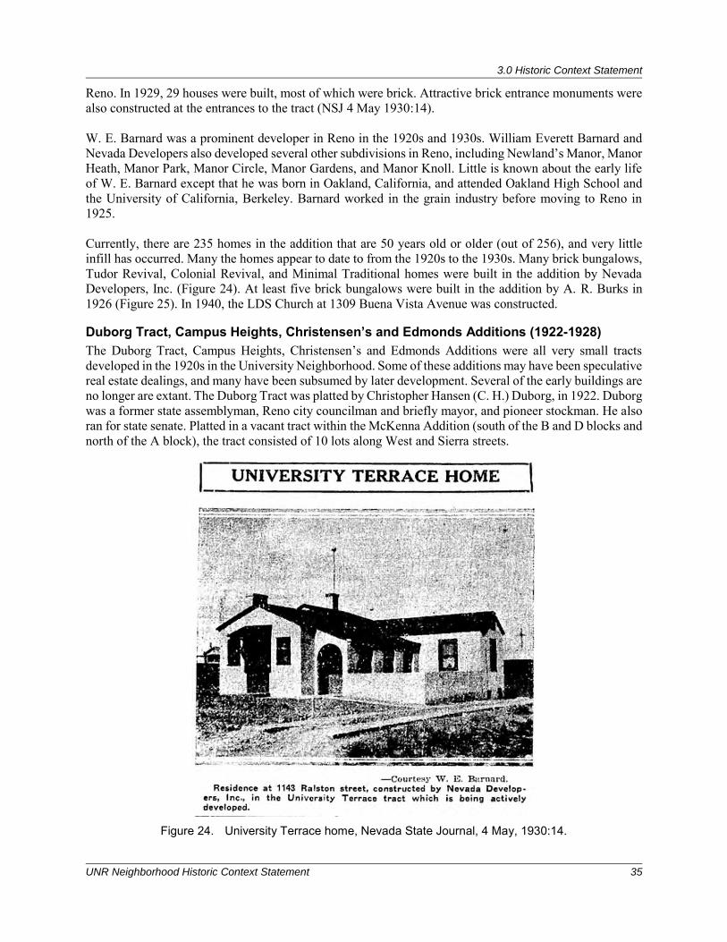
3.0 Historic Context Statement
UNR Neighborhood Historic Context Statement 35
Reno. In 1929, 29 houses were built, most of which were brick. Attractive brick entrance monuments were also constructed at the entrances to the tract (NSJ 4 May 1930:14). W. E. Barnard was a prominent developer in Reno in the 1920s and 1930s. William Everett Barnard and Nevada Developers also developed several other subdivisions in Reno, including Newland’s Manor, Manor Heath, Manor Park, Manor Circle, Manor Gardens, and Manor Knoll. Little is known about the early life of W. E. Barnard except that he was born in Oakland, California, and attended Oakland High School and the University of California, Berkeley. Barnard worked in the grain industry before moving to Reno in 1925. Currently, there are 235 homes in the addition that are 50 years old or older (out of 256), and very little infill has occurred. Many the homes appear to date to from the 1920s to the 1930s. Many brick bungalows, Tudor Revival, Colonial Revival, and Minimal Traditional homes were built in the addition by Nevada Developers, Inc. (Figure 24). At least five brick bungalows were built in the addition by A. R. Burks in 1926 (Figure 25). In 1940, the LDS Church at 1309 Buena Vista Avenue was constructed.
Duborg Tract, Campus Heights, Christensen’s and Edmonds Additions (1922-1928) The Duborg Tract, Campus Heights, Christensen’s and Edmonds Additions were all very small tracts developed in the 1920s in the University Neighborhood. Some of these additions may have been speculative real estate dealings, and many have been subsumed by later development. Several of the early buildings are no longer are extant. The Duborg Tract was platted by Christopher Hansen (C. H.) Duborg, in 1922. Duborg was a former state assemblyman, Reno city councilman and briefly mayor, and pioneer stockman. He also ran for state senate. Platted in a vacant tract within the McKenna Addition (south of the B and D blocks and north of the A block), the tract consisted of 10 lots along West and Sierra streets.
Figure 24. University Terrace home, Nevada State Journal, 4 May, 1930:14.
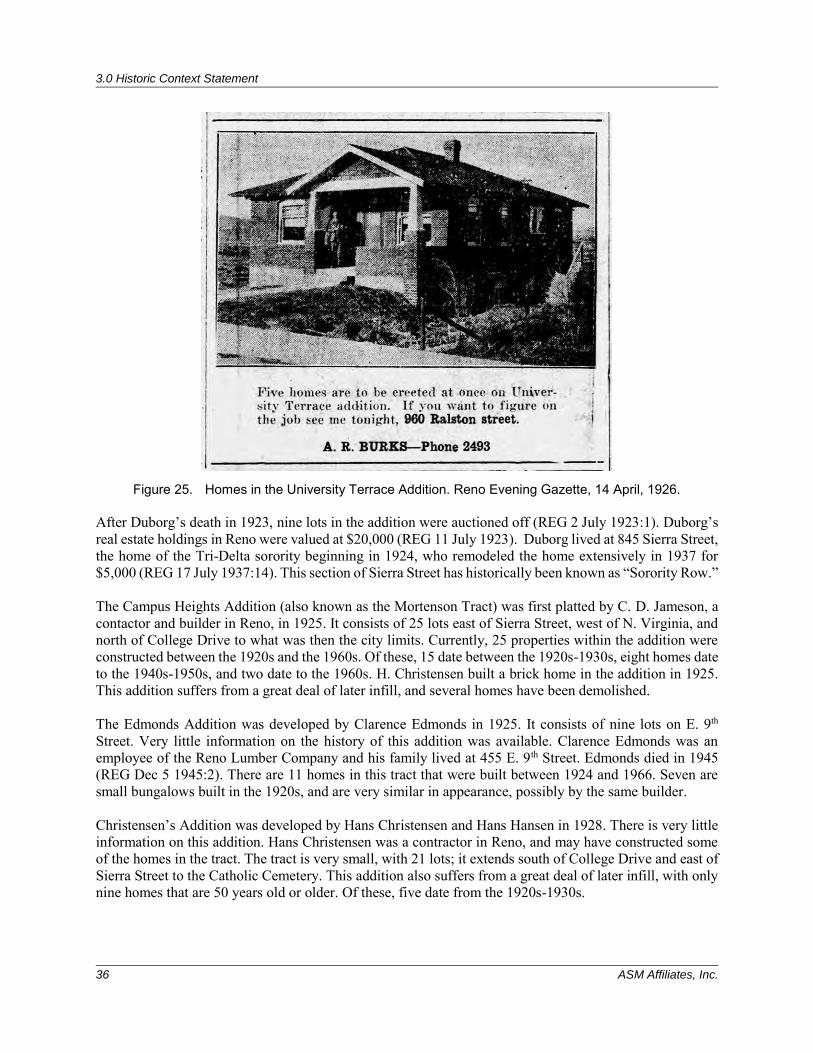
3.0 Historic Context Statement
36 ASM Affiliates, Inc.
Figure 25. Homes in the University Terrace Addition. Reno Evening Gazette, 14 April, 1926. After Duborg’s death in 1923, nine lots in the addition were auctioned off (REG 2 July 1923:1). Duborg’s real estate holdings in Reno were valued at $20,000 (REG 11 July 1923). Duborg lived at 845 Sierra Street, the home of the Tri-Delta sorority beginning in 1924, who remodeled the home extensively in 1937 for $5,000 (REG 17 July 1937:14). This section of Sierra Street has historically been known as “Sorority Row.” The Campus Heights Addition (also known as the Mortenson Tract) was first platted by C. D. Jameson, a contactor and builder in Reno, in 1925. It consists of 25 lots east of Sierra Street, west of N. Virginia, and north of College Drive to what was then the city limits. Currently, 25 properties within the addition were constructed between the 1920s and the 1960s. Of these, 15 date between the 1920s-1930s, eight homes date to the 1940s-1950s, and two date to the 1960s. H. Christensen built a brick home in the addition in 1925. This addition suffers from a great deal of later infill, and several homes have been demolished. The Edmonds Addition was developed by Clarence Edmonds in 1925. It consists of nine lots on E. 9th Street. Very little information on the history of this addition was available. Clarence Edmonds was an employee of the Reno Lumber Company and his family lived at 455 E. 9th Street. Edmonds died in 1945 (REG Dec 5 1945:2). There are 11 homes in this tract that were built between 1924 and 1966. Seven are small bungalows built in the 1920s, and are very similar in appearance, possibly by the same builder. Christensen’s Addition was developed by Hans Christensen and Hans Hansen in 1928. There is very little information on this addition. Hans Christensen was a contractor in Reno, and may have constructed some of the homes in the tract. The tract is very small, with 21 lots; it extends south of College Drive and east of Sierra Street to the Catholic Cemetery. This addition also suffers from a great deal of later infill, with only nine homes that are 50 years old or older. Of these, five date from the 1920s-1930s.
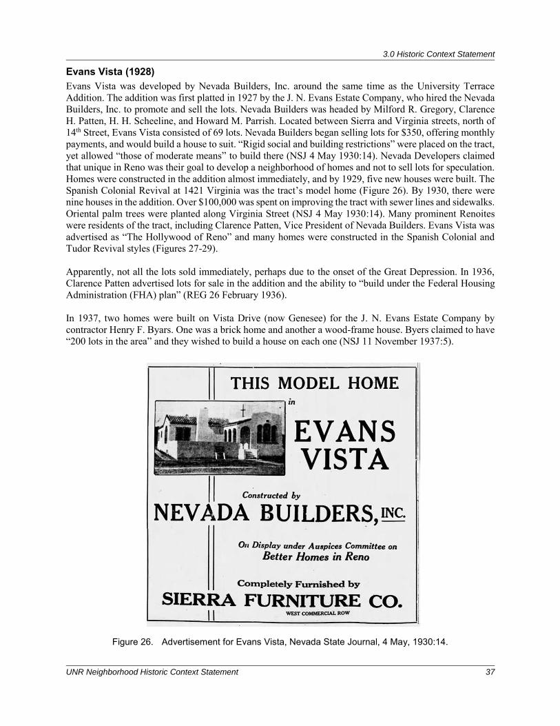
3.0 Historic Context Statement
UNR Neighborhood Historic Context Statement 37
Evans Vista (1928) Evans Vista was developed by Nevada Builders, Inc. around the same time as the University Terrace Addition. The addition was first platted in 1927 by the J. N. Evans Estate Company, who hired the Nevada Builders, Inc. to promote and sell the lots. Nevada Builders was headed by Milford R. Gregory, Clarence H. Patten, H. H. Scheeline, and Howard M. Parrish. Located between Sierra and Virginia streets, north of 14th Street, Evans Vista consisted of 69 lots. Nevada Builders began selling lots for $350, offering monthly payments, and would build a house to suit. “Rigid social and building restrictions” were placed on the tract, yet allowed “those of moderate means” to build there (NSJ 4 May 1930:14). Nevada Developers claimed that unique in Reno was their goal to develop a neighborhood of homes and not to sell lots for speculation. Homes were constructed in the addition almost immediately, and by 1929, five new houses were built. The Spanish Colonial Revival at 1421 Virginia was the tract’s model home (Figure 26). By 1930, there were nine houses in the addition. Over $100,000 was spent on improving the tract with sewer lines and sidewalks. Oriental palm trees were planted along Virginia Street (NSJ 4 May 1930:14). Many prominent Renoites were residents of the tract, including Clarence Patten, Vice President of Nevada Builders. Evans Vista was advertised as “The Hollywood of Reno” and many homes were constructed in the Spanish Colonial and Tudor Revival styles (Figures 27-29). Apparently, not all the lots sold immediately, perhaps due to the onset of the Great Depression. In 1936, Clarence Patten advertised lots for sale in the addition and the ability to “build under the Federal Housing Administration (FHA) plan” (REG 26 February 1936). In 1937, two homes were built on Vista Drive (now Genesee) for the J. N. Evans Estate Company by contractor Henry F. Byars. One was a brick home and another a wood-frame house. Byers claimed to have “200 lots in the area” and they wished to build a house on each one (NSJ 11 November 1937:5).
Figure 26. Advertisement for Evans Vista, Nevada State Journal, 4 May, 1930:14.
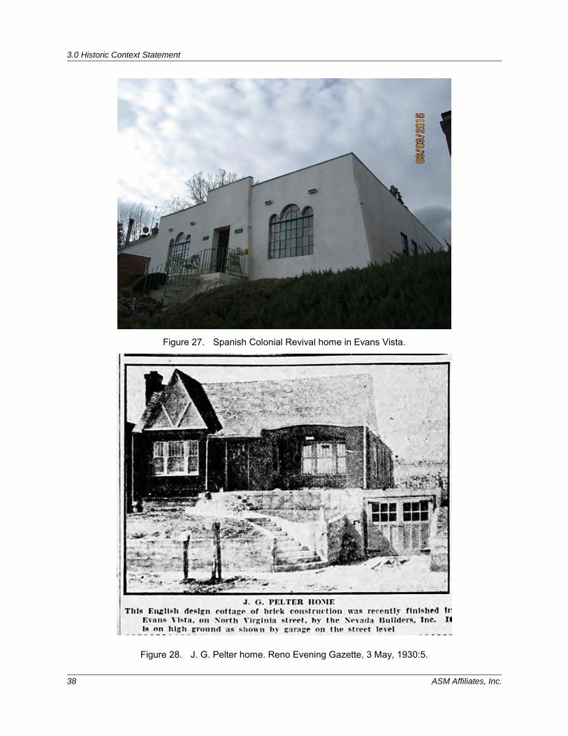
3.0 Historic Context Statement
38 ASM Affiliates, Inc.
Figure 27. Spanish Colonial Revival home in Evans Vista.
Figure 28. J. G. Pelter home. Reno Evening Gazette, 3 May, 1930:5.
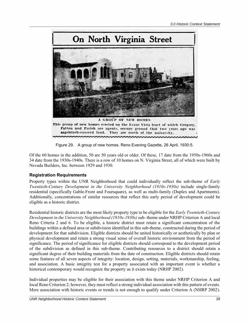
3.0 Historic Context Statement
UNR Neighborhood Historic Context Statement 39
Figure 29. A group of new homes. Reno Evening Gazette, 26 April, 1930:5. Of the 60 homes in the addition, 50 are 50 years old or older. Of these, 17 date from the 1950s-1960s and 34 date from the 1930s-1940s. There is a row of 10 homes on N. Virginia Street, all of which were built by Nevada Builders, Inc. between 1929 and 1930.
Registration Requirements Property types within the UNR Neighborhood that could individually reflect the sub-theme of Early Twentieth-Century Development in the University Neighborhood (1910s-1930s) include single-family residential (specifically Gable-Front and Foursquare), as well as multi-family (Duplex and Apartments). Additionally, concentrations of similar resources that reflect this early period of development could be eligible as a historic district. Residential historic districts are the most likely property type to be eligible for the Early Twentieth-Century Development in the University Neighborhood (1910s-1930s) sub- theme under NRHP Criterion A and local Reno Criteria 2 and 6. To be eligible, a historic district must retain a significant concentration of the buildings within a defined area or subdivision identified in this sub-theme, constructed during the period of development for that subdivision. Eligible districts should be united historically or aesthetically by plan or physical development and retain a strong visual sense of overall historic environment from the period of significance. The period of significance for eligible districts should correspond to the development period of the subdivision as defined in this sub-theme. Contributing resources to a district should retain a significant degree of their building materials from the date of construction. Eligible districts should retain some features of all seven aspects of integrity: location, design, setting, materials, workmanship, feeling, and association. A basic integrity test for a property associated with an important event is whether a historical contemporary would recognize the property as it exists today (NRHP 2002). Individual properties may be eligible for their association with this theme under NRHP Criterion A and local Reno Criterion 2; however, they must reflect a strong individual association with this pattern of events. Mere association with historic events or trends is not enough to qualify under Criterion A (NHRP 2002).
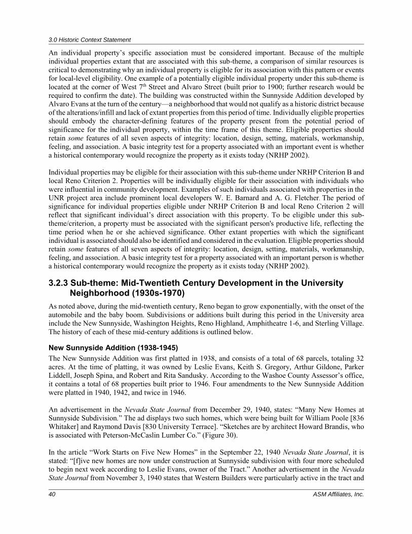
3.0 Historic Context Statement
40 ASM Affiliates, Inc.
An individual property’s specific association must be considered important. Because of the multiple individual properties extant that are associated with this sub-theme, a comparison of similar resources is critical to demonstrating why an individual property is eligible for its association with this pattern or events for local-level eligibility. One example of a potentially eligible individual property under this sub-theme is located at the corner of West 7th Street and Alvaro Street (built prior to 1900; further research would be required to confirm the date). The building was constructed within the Sunnyside Addition developed by Alvaro Evans at the turn of the century—a neighborhood that would not qualify as a historic district because of the alterations/infill and lack of extant properties from this period of time. Individually eligible properties should embody the character-defining features of the property present from the potential period of significance for the individual property, within the time frame of this theme. Eligible properties should retain some features of all seven aspects of integrity: location, design, setting, materials, workmanship, feeling, and association. A basic integrity test for a property associated with an important event is whether a historical contemporary would recognize the property as it exists today (NRHP 2002). Individual properties may be eligible for their association with this sub-theme under NRHP Criterion B and local Reno Criterion 2. Properties will be individually eligible for their association with individuals who were influential in community development. Examples of such individuals associated with properties in the UNR project area include prominent local developers W. E. Barnard and A. G. Fletcher. The period of significance for individual properties eligible under NRHP Criterion B and local Reno Criterion 2 will reflect that significant individual’s direct association with this property. To be eligible under this sub-theme/criterion, a property must be associated with the significant person's productive life, reflecting the time period when he or she achieved significance. Other extant properties with which the significant individual is associated should also be identified and considered in the evaluation. Eligible properties should retain some features of all seven aspects of integrity: location, design, setting, materials, workmanship, feeling, and association. A basic integrity test for a property associated with an important person is whether a historical contemporary would recognize the property as it exists today (NRHP 2002).
3.2.3 Sub-theme: Mid-Twentieth Century Development in the University Neighborhood (1930s-1970)
As noted above, during the mid-twentieth century, Reno began to grow exponentially, with the onset of the automobile and the baby boom. Subdivisions or additions built during this period in the University area include the New Sunnyside, Washington Heights, Reno Highland, Amphitheatre 1-6, and Sterling Village. The history of each of these mid-century additions is outlined below.
New Sunnyside Addition (1938-1945) The New Sunnyside Addition was first platted in 1938, and consists of a total of 68 parcels, totaling 32 acres. At the time of platting, it was owned by Leslie Evans, Keith S. Gregory, Arthur Gildone, Parker Liddell, Joseph Spina, and Robert and Rita Sandusky. According to the Washoe County Assessor’s office, it contains a total of 68 properties built prior to 1946. Four amendments to the New Sunnyside Addition were platted in 1940, 1942, and twice in 1946. An advertisement in the Nevada State Journal from December 29, 1940, states: “Many New Homes at Sunnyside Subdivision.” The ad displays two such homes, which were being built for William Poole [836 Whitaker] and Raymond Davis [830 University Terrace]. “Sketches are by architect Howard Brandis, who is associated with Peterson-McCaslin Lumber Co.” (Figure 30). In the article “Work Starts on Five New Homes” in the September 22, 1940 Nevada State Journal, it is stated: “[f]ive new homes are now under construction at Sunnyside subdivision with four more scheduled to begin next week according to Leslie Evans, owner of the Tract.” Another advertisement in the Nevada State Journal from November 3, 1940 states that Western Builders were particularly active in the tract and
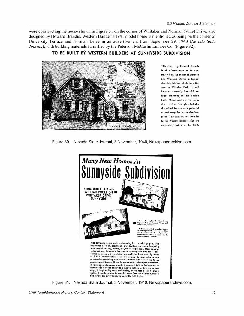
3.0 Historic Context Statement
UNR Neighborhood Historic Context Statement 41
were constructing the house shown in Figure 31 on the corner of Whitaker and Norman (Vine) Drive, also designed by Howard Brandis. Western Builder’s 1941 model home is mentioned as being on the corner of University Terrace and Norman Drive in an advertisement from September 29, 1940 (Nevada State Journal), with building materials furnished by the Peterson-McCaslin Lumber Co. (Figure 32).
Figure 30. Nevada State Journal, 3 November, 1940, Newspaperarchive.com.
Figure 31. Nevada State Journal, 3 November, 1940, Newspaperarchive.com.
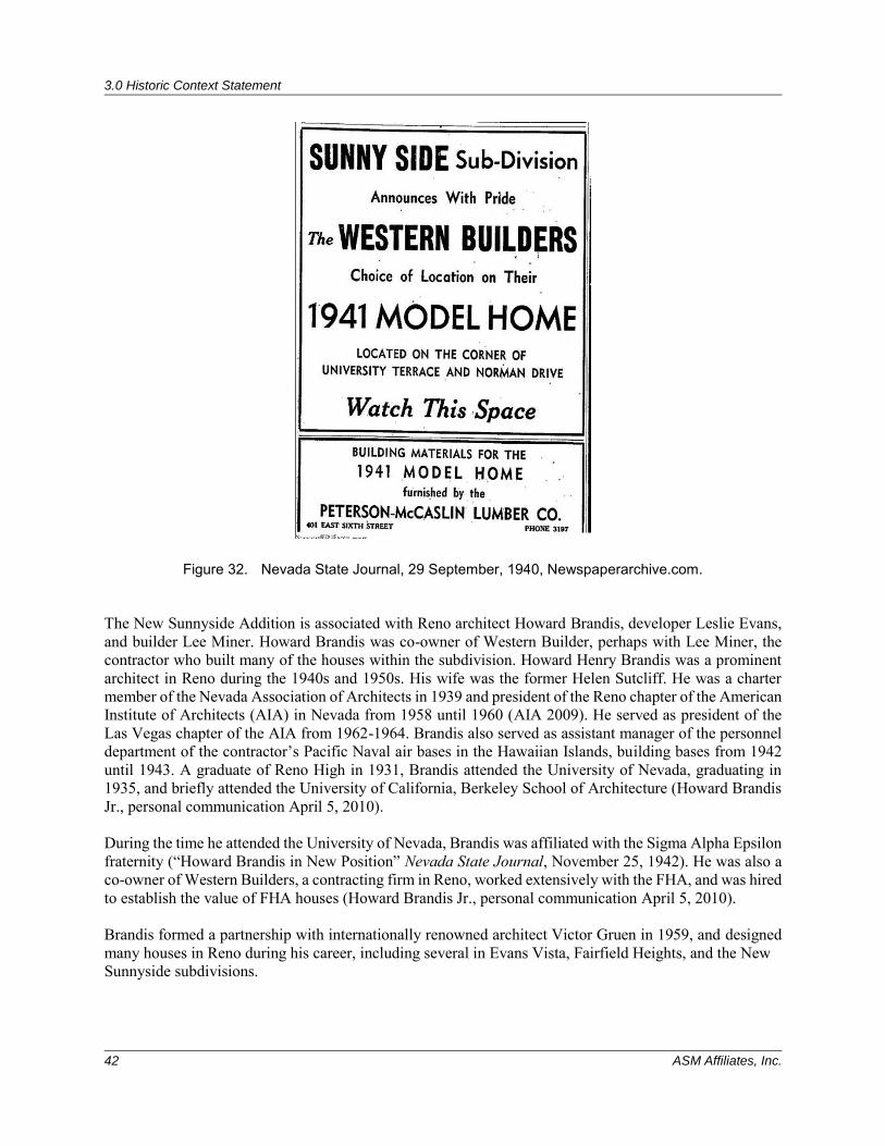
3.0 Historic Context Statement
42 ASM Affiliates, Inc.
Figure 32. Nevada State Journal, 29 September, 1940, Newspaperarchive.com. The New Sunnyside Addition is associated with Reno architect Howard Brandis, developer Leslie Evans, and builder Lee Miner. Howard Brandis was co-owner of Western Builder, perhaps with Lee Miner, the contractor who built many of the houses within the subdivision. Howard Henry Brandis was a prominent architect in Reno during the 1940s and 1950s. His wife was the former Helen Sutcliff. He was a charter member of the Nevada Association of Architects in 1939 and president of the Reno chapter of the American Institute of Architects (AIA) in Nevada from 1958 until 1960 (AIA 2009). He served as president of the Las Vegas chapter of the AIA from 1962-1964. Brandis also served as assistant manager of the personnel department of the contractor’s Pacific Naval air bases in the Hawaiian Islands, building bases from 1942 until 1943. A graduate of Reno High in 1931, Brandis attended the University of Nevada, graduating in 1935, and briefly attended the University of California, Berkeley School of Architecture (Howard Brandis Jr., personal communication April 5, 2010). During the time he attended the University of Nevada, Brandis was affiliated with the Sigma Alpha Epsilon fraternity (“Howard Brandis in New Position” Nevada State Journal, November 25, 1942). He was also a co-owner of Western Builders, a contracting firm in Reno, worked extensively with the FHA, and was hired to establish the value of FHA houses (Howard Brandis Jr., personal communication April 5, 2010). Brandis formed a partnership with internationally renowned architect Victor Gruen in 1959, and designed many houses in Reno during his career, including several in Evans Vista, Fairfield Heights, and the New Sunnyside subdivisions.
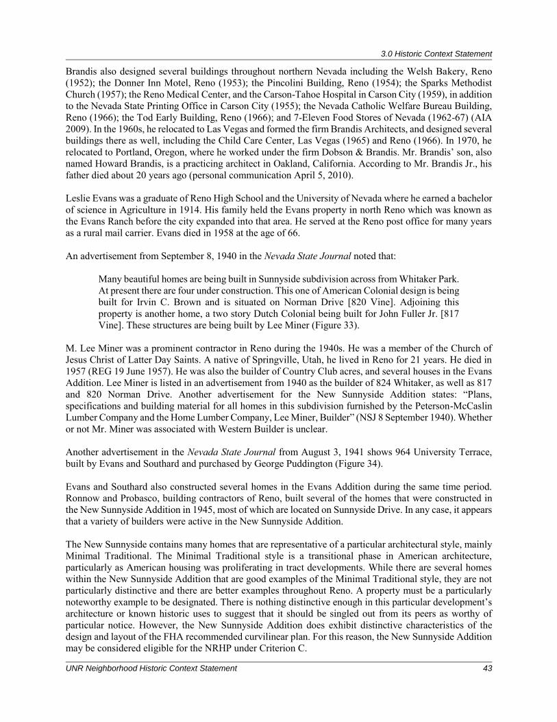
3.0 Historic Context Statement
UNR Neighborhood Historic Context Statement 43
Brandis also designed several buildings throughout northern Nevada including the Welsh Bakery, Reno (1952); the Donner Inn Motel, Reno (1953); the Pincolini Building, Reno (1954); the Sparks Methodist Church (1957); the Reno Medical Center, and the Carson-Tahoe Hospital in Carson City (1959), in addition to the Nevada State Printing Office in Carson City (1955); the Nevada Catholic Welfare Bureau Building, Reno (1966); the Tod Early Building, Reno (1966); and 7-Eleven Food Stores of Nevada (1962-67) (AIA 2009). In the 1960s, he relocated to Las Vegas and formed the firm Brandis Architects, and designed several buildings there as well, including the Child Care Center, Las Vegas (1965) and Reno (1966). In 1970, he relocated to Portland, Oregon, where he worked under the firm Dobson & Brandis. Mr. Brandis’ son, also named Howard Brandis, is a practicing architect in Oakland, California. According to Mr. Brandis Jr., his father died about 20 years ago (personal communication April 5, 2010). Leslie Evans was a graduate of Reno High School and the University of Nevada where he earned a bachelor of science in Agriculture in 1914. His family held the Evans property in north Reno which was known as the Evans Ranch before the city expanded into that area. He served at the Reno post office for many years as a rural mail carrier. Evans died in 1958 at the age of 66. An advertisement from September 8, 1940 in the Nevada State Journal noted that:
Many beautiful homes are being built in Sunnyside subdivision across from Whitaker Park. At present there are four under construction. This one of American Colonial design is being built for Irvin C. Brown and is situated on Norman Drive [820 Vine]. Adjoining this property is another home, a two story Dutch Colonial being built for John Fuller Jr. [817 Vine]. These structures are being built by Lee Miner (Figure 33).
M. Lee Miner was a prominent contractor in Reno during the 1940s. He was a member of the Church of Jesus Christ of Latter Day Saints. A native of Springville, Utah, he lived in Reno for 21 years. He died in 1957 (REG 19 June 1957). He was also the builder of Country Club acres, and several houses in the Evans Addition. Lee Miner is listed in an advertisement from 1940 as the builder of 824 Whitaker, as well as 817 and 820 Norman Drive. Another advertisement for the New Sunnyside Addition states: “Plans, specifications and building material for all homes in this subdivision furnished by the Peterson-McCaslin Lumber Company and the Home Lumber Company, Lee Miner, Builder” (NSJ 8 September 1940). Whether or not Mr. Miner was associated with Western Builder is unclear. Another advertisement in the Nevada State Journal from August 3, 1941 shows 964 University Terrace, built by Evans and Southard and purchased by George Puddington (Figure 34). Evans and Southard also constructed several homes in the Evans Addition during the same time period. Ronnow and Probasco, building contractors of Reno, built several of the homes that were constructed in the New Sunnyside Addition in 1945, most of which are located on Sunnyside Drive. In any case, it appears that a variety of builders were active in the New Sunnyside Addition. The New Sunnyside contains many homes that are representative of a particular architectural style, mainly Minimal Traditional. The Minimal Traditional style is a transitional phase in American architecture, particularly as American housing was proliferating in tract developments. While there are several homes within the New Sunnyside Addition that are good examples of the Minimal Traditional style, they are not particularly distinctive and there are better examples throughout Reno. A property must be a particularly noteworthy example to be designated. There is nothing distinctive enough in this particular development’s architecture or known historic uses to suggest that it should be singled out from its peers as worthy of particular notice. However, the New Sunnyside Addition does exhibit distinctive characteristics of the design and layout of the FHA recommended curvilinear plan. For this reason, the New Sunnyside Addition may be considered eligible for the NRHP under Criterion C.
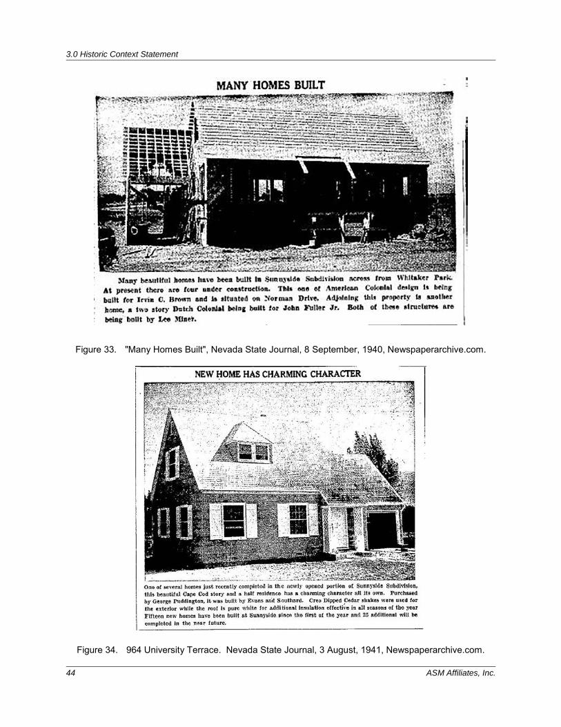
3.0 Historic Context Statement
44 ASM Affiliates, Inc.
Figure 33. "Many Homes Built", Nevada State Journal, 8 September, 1940, Newspaperarchive.com.
Figure 34. 964 University Terrace. Nevada State Journal, 3 August, 1941, Newspaperarchive.com.
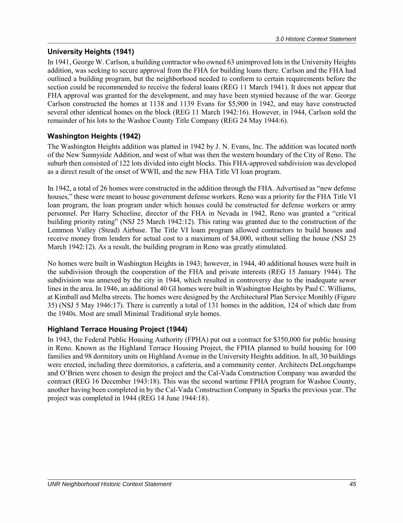
3.0 Historic Context Statement
UNR Neighborhood Historic Context Statement 45
University Heights (1941) In 1941, George W. Carlson, a building contractor who owned 63 unimproved lots in the University Heights addition, was seeking to secure approval from the FHA for building loans there. Carlson and the FHA had outlined a building program, but the neighborhood needed to conform to certain requirements before the section could be recommended to receive the federal loans (REG 11 March 1941). It does not appear that FHA approval was granted for the development, and may have been stymied because of the war. George Carlson constructed the homes at 1138 and 1139 Evans for $5,900 in 1942, and may have constructed several other identical homes on the block (REG 11 March 1942:16). However, in 1944, Carlson sold the remainder of his lots to the Washoe County Title Company (REG 24 May 1944:6).
Washington Heights (1942) The Washington Heights addition was platted in 1942 by J. N. Evans, Inc. The addition was located north of the New Sunnyside Addition, and west of what was then the western boundary of the City of Reno. The suburb then consisted of 122 lots divided into eight blocks. This FHA-approved subdivision was developed as a direct result of the onset of WWII, and the new FHA Title VI loan program. In 1942, a total of 26 homes were constructed in the addition through the FHA. Advertised as “new defense houses,” these were meant to house government defense workers. Reno was a priority for the FHA Title VI loan program, the loan program under which houses could be constructed for defense workers or army personnel. Per Harry Scheeline, director of the FHA in Nevada in 1942, Reno was granted a “critical building priority rating” (NSJ 25 March 1942:12). This rating was granted due to the construction of the Lemmon Valley (Stead) Airbase. The Title VI loam program allowed contractors to build houses and receive money from lenders for actual cost to a maximum of $4,000, without selling the house (NSJ 25 March 1942:12). As a result, the building program in Reno was greatly stimulated. No homes were built in Washington Heights in 1943; however, in 1944, 40 additional houses were built in the subdivision through the cooperation of the FHA and private interests (REG 15 January 1944). The subdivision was annexed by the city in 1944, which resulted in controversy due to the inadequate sewer lines in the area. In 1946, an additional 40 GI homes were built in Washington Heights by Paul C. Williams, at Kimball and Melba streets. The homes were designed by the Architectural Plan Service Monthly (Figure 35) (NSJ 5 May 1946:17). There is currently a total of 131 homes in the addition, 124 of which date from the 1940s. Most are small Minimal Traditional style homes.
Highland Terrace Housing Project (1944) In 1943, the Federal Public Housing Authority (FPHA) put out a contract for $350,000 for public housing in Reno. Known as the Highland Terrace Housing Project, the FPHA planned to build housing for 100 families and 98 dormitory units on Highland Avenue in the University Heights addition. In all, 30 buildings were erected, including three dormitories, a cafeteria, and a community center. Architects DeLongchamps and O’Brien were chosen to design the project and the Cal-Vada Construction Company was awarded the contract (REG 16 December 1943:18). This was the second wartime FPHA program for Washoe County, another having been completed in by the Cal-Vada Construction Company in Sparks the previous year. The project was completed in 1944 (REG 14 June 1944:18).
3.0 Historic Context Statement
46 ASM Affiliates, Inc.
Figure 35. GI Homes built in Washington Heights. Nevada State Journal, 5 May, 1946:17.
Miller and Pray Additions (1946) The Miller and Pray additions were both platted in 1946; the Miller Addition by George, Fred and Edna Miller, and the Pray Addition by Harry Pray. The Miller Addition is very small, consisting of 18 lots, south of 11th Street between Nevada and Angel streets. The Pray Addition is just east of the New Sunnyside Addition and consists of seven lots. Little is known about either of these additions. The Miller Addition contains less than 20 homes, most of which date from the 1950s-1970s. The seven ranch houses in the Pray Addition date between 1947 and 1950.
University Park (1948) Platted by Joseph and Virginia Raffetto in 1947 in cooperation with Probasco & Raffetto and the Realty Investment Corporation, this addition is located east of Evans Drive along Bartlett and Bisby Streets, and east of the Western Pacific Railroad tracks. The tract consisted of 99 lots and currently consists of 88 homes built from 1948-1956. Seventy-nine identical early ranch style homes were built in 1948 by local contractors Wiechmann and Probasco for a cost of $800,000 (REG 7 October 1947:4, 9 March 1948:8). These small two-bedroom homes were selling for $9,800 and were FHA-GI Bill financed (REG 10 August 1948:15).
Grand View Heights (1947) The Grand View Heights subdivision was first platted by Clarence Taylor of Hawthorne in 1947. Also known as the Edwards subdivision, it was later developed by Ben Edwards and Carl Stoddard in 1952 (NSJ 26 May 1952). This small tract is located north of Keystone Avenue (formerly Peavine Road) and consists
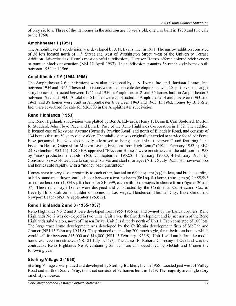
3.0 Historic Context Statement
UNR Neighborhood Historic Context Statement 47
of only six lots. Three of the 12 homes in the addition are 50 years old, one was built in 1930 and two date to the 1960s.
Amphitheater 1 (1951) The Amphitheater 1 subdivision was developed by J. N. Evans, Inc. in 1951. The narrow addition consisted of 38 lots located north of 11th Street and west of Washington Street, west of the University Terrace Addition. Advertised as “Reno’s most colorful subdivision,” Harrison Homes offered colored brick veneer or pumice block construction (NSJ 12 April 1953). The subdivision contains 38 ranch style homes built between 1952 and 1966.
Amphitheater 2-6 (1954-1965) The Amphitheater 2-6 subdivisions were also developed by J. N. Evans, Inc. and Harrison Homes, Inc. between 1954 and 1965. These subdivisions were smaller-scale developments, with 20 split-level and single story homes constructed between 1955 and 1956 in Amphitheater 2, and 35 homes built in Amphitheater 3 between 1957 and 1960. A total of 45 homes were constructed in Amphitheater 4 and 5 between 1960 and 1962, and 38 homes were built in Amphitheater 6 between 1963 and 1965. In 1962, homes by Bilt-Rite, Inc. were advertised for sale for $26,000 in the Amphitheater subdivision.
Reno Highlands (1953) The Reno Highlands subdivision was platted by Ben A. Edwards, Henry F. Bennett, Carl Stoddard, Morton R. Stoddard, John Floyd Pace, and Eula B. Pace of the Reno Highlands Corporation in 1952. The addition is located east of Keystone Avenue (formerly Peavine Road) and north of Ellendale Road, and consists of 134 homes that are 50 years old or older. The subdivision was originally intended to service Stead Air Force Base personnel, but was also heavily advertised as being “available to everyone” and featuring “The Freedom House Designed for Modern Living, Freedom from High Rents” (NSJ 1 February 1953:3; REG 23 September 1952:11). 128 FHA approved “Freedom Homes” were constructed in the addition in 1953 by “mass production methods” (NSJ 23 September 1952:8; 1 February 1953:3; 4 February 1953:16). Construction was slowed due to carpenter strikes and steel shortages (NSJ 26 July 1953:14); however, lots and homes sold rapidly, with a “money back guarantee.”
Homes were in very close proximity to each other, located on 6,000 square (sq.) ft. lots, and built according to FHA standards. Buyers could choose between a two-bedroom (864 sq. ft.) home, (plus garage) for $9,995 or a three-bedroom (1,034 sq. ft.) home for $10,999, each with four designs to choose from (Figures 36 and 37). These ranch style homes were designed and constructed by the Continental Construction Co., of Beverly Hills, California, builder of homes in Las Vegas, Henderson, Boulder City, Bakersfield, and Newport Beach (NSJ 18 September 1953:12).
Reno Highlands 2 and 3 (1955-1957) Reno Highlands No. 2 and 3 were developed from 1955-1956 on land owned by the Landa brothers. Reno Highlands No. 2 was developed in two units. Unit 1 was the first development and is just north of the Reno Highlands subdivision, north of Lassen Drive. Unit 2 is directly north of Unit 1. Each consisted of 100 lots. The large tract home development was developed by the California development firm of McGah and Cramer (NSJ 15 February 1955:8). They planned on erecting 200 ranch style, three-bedroom homes which would sell for between $13,000 and $14,000 (NSJ 15 February 1955:8). Unit 1 sold out before the model home was even constructed (NSJ 21 July 1955:7). The James E. Roberts Company of Oakland was the contractor. Reno Highlands No 3, containing 35 lots, was also developed by McGah and Cramer the following year.
Sterling Village 2 (1958) Sterling Village 2 was platted and developed by Sterling Builders, Inc. in 1958. Located just west of Valley Road and north of Sadler Way, this tract consists of 72 homes built in 1959. The majority are single story ranch style houses.
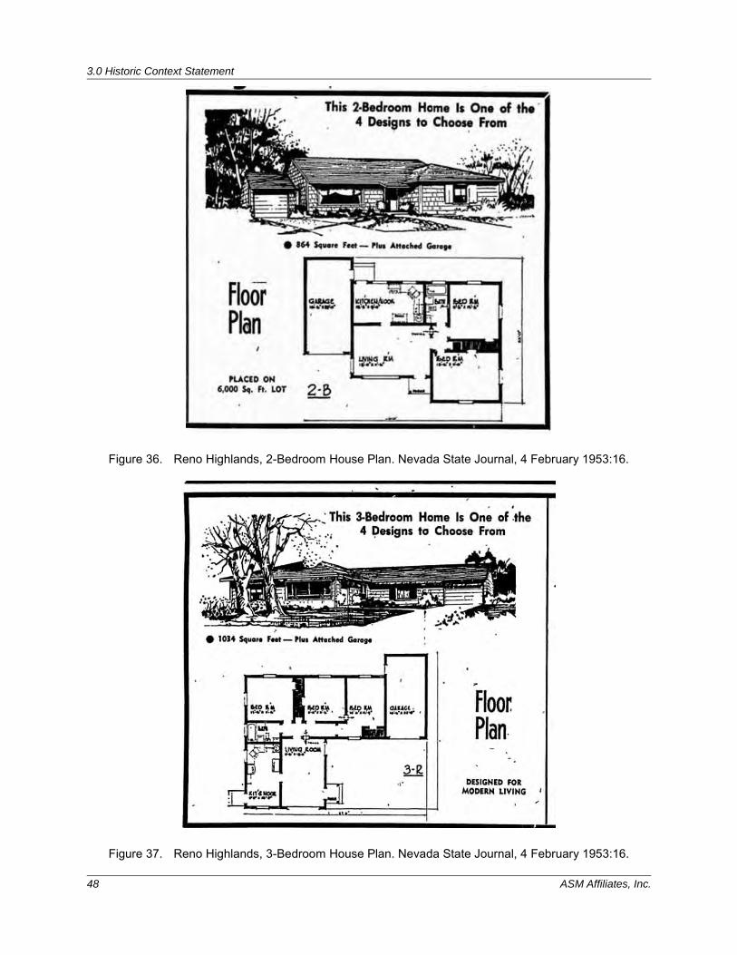
3.0 Historic Context Statement
48 ASM Affiliates, Inc.
Figure 36. Reno Highlands, 2-Bedroom House Plan. Nevada State Journal, 4 February 1953:16.
Figure 37. Reno Highlands, 3-Bedroom House Plan. Nevada State Journal, 4 February 1953:16.
3.0 Historic Context Statement
UNR Neighborhood Historic Context Statement 49
Registration Requirements Property types within the UNR Neighborhood that could individually reflect the sub-theme of Mid-Twentieth Century Development in the University Neighborhood (1930s-1970) single-family residential (specifically Bungalow, Minimal Traditional, Tract Ranch, Custom Ranch, and FHA), as well as multi-family (Duplex and Apartments), and commercial property types including one-part block, two-part block, and motel. Additionally, concentrations of similar resources that reflect this early period of development could be eligible as a historic district. Residential historic districts are the most likely property type to be eligible for the Mid-Twentieth Century Development in the University Neighborhood (1930s-1970) sub-theme under NRHP Criterion A and local Reno Criteria 2 and 6. To be eligible, a historic district must retain a significant concentration of the buildings within a defined area or subdivision identified in this sub-theme. Additionally, prior to nomination of any potential historic district, comparison to other WWII and post-war subdivisions must be conducted and analyzed—within the project area and the greater Reno area. Eligible districts should be united historically or aesthetically by plan or physical development and retain a strong visual sense of overall historic environment from the period of significance. The period of significance for eligible districts should correspond to the development period of the subdivision. Contributing resources to a district should retain a significant degree of their building materials from the period of significance. Eligible districts should retain some features of all seven aspects of integrity: location, design, setting, materials, workmanship, feeling, and association. A basic integrity test for a property associated with an important event is whether a historical contemporary would recognize the property as it exists today (NRHP 2002). Although it will be extremely rare, individual properties may be eligible for their association with this sub-theme under NRHP Criterion A and local Reno Criterion 2. Mere association with historic events or trends is not enough to qualify under Criterion A (NHRP 2002). This sub-theme is best represented by a neighborhood/historic district built as a development project; for an individual property to be eligible it must reflect a strong individual association with mid-twentieth century development. An individual property’s specific association must be considered important. An individual property constructed as part of larger development would not be eligible unless it was the model home for an important subdivision neighborhood and the rest of the development was no longer extant nor retained integrity as a historic district. A comparison of similar resources is critical to demonstrating why an individual property is eligible for its association with this pattern or events for local-level eligibility. Individually eligible properties should embody the character-defining features of the property present from the potential period of significance for the individual property, within the time frame of this theme. Eligible properties should retain some features of all seven aspects of integrity: location, design, setting, materials, workmanship, feeling, and association. Individual properties are more likely to be eligible for their association with this sub-theme under NRHP Criterion B and local Reno Criterion 2. Properties will be individually eligible for their association with individuals who were influential in community development. Examples of such individuals associated with properties in the UNR project area could include developer Leslie Evans and Margaret Faires Baily. Margaret Baily, an attorney who was admitted to the Nevada Bar in 1938 and was admitted to practice before the U.S. Supreme court in 1963, also lived in the UNR area during this time period, and could potentially be a significant individual associated with the theme of social history (not one of the themes identified as significant for the overall UNR area); additional research would have to be conducted to determine if she is associated with community development as well. The period of significance for individual properties eligible under NRHP Criterion B and local Reno Criterion 2 will reflect that significant individual’s direct association with this property. To be eligible under this sub-theme/criterion, a property must be associated with the significant person’s productive life, reflecting the time period when he or she achieved significance. Other extant properties with which the significant individual is associated should
3.0 Historic Context Statement
50 ASM Affiliates, Inc.
also be identified and considered in the evaluation. Eligible properties should retain some features of all seven aspects of integrity: location, design, setting, materials, workmanship, feeling, and association. A basic integrity test for a property associated with an important person is whether a historical contemporary would recognize the Property as it exists today (NRHP 2002).
3.3 THEME 2: FHA MINIMUM HOUSE AND SMALL HOUSE PROGRAM AND GI BILL (1936-1960)
During the 1930s, the FHA instituted a national program that, through its approval of properties for mortgage insurance and the publication of housing and subdivision standards, would stimulate home ownership and regulate home building practices for decades to come. The FHA did not build houses or lend money, but rather induced private lenders to invest in residential mortgages by insuring them against loss. Additional home improvement and modernization loans were also insured by the FHA, allowing borrowers to renovate their homes. Among the FHA’s highest priorities was the modernizing of American homes as a means of improving the national standard of living (Winton 2004:381). This was done through electrification and standardizing building codes. The FHA exerted a powerful influence over the design and appearance of the homes it helped insure and issued a series of technical bulletins that gave direct design and construction advice to homebuilders. The term ‘modern’ was defined as a pragmatic use of space and economic use of materials, as opposed to faddish designs with stylistic features that had nothing to do with the function or structure of the house. Another booklet listed design principals and prescribed building standards by illustrating sample homes. This became the standard to which the FHA would adhere for decades (Winton 2004:381). House designs were first published in FHA’s Principles of Planning Small Houses (1936), which was updated periodically. Circulars addressed issues of prefabrication methods and materials, housing standards, and principles of design (Ames and McClelland 2002). There were five FHA house types that appeared in Principles of Planning Small Houses in 1936. They offered “a range in comfort of living,” and in succession a “slightly increasing accommodation.” Each type was void of nonessential spaces, picturesque features, and unnecessary items that would add to their cost (Ames and McClelland 2002). Illustrated by floor plans and simple elevations, it allowed builders to copy the designs directly and modify them to suit the needs of the region. Following the FHA’s principle for “providing a maximum accommodation within a minimum of means,” houses could be built in a variety of materials, including wood, brick, concrete block, shingles, stucco, or stone. Several new labor saving technologies were introduced such as kitchens equipped with modern appliances, and the utility room’s integrated mechanical system, which replaced the basement furnace of earlier homes (FHA 1939). The simplest FHA design became known in the home building industry as the “FHA minimum house.” “House A” was a one-story, two-bedroom house designed for a family of three adults or two adults and two children. It measured 534 sq. ft. and lacked a basement. A small kitchen and larger multipurpose living room extended across the front of the house, while two bedrooms and a bathroom were located off a small hallway at the back of the house. According to the 1936 FHA bulletin:
The accompanying drawings show two of the many possible variations of the basic design. Besides utilizing different materials, variety may be achieved through variation of the character of the roof, orientation of the house, and changing the location of openings. Where it may be afforded, a porch may be added, or a garage designed in connection with the house may increase the range of variation in appearance.
The slightly larger “House B” provided 624 sq. ft. of living space and had more lasting appeal, the main difference being that the kitchen was separated from the living room (FHA 1936). For the exterior,
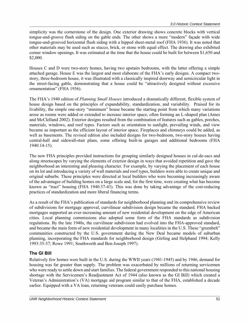
3.0 Historic Context Statement
UNR Neighborhood Historic Context Statement 51
simplicity was the cornerstone of the design. One exterior drawing shows concrete blocks with vertical tongue-and-groove flush siding on the gable ends. The other shows a more “modern” façade with wide tongue-and-grooved horizontal flush siding with a hipped sheet-metal roof (FHA 1936). It was noted that other materials may be used such as stucco, brick, or stone with equal effect. The drawing also exhibited corner window openings. It was estimated at the time that the house could be built for between $1,650 and $2,000. Houses C and D were two-story homes, having two upstairs bedrooms, with the latter offering a simple attached garage. House E was the largest and most elaborate of the FHA’s early designs. A compact two-story, three-bedroom house, it was illustrated with a classically inspired doorway and semicircular light in the street-facing gable, demonstrating that a house could be “attractively designed without excessive ornamentation” (FHA 1936). The FHA’s 1940 edition of Planning Small Houses introduced a dramatically different, flexible system of house design based on the principles of expandability, standardization, and variability. Praised for its livability, the simple one-story “minimum” house became the starting point from which many variations arose as rooms were added or extended to increase interior space, often forming an L-shaped plan (Ames and McClelland 2002). Exterior designs resulted from the combination of features such as gables, porches, materials, windows, and roof types. Factors such as orientation to sunlight, prevailing winds, and view became as important as the efficient layout of interior space. Fireplaces and chimneys could be added, as well as basements. The revised edition also included designs for two-bedroom, two-story houses having central-hall and sidewall-stair plans, some offering built-in garages and additional bedrooms (FHA 1940:14-15). The new FHA principles provided instructions for grouping similarly designed houses in cul-de-sacs and along streetscapes by varying the elements of exterior design in ways that avoided repetition and gave the neighborhood an interesting and pleasing character. For example, by varying the placement of each house on its lot and introducing a variety of wall materials and roof types, builders were able to create unique and original suburbs. These principles were directed at local builders who were becoming increasingly aware of the advantages of building homes on a large scale and, for the first time, were creating what has become known as “tract” housing (FHA 1940:37-43). This was done by taking advantage of the cost-reducing practices of standardization and more liberal financing terms. As a result of the FHA’s publication of standards for neighborhood planning and its comprehensive review of subdivisions for mortgage approval, curvilinear subdivision design became the standard. FHA backed mortgages supported an ever-increasing amount of new residential development on the edge of American cities. Local planning commissions also adopted some form of the FHA standards as subdivision regulations. By the late 1940s, the curvilinear subdivision had evolved into the FHA-approved standard, and became the main form of new residential development in many localities in the U.S. These “greenbelt” communities constructed by the U.S. government during the New Deal became models of suburban planning, incorporating the FHA standards for neighborhood design (Girling and Helphand 1994; Kelly 1993:35-37; Rowe 1991; Southworth and Ben-Joseph 1997).
The GI Bill Relatively few homes were built in the U.S. during the WWII years (1941-1945) and by 1946, demand for housing was far greater than supply. The problem was exacerbated by millions of returning servicemen who were ready to settle down and start families. The federal government responded to this national housing shortage with the Servicemen’s Readjustment Act of 1944 (also known as the GI Bill) which created a Veteran’s Administration’s (VA) mortgage aid program similar to that of the FHA, established a decade earlier. Equipped with a VA loan, returning veterans could easily purchase homes.
3.0 Historic Context Statement
52 ASM Affiliates, Inc.
The 1944 Servicemen’s Readjustment Act or GI Bill also guaranteed long-term mortgages issued by private banks for house construction, and largely followed FHA procedures and policies. As a result, federal insurance lessened down payments and interest rates, making purchasing a home more affordable. From 1946 to 1953, FHA and VA-backed banks doled out loans to cover the erection of 10 million homes. Between 1949 and 1950, young servicemen with families composed half of all new American homeowners (Richfield 2007). Millions of veterans also took advantage of the GI Bill’s home loan guaranty. From 1944 to 1952, the VA backed nearly 2.4 million home loans for WWII veterans.
New Sunnyside Based on archival research and the commonalities found in the architectural and design traits, it is likely that the FHA had a profound influence on the development of the New Sunnyside Addition. The curvilinear streets of the New Sunnyside are typical of FHA-backed subdivisions which abandoned the rectilinear grid in favor of street design that conformed to the natural terrain. In addition, New Sunnyside was located in an outlying area at the edge of the city limits at the time, and was later annexed by the city. This is another feature of a FHA suburb. Lot sizes and square footages were likely small because the FHA required it for approval and financial backing. The New Sunnyside Addition is an example of an FHA-backed subdivision that was constructed in the late 1930s and early 1940s. New Sunnyside was perhaps influential in employing out of work architects and builders in Reno during the Depression and may have played an important role for the housing it provided to war workers.
3.3.1 Registration Requirements The single family/FHA residential property type is the only property type within the UNR Neighborhood that could individually reflect the theme of FHA Minimum House and Small House Program & GI Bill (1936-1960). Additionally, concentrations of similar resources that reflect FHA funding and design could be eligible as a historic district. Residential historic districts are the most likely property type to be eligible for the FHA Minimum House and Small House Program & GI Bill (1936-1960) theme under NRHP Criterion A and local Reno Criteria 2 and 6. To be eligible, a historic district must retain a significant concentration of the buildings within a defined FHA-funded neighborhood constructed between 1936-1960. Eligible districts should be united historically or aesthetically by plan or physical development and retain a strong visual sense of overall historic environment from the period of significance. Contributing resources to a district should retain a significant degree of their building materials from the date of construction. Eligible districts should retain some features of all seven aspects of integrity: location, design, setting, materials, workmanship, feeling, and association. A basic integrity test for a property associated with an important event is whether a historical contemporary would recognize the property as it exists today (NRHP 2002). Although it will be extremely rare, individual properties may be eligible for their association with this theme under NRHP Criteria A and C and local Reno Criteria 2 and 4, if the house was clearly constructed following one of the FHA house designs. This theme is best represented by a neighborhood/historic district built as a FHA development project; for an individual property to be eligible it must reflect a strong individual association with FHA development. An individual property constructed as part of larger development would not be eligible unless it was the model home and the rest of the development was no longer extant nor retained integrity as a historic district. A comparison of similar resources is critical to demonstrating why an individual property is eligible for its association with the FHA program or property type for local-level eligibility. Individually eligible properties should embody the character-defining features of the property type from the potential period of significance for the individual property, within the time frame of this theme. Eligible properties should retain some features of all seven aspects of integrity:
3.0 Historic Context Statement
UNR Neighborhood Historic Context Statement 53
location, design, setting, materials, workmanship, feeling, and association. A basic integrity test for a property associated with an important event is whether a historical contemporary would recognize the property as it exists today (NRHP 2002).
3.4 THEME 3: EDUCATION (1886-1960s)
3.4.1 The University of Nevada, Reno The University of Nevada was established in Elko in eastern Nevada in 1874. The state legislature required that any town wishing to be considered for the university must provide $10,000 for a building, 20 acres for the campus, and have the capacity to serve 100 students. Although most of the Board of Regents lived in western Nevada, and Carson City was the state capital, Elko was the only town to meet the requirements (Greenhaw and Primeaux 1998). In 1885, the Nevada legislature decided to close the university and move it to Reno, which by then had grown to a bustling metropolis of 4,000 and Nevada’s second largest town (Harmon 2003). On March 31, 1886, the Nevada State University, as it was then called, was moved from Elko to Reno. A site was selected on “the hill” north of town surrounded by 10 acres of hay fields purchased from the Evans Ranch. Morrill Hall, the elegant French Second Empire structure, was the first building erected on the campus and contained the office of the president, classrooms, the dormitories, the library, and the Normal School (Walton-Buchanan 2007). The university charged no tuition. While it required entering students be at least 15 years old, of good moral character, and pass a basic entrance exam, the biggest draw was that students from Nevada high schools were not required to take the exam (Harmon 2017). After the turn of the twentieth century, a series of major gifts from Clarence and Mary Louise Mackay, heirs of Comstock “king” John Mackay, expanded the campus with the Mackay School of Mines building in 1906, the Mackay Science Hall in 1930 and several others, Clarence Mackay made his mark on the university by hiring a landscape architect to design a quadrangle modeled after the University of Virginia, and funding the construction of numerous educational buildings and facilities. During the years of Mackay influence (1906-1938), the campus and student enrollment continued to grow (Hamby and Sikes 1986). In 1938, the university began receiving donations from Max C. Fleischmann. Max C. Fleischmann, a member of the prominent “Fleischmann Yeast” family, was born in Ohio in 1877 (Silver 2013:85-87). In 1935, he and his wife Sarah moved to Glenbrook, Nevada, ostensibly to avoid the tax burden in California. Fleischmann was one of numerous wealthy Californians who bought up ranch property in western Nevada, 258 acres of which he later gifted to UNR in 1944. Just prior to his death in 1951, he created the Max C. Fleischmann Foundation as a way to distribute funds for projects for religious, educational, charitable, and scientific non-profit organizations throughout the country (UNR Special Collections 2017b). During the lifetime of the Foundation, over $19 million was donated to the university, some of which allowed for the construction of the College of Agriculture building in 1957; the establishment of the Desert Research Institute in 1959; addition of the Life Sciences Wing to the Fleischmann Agriculture building in 1961-1963; and construction of Fleischmann Planetarium in 1963. Overall, his gifts more than doubled the size of the university and substantially contributed to its development into a world class research institution.
3.4.2 The Fraternity Movement at the University of Nevada, Reno The University of Nevada housed a number of fraternities and sororities beginning around 1895. The earliest reference to a fraternity at UNR was T.H.P.O., which began as a secretive organization founded by University students in the 1890s. These students were from eastern Nevada and California, and stayed in the de facto “dormitory” on the second floor of the mechanical arts building, a converted barn, constructed on campus in 1891. Not unlike the famous and mysterious Skull and Bones Society at Yale, the brotherhood spawned many prominent public figures. After the barn burned down in 1895, the group moved to Lincoln
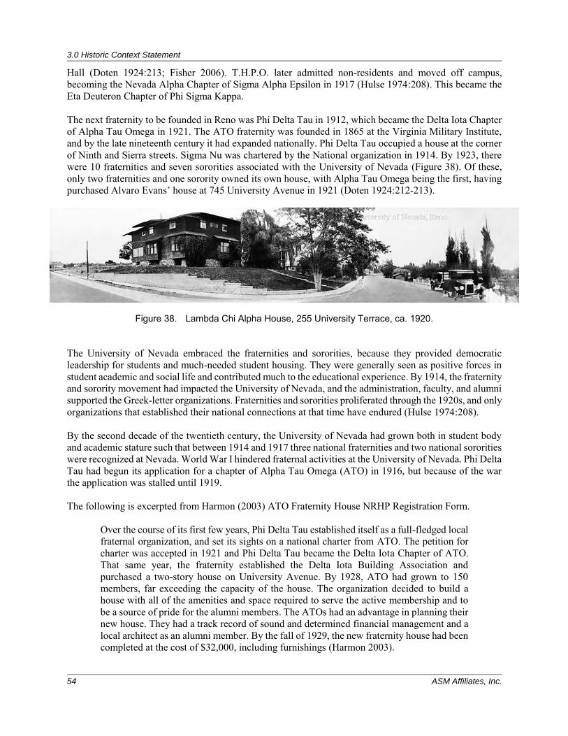
3.0 Historic Context Statement
54 ASM Affiliates, Inc.
Hall (Doten 1924:213; Fisher 2006). T.H.P.O. later admitted non-residents and moved off campus, becoming the Nevada Alpha Chapter of Sigma Alpha Epsilon in 1917 (Hulse 1974:208). This became the Eta Deuteron Chapter of Phi Sigma Kappa. The next fraternity to be founded in Reno was Phi Delta Tau in 1912, which became the Delta Iota Chapter of Alpha Tau Omega in 1921. The ATO fraternity was founded in 1865 at the Virginia Military Institute, and by the late nineteenth century it had expanded nationally. Phi Delta Tau occupied a house at the corner of Ninth and Sierra streets. Sigma Nu was chartered by the National organization in 1914. By 1923, there were 10 fraternities and seven sororities associated with the University of Nevada (Figure 38). Of these, only two fraternities and one sorority owned its own house, with Alpha Tau Omega being the first, having purchased Alvaro Evans’ house at 745 University Avenue in 1921 (Doten 1924:212-213).
Figure 38. Lambda Chi Alpha House, 255 University Terrace, ca. 1920. The University of Nevada embraced the fraternities and sororities, because they provided democratic leadership for students and much-needed student housing. They were generally seen as positive forces in student academic and social life and contributed much to the educational experience. By 1914, the fraternity and sorority movement had impacted the University of Nevada, and the administration, faculty, and alumni supported the Greek-letter organizations. Fraternities and sororities proliferated through the 1920s, and only organizations that established their national connections at that time have endured (Hulse 1974:208). By the second decade of the twentieth century, the University of Nevada had grown both in student body and academic stature such that between 1914 and 1917 three national fraternities and two national sororities were recognized at Nevada. World War I hindered fraternal activities at the University of Nevada. Phi Delta Tau had begun its application for a chapter of Alpha Tau Omega (ATO) in 1916, but because of the war the application was stalled until 1919. The following is excerpted from Harmon (2003) ATO Fraternity House NRHP Registration Form.
Over the course of its first few years, Phi Delta Tau established itself as a full-fledged local fraternal organization, and set its sights on a national charter from ATO. The petition for charter was accepted in 1921 and Phi Delta Tau became the Delta Iota Chapter of ATO. That same year, the fraternity established the Delta Iota Building Association and purchased a two-story house on University Avenue. By 1928, ATO had grown to 150 members, far exceeding the capacity of the house. The organization decided to build a house with all of the amenities and space required to serve the active membership and to be a source of pride for the alumni members. The ATOs had an advantage in planning their new house. They had a track record of sound and determined financial management and a local architect as an alumni member. By the fall of 1929, the new fraternity house had been completed at the cost of $32,000, including furnishings (Harmon 2003).
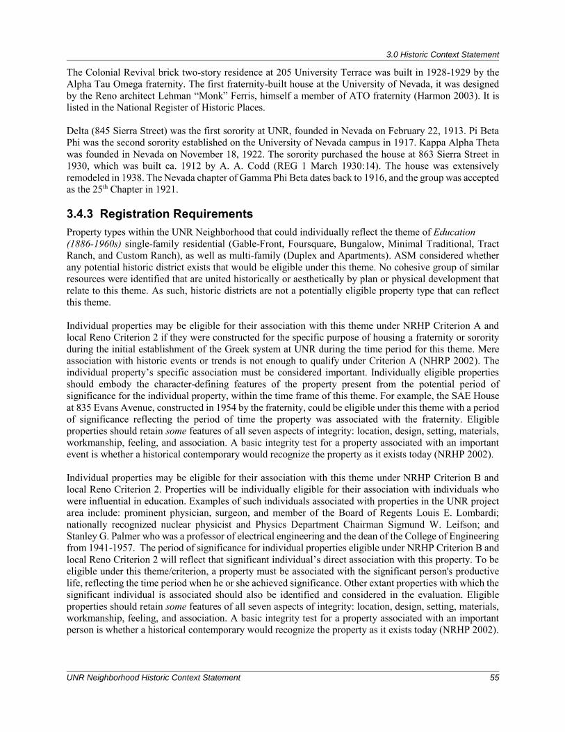
3.0 Historic Context Statement
UNR Neighborhood Historic Context Statement 55
The Colonial Revival brick two-story residence at 205 University Terrace was built in 1928-1929 by the Alpha Tau Omega fraternity. The first fraternity-built house at the University of Nevada, it was designed by the Reno architect Lehman “Monk” Ferris, himself a member of ATO fraternity (Harmon 2003). It is listed in the National Register of Historic Places. Delta (845 Sierra Street) was the first sorority at UNR, founded in Nevada on February 22, 1913. Pi Beta Phi was the second sorority established on the University of Nevada campus in 1917. Kappa Alpha Theta was founded in Nevada on November 18, 1922. The sorority purchased the house at 863 Sierra Street in 1930, which was built ca. 1912 by A. A. Codd (REG 1 March 1930:14). The house was extensively remodeled in 1938. The Nevada chapter of Gamma Phi Beta dates back to 1916, and the group was accepted as the 25th Chapter in 1921. 3.4.3 Registration Requirements Property types within the UNR Neighborhood that could individually reflect the theme of Education (1886-1960s) single-family residential (Gable-Front, Foursquare, Bungalow, Minimal Traditional, Tract Ranch, and Custom Ranch), as well as multi-family (Duplex and Apartments). ASM considered whether any potential historic district exists that would be eligible under this theme. No cohesive group of similar resources were identified that are united historically or aesthetically by plan or physical development that relate to this theme. As such, historic districts are not a potentially eligible property type that can reflect this theme. Individual properties may be eligible for their association with this theme under NRHP Criterion A and local Reno Criterion 2 if they were constructed for the specific purpose of housing a fraternity or sorority during the initial establishment of the Greek system at UNR during the time period for this theme. Mere association with historic events or trends is not enough to qualify under Criterion A (NHRP 2002). The individual property’s specific association must be considered important. Individually eligible properties should embody the character-defining features of the property present from the potential period of significance for the individual property, within the time frame of this theme. For example, the SAE House at 835 Evans Avenue, constructed in 1954 by the fraternity, could be eligible under this theme with a period of significance reflecting the period of time the property was associated with the fraternity. Eligible properties should retain some features of all seven aspects of integrity: location, design, setting, materials, workmanship, feeling, and association. A basic integrity test for a property associated with an important event is whether a historical contemporary would recognize the property as it exists today (NRHP 2002). Individual properties may be eligible for their association with this theme under NRHP Criterion B and local Reno Criterion 2. Properties will be individually eligible for their association with individuals who were influential in education. Examples of such individuals associated with properties in the UNR project area include: prominent physician, surgeon, and member of the Board of Regents Louis E. Lombardi; nationally recognized nuclear physicist and Physics Department Chairman Sigmund W. Leifson; and Stanley G. Palmer who was a professor of electrical engineering and the dean of the College of Engineering from 1941-1957. The period of significance for individual properties eligible under NRHP Criterion B and local Reno Criterion 2 will reflect that significant individual’s direct association with this property. To be eligible under this theme/criterion, a property must be associated with the significant person's productive life, reflecting the time period when he or she achieved significance. Other extant properties with which the significant individual is associated should also be identified and considered in the evaluation. Eligible properties should retain some features of all seven aspects of integrity: location, design, setting, materials, workmanship, feeling, and association. A basic integrity test for a property associated with an important person is whether a historical contemporary would recognize the property as it exists today (NRHP 2002).
3.0 Historic Context Statement
56 ASM Affiliates, Inc.
3.5 THEME 4: ARCHITECTURAL HISTORY
The area surrounding the UNR campus was initially agricultural land purchased by Alvaro and John Newt Evans in the late nineteenth century. In 1879, there was very little development north of the Central Pacific Railroad tracks in Reno. The first homes were constructed south of the university on Center and Lake streets. As Reno grew, streets were platted on all sides of the university except to the north. These early subdivisions were later gridded off and sold to prospective developers. The new streets soon filled in with fine homes for professors and modest cottages for students and other university employees. Architectural styles found in the UNR area range from Victorian to Modern, and the building types that remain are primarily residential, with a few examples of commercial architecture. Buildings within the survey area represent a diversity of architectural styles. The earliest remaining buildings were built in the Victorian-era modes, primarily Queen Anne—as evidenced by the remaining Center and Lake Street houses. A few modest vernacular residential buildings from this period are also extant, the designs of which were less influenced by a specific architectural style than by common housing construction methods and available supplies. Much of the built environment that remains from the early twentieth century reflects the popular architectural styles and property types from that time period. The University Neighborhood has several good examples of the Craftsman and Spanish Colonial Revival styles. However, the predominant style employed from the 1920s through the 1940s was Tudor Revival. Examples of these styles are generally found in small clusters or several blocks of similar single-family residences. Through the 1950s and 1960s, the predominant property type of the wartime and postwar residential building boom in Reno and the University Neighborhood were Minimal Traditional and the Tract Ranch (a planned development of Ranch-type housing). Several examples of Minimal Traditional and Tract Ranch neighborhoods can be found in the survey area. To a lesser extent, the area also includes Custom Ranch house neighborhoods—neighborhoods with houses designed and constructed individually and not part of a larger planned development. The following section details the predominant styles and property types present in the project area. The character defining features are those attributed to these styles and types in general, not necessary specific to Reno. Residential property types in the project area include single family Front-Gable, Foursquare, Bungalow, FHA/Small House, Minimal Traditional, and Ranch (Tract and Custom), as well as multi-family duplex and apartments. Non-residential property types in the project area include One-Part and Two-Part Block commercial buildings, as well as examples of the Motel property types.
3.0 Historic Context Statement
UNR Neighborhood Historic Context Statement 57
3.5.1 Character-Defining Features of Architectural Styles and Types Present in the University Neighborhood
Second Empire Style The Second Empire Style, in contrast to the Italianate and Gothic Revival styles, was considered quite modern because it called on the latest French building styles rather than on a romantic past (Figure 39). The style was most popular in American houses constructed between 1860 and 1880, but was commonly used for remodeling residential and commercial buildings. Its most notable feature is the distinctive roof line, which is seen mixed with elements of various styles.
• Mansard (dual-pitched hipped) roof • Dormer windows • Closed eaves • Decorative brackets beneath eaves • Combined with other styles
Figure 39. Example of Second Empire style house in Sunnyside.
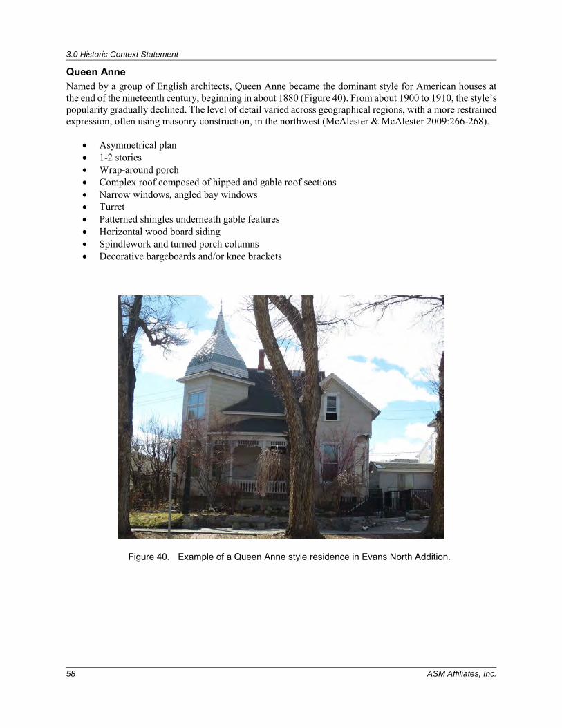
3.0 Historic Context Statement
58 ASM Affiliates, Inc.
Queen Anne Named by a group of English architects, Queen Anne became the dominant style for American houses at the end of the nineteenth century, beginning in about 1880 (Figure 40). From about 1900 to 1910, the style’s popularity gradually declined. The level of detail varied across geographical regions, with a more restrained expression, often using masonry construction, in the northwest (McAlester & McAlester 2009:266-268).
• Asymmetrical plan • 1-2 stories • Wrap-around porch • Complex roof composed of hipped and gable roof sections • Narrow windows, angled bay windows • Turret • Patterned shingles underneath gable features • Horizontal wood board siding • Spindlework and turned porch columns • Decorative bargeboards and/or knee brackets
Figure 40. Example of a Queen Anne style residence in Evans North Addition.
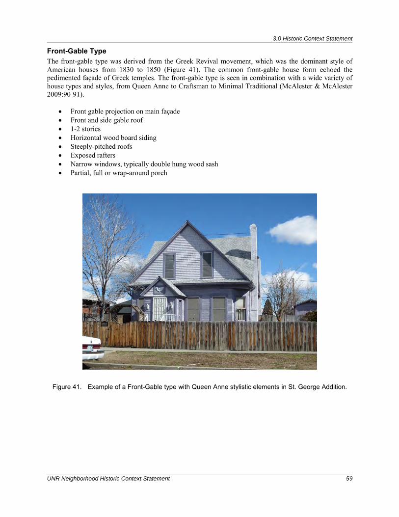
3.0 Historic Context Statement
UNR Neighborhood Historic Context Statement 59
Front-Gable Type The front-gable type was derived from the Greek Revival movement, which was the dominant style of American houses from 1830 to 1850 (Figure 41). The common front-gable house form echoed the pedimented façade of Greek temples. The front-gable type is seen in combination with a wide variety of house types and styles, from Queen Anne to Craftsman to Minimal Traditional (McAlester & McAlester 2009:90-91).
• Front gable projection on main façade • Front and side gable roof • 1-2 stories • Horizontal wood board siding • Steeply-pitched roofs • Exposed rafters • Narrow windows, typically double hung wood sash • Partial, full or wrap-around porch
Figure 41. Example of a Front-Gable type with Queen Anne stylistic elements in St. George Addition.
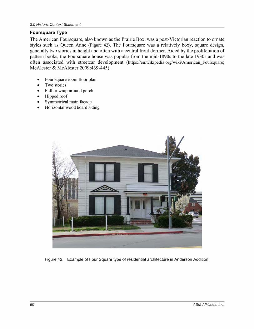
3.0 Historic Context Statement
60 ASM Affiliates, Inc.
Foursquare Type The American Foursquare, also known as the Prairie Box, was a post-Victorian reaction to ornate styles such as Queen Anne (Figure 42). The Foursquare was a relatively boxy, square design, generally two stories in height and often with a central front dormer. Aided by the proliferation of pattern books, the Foursquare house was popular from the mid-1890s to the late 1930s and was often associated with streetcar development (https://en.wikipedia.org/wiki/American_Foursquare; McAlester & McAlester 2009:439-445).
• Four square room floor plan • Two stories • Full or wrap-around porch • Hipped roof • Symmetrical main façade • Horizontal wood board siding
Figure 42. Example of Four Square type of residential architecture in Anderson Addition.
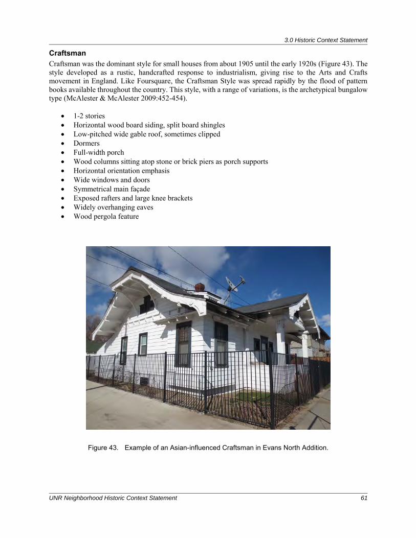
3.0 Historic Context Statement
UNR Neighborhood Historic Context Statement 61
Craftsman Craftsman was the dominant style for small houses from about 1905 until the early 1920s (Figure 43). The style developed as a rustic, handcrafted response to industrialism, giving rise to the Arts and Crafts movement in England. Like Foursquare, the Craftsman Style was spread rapidly by the flood of pattern books available throughout the country. This style, with a range of variations, is the archetypical bungalow type (McAlester & McAlester 2009:452-454).
• 1-2 stories • Horizontal wood board siding, split board shingles • Low-pitched wide gable roof, sometimes clipped • Dormers • Full-width porch • Wood columns sitting atop stone or brick piers as porch supports • Horizontal orientation emphasis • Wide windows and doors • Symmetrical main façade • Exposed rafters and large knee brackets • Widely overhanging eaves • Wood pergola feature
Figure 43. Example of an Asian-influenced Craftsman in Evans North Addition.
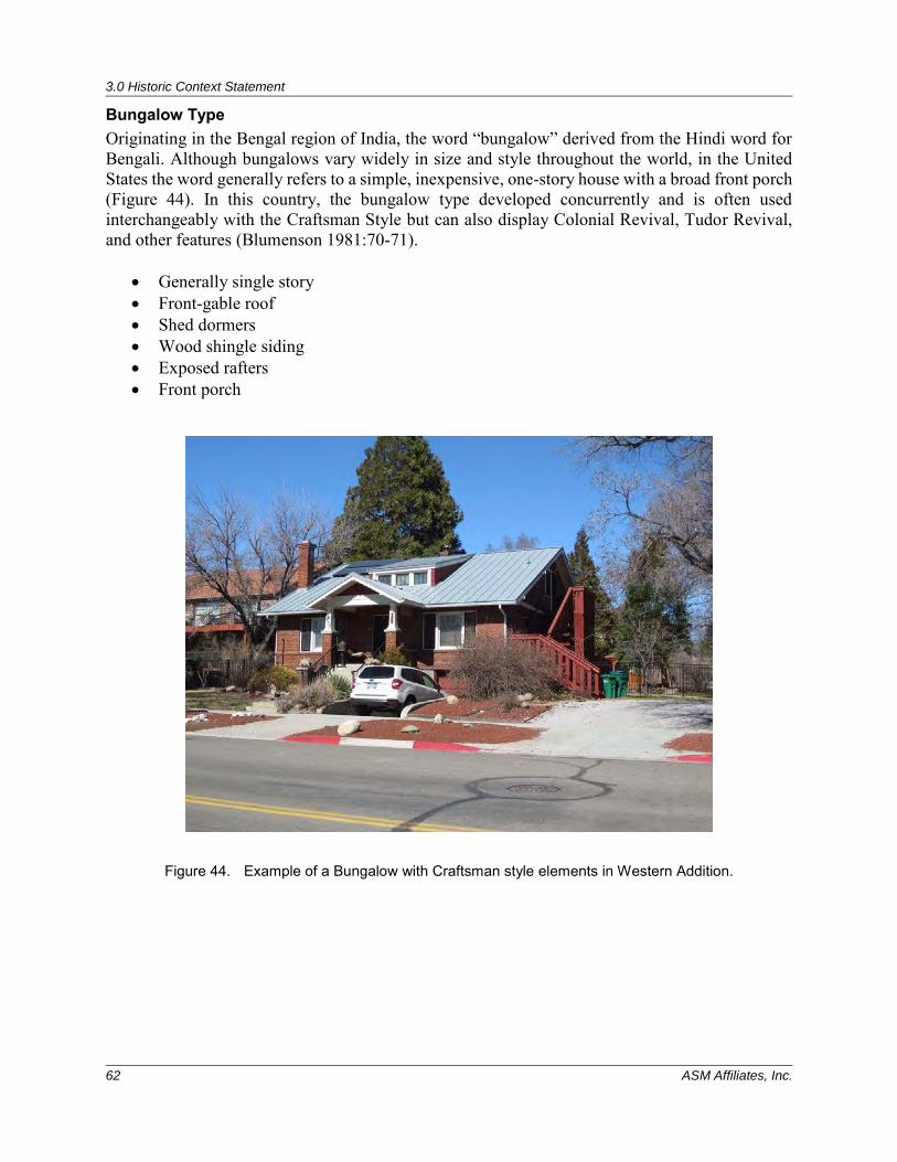
3.0 Historic Context Statement
62 ASM Affiliates, Inc.
Bungalow Type Originating in the Bengal region of India, the word “bungalow” derived from the Hindi word for Bengali. Although bungalows vary widely in size and style throughout the world, in the United States the word generally refers to a simple, inexpensive, one-story house with a broad front porch (Figure 44). In this country, the bungalow type developed concurrently and is often used interchangeably with the Craftsman Style but can also display Colonial Revival, Tudor Revival, and other features (Blumenson 1981:70-71).
• Generally single story • Front-gable roof • Shed dormers • Wood shingle siding • Exposed rafters • Front porch
Figure 44. Example of a Bungalow with Craftsman style elements in Western Addition.
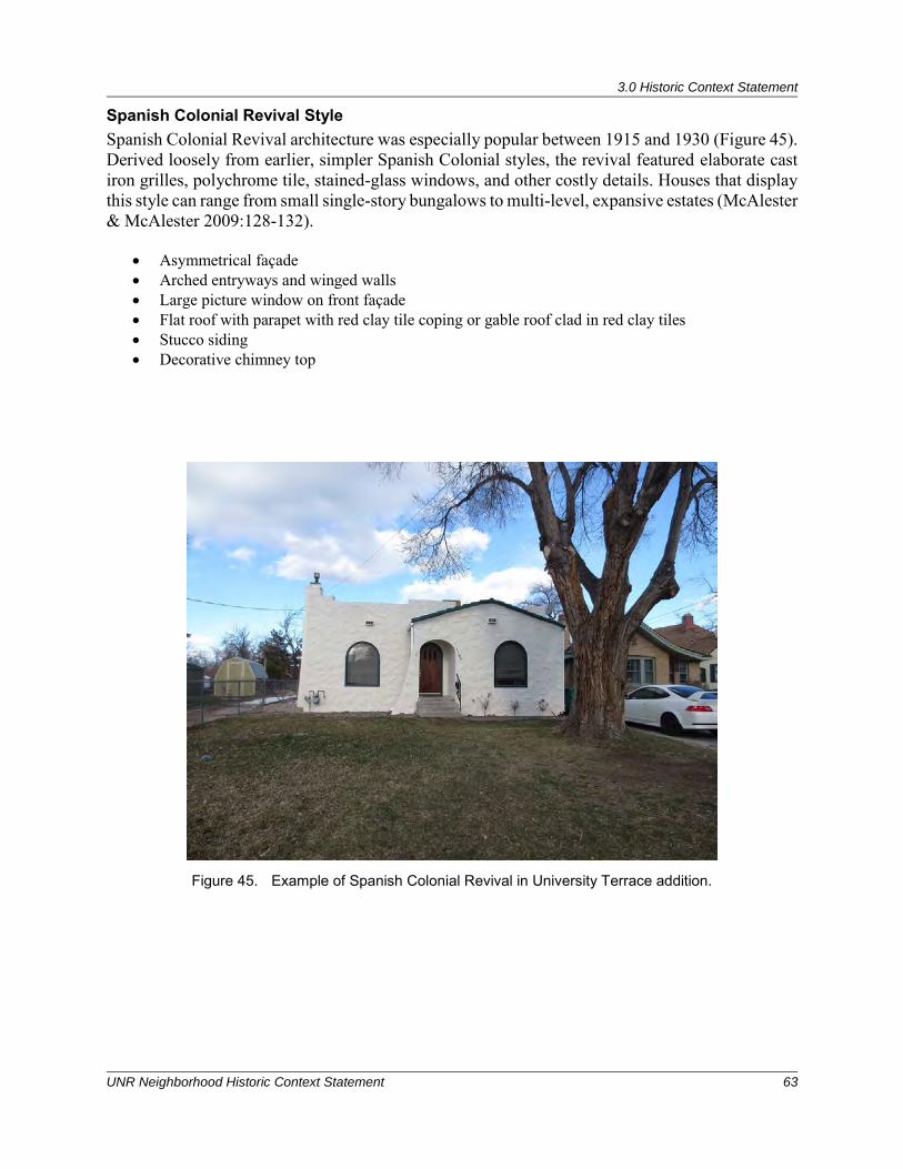
3.0 Historic Context Statement
UNR Neighborhood Historic Context Statement 63
Spanish Colonial Revival Style Spanish Colonial Revival architecture was especially popular between 1915 and 1930 (Figure 45). Derived loosely from earlier, simpler Spanish Colonial styles, the revival featured elaborate cast iron grilles, polychrome tile, stained-glass windows, and other costly details. Houses that display this style can range from small single-story bungalows to multi-level, expansive estates (McAlester & McAlester 2009:128-132).
• Asymmetrical façade • Arched entryways and winged walls • Large picture window on front façade • Flat roof with parapet with red clay tile coping or gable roof clad in red clay tiles • Stucco siding • Decorative chimney top
Figure 45. Example of Spanish Colonial Revival in University Terrace addition.
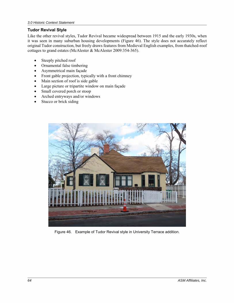
3.0 Historic Context Statement
64 ASM Affiliates, Inc.
Tudor Revival Style Like the other revival styles, Tudor Revival became widespread between 1915 and the early 1930s, when it was seen in many suburban housing developments (Figure 46). The style does not accurately reflect original Tudor construction, but freely draws features from Medieval English examples, from thatched-roof cottages to grand estates (McAlester & McAlester 2009:354-365).
• Steeply pitched roof • Ornamental false timbering • Asymmetrical main façade • Front gable projection, typically with a front chimney • Main section of roof is side gable • Large picture or tripartite window on main façade • Small covered porch or stoop • Arched entryways and/or windows • Stucco or brick siding
Figure 46. Example of Tudor Revival style in University Terrace addition.
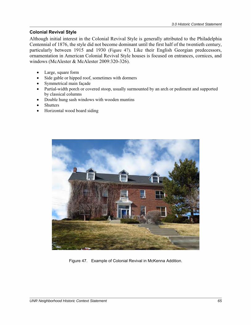
3.0 Historic Context Statement
UNR Neighborhood Historic Context Statement 65
Colonial Revival Style Although initial interest in the Colonial Revival Style is generally attributed to the Philadelphia Centennial of 1876, the style did not become dominant until the first half of the twentieth century, particularly between 1915 and 1930 (Figure 47). Like their English Georgian predecessors, ornamentation in American Colonial Revival Style houses is focused on entrances, cornices, and windows (McAlester & McAlester 2009:320-326).
• Large, square form • Side gable or hipped roof, sometimes with dormers • Symmetrical main façade • Partial-width porch or covered stoop, usually surmounted by an arch or pediment and supported
by classical columns • Double hung sash windows with wooden muntins • Shutters • Horizontal wood board siding
Figure 47. Example of Colonial Revival in McKenna Addition.
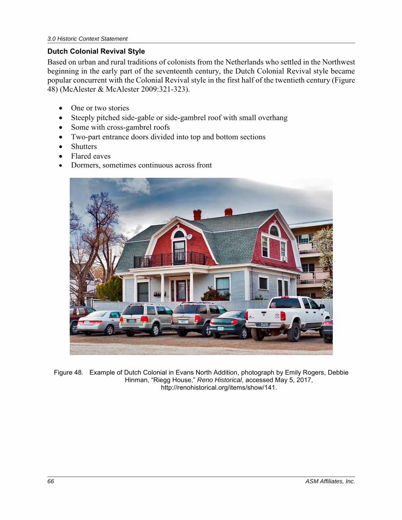
3.0 Historic Context Statement
66 ASM Affiliates, Inc.
Dutch Colonial Revival Style Based on urban and rural traditions of colonists from the Netherlands who settled in the Northwest beginning in the early part of the seventeenth century, the Dutch Colonial Revival style became popular concurrent with the Colonial Revival style in the first half of the twentieth century (Figure 48) (McAlester & McAlester 2009:321-323).
• One or two stories • Steeply pitched side-gable or side-gambrel roof with small overhang • Some with cross-gambrel roofs • Two-part entrance doors divided into top and bottom sections • Shutters • Flared eaves • Dormers, sometimes continuous across front
Figure 48. Example of Dutch Colonial in Evans North Addition, photograph by Emily Rogers, Debbie Hinman, “Riegg House,” Reno Historical, accessed May 5, 2017,
http://renohistorical.org/items/show/141.
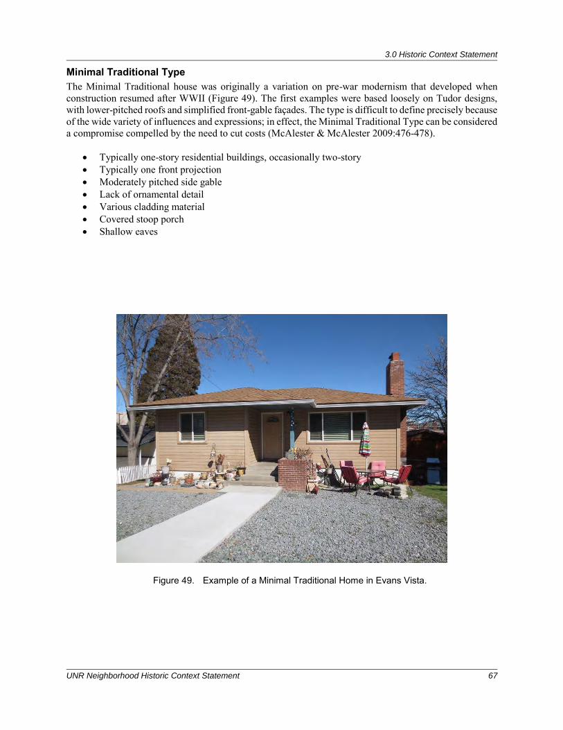
3.0 Historic Context Statement
UNR Neighborhood Historic Context Statement 67
Minimal Traditional Type The Minimal Traditional house was originally a variation on pre-war modernism that developed when construction resumed after WWII (Figure 49). The first examples were based loosely on Tudor designs, with lower-pitched roofs and simplified front-gable façades. The type is difficult to define precisely because of the wide variety of influences and expressions; in effect, the Minimal Traditional Type can be considered a compromise compelled by the need to cut costs (McAlester & McAlester 2009:476-478).
• Typically one-story residential buildings, occasionally two-story • Typically one front projection • Moderately pitched side gable • Lack of ornamental detail • Various cladding material • Covered stoop porch • Shallow eaves
Figure 49. Example of a Minimal Traditional Home in Evans Vista.
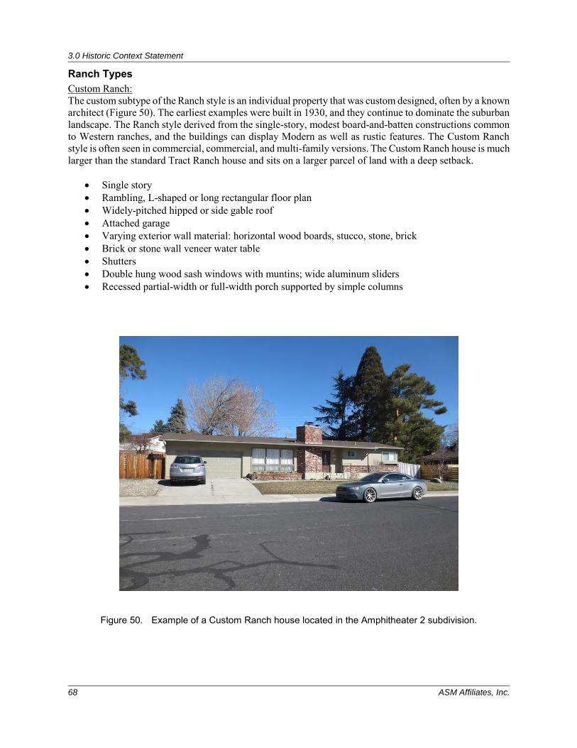
3.0 Historic Context Statement
68 ASM Affiliates, Inc.
Ranch Types Custom Ranch: The custom subtype of the Ranch style is an individual property that was custom designed, often by a known architect (Figure 50). The earliest examples were built in 1930, and they continue to dominate the suburban landscape. The Ranch style derived from the single-story, modest board-and-batten constructions common to Western ranches, and the buildings can display Modern as well as rustic features. The Custom Ranch style is often seen in commercial, commercial, and multi-family versions. The Custom Ranch house is much larger than the standard Tract Ranch house and sits on a larger parcel of land with a deep setback.
• Single story • Rambling, L-shaped or long rectangular floor plan • Widely-pitched hipped or side gable roof • Attached garage • Varying exterior wall material: horizontal wood boards, stucco, stone, brick • Brick or stone wall veneer water table • Shutters • Double hung wood sash windows with muntins; wide aluminum sliders • Recessed partial-width or full-width porch supported by simple columns
Figure 50. Example of a Custom Ranch house located in the Amphitheater 2 subdivision.
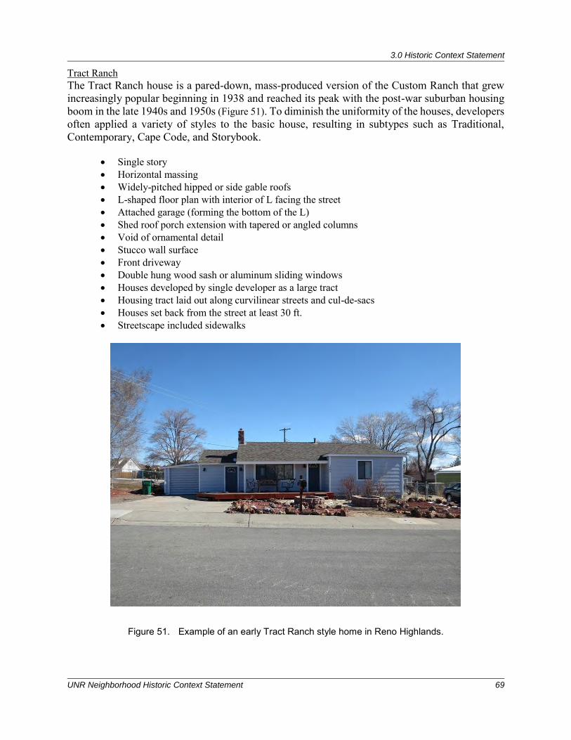
3.0 Historic Context Statement
UNR Neighborhood Historic Context Statement 69
Tract Ranch The Tract Ranch house is a pared-down, mass-produced version of the Custom Ranch that grew increasingly popular beginning in 1938 and reached its peak with the post-war suburban housing boom in the late 1940s and 1950s (Figure 51). To diminish the uniformity of the houses, developers often applied a variety of styles to the basic house, resulting in subtypes such as Traditional, Contemporary, Cape Code, and Storybook.
• Single story • Horizontal massing • Widely-pitched hipped or side gable roofs • L-shaped floor plan with interior of L facing the street • Attached garage (forming the bottom of the L) • Shed roof porch extension with tapered or angled columns • Void of ornamental detail • Stucco wall surface • Front driveway • Double hung wood sash or aluminum sliding windows • Houses developed by single developer as a large tract • Housing tract laid out along curvilinear streets and cul-de-sacs • Houses set back from the street at least 30 ft. • Streetscape included sidewalks
Figure 51. Example of an early Tract Ranch style home in Reno Highlands.
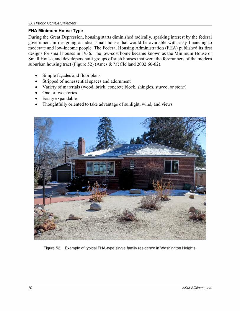
3.0 Historic Context Statement
70 ASM Affiliates, Inc.
FHA Minimum House Type During the Great Depression, housing starts diminished radically, sparking interest by the federal government in designing an ideal small house that would be available with easy financing to moderate and low-income people. The Federal Housing Administration (FHA) published its first designs for small houses in 1936. The low-cost home became known as the Minimum House or Small House, and developers built groups of such houses that were the forerunners of the modern suburban housing tract (Figure 52) (Ames & McClelland 2002:60-62).
• Simple façades and floor plans • Stripped of nonessential spaces and adornment • Variety of materials (wood, brick, concrete block, shingles, stucco, or stone) • One or two stories • Easily expandable • Thoughtfully oriented to take advantage of sunlight, wind, and views
Figure 52. Example of typical FHA-type single family residence in Washington Heights.
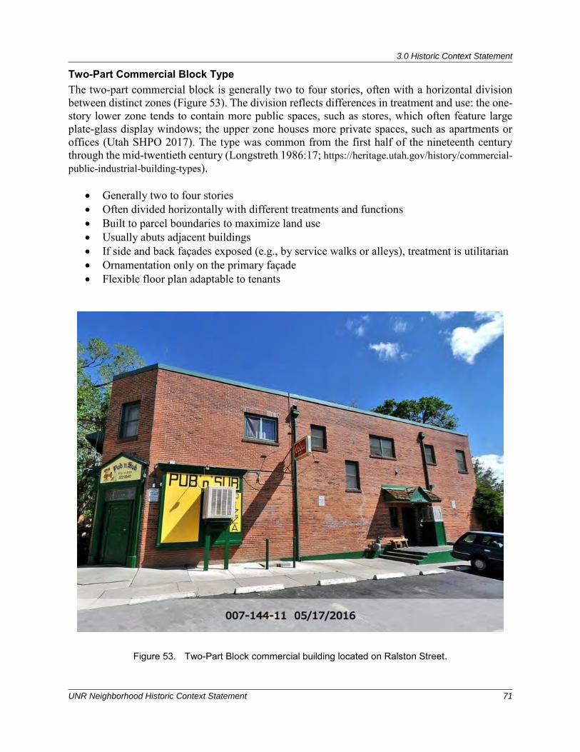
3.0 Historic Context Statement
UNR Neighborhood Historic Context Statement 71
Two-Part Commercial Block Type The two-part commercial block is generally two to four stories, often with a horizontal division between distinct zones (Figure 53). The division reflects differences in treatment and use: the one-story lower zone tends to contain more public spaces, such as stores, which often feature large plate-glass display windows; the upper zone houses more private spaces, such as apartments or offices (Utah SHPO 2017). The type was common from the first half of the nineteenth century through the mid-twentieth century (Longstreth 1986:17; https://heritage.utah.gov/history/commercial-public-industrial-building-types).
• Generally two to four stories • Often divided horizontally with different treatments and functions • Built to parcel boundaries to maximize land use • Usually abuts adjacent buildings • If side and back façades exposed (e.g., by service walks or alleys), treatment is utilitarian • Ornamentation only on the primary façade • Flexible floor plan adaptable to tenants
Figure 53. Two-Part Block commercial building located on Ralston Street.
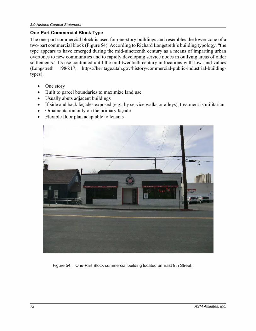
3.0 Historic Context Statement
72 ASM Affiliates, Inc.
One-Part Commercial Block Type The one-part commercial block is used for one-story buildings and resembles the lower zone of a two-part commercial block (Figure 54). According to Richard Longstreth’s building typology, “the type appears to have emerged during the mid-nineteenth century as a means of imparting urban overtones to new communities and to rapidly developing service nodes in outlying areas of older settlements.” Its use continued until the mid-twentieth century in locations with low land values (Longstreth 1986:17; https://heritage.utah.gov/history/commercial-public-industrial-building-types).
• One story • Built to parcel boundaries to maximize land use • Usually abuts adjacent buildings • If side and back façades exposed (e.g., by service walks or alleys), treatment is utilitarian • Ornamentation only on the primary façade • Flexible floor plan adaptable to tenants
Figure 54. One-Part Block commercial building located on East 9th Street.
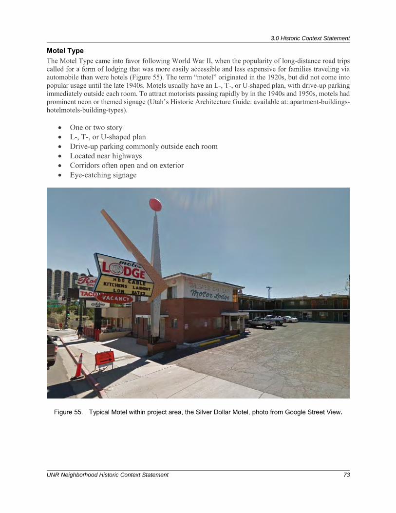
3.0 Historic Context Statement
UNR Neighborhood Historic Context Statement 73
Motel Type The Motel Type came into favor following World War II, when the popularity of long-distance road trips called for a form of lodging that was more easily accessible and less expensive for families traveling via automobile than were hotels (Figure 55). The term “motel” originated in the 1920s, but did not come into popular usage until the late 1940s. Motels usually have an L-, T-, or U-shaped plan, with drive-up parking immediately outside each room. To attract motorists passing rapidly by in the 1940s and 1950s, motels had prominent neon or themed signage (Utah’s Historic Architecture Guide: available at: apartment-buildings-hotelmotels-building-types).
• One or two story • L-, T-, or U-shaped plan • Drive-up parking commonly outside each room • Located near highways • Corridors often open and on exterior • Eye-catching signage
Figure 55. Typical Motel within project area, the Silver Dollar Motel, photo from Google Street View.
3.0 Historic Context Statement
74 ASM Affiliates, Inc.
3.5.2 Master Architects
Frederic J. DeLongchamps (1882-1969) One of the most influential architects in Nevada in the twentieth century, Frederic Joseph DeLongchamps was born in Reno in 1882. He studied mining at the University of Nevada, Reno, graduating in 1904 and worked in the mining field for a short time. Due to health reasons, he took a job as a draftsman for the U.S. Surveyors Office in Reno, and quickly began designing buildings. He won a competition to design the Washoe County Courthouse in 1909, which launched his career (James 2006:177). Travelling to San Francisco after the 1906 earthquake, he helped to rebuild the city, working with an architect and gaining further experience. Ultimately returning to Nevada, DeLongchamps designed nine county courthouses, including two in California. He also worked on major additions to the Nevada State Capital, mansions for the Mapes family, George Whittell, and more than 500 other buildings (James 2006:178). His works include the Reno Post Office (1932) and the Riverside Hotel (1927), as well as several buildings at the University of Nevada, Reno. He won awards for his buildings at the 1915 Panama-Pacific International Expositions in San Francisco and San Diego. He became the official Nevada State Architect in 1919, the only person to hold that title (James 2009:178). DeLongchamps died in Reno in 1969 at the age of 86. Within the UNR Neighborhood, DeLongchamps designed the Graham Mansion at 1079 Ralston in St. George’s subdivision and 555 University Terrace in the Western Addition. He may have also designed the Colonial Revival mansion at 1079 Ralston Street. His works include Classical Revival, Spanish Colonial Revival, Neoclassical, Beaux Arts, Art Deco, International, Gothic Revival, Tudor, Mediterranean, and English Cottage Revival styles.
George A. Ferris (1859-1948) and Lehman “Monk” Ferris (1893-1996) George A. Ferris served as an architect in Nevada for more than 30 years. He was born in Philadelphia in 1859 and educated at Swarthmore College. Ferris settled in Reno in 1906 where he opened his architectural office. Some of Ferris’ more the noteworthy buildings include the Mount Rose, McKinley Park, Orvis Ring, and Mary S. Doten schools in Reno; the Governor's Mansion in Carson City; and the Rialto Theater in Reno. George Ferris and his son, Lehman A. Ferris, formed a partnership in 1928. Lehman was born in 1893, and studied electrical engineering at the University of Nevada, Reno. After he graduated in 1915, he held jobs as a mine engineer, draftsman, specifications writer, and superintendent of construction. Lehman worked for prominent Nevada architect, Frederic J. DeLongchamps in 1919 as a specifications writer before going to work for his father. George Ferris and Son designed several buildings throughout Nevada, including the El Cortez Hotel, Reno (1931); the Oddfellows Building, Reno (1928); the Cladianos Building, Reno; the Nevada State Building, Reno (designed in collaboration with DeLongchamps in 1926); and schools in Las Vegas, Austin and Elko (Koyal and Lawrence-Dietz 1983). Their partnership dissolved in 1932. Monk Ferris designed the Alpha Tau Omega Fraternity House at 205 University Terrace; Ferris and Son designed the Pi Beta Phi Sorority house at 869 Sierra Street in 1931.
Edward S. Parsons (1907-1991) Edward Shier Parsons was one of the most prolific and important architects in Nevada. Born in Tonopah, Nevada in 1907, his family moved to Reno in 1922. After graduating from Reno High in 1924, Parsons went to the University of Southern California and then transferred to the University of Pennsylvania, where he graduated with a degree in architecture. When he could not find a job in Philadelphia, he moved for a short time to San Francisco. In 1934, he returned to Reno and worked with Russell Mills, who gave Parsons an assistant’s job inspecting construction projects (Glass 1983).
3.0 Historic Context Statement
UNR Neighborhood Historic Context Statement 75
Parsons was a partner in the architectural firm of Frederic DeLongchamps and assisted with the design of the new post office in Reno in 1932 (Glass 1983). Over the years, Parsons worked with other noteworthy Nevada architects, before starting his own practice in 1938. Parsons’ first commissions were several residences in the Newlands Addition in 1939, but he is also well known for designing buildings for the University of Nevada, Reno, including the Fleischmann Agricultural Building, the Home Economic Building, and the Orvis School of Nursing (Glass 1983). In addition, Parsons is known for his restorations of several buildings in Nevada, as well as his continued design of new residences. Parsons designed the Sigma Alpha Epsilon (SAE) House at 835 Evans Avenue. Parsons also worked closely with the Max Fleishmann foundation, which funded many important projects throughout Nevada. Parsons was a leader in historic preservation in Nevada, restoring numerous buildings in his service to the National Trust for Historic Preservation. Edward Parsons passed away in 1991 at the age of 84. His favored architectural styles included Period Revival/Tudor and French Provincial.
Howard Henry Brandis (1912-1989) Howard Henry Brandis, a native of Willows, California, was a prominent architect in Reno during the 1940s and 1950s. His wife was the former Helen Sutcliff. He was a charter member of the Nevada Association of Architects in 1939 and president of the Reno chapter of the AIA in Nevada from 1958 until 1960 (AIA 2009). He served as president of the Las Vegas chapter of the AIA from 1962-1964. Brandis also served as assistant manager of the personnel department of the contractor’s Pacific Naval air bases in the Hawaiian Islands, building bases from 1942 until 1943. A graduate of Reno High in 1931, Brandis attended the University of Nevada, graduating in 1935, and briefly attended the University of California, Berkeley School of Architecture (Howard Brandis Jr., personal communication April 5, 2010). During the time he attended the University of Nevada, Brandis was affiliated with the Sigma Alpha Epsilon fraternity (“Howard Brandis in New Position” NSJ 25 November 1942). He was also a co-owner of Western Builders, a contracting firm in Reno, worked extensively with the FHA, and was hired to establish the value of FHA houses (Howard Brandis Jr., personal communication April 5, 2010). Brandis formed a partnership with internationally renowned architect Victor Gruen in 1959, and designed many houses in Reno during his career, including several in Evans Vista, Fairfield Heights, and the New Sunnyside subdivisions. Brandis also designed several buildings throughout northern Nevada including the Welsh Bakery, Reno (1952); the Donner Inn Motel, Reno (1953); the Pincolini Building, Reno (1954); the Sparks Methodist Church (1957); the Reno Medical Center, and the Carson-Tahoe Hospital in Carson City (1959), in addition to the Nevada State Printing Office in Carson City (1955); the Nevada Catholic Welfare Bureau Building, Reno (1966); the Tod Early Building, Reno (1966); and 7-Eleven Food Stores of Nevada (1962-67) (AIA 2009). In the 1960s, he relocated to Las Vegas and formed the firm Brandis Architects, and designed several buildings there as well, including the Child Care Center, Las Vegas (1965) and Reno (1966). In 1970, he relocated to Portland, Oregon, where he worked under the firm Dobson & Brandis. Mr. Brandis’ son, also named Howard Brandis, is a practicing architect in Oakland, California. Mr. Brandis died in 1989 (RGJ 9 March 1989:2C). Although Mr. Brandis designed several buildings in Reno and Las Vegas during the 1950s and 1960s, he is not recognized as a master architect.
Milferd R. Wheeler (1904-1968) and Robert E. Gray Milferd R. Wheeler and Robert E. Gray formed the firm Architectural Plan Service of Reno in ca. 1946 and were active in the 1940s and 1950s. Milferd Wheeler was born in Kenton, Ohio in 1904 and moved to Reno in 1929. He was a member of the Reno chapter of the AIA from 1957-1963. Wheeler and Gray designed the Lambda Chi Alpha fraternity house (255 University Terrace) in Reno in 1955 (see Figure 38). Other works in Nevada include the Topaz Lodge, the Villa Sierra Motel, schools in Sun Valley and Schurz, the Byron C. Carlton apartments in Reno, the Mountain View Mausoleum, as well as the Walton Funeral Home,
3.0 Historic Context Statement
76 ASM Affiliates, Inc.
Reno (1955). Although Wheeler and Gray designed several buildings in Reno during the 1940s and 1950s, they are not recognized as a master architects.
3.5.3 Registration Requirements Property types within the UNR Neighborhood that could individually reflect this theme Front-Gable, Foursquare, Bungalow, FHA/Small House, Minimal Traditional, and Ranch (Tract and Custom), as well as multi-family Duplex and Apartments, One-Part and Two-Part Block commercial buildings, and Motels. Additionally, concentrations of similar resources that reflect a similar style or a cohesive mix of styles from a specific period of time during which those multiple styles were prevalent could be eligible as a historic district. Individual properties will be eligible for their association with one of the specific architectural styles or types identified in the preceding section under NRHP Criterion C and local Reno Criterion 3 if they embody the character-defining features of that style and retain a significant degree of their building materials from the date of construction, which is the period of significance under these criteria. It is unlikely that Minimal Traditional or Tract Ranch types houses would be individually eligible under this theme/criteria as their significance is derived from comprehensive subdivision planning and design (and therefore best evaluated as historic districts). Eligible properties will retain a high degree of integrity of design, materials, and craftsmanship. Properties should also retain good integrity of location, setting, feeling, and association, but some loss of these aspects of integrity is acceptable (NRHP 2002). If multiple properties are extant that represent the same architectural style, a comparison of similar resources is critical to determining local-level eligibility. Individual properties will be eligible for their association with a specific master architect or builder under NRHP Criterion C and local Reno Criterion 4 if they embody the character-defining features that represent the work of that master and retain to a significant degree their building materials dating to the date of construction, which is the period of significance under these criteria. Eligible properties will retain a high degree of integrity of design, materials, and craftsmanship. Properties should also retain good integrity of location, setting, feeling, and association, but some loss of these aspects of integrity is acceptable. If multiple properties are extant that represent the work of that master, a comparison of similar resources is critical to determining local-level eligibility. Residential historic districts will be eligible under NRHP Criterion C and local Reno Criteria 2 and 6 for their association with one or more of the specific architectural styles or types identified in the preceding section, if there is significant concentration of the buildings within the defined area, such as original subdivision or multiple related subdivisions, that reflect the character-defining features of that style(s) or types. Eligible districts should also be united historically or aesthetically by plan or physical development. Due to the number of wartime and postwar subdivisions, prior to nomination of any potential historic district, comparison to other similar subdivisions must be conducted and analyzed—within the project area and the greater Reno area. The period of significance for eligible districts should correspond to the development period of the subdivision as defined in the Community Development sub-themes in Section 3 of this report. Contributing resources to a district should retain a significant degree of their building materials from the date of construction Eligible districts will retain an overall high degree of integrity of design, materials, and craftsmanship. Districts should also retain good integrity of location, setting, feeling, and association, but some loss of these aspects of integrity is acceptable.
4.0 Results and Recommendations
UNR Neighborhood Historic Context Statement 77
4.0 RESULTS AND RECOMMENDATIONS As a result of the HCS development and reconnaissance level survey of the UNR Neighborhood, ASM has identified four potentially eligible historic districts: Evans North, New Sunnyside, Washington Heights, and University Terrace (Figure 56). Recommendations for individually eligible properties was outside the scope of this project. However, this document is intended to form the foundation for future intensive survey and evaluation that could identify individually eligible historic properties under the registration requirements established in Section 3. Under NRHP Criterion A and local Register Criterion 2, individually eligible properties might be identified in additions or neighborhoods where the neighborhood is not eligible as district due to significant amounts of alterations and infill, but a specific individual building might meet the registration requirements for the important themes identified herein. Individual properties might also be identified for their associations with historically significant individuals under NRHP Criterion B and local Reno Criterion 2. Lastly, there are likely individual properties in the project area that meet the registration requirements established under the Theme of Architecture and NRHP Criterion 3 and Local Register Criterion 3 for the styles, property types, and master architects identified herein.
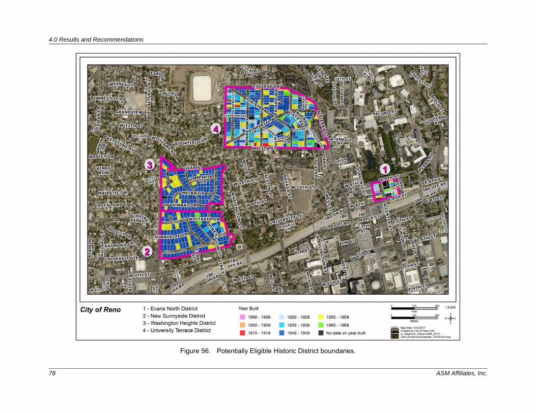
4.0 Results and Recommendations
78 ASM Affiliates, Inc.
Figure 56. Potentially Eligible Historic District boundaries.
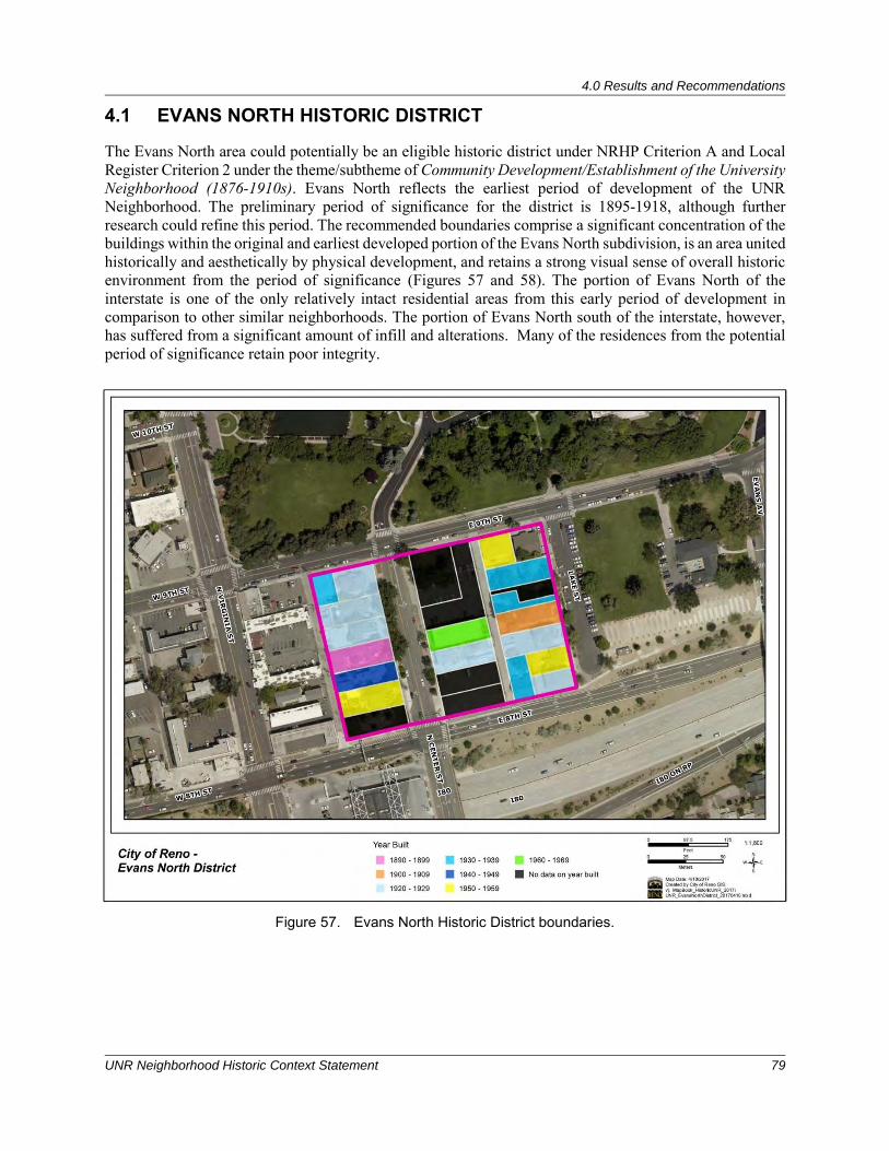
4.0 Results and Recommendations
UNR Neighborhood Historic Context Statement 79
4.1 EVANS NORTH HISTORIC DISTRICT
The Evans North area could potentially be an eligible historic district under NRHP Criterion A and Local Register Criterion 2 under the theme/subtheme of Community Development/Establishment of the University Neighborhood (1876-1910s). Evans North reflects the earliest period of development of the UNR Neighborhood. The preliminary period of significance for the district is 1895-1918, although further research could refine this period. The recommended boundaries comprise a significant concentration of the buildings within the original and earliest developed portion of the Evans North subdivision, is an area united historically and aesthetically by physical development, and retains a strong visual sense of overall historic environment from the period of significance (Figures 57 and 58). The portion of Evans North of the interstate is one of the only relatively intact residential areas from this early period of development in comparison to other similar neighborhoods. The portion of Evans North south of the interstate, however, has suffered from a significant amount of infill and alterations. Many of the residences from the potential period of significance retain poor integrity.
Figure 57. Evans North Historic District boundaries.
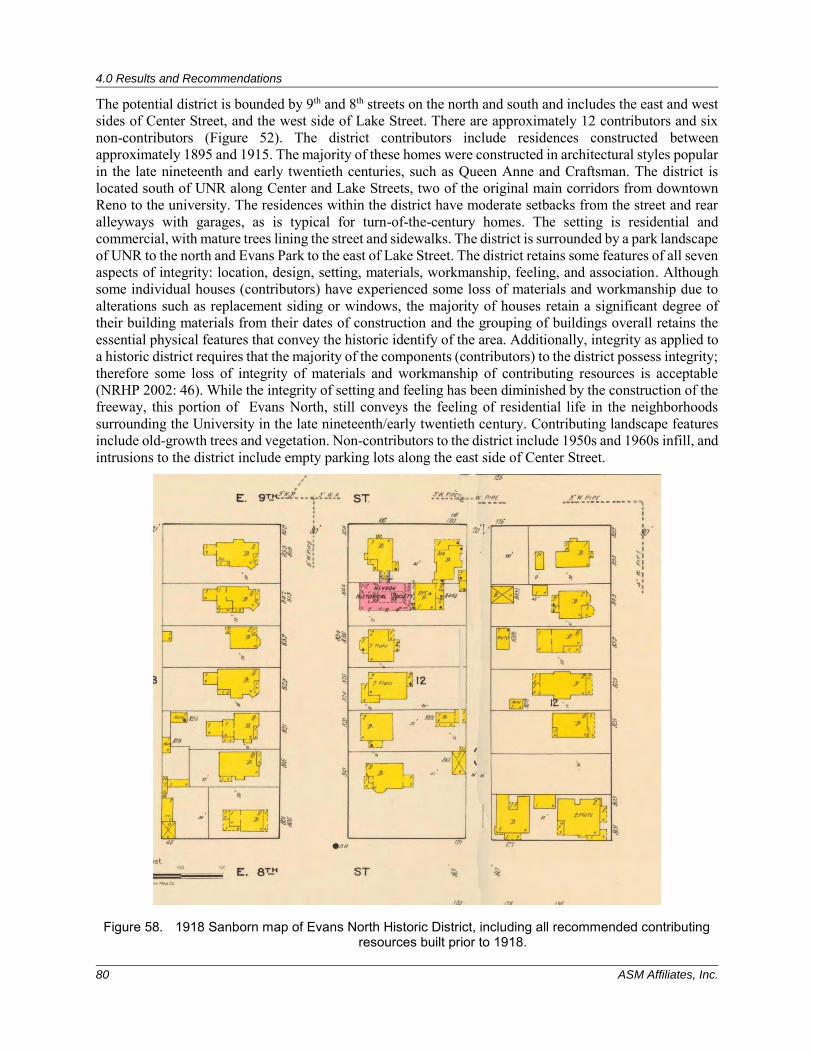
4.0 Results and Recommendations
80 ASM Affiliates, Inc.
The potential district is bounded by 9th and 8th streets on the north and south and includes the east and west sides of Center Street, and the west side of Lake Street. There are approximately 12 contributors and six non-contributors (Figure 52). The district contributors include residences constructed between approximately 1895 and 1915. The majority of these homes were constructed in architectural styles popular in the late nineteenth and early twentieth centuries, such as Queen Anne and Craftsman. The district is located south of UNR along Center and Lake Streets, two of the original main corridors from downtown Reno to the university. The residences within the district have moderate setbacks from the street and rear alleyways with garages, as is typical for turn-of-the-century homes. The setting is residential and commercial, with mature trees lining the street and sidewalks. The district is surrounded by a park landscape of UNR to the north and Evans Park to the east of Lake Street. The district retains some features of all seven aspects of integrity: location, design, setting, materials, workmanship, feeling, and association. Although some individual houses (contributors) have experienced some loss of materials and workmanship due to alterations such as replacement siding or windows, the majority of houses retain a significant degree of their building materials from their dates of construction and the grouping of buildings overall retains the essential physical features that convey the historic identify of the area. Additionally, integrity as applied to a historic district requires that the majority of the components (contributors) to the district possess integrity; therefore some loss of integrity of materials and workmanship of contributing resources is acceptable (NRHP 2002: 46). While the integrity of setting and feeling has been diminished by the construction of the freeway, this portion of Evans North, still conveys the feeling of residential life in the neighborhoods surrounding the University in the late nineteenth/early twentieth century. Contributing landscape features include old-growth trees and vegetation. Non-contributors to the district include 1950s and 1960s infill, and intrusions to the district include empty parking lots along the east side of Center Street.
Figure 58. 1918 Sanborn map of Evans North Historic District, including all recommended contributing resources built prior to 1918.
4.0 Results and Recommendations
UNR Neighborhood Historic Context Statement 81
The potential district could also be eligible under NRHP Criterion C and Local Register Criterion 3 for the historic theme of Architecture. The Evans North Historic District embodies distinctive characteristics of some of the earliest architectural styles in the City of Reno including Queen Anne and Craftsman. As discussed above under Criterion A, contributing resources mostly retain integrity of location, design, setting, materials, workmanship, feeling, and association; as such the district retains overall integrity under the theme of Architecture.
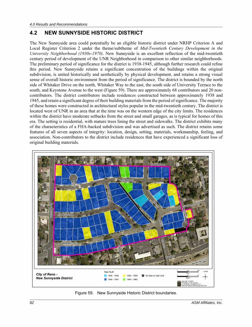
4.0 Results and Recommendations
82 ASM Affiliates, Inc.
4.2 NEW SUNNYSIDE HISTORIC DISTRICT
The New Sunnyside area could potentially be an eligible historic district under NRHP Criterion A and Local Register Criterion 2 under the theme/subtheme of Mid-Twentieth Century Development in the University Neighborhood (1930s-1970). New Sunnyside is an excellent reflection of the mid-twentieth century period of development of the UNR Neighborhood in comparison to other similar neighborhoods. The preliminary period of significance for the district is 1938-1945, although further research could refine this period. New Sunnyside retains a significant concentration of the buildings within the original subdivision, is united historically and aesthetically by physical development, and retains a strong visual sense of overall historic environment from the period of significance. The district is bounded by the north side of Whitaker Drive on the north, Whitaker Way to the east, the south side of University Terrace to the south, and Keystone Avenue to the west (Figure 59). There are approximately 68 contributors and 20 non-contributors. The district contributors include residences constructed between approximately 1938 and 1945, and retain a significant degree of their building materials from the period of significance. The majority of these homes were constructed in architectural styles popular in the mid-twentieth century. The district is located west of UNR in an area that at the time was on the western edge of the city limits. The residences within the district have moderate setbacks from the street and small garages, as is typical for homes of this era. The setting is residential, with mature trees lining the street and sidewalks. The district exhibits many of the characteristics of a FHA-backed subdivision and was advertised as such. The district retains some features of all seven aspects of integrity: location, design, setting, materials, workmanship, feeling, and association. Non-contributors to the district include residences that have experienced a significant loss of original building materials.
Figure 59. New Sunnyside Historic District boundaries.
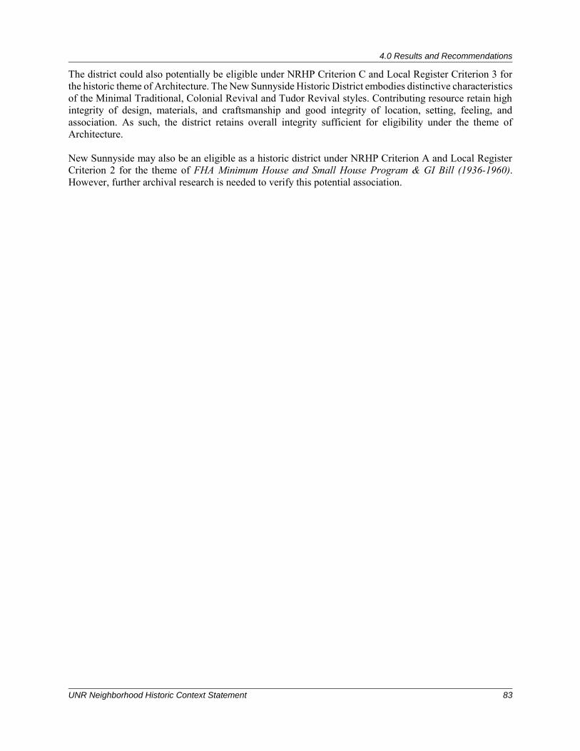
4.0 Results and Recommendations
UNR Neighborhood Historic Context Statement 83
The district could also potentially be eligible under NRHP Criterion C and Local Register Criterion 3 for the historic theme of Architecture. The New Sunnyside Historic District embodies distinctive characteristics of the Minimal Traditional, Colonial Revival and Tudor Revival styles. Contributing resource retain high integrity of design, materials, and craftsmanship and good integrity of location, setting, feeling, and association. As such, the district retains overall integrity sufficient for eligibility under the theme of Architecture. New Sunnyside may also be an eligible as a historic district under NRHP Criterion A and Local Register Criterion 2 for the theme of FHA Minimum House and Small House Program & GI Bill (1936-1960). However, further archival research is needed to verify this potential association.
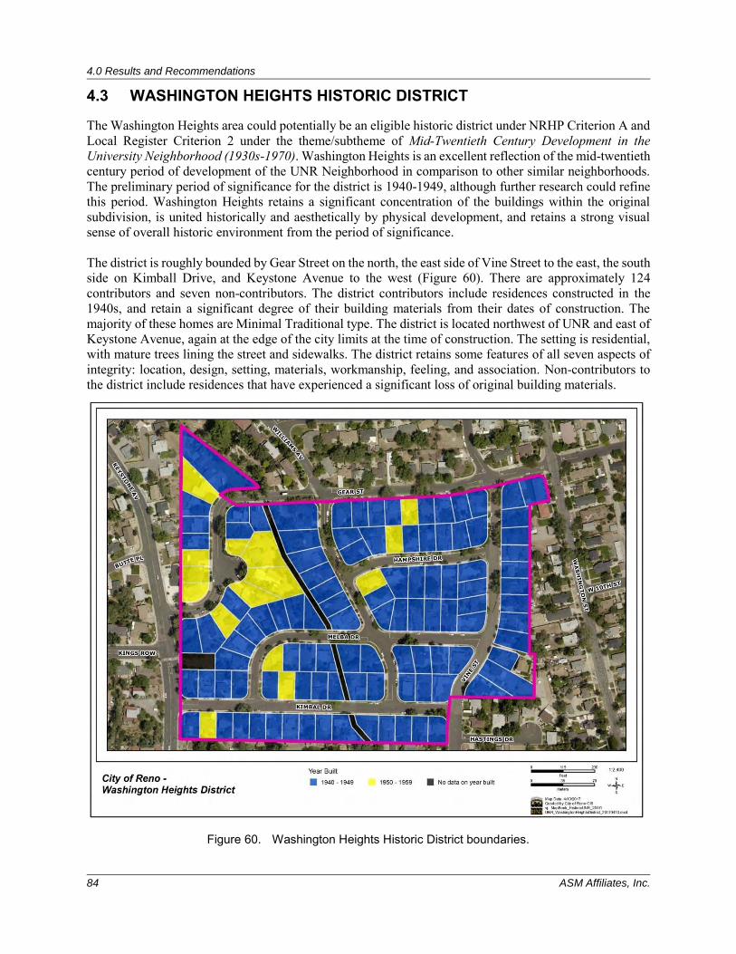
4.0 Results and Recommendations
84 ASM Affiliates, Inc.
4.3 WASHINGTON HEIGHTS HISTORIC DISTRICT
The Washington Heights area could potentially be an eligible historic district under NRHP Criterion A and Local Register Criterion 2 under the theme/subtheme of Mid-Twentieth Century Development in the University Neighborhood (1930s-1970). Washington Heights is an excellent reflection of the mid-twentieth century period of development of the UNR Neighborhood in comparison to other similar neighborhoods. The preliminary period of significance for the district is 1940-1949, although further research could refine this period. Washington Heights retains a significant concentration of the buildings within the original subdivision, is united historically and aesthetically by physical development, and retains a strong visual sense of overall historic environment from the period of significance. The district is roughly bounded by Gear Street on the north, the east side of Vine Street to the east, the south side on Kimball Drive, and Keystone Avenue to the west (Figure 60). There are approximately 124 contributors and seven non-contributors. The district contributors include residences constructed in the 1940s, and retain a significant degree of their building materials from their dates of construction. The majority of these homes are Minimal Traditional type. The district is located northwest of UNR and east of Keystone Avenue, again at the edge of the city limits at the time of construction. The setting is residential, with mature trees lining the street and sidewalks. The district retains some features of all seven aspects of integrity: location, design, setting, materials, workmanship, feeling, and association. Non-contributors to the district include residences that have experienced a significant loss of original building materials.
Figure 60. Washington Heights Historic District boundaries.
4.0 Results and Recommendations
UNR Neighborhood Historic Context Statement 85
The district could also potentially be an eligible under NRHP Criterion C and Local Register Criterion 3 for the historic theme of Architecture. The Washington Heights Historic District embodies distinctive characteristics of the Minimal Traditional type. Contributing resource retain high integrity of design, materials, and craftsmanship and good integrity of location, setting, feeling, and association. As such the district retains overall integrity sufficient for eligibility under the theme of Architecture. Washington Heights could also potentially be an eligible as a historic district under NRHP Criterion A and Local Register Criteria 2 and 6 for the theme of FHA Minimum House and Small House Program & GI Bill (1936-1960). This FHA approved subdivision was developed as a direct result of the onset of WWII, and the new FHA Title VI loan program.
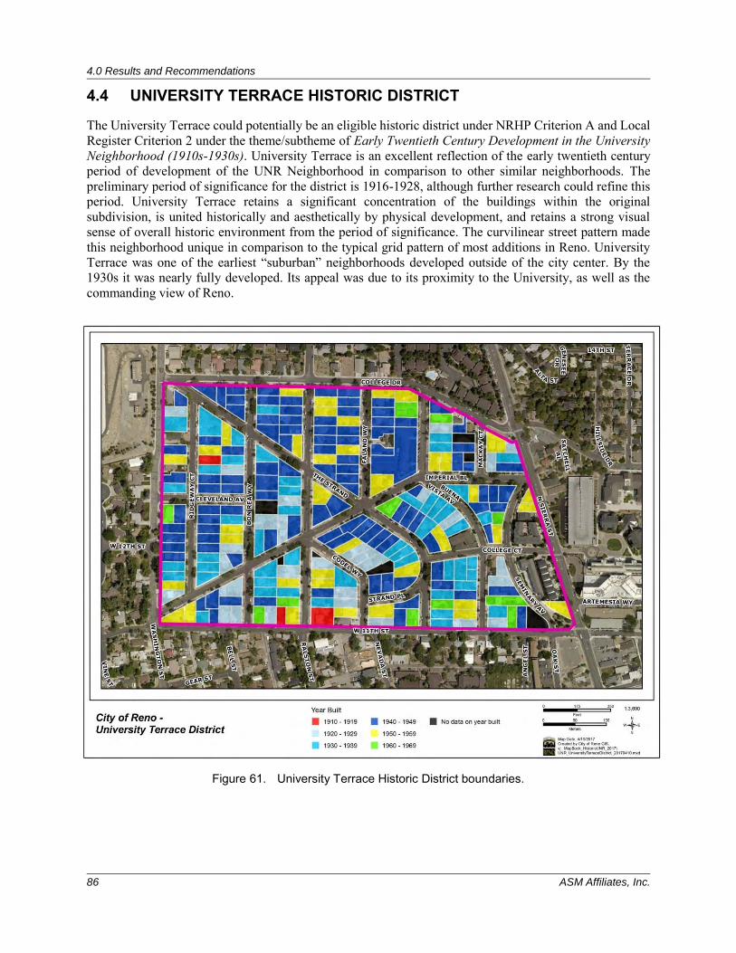
4.0 Results and Recommendations
86 ASM Affiliates, Inc.
4.4 UNIVERSITY TERRACE HISTORIC DISTRICT
The University Terrace could potentially be an eligible historic district under NRHP Criterion A and Local Register Criterion 2 under the theme/subtheme of Early Twentieth Century Development in the University Neighborhood (1910s-1930s). University Terrace is an excellent reflection of the early twentieth century period of development of the UNR Neighborhood in comparison to other similar neighborhoods. The preliminary period of significance for the district is 1916-1928, although further research could refine this period. University Terrace retains a significant concentration of the buildings within the original subdivision, is united historically and aesthetically by physical development, and retains a strong visual sense of overall historic environment from the period of significance. The curvilinear street pattern made this neighborhood unique in comparison to the typical grid pattern of most additions in Reno. University Terrace was one of the earliest “suburban” neighborhoods developed outside of the city center. By the 1930s it was nearly fully developed. Its appeal was due to its proximity to the University, as well as the commanding view of Reno.
Figure 61. University Terrace Historic District boundaries.
4.0 Results and Recommendations
UNR Neighborhood Historic Context Statement 87
The district boundaries include the original subdivision boundaries; Terrace Avenue (now College Drive) to the north, 11th Street to the south, Washington Street to the west, and Sierra Street to the east (Figure 61). There are 210 potentially contributing resources within the district and 63 non-contributors. The majority of homes within the district were constructed in the 1920s and 1930s in various styles/types including Tudor Revival, Spanish Revival, Craftsman, and Minimal Traditional. Contributing resources retain a significant degree of their building materials from their dates of construction. Non-contributors to the district include residences constructed in the 1950s and 1960s, and some that were constructed after 1970. The district is located to the northwest of UNR and features a neighborhood constructed on a high point of the city overlooking downtown Reno. The streets are curvilinear with sidewalks and street parking. The homes have moderate to low setbacks with driveways that lead to attached garages on some homes. In some areas, sidewalks have been added to the streetscape. The neighborhood is filled with tree-lined streets in most areas, as well as grass lawns. The district is entirely residential. The district could also potentially be an eligible under NRHP Criterion C and Local Register Criterion 3 for the historic theme of Architecture. The University Terrace Historic District embodies distinctive characteristics of the eclectic styles and types popular during the early twentieth century: Tudor Revival, Spanish Revival, Craftsman, and Minimal Traditional. Contributing resources retain high integrity of design, materials, and craftsmanship and good integrity of location, setting, feeling, and association. As such the district retains overall integrity sufficient under the theme of Architecture.

5.0 References
UNR Neighborhood Historic Context Statement 89
5.0 REFERENCES American Institute of Architects
1970 American Architects Directory, Third edition, R.R. Bowker LLC. 1970 Ames, David L., and Linda Flint McClelland
2002 National Register Bulletin: Historic Residential Suburbs: Guidelines for Evaluation and Documentation for the National Register of Historic Places. U.S. Department of the Interior, National Park Service, Washington D.C.
Barber, Alicia
2008 Reno’s Big Gamble: Image and Reputation in the Biggest Little City. University Press of Kansas, Lawrence, Kansas.
Blumenson, John J.-G.
1981 Identifying American Architecture. W.W. Norton, New York. Breckenridge, Karl
2015 The History of the Graham Mansion on Ralston Street. Reno Gazette Journal, 1 March 2015.
Carley, Rachel 1997 The Visual Dictionary of American Domestic Architecture. Holt Paperbacks.
Cooper, Jason A.
1938 Men at Work. Federal City of Reno Relief Program. United State Community Improvement Appraisal. University of Nevada, Reno Special Collections Library, Manuscript Collection NC 233.
Doten, Samuel Bradford
1924 An Illustrated History of the University of Nevada. University of Nevada, Reno. FHA
1936 Planning Neighborhoods for Small Houses, Technical Bulletin 5. GPO, Washington, D.C., pp. 8-9.
1940 Principals of Planning Small Houses (rev. ed., 1940), 14-15. Fisher, Michael
2006 Nevada’s First Fraternity. In Silver and Blue, Fall 2006. University of Nevada, Reno. Franzwa, Gregory M., and Jesse G. Petersen
2004 The Lincoln Highway, Nevada, Volume 5. Published by The Patrice Press, Tucson, Arizona, 2004.
Girling, Cynthia L. and Kenneth I. Helphand
1994 Yard—Street—Park, New York: John Wiley & Sons, pp. 59-64. Glass, Mary Ellen
1983 Edward S. Parsons: Charrette! The Life of an Architect. University of Nevada, Reno Oral History Program.
5.0 References
90 ASM Affiliates, Inc.
Green, Michael S. 2015 Nevada: A History of the Silver State. University of Nevada Press, Reno, Nevada.
Greenhaw, Charles, and Antoine Primeaux
1998 University of Nevada was born in Elko. Elko Daily Free Press, Tuesday, May 12, 1998. Hamby, Mary Beth, and Nancy E. Sikes
1986 National Register nomination for the University of Nevada, Reno Historic District. On file at the State Historic Preservation Office, Carson City.
Harmon, Mella
1998 Divorce and Economic Opportunity in Reno, Nevada during the Great Depression. Unpublished Master’s Thesis. University of Nevada, Reno.
2002 W. E. Barnard House National Register of Historic Places Registration Form. U. S. Department of the Interior, National Park Service. On file at the State Historic Preservation Office, Carson City, Nevada.
2003 Alpha Tau Omega Fraternity House. National Register of Historic Places Registration Form. Electronic document, accessed online at https://npgallery.nps.gov/pdfhost/docs/NRHP/Text/03001508.pdf, March 20, 2017.
2010 Reno and Transportation in the West. Electronic document, accessed online at http://www.onlinenevada.org/reno_and_transportation_in_the_west, April 6, 2016.
2017 “Bishop Whitaker's School for Girls (site),” Reno Historical, accessed March 17, 2017, http://renohistorical.org/items/show/30.
Hinman, Debbie
2016 The Endangered University Neighborhood. In Footprints: Vol 19 No. 1. Historic Reno Preservation Society, Reno, Nevada
2017 “The Historic University Gateway.” Reno Historical, accessed March 17, 2017, http://renohistorical.org/tours/show/9.
2017 “Atcheson House,” Reno Historical, accessed March 20, 2017, http://renohistorical.org/items/show/139.
Hulse, James W.
1974 The University of Nevada: Centennial History. University of Nevada Press, Reno. 1998 The Silver State: Nevada’s Heritage Reinterpreted, 2nd ed.. University of Nevada Press,
Reno. 2004 The Silver State: Nevada’s Heritage Reinterpreted, 3rd ed.. University of Nevada Press,
Reno. James, Ronald
2006 Frederic J. Delongchamps. In Nevada Historical Society Quarterly, Vol. 49, No. 3:175-182. 2009 Nevada's Historic Buildings: A Cultural Legacy. University of Nevada Press.
Kelly, Barbara
1993 Expanding the American Dream. State University of New York Press, Albany.
Koyal, Ana, and Patricia Lawrence-Dietz 1983 El Cortez Hotel, Washoe County, NV, National Register of Historic Places Registration
Form. National Park Service, Washington, D.C.
5.0 References
UNR Neighborhood Historic Context Statement 91
Land, Myrick and Barbara 1995 A Short History of Reno. University of Nevada Press, Reno, Nevada.
Longstreth, Richard
1986 “Compositional Types in American Commercial Architecture: 1800-1950.” In Perspectives in Vernacular Architecture, Vol. 2, ed. by Camille Wells, 12-23. Columbia: University of Missouri Press.
McAlester, Virginia, and Lee McAlester
2009 A Field Guide to American Houses. Alfred A. Knopf, New York. Moehring, Eugene P.
2014 Reno, Las Vegas, and the Strip: A Tale of Three Cities. University of Nevada Press, Reno, Nevada.
Moreno, Richard
2015 A Short History of Reno, Second Edition. University of Nevada Press, Reno, Nevada. Myrick, David F.
1962 Railroads of Nevada and Eastern California, Volume 1 - The Northern Roads. Howell-North Books, Berkeley.
1992 Railroads of Nevada and Eastern California, Volume II: The Southern Roads. University of Nevada Press, Reno.
National Park Service, National Register of Historic Places
1991 How to Apply the National Register Criteria for Evaluation. National Register Bulletin No. 15. Washington, D.C.
National Register of Historic Places
2002 How to Apply the National Register Criteria for Evaluation, Bulletin 15. U.S. Department of the Interior, National Park Service, Washington, DC. Revised 2002 for internet publication. Available online at https://www.nps.gov/nr/publications/bulletins/nrb15/INDEX.htm
2015 “Updated Data Categories: Architectural Classifications and Type/Form/Plan for Revised How to Complete the NR Form Bulletin,” November 2015.
Nevada State Journal (NSJ) Reno, Nevada
1875 Building Improvements. 29 August, 1875. 1876 Fire in the Western Addition. 21 May, 1876:2. 1895a The Northern Part of Town is Rapidly Building Up. 12 October 1895. 1895b A Model House. 31 December 1895. 1896 New University Addition. 13 February, 1896. 1901 These Lots are in Good Demand. 6 December 1901. 1901 St. George’s Addition. 13 October 1901:1. 1901 Advertisement for St. George’s Addition. 26 October 1901. 1901 Real Estate Transactions. 16 September, 1901. 1902a A Modern Mansion on Ralston Heights. 27 September 1902. 1902b Advertisement: “Get a Lot from St. George.” 27 September 1902. 1903 Nevada Mining and Real Estate Advertisement for lots in Ward’s Addition. 3 May, 1903:5. 1903 Great Building Activity. 25 July 1903. 1905 A Bargain List. 18 June, 1905. 1907 A Lesson From the Flood. 21 March, 1907.
5.0 References
92 ASM Affiliates, Inc.
1907 Notice. 8 July 1907. 1907 Bonham Realty and Trust Co. advertisement. 27 July, 1907:8. 1907 Travers Realty Company ad for University Addition. 3 August, 1907. 1907 Sewer Construction Work Under Way. 2 October, 1907. 1907 Report of board meeting of Bonham Realty and Trust Company. 7 November, 1907:4. 1910 Real Estate is Moving Lively. 2 October 1910. 1910 Activity reported in Reno Real Estate. 31 March 1910:8. 1911 Advertisement for 46 W. 10th. 16 January 1911:3. 1911 Aged Doctor is Laid to Rest. 11 December 1911:6. 1920 Advertisement for Lots in St. George addition. 4 May, 1920. 1922 New Park Urged. 9 May 1922:2. 1922 School Boys of Reno Appeal to City for Field. 2 October 1922:6. 1924 Reno Forging Rapidly ahead with Improvement Projects. 1 January 1924:8. 1926 Evans Tract Offered City. 15 June 1926. 1930 Northside has rapid growth. 4 May 1930:14. 1930 Henry Anderson Succumbs Here. 4 November 1930: 8. 1931 U. of N. Sorority Enters New Home. 16 October 1931:8. 1932 6 Permits to Build Granted Here in Day. 30 September 1932:3. 1937 Two homes built by Evans Estate. 11 November 1937: 5. 1940 Many Homes Built, September 8, 1940. 1940 Work Starts on Five New Homes. 22 September:15. 1940 Advertisement for the Western Builders 1941 Model Home. 29 September:14. 1940 Advertisement for Western Builders at Sunnyside Subdivision. 3 November 1940:17. 1942 Reno Granted Critical Building Priority Rating. 25 March 1942:12. 1942 “Howard Brandis in New Position.” 25 November, 1942. 1942 Building Work in Reno Even. 29 March, 1942. 1946 Advertisement for GI homes in Washington Heights. 5 May 1946:17. 1952 Grand View Heights Seeks Annexation. 26 May 1952. 1952 Defense Housing Work Studied by Reno Councilmen. 23 September 1952:8. 1953 “Good News for Reno!” Advertisement for Reno Highlands. 1 February 1953:3. 1953 “Inviting You to Own Your Own Home in Beautiful Reno Highlands.” 4 February 1953:16. 1953 Advertisement Harrison Homes. 12 April 1953. 1953 500 Renoites will be moving uphill soon. 26 July 1953:14. 1953 Reno Highlands Housing Project Opens Tomorrow. 18 September 1953:12. 1954 Founders Day Observed by Nevada SAE’s. 16 March 1954:7. 1955 Two Extensive Subdivisions are Planned. 15 February 1955:8. 1955 Advertisement for Reno Highlands. 21 July, 1955. 1964 I-80 Route Taking Shape in Nevada. 30 June 1964:10. 1966 Stewart Dinwiddie was the contractor for the Carson Mall. 21 September 1966:8. 1968 Ready to Open. 12 August 1968:9. 1977 Old Evans Ranch House Watched Reno Grow. 6 August, 1977.
Poor’s Railroad Manual Company
1915 Poor's Manual of Public Utilities: Street, Railway, Gas, Electric, Water, Power, Telephone and Telegraph Companies. Electronic document, accessed online at https://books.google.com/.
Regional Transportation Commission (RTC)
2016 Lincoln Highway Era (1913-1928): 4th Street/Prater Way History Project. Webpage http://4thprater.onlinenevada.org/era/lincoln-highway-era; accessed online March 29, 2016.
5.0 References
UNR Neighborhood Historic Context Statement 93
Reno City Directory, Polk’s 1932 Polk’s Reno City Directory, Polk & Company, San Francisco, California. 1948 Polk’s Reno City Directory, Polk & Company, San Francisco, California.
Reno Evening Gazette (REG) Reno, Nevada
1877 Real Estate Transactions. 31 January, 1877:3 1895 7 January 1895. 1895 Brevities. 30 August 1895. 1901 Real Estate Transfers. 16 September 1901:4 1902 “I Must Have Money.” 17 April, 1902 1904 Street Railway Incorporation. 30 July:5. 1905 End Reached by Old Citizen. 5 October:4. 1906 Certificate of Partnership. 1 December:7 1907 University Heights Lots Sell Rapidly. 5 August 1907. 1907 Great Activity in Building Circles. 26 September:5. 1908 C. C. Higgins property. 13 May 1908:7. 1908 Streetcar Lines to be Extended. 6 November. 1910 Expended for Building in 1909 in Reno. 5 January 1910 1910 Many Houses Under Way. 15 April 1910. 1911 Died. 11 February 1911. 1912 To Entertain Sewing Circle. February 26:1. 1914 Reno Enjoys Activities in Construction. 1 October 1914: 8 1916 Council Grants Permission to Build Streets. 24 October 1916:8. 1917 Advertisement, Peck & Sample Company. 15 January:6. 1920 New Homes taken by fraternities at college. 6 January:8. 1922 Building Permits Reach $200,000. 6 May 1922:6 1922 Notice of Sale of Real Estate. 14 June 1922. 1923 City Councilman is Found Dying by side of Ditch. 2 July 1923:1 1923 C. H. Duborg Estate is Valued at $100,000. 11 July 1923. 1924 Evans Addition Plat Accepted. 18 March 1924. 1926 243 University Terrace Lots are Sold. 2 April 1926:8. 1928 171 lots sold in University Terrace. 8 March 1928 1930 Notice to Holders. 21 January 1930:10. 1930 Building Permit Applications are Few. 21 June 1930:5. 1930 Sorority Row on Sierra Street Showing Growth. 1 March 1930:14 1932 Street Improving Plans adopted by Council. 29 March, 1932:2. 1933 Mrs. L.D. Graham to build a house. 21 June 1933:10. 1936 Advertisement for Evans Vista. 26 February:12. 1937 Building permits are few this month. 17 July 1937:14 1938 Building permits total $30,100 for week. 21 May 1938:7. 1939 Max Fleischmann Buys Ranch Holdings. 3 August 1939:2 1941 Seek to qualify addition for FHA Loans. 11 March 1941. 1942 Building Lags here this Year. 11 March 11 1942:16 1942 G. W. Carlson, new residence at 1139 Evans avenue, $5900. 11 March 1942:16. 1942 $157,854 Building in First Quarter. 2 April, 1942. 1943 Housing Project Bids to be Opened. 16 December 1943:18 1944 Family House Units Ready. 14 June 1944:18. 1944 Deeds Recorded. May 24, 1944:6 1944 Expand city limits mayor suggests. 15 January 1944:14. 1945 Clarence Edmonds Funeral is Held. 5 December 1945:2. 1947 Council Considers Assorted Requests. 7 October 1947:4

5.0 References
94 ASM Affiliates, Inc.
1948 Advertisement: Immediate Possession. August 10 1948:15. 1948 Reno Civic Needs to be Considered. 9 March 1948:8. 1952 Reno City Council Includes V. and T. Strip in Road Net. 23 September 1952:11 1954 SAE Observes Founders Day. 17 March 1954:13. 1955 New Subdivision Model Home now Being Displayed. 21 July 1955:7 1955 Lambda Chi Alpha House Nearing Completion. 26 October 1955:8 1957 Obituary for Mr. Lee Miner. 19 June, 1957
Reno Gazette Journal (RGJ) Reno, Nevada 1907 New Sierra street car line runs within one block of University Addition. 3 August, 1907:7. 1962 Memorial Park Plan Advanced. 12 July, 1962:19. 1982 Hillside’s Revolving Caretakers. 2 July 1982:29-30 1989 Howard H. Brandis. 9 March 1989:2C.
The Reno Historical Team
2017 “Leaver House,” Reno Historical, accessed March 20, 2017, http://renohistorical.org/items/show/146.
Richfield, Clare
2007 The Suburban Ranch House in Post-World War II America: A Site of Contrast in an Era of Unease, Uncertainty and Instability. Unpublished Master’s Thesis, Barnard College, New York.
Ross-Hauer, JoEllen
2010 A Comparison of Pre- and Post WWII Suburbs in Reno, Nevada. Unpublished Master’s Thesis. University of Nevada, Reno.
Rowe, Peter G.
1991 Making a Middle Landscape. MIT Press, Cambridge. Rowley, William, D.
1984 Reno: Hub of the Washoe Country. Windsor Publications, Woodland Hills, California. Silver, Sue
2013 Along the East Walker River Nevada: An Historical Perspective. CreateSpace Independent Publishing Platform, North Charleston, South Carolina.
Southworth, Michael and E. Ben-Joseph
1997 Streets and the Shaping of Towns and Cities. McGraw-Hill, New York. Townley, John M.
1983 Tough Little Town on the Truckee. Reno:1868-1900. Great Basin Studies Center, Reno. University of Nevada Reno, Special Collections Library
2017a A Guide to the Papers of John Newton Evans. Electronic document, http://dewey.library.unr.edu/xtf/view?docId=ead/91-42-ead.xml, accessed online March 22, 2017.
2017b A Guide to the Records of The Max C. Fleischmann Foundation. Electronic document, http://dewey.library.unr.edu/xtf/view?docId=ead/90-36-ead.xml, accessed online July 22, 2017.
5.0 References
UNR Neighborhood Historic Context Statement 95
U.S. Census 1900 Ancestry.com. 1900 United States Federal Census [database on-line]. Provo, UT, USA:
Ancestry.com Operations Inc, 2004. 1910 Ancestry.com. 1910 United States Federal Census [database on-line]. Provo, UT, USA:
Ancestry.com Operations Inc, 2006. Utah State Historic Preservation Office
2017 Utah’s Historic Architecture Guide. Available at: https://heritage.utah.gov/history/utahs-historic-architecture; accessed July 26, 2017.
Walton-Buchanan, Holly
2007 Historic Houses and Buildings of Reno, Nevada. The Black Rock Press, University of Nevada, Reno.
Winton, Alexandra Griffith
2004 A Man’s House is His Art. The Walker Art Center’s Idea House Project and the Marketing of Domestic Design 1941-1947. Journal of Design History, Vol. 17, No. 4:377-396.

6.0 Other Sources Consulted
UNR Neighborhood Historic Context Statement 97
6.0 OTHER SOURCES CONSULTED FHA
1936 -1939 Principals of Planning Small Houses (1936-1939 eds.), 24-27. 1938 Subdivision Standards, Circular no. 5 (Washington, DC: FHA, August 15, 1938) 5.
National Register of Historic Places 1983 Secretary of the Interior's Standards and Guidelines for Archeology and Historic Preservation.
Available online at: https://www.nps.gov/history/local-law/arch_stnds_0.htm
Nevada State Journal (NSJ) Reno, Nevada 1907 University Heights Advertisement. 27 July, 1907.
Reno Evening Gazette (REG) Reno, Nevada 1893 Real Estate Transactions 12 July,1893:1. 1908 Legal advertisements. 13 May,1908:7. 1930 A Group of New Homes. 26 April, 1930:5 1948 New Living Quarters provided for 430 Reno Families in ‘48. 21 December, 1948:14.
Appendices
UNR Neighborhood Historic Context Statement 99
APPENDICES

Appendices
UNR Neighborhood Historic Context Statement
APPENDIX A
Subdivision Maps

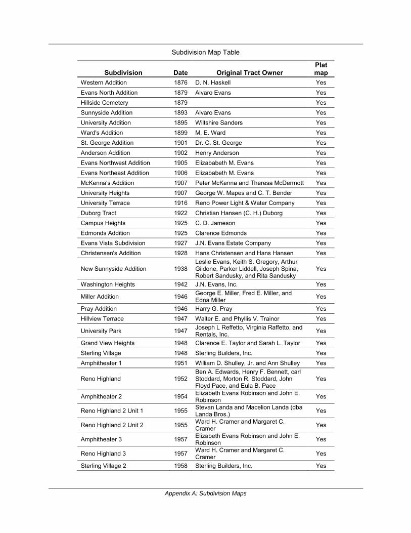
Appendix A: Subdivision Maps
Subdivision Map Table
Subdivision Date Original Tract Owner Plat map
Western Addition 1876 D. N. Haskell Yes
Evans North Addition 1879 Alvaro Evans Yes Hillside Cemetery 1879 Yes Sunnyside Addition 1893 Alvaro Evans Yes University Addition 1895 Wiltshire Sanders Yes Ward's Addition 1899 M. E. Ward Yes St. George Addition 1901 Dr. C. St. George Yes
Anderson Addition 1902 Henry Anderson Yes Evans Northwest Addition 1905 Elizababeth M. Evans Yes Evans Northeast Addition 1906 Elizababeth M. Evans Yes McKenna's Addition 1907 Peter McKenna and Theresa McDermott Yes University Heights 1907 George W. Mapes and C. T. Bender Yes University Terrace 1916 Reno Power Light & Water Company Yes
Duborg Tract 1922 Christian Hansen (C. H.) Duborg Yes Campus Heights 1925 C. D. Jameson Yes Edmonds Addition 1925 Clarence Edmonds Yes Evans Vista Subdivision 1927 J.N. Evans Estate Company Yes Christensen's Addition 1928 Hans Christensen and Hans Hansen Yes
New Sunnyside Addition 1938 Leslie Evans, Keith S. Gregory, Arthur Gildone, Parker Liddell, Joseph Spina, Robert Sandusky, and Rita Sandusky
Yes
Washington Heights 1942 J.N. Evans, Inc. Yes
Miller Addition 1946 George E. Miller, Fred E. Miller, and Edna Miller Yes
Pray Addition 1946 Harry G. Pray Yes Hillview Terrace 1947 Walter E. and Phyllis V. Trainor Yes
University Park 1947 Joseph L Reffetto, Virginia Raffetto, and Rentals, Inc. Yes
Grand View Heights 1948 Clarence E. Taylor and Sarah L. Taylor Yes Sterling Village 1948 Sterling Builders, Inc. Yes Amphitheater 1 1951 William D. Shulley, Jr. and Ann Shulley Yes
Reno Highland 1952 Ben A. Edwards, Henry F. Bennett, carl Stoddard, Morton R. Stoddard, John Floyd Pace, and Eula B. Pace
Yes
Amphitheater 2 1954 Elizabeth Evans Robinson and John E. Robinson Yes
Reno Highland 2 Unit 1 1955 Stevan Landa and Macelion Landa (dba Landa Bros.) Yes
Reno Highland 2 Unit 2 1955 Ward H. Cramer and Margaret C. Cramer Yes
Amphitheater 3 1957 Elizabeth Evans Robinson and John E. Robinson Yes
Reno Highland 3 1957 Ward H. Cramer and Margaret C. Cramer Yes
Sterling Village 2 1958 Sterling Builders, Inc. Yes
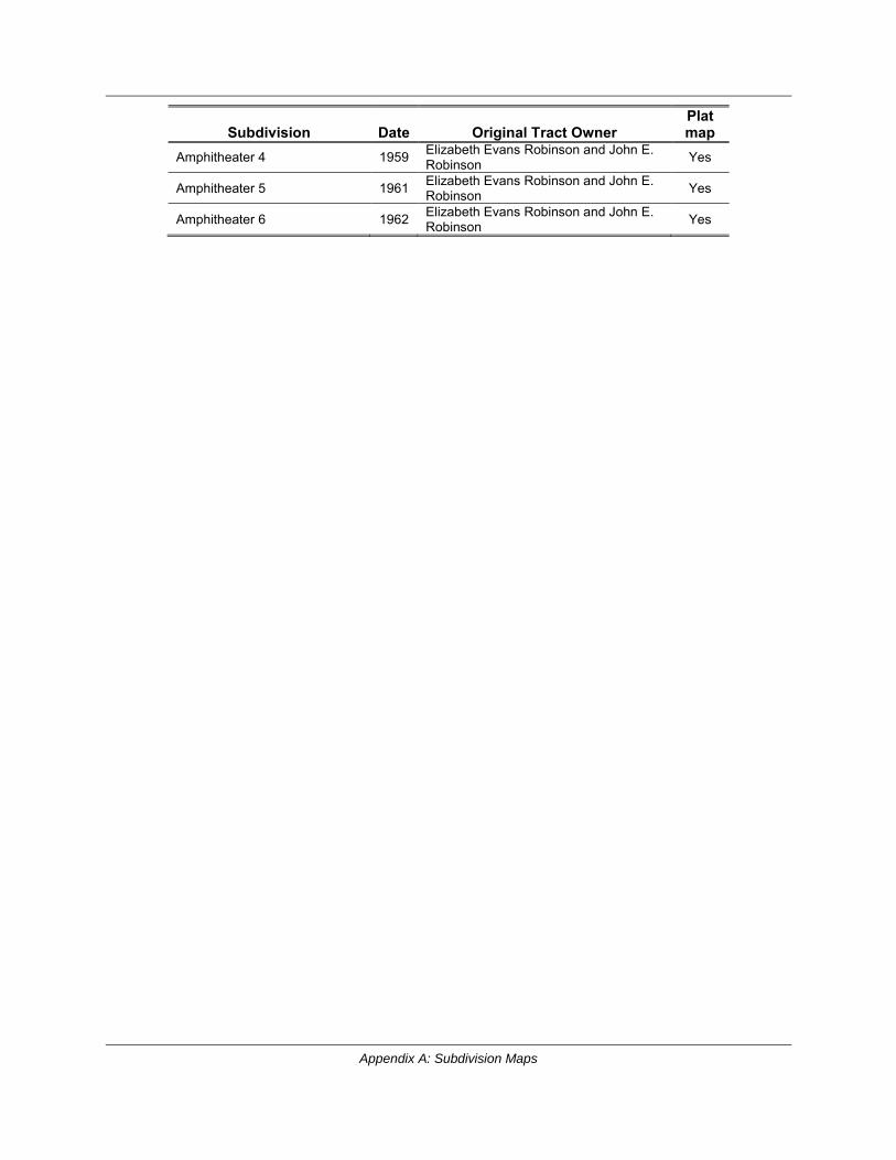
Appendix A: Subdivision Maps
Subdivision Date Original Tract Owner Plat map
Amphitheater 4 1959 Elizabeth Evans Robinson and John E. Robinson Yes
Amphitheater 5 1961 Elizabeth Evans Robinson and John E. Robinson Yes
Amphitheater 6 1962 Elizabeth Evans Robinson and John E. Robinson Yes
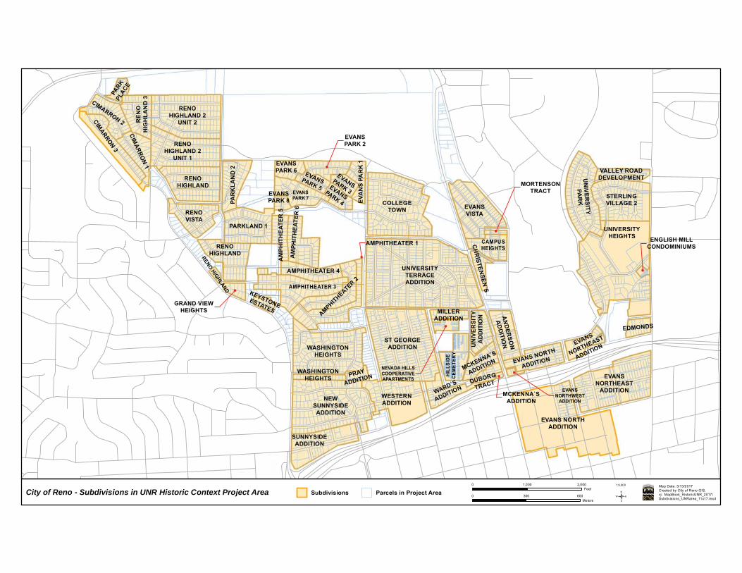
PARK
PLACE
CIMARRON 2
RENOHIGHLAND 2
UNIT 2REN
OH
IGH
LAN
D 3
CIMARRON 3
RENOHIGHLAND 2
UNIT 1
CIMARRO
N 1
UN
IVE
RSITY
PAR
KPAR
KLA
ND
2
EVANSPARK 6
EVANSPARK 2
EVA
NS
PAR
K 1
RENOHIGHLAND
VALLEY ROADDEVELOPMENTEVANSPARK 5
COLLEGETOWN
EVANSPARK 3EVANSPARK 7 STERLING
VILLAGE 2EVANSVISTA
EVANSPARK 4EVANSPARK 8
RENOVISTA
PARKLAND 1
AM
PHIT
HE
ATER
5
AM
PHIT
HE
ATER
6
UNIVERSITYHEIGHTS
CAMPUSHEIGHTS
UNIVERSITYTERRACEADDITION
RENOHIGHLAND
CH
RISTEN
SEN`S
AMPHITHEATER 1
AMPHITHEATER 2AMPHITHEATER 4
RENO HIGHLAND AMPHITHEATER 3
GRAND VIEWHEIGHTS
KEYSTONEESTATES MILLER
ADDITION
UN
IVE
RSI
TYA
DD
ITIO
N AN
DER
SON
AD
DITIO
N
WASHINGTONHEIGHTS
EDMONDS
NEVADA HILLSCOOPERATIVEAPARTMENTS
EVANS
NORTHEAST
ADDITION
HILL
SIDE
CEM
ETER
Y
MCKENNA`S
ADDITION EVANS NORTH
ADDITION
EVANSNORTHEAST
ADDITIONDUBORG
TRACTPRAY
ADDITION
EVANSNORTHWEST
ADDITION
WARD`S
ADDITION
WASHINGTONHEIGHTS
WESTERNADDITION
NEWSUNNYSIDEADDITION
EVANS NORTHADDITION
SUNNYSIDEADDITION
ST GEORGEADDITION
MORTENSONTRACT
ENGLISH MILLCONDOMINIUMS
MCKENNA`SADDITION
City of Reno - Subdivisions in UNR Historic Context Project Area Subdivisions Parcels in Project AreaMap Date: 3/13/2017Created by City of Reno GIS.vj: MapBook_HistoricUNR_2017\Subdivisions_UNRarea_11x17.mxd/
0 1,000 2,000Feet
1:9,600
0 300 600Meters

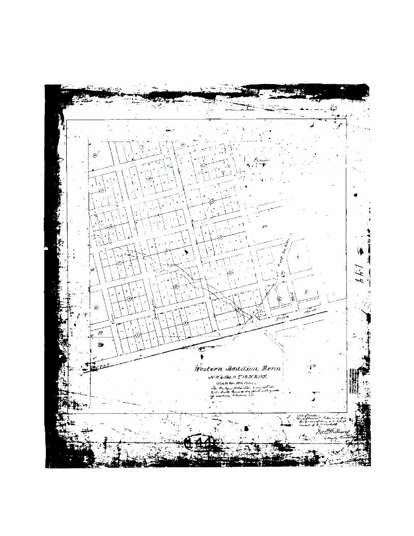
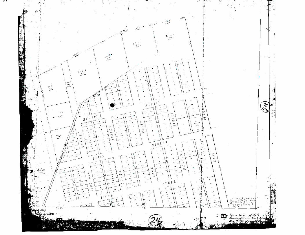
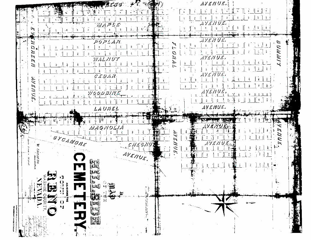
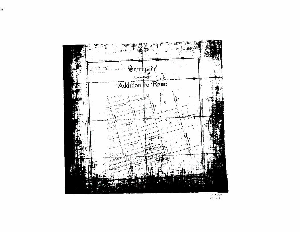
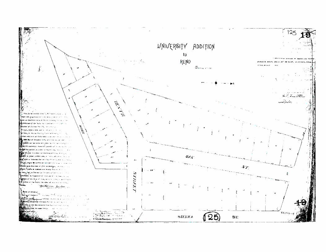
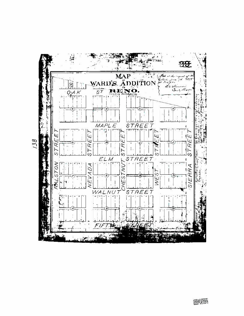
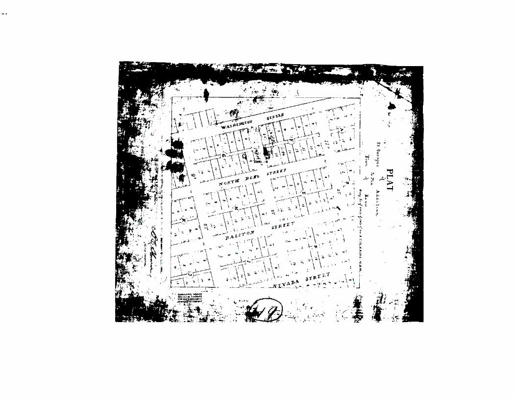
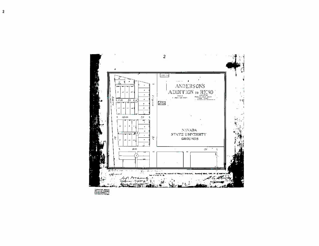
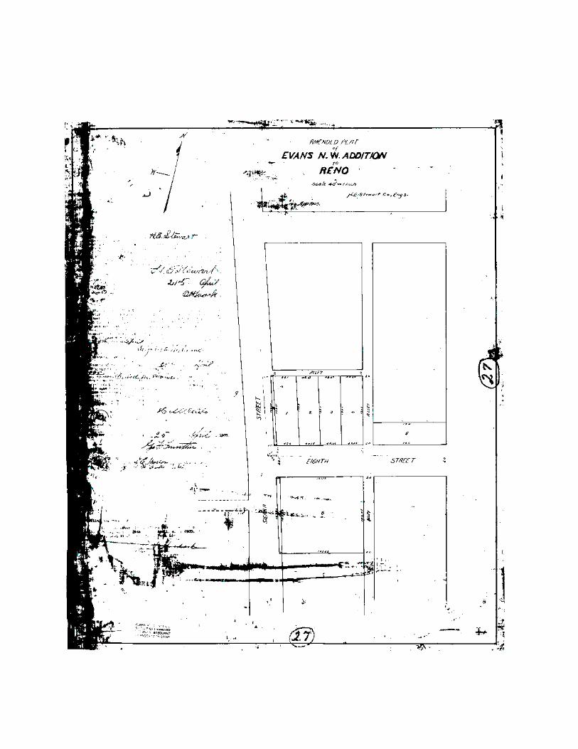
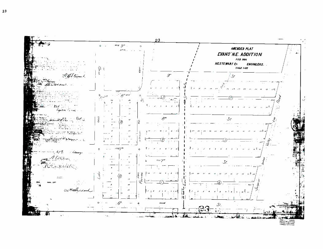
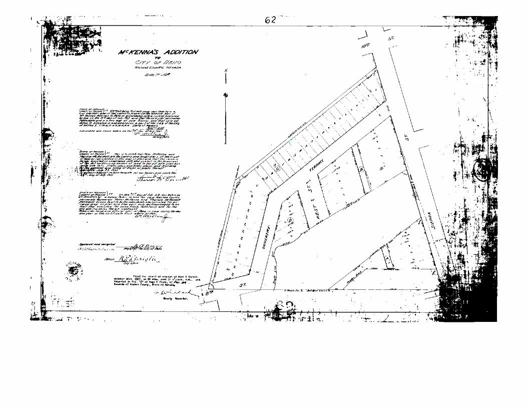
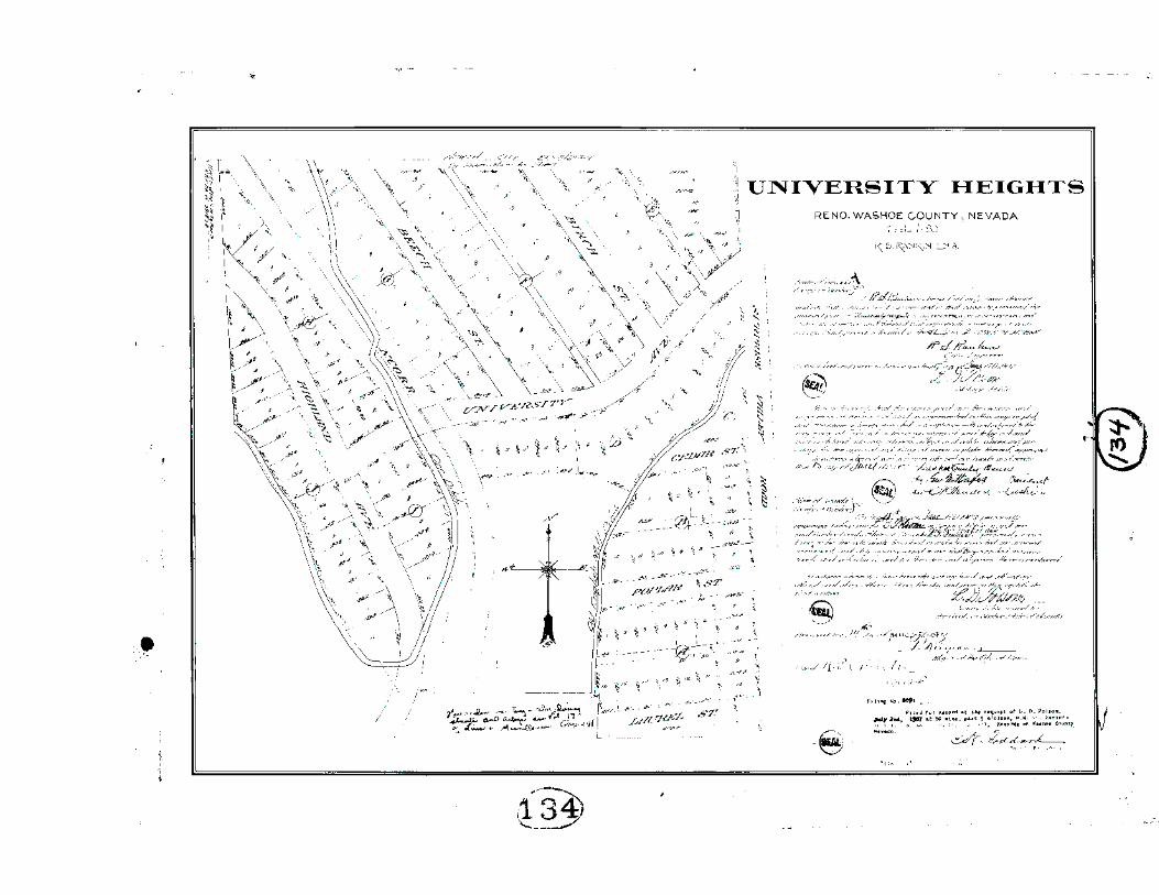
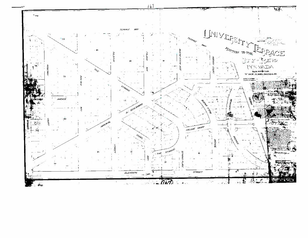
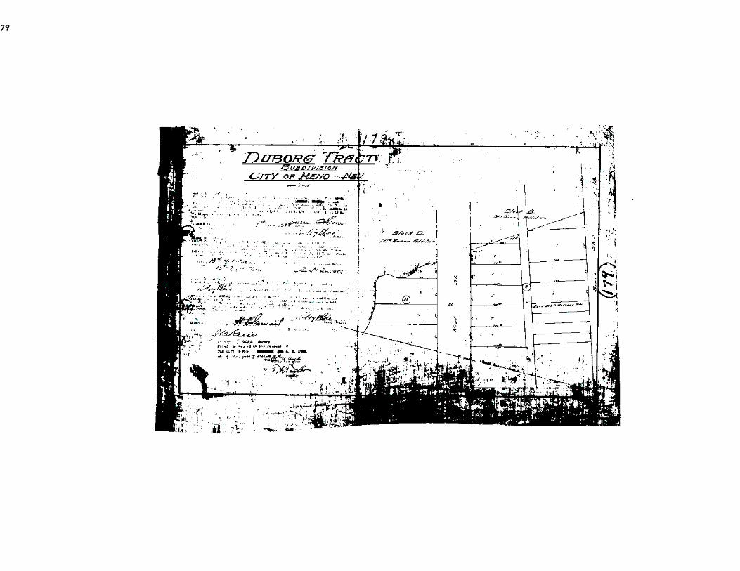
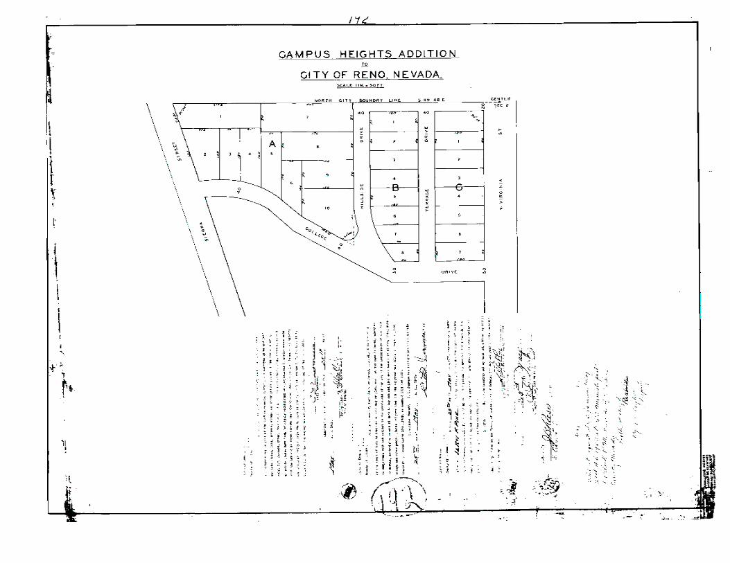
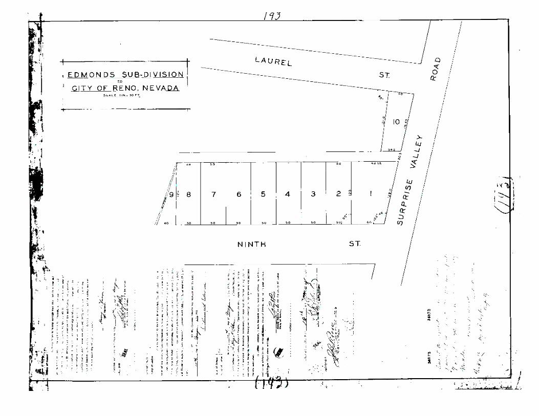
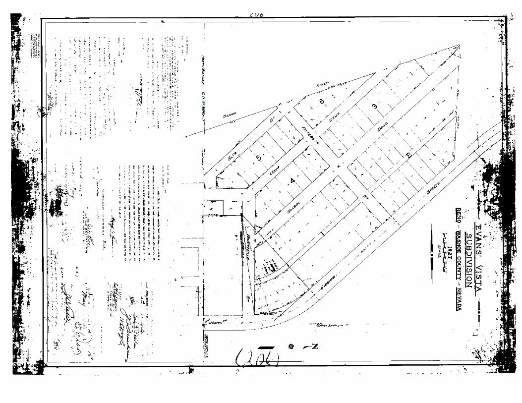
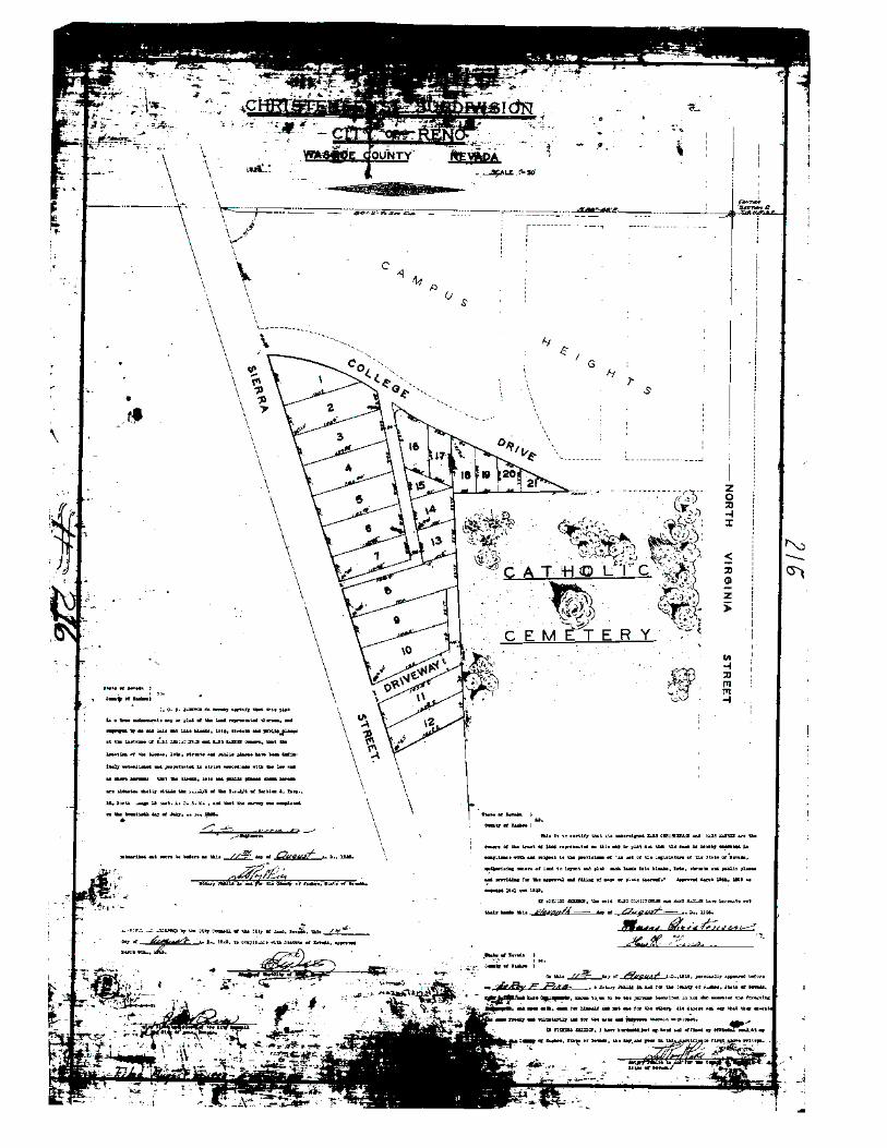
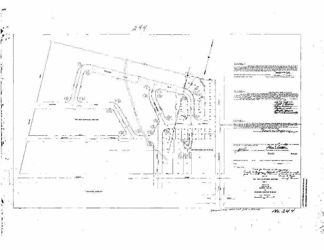
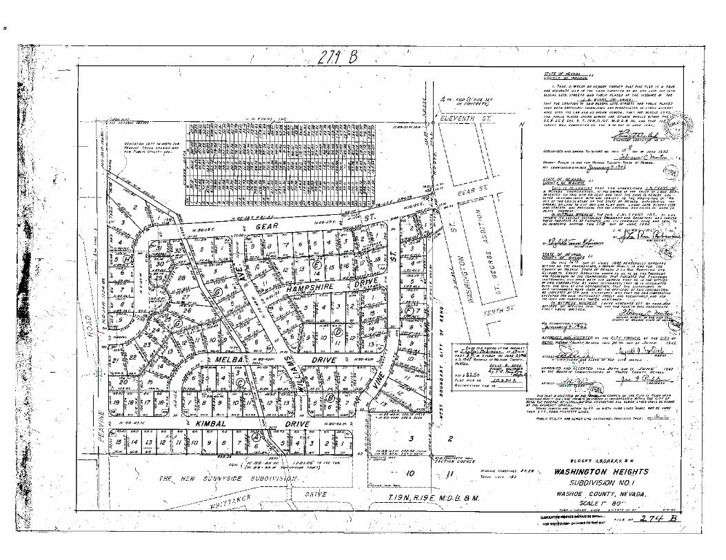
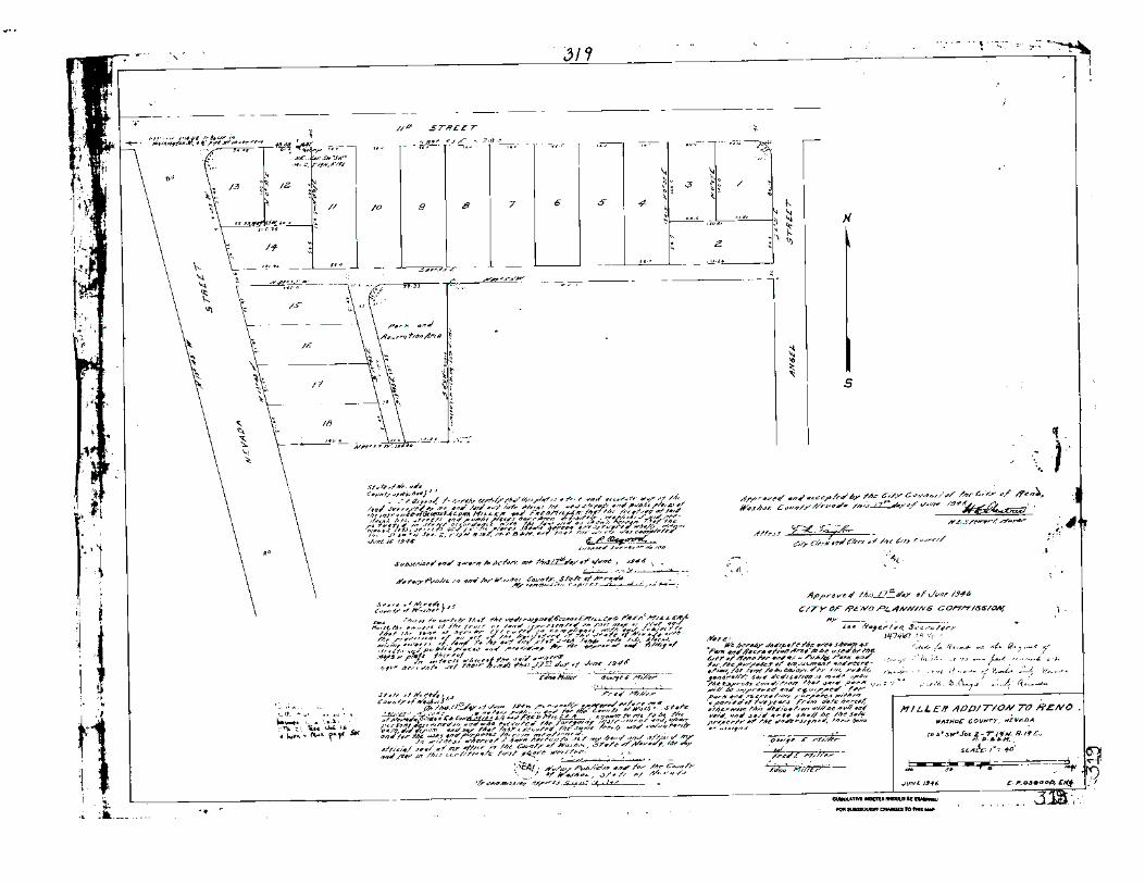
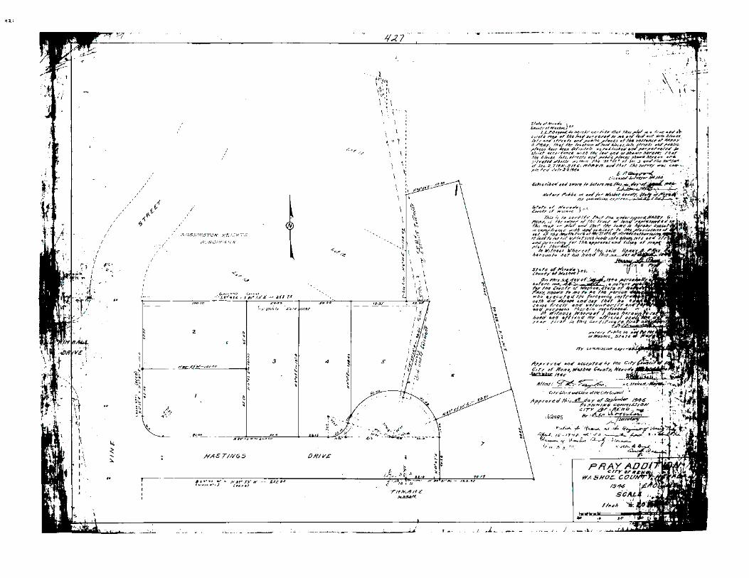
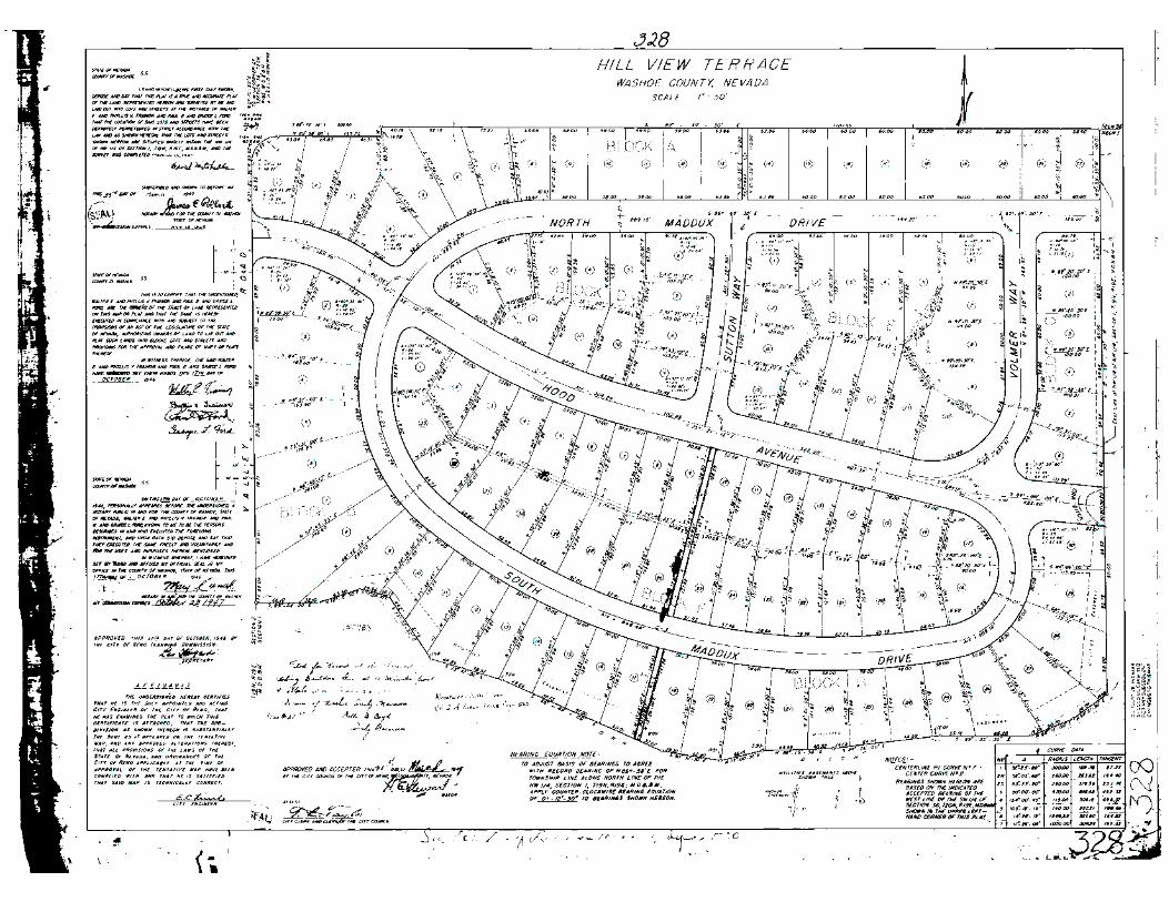

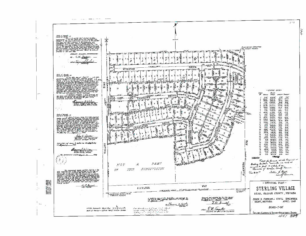
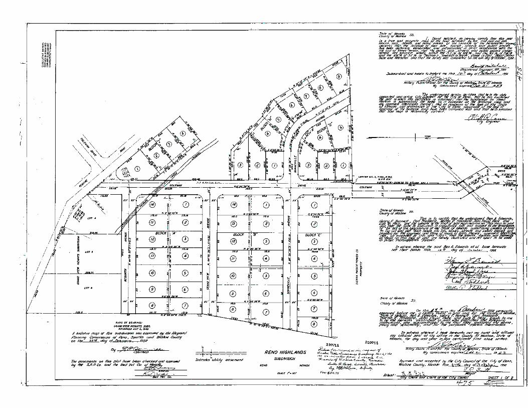
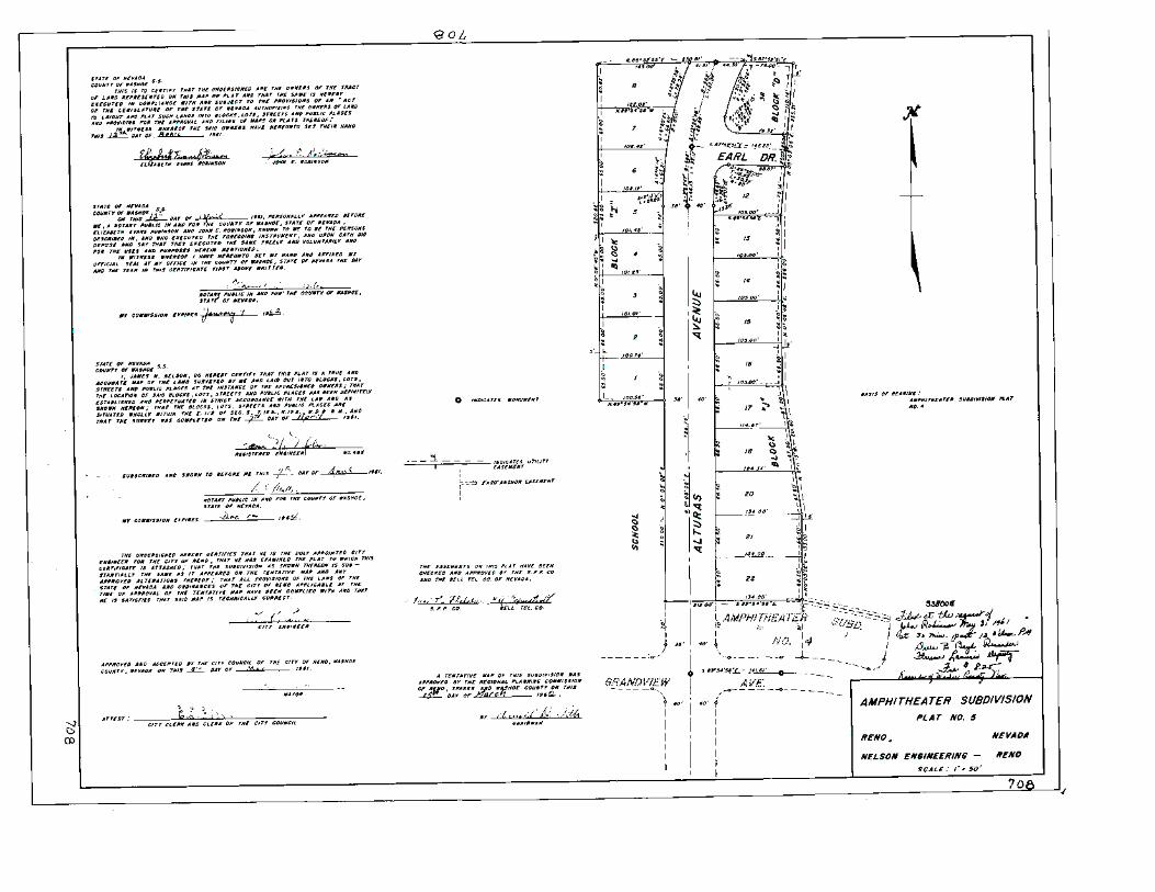
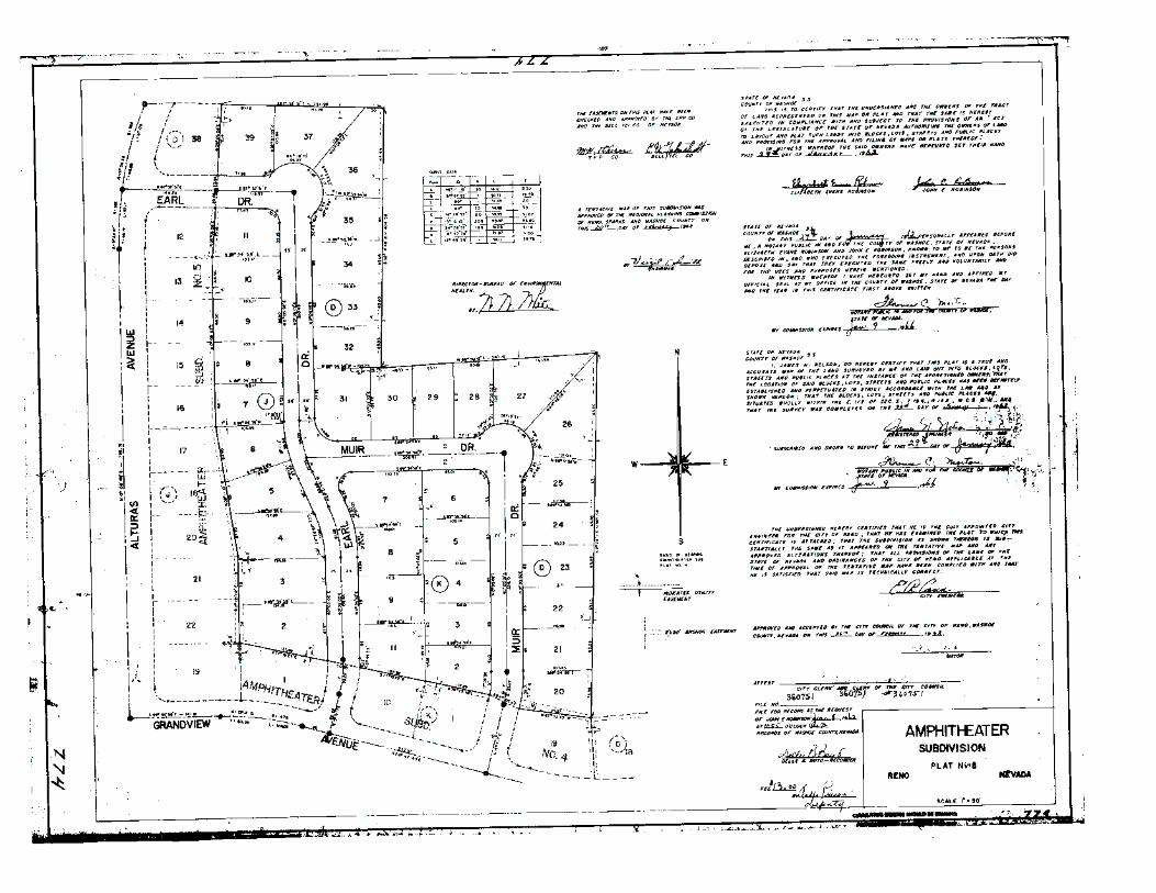

Appendices
UNR Neighborhood Historic Context Statement
APPENDIX B
Survey Photos (included on DVD) and
Reconnaissance Survey Photo Log

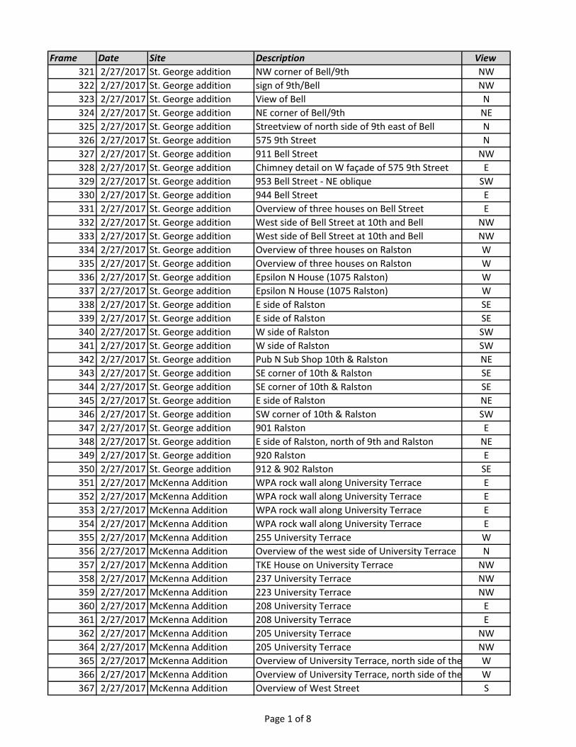
Frame Date Site Description View
321 2/27/2017 St. George addition NW corner of Bell/9th NW
322 2/27/2017 St. George addition sign of 9th/Bell NW
323 2/27/2017 St. George addition View of Bell N
324 2/27/2017 St. George addition NE corner of Bell/9th NE
325 2/27/2017 St. George addition Streetview of north side of 9th east of Bell N
326 2/27/2017 St. George addition 575 9th Street N
327 2/27/2017 St. George addition 911 Bell Street NW
328 2/27/2017 St. George addition Chimney detail on W façade of 575 9th Street E
329 2/27/2017 St. George addition 953 Bell Street - NE oblique SW
330 2/27/2017 St. George addition 944 Bell Street E
331 2/27/2017 St. George addition Overview of three houses on Bell Street E
332 2/27/2017 St. George addition West side of Bell Street at 10th and Bell NW
333 2/27/2017 St. George addition West side of Bell Street at 10th and Bell NW
334 2/27/2017 St. George addition Overview of three houses on Ralston W
335 2/27/2017 St. George addition Overview of three houses on Ralston W
336 2/27/2017 St. George addition Epsilon N House (1075 Ralston) W
337 2/27/2017 St. George addition Epsilon N House (1075 Ralston) W
338 2/27/2017 St. George addition E side of Ralston SE
339 2/27/2017 St. George addition E side of Ralston SE
340 2/27/2017 St. George addition W side of Ralston SW
341 2/27/2017 St. George addition W side of Ralston SW
342 2/27/2017 St. George addition Pub N Sub Shop 10th & Ralston NE
343 2/27/2017 St. George addition SE corner of 10th & Ralston SE
344 2/27/2017 St. George addition SE corner of 10th & Ralston SE
345 2/27/2017 St. George addition E side of Ralston NE
346 2/27/2017 St. George addition SW corner of 10th & Ralston SW
347 2/27/2017 St. George addition 901 Ralston E
348 2/27/2017 St. George addition E side of Ralston, north of 9th and Ralston NE
349 2/27/2017 St. George addition 920 Ralston E
350 2/27/2017 St. George addition 912 & 902 Ralston SE
351 2/27/2017 McKenna Addition WPA rock wall along University Terrace E
352 2/27/2017 McKenna Addition WPA rock wall along University Terrace E
353 2/27/2017 McKenna Addition WPA rock wall along University Terrace E
354 2/27/2017 McKenna Addition WPA rock wall along University Terrace E
355 2/27/2017 McKenna Addition 255 University Terrace W
356 2/27/2017 McKenna Addition Overview of the west side of University Terrace N
357 2/27/2017 McKenna Addition TKE House on University Terrace NW
358 2/27/2017 McKenna Addition 237 University Terrace NW
359 2/27/2017 McKenna Addition 223 University Terrace NW
360 2/27/2017 McKenna Addition 208 University Terrace E
361 2/27/2017 McKenna Addition 208 University Terrace E
362 2/27/2017 McKenna Addition 205 University Terrace NW
364 2/27/2017 McKenna Addition 205 University Terrace NW
365 2/27/2017 McKenna Addition Overview of University Terrace, north side of the streetW
366 2/27/2017 McKenna Addition Overview of University Terrace, north side of the streetW
367 2/27/2017 McKenna Addition Overview of West Street S
Page 1 of 8
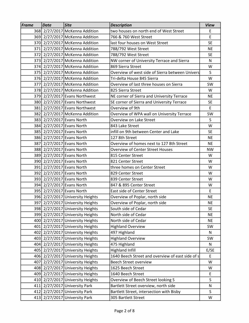
Frame Date Site Description View
368 2/27/2017 McKenna Addition two houses on north end of West Street E
369 2/27/2017 McKenna Addition 766 & 760 West Street E
370 2/27/2017 McKenna Addition last four houses on West Street SE
371 2/27/2017 McKenna Addition 788/792 West Street NE
372 2/27/2017 McKenna Addition 788/792 West Street SE
373 2/27/2017 McKenna Addition NW corner of University Terrace and Sierra N
374 2/27/2017 McKenna Addition 869 Sierra Street W
375 2/27/2017 McKenna Addition Overview of west side of Sierra between University Terrace and on-rampS
376 2/27/2017 McKenna Addition Tri-delta House 845 Sierra W
377 2/27/2017 McKenna Addition Overview of last three houses on Sierra SW
378 2/27/2017 McKenna Addition 825 Sierra Street W
379 2/27/2017 Evans Northwest NE corner of Sierra and University Terrace NE
380 2/27/2017 Evans Northwest SE corner of Sierra and University Terrace SE
381 2/27/2017 Evans Northwest Overview of 9th E
382 2/27/2017 McKenna Addition Overview of WPA wall on University Terrace SW
383 2/27/2017 Evans North Overview on Lake Street S
384 2/27/2017 Evans North 843 Lake Street W
385 2/27/2017 Evans North infill on 9th between Center and Lake SE
386 2/27/2017 Evans North 127 8th Street NE
387 2/27/2017 Evans North Overview of homes next to 127 8th Street NE
388 2/27/2017 Evans North Overview of Center Street Houses NW
389 2/27/2017 Evans North 815 Center Street W
390 2/27/2017 Evans North 821 Center Street W
391 2/27/2017 Evans North three homes on Center Street W
392 2/27/2017 Evans North 829 Center Street W
393 2/27/2017 Evans North 839 Center Street W
394 2/27/2017 Evans North 847 & 895 Center Street W
395 2/27/2017 Evans North East side of Center Street E
396 2/27/2017 University Heights Overview of Poplar, north side NE
397 2/27/2017 University Heights Overview of Poplar, north side NE
398 2/27/2017 University Heights South side of Cedar SE
399 2/27/2017 University Heights North side of Cedar NE
400 2/27/2017 University Heights North side of Cedar NE
401 2/27/2017 University Heights Highland Overview SW
402 2/27/2017 University Heights 497 Highland N
403 2/27/2017 University Heights Highland Overview SW
404 2/27/2017 University Heights 475 Highland N
405 2/27/2017 University Heights Highland Infill E/SE
406 2/27/2017 University Heights 1640 Beech Street and overview of east side of street E
407 2/27/2017 University Heights Beech Street overview W
408 2/27/2017 University Heights 1625 Beech Street W
409 2/27/2017 University Heights 1640 Beech Street E
410 2/27/2017 University Heights Overview of Beech Street looking S S
411 2/27/2017 University Park Bartlett Street overview, north side N
412 2/27/2017 University Park Bartlett Street, intersection with Bisby S
413 2/27/2017 University Park 305 Bartlett Street W
Page 2 of 8
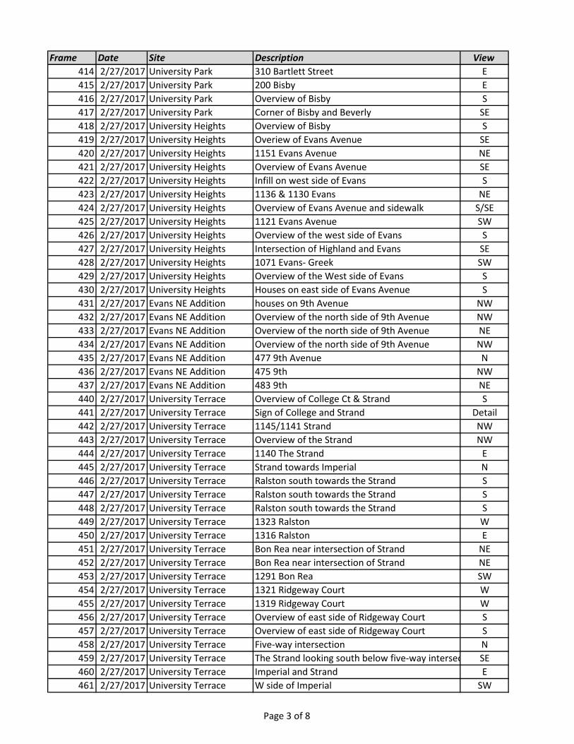
Frame Date Site Description View
414 2/27/2017 University Park 310 Bartlett Street E
415 2/27/2017 University Park 200 Bisby E
416 2/27/2017 University Park Overview of Bisby S
417 2/27/2017 University Park Corner of Bisby and Beverly SE
418 2/27/2017 University Heights Overview of Bisby S
419 2/27/2017 University Heights Overiew of Evans Avenue SE
420 2/27/2017 University Heights 1151 Evans Avenue NE
421 2/27/2017 University Heights Overview of Evans Avenue SE
422 2/27/2017 University Heights Infill on west side of Evans S
423 2/27/2017 University Heights 1136 & 1130 Evans NE
424 2/27/2017 University Heights Overview of Evans Avenue and sidewalk S/SE
425 2/27/2017 University Heights 1121 Evans Avenue SW
426 2/27/2017 University Heights Overview of the west side of Evans S
427 2/27/2017 University Heights Intersection of Highland and Evans SE
428 2/27/2017 University Heights 1071 Evans- Greek SW
429 2/27/2017 University Heights Overview of the West side of Evans S
430 2/27/2017 University Heights Houses on east side of Evans Avenue S
431 2/27/2017 Evans NE Addition houses on 9th Avenue NW
432 2/27/2017 Evans NE Addition Overview of the north side of 9th Avenue NW
433 2/27/2017 Evans NE Addition Overview of the north side of 9th Avenue NE
434 2/27/2017 Evans NE Addition Overview of the north side of 9th Avenue NW
435 2/27/2017 Evans NE Addition 477 9th Avenue N
436 2/27/2017 Evans NE Addition 475 9th NW
437 2/27/2017 Evans NE Addition 483 9th NE
440 2/27/2017 University Terrace Overview of College Ct & Strand S
441 2/27/2017 University Terrace Sign of College and Strand Detail
442 2/27/2017 University Terrace 1145/1141 Strand NW
443 2/27/2017 University Terrace Overview of the Strand NW
444 2/27/2017 University Terrace 1140 The Strand E
445 2/27/2017 University Terrace Strand towards Imperial N
446 2/27/2017 University Terrace Ralston south towards the Strand S
447 2/27/2017 University Terrace Ralston south towards the Strand S
448 2/27/2017 University Terrace Ralston south towards the Strand S
449 2/27/2017 University Terrace 1323 Ralston W
450 2/27/2017 University Terrace 1316 Ralston E
451 2/27/2017 University Terrace Bon Rea near intersection of Strand NE
452 2/27/2017 University Terrace Bon Rea near intersection of Strand NE
453 2/27/2017 University Terrace 1291 Bon Rea SW
454 2/27/2017 University Terrace 1321 Ridgeway Court W
455 2/27/2017 University Terrace 1319 Ridgeway Court W
456 2/27/2017 University Terrace Overview of east side of Ridgeway Court S
457 2/27/2017 University Terrace Overview of east side of Ridgeway Court S
458 2/27/2017 University Terrace Five-way intersection N
459 2/27/2017 University Terrace The Strand looking south below five-way intersectionSE
460 2/27/2017 University Terrace Imperial and Strand E
461 2/27/2017 University Terrace W side of Imperial SW
Page 3 of 8
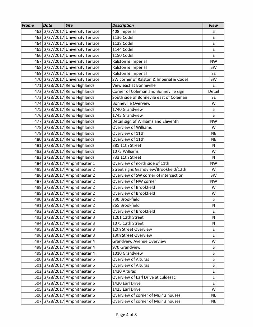
Frame Date Site Description View
462 2/27/2017 University Terrace 408 Imperial S
463 2/27/2017 University Terrace 1136 Codel E
464 2/27/2017 University Terrace 1138 Codel E
465 2/27/2017 University Terrace 1144 Codel E
466 2/27/2017 University Terrace 1150 Codel E
467 2/27/2017 University Terrace Ralston & Imperial NW
468 2/27/2017 University Terrace Ralston & Imperial SW
469 2/27/2017 University Terrace Ralston & Imperial SE
470 2/27/2017 University Terrace SW corner of Ralston & Imperial & Codel SW
471 2/28/2017 Reno Highlands View east at Bonneville E
472 2/28/2017 Reno Highlands Corner of Coleman and Bonneville sign Detail
473 2/28/2017 Reno Highlands South side of Bonnevile east of Coleman SE
474 2/28/2017 Reno Highlands Bonneville Overview W
475 2/28/2017 Reno Highlands 1740 Grandview S
476 2/28/2017 Reno Highlands 1745 Grandview S
477 2/28/2017 Reno Highlands Detail sign of Williams and Eleventh NW
478 2/28/2017 Reno Highlands Overview of Williams W
479 2/28/2017 Reno Highlands Overview of 11th NE
480 2/28/2017 Reno Highlands Overview of 11th NE
481 2/28/2017 Reno Highlands 885 11th Street N
482 2/28/2017 Reno Highlands 1075 Williams W
483 2/28/2017 Reno Highlands 733 11th Street N
484 2/28/2017 Amphitheater 1 Overview of north side of 11th NW
485 2/28/2017 Amphitheater 2 Street signs Grandview/Brookfield/12th W
486 2/28/2017 Amphitheater 2 Overview of SW corner of intersection SW
487 2/28/2017 Amphitheater 2 Overview of NW corner NW
488 2/28/2017 Amphitheater 2 Overview of Brookfield W
489 2/28/2017 Amphitheater 2 Overview of Brookfield W
490 2/28/2017 Amphitheater 2 730 Brookfield S
491 2/28/2017 Amphitheater 2 865 Brookfield N
492 2/28/2017 Amphitheater 2 Overview of Brookfield E
493 2/28/2017 Amphitheater 3 1201 12th Street N
494 2/28/2017 Amphitheater 3 1075 12th Street N
495 2/28/2017 Amphitheater 3 12th Street Overview E
496 2/28/2017 Amphitheater 3 13th Street Overview E
497 2/28/2017 Amphitheater 4 Grandview Avenue Overview W
498 2/28/2017 Amphitheater 4 970 Grandview S
499 2/28/2017 Amphitheater 4 1010 Grandview S
500 2/28/2017 Amphitheater 5 Overview of Alturas S
501 2/28/2017 Amphitheater 5 Overview of Alturas S
502 2/28/2017 Amphitheater 5 1430 Alturas E
503 2/28/2017 Amphitheater 6 Overview of Earl Drive at culdesac E
504 2/28/2017 Amphitheater 6 1420 Earl Drive E
505 2/28/2017 Amphitheater 6 1425 Earl Drive W
506 2/28/2017 Amphitheater 6 Overview of corner of Muir 3 houses NE
507 2/28/2017 Amphitheater 6 Overview of corner of Muir 3 houses NE
Page 4 of 8
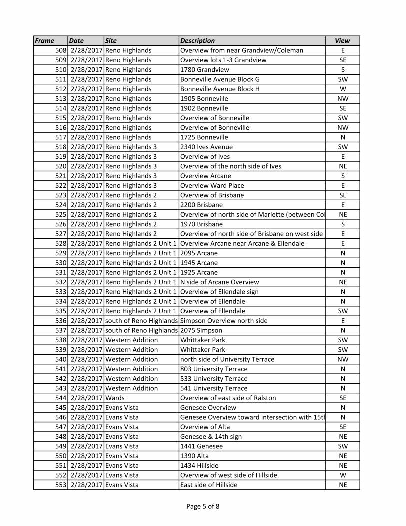
Frame Date Site Description View
508 2/28/2017 Reno Highlands Overview from near Grandview/Coleman E
509 2/28/2017 Reno Highlands Overview lots 1-3 Grandview SE
510 2/28/2017 Reno Highlands 1780 Grandview S
511 2/28/2017 Reno Highlands Bonneville Avenue Block G SW
512 2/28/2017 Reno Highlands Bonneville Avenue Block H W
513 2/28/2017 Reno Highlands 1905 Bonneville NW
514 2/28/2017 Reno Highlands 1902 Bonneville SE
515 2/28/2017 Reno Highlands Overview of Bonneville SW
516 2/28/2017 Reno Highlands Overview of Bonneville NW
517 2/28/2017 Reno Highlands 1725 Bonneville N
518 2/28/2017 Reno Highlands 3 2340 Ives Avenue SW
519 2/28/2017 Reno Highlands 3 Overview of Ives E
520 2/28/2017 Reno Highlands 3 Overview of the north side of Ives NE
521 2/28/2017 Reno Highlands 3 Overview Arcane S
522 2/28/2017 Reno Highlands 3 Overview Ward Place E
523 2/28/2017 Reno Highlands 2 Overview of Brisbane SE
524 2/28/2017 Reno Highlands 2 2200 Brisbane E
525 2/28/2017 Reno Highlands 2 Overview of north side of Marlette (between Coleman & Brisbane)NE
526 2/28/2017 Reno Highlands 2 1970 Brisbane S
527 2/28/2017 Reno Highlands 2 Overview of north side of Brisbane on west side of ColemanE
528 2/28/2017 Reno Highlands 2 Unit 1 Overview Arcane near Arcane & Ellendale E
529 2/28/2017 Reno Highlands 2 Unit 1 2095 Arcane N
530 2/28/2017 Reno Highlands 2 Unit 1 1945 Arcane N
531 2/28/2017 Reno Highlands 2 Unit 1 1925 Arcane N
532 2/28/2017 Reno Highlands 2 Unit 1 N side of Arcane Overview NE
533 2/28/2017 Reno Highlands 2 Unit 1 Overview of Ellendale sign N
534 2/28/2017 Reno Highlands 2 Unit 1 Overview of Ellendale N
535 2/28/2017 Reno Highlands 2 Unit 1 Overview of Ellendale SW
536 2/28/2017 south of Reno Highlands Simpson Overview north side E
537 2/28/2017 south of Reno Highlands 2075 Simpson N
538 2/28/2017 Western Addition Whittaker Park SW
539 2/28/2017 Western Addition Whittaker Park SW
540 2/28/2017 Western Addition north side of University Terrace NW
541 2/28/2017 Western Addition 803 University Terrace N
542 2/28/2017 Western Addition 533 University Terrace N
543 2/28/2017 Western Addition 541 University Terrace N
544 2/28/2017 Wards Overview of east side of Ralston SE
545 2/28/2017 Evans Vista Genesee Overview N
546 2/28/2017 Evans Vista Genesee Overview toward intersection with 15th N
547 2/28/2017 Evans Vista Overview of Alta SE
548 2/28/2017 Evans Vista Genesee & 14th sign NE
549 2/28/2017 Evans Vista 1441 Genesee SW
550 2/28/2017 Evans Vista 1390 Alta NE
551 2/28/2017 Evans Vista 1434 Hillside NE
552 2/28/2017 Evans Vista Overview of west side of Hillside W
553 2/28/2017 Evans Vista East side of Hillside NE
Page 5 of 8
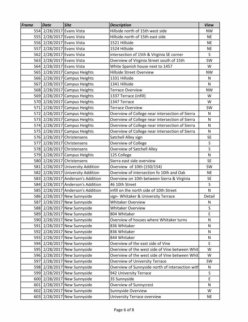
Frame Date Site Description View
554 2/28/2017 Evans Vista Hillside north of 15th west side NW
555 2/28/2017 Evans Vista Hillside north of 15th east side NE
556 2/28/2017 Evans Vista 1521 Hillside NE
557 2/28/2017 Evans Vista 1524 Hillside NE
562 2/28/2017 Evans Vista intersection of 15th & Virginia SE corner S
563 2/28/2017 Evans Vista Overview of Virginia Street south of 15th SW
564 2/28/2017 Evans Vista White Spanish house next to 1457 W
565 2/28/2017 Campus Heights Hillside Street Overview NW
566 2/28/2017 Campus Heights 1331 Hillside N
567 2/28/2017 Campus Heights 1341 Hillside N
568 2/28/2017 Campus Heights Terrace Overview NW
569 2/28/2017 Campus Heights 1337 Terrace (infill) W
570 2/28/2017 Campus Heights 1347 Terrace W
571 2/28/2017 Campus Heights Terrace Overview SW
572 2/28/2017 Campus Heights Overview of College near intersection of Sierra N
573 2/28/2017 Campus Heights Overview of College near intersection of Sierra N
574 2/28/2017 Campus Heights Overview of College near intersection of Sierra N
575 2/28/2017 Campus Heights Overview of College near intersection of Sierra N
576 2/28/2017 Christensens Satchell Alley sign SE
577 2/28/2017 Christensens Overview of College S
578 2/28/2017 Christensens Overview of Satchell Alley S
579 2/28/2017 Campus Heights 125 College N
580 2/28/2017 Christensens Sierra east side overview SE
581 2/28/2017 University Addition Overview of 10th (150/154) SW
582 2/28/2017 University Addition Overview of intersection fo 10th and Oak NE
583 2/28/2017 Anderson's Addition Overview on 10th between Sierra & Virginia SE
584 2/28/2017 Anderson's Addition 46 10th Street S
585 2/28/2017 Anderson's Addition infill on the north side of 10th Street N
586 2/28/2017 New Sunnyside sign- Whitaker & University Terrace Detail
587 2/28/2017 New Sunnyside Whitaker Overview N
588 2/28/2017 New Sunnyside Whitaker Overview S
589 2/28/2017 New Sunnyside 804 Whitaker E
590 2/28/2017 New Sunnyside Overview of houses where Whitaker turns N
591 2/28/2017 New Sunnyside 836 Whitaker N
592 2/28/2017 New Sunnyside 836 Whitaker N
593 2/28/2017 New Sunnyside 844 Whitaker N
594 2/28/2017 New Sunnyside Overview of the east side of Vine E
595 2/28/2017 New Sunnyside Overview of the west side of Vine between Whitaker & University TerraceW
596 2/28/2017 New Sunnyside Overview of the west side of Vine between Whitaker & University TerraceW
597 2/28/2017 New Sunnyside Overview of University Terrace SW
598 2/28/2017 New Sunnyside Overview of Sunnyside north of intersection with University TerraceN
599 2/28/2017 New Sunnyside 942 University Terrace S
600 2/28/2017 New Sunnyside 35 Sunnyside E
601 2/28/2017 New Sunnyside Overview of Sunnycrest N
602 2/28/2017 New Sunnyside Sunnyside Overview W
603 2/28/2017 New Sunnyside University Terrace overview NE
Page 6 of 8
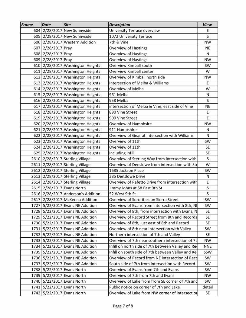
Frame Date Site Description View
604 2/28/2017 New Sunnyside University Terrace overview E
605 2/28/2017 New Sunnyside 1072 University Terrace S
606 2/28/2017 Western Addition 7th & Vine NW
607 2/28/2017 Pray Overview of Hastings NE
608 2/28/2017 Pray Overview of Hastings N
609 2/28/2017 Pray Overview of Hastings NW
610 2/28/2017 Washington Heights Overview Kimball south SW
611 2/28/2017 Washington Heights Overview Kimball center W
612 2/28/2017 Washington Heights Overview of Kimball north side NW
613 2/28/2017 Washington Heights Intersection of Melba & Williams E
614 2/28/2017 Washington Heights Overview of Melba W
615 2/28/2017 Washington Heights 961 Melba N
616 2/28/2017 Washington Heights 958 Melba S
617 2/28/2017 Washington Heights intersection of Melba & Vine, east side of Vine NE
618 2/28/2017 Washington Heights 890 Vine Street E
619 2/28/2017 Washington Heights 900 Vine Street E
620 2/28/2017 Washington Heights Overview of Hamphsire NW
621 2/28/2017 Washington Heights 911 Hampshire N
622 2/28/2017 Washington Heights Overview of Gear at intersection with Williams N
623 2/28/2017 Washington Heights Overview of 11th SW
624 2/28/2017 Washington Heights Overview of 11th SE
625 2/28/2017 Washington Heights Including infill SE
2610 2/28/2017 Sterling Village Overview of Sterling Way from intersection with Denslowe DrS
2611 2/28/2017 Sterling Village Overview of Denslowe from intersection with Sterling WayW
2612 2/28/2017 Sterling Village 1685 Jackson Place SW
2613 2/28/2017 Sterling Village 385 Denslowe Drive N
2614 2/28/2017 Sterling Village Overview of Rafetto Drive from intersection with Beech StE
2615 2/28/2017 Evans North Jimmy Johns at 58 East 9th St S
2616 2/28/2017 Anderson's Addition 52 West 9th St S
2617 2/28/2017 McKenna Addition Overview of Sororities on Sierra Street SW
1727 5/22/2017 Evans NE Addition Overview of Evans from intersection with 8th, NE cornerSW
1728 5/22/2017 Evans NE Addition Overview of 8th, from intersection with Evans, NE cornerSE
1729 5/22/2017 Evans NE Addition Overview of Record Street from 8th and Records SE
1730 5/22/2017 Evans NE Addition Overview of 8th, just east of 8th and Record SE
1731 5/22/2017 Evans NE Addition Overview of 8th near intersection with Valley SW
1732 5/22/2017 Evans NE Addition Northern intersection of 7th and Valley SE
1733 5/22/2017 Evans NE Addition Overview of 7th near southern intersection of 7th and ValleyNW
1734 5/22/2017 Evans NE Addition Infill on north side of 7th between Valley and RecordNNE
1735 5/22/2017 Evans NE Addition Infill on south side of 7th between Valley and RecordSSW
1736 5/22/2017 Evans NE Addition Overview of Record from NE intersection of Record and 7thSW
1737 5/22/2017 Evans NE Addition South side of 7th from intersection with Record SW
1738 5/22/2017 Evans North Overview of Evans from 7th and Evans SW
1739 5/22/2017 Evans North Overview of 7th from 7th and Evans NW
1740 5/22/2017 Evans North Overview of Lake from from SE corner of 7th and LakeSW
1741 5/22/2017 Evans North Public notice on corner of 7th and Lake detail
1742 5/22/2017 Evans North Overview of Lake from NW corner of intersection with 7thSE
Page 7 of 8
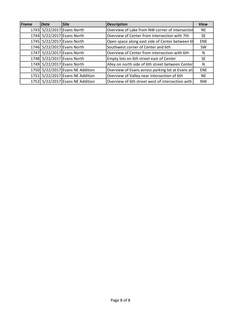
Frame Date Site Description View
1743 5/22/2017 Evans North Overview of Lake from NW corner of intersection with 7thNE
1744 5/22/2017 Evans North Overview of Center from intersection with 7th SE
1745 5/22/2017 Evans North Open space along east side of Center between 6th and 7thENE
1746 5/22/2017 Evans North Southwest corner of Center and 6th SW
1747 5/22/2017 Evans North Overview of Center from intersection with 6th N
1748 5/22/2017 Evans North Empty lots on 6th street east of Center SE
1749 5/22/2017 Evans North Alley on north side of 6th street between Center and EvansN
1750 5/22/2017 Evans NE Addition Overview of Evans across parking lot at Evans and 6thENE
1751 5/22/2017 Evans NE Addition Overview of Valley near intersection of 6th NE
1752 5/22/2017 Evans NE Addition Overview of 6th street west of intersection with ValleyNW
Page 8 of 8