UNOSAT Brief - ReliefWeb
24
Knowledge to lead 2011 UNOSAT Brief Satellite Applications for Human Security
Transcript of UNOSAT Brief - ReliefWeb
Knowledge to lead
2011
UNOSAT BriefSatellite Applications for Human Security


Applying New Solutions for Human Security
The United Nations Institute for Training and Research - Operational Satellite Applications Programme (UNITAR /UNOSAT) – is a centre of excellence for geogra-phic information and satellite imagery analysis to support the United Nations sys-tem and its member states. UNOSAT work includes analysis, mapping, and knowledge and capacity development in three main areas: Humanitarian Relief and Emergency Response, Human Security, and Strategic Territorial Planning and Monitoring. In each of these areas UNOSAT mobilizes the research and innovation skills within its team and throughout its partnerships to deliver the potential of satellite applications and geospatial information through professional imagery analysis and Geographic Information System solutions.
Each year UNOSAT publishes a thematic brief illustrating achievement and results in one of the application areas in which the organization has made significant gains. This year’s brief is devoted to satellite applications for human security, with a specific focus on conflict analysis, human rights, international humanitarian law (IHL), and how technology can improve the lives of those at risk by creating human-centred solutions.
Since 2001 UNOSAT has been innovating in the field of applied geospatial solutions and imagery analysis. Since 2003 the Programme has operated a 24/7 humanitarian mapping service available to the international humanitarian community at large. The service produces dedicated geospatial information and in-field technical assis-tance during humanitarian emergency response operations. Starting in 2009 UNOSAT expanded its work to applications relating to human security, in particular for the protection of human rights and the documentation of gross violations of international humanitarian law. This annual brief illustrates key facts and figures of UNOSAT work in the area of human security together with examples drawn from recent activities.

UNOSAT Brief 2011 - Satellite Applications for Human SecurityReaders are encouraged to quote or reproduce materials from this publication for non profit or non commercial purposes and in a truthful context. UNITAR requests due acknowledgement and would also appreciate that complementary copies of the final publication are physically sent to the attention of UNOSAT. If instead the materials from this publication are being published on the Internet kindly send us the link to the hosting website. This brief is also available as pdf from www.unitar.org/unosat
DISCLAIMERThe designations employed and the presentation of material in this publication do not imply the expression of any opinion whatsoever on the part of the United Nations concerning the legal status of any country, territory, city or area or of its authorities, or concerning the delimitation of its frontier or boun-daries or regarding its economic system or degree of development.
Satellite Applications for Human Security•1
At the United Nations Institute for Training and Research (UNITAR), we value applied research as much as training and services. To carry out our mission we strive to generate bodies of knowledge that we transfer to thousands of beneficiaries each year. In some of these, technology plays a prime role. Our Department of Research is tasked with imagining, developing and applying new ideas and new methodologies to help us help the United Nations and its member states go from good to great. The UNITAR Operational Satellite Applications Programme -UNOSAT- is a luminous example of the continuum linking technology, novelty and operational solutions.
Today UNOSAT is a reliable centre of excellence at the heart of the United Nations, capable of catering to communities of users in the domains of humanitarian aid, human security, and development planning. A network of scientific and private sector partners work with us and takes pride in accompanying us in our unique mission.
The specialised area of satellite applications is a fascinating and fast developing field in which we chose to embark on an unprecedented challenge: that of building solutions starting from the real user needs to which we respond by integrating the best available technology and the most effective result oriented methodologies.
This year’s brief by UNOSAT is dedicated to how our applied research efforts are having an impact on human security and human rights. As satellite technology progresses the range of possible applications increases. UNOSAT is often the first one to suggest advancements in the way satellite derived information can support the goals and objectives of the United Nations and the international community at large. The timely, objective, and accurate information we produce by analysing satellite imagery and data often has a prime role in the monitoring and verification of human rights cases and facilitates the work of UN panels of inquiry and fact finding missions with corroborating observations and maps.
We are proud of presenting in this brief yet another successful illustration of bringing technology-driven innovation to some of the most crucial challenges faced today by the international community.
I wish you a good reading.
Carlos LopesUnited Nations Assistant Secretary-GeneralUNITAR Executive Director
Foreword
2•Satellite Applications for Human Security
Contents
Foreword _______________________________________________________ 1
Introduction ____________________________________________________ 3
Satellite Applications for Human Security ___________________________ 5
Methodology ___________________________________________________ 9
Research ______________________________________________________ 11
Limitations ____________________________________________________ 13
Review of Case Studies __________________________________________ 14
Looking Forward _______________________________________________ 18
Satellite Applications for Human Security•3
The preamble of the Charter of the United Nations stipulates that “We the peoples of the United Nations determined […] to reaffirm faith in fundamental human rights, in the dignity and worth of the human person […] and to establish conditions under which justice and respect for the obligations arising from treaties and other sources of international law can be maintained.”
“ Article One of the Charter gives to the organization the Purposes “To maintain international peace and security […] to achieve international co-operation in solving international problems of an economic, social, cultural, or humanitarian character, and in promoting and encouraging respect for human rights and for fundamental freedoms for all […] ; and to be a centre for harmonizing the actions of nations in the attainment of these common ends.”
In this spirit, UNOSAT produces geospatial information to feed systems and user groups within the United Nations family and its Member States that have a stake in upholding and protecting the universally shared principles of human security, peace, and development. This work proceeds from the identification of the needs of specific user systems on to the most appropriate technology to generate solutions while using in-house spe-cialized skills to perform satellite analysis, design integrated solutions in Geographic Information Systems (GIS) and geopositioning, and improve the capabilities of agencies and national beneficiaries via training and capacity development. UNOSAT maintains a commitment to producing concrete, tangible and usable results within three main systemic areas:
Introduction
Humanitarian Relief and Emergency Response•Emergency and situational mapping•Damage and impact assessment
Human Security •Monitoring •Safety and security•Human rights and International Humanitarian Law (IHL)
Territorial Planning and Monitoring•Capacity development and technical assistance•In-country technical assistance and project implementation
4•Satellite Applications for Human Security
UNOSAT uses satellite derived geographic information for human security in all areas in which monitoring, GIS, and remote sensing offers the ability to gain access to inaccessible and remote crisis zones while providing accurate and up to date compelling visual material in an effective and efficient manner. Satellite imagery analysis can make key contributions to assessing threats to human security, violations of human rights and IHL, piracy activities, and international responses to complex emergencies. In 2011 the growth of technical capacity and expertise at UNOSAT continued with a special emphasis on developing knowledge, practice, and applications in the area of human security.
Satellite-based analysis is playing an ever increasing role in processes to discover, document and record violations of human rights and IHL during armed conflicts and complex emergencies. With new funding from public and private sources, UNOSAT was able to expand its support to the UN Office of the High Commissioner for Human Rights (UNOHCHR), the International Criminal Court (ICC), several Panels of Experts appointed by the UN Secretary General and the UN Security Council, and to provide the UN system as a whole with monitoring and analytical capacity in highly volatile situations.
Within these partnerships UNOSAT has maintained its commitment to keeping the UN system ahead of the technology curb. New evolutions in web-based geospatial services occurred in the year 2011 together with the inception of substantial collaboration with crowdsourcing circles and other innovative initiatives. These technical advancements and new partnerships involving key human security and humanitarian partners have allowed exciting new applications of satellite imagery analysis to human security issues.
Such partnerships include the International Committee of the Red Cross (ICRC), the Agency for Technical Cooperation and Development (ACTED), Human Rights Watch (HRW), Not On Our Watch, Google, DigitalGlobe, GeoEye, European Space Imaging (EUSI), e-GEOS, ESRI, and academic leaders such as Harvard University and the University of Geneva, among many others.
Satellite Applications for Human Security•5
Satellite Applications for Human Security
Since 2009 UNOSAT applies satellite analysis for human security issues (broadly encompassing human security as well as violations of human rights and IHL) with two main objectives:
• To provide professional and sustainable support to human rights orga-nizationssuchas theUNOfficeof theHighCommissioner forHumanRightsandtheUNHumanRightsCouncilaswellasotherrelevantinternationalandnon-governmentalorganizationsconcernedwithhumansecurityincludingtheICC,UNfactfindingmissions,andPanelsofExperts;
• Togenerateinnovativeapplicationsofgeospatialtechnologiesforhumanse-curity,drawinginspirationandlessonsfromongoingoperationalhumanitariansupportandfromprofessionaltrainingwithinUNOSATcapacitydevelopmentprojects.
Accomplishing these objectives has required a new combination of expertise and competencies within UNOSAT to anticipate and respond to the diverse requirements of human security users. It also involved strengthening the network of collaborations with a variety of relevant partners.
In the initial phases of UNOSAT work in this area it has become evident that the use of satellite derived analysis and geographic information has a positive impact on processes, initiatives and organisations with a mission to protect human rights and uphold international humanitarian law, thus improving overall human security internationally. Based on the last ten years of geospatial applications for human security, it is possible to identify the following five primary thematic areas of specific contribution :
• Advocacy• Mitigation and Prevention• Enhancing Field Investigations• Remote Fact Finding• Peace and Reconciliation

6•Satellite Applications for Human Security
Advocacy
Detailed satellite imagery over a crisis area has an immediate and powerful utility for raising public awareness. Imagery can provide a more realistic understanding of often complex and remote events on the ground, transforming sometimes abstract allegations of human rights and IHL violations and threats to human security into a more concrete and publicly accessible format. In combination with field reports, satellite imagery can often play an important role in framing public debate and mobilizing international response.
«Such (UNOSAT) satellite imagery and maps have not only assisted our Office in obtaining up to date and reliable information of relevance to our ongoing investigations, but, as experience shows, they may also be of potential evidentiary value in the context of prosecutions in assisting the Court to establish the truth of events»
Michel De SmedtHead of Investigations Division
International Criminal Court
EnhancingFieldInvestigations
The use of satellite imagery not only complements traditional field investigations but can also have an enhancing effect, improving the planning, quality and accuracy of field work. Satellite imagery can help basic planning by identifying sites of interest before or during field missions. Imagery and mapping can also provide common understanding (also known as a Common Operating Picture) of the situation on the ground, helping to clarify circumstances when multiple contradictory reports present an uncertain narrative of relevant events and locations. Imagery and mapping can also provide a more complete understanding of the number of people or total area affected when alleged violations are documented by investigators with limited access to the conflict zone. Similarly, imagery can help to verify testimony of uncertain reliability or challenge claims made by suspected human rights violators. Finally, multiple images collected over time can provide critical insights on specific sequences of events which may be very difficult to accurately assess after a conflict has ended.
MitigationandPrevention
Although it has been widely discussed and hypothetically possible, there are no verified cases where the actions of a government or militia force have been influenced by the independent col-lection and analysis of satellite imagery. The ability of this technology to act alone as a preventative tool, helping to deter forces from committing serious crimes is an attractive but likely unrealistic expectation. However, when used within the broader regime of protecting human rights and en-forcing compliance with IHL, involving many organizations and governments, satellite analysis can play a significant role. Over time, satellite imagery analysis and mapping can strengthen global efforts to reduce such violations and threats to human security, ideally mitigating and perhaps preventing conflict and its significant impacts on civilians. UNOSAT constantly strives to make this ideal a reality in both the policy and technical spheres via its everyday work.
Satellite Applications for Human Security•7
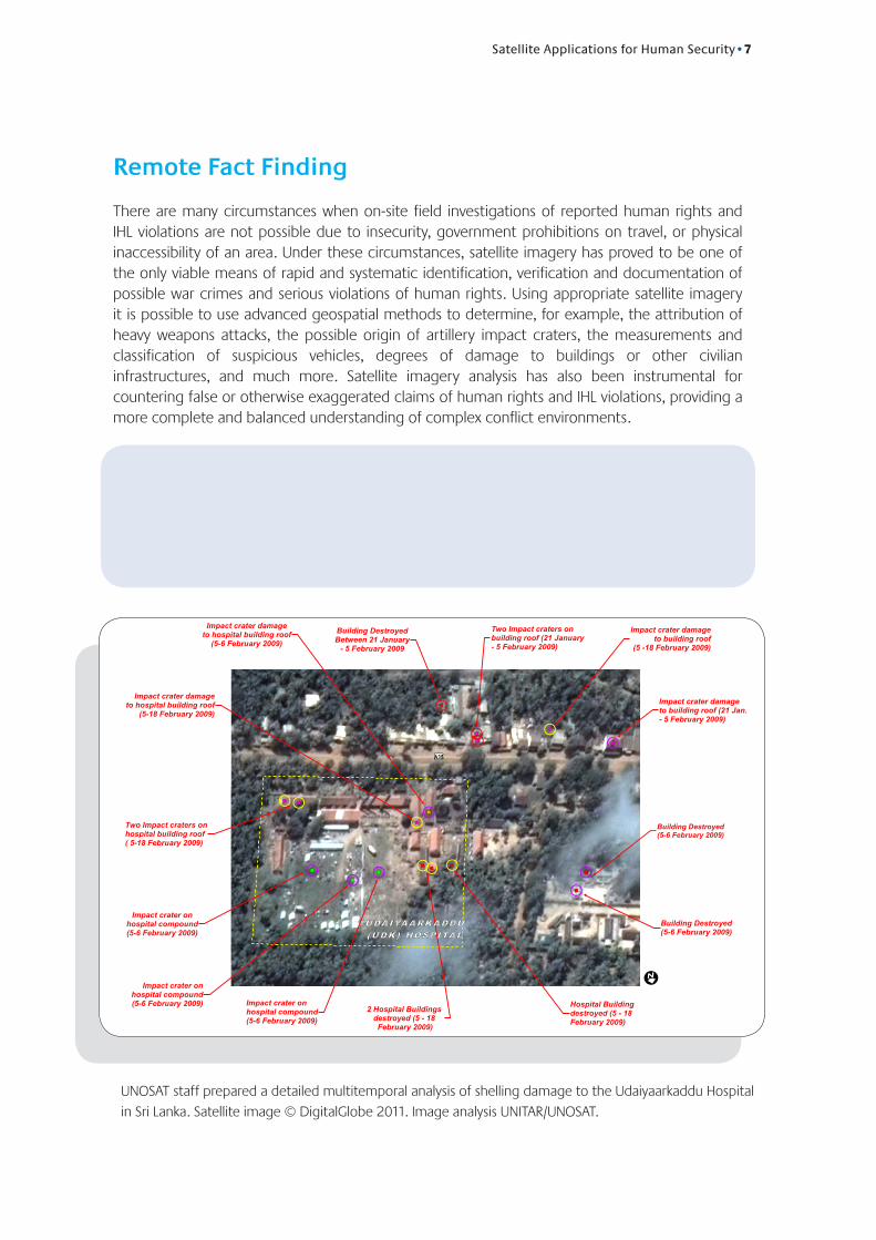
RemoteFactFinding
There are many circumstances when on-site field investigations of reported human rights and IHL violations are not possible due to insecurity, government prohibitions on travel, or physical inaccessibility of an area. Under these circumstances, satellite imagery has proved to be one of the only viable means of rapid and systematic identification, verification and documentation of possible war crimes and serious violations of human rights. Using appropriate satellite imagery it is possible to use advanced geospatial methods to determine, for example, the attribution of heavy weapons attacks, the possible origin of artillery impact craters, the measurements and classification of suspicious vehicles, degrees of damage to buildings or other civilian infrastructures, and much more. Satellite imagery analysis has also been instrumental for countering false or otherwise exaggerated claims of human rights and IHL violations, providing a more complete and balanced understanding of complex conflict environments.
Very high-resolution (VHR) satellite imagery is generally defined as imagery recorded at a spatial resolution of one metre or less. Image resolution refers to the size of the smallest detail on the surface of the Earth detected by the satellite. Thus, a satellite with a resolution of one meter can discern objects one metre across or greater. VHR is considered by UNOSAT to be the most suitable for human rights and human security applications, though lower resolution imagery can sometimes be used as well.
")
")
")
")
")
")
")
") ")
")
")
")
")")
")
")
")
")
")
")
")
")
")")
")
")
")
")
")
")
")
") ")
")
")
==
===
= =
=
=
=
===
=
== =
=
=
==
== =
=
=
=
=
====
=
==
=
Building Destroyed(5-6 February 2009)
!I
Impact crater damageto building roof (21 Jan.- 5 February 2009)
Two Impact craters onbuilding roof (21 January- 5 February 2009)
Impact crater onhospital compound(5-6 February 2009)
Impact crater onhospital compound(5-6 February 2009)
Impact crater onhospital compound(5-6 February 2009)
Impact crater damageto hospital building roof
(5-6 February 2009)
Two Impact craters onhospital building roof( 5-18 February 2009)
Hospital Buildingdestroyed (5 - 18 February 2009)
Impact crater damageto hospital building roof
(5-18 February 2009)
Impact crater damageto building roof
(5 -18 February 2009)
Building DestroyedBetween 21 January
- 5 February 2009
Impact Crater (Damage to Field) (Artillery or Mortar fire) Between 5-6 February 2009
Building Destroyed(5-6 February 2009)
2 Hospital Buildings destroyed (5 - 18
February 2009)
£¤A35
UNOSAT staff prepared a detailed multitemporal analysis of shelling damage to the Udaiyaarkaddu Hospital
in Sri Lanka. Satellite image © DigitalGlobe 2011. Image analysis UNITAR/UNOSAT.
8•Satellite Applications for Human Security
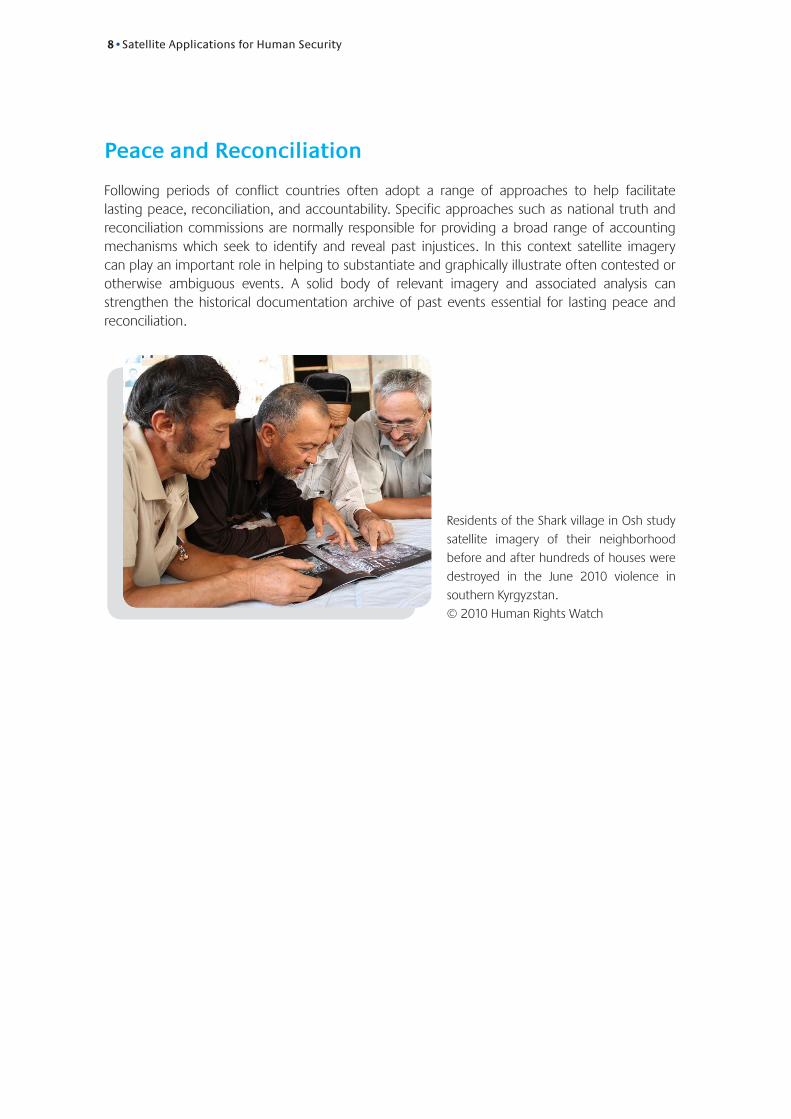
PeaceandReconciliation
Following periods of conflict countries often adopt a range of approaches to help facilitate lasting peace, reconciliation, and accountability. Specific approaches such as national truth and reconciliation commissions are normally responsible for providing a broad range of accounting mechanisms which seek to identify and reveal past injustices. In this context satellite imagery can play an important role in helping to substantiate and graphically illustrate often contested or otherwise ambiguous events. A solid body of relevant imagery and associated analysis can strengthen the historical documentation archive of past events essential for lasting peace and reconciliation.
Residents of the Shark village in Osh study
satellite imagery of their neighborhood
before and after hundreds of houses were
destroyed in the June 2010 violence in
southern Kyrgyzstan.
© 2010 Human Rights Watch

Satellite Applications for Human Security•9
Methodology
Building on significant technical and thematic expertise developed since 2001 in humanitarian mapping, UNOSAT has developed methods for assessment and analysis of satellite imagery, often in close partnership with other organizations. Partnerships are valuable for analytical activities because they can provide access to detailed information from first hand sources on the ground as well as specialized technical expertise on specific subjects or questions. It is common that human security issues take place in large or poorly defined areas with limited and incomplete geographic references. It is likewise common that initial reports on threats to human security are fragmentary and even contradictory. In such situations considerable research must take place before imagery can be acquired and the major preliminary focus for UNOSAT is one of detailed conflict tracking and mapping.
Once baseline geographic information on security issues is acquired, specific areas of interest located, and relevant satellite imagery acquired, the imagery analysis process can begin. Satellite imagery analysis is conducted using a variety of computational tools which combine both manual and automated change detection and feature extraction techniques. Most often, a primary goal of such analysis is completion and delivery of a preliminary report as quickly as possible. Although initial products generally require between one and three days following receipt of the necessary satellite imagery, there are emergency situations when satellite imagery was both acquired and analyzed in a matter of hours due to clear threats to civilian populations. At the opposite end of the production spectrum, complex UN inquiries or formal investigations commonly require extended and detailed analytical support. Such products can require weeks or months of work, multiple analysts, dozens of satellite images, and a great deal of contextual information.
The findings of these analytical processes are often delivered in a standard report format containing written text, tables and graphs, detailed maps, and graphics illustrating spatial patterns. These findings can also be delivered in cutting-edge formats, like kml layers and web-map, intended for presentation via the media or for use by outside agencies conducting their own independent analysis.
UNOSAT’s imagery analysis for human security issues often focuses on the identification and assessment of a range of features including damaged or destroyed buildings (including hospitals, schools, residential neighbourhoods and cultural and religious sites), as well as populations under threat, or militia deployments. UNOSAT has adopted two specific approaches when analyzing satellite imagery for human security: Traditional post-conflict event analysis and dynamic conflict event monitoring.
“Many thanks for this great product on Mogadishu... the details and the info posted on the maps are very useful. By far your maps are the most dynamic and informative out of all the maps that have been done regarding Horn of Africa.”
Jihad AbdallaProgramme Officer
Emergency OPSCEN Office of Emergency Programmes
UNICEF
10•Satellite Applications for Human Security
Post-ConflictEventAnalysis
The standard approach to conflict analysis is to compare a small number of satellite images (usually one pre-event image, and one or more post-event images) in a change detection process with the output representing a final, post-conflict event assessment. In some circumstance the acquisition of new satellite imagery (called “tasking”) over the location(s) of interest is required while in others this workflow can be conducted using archives of existing imagery collected at earlier dates (see case example of Kyrgyzstan on page 16).
Although this is still the most common approach for rapidly generating synoptic overviews of conflict-affected areas, there are important limitations which need to be understood. This method of analysis tends to compress the complex phases of extended security events into a single, aggre-gated total, thus potentially losing critical information related to specific incidents that occurred in a short time sequence between the relevant imagery dates. Regardless of such limitations, due to limited satellite coverage over the areas or dates of interest, this post-conflict level of analysis has rarely been employed for human security cases since commercial VHR satellite imagery became widely available to the UN in 1999.
DynamicConflictEventMonitoring
With the rapid growth in the number and capabilities of VHR satellites as well as dramatic improvements in computer processing power, it has become increasingly feasible to conduct active conflict monitoring as events unfold using collections of imagery recorded at semi-regu-lar intervals. The ability to review imagery within a day of acquisition against a comprehensive collection of earlier scenes can provide new types of information critical to humanitarian relief operations as well as to human security issues. Satellite monitoring has, for example, indenti-fied unreported security incidents and rapid changes in the extent of the active conflict zone, confirmed unverified eyewitness accounts, and even provided near real-time insights into rapidly evolving conflict dynamics and impacts on civilians. Although the number of genuine monitoring case examples is relatively small in comparison with traditional post-conflict analysis cases there have emerged two monitoring sub-categories: active monitoring of civilians and direct monitoring of security incidents.
Active monitoring of civilian populations at risk, where the assessment of satellite imagery collected at multiple, short-interval dates can provide humanitarian and protection agencies with reliable population estimates of civilians exposed to artillery fire, as well as to track the rapid and large-scale movement of civilians within conflict zones as they react to changes in fighting on the ground. A preeminent example of such monitoring involved UNOSAT and the UN Office of the Coordination for Humanitarian Affairs (OCHA) and focused on internally displaced civilians trapped within the conflict zone near Mullitivu, Sri Lanka in 2009 (see Sri Lanka case example on page 14).
Directly monitoring conflict and security incidents throughout the conflict lifecycle presents unique challenges. By expanding the post-conflict event analysis approach in both scale and duration, satellite monitoring can provide more complex insights on the time sequence of specific events, identify probable cease-fire violations, and address important legal questions regarding alleged violations of human rights and IHL (see case examples of Libya, South Sudan and Sri Lanka on pages 14-17).
Satellite Applications for Human Security•11
Research
The position of UNOSAT within the Research Department of UNITAR allows a key interplay of operational practice and research activities. The experience of day-to-day activities and cutting-edge technical research are merged to generate solutions to meet operational needs expressed by the various users. The result is the translation of technology, often developed by partners, into usable solutions that are innovative, timely, and fit for purpose. Recent examples of this dynamic approach to applied research include joint development of a sophisticated vehicle fleet manage-ment system currently in use by UN agencies and NGO partners, facilitation of access to mobile phone applications for geospatial data gathering, and leveraging crowdsourcing technologies.
Looking forward, UNOSAT is actively engaged in a number of research projects and initiatives which promise new geospatial applications for the analysis of human security issues. Two among these include the use of new radar satellite sensors for conducting advanced change detection techniques in circumstances when optical VHR satellite sensors are ineffective and the development of computational models for analyzing satellite-detected active fire locations to help identify violent conflicts in their earliest stages.
Radar-BasedChangeDetection
Radar imaging systems offer significant advantages in critical situations. Because of the unique all-weather and night-time capabilities of radar it is often used to assess major natural disasters such as flooding, landslides, and volcanic eruptions. However, the practical use of radar data for more difficult applications related to human security has until recently been limited by the lower levels of spatial resolution and correspondingly higher levels of data complexity provided by radar systems.
With recent advancements in the spatial resolution of new radar satellites as well as in the frequency of data acquisition allowing improved monitoring intervals, advanced radar processing and analysis techniques are currently being developed and implemented by UNOSAT that take advantage of new radar satellites such as COSMO-SkyMed and TerraSAR-X. Applications being tested include: monitoring hijacked civilian vessels, detecting illegal waste dumps and industrial accidents, monitoring large scale construction projects such as pipelines and mining, and more traditional applications such as detecting severe building damage and other conflict-related impacts.
Fire-detectionsForConflictAnalysis
Fire-detections for conflict analysis: Fires are often a hallmark of conflict and can also indicate significant impact on civilian populations. For example, the widespread violence in Darfur in 2003 and after often saw fire used as a weapon to destroy villages and agricultural fields. Election related violence in Kenya in 2007-2008 featured numerous large fires, as did the conflict between Russia and Georgia in 2009, with both events including significant civilian casualties as a direct result of violence. Many of these active fires were detected by scientific satellites such as the MODIS sensors operated by NASA as well as the Ionia active fire detection system operated by the European Space Agency.
12•Satellite Applications for Human Security
“I want to thank you for this useful information... I find your maps very useful for updating response plans.”
Sarah El Khazin Consultant
Regional Office for the Middle East OCHA
These satellite-derived datasets provide active fire detections up to four times per day for the entire world and can constitute the basis for a global conflict early-warning and monitoring system.Research conducted by UNOSAT staff found that a strong relationship exists between active fire detections and reported attacks on civilians in the Darfur region of Sudan during 2003. Fires in Darfur during the latter half of 2003, when violence was at its peak, significantly exceeded levels detected in previous years. This increase is statistically significant enough to allow an automa-ted algorithm for reviewing fire detection data to possibly identify abnormally high levels of fire detections. Additional research by UNOSAT indicated that fires detected during the Kenya election violence, the Georgian conflict, and the conflict in Kyrgyzstan in 2010, generally occurred in locations with no previous fire activity and where specific arson-related building damage was later identified with VHR satellite imagery.
Based on these factors UNOSAT is currently developing and testing a model for analyzing fire detection data in order to identify and assess violent conflicts, especially in their earliest phases. The UNOSAT conflict fire detection model as a potential to automatically delineate areas of significant deviations from the norm which can then be further reviewed by UNOSAT together with other data to identify areas of possible violent conflict and subsequently early action by relevant entities to stop or limit the consequences of the conflict.
Satellite Applications for Human Security•13
Limitations
Understanding the inherent limitations of satellite imagery and geospatial technology is central to comprehending their real value and possible use. In keeping with its reputation as a trusted centre of excellence for satellite analysis, UNOSAT is committed to transparency and objectivity with regard to the limitations of satellite applications. Some of the most important of these limitations are highlighted below.
TechnicalLimits
Optical VHR satellite sensors are of course limited by clouds and dense vegetation cover. Satellite sensor or transmission errors can also sometimes occur, causing loss of data and delays in analysis, and sometimes the spatial resolution of the satellite imagery is simply not adequate for resolving details on the ground. It is therefore possible to obtain inconclusive results that cannot verify whether initial field reporting was accurate even if imagery is received.
AnalystLimits
Most satellite imagery analysis is based on traditional photo-interpretation skills and local field knowledge. Analysts can make mistakes, come to widely divergent conclusions about the same image, and can even subconsciously shape their findings to meet preconceived expectations. Imagery interpretation requires knowledge about the local environment and society, without which it is easy to misinterpret the context, significance, or identity of specific objects on the ground. A related problem is the tendency to conflate damages from different time periods into a single event summary if available imagery was not acquired frequently enough to account for multiple distinct periods of conflict.
ImaginedCapabilities
It is important to distinguish between real and imagined satellite capabilities as portrayed in movies and works of fiction. One common misconception is that satellites can continuously monitor a single location, hovering over a given area or even reversing direction to get a better look. Commercial VHR satellites orbit the Earth in about 95 minutes and thus have only a few seconds to record their data over any particular location. Additionally, though the capabilities of sensors are steadily improving, the commercial and scientific satellites used by UNOSAT do not have the capability to read license plates, identify people, or detect people at night with thermal infrared sensors.
14•Satellite Applications for Human Security
ReviewofCaseStudies
Libya
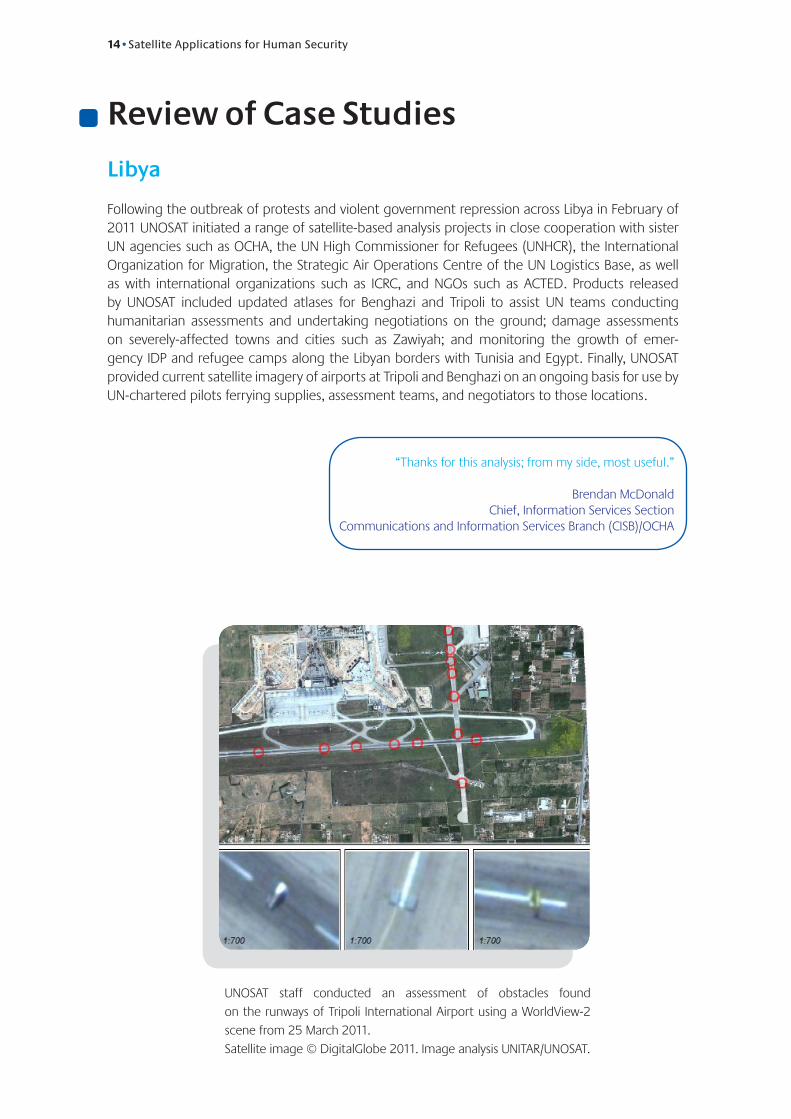
Following the outbreak of protests and violent government repression across Libya in February of 2011 UNOSAT initiated a range of satellite-based analysis projects in close cooperation with sister UN agencies such as OCHA, the UN High Commissioner for Refugees (UNHCR), the International Organization for Migration, the Strategic Air Operations Centre of the UN Logistics Base, as well as with international organizations such as ICRC, and NGOs such as ACTED. Products released by UNOSAT included updated atlases for Benghazi and Tripoli to assist UN teams conducting humanitarian assessments and undertaking negotiations on the ground; damage assessments on severely-affected towns and cities such as Zawiyah; and monitoring the growth of emer-gency IDP and refugee camps along the Libyan borders with Tunisia and Egypt. Finally, UNOSAT provided current satellite imagery of airports at Tripoli and Benghazi on an ongoing basis for use by UN-chartered pilots ferrying supplies, assessment teams, and negotiators to those locations.
UNOSAT staff conducted an assessment of obstacles found
on the runways of Tripoli International Airport using a WorldView-2
scene from 25 March 2011.
Satellite image © DigitalGlobe 2011. Image analysis UNITAR/UNOSAT.
“Thanks for this analysis; from my side, most useful.”
Brendan McDonald Chief, Information Services Section
Communications and Information Services Branch (CISB)/OCHA
Satellite Applications for Human Security•15
SouthSudan
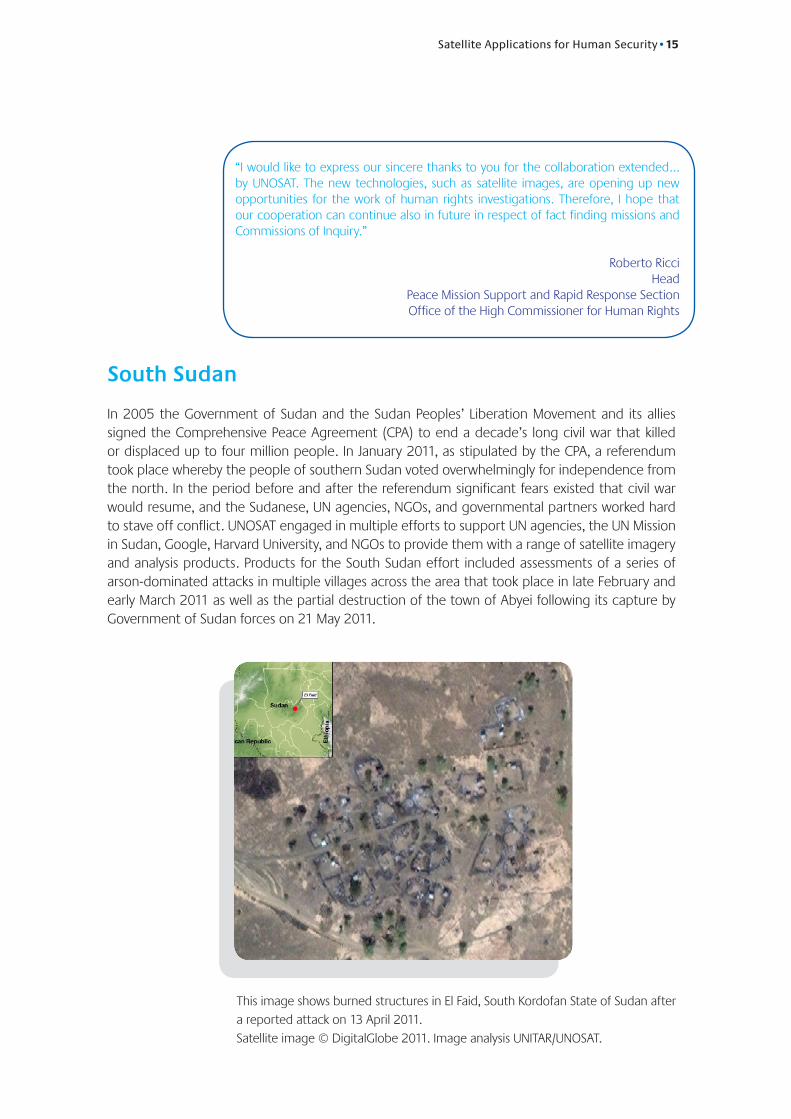
In 2005 the Government of Sudan and the Sudan Peoples’ Liberation Movement and its allies signed the Comprehensive Peace Agreement (CPA) to end a decade’s long civil war that killed or displaced up to four million people. In January 2011, as stipulated by the CPA, a referendum took place whereby the people of southern Sudan voted overwhelmingly for independence from the north. In the period before and after the referendum significant fears existed that civil war would resume, and the Sudanese, UN agencies, NGOs, and governmental partners worked hard to stave off conflict. UNOSAT engaged in multiple efforts to support UN agencies, the UN Mission in Sudan, Google, Harvard University, and NGOs to provide them with a range of satellite imagery and analysis products. Products for the South Sudan effort included assessments of a series of arson-dominated attacks in multiple villages across the area that took place in late February and early March 2011 as well as the partial destruction of the town of Abyei following its capture by Government of Sudan forces on 21 May 2011.
“I would like to express our sincere thanks to you for the collaboration extended... by UNOSAT. The new technologies, such as satellite images, are opening up new opportunities for the work of human rights investigations. Therefore, I hope that our cooperation can continue also in future in respect of fact finding missions and Commissions of Inquiry.”
Roberto RicciHead
Peace Mission Support and Rapid Response SectionOffice of the High Commissioner for Human Rights
This image shows burned structures in El Faid, South Kordofan State of Sudan after
a reported attack on 13 April 2011.
Satellite image © DigitalGlobe 2011. Image analysis UNITAR/UNOSAT.
16•Satellite Applications for Human Security
Kyrgyzstan
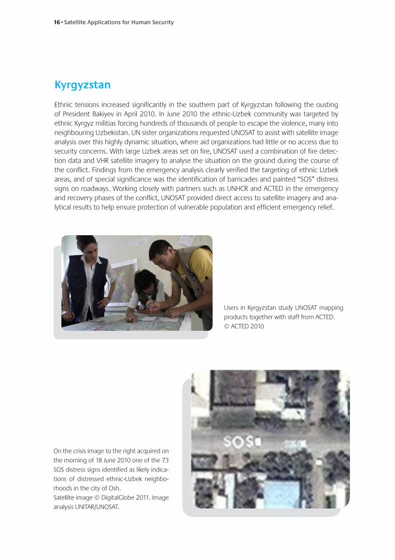
Ethnic tensions increased significantly in the southern part of Kyrgyzstan following the ousting of President Bakiyev in April 2010. In June 2010 the ethnic-Uzbek community was targeted by ethnic Kyrgyz militias forcing hundreds of thousands of people to escape the violence, many into neighbouring Uzbekistan. UN sister organizations requested UNOSAT to assist with satellite image analysis over this highly dynamic situation, where aid organizations had little or no access due to security concerns. With large Uzbek areas set on fire, UNOSAT used a combination of fire detec-tion data and VHR satellite imagery to analyse the situation on the ground during the course of the conflict. Findings from the emergency analysis clearly verified the targeting of ethnic Uzbek areas, and of special significance was the identification of barricades and painted “SOS” distress signs on roadways. Working closely with partners such as UNHCR and ACTED in the emergency and recovery phases of the conflict, UNOSAT provided direct access to satellite imagery and ana-lytical results to help ensure protection of vulnerable population and efficient emergency relief.
Users in Kyrgyzstan study UNOSAT mapping
products together with staff from ACTED.
© ACTED 2010
On the crisis image to the right acquired on
the morning of 18 June 2010 one of the 73
SOS distress signs identified as likely indica-
tions of distressed ethnic-Uzbek neighbo-
rhoods in the city of Osh.
Satellite image © DigitalGlobe 2011. Image
analysis UNITAR/UNOSAT.
Satellite Applications for Human Security•17
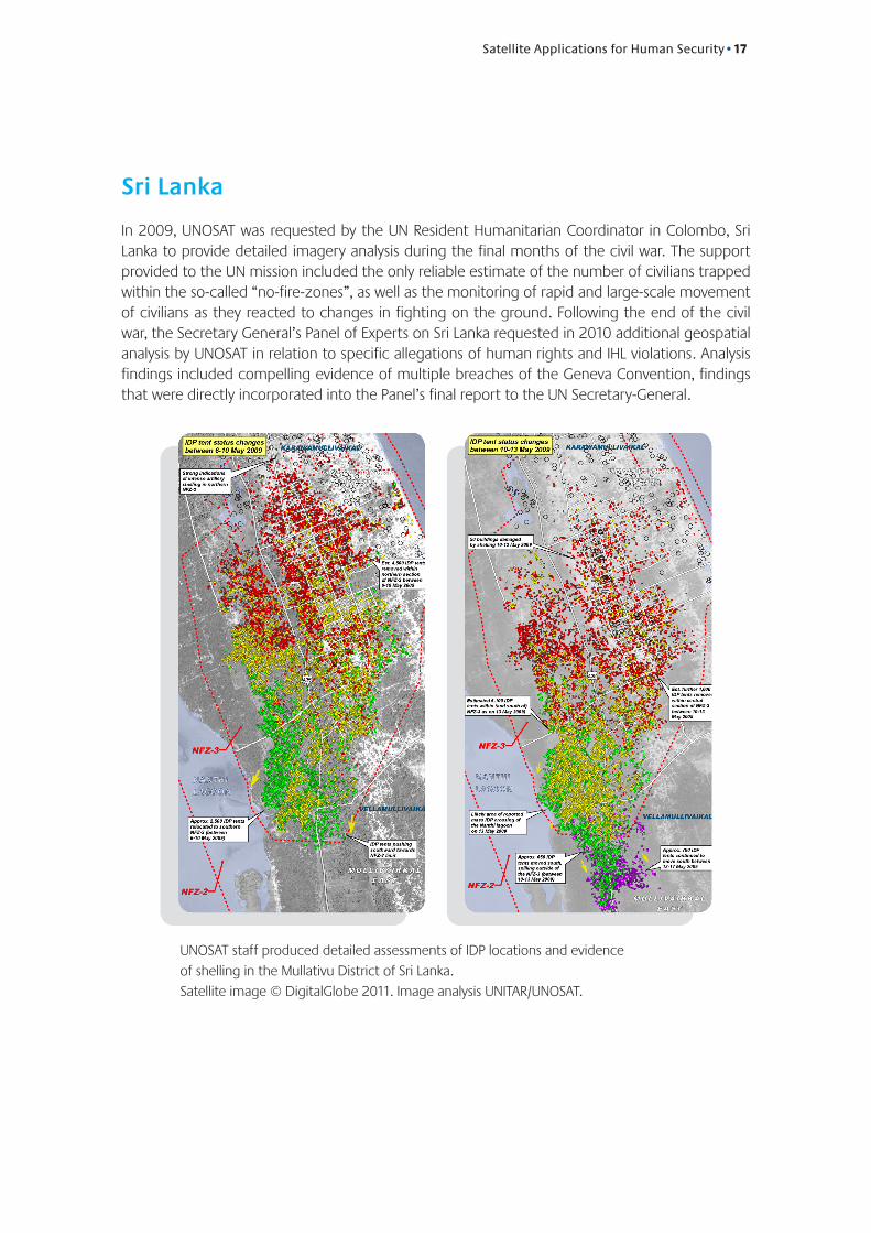
SriLanka
In 2009, UNOSAT was requested by the UN Resident Humanitarian Coordinator in Colombo, Sri Lanka to provide detailed imagery analysis during the final months of the civil war. The support provided to the UN mission included the only reliable estimate of the number of civilians trapped within the so-called “no-fire-zones”, as well as the monitoring of rapid and large-scale movement of civilians as they reacted to changes in fighting on the ground. Following the end of the civil war, the Secretary General’s Panel of Experts on Sri Lanka requested in 2010 additional geospatial analysis by UNOSAT in relation to specific allegations of human rights and IHL violations. Analysis findings included compelling evidence of multiple breaches of the Geneva Convention, findings that were directly incorporated into the Panel’s final report to the UN Secretary-General.
UNOSAT staff produced detailed assessments of IDP locations and evidence
of shelling in the Mullativu District of Sri Lanka.
Satellite image © DigitalGlobe 2011. Image analysis UNITAR/UNOSAT.
18•Satellite Applications for Human Security
LookingForward
At UNOSAT we consider innovation as an enabler of change. Current and future innovation in geospatial analysis and the constant evolution of satellite technology will mean a deep positive change for the safeguarding of human security and human rights worldwide. In the next decade over 500 new satellites will be put into orbit by UN member states and the private sector. The wealth of available high resolution imagery will increase significantly in the next few years and this will provide more objectivity and more coverage together with the possibility of monitoring and assessing any area of our planet no matter how remote.
UNOSAT’s outlook for the future relies on these technological improvements and on our constant work to research advanced solutions and break new grounds to provide the United Nations and its member states with independent, dependable, timely, impartial and accountable analytical capacity.
Satellite technology when applied consciously to well identified requirements can make a difference in the various declinations of human security. Sound geospatial analysis helps take on the challenges outlined by UN Secretary General on the safety of humanitarian workers and UN staff for example. Professional imagery analysis has set a new paradigm in evaluating objectively gross violations of human rights and IHL. Today commercial VHR satellites provide the possibility of monitoring large territories without the necessity of human presence on the ground.
UNOSAT is committed to contributing professional and accountable work in each of these areas while keeping the United Nations ahead of the curve in an area of fast paced technological and application evolution. The strategic advantage of UNOSAT, which celebrated 10 years of achievements in 2011, is that it is entirely dedicated to researching and applying satellite technology and imagery analysis. Its entire budget, staff and expertise is aimed at making progress and supporting the work of organisations and countries committed to humanitarian relief, human security and building the capacities of vulnerables. The location of UNOSAT in Geneva, the world humanitarian capital and home to the most central humanitarian and human rights institutions, is another powerful advantage. These strengths are complemented by a robust network of cooperating institutions and the support of a growing number of donor governments and member states.
“[UNHCR] deeply appreciates the work done by UNOSAT to provide mapping, including satellite images, in situations of humanitarian emergency.
UNOSATs work and its ability to directly improve the lives of some of the world’s most vulnerable and threatened people is a unique resource. I hope you share my desire
for UNHCR and UNOSAT to work together more closely.”
António GuterresUN High Commissioner for Refugees
All illustrations, including maps and photos, by UNOSAT unless otherwise indicated
Copyright © United Nations Institute for Training and Research (UNITAR), 2011
Schweizerische EidgenossenschaftConfédération suisseConfederazione SvizzeraConfederaziun svizra
Federal Department of Foreign Affairs FDFA
The present brief has been printed thanks to the support of :
Palais des Nations1211 - Geneva 10 SwitzerlandT + 41-22-767-4137 F + 41-22-917-8047 www.unitar.org/unosat